palisades scenic byway · pip scenic byway historic properties henry hudson drive palisades...
TRANSCRIPT

State Line BoundaryMonument
Ruckman Point
Points of Interest:Camp Alpine New York Council
"/
"/
Rockleigh Historic District
Site of Washington's Troop Encampment
Rockleigh Country Club
Camp Alpine New Jersey CouncilBombay Hook/"Man-in-the-Rock" PillarPoint Comfort
!
Hu d
s on
R iv e
r
ROCKLAND COUNTY
BERGEN COUNTYRO
CKLE
IGH BO
ROUG
HAL
PINE B
OROU
GH
NORW
OOD B
OROU
GH
Peanut Leap Cascade
State Line Lookout and InnWomen's Federation Monument
Twombly's Landing
!!1
!!2
!!3
!!4
!!5
!!6
!!7
!!8
!!9
LEGEND
Bergen County Hiking Trails
Historic Sites!
PIP Scenic Byway (NJ Section)
Historic Properties
Henry Hudson DrivePalisades Interstate ParkParks & Open Space
Match Line -- See Map: 2 of 3
Palisa
des In
tersta
te Pa
rkway
N E W Y O R K
N E W J E R S E Y
Long PathShore Trail
Forest View TrailOther Trails
Ski Trail
à
à Pedestrian Overpass
CLOS
TER B
OROU
GHAL
PINE B
OROU
GH
T o B e a r M o u n t a i nN Y S T h r u w a yI - 8 7I - 2 8 7
!!1
!!7
!!5
!!3
!!4
!!6
!!8
!!9
Ruckman Road
Exit 4 (SB)US 9W
(Highland Ave)
Exit 4 (NB)US 9W
(Highland Ave)
Exit 3 (NB/SB)US 9W
(Palisades Blvd)
!
!!2
9W
9W
´0 0.50.25
Miles
Note: GIS Data obtained through NY-NJ TRAIL CONFERENCE, NJDOT & NJDEP GIS websites. Bing Maps Aerial Basemap obtained from ArcGIS.
Path: S:\Project\J422800\Mapping\Basemap 011111\Basemap 1 of 3 01_11_11.mxd
!!10
!!10 Armstrong Tower
NEW
YORK
NEW
JERS
EY
Palisades Scenic Byway Corridor Management Plan
J A N U A R Y 2 0 1 1J A N U A R Y 2 0 1 1
4567501
PALISADES SCENIC BYWAYPOINTS OF INTEREST MAP
Map: 1 of 3
!!11
!!11 Excelsior Dock
and Picnic Area
NEW
YORK
NEW
JERS
EYH
u ds o
n R i
v er
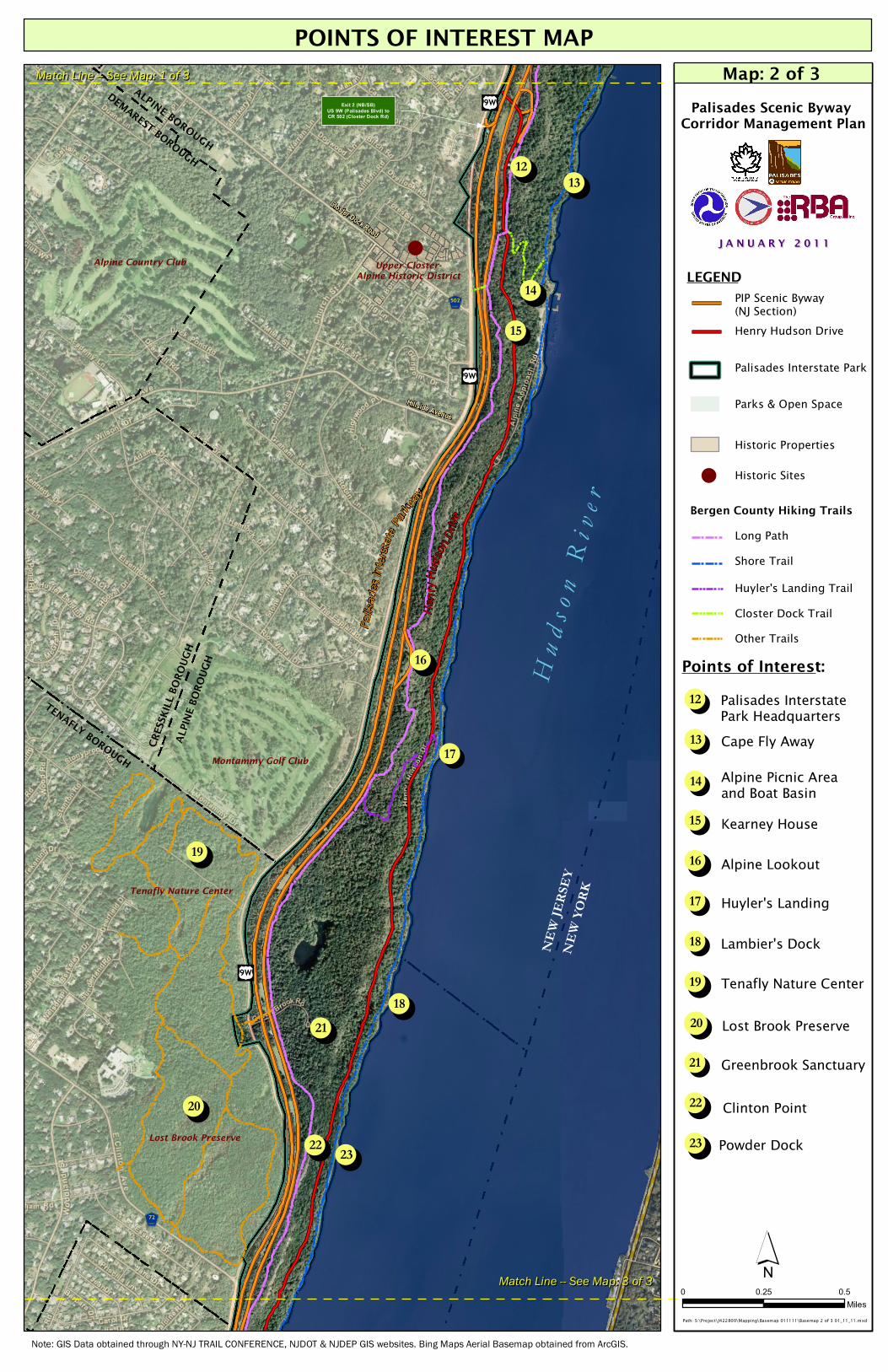
Upper Closter-Alpine Historic District
Alpine Country Club
Montammy Golf Club
MMaattcchh LL iinnee -- -- SSeeee MMaapp:: 11 ooff 33
Points of Interest:
!!18
!!19
!!20
!!21
Site of Washington's Troop Encampment
!
Henr
y Hud
son D
rive
Palisa
des I
nterst
ate Pa
rkway
LEGEND
Historic Sites!
PIP Scenic Byway (NJ Section)Henry Hudson Drive
Palisades Interstate Park
Parks & Open Space
Bergen County Hiking TrailsLong PathShore Trail
Closter Dock TrailOther Trails
Huyler's Landing Trail
!!12!!13
!!14
!!15
!!17
!!16
DEMAREST BOROUGH
ALPINE BOROUGH
Lost Brook Preserve
Tenafly Nature Center
TENAFLY BOROUGH
CRESS
KILL B
OROU
GHAL
PINE B
OROU
GH
Palisades Scenic Byway Corridor Management Plan
J A N U A R Y 2 0 1 1J A N U A R Y 2 0 1 1
Exit 2 (NB/SB)US 9W (Palisades Blvd) toCR 502 (Closter Dock Rd)
Closter Dock Road
4567502
!!23!!22
Palisades InterstatePark Headquarters!!12
Cape Fly Away!!13
Alpine Picnic Area and Boat Basin!!14
Kearney House !!15
Alpine Lookout!!16
Huyler's Landing!!17
Tenafly Nature Center!!19
Lost Brook Preserve!!20
Greenbrook Sanctuary!!21
Lambier's Dock!!18
!!23 Powder Dock!!22 Clinton Point
Note: GIS Data obtained through NY-NJ TRAIL CONFERENCE, NJDOT & NJDEP GIS websites. Bing Maps Aerial Basemap obtained from ArcGIS.
Hillside Avenue
456772
"/9W
"/9W
Historic Properties
MMaattcchh LLiinnee -- -- SSeeee MMaapp:: 33 ooff 33 ´0 0.50.25
MilesPath: S:\Project\J422800\Mapping\Basemap 011111\Basemap 2 of 3 01_11_11.mxd
POINTS OF INTEREST MAPMap: 2 of 3
"/9W

Lydecker Homestead
G.W. Betts House
Bergen Building
Flat Rock Nature Center
Barrymore House
Monument Park
Judge James D.Moore House
George Washington Bridge
4Points of Interest:
!!24
!!25
!!27
!!28
!!29
!!30
!!31
!!32 Hazard's DockBoat Ramp
Fort Lee Historic Park
!
!
!
!
!!
LEGEND
Historic Sites!
PIP Scenic Byway
Historic Properties
Henry Hudson DrivePalisades Interstate ParkParks & Open Space
George Washington Bridge
Palisa
des In
tersta
te Pa
rkway
Henry
Hudso
n Driv
e
Rockefeller Lookout
Undercliff Dock and Picnic Area
!!26
Ross Dock Picnic Area
Linwood Park
Hudson RiverWaterfront Walkway
Bergen County Hiking TrailsLong PathShore TrailCarpenter's TrailDyckman Hill Trail
à Pedestrian Overpass
Canoe Beach
Bloomer's Beach
Englewood Picnic Area and Boat BasinAllison Park
Carpenter's Dockà
Palisades Scenic Byway Corridor Management Plan
J A N U A R Y 2 0 1 1J A N U A R Y 2 0 1 1
MMaattcchh LL iinnee -- -- SSeeee MMaapp:: 22 ooff 33
Exit 1 (NB/SB)Palisade Ave (CR 505)
à
!!36!!35 !!34!!33
!!24
!!25
!!26
!!27
!!28
!!29
!!30
!!31
!!32
!!33
!!34
!!35
!!36
4567505
"/9W
Note: GIS Data obtained through NY-NJ TRAIL CONFERENCE, NJDOT & NJDEP GIS websites. Bing Maps Aerial Basemap obtained from ArcGIS.
´0 0.50.25
MilesPath: S:\Project\J422800\Mapping\Basemap 011111\Basemap 3 of 3 01_11_11.mxd
ENGLE
WOOD C
ITY
ENGLEWOOD CLIFFS BOROUGH
FORT LEE BOROUGH
ENGL
EWOO
D CITY
ENGL
EWOO
D CLIF
FS BO
ROUG
H
NEW
YORK
NEW
JERS
EY
Access to 9W (NB/SB)
"/9W
"/9W
"867
"867
EDGEWATER BOROUGH
H u ds o
n R i v
e r
POINTS OF INTEREST MAPMap: 3 of 3