palmerton zinc pile superfund site natural resource damage
TRANSCRIPT

Palmerton Zinc Pile Superfund Site Natural Resource Damage Assessment
DRAFT Restoration Plan and Environmental Assessment
Produced by
The Trustees of the Palmerton Zinc Pile Superfund Site
U.S. Department of the Interior F ish and Wild li fe Service U.S. Department of the Interior National Park Service
U.S. Department of Commerce National Oceanic and Atmospheric Administration Pennsylvania Department of Conservation and Natural Resources
Pennsylvania Department of Environmental Protection Pennsylvania F ish and Boat Commission
Pennsylvania Game Commission
May 19, 2010

TABLE OF CONTENTS EXECUTIVE SUMMARY I
1.0 INTRODUCTION 1
1.1 Superfund Cleanup 1 1.2 Natural Resource Damage Assessment and Restoration 2
2.0 PURPOSE AND NEED FOR RESTORATION 4
2.1 Compliance with Other Authorities 5 2.2 Administrative Record 6 2.3 Public Notification and Review 6
3.0 SUMMARY OF NATURAL RESOURCES, INJURIES, AND SERVICE LOSSES 8
3.1 Riverine and Wetland Habitat 10 3.1.1 Recreational Fishing 13
3.2 Upland Habitat 13 3.2.1 Hiking and Recreational Trail Use 16
3.2.2 Forest Management 17
3.2.3 Hunting and Trapping 17
4.0 PROPOSED RESTORATION ALTERNATIVES 18
4.0.1 Kings Manor 18
4.0.2 Lehigh Gap Nature Center 18
4.0.3 Remainder of Chapter 19
4.1 Alternative A: No Action / Natural Recovery 19 4.2 Alternative B: Habitat Acquisition / Easement Protection 19
4.2.1 Cherry Valley National Wildlife Refuge 19
4.2.2 Upper Lehigh River 21
4.3 Alternative C: Habitat Restoration 22
4.3.1 Wetland Restoration 22
4.3.2 Aquatic Habitat Restoration 23
4.3.3 Upland Habitat Restoration 24
4.4 Alternative D: Enhanced Migratory Fish Passage 24
4.4.1 Fish Ladder Improvements 25
4.4.2 Partial or Complete Dam Removal 26
4.5 Alternative E: Improved Fishing Access 26
4.6 Alternative F: Trail Restoration and Enhancement of the Appalachian Trail 27
4.6.1 Trail Restoration 27
4.6.2 Enhancement of the Appalachian Trail 29
4.7 Alternatives Considered but not Pursued 30
4.7.1 Onsite Habitat Restoration 30
4.7.2 Fish Stocking 31
4.7.3 Trail Restoration Elsewhere 31
4.7.4 Appalachian Trail Pedestrian Bridge 32
5.0 EVALUATION AND SELECTION OF THE PREFERRED ALTERNATIVES 33
5.1 Evaluation of Alternative A: No Action 34 5.2 Evaluation of Alternative B: Land Acquisition / Easement Protection 34
5.3 Evaluation of Alternative C: Habitat Restoration 35
5.4 Evaluation of Alternative D: Enhanced Migratory Fish Passage 36
5.5 Evaluation of Alternative E: Improved Fishing Access 37
5.6 Evaluation of Alternative F: Trail Restoration and Enhancement of the Appalachian Trail 38
6.0 PREFERRED RESTORATION ALTERNATIVES SUMMARY 40
7.0 PUBLIC COMMENTS AND TRUSTEES RESPONSES 41
8.0 LITERATURE CITED 42
APPENDIX A: LEHIGH RIVER RECREATIONAL ACCESS DEVELOPMENT OR
IMPROVEMENT OPPORTUNITIES A-1
APPENDIX B: APPALACHIAN TRAIL RESTORATION SEGMENTS B-1

LIST OF EXHIBITS
Exhibit ES-1 Preferred Restoration Alternatives ii
Exhibit 3-1 Map of the Assessment Area: Aquatic Resources of Aquashicola Creek and the Lehigh River, and Terrestrial Resources of Blue Mountain and Stony Ridge 9
Exhibit 3-2 Relative Aquatic Toxicity of Sediment Zinc Levels in Aquashicola Creek and the Lehigh River 12
Exhibit 3-3 Deforested Land on Blue Mountain 15
Exhibit 3-4 The Relative Phytotoxicity of Soil Zinc Levels on Blue Mountain and Stony Ridge 15
Exhibit 4-1 Cherry Valley National Wildlife Refuge 20
Exhibit 4-2 Upper Lehigh River Area 22
Exhibit 4-3 Dams on the Lower Lehigh River 25
Exhibit 6-1 Preferred Restoration Alternatives 40
Exhibit A-1 Proposed Recreational Fishing Projects A-1
Exhibit A-2 Map of Proposed Recreational Fishing Projects A-3
Exhibit B-1 Map of Appalachian Trail Proposed Primary Remediation Segments B-2

LIST OF ACRONYMS
assessment area Aquashicola Creek, the Lehigh River, Blue Mountain, and Stony Ridge ATC Appalachian Trail Conservancy CERCLA Comprehensive Environmental Response, Compensation and Liability Act DOI Department of the Interior EA environmental assessment EIS environmental impact statement EPA United States Environmental Protection Agency FONSI Finding of No Significant Impact LGNC Lehigh Gap Nature Center MOA Memorandum of Agreement NEPA National Environmental Policy Act NOAA United States Department of Commerce National Oceanic and
Atmospheric Administration NPS United States Department of the Interior National Park Service NRCS Natural Resource Conservation Service NRDAR Natural Resource Damage Assessment and Restoration NWR National Wildlife Refuge PDCNR Pennsylvania Department of Conservation and Natural Resources PDEP Pennsylvania Department of Environmental Protection PFBC Pennsylvania Fish and Boat Commission PGC Pennsylvania Game Commission PNHP Pennsylvania Natural Heritage Program PRPs potentially responsible parties RI/FS Remedial Investigation / Feasibility Study RM river mile ROD Record of Decision RP/EA Restoration Plan / Environmental Assessment Site Palmerton Zinc Pile Superfund Site SGL State Game Lands USFWS United States Department of the Interior Fish and Wildlife Service

i
EXECUTIVE SUMMARY
The Palmerton Zinc Pile Superfund Site (the Site), located in the Ridge and Valley Province of Carbon, Lehigh, and Northampton Counties, Pennsylvania, has been a source of metal contamination since the beginning of the 20th century. The East and West Plants of the former New Jersey Zinc Company, a primary zinc smelting facility, discharged metals to the surrounding environment via air emissions and through the release of liquid and solid wastes. A secondary metals processing and reclamation facility has operated in the East Plant area since the shutdown of the primary zinc smelting facility in 1980. Metals, including arsenic, cadmium, chromium, copper, lead, manganese, and zinc were released to the environment from these facilities, adversely affecting Aquashicola Creek, the Lehigh River, Blue Mountain, and Stony Ridge.
Under Federal law, Federal and state agencies are authorized to act as trustees of natural resources on behalf of the public. In this role, trustees can assess and recover monetary and other damages for injuries to natural resources caused by hazardous substance releases, and use these recovered damages to plan and implement actions that will compensate the public for the loss of services that natural resources would have provided had the injury not occurred.
The trustees for the Palmerton Site are the U.S. Fish and Wildlife Service, the National Park Service, the National Oceanic and Atmospheric Administration, the Pennsylvania Department of Conservation and Natural Resources, the Pennsylvania Department of Environmental Protection, the Pennsylvania Fish and Boat Commission, and the Pennsylvania Game Commission. The Trustees initiated damage assessment activities in 2003 and completed an Assessment Plan in 2006. In 2009 the Trustees and the potentially responsible parties (PRPs) reached a settlement comprised of a cash payment of $9.875 million and the transfer of approximately 1,300 acres of property (the Kings Manor property) to the Pennsylvania Game Commission to be used for wildlife and wildlife habitat in accordance with the Pennsylvania Game and Wildlife Code. In addition, the PRPs agreed to pay $2.5 million for the Trustees’ unreimbursed damage assessment costs and to discharge a $300,000 mortgage on the Lehigh Gap Nature Center (formerly known as the Wildlife Information Center), a non-profit conservation and environmental education organization located at the Lehigh Gap.
This Restoration Plan/Environmental Assessment (RP/EA) describes the Trustees’ priorities and proposed plans with respect to the use of the $9.875 million cash payment. Consideration of restoration benefits provided by the Kings Manor property and Lehigh Gap Nature Center is also included in the planning process as described in this RP/EA.
The Trustees evaluated seven general restoration alternatives that address injuries and service reductions associated with terrestrial and aquatic habitats and the uses of these resources (specifically recreational fishing and hiking), and identified four preferred alternatives: habitat acquisition/easement protection; enhancing migratory fish passage;

ii
improved fishing access on the Lehigh River; and hiking/trail improvements (Exhibit ES-1).
EXHIBIT ES-1 PREFERRED RESTORATION ALTERNATIVES
ALTERNATIVE BENEFITS ENVIRONMENTAL IMPACTS
Habitat Acquisition/Easement Protection Cherry Valley National Wildlife Refuge
Lehigh River Headwaters
Other areas on Kittatinny Ridge and the Lehigh River
Preserves high-quality upland and aquatic habitats, provides view-shed protection and access to the Trail, and restores fishing opportunities.
Potential for minor impacts associated with increased visitor use.
Enhanced Migratory Fish Passage Lower Lehigh River Dam Removal Feasibility Study
Supports initial steps needed for migratory fish restoration, free-flowing aquatic habitat restoration, and increased fishing opportunities.
Feasibility study: No impact.
Future dam removal: To be determined on a project specific basis.
Improved Fishing Access Lehigh River
Restores a high level of good-quality fishing opportunities in the Palmerton area.
Minor stream bank impacts associated with boat ramp improvements; minor impacts associated with increased visitor use.
Trail Restoration and Enhancement of the Appalachian National Scenic Trail
Appalachian National Scenic Trail
Enhances hiker opportunities and restores trail conditions, improves trail stability and hiker safety. Reduces erosion and impacts to trailside vegetation. Provides enhanced trail protection and protects visitor hiking experience.
Impacts of the proposed trail restoration are expected to be minor and generally beneficial. No negative impacts are expected from the trail enhancement work.
In terms of habitat acquisition and/or easement protection, the recent creation of the nearby Cherry Valley National Wildlife Refuge provides a unique opportunity to preserve high-quality upland and aquatic habitat similar to habitat injured by metals contamination, and to ensure the area’s long-term protection and management within the National Wildlife Refuge system. Habitat preservation in the headwaters of the Lehigh River would also provide aquatic resource services similar to those lost due to metals contamination (e.g., high-quality streams and wetlands and migratory fish habitat). High-quality habitat protection elsewhere on Kittatinny Ridge and along the Lehigh River will also be considered under this option. The potential benefits of dam removal to migratory fish, free-flowing aquatic habitat, and recreational fishing are sufficient for the Trustees to fund a feasibility study to evaluate dam removal on the lower Lehigh River. Finally, the selected fishing access and hiking/trail improvement alternatives complement the habitat-based alternatives by addressing two of the primary human use services that have been impaired as a result of Site-related metals contamination.

1
1.0 INTRODUCTION
The Palmerton Zinc Pile Superfund Site (the Site), located in the Ridge and Valley Province of Carbon, Lehigh, and Northampton Counties, Pennsylvania, has been a source of metal contamination since the beginning of the 20th century. The East and West Plants of the former New Jersey Zinc Company, a primary zinc smelting facility, discharged metals to the surrounding environment via air emissions and through the release of liquid and solid wastes. A secondary metals processing and reclamation facility has operated in the East Plant area since the shutdown of the primary zinc smelting facility in 1980.
1.1 SUPERFUND CLEANUP
The United States Environmental Protection Agency (EPA) is overseeing Site remediation, which is being carried out by a group of five potentially responsible parties (PRPs).1 Remedial actions have been divided into four separate sets of activities, or “operable units.”
• Operable Unit 1 addresses the loss of vegetation due to Site smelting activities on Blue Mountain. EPA’s selected remedy for this operable unit, as documented in a final Record of Decision (ROD), requires the revegetation of approximately 2,000 acres of the mountain (EPA 1987a).2
• Operable Unit 2 addresses a 33 million-ton slag pile (the “Cinder Bank”) that extends for 2.5 miles along the bank of Aquashicola Creek. EPA finalized a ROD for this operable unit in 1988; a modified ROD became final in 2002 (EPA 2002, EPA 1988). Per these agreements, a system was built to divert surface water around the Cinder Bank and treat contaminated leachate before it is discharged to nearby Aquashicola Creek. In addition, a portion of the Cinder Bank was revegetated. This work was completed in the fall of 2002. Monitoring of the treated discharge and revegetation is ongoing.
• Operable Unit 3 addresses the cleanup of residential soils in the Borough of Palmerton and in other areas near the Site where hazardous substances had come to be located. The selected remedy described in a 2001 ROD created a voluntary program of soil and interior dust sampling followed by remediation when observed concentrations exceeded specified levels. The resulting property cleanups were completed in 2005.
1 CBS Operations Inc., TCI Pacific Communications Inc., CBS/Westinghouse of Pa. Inc., HH Liquidating Corp. and HRD Liquidating Corp.
2 By 1995, approximately 800 acres of private land had been revegetated using a mixture of sewage sludge, fly ash, limestone, and grass and tree seed. Work to apply fertilizer, lime, and warm season grasses to an additional 400 acres of private land was completed in 2006. Aerial application of lime fertilizer and seed occurred in 2008 on approximately 700 acres of Pennsylvania Game Commission (PGC) and United States Department of the Interior National Park Service (NPS) land. EPA is currently working with the Pennsylvania Department of Environmental Protection (PDEP), PGC, and NPS along with the PRPs to complete a design for revegetation of approximately 1,500 acres of public land (along the Appalachian Trial). This additional revegetation work is anticipated to commence in Fall 2010.

2
• Operable Unit 4 addresses groundwater, surface water, and ecological risks resulting from Site-related contamination. EPA is currently overseeing finalization of a Remedial Investigation/Feasibility Study (RI/FS), including an ecological risk assessment, which will utilize groundwater, surface water, and soils data to define the nature and extent of contamination and to determine the degree to which this contamination adversely affects flora and fauna. As part of the RI/FS process, EPA will evaluate several possible cleanup plans before it documents a preferred remedy in an Operable Unit 4 ROD.
• Stony Ridge is included in the current scope of Operable Unit 4 to address erosion and sedimentation problems. Severe erosion of contaminated soils from Stony Ridge into residential areas required the initiation of emergency response actions in 1996; EPA subsequently oversaw efforts to stabilize a limited area of eroding and contaminated soils on Stony Ridge. Ongoing surface run-off and erosion associated with the remaining denuded areas along the ridge may result in future remedial actions.
1.2 NATURAL RESOURCE DAMAGE ASSESSMENT AND RESTORATION
Natural resources provide a variety of ecological and human use services. However, the releases of metals from the Site have injured and impaired the ability of natural resources to provide these services. The Comprehensive Environmental Response, Compensation, and Liability Act (CERCLA) of 1980, as amended, commonly known as Superfund (42 U.S.C. 9601 et seq.), allows the public to be compensated for injuries to natural resources and the services resources provide resulting from the release of hazardous substances into the environment. As described in Department of the Interior (DOI) regulations (43 Code of Federal Regulations (CFR) Part 11), Federal and state governments, Indian Tribes, and in some cases foreign governments, can act on behalf of the public as natural resource trustees to seek such compensation. This process by which trustees can pursue compensation, formalized in the DOI regulations, is referred to as Natural Resource Damage Assessment and Restoration (NRDAR).
The goal of the NRDAR process is to “replace, restore, or acquire the equivalent of natural resources” injured by the release of hazardous substances (43 CFR § 11.82 (b)). The restoration objective is achieved when the injured natural resources and the services they provide are returned to their baseline condition. Baseline is the condition in which the resources and services would exist “but for” the release of hazardous substances.
The Trustees for the Site initiated NRDAR activities in 2003 in order to assess and recover damages associated with injuries to natural resources resulting from Site-related contamination (Trustees 2003b). The Trustees completed an Assessment Plan in 2006, summarizing existing information on natural resource injuries and describing proposed studies to evaluate past, current, and future impacts to natural resources and the services they provide (Trustees 2006). In addition, the Plan outlined how information gathered from these studies would be used to determine the types and scale of restoration needed to address these injuries.

3
In 2009, prior to completion of the assessment process, the Trustees and PRPs reached a settlement comprised of a cash payment of $9.875 million and the transfer of approximately 1,300 acres of property (the “Kings Manor” property) to the Pennsylvania Game Commission. In addition, the PRPs agreed to pay $2.5 million for the unreimbursed portion of the Trustees’ past damage assessment costs and to discharge a $300,000 mortgage on the Lehigh Gap Nature Center (LGNC), a non-profit conservation and environmental education organization located at the Lehigh Gap (USDOJ 2009). The cash payment was deposited into the U.S. Department of the Interior’s Natural Resource Damage Assessment and Restoration Trust Fund to be used exclusively for restoration activities associated with the Site.
Restoration must supplement remedial responses that are underway or planned. That is, the extent to which remediation returns natural resources and the services they provide to their baseline condition should be considered in the NRDAR process. Remediation addresses risks to human health and the environment posed by hazardous contamination. NRDAR addresses injuries to natural resources and the services they provide due to hazardous substances, in addition to injuries that may have occurred during the remedial process and that may persist into the future. Thus, restoration addresses residual injury and natural resource service losses that remain until and upon completion of a remedial response.
In addition to primary restoration costs (i.e., costs associated with directly restoring the injured resource to its baseline condition), damages can also include compensation for the loss of natural resource services during the period of injury (i.e., from the time of the injury until baseline recovery is achieved, referred to as the period of "interim loss"). These are the losses upon which NRDAR activities at the Site have been focused, and for which damages have already been paid by the PRPs. This document presents the draft Restoration Plan for the Site.

4
2.0 PURPOSE AND NEED FOR RESTORATION
The Trustees for the Site, and the natural resources for which they assert trusteeship, include:
• The United States Department of the Interior Fish and Wildlife Service (USFWS) — migratory birds, migratory fish, threatened and endangered species, and their respective habitats.
• The United States Department of the Interior National Park Service (NPS) — National Park lands including lands along the Appalachian National Scenic Trail (Trail).
• The United States Department of Commerce National Oceanic and Atmospheric Administration (NOAA) — diadromous fish, such as the American shad, alewife, blueback herring and the American Eel, and their supporting habitats.
• The Pennsylvania Game Commission (PGC) - State Game Lands and wildlife.
• The Pennsylvania Fish and Boat Commission (PFBC) — state aquatic resources including fish, amphibians, reptiles, and aquatic habitat.
• The Pennsylvania Department of Environmental Protection (PDEP) —Commonwealth natural resources including groundwater.
• The Pennsylvania Department of Conservation and Natural Resources (PDCNR) — state-protected plants.
In 2003, the Trustees signed a Memorandum of Agreement (MOA) that, among other things, created a Trustee Council for the purpose of coordinating NRDAR activities (Trustees 2003a). In the MOA, the Trustees also:
• Recognize their joint, and in some instances overlapping, trusteeship for natural resources associated with the Site;
• Agree that any natural resource damage recoveries and any interest earned thereon, with the exception of recoveries to reimburse past damage assessment costs, shall be jointly used to restore, replace, rehabilitate, and/or acquire the equivalent of natural resources injured, destroyed, or lost as a result of the release of hazardous substances from the Site; and
• Agree to maximize expenditures for restoration activities and control expenditures for post-settlement planning and administrative costs.
The DOI’s NRDAR regulations require the Trustees to develop a draft Restoration Plan, with an opportunity for public review and comment prior to the development of a final Restoration Plan. The plan must include a reasonable number of alternative restoration actions and must identify a preferred alternative (which may include one or more of the possible actions).

5
Actions undertaken by the Trustees to restore natural resources or services under CERCLA and other Federal laws are also subject to the National Environmental Policy Act (NEPA; 42 U.S.C. 4321 et seq.), and the regulations guiding its implementation at 40 C.F.R. Parts 1500 through 1517. NEPA and its implementing regulations outline the responsibilities of Federal agencies under NEPA, including requirements for environmental documentation. In general, Federal agencies contemplating implementation of a major Federal action must produce an environmental impact statement (EIS) if the action is expected to have significant impacts on the quality of the human environment. When it is uncertain whether a contemplated action is likely to have significant impacts, Federal agencies prepare an environmental assessment (EA) to evaluate the need for an EIS. If the EA demonstrates that the proposed action will not significantly impact the quality of the human environment, the agency issues a Finding of No Significant Impact (FONSI), which satisfies the requirements of NEPA, and no EIS is required. For a proposed restoration plan, if a FONSI determination is made, the Trustees may then issue a final restoration plan describing the selected restoration action(s).
In accordance with NEPA and its implementing regulations, this RP/EA summarizes the current environmental setting, describes the purpose and need for restoration actions, identifies alternative actions, assesses their applicability and potential impact on the quality of the physical, biological and cultural environment, and outlines public participation in the decision-making process. This information will be used to make a threshold determination as to whether preparation of an EIS is required prior to selection of the final restoration actions. Based on the EA integrated in this document, the Trustees will also determine whether the proposed restoration action does not meet the threshold that requires an EIS.
2.1 COMPLIANCE WITH OTHER AUTHORITIES
Restoration alternatives described in this document will be conducted in compliance with all applicable Federal, state, and local regulations.
The Trustees prepared this draft RP/EA to fulfill requirements under CERCLA. Authority to seek natural resource damages is also provided by the Federal Water Pollution Control Act of 1972, as amended, commonly referred to as the Clean Water Act.
Other Federal natural resource and environmental laws and regulations considered during the development of this RP/EA include: the National Parks Omnibus Management Act of 1998; the National Park Service Organic Act of 1916; the National Park Service Resource Protection Act; the Endangered Species Act of 1973; the Migratory Bird Treaty Act; the National Historic Preservation Act; the Archaeological Resources Protection Act; the National Wildlife Refuge System Administration Act of 1966, as amended by the National Wildlife Refuge System Improvement Act of 1997; the Wilderness Act of 1964; the Fish and Wildlife Coordination Act of 1934; the Refuge Recreation Act of 1962; the U.S. Fish and Wildlife Mitigation Policy of 1981; Executive Order 11990 on Wetlands; Executive Order 11988 on Floodplains; Executive Order 12580 on Superfund;
6
Executive Order 12898 on Environmental Justice; and the Information Quality Act of 2001.
The major state environmental statutes and programs considered during the development of this RP/EA include: the Commonwealth of Pennsylvania’s Clean Streams Law; the Pennsylvania Natural Diversity Index; the Pennsylvania Fish and Boat Commission’s stream restoration authorities under the Pennsylvania Fish and Boat Code; the Pennsylvania Game Commission’s Inventory of wildlife or wildlife habitats; the Pennsylvania History Code; and the Pennsylvania Hazardous Sites Cleanup Act.
2.2 ADMINISTRATIVE RECORD
The Trustees have maintained records documenting the information considered and actions taken by the Trustees during this restoration planning process. These records collectively comprise the Trustees’ administrative record supporting this RP/EA, and are available for review by the public. Interested parties can access or view these records at the Palmerton Public Library, Palmerton, Pennsylvania.
2.3 PUBLIC NOTIFICATION AND REVIEW
Under CERCLA and NEPA, Trustees must involve the public in the restoration planning process. Accordingly, the Trustees have published, distributed, and are seeking comments on this Draft RP/EA. In addition, the Trustees published a Notice of Availability of the Draft Plan in two local papers: the Morning Call (May 23 and 26) and the Times News (May 24). A copy of this Draft Plan is also available for review at the Palmerton Public Library and online at the following two websites:
http://www.fws.gov/contaminants/restorationplans/palmerton/palmerton.cfm
http://www.dep.state.pa.us/dep/deputate/airwaste/wm/remserv/nrd/nrdhome.html
Interested parties can obtain a hard copy of this Draft RP/EA from the Trustees by submitting a written request to the following address:
U.S. Fish and Wildlife Service Pennsylvania Field Office Attention: Dr. Kathleen Patnode 315 S. Allen Street, Suite 322 State College, PA 16801
The Trustees believe that public comment and input is critical to the success of this RP/EA and will respond to all comments received from the public. Comments received by the Trustees will be addressed in the Final RP/EA. The comment period will be open until June 23, 2010.

7
The USFWS, acting as Lead Administrative Trustee, is the central contact point for the Trustee Council. Comments may be submitted in writing or by e-mail to:
Dr. Kathleen Patnode U.S. Fish and Wildlife Service Pennsylvania Field Office 315 South Allen Street, Suite 322 State College, PA 16801 e-mail: [email protected]

8
3.0 SUMMARY OF NATURAL RESOURCES, INJURIES, AND SERVICE LOSSES
Metals, including arsenic, cadmium, chromium, copper, lead, manganese, and zinc were released to the environment from the Site, adversely affecting Aquashicola Creek, the Lehigh River, Blue Mountain, and Stony Ridge (collectively referred to as the “assessment area”; Exhibit 3-1). Blue Mountain and Stony Ridge demarcate the assessment area to the south and north, respectively. The Lehigh River divides the assessment area to the west of the Borough of Palmerton. Aquashicola Creek drains the majority of the Site, flowing in a southwest direction through the town of Palmerton before joining the Lehigh River at Lehigh Gap. Within the assessment area, NPS owns and maintains approximately 1,500 acres of land that it acquired to protect the Trail, which winds along the Blue Mountain ridge and through the associated gaps. PGC also owns several thousand acres of State Game Lands (SGL) on Blue Mountain.
According to the DOI NRDAR regulations, natural resources are defined as:
Land, fish, wildlife, biota, air, water, ground water, drinking water supplies, and other such resources belonging to, managed by, held in trust by, appertaining to, or otherwise controlled by the United States (including the resources of the fishery conservation zone established by the Magnuson Fishery Conservation and Management Act of 1976), any State or local government, any foreign government, any Indian tribe, or, if such resources are subject to a trust restriction on alienation, any member of an Indian tribe (42 USC § 9601 (16)). These natural resources have been categorized into the following five groups: Surface water resources, ground water resources, air resources, geologic resources, and biological resources (43 CFR § 11.14 (z)).
The assessment area encompasses several diverse ecological systems, including the riverine, wetland, and floodplain systems of Aquashicola Creek, the main channel of the Lehigh River, and the upland habitats of Blue Mountain and Stony Ridge. Natural resources in these areas include, but are not limited to: surface and groundwater, sediment, fish, amphibians, birds, mammals, soil, and vegetation.

9
EXHIBIT 3-1 MAP OF THE ASSESSMENT AREA: AQUATIC RESOURCES OF AQUASHICOLA CREEK AND THE LEHIGH RIVER, AND
TERRESTRIAL RESOURCES OF BLUE MOUNTAIN AND STONY RIDGE

10
These natural resources provide a variety of services. Services are “the physical and biological functions performed by the resource, including the human uses of those functions, [that result from the resource’s] physical, chemical, or biological quality” (43 CFR § 11.14 (nn)). For example, ecological services provided by streams include the provision of habitat for fish (including stocked and migratory species), amphibians, and other aquatic organisms; and foraging opportunities for animals that eat fish, macroinvertebrates, and aquatic plants. Similarly, soils provide services by supporting healthy vegetation and diverse plant communities that in turn provide animals with foraging opportunities, nesting or denning areas, and protective cover. Examples of human use services provided by natural resources include opportunities for fishing, hunting, hiking, and wildlife viewing and appreciation.
According to the DOI NRDAR regulations, injury is defined as:
A measurable adverse change, either long- or short-term, in the chemical or physical quality or the viability of a natural resource resulting either directly or indirectly from exposure to a…release of a hazardous substance (43 CFR § 11.14 (v)).
As described in more detail below, natural resources within the assessment area have been injured as a result of exposure to hazardous substances including cadmium, lead, and zinc (Trustees 2006). As a result, the public has experienced and continues to experience a reduction (i.e., an interim loss) of both ecological and human use services provided by these natural resources relative to the services that the resources would provide in their baseline condition. Through the proposed restoration activities described later in this Plan, the Trustees seek to ensure that natural resource services are provided, in the future, of a type and scale sufficient to compensate for this interim loss.
3.1 RIVERINE AND WETLAND HABITAT
Aquashicola Creek, Buckwha Creek, and the Lehigh River are the primary waterbodies near the Site. Aquashicola Creek drains into the Lehigh River approximately six miles below Aquashicola Creek’s confluence with the Buckwha, and Aquashicola Creek supports a regionally significant recreational cold water fishery (PDEP 1988). Fish species in the creek include brook trout (Salvelinus fontinalis), brown trout (Salmo trutta), rainbow trout (Oncorhynchus mykiss), redfin pickerel (Esox americanus), pumpkinseed (Lepomis gibbosus), white sucker (Catostomas commersoni), creek chubsucker (Erimyzon oblongus), tesselated darter (Etheostoma olmstedi), and migratory American eels (Anguilla rostrata). Sections of Aquashicola Creek are also stocked with legal-sized (i.e., ≥seven-inch) trout. Aquashicola Creek and Buckwha Creek also support reproducing trout upstream of the mouth of Buckwha Creek. The Lehigh River, in addition to supporting resident aquatic species, also provides habitat for migratory fish including the American shad and American eel.

11
Although Blue Mountain is primarily upland forest, it includes streams, seeps, springs, and vernal pools. These riparian and wetland areas are important habitat for a wide diversity of plant species as well as for many animals, including birds, reptiles, amphibians, odonates (dragonflies and damselflies), and other aquatic insects.
Hazardous substances (i.e., metals) released from the Site contaminated several miles of Aquashicola Creek and the Lehigh River as a result of aerial deposition, erosion, surface runoff, and shallow groundwater contamination. Over 40 acres of wetlands in the Aquashicola watershed have also been contaminated with metals from the Site (EPA 2001). As summarized in the Assessment Plan, numerous sources have documented metal levels in area sediment and surface waters at levels sufficient to cause injury to aquatic resources (Wills 2002, EPA 2001, EPA 1987b, Carline and Jobsis 1989, Kime and Moyer1986).
The Trustees conducted several additional studies from 2004 through 2008 to evaluate injury to the aquatic habitat resulting from site-specific metals contamination. Results of a Trustee sediment study conducted in 2004 were comparable to the 1997 EPA sediment results for similar locations on Aquashicola Creek (Trustees 2007a, EPA 2001). The same area of elevated metals concentrations was delineated in the lower four miles of the creek, indicating continued injury to aquatic habitat throughout this section of stream (Exhibit 3-2). The 2004 sample results also mirrored Lehigh River sediment sample results from 1997. Zinc and cadmium in particular were elevated at and downstream of the West Plant. Similarly, the results of the Trustee fish community, macroinvertebrate, periphyton, and aquatic toxicity studies were consistent with historical data, indicating ongoing injury to aquatic resources in lower Aquashicola Creek and to a lesser extent in the Lehigh River downstream of the West Plant (Besser et al. 2009, Trustees 2008a, Bilger and Eichman 2008, Trustees unpublished).

12
EXHIBIT 3-2 RELATIVE AQUATIC TOXICITY OF SEDIMENT ZINC LEVELS IN AQUASHICOLA
CREEK AND THE LEHIGH RIVER (TRUSTEES 2007A)
Notes on Relative Toxicity Levels:
Levels reflect a range of potential toxicity. For example:
None = Adverse are not expected to occur; concentration is below the threshold effects concentration (MacDonald et al. 2000).
Very High = Concentrations are more than ten times the level at which adverse effects are expected to occur (probable effects concentration; MacDonald et al. 2000).

13
3.1.1 RECREATIONAL F ISHING
Aquashicola Creek and Buckwha Creek are classified by PFBC as trout-stocked cold water fisheries. As noted above, upstream portions of Aquashicola Creek provide good opportunity for stocking legal-sized (i.e., greater than or equal to seven-inches) trout. For example, Aquashicola Creek from the confluence with Buckwha Creek to the entrance of the East Plant has been stocked with an average of approximately 8,000 trout annually since 1978 (PDEP 1988). The Lehigh River in the vicinity of the Site is a transition area supporting both cool water and warm water fish and overall is a popular river for both fishing and recreational boaters. The 106-mile river is divided into six fisheries management sections that are explained in detail in the Lehigh River Management Plan (PFBC 2007). The Lehigh River is locally stocked with trout by the Lehigh River Stocking Association, supporting commercial guide services and other anglers in pursuit of trout.
Releases of metals from the Site, however, have prevented stocking in downstream sections of Aquashicola Creek and have therefore eliminated the fishing opportunities which might have existed in this section of the creek. Specifically, since 1978 metal contamination has prevented PFBC from stocking Aquashicola Creek between the entrance to the Palmerton Zinc East Plant and the confluence with the Lehigh River. PFBC policy is to not stock any stream section where pollutants are known to be present at concentrations equal to or greater than Pennsylvania Department of Health action limits, or, in the case of a bioaccumulative substance, at concentrations that are harmful to humans (PFBC 1997).
Upstream stocking indicates that, but for contamination, Aquashicola Creek between the East Plant and the Lehigh River would also be stocked with trout. Without stocking in this section, fewer recreational fishing trips occur. In addition, anglers commonly respond to contamination and associated advisories or changes in resource management at their preferred fishing locations by fishing less frequently or not at all, fishing in less desirable locations, traveling further to fish, converting to catch-and-release angling, or pursuing a different activity altogether (Jakus et al. 1997). Each of these responses constitutes a reduction in services provided by natural resources.
3.2 UPLAND HABITAT
Blue Mountain, also known as Kittatinny Ridge, is part of a long mountain ridge that runs over 250 miles from southeastern New York through central Pennsylvania almost to Maryland. Blue Mountain’s relatively unfragmented forests and associated watersheds provide important habitat to a great diversity of plants and animals. One of the most comprehensive biological surveys conducted in the area is from Hawk Mountain, located approximately 27 miles west of Lehigh Gap (Hawk Mountain Master Biota List 2007). The results of this survey include the identification of hundreds of species, including 293 plants, 292 fungi, 17 fish, 35 reptiles and amphibians, 255 birds, 37 mammals, and 476 invertebrates. The Pennsylvania Audubon Society Kittatinny Ridge Bird Checklist includes 106 bird species that were found or suspected to be breeding on or near the Hawk Mountain Sanctuary (the world’s first designated refuge for birds of prey; PAS 2010). As part of a state-wide effort to identify, survey, and map outstanding ecological
14
areas within each of the state’s counties, the Pennsylvania Natural Heritage Program (PNHP) highlighted Blue Mountain as the most extensive, relatively contiguous area of natural habitat within Lehigh and Northampton Counties (Lehigh Valley Planning Commission 1999).
The PNHP database of Ecological Resources of Special Concern includes endangered, threatened, candidate, rare, and tentatively undetermined species; species of conservation concern that lack a jurisdictional entity in Pennsylvania with authority for listing; exemplary natural communities; and outstanding geologic features. A few of the listed species found around Blue Mountain and associated watersheds include: bog turtle (Federal-threatened, PA-endangered), Allegheny woodrat (PA-endangered), timber rattlesnake (PA-species of concern), bald eagle (PA-threatened), osprey (PA-threatened), northeastern bulrush (Federal-endangered, PA-endangered) and many other plants. Blue Mountain, one of the major corridors for the movement of biota in eastern Pennsylvania, is part of the most significant raptor migration flyway in the northeastern U.S, and its forests provide key breeding sites for many interior forest birds (PAS 2010, PAS 1999).
Smelting operations at the Site emitted large quantities of metals that were carried by the wind and deposited over surrounding areas, resulting in the defoliation and contamination of thousands of acres of forested land (Exhibit 3-3; EPA 1987a, EPA 1987b). Several thousand of these affected acres are owned by PGC and are managed and protected for wildlife. PGC, in cooperation with NPS, also manages game lands adjacent to the Trail following principles designed to protect the Trail (NPS 1995). In addition, NPS owns and manages over 800 acres of affected lands along the ridge to protect the Trail and surrounding upland habitat.
As summarized in the Assessment Plan (Trustees 2006), numerous sources have documented the effects of Site-related metals at levels sufficient to cause injury to soils, vegetation, birds, mammals, and amphibians (EPA 2001, Beyer and Storm 1995, Storm et al. 1994, Storm et al. 1993, EPA 1993, Beyer 1988, Beyer et al. 1985, Beyer et al. 1984, Strojan 1978, Jordan 1975, Jordan and Lechevalier 1975, Nash 1975, Buchauer 1973). The Trustees conducted several additional studies from 2004 through 2008 to evaluate injury to the upland habitat resulting from Site-specific metals contamination. The results of a 2004 Trustee soil study showed that soil metal concentrations on over 3,000 acres of public land on Blue Mountain remained highly elevated at levels sufficient to cause injury to natural resources (Exhibit 3-4, Trustees 2007b). The habitat assessment included in this study indicated reductions in tree cover, tree seedlings, and leaf litter in the contaminated areas and found little sign of recovery in previously denuded areas. Follow-up greenhouse and field investigations further demonstrated the phytotoxic effects of soil metal levels, including losses in tree cover, tree seedlings, and forest structure (Beyer et al. 2010, Trustees 2008b). Based on current estimates, approximately 1,000 acres of public land remains deforested as a result of metals contamination.

15
EXHIBIT 3-3 DEFORESTED LAND ON BLUE MOUNTAIN
EXHIBIT 3-4 THE RELATIVE PHYTOTOXICITY OF SOIL Z INC LEVELS ON BLUE MOUNTAIN
AND STONY RIDGE (TRUSTEES 2007B)
16
3.2.1 HIK ING AND RECREATIONAL TRAIL USE
Kittatinny Ridge is one of Pennsylvania’s most prominent natural features. Millions of people and hundreds of communities value the ridge for its scenic beauty, recreational opportunities, wildlife habitat, and water supplies (Kittatinny Project 2010). Of particular relevance to this assessment, the Ridge is a nationally important habitat link in the Appalachian forest, and the Appalachian National Scenic Trail, a unit of the National Park System, runs along the Kittatinny Ridge and is protected by a publicly owned corridor. The Trail is managed cooperatively by NPS, the not-for-profit Appalachian Trail Conservancy, volunteers from 30 local volunteer clubs, the U.S. Department of Agriculture Forest Service, and other public land-managing agencies. The assessment area includes approximately 11 miles of the Trail, specifically the segment from Lehigh Furnace Gap through Lehigh Gap to Little Gap. In addition, there is a popular side trail, known as the Winter Trail, which forms a two-mile loop with the Trail in the Lehigh Gap area.
Although the Trail-associated lands within the assessment area from Lehigh Furnace Gap to Little Gap have been contaminated by metals in the soil, the Trail has not been closed. However, the resulting lack of vegetation has created a different hiking experience than that of comparable sections elsewhere along the Trail.
The Trustees conducted a Hiker Count Study in 2006 to obtain preliminary estimates of Trail usage in the Palmerton area (Trustees 2008c). Based on this study, an estimated 12,000 hikers visit the Trail annually in this area. Such a high rate of use is indicative of the importance of restoring the services that the Trail and associated natural resources provide to the hiking community.
Contaminated soils are a concern for both trail hikers and volunteers who maintain the trail. To address this concern, on-site signs and Trail hiking guides warn hikers of the contamination along the section of the Trail that runs through the assessment area. Many of the published guides describe the effects of metals contamination on this section of the Trail (Connick and O’Mahoney 2004, Gross 1998, Scherer and Hopey 1998). Since 1990, NPS has posted this section with “hiker advisory” signs discouraging children from daily recreation in the area and discouraging hikers from consuming water from untested on-site springs (Trustees 2008c). Therefore Trail hikers may know of the contamination and damage to the trail and forest even before they encounter it. Trail volunteers have been advised to reduce their exposure to the extent possible and wear appropriate protective clothing such as long pants and gloves and to wash any residue off as soon as possible after maintenance activities. Respirator masks are not required.
Further, the contamination and associated deforestation have also caused the deterioration of the Trail treadway due to erosion and lack of stable soil. This degradation has resulted in poor trail conditions that do not meet the current sustainable trail design principles employed along the length of the Trail. These poor conditions create a potential safety issue for visitors due to loose rock and steep slopes, which present tripping and falling hazards. Rockslides are also a serious safety concern for visitors, volunteers, trail maintenance crews, and motorists passing through Lehigh Gap on Route 248. The steep slopes and lack of soil threaten both the existing alignment of the Trail and the highway below.
17
3.2.2 FOREST MANAGEMENT
SGLs in Pennsylvania are managed and maintained by PGC for outdoor recreation (in the form of sport-hunting and trapping), and for wildlife habitat protection and management. In accordance with its goals of protecting and perpetuating non-game wildlife species and managing for an annual harvest of all game species, PGC also harvests timber on the SGLs and maintains wildlife food plots.
As described above, numerous studies indicate that soil metal levels are phytotoxic on thousands of acres of public land. As a result of this soil contamination, the Trustees estimate over 1,200 acres of upland habitat located on SGLs 168 and 217 have been rendered inoperable for timber production and adversely impacted for wildlife habitat management. The associated loss of timber revenues constitutes a reduction in the services provided by natural resources within the assessment area.
3.2.3 HUNTING AND TRAPPING
The assessment area, including SGLs 168 and 217, provides the public with opportunities for hunting and trapping woodland and aquatic/riparian wildlife including deer, bear, turkey, squirrels, rabbit, grouse, raccoon, groundhog, woodcock, fox, weasel, bobcat, coyote, crow, dove, skunk, opossum, muskrat, mink, and waterfowl (PGC 2004, PGC 2003). Based on the Trustee soil study and estimates of ground cover, approximately 1,000 acres of public upland forest habitat remain deforested and several thousand acres have elevated soil metal concentrations (Trustees 2007b). As a result, habitat for these species has been reduced and degraded within the assessment area; some species have experienced direct adverse effects due to exposure to metals (Beyer and Storm 1995, Beyer 1988, Sileo and Beyer 1985, Gunson et al. 1982).
A loss of habitat and the toxic effects of metals combine to create the potential for reductions in wildlife populations, the result of which could be a decrease in success rates (i.e., a reduction in services) for hunters and trappers in the assessment area. In response to reduced success rates resulting from contamination and associated changes in resource management, hunters and trappers may decide to hunt/trap less frequently, hunt/trap in less desirable locations, travel further to hunt/trap, or pursue a different activity altogether. Each of these responses constitutes a reduction in services provided by natural resources.

18
4.0 PROPOSED RESTORATION ALTERNATIVES
As described in Chapter 1, the PRPs’ settlement with the Trustees included a cash payment of $9.875 million and a legal transfer to PGC of the approximately 1,300-acre Kings Manor property, as well as a discharge of the $300,000 mortgage on the non-profit Lehigh Gap Nature Center. This RP/EA describes the Trustees’ priorities and proposed plans with respect to the use of the cash payment, in conjunction with the benefits that will result from the transfer of the Kings Manor property to PGC and the discharge of the LGNC mortgage, which are assumed to provide partial compensation for the natural resource injuries and service reductions described in Chapter 3.
4.0.1 K INGS MANOR
Kings Manor is a mostly forested tract on the north side of Blue Mountain, approximately ten miles east of Palmerton, and is contiguous with approximately four miles of NPS land along the ridge (through witch the Train runs), adjacent to SGL 168. Kings Manor was under imminent development threat, so securing its permanent protection through the Palmerton NRDA settlement is a value-added benefit for trust resources, as it will be used for wildlife and wildlife habitat in accordance with the Pennsylvania Game and Wildlife Code. The property provides natural resource services similar to the assessment area’s baseline services. Specifically:
• Kings Manor provides protection to approximately 1,300 acres of upland habitat on Blue Mountain. The Trustees believe PGC’s acquisition of this property is sufficient to compensate for the full extent of natural resource injuries and service reductions on SGLs 168 and 217, including impacts to wildlife habitat, forest management, hunting, and trapping. Thus additional restoration options to compensate for injuries on PGC lands are not proposed in this RP/EA.
• Kings Manor provides protection to approximately 14 acres of aquatic habitat, including a 1.4-mile stretch of Aquashicola Creek upstream of Palmerton. This acquisition will thus provide partial compensation for injuries to aquatic habitat in Aquashicola Creek and associated recreational fishing losses.
• By preventing commercial development of this land, the long-term protection of forested habitat adjacent to the Trail will provide partial compensation for impacts to trail management and reductions in hiking services. Kings Manor will also provide additional hiker access to the Trail from the north side of Blue Mountain.
4.0.2 LEHIGH GAP NATURE CENTER
The release of the LGNC mortgage will provide partial compensation for injuries to upland habitat and will support public participation in the long-term monitoring and restoration of injured lands on Blue Mountain. The LGNC is a non-profit conservation organization located in Lehigh Gap, PA, at the foot of the Kittatinny Ridge. The LGNC owns over 750 acres bordering the Trail west of the Lehigh River, much of which was degraded by metals contamination, but is being restored in conjunction with remedial

19
activities at the Site. The LGNC’s mission is to preserve wildlife and habitat through conservation, education, and research for the benefit of the earth and all its inhabitants. The LGNC is also open to the public for recreational activities including hiking and wildlife watching and provides public access to the Lehigh River (LGNC 2010).
4.0.3 REMAINDER OF CHAPTER
The remainder of this chapter describes six restoration alternatives considered appropriate for further evaluation, as well as several alternatives that the Trustees evaluated but eliminated from further consideration as components of the preferred alternatives. The evaluation of restoration alternatives, and the specifications of the Trustees’ preferred alternatives, are presented in Chapter 5.
4.1 ALTERNATIVE A: NO ACTION / NATURAL RECOVERY
The No Action alternative would include the continuance of ongoing remedial activities, such as revegetation efforts on Blue Mountain and associated adaptive management, but would not include additional activities to restore injured natural resources or compensate for the interim loss of natural resource services.
NEPA requires the Trustees to consider no action/natural recovery as an option for restoring injured natural resources and services. The No Action alternative thus serves as a point of comparison to determine the context, duration, and magnitude of any environmental effects that might result from the implementation of other restoration actions.
4.2 ALTERNATIVE B: HABITAT ACQUIS IT ION / EASEMENT PROTECTION
This alternative would preserve nearby areas of high-quality habitat that provide natural resource services similar to the services that injured habitat would provide in its baseline condition. Habitat preservation could be accomplished by purchasing land or by securing easements. In either case, lands that would be considered most appropriate for protection include those that preserve forested migratory bird habitat along Kittatinny Ridge, provide viewshed protection along and additional access to the Trail, or preserve nearby aquatic habitat or wetlands that provide tangible benefits to fish and other aquatic-dependent resources.
For this alternative, the first task is to identify available areas and associated resource and service benefits.3 At this time, the Trustees have identified Cherry Valley National Wildlife Refuge and the Upper Lehigh River area for potential acquisition or easement protection, but note that additional areas will be considered as they are identified.
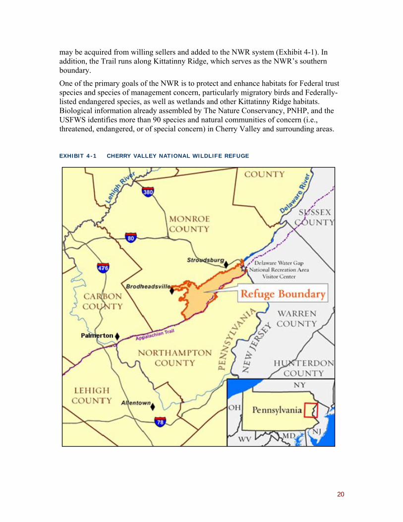
4.2.1 CHERRY VALLEY NATIONAL WILDLIFE REFUGE
The Cherry Valley National Wildlife Refuge (NWR) is located less than 20 miles east of Palmerton along the Kittatinny Ridge. Established in December 2008, the NWR encompasses all of Cherry Valley, adjacent sections of Kittatinny Ridge, and sections of the Delaware River, Brodhead Creek, McMichael Creek, Buckwha Creek, and Aquashicola Creek watersheds, and is adjacent to more than 20,000 acres of land that
3 At this point, the Trustees have not selected the organization(s) that would hold the titles to any purchases or easements; options potentially include the USFWS, agencies within the Commonwealth of Pennsylvania, or non-governmental organizations.
20
may be acquired from willing sellers and added to the NWR system (Exhibit 4-1). In addition, the Trail runs along Kittatinny Ridge, which serves as the NWR’s southern boundary.
One of the primary goals of the NWR is to protect and enhance habitats for Federal trust species and species of management concern, particularly migratory birds and Federally-listed endangered species, as well as wetlands and other Kittatinny Ridge habitats. Biological information already assembled by The Nature Conservancy, PNHP, and the USFWS identifies more than 90 species and natural communities of concern (i.e., threatened, endangered, or of special concern) in Cherry Valley and surrounding areas.
EXHIBIT 4-1 CHERRY VALLEY NATIONAL WILDLIFE REFUGE
21
Cherry Valley ridges and hills are home to nearly 18,800 acres of mixed hardwood and conifer upland forest, with chestnut oak, gray birch, quaking aspen, white pine, and pitch pine populating flat ridge tops once cleared for pasture and logging. Oaks, red maple, black cherry, hemlock and tulip poplar dominate in other areas. Over 40 fish species have been identified within the NWR boundary. For example, Cherry Creek is a second-order stream with well-established riparian vegetation that provides habitat for fish including native brook trout and American eel. The Delaware River and numerous creeks and streams shape portions of the surrounding landscape. In addition to streams and creeks, a variety of forested and open wetlands, totaling nearly 1,750 acres, are located in the valley bottom. A more detailed description of Cherry Valley resources is available in the Cherry Valley National Wildlife Refuge Final Environmental Assessment (USFWS 2009).
The USFWS is currently working with state and local agencies, non-governmental organizations, and private landowners to identify potential parcels for acquisition and easement protection in Cherry Valley. By late 2009 over 100 landowners had expressed interest in participating.
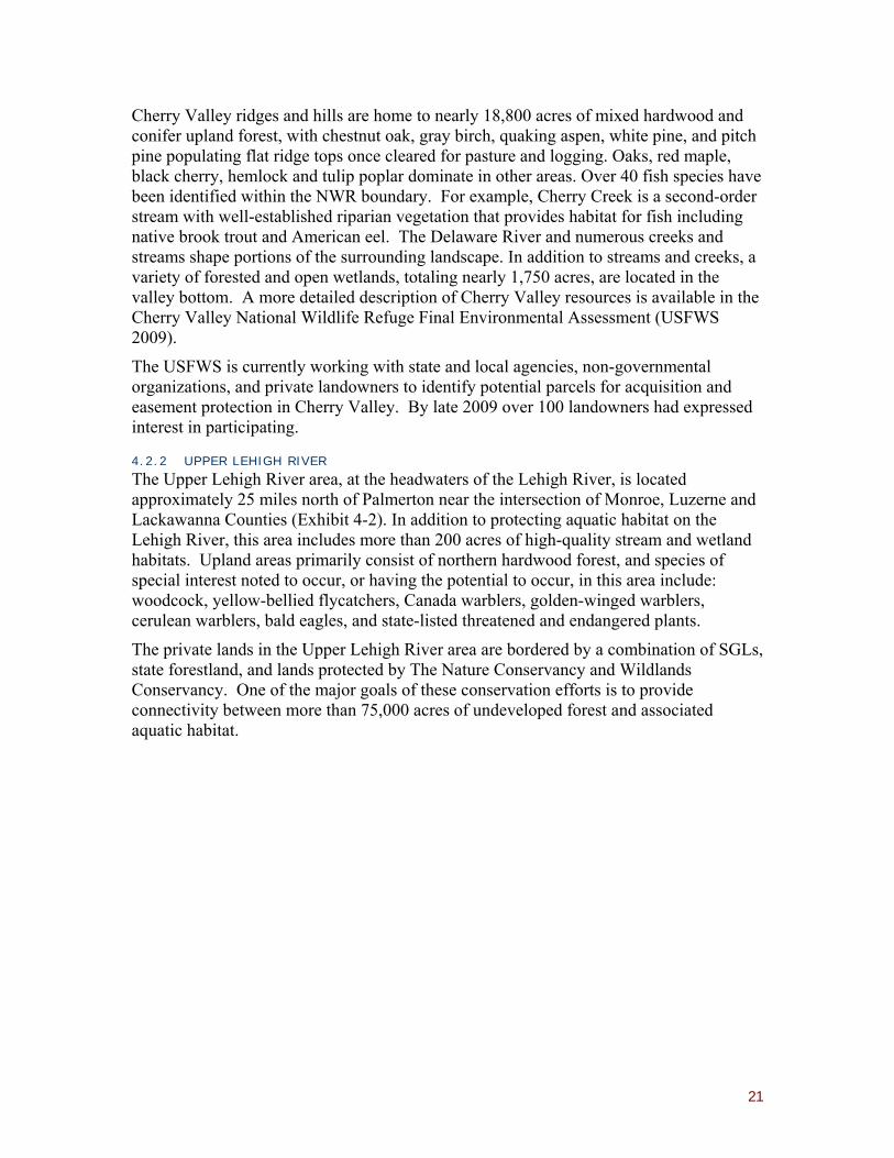
4.2.2 UPPER LEHIGH RIVER
The Upper Lehigh River area, at the headwaters of the Lehigh River, is located approximately 25 miles north of Palmerton near the intersection of Monroe, Luzerne and Lackawanna Counties (Exhibit 4-2). In addition to protecting aquatic habitat on the Lehigh River, this area includes more than 200 acres of high-quality stream and wetland habitats. Upland areas primarily consist of northern hardwood forest, and species of special interest noted to occur, or having the potential to occur, in this area include: woodcock, yellow-bellied flycatchers, Canada warblers, golden-winged warblers, cerulean warblers, bald eagles, and state-listed threatened and endangered plants.
The private lands in the Upper Lehigh River area are bordered by a combination of SGLs, state forestland, and lands protected by The Nature Conservancy and Wildlands Conservancy. One of the major goals of these conservation efforts is to provide connectivity between more than 75,000 acres of undeveloped forest and associated aquatic habitat.

22
EXHIBIT 4-2 UPPER LEHIGH RIVER AREA
4.3 ALTERNATIVE C: HABITAT RESTORATION
Similar in purpose to Alternative B, this alternative would involve actions to restore, enhance, or create contiguous areas of high-quality habitat that could provide natural resource services similar to those that injured habitat would provide in its baseline condition. Actions that would be considered most appropriate for restoration include those that restore forested migratory bird habitat along Kittatinny Ridge or nearby aquatic habitat, including wetlands and migratory fish habitat. As part of this alternative, the Trustees would consider enhancing acquisitions associated with the implementation of Alternative B. As explained in Section 4.7, this option does not include the restoration of injured habitat within the assessment area. While the Trustees have not yet identified candidate habitat restoration projects, the following three project types are considered in this RP/EA.
4.3.1 WETLAND RESTORATION
Wetland restoration may involve returning a degraded wetland or former wetland to a pre-existing condition, converting a non-wetland area (either dry land or unvegetated water) to a wetland, or increasing one or more of the functions performed by an existing wetland beyond what currently or previously existed in the wetland.

23
Although wetland types are diverse, they all possess several ecological characteristics that distinguish them from upland or other aquatic ecosystems. Specifically, wetlands are characterized by unique hydrologic, soil (substrate), and biotic conditions. The hydrological regime, which is determined by the duration, flow, volume, and frequency of water on a site, is typically the primary factor driving the other ecological elements of the system. Restoration efforts are often focused on restoring hydrology. Common methods include crushing drainage tiles, constructing ditch plugs, and installing small berms and water control structures. Additional efforts may include the re-creation of microtopography (small ridges and swales on the land surface) to create a more diverse soil moisture regime, transplanting trees and shrubs, and the addition of coarse woody debris to provide long-term carbon sources and habitat structure. Straw or hay may also be incorporated into restoration projects to stimulate the denitrification process and to provide substrate for aquatic invertebrates. Revegetation may occur naturally or may require active planting and invasive species control.
Wetland restoration projects require permanent easements and monitoring to ensure the long-term protection of these restored habitats. Upon project completion, initial site conditions (including as-built conditions) would be documented to provide baseline information against which changes to the site can be evaluated through long-term monitoring. Monitoring consists of measuring a number of wetland attributes or parameters at regular intervals to ensure that restoration objectives are being achieved, or to identify any need for corrective action. Measurement parameters are tailored to project objectives, but generally include an array of hydrologic, soil, and biological conditions.
4.3.2 AQUATIC HABITAT RESTORATION
Aquatic habitat restoration can focus on streambed or streambank improvements. Streambed improvements include creating pools to provide deeper, cooler spots for fish when water temperatures rise during the summer, providing cover for fish to escape natural and human predation, narrowing stream channels to keep waters deeper and cooler overall, and removing sediment bars. Streambank stabilization reduces or prevents erosion and sediment generation by decreasing the energy impact of the stream on the bank or redirecting that energy away from the bank and back to the center of the stream. This may involve reducing the vertical angle of the bank, planting vegetation on the bank slope, placing boulders in the stream in specific patterns, hardening the bank surface with rocks, or hardening the toe of the slope and planting appropriate vegetation above the toe.
The design of streambank stabilization measures must take into account the expected volume and velocity of water reaching the banks and the fluvial geomorphology of the stream. Considerations include:
• Reduction of upstream stormwater runoff volume might allow for less costly stabilization measures.
• Streambank bioengineering addresses banks that have been vertically eroded. Banks are sloped back to a stable angle then planted with natural or native vegetation.

24
• Boulders may be used at the base of the slope to prevent undercutting of the bank by the stream, and/or to improve epifaunal cover (i.e., substrate suitable for colonization and fish cover, consisting of a mix of snags, submerged logs, undercut banks, cobble or other stable habitat features).
• Vanes may be constructed by placing boulders in the stream in specific patterns designed to direct the energy of the stream flow into the center of the channel and to help create pools in which fish can congregate.
• Skyhooks use a combination of poles, logs, rocks, and posts to deflect water away from a bank and to create cover for fish.
Long-term monitoring of streambed and streambank measures is also required to ensure that restoration goals are achieved and to determine whether a need for corrective action exists.
4.3.3 UPLAND HABITAT RESTORATION
Upland habitat restoration can be accomplished through reforestation, which is generally designed to accelerate forest succession while also providing land stabilization, erosion control, and wildlife habitat. Reforestation best practices involve the establishment of a combination of grasses, legumes, nurse shrubs and trees, and slower growing hardwood trees more or less simultaneously. Grasses emerge first to quickly stabilize the soil surface before yielding to legumes when fertilizer is minimized. The slow-starting, ground-sprawling legumes allow trees to become established and grow before completely covering the ground. Legumes enrich the soil and eventually give way to tree cover. Early successional trees and shrubs condition the site for slower-growing hardwood trees and yield to the hardwoods as they close canopy. Of particular importance is the planting of hard mast species which require a much longer period of time to invade a site naturally. Species of trees with wind-borne seeds, such as sweet gum, tulip poplar, and the maples, will invade a site on their own given time, an appropriate rooting medium, and a less aggressive species as ground cover. Additional measures may include invasive species control and the use of tree tubes or fencing to reduce seedling herbivory. Species should be chosen based on usefulness as food and cover for wildlife, as well as compatibility with forest growth, and long-term monitoring of ecological performance standards is important for adaptive management and to ensure the success of the project.
4.4 ALTERNATIVE D: ENHANCED MIGRATORY FISH PASSAGE
The primary objective of this alternative would be to enhance migratory fish passage on the Lehigh River. Enhanced migratory fish passage would provide compensation for both ecological injuries to aquatic habitat and reductions in recreational fishing services. Dam construction and other anthropogenic impacts have resulted in the extirpation of American shad and other migratory fishes on the Lehigh River in eastern Pennsylvania. For over 30 years, PFBC and partners have been attempting to restore American shad to the Lehigh River through a combination of stocking and fish passage construction at existing dams. Studies of juvenile and returning adult shad have demonstrated that while stocking efforts have been successful at establishing a population imprinted to the Lehigh River, fish passage efforts have been less successful. Four dams are currently in place on

25
the lower Lehigh River: Easton Dam (river mile (RM) 0.0), Chain Dam (RM 3.0), Hamilton Street Dam (RM 17.0), and Northampton Dam (RM 24.0) (Exhibit 4-3). The Easton, Chain, and Hamilton Street dams have engineered fishways. However, monitoring of fishways has determined that shad passage is currently insufficient to support the restoration effort. The Trustees have identified the following two options for enhancing migratory fish passage on the Lehigh River.
EXHIBIT 4-3 DAMS ON THE LOWER LEHIGH RIVER
4.4.1 F ISH LADDER IMPROVEMENTS
Fish passage criteria for American shad and American eel are not well understood. Knowledge regarding the general effectiveness of passage structures for these important East Coast species is based largely on structures originally designed for Pacific salmonids, empirical data, and trial-and-error experiences, and although engineered passageways may have limited functionality in both upstream and downstream passage for shad and eel, these structures have proven to be successful in some cases.
26
A variety of hydraulic and environmental conditions are known to influence passage performance. Potential problems associated with these conditions include: flow regimes that are not conducive to attracting fish to the fishway; physical or behavioral blockages within the fishway; and velocity barriers at the exit. Projects that clearly identify problems, and involve modifications to fishway structures or operation to enhance fishway performance significantly over past performance, would be considered under this option.
4.4.2 PARTIAL OR COMPLETE DAM REMOVAL
While public support for dam removal is generally increasing through recognition of the benefits of restoring aquatic habitat to its free-flowing state, gaining public acceptance for dam removal remains challenging in some instances. Specifically for this NRDAR effort, PFBC is working with dam owners to gather information that would determine the feasibility of total and/or partial dam removal options on the Lehigh River. In December 2009, PFBC submitted a proposal to the American Rivers/NOAA Community Grant Program for funding support to explore the feasibility of removing one or more of the existing dams in the lower Lehigh River. Palmerton restoration funds will be used as the matching funds required for the grant proposal. The focus of the feasibility study is to determine whether the primary and secondary functions of individual dams could be provided by other means; to estimate the costs associated with operation and maintenance of the identified alternatives; and to identify other social, environmental, and engineering issues pertinent to dam removal. Work planned as part of the proposed feasibility study includes:
1. Assessment of water needs currently provided by the dams; 2. Identification of alternative methods of providing water without the dams; 3. Evaluation of impacts to existing infrastructure should the dams be partially or
fully removed; 4. Cost estimates of operation and maintenance for alternative water supply
methods; and 5. Evaluation of localized flooding impacts.
Pending the findings of this feasibility study, additional funding could be used toward the planning and implementation of dam removal projects on the Lehigh River. All such projects would be subject to a separate, comprehensive environmental review and planning process to evaluate the potential effects of the action on human health and safety and the environment, as well as compliance with applicable Federal, state, and local laws.
4.5 ALTERNATIVE E: IMPROVED FISHING ACCESS
This alternative would provide increased fishing opportunities in the Palmerton area to compensate for reduced recreational fishing services on Aquashicola Creek. Specifically, the Trustees propose improvements to recreational fishing access on the Lehigh River between Jim Thorpe and Easton. Access improvements along this section of the Lehigh would be desirable from several perspectives. First, PFBC has received numerous comments from staff, legislators, sportsmen, and organized groups indicating that access is limiting recreational fishing along this section of the river. Second, due to its physical

27
size, the Lehigh can more easily accommodate increased fishing pressure than other nearby streams. Finally, as this section of the Lehigh is near the Site, access improvements would provide benefits to the set of anglers most likely to have been affected by the lack of stocking in Aquashicola Creek.
PFBC, with input from other relevant organizations (e.g., Wildlands Conservancy) has identified over fourteen potential access-related projects in the relevant stretch of the Lehigh River. Eight of these projects have been classified by PFBC as potentially providing a “large” increase in recreational fishing use, while the remaining projects have been classified by PFBC as potentially providing a “small” increase in recreational fishing use. These projected increases in use assume that high-quality signs clearly identify the access points. Projects are summarized and mapped in Appendix A.
4.6 ALTERNATIVE F: TRAIL RESTORATION AND ENHANCEMENT OF THE APPALACHIAN TRAIL
This alternative involves two distinct projects that would provide substantial trail improvements on the Trail near Palmerton and enhance the trail experience for Trail hikers in Pennsylvania. These projects would compensate the public for injuries that have resulted in poor trail conditions and in a diminished hiking experience. The Trustees would consider projects that involve treadway restoration or relocation as well as projects that provide for the long-term protection or enhancement of the “Appalachian Trail Experience” in the broader Pennsylvania area. This includes land-use planning assistance to municipalities adopting zoning in compliance with Pennsylvania Act 24, an unprecedented effort by the state of Pennsylvania to achieve broad protection for the Trail through facilitated, comprehensive land-use planning.
4.6.1 TRAIL RESTORATION
The development and implementation of any trail project must be consistent with NPS policy as set out in the Appalachian Trail Comprehensive Plan (NPS 1981). Furthermore, the Appalachian Trail Conservancy (ATC), as the primary management partner to NPS, works cooperatively with local volunteer trail clubs on trail design, construction, and maintenance projects (e.g., with guidance from the ATC’s Trail Design, Construction, and Maintenance manual; Brichard and Proudman 2000).4 The ATC’s manual provides the standards to which the Trail should be designed, constructed, and maintained, and is internationally recognized as a benchmark for backcountry foot trails. More detailed information regarding trail management can be found in the ATC's Local Management Planning Guide (2009).
For purposes of trail restoration evaluation, the Trail has been divided into the following segments and is illustrated on the map in Appendix B.
• Segment 1: West of Lehigh River, Lehigh Furnace Gap to the top of the east end of Blue Mountain at Lehigh Gap, including the alternate blue-blaze route that parallels the Trail known as the North Trail (approximately 3.3 miles).
4 The Philadelphia Trail Club maintains the 10.3 miles of the Trail within the Assessment area from Little Gap to Lehigh Furnace Gap.

28
• Segment 2: West of Lehigh River (at Lehigh Gap), from the top of the east end of Blue Mountain to the Lehigh River (approximately 1.3 miles).
• Segment 3: East of Lehigh River (at Lehigh Gap) to the Winter Trail junction at the top of the west end of Blue Mountain (approximately 1.3 miles).
• Segment 4: East of Lehigh River (at Lehigh Gap), from the Winter Trail junction at the top of the west end of Blue Mountain to Little Gap (approximately 4.5 miles). As noted earlier in section 2.2.1, this segment is included in remedial activities and is not included in this Alternative.
• Segment 5: West of Lehigh River, from the top of the east end of Blue Mountain along the Devil’s Pulpit side trail (approximately 0.5 miles).
• Segment 6: East of the Lehigh River along the blue-blaze Winter Trail to the junction of the Trail main route at the top of the west end of Blue Mountain (approximately 1.6 miles).
In total, approximately 28,000 linear feet of trail would be restored. The following list describes in detail the typical elements that are included in trail restoration for each segment and the approximate total number of estimated structures for the entire project:
• Treadway Width - The Appalachian National Scenic Trail tread width standard is 18 to 24 inches - a typical backcountry hiking trail.
o The entire trail project will adhere to this treadway width standard.
o Approximately 11,000 linear feet of new trail would be constructed.
• Clearing Width - A typical hiking trail is cleared to a width of four to six feet depending on the vegetation. Trees larger than three to four inches are typically left as long as there is sufficient clearance for hikers to pass.
o The entire trail project would adhere to this clearing width standard.
o Approximately 3,000 linear feet of clearing would be necessary to achieve this standard.
• Full Bench Cut - This trail tread creation technique involves the cutting of soil and stone out of a slope to create a surface on which to hike. The surface is out-sloped to drain water. A back slope is cut to prevent the soil material from above from slumping into the trail treadway. The material removed may be used as fill elsewhere on the trail or it may be scattered below the cut.
o Approximately 10,000 linear feet would be cut.
• Stone Cribbing - These structures can be found either below the trail treadway to provide support or above the treadway to retain a slope above the trail. The base of a crib wall usually starts six inches below the mineral soil line and is built up to the level of the trail treadway. Stone cribbing can be constructed using the dry stack method of stone placement or by using larger stones which are “toothed” into position. The latter method is used when only one stone high

29
is necessary (usually up to about 24 inches). The dimensions are expressed as sq. ft. which is the area of the crib face. Stone cribs extend into the hillside a minimum of one foot.
o Approximately 3,000 cubic feet of stone cribbing would be installed.
• Stone Steps - These erosion control structures will be calculated with a nine-inch rise and 14-inch run. Gargoyles, that is, stones placed on either side of stone steps to keep hikers on the steps, would be placed on either side of each step and extend a minimum of six inches above the step tread. Each step would require a maximum of two gargoyles.
o Approximately 1,200 stone steps would be installed.
• Stone Tread - For the purposes of this evaluation, stone tread refers to treadway sections that cross stone talus slopes or areas of pure stone where there is a need to re-arrange the stones to create a reasonably passable trail surface. Larger sloping stones may be leveled and void between stones filled with other stone to create a stable treadway.
o Approximately 1,000 linear feet of stone tread would be installed.
• Tread Reshaping - This action is proposed where the tread is slightly entrenched and the tread can be reshaped to allow for cross drainage. This activity may require filling the entrenched treadway to build up sufficient material to create an out-slope.
o Approximately 2,000 linear feet of tread would be reshaped.
• Drainages - Rock Waterbars - These structures are installed to divert water off of a trail. Stones are installed in a “shingle” fashion to shed water off the trail. In general, the drainages would be installed at approximately 50-foot intervals. On steeper trails, stone steps are typically needed just below the installation of a rock waterbar. One to two steps are needed depending on the trail grade.
o Approximately 100 drainage diversion structures would be installed.
• Turnpike with Cross Drains - This structure raises the trail tread by retaining both sides of the trail with stone, filling with crushed stone, and then surfacing with mineral soil. Subsurface water can seep through the crushed stone while surface water passes through the structure at the cross drain gaps. The cross drains can have a step stone placed within them to aid in crossing over the drain.
o Approximately 200 linear feet of turnpike would be installed.
Additional planning and design is required to validate the above recommendations and to determine both final trail routing and the specific location of trail structures.
4.6.2 ENHANCEMENT OF THE APPALACHIAN TRAIL
The second portion of this alternative calls for actions that would enhance the Trail. Specifically, the project would provide funding to assist with the implementation of Pennsylvania Act 24 of 2008 (amending the 1978 Pennsylvania Appalachian Trail Act).

30
Act 24 is an unprecedented effort by the state of Pennsylvania to recognize and protect the significance of the Appalachian National Scenic Trail. With the passage of Act 24 in June 2008, 58 Pennsylvania municipalities must:
…take such action consistent with applicable law, as at least an interim measure, to preserve the natural, scenic, historic and aesthetic values of the trail and to conserve and maintain it as a public natural resource. Such action shall include the adoption, implementation and enforcement of zoning ordinances as the governing body deems necessary to preserve those values.
The Pennsylvania Department of Community and Economic Development had previously assisted municipalities in complying with these provisions, but no longer has sufficient funding.
The full implementation of Act 24 would require substantial investment to assist the 58 municipalities adjacent to the Trail. Funding would be used to support a three-pronged strategy:
• Financial support, through matching funds or other measures, to assist county and municipal assessments and development of land-use ordinances.
• A professional with land-use planning expertise and intimate familiarity with the Pennsylvania municipal planning code to provide technical assistance and management for Act 24 implementation in the counties and municipalities along the Trail.
• Support for a number of complementary activities that would provide additional value to the Trail communities and encourage municipal decision makers and landowners to make land-use decisions that better protect the Appalachian National Scenic Trail as a resource.
4.7 ALTERNATIVES CONSIDERED, BUT NOT PURSUED
The Trustees identified, but eliminated from further evaluation, four additional restoration alternatives: on-Site habitat restoration, additional fish stocking, non-Trail restoration, and the construction of an Appalachian Trail bridge.
4.7.1 ONSITE HABITAT RESTORATION
The Trustees considered the potential benefits of projects intended to restore contaminated habitats if completed or ongoing remedial efforts at the Site fail to return the injured resources to their baseline condition. The Trustees chose not to evaluate on-site upland and aquatic habitat restoration alternatives after considering technical feasibility, the possibility that restoration actions would result in additional injury, the actions’ likelihood of success, anticipated recovery times, and projected costs relative to anticipated benefits. Remedial revegetation efforts are in progress at the Site and NPS and PGC are working closely with EPA, PDEP and the PRPs in an effort to incorporate methods that will promote long-term forest restoration. Despite the current successes of revegetion efforts in establishing warm season grasses, the feasibility of restoring a
31
healthy sustainable forest remains uncertain due to problems with soil contamination, low soil fertility, and lack of soil, and will likely require many decades to achieve.
Injuries to the aquatic habitat are primarily a result of surface water and sediment contamination and are expected to gradually recover over time once contamination sources are eliminated. As described in the Trustee Sediment Study (2007a), Aquashicola Creek and the Lehigh River are both efficient at mobilizing sediment, making the feasibility of locating and removing significant levels of metals from the system extremely challenging and of uncertain benefit. The Trustees have noted progress by EPA and the PRPs in reducing sediment and surface water contamination from the Site, and believe that the actions ultimately approved for implementation at Palmerton will be protective of human health and the environment.
4.7.2 F ISH STOCKING
PFBC often receives proposals to stock fish to offset pollution-related stream impacts, but generally finds such proposals to be insufficient and inappropriate. Such a “quick fix” does not stock fish in a manner that is consistent with PFBC statewide policy, and would not provide the sustainable long-term benefits needed to compensate anglers sufficiently for decades of reduced fishing opportunities. Application of PFBC policy to area waters has resulted in stocking rates that are optimal when considering resource attributes and angler opportunities (PFBC 1997). For example, upstream sections of Aquashicola Creek are either stocked at the optimal prescribed rate or contain sufficient wild trout to make any additional stocking counter to statewide programs and policies.
Stocking trout in the Lehigh River is also rejected. PFBC limits large systems such as the Lehigh River downstream of Jim Thorpe in its stocked trout program because stocking would not result in a catch rate and number of angler trips comparable to the higher rates associated with smaller systems.5 In addition, the river’s temperature regime is unsuitable for stocking adult trout downstream of the confluence of Sandy Run. PFBC is evaluating fingerling trout stocking success and is conducting a temperature modeling and water quality study with PDCNR and the Corps of Engineers to further evaluate temperature issues.
4.7.3 TRAIL RESTORATION ELSEWHERE
The Trustees considered the benefits of funding new trail construction or restoration of trails other than the Appalachian Trail. Recognizing that alternative trails also benefit the hiking community and that numerous alternative projects exist, the Trustees also acknowledge the unique nature of the nation’s longest marked and protected footpath and first national scenic trail, and believe that service reductions associated with the Trail can only be restored through its grassroots volunteer caretakers. As noted in the Appalachian Trail Comprehensive Plan (NPS 1981):
The “soul” of the Appalachian Trail is what has distinguished it over the years from all other trails. This soul results from the high level of participation by the people who live along it and provide for its care and
5 PFBC stocks adult trout in the Lehigh River downstream to Sandy Run (RM 66.77), which is upstream of the assessment area.
32
maintenance. The Trail has been attended to by the many, without direct supervision, which makes it basically a grassroots undertaking. It reflects the personalities of thousands of persons who have devoted their energies to the Trail because they love it. Volunteers with little means help keep the Trail a simple footpath.
4.7.4 APPALACHIAN TRAIL PEDESTRIAN BRIDGE
The Trail currently crosses the Lehigh River on the Route 873 road bridge, and then is located on the road shoulder of Route 248 before crossing that road and entering NPS lands. In all, it is an approximately 2,000-foot road walk. Managers seek to locate the Trail off of and away from roads to the extent feasible in order to provide both a safe and enjoyable trail experience. A grade-separated pedestrian footbridge to carry visitors across Route 248 would reduce the distance the trail is located on the road shoulder and provide for a safe crossing. The Trustees considered the benefits of constructing a bridge at this location, but determined that the cost (as estimated by the Federal Highway Administration) would be prohibitive and that the benefit would be concentrated on a very small segment of Trail relative to the overall need to improve Trail conditions within the Palmerton site.
33
5.0 EVALUATION AND SELECTION OF THE PREFERRED ALTERNATIVES
This chapter presents an evaluation of the restoration alternatives described in Chapter 4. The Trustees’ primary goal is to select one or more restoration alternatives that sufficiently compensate the public for natural resource injuries and associated service losses resulting from exposure of these resources to Site-related metals in the aquatic and terrestrial habitats of Aquashicola Creek, the Lehigh River, Blue Mountain, and Stony Ridge. The Trustees believe that the most significant of these injuries and service losses resulted from: 1) reductions in the level and value of recreational activities such as fishing, hunting, and hiking; 2) changes in forest management opportunities; and 3) the ecological effects of elevated metals in the environment.
In accordance with the DOI regulations and site-specific characteristics, the factors considered by the Trustees in the evaluation of alternatives include:
1. Technical feasibility (i.e., whether it is possible to implement the alternative);
2. The relative cost-effectiveness of different alternatives (i.e., if two alternatives are expected to produce similar benefits, the least costly one is preferred);6
3. The probability of project success (i.e., the likelihood that implementing the alternative would produce the desired results);
4. The ability of the natural resources to recover with or without each alternative, and the time required for such recovery;
5. The potential for collateral injury to the environment if the alternative is implemented;
6. Proximity and benefit to the affected natural resources and services;
7. Potential for multiple resource benefits;
8. Potential partnerships for matching funding;
9. The results of actual or currently-planned response actions;
10. Potential effects on public health and safety; and
11. Compliance with applicable Federal and state laws. 6 Cost estimates are based on information from Federal, state, and other organizations, including the FWS Partners for Fish & Wildlife Program, PFBC, The Nature Conservancy, the Natural Resource Conservation Service (NRCS), and professional judgment. All costs are presented in 2010 dollars (2010$). Costs are presented as unit costs when information is not available to determine the total likely scale of an alternative—for instance, the number of acres of land that may be available for acquisition or easement protection. Cost estimates are approximations based on information available at the time of this report; costs are expected to vary over time and these variations may be substantial. Government agencies are required to pay fair market value when they acquire land. Fair market value is determined through established appraisal procedures. The cost information developed in this report is intended to be of sufficient detail and reliability for purposes of general prioritization of restoration alternatives. Cost estimates therefore do not precisely represent the expected costs that would be incurred for each alternative. In addition, due to rounding, cost totals may not match the sum of their underlying cost elements.

34
5.1 EVALUATION OF ALTERNATIVE A: NO ACTION
Under the No Action alternative, the public would not be fully compensated for injuries to trust resources, including upland and aquatic habitats, or for associated reductions in ecological and human use services.
Under the No Action scenario, natural resources in the Palmerton area would continue to be influenced by a variety of ongoing ecological stressors, including development, mine site and industrial point source discharges, agricultural non-point source discharges, and other factors. The absence of Trustee-funded restoration activity under the No Action alternative therefore implies lower environmental quality and reduced natural resource services within the region than if restoration projects were implemented.
Some of the natural resources and services impacted by Site metals may recover naturally. However, this recovery would be slow and may fall short of conditions achieved through active restoration efforts. In contrast, the recovery of injured natural resources and services could be expedited with the implementation of restoration projects.
Although the No Action alternative provides a useful reference point for characterizing the impact of the other restoration alternatives as required by NEPA, it fails to fulfill the Trustees’ mandate under CERCLA. The Trustees are required under CERCLA and the terms of the 2009 Palmerton Consent Decree, to use the settlement funds to restore, replace or acquire the equivalent of injured resources. Therefore, the Trustees do not consider No Action a viable alternative.
5.2 EVALUATION OF ALTERNATIVE B: LAND ACQUIS ITION/EASEMENT PROTECTION
Throughout Pennsylvania, development pressure continues to threaten natural resources. Therefore, the preservation of contiguous areas of high-quality habitat that provide services similar to those injured by the release of metals from the Palmerton Site is considered highly desirable. Such preservation, whether through acquisition or easement protection, could meet all of the selection criteria described above. Options associated with the Cherry Valley NWR are attractive because they would preserve forested migratory bird habitat along Kittatinny Ridge, provide viewshed protection and additional trail access along the Appalachian Trail, and preserve nearby aquatic and wetland habitat. Additional benefits include: opportunities for partnerships with the USFWS Refuge System and locally active conservation organizations, permanent protection and management by the NWR, and potential benefits to local hunters and anglers. Furthermore, NEPA requirements for the acquisition of property within the NWR have already been satisfied by the Cherry Valley Environmental Assessment (USFWS 2009).
The costs of acquisitions and easements will depend on a variety of factors including parcel size, habitat type, and the current market.
Habitat preservation in the Upper Lehigh River area is also considered highly desirable, with benefits that include the preservation of high-quality streams and pristine wetland habitat. Such headwaters protection would also provide indirect benefits to migratory fish and recreational fishing many miles downstream.

35
The Blue Ridge Real Estate Company owns large tracts of land in the upper Lehigh River area and is actively selling and developing lands for residential use. These large tracts are estimated to range in cost from one to several million dollars. Potential acquisition partners for these lands include PGC, PDCNR, Monroe County, Lackawanna County, The Nature Conservancy, and Wildlands Conservancy.
As compared to the No Action alternative, the risks of habitat preservation are few, once preservation actions are complete resource benefits are immediate, and protection on a habitat scale benefits multiple resources. The Trustees are also confident that the managerial and logistical issues of habitat preservation would be successfully resolved. Therefore, the Trustees have identified Alternative B as a component of their preferred restoration plan for the Palmerton Site.
5.3 EVALUATION OF ALTERNATIVE C: HABITAT RESTORATION
The habitat restoration options described in Chapter 4 - wetland restoration, stream restoration, and reforestation - all have the potential to accomplish the primary goal of compensating the public for injuries to trust resources and associated service reductions, and would also satisfy a number of the other evaluation criteria. Wetland restoration is technically feasible and can be successful at restoring a variety of wetland functions, but many challenges exist in trying to duplicate all the characteristics of undisturbed wetlands (e.g., hydrology, soil parameters). Often, wetland enhancement can improve a specific function, such as waterfowl habitat, but this typically comes at the expense of other functions. Wetland restoration costs vary widely depending on the amount of required grading, planting, and types of water control structures, but typically range from $10,000-$200,000 per acre. Thus, existing alternatives for acquisition/easement protection and potential enhancement of wetlands in the region is more cost effective and would likely provide greater ecological benefits.
Stream restoration can also be technically feasible and successful in restoring a variety of habitat functions and enhancing recreational fishing. The challenge lies in finding suitable sites that, once restored, would provide adequate compensation for the nature and extent of aquatic injuries and reduced services associated with the Palmerton Site. In addition, at an estimated cost of $75-$150 per linear foot, such restoration projects are only cost effective if they provide appreciable benefits over a substantial area of stream (Valley Creek Trustee Council 2004).
Reforestation can be expensive and uncertain. Although replanting costs are typically low ($50-$200 per acre depending mainly on the level of required site preparation), this does not include the cost of permanent easement protection and long-term monitoring, which would be a minimum requirement for projects conducted on private lands. In addition, recovery times for forested habitat are slow, and it would take many years before the public realized full compensation. Similar to stream restoration, the principal difficulty with this option is associated with finding suitable sites that, once restored, would provide adequate compensation for the nature and extent of habitat injury associated with the Palmerton Site.

36
Due primarily to high projected costs (relative to the other alternatives) and the challenge of identifying suitable habitat restoration sites, the Trustees are not including Alternative C as an independent component of the preferred restoration alternative. The Trustees will consider habitat enhancement as a component of lands acquired or protected by easements under Alternative B.
5.4 EVALUATION OF ALTERNATIVE D: ENHANCED MIGRATORY FISH PASSAGE
Fish passage enhancements are critical to the restoration of migratory fish on the Lehigh River. Other types of aquatic habitat improvements will be of lesser benefit to migratory and resident fish if these fish are unable to freely move up- and downstream in sustainable numbers. Substantial effort and cost have gone into the development and monitoring of fish ladders at the river’s lower three dams, but the rates of passage remain too low to achieve restoration of relevant fish species such as the American shad. While improvements to fish ladder structures and management may provide modest increases in the rates of fish passage, the Trustees believe that total or partial removal of dams has the highest likelihood to improve fish passage to levels that will support establishment of a healthy American shad population in the Lehigh River watershed.
Dam removal also has widespread ecological benefits. It can restore a river’s ecological functions and critical habitat by improving sediment transport and water quality, allowing greater movement of fish and other riverine species, and restoring natural flow. When river habitat and natural flow fluctuations are restored, natural diversity and populations of river and riparian species increase. For example, changes in flooding regime may promote riparian plant growth, revitalize inland wetlands, and create small ephemeral ponds that serve as nurseries for aquatic species. Dam removal may also reduce flooding upstream from the dam site due to an increase in the channel’s capacity to carry water. When a dam is removed, natural riparian corridors and riverside lands can be restored, with benefits for native fish, birds, plants, insects, and other wildlife.
Dam removal also eliminates impounded habitat and may reduce or change the type of riparian wetland habitat. Species that prefer the languid flow and organic profile of the impoundment will now find themselves in unsuitable habitat. Depending on the species of concern and the presence of other lakes, reservoirs, or impoundments in the region, this may or may not be a positive outcome.
Changes in flow and water levels due to dam removal, however, may have some short-term adverse impacts. Dam removal may increase the frequency of flooding in some riparian areas, potentially harming wildlife and human property. The release of sediments from the impoundment behind the dam can cause short-term turbidity or decreased water quality in the river that could temporarily harm fish and wildlife. Additionally, when a dam’s impoundment is drawn down, previously stable riparian soils may become unstable and subject to erosion, possibly requiring human intervention (e.g., streambank stabilization with plantings and shaping) to limit any negative potential impacts on buildings, roadways, and other infrastructure. These potential impacts are considered in development of a breach plan typically reviewed by state authorities.
37
Removing the first four downstream dams on the lower Lehigh River would open nearly 75 miles of spawning and rearing habitat for migratory fish. Resident fish would also benefit from improved passage. Evaluating this option is necessary to determine if meaningful fish passage options exist for the Lehigh River and whether or not partial or complete dam removal is feasible. Actual dam removal or modification costs vary according to site needs and conditions, and typically range from about $250,000 to $2,000,000 depending upon the structure and its location. Costs for fish passage improvement also vary based on site-specific conditions and requirements. The cost of habitat improvement after removal of the Lehigh River dams could involve costs for channel modification, hydraulic modification, and bank stabilization and would need to be determined on a project-specific basis. In some cases, the Trustees also need to consider the cost of providing an alternative water supply.
Based on this evaluation, the Trustees have provided $75,000 as matching funds for a grant from NOAA and American Rivers for a dam removal feasibility study as an element of the Trustees’ preferred restoration alternative. The study will identify the engineering concepts of both partial and complete dam-removal projects as well as the effects of removal on the historic canal in Delaware State Park (owned and managed by PDCNR). The canal is supplied with water from the Lehigh River at a point just above the Easton Dam. The feasibility study will address alternative methods for irrigating the canal, associated costs, and the effect of the dam’s removal on the surrounding human population.
The Trustees also support the funding of future dam removal projects on the Lehigh River pending positive outcomes of the feasibility study and project-specific environmental, social, and financial assessments. The level of available funding for such potential projects is difficult to determine at this time, but will be balanced with the costs of other aquatic habitat and recreational fishing options selected in this plan. Similar to the No Action alternative, the feasibility study has no impact to the environment. The future selection of dam removal projects would require a publicly reviewed amendment to this RP/EA to evaluate the project and its environmental impacts. The Trustees also note that a conclusion that dam removal is feasible does not guarantee dam owners’ permission for removal.
Because stakeholder interests are intimately bound up with both the Lehigh River and the Delaware Canal, PFBC and the PDCNR intend to keep the public apprised of significant actions the agencies consider. Through ongoing notifications and public meetings, in addition to those described in Section 1.3 of this document, the public will be invited and encouraged to participate and provide input on these projects. Therefore, Alternative D is selected as a component of the Trustees’ preferred restoration alternative.
5.5 EVALUATION OF ALTERNATIVE E: IMPROVED FISHING ACCESS
Improvements to existing access areas and creation of new access areas on the Lehigh River would provide substantial compensation for reduced recreational fishing opportunities associated with Site-related contamination. While habitat acquisition (Alternative B) may provide limited additional fishing opportunities, and migratory fish enhancement (Alternative D) has long-term potential for significantly increasing fishing

38
opportunities, improved fishing access is the only option that would directly and sufficiently compensate the public for reductions in recreational fishing services.
Compared to the No Action alternative, the environmental impacts of the proposed projects are anticipated to be minor and in many cases beneficial. All of the proposed sites, which range from existing formal and informal access areas to local riverside parks, have access roads or trails. Improvements to the roads, parking lots, trails, and boat ramps may cause minor short-term impacts to the environment but will help to reduce erosion, promote bank stabilization, reduce impacts to riparian vegetation, and improve user safety. Negative impacts would primarily be associated with increased use, which can result in minor increases in traffic, noise, and litter. Alternative locations in lieu of those listed in Appendix A will be considered if access at the designated locations proves impractical or is not cost effective.
The approximate costs for the proposed access-related projects are $70,000 per small sites and $200,000 per the larger sites. The total cost will depend on the actual number of sites that are improved.
Based on this evaluation the Trustees believe improved fishing access is the most cost-effective approach for meeting the goal of restoring recreational fishing services in the vicinity of Palmerton. Therefore, Alternative E is selected as a component of the Trustees’ preferred restoration alternative.
5.6 EVALUATION OF ALTERNATIVE F: TRAIL RESTORATION AND ENHANCEMENT OF THE APPALACHIAN TRAIL
This alternative is broken into two distinct projects. The first is the restoration of the Trail treadway and the second is the enhancement of the trail experience. These projects would compensate the public for injuries that have resulted in poor trail conditions and in a diminished hiking experience. In addition, the improvements are technically feasible, have a high probability of success, are cost-effective, are unlikely to result in collateral injury to natural resources, pose little if any risk to public health, and are compliant with applicable laws and policies.
In total, the trail restoration actions would restore the injured segments of the Trail to design and construction standards. Cost to complete this work has been estimated based on an initial technical review. The final planning and design would be approximately $55,000. This includes the development of specific trail layout recommendations and trail construction specifications. The construction restoration cost for all segments is estimated to be $670,000. This assumes that the work would be completed by a professional trail contractor. However, it is likely that a combination of professional and volunteer efforts would be used to complete the project; this increases the likelihood that the project will be completed on – or under – budget. An additional $55,000 is required for project oversight and administration. In total, completion of the project is estimated to be $780,000. The final design would influence this estimate.
Compared to the No Action alternative, the environmental impacts of the proposed trail improvements are anticipated to be minor and generally beneficial. Trail restoration will reduce erosion, promote slope stability, improve hiker safety, and reduce impacts to

39
trailside vegetation. The methods proposed are in compliance with NPS standards for trail work on the Trail and commonly used elsewhere on the Trail.
The Trustees recognize that the passage of Pennsylvania Act 24 is a seminal event and represents an historic opportunity to confront an important, but complicated, challenge. Large landscape protection across 58 municipalities is a daunting task and while statutory authority helps, it can also create the impression of an unfair mandate. Developing land-use ordinances at the municipal level is an expensive endeavor, and assistance to the municipalities is critical to the success of the Act. The cost estimate for this assistance is $500,000; this represents only a portion of the full funding necessary. Support for the full implementation relies on a combination of public and private funds. Without Federal resources for matching funds, most of those sources of private funds will be inaccessible. This funding is only one piece of a funding strategy, but it is the most critical. It would allow Pennsylvania’s effort to become a national model for large landscape protection. In fact, it may lead to similar efforts to protect the Trail in the other 13 states and be used as a model for other National Scenic Trails. As compared with the No Action alternative, support of landscape protection in accordance with Act 24 will have no negative impacts on the environment and will help to protect the natural, scenic, historic and aesthetic values of the Trail, assuring a high-quality visitor experience for future generations.
The Trustees support both the short-term project to restore the Trail in the vicinity of Palmerton and the long-term strategy to assist Pennsylvania municipalities successfully implement the protections provided by Act 24. Both of these actions will directly compensate the public for reductions in hiking-related services and values. In both cases, the long-standing tradition of cooperative management and volunteer engagement will be used to leverage available funding. Therefore, the Trustees have selected Alternative F as a component of the preferred restoration alternative.

40
6.0 PREFERRED RESTORATION ALTERNATIVES SUMMARY
The Trustees evaluated seven general restoration alternatives that address natural resource injuries and service reductions resulting from the release of metals from the Site. Based on a variety of criteria described in Chapter 5, the Trustees then selected four Preferred Alternatives as summarized in Exhibit 6-1.
The cumulative impact of the Preferred Alternatives, in which all of the projects act synergistically, will be positive. The combination of habitat protection, enhanced migratory fish passage, improved fishing access, and Trail restoration and enhancement, will improve, enhance, and protect the natural environment and will have individual as well as cumulative positive impacts. No negative cumulative impacts have been identified. The result of the restoration projects, along with past, present, and ongoing initiatives by municipalities, conservation and environmental groups, and state-sponsored programs, will be a positive improvement to the natural resources and public enjoyment of those resources on a widespread, regional basis.
EXHIBIT 6-1 PREFERRED RESTORATION ALTERNATIVES
ALTERNATIVE BENEFITS ENVIRONMENTAL IMPACTS
Habitat Acquisition/Easement Protection Cherry Valley National Wildlife Refuge
Lehigh River Headwaters
Other areas on Kittatinny Ridge and the Lehigh River
Preserves high-quality upland and aquatic habitats, provides view-shed protection and access to the Trail, and restores fishing opportunities.
Potential for minor impacts associated with increased visitor use.
Enhanced Migratory Fish Passage Lower Lehigh River Dam Removal
Feasibility Study
Supports initial steps needed for migratory fish restoration, free-flowing aquatic habitat restoration, and increased fishing opportunities.
Feasibility study: No impact.
Future dam removal: To be determined on a project specific basis.
Improved Fishing Access Lehigh River
Restores a high level of good-quality fishing opportunities in the Palmerton area.
Minor stream bank impacts associated with boat ramp improvements; minor impacts associated with increased visitor use.
Trail Restoration and Enhancement of the Appalachian National Scenic Trail
Appalachian National Scenic Trail
Enhances hiker opportunities and restores trail conditions, improves trail stability and hiker safety. Reduces erosion and impacts to trailside vegetation. Provides enhanced trail protection and protects visitor hiking experience.
Impacts of the proposed trail restoration are expected to be minor and generally beneficial. No negative impacts are expected from the trail enhancement work.

41
7.0 PUBLIC COMMENTS AND TRUSTEES RESPONSES
This section will be completed in the Final RP/EA following the 30-day public review and comment period on the Draft RP/EA.

42
8.0 LITERATURE CITED
ATC (Appalachian Trail Club). 2009. ATC's Local Management Planning Guide. http://www.appalachiantrail.org/site/c.mqLTIYOwGlF/b.4805659/k.DD0E/Policies.htm#LMPG
Besser J.M., Brumbaugh B. and C. Ingersoll. 2009. Ecotoxicology studies with sediment, pore water and surface water from the Palmerton Zinc site. Presentation Report. Columbia Environmental Research Center, USGS, Columbia Missouri. http://www.fws.gov/contaminants/restorationplans/palmerton/Besserposter.pdf
Beyer, W.N. 1988. Damage to the Forest Ecosystem on Blue Mountain from Zinc Smelting. Paper presented at Trace Substances in Environmental Health-XXII Symposium, University of Missouri, Columbia.
Beyer, W.N., Krafft, C., Klassen, S.P., Green, C., and Rufus Chaney. (2010 submitted) Relating forest injury near Palmerton, PA, to zinc contamination from smelting. Env. Tox. and Chem.
Beyer, W.N., G.W. Miller, and E.J. Cromartie. 1984. Contamination of the O2 soil horizon by zinc smelting and its effect on woodlouse survival. Journal of Environmental Quality 13(2): 247-251.
Beyer, W.N., O.H. Pattee, L. Sileo, D.J. Hoffman, and B.M. Mulhern. 1985. Metal contamination in wildlife living near two zinc smelters. Environmental Pollution 38: 63-86.
Beyer, W.N. and G. Storm. 1995. Ecotoxicological Damage from Zinc Smelting at Palmerton, Pennsylvania. In: Handbook of Ecotoxicology, Hoffman, B.A., G.A. Burton Jr., and J. Cairns, Jr. (eds.). Lewis Publishers, CRC Press, Inc., Boca Raton, FL. 755 pp.
Bilger, M. and J. Eichman. 2008. Final Report To Assess the Status of the Benthic Macroinvertebrate and Periphyton Communities Within the Vicinity of the Palmerton Zinc Pile Superfund Site, Palmerton, Carbon County, PA 2006-2007. EcoAnalysts. Prepared for the Palmerton Zinc Pile Superfund Site Natural Resource Damage Assessment Trustee Council.
Brichard Jr. W. and R.D. Proudman. 2000. Appalachian Trail Design, Construction, and Maintenance (2nd Edition). Harpers Ferry: Appalachian Trail Conference.
Buchauer M.J. 1973. Contamination of soil and vegetation near a zinc smelter by zinc, cadmium, copper, and lead. Environmental Science and Technology 7:131-135.
Carline, R.F. and G.J. Jobsis. 1989. Effects of Heavy Metal Contamination on Aquatic Fauna in the Vicinity of the Palmerton, Pennsylvania, Smelters. Final report

43
prepared for the U.S. Fish and Wildlife Service Ecological Services Field Office, State College, PA. August.
Connick, K. and J. O’Mahoney (eds.). 2004. Appalachian Trail Thru-Hikers’ Companion. Harpers Ferry: Appalachian Trail Conference.
EPA (US Environmental Protection Agency). 2002. EPA Explanation of Significant Differences: Palmerton Zinc Pile, EPA ID: PAD002395887, OU 02, Palmerton, PA. EPA 1987a. EPA Superfund Record of Decision: Palmerton Zinc Pile, EPA ID: PAD002395887, OU 01, Palmerton, PA. http://www.epa.gov/reg3hwmd/super/sites/PAD002395887/index.htm
EPA. 2001. Final Draft Palmerton Zinc Site Ecological Risk Assessment, Volumes 1-7. February.
EPA. 1993. Hazardous substances source identification study, Palmerton Zinc CERCLA NPL Site, Carbon County, Pennsylvania. Enforcement Confidential Report EPA-330/2-94-029. Prepared by the National Enforcement Investigations Center, Denver, Colorado. Three volume set.
EPA. 1988. EPA Superfund Record of Decision: Palmerton Zinc Pile, EPA ID: PAD002395887, OU 02, Palmerton, PA.
EPA. 1987a. EPA Superfund Record of Decision: Palmerton Zinc Pile, EPA ID: PAD002395887, OU 01, Palmerton, PA.
EPA. 1987b. Palmerton Zinc Superfund Site Blue Mountain Project. Summary of RI/FS Results. Prepared by EPA Region III, Philadelphia, PA. April. 85 pp. + appendices.
Gross, W.E. (ed.). 1998. Guide to the Appalachian Trail in Pennsylvania. Tenth Edition. Cogan Station, PA: Keystone Trails Association. Scherer and Hopey 1998).
Gunson D.E., D.F. Kowalczyk C.R. Shoop, C.J. Ramberg. 1982. Environmental zinc and cadmium pollution associated with generalized osteochondrosis, osteoporosis and nephrocalcinosis in horses. Journal of the American Veterinary Medical Association 180:295-299.
Hawk Mountain Master Biota List. 2007. http://hawkmountain.org/media/biota.pdf
Jakus P.M., Downing M., Bevelhimer M.S. and J.M. Fly. 1997. Do sportfish consumption advisories affect reservoir anglers’ site choice? Agricultural and Resource Economics Review 26:196-204.
Jordan M.J. 1975. Effects of zinc smelter emissions and fire on a chestnut-oak woodland. Ecology 56(1)78-91.
Jordan M.J. and M.P. Lechevalier. 1975. Effects of zinc-smelter emissions on forest soil microflora. Canadian Journal of Microbiology 21:1855-1865.
Kime, R. and G. Moyer. 1986. Aquashicola Creek. Priority Water Body Survey Report. Water Quality Standards Review. Report prepared for Quality Assessment Unit,
44
Division of Water Quality, Bureau of Water Quality Management, Department of Environmental Resources. September.
Kittatinny Project. 2010. Fact Sheet on the Blue-Mountain Kittatinny Ridge. http://pa.audubon.org/kittatinny/facts.html
Lehigh Valley Planning Commission. 1999. Natural Areas Inventory of Northampton and Lehigh Counties. http://www.lvpc.org/lvpc_site/commission/publications.html#natural
LGNC (Lehigh Gap Nature Center). 2010. Lehigh Gap Nature Center. http://lgnc.org.
MacDonald, D.D., C.G. Ingersoll and T.A. Berger. 2000. Development and evaluation of consensus-based sediment quality guidelines for freshwater systems. Arch. Envrion. Contam. Toxicol. 39:20-31.
Nash, T.H. III. 1975. Influence of effluents from a zinc factory on lichens. Ecological Monographs 45:183-198.
NPS (US National Park Service). 1995. Agreement for the Appalachian National Scenic Trail in the Commonwealth of Pennsylvania. 22 pp.
NPS. 1981. AT Comprehensive Plan http://www.appalachiantrail.org/atf/cf/%7bD25B4747-42A3-4302-8D48-EF35C0B0D9F1%7d/CompPlan_web.pdf
PAS (Pennsylvania Audubon Society). 2010. Kittatinny Ridge Bird Checklist. http://pa.audubon.org/kittatinny/birdinfo_checklist.html
PAS. 1999. Important Bird Areas in Pennsylvania: A Guide to Identifying and Conserving Critical Bird Habitat. http://pa.audubon.org/Book/ch2.pdf
PDEP (Pennsylvania Department of Environmental Protection). 1988. Aquashicola Creek, Carbon, Monroe, and Northampton Counties, Special Protection Evaluation Report, Water Quality Standards Review. Quality Assessment Unit, Division of Water Quality, Bureau of Water Quality Management. November.
PFBC (Pennsylvania Fish and Boat Commission). 2007. Lehigh River Management Plan. http://www.fishandboat.com/newsreleases/2007/lehigh_fm_plan.htm
PFBC. 1997. Management of Trout Fisheries in Pennsylvania Waters. Report prepared for Bureau of Fisheries Division of Fisheries Management. 3rd Edition (November).
PGC (Pennsylvania Game Commission). 2004. About the Pennsylvania Game Commission. http://www.portal.state.pa.us/portal/server.pt/community/aboutus/9113
PGC. 2003. Forest Wildlife Management Plan State Game Lands 217. Forestry Division, Bureau of Land Management. January.
Scherer, G. and D. Hopey. 1998. Exploring the Appalachian Trail. Hikes in the Mid-Atlantic States. Mechanicsburg, PA: Stackpole Books.
Sileo, L. and W.N. Beyer. 1985. Heavy metals in white-tailed deer living near a zinc smelter in Pennsylvania. Journal of Wildlife Diseases 21(3): 289-296.

45
Storm, G.L., G.J. Fosmire, and E.D. Bellis. 1994. Persistence of metals in soil and selected vertebrates in the vicinity of the Palmerton Zinc smelters. Journal of Environmental Quality 23(3): 508-514.
Storm G.L., R.H. Yahner, and E.D. Bellis. 1993. Vertebrate abundance and wildlife habitat suitability near the Palmerton zinc smelters, Pennsylvania. Archives of Environmental Contamination and Toxicology 25:428-437.
Strojan, C.L. 1978. The impact of zinc smelter emissions on forest litter arthropods. Oikos 31: 41-46.
Trustees (Palmerton Natural Resource Trustee Council). 2008a. Aquatic Investigations: Evaluation of Injury to Aquatic Habitat Resulting from Metals Contamination. January
Trustees. 2008b. Forest Investigations: Evaluation of Injury to Forest Habitat Resulting from Metals-Contaminated Soils. January.
Trustees. 2008c. Appalachian Trail Hiking Study: Assessment of Hiking Activity in Areas Potentially Impacted by Contamination. January.
Trustees. 2007a. Data Report for the Scoping Study on Metal Contaminant Levels in Sediment and Concurrent Aquatic Habitat Evaluation for the Palmerton Zinc Natural Resource Damage Assessment, Palmerton, Pennsylvania. January.
Trustees. 2007b. Palmerton Natural Resource Trustee Council. 2007. Data Report for the Scoping Study on Metal Contaminant Levels in Forest Soils and Concurrent Habitat Evaluation for the Palmerton Zinc Natural Resource Damage Assessment, Palmerton, PA. January 30.
Trustees. 2006. Palmerton Zinc Pile Superfund Site Natural Resource Damage Assessment Plan. February.
Trustees. 2003a. Memorandum of Agreement. November. http://www.fws.gov/contaminants/restorationplans/palmerton/palmerton.cfm
Trustees. 2003b. Preassessment Screen Determination for the Palmerton Zinc Pile Superfund Site. December.
USDOJ (US Department of Justice) 2009. Consent Decree in the matter of United States v. Horsehead Industries, Inc., et al., Civil Action No. 3:CV-98-0654, relating to the Palmerton Zinc Pile Superfund Site.
USFWS (US Fish and Wildlife Service). 2009. Cherry Valley National Wildlife Refuge Final Environmental Assessment. http://www.fws.gov/northeast/planning/Cherry%20Valley/finalea.html
Valley Creek Trustee Council. 2004. Valley Creek Restoration Plan. August. http://www.savevalleycreek.org/restorationplan.asp

46
Wills, S.R. 2002. Aquashicola Creek Lower Towamensing Township, Palmerton Borough, Carbon County. Pennsylvania Department of Environmental Protection, Northeast Regional Office, Water Management Program. June.
A-1
APPENDIX A LEHIGH RIVER RECREATIONAL ACCESS DEVELOPMENT OR IMPROVEMENT OPPORTUNITIES
EXHIBIT A-1 PROPOSED RECREATIONAL FISHING PROJECTS
PROJECT NAME RIVER MILE LOCATION CURRENT USE PROPOSED IMPROVEMENT
POTENTIAL INCREASE
IN USE
Packerton 44.5 40° 50’ 58.0˝ 75° 42’ 33.2˝
Informal fishing access and canoe launch site owned by Carbon County.
Develop parking lot and install concrete boat launch.
Large
Lehighton Truss Bridge
43.6 40° 50’ 3.8˝ 75° 42’ 8.3˝
Informal boat launch site located underneath railroad bridge behind Dunbar Bottling Company (on North Main Lane off Rt. 209). Parking is available and site is popular with rafters.
Improve parking lot and access road.
Small
Parryville at Turnpike Bridge
41.2 40° 48’ 59.5˝ 75° 40’ 34.4˝
Informal boat launch site located downstream of turnpike bridge and accessed by crossing footbridge over the Lehigh Canal.
Establish new boat launch area with public parking and gravel access. Specific boat launch area is dependent on new turnpike bridge construction (in progress), however, it appears that the best location would be directly under the new bridge.
Large
Route 248 near West Plant
37.5 40° 47’ 33.1˝ 75° 38’ 8.0˝
Parking area adjacent to SR248 near West Plant; pedestrian tunnel under highway to river.
Improve and expand parking area, improve path to river.
Small
Route 248 Palmerton Exit
36.6 40° 47’ 47.0˝ 75° 37’ 7.4˝
Informal fishing access on east river bank just upstream of the confluence of the Lehigh and Aquashicola.
Improve parking area and access to river.
Small
Wildlife Information Center
35.7 40° 47’ 2.1˝ 75° 36’ 29.9˝
Informal boat access point near Carbon County line.
Improve parking, develop stabilized stream access.
Small
Borough of Walnutport
33.4 40° 44’ 59.3˝ 75° 36’ 4.0˝
Concrete boat launch with small parking area just off of Main Street. Also large parking area and informal launch approximately 600 feet downstream.
Replace concrete boat launch, expand parking area if possible. None recommended for area downstream.
Large
A-2
PROJECT NAME RIVER MILE LOCATION CURRENT USE PROPOSED IMPROVEMENT
POTENTIAL INCREASE
IN USE
Treichlers (SR 145 Bridge)
28.23 40° 43’ 59.3˝ 75° 32’ 26.2˝
Informal boat and fishing access on PennDot right-of-way.
Develop paved parking lot. Install concrete boat launch, lighting, and restroom facilities.
Large
Northampton Canal Park
24.0 40° 41’ 21.0˝ 75° 30’ 6.9˝
Shoreline trail for anglers, parking lot. And non-public cement boat launch part of borough park.
Work with Northampton Borough to improve or replace the existing concrete boat launch and open for public use.
Large
Cementon 24.0 40° 41’ 21.7˝ 75° 30’ 17.0˝
Informal road pull-off and foot path to boat access on Lafarge Corporation land between dam and Route 329 bridge. Area is site of required portage (due to dam) for through paddlers.
Improvements to ease the portage around the dam. Expanded access areas above and below the dam, as well as improvement to the pathway in between.
Small
Palmer Township-Riverside Park
2.55 40° 39’ 45.8” 75° 14’ 31.5”
Township park with large parking area and a wooden fishing pier along the Lehigh River.
Install concrete boat launch and improve facilities. A few miles downstream the existing boat launch has no parking for use.
Large
Wilson Avenue (off Farmville Rd just east of Middletown)
7.61 40 37’ 52.86” 75 18’ 55.11”
Small parking area with path to informal boating access area.
Improve and expand parking area; improve path to river and river access area. Concrete boat launch could be installed.
Small
Township of Salisbury Walking Purchase Park
14.5 40° 36’ 56.5” 75˚ 24’ 53.2”
Preserved wooded land with unimproved access.
Install boat launch, develop parking area.
Large
Hugh Moore Park
0.0-3.0 Several Informal take-out area by lock tender’s house just upstream of the dam.
Coordinate with the City of Easton and the National Canal Museum to determine best plan development to upgrade river access through Hugh Moore Park. Possible master site plan with several river access areas throughout the park.
Large
A-3
EXHIBIT A-2 MAP OF PROPOSED RECREATIONAL FISHING PROJECTS

B-1
APPENDIX B APPALACHIAN TRAIL RESTORATION SEGMENTS

B-2
EXHIBIT B-1 MAP OF APPALACHIAN TRAIL PROPOSED PRIMARY REMEDIATION SEGMENTS