paran creek watershed plan - northbennington.org · in october 2015, the vermont dec watershed...
TRANSCRIPT
1 | P a g e
PARAN CREEK WATERSHED PLAN Version 1
Friday, June 23, 2017
Table of Contents
Executive Summary - Priority Actions
Section 1: Introduction - Basin Description - Purpose of Plan - Watershed Partners
Section 2: Water Quality in the Basin - Paran Creek
- Special Features of Paran Creek - Paran Creek Watershed Impacts Summary
- Fisheries assessment - Surface water with high biological integrity - Stressors, Causes, Sources of Impairment - Direct discharges to surface water
Section 3: Management Goals for Surface Waters - Existing uses - Fish Habitat Designations - Cold Water Fish Habitat
Section 4: Watershed Improvement Actions and Implementation - Best Practices
- Monitoring and Assessment Projects - Project Identification
- Active Management - General Watershed Strategies - Implementation
References Appendices
2 | P a g e
Executive Summary The Paran Creek Watershed Plan is intended to be first and foremost a living document. The initial version of this plan is being written in 2017 before full implementation of the plan is possible. The Plan aims to serve as a guideline for a water steward that can work for the Village of North Bennington to implement this Plan. The Watershed Plan also exists as a resource for interested community members that are looking for information and resources specific to our watershed.
Priority Actions
1. Address presence of Eurasian milfoil in Lake Paran
2. Address shoreline erosion around Lake Paran
3 | P a g e
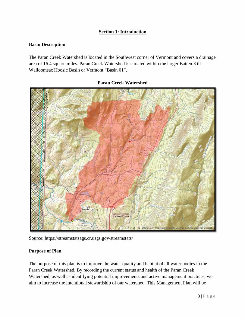
Section 1: Introduction
Basin Description The Paran Creek Watershed is located in the Southwest corner of Vermont and covers a drainage area of 16.4 square miles. Paran Creek Watershed is situated within the larger Batten Kill Walloomsac Hoosic Basin or Vermont “Basin 01”.
Paran Creek Watershed
Source: https://streamstatsags.cr.usgs.gov/streamstats/ Purpose of Plan The purpose of this plan is to improve the water quality and habitat of all water bodies in the Paran Creek Watershed. By recording the current status and health of the Paran Creek Watershed, as well as identifying potential improvements and active management practices, we aim to increase the intentional stewardship of our watershed. This Management Plan will be

4 | P a g e
actively carried out so as to positively impact the health and integrity of our water resources, our public recreation, riverine habitat and every aspect of the watershed. This marks a new era of acknowledging our privilege to have access to water resources such as the Paran Creek Watershed, and fulfilling our responsibility as a community to sustain it. The mission of The Paran Creek Watershed Project is to establish North Bennington as a model for energy independence and form a sustainable, long term watershed management plan by revitalizing existing infrastructure. The main goal of this project is to develop a means by which the water self-funds its own health and resilience without raising cost to the taxpayers. Paran Creek Watershed Partners Village of North Bennington The Paran Creek Watershed and Lake Paran specifically exist within the Village of North Bennington. As such, this Plan is written entirely in collaboration with the Village Government and Citizens, and the position of the watershed steward would be a position created through the Village. Town of Shaftsbury The Paran Creek Watershed extends into the Town of Shaftsbury as well and therefore the Town is another significant partner in this project. Lake Paran Association (Paran Recreations Inc.) The Lake Paran Association is a non-profit responsible for upkeep of recreation and facilities around Lake Paran. The group has pursued testing and projects regarding the water quality and health of Lake Paran, and this project is in support of their efforts. Watershed Management Division, Vermont Department of Environmental Conservation This Plan was written in consultation with the Watershed Management Division of the Vermont DEC which oversees the greater Batten Kill, Walloomsac, Hoosic River Basin Planning. Bennington County Regional Commission The Bennington County Regional Commission (BCRC) was created, pursuant to 24 V.S.A. Section 4341, by the seventeen towns and villages it serves and will work with and on behalf of those municipalities to build strong, resilient, and sustainable communities, to foster economic prosperity, and to promote a high quality of life for residents of the region. Source: http://www.rpc.bennington.vt.us/About_the_BCRC/ Bennington County Conservation District Contact Shelly Stiles - http://www.bccdvt.org/
5 | P a g e
Vermont Agency of Transportation The Vermont Agency of Transportation owns Lake Paran and land that bordering Lake Paran. This land and the railroad track across the dam is leased from VTAoT by the Vermont Rail System.
6 | P a g e
Section 2: Water Quality in the Basin
Paran Creek Special Features of Paran Creek Lake Paran: Lying partially in Bennington, North Bennington, and Shaftsbury and an impoundment of Paran Creek, it is an important recreation site and views of and across the lake from the dam, boat launch, park, and the old rail spur are unique in the area. In the summer months this is one of the most heavily used waterbodies in the County and the primary swimming spot in the Paran Creek watershed. The Lake Paran Association provides a safe swimming access for local families at a small annual fee. Lake Paran occupies a natural basin at the northern edge of the Village of North Bennington. The lake’s current shape, coverage, and depth were established by the railroad dam that was constructed in 1850. The surface area of the lake is now 36 acres and it lies at 647 feet above Mean Sea Level (MSL).
Current uses of Lake Paran and adjacent lands include swimming, fishing, non-motorized boating, ice-skating, hiking, and aesthetic appreciation. Protection of the lake’s water quality and conservation of surrounding land has been the subject of considerable effort in recent years. Two invasive aquatic plants, Eurasian watermilfoil and water chestnut are known from the lake; watermilfoil was confirmed in the 1980s and water chestnut in 1998. The population fluctuates annually. Past control efforts at the Lake Paran Association beach to control watermilfoil include benthic matting and hydroraking; no controls were implemented in recent years. Lake staff surveyed the lake for water chestnut yearly, 1998-2014. Any water chestnut plants found were removed by hand. Water chestnut has not been found since 2013. Paran Creek Fen located south of Simeon Dean Road consists of two small rich fens that contain a population of a globally rare sedge.
Because development along the shoreline of Lake Paran could cause erosion and lead to other sources of pollution, the Village, as well as the towns of Shaftsbury and Bennington, adopted shoreline protection provisions in their land use regulations that require that a natural buffer be maintained along the shore. Fortunately, a conservation effort involving private landowners, the Vermont Land Trust, the Vermont Housing and Conservation Board, and the Sage City Syndicate has led to conservation of 56 acres and 2,976 feet of shoreline along Lake Paran and the upper portion of Paran Creek. Continued inter municipal and regional cooperation will be necessary to ensure that water quality is not degraded by point or nonpoint discharges from upstream sources and that conserved lands are properly maintained and used.
7 | P a g e
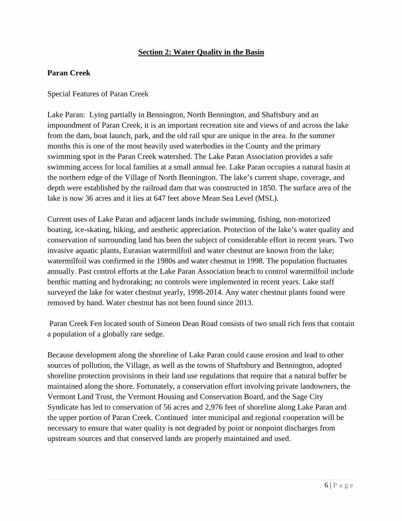
In October 2015, the Vermont DEC Watershed Management Division collected site monitoring data from river mile 1.9 of Paran Creek which is above the Route 67 bridge adjacent to manufacturing plant. The data on water quality for this site consists of five measurements (excluding conductivity) including: chloride, nitrogen, pH, phosphorus and turbidity. The significance of the five measurements taken at the site are compared to the Vermont State Water Quality Standard 1. The first measurement taken was chloride at 22.7 mg/L or milligrams per liter. The Vermont Water Quality Standard suggests chloride levels should remain below 260 mg/L. Nitrogen levels are measured in order to see the potential for algae blooms to grow. The Vermont Standard on nitrogen suggests a level below 2 mg/L at elevations less than 2,500 ft. Paran Creek measured .3 mg/L which is well below this standard. The pH is a measure of the hydrogen ion concentration in water on a scale ranging from 0 to 14. A pH under 7 indicates more hydrogen ions and therefore more acidic solutions. A pH greater than 7 indicates a more alkaline solution. A pH of 7.0 is considered neutral, neither acidic nor alkaline. The pH of Paran Creek was 7.8. This slightly alkaline value is consistent with the carbonate bedrock in the watershed. Phosphorous is another characteristic tested to determine its contribution to the growth of algae blooms. Paran Creek measured 9.7 ppb of phosphorous meeting the suggested Vermont standard of 9-27 parts per billion, depending on the stream type. The last characteristic measured was the turbidity or the measure of suspended matter in Paran Creek. The Vermont Standard is a maximum of 25 NTU or nephelometric turbidity units, and Paran Creek was 1.6 NTU. Overall this data on water quality does not point to any problematic areas in Paran Creek, although it is brief data summary taken in 2015 and could be better understood when compared to trends taken from multiple site monitoring data over the years.
Paran Creek Site Monitoring, Creek Mile 1.9 – October 2015
1 https://anrweb.vt.gov/DEC/IWIS/Factsheets/Chem.pdf
8 | P a g e
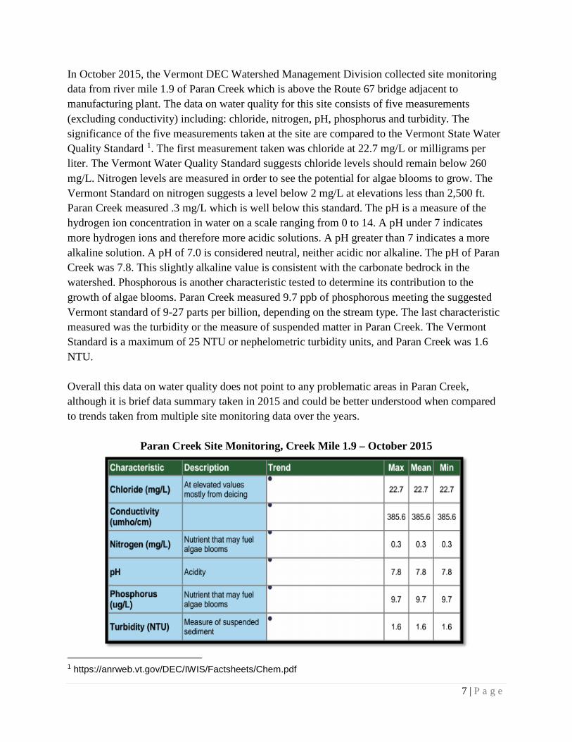
Dam & Mills along Paran Creek Below Lake Paran there are five dams and four mill ponds exist along Paran Creek: Lake Paran Dam, Upper Mill Dam, Grist Mill Dam, Cushman Dam, and Polygraphic Dam. Above Lake Paran there is the Shaftbury-2 Dam, Cider Mill Dam, Shaftsbury-7 Dam, and the Lake Shaftsbury Dam. At one time in the early 19th century there were up to 13 “privileges” claimed along Paran Creek. Early products made or prepared along Paran Creek included flax, paper, textiles, lime, marble, iron ore, lenses, furniture, and carpenter squares. Most of the mills and factories have closed but the buildings remain.
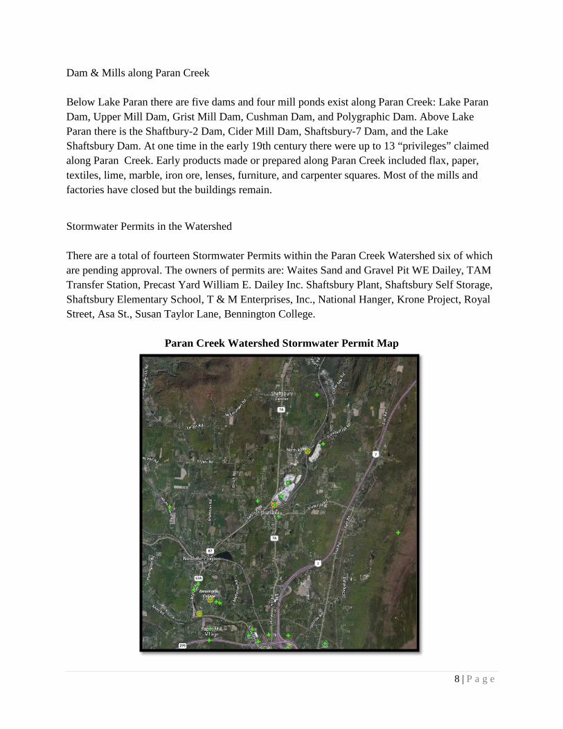
Stormwater Permits in the Watershed There are a total of fourteen Stormwater Permits within the Paran Creek Watershed six of which are pending approval. The owners of permits are: Waites Sand and Gravel Pit WE Dailey, TAM Transfer Station, Precast Yard William E. Dailey Inc. Shaftsbury Plant, Shaftsbury Self Storage, Shaftsbury Elementary School, T & M Enterprises, Inc., National Hanger, Krone Project, Royal Street, Asa St., Susan Taylor Lane, Bennington College.
Paran Creek Watershed Stormwater Permit Map
9 | P a g e
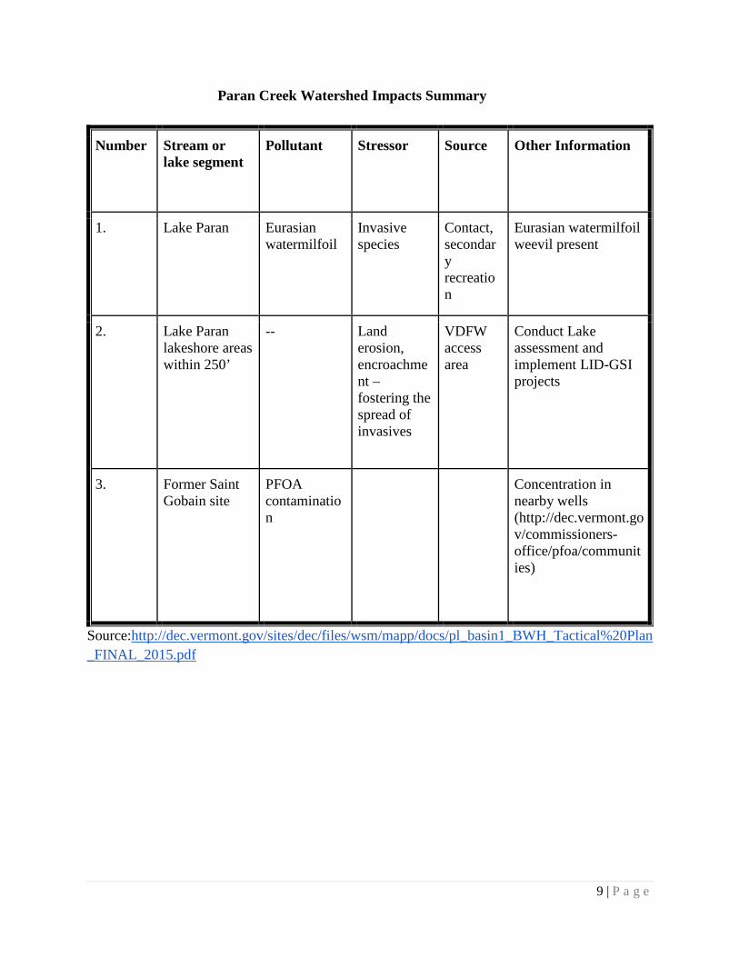
Paran Creek Watershed Impacts Summary
Number Stream or lake segment
Pollutant Stressor Source Other Information
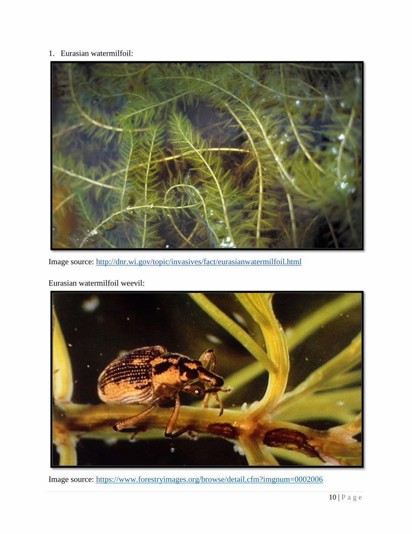
1. Lake Paran Eurasian watermilfoil
Invasive species
Contact, secondary recreation
Eurasian watermilfoil weevil present
2. Lake Paran lakeshore areas within 250’
-- Land erosion, encroachment – fostering the spread of invasives
VDFW access area
Conduct Lake assessment and implement LID-GSI projects
3. Former Saint Gobain site
PFOA contamination
Concentration in nearby wells (http://dec.vermont.gov/commissioners-office/pfoa/communities)
Source:http://dec.vermont.gov/sites/dec/files/wsm/mapp/docs/pl_basin1_BWH_Tactical%20Plan_FINAL_2015.pdf
10 | P a g e
1. Eurasian watermilfoil:
Image source: http://dnr.wi.gov/topic/invasives/fact/eurasianwatermilfoil.html Eurasian watermilfoil weevil:
Image source: https://www.forestryimages.org/browse/detail.cfm?imgnum=0002006

11 | P a g e
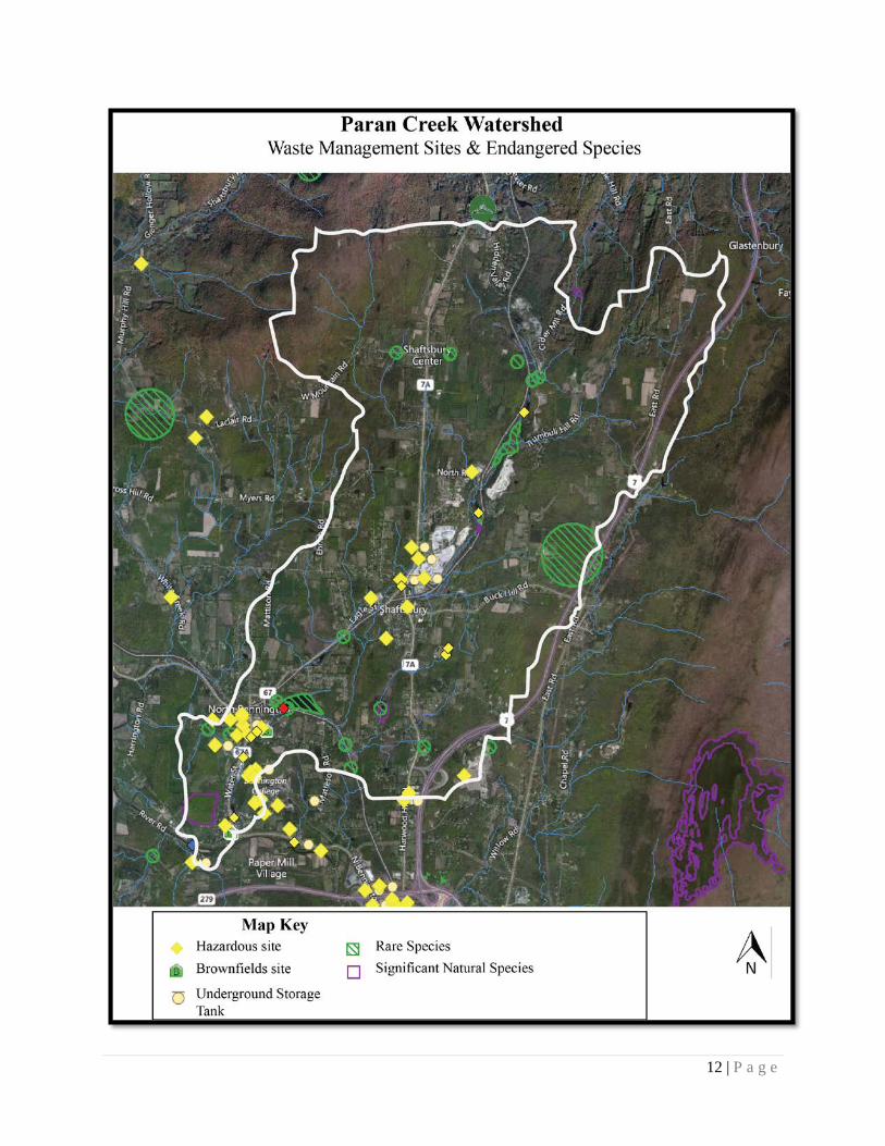
Hazardous Sites within Watershed
Site Name Date Location Contaminant Status Classification
Shaftsbury State Police Barracks
2008 Shaftsbury UST- gasoline Removed Hazardous site
Paulin Inc 1998 Shaftsbury UST- gasoline Removed Hazardous site
W.E. Dailey Inc
2005 Shaftsbury UST - diesel, UST - gasoline
Removed Hazardous site
Eagle Square - Stanley Tools
2005 Shaftsbury Non-petroleum, other metals
Brownfields BRELLA
Brownfields
Levigne Property
2004 Shaftsbury Unknown sheen removed Spill
Vermont Arts Exchange/ Sage Street Mill
2015 North Bennington
unknown Phase II of ESA
Hazardous site
Apollo Fuel Former Bulk Plant
Placed 2016 North Bennington
UST - gasoline Active Hazardous site
Source: https://anrweb.vt.gov/DEC/ERT/
12 | P a g e
13 | P a g e
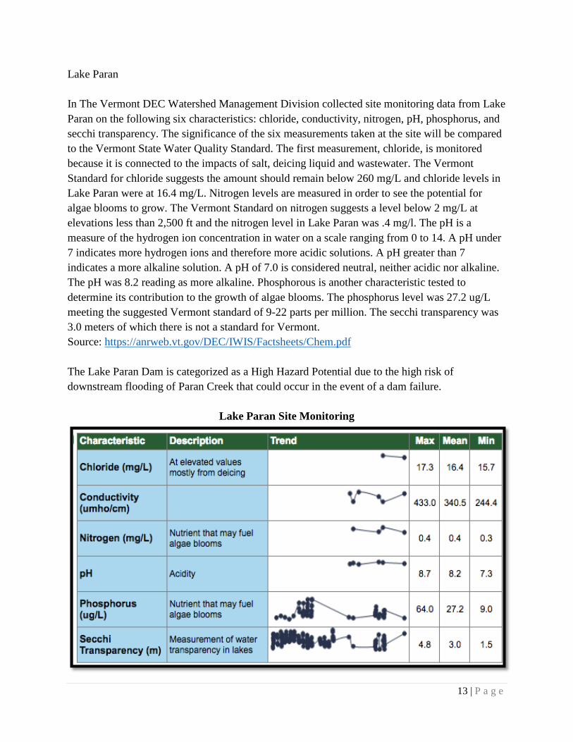
Lake Paran
In The Vermont DEC Watershed Management Division collected site monitoring data from Lake Paran on the following six characteristics: chloride, conductivity, nitrogen, pH, phosphorus, and secchi transparency. The significance of the six measurements taken at the site will be compared to the Vermont State Water Quality Standard. The first measurement, chloride, is monitored because it is connected to the impacts of salt, deicing liquid and wastewater. The Vermont Standard for chloride suggests the amount should remain below 260 mg/L and chloride levels in Lake Paran were at 16.4 mg/L. Nitrogen levels are measured in order to see the potential for algae blooms to grow. The Vermont Standard on nitrogen suggests a level below 2 mg/L at elevations less than 2,500 ft and the nitrogen level in Lake Paran was .4 mg/l. The pH is a measure of the hydrogen ion concentration in water on a scale ranging from 0 to 14. A pH under 7 indicates more hydrogen ions and therefore more acidic solutions. A pH greater than 7 indicates a more alkaline solution. A pH of 7.0 is considered neutral, neither acidic nor alkaline. The pH was 8.2 reading as more alkaline. Phosphorous is another characteristic tested to determine its contribution to the growth of algae blooms. The phosphorus level was 27.2 ug/L meeting the suggested Vermont standard of 9-22 parts per million. The secchi transparency was 3.0 meters of which there is not a standard for Vermont. Source: https://anrweb.vt.gov/DEC/IWIS/Factsheets/Chem.pdf The Lake Paran Dam is categorized as a High Hazard Potential due to the high risk of downstream flooding of Paran Creek that could occur in the event of a dam failure.
Lake Paran Site Monitoring
14 | P a g e
Fisheries assessment Existing Fishing access: On the south bank of Lake Paran there is public parking and boating access via a small concrete ramp. According to the Vermont Agency of Natural Resources there are rainbow trout, yellow perch, northern pike, largemouth bass, and panfish. Source: http://www.vtfishandwildlife.com/common/pages/DisplayFile.aspx?itemId=111999 Stressors, Causes, Sources of Impairment The Vermont Surface Water Management Strategy (VDEC 2012) lays out the goals and objectives of the Watershed Management Division to address pollutants and stressors that affect the designated uses of Vermont surface waters. The strategy discusses the 10 major stressors that are managed to protect and improve surface waters. A stressor is defined as a phenomenon with quantifiable damaging effects on surface waters resulting from the delivery of pollutants to a
15 | P a g e
waterbody, or an increased threat to public health and safety. Stressors result from certain activities on the landscape, although occasionally natural factors result in stressors being present. Controlling stressors requires the management of associated activities. When landscape activities are appropriately managed, stressors are reduced or eliminated, resulting in the objectives of the Strategy being achieved, and the goals met.2 Direct discharges to surface water There are no wastewater treatment facilities located in the Paran Creek Watershed but there is sewer service located along Route 67A in North Bennington. Additionally, there is a suspected issue with the septic in the Paran Acres development that requires some investigation.
2 Source: Batten Kill Walloomsac Hoosic Tactical Plan
16 | P a g e
Section 3: Management Goals for Surface Waters
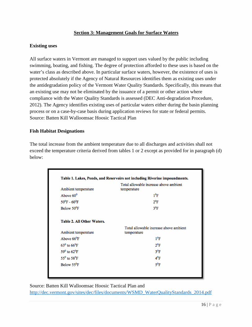
Existing uses All surface waters in Vermont are managed to support uses valued by the public including swimming, boating, and fishing. The degree of protection afforded to these uses is based on the water’s class as described above. In particular surface waters, however, the existence of uses is protected absolutely if the Agency of Natural Resources identifies them as existing uses under the antidegradation policy of the Vermont Water Quality Standards. Specifically, this means that an existing use may not be eliminated by the issuance of a permit or other action where compliance with the Water Quality Standards is assessed (DEC Anti-degradation Procedure, 2012). The Agency identifies existing uses of particular waters either during the basin planning process or on a case-by-case basis during application reviews for state or federal permits. Source: Batten Kill Walloomsac Hoosic Tactical Plan Fish Habitat Designations The total increase from the ambient temperature due to all discharges and activities shall not exceed the temperature criteria derived from tables 1 or 2 except as provided for in paragraph (d) below:
Source: Batten Kill Walloomsac Hoosic Tactical Plan and http://dec.vermont.gov/sites/dec/files/documents/WSMD_WaterQualityStandards_2014.pdf
17 | P a g e
Cold Water Fish Habitat Paran Creek is classified as a coldwater fishery, Class B2 under the 2016 Water Quality Standards.

18 | P a g e
Section 4: Watershed Improvement Actions and Implementation Best Practices Daily Monitoring: A foundational part of maintaining best practices is regular monitoring of all components of the watershed. This monitoring would be carried out by a watershed steward who would be working in and around the Watershed on a daily basis. This includes all waterways, dams, reservoirs, surrounding public land, and hydropower plants. Daily monitoring is of high priority in the Paran Creek Watershed because of the waterway’s intimate and central importance to the Village of North Bennington, Bennington and Shaftsbury. With roads and public lands bordering waterways throughout the watershed it is exposed to the impacts of littering, dumping, and irresponsible recreating as well as impacts of stormwater runoff and road salt. By regularly traveling up and downstream, a watershed steward is able to foster positive awareness around how we interact with the watershed, and hopefully stay alert to any changes. Citizen reporting: In addition to a watershed steward performing regular monitoring of the watershed, it will be helpful to implement a system in which community members can report observations or concerns regarding a specific area. This could entail an email address or P.O. Box managed by the watershed steward which requires a response to all reports filed. This may require investigation by the steward to look into the concern, or sharing of knowledge in order to answer the community member’s question. Regular testing: In Section 2 we will discuss a Monitoring Site Summary conducted by DEC Watershed Management Division which is comprised of a macroinvertebrate assessment, fish assessment, water quality measurements, and habitat observations. Similar testing will need to be conducted on a regular yearly basis to keep current records as well as to develop data trends and make comparisons across years. It is important that such testing is conducted at multiple sites up and down Paran Creek in addition to multiple sites within Lake Paran in order to gather accurate results specific to a particular area to avoid generalization. Monitoring and Assessment Projects: There are numerous aspects of the watershed that will require regular monitoring and assessment to determine the status of a project. Impacts such as highway runoff, discharge, and invasive species will require check ins as well as record keeping through photo documentation.
19 | P a g e
Project Identification: It will be the responsibility of the water steward to identify ongoing and new projects in the watershed. There are currently a few identified projects outlined in this Plan such as developing a plan to address the Eurasian milfoil in Lake Paran as well as addressing the presence of water chestnut, but this list will be added to further by the water steward. Active Management General Watershed Strategies: The water steward will play the biggest role in implementing strategies to manage the watershed and prioritizing projects to gain the greatest overall benefit. This will include prioritization and creation of timelines for all of the identified watershed projects. Additionally, under the Vermont Clean Water Act there are possible municipal actions that can be taken such as controlling storm water runoff. There are also potential actions on the residential and citizen level such as managing lawn fertilizer, picking up animal waste and installing riparian buffers along streams. Implementation: The implementation of the Watershed Plan will entail accomplishing the practices, projects, and monitoring outlined above. We have a goal of creating the water steward position in five years’ time after which they will be able to start the full implementation process.
20 | P a g e
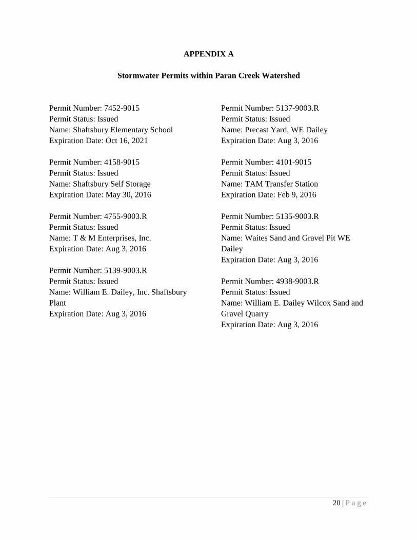
APPENDIX A
Stormwater Permits within Paran Creek Watershed
Permit Number: 7452-9015 Permit Status: Issued Name: Shaftsbury Elementary School Expiration Date: Oct 16, 2021 Permit Number: 4158-9015 Permit Status: Issued Name: Shaftsbury Self Storage Expiration Date: May 30, 2016 Permit Number: 4755-9003.R Permit Status: Issued Name: T & M Enterprises, Inc. Expiration Date: Aug 3, 2016 Permit Number: 5139-9003.R Permit Status: Issued Name: William E. Dailey, Inc. Shaftsbury Plant Expiration Date: Aug 3, 2016
Permit Number: 5137-9003.R Permit Status: Issued Name: Precast Yard, WE Dailey Expiration Date: Aug 3, 2016 Permit Number: 4101-9015 Permit Status: Issued Name: TAM Transfer Station Expiration Date: Feb 9, 2016 Permit Number: 5135-9003.R Permit Status: Issued Name: Waites Sand and Gravel Pit WE Dailey Expiration Date: Aug 3, 2016 Permit Number: 4938-9003.R Permit Status: Issued Name: William E. Dailey Wilcox Sand and Gravel Quarry Expiration Date: Aug 3, 2016