paris mountain state park trails - south … parks files/paris mtn/pm...paris mountain state park...

1
St a t e P a rk R o a d ! i ! O ! 8 ! 8 ! 8 ! 8 ! 8 ! i ! i ! i ! i ! i ! i ! 3 ! 3 ! 3 ! 3 ! 3 ! 3 ! _ ! _ ! @ ! ? ! 9 Ballfield Camp Buckhorn Res er v o ir 3 La k e Placid Mountain Lake Buckhorn Lake ! ¯ Bu c k h orn Cree k ! i 1400 1000 1600 1600 1400 1200 1200 1780 1600 1400 1200 1400 1200 1200 1400 1200 1720 Lake Placid -Hikers Only Turtle Mountain Creek Sulphur Springs Sulphur Springs - Hikers Only Brissy Ridge Brissy Ridge - Hikers Only Fire Tower Pipsissewa North Lake Kanuga Connector Trails 0 0.25 0.5 0.125 Miles To ensure that your state park experience is enjoyable, please be aware of the dynamic characteristics of the natural environment. There are some areas that may be potentially hazardous. All visitors should exercise caution when visiting any state park. Anyone who is unsure about possible hazards should contact a Park Ranger. / Park Entrance PARIS MOUNTAIN STATE PARK TRAILS PARIS MOUNTAIN STATE PARK TRAILS Paris Mountain State Park Trails Trail difficulty using a scale of 1 to 10 - Easiest to - Most Strenuous ! ( 1 ! ( 10 ! ( 1 ! ( 4 ! ( 8 ! ( 9 ! ( 9 ! ( 7 ! ( 5 ! ( 6 ! ( 5 ! ( 3 . . . Source: Trail locations captured by GPS by Carmen Durham; Additional data, Greenville County ©Carmen Durham, 2012 ! i ! _ ! 3 ! 9 Parking Area Shelter Restrooms Campground Paved Park Road Park Boundary ! ¯ Amphitheater ! ( 6 ! ( 4 Approximate Trail Lengths: Lake Placid Loop - .75 mi. Mountain Creek - 1.3 mi. (one way) Sulphur Springs Loop - 3.6 mi. Brissy Ridge Loop - 2.4 mi. Pipsissewa (one way) - 1.0 mi. North Lake Loop - 1.2 mi. Fire Tower (one way) - 0.4 mi. Kanuga (one way) - 2 mi. Turtle (one way) - .5 mi. ! @ Park Center ! 8 Trailside Campsites

Upload: vandat

Post on 02-Apr-2018

216 views

Category:

Documents


1 download

TRANSCRIPT

State

Park

Road

!i

!O

!8!8

!8

!8!8

!i!i

!i

!i

!i

!i

!3

!3

!3

!3

!3

!3!_

!_

!@

!?

!9

Ballfield

Camp Buckhorn

Reservoir 3

Lake Placid

MountainLake

BuckhornLake

Buc khorn Creek

!i

1400

1600

1000

1600

1600

1400

1200

1200

1780

160014

00

1200

1400

1200

1200

1400

1200

1720

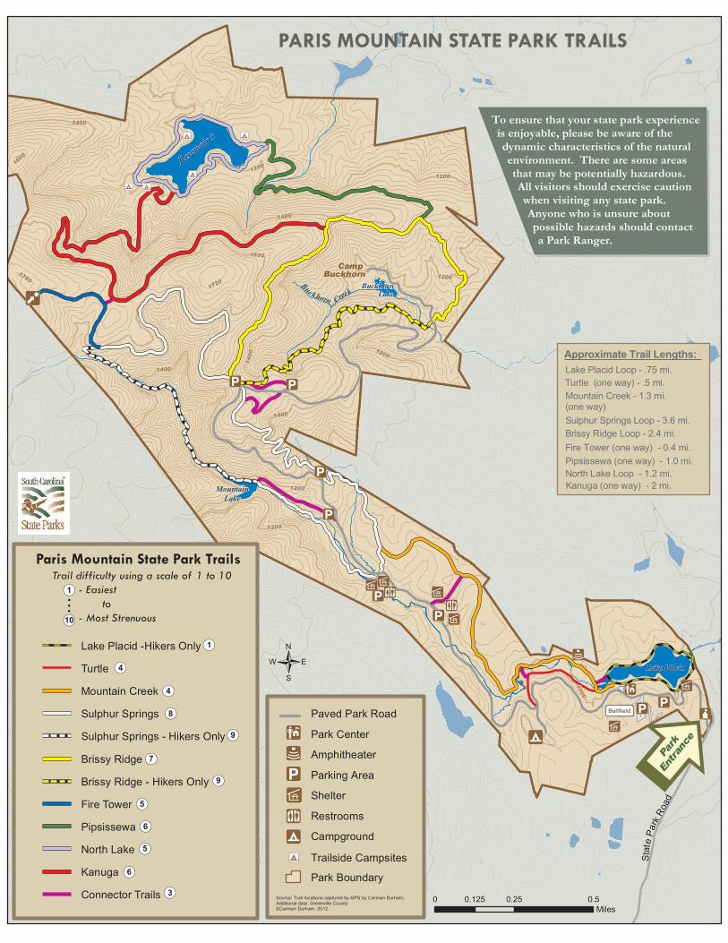
Lake Placid -Hikers OnlyTurtleMountain CreekSulphur SpringsSulphur Springs - Hikers OnlyBrissy RidgeBrissy Ridge - Hikers OnlyFire TowerPipsissewaNorth LakeKanugaConnector Trails 0 0.25 0.50.125

Miles

To ensure that your state park experienceis enjoyable, please be aware of thedynamic characteristics of the naturalenvironment. There are some areasthat may be potentially hazardous.All visitors should exercise cautionwhen visiting any state park.Anyone who is unsure aboutpossible hazards should contacta Park Ranger.

/

Park

Entra

nce

PARIS MOUNTAIN STATE PARK TRAILSPARIS MOUNTAIN STATE PARK TRAILS

Paris Mountain State Park TrailsTrail difficulty using a scale of 1 to 10 - Easiest to - Most Strenuous!(1

!(10

!(1

!(4

!(8

!(9

!(9!(7

!(5

!(6

!(5

!(3

...

Source: Trail locations captured by GPS by Carmen Durham; Additional data, Greenville County©Carmen Durham, 2012

!i

!_

!3

!9

Parking AreaShelterRestroomsCampground

Paved Park Road

Park Boundary

!̄ Amphitheater

!(6

!(4

Approximate Trail Lengths:Lake Placid Loop - .75 mi.

Mountain Creek - 1.3 mi.(one way) Sulphur Springs Loop - 3.6 mi.Brissy Ridge Loop - 2.4 mi.

Pipsissewa (one way) - 1.0 mi.North Lake Loop - 1.2 mi.

Fire Tower (one way) - 0.4 mi.

Kanuga (one way) - 2 mi.

Turtle (one way) - .5 mi.

!@ Park Center

!8 Trailside Campsites