part: b distinctiveness - stratford-on-avon district
TRANSCRIPT
B.1
Development Requirements Supplementary Planning Document (SPD)
Stratford-on-Avon District Council – December 2018
Part: B Character and Local Distinctiveness Contents B1 What is Character?
B2 Stratford-on-Avon Character Areas
B3 Arden Character Area
B4 Feldon and Ironstone Character Area
B5 Cotswold Fringe Character area
B6 Avon Valley Character Area
B7 Stour Valley Character Area
This part the Development Requirements SPD provides further detailed guidance on the interpretation of a range of Core Strategy policies, in particular and as appropriate:
• CS.5 Landscape
• CS.8 Historic Environment
• CS.9 Design and Distinctiveness
• CS.11 Cotswolds Area of Outstanding Natural Beauty
• CS.12 Special Landscape Areas
It provides guidance and advice on how applicants can reflect the character of Stratford-on-Avon District within the design in new development. It should be read in conjunction with other relevant parts of the SPD.
The SPD will be used by Stratford-on-Avon District Council to help reach decisions on whether to approve or refuse planning applications. Making sure that applications comply with the guidance contained within the SPD will make it easier for the Council to grant planning permission. The Council’s Planning Policies are set out in the Core Strategy available at www.stratford.gov.uk/corestrategy
Key words or terms which appear throughout the document are included in the Glossary
B.2
Development Requirements Supplementary Planning Document (SPD)
Stratford-on-Avon District Council – December 2018
B1 What is Character? Character is the combined effect of those features that make a place identifiable. It could be defined as everything; however such a definition is clearly unworkable in practice. For the purposes of this document, therefore, the descriptions and principles will focus on the selection of aspects that contribute to the character of the countryside and settlements in the District. The selection has been based on the need to choose characteristics that are readily observable, as well as readily taken as considerations in design. It is worth noting that character is not entirely derived from physical aspects of a place. Firstly, the D istrict’s location within its larger spatial context influences its perceived character. The setting and the surrounding regions; the places you travel through to get to the district, contribute towards its identity. This consideration underlines the fact that character is only possible to identify by comparison and the contrasts between one place and another. Secondly, character involves far more than bricks and mortar of a settlement. Human activities that have taken place over time and continue to do so are a significant contributor factor to character of a place. The character of the district has evolved through an extended historical development, through the working life of many generations. B2. Stratford–on-Avon District Character Areas
Stratford-on-Avon District lies in Midland England in the county of Warwickshire. It is a rural district corresponding to the southern third of historic Warwickshire and encompasses the historic towns of Stratford-upon-Avon, Henley-in-Arden, Alcester, Shipston-on-Stour and Southam. The general character of Stratford-on-Avon District is one of rolling lowland countryside, much of it arable farmland. That character is all the more obvious when compared with such areas as the flat fenland of the east Midlands, the mountains of the Peak District or the estuaries of Essex. A closer look reveals, however, that Stratford-on-Avon District lies at the confluence of several broader character areas and its own character is far from uniform. The geological features and climate of the area and the impact of several thousand years of people living and working on the land have created a landscape of subtle but real variation. Travelling from north to south, for example, the differences are clear. The hamlets, winding lanes and small fields of the more wooded Arden in the north-west give way to the open areas of grazing and larger scale fields of the Avon and Stour valleys with their closely built villages. From there, south, the ground rolls gently to the steep scarp slope of Edgehill and the downland of the Cotswold fringe. The downland and broad valleys are marked by medium scale fields of arable and pasture, dotted with compact stone villages. These differences form the basis for identifying distinct regions within the District. These regions, or character areas, in their turn provide the basis for design guidance. The features taken into account include the underlying geology, the landform, the variety and number of trees and other plants, the shape and size of fields and the way they are managed, the pattern of roads and settlements and their internal structure and the building materials out of which the towns and villages are made.
B.3
Development Requirements Supplementary Planning Document (SPD)
Stratford-on-Avon District Council – December 2018
There are five main character areas within Stratford-on-Avon District:
• Arden; • Feldon and Ironstone Uplands. • Cotswold Fringe; • Avon Valley; • Stour Valley.
A map of Stratford-on-Avon District Character Areas is available on the Council’s website, using the link below. https://www.stratford.gov.uk/planning-regeneration/the-district-design-guide.cfm The Feldon and Arden correspond in a large part to historically recognised regions. The terms Arden and Feldon were used by medieval times. Arden derives from the Old English word ‘ardu’ meaning 'high, steep', and Feldon from the word ‘feld’ meaning 'open land'. Early settlements and agricultural activity tended to centre on river valleys, principally the Avon, Arrow, Alne and Stour. It is also notable that while the District is an administrative entity with 'artificial' boundaries, many of those boundaries correspond to 'natural' boundaries such as river basin divides. The District lies almost entirely within the drainage basin of the River Avon. The northern and southern boundaries of the District fall approximately on the divides with the greater basins of the Rivers Trent and Thames. Each of the character areas is further divided into sub-areas to account for more local differences. The areas and sub-areas are intended to provide a general record of the character of the District as a whole, but are not intended to account fully for the details that make places unique. The boundaries identify areas in which there is a degree of similarity in terms of landscape and settlement pattern. The character map and further sections of Part C describe some of the general similarities as well as differences.
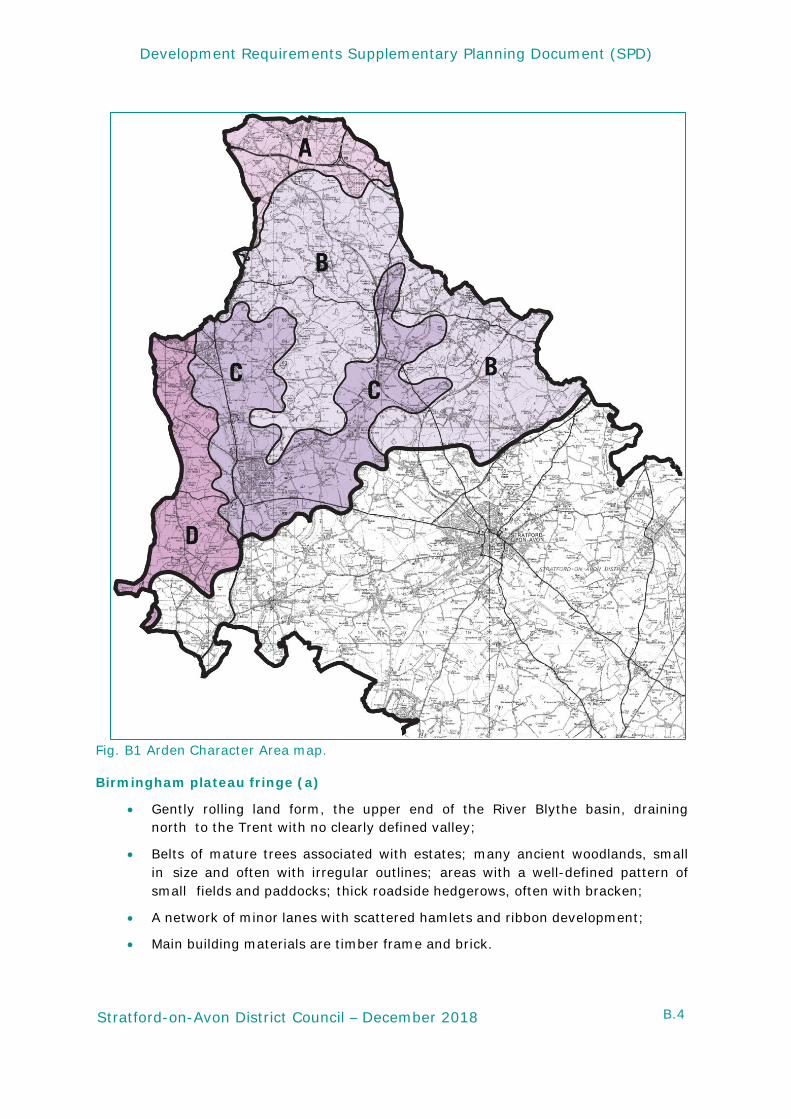
B3. Arden Character Area
The Arden character area comprises the following sub-areas: Birmingham plateau; Ancient Arden; Alne and Arrow valley floors; Feldon; Cotswold Fringe; Avon Valley and Stour Valley. These are shown in the Arden Character Area Map (Fig.B1) below.
B.4
Development Requirements Supplementary Planning Document (SPD)
Stratford-on-Avon District Council – December 2018
Fig. B1 Arden Character Area map.
Birmingham plateau fringe (a)
• Gently rolling land form, the upper end of the River Blythe basin, draining north to the Trent with no clearly defined valley;
• Belts of mature trees associated with estates; many ancient woodlands, small in size and often with irregular outlines; areas with a well-defined pattern of small fields and paddocks; thick roadside hedgerows, often with bracken;
• A network of minor lanes with scattered hamlets and ribbon development;
• Main building materials are timber frame and brick.
B.5
Development Requirements Supplementary Planning Document (SPD)
Stratford-on-Avon District Council – December 2018
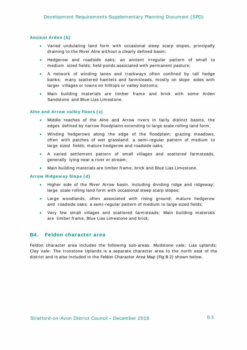
Ancient Arden (b)
• Varied undulating land form with occasional steep scarp slopes, principally draining to the River Alne without a clearly defined basin;
• Hedgerow and roadside oaks; an ancient irregular pattern of small to medium sized fields; field ponds associated with permanent pasture;
• A network of winding lanes and trackways often confined by tall hedge banks; many scattered hamlets and farmsteads, mostly on slope sides with larger villages or towns on hilltops or valley bottoms;
• Main building materials are timber frame and brick with some Arden Sandstone and Blue Lias Limestone.
Alne and Arrow valley floors (c)
• Middle reaches of the Alne and Arrow rivers in fairly distinct basins, the edges defined by narrow floodplains extending to large scale rolling land form;
• Winding hedgerows along the edge of the floodplain; grazing meadows, often with patches of wet grassland; a semi-regular pattern of medium to large sized fields; mature hedgerow and roadside oaks;
• A varied settlement pattern of small villages and scattered farmsteads, generally lying near a river or stream;
• Main building materials are timber frame, brick and Blue Lias Limestone.
Arrow Ridgeway Slope (d)
• Higher side of the River Arrow basin, including dividing ridge and ridgeway; large scale rolling land form with occasional steep scarp slopes;
• Large woodlands, often associated with rising ground; mature hedgerow and roadside oaks; a semi-regular pattern of medium to large sized fields;
• Very few small villages and scattered farmsteads; Main building materials are timber frame, Blue Lias Limestone and brick.
B4. Feldon character area
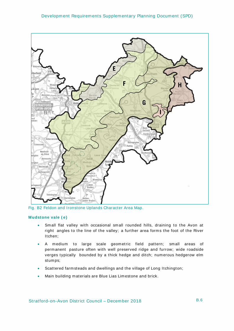
Feldon character area includes the following sub-areas: Mudstone vale; Lias uplands; Clay vale. The Ironstone Uplands is a separate character area to the north east of the district and is also included in the Feldon Character Area Map (Fig B 2) shown below.
B.6
Development Requirements Supplementary Planning Document (SPD)
Stratford-on-Avon District Council – December 2018
Fig. B2 Feldon and Ironstone Uplands Character Area Map. Mudstone vale (e)
• Small flat valley with occasional small rounded hills, draining to the Avon at right angles to the line of the valley; a further area forms the foot of the River Itchen;
• A medium to large scale geometric field pattern; small areas of permanent pasture often with well preserved ridge and furrow; wide roadside verges typically bounded by a thick hedge and ditch; numerous hedgerow elm stumps;
• Scattered farmsteads and dwellings and the village of Long Itchington;
• Main building materials are Blue Lias Limestone and brick.
B.7
Development Requirements Supplementary Planning Document (SPD)
Stratford-on-Avon District Council – December 2018
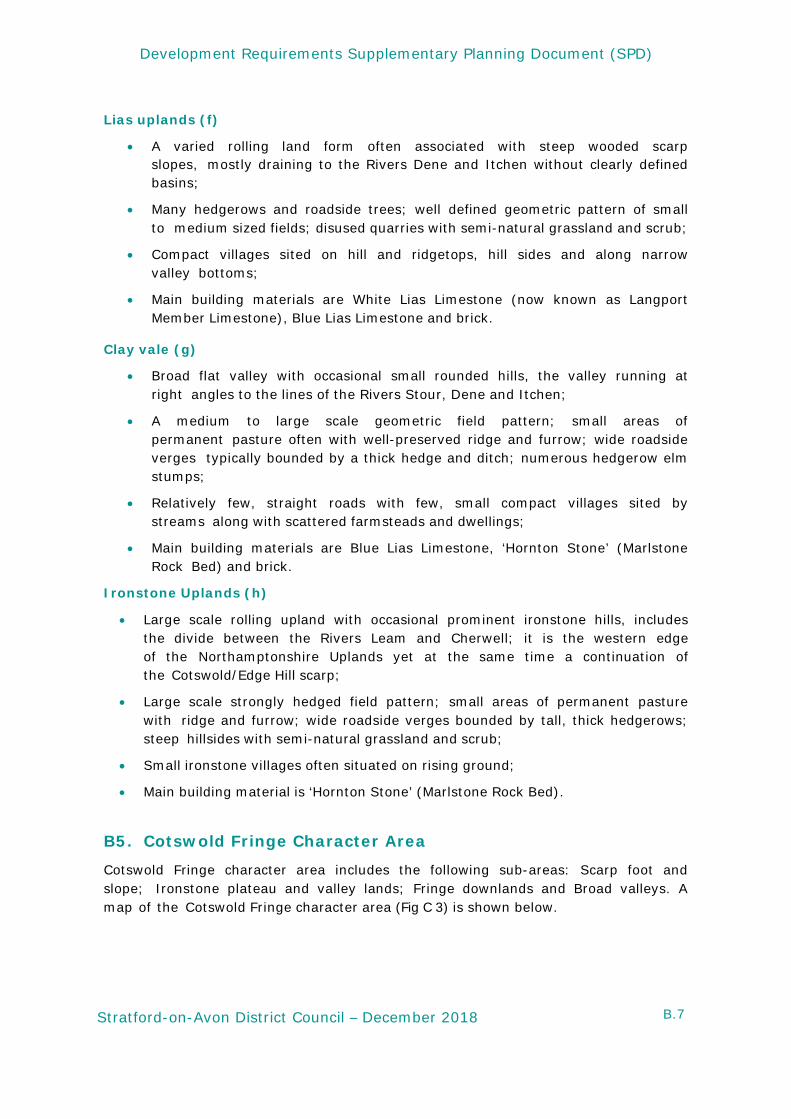
Lias uplands (f)
• A varied rolling land form often associated with steep wooded scarp slopes, mostly draining to the Rivers Dene and Itchen without clearly defined basins;
• Many hedgerows and roadside trees; well defined geometric pattern of small to medium sized fields; disused quarries with semi-natural grassland and scrub;
• Compact villages sited on hill and ridgetops, hill sides and along narrow valley bottoms;
• Main building materials are White Lias Limestone (now known as Langport Member Limestone), Blue Lias Limestone and brick.
Clay vale (g)
• Broad flat valley with occasional small rounded hills, the valley running at right angles to the lines of the Rivers Stour, Dene and Itchen;
• A medium to large scale geometric field pattern; small areas of permanent pasture often with well-preserved ridge and furrow; wide roadside verges typically bounded by a thick hedge and ditch; numerous hedgerow elm stumps;
• Relatively few, straight roads with few, small compact villages sited by streams along with scattered farmsteads and dwellings;
• Main building materials are Blue Lias Limestone, ‘Hornton Stone’ (Marlstone Rock Bed) and brick.
Ironstone Uplands (h)
• Large scale rolling upland with occasional prominent ironstone hills, includes the divide between the Rivers Leam and Cherwell; it is the western edge of the Northamptonshire Uplands yet at the same time a continuation of the Cotswold/Edge Hill scarp;
• Large scale strongly hedged field pattern; small areas of permanent pasture with ridge and furrow; wide roadside verges bounded by tall, thick hedgerows; steep hillsides with semi-natural grassland and scrub;
• Small ironstone villages often situated on rising ground;
• Main building material is ‘Hornton Stone’ (Marlstone Rock Bed). B5. Cotswold Fringe Character Area
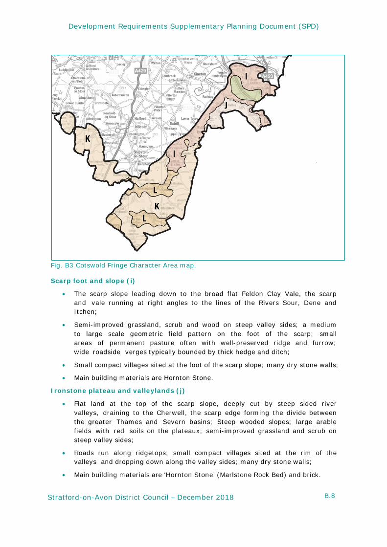
Cotswold Fringe character area includes the following sub-areas: Scarp foot and slope; Ironstone plateau and valley lands; Fringe downlands and Broad valleys. A map of the Cotswold Fringe character area (Fig C 3) is shown below.
B.8
Development Requirements Supplementary Planning Document (SPD)
Stratford-on-Avon District Council – December 2018
Fig. B3 Cotswold Fringe Character Area map.
Scarp foot and slope (i)
• The scarp slope leading down to the broad flat Feldon Clay Vale, the scarp and vale running at right angles to the lines of the Rivers Sour, Dene and Itchen;
• Semi-improved grassland, scrub and wood on steep valley sides; a medium to large scale geometric field pattern on the foot of the scarp; small areas of permanent pasture often with well-preserved ridge and furrow; wide roadside verges typically bounded by thick hedge and ditch;
• Small compact villages sited at the foot of the scarp slope; many dry stone walls;
• Main building materials are Hornton Stone.
Ironstone plateau and valleylands (j)
• Flat land at the top of the scarp slope, deeply cut by steep sided river valleys, draining to the Cherwell, the scarp edge forming the divide between the greater Thames and Severn basins; Steep wooded slopes; large arable fields with red soils on the plateaux; semi-improved grassland and scrub on steep valley sides;
• Roads run along ridgetops; small compact villages sited at the rim of the valleys and dropping down along the valley sides; many dry stone walls;
• Main building materials are ‘Hornton Stone’ (Marlstone Rock Bed) and brick.
B.9
Development Requirements Supplementary Planning Document (SPD)
Stratford-on-Avon District Council – December 2018
Fringe downlands (k)
• A varied rolling land form of rounded or flat topped hills and secluded river valleys; includes Meon Hill, Ilmington Downs, and Brailes Hill;
• A medium to large scale geometric field pattern; rich red soils supporting productive arable farmland with some woodland on higher ground; small areas of permanent pasture often with well-preserved ridge and furrow; steep hillsides with semi grassland and scrub;
• Small compact stone villages, mostly sited on ridgetops or the foot of the scarp slope; many dry stone walls;
• Main building materials are ‘Hornton Stone’ (Marlstone Rock Bed), ‘Cotswold Limestone’ (Oolitic Limestone) and brick.
Broad valleys (l)
• Valley floors with some varied undulation and small rounded hills;
• A medium to large scale geometric field pattern with small areas of permanent pasture often with well-preserved ridge and furrow;
• Small compact stone villages, mainly on the valley bottoms; many dry stone walls;
• Main building materials are ‘Hornton Stone’ (Marlstone Rock Bed), ‘Cotswold Limestone’ (Oolitic Limestone) and brick.
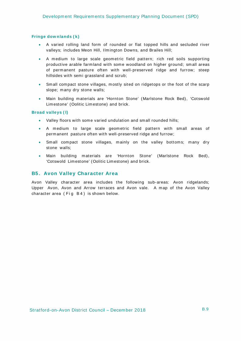
B5. Avon Valley Character Area
Avon Valley character area includes the following sub-areas: Avon ridgelands; Upper Avon, Avon and Arrow terraces and Avon vale. A map of the Avon Valley character area ( F i g B 4 ) is shown below.
B.10
Development Requirements Supplementary Planning Document (SPD)
Stratford-on-Avon District Council – December 2018
Fig. B4 Avon Valley Character Area map. Avon ridgelands (m)
Steeper side of the Avon basin including dividing the Rivers Avon and Alne with large scale rolling land form;
• A large scale often poorly defined field pattern; some large orchards on hilltops and south facing slopes; prominent hilltop woodlands; steep wooded scarps and associated semi-improved grassland;
• Varied settlement pattern of small compact villages, mostly on hilltops and ridges, and loose clusters of roadside dwellings;
• Main building materials are Blue Lias Limestone and brick.
Upper Avon (n)
• Flatter sides of the upper reach of the Avon basin; narrow river corridors defined by flat floodplains with steeply sloping often wooded bluffs to the north west side extending to broad flat gravel terraces on the south east side;
• Grazing meadows often with meanders, islands, steep banks and much marginal vegetation; fringing alders and scrub; winding hedgerows and ditches along the boundary of the floodplain; a large scale geometric field pattern on the terraces with well wooded streamlines and some small arable plots growing a wide variety of vegetable crops;
B.11
Development Requirements Supplementary Planning Document (SPD)
Stratford-on-Avon District Council – December 2018
• Small compact villages generally on or next to a river; scattered greenhouses and other horticultural buildings;
• Main building materials are timber frame, Blue Lias Limestone and brick.
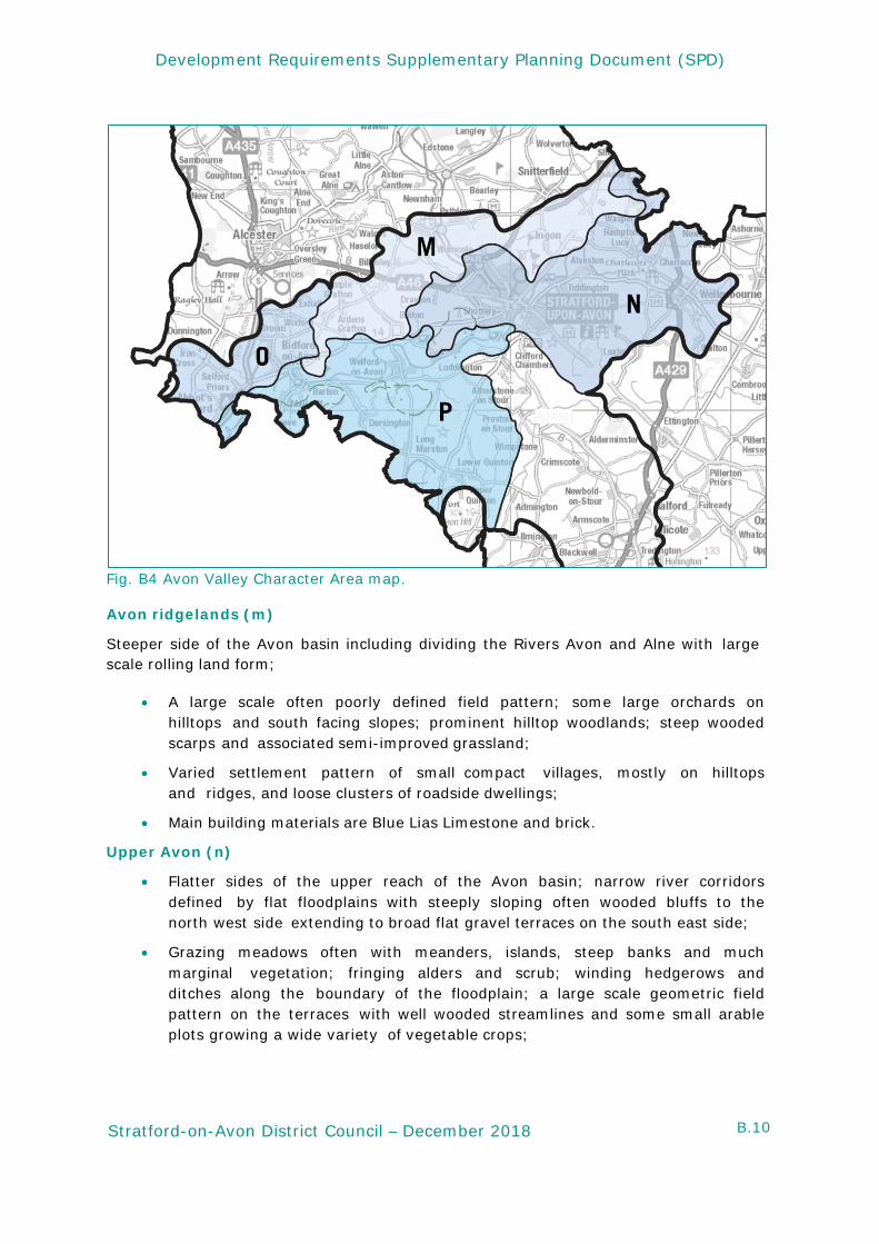
Avon and Arrow terraces (o)
• Broad flat gravel terraces at the meeting of the rivers Arrow and Avon;
• A large scale geometric field pattern; some small arable plots growing a wide variety of vegetable crops; well wooded streamlines;
• Small compact villages, generally on or next to a river; scattered greenhouses and other horticultural buildings;
• Main building materials are timber frame, Blue Lias Limestone and brick.
Avon vale (p)
• Flatter side of the lower Avon basin; narrow river corridors defined by flat floodplains with steeply sloping, often wooded bluffs extending out to broad flat valley with occasional low rounded hills;
• Grazing meadows often with meanders, islands, steep banks and much marginal vegetation; fringing alders and scrub; winding hedgerows and ditches along the boundary of the floodplain; a medium to large scale geometric field pattern on the valley land with many small often abandoned orchards;
• Straight roads with wide roadside verges typically bounded by a tall hedge and ditch; a strongly nucleated settlement pattern of medium sized villages, often fringed by greenhouses or other horticultural buildings;
• Main building materials are timber frame, Blue Lias Limestone, ‘Cotswold Limestone’ (Oolitic Limestone) and brick.
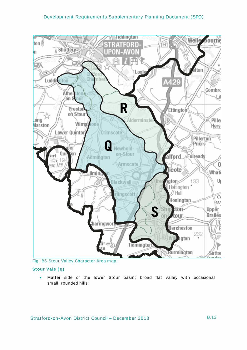
B6. Stour Valley Character Area
Stour Valley character area includes the following sub-areas: Stour vale; Stour Feldon edge and Upper Stour. These are shown in the character area map (Fig B.5) below.
B.12
Development Requirements Supplementary Planning Document (SPD)
Stratford-on-Avon District Council – December 2018
Fig. B5 Stour Valley Character Area map.
Stour Vale (q)
• Flatter side of the lower Stour basin; broad flat valley with occasional small rounded hills;
B.13
Development Requirements Supplementary Planning Document (SPD)
Stratford-on-Avon District Council – December 2018
• A medium to large scale geometric field pattern; small areas of permanent pasture often with well-preserved ridge and furrow; wide roadside verges typically bounded by a thick hedge and ditch; numerous hedgerow elm stumps;
• Small compact estate villages and clusters of farmsteads and dwellings;
• Main building materials are Blue Lias Limestone, ‘), ‘Cotswold Limestone’ (Oolitic Limestone), ‘Hornton Stone’ (Marlstone Rock Bed) and brick.
Stour Feldon Edge (r)
• Steeper side of the lower Stour basin; large scale rolling land form with occasional steep scarp slopes;
• Large woodlands often associated with rising ground; many small coverts and belts of trees; mature hedgerows and roadside oaks;
• Scattered farmsteads and a small compact village;
• Main buildings materials are White Lias Limestone (known as Langport Member Limestone) and brick.
Upper Stour (s)
• Middle reach of the Stour valley, a distinct basin defined by the Tredington hills and the flatter, rolling southern edge of the Feldon;
• A medium to large scale geometric field pattern; small areas of permanent pasture often with well-preserved ridge and furrow; wide roadside verges typically bounded by a thick hedge and ditch; numerous hedgerow elm stumps;
• Compact valley bottom settlements and small estate villages;
• Main buildings materials are Blue Lias Limestone, ‘Hornton Stone’ (Marlstone Rock Limestone Bed), ‘Cotswold Limestone’ (Oolitic Limestone).
