past plans
TRANSCRIPT

1
PAST PLANS
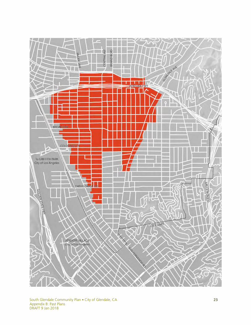
South Glendale, 1972-Present Day
A summary of public planning and policy efforts in the
South Glendale Community Plan area, 1972 to present day.

South Glendale Community Plan • City of Glendale, CA Appendix B: Past Plans
DRAFT 9 Jan 2018
2

South Glendale Community Plan • City of Glendale, CA Appendix B: Past Plans DRAFT 9 Jan 2018
3
CITY OF GLENDALE, CA
City Council
Vrej Agajanian Paula Devine Vartan Gharpetian Ara Najarian Zareh Sinanyan
Community Development Department Philip Lanzafame, Director of Community Development Erik Krause, Deputy Director of Community Development Laura Stotler, Principal Planner Jay Platt, Senior Urban Designer Kathy Duarte, Planner Jeff Hamilton, Senior Planner Wolfgang Krause, Principal Planner Alan Loomis, Deputy Director of Community Development Michael Nilsson, Senior Mobility Planner Stephanie Reich, Senior Urban Designer Prepared by Justin Robertson AICP, Planning Associate

South Glendale Community Plan • City of Glendale, CA Appendix B: Past Plans
DRAFT 9 Jan 2018
4
INTRODUCTION PURPOSE & BACKGROUND This document is a review of planning efforts in the South Glendale Community Plan area since the 1972 creation of the Glendale Redevelopment Agency and its Central Glendale Redevelopment Project; arguably the beginning of four decades of modern, community-oriented planning in South Glendale. In reviewing the considerable planning efforts of the modern era, including outreach and specific outcomes, we can better understand where, how, and when the community set its desired course, and the degree to which the public has directly influenced the shape of today’s South Glendale. The following was presented to the City Council on July 12, 2016, and reflects the input and research of Community Development Department staff, past and present. It is meant to inform policy and planning projects moving forward, in concert with the Historic Context and the Planning Framework (Chapter 5).

South Glendale Community Plan • City of Glendale, CA Appendix B: Past Plans DRAFT 9 Jan 2018
5
Table of Contents
1972 Glendale Redevelopment Agency/Central Glendale Redevelopment Project ............ 6 1986 Citywide Land Use and Zoning Consistency Program .................................................. 8 1990 Citywide Multifamily Rezoning Program .................................................................... 10 1991 Citywide Single-Family Neighborhood Guidelines ..................................................... 12 1992 San Fernando Road Corridor Redevelopment Project ............................................... 14 1992 South Brand Boulevard Specific Plan ......................................................................... 16 1994 Colorado Street Revitalization Project ....................................................................... 18 1994 Glendale Municipal Transportation Center Specific Plan ........................................... 20 1996 Greater Downtown Strategic Plan .............................................................................. 22 1997 San Fernando Design & Implementation Feasibility Plan .......................................... 24 1996 Pacific Edison Model Neighborhood Planning Program ............................................ 26 1997 Adams Square Revitalization Project and Design Guidelines ..................................... 28 1998 Citywide Urban Design Guidelines for Commercial Zones ......................................... 30 2001 East Garfield Neighborhood Plan ............................................................................... 32 2002 Citywide Multifamily Rezoning Program .................................................................... 34 2004 San Fernando Road Mixed-Use Rezoning .................................................................. 36 2006 Citywide Long Range Plan Program ............................................................................ 38 2006 Adams Hill Hillside Ordinance Working Group Proposals .......................................... 40 2006 Historic District Overlay Zone Ordinance & Design Guidelines .................................. 42 2006 Downtown Specific Plan ............................................................................................. 44 2007 Downtown Mobility Study .......................................................................................... 46 2008 Citywide Craftsman Survey ......................................................................................... 48 2009 Multifamily Parking Study .......................................................................................... 50 2010 San Fernando Road “Creative Corridor” Initiative ..................................................... 52 2011 Safe & Healthy Streets Plan/Riverdale-Maple Neighborhood Greenway .................. 54 2011 Columbus Soccer Fields Joint-Use Project .................................................................. 56 2011 South Brand Boulevard Rezoning & Preferential Parking District .............................. 58 2012 Citywide Bicycle Transportation Plan ......................................................................... 60 2013 Space 134 Freeway Cap Park Concept ....................................................................... 62 2013 Tropico Center Plan .................................................................................................... 64 2014 South Glendale Historic Context Statement .............................................................. 66

South Glendale Community Plan • City of Glendale, CA Appendix B: Past Plans
DRAFT 9 Jan 2018
6
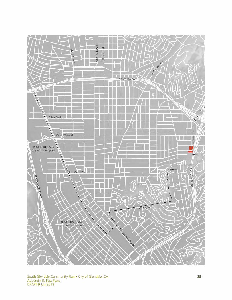
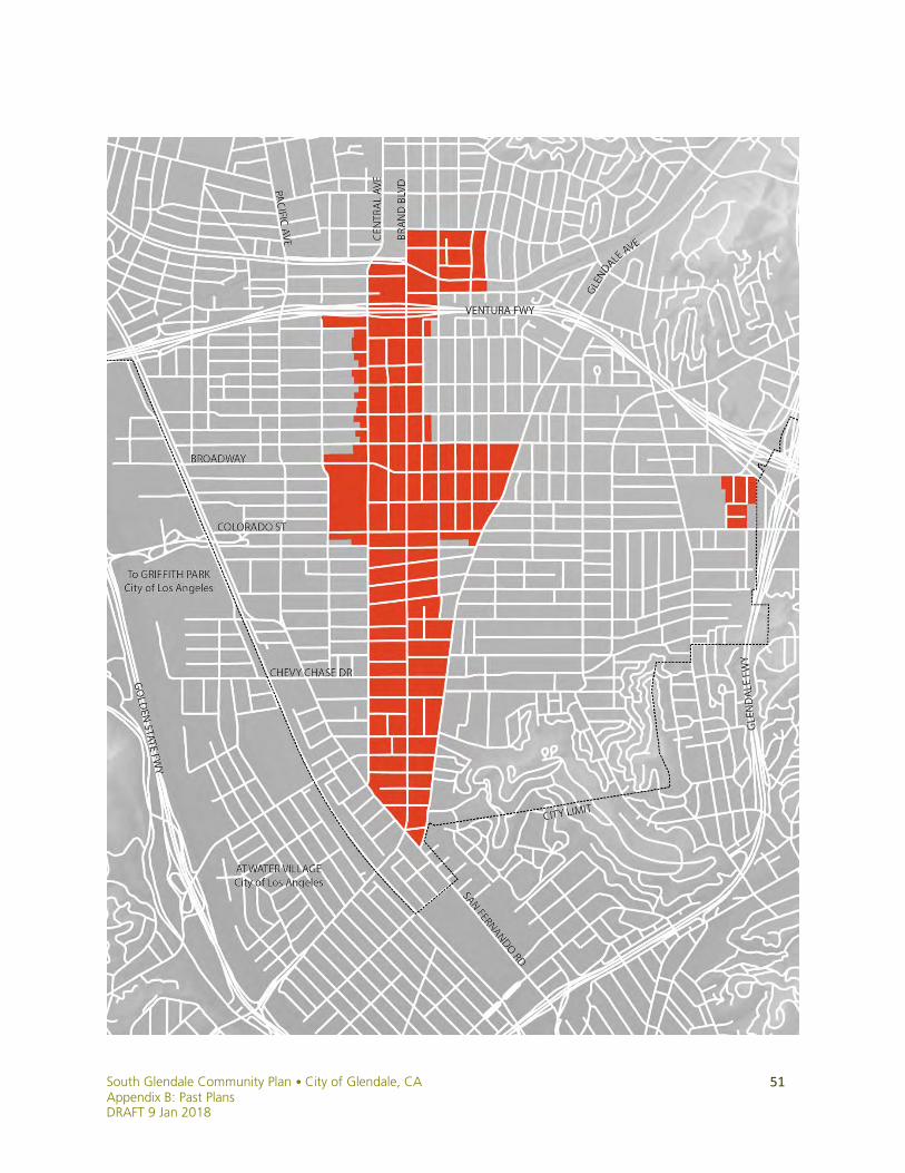
1972 Glendale Redevelopment Agency/Central Glendale Redevelopment Project
Location: The Central Glendale Redevelopment Project Area encompasses 263 acres in the heart of downtown Glendale. The Project Area is generally bounded by Colorado Street to the south, Glenoaks Boulevard to the north, Central and Columbus Avenues on the west and Louise Street and Maryland Avenue on the east. The Project Area is bisected by Brand Boulevard, one of the community's major thoroughfares, and by the Ventura Freeway (State Route 134). Background: The Glendale Redevelopment Agency (GRA) was created for the purpose of improving, upgrading and revitalizing areas within the City that had become blighted due to deterioration, disuse, and “unproductive economic conditions.” GRA was a legal and separate public body, with its own powers and budget separate from the City. Public Outreach: In 1972, a Central Business District Citizens’ Advisory Committee was appointed by the Mayor. It conducted and submitted the Central Glendale Study, which considered the economic, physical, and “other municipal” characteristics of the area. Its four recommendations included the establishment of a Community Redevelopment Agency for the purposes of downtown revitalization.
Outcome/Implementation: The creation of the Glendale Redevelopment Agency was approved by the City Council in March 1972. The GRA’s first major project was the development of the Glendale Galleria in 1974, which has since served as a catalyst for downtown revitalization and continues to serve as a regional center for retail activity. Other commercial/office/retail/entertainment projects in the Central Glendale Redevelopment Project Area included the Glendale Town Center, the Embassy Suites (800 N. Central), the Hilton Hotel, DPSS Site Reuse, the Glendale City Center, Alex Theater Improvements, The Americana at Brand, and the Central Glendale Façade Improvement Program. Completed public improvement projects in the Central Glendale Redevelopment Project Area include Brand Boulevard Improvements, Mid-Brand District, Orange Street Public Parking Garage, Orange Street Public Improvements, The Exchange Public Parking Garage, and the Marketplace/Maryland Garage. The Central Glendale Redevelopment Project Area is scheduled to sunset in 2015. The Project Area is still active despite the dissolution of the Redevelopment Agency by the passage of ABX1 26, the Dissolution Act. The Dissolution Act changed the procedures for administering existing redevelopment projects within the Project Area, and disallows the Successor Agency (former Redevelopment Agency) to enter into new agreements or contracts.

South Glendale Community Plan • City of Glendale, CA Appendix B: Past Plans DRAFT 9 Jan 2018
7
South Glendale Community Plan • City of Glendale, CA Appendix B: Past Plans
DRAFT 9 Jan 2018
8
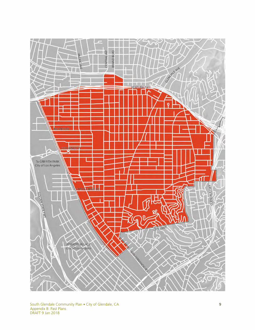
1986 Citywide Land Use and Zoning Consistency Program
Background: The Land Use and Zoning Consistency Program began in June 1981 in order to bring Glendale’s Zoning Ordinance and Map (1922) into conformance with the moderate growth policy of its General Plan Land Use Element (1977). Under the 1922 zoning code, the estimated population capacity for Glendale was 350,000 people, certainly more than Glendale’s existing facilities could support. Between 1981 and 1983, the City conducted land use studies of every potential zone change area in Glendale, enabling analysis of each area on a lot-by-lot basis.
Public Outreach: An extensive public outreach effort was undertaken to inform Glendale’s 152,000 citizens and any persons with development interests about the program. Council and the Planning Commission participated in monthly study sessions to discuss the zoning map and consistency changes, which were publicly noticed in all Glendale newspapers, and were open to the public. An ad-hoc committee composed of representatives of the various building professions and associations reviewed sections of the proposed Zoning Ordinance with planning staff on a weekly basis.
Over 53,000 public notices were mailed as part of the outreach effort. These notices announced the dates of public hearings as well as informal neighborhood sessions, one for each neighborhood, to be held by the Planning Division. Each neighborhood session included a slide show describing the reasons for and effects of the Consistency Program, particularly as they related to the neighborhood in question, as well as other concerns including increased buffering between incompatible land uses and the establishment of a design review process. The formal public hearing process began two days following each neighborhood’s informational meeting. The entire hearing process lasted for more than fifteen months, allowing for a great deal of public input. Over one thousand pieces of correspondence from Glendale landowners were transmitted to the City Council, Planning Commission and the Planning Division, collectively giving a strong indication as to the public’s concerns, comments and areas of support. The public hearing process accounted for a major portion of the public input, with 17 Council meetings and 22 Commission meetings allotting a total of over 120 hours of public hearings on the program.
Outcome/Implementation: The program revised the city’s zoning in 1986 to conform to the moderate growth policy of the Land Use Element, and created the City’s Design Review Process. It also established a precedent for providing public notice beyond minimum requirements. The Land Use and Zoning Consistency Program was the first of its kind in any charter city in California to successfully reach completion, and it was awarded the Los Angeles Section of the American Planning Association’s Distinguished Leadership Award.
South Glendale Community Plan • City of Glendale, CA Appendix B: Past Plans DRAFT 9 Jan 2018
9

South Glendale Community Plan • City of Glendale, CA Appendix B: Past Plans
DRAFT 9 Jan 2018
10
1990 Citywide Multifamily Rezoning Program
Background: In June 1989, City Council directed staff to begin working on ordinances which would effectively assist in the goal of limiting the maximum population to 200,000 people. Although downzoning had only occurred a few years earlier, there was a need to pursue growth management strategies to protect the community from the negative effects of increased congestion, overcrowding and other effects. In March 1990, the State Government Code was amended to require local governments to provide 20 percent density bonuses for affordable multifamily housing projects of 5 units in size or greater. In Glendale, projects using state density bonus provisions could be built in all multifamily zones and in commercial zones where development is permitted, subject to R-1250 Zone restrictions. Staff and consultants prepared several studies in preparation for this effort including a detailed analysis of multifamily residential demographics. A Building Cap Feasibility Report was also prepared, and the City completed a geo-base mapping program for the multifamily zones to aid in analysis.
Public Outreach: Over 24,500 public notices concerning this program were mailed to owners of all properties involved in the change of zone and to property owners within 300 feet of any change of zone. Published notice was provided through an 1/8th page advertisement in the Glendale News-Press. The Planning Division divided the City into three geographical areas in order to provide detailed information and held special planning Commission hearings for the affected property owners and interested citizens. Six Planning Division informational meetings and Planning Commission special hearings were held, prior to a formal recommendation hearing by Planning Commission and adoption hearing by City Council.
Outcome/Implementation: The Rezoning Project resulted in downzoning throughout Glendale, with the City’s multifamily zones changing from R-1750 (25 du/ac) to R-3050 (14 du/ac), R-1250 (35 du/ac) to R-2250 (19 du/ac) and R-750 (58 du/ac) to R-1650 (26 du/ac). Certain multifamily zones were changed to the R-1 single-family zone. The proposed amendments resulted in the following Land Use Element General Plan densities:
• Moderate Density Residential standard of 9 to 14 dwelling units per acre. • Medium Density Residential standard of 15 to 19 dwelling units per acre. • Medium/High Density Residential standard of 20 to 26 dwelling units per acre. • High Density Residential standard of 27 to 35 dwelling units per acre. • Density Bonus in multifamily residential categories of medium, medium high and
high densities, a density bonus of up to 25% may be added to lots/parcels which are combined to create a building site for purposes of creating more open space and amenities. Density bonuses may also be granted for projects in order to provide affordable housing.
South Glendale Community Plan • City of Glendale, CA Appendix B: Past Plans DRAFT 9 Jan 2018
11
South Glendale Community Plan • City of Glendale, CA Appendix B: Past Plans
DRAFT 9 Jan 2018
12
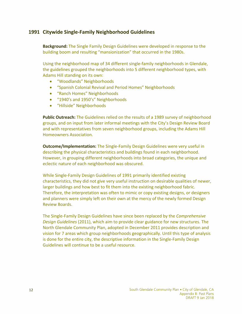
1991 Citywide Single-Family Neighborhood Guidelines
Background: The Single Family Design Guidelines were developed in response to the building boom and resulting “mansionization” that occurred in the 1980s. Using the neighborhood map of 34 different single-family neighborhoods in Glendale, the guidelines grouped the neighborhoods into 5 different neighborhood types, with Adams Hill standing on its own:
• “Woodlands” Neighborhoods • “Spanish Colonial Revival and Period Homes” Neighborhoods • “Ranch Homes” Neighborhoods • “1940’s and 1950’s” Neighborhoods • “Hillside” Neighborhoods
Public Outreach: The Guidelines relied on the results of a 1989 survey of neighborhood groups, and on input from later informal meetings with the City’s Design Review Board and with representatives from seven neighborhood groups, including the Adams Hill Homeowners Association.
Outcome/Implementation: The Single-Family Design Guidelines were very useful in describing the physical characteristics and buildings found in each neighborhood. However, in grouping different neighborhoods into broad categories, the unique and eclectic nature of each neighborhood was obscured. While Single-Family Design Guidelines of 1991 primarily identified existing characteristics, they did not give very useful instruction on desirable qualities of newer, larger buildings and how best to fit them into the existing neighborhood fabric. Therefore, the interpretation was often to mimic or copy existing designs, or designers and planners were simply left on their own at the mercy of the newly formed Design Review Boards. The Single-Family Design Guidelines have since been replaced by the Comprehensive Design Guidelines (2011), which aim to provide clear guidance for new structures. The North Glendale Community Plan, adopted in December 2011 provides description and vision for 7 areas which group neighborhoods geographically. Until this type of analysis is done for the entire city, the descriptive information in the Single-Family Design Guidelines will continue to be a useful resource.

South Glendale Community Plan • City of Glendale, CA Appendix B: Past Plans DRAFT 9 Jan 2018
13
South Glendale Community Plan • City of Glendale, CA Appendix B: Past Plans
DRAFT 9 Jan 2018
14
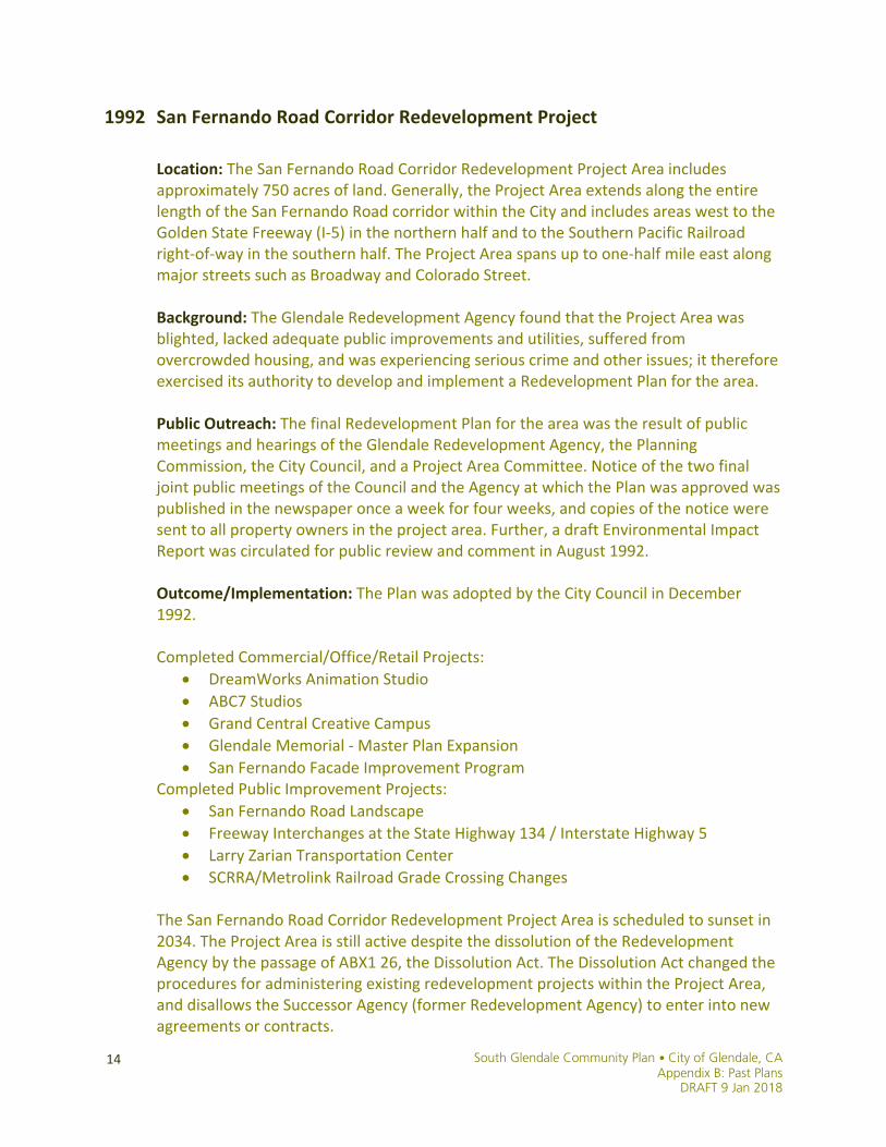
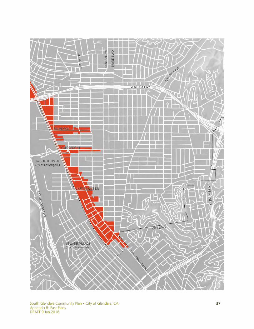
1992 San Fernando Road Corridor Redevelopment Project
Location: The San Fernando Road Corridor Redevelopment Project Area includes approximately 750 acres of land. Generally, the Project Area extends along the entire length of the San Fernando Road corridor within the City and includes areas west to the Golden State Freeway (I-5) in the northern half and to the Southern Pacific Railroad right-of-way in the southern half. The Project Area spans up to one-half mile east along major streets such as Broadway and Colorado Street. Background: The Glendale Redevelopment Agency found that the Project Area was blighted, lacked adequate public improvements and utilities, suffered from overcrowded housing, and was experiencing serious crime and other issues; it therefore exercised its authority to develop and implement a Redevelopment Plan for the area.
Public Outreach: The final Redevelopment Plan for the area was the result of public meetings and hearings of the Glendale Redevelopment Agency, the Planning Commission, the City Council, and a Project Area Committee. Notice of the two final joint public meetings of the Council and the Agency at which the Plan was approved was published in the newspaper once a week for four weeks, and copies of the notice were sent to all property owners in the project area. Further, a draft Environmental Impact Report was circulated for public review and comment in August 1992.
Outcome/Implementation: The Plan was adopted by the City Council in December 1992. Completed Commercial/Office/Retail Projects:
• DreamWorks Animation Studio • ABC7 Studios • Grand Central Creative Campus • Glendale Memorial - Master Plan Expansion • San Fernando Facade Improvement Program
Completed Public Improvement Projects: • San Fernando Road Landscape • Freeway Interchanges at the State Highway 134 / Interstate Highway 5 • Larry Zarian Transportation Center • SCRRA/Metrolink Railroad Grade Crossing Changes
The San Fernando Road Corridor Redevelopment Project Area is scheduled to sunset in 2034. The Project Area is still active despite the dissolution of the Redevelopment Agency by the passage of ABX1 26, the Dissolution Act. The Dissolution Act changed the procedures for administering existing redevelopment projects within the Project Area, and disallows the Successor Agency (former Redevelopment Agency) to enter into new agreements or contracts.

South Glendale Community Plan • City of Glendale, CA Appendix B: Past Plans DRAFT 9 Jan 2018
15

South Glendale Community Plan • City of Glendale, CA Appendix B: Past Plans
DRAFT 9 Jan 2018
16
1992 South Brand Boulevard Specific Plan
Location: The plan area is bounded by Colorado Street on the north, Louise Street and Glendale Avenue on the east, San Fernando Road on the South and Central Avenue on the west. Background: Automotive dealerships and related uses have been a cornerstone of South Brand Boulevard’s economic base since the early 1920s. As private automobiles gained popularity and importance in southern California, demand for them rose; dealerships and related businesses expanded accordingly. The results were an informal, long-time automobile sales and service identity for the area, and a steadily lessening presence of the general retail businesses that once co-existed with auto related uses. Residential uses changed as well, as area zoning changed to permit high density residential development in areas originally designated for low and medium density residential uses. Numerous variances granted within existing residential zoning districts over the previous 30 years permitted the expansion of auto-related uses into residential zones. The changing land use patterns resulted in visual and functional incompatibilities within the commercial districts themselves and in the interface areas between residentially and commercially zoned land. The South Brand Boulevard Specific Plan was initiated in response to these conditions. It sought to concentrate dealership and related uses along Brand Boulevard, and to permit other commercial development such as office and retail uses in specified areas, while preserving existing residential neighborhoods within the plan area.
Public Outreach: City Staff held two public hearings in May and June, 1990. Property owners, business owners, residents, and other interested members of the community attended. As a result of comments received at the May 1990 hearing, Staff developed a South Brand Boulevard Study Guide, organizing the issues and goals identified at the public hearings and suggesting ways to address community concerns and meet the goals of the planning effort. A draft of the plan was prepared by City Planning with the input of property owners, residents, merchants, the Glendale Motor Car Dealers Association, and other stakeholders. Further public input was solicited through public workshops and the environmental review and public hearing and notification process. Finally, the plan received a hearing before the City Council prior to its adoption.
Outcome/Implementation: The Specific Plan was adopted by the City Council in May 1992, and was repealed by the City Council in January 2012. Some aspects of the plan proved cumbersome, and the regulations were not well suited to the types of projects that dealerships had proposed in recent years. The Council moved to replace the Plan with conventional zoning and an area parking plan. See page 56 in this document for more on the subsequent South Brand Boulevard Rezoning effort (2011).
South Glendale Community Plan • City of Glendale, CA Appendix B: Past Plans DRAFT 9 Jan 2018
17
South Glendale Community Plan • City of Glendale, CA Appendix B: Past Plans
DRAFT 9 Jan 2018
18
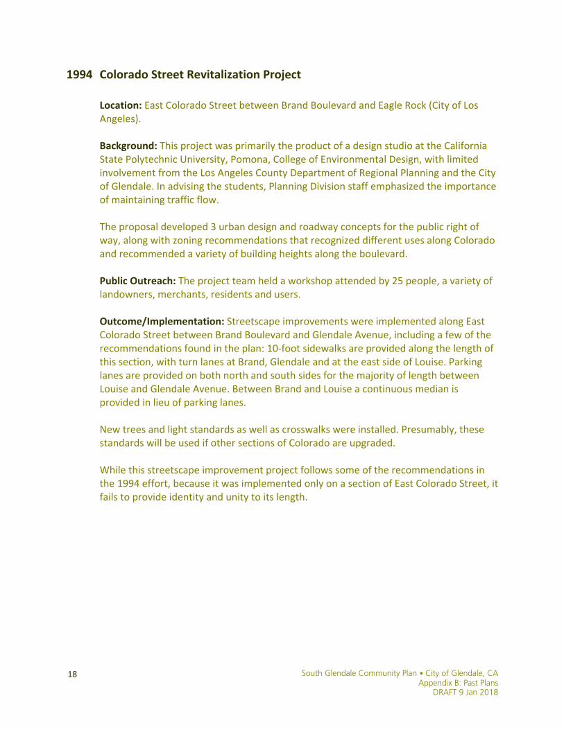
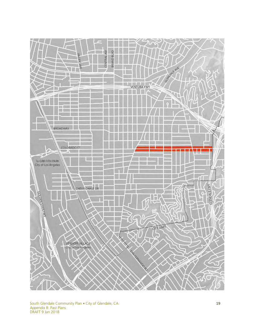
1994 Colorado Street Revitalization Project
Location: East Colorado Street between Brand Boulevard and Eagle Rock (City of Los Angeles).
Background: This project was primarily the product of a design studio at the California State Polytechnic University, Pomona, College of Environmental Design, with limited involvement from the Los Angeles County Department of Regional Planning and the City of Glendale. In advising the students, Planning Division staff emphasized the importance of maintaining traffic flow. The proposal developed 3 urban design and roadway concepts for the public right of way, along with zoning recommendations that recognized different uses along Colorado and recommended a variety of building heights along the boulevard.
Public Outreach: The project team held a workshop attended by 25 people, a variety of landowners, merchants, residents and users.
Outcome/Implementation: Streetscape improvements were implemented along East Colorado Street between Brand Boulevard and Glendale Avenue, including a few of the recommendations found in the plan: 10-foot sidewalks are provided along the length of this section, with turn lanes at Brand, Glendale and at the east side of Louise. Parking lanes are provided on both north and south sides for the majority of length between Louise and Glendale Avenue. Between Brand and Louise a continuous median is provided in lieu of parking lanes. New trees and light standards as well as crosswalks were installed. Presumably, these standards will be used if other sections of Colorado are upgraded.
While this streetscape improvement project follows some of the recommendations in the 1994 effort, because it was implemented only on a section of East Colorado Street, it fails to provide identity and unity to its length.
South Glendale Community Plan • City of Glendale, CA Appendix B: Past Plans DRAFT 9 Jan 2018
19

South Glendale Community Plan • City of Glendale, CA Appendix B: Past Plans
DRAFT 9 Jan 2018
20
1994 Glendale Municipal Transportation Center Specific Plan
Location: The Glendale Municipal Transportation Center (recently renamed the Larry Zarian Transportation Center) is located in the southwestern corner of the City of Glendale, adjacent to San Fernando Road off of Cerritos Avenue. The Plan looks at the historic depot as well as the neighborhood immediately adjacent to the train station, which is bound by Los Feliz Road to the north, San Fernando Road to the east, Brand Boulevard to the south and the SCRRA railroad tracks to the west.
Background: The Glendale Railroad Depot, located at the southeastern terminus of Cerritos Avenue adjacent to the Southern Pacific Railroad right-of-way (SCRRA), was constructed in 1923 to replace the City’s original 1883 depot. While the train station serviced Amtrak trains since the 1970’s, the arrival of Metrolink service in 1992 created an opportunity for the City of Glendale to establish a multi-modal transportation facility which serves as a gateway to the City. In addition, there were proposals in the early 1990’s for the Blue Line to be extended north from Downtown Los Angeles on the San Fernando Road corridor through Glendale and Burbank, which also sparked interest for a consolidated transit facility in Glendale at that time. With this interest, the Plan aimed to preserve and enhance the historic depot as well as upgrade facilities at the train station to serve a variety of transit modes.
Public Outreach: The Glendale Municipal Transportation Center Specific Plan was prepared for the Glendale Redevelopment Agency by Gruen Associates, a Los Angeles consulting firm. In the plan there is no mention of outreach conducted during its development.
Outcome/Implementation: The Glendale Municipal Transportation Center Specific Plan was never officially adopted by City Council. However, the final plan was completed in October 1994 and several components of the Plan have been implemented, including:
• Design and circulation of the surface parking lots servicing the train station • Restoration of the historic Southern Pacific Railroad depot building • Purchase of properties along Gardena Avenue adjacent to the railroad depot • Enhancements to the entrance of the Glendale Transportation Center, including
updated streetscapes, sidewalks, and landscaping

South Glendale Community Plan • City of Glendale, CA Appendix B: Past Plans DRAFT 9 Jan 2018
21

South Glendale Community Plan • City of Glendale, CA Appendix B: Past Plans
DRAFT 9 Jan 2018
22
1996 Greater Downtown Strategic Plan
Location: The Greater Downtown Strategic Plan (GDSP) focuses on the area Greater Downtown bounded by Glenoaks Boulevard on the north, Glendale Avenue on the east, San Fernando Road Corridor Redevelopment Project Area on the south and west, and South Brand Boulevard Specific Plan on the south.
Background: The first major planning effort of the modern era in South Glendale, the Central Glendale Redevelopment Project Area of the early 1970s, was followed by the early 1980s creation of the North Brand Boulevard financial district. By the 1990s, the City of Glendale recognized a need for a third major planning effort for the downtown area, though the effort would require focusing on both the Downtown and its surrounding neighborhoods. The motivation twofold: to address a need for a growth management strategy, and to address the impacts of the early 1990s recession on Downtown and its surrounding neighborhoods, including visible deterioration, flat development activity, and high rates of office vacancy.
Public Outreach: In Spring 1993, planning consultant Alex Cooper was hired through a public-private partnership of business group Glendale Partners and the City of Glendale to develop a visioning document, resulting in 1994’s Cooper Report, adopted by the City Council. To implement the vision, the City established an Implementation Steering Group comprised of community representatives, business leaders, and public officials. Joining in this effort was the Neighborhood Task Force, whose focus was on dealing with the variety of issues affecting the surrounding neighborhoods. The GDSP, which includes planning frameworks for land use and transportation, demonstration projects, and an implementation plan, was the result of that effort. Among its goals are “significantly increasing the amount of public open space and developed parkland in the downtown” and “strengthening the interdependence between downtown and surrounding neighborhoods.”
Outcome/Implementation: The Plan was adopted by the City Council in 1996. The Plan’s proposal for a “Town Center” to anchor the south end of Brand Boulevard eventually evolved into the present-day Americana at Brand development, brought about through a competitive call for development proposals. The GDSP was followed by the Downtown Specific Plan (2006), developed to further study and implement the vision, goals, and policies of the GDSP.
South Glendale Community Plan • City of Glendale, CA Appendix B: Past Plans DRAFT 9 Jan 2018
23
South Glendale Community Plan • City of Glendale, CA Appendix B: Past Plans
DRAFT 9 Jan 2018
24
1997 San Fernando Design & Implementation Feasibility Plan
Location: The San Fernando Road Corridor Redevelopment Project Area extends along the entire length of the San Fernando Road corridor within the City and includes areas west to the Golden State Freeway (I-5) in the northern half and to the Southern Pacific Railroad right-of-way in the southern half. The Project Area spans up to one-half mile east along major streets such as Broadway and Colorado Street. Background: The former Glendale Redevelopment Agency established the San Fernando Road Corridor Redevelopment Project Area in 1992. The Agency, staff, consultants, and the Project Area Committee developed a Redevelopment Plan for the area, including calls for a design plan including guidelines and zoning, a Historic Resources Survey, a plan for a multi-modal transportation center at the then-Glendale Railroad Depot, and an implementation plan.
Public Outreach: Project coordinators Cooper, Robertson & Partners and their consultants met with the Glendale Redevelopment Agency (GRA) and the Project Area Committee (PAC) during each phase of the effort to review work-in-progress and obtain their input. Presentations were made at the conclusion of each of the four project phases, and as required by the nature of the work being done at the time, to the GRA, PAC, and other groups and individuals. There was also a public workshop on the Design Guidelines and a bus tour of all of the key locations being considered during the Alternatives phase in which PAC members, GRA staff, City staff, City Council members, and consultants participated.
Outcome/Implementation: The “Cooper/Robertson” Plan included extensive recommendations on zoning and development standards. With regard to land use, the main premise of the Cooper/Robertson Plan was that existing zoning was too inflexible to produce the desired land use changes along the corridor. The plan’s primary recommendation for zoning was the creation of a mixed-use zone with a wide variety of permitted uses based on a project’s ability to meet certain performance criteria or thresholds. These recommendations led to the San Fernando Road Mixed-Use Rezoning (2004) discussed on page 34 of this document.

South Glendale Community Plan • City of Glendale, CA Appendix B: Past Plans DRAFT 9 Jan 2018
25
South Glendale Community Plan • City of Glendale, CA Appendix B: Past Plans
DRAFT 9 Jan 2018
26
1996 Pacific Edison Model Neighborhood Planning Program
Location: The Pacific Edison Model Neighborhood area was bordered by Colorado Street on the north, Brand Boulevard in the east, Chevy Chase Drive on the south, and San Fernando Road in the west.
Background: The Greater Downtown Strategic Plan (1996) concluded that a healthy Downtown relies on the health of the neighborhoods that surround it. As such, several committees of the Greater Downtown Strategic Plan effort and the City’s Neighborhood Task Force (NTF), comprised of 70 residents, business representatives, and community organizations from south of the 134 Freeway, formed the Community Facilities and Services Committee. Its goal was to identify locations for the development of community/neighborhood centers that would service specific neighborhoods. The joint committee set about identifying a “model neighborhood” to which highly localized attention would be paid to area problems and solutions. The neighborhood around Pacific Park and Thomas Edison Elementary School met the committee’s criteria and served as the laboratory for developing a set of “Model Neighborhood” and Neighborhood Planning Program Guidelines centered around the park and school, but applicable city-wide.
Public Outreach: The formulation of the “Model Neighborhood” guidelines was structured around the conduct of community meetings and workshops. The process involved the following basic steps:
• A community meeting in October 1995 in which participants reviewed the neighborhood issues identified by the NTF in their neighborhood and prioritized applicable “tools.” The meeting was attended by approximately 1,500 stakeholders, including 500 adults and 1,000 children.
• A neighborhood workshop in November 1995 in which participants identified a range of facility options that may be appropriate for their neighborhood, including potential uses for a multipurpose community center, and identified key neighborhood problems. The meeting was attended by approximately 400 stakeholders, including 160 adults and 240 children.
• Community input from the meeting and workshop was reviewed for common elements and recommendations, including identified problems and potential facilities and land uses for a proposed community center. The results of this review were presented at a neighborhood workshop in December 1995 for public review and for the selection of preferred guidelines and uses for a community center.
Outcome/Implementation: The Model Neighborhood planning effort resulted in the development of a $45 million joint-use project by the City of Glendale and the Glendale Unified School District, combining a new Edison school complex, community center, and public library into a true neighborhood center alongside Pacific Park.

South Glendale Community Plan • City of Glendale, CA Appendix B: Past Plans DRAFT 9 Jan 2018
27
South Glendale Community Plan • City of Glendale, CA Appendix B: Past Plans
DRAFT 9 Jan 2018
28
1997 Adams Square Revitalization Project and Design Guidelines
Location: The Adams Square Revitalization Project applied to the Adams Square neighborhood. Background: In 1997, the City completed a study of the Adams Square neighborhood commercial zone. The study found that the Adams Square commercial zone served as an important economic and cultural center for the Adams Square/Adams Hill neighborhood, and was a good candidate for revitalization. The goals of the revitalization project included expanding the market for Adams Square -- helping make businesses more viable to draw a larger number of local residents and the creation of a lively, charming, pedestrian oriented neighborhood center. Public Outreach: Throughout the development of the conceptual plans and designs for the public improvements, there was significant community input. Early in the process, four stakeholder groups were identified: Adams Square commercial property owners and merchants; residents adjacent to the Adams Square commercial zone, institutions in the neighborhood including John Muir School, Glendale College Training Center, Windsor Manor Retirement Facility, and Mullikin Medical Center; and the Adams Hill Homeowners Association. Staff and consultants held meetings with these groups to better understand their neighborhood. The City also organized a visioning tour involving over 240 community residents who provided direct input on area needs and priorities Outcome/Implementation: The Adams Square Revitalization Project’s revitalization strategy and implementation plan was approved by the City Council in November 1999. In December 1998, the Adams Square Facade Improvement Program was initiated. In December 1999, a street and pedestrian lighting project on Chevy Chase, Adams and Palmer was completed. In March 2000, the Adams Square Merchants Association was formed; the Association has undertaken promotional activities such as the Adams Square summer fair and holiday tree lighting. In June 2002, the Phase I Public Streetscape Improvement Project was completed, consisting of a pair of landscaped traffic chokers with an entry marker on Chevy Chase west of Adams, a landscaped sidewalk widening and development of a plaza with water feature on the southwest corner of Adams and Chevy Chase, construction of a landscaped center median on Chevy Chase and Tyler, and landscaping at a parkway pocket and installation of an entry marker at the southwest corner of Chevy Chase and Tyler. Related projects included a private commercial redevelopment at the southwest corner of Chevy Chase and Adams and a new Glendale Public Library branch on the opposite corner; a Habitat for Humanity housing project at 900 E. Palmer; the Adams Mini Park that repurposed a now-designated historic gas station at the southeast corner of Adams and Palmer; and acquisition and owner-occupancy of the Adams Square Building by Neighborhood Legal Services (NLS).

South Glendale Community Plan • City of Glendale, CA Appendix B: Past Plans DRAFT 9 Jan 2018
29
South Glendale Community Plan • City of Glendale, CA Appendix B: Past Plans
DRAFT 9 Jan 2018
30
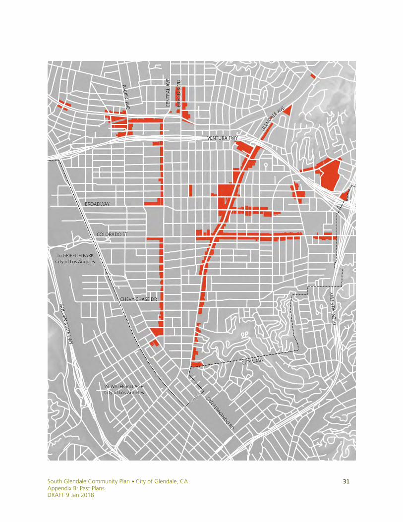
1998 Citywide Urban Design Guidelines for Commercial Zones
Background: The purpose of the Urban Design Guidelines adopted in 1998 was to “assist citizens, business owners and design professionals to contribute positively to the surrounding commercial and residential neighborhoods” by “identifying good general design principles” as well as specific design and development issues of concern to the community. The Urban Design Guidelines are broken into 5 main sections: • Background including application and other documents; • Purpose and Goals Statements including Pedestrian Oriented Design; • Commercial Classifications of different type of commercial development and
identification of each commercial area into one of these classifications; • Design Guidelines including Site Plan, Mass and Scale, and Design Components and
Details, lighting, landscaping and signage; • “Special Situations” including Mixed-Use, Older Buildings and Art and Culture.
Public Outreach: Design Review Boards were actively involved in the development of the guidelines. A public workshop and public meetings were conducted involving various community groups, including design professionals, San Fernando Road Project Area Committee members, Glendale Association of Realtors, Glendale Chamber of Commerce, Glendale Homeowner’s Coordinating Council, and representatives of the Glendale Historical Society.
Outcome/Implementation: Adopted by City Council in June, 1998, the Urban Design Guidelines provided sound design principles for guidance to commercial developers and designers, as well as to planning staff and Design Review Board members. Planning staff regularly reviewed applications for compliance with the Urban Design Guidelines until they were replaced in December 2011 with the Comprehensive Design Guidelines. Much of the content of the Urban Design Guidelines, such as pedestrian orientation, design guidance on site planning, mass and scale, and design and detailing have been incorporated into the Comprehensive Design Guidelines.
South Glendale Community Plan • City of Glendale, CA Appendix B: Past Plans DRAFT 9 Jan 2018
31
South Glendale Community Plan • City of Glendale, CA Appendix B: Past Plans
DRAFT 9 Jan 2018
32
2001 East Garfield Neighborhood Plan
Location: The East Garfield Neighborhood area is a four block area generally bounded by Glendale Avenue, Brand Boulevard, Chevy Chase Drive and Maple Street, with auto uses on Brand Boulevard, small commercial uses along Glendale Avenue, a school use along Chevy Chase Drive, and a mix of low, medium and high residential uses to the north and center of the neighborhood. Background: In 2001 the Housing Authority identified East Garfield as an appropriate area for neighborhood revitalization. A primary factor for this designation was the conditions and concerns associated with the H-alley, a substandard alley located in the center of this neighborhood. Specific issues/concerns about this neighborhood included:
● Crime ● Deferred property maintenance ● Substandard Housing ● Density ● Vacant/Undeveloped Land ● Lack of Open Space ● Parking (onsite and offsite) ● Condition of street lighting, sidewalks, streets and curbs ● Traffic Circulation/Alley Improvements
From these issues/concerns, three major areas were identified to address as tools towards neighborhood revitalization: public infrastructure improvements, park development, and affordable housing. Public Outreach: Development of the Neighborhood Plan involved direct mailings, one neighborhood meeting, and hearings with the City Council and Housing Authority. The Maryland Mini Park improvements were funded by a Proposition 84 grant, which places a high level of importance on community-based planning. A total of fifteen focus groups, design workshops, and community meetings were held with the community about the park design. Local residents provided input on five elements of park design required by the grant. These included recreational features, the design of those features, the location of those features, ideas for park security, and ideas for park beautification. Outcome / Implementation: The final East Garfield Neighborhood Plan was adopted by City Council and the Housing Authority in 2005. Acquisition of five residential parcels was completed in 2003, and an RFP to develop three of the parcels with an affordable housing development was issued in 2005. Thomas Safran & Associates was awarded this proposal in 2006, and completed the 30-unit “Gardens on Garfield” project in 2010. Public improvements to the H-alley were completed in 2010 as well. Design for the Maryland Mini Park on the remaining two parcels also began in 2010 and was approved by Council in March 2011; the park officially opened in August 2014.

South Glendale Community Plan • City of Glendale, CA Appendix B: Past Plans DRAFT 9 Jan 2018
33
South Glendale Community Plan • City of Glendale, CA Appendix B: Past Plans
DRAFT 9 Jan 2018
34
2002 Citywide Multifamily Rezoning Program
Background: The Multifamily Rezoning Program began in August 2002 when the City Council directed staff to evaluate the existing zoning for multifamily residential zones and provide analysis of the existing zoning development patterns, identify areas of significant single family land uses within multifamily residential zones, and examine the current multifamily development standards. City staff evaluated the additional development potential on all multifamily zoned lots in the city and looked for clusters of lots that had the potential for development and that were near the boundaries of single family zoned areas. Outreach: The City was divided into 9 “study areas”: Hills, La Crescenta, North East, East, East Central, North West, West Central, South West and South East. Street Planning Division staff conducted public workshops in the fall of 2003 for each of the study areas, and a final citywide workshop. A total of 71 participants attended the workshops. The City Council and Planning Commission conducted a joint study session in December 2004. Notices were mailed to those who owned property that was proposed for rezoning or within 500 feet of such a property. Notices were again mailed to the same group prior to a City Council hearing in September 2005. Outcome/Implementation: Eventually, staff narrowed down the possible rezoning to 17 different areas in the City where multifamily zoned properties abutted single family areas, or where there were pockets of single family housing within multifamily zoned areas. In October 2005, the City Council adopted new zoning for 9 areas totaling 136 lots in various parts of town. In March 2006, the City Council adopted new zoning for areas 3 and 7 totaling 48 lots. Area 3 was on the west side of La Crescenta Avenue north of Piedmont. All but one portion of a lot were downzoned from R1650 to R2250. A small triangular portion of a lot was downzoned from R1650 to R1 II to have the zone boundary match the lot line. In Area 7, both sides of Lincoln Avenue and the east side of Zinnia Lane were downzoned from R2250 to R1 III. Also in Area 7, seven lots on the south side of Maple Street from the city limits west to just past Zinnia Lane were downzoned from R2250 to R1R III. The proposed downzoning for Area 14, which included the site at 1303-1311 N. Central Avenue, was not downzoned. Although the General Plan Resolution was introduced, it failed to get the necessary 4 votes to pass. The Planning Commission also did not recommend the proposed rezoning for Area 14, but supported the others. Both actions were taken despite intense public support for the downzoning but with the potential for a lawsuit from the owners of the apartment complex looming.
South Glendale Community Plan • City of Glendale, CA Appendix B: Past Plans DRAFT 9 Jan 2018
35
South Glendale Community Plan • City of Glendale, CA Appendix B: Past Plans
DRAFT 9 Jan 2018
36
2004 San Fernando Road Mixed-Use Rezoning
Location: The rezoning effort included properties within the boundaries of the Glendale Redevelopment Agency’s 1992 San Fernando Road Corridor Redevelopment Project Area. Background: In 1997 consultant Cooper, Robertson and Partners prepared the San Fernando Design and Implementation Feasibility Plan (generally referred to as the “Cooper/Robertson Plan”). The plan provided extensive recommendations on zoning and development standards. With regard to land use, the main premise of the Cooper/Robertson Plan was that existing zoning was too inflexible to produce the desired land use changes along the corridor. The plan’s primary recommendation for zoning was the creation of a mixed-use zone with a wide variety of permitted uses based on a project’s ability to meet certain performance criteria or thresholds. This approach was intended to create the flexibility necessary for the market to determine the appropriate types of uses for a given site. The team decided to develop a set of new land use policies based on the changing economic and employment trends in the area and the region, moving toward mixing different uses and giving a clear street frontage to San Fernando Road.
Public Outreach: In the summer of 1999, an advisory group was formed, consisting of a cross-section of San Fernando Road stakeholders. The advisory group started working in partnership with Planning and Development Services staff on a new set of land use regulations that would implement the Cooper/Robertson Plan. However, the business community, property owners, and the area residents raised some competing concerns. It became clear that some trade-offs were necessary before general consensus could be reached. Staff embarked upon an extensive public outreach and invited the public to a number of neighborhood discussions to sort out the key differences of opinion among different constituents. The meetings attracted over 100 members of the public. After receiving public input, staff held additional in-depth discussion meetings with the advisory group and the Project Area Committee to fine-tune the proposed new land use scenario, ensuring its consistency with the original goals of the project. Initially, all of the areas with “IMU-R” zoning were being considered to be included under “SFMU.” After public outreach, the advisory group recommended the “IMU-R” zoning designation as a way of addressing some property and business owner concerns. The proposed rezoning reflected the culmination of years of analysis and a consensus among all stakeholders.
Outcome/Implementation: Portions of the corridor were alternately rezoned Commercial (“C3”), Industrial (“IND”), Industrial & Commercial Mixed Use (“IMU”), Industrial/Commercial Mixed Use – Residential Conditionally Permitted (“IMU-R”), Transportation (“T”), or Commercial/Residential Mixed Use (“SFMU”).
South Glendale Community Plan • City of Glendale, CA Appendix B: Past Plans DRAFT 9 Jan 2018
37
South Glendale Community Plan • City of Glendale, CA Appendix B: Past Plans
DRAFT 9 Jan 2018
38
2006 Citywide Long Range Plan Program
Background: This study resulted in an organizational assessment conducted by City executives and management employees called the “PRD” (Principally Responsible Department) process, in which services provided by the City were given descriptive statements and then organized into service categories. With the help of a consultant, staff developed an outreach strategy to learn public opinion about the service delivery, efficiency and the need for service improvements related to these service categories. Community input served: 1) to receive input from residents for community goal setting, and 2) to educate the public about competing demands for limited resources when setting community goals. The intent of the Long Range Plan (LRP) process was to use the data received to help the City implement for service delivery improvements through integration of policies, programs and long-term funding.
Public Outreach: The LRP process included an extensive public outreach plan in which the City would obtain feedback from different sources and in different formats- including an on-line survey through the City’s website, telephone random-sample surveys, televised Q & A sessions with the City Council, community stakeholder interviews, and community interviews and open community workshops. Eight community meeting dates and sites throughout the City were established and publicized, with an average of forty-five (45) participants attending each event which consisted of Glendale residents, merchants and their employees, totaling 356 participants. Three supplemental meetings were conducted which included twenty (20) participants attending the Leadership Glendale meeting, which consisted of the Glendale Chamber of Commerce Leadership Glendale class of 2006 (Glendale merchants, GUSD staff and City staff). Sixty-three (63) participants attended the Street Mary’s Armenian Apostolic Church meeting which was publicized by the Armenian National Committee (ANC). Fifteen (15) participants attended a West Glendale Gateway Kiwanis group meeting. Forty-four (44) participants attended the Glendale Adventist Medical Center meeting, and nineteen (19) attended the Hoover-Toll-Keppel PTA meeting. Results were obtained from eight public meetings, with 356 participants and five supplemental meetings, with 161 participants. An aggregate total of 517 participants responded, city-wide.
Outcome/Implementation: Policy implications of the LRP were to be included in a comprehensive update to the City’s General Plan. However, following the 2006 downturn in the economy, establishment of policies implementing LRP direction through a comprehensive update to the General Plan became cost prohibitive. The City has instead incorporated them into the North Glendale Community Plan, Downtown Specific Plan and Mobility Study, Housing Element updates, Safe & Healthy Streets Plan, Bicycle Transportation Plan, and the Greener Glendale Plan; implementation continues through this and other community planning efforts.

South Glendale Community Plan • City of Glendale, CA Appendix B: Past Plans DRAFT 9 Jan 2018
39
South Glendale Community Plan • City of Glendale, CA Appendix B: Past Plans
DRAFT 9 Jan 2018
40
2006 Adams Hill Hillside Ordinance Working Group Proposals
Location: While the Hillside Ordinance Working Group considered amendments to the citywide hillside standards, about half of the issues would have affected Adams Hill uniquely, and therefore required a focus on and participation by that neighborhood. Background: The early 2000s saw a number of incompatible single family homes constructed in Glendale’s hillside areas. In response, the City Council initiated a 2004 effort to study and amend the hillside development standards in the Zoning Code. The Council adopted a number of revisions to the code in March and November 2004, though some proposals were left for further study. While the existing and revised hillside standards applied citywide, Adams Hill and Chevy Chase Canyon had additional circumstances unique to those neighborhoods, and were studied as such.
Public Outreach: In 2005, planning staff met with members of the Hillside Ordinance Working Group that consisted of architects, developers, design review and other board members, and neighborhood representatives, to discuss the three standards listed above. The meetings were held approximately every other week between May 2005 and November 2005. On average, twelve of the thirty-two members of the working group participated in the discussion at each meeting. These meetings were followed by multiple hearings between February 2006 and February 2012 at which the City Council and the Planning Commission considered working group discussion proposals for amending the hillside standards. The Adams Hill Homeowners Association was particularly engaged in these hearings.
Outcome/Implementation: In February 2012, the City Council took up and declined adoption of the Adams Hill Working Group proposals in favor of using the South Glendale Community Plan to enact area-specific guidelines, as was done with the North Glendale Community Plan for other hillside areas.

South Glendale Community Plan • City of Glendale, CA Appendix B: Past Plans DRAFT 9 Jan 2018
41

South Glendale Community Plan • City of Glendale, CA Appendix B: Past Plans
DRAFT 9 Jan 2018
42
2006 Historic District Overlay Zone Ordinance & Design Guidelines
Background: In 2003, the City Council adopted an ordinance permitting applications for historic districts, implementing a goal of the General Plan’s Historic Preservation Element. In 2004, after beginning to process the first application for a historic district under the new ordinance (later withdrawn), Council directed changes to the ordinance, and ordered an extensive staff review of the ordinance. Staff proposed changes to the process of applying for, reviewing, and adopting historic districts. In May 2006, the City Council adopted historic district design guidelines and a companion Handbook on Historic Districts. The guidelines were developed to inform property owners of the important features typically found in various architectural styles, and to offer solutions to common conditions that may be encountered while rehabilitating historic residential buildings. The guidelines also serve as the basis for decisions by the Design Review Board and City staff concerning changes to architecturally and historically significant characteristics of properties within adopted historic districts.
Public Outreach: The revised Ordinance and Design Guidelines are the result of the experience gained from the Cumberland Heights historic district application, filed in 2003, and withdrawn in 2004, and from extensive deliberations by the Historic District Design Guidelines Advisory Group, the Historic Preservation Commission, the Planning Commission and the City Council.
Outcome/Implementation: The revised Historic District Overlay Zone Ordinance and revisions to the Design Guidelines and Handbook were adopted in September 2006. Since the adoption of the revised Ordinance and Guidelines, and as of this writing, seven Historic Districts have been approved by the City Council: Royal Boulevard (2009), Ard Eevin Highlands (2009), Cottage Grove (2009), North Cumberland Heights (2012), Rossmoyne (2012), Brockmont Park (2014) and Niodrara Drive (2016). Only Cottage Grove is located in the South Glendale Community Plan area.

South Glendale Community Plan • City of Glendale, CA Appendix B: Past Plans DRAFT 9 Jan 2018
43
South Glendale Community Plan • City of Glendale, CA Appendix B: Past Plans
DRAFT 9 Jan 2018
44
2006 Downtown Specific Plan
Location: The Downtown Specific Plan (DSP) is generally bounded by Elk Avenue to the south, Central Avenue on the west, Glenoaks Boulevard to the north, and Maryland Avenue to the east, extending to Glendale Avenue south of Wilson Avenue.
Background: The City’s Planning Department in conjunction with the Glendale Redevelopment Agency established development standards for the Central Business District and East Broadway Neighborhood through a specific plan. These standards provide a framework for addressing specific issues including economic development and incentives, urban design, urban housing, adaptive reuse, mixed-use, and historic preservation. This guide to development became especially important given the dissolution of Redevelopment Agencies in February 2012.
Public Outreach: Planning and Development Services Staff convened a 46-member “DSP Advisory Group” on March 27, 2006, which met an additional eight times over the summer. Comprised of a cross section of downtown interests (Business Owners/Representatives, Brokers/Developers/Architects, Current and Past Commissioners, and Neighborhood & Historic Associations) the Advisory Group participated in a series of staff-led workshops to “fine-tune” the DSP proposals and framework. Between August and November 2006, the DSP was reviewed by the Planning Commission, Parks & Recreation Commission, Historic Preservation Commission, Transportation & Parking Commission and Arts & Culture Commission, prior to a formal recommendation hearing by Planning Commission and adoption hearing by City Council.
Outcome/Implementation: The DSP was adopted in November 2006. Since its adoption, subsequent amendments to the Downtown Specific Plan since 2007 have enacted various implementation programs and policies identified by the Plan or by the associated Downtown Mobility Study. Nearly two dozen projects totaling almost 1500 residences have been entitled under the Downtown Specific Plan’s standards and guidelines. Although high-rise luxury condominium and hotel proposals approved in 2007 fell victim to the recession, the Plan has proved adept in guiding mid-rise apartment developments of the post-Bubble economy. Between 2009 and 2011, a mid-market hotel and over 800 apartments were entitled under the Plan’s streamlined two-step review process. Unlike condominium projects proposed during the housing boom, these new projects are under construction. New commercial development has also followed, including an expansion of the Americana at Brand, a substantive renovation of the Glendale Galleria shopping mall including the addition of a Bloomingdale’s, and the arrival of two art-house cinema chains in the “Arts & Entertainment District” proposed by the Plan.

South Glendale Community Plan • City of Glendale, CA Appendix B: Past Plans DRAFT 9 Jan 2018
45
South Glendale Community Plan • City of Glendale, CA Appendix B: Past Plans
DRAFT 9 Jan 2018
46
2007 Downtown Mobility Study
Location: The Downtown Mobility Study area is bounded by generally the same boundaries as the Downtown Specific Plan, which consists of Elk Avenue to the south, Central Avenue on the west, Glenoaks Boulevard to the north, and Maryland Avenue to the east, extending to Glendale Avenue south of Wilson Avenue. The Study also discussed improvements to West Colorado Street, North Glendale Avenue, and access roads parallel to SR-134. Background: In January 2006, the Glendale Redevelopment Agency and City Council authorized the services of Nelson\Nygaard Consulting Associates to prepare a comprehensive Mobility Study for the DSP area. As part of implementing the vision of a vibrant and transit-oriented downtown, the Mobility Study gathers under a single umbrella the full range of best-practices to reduce auto congestion and promote multi-modal transportation, effectively accommodating growth without decreasing quality of life. The Downtown Mobility Study focuses on establishing transit and pedestrian-friendly policies within downtown Glendale. This includes recommending policy concepts such as parking benefit districts, in-lieu fees, and designating transit priority streets for the Downtown Specific Plan area. The Mobility Study includes a phased implementation plan to incorporate policy concepts discussed above into downtown Glendale projects. Public Outreach: The Downtown Specific Plan Advisory Group, which comprised a range of business owners, brokers, developers, architects, current and past commissioners, and members of neighborhood and historic associations, held a key role in providing input on the Mobility Study. Over 15 public meetings were held between April 2006 and February 2007 to discuss components of the DSP Mobility Study. The advisory group and downtown merchants were key constituents to offer support for the installation of parking meters on Brand Boulevard and to restructure the hours and pricing of public parking in downtown Glendale, a major component of policies recommended in the Downtown Mobility Study. Outcome/Implementation: The Downtown Mobility Study was adopted by the City Council in March 2007. Its implementation phases were at one year, five years, by 2020, and by 2030. At the time of this writing, nearly all of the Study’s 1- and 5-year actions have been implemented, beginning with adjustment of Downtown parking management policies. To encourage drivers to “park once” in public garages, the City installed new digital pay stations and restructured meter, lot and garage fees to integrate all public parking resources into a single market-based price structure. The City also reformed its downtown parking requirements from suburban-based ratios to standards more appropriate to a mixed-use urban environment. The City codified incentives for developers to reduce their parking demand even further with in-lieu fees, additional bike parking, and transportation demand management programs.

South Glendale Community Plan • City of Glendale, CA Appendix B: Past Plans DRAFT 9 Jan 2018
47

South Glendale Community Plan • City of Glendale, CA Appendix B: Past Plans
DRAFT 9 Jan 2018
48
2008 Citywide Craftsman Survey
Background: The Craftsman Survey was conducted in 2006-07 to identify potential historic resources designed in the Craftsman style, which dominated residential design in Glendale during the period between 1900 and 1925. The loss of many of these homes over the years through demolition or inappropriate alterations led community members to lobby the City to conduct the survey. By identifying properties of potential historical interest along with those that have lost their historic character to varying degrees, the survey gives property owners and City staff greater certainty in the design and demolition review processes as well as with environmental review under CEQA. Though the survey was conducted on a citywide basis, budget constraints led to a focus on higher density, multifamily zones because of heightened development pressure in these areas. Approximately 1500 properties in the R-1250, R-1650, and R-2050 zones are included in the survey. 54 properties were determined eligible for local listing, 444 are not eligible but may warrant special planning consideration, and 1053 were found ineligible for designation due to their altered condition. One potential historic district consisting of eight properties was also identified.
The Craftsman Survey report provides the following information: • Discussion of project objectives and survey methodology • Historic Context Statement – provides background about the Craftsman style, its
historic development, and information about its use in Glendale • Results and Findings – discussion of survey results, including charts indicating
California Historic Resource Codes and integrity levels for all properties identified as either eligible for local designation or warranting special consideration in local planning. Individual survey forms for each property are appended to the document.
Public Outreach: One of the goals of the survey was to involve members of the public directly in the process by training volunteers to actually conduct field survey work. Galvin Associates, the project consultant, prepared a training manual and held workshops to give volunteers the background they needed to identify the properties’ architectural features and overall condition. Members of the general public joined members of the Glendale Historical Society, the Historical Society of the Crescenta Valley, and Planning Division staff to conduct the majority of the field work under the supervision of the project consultant. Outcome/Implementation: The Craftsman Survey was reviewed by the Historic Preservation Commission in March, 2008. It is consulted by Planning Division staff in its review of proposals to alter or demolish Craftsman-style properties. The results of the survey are also included in the city’s historic resources database (CHRID), which is accessible to the public through the Planning Division’s website.

South Glendale Community Plan • City of Glendale, CA Appendix B: Past Plans DRAFT 9 Jan 2018
49
South Glendale Community Plan • City of Glendale, CA Appendix B: Past Plans
DRAFT 9 Jan 2018
50
2009 Multifamily Parking Study
Location: The Carr Park neighborhood and the area surrounding the Nestle corporate headquarters were selected as case studies for purposes of analyzing existing parking supply, zoning regulations, transit accessibility and parking regulations. Background: Over the past several years, City Council received complaints about the availability and accessibility of parking spaces in residential buildings and some commercial developments. A desire for solutions to these issues was reflected in the policies of the Downtown Mobility Study (2007). As such, the City Council requested City Staff report on existing code language related to parking space assignments for residents in multifamily buildings and tenants in commercial developments. Upon presenting initial options to Council in January 2009, Council members requested City Staff and members of the Transportation and Parking Commission (TPC) further analyze parking issues in multifamily residential neighborhoods and commercial areas in Glendale. Public Outreach: Members of the TPC determined that the issue would be best analyzed by forming a subcommittee consisting of two TPC members and five City Staff members. The City’s transportation consultant provided assistance in the discussion and researched transportation best practices. The subcommittee met four times throughout Summer and Fall 2009 to discuss, analyze and prepare recommendations for parking policies for discussion with the larger TPC in a public meeting. Outcome/Implementation: The subcommittee created a list of recommendations to improve parking management, organized based on the magnitude of changes to existing policy and code. Recommendations from the multifamily subcommittee were presented at the TPC meeting in December 2009. Upon further concerns raised regarding parking issues in multifamily neighborhoods adjacent to South Brand Boulevard, City Council executed a contract with Nelson\Nygaard to prepare a parking management plan for the neighborhood, incorporating some of the recommendations discussed in the Multifamily parking study. The 2011 effort to modify parking policy in the South Brand neighborhood was concurrent with the zoning revisions and repeal of the South Brand Specific Plan, including public outreach that was conducted with local residents and business owners. Parking policy changes in the South Brand neighborhood based on recommendations from the Multifamily Parking Study were adopted by the City Council in Summer 2013. Other recommendations from the study, including strengthening the Transportation Demand Management ordinance, revising parking standards to allow tandem, stacked, and valet parking and creating an In-Lieu Fee option were adopted by City Council in March 2011 as part of revising parking standards in the Downtown Specific Plan area.
South Glendale Community Plan • City of Glendale, CA Appendix B: Past Plans DRAFT 9 Jan 2018
51

South Glendale Community Plan • City of Glendale, CA Appendix B: Past Plans
DRAFT 9 Jan 2018
52
2010 San Fernando Road “Creative Corridor” Initiative
Location: The Creative Corridor initiative applies to the San Fernando Road Redevelopment Project Area. Background: In 2009, the Glendale Redevelopment Agency introduced the concept of developing a “Creative Corridor” along San Fernando Road. The idea was to define and identify strategies for nurturing Glendale's existing creative industry along with an action plan to encourage further development of a creative industries district within the San Fernando Road Corridor Redevelopment Project Area. The Creative Corridor’s target industry clusters deliver a highly-paid workforce with clean, attractive industrial real estate uses. Several real estate analyses were conducted, and a full inventory of businesses within the San Fernando Road Corridor Project Area was completed. It was concluded that creative industries represent at least 34% of the total number of businesses. Public Outreach: To help guide the research and analysis of the factors involving the development of the Creative Corridor, a 25-member Task Force was convened made up of business leaders in creative industries, major creative industry occupants of the Creative Corridor, real estate professionals, property owners, and other Glendale key stakeholders, and staff. This Task Force met three times through 2010. Outcome / Implementation: In September 2010, the Agency directed staff to formalize a business assistance program that would further support opportunities to develop the Creative Corridor, and to devise a marketing strategy to promote the Creative Corridor. Since 2010, staff has assisted numerous companies and landlords in occupying real estate in the Creative Corridor. At least twenty-two of the entities assisted represent creative industry or real estate developed for creative uses. Economic development assistance has included project management, entitlement process assistance, site search for prospective tenants, tenant searches for landlords, liaison between potential tenants and landlords, various real estate tours of the Corridor, and manufacturing process improvement assistance via the City’s partnership with the Verdugo Workforce Investment Board. However, with the dissolution of Redevelopment Agencies by State Statute ABX1 26 in 2011, financial incentives are no longer available.

South Glendale Community Plan • City of Glendale, CA Appendix B: Past Plans DRAFT 9 Jan 2018
53

South Glendale Community Plan • City of Glendale, CA Appendix B: Past Plans
DRAFT 9 Jan 2018
54
2011 Safe & Healthy Streets Plan/Riverdale-Maple Neighborhood Greenway
Location: The Safe & Healthy Streets Plan recommends a set of bicycle and pedestrian-friendly policies for the entire City of Glendale. Development of the Riverdale-Maple Neighborhood Greenway, a 3.5 mile pilot project along Riverdale Avenue, Maple Street, Rock Glen Avenue and Lincoln Avenue, was included in the Safe & Healthy Streets Plan. Background: In 2007, the City had some of the highest pedestrian accident rates in the nation and had implemented little of its existing Bicycle Master Plan, adopted in 1996. Through a partnership with the Los Angeles County Bicycle Coalition (LACBC) and the Los Angeles County Department of Public Health, resources were made available for an in-house coordinator affiliated with the LACBC to work directly with a City staff team from Community Development, Public Works, Glendale Police, and Community Services & Parks Department to develop support for policies and infrastructure for bicycling and walking. The goal behind the collaboration was to produce a policy document supporting the implementation of multi-modal infrastructure throughout the City. Public Outreach: The outreach methods employed during the plan process focused on directly meeting with local organizations and business groups in the City of Glendale, hosting events promoting bicycling and walking, and constructing pilot projects that exhibit best practices. Educating the public was another component of the outreach program, which included themed bike rides, organized neighborhood walks, and funding educational courses on how to ride a bike. It also supported promoting national programs and events such as Bike to Work day, Safe Routes to School and International Walk to School Day. Outcome/Implementation: The Safe & Healthy Streets Plan and the Riverdale-Maple Greenway project were adopted by Council in April 2011, with all physical improvements completed for the Greenway project in January 2012. Since the Safe & Healthy Streets Plan was adopted in April 2011, the following policies, programs and infrastructure have been implemented: A local chapter of the Los Angeles County Bicycle Coalition, Walk Bike Glendale, was established; the Bicycle Transportation Plan was updated soon after Safe & Healthy Streets Plan adoption; over 230 bicycle racks have been installed throughout the City of Glendale; the 3.5-mile Riverdale-Maple Neighborhood Greenway has been completed and the City is pursuing to expand the Neighborhood Greenway program Citywide.

South Glendale Community Plan • City of Glendale, CA Appendix B: Past Plans DRAFT 9 Jan 2018
55
South Glendale Community Plan • City of Glendale, CA Appendix B: Past Plans
DRAFT 9 Jan 2018
56
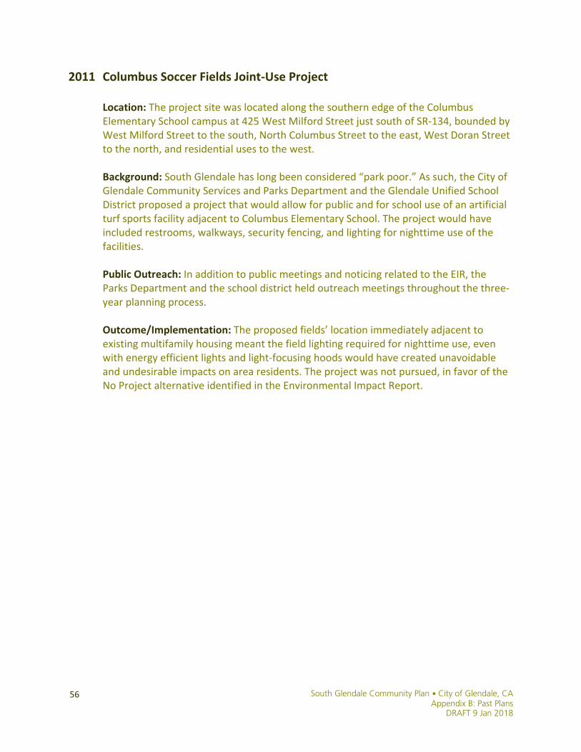
2011 Columbus Soccer Fields Joint-Use Project
Location: The project site was located along the southern edge of the Columbus Elementary School campus at 425 West Milford Street just south of SR-134, bounded by West Milford Street to the south, North Columbus Street to the east, West Doran Street to the north, and residential uses to the west. Background: South Glendale has long been considered “park poor.” As such, the City of Glendale Community Services and Parks Department and the Glendale Unified School District proposed a project that would allow for public and for school use of an artificial turf sports facility adjacent to Columbus Elementary School. The project would have included restrooms, walkways, security fencing, and lighting for nighttime use of the facilities. Public Outreach: In addition to public meetings and noticing related to the EIR, the Parks Department and the school district held outreach meetings throughout the three-year planning process. Outcome/Implementation: The proposed fields’ location immediately adjacent to existing multifamily housing meant the field lighting required for nighttime use, even with energy efficient lights and light-focusing hoods would have created unavoidable and undesirable impacts on area residents. The project was not pursued, in favor of the No Project alternative identified in the Environmental Impact Report.
South Glendale Community Plan • City of Glendale, CA Appendix B: Past Plans DRAFT 9 Jan 2018
57

South Glendale Community Plan • City of Glendale, CA Appendix B: Past Plans
DRAFT 9 Jan 2018
58
2011 South Brand Boulevard Rezoning & Preferential Parking District
Location: The parcels rezoned along or adjacent to Brand Boulevard were bounded to the north by Elk Avenue, by Central Avenue to the west, by Glendale Avenue to the east, and extended down to the intersection of Glendale Avenue and San Fernando Road. The Preferential Parking District was bounded by Central Avenue to the west, by Colorado Street to the north, by Glendale Avenue to the east, and by San Fernando Road to the south. Background: The South Brand Boulevard area is an economically vibrant neighborhood with a mix of commercial and residential uses. In particular, the South Brand Boulevard of Cars has been an important economic engine for the City of Glendale for over 85 years. Prior to the December 2011 rezoning, the South Brand Boulevard Specific Plan (1992) defined neighborhood zoning and development guidelines. However, the specific plan proved extremely cumbersome to administer, and did not achieve the desired outcomes. The 2011 rezoning study was combined with a parking study and proposed parking policies, given ongoing parking challenges in the area. Staff from the Planning Division, Traffic and Transportation and Economic Development began work on the planning portion of the effort in the fall of 2010, while a Comprehensive Parking Study was begun earlier in the year. Changes to the zoning code included a clear set of building heights, building setbacks and buffer zones between commercial and residential uses, and greater flexibility for a variety of commercial uses along South Brand Boulevard. Public Outreach: For the Comprehensive Parking Study, a survey was sent to over 200 businesses in the South Brand Boulevard area. Following the parking survey and zoning changes drafted by staff, the City conducted over two dozen presentations before a broad array of stakeholders and to public bodies between January 2011 and June 2013, an effort that included public notices sent to over 4,000 residential addresses and to 900 businesses in the greater South Brand Boulevard neighborhood. Outcome/Implementation: As a result of the South Brand Boulevard parking and zoning studies, City Council repealed the South Brand Boulevard Specific Plan and replaced it with conventional, more streamlined zoning regulations in January 2012, and established the South Brand Boulevard Special Preferential Parking District in June 2013.

South Glendale Community Plan • City of Glendale, CA Appendix B: Past Plans DRAFT 9 Jan 2018
59

South Glendale Community Plan • City of Glendale, CA Appendix B: Past Plans
DRAFT 9 Jan 2018
60
2012 Citywide Bicycle Transportation Plan
Background: Shortly after the adoption of the Safe & Healthy Streets Plan in April 2011, the City of Glendale City Council approved a comprehensive update of the City’s Bicycle Transportation Plan (BTP), which was last updated in 1996. The purpose of the Plan is to provide a convenient, useful, and interconnected bicycle transportation system that serves commuter and recreational users. The BTP proposes a variety of measures, including improvement of existing bicycle facilities, construction of new bike routes linking major activity centers, the installation of secured bicycle parking equipment, and the expansion of bicycle education/advocacy programs to improve the riding environment for bicyclists. One of the requirements for local jurisdictions to qualify for bicycle facility grants is to have an approved Bicycle Transportation Plan (BTP) that has been updated once every three years. A current Bicycle Transportation Plan enables Glendale to pursue local, state and federal funds that it was previously not eligible for, allowing for quicker implementation of bicycle infrastructure.
Public Outreach: One of the first steps the City took to update the Bicycle Transportation Plan (BTP) was to develop a Bicycle Advisory Committee (BAC). The BAC was comprised of City staff from various departments including Public Works, Community Development, Community Services, Police and members from the Transportation & Parking and Planning Commissions. In addition, community stakeholders comprised of representatives from Bicycle Clubs, Homeowner’s Groups, Glendale Unified School District, the Los Angeles Bicycle Coalition and Glendale Community College were also invited to participate. Four meetings were held with BAC members from March 2011 through March 2012. Members provided recommendations regarding bicycle route designations, destinations and facilities. BAC members were asked to help ‘get the word out’ and encourage interested residents to provide input. This input was considered along with feedback received at City-wide Community Outreach meetings, Commission meetings and City Council Study Session meetings held from Spring 2011 through 2012. Residents, visitors and the business community were invited to provide comments on the BTP via website, telephone and/or comment cards found at public counters and local bicycle shops prior to Council adoption of the Plan.
Outcome/Implementation: The Bicycle Transportation Plan was adopted by the City Council in August 2012.
The City of Glendale continues to implement bicycle infrastructure where recommended by the Bicycle Transportation Plan; the Public Works Department incorporates bikeways into its street improvement projects when feasible, while CDD Urban Design & Mobility staff continues to apply for Metro and Caltrans grant funds to support active transportation planning and projects.
South Glendale Community Plan • City of Glendale, CA Appendix B: Past Plans DRAFT 9 Jan 2018
61
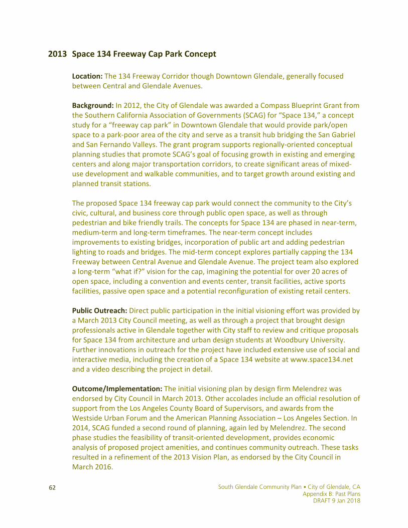
South Glendale Community Plan • City of Glendale, CA Appendix B: Past Plans
DRAFT 9 Jan 2018
62
2013 Space 134 Freeway Cap Park Concept
Location: The 134 Freeway Corridor though Downtown Glendale, generally focused between Central and Glendale Avenues. Background: In 2012, the City of Glendale was awarded a Compass Blueprint Grant from the Southern California Association of Governments (SCAG) for “Space 134,” a concept study for a “freeway cap park” in Downtown Glendale that would provide park/open space to a park-poor area of the city and serve as a transit hub bridging the San Gabriel and San Fernando Valleys. The grant program supports regionally-oriented conceptual planning studies that promote SCAG’s goal of focusing growth in existing and emerging centers and along major transportation corridors, to create significant areas of mixed-use development and walkable communities, and to target growth around existing and planned transit stations. The proposed Space 134 freeway cap park would connect the community to the City’s civic, cultural, and business core through public open space, as well as through pedestrian and bike friendly trails. The concepts for Space 134 are phased in near-term, medium-term and long-term timeframes. The near-term concept includes improvements to existing bridges, incorporation of public art and adding pedestrian lighting to roads and bridges. The mid-term concept explores partially capping the 134 Freeway between Central Avenue and Glendale Avenue. The project team also explored a long-term “what if?” vision for the cap, imagining the potential for over 20 acres of open space, including a convention and events center, transit facilities, active sports facilities, passive open space and a potential reconfiguration of existing retail centers. Public Outreach: Direct public participation in the initial visioning effort was provided by a March 2013 City Council meeting, as well as through a project that brought design professionals active in Glendale together with City staff to review and critique proposals for Space 134 from architecture and urban design students at Woodbury University. Further innovations in outreach for the project have included extensive use of social and interactive media, including the creation of a Space 134 website at www.space134.net and a video describing the project in detail. Outcome/Implementation: The initial visioning plan by design firm Melendrez was endorsed by City Council in March 2013. Other accolades include an official resolution of support from the Los Angeles County Board of Supervisors, and awards from the Westside Urban Forum and the American Planning Association – Los Angeles Section. In 2014, SCAG funded a second round of planning, again led by Melendrez. The second phase studies the feasibility of transit-oriented development, provides economic analysis of proposed project amenities, and continues community outreach. These tasks resulted in a refinement of the 2013 Vision Plan, as endorsed by the City Council in March 2016.
South Glendale Community Plan • City of Glendale, CA Appendix B: Past Plans DRAFT 9 Jan 2018
63

South Glendale Community Plan • City of Glendale, CA Appendix B: Past Plans
DRAFT 9 Jan 2018
64
2013 Tropico Center Plan
Location: Generally, the area south of Cypress Street, approximately 1/2 mile radius from the Metrolink Station. Background: The Tropico Station Transit Oriented Development Study Round 2 was funded through a Metro Transit Oriented Development (TOD) Planning Grant. The TOD Planning Grant Program is designed to enable a local regulatory environment supportive of TOD in Los Angeles County. Round 2 grants were open to municipalities with land use regulatory control over property within ¼ mile of designated transit corridors and within ½ mile of designated Metrolink Stations, as measured from the station property line boundary. In 2012, Glendale was awarded $250,000 through this program to support Urban Design Visioning, including street cross sections and pedestrian improvements; Review of Development Standards in Zoning Code; Review of parking standards in Zoning Code and parking policies in project area, including industrial areas north of project and parallel to railroad tracks; and Peer review of development proposals under consideration by the City. Public Outreach: The Tropico Center Plan was shaped by input the City and consultants gathered during four major public events held between May 2013 and October 2015. The events were designed to reach local residents who walk and are interested in the Tropico neighborhood and Transportation Center, heighten awareness of the historic station and Tropico neighborhood across the City, and reach families in Tropico who in the Cerritos Elementary School attendance area and who use Cerritos Park. Over 500 people provided feedback at these events, representing Tropico’s diverse population of residents, visitors, and workers. These innovative efforts were recognized by the American Planning Association - Los Angeles Chapter, earning its Public Outreach Award of Merit in 2014. Outcome/Implementation: The Tropico Station Transit Oriented Development Study Round 2 resulted in the development of the draft Tropico Center Plan, which may be adopted as an appendix to the South Glendale Community Plan. The draft Tropico Center Plan recommends urban design guidelines along with supportive zoning designations and parking standards for the Tropico district surrounding the City’s Metrolink Station and Transportation Center. The City Council will consider the draft recommendations as part of the South Glendale Community Plan process.
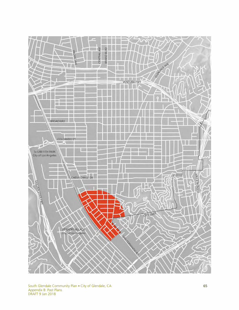
South Glendale Community Plan • City of Glendale, CA Appendix B: Past Plans DRAFT 9 Jan 2018
65
South Glendale Community Plan • City of Glendale, CA Appendix B: Past Plans
DRAFT 9 Jan 2018
66
2014 South Glendale Historic Context Statement Location: The South Glendale Historic Context Statement study area is roughly bounded by the San Fernando Road Corridor to the west, SR-134 to the north, SR-2 to the east, and the City of Los Angeles to the south. Background: A Historic Context is the foundation for preservation planning. It provides guidance for decisions about identification and evaluation of historic properties, and places built resources in the appropriate historic, social, and architectural contexts. Such studies establish the relationship between the physical environment and its broader history, and ensure the preservation of a wide variety of properties that represent the layered history of an area. The South Glendale Historic Context Statement was funded in part by a grant through the Certified Local Government program. The statement followed standard preservation practice and guidance provided by the National Park Service and the California Office of Historic Preservation. In preparing the statement, authors Historic Resources Group utilized existing studies, contexts, and survey evaluations of the area, supplemented by a reconnaissance survey of the area and additional research in consultation with City staff and the Glendale Historical Society. This consultation helped develop the contexts and themes, and registration requirements for evaluating historic resources in South Glendale for eligibility at the federal, state, and local levels. The statement considers all phases of the study area’s built environment, from the 19th century through the recent past; themes and events important in South Glendale’s development; significant people, and building types and architectural styles. Public Outreach: The Historic Preservation Commission reviewed and commented on the draft South Glendale Historic Context Statement at its regular public meeting on August 21, 2014. Outcome/Implementation: The South Glendale Historic Context Statement has been submitted to the State Historic Preservation Officer. It serves to inform the South Glendale Community Plan as well as the required environmental review, as it assists in the identification and protection of historic resources, and informs policy recommendations, zoning changes, and design review. It may be formally adopted as an appendix to the South Glendale Community Plan, as was previously done with the North Glendale Community Plan and Historic Context Statement.

South Glendale Community Plan • City of Glendale, CA Appendix B: Past Plans DRAFT 9 Jan 2018
67