past, present and future inlets of the outer banks barrier ... · pdf filepast, present and...
TRANSCRIPT
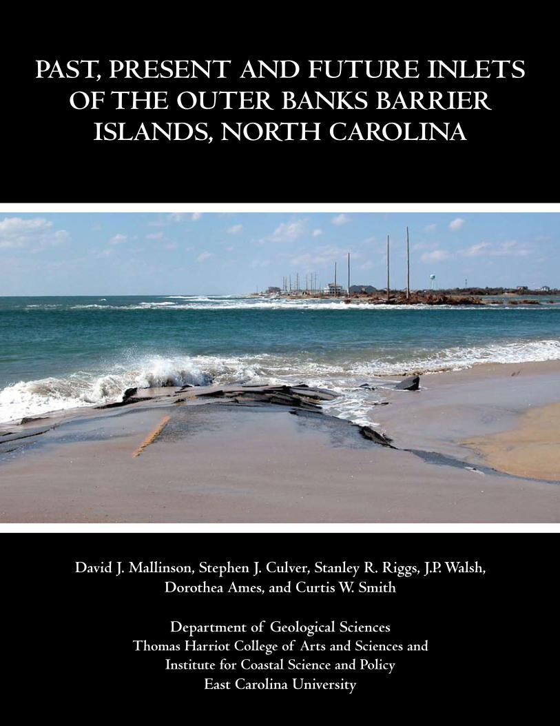
Past, Present and Future Inlets oF the outer Banks BarrIer
Islands, north CarolIna
david J. Mallinson, stephen J. Culver, stanley r. riggs, J.P. Walsh, dorothea ames, and Curtis W. smith
department of Geological sciencesthomas harriot College of arts and sciences and
Institute for Coastal science and Policyeast Carolina university

FRONT COVER PHOTOGRAPH. This photograph looks west toward Hatteras Village, across Isabel Inlet that formed during Hurricane Isabel (2003). The remnants of Highway 12 are seen in the foreground, and the former location of the ocean shoreline is in the white surf beyond the inlet. Photograph is by S.R. Riggs.

Past, Present and Future Inlets oF the outer Banks BarrIer
Islands, north CarolIna
a White Paper by
david J. Mallinson, stephen J. Culver, stanley r. riggs, J.P. Walsh1, dorothea ames, and Curtis W. smith2
Members of the north CarolIna Coastal GeoloGY
CooPeratIVe researCh ProGraM
department of Geological sciencesthomas harriot College of arts and sciences and
1Institute for Coastal science and Policyeast Carolina university, nC 27858
december, 2008
2 now at Marshall Miller and associates, 11277 airpark road, suite 203, ashland, Va 23005

TAblE OF CONTENTs
Executive summary ........................................................................................................... 1
Inlet Issues ........................................................................................................................... 2
Inlet Processes ................................................................................................................... 2
Past Inlets of the Outer banks ........................................................................................ 5
Recent and Presently Active Inlets ............................................................................... 9
Oregon Inlet .................................................................................................................. 9
Hatteras Inlet ................................................................................................................ 10
Ocracoke Inlet .............................................................................................................. 10 Drum and Ophelia Inlet ............................................................................................. 12
Buxton Inlet .................................................................................................................. 12
Isabel Inlet .................................................................................................................... 14
Future Inlets ....................................................................................................................... 15
Management Issues .......................................................................................................... 19
literature Cited ................................................................................................................ 20
The work summarized in this report is the product of the collaborative efforts of many researchers associated with the North Carolina Coastal Geology Cooperative, a multi-year research program led by East Carolina University, the United States Geological Survey, and the North Carolina Geological Survey, with contributions from scientists at the University of Delaware, the University of Pennsylvania, and the Virginia Institute of Marine Sciences. We would additionally like to acknowledge the assistance of Jim Watson, John Woods, Ron Crowson, and numerous graduate students. This work was funded in part by the USGS Cooperative Agreement award 02ERAG0044, and a UNC General Administration Research Competitiveness award. Other support came from the U.S. National Park Service, the U.S. Fish and Wildlife Service, Environmental Defense, NC Division of Coastal Management, and the NC Division of State Parks and Recreation. Sources of aerial photographs include: USACE-FRF, Duck, NC; USACE-Wilmington; CHNS, Manteo; NC State Database; NC DOT; U.S. Geological Survey.
ACkNOwlEdGEMENTs
1
For centuries, humans have depended on inlets as a means of navigating between the ocean and the protected coastal waters behind barrier islands. Inlets along the North Carolina Outer Banks barrier islands offered access to the first English settlers in the New World during the late 16th century, and continue to offer access for commercial and recreational vessels. Although promising passage to sheltered waters, the dynamic, shifting sands of the inlet shoals have led to the grounding and destruction of numerous vessels, contributing to the infamous label “graveyard of the Atlantic” for the North Carolina coast. With time, some inlets provided access to port towns which became locations for trade, and which would provide a local pilot to help navigate ships through the shifting channels. Thus, inlets became an important economic asset. Today, inlets are still vital to navigation, trade, and commerce, especially commercial and recreational fishing.
In addition to their clear historical and economic significance, inlets provide a vital service to the maintenance of estuaries and barrier islands, and play a fundamental role in the evolution of transgressive (landward migrating) barrier islands. In spite of their name, inlets could more appropriately be termed “outlets” as they provide an exit for fresh water flowing down the rivers. Within the estuaries, the fresh riverine water mixes
with salty ocean water to produce the mixed salinity or brackish waters. The riverine flow volumes and ocean storm dynamics determine the residence time of water within the estuaries, which is important to biological systems.
Inlets also provide a pathway for sand to be transferred from the shorezone on the ocean-side of the island to the estuarine side of the island. The sand is deposited as vast flood-tide deltas which are colonized by marsh plants upon inlet closure. The resulting back-barrier shoals and marshes maintain island width, and provide a shallow platform over which the island may migrate landward. The occurrence of inlet channel sediments and flood-tide delta sediments beneath the barrier islands affects the variety of sediment available to the beach system as the ocean shoreline recedes. As such, island, beach, and shoreface morphologies are related to the occurrence of paleo-inlet channels beneath the islands. In turn, the island geomorphology is a key factor in determining where future inlets are most likely to occur. Thus, it is important to understand the dynamics of past inlets and their relationship to the sediment budget and island geomorphology. Inlets are vital to the short-term maintenance of barrier island systems and their estuaries, and long-term barrier island evolution in response to ongoing sea-level rise.
ExECuTIVE suMMARy
A digital version of this document, along with reports on related research funded by a grant from the University of North Carolina system, can be accessed at the North Carolina Coastal Hazards Decision Portal: http://www.coastal.geology.ecu.edu/NCCOHAZ/.

2
Inlets are a fundamentally important part of our coastal system by virtue of their roles in both human activities and barrier island maintenance and evolution. But inlets are not fixed in space and time and this fact is at the root of several inlet-related coastal management issues. This White Paper
is produced for coastal managers, agencies, business owners, coastal residents, etc., to provide a general overview of the workings of inlet systems as we struggle to live with their dynamic nature during a time of sea-level rise and high storm activity.
INlET IssuEs
Inlets provide for the interchange of fresh and marine waters within the estuarine system. The number and size of inlets is naturally adjusted to (i.e., is in equilibrium with) the volume of water discharged from the rivers and the amount of water that enters and exits the estuaries daily due to astronomical and wind tides (the “tidal prism”). Typically, where tidal energy is high, such as in southern NC, many inlets are required to accommodate the exchange of seawater during a tidal cycle, resulting in more inlets and shorter islands. Where the tidal range is minimal, inlets act primarily as outlets for fresh water that
flows into the estuaries from the rivers. This situation results in fewer inlets and longer barrier islands. Currently, within the Albemarle-Pamlico Estuarine System (APES) the river discharge is relatively low and the average length of time that water stays in the sounds (residence time) is approximately 11 months. Except in the vicinity of inlets, astronomical tides within the APES are small (<1 ft.). However wind tides associated with a variety of weather systems increase the volume of water being exchanged between the estuaries and ocean. Storm events frequently result in the formation of ephemeral inlets to accommodate
this additional exchange. Due to the low volume of freshwater discharge and small astronomical tidal prism, few inlets occur along the Outer Banks north of Cape Lookout, and currently include New Drum, New Old Drum, and Ophelia inlets in Core Banks, Ocracoke Inlet, Hatteras Inlet, and Oregon Inlet (Fig. 1).
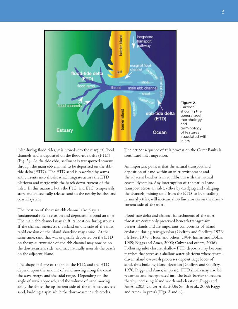
An inlet consists of a variety of geomorphic components (Fig. 2). The inlet channel that separates the adjacent islands is the throat channel and consists of a central main ebb channel and flanking marginal flood channels. The cross-sectional area of the throat channel conforms to the volume of water that must pass through it. When the water volume is decreased, the channel will tend to shoal. If the volume increases, the channel will deepen and/or widen.
Depending on wave and current patterns, sand transport between islands may take a circuitous route to bypass the intervening inlet. Sand is moved along the beach and nearshore area parallel to the coastline in response to waves as they encounter the shallow coastal environments. Along the Outer Banks, sand generally moves from north to south in the longshore current owing to the cumulative high energy wave action from the northeast. As sand encounters the
INlET PROCEssEs
Figure 1. MODIS satellite image showing the location of active inlets between the Virginia state line and Cape Lookout, NC. Satellite image courtesy of Institute for Marine Remote Sensing, College of Marine Science, University of South Florida.
3
Figure 2. Cartoon showing the generalized morphology and terminology of features associated with inlets.
inlet during flood tides, it is moved into the marginal flood channels and is deposited on the flood-tide delta (FTD) (Fig. 2). As the tide ebbs, sediment is transported seaward through the main ebb channel to be deposited on the ebb-tide delta (ETD). The ETD sand is reworked by waves and currents into shoals, which migrate across the ETD platform and merge with the beach down-current of the inlet. In this manner, both the FTD and ETD temporarily store and episodically release sand to the nearby beaches and coastal system.
The location of the main ebb channel also plays a fundamental role in erosion and deposition around an inlet. The main ebb channel may shift its location during storms. If the channel intersects the island on one side of the inlet, rapid erosion of the island shoreline may ensue. At the same time, sand that was originally deposited on the ETD on the up-current side of the ebb channel may now be on the down-current side, and may naturally nourish the beach on the adjacent island.
The shape and size of the inlet, the FTD, and the ETD depend upon the amount of sand moving along the coast, the wave energy and the tidal range. Depending on the angle of wave approach, and the volume of sand moving along the shore, the up-current side of the inlet may accrete sand, building a spit, while the down-current side erodes.
The net consequence of this process on the Outer Banks is southward inlet migration. An important point is that the natural transport and deposition of sand within an inlet environment and the adjacent beaches is in equilibrium with the natural coastal dynamics. Any interruption of the natural sand transport across an inlet, either by dredging and enlarging the channels, mining sand from the ETD, or by installing terminal jetties, will increase shoreline erosion on the down-current side of the inlet.
Flood-tide delta and channel-fill sediments of the inlet throat are commonly preserved beneath transgressive barrier islands and are important components of island evolution during transgression (Godfrey and Godfrey, 1976; Herbert, 1978; Heron and others, 1984; Inman and Dolan, 1989; Riggs and Ames, 2003; Culver and others, 2006). Following inlet closure, shallow FTD deposits may become marshes that serve as a shallow water platform where storm-driven island overwash processes deposit large lobes of sand, thus building island elevation (Godfrey and Godfrey, 1976; Riggs and Ames, in press). FTD shoals may also be reworked and incorporated into the back-barrier shorezone, thereby increasing island width and elevation (Riggs and Ames, 2003; Culver et al., 2006; Smith et al., 2008; Riggs and Ames, in press) (Figs. 3 and 4).
4
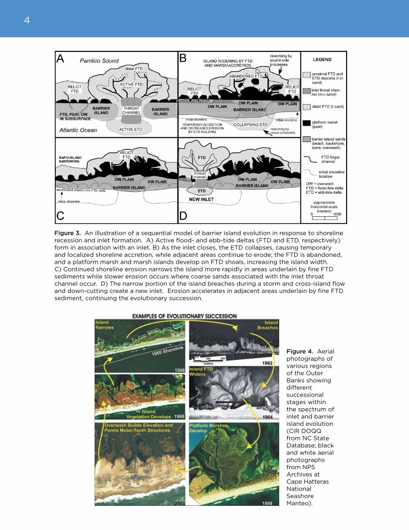
Figure 3. An illustration of a sequential model of barrier island evolution in response to shoreline recession and inlet formation. A) Active flood- and ebb-tide deltas (FTD and ETD, respectively) form in association with an inlet. B) As the inlet closes, the ETD collapses, causing temporary and localized shoreline accretion, while adjacent areas continue to erode; the FTD is abandoned, and a platform marsh and marsh islands develop on FTD shoals, increasing the island width. C) Continued shoreline erosion narrows the island more rapidly in areas underlain by fine FTD sediments while slower erosion occurs where coarse sands associated with the inlet throat channel occur. D) The narrow portion of the island breaches during a storm and cross-island flow and down-cutting create a new inlet. Erosion accelerates in adjacent areas underlain by fine FTD sediment, continuing the evolutionary succession.
Figure 4. Aerial photographs of various regions of the Outer Banks showing different successional stages within the spectrum of inlet and barrier island evolution (CIR DOQQ from NC State Database; black and white aerial photographs from NPS Archives at Cape Hatteras National Seashore Manteo).

5
Although six inlets currently occur north of Cape Lookout, numerous additional inlets have dissected the island chain episodically during historical times (post 1585 A.D.) (Stick, 1958; Fisher, 1962). The first map of northeastern North Carolina was made in 1590 and illustrates the occurrence of numerous inlets along the northern Outer Banks (Fig. 5). Studies have attempted to identify the location of paleo-inlets based upon historical maps (Stick, 1958; Payne, 1985), island geomorphology (Fisher, 1962; Riggs and Ames, in press; Ames and Riggs, in press) or stratigraphy, as derived from cores and geophysical data (Susman, 1975; Moslow and Heron, 1978; Herbert, 1978; Susman and Heron, 1979; Heron et al., 1984; Smith, 2004; Mallinson et al., 2005; Smith, 2006; Culver et al., 2006; Smith et al., in press). Such studies are significant in understanding island geomorphology and the processes of island formation
and evolution.
Fisher (1962) attempted to recognize paleo-inlets along the Outer Banks by analyzing aerial photographs for the occurrence of geomorphologic features (i.e., the shape of the land surface) related to paleo-inlets. He also provided the positions and dates of known historic inlets (Fig. 6). Recent studies using modern geophysical techniques (Smith, 2006) have demonstrated that the inlets identified in Fisher’s 1962 study represent only a fraction of the total number of inlet channels underlying the Outer Banks (Fig. 6).
Modern advances in geophysical technology, specifically ground penetrating radar (GPR) (Fig. 7), have allowed for rapid acquisition and interpretation of shallow subsurface data to define the geology beneath barrier islands (Fitzgerald
PAsT INlETs OF THE OuTER bANks
Figure 5. The White-deBry map was made in 1590 and shows the occurrence of numerous inlets along the NC coast.

6
et al., 1992; Bristow et al., 2000; Neal and Roberts, 2000; Barnhardt et al., 2002; Jol et al., 1996, 2002; Havholm et al., 2004; Culver et al., 2006). Ground penetrating radar works by transmitting radar (radio) waves into the ground and recording the energy as it is reflected from boundaries associated with changes in sediment type beneath the
surface. The data provide a profile of the geology such that different layers of rock or sediment can be mapped and interpreted (Fig. 7). Inlet channels that are filled with sand have distinctive appearances in the GPR data (Figs. 7B and C).
Figure 6. Map illustrating the approximate locations and dates of existence of documented historic inlets (red arrows) and previously undocumented inlet channels (blue arrows) discovered using ground-penetrating radar data.
7
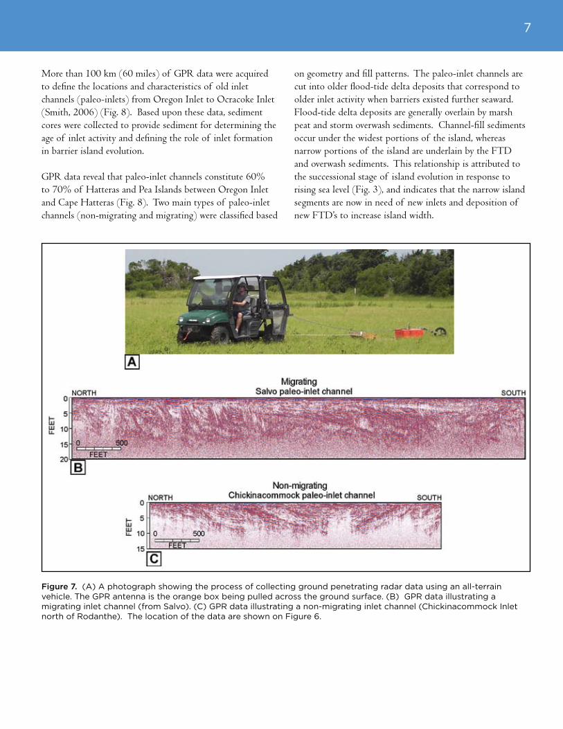
Figure 7. (A) A photograph showing the process of collecting ground penetrating radar data using an all-terrain vehicle. The GPR antenna is the orange box being pulled across the ground surface. (B) GPR data illustrating a migrating inlet channel (from Salvo). (C) GPR data illustrating a non-migrating inlet channel (Chickinacommock Inlet north of Rodanthe). The location of the data are shown on Figure 6.
More than 100 km (60 miles) of GPR data were acquired to define the locations and characteristics of old inlet channels (paleo-inlets) from Oregon Inlet to Ocracoke Inlet (Smith, 2006) (Fig. 8). Based upon these data, sediment cores were collected to provide sediment for determining the age of inlet activity and defining the role of inlet formation in barrier island evolution.
GPR data reveal that paleo-inlet channels constitute 60% to 70% of Hatteras and Pea Islands between Oregon Inlet and Cape Hatteras (Fig. 8). Two main types of paleo-inlet channels (non-migrating and migrating) were classified based
on geometry and fill patterns. The paleo-inlet channels are cut into older flood-tide delta deposits that correspond to older inlet activity when barriers existed further seaward. Flood-tide delta deposits are generally overlain by marsh peat and storm overwash sediments. Channel-fill sediments occur under the widest portions of the island, whereas narrow portions of the island are underlain by the FTD and overwash sediments. This relationship is attributed to the successional stage of island evolution in response to rising sea level (Fig. 3), and indicates that the narrow island segments are now in need of new inlets and deposition of new FTD’s to increase island width.
8
Fig
ure
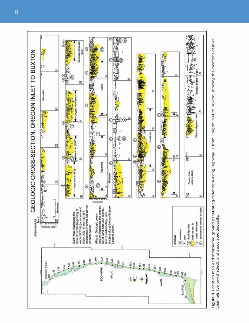
8. L
ocati
on
map
an
d in
terp
rete
d g
rou
nd
pen
etr
ati
ng
rad
ar
data
alo
ng
Hig
hw
ay 1
2 f
rom
Ore
go
n In
let
to B
uxto
n, sh
ow
ing
th
e lo
cati
on
s o
f in
let
ch
an
nels
(yello
w-s
had
ed
), a
nd
ass
ocia
ted
dep
osi
ts.

9
The current active inlets along the Outer Banks of North Carolina include Oregon Inlet (opened in 1846), Hatteras Inlet (opened in 1846), Ocracoke Inlet (opened prior to 1585), New Drum Inlet (opened by the U.S. Army Corps of Engineers in 1971), New-Old Drum Inlet (opened in 1999 by Hurricane Dennis) and Ophelia Inlet (opened in 2005 by Hurricane Ophelia) (Fig. 1). Two other inlets, New Inlet (closed in 1945) and Drum Inlet (closed in 1971), were recently active and closed naturally. In addition, two inlets were recently active, but were closed by the USACE, including Isabel Inlet (opened in 2003 by Hurricane Isabel) and Buxton Inlet (opened in 1962 by the Ash Wednesday nor’easter) (Fig. 6).
Oregon Inlet
Oregon Inlet (Figs. 9 and 10) opened by a hurricane in 1846 near the site of a previous inlet (Gun or Gunt Inlet) which closed in 1798. Between 1846 and 1989, the inlet migrated approximately 2 miles south of its original location (Fig. 9B). In 1962-1963 the Oregon Inlet Bridge was built (Fig. 10), but the inlet continued to migrate causing the throat channel to migrate from under the fixed navigation span and Pea Island to be almost severed from the bridge. Consequently, inlet dredging was increased to preserve the navigation channel, a rock jetty was emplaced on the south bank in 1989-1991, and a rock revetment was emplaced around the south base of the bridge to prevent further migration. However, the constrained location of the south bank, and the continued southward spit growth on the north bank caused Oregon Inlet to narrow and deepen. The narrower throat channel resulted in rapid scour beneath the central bridge pilings. As a result, rocks were emplaced beneath the free-hanging pilings.
Oregon Inlet is an extremely dynamic inlet which, under natural conditions, would likely continue to migrate southward. The high energy and dynamic character of the inlet conflict with the static human infrastructure (bridge and road), often pitting management policies and local interests against natural coastal dynamics. Continually shifting sand shoals and channels have necessitated increased dredging to maintain navigability for commercial and recreational vessels from nearby ports.
Controversies persist with the Oregon Inlet Bridge. The bridge has exceeded its life expectancy and needs to be replaced. One option is to rebuild it at its current location, which would require continued financial expenditures to nourish the beach on Pea Island, to continually replace the constructed dune ridges and Highway 12 (which are frequently destroyed by storms) and to emplace kilometers of
RECENT ANd PREsENTly ACTIVE INlETs
Figure 9. (A) Figure shows a 1998 aerial photograph of Oregon Inlet (NC State Database). (B) The 1998 aerial photograph of Oregon Inlet showing superimposed shorelines from 1849, 1932, and 1962 (following the 1962 Ash Wednesday storm), illustrating the large degree of shoreline variation and inlet migration.

10
sand bags in an attempt to hold the island in place. Another option being considered is to build a 17-mile-long causeway in the sound behind Oregon Inlet to Rodanthe, by-passing the rapidly eroding Pea Island barrier segment, and allowing the Pea Island Wildlife Refuge to revert to a natural state without needing continued beach nourishment (Riggs et al., 2008). From a long-term financial, management, and scientific perspective, this latter option is more viable but it conflicts strongly with local and shorter-term interests.
Hatteras Inlet
Hatteras Inlet (Fig. 11) opened during the same hurricane that opened Oregon Inlet in September of 1846. During the Civil War, this inlet was used extensively since it was more navigable than Ocracoke Inlet (Stick, 1958). In fact, it was used by the Federal fleet that captured two Confederate forts near Hatteras Village in 1861, and again in 1862 when Roanoke Island was attacked. Today, Hatteras Inlet is used only by small craft as the inlet shoals and channels are subject to continual change. Transportation between Hatteras Island and Ocracoke Island is maintained via the state-run ferry system.
Ocracoke Inlet
Ocracoke Inlet (Fig. 12) occurs on all of the 16th and 17th century maps of coastal NC. New data indicate that Ocracoke Inlet is located within a former river valley (Pamlico Creek) that drained the Pamlico Sound basin during the Last Glacial Maximum approximately 20,000 years ago (Mallinson et al., in review) (Fig. 13). It is likely that the occurrence of this river valley beneath the inlet accounts for its stability and longevity.
Figure 10. An oblique aerial photograph of Oregon Inlet and the Oregon Inlet Bridge. Courtesy of the U.S. Army Corps of Engineers, Field Research Facility in Duck, NC.
Figure 11. Figure showing the 1998 aerial photograph of Hatteras Inlet (NC State Database).
Ocracoke Inlet has offered a navigable route for private and commercial vessels for centuries. Prior to the opening of Oregon Inlet in 1846, ships traveling to ports on the mainland (Bath, Edenton, Washington, New Bern, etc.) only had the option of using Ocracoke Inlet or Hatteras Inlet. In 1715 Ocracoke Inlet was designated an official port of entry for access to the mainland communities, and required official
11
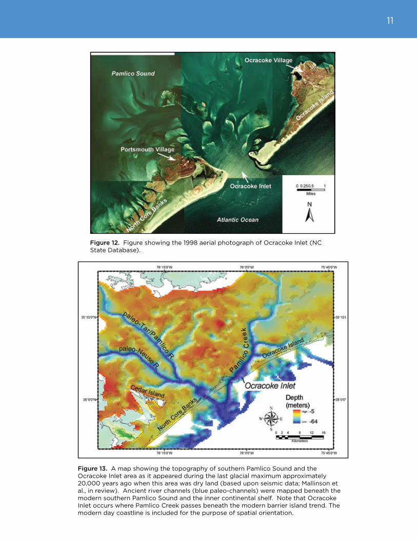
Figure 12. Figure showing the 1998 aerial photograph of Ocracoke Inlet (NC State Database).
Figure 13. A map showing the topography of southern Pamlico Sound and the Ocracoke Inlet area as it appeared during the last glacial maximum approximately 20,000 years ago when this area was dry land (based upon seismic data; Mallinson et al., in review). Ancient river channels (blue paleo-channels) were mapped beneath the modern southern Pamlico Sound and the inner continental shelf. Note that Ocracoke Inlet occurs where Pamlico Creek passes beneath the modern barrier island trend. The modern day coastline is included for the purpose of spatial orientation.

12
harbor pilots (Stick, 1958; Riggs and Ames, 2007). As a result, Ocracoke Village (on the southwestern end of Ocracoke Island), and Portsmouth Village (on the northeastern end of Core Banks) flourished. Ocracoke Village is still a thriving community with a tourist-based economy. Portsmouth Village is now a historical site within the Cape Lookout National Seashore.
drum and Ophelia Inlets
Drum Inlet (Fig. 14) initially opened in about 1899, but then closed naturally by 1919. It was then reopened during a major hurricane in 1933. Early attempts (beginning in 1938) at dredging by the U.S. Army Corps of Engineers did little to maintain a navigable channel for commercial fisherman (Stick, 1958; Riggs and Ames, 2007). By 1971, the inlet was nearly closed, and the U.S. Army Corps of Engineers proceeded to open New Drum Inlet several miles to the southwest. A channel was dredged and blasted through the island to create New Drum Inlet in 1971. The purpose of New Drum Inlet was to allow commercial fishing vessels to transit between the ocean and several small coastal communities. However, due to rapid shoaling, no commercial vessels have ever used the inlet (Riggs and Ames, 2007). In 1999, Hurricane Dennis reopened Drum Inlet, which is now referred to as New-Old Drum Inlet. In 2005, Hurricane Ophelia opened an inlet southwest of New Drum Inlet. Currently Ophelia Inlet is expanding, and has nearly merged with New Drum Inlet.
buxton Inlet
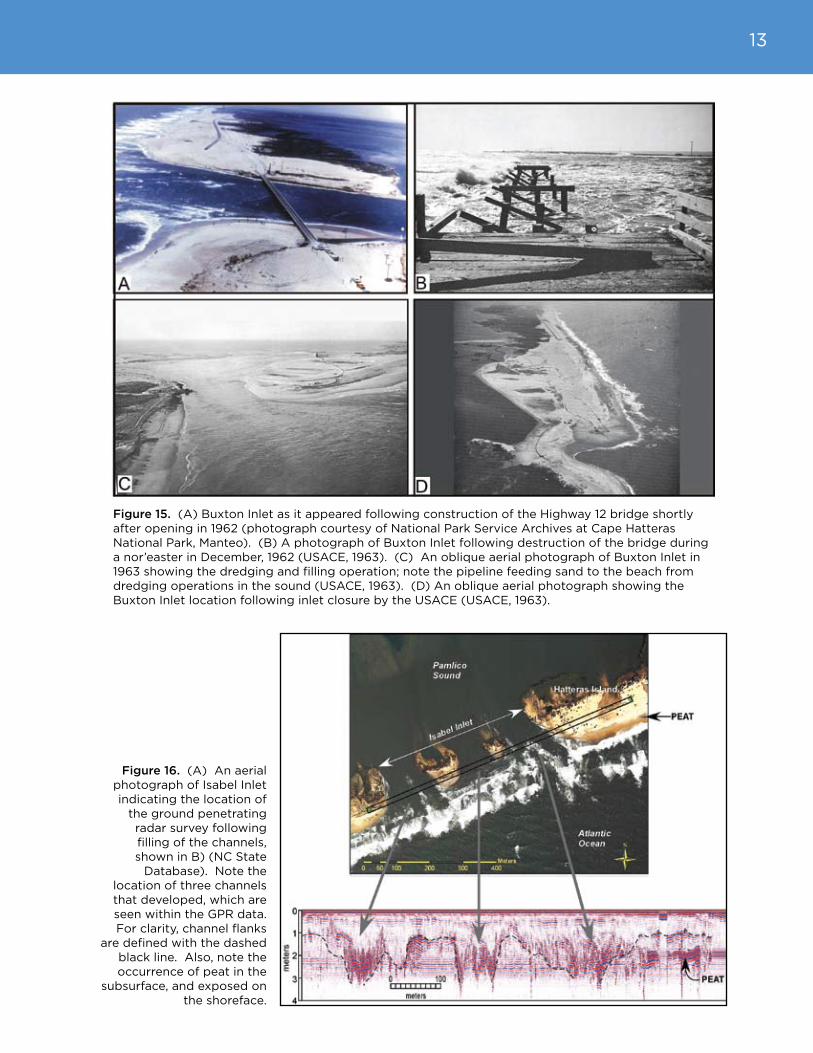
Buxton Inlet (Fig. 15) opened in March 1962, during the Ash Wednesday storm which was an intense nor’easter. A bridge built over the inlet was destroyed in a second nor’easter in December of the same year. Following the bridge destruction, the U.S. Army Corps of Engineers decided to fill the inlet using dredged sand from the shallow sound behind the island at a location referred to as “The Haulover”. The dredged hole still exists in this
Figure 14. A figure showing two aerial photographs of Core Banks that illustrate the location of New Drum Inlet in 1998, and Ophelia and New-Old Drum Inlets in 2006 (NC State Database). New-Old Drum Inlet opened in 1999 during Hurricane Dennis in the same location that Old Drum inlet occurred (paleo-Old Drum Inlet in the 1998 photograph). Ophelia Inlet opened in 2005 during Hurricane Ophelia.
area between Avon and Buxton, and is commonly referred to as “Canadian Hole”. Because this inlet was quickly closed, no significant flood-tide delta developed, and the island continues to narrow and is vulnerable to future inlet opening. The ocean shoreline at this location has receded approximately 2500 feet since 1852 with a net loss of 76% of island width by 1998 (Riggs and Ames, 2008).
13
Figure 15. (A) Buxton Inlet as it appeared following construction of the Highway 12 bridge shortly after opening in 1962 (photograph courtesy of National Park Service Archives at Cape Hatteras National Park, Manteo). (B) A photograph of Buxton Inlet following destruction of the bridge during a nor’easter in December, 1962 (USACE, 1963). (C) An oblique aerial photograph of Buxton Inlet in 1963 showing the dredging and filling operation; note the pipeline feeding sand to the beach from dredging operations in the sound (USACE, 1963). (D) An oblique aerial photograph showing the Buxton Inlet location following inlet closure by the USACE (USACE, 1963).
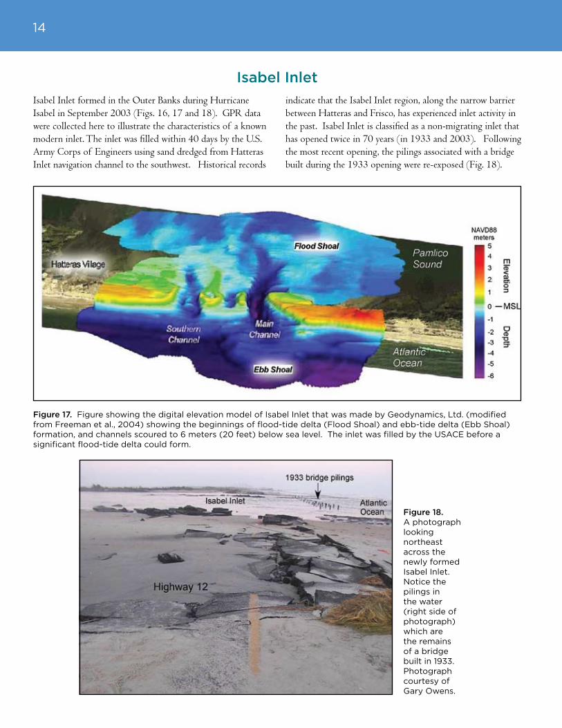
Figure 16. (A) An aerial photograph of Isabel Inlet indicating the location of
the ground penetrating radar survey following filling of the channels, shown in B) (NC State
Database). Note the location of three channels that developed, which are seen within the GPR data. For clarity, channel flanks
are defined with the dashed black line. Also, note the occurrence of peat in the
subsurface, and exposed on the shoreface.
14
Isabel Inlet formed in the Outer Banks during Hurricane Isabel in September 2003 (Figs. 16, 17 and 18). GPR data were collected here to illustrate the characteristics of a known modern inlet. The inlet was filled within 40 days by the U.S. Army Corps of Engineers using sand dredged from Hatteras Inlet navigation channel to the southwest. Historical records
indicate that the Isabel Inlet region, along the narrow barrier between Hatteras and Frisco, has experienced inlet activity in the past. Isabel Inlet is classified as a non-migrating inlet that has opened twice in 70 years (in 1933 and 2003). Following the most recent opening, the pilings associated with a bridge built during the 1933 opening were re-exposed (Fig. 18).
Figure 17. Figure showing the digital elevation model of Isabel Inlet that was made by Geodynamics, Ltd. (modified from Freeman et al., 2004) showing the beginnings of flood-tide delta (Flood Shoal) and ebb-tide delta (Ebb Shoal) formation, and channels scoured to 6 meters (20 feet) below sea level. The inlet was filled by the USACE before a significant flood-tide delta could form.
Isabel Inlet
Figure 18. A photograph looking northeast across the newly formed Isabel Inlet. Notice the pilings in the water (right side of photograph) which are the remains of a bridge built in 1933. Photograph courtesy of Gary Owens.

15
Due to increased global temperature, sea level may rise between 1.5 feet to 2.6 feet above modern mean sea level by the year 2100 (Church and White, 2006; Overpeck et al., 2006; IPCC, 2007; Pfeffer et al., 2008; Riggs et al., 2008). In addition, there is growing evidence that warmer global temperatures are already increasing the destructive potential of hurricanes (Emanuel, 2005; Mann and Emanuel, 2006) and may increase the frequency of hurricanes that reach category 4 or 5 (Webster et al., 2005; Elsner et al., 2008). Because barrier islands respond relatively rapidly to changes in sea level and storm activity, global climate change has the potential to significantly alter both the morphology and the evolution of barrier islands in the future, an important component of which is inlet activity. With accelerating climate change and sea-level rise, it has become increasingly important to forecast future barrier island conditions, in order to make long-term coastal management plans and policies. Road maintenance plans, development policies, hazard mitigation, and emergency response plans depend upon an understanding of local erosion rates, and the potential for the creation of new inlets. Some barrier island segments are clearly in danger of developing inlets in the near
future. These are the narrow and low barrier island segments that experience the highest erosion rates, such as the island segment immediately north of Rodanthe, or the Buxton and Isabel Inlet areas. In areas with low sand volume (sand-starved segments; Riggs et al., 2008), where the underlying geologic units are not resistant to erosion, major storm surge and cross-island flow can cut a channel substantially below sea level that results in post-storm tidal flow. The result is an inlet.
Several investigations have conducted coastal hazard assessments of the Outer Banks and other coastal areas, including the potential for future inlet formation. These assessments address a range in spatial scales and have different purposes; some are more regional and qualitative in focus while others are detailed and quantitative. For example, Pilkey et al. (1998) produced maps of coastal vulnerability to hurricanes and winter storm damage, including inlet hazard areas, based upon the occurrence of past inlets, island width and elevation, forest cover, dune height and width, erosion or accretion rates, and various human impacts. Riggs et al. (in press) produced maps of inlet vulnerability
based on knowledge of the geologic framework, geomorphology and erosion rates (Fig. 19). In a more quantitative assessment and covering a much larger area, Thieler and Hammar-Klose (1999) produced a Coastal Vulnerability Index (CVI) for the U.S. coastline. The CVI is a quantitative measure of the collective risk to coastal hazards and is derived from six parameters including geomorphology, coastal slope, relative sea-level change, shoreline erosion rates, mean tidal range and mean wave height. This index, however, lumps the potential effects of many factors into one measure and, therefore, its relevance to specific hazards
FuTuRE INlETs
Figure 19. A map from Riggs et al. (in press) showing the potential for future inlet formation based upon barrier island geomorphology.
16
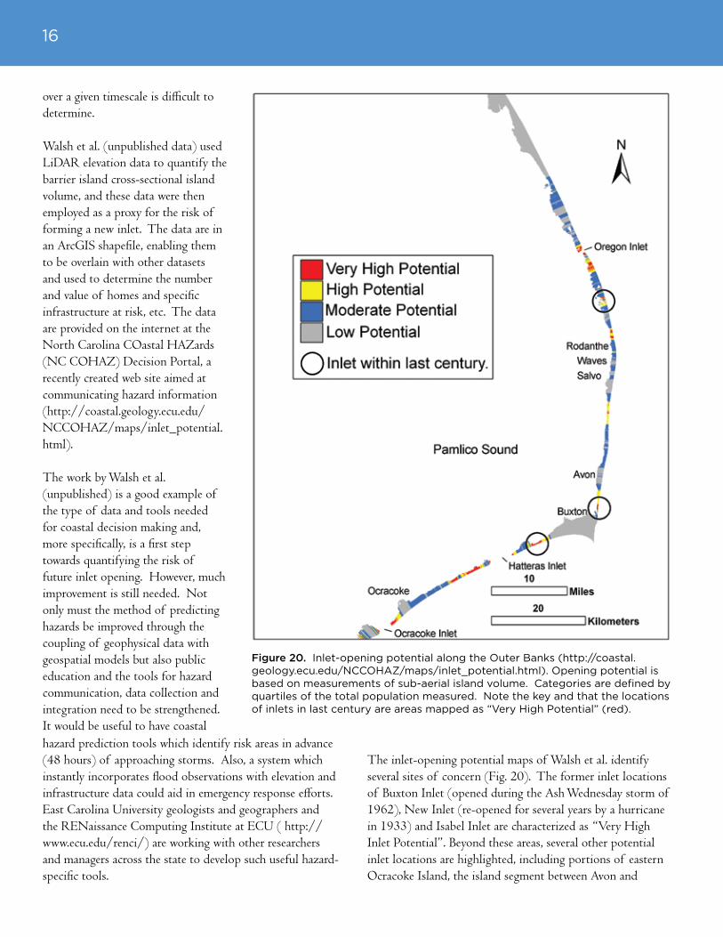
over a given timescale is difficult to determine.
Walsh et al. (unpublished data) used LiDAR elevation data to quantify the barrier island cross-sectional island volume, and these data were then employed as a proxy for the risk of forming a new inlet. The data are in an ArcGIS shapefile, enabling them to be overlain with other datasets and used to determine the number and value of homes and specific infrastructure at risk, etc. The data are provided on the internet at the North Carolina COastal HAZards (NC COHAZ) Decision Portal, a recently created web site aimed at communicating hazard information (http://coastal.geology.ecu.edu/NCCOHAZ/maps/inlet_potential.html).
The work by Walsh et al. (unpublished) is a good example of the type of data and tools needed for coastal decision making and, more specifically, is a first step towards quantifying the risk of future inlet opening. However, much improvement is still needed. Not only must the method of predicting hazards be improved through the coupling of geophysical data with geospatial models but also public education and the tools for hazard communication, data collection and integration need to be strengthened. It would be useful to have coastal hazard prediction tools which identify risk areas in advance (48 hours) of approaching storms. Also, a system which instantly incorporates flood observations with elevation and infrastructure data could aid in emergency response efforts. East Carolina University geologists and geographers and the RENaissance Computing Institute at ECU ( http://www.ecu.edu/renci/) are working with other researchers and managers across the state to develop such useful hazard-specific tools.
The inlet-opening potential maps of Walsh et al. identify several sites of concern (Fig. 20). The former inlet locations of Buxton Inlet (opened during the Ash Wednesday storm of 1962), New Inlet (re-opened for several years by a hurricane in 1933) and Isabel Inlet are characterized as “Very High Inlet Potential”. Beyond these areas, several other potential inlet locations are highlighted, including portions of eastern Ocracoke Island, the island segment between Avon and
Figure 20. Inlet-opening potential along the Outer Banks (http://coastal.geology.ecu.edu/NCCOHAZ/maps/inlet_potential.html). Opening potential is based on measurements of sub-aerial island volume. Categories are defined by quartiles of the total population measured. Note the key and that the locations of inlets in last century are areas mapped as “Very High Potential” (red).

17
Salvo, the Rodanthe area and finally the northern end of Pea Island. Inlets in these areas would all affect traffic flow along Highway 12, the main transportation route along the Outer Banks.
Beyond simple inlet formation, it is now understood that areas with very high inlet potential also have the potential to erode catastrophically to the point of barrier island collapse; that is, the erosion below sea level of long segments of the barriers (Culver et al., 2007). The collapse of portions of Dauphin Island, Alabama and the Chandeleur Islands, LA following the impacts of hurricanes Ivan and Katrina are modern examples of what could happen to segments of the Outer Banks (http://coastal.er.usgs.gov/hurricanes/katrina/lidar/dauphin-island.html) (Fig.21). As sea level rises, a barrier island will respond either by migrating landward across the underlying substrate or by disintegrating if there is not sufficient sand volume to maintain relief above sea level (Sallenger, 2000). As storms occur more frequently,
or with more intensity, the process of inlet creation and barrier disintegration or collapse may proceed more quickly. Based on geologic evidence, Riggs and Ames (2003) suggest that large portions of the Outer Banks of North Carolina could disappear within the next several decades if sea level continues rising at the current rate or if one or more major hurricanes were to directly impact the Outer Banks (Fig. 22). Similar collapse occurred approximately 1,000 years ago during the warm climatic interval known as the Medieval Warm Period (Culver et al., 2007). Given the importance of barrier islands as coastal landforms, changes in barrier island morphology, especially the possible increase in inlet activity and disintegration or collapse of barriers altogether, would have serious socio-economic implications. Understanding and predicting the response of coastal systems and landforms to sea-level rise and climate change is critical for effective coastal planning and to develop management efforts that can adapt to rising sea level and increased storm activity, as evidenced by the recent Hurricane Katrina disaster.
Figure 21. Photographs showing portions of the Chandeleur Islands, LA before and after Hurricane Katrina. The top photographs are from July 17, 2001, before the hurricane. The bottom two photographs are from August 31, 2005, two days following Hurricane Katrina. The yellow arrows point to the same location in each photographic pair (http://coastal.er.usgs.gov/hurricanes/katrina/photo-comparisons/chandeleur.html).

18
Figure 22. Conceptual model shows the potential evolution of the North Carolina coastal system in response to a 2 foot sea-level rise and increased tropical storm intensity, both of which are possible by 2100. The future mainland shoreline and wetland environments (marsh, pocosin swamp forest) are superimposed upon the modern shoreline and elevation configuration. Greater shoreline recession, ecosystem migration and marsh development in northern Pamlico Sound is likely to occur where the tidal range will be enhanced. Segmentation of the barrier islands in numerous vulnerable locations may occur in response to a 2 foot/century rate of rise and increased hurricane activity causing enhanced tidal interchange.

19
As a result of the highly dynamic nature of inlets and their adjacent shorelines, measures are being taken to responsibly manage development around inlets. One significant measure which is undergoing review by the North Carolina Division of Coastal Management is the redefinition of Inlet Hazard Areas, which include the ocean beaches adjacent to inlets where the rate of shoreline change is more rapid and variable than on other ocean beaches. Within these newly defined Inlet Hazard Areas, shoreline setback regulations are being revised to account for the high variability in shoreline erosion and accretion.
Additionally, there are some controversial measures that are being explored by local communities to “stabilize” the inlets and adjacent beaches. These proposals include sand mining of the ETD to nourish beaches and installing terminal jetties on one or both sides of the inlets to stabilize the inlet. However, these measures would interrupt the natural sand transport mechanism and alter the sediment budget, destabilizing the inlet and diminishing the quantity of sand available to the backside of the island for back-barrier island maintenance. Ultimately, these endeavors lead to increased erosion and narrowing of the barrier island (Fig. 23).Another controversial management issue involves the dredging of the ebb channel to maintain a fixed navigation channel. If
the dredge spoil sediment has the appropriate characteristics, it is sometimes used to nourish beaches adjacent to the inlet. However, frequently the most cost effective method of dredge spoil disposal is to deposit it offshore, where it may be lost from the beaches. Furthermore, the dredged navigation channel interrupts the natural sand bypassing process, and may result in the deposition of sand farther offshore and at greater depths than under natural conditions, resulting in a decrease of sediment available for the beaches (Pilkey et al. 1998). The net effect of removing this sand is an increase in shoreline recession rates.
Inlets adjust naturally to changing hydrodynamic conditions imparted by climate change, including storms and sea-level rise. Inlet adjustment is a natural process that only becomes a “hazard” or “natural disaster” when human structures and infrastructure are in the way. Responsible management of the inlet resources means designing policies and infrastructure that are adaptive to the changing conditions. For example, instead of building bridges across the inlet throat, which naturally migrates rapidly due to high current activity, they could be built across the FTD and shallow water platform (i.e., the Hatteras Flats) behind the islands where sediments are more stable. Instead of closing newly formed inlets, they should be allowed to remain open at least long enough to build a
substantial FTD for the long-term maintenance and stability of the barrier island. Access across inlets could be accommodated by high speed ferries such as those described by Riggs et al. (2008). A sustainable coastal infrastructure necessitates the ability to be flexible as opposed to static; to be able to change and adapt to the natural dynamics of the coast. It is these natural dynamics and the constant change that provide the fundamental beauty of the Outer Banks to which so many are attracted.
MANAGEMENT IssuEs
Figure 23. Aerial photograph of Ocean City Inlet, which formed in 1933 (Google Earth; NASA, 2005). The 1933 shoreline is shown in red, the photograph is from 2005. Jetties were built in 1933 and 1934 in an attempt to stabilize the inlet for navigation. The result was a disruption in the sediment transport processes and a large increase in erosion rates (up to 40 feet/year), reduction in island elevation, and loss of critical beach and dune habitats on Assateague Island down-drift of the inlet. The effects extend for approximately 9 miles southward from the inlet.
20
Ames, D.V., and Riggs, S.R., in press. Geomorphic framework of the North Carolina Outer Banks. U.S. Geological Survey Scientific Investigations Report.
Barnhardt, W.A., Gonzalez, R., Kelley, J.T., Neal, W.J, Pilkey, Jr., O.H., Jose, H., and Dias, J.A., 2002. Geologic evidence for the incorporation of flood tidal deltas at Tavira Island, southern Portugal. Journal of Coastal Research, Special Issue 36: 28-36.
Bristow, C.S., Chroston, P.N., and Bailey, S.D., 2000. The structure and development of foredunes on a locally prograding coast insights from ground-penetrating radar surveys, Norfolk, U.K. Sedimentology, 47: 923-944.
Church, J.A. and White, N.J., 2006. A 20th century acceleration in global sea-level rise. Geophysical Research Letters, 33(l01602): DOI:10.1029/2005gl024826.
Culver, S.J., Ames, D.V., Corbett, D.R., Mallinson, D.J., Riggs, S.R., Smith, C.G., and Vance, D.J., 2006. Foraminiferal and sedimentary record of late Holocene barrier island evolution, Pea Island, North Carolina: the role of storm overwash, inlet processes, and anthropogenic modification. Journal of Coastal Research, 22: 836-846.
Culver, S., Grand Pre, C., Mallinson, D., Riggs, S., Corbett, D., Foley, J., Hale, M., Ricardo, J., Rosenberger, J., Smith, C.G., Smith, C.W., Snyder, S., Twamley, D., Farrell, K., and Horton, B., 2007. Late Holocene Barrier Island Collapse: Outer Banks, North Carolina, U.S.A. The Sedimentary Record, 5: 4-8.
Elsner, J.B., Kossin, J.P., Jagger, T.H., 2008. The increasing intensity of the strongest tropical cyclones. Nature, 455: 92-95.
Emanuel, K., 2005. Increasing destructiveness of tropical cyclones over the past 30 years. Nature, 436: 686-688.
Fisher, J.J., 1962. Geomorphic Expression of Former Inlets along the Outer Banks of North Carolina. Unpub. M.S. Thesis, University of North Carolina, Chapel Hill, North Carolina, 120p.
Fitzgerald, D.M., Baldwin, C.T., Ibrahim, N.A., and Humphries, S.M., 1992. Sedimentologic and morphologic evolution of a beach-ridge barrier along an indented coast: Buzzards Bay, Massachusetts. Quaternary Coasts of the United States: Marine and Lacustrine Systems, SEPM Special Publication, 48: 65-75.
Freeman, C.H., Bernstein, D.J., and Mitasova, H., 2004. Rapid response 3D survey techniques for seamless topo/bathy modeling: 2003 Hatteras Breach, North Carolina. Shore and Beach, 72: 25-30.
Godfrey, P.J., and Godfrey, M.M., 1976. Barrier Island Ecology of Cape Lookout National Seashore and Vicinity, North Carolina. National Park Service Scientific Monograph Series No. 9, 160 p.
Havholm, K.G., Ames, D.V., Whittecar, G.R., Wenell, B.A., Riggs, S.R., Jol, H.M., Berger, G.W., and Holmes, M.A., 2004. Stratigraphy of back-barrier coastal dunes, northern North Carolina and southern Virginia. Journal of Coastal Research, 20: 980-999.
Herbert, J., 1978. Post-Miocene Stratigraphy and Evolution of Northern Core Banks, NC. Unpub. M.S. Thesis, Dept. of Geology, Duke University, Durham, NC, 133 p.
Heron Jr., S.D., Moslow, T.F., Berelson, W.M., Herbert, J.R., Steele III, G.A., and Susman, K.R., 1984. Holocene sedimentation of a wave-dominated barrier island shoreline: Cape Lookout, North Carolina. Marine Geology, 60: 413-434.
lITERATuRE CITEd

21
Inman, D.L. and Dolan, R., 1989. The Outer Banks of North Carolina: Budget of sediment and inlet dynamics along a migrating barrier system. Journal of Coastal Research, 5: 193-237.
IPCC, 2007. Climate Change 2007 - The Physical Science Basis: Contribution of Working Group I to the Fourth Assessment Report of the Intergovernmental Panel on Climate Change. http://www.ipcc.ch/ipccreports/ar4-wg1.htm
Jol, H.M., Smith, D.G., and Meyers, R.A., 1996. Digital Ground Penetrating Radar (GPR): A new geophysical tool for coastal barrier research (examples from the Atlantic, Gulf, and Pacific Coasts, U.S.A.). Journal of Coastal Research, 12: 960-968.
Jol, H.M., Lawton, D.C., and Smith, D.G., 2002. Ground penetrating radar: 2-D and 3-D subsurface imaging of a coastal barrier spit, Long Beach, WA, USA. Geomorphology, 53: 165-181.
Mallinson, D., Culver, S., Riggs, S., Thieler, E.R., Foster, D., Wehmiller, J., Farrell, K., and Pierson, J., in review. Regional seismic stratigraphy and controls on the Quaternary evolution of the Cape Hatteras region of the Atlantic passive margin; USA. Marine Geology.
Mallinson, D., Riggs, S., Thieler, R., Culver, S., Foster, D., Corbett, R., Farrell, K., and Wehmiller, J., 2005. Late Neogene and Quaternary evolution of the northern Albemarle Embayment (mid-Atlantic continental margin, USA), Marine Geology, 217: 97-117.
Mann, M.E., and Emanuel, K.A., 2006. Atlantic hurricane trends linked to climate change. Eos, 87: 233, 238, 241.
Moslow, T.F., and Heron, S.D.Jr., 1978. Relict inlets: Preservation and occurrence in the Holocene stratigraphy of southern Core Banks, North Carolina. Journal of Sedimentary Petrology, 48:1275-1286.
Neal, A., and Roberts, C., 2000. Applications of ground-penetrating radar (GPR) to sedimentological, geomorphological and geoarchaeological studies in coastal environments. In, Pye, K., and Allen, J.R.L. (eds.). Coastal and Estuarine Environments: Sedimentology, Geomorphology and Geoarchaeology. Geological Society, London, Special Publications, 175: 139-171.
Overpeck, J.T. Otto-Bliesner, B.L., Miller, G.H. ,Muhs, .R., Alley, R.B., and Kiehl, J.T., 2006. Paleoclimatic evidence for future ice-sheet instability and rapid sea-level rise. Science, 311: 1747-1750.
Payne, R.L., 1985. Places Names of the Outer Banks. T.A. Williams Publishing Co., Washington, NC, 198 p.
Pfeffer, W.T., Harper, J.T., and O’Neel, S., 2008 Kinematic constraints on glacier contributions to 21st-century sea-level rise. Science, 321: 1340-1343.
Pilkey, O.H., Neal, W.J., Riggs, S.R., Webb, C.A., Bush, D.M., Pilkey, D.F., Bullock, J., and Cowan, B.A., 1998. The North Carolina Shore and Its Barrier Islands: Restless Ribbons of Sand. Duke University Press, Durham, NC. 318 p.
Riggs, S.R. and Ames, D.V., 2003. Drowning the North Carolina coast: Sea-level rise and estuarine dynamics, North Carolina Sea Grant College Program, Raleigh, NC, Pub. No. UNC-SG-03-04, 152 p.
Riggs, S.R., and Ames, D.V., 2007. Effect of storms on barrier island dynamics: Core Banks, Cape Lookout National Seashore, North Carolina, 1960-2001. U.S. Geological Survey Scientific Investigations Report 2006-5309. 73 p.
Riggs, S.R., and Ames, D.V., in press. Barrier island evolution: a model for development of the geomorphic framework, North Carolina Outer Banks. U.S. Geological Survey Scientific Investigations Report.

22
Riggs, S.R., Ames, D.V., Culver, S.J., Mallinson, D.J., Corbett, D.R., and Walsh, J.P., in press. In the eye of a human hurricane: Oregon Inlet, Pea Island, and the northern Outer Banks of North Carolina. In, Kelley, J.T., Young, R.S. and Pilkey O.H. (eds.), Identifying America’s Most Vulnerable Oceanfront Communities: A Geological Perspective, Geological Society of America, Special Publication.
Riggs, S.R., Culver, S.J., Ames, D.V., Mallinson, D.J., Corbett, D.R., and Walsh, J.P., 2008. North Carolina Coasts in Crisis: A Vision for the Future. East Carolina University White Paper, Greenville, NC, 26 p.
Sallenger, A.H., 2000. Storm impact scale for barrier islands. Journal of Coastal Research, 16: 890-895.
Smith, C.G., 2004. Late Holocene Geologic Development of Pea Island and Avon-Buxton Area, Outer Banks, North Carolina. Unpub. M.S. Thesis, East Carolina University, Greenville, NC, 156 p.
Smith, C.G, Riggs, S., Culver, S., Ames, D., Corbett, D., Mallinson, D., 2008. Geospatial analysis of barrier island width of two segments of the Outer Banks, North Carolina, USA: anthropogenic curtailment of natural self-sustaining processes. Journal of Coastal Research, 24: 70-83.
Smith C.G., Culver, S.J., Mallinson, D.J., Riggs, S.R. and Corbett, D.R., in press. Recognizing former flood tidal delta deposits in the late Holocene stratigraphic record: examples from the Outer Banks of North Carolina, USA. Stratigraphy.
Smith, C.W. 2006. Lithologic, Geophysical, and Paleoenvironmental Framework of Relict Inlet Channel-Fill and Adjacent Facies: North Carolina Outer Banks. Unpub. M.S. Thesis, East Carolina University, Greenville, NC, 267 p.
Stick, D., 1958. The Outer Banks of North Carolina. University of North Carolina Press, Chapel Hill, NC. 352 p.
Susman, K.R, 1975. Post-Miocene Subsurface Stratigraphy of Shackleford Banks, Carteret County, North Carolina. Unpub. M.S. Thesis, Duke University, Durham, North Carolina, 102p.
Susman, K.R. and Heron Jr., S.D., 1979. Evolution of a barrier island, Shackleford Banks, Carteret County, North Carolina. Geological Society of America Bulletin, 90: 205-215.
Thieler, E.R., and Hammar-Klose, E.S., 1999, National Assessment of Coastal Vulnerability to Sea-Level Rise, U.S. Atlantic Coast: U.S. Geological Survey, Open-File Report 99-593, 1 sheet. (Available online at: http://pubs.usgs.gov/of/of99-593/.)
USACE, 1963. Report On Operation Five- High: March 1962 Storm. United States Army Corps of Engineers Report; prepared by civil Works Branch – Construction Operations Division, North Atlantic Division, August 1963.
Webster, P.J., Holland, G.J., Curry, J.A. and Chang, H.R., 2005. Changes in tropical cyclone number, duration, and intensity in a warming environment. Science, 309: 1844-1846.

bACk COVER PHOTOGRAPH. A NASA Terra satellite image of Hurricane Isabel as it made landfall across North Core Banks, North Carolina on September 18, 2003. Isabel was a category 5 hurricane while at sea, but slowed and diminished in intensity as it approached North Carolina. It came ashore as a category 2 storm with about a 6 to 8 foot storm surge and 100 mph winds. The storm opened Isabel Inlet (front cover) adjacent to Hatteras Village and came within minutes and/or inches of opening additional inlets between Avon and Buxton and on the northeast end of Ocracoke Island.