patuxent river solomons island and vicinity
TRANSCRIPT

BookletChart™ Patuxent River – Solomons Island and Vicinity NOAA Chart 12284
A reduced-scale NOAA nautical chart for small boaters When possible, use the full-size NOAA chart for navigation.
2
Published by the National Oceanic and Atmospheric Administration
National Ocean Service Office of Coast Survey
www.NauticalCharts.NOAA.gov 888-990-NOAA
What are Nautical Charts?
Nautical charts are a fundamental tool of marine navigation. They show water depths, obstructions, buoys, other aids to navigation, and much more. The information is shown in a way that promotes safe and efficient navigation. Chart carriage is mandatory on the commercial ships that carry America’s commerce. They are also used on every Navy and Coast Guard ship, fishing and passenger vessels, and are widely carried by recreational boaters.
What is a BookletChart?
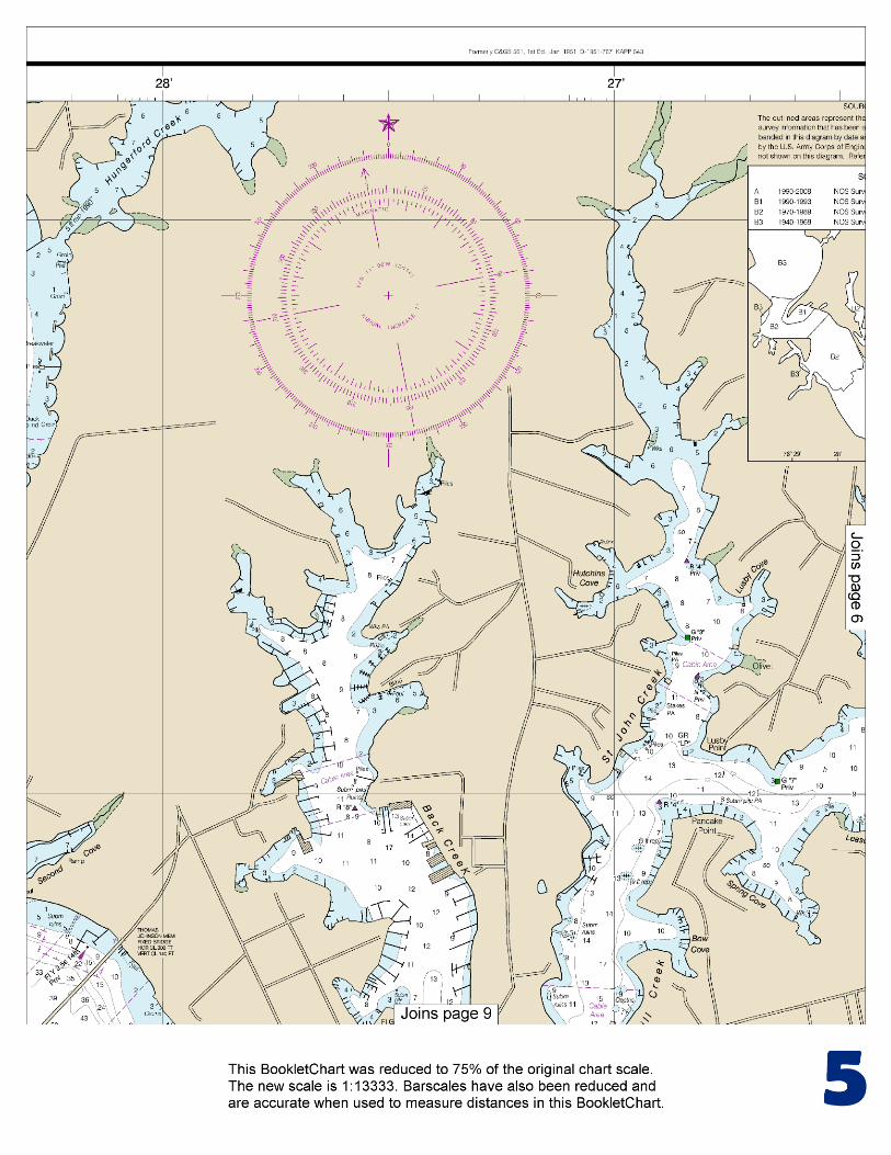
This BookletChart is made to help recreational boaters locate themselves on the water. It has been reduced in scale for convenience, but otherwise contains all the information of the full-scale nautical chart. The bar scales have also been reduced, and are accurate when used to measure distances in this BookletChart. See the Note at the bottom of page 5 for the reduction in scale applied to this chart.
Whenever possible, use the official, full scale NOAA nautical chart for navigation. Nautical chart sales agents are listed on the Internet at http://www.NauticalCharts.NOAA.gov.
This BookletChart does NOT fulfill chart carriage requirements for regulated commercial vessels under Titles 33 and 44 of the Code of Federal Regulations.
Notice to Mariners Correction Status
This BookletChart has been updated for chart corrections published in the U.S. Coast Guard Local Notice to Mariners, the National Geospatial Intelligence Agency Weekly Notice to Mariners, and, where applicable, the Canadian Coast Guard Notice to Mariners. Additional chart corrections have been made by NOAA in advance of their publication in a Notice to Mariners. The last Notices to Mariners applied to this chart are listed in the Note at the bottom of page 7. Coast Pilot excerpts are not being corrected.
For latest Coast Pilot excerpt visit the Office of Coast Survey website at http://www.nauticalcharts.noaa.gov/nsd/searchbychart.php?chart=12284.
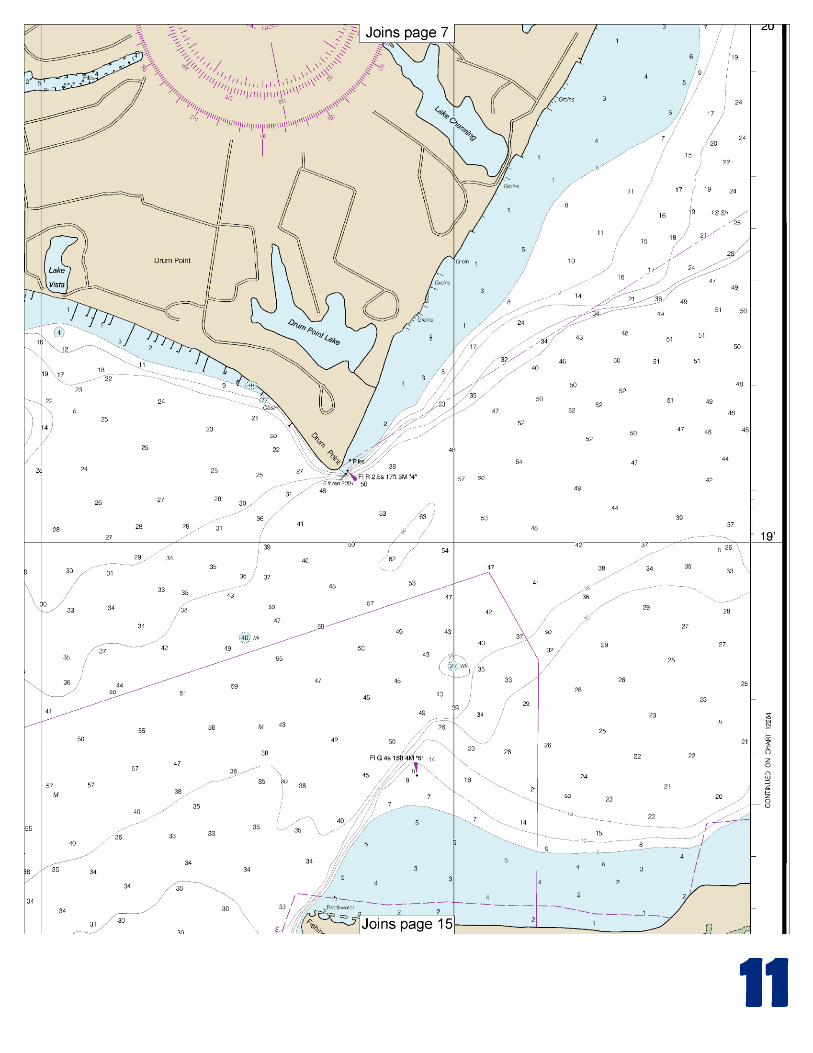
(Selected Excerpts from Coast Pilot) Patuxent River empties into the west side of Chesapeake Bay 89.3 miles above the Virginia Capes. Commercial traffic consists chiefly of shellfish and shells, and petroleum products. Drafts of vessels using the river are mostly 7 feet or less and seldom exceed 12 feet. The river has natural depths of 25 to 30 feet in the approach, 30 to over 100 feet for 16 miles upstream, thence 23 feet to the
Benedict highway bridge 19 miles above the mouth, thence 10 feet for 12 miles to within 2 miles of Nottingham, thence 6 feet for 5 miles, and thence 3 feet to Hills Bridge, 40 miles above the mouth. The channel is not difficult to follow as far as the Benedict bridge, and the principal
shoals are marked by lights and daybeacons; the channel above the bridge is narrow in places and is marked for about another 2.5 miles. Anchorage can be had off the mouth of Patuxent River; shelter from westerly winds is found in depths of 20 to 30 feet close to shore on the north side of the approach. Shelter from easterly winds is found in depths of 30 to 50 feet in the channel about 1.5 miles above the entrance. Bottom in Patuxent River channel is mostly soft as far as the Benedict highway bridge, and vessels can anchor where convenient. Small vessels anchor in the creeks back of Solomons Island, but there is little swinging room. St. Leonard Creek is a good small-vessel anchorage in any weather. The current velocity is 0.4 knot in the entrance to Patuxent River off Drum Point. Ice closes the river to near the mouth in severe winters. Marine supplies and complete hull and machinery repairs are available along the Patuxent River. Principal locations are in the creeks behind Solomons Island, i.e., Back Creek and Mill Creek. Facilities are also available in Town Creek, Cuckold Creek, Island Creek, and at Benedict. Patuxent River empties into the head of the bight between Cedar Point and Cove Point, 5 miles to the northward. Cove Point Light (38°23'11"N., 76°22'54"W.), 45 feet above the water, is shown from a white tower on the point. The light is 1 mile west of a point on the bay ship channel 92.6 miles above the Capes. The high bluffs on Little Cove Point, 1.5 miles to the southward, are prominent. The entrance to Patuxent River is between Drum Point and Fishing Point, 0.9 mile to the southward. The shoals that extend off Fishing Point and Hog Point, 1 mile to the east-northeastward, are marked at their outer ends by lights. A fish haven, marked by buoys, is about 1 mile east-southeastward of Light 3. A light is just off Drum Point. Mileages on Patuxent River, shown as Mile 8W, 11E, etc., are the nautical miles above the midchannel point on a line drawn between Drum and Fishing Points. The letters N, S, E, and W following the numerals denote by compass points the side of the river where each feature is located. The Patuxent River Naval Air Station is along the south side of the entrance. The inclosed seaplane basins, East Patuxent Basin at Mile 0.8S, and West Patuxent Basin at Mile 1.35S have general depths of 9 to 4 feet, and 15 to 7 feet, respectively. Lights mark the entrance points to West Patuxent Basin. A restricted area off the air station begins about 2.4 miles south of Cedar Point and extends north to the mouth of Patuxent River, thence upstream for about 2.5 miles. (See 334.180, chapter 2, for limits and regulations.) Solomons Island, Mile 1.8N, is joined to the mainland on the northwest by a causeway. The shoal that extends 500 yards southward from Sandy Point, at the south end of the island, is marked at its outer end by a light. Solomons, is the village on the island. The pier of the Chesapeake Biological Laboratory on the east side of the island has depths of 8 feet at the outer end and is marked by a private light. Back Creek and Mill Creek have a common entrance between Solomons Island and the mainland 200 yards to the north-northeastward. The marked main approach, between the island and the shallow middle ground to the eastward, has depths of 20 to 25 feet. The second marked approach, between the middle ground and the mainland to the northward, has depths of 12 feet.
U.S. Coast Guard Rescue Coordination Center 24 hour Regional Contact for Emergencies
RCC Norfolk Commander
5th CG District (575) 398-6231 Norfolk, VA
G
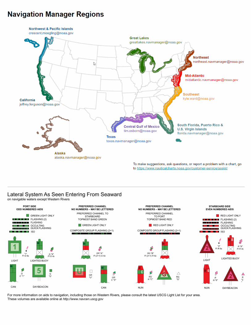
Lateral System As Seen Entering From Seaward on navigable waters except Western Rivers
PORT SIDE ODD NUMBERED AIDS
GREEN LIGHT ONLY FLASHING (2)
PREFERRED CHANNEL NO NUMBERS – MAY BE LETTERED
PREFERRED CHANNEL TO STARBOARD
TOPMOST BAND GREEN
PREFERRED CHANNEL NO NUMBERS – MAY BE LETTERED
PREFERRED CHANNEL TO PORT
TOPMOST BAND RED
STARBOARD SIDE EVEN NUMBERED AIDS
RED LIGHT ONLY FLASHING (2)
FLASHING FLASHING OCCULTING GREEN LIGHT ONLY RED LIGHT ONLY OCCULTING QUICK FLASHING QUICK FLASHING ISO COMPOSITE GROUP FLASHING (2+1) COMPOSITE GROUP FLASHING (2+1) ISO
"1"
Fl G 6s
G "9"
Fl G 4s
GR "A"
Fl (2+1) G 6s
RG "B"
Fl (2+1) R 6s
"2"
Fl R 6s
8
R "8" Fl R 4s
LIGHT
G
C "1"
LIGHTED BUOY
G "5"
GR "U"
GR
C "S"
RG
N "C"
RG "G"
LIGHT
6
R
N "6"
LIGHTED BUOY
R
"2"
CAN DAYBEACON
CAN NUN NUN
DAYBEACON
For more information on aids to navigation, including those on Western Rivers, please consult the latest USCG Light List for your area. These volumes are available online at http://www.navcen.uscg.gov
2
2
C U 5
1


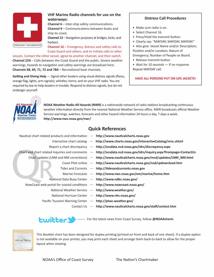
VHF Marine Radio channels for use on the waterways:Channel 6 – Inter-ship safety communications.Channel 9 – Communications between boats and ship-to-coast.Channel 13 – Navigation purposes at bridges, locks, and harbors.Channel 16 – Emergency, distress and safety calls to Coast Guard and others, and to initiate calls to other
vessels. Contact the other vessel, agree to another channel, and then switch.Channel 22A – Calls between the Coast Guard and the public. Severe weather warnings, hazards to navigation and safety warnings are broadcast here.Channels 68, 69, 71, 72 and 78A – Recreational boat channels.
Getting and Giving Help — Signal other boaters using visual distress signals (flares, orange flag, lights, arm signals); whistles; horns; and on your VHF radio. You are required by law to help boaters in trouble. Respond to distress signals, but do not endanger yourself.
EMERGENCY INFORMATION
Distress Call Procedures
• Make sure radio is on.• Select Channel 16.• Press/Hold the transmit button.• Clearly say: “MAYDAY, MAYDAY, MAYDAY.”• Also give: Vessel Name and/or Description;Position and/or Location; Nature of Emergency; Number of People on Board.• Release transmit button.• Wait for 10 seconds — If no responseRepeat MAYDAY call.
HAVE ALL PERSONS PUT ON LIFE JACKETS!
This Booklet chart has been designed for duplex printing (printed on front and back of one sheet). If a duplex option is not available on your printer, you may print each sheet and arrange them back-to-back to allow for the proper layout when viewing.
QR
Quick ReferencesNautical chart related products and information - http://www.nauticalcharts.noaa.gov
Interactive chart catalog - http://www.charts.noaa.gov/InteractiveCatalog/nrnc.shtmlReport a chart discrepancy - http://ocsdata.ncd.noaa.gov/idrs/discrepancy.aspx
Chart and chart related inquiries and comments - http://ocsdata.ncd.noaa.gov/idrs/inquiry.aspx?frompage=ContactUs
Chart updates (LNM and NM corrections) - http://www.nauticalcharts.noaa.gov/mcd/updates/LNM_NM.html
Coast Pilot online - http://www.nauticalcharts.noaa.gov/nsd/cpdownload.htm
Tides and Currents - http://tidesandcurrents.noaa.gov
Marine Forecasts - http://www.nws.noaa.gov/om/marine/home.htm
National Data Buoy Center - http://www.ndbc.noaa.gov/
NowCoast web portal for coastal conditions - http://www.nowcoast.noaa.gov/
National Weather Service - http://www.weather.gov/
National Hurrican Center - http://www.nhc.noaa.gov/
Pacific Tsunami Warning Center - http://ptwc.weather.gov/
Contact Us - http://www.nauticalcharts.noaa.gov/staff/contact.htm
NOAA’s Office of Coast Survey The Nation’s Chartmaker
For the latest news from Coast Survey, follow @NOAAcharts
NOAA Weather Radio All Hazards (NWR) is a nationwide network of radio stations broadcasting continuous weather information directly from the nearest National Weather Service office. NWR broadcasts official Weather Service warnings, watches, forecasts and other hazard information 24 hours a day, 7 days a week. http://www.nws.noaa.gov/nwr/