uptown preliminary rezone …pan/documents/web_informational/...seattle uptown preliminary rezone...
TRANSCRIPT

UPTOWN PRELIMINARY REZONE RECOMMENDATION DIRECTOR’S REPORT

S E AT T L E U P TO W N P R E L I M I N A R Y R E ZO N E R E CO M M E N DAT I O N D I R E C TO R ’S R E P O R T · M A R C H 2017
1
TABLE OF CONTENTS
I. Planning in Uptown..............................................................3GoalsComprehensive PlanShaping Future GrowthPlanning ProcessEnviornmental Impact Study
II. Zoning Recommendation...................................................16Urban FormViewsDevelopment StandardsNeighborhood Character
III. Affordable Housing Requirements...................................28
Appendix A: Growth Strategy Element
Appendix B: Recommended Height Limits
Appendix C: Draft Development Standards

S E AT T L E U P TO W N P R E L I M I N A R Y R E ZO N E R E CO M M E N DAT I O N D I R E C TO R ’S R E P O R T · M A R C H 2017
2
CONTRIBUTORS
Uptown UDF Advisory CommitteeDebi Frausto, ResidentKatie Idziorek, ResidentRick Hooper, ResidentKay Knapton, ResidentMarty Kaplan, ResidentRobert Nellams, Director, Seattle CenterRon Sevart, CEO, Space NeedleCary Moon, ResidentKarl Spence, SIFFMartin Selig, CEO Martin Selig Corporation.Bob Burkheimer, CEO Burkheimer AssociatesJohn Coney, Former Resident
Uptown Alliance (UA) UDF SubcommitteeDebi Frausto, Chair UA UDF CommitteeKatie Idziorek, Co-President, UARick Hooper, Co-President, UAJohn Coney, ResidentMatt Roewe, ResidentKaren Kiest, Business OwnerMaria Barrientos, Seattle Center Advisory CommissionJane Zalutsky, Lake 2 BayCraig Hanway, ResidentDon Miles, ResidentSara Lewontin, ResidentKristin Larson, Resident
City StaffDiane Sugimura, Former Director, OPCDNathan Torgelson, Deputy Director, OPCDSusan McLain, Deputy Planning Director, OPCDDave LaClergue, Area Planning Manager, OPCDVanessa Murdock, Executive Director, Seattle Planning CommissionLyle Bicknell, Principal Urban Designer, OPCDJim Holmes, Senior Planner, OPCDMoon Callison, Community Engagement, OPCDAndrew Badgett, Community Engagement, OPCDIan Dapiaoen, Community Engagement, OPCDCayce James, Associate Urban Designer, OPCDMichael James, SDOTChristopher Yakes, SDOTMichelle Marx, SDOTJill Crary, Redevelopment Director, Seattle CenterLayne Cubell, Strategic Advisor, Seattle Center

S E AT T L E U P TO W N P R E L I M I N A R Y R E ZO N E R E CO M M E N DAT I O N D I R E C TO R ’S R E P O R T · M A R C H 2017
3
I . PLANNING IN UPTOWN
This preliminary Uptown rezone recommendation seeks to advance the principles set out in the Uptown Urban Design Framework (UDF), which are the result of a multi-year community planning process. This process included input from residents, businesses, arts organizations, and voices from adjacent neighborhoods, including a diverse set of concerns and goals. This recommendation represents a balancing of what we heard, consideration of related planning efforts in the neighborhood, and infrastructure investments that will influence Uptown’s character and place in the City.
Specific objectives of the draft legislation include:
• Shaping future growth through development standards to improve the pedestrian environment, create more ground-level open space, and match the scale of surrounding development and geographic features.

S E AT T L E U P TO W N P R E L I M I N A R Y R E ZO N E R E CO M M E N DAT I O N D I R E C TO R ’S R E P O R T · M A R C H 2017
4
• Increasing the supply of affordable housing by implementing the Housing and Livability agenda by increasing development capacity and applying new requirements on developers.
• Leveraging major transportation investments that will improve connections to adjacent neighborhoods and facilitate movement of people and goods to and from Uptown.
• Providing the ability to provide more affordable housing opportunities by increasing development capacity and through application of Mandatory Affordable Housing (MHA) requirements that are part of the Mayor’s Housing and Livability Agenda.
• Retaining landmarks and other historic buildings by allowing transfer of development rights in exchange for funding to help provide for building preservation. Strengthening the heart of Uptown and Uptown’s connection to Seattle Center.
Center City Neighborhoods
LakeUnion
Port ofSeattle
ElliottBay
Pike / Pine
First Hill
CapitolHill
Uptown
BelltownDenny
Triangle
CommercialCore
PioneerSquare
SouthLake
Union
90
Chinatown /International
District

S E AT T L E U P TO W N P R E L I M I N A R Y R E ZO N E R E CO M M E N DAT I O N D I R E C TO R ’S R E P O R T · M A R C H 2017
5
Comprehensive Plan
Uptown is growing and changing just as Seattle is growing and changing. This growth has created challenges regarding housing supply, transportation, and neighborhood livability. Seattle’s Comprehensive Plan (Seattle 2035), which is the City’s growth management strategy, designates Uptown as one of six Urban Centers. Importantly, it is part of the 4 contiguous Urban Centers that form the Center City Core from Kinnear Park as the northwest edge to the international District at the southeast and includes First Hill, Capitol Hill, Pioneer Square, Downtown, Belltown and South Lake Union.
This means that as the City grows, Uptown will play a central role in Seattle’s future as a regional center for housing and job growth. Policies that promote equitable and affordable housing, advance a strong jobs/housing balance, support growth built on a strong multimodal transit network, and strive to achieve a high quality built environment can allow us to grow and simultaneously achieve a high quality of livability.
Currently there are approximately 6,855 households and 14,592 jobs in Uptown. Seattle 2035 estimates that the number of households in Uptown will increase by approximately 3,000, and the number of jobs will increase by approximately 2,500.
These 20-year growth estimates are for planning purposes only and are not meant to be used as a statement of optimal growth. Estimating how much of the City’s growth Uptown will receive allows the City to channel investments in infrastructure and services where they are needed.
Seattle 2035 contains policies that guide development in Urban Centers and that support the rezone recommendation. For a list of these policies, please see Appendix A.
Uptown UDF Guiding Principles:
• Uptown is a growing Urban Center. • Uptown encourages the development of a diverse
range of housing types and affordability levels. • Uptown is a regional hub connecting adjacent
neighborhoods and major employers. • Uptown celebrates Seattle Center as a vital part of
the neighborhood.• Uptown is best served by a robust multi-modal
Transportation system. • Uptown’s open space supports healthy
Uptown residents. • Uptown Values its History• Uptown is a vibrant emerging Arts and
Culture District.

S E AT T L E U P TO W N P R E L I M I N A R Y R E ZO N E R E CO M M E N DAT I O N D I R E C TO R ’S R E P O R T · M A R C H 2017
6
Shaping Future Growth
The rezone recommendation includes development standards that are intended to reinforce the pedestrian environment throughout the neighborhood and particularly the pedestrian hubs found in the heart of Uptown, the Mercer Roy Corridor, and along 5th Avenue N. Other standards include creating more ground-level open space, upper level setbacks to maintain a pedestrian scale at the street level, and use requirements in some areas to ensure lively, active frontage. New regulations would also prohibit “parking only” buildings, and require screening of parking in aboveground structures.
Increasing the Supply of Housing
Located near the job centers of Downtown and South Lake Union, Uptown’s housing resources play an important role in achieving a sustainable and equitable jobs/housing balance. This recommendation increases housing capacity and includes affordable housing provisions to ensure there is a diversity of housing opportunities in Uptown. Specifically, the rezone recommendation increases capacity in the multi-family zoned areas of Uptown by approximately 1 floor to implement the Mandatory Housing Affordability (MHA) program, with greater increases in the mixed-use areas of Uptown to encourage development of housing and commercial uses in the heart of Uptown and the Mercer/Roy Corridor. Through the new MHA requirements, we expect development in Uptown will produce approximately 600 new affordable units over the next 20 years.
Leverage Transportation Investments and Plans
A key principle in the UDF is that Uptown’s future growth be built on a multi-modal transportation system. This means that while the automobile will remain an important mode of transportation, alternatives to the car are critical to provide efficient movement to
Uptown Residential Typologies

S E AT T L E U P TO W N P R E L I M I N A R Y R E ZO N E R E CO M M E N DAT I O N D I R E C TO R ’S R E P O R T · M A R C H 2017
7
and from Uptown. The City, King County, the State of Washington, and Sound Transit are working together to make important investments in transportation infrastructure and services that will improve connections to and from Uptown. Specifically:
• Completion of the Alaska Way Viaduct Tunnel and North Portal and the important reconnection of John, Thomas, and Harrison Streets increasing the number of east/west connections beyond Mercer Street and Denny Way.
• Improvements in metro transit service, which will increase bus options in and out of Uptown.
• Development of the Center City Mobility Plan making movement from Uptown to adjacent neighborhoods more efficient.
• In the future, light rail built by Sound Transit as part of the voter approved Sound Transit 3 ballot measure. Completion of Sound Transit 2 will bring benefit to the Center City with Downtown serving as its regional hub. Strategies to create “last mile/first mile connections” to Uptown are essential.

S E AT T L E U P TO W N P R E L I M I N A R Y R E ZO N E R E CO M M E N DAT I O N D I R E C TO R ’S R E P O R T · M A R C H 2017
8
• Implementation of the Pedestrian and Bike Master Plans will increase mobility options in Uptown and make it a walkable well-connected neighborhood.
Valuing Uptown’s History
Uptown is one of Seattle’s oldest neighborhoods. Its housing stock includes a variety of architectural styles with a concentration of buildings built in the 20s, 30s, and 40s. Many of these buildings provide relatively affordable market-rate housing and their loss through rising rents, renovation, or redevelopment is contributing to an overall decrease in neighborhood affordability. Many of these buildings are constructed of unreinforced masonry which requires expensive retrofitting to be preserved. This rezone recommendation provides a mechanism that may help to preserve some of these buildings by allowing them to sell unused development rights to build taller new buildings. A transfer of development rights approach alone may not preserve these buildings, but could play an important role in leveraging other resources to do so.
Strengthening the Heart of Uptown and Connections to Seattle Center
The main pedestrian oriented district in Uptown is referred to as the Heart of Uptown. It sits at the intersection of critical transportation infrastructure and near Seattle Center and gives focus to Uptown as a neighborhood. Consistent with the make-up of pedestrian oriented districts, there is a concentration of uses that generate pedestrian activity, sustaining diverse businesses, and creating a lively street environment. The rezone recommendation seeks to strengthen this area through new street-level development standards that promote pedestrian activity and additional height to encourage a mix of uses, including residential, to generate more activity in this area. Seattle Center is the primary arts, sports, and entertainment hub for the region and is a key part of the Uptown neighborhood Uptown residents use the Center as an important open space and cultural resource. Activities at Seattle Center provide support for the businesses in the neighborhood and working in partnership with the neighborhood, Seattle Center can help shape the character of future development in Uptown.

S E AT T L E U P TO W N P R E L I M I N A R Y R E ZO N E R E CO M M E N DAT I O N D I R E C TO R ’S R E P O R T · M A R C H 2017
9
Key opportunities to improve neighborhood connections include:
• A redesigned Thomas and 5th Avenue N. entrance on the east side of campus.
• Improved connections on the west side of campus to the Heart of Uptown, created through the redesign of Republican Street as a festival street connecting Queen Anne Avenue with August Wilson Way as it traverses the Campus.
• Implementation of the Lake 2 Bay Street concept plan and improvements to the Broad Street Green for greater access and activation of the Pacific Science Center, Chihuly Garden and Glass, the Space Needle, and Experience Music Project.
• Redevelopment of parcels on the perimeter of the Seattle Center campus, including the Mercer Street Garage.
The rezone recommendation advances these opportunities by providing development standards that will support redevelopment of key edge properties and through street classifications that promote pedestrian design and uses on 5th Avenue N., Mercer Street, and 1st Avenue N.
Planning process
Development of this rezone recommendation is the result of a multi-year planning process engaging a broad cross section of
stakeholders. Early planning began with a small charrette focusing specifically on the Uptown Triangle in 2012. Sponsored by the City of Seattle, the Uptown Alliance, and the American Architectural Foundation, the product of this charrette was a report recommending a network of green streets and a mix of uses bridging the South Lake Union Neighborhood and the Seattle Center, and consideration of increasing heights. Importantly, this charrette also led to the recognition that significant change was occurring that affected the entire Uptown Neighborhood. These recommendations
UPTOWNurban design framework
May 2016
Uptown Urban Design Framework Charrette

S E AT T L E U P TO W N P R E L I M I N A R Y R E ZO N E R E CO M M E N DAT I O N D I R E C TO R ’S R E P O R T · M A R C H 2017
10
included substantial infrastructure investments such as the elimination of Broad Street between Aurora Avenue North and Fifth Avenue North and making Mercer Street a two-way street, anticipated completion of the Alaska Way Viaduct replacement resulting in a connection of the street grid across Aurora Ave N, and the substantial growth occurring in and adjacent to Uptown. This recognition led the City to engage local stakeholders in a neighborhood wide planning effort. The results of this effort are the UDF and, ultimately, this preliminary rezone recommendation.

S E AT T L E U P TO W N P R E L I M I N A R Y R E ZO N E R E CO M M E N DAT I O N D I R E C TO R ’S R E P O R T · M A R C H 2017
11
Uptown Urban Design Framework
In November of 2013 the City and the Uptown Alliance held a community workshop to kick-off the UDF process. The workshop, held at Seattle Center, was attended by approximately 70 neighborhood stakeholders including interested neighbors from Queen Anne, South Lake Union, and Belltown. Key themes emerging from the workshop include:
• Connectivity: Recognize Uptown as both a destination as well as a place people pass through or visit. Improvements to transit and pedestrian facilities were prioritized to allow for safe, efficient, and enjoyable movement through the neighborhood.
• Economic Vitality: Occupancy and density on the commercial core of Uptown should be maximized while maintaining existing character. Focus additional retail and to residents while acknowledging and building on the neighborhood’s current cultural assets.
• Living in Uptown: Preserve the neighborhood’s character and seek to attracting a diversity of ages. Cue visitors and residents alike that they are in Uptown. Many participants described the need for a community center/public gathering space for residents.
• Public Realm: Uptown’s streets should be more pedestrian-friendly. The activation of the public realm – sidewalks, Kinnear park etc. could help make these places friendly and welcoming. Enhance connections to the Seattle Center and the waterfront.
• Seattle Center: Seattle Center is a significant asset for the neighborhood. Participants expressed interest in a more permeable edge of Seattle Center. Many asked how Uptown and Seattle Center can integrate their movement patterns (pedestrian, bike, and transit). Questions were raised regarding the status of talk between the City and the Seattle School District regarding the future of Memorial stadium. Many noted support for the redevelopment of the parking garages between Mercer and Roy.
Following the workshop, the City sponsored a series of three design

S E AT T L E U P TO W N P R E L I M I N A R Y R E ZO N E R E CO M M E N DAT I O N D I R E C TO R ’S R E P O R T · M A R C H 2017
12
charrettes to develop these themes into concrete recommendations for inclusion in the UDF. Each charrette had approximately 50 participants and included Uptown residents, business and property owners, arts organizations, and representatives from adjacent neighborhoods. The results of the charrettes were used to develop a draft UDF. Concurrent with the charrette process, the City convened an advisory group reflecting a cross section like the charrette attendees to serve as a sounding board as the UDF was developed from the charrette results. The UDF was complete in 2016 and can be found on the City’s website (http://bit.ly/opcd-uptown).
Environmental Impact Study
A key recommendation of the UDF was that changes in zoning be studied through an Environmental Impact Study (EIS). The UDF set out 2 different height alternatives plus a ‘no-action’ alternative for study that would demonstrate the potential impacts and tradeoffs between different heights in different parts of the neighborhood. The EIS studied potential impacts on the built and natural environment looking ahead 20 years. For all topics, the EIS studies impacts as growth occurs under existing zoning as well as possible rezone scenarios. Specifically issues that the EIS studied include:
• Proposed heights, redevelopment, and potential effects of growth on land use compatibility and housing displacement;
• How different heights would change public views, increase shade and shadow, and other aesthetic impacts;
• The effect of redevelopment on housing supply and affordability;
• The effect of redevelopment on potential historic and designated landmark sites;
• How growth affects transportation mobility and mode share goals;
• How appropriate building design, streetscape treatments, and open space improve potential adverse impacts of growth?

S E AT T L E U P TO W N P R E L I M I N A R Y R E ZO N E R E CO M M E N DAT I O N D I R E C TO R ’S R E P O R T · M A R C H 2017
13
• Are public services and utilities adequate to meet the growth of the neighborhood.
In July of 2016 the City released the draft EIS and invited public comment over a period of 60 days. A public hearing was held in August and City staff met with numerous neighborhood groups during this period to talk about the results of the EIS, answer questions, and explain how to participate in the process. Over 400 comments were received and the Final EIS includes responses to the issues raised.
What we Heard
Through the comment period and through meeting with
Park View Study - No zoning change alternative
Park View Study - Mid-rise alternativePark View Study - High-rise alternative

S E AT T L E U P TO W N P R E L I M I N A R Y R E ZO N E R E CO M M E N DAT I O N D I R E C TO R ’S R E P O R T · M A R C H 2017
14
neighborhood groups three common concerns were brought up. The concerns are traffic, views, and affordable housing.
Traffic
City staff heard very real frustration with the volume of traffic running through the neighborhood. Uptown is at the crossroads of several important arterials connecting neighborhoods in Seattle. The EIS includes an analysis of changes in traffic over the next 20 years. This analysis shows that the traffic affecting Uptown over the 20 years is primarily a factor of citywide growth. As the City grows, more people will pass through the neighborhood and more people will come to the neighborhood for access to Seattle Center and other neighborhood amenities. Above, several efforts to improve mobility are listed, but it is important to understand how land use impacts can affect traffic as well.
Parking
Parking is a complicated issue in Uptown. Recently, the City completed an Uptown/Seattle Center Parking study as an implementation action of the UDF. Home to Seattle Center and numerous performing arts venues, Uptown experiences event-related fluctuations in parking demand. To meet this demand, Seattle Center, and the Pacific Science Center each own parking facilities in the neighborhood. The supply of off-street parking is also partially met through numerous privately owned surface parking lots throughout the neighborhood. These conditions result in excessive parking supply during non-event periods. Conversely, during special events at the Center, parking demand places a hardship on residents and businesses in Uptown by exceeding the supply of parking available.
The unusual nature of event related parking demand in Uptown also affects the physical development of the neighborhood. The Seattle Center Master Plan proposes redevelopment of Seattle Centers’ Mercer Garage. The prevalence of event oriented parking demand serves as a disincentive to redevelop the numerous surface parking lots found throughout Uptown.
The Uptown/Seattle Center Parking Study was released. This study takes a close look at existing parking resources, how parking
S E AT T L E U P TO W N P R E L I M I N A R Y R E ZO N E R E CO M M E N DAT I O N D I R E C TO R ’S R E P O R T · M A R C H 2017
15
demand may change in Uptown over the course of the next 20 years, and identifies strategies to manage parking.
Views
View impacts, particularly to the south slope of Queen Anne have been the subject of substantial comment. In a City of hills and valleys it is simply not practical to put in place policies that protect private views. It is important to note that the City does have policies to protect public views but does not for private views. Nevertheless, the rezone criteria in the Seattle Municipal Code allows for consideration of all views but suggests these considerations balance other rezone criteria for building heights. This rezone recommendation carefully balances recommended height increases with these concerns and does not significantly impact views. It is possible new buildings may impact some private views, but they will not obstruct the primary views downtown and Elliott Bay.

S E AT T L E U P TO W N P R E L I M I N A R Y R E ZO N E R E CO M M E N DAT I O N D I R E C TO R ’S R E P O R T · M A R C H 2017
16
I I . ZONING RECOMMENDATION
This rezone recommendation for the Uptown Urban Center includes changes to zone designations, building heights and development standards. This recommendation advances many of the goals of the Uptown UDF and is also informed by what we learned from analysis in the EIS, in discussions with neighborhood stakeholders, and citywide policies relating to affordable housing.
Urban Form
This proposal recommends height limits that balance the desire to allow new, taller building types in the neighborhood with the importance of preserving openness to the sky, preserving important public views through the neighborhood and from adjacent neighborhoods, and providing sunlight to streets and public spaces. Consideration was given to topographic features, key landmarks, and how development standards, including height and floor area ratios work together to define urban form.
View from Kerry Park with recommended height limits. New buildings highlighted in blue.

S E AT T L E U P TO W N P R E L I M I N A R Y R E ZO N E R E CO M M E N DAT I O N D I R E C TO R ’S R E P O R T · M A R C H 2017
17
The defining topographic characteristics of the neighborhood are the south slope of Queen Anne Hill looking down on the neighborhood, a gradual slope toward Elliott Bay west of Seattle Center and relatively flat topography moving east from Seattle Center toward South Lake Union. Views within the neighborhood include views to Elliott Bay, views to the Space Needle and Pacific Science Center arches, and the downtown skyline. The Uptown Urban Center serves as a transition from the much more intensely developed Belltown, Downtown, and South Lake Union Neighborhoods to the single-family neighborhood of Queen Anne.
The heights recommended for Uptown respect this transition and reinforces natural land forms by locating the tallest buildings closest to Belltown and South Lake Union with more modest changes approaching Queen Anne to the north and Elliott Bay to the west. Height limits at the base of Queen Anne Hill consider the rise of the hill which supports slightly taller heights east of 1st Avenue North where the hill rises more steeply and somewhat lower height limits to the west where the hill rises relatively more gradually.
Views
The potential for view impacts has been a major part of the community discussion that informs this rezone recommendation. With taller buildings, views will change. Although changes in height will affect views, heights have been scaled and development standards applied to limit view impacts. These development standards will preserve public views throughout and within the neighborhood. The City’s environmental policies related to public view protection identify important public views that should guide development of new projects and land use regulations. Specifically, “it is the City’s policy to protect public views of significant natural and human-made features: Mount Rainer, the Olympic and Cascade Mountains, the downtown skyline, and major bodies of water including Puget Sound, Lake Washington, Lake Union, and the Ship Canal, from public places consisting of the specified viewpoints, parks, scenic routes, and view corridors (SMC 25.05.675).”
There are two City-designated viewpoints relevant to this rezone – Bhy Kracke Park and Kerry Park. The EIS provides analysis of a range of heights for these viewpoints and identifies no significant adverse impacts for the rezone recommendation (the Preferred Alternative).

S E AT T L E U P TO W N P R E L I M I N A R Y R E ZO N E R E CO M M E N DAT I O N D I R E C TO R ’S R E P O R T · M A R C H 2017
18
Development Standards
Development standards regulate building mass, provide for ground level open space, ease pedestrian movement through the neighborhood, and provide for land uses appropriate for each subarea.
Areas currently zoned for mixed use commercial development are currently zoned Neighborhood Commercial 3 (NC3). OPCD is recommends a new zone – Seattle Mixed Uptown (SM-UP) for these areas. This new zone provides for a broad range of uses and enables application of development regulations that respond to unique conditions in the Uptown Urban Center and advance the goals of the Uptown UDF. Below is a description of major development standards. Following this section is a discussion of how these subareas advance the character of key subareas as recommended in the Urban Design Framework.
Appendix B: Recommended height limits

S E AT T L E U P TO W N P R E L I M I N A R Y R E ZO N E R E CO M M E N DAT I O N D I R E C TO R ’S R E P O R T · M A R C H 2017
19
Floor Area Ratio Floor Area Ratio (FAR) controls bulk. The amount of permitted floor area is a function of lot size multiplied by the FAR limit. For example a development site 10,000 sf in size with a FAR of 5 can develop 50,000 square feet of chargeable floor area. There are exemptions from FAR limits that are not counted in chargeable floor area. These include exemptions for mechanical equipment such as elevators, pedestrian oriented street level uses, and for floor area used as a school within a mixed-use project. This rezone proposal establishes FAR limits based on building height and in some cases use: FAR LIMIT RESIDENTIAL USES COMMERCIAL USES
SM-UP 65 4.5 4.5SM-UP 85 5 5SM-UP 125 7 7SM-UP 160 7* 2
*7 is the maximum FAR for all uses as well as the maximum FAR for residential uses. These building heights are achieved through the incentive zoning program which requires provision projects achieve LEED Gold certification, prepare a Transportation Management Plan, and provide other amenities as set out in the incentive zoning section.
These FAR ratios allow variation in massing within the height limit – they do not allow for lot line to lot line development up to the maximum height. The relatively low FAR for commercial uses in the SM-UP 160 reflect the intent of this zone to allow high-rise residential projects with ground level commercial uses.
Street Level Uses
Street level uses are a set of land use categories that generate pedestrian activity. These uses are required on some streets and incentivized in others. These uses include retail, restaurants, cultural uses, community centers, and schools. They must meet certain development standards including a primary entrance oriented to the street, minimum ground to ceiling clearances of 15 feet, and

S E AT T L E U P TO W N P R E L I M I N A R Y R E ZO N E R E CO M M E N DAT I O N D I R E C TO R ’S R E P O R T · M A R C H 2017
20
transparency requirements. The requirement for minimum floor to ceiling clearance is to provide the higher quality design that is more leasable, and allows greater adaptability over time.
Transparency
Transparency refers to windows, doors, and other building openings that provide visibility into the ground floor. This transparency is to create a visual interest by allowing pedestrian to see activity within the building. On most streets in Uptown, nonresidential uses at ground level are required to achieve transparency for at least 60% of the building façade.
Upper Level Setbacks
Upper level setbacks provide several benefits. They maintain view corridors as maintain pedestrian scale by limiting street wall height to a level commensurate with the width of the right-of-way. On mapped streets (insert setback map) upper level setbacks are required at 45 feet. The upper level of a building must be set back from the street lot line 1 foot for every 2 feet in height up to a maximum of 15 feet.
Parking Standards
Two types of parking exist. One type of parking is accessory parking that supports specific activity in a building. For example, parking for customers of a store, parking for residents, parking for offices. Principal use parking is parking built as a commercial business. Principal parking is not associated with any activity in a building, but is itself a business and provides parking for whoever pays. The prohibition on principal use parking structures is intended to prevent excess parking in the neighborhood and encourage more productive uses than parking in Uptown. Accessory parking – parking required for the activities in a building – is allowed. This rezone recommendation prohibits surface parking lots and principal use parking structures. The prohibition on principal use parking is necessary to avoid development of excess parking. Uptown is a neighborhood well served by transit in addition to being very pedestrian in scale. Excess parking has been shown to encourage driving and increase traffic. New parking regulations are being developed that may allow levels of accessory parking that
Example of parking separated with active street uses

S E AT T L E U P TO W N P R E L I M I N A R Y R E ZO N E R E CO M M E N DAT I O N D I R E C TO R ’S R E P O R T · M A R C H 2017
21
may also be shared parking to create parking flexibility – one can park and visit several venues in the neighborhood.
Permitted parking in Uptown will be subject to a set of development standards intended to support the pedestrian environment by limiting visual blight of surface lots and maintaining continuity of street facing facades. Surface parking lots where a lot or portion of a lot is developed for parking and is open to the street are prohibited. All parking at ground level will be separated from the street by another use. Additionally, no more than 50% of parking can be above grade. Parking on floors above the ground floor must be completely screened from public view.
Façade requirements
The pedestrian environment is defined by the public realm – streets, sidewalks, and other public spaces framed by adjacent building facades. While upper level setbacks can avoid the canyon like feel that can result in shade and shadow impacts at the street level, facades that are too low, high, or long can also overwhelm the pedestrian environment and create a ‘canyon’ like feel. The proposed ordinance contains development standards that regulate façade height and width, particularly in areas with concentrated pedestrian activity. In pedestrian areas these facades are limited to a width of 250 feet and a height of 45 feet.
Mid-Block Connections
Mid-block pedestrian connections refer to openings in large development that allow pedestrian to move between streets through a project. Mid-Block connections play an important role in development of larger sites by breaking up the mass of buildings and providing additional ways to meet open space requirements.
Appendix C is a complete table of development standards with cross references to proposed zoning regulations.
Example of a mid-block connection
S E AT T L E U P TO W N P R E L I M I N A R Y R E ZO N E R E CO M M E N DAT I O N D I R E C TO R ’S R E P O R T · M A R C H 2017
22
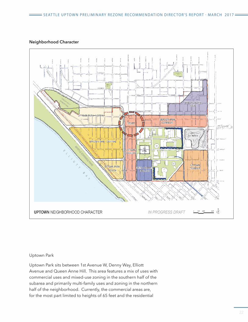
Uptown Park
Uptown Park sits between 1st Avenue W, Denny Way, Elliott Avenue and Queen Anne Hill. This area features a mix of uses with commercial uses and mixed-use zoning in the southern half of the subarea and primarily multi-family uses and zoning in the northern half of the neighborhood. Currently, the commercial areas are, for the most part limited to heights of 65 feet and the residential
Neighborhood Character

S E AT T L E U P TO W N P R E L I M I N A R Y R E ZO N E R E CO M M E N DAT I O N D I R E C TO R ’S R E P O R T · M A R C H 2017
23
areas are a mix ranging from 40 feet to 75 feet. Some taller housing projects were built under earlier zoning regulations are taller than current maximum height limits.
This rezone recommendation makes limited changes to the multi-family areas providing an incremental increase in height and floor area consistent with the Mayor’s Housing Affordability and Livability Agenda (see page x) In the commercial areas the current height limit is 65 feet. This rezone, if adopted, would increase heights to 85 feet and allow an FAR increase in single-use projects (all residential or all commercial) from 4.25 to 5 and an FAR increase for mixed use projects from 4.75 to 5. The increase height and FAR will increase development capacity for both commercial and residential uses while also applying MHA requirements. The rezone designates the streets in Uptown Park as Class III streets which means that commercial projects at the ground level will have transparency requirements.
Heart of Uptown and the Uptown Corridor
The heart of Uptown anchors the neighborhood serving as both a transportation crossroads and the focus of pedestrian and retail activity. Well- served by transit, the Heart of Uptown is how many experience the Uptown Neighborhood – whether it is their destination, they are passing through or on their way to Seattle Center. Development consists of 2 to 3 story structures with some single story buildings. In addition to being the identifiable neighborhood center of Uptown, this subarea provides the neighborhood with the bulk of goods and services for the residents and workers. However, despite its central location and access to transit the business climate in this area has been challenging over the years. The UDF recommends that future development should continue building on its pedestrian character and improve connections to and from Seattle Center. Developers should be encouraged to develop sites to their full potential with a mix of commercial, residential, and cultural spaces.
The rezone recommends increasing heights in this subarea from 40 to 65 feet. An increase in height of 20 feet may provide an incentive for development of mixed use structures with pedestrian oriented uses at the ground level and residential on upper levels. This area abuts the south slope of Queen Anne hill. Analysis of view impacts in the EIS shows that where this area abuts the hill, the rise is more gradual than it is to the east along Roy Street. A height limit

S E AT T L E U P TO W N P R E L I M I N A R Y R E ZO N E R E CO M M E N DAT I O N D I R E C TO R ’S R E P O R T · M A R C H 2017
24
of 65 feet has minimal impacts to both public and private views. New buildings will be visible but the territorial view of Seattle Center, downtown, and Elliott Bay will not be adversely affected.
This recommendation also includes development standards to promote a better pedestrian environment and maintain view corridors. Any new building that exceeds 45 feet on 1st Avenue N, Queen Anne Avenue, Roy Street, and Mercer Street will have an upper level setback up to 15 feet depending on building height. This setback maintains the pedestrian scale at the street level that the current 40-foot height limit achieves, maintains solar access, and north/south view corridors. In addition to these standards, the rezone recommendation designates these streets as Class I pedestrian Streets. This means that 70% of the street frontage must be pedestrian oriented uses (stores, restaurants, cultural uses, etc..) and the street facing façade must have transparency.
The Uptown corridor is the area south of Republican Street that includes 1st Avenue N and Queen Anne Avenue N. It is expected that this area will consist of mixed use development. As it is further from the base of Queen Anne Hill than the Heart of Uptown, this area can support buildings of 85 feet with little to know view impacts. Setback above 45 feet will be required, but unlike the Heart of Uptown this area will not be required to have street level

S E AT T L E U P TO W N P R E L I M I N A R Y R E ZO N E R E CO M M E N DAT I O N D I R E C TO R ’S R E P O R T · M A R C H 2017
25
pedestrian uses. It should be noted, that throughout Uptown even where street level uses are not required, they are encouraged by exempting their floor area from chargeable FAR.
Mercer Roy Corridor
The Mercer/Roy Corridor between 1st Avenue N and 5th Avenue N is an important redevelopment opportunity. It is along Seattle Center’s north boundary and includes the Theater District. Mercer Street’s critical function as the major east/west transportation corridor in Uptown mean that the character of development in this plays area a major role in the strengthening of connections between the neighborhood and Seattle Center.
The north side of Mercer Street currently is limited to a height of 40 feet. Development consists of parking structures and parking lots, and institutional uses. The Uptown UDF recognizes that redevelopment of the Mercer Garage and redevelopment of the site owned by the Seattle Opera has the potential to redefine the character of these blocks. Recommendations for future

S E AT T L E U P TO W N P R E L I M I N A R Y R E ZO N E R E CO M M E N DAT I O N D I R E C TO R ’S R E P O R T · M A R C H 2017
26
development includes increasing height to encourage residential and arts related commercial uses that can complement Seattle Center, street activating uses and ground level transparency to increase visual interest.
Uptown Triangle
The Uptown triangle is that area just south of the Gates Foundation bordered by Aurora Avenue N, Denny Way, Fifth Avenue N, and the former Broad Street. Major features in this area include the North Portal of the SR99 Tunnel, a City light substation, and a number of midcentury hotels and offices of 2 to 3 stories. Recently new residential and hotel development has occurred south of Thomas.
When the tunnel is completed the street grid across Aurora Ave N will reconnect on John Street, Thomas Street, and Harrison Street. These connections will substantially improve access between Uptown and Seattle Center and South Lake Union, with Thomas providing a strong pedestrian connection from Eastlake Avenue East to Myrtle Edwards Park. The Thomas street connection is also part of the Lake 2 Bay trail that provides a connection from Lake Union to the Waterfront. This areas proximity to South Lake Union, particularly when the street grid is reconnected, and downtown may make this an attractive for commercial development.
This preliminary recommendation is to increase height limits in this area from 85 feet to a choice of 125 feet or 160 feet. For those
Thomas StConceptPlan
Broad StGreen
Class IIIPedstrian Streets
Uptown Triangle
S E AT T L E U P TO W N P R E L I M I N A R Y R E ZO N E R E CO M M E N DAT I O N D I R E C TO R ’S R E P O R T · M A R C H 2017
27
buildings that use the 160-foot height limit, floor plates would be limited after first 3 to 4 floors to 12,500 square feet and only on structure may be built to this height on a block. The 125 feet height limit would allow larger floor plates and be more attractive to commercial development.
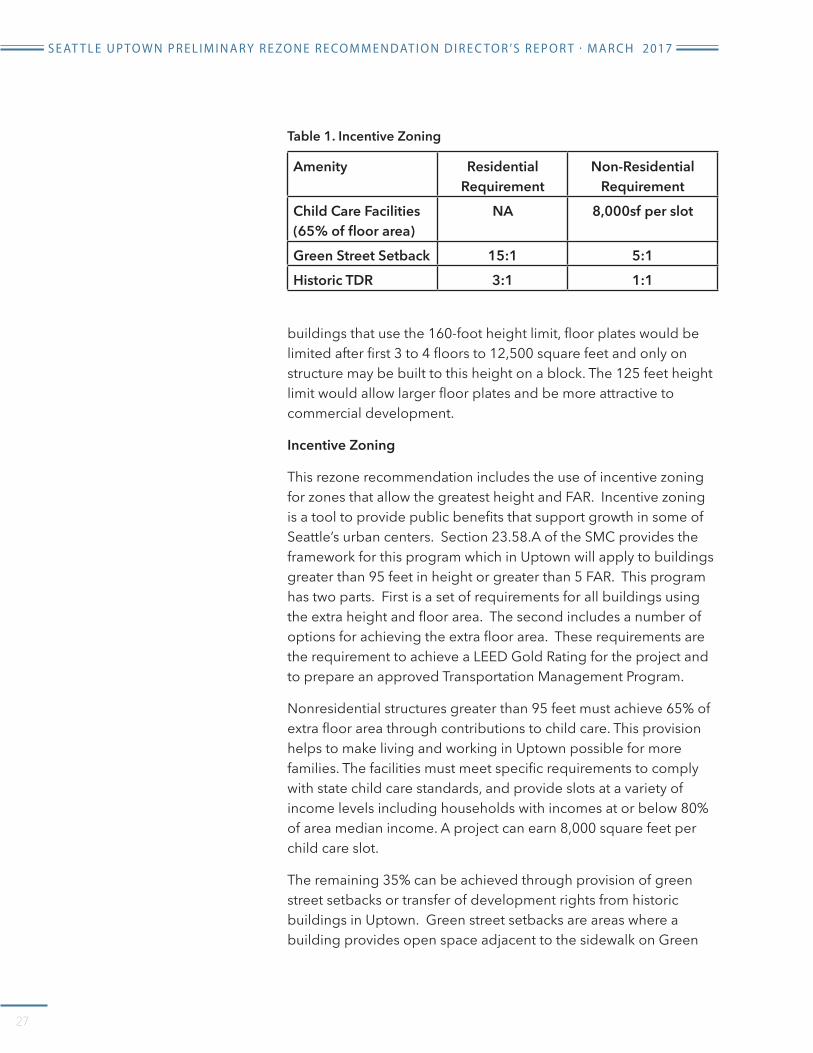
Incentive Zoning
This rezone recommendation includes the use of incentive zoning for zones that allow the greatest height and FAR. Incentive zoning is a tool to provide public benefits that support growth in some of Seattle’s urban centers. Section 23.58.A of the SMC provides the framework for this program which in Uptown will apply to buildings greater than 95 feet in height or greater than 5 FAR. This program has two parts. First is a set of requirements for all buildings using the extra height and floor area. The second includes a number of options for achieving the extra floor area. These requirements are the requirement to achieve a LEED Gold Rating for the project and to prepare an approved Transportation Management Program.
Nonresidential structures greater than 95 feet must achieve 65% of extra floor area through contributions to child care. This provision helps to make living and working in Uptown possible for more families. The facilities must meet specific requirements to comply with state child care standards, and provide slots at a variety of income levels including households with incomes at or below 80% of area median income. A project can earn 8,000 square feet per child care slot.
The remaining 35% can be achieved through provision of green street setbacks or transfer of development rights from historic buildings in Uptown. Green street setbacks are areas where a building provides open space adjacent to the sidewalk on Green
Amenity Residential Requirement
Non-Residential Requirement
Child Care Facilities (65% of floor area)
NA 8,000sf per slot
Green Street Setback 15:1 5:1Historic TDR 3:1 1:1
Table 1. Incentive Zoning

S E AT T L E U P TO W N P R E L I M I N A R Y R E ZO N E R E CO M M E N DAT I O N D I R E C TO R ’S R E P O R T · M A R C H 2017
28
Streets in Uptown. Currently the only green street in Uptown is Thomas Street.
Historic TDR is when an owner of a landmark or unreinforced masonry structure sells unused development rights to developers of new projects using this incentive zoning program.
I I I . AFFORDABLE HOUSING REQUIREMENTS
As part of this proposal, new affordable housing requirements will apply to new development projects in the Uptown neighborhood. These requirements help address the challenges presented by the rising cost of housing.
During the planning process, many in the community advocated adding affordability requirements as part of the Uptown rezone to make sure that future development contributes to long-term affordability. This idea gained support in 2015 through the Housing Affordability and Livability Agenda (HALA), initiated by the Mayor and City Council. HALA convened an interdisciplinary task force of 28 members, including housing experts, community group representatives, non-profit housing providers, and for-profit architects to find housing solutions.
The HALA committee issued a report in July 2015 with 65 recommendations for making Seattle more affordable. Key among these were upzones to allow increased housing supply, along with new requirements to set aside rent- and income-restricted units or make in-lieu payments to a housing fund.
The HALA committee recommended Mandatory Housing Affordability requirements as the primary tool for addressing housing affordability as Seattle grows. MHA requirements are intended to apply in all multifamily residential and commercial areas throughout the City, along with upzones to increase development capacity.
MHA includes a residential program and a commercial program (MHA-R land MHA-C). Council has adopted frameworks for each of these programs but they do not apply to new development until Council subsequently approves zoning changes that add development capacity. In this process, the Uptown rezone would be an early adopter.

S E AT T L E U P TO W N P R E L I M I N A R Y R E ZO N E R E CO M M E N DAT I O N D I R E C TO R ’S R E P O R T · M A R C H 2017
29
Mandatory Housing Affordability in Uptown
Some parts of the Uptown rezone are limited to the height increase that is part of the implementation of the City’s Mandatory Housing Affordablility program. Height increases in this case are limited to one floor of development capacity. Under MHA, developers in Uptown will be required to contribute to affordable housing as part of new development. This contribution can be met either by including affordable housing within new development (‘performance’) or by paying into a fund to support development of affordable housing.
The performance and payment requirements vary by zone, as shown in Table 2. For residential development, the amount of affordable housing required under the performance option is calculated by multiplying the percentage by the total number homes to be developed. For commercial development, the square feet of affordable housing to meet the performance option is calculated by multiplying the required percentage by the floor area of the commercial uses. Payment amounts would be measured in dollars per square foot of residential and commercial development, excluding portions of buildings that are underground as well as certain exempted commercial area. Payment amounts will adjust annually to account for inflation.
In setting the performance and payment amounts we considered the following factors including:
• The critical need for affordable housing;
Residential Commercial
Performance % Payment $ Performance % Payment $
SM-UP zones 95 feet or less with M suffix
7% $20.75 5% $8.00
SM-UP zones 95 feet or less with M1 suffix
10% $29.75 8% $12.75
SM-UP greater than 95 feet in height with an M suffix
7% $20.75 7% $20.75
Midrise ad Lowrise zones with M suffix
7% $20.75 5% $8.00
Table 2. Mandatory Affordability Requirements in Uptown

S E AT T L E U P TO W N P R E L I M I N A R Y R E ZO N E R E CO M M E N DAT I O N D I R E C TO R ’S R E P O R T · M A R C H 2017
30
• The importance of additional housing supply in limiting future increases in housing cost;
• The increase in development capacity being provided;
• The feasibility of development under the proposed zoning;
• The challenges of building single-purpose commercial buildings in lowrise and midrise zones, due to the cost of steel and concrete construction.
The total amount of new affordable housing produced will depend on the amount of development that occurs. Assuming the growth projections in the EIS, we estimate that MHA in Uptown will produce approximately 600 units of affordable housing over the next 20 years. A summary of specific requirements for units created through performance and payment are below.
Performance Option
All affordable housing provided through the performance option must meet the standards outlined in Seattle Municipal Code 23.58B and 23.58C.
Location: Affordable housing must be located on the same site as the development being permitted for residential development. For commercial development, the affordable housing may be located on the same site or elsewhere within the Uptown Urban Center.
Duration of affordability: Rental housing must remain rent and income-restricted for 75 years, except that in the case of a residential development that is demolished or changed from residential use, or converted to ownership housing, the requirements expire at that time. In the event of such demolition, change of use, or conversion to ownership housing, the owner must make a payment in lieu of continuing affordability.
Distribution: Affordable housing units must be distributed throughout each structure within the development containing residential units.
Compatibility to other units: Affordable housing must be comparable to market-rate units in terms of number of bedrooms/bathrooms and size. The units must have substantially the same features as other units, and households occupying affordable housing must be allowed access to the same development

S E AT T L E U P TO W N P R E L I M I N A R Y R E ZO N E R E CO M M E N DAT I O N D I R E C TO R ’S R E P O R T · M A R C H 2017
31
amenities as other tenants. Tenants of affordable units must also be offered comparable lease terms to those of market-rate tenants.
Public subsidy: An applicant for a permit may seek public subsidies for development, but the affordable housing units provided to satisfy MHA requirements must be different than those provided as a condition of such subsidy or incentive. For example, if 20% of the total units in a development must be rent-and income-restricted to qualify for a residential property tax exemption using Seattle’s Multifamily Property Tax Exemption (MFTE) program, those units must be in addition to any units provided to satisfy affordable housing requirements under MHA.
Eligible households:
• For a rental unit with a net area of 400 square feet or less, affordable housing may serve only households with incomes no greater than 40% of AMI at initial certification and no greater than 60% of AMI at annual recertification.
• For a rental unit with a net area greater than 400 square feet, affordable housing may serve only households with incomes no greater than 60% of AMI at initial certification and no greater than 80% of AMI at annual recertification;
• For an ownership unit, affordable housing may be sold only to households with incomes no greater than 80% of AMI at initial occupancy and that meet limits on assets.
Additional requirements for affordable housing for renters:
• Rent levels: Monthly rent (including a utility allowance an any recurring fees required as a condition of tenancy) may not exceed 30% of the income limit for an eligible household.
Household size Qualifying Income1 $37,9802 $43,380
3 $48,7804 $54,1805 $58,560
Table 3. Affordable housing income limits (60% Area Median Income)

S E AT T L E U P TO W N P R E L I M I N A R Y R E ZO N E R E CO M M E N DAT I O N D I R E C TO R ’S R E P O R T · M A R C H 2017
32
• Annual income certification. Owners must recertify tenant incomes and household sizes annually. Owners must attempt to obtain third party verification whenever possible.
• Over-income households: If a tenant of an affordable housing unit is determined, upon recertification, to no longer be an ‘eligible household,” the owner of the development must provide a comparable substitute unit of affordable housing as soon as one becomes available. In addition, the owner of the development must provide at least six months’ notice of any rent increases to over-income tenant households once the unit substation has occurred.
Additional requirements for affordable ownership housing include:
• Affordable sale price: The initial sale price is regulated to be affordable for households at 65% of Area Median Income. The Office of Housing administers rules about the maximum down payment and other housing costs.
• Affordable resale price: The resale price will be calculated to allow modest growth in homeowner equity while maintain long-term affordability for future buyers.
• Other restrictions: Owners must occupy the units as their principal residence, and meet other conditions to maintain the property.
Payment Option
Developers who choose to use the payment option would be required to provide a cash contribution to the City that would be used to develop, or in some cases preserve affordable housing. The Office of Housing will deposit all cash contributions into a special account established solely for the purpose of supporting
Bedrooms Qualifying Income0 $9491 $1,017
2 $1,2193 $1,4094 $1,512
Table 4. Allowed rents in affordable housing at 60% AMI

S E AT T L E U P TO W N P R E L I M I N A R Y R E ZO N E R E CO M M E N DAT I O N D I R E C TO R ’S R E P O R T · M A R C H 2017
33
housing for renter households with incomes at or below 60% of AMI, or owner households with incomes at or below 80% of AMI.
The office of Housing invests funds strategically in long-term affordable housing developments. The regulatory framework for MHA lays out the following priorities for determining where MHA funds should be spent.
Affirmatively furthing fair housing choice.
• Locating within an urban center or urban village.
• Locating in proximity to transit, light rail and/or frequent bus service.
• Furthering City policies to address the needs of communities vulnerable to displacement.
• Locating affordable housing near the development that generate cash contributions.
Other housing affordability actions
The following are additional HALA-recommended actions that the City is advancing or has advanced to support the creation and preservation of affordable housing (separate from zoning changes):
• New tenant protection laws to prevent “economic eviction” and ensure due process for tenants facing eviction.
• Renew and expand the Seattle Housing Levy – Seattleites approved a new expanded levy in August 2016.
• Renew the Multifamily Tax Exemption (MFTE) Program – The MFTE program was renewed by the City Council in November 2015. The program was expanded to all multifamily zoned areas and also provides increased incentives for providing affordable units with 2 or more bedrooms.
• Create a Preservation Property Tax Exemption Program – The City and other affordable housing advocates support the passage of state legislation that would create a local option for a 15-year tax exemption for property owners who agree to set aside 25 percent of their units for low-income tenants. This legislation did not pass in 2016 or 2017, but advocates will try again in 2018.

34
APPENDIX A: GROWTH STRATEGY ELEMENT

S E AT T L E U P TO W N P R E L I M I N A R Y R E ZO N E R E CO M M E N DAT I O N D I R E C TO R ’S R E P O R T · M A R C H 2017
35
APPENDIX A: GROWTH STRATEGY ELEMENT
Relevant goals and policies for the Uptown rezone from Seattle’s Comprehensive Plan, Seattle 2035.
The Growth Strategy Element contains guidance to support the City’s urban village strategy, comparable to the guidance found in the adopted Comprehensive Plan Urban Village Element. Goals and policies applicable to the proposed action are listed below.
Urban Village Strategy
GS G2 Keep Seattle as a city of unique, vibrant, and livable urban neighborhoods, with concentrations of development where all residents can have access to employment, transit, and retail services that can meet their daily needs.
GS 2.5 Encourage infill development in underused sites, particularly in urban centers and villages.
GS 2.6 Plan for development in urban centers and urban villages in ways that will provide all Seattle households, particularly marginalized populations, with better access to services, transit, and educational and employment opportunities.
GS 2.7 Promote levels of density, mixed-uses, and transit improvements in urban centers and villages that will support walking, biking, and use of public transportation.
GS 2.8 Use zoning and other planning tools to shape the amount and pace of growth in ways that will limit displacement of marginalized populations, community services, and culturally relevant institutions and businesses.
GS 2.13 Provide opportunities for marginalized populations to live and work in urban centers and urban villages throughout the city by allowing a variety of housing types and affordable rent levels in these places.
GS G3 Accommodate a majority of the city’s expected household growth in urban centers and urban villages and a majority of employment growth in urban centers. (Figure 2 shows the estimated amount of growth for each urban center, and Figure 3 shows the estimated growth rate for different categories of urban villages.)
GS 3.1 Plan for a variety of uses and the highest densities of both housing and employment in Seattle’s urban centers, consistent with their role in the regional growth strategy.
Urban Design
GS 4.8 Preserve characteristics that contribute to communities’ general identity, such as block and lot patterns and areas of historic, architectural, or social significance.
GS 4.9 Design public infrastructure and private building developments to help visitors understand the existing block and street patterns and to reinforce the walkability of neighborhoods.

S E AT T L E U P TO W N P R E L I M I N A R Y R E ZO N E R E CO M M E N DAT I O N D I R E C TO R ’S R E P O R T · M A R C H 2017
36
GS 4.10 Use zoning tools and natural features to ease the transitions from the building intensities of urban villages and commercial arterials to lower-density developments of surrounding areas.
GS 4.12 Preserve, strengthen, and, as opportunities permit, reconnect Seattle’s street grid as a means to knit together neighborhoods and to connect areas of the city.
GS 4.13 Design urban villages to be walkable, using approaches such as clear street grids, pedestrian connections between major activity centers, incorporation of public open spaces, and commercial buildings with retail and active uses that flank the sidewalk.
GS 4.14 Design multifamily zones to be appealing residential communities with high-quality housing and development standards that promote privacy and livability, such as appropriately scaled landscaping, street amenities, and, in appropriate locations, limited commercial uses targeted for the local population.
GS 4.17 Use varied building forms and heights to enhance attractive and walkable neighborhoods.
GS 4.18 Use groupings of tall buildings, instead of lone towers, to enhance overall topography or to define districts.
GS 4.19 Consider taller building heights in key locations to provide visual focus and define activity centers, such as near light rail stations in urban centers and urban villages.
GS 4.20 Limit the negative impacts of tall buildings on public views and on sunlight in public streets and parks by defining upper-level building setbacks and lot coverage or by using other techniques.
GS 4.21 Locate tall buildings to respect natural surroundings and key natural features and to minimize obstructing views of these features, such as by having lower building heights near lakes or Puget Sound.
GS 4.22 Encourage street widths and building heights that are in proportion with each other by reducing setbacks from the street and keeping reasonable sidewalk widths for lower buildings.
Land Use Element
LU G1 Achieve a development pattern consistent with the urban village strategy, concentrating most new housing and employment in urban centers and villages, while allowing some infill development compatible with established context in areas outside of centers and villages.
LU 1.1 Use the Future Land Use Map to identify where different types of development may occur in support of the urban village strategy.
LU G2 Provide zoning and accompanying land use regulations that

S E AT T L E U P TO W N P R E L I M I N A R Y R E ZO N E R E CO M M E N DAT I O N D I R E C TO R ’S R E P O R T · M A R C H 2017
37
• allow a variety of housing types to accommodate housing choices for households of all types and income levels;
• support a wide diversity of employment-generating activities to provide jobs for a diverse residential population, as well as a variety of services for residents and businesses; and
• accommodate the full range of public services, institutions, and amenities needed to support a racially and economically diverse, sustainable urban community.
LU 2.7 Review future legislative rezones to determine if they pose a risk of increasing the displacement of residents, especially marginalized populations, and the businesses and institutions that serve them.
LU 2.8 Evaluate new land use regulations to determine if there are potential adverse outcomes that may affect marginalized populations or other groups or individuals unfairly, and seek to avoid or mitigate such potential outcomes.
Multifamily Residential Areas
LU G9 Create and maintain successful commercial/mixed-use areas that provide a focus for the surrounding neighborhood and that encourage new businesses, provide stability and expansion opportunities for existing businesses, and promote neighborhood vitality, while also accommodating residential development in livable environments.
LU 9.2 Encourage the development of compact, concentrated commercial/mixed-use areas, in urban centers and urban villages, where pedestrians can easily access transit and a variety of businesses.
LU 9.3 Provide a range of commercial-zone classifications to allow different mixes and intensities of activity, varying scales of development, varying degrees of residential or commercial orientation, and varying degrees of pedestrian or auto orientation.
LU 9.5 Support a wide range of uses in commercial areas, taking into account the intended pedestrian, automobile, or residential orientation of the area, the area’s role in the urban village strategy, and the impacts that the uses could have on surrounding areas.
LU 9.6 Encourage housing in mixed-use developments in pedestrian-oriented commercial/ mixed-use areas to provide additional opportunities for residents to live in neighborhoods where they can walk to transit, services, and employment.
LU 9.11 Preserve active streetscapes in pedestrian-oriented commercial/mixed-use areas by limiting residential uses along the street frontage of the ground floor and by keeping those spaces available primarily for commercial uses and other uses that help activate the street, in order to strengthen business districts.

S E AT T L E U P TO W N P R E L I M I N A R Y R E ZO N E R E CO M M E N DAT I O N D I R E C TO R ’S R E P O R T · M A R C H 2017
38
LU 9.12 Consider allowing street-level residential uses outside pedestrian-oriented areas and, when street-level residential uses are permitted, identify ways to give ground floor tenants privacy and to create visual interest along the street front.
LU 9.13 Provide amenity areas for use by residents of housing in commercial/mixed-use areas.
LU 9.14 Assign height limits to commercial/mixed-use areas independent of the commercial zone designations but consistent with the intended intensity of development in the zone. Allow different areas within a zone to be assigned different height limits based on the need to
• further the urban village strategy’s goals of focusing growth in urban villages,
• accommodate the desired functions and intensity of development,
• provide a compatible scale relationship with existing zoning in the vicinity,
• accommodate desired transitions with development in adjacent areas, and
• consider potential view blockage.
Housing Element
Housing Diversity
H G3 Achieve a mix of housing types that provide opportunity and choice throughout Seattle for people of various ages, races, ethnicities, and cultural backgrounds and for a variety of household sizes, types, and incomes.
H 3.1 Identify and implement strategies, including development standards and design guidelines reflecting unique characteristics of each neighborhood, to accommodate an array of housing designs that meet the needs of Seattle’s varied households.
Housing Affordability
H G5 Make it possible for households of all income levels to live affordably in Seattle, and reduce over time the unmet housing needs of lower-income households in Seattle.
H 5.3 Promote housing affordable to lower-income households in locations that help increase access to education, employment, and social opportunities, while supporting a more inclusive city and reducing displacement from Seattle neighborhoods or from the city as a whole.
H 5.4 Monitor regularly the supply, diversity, and affordability of housing for households by income level, and use this information to help evaluate whether changes to housing strategies and policies are needed to encourage more affordable housing or to advance racial and social equity
H 5.7 Consider that access to high-frequency transit may lower the combined housing and transportation costs for households when locating housing for lower-income households.

S E AT T L E U P TO W N P R E L I M I N A R Y R E ZO N E R E CO M M E N DAT I O N D I R E C TO R ’S R E P O R T · M A R C H 2017
39
H 5.16 Consider implementing a broad array of affordable housing strategies in connection with new development, including but not limited to development regulations, inclusionary zoning, incentives, property tax exemptions, and permit fee reductions.
H 5.17 Consider using substantive authority available through the State Environmental Policy Act to require that new development mitigate adverse impacts on housing affordable for lower-income households.
H 5.18 Consider implementing programs that require affordable housing with new development, with or without rezones or changes to development standards that increase development capacity.

40
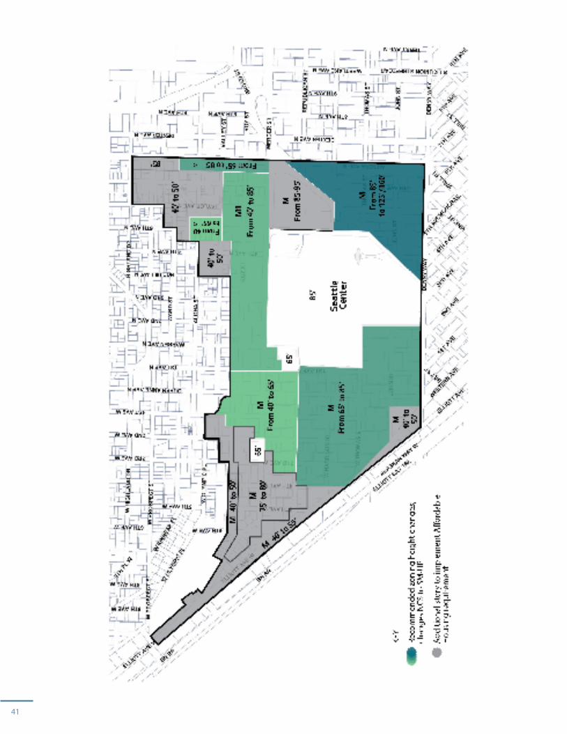
APPENDIX B: RECOMMENDED HEIGHT LIMITS
41
42
APPENDIX C: DRAFT DEVELOPMENT STANDARDS

43
S E AT T L E U P TO W N P R E L I M I N A R Y R E ZO N E R E CO M M E N DAT I O N D I R E C TO R ’S R E P O R T · M A R C H 2017
FAR
FAR Limit Maximum floor area for a structure containing
residential uses
Commercial
SM-UP 40 N/A N/ASM-UP 65 4.5 4.5SM-UP 85 5 5SM-UP 125 7 7
SM-UP 160 7 2
Development Standards by Street Classification
Standard Code Section Class I Street Class II Street Class III StreetsStreet Level Uses; Retail, Restaurants, Entertainment uses, public libraries, public parks, arts facilities.
23.48.005 D.1 75% of street frontage must consist of street level uses. Street level uses must be with 10 feet of street lot line or open space abutting the street.
Floor to ceiling clearance shall be a minimum of 13 feet and be 30 feet in depth.
30% of street frontage must consist of street level uses. Street level uses must be with 10 feet of street lot line or open space abutting the street.
Floor to ceiling clearance shall be a minimum of 13 feet and be 30 feet in depth.
No requirements, but street level uses are exempt from FAR limits if they meet standards set out for Class I streets.

44
S E AT T L E U P TO W N P R E L I M I N A R Y R E ZO N E R E CO M M E N DAT I O N D I R E C TO R ’S R E P O R T · M A R C H 2017
Standard Code Section Class I Street Class II Street Class III StreetTransparency
Transparency requirements apply to all street-facing street-level facades excluding ground level residential development
23.48.040 B 60% of façade must be transparent.
60% of façade must be transparent.
60% of façade must be transparent.
Upper Level Setbacks
23.48.735 For structures 45 feet or greater in height, 1 foot for every 2 feet in height to a maximum of 15 feet.
For structures 45 feet or greater in height, 1 foot for every 2 feet in height to a maximum of 15 feet.
N/A
Parking 23.48.055
23.48.702
23.48.780
23.48.785
Principal Use Parking Prohibited.
No more than 50% of parking above grade.
Ground level parking to be separated ROW by another use.
Upper level parking to be completely screened.
Principal Use Parking Prohibited.
No more than 50% of parking above grade.
Ground level parking to be separated ROW by another use.
Upper level parking to be completely screened.
Principal Use Parking Prohibited.
No more than 50% of parking above grade. Ground level parking to be separated ROW by another use.
Upper level parking to be completely screened.
Minimum Façade Requirements
23.48.040 45 Feet High 45 Feet High 25 Feet High

45
S E AT T L E U P TO W N P R E L I M I N A R Y R E ZO N E R E CO M M E N DAT I O N D I R E C TO R ’S R E P O R T · M A R C H 2017
Standard Code Section Class I Street Class II Street Class III StreetMid-Block Connection
23.48.740 D Required for projects on lots 40,000 sf or larger. Connection should average 25 feet in width with a minimum of 15 feet. No more than 35% of the length of the connection shall be covered or enclosed.
Required for projects on lots 40,000 sf or larger. Connection should average 25 feet in width with a minimum of 15 feet. No more than 35% of the length of the connection shall be covered or enclosed.
Required for projects on lots 40,000 sf or larger Connection should average 25 feet in width with a minimum of 15 feet. No more than 35% of the length of the connection shall be covered or enclosed.
Blank Façade Limits
23.48.040.B.2 The maximum width of blank facades is 15 feet (exceptions permitted for garage doors). Total frontage of blank facades cannot exceed 30% of the façade frontage.
The maximum width of blank facades is 15 feet (exceptions permitted for garage doors). Total frontage of blank facades cannot exceed 30% of the façade frontage.
The maximum width of blank facades is 15 feet (exceptions permitted for garage doors). Total frontage of blank facades cannot exceed 30% of the façade frontage.
Open Space 23.48.740
23.48.250
For projects of 30,000 s.f. or greater, usable ground level open space equivalent to 15% of lot area is required.
For projects of 30,000 s.f. or greater, usable ground level open space equivalent to 15% of lot area is required.
For projects of 30,000 s.f. or greater, usable ground level open space equivalent to 15% of lot area is required.
Podium Requirements
23.48.745.B.1 For structures taller than 125 feet, tower floor plate is limited to 12,500 feet above a height of 45 feet.
For structures taller than 125 feet, tower floor plate is limited to 12,500 feet above a height of 45 feet.
For structures taller than 125 feet, tower floor plate is limited to 12,500 feet above a height of 45 feet.

46
S E AT T L E U P TO W N P R E L I M I N A R Y R E ZO N E R E CO M M E N DAT I O N D I R E C TO R ’S R E P O R T · M A R C H 2017
Standard Code Section Class I Street Class II Street Class III StreetLot Area 23.48.745.A Structures greater
than 125 feet in height, must have a lot area of twice the tower floor plate.
Structures greater than 125 feet in height, must have a lot area of twice the tower floor plate.
Structures greater than 125 feet in height, must have a lot area of twice the tower floor plate.
Tower Limits 23.48.745.F One structure greater than 125 feet is permitted per block.
One structure greater than 125 feet is permitted per block.
One structure greater than 125 feet is permitted per block.