peddie wind energy facility project agricultural impact ... wind energy project cb 18.12.12... ·...
TRANSCRIPT
Peddie Wind Energy Facility Project
AGRICULTURAL IMPACT ASSESSMENT
Prepared for:
Prepared by:
Coastal & Environmental Services EAST LONDON
2 Marine Terrace, Hampton Court 5201
043 742 3302 Also in Grahamstown
www.cesnet.co.za
23 August 2012

Agricultural Assessment – 23 August 2012
Coastal & Environmental Services Peddie WEF Project
i
COPYRIGHT INFORMATION This document contains intellectual property and propriety information that is protected by copyright in favour of Coastal & Environmental Services and the specialist consultants. The document may therefore not be reproduced, used or distributed to any third party without the prior written consent of Coastal & Environmental Services. This document is prepared exclusively for submission to Innowind, and is subject to all confidentiality, copyright and trade secrets, rules intellectual property law and practices of South Africa.

Agricultural Assessment – 23 August 2012
Coastal & Environmental Services Peddie WEF Project iii
CES Report Revision and Tracking Schedule
Document Title
Agricultural Impact Assessment
Client Name & Address
Innowind
Document Reference
23 August 2012: Peddie WEF Agricultural Impact Assessment, CES, East London
Status
Final
Issue Date
23 August 2012
Lead Author
Roy de Kock CES East London
Reviewer
Dr Alan Carter CES East London
THE PROJECT TEAM Dr Alan Carter Pri. Nat. Sci., Director of the East London Office, has extensive training and experience in both financial accounting and environmental science disciplines with international accounting firms in South Africa and the USA. He is a member of the American Institute of Certified Public Accountants and holds a PhD in Plant Sciences. He is also a certified ISO14001 EMS auditor with the American National Standards Institute and the British Standards Institute. Mr Roy de Kock Cand. Nat. Sci., Environmental Consultant, holds a BSc Honours in Geology and an MSc in Botany from the Nelson Mandela Metropolitan University in Port Elizabeth. His MSc thesis focussed on Rehabilitation Ecology with the focus on Mine Rehabilitation. He has been working for CES since 2010, and is based at the East London branch where he focuses on ecological impact assessments, geological and hydro geological analysis, environmental management plans and various environmental impact studies.

Agricultural Assessment – 23 August 2012
Coastal & Environmental Services Peddie WEF Project
iv
TABLE OF CONTENTS 1 INTRODUCTION ..................................................................................................................... 1
1.1 Project description ........................................................................................................... 1 1.2 Project location ................................................................................................................ 1 1.3 Alternatives ...................................................................................................................... 2
1.3.1 No-Go alternative......................................................................................................... 2 1.4 Components of the project that will impact on soils and agricultural potential .................. 2 1.5 Objectives and Terms of Reference................................................................................. 2 1.6 Approach ......................................................................................................................... 3 1.7 Limitations and assumptions ........................................................................................... 3
2 RELEVANT LEGISLATION .................................................................................................... 4 3 DESKTOP ANALYSIS OF THE AGRICULTURAL ENVIRONMENT ...................................... 5
3.1.1 Climate ........................................................................................................................ 5 3.1.2 Geology ....................................................................................................................... 5 3.1.3 Terrain ......................................................................................................................... 6 3.1.4 Wetlands and rivers ..................................................................................................... 7 3.1.5 Current land-use .......................................................................................................... 8 3.1.6 Soil characteristics ....................................................................................................... 9 3.1.7 Summary ................................................................................................................... 10
4 SITE CONFIRMATION ......................................................................................................... 11 4.1 Visual identification ........................................................................................................ 11
4.1.1 First subsoil layer ....................................................................................................... 11 4.1.2 Second subsoil layer .................................................................................................. 11 4.1.3 Soil form .................................................................................................................... 11
4.2 Laboratory samples ....................................................................................................... 11 4.3 Summary ....................................................................................................................... 11
5 AGRICULTURAL POTENTIAL ............................................................................................. 13 6 IMPACT IDENTIFICATION AND ASSESSMENT ................................................................. 14
6.1 Identified Impacts .......................................................................................................... 14 6.2 Assessment methodology .............................................................................................. 14 6.3 Description of criteria ..................................................................................................... 15 6.4 Impact Assessment ....................................................................................................... 17
7 IMPACT STATEMENT, CONCLUSION & RECOMMENDATIONS ....................................... 20 7.1 Conclusions ................................................................................................................... 20 7.2 Recommendations for the proposed Peddie Wind Energy Facility ................................. 20
7.2.1 Construction .............................................................................................................. 20 7.2.2 Operation ................................................................................................................... 20
7.3 Agricultural statement and Opinion of the Specialist ...................................................... 21 8 REFERENCES...................................................................................................................... 22
LIST OF FIGURES Figure 1.1. Locality map indicating the location of proposed Peddie WEF project in the Eastern Cape. ......... 1 Figure 1.2. Layout of the various wind turbines for the proposed Peddie WEF project in the Eastern Cape. .. 2 Figure 3.1. Average yearly climate for Peddie (Source: http://www.saexplorer.co.za/south-
africa/climate/peddie_climate.asp). ........................................................................................................... 5 Figure 3.2. Geological map of the area surrounding the Peddie Wind Energy Facility site (Source: AGIS). ... 5 Figure 3.3. Topography of the area surrounding the proposed Peddie WEF (Source: Geology.com). ............ 6 Figure 3.4. Digital Terrain Model of the area surrounding the proposed Peddie WEF (Source: AGIS). ........... 7 Figure 3.4. SANBI Working for Wetland map of the surrounding area (Source: BGIS). ................................... 8 Figure 3.5. Current land cover of the affected area. (Source: BGIS). ............................................................... 9 Figure 3.6. Soil types found on the affected area are classified as lithosols. (Source: AGIS). ......................... 9 Figure 5.1. Agricultural grazing potential in the Peddie area. (Source: AGIS, 2007). ..................................... 13
Agricultural Assessment – 23 August 2012
Coastal & Environmental Services Peddie WEF Project
v
LIST OF TABLES Table 2.1 Agricultural legislation considered in the preparation of the Peddie WEF Agricultural Report. ........ 4 Table 6.1 Impact identified during the phases of the Peddie Wind Energy Facility ........................................ 14 Table 6.2 Significance Rating Table ................................................................................................................ 15 Table 6.3 Impact Severity Rating .................................................................................................................... 15 Table 6.4 Overall Significance Rating ............................................................................................................. 16 Table 6.5 Assessment and mitigation of impacts identified in the Planning and Design Phase ..................... 18 Table 6.6 Assessment and mitigation of impacts identified in the Construction Phase .................................. 18 Table 6.7 Assessment and mitigation of impacts identified in the Operation Phase ...................................... 19 Table 6.8 Assessment of the No-Go alternative during all phases of the proposed Peddie WEF .................. 19
LIST OF PLATES Plate 4.1. Showing the rocky highly erodible soil profile in the area. .............................................................. 12 Plate 5.1. Grazing cattle were noted onsite. .................................................................................................... 13
Agricultural Assessment – 23 August 2012
Coastal & Environmental Services Peddie WEF Project
1
1 INTRODUCTION
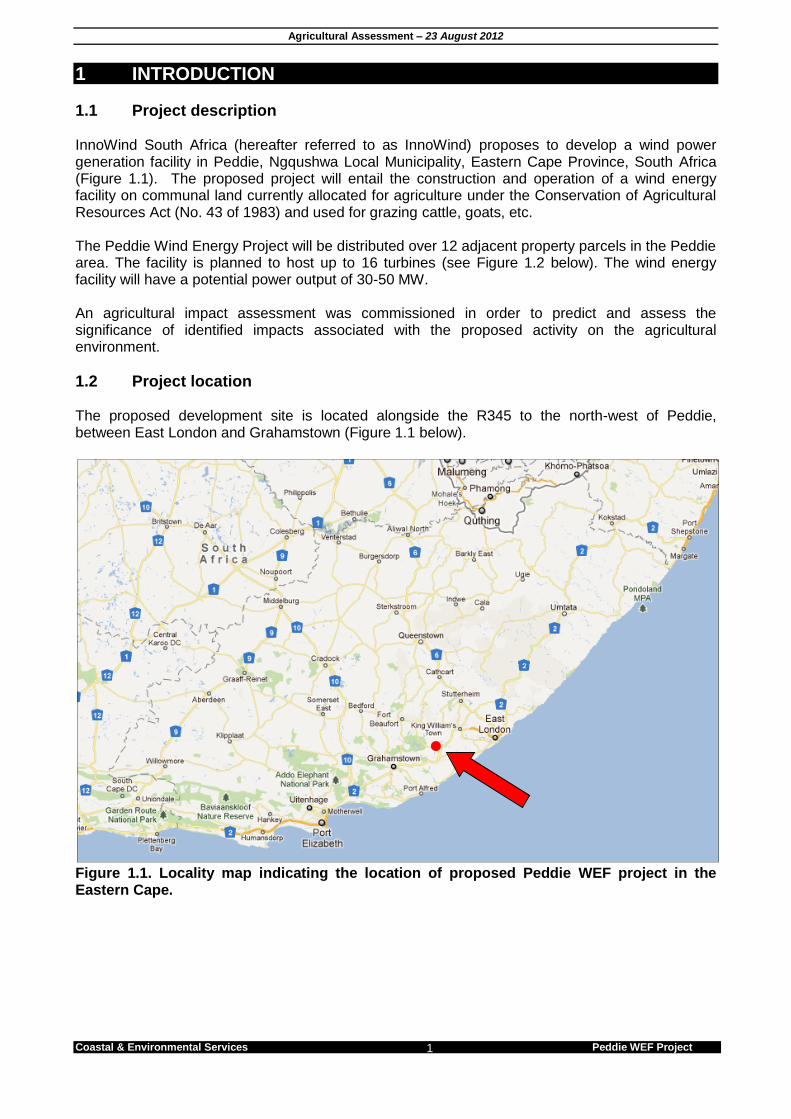
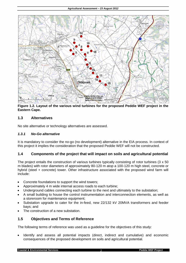
1.1 Project description InnoWind South Africa (hereafter referred to as InnoWind) proposes to develop a wind power generation facility in Peddie, Ngqushwa Local Municipality, Eastern Cape Province, South Africa (Figure 1.1). The proposed project will entail the construction and operation of a wind energy facility on communal land currently allocated for agriculture under the Conservation of Agricultural Resources Act (No. 43 of 1983) and used for grazing cattle, goats, etc. The Peddie Wind Energy Project will be distributed over 12 adjacent property parcels in the Peddie area. The facility is planned to host up to 16 turbines (see Figure 1.2 below). The wind energy facility will have a potential power output of 30-50 MW. An agricultural impact assessment was commissioned in order to predict and assess the significance of identified impacts associated with the proposed activity on the agricultural environment.
1.2 Project location The proposed development site is located alongside the R345 to the north-west of Peddie, between East London and Grahamstown (Figure 1.1 below).
Figure 1.1. Locality map indicating the location of proposed Peddie WEF project in the Eastern Cape.
Agricultural Assessment – 23 August 2012
Coastal & Environmental Services Peddie WEF Project 2
Figure 1.2. Layout of the various wind turbines for the proposed Peddie WEF project in the Eastern Cape.
1.3 Alternatives No site alternative or technology alternatives are assessed. 1.3.1 No-Go alternative It is mandatory to consider the no-go (no development) alternative in the EIA process. In context of this project it implies the consideration that the proposed Peddie WEF will not be constructed.
1.4 Components of the project that will impact on soils and agricultural potential The project entails the construction of various turbines typically consisting of rotor turbines (3 x 50 m blades) with rotor diameters of approximately 80-120 m atop a 100-120 m high steel, concrete or hybrid (steel + concrete) tower. Other infrastructure associated with the proposed wind farm will include:
Concrete foundations to support the wind towers;
Approximately 4 m wide internal access roads to each turbine;
Underground cables connecting each turbine to the next and ultimately to the substation;
A small building to house the control instrumentation and interconnection elements, as well as a storeroom for maintenance equipment;
Substation upgrade to cater for the in-feed, new 22/132 kV 20MVA transformers and feeder bays; and
The construction of a new substation.
1.5 Objectives and Terms of Reference The following terms of reference was used as a guideline for the objectives of this study:
Identify and assess all potential impacts (direct, indirect and cumulative) and economic consequences of the proposed development on soils and agricultural potential.
Agricultural Assessment – 23 August 2012
Coastal & Environmental Services Peddie WEF Project 3
Describe and map soil types (soil forms) and characteristics (soil depth, soil colour, limiting factors, and clay content of the top and sub soil layers.
Describe the slope of the site.
Determine the agricultural potential of the site.
Describe current land use as well as possible alternative land use options.
Provide recommended mitigation measures, monitoring requirements, and rehabilitation guidelines.
1.6 Approach The study site and surrounding areas were described using a two-phased approach. Firstly, a desktop assessment of the site was conducted in terms of current agricultural classifications. The assessment was based on existing soil and agricultural potential data for the site. The source of data was the AGIS online database, produced by the Institute of Soil, Climate and Water, of the Agricultural Research Council of South Africa (Agricultural Research Council, undated). This information was largely compiled from a nationwide survey of land types conducted since the 1970's. Satellite imagery of the site available on Google Earth was also used for evaluation. Further to the above, a site visit was conducted on the 10th November 2011 in order to assess soils onsite.
1.7 Limitations and assumptions This report is based on currently available information and, as a result, the following limitations and assumptions are implicit:–
The report is based on a project description taken from design specifications for the proposed wind energy facility that have not yet been finalised, and which are likely to undergo a number of iterations and refinements before they can be regarded as definitive;
Descriptions of the surrounding agricultural environment are based on limited fieldwork and available literature.

Agricultural Assessment – 23 August 2012
Coastal & Environmental Services Peddie WEF Project
4
2 RELEVANT LEGISLATION The following legislation is relevant when considering agricultural impacts identified during the Planning and Design, Construction and Operation Phase of the proposed Peddie WEF project. Table 2.1 Agricultural legislation considered in the preparation of the Peddie WEF Agricultural Report.
Title of Agricultural legislation, policy
or guideline Date
Implications for proposed Peddie WEF
The National Environmental Management Act (NEMA) (107 of 1998)
1998 The developer must apply the NEMA principles, the fair decision-making and conflict management procedures that are provided for in NEMA. The developer must apply the principles of Integrated Environmental Management and the consideration, investigation and assessment of the potential impact of existing and planned activities on the environment, socio-economic conditions; and the cultural heritage.
Conservation of Agricultural Resources Act (43 of 1983)
1983 The proposed development must conserve natural agricultural resources; Must assess the impacts of the proposed development on the existing agricultural environment; Must maintain the production potential of the land by:- - Combating and preventing erosion; - Weakening or destruction of water sources; - Protection of vegetation; - Combating weeds and invader plants.
National Water Act (No. 36 of 1998)
1998 Provides details of measures intended to ensure the comprehensive protection of all water resources, including the water reserve and water quality.
Agricultural Assessment – 23 August 2012
Coastal & Environmental Services Peddie WEF Project 5
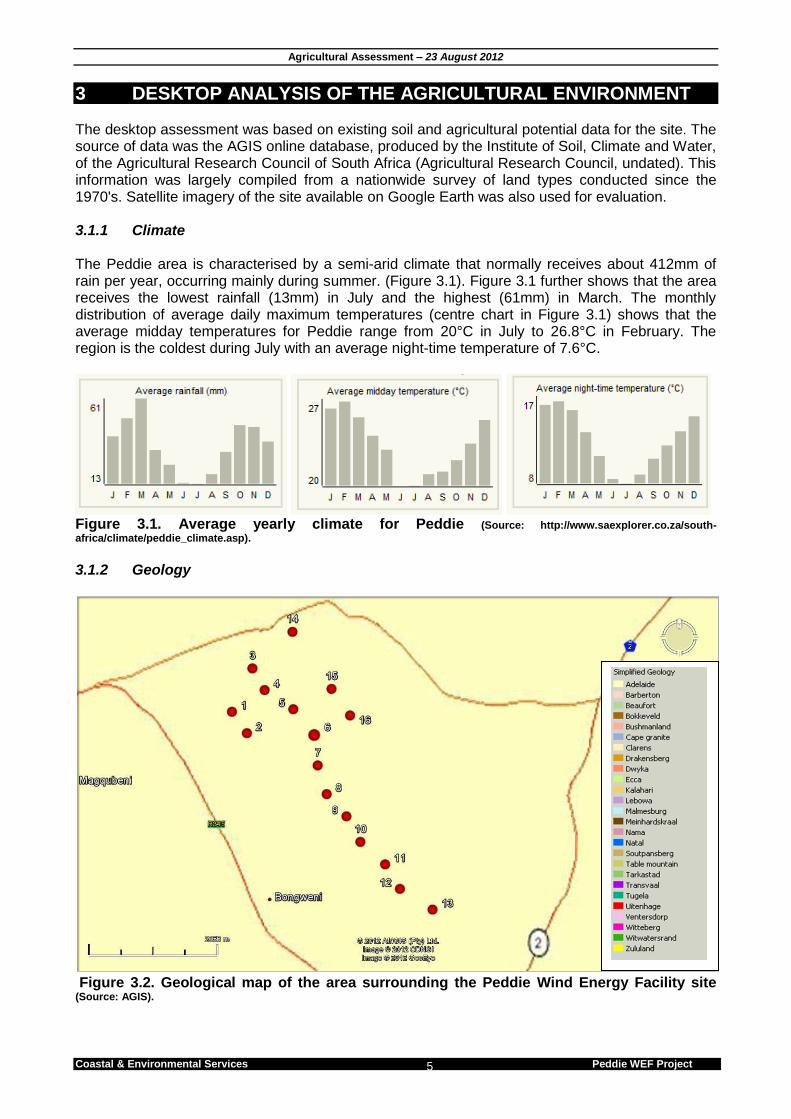
3 DESKTOP ANALYSIS OF THE AGRICULTURAL ENVIRONMENT The desktop assessment was based on existing soil and agricultural potential data for the site. The source of data was the AGIS online database, produced by the Institute of Soil, Climate and Water, of the Agricultural Research Council of South Africa (Agricultural Research Council, undated). This information was largely compiled from a nationwide survey of land types conducted since the 1970's. Satellite imagery of the site available on Google Earth was also used for evaluation. 3.1.1 Climate The Peddie area is characterised by a semi-arid climate that normally receives about 412mm of rain per year, occurring mainly during summer. (Figure 3.1). Figure 3.1 further shows that the area receives the lowest rainfall (13mm) in July and the highest (61mm) in March. The monthly distribution of average daily maximum temperatures (centre chart in Figure 3.1) shows that the average midday temperatures for Peddie range from 20°C in July to 26.8°C in February. The region is the coldest during July with an average night-time temperature of 7.6°C.
Figure 3.1. Average yearly climate for Peddie (Source: http://www.saexplorer.co.za/south-
africa/climate/peddie_climate.asp). 3.1.2 Geology
Figure 3.2. Geological map of the area surrounding the Peddie Wind Energy Facility site (Source: AGIS).
Agricultural Assessment – 23 August 2012
Coastal & Environmental Services Peddie WEF Project 6
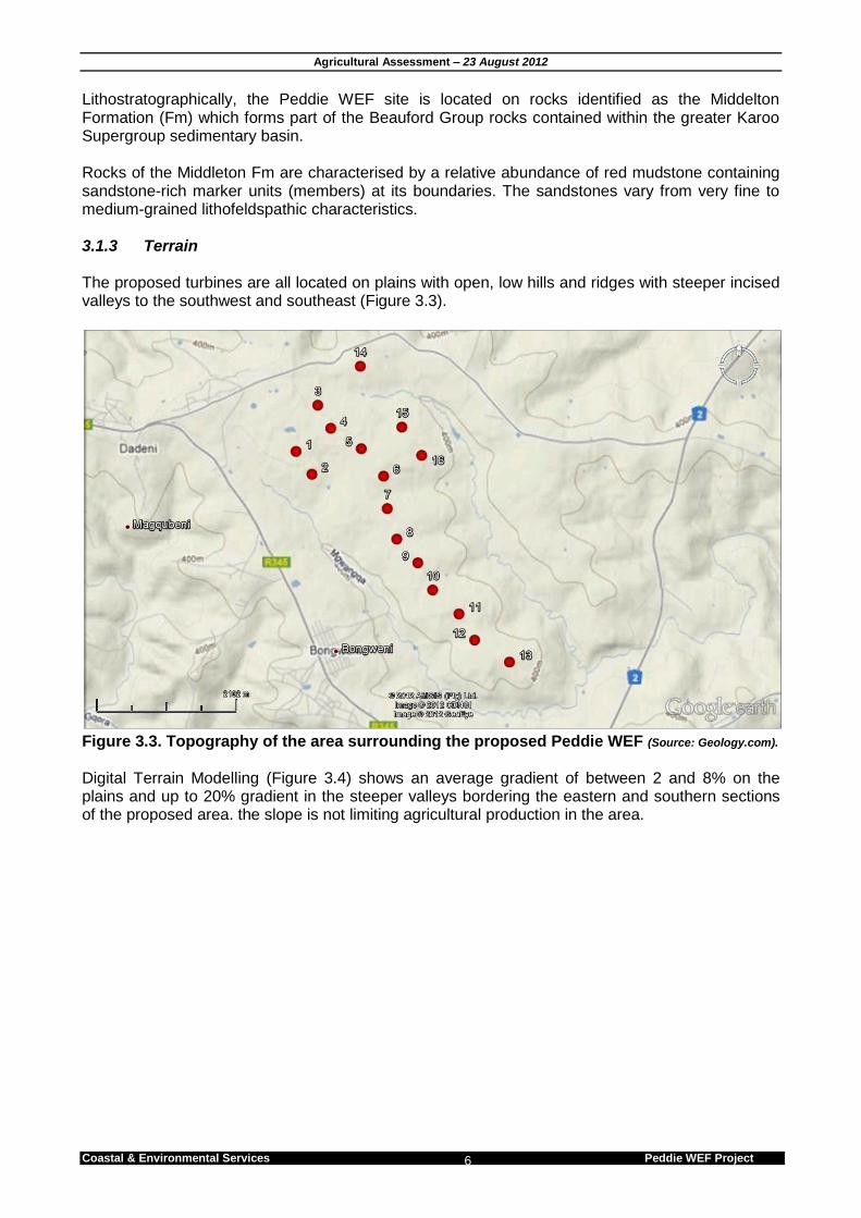
Lithostratographically, the Peddie WEF site is located on rocks identified as the Middelton Formation (Fm) which forms part of the Beauford Group rocks contained within the greater Karoo Supergroup sedimentary basin. Rocks of the Middleton Fm are characterised by a relative abundance of red mudstone containing sandstone-rich marker units (members) at its boundaries. The sandstones vary from very fine to medium-grained lithofeldspathic characteristics. 3.1.3 Terrain The proposed turbines are all located on plains with open, low hills and ridges with steeper incised valleys to the southwest and southeast (Figure 3.3).
Figure 3.3. Topography of the area surrounding the proposed Peddie WEF (Source: Geology.com).
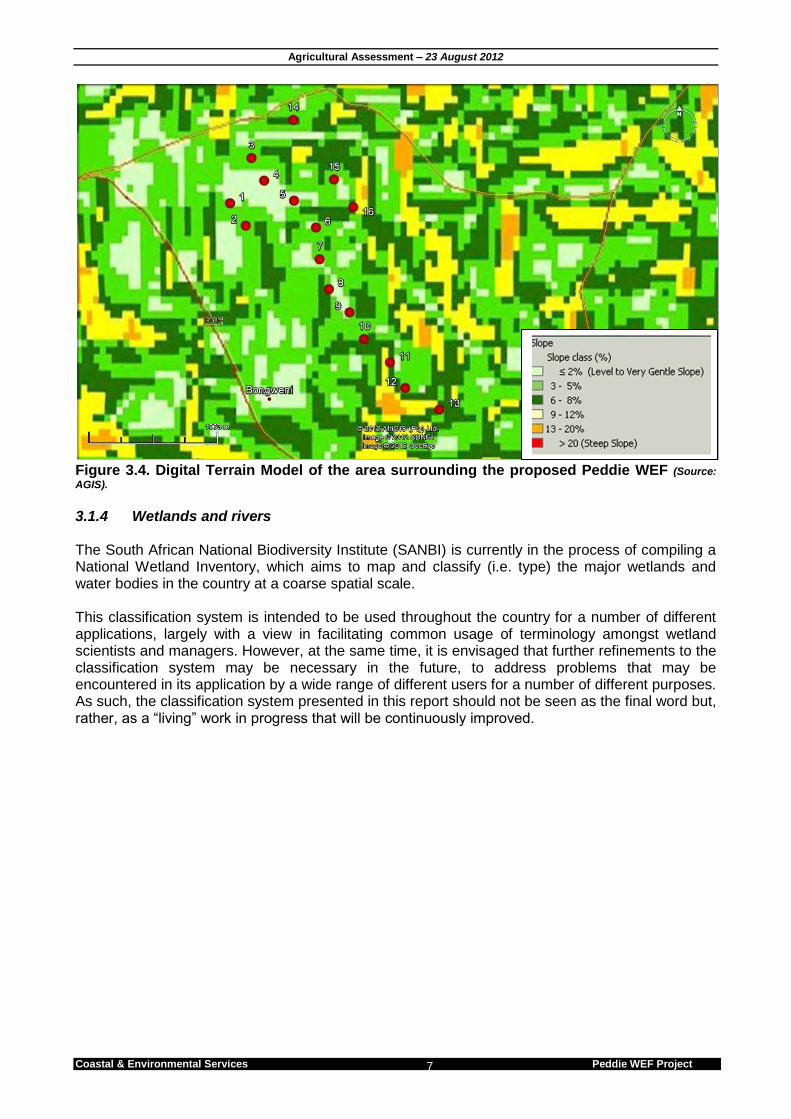
Digital Terrain Modelling (Figure 3.4) shows an average gradient of between 2 and 8% on the plains and up to 20% gradient in the steeper valleys bordering the eastern and southern sections of the proposed area. the slope is not limiting agricultural production in the area.
Agricultural Assessment – 23 August 2012
Coastal & Environmental Services Peddie WEF Project 7
Figure 3.4. Digital Terrain Model of the area surrounding the proposed Peddie WEF (Source:
AGIS).
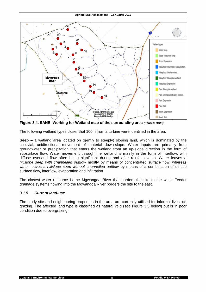
3.1.4 Wetlands and rivers The South African National Biodiversity Institute (SANBI) is currently in the process of compiling a National Wetland Inventory, which aims to map and classify (i.e. type) the major wetlands and water bodies in the country at a coarse spatial scale. This classification system is intended to be used throughout the country for a number of different applications, largely with a view in facilitating common usage of terminology amongst wetland scientists and managers. However, at the same time, it is envisaged that further refinements to the classification system may be necessary in the future, to address problems that may be encountered in its application by a wide range of different users for a number of different purposes. As such, the classification system presented in this report should not be seen as the final word but, rather, as a “living” work in progress that will be continuously improved.
Agricultural Assessment – 23 August 2012
Coastal & Environmental Services Peddie WEF Project 8
Figure 3.4. SANBI Working for Wetland map of the surrounding area (Source: BGIS). The following wetland types closer that 100m from a turbine were identified in the area: Seep – a wetland area located on (gently to steeply) sloping land, which is dominated by the colluvial, unidirectional movement of material down-slope. Water inputs are primarily from groundwater or precipitation that enters the wetland from an up-slope direction in the form of subsurface flow. Water movement through the wetland is mainly in the form of interflow, with diffuse overland flow often being significant during and after rainfall events. Water leaves a hillslope seep with channelled outflow mostly by means of concentrated surface flow, whereas water leaves a hillslope seep without channelled outflow by means of a combination of diffuse surface flow, interflow, evaporation and infiltration The closest water resource is the Mgwangqa River that borders the site to the west. Feeder drainage systems flowing into the Mgwangqa River borders the site to the east. 3.1.5 Current land-use The study site and neighbouring properties in the area are currently utilised for informal livestock grazing. The affected land type is classified as natural veld (see Figure 3.5 below) but is in poor condition due to overgrazing.

Agricultural Assessment – 23 August 2012
Coastal & Environmental Services Peddie WEF Project 9
Figure 3.5. Current land cover of the affected area. (Source: BGIS).
3.1.6 Soil characteristics
Figure 3.6. Soil types found on the affected area are classified as lithosols. (Source: AGIS).
The affected area is underlain by lithosols. This form is associated with shallow soils (less than 0.5m), where parent rock is found close to the land surface and as such is considered a limiting factor for sustainable crop production. Because of their extreme shallowness, these soils are not suitable for arable farming. The flora (grassland) supported on them is of very poor nutritive value for grazing, so only low stocking rates are practicable.
Agricultural Assessment – 23 August 2012
Coastal & Environmental Services Peddie WEF Project 10
3.1.7 Summary Based on the above-mentioned characteristic the study site is considered as low agricultural potential for both crop production and grazing. Factors limiting agricultural potential are:
Shallow soils
Inconsistent rainfall throughout the year
Degraded vegetation
Agricultural Assessment – 23 August 2012
Coastal & Environmental Services Peddie WEF Project 11
4 SITE CONFIRMATION Five random sites were assessed to verify the soil characteristics. Samples were visually identified onsite. The following procedure was followed in the identification of soils (Taken from the AGIS website): 1. the master horizons present in the profile were demarcated 2. diagnostic horizons or materials were identified 3. the AGIS online soil Key were used to establish soil forms 4. soil families were identified 5. The texture class of the A horizon was determined and added it to the name or code of the soil
family. To confirm visual identification, soil samples were also taken and send to a certified laboratory for analysis.
4.1 Visual identification 4.1.1 First subsoil layer This layer is identified as a surface horizon (A Horizon) that does not qualify as organic, humic, vertic or melanic topsoil and as such is classified as orthic. 4.1.2 Second subsoil layer The second subsoil layer consists of a continuous hard layer of rock that occurs beneath a diagnostic orthic A horizon, and cannot be cut with a spade, even when wet. The layer does not qualify as a diagnostic lithocutanic or hard plinthic B horizon, or as a hardpan carbonate horizon, or as diagnostic dorbank No further subsoil layers were identified. 4.1.3 Soil form All 5 samples were identified as the same soil form. Based on the two identified subsoil layers, soils at the Peddie WEF site are identified as Mispah soil forms. This soil form is characterised by a thin Orthic A – horizon layer (less than 0.5 m) overlying hard rock and as such are considered too shallow for sustainable agriculture.
4.2 Laboratory samples Soil samples were sent to Brookside Laboratories Inc. for analysis. To date CES has not received any results for comparison.
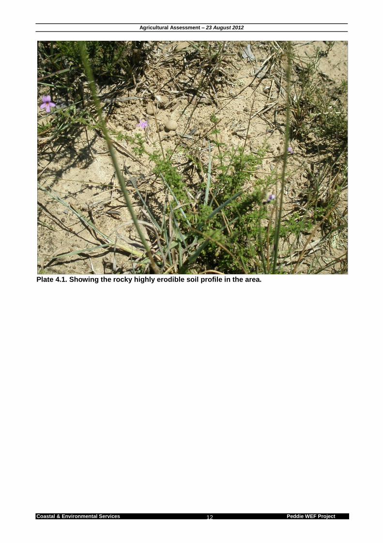
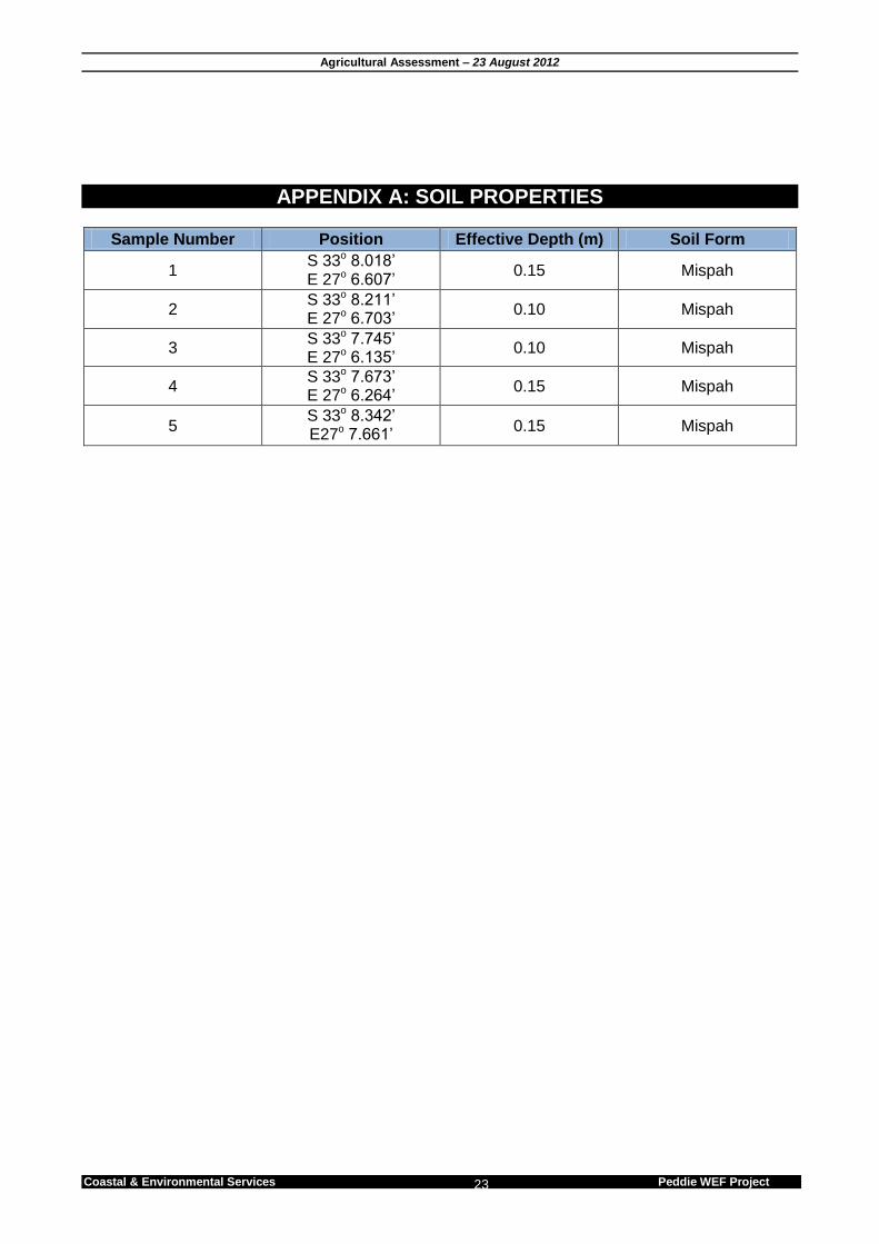
4.3 Summary Shallow Mispah soil form covers the entire surveyed area. This soil type is predominantly rocky and shallow with a low agricultural potential and a high erodability. Low nutrition value grassland dominates the area with condensed valley thicket found in the low lying drainage channels. The location and description of the sample points are provided in Appendix A.
Agricultural Assessment – 23 August 2012
Coastal & Environmental Services Peddie WEF Project 12
Plate 4.1. Showing the rocky highly erodible soil profile in the area.
Agricultural Assessment – 23 August 2012
Coastal & Environmental Services Peddie WEF Project 13
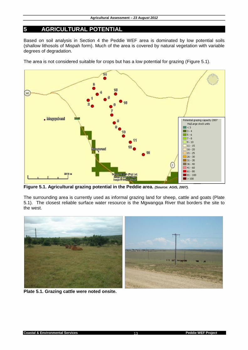
5 AGRICULTURAL POTENTIAL Based on soil analysis in Section 4 the Peddie WEF area is dominated by low potential soils (shallow lithosols of Mispah form). Much of the area is covered by natural vegetation with variable degrees of degradation. The area is not considered suitable for crops but has a low potential for grazing (Figure 5.1).
Figure 5.1. Agricultural grazing potential in the Peddie area. (Source: AGIS, 2007).
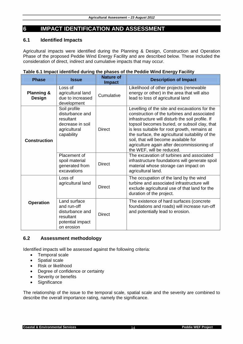
The surrounding area is currently used as informal grazing land for sheep, cattle and goats (Plate 5.1). The closest reliable surface water resource is the Mgwangqa River that borders the site to the west.
Plate 5.1. Grazing cattle were noted onsite.
Agricultural Assessment – 23 August 2012
Coastal & Environmental Services Peddie WEF Project 14
6 IMPACT IDENTIFICATION AND ASSESSMENT
6.1 Identified Impacts
Agricultural impacts were identified during the Planning & Design, Construction and Operation Phase of the proposed Peddie Wind Energy Facility and are described below. These included the consideration of direct, indirect and cumulative impacts that may occur. Table 6.1 Impact identified during the phases of the Peddie Wind Energy Facility
Phase Issue Nature of
Impact Description of Impact
Planning & Design
Loss of agricultural land due to increased development
Cumulative
Likelihood of other projects (renewable energy or other) in the area that will also lead to loss of agricultural land
Construction
Soil profile disturbance and resultant decrease in soil agricultural capability
Direct
Levelling of the site and excavations for the construction of the turbines and associated infrastructure will disturb the soil profile. If topsoil becomes buried, or subsoil clay, that is less suitable for root growth, remains at the surface, the agricultural suitability of the soil, that will become available for agriculture again after decommissioning of the WEF, will be reduced.
Placement of spoil material generated from excavations
Direct
The excavation of turbines and associated infrastructure foundations will generate spoil material whose storage can impact on agricultural land.
Operation
Loss of agricultural land Direct
The occupation of the land by the wind turbine and associated infrastructure will exclude agricultural use of that land for the duration of the project.
Land surface and run-off disturbance and resultant potential impact on erosion
Direct
The existence of hard surfaces (concrete foundations and roads) will increase run-off and potentially lead to erosion.
6.2 Assessment methodology
Identified impacts will be assessed against the following criteria:
Temporal scale
Spatial scale
Risk or likelihood
Degree of confidence or certainty
Severity or benefits
Significance The relationship of the issue to the temporal scale, spatial scale and the severity are combined to describe the overall importance rating, namely the significance.

Agricultural Assessment – 23 August 2012
Coastal & Environmental Services Peddie WEF Project 15
6.3 Description of criteria Table 6.2 Significance Rating Table
Significance Rating Table
Temporal Scale (The duration of the impact)
Short term Less than 5 years (Many construction phase impacts are of a short duration).
Medium term Between 5 and 20 years.
Long term Between 20 and 40 years (From a human perspective almost permanent).
Permanent Over 40 years or resulting in a permanent and lasting change that will always be there.
Spatial Scale (The area in which any impact will have an affect)
Individual Impacts affect an individual.
Localised Impacts affect a small area of a few hectares in extent. Often only a portion of the project area.
Project Level Impacts affect the entire project area.
Surrounding Areas Impacts that affect the area surrounding the development
Municipal Impacts affect either BCM, or any towns within them.
Regional Impacts affect the wider district municipality or the province as a whole.
National Impacts affect the entire country.
International/Global Impacts affect other countries or have a global influence.
Will definitely occur Impacts will definitely occur.
Degree of Confidence or Certainty (The confidence with which one has predicted the significance of an impact)
Definite More than 90% sure of a particular fact. Should have substantial supportive data.
Probable Over 70% sure of a particular fact, or of the likelihood of that impact occurring.
Possible Only over 40% sure of a particular fact, or of the likelihood of an impact occurring.
Unsure Less than 40% sure of a particular fact, or of the likelihood of an impact occurring.
Table 6.3 Impact Severity Rating
Impact severity (The severity of negative impacts, or how beneficial positive impacts would be on a particular affected system or affected party)
Very severe Very beneficial
An irreversible and permanent change to the affected system(s) or party (ies) which cannot be mitigated. For example the permanent loss of land.
A permanent and very substantial benefit to the affected system(s) or party (ies), with no real alternative to achieving this benefit. For example the vast improvement of sewage effluent quality.

Agricultural Assessment – 23 August 2012
Coastal & Environmental Services Peddie WEF Project 16
Severe Beneficial
Long term impacts on the affected system(s) or party (ies) that could be mitigated. However, this mitigation would be difficult, expensive or time consuming, or some combination of these. For example, the clearing of forest vegetation.
A long term impact and substantial benefit to the affected system(s) or party (ies). Alternative ways of achieving this benefit would be difficult, expensive or time consuming, or some combination of these. For example an increase in the local economy.
Moderately severe Moderately beneficial
Medium to long term impacts on the affected system(s) or party (ies), which could be mitigated. For example constructing the sewage treatment facility where there was vegetation with a low conservation value.
A medium to long term impact of real benefit to the affected system(s) or party (ies). Other ways of optimising the beneficial effects are equally difficult, expensive and time consuming (or some combination of these), as achieving them in this way. For example a ‘slight’ improvement in sewage effluent quality.
Slight Slightly beneficial
Medium or short term impacts on the affected system(s) or party (ies). Mitigation is very easy, cheap, less time consuming or not necessary. For example a temporary fluctuation in the water table due to water abstraction.
A short to medium term impact and negligible benefit to the affected system(s) or party (ies). Other ways of optimising the beneficial effects are easier, cheaper and quicker, or some combination of these.
No effect Don’t know/Can’t know
The system(s) or party (ies) is not affected by the proposed development.
In certain cases it may not be possible to determine the severity of an impact.
Table 6.4 Overall Significance Rating Overall Significance (The combination of all the above criteria as an overall significance)
VERY HIGH NEGATIVE VERY BENEFICIAL
These impacts would be considered by society as constituting a major and usually permanent change to the (natural and/or social) environment, and usually result in severe or very severe effects, or beneficial or very beneficial effects. Example: The loss of a species would be viewed by informed society as being of VERY HIGH significance. Example: The establishment of a large amount of infrastructure in a rural area, which previously had very few services, would be regarded by the affected parties as resulting in benefits with VERY HIGH significance.
HIGH NEGATIVE BENEFICIAL
These impacts will usually result in long term effects on the social and/or natural environment. Impacts rated as HIGH will need to be considered by society as constituting an important and usually long term change to the (natural and/or social) environment. Society would probably view these impacts in a serious light. Example: The loss of a diverse vegetation type, which is fairly common elsewhere, would have a significance rating of HIGH over the long term, as the area could be rehabilitated. Example: The change to soil conditions will impact the natural system, and the impact on affected parties (such as people growing crops in the soil) would be HIGH.
MODERATE NEGATIVE SOME BENEFITS
These impacts will usually result in medium to long term effects on the social and/or natural environment. Impacts rated as MODERATE will need to be considered by society as constituting a fairly important and usually medium term change to the (natural and/or social) environment. These impacts are real but not substantial. Example: The loss of a sparse, open vegetation type of low diversity may be regarded as MODERATELY significant.
LOW NEGATIVE FEW BENEFITS
These impacts will usually result in medium to short term effects on the social and/or natural environment. Impacts rated as LOW will need to be considered by the public and/or the specialist as constituting a fairly unimportant and usually short term change to the (natural and/or social)
Agricultural Assessment – 23 August 2012
Coastal & Environmental Services Peddie WEF Project 17
environment. These impacts are not substantial and are likely to have little real effect. Example: The temporary changes in the water table of a wetland habitat, as these systems are adapted to fluctuating water levels. Example: The increased earning potential of people employed as a result of a development would only result in benefits of LOW significance to people who live some distance away.
NO SIGNIFICANCE
There are no primary or secondary effects at all that are important to scientists or the public. Example: A change to the geology of a particular formation may be regarded as severe from a geological perspective, but is of NO significance in the overall context.
DON’T KNOW
In certain cases it may not be possible to determine the significance of an impact. For example, the primary or secondary impacts on the social or natural environment given the available information. Example: The effect of a particular development on people’s psychological perspective of the environment.
6.4 Impact Assessment The impacts identified in Section 6.1 are assessed in terms of the criteria described in Section 6.2 and are summarised in the tables below (Table 6.5 – 6.7). .
Agricultural Assessment – 23 August 2012
Coastal & Environmental Services Peddie WEF Project
18
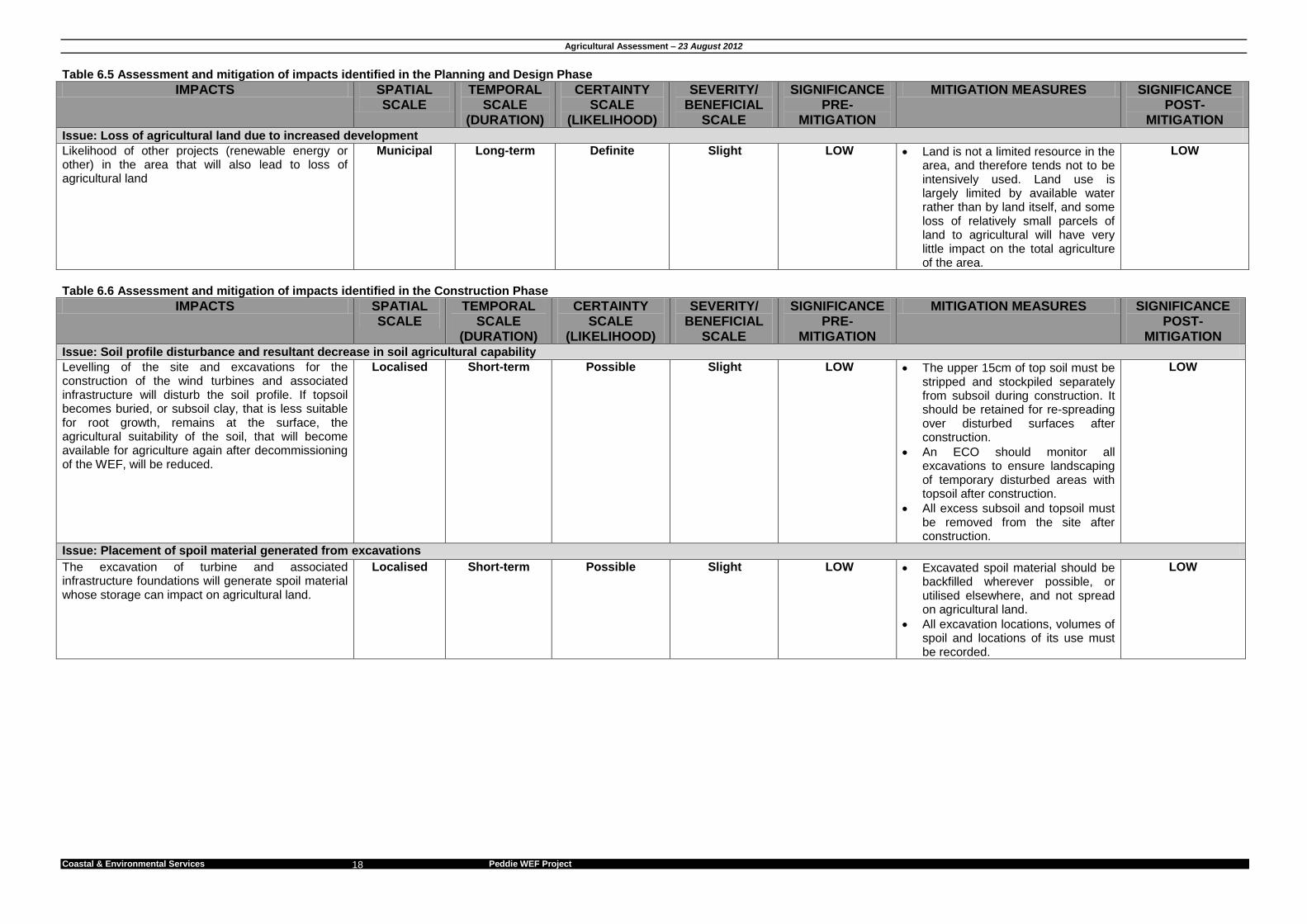
Table 6.5 Assessment and mitigation of impacts identified in the Planning and Design Phase
IMPACTS SPATIAL SCALE
TEMPORAL SCALE
(DURATION)
CERTAINTY SCALE
(LIKELIHOOD)
SEVERITY/ BENEFICIAL
SCALE
SIGNIFICANCE PRE-
MITIGATION
MITIGATION MEASURES SIGNIFICANCE POST-
MITIGATION Issue: Loss of agricultural land due to increased development
Likelihood of other projects (renewable energy or other) in the area that will also lead to loss of agricultural land
Municipal Long-term Definite Slight LOW Land is not a limited resource in the area, and therefore tends not to be intensively used. Land use is largely limited by available water rather than by land itself, and some loss of relatively small parcels of land to agricultural will have very little impact on the total agriculture of the area.
LOW
Table 6.6 Assessment and mitigation of impacts identified in the Construction Phase
IMPACTS SPATIAL SCALE
TEMPORAL SCALE
(DURATION)
CERTAINTY SCALE
(LIKELIHOOD)
SEVERITY/ BENEFICIAL
SCALE
SIGNIFICANCE PRE-
MITIGATION
MITIGATION MEASURES SIGNIFICANCE POST-
MITIGATION Issue: Soil profile disturbance and resultant decrease in soil agricultural capability
Levelling of the site and excavations for the construction of the wind turbines and associated infrastructure will disturb the soil profile. If topsoil becomes buried, or subsoil clay, that is less suitable for root growth, remains at the surface, the agricultural suitability of the soil, that will become available for agriculture again after decommissioning of the WEF, will be reduced.
Localised Short-term Possible Slight LOW The upper 15cm of top soil must be stripped and stockpiled separately from subsoil during construction. It should be retained for re-spreading over disturbed surfaces after construction.
An ECO should monitor all excavations to ensure landscaping of temporary disturbed areas with topsoil after construction.
All excess subsoil and topsoil must be removed from the site after construction.
LOW
Issue: Placement of spoil material generated from excavations
The excavation of turbine and associated infrastructure foundations will generate spoil material whose storage can impact on agricultural land.
Localised Short-term Possible Slight LOW Excavated spoil material should be backfilled wherever possible, or utilised elsewhere, and not spread on agricultural land.
All excavation locations, volumes of spoil and locations of its use must be recorded.
LOW
Agricultural Assessment – 23 August 2012
Coastal & Environmental Services Peddie WEF Project 19
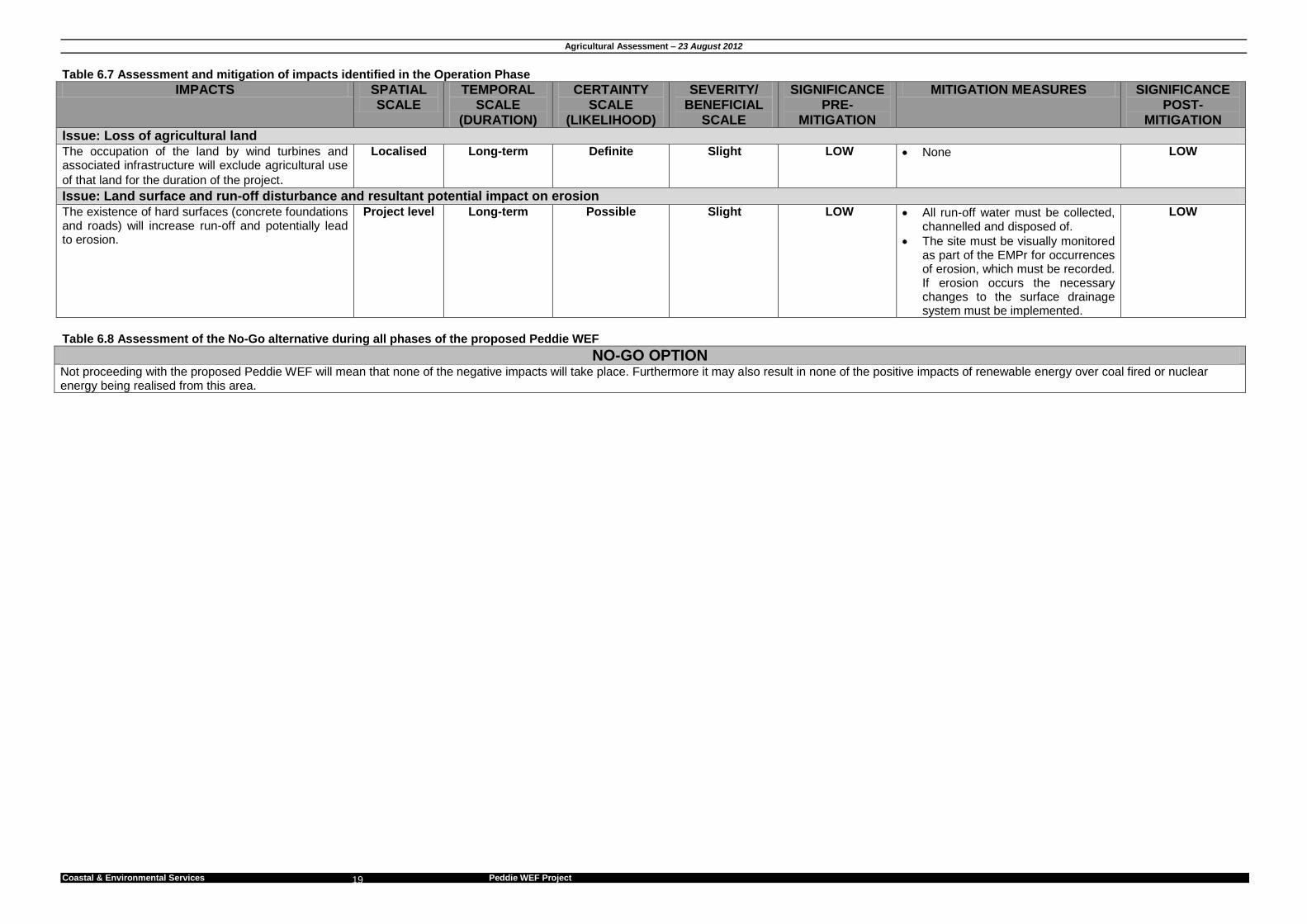
Table 6.7 Assessment and mitigation of impacts identified in the Operation Phase
IMPACTS SPATIAL SCALE
TEMPORAL SCALE
(DURATION)
CERTAINTY SCALE
(LIKELIHOOD)
SEVERITY/ BENEFICIAL
SCALE
SIGNIFICANCE PRE-
MITIGATION
MITIGATION MEASURES SIGNIFICANCE POST-
MITIGATION
Issue: Loss of agricultural land The occupation of the land by wind turbines and associated infrastructure will exclude agricultural use
of that land for the duration of the project.
Localised Long-term Definite Slight LOW None LOW
Issue: Land surface and run-off disturbance and resultant potential impact on erosion
The existence of hard surfaces (concrete foundations and roads) will increase run-off and potentially lead to erosion.
Project level Long-term Possible Slight LOW All run-off water must be collected, channelled and disposed of.
The site must be visually monitored as part of the EMPr for occurrences of erosion, which must be recorded. If erosion occurs the necessary changes to the surface drainage system must be implemented.
LOW
Table 6.8 Assessment of the No-Go alternative during all phases of the proposed Peddie WEF
NO-GO OPTION Not proceeding with the proposed Peddie WEF will mean that none of the negative impacts will take place. Furthermore it may also result in none of the positive impacts of renewable energy over coal fired or nuclear energy being realised from this area.
Agricultural Assessment – 23 August 2012
Coastal & Environmental Services Peddie WEF Project
20
7 IMPACT STATEMENT, CONCLUSION & RECOMMENDATIONS
7.1 Conclusions InnoWind South Africa (hereafter referred to as InnoWind) proposes to develop a wind power generation facility in Peddie, Ngqushwa Local Municipality, Eastern Cape Province, South Africa (Figure 1.1). The proposed project will entail the construction and operation of a wind energy facility on land currently zoned for agriculture and used for grazing cattle. The Peddie Wind Energy Project will be distributed over 12 adjacent property parcels in the Peddie area. The facility is planned to host up to 16 turbines (see Figure 1.2 below). The wind energy facility will have a potential power output of 30-50 MW. An agricultural impact assessment was commissioned in order to predict and assess the significance of identified impacts associated with the proposed activity on the agricultural environment.
The proposed development’s primary impact on agricultural activities will involve the construction of the wind turbines and associated infrastructure. The construction of these turbines will only influence a small area of the total local agricultural portion. The No-go alternative would mean abandoning the proposed development and as such there will be no negative impact on the environment as identified in Section 6. Furthermore it may also result in none of the positive impacts of renewable energy over coal fired or nuclear energy being realised from this area. The construction entails the clearing of vegetation underneath the footprint of the wind turbine, as well as creating service roads. Normal grazing (the dominant agricultural activity) may be permitted around the wind turbines. The impact of the proposed development on the study area’s agricultural potential will be extremely low, with the loss of agricultural land being attributed to the creation of the service roads and wind turbine foundations. The total loss of grazing land will be less than 1 % of the total agricultural area. All post-mitigation impacts are considered as LOW.
7.2 Recommendations for the proposed Peddie Wind Energy Facility All the mitigation measures provided below are to be implemented in the Planning and Design, Construction and Operation Phases of the proposed Peddie Wind Energy Facility. 7.2.1 Construction
The upper 15cm of top soil must be stripped and stockpiled separately from subsoil during construction. It should be retained for re-spreading over disturbed surfaces after construction.
An ECO should monitor the rehabilitation of temporary disturbed areas. Ensure that stockpiled topsoil is used during landscaping.
All excess subsoil must be removed from the site after construction.
Excavated spoil material should be backfilled wherever possible, or utilised elsewhere, and not spread on agricultural land.
All excavation locations, volumes of spoil and locations of its use must be recorded. 7.2.2 Operation
All run-off water must be collected, channelled and disposed of.
Agricultural Assessment – 23 August 2012
Coastal & Environmental Services Peddie WEF Project 21
The site must be visually monitored as part of the EMPr for occurrences of erosion, which must be recorded. If erosion occurs the necessary changes to the surface drainage system must be implemented.
7.3 Agricultural statement and Opinion of the Specialist The agricultural impacts of all the aspects of the proposed Peddie Wind Energy Facility were considered and deemed to be acceptable, provided that the mitigation measures provided in this report are implemented. As there is currently no active agricultural output within the affected area which will be influenced by the proposed development, no problematic areas or fatal flaws were identified for the site. All the identified impacts on agriculture are considered to have high reversibility because the land will be able to be returned to agriculture after closure with very little change in agricultural potential. Impacts on agriculture are also considered to have low irreplaceability of resource loss because: 1. of the small areas of land involved, 2. that it is highly unlikely to be irreplaceably lost to agriculture, 3. and that it is of low agricultural potential.

Agricultural Assessment – 23 August 2012
Coastal & Environmental Services Peddie WEF Project 22
8 REFERENCES Agricultural Research Council. undated. Available at http://www.agis.agric.za/ (last visited on 11 June 2012). Munica, L, Scott-Shaw CR, Rutherford MC, Camp KGT, Matthews WS, Powrie LW and Hoare DB (2006) Indian Ocean Coastal Belt In: The vegetation of South Africa, Lesotho and Swaziland, Mucina L and Rutherford (eds). South African National Biodiversity Institute, Pretoria. National Environmental Management Act (No 107 of 1998) as amended in 2008 National Water Act (No 36 of 1998) Soil Classification Working Group. (1991) Soil Classification - A Taxonomic System for South Africa
Agricultural Assessment – 23 August 2012
Coastal & Environmental Services Peddie WEF Project 23
APPENDIX A: SOIL PROPERTIES
Sample Number Position Effective Depth (m) Soil Form
1 S 33o 8.018’ E 27o 6.607’
0.15 Mispah
2 S 33o 8.211’ E 27o 6.703’
0.10 Mispah
3 S 33o 7.745’ E 27o 6.135’
0.10 Mispah
4 S 33o 7.673’ E 27o 6.264’
0.15 Mispah
5 S 33o 8.342’ E27o 7.661’
0.15 Mispah