pelican landing cpd/rpd request statement and ...cityofbonitaspringscd.org/projects/lee...
TRANSCRIPT

Pelican Landing CPD/RPD
Request Statement and
Demonstration of Compatibility
Page 1 of 16
Request Statement and Project Narrative The annexed property is part of the Pelican Landing DRI. The property was annexed into the City of Bonita Springs from unincorporated Lee County on May 2014. The annexed property, which is part of the Pelican Landing community, is located off Coconut Point Resort Drive. The annexed property is currently zoned Pelican Landing CPD/RPD and Kersey-Smoot RPD. The applicant, Pelican Landing Golf Resort Ventures LP, is proposing to add the 20± acre portion of the annexed property currently located in the Kersey-Smoot RPD into the Pelican Landing CPD/RPD. The 20 acres in Kersey Smoot RPD and approximately 35 acres of the Pelican Landing RPD/CPD were annexed into the City of Bonita Springs. The Kersey Smoot residential planned development was originally approved in 1998 by Resolution Z-98-066 and it included residential uses. At the time of the original Kersey Smoot RPD zoning, the plan was to include residential and golf. The DRI Map H identified the property as residential/golf in 1998. The property was determined to be suitable for residential uses. Also, the 35 acre portion of the Pelican Landing RPD/CPD approved in 1994 (Z-94-014) depicted this area as residential. In 2000 this area was modified by Z-00-031 switching the primary use from residential to golf. After the golf course was built, it was suggested by the County that the residential uses should be eliminated to avoid confusion. Thus, it needs to be clear that the property was previously evaluated for consistency with the LDC and Lee Plan for residential and golf uses. The golf course market has changed, and the number of rounds played in the U.S. has been consistently dropping. There are additional lands designated for golf that can accommodate the four holes that will be relocated to maintain the 18-hole golf course. The property owner does not presently plan to construct all of the golf holes approved north of Coconut. The property owner wants to relocate existing golf holes to an area where golf is permitted and allocate available approved units to the annexed property. To avoid the confusion of developing the residential in two separate planned developments it makes sense to locate all of the annexed property in the Pelican Landing RPD/CPD. Thus, the application will remove 20± acres from the Kersey-Smoot RPD and add the 20+/- acres to the Pelican Landing CPD/RPD. Once the 20 acres from Kersey Smoot is moved into the Pelican Landing RPD/CPD, the residential units can be developed consistent with the same high standards currently in place for a significant portion (1,122 acres) of Pelican Landing. The application does not increase the number of units in the RPD/CPD or the DRI. The units are approved vested units. WCI Communities has the right to develop the balance of unbuilt units within the Pelican

Pelican Landing CPD/RPD
Request Statement and
Demonstration of Compatibility
Page 2 of 16
Landing community, and a portion of the approved units will be assigned to the annexed 55± acres, depicted as F.1. on the Master Concept Plan. The applicant needs to correct misstatements that have been placed on the record. There are people who have incorrectly stated that the Pelican Landing DRI never had any units approved north of Coconut Road. The original DRI and accompanying RPD/CPD Master Concept Plan in 1994 clearly identified almost all of the lands controlled by WCI Communities north of Coconut Road as a residential development area. The 1994 DRI authorized a maximum of 4,050 residential dwelling units and the 1994 RPD/CPD approval authorized a maximum of 2616 residential dwellings to be constructed within the Pelican Landing RPD/CPD portion of the DRI. The approvals did not specify a maximum or minimum number of units north or south of Coconut Road. In 1998, WCI acquired 204 acres known as the Kersey Smoot property. The Kersey Smoot property was added to the Pelican Landing DRI at a public hearing. The property has been developed with the Hyatt Timeshare Resort/sales facility and Raptor Bay Golf Club. It should be noted that the timeshare units are considered residential units and the units are located north of Coconut Road. The Kersey Smoot addition to the Pelican Landing DRI did not increase the number of units in the DRI, which effectively reduced the overall density of the DRI. Approved units were simply assigned to the Kersey Smoot property when the property was rezoned in 1998. A total of 362 units were approved on the Kersey Smoot property. Thus, it is clear that since the 1994 approval of the DRI, dwelling units have been contemplated north of Coconut Road. The roadway impacts, as well as hurricane mitigation for the then maximum of 4,050 units have been fully satisfied in 2006. WCI opted to reduce the maximum number of units to 3,912 to allow for less multi-family and more single family but keeping traffic impacts consistent. Demonstration of Compatibility The incorporation of the Kersey Smoot property into the Pelican Landing RPD/CPD is consistent with the Lee Plan and the required LDC findings for a rezoning. Below is a discussion /analysis of consistency with the Lee Plan and LDC. The property is designated Outlying Suburban on the Lee County Future Land Use Map. The Outlying Suburban category is described in Lee Plan Policy 1.1.6 of the Future Land Use Element and it permits a density range of one du/ac to three du/ac for residential development.

Pelican Landing CPD/RPD
Request Statement and
Demonstration of Compatibility
Page 3 of 16
POLICY 1.1.6: The Outlying Suburban areas are characterized by their peripheral location in relation to established urban areas. In general, these areas are rural in nature or contain existing low-density development. Some, but not all, of the requisite infrastructure needed for higher density development is generally planned or in place. It is intended that these areas will develop at lower residential densities than other Future Urban Areas. As in the Suburban areas, higher densities, commercial development greater than neighborhood centers, and industrial land uses are not permitted. The standard density range is from one dwelling unit per acre (1 du/acre) to three dwelling units per acre (3 du/acre). Bonus densities are not allowed. The 20± acre property Kersey Smoot RPD annexed property is being shifted into the City of Bonita Springs portion of the DRI DO and the Pelican Landing RPD/CPD. The Outlying Suburban Land Use Category is a Lee Plan Future Land Use Category, which permits residential uses; therefore, the proposed residential use is consistent with the Lee Plan. Residential uses as well as the Hyatt Hotel have been approved in the Outlying Suburban future land use category. It should be noted that the Outlying Suburban areas were designated over 30 years ago when Bonita had not yet incorporated and many of the gated communities were in their infancy or did not exist. The property is part of an incorporated area, which by definition is urban, the property is certainly not in a rural area. The existing Pelican Landing DRI is currently vested for a total of 3,912 dwelling units, original DRI approval was for 4,050 units. The Pelican Landing RPD/CPD is approved for a total of 2,616 dwelling units. At the present time, approximately 800 dwelling units remain undeveloped and under the control of the applicant. The overall density for the Pelican Landing DRI when all units are constructed will be approximately 1.5 du/ac. The Pelican Landing RPD/CPD includes a condition, which permits 2,266 units to be built in the Outlying Suburban land use category. To date only 1,041 units have been built in the Outlying Suburban areas. Even though approximately 300± acres of land was added that previously had its own unit allocation, the applicant is not asking to increase the number of units in the Pelican Landing RPD/CPD, and the applicant is not asking for an increase in the number of units in the Outlying Suburban land use category. GOAL 2: GROWTH MANAGEMENT. To provide for an economically feasible plan which coordinates the location and timing of new development with the provision of infrastructure by government agencies, private utilities, and other sources. Development on the 20-acre annexed portion of the Kersey Smoot RPD combined with the 35± acre portion of the Pelican Landing RPD/CPD (annexed properties), results in

Pelican Landing CPD/RPD
Request Statement and
Demonstration of Compatibility
Page 4 of 16
development on property currently serviced by urban infrastructure, including water, sewer, electric, cable, and drainage facilities, consistent with this Goal. OBJECTIVE 2.1: DEVELOPMENT LOCATION. Contiguous and compact growth patterns will be promoted through the rezoning process to contain urban sprawl, minimize energy costs, conserve land, water, and natural resources, minimize the cost of services, prevent development patterns where large tracts of land are by-passed in favor of development more distant from services and existing communities. The subject property would represent redevelopment of a golf course tract. Redevelopment at this location is consistent with Objective 2.1, which promotes compact and contiguous growth patterns. This development area is contiguous to other developed portions of the Pelican Landing DRI, including the Hyatt Timeshare Resort. The proposed development of high-rise towers on the site will minimize costs for services, create a more compact form of development on a reduced development area. This form of development accommodates the preservation of natural resources. POLICY 2.1.1: Most residential, commercial, industrial, and public development is expected to occur within the designated Future Urban Areas on the Future Land Use Map through the assignment of very low densities to the non-urban categories. The proposed development area is designated Outlying Suburban on the Lee County Future Land Use Map. Outlying Suburban is a future Urban Area per Objective 1.1 of the Future Land Use Element. POLICY 2.1.2: New land uses will be permitted only if they are consistent with the Future Land Use Map and the goals, objectives, policies, and standards of this plan. The proposed residential development on the subject parcel is not a new land use proposal. As far back as 1994, the Pelican Landing RPD/CPD designated a majority of the parcel for residential development. Because no additional dwelling units are being proposed within the Pelican Landing RPD/CPD, there is no increase in dwelling units and it is not a new land use. Furthermore, the development is consistent with the goals, objectives, policies and standards of the plan. OBJECTIVE 2.2: DEVELOPMENT TIMING. Direct new growth to those portions of the Future Urban Areas where adequate public facilities exist or are assured and where compact and contiguous development patterns can be created. Development orders and permits (as defined in F.S. 163.3164(7)) will be granted only when consistent with
Pelican Landing CPD/RPD
Request Statement and
Demonstration of Compatibility
Page 5 of 16
the provisions of Sections 163.3202(2)(g) and 163.3180, Florida Statutes and the county's Concurrency Management Ordinance. Adequate public facilities are in place to serve the 4 residential high-rise towers planned for the property and the development type is considered a compact form of development. POLICY 2.2.1: Rezonings and development-of-regional-impact proposals will be evaluated as to the availability and proximity of the road network; central sewer and water lines; community facilities and services such as schools, EMS, fire and police protection, and other public facilities; compatibility with surrounding land uses; and any other relevant facts affecting the public health, safety, and welfare. All public facilities necessary to serve the proposed residential units are available at the site. There are no identified Level of Service deficiencies for any Class A public facilities. There is no new impact to schools, EMS, fire or police. The form of development is compatible with the development pattern that currently exists within the Pelican Landing Community and within the coastal area of the City of Bonita Springs and Village of Estero. The nearest existing external residential unit to the proposed development tract is approximately 2,000± feet to the east. For comparison, units within the Colony portion of Pelican Landing community have single-family homes within 200± feet of residential tower buildings. This mix of unit types has been thoughtfully planned for compatibility and has been proven to be very successful. The public welfare will be protected. There are no proposed impacts to wetlands or coastal resources. Wetlands are protected with conservation easements that have been in place since 2001. Although portions of the property are located within the CHHA, the Pelican Landing DRI is fully vested and hurricane evacuation impacts have been fully mitigated based on a higher number of dwelling units than currently authorized within the Pelican Landing DRI. The impacts on schools, police, fire and other local issues were reviewed as part of the original ADA, and were addressed in the SWFRPC assessment and when necessary in the subsequent DRI DO. POLICY 2.2.2: Map 1 of the Future Land Use Map series indicates the uses and density ranges that will ultimately be permitted on a given parcel. However, it is not a guarantee that such densities or uses are immediately appropriate, as the map provides for the county’s growth beyond the Lee Plan's planning horizon of 2030. During the rezoning process the Board of County Commissioners will balance the overall standards and policies of this plan with three additional factors:
Pelican Landing CPD/RPD
Request Statement and
Demonstration of Compatibility
Page 6 of 16
1. Whether a given proposal would further burden already overwhelmed existing and committed public facilities such that the approval should be delayed until the facilities can be constructed; and
2. Whether a given proposal is for land so far beyond existing development or adequate public facilities that approval should be delayed in an effort to encourage compact and efficient growth patterns; and
3. Whether a given proposal would result in unreasonable development expectations that may not be achievable because of acreage limitations contained in the Acreage Allocation Table (see Policy 1.7.6, Map 16 and Table 1(b)). Additional provisions related to mining are provided in Policy 33.1.4.
In all cases where rezoning is approved, such approval does not constitute a determination that the minimum acceptable levels of service (see Policy 95.1.3) will be available concurrent with the impacts of the proposed development. Such a determination must be made prior to the issuance of additional development permits, based on conditions which exist at that time, as required by Lee County’s concurrency management system.
No additional dwelling units are being added to the Pelican Landing RPD/CPD and the overall project density will remain at approximately 1.5 du/ac, far below the maximum density for Outlying Suburban. The proposal will not over burden existing public facilities and no new facilities are necessary to serve the development. The proposed development is not an unreasonable development expectation given the consistent development pattern in the balance of Pelican Landing. The allocation tables already accommodate the vested dwelling units in Pelican Landing DRI. POLICY 5.1.1: Residential developments requiring rezoning and meeting Development of County Impact (DCI) thresholds must be developed as planned residential developments. The Pelican Landing RPD/CPD is located within multiple Lee Plan Future Land Use Categories, including Urban Community, Suburban, Outlying Suburban, and Wetlands. Policy 5.1.1 of the Lee Plan provides that when a project is divided by two or more land use categories, the allowable density will be the sum of the allowable densities. This provision is applicable when utilizing the Planned Development process, which Pelican Landing RPD/CPD did and is. The Policy also says that density is not allocated to any lands that are non-urban or environmentally critical that would exceed that allowed in those areas. No density or development has been proposed to areas that are non-urban
Pelican Landing CPD/RPD
Request Statement and
Demonstration of Compatibility
Page 7 of 16
or environmentally critical. In fact, the subject 20-acre Kersey Smoot parcel proposed to be added to the Pelican Landing RPD/CPD is developed with golf holes and the property is not in its natural state. The lands at the time this Policy was established were under the control of WCI Communities, and related business entities. Through the RPD/CPD and Development of Regional Impact, some 800± acres have been placed in Conservation Easements. The subject zoning amendment is consistent with Policy 5.1.10 and results in no density increase within the project. POLICY 5.1.10: In those instances where land under single ownership is divided into two or more land use categories by the adoption or revision of the Future Land Use Map, the allowable density under this Plan will be the sum of the allowable densities for each land use category for each portion of the land. This density can be allocated across the property provided that:
1. The Planned Development zoning is utilized; and 2. No density is allocated to lands designated as Non-Urban or
Environmentally Critical that would cause the density to exceed that allowed on such areas; and
3. The land was under single ownership at the time this policy was adopted
and is contiguous; in situations where land under single ownership is divided by roadways, railroads, streams (including secondary riparian systems and streams but excluding primary riparian systems and major flow ways such as the Caloosahatchee River and Six Mile Cypress Slough), or other similar barriers, the land will be deemed contiguous for purposes of this policy; and
4. The resultant Planned Development affords further protection to
environmentally sensitive lands if they exist on the property. The underlying Lee Plan Designation of the subject property is Wetland and Outlying Suburban. The area designated as wetlands has already been placed in a conservation easement and no development will occur in these wetlands. Future residential uses are contemplated in the Outlying Suburban land use category and the property is already zoned RPD (Residential Planned Development), consistent with the requirement to assure compatibility through the Planned Development zoning process. Several zoning conditions exist within the Pelican Landing RPD/CPD, which include standards to assure that all allowable uses are appropriate and compatible both internal and external to the Pelican Landing community. There are no environmental issues associated with the
Pelican Landing CPD/RPD
Request Statement and
Demonstration of Compatibility
Page 8 of 16
development of the subject property. The total amount of wetland impacts within the entire Pelican Landing DRI is identified in the DRI, and the mitigation has already been provided. POLICY 5.2.4: The site design of the proposed development must be compatible with surrounding land uses to the maximum extent possible. Policy 5.2.4 requires site design to be compatible with surrounding land uses to the maximum extent possible. The 20± acres (Kersey Smoot) proposed to be added to the Pelican Landing RPD/CPD is contiguous to approximately 35± acres annexed into the city of Bonita Springs as part of the same annexation agreement and ordinance. In the annexation agreement the city found the proposed form of development to be appropriate for the area and will be of substantial benefit. The 55± acre annexed area will support up to four high-rise towers, shown as area F-1 on the MCP, consistent with the annexation agreement. The proposed towers are compatible with the towers approved and constructed in West Bay Club, the Colony, the Hyatt Regency Coconut Point Resort and Spa, and Bonita Bay. The applicant has developed six other high-rise towers within the Outlying Suburban Land Use Category, just south of Coconut Road. The site is near the existing Hyatt Regency Coconut Point Resort and Spa, which is an 18-story high-rise hotel (a commercial uses) is located to the south in the Outlying Suburban land use category. The proposed 20 story towers over two stories of parking are consistent with the existing development pattern. The nearest residential structure is one of the Pelican Landing mid-rise time-share buildings located in the Raptor Bay RPD. The nearest single family home is located in the Eldorado Acres subdivision and that home is approximately 2,000± feet from the proposed development area. The existing homes will be buffered and separated from the towers by heavily wooded conservation lands, golf course fairways and lakes. This separation and buffering is substantially greater than separations that exist internally within the Pelican Landing RPD/CPD. POLICY 135.9.5: New development adjacent to areas of established residential neighborhoods must be compatible with or improve the area's existing character. Policy 135.9.5 of the Lee Plan Housing Element, addresses compatibility of development adjacent to areas of established residential neighborhoods. The proposed amendment would authorize construction of up to four high-rise residential tower buildings. This development pattern is consistent with development to the south in Pelican Landing located within the Village of Estero and City of Bonita Springs, and Bonita Bay also within the City of Bonita Springs. Near the west end of Coconut Road is the Hyatt Regency Coconut Point Resort and Spa, which is comparable in height to the proposed
Pelican Landing CPD/RPD
Request Statement and
Demonstration of Compatibility
Page 9 of 16
high-rise towers. North of the City of Bonita Springs and within the Village of Estero is a series of high-rise towers developed within the West Bay Club community. This pattern is clearly one that has been determined by Lee County, Village of Estero, and Bonita Springs to be compatible with adjacent residential neighborhoods. The nearest proposed tower to any established external residential neighborhood such as Eldorado Acres, also located north of Coconut Road, would be approximately 2,000± feet. For context, there are single-family neighborhoods within Pelican Landing RPD/CPD, where the separation from a high-rise tower is approximately 200 ± feet. The proposed development is compatible with surrounding development. The Lee County LDC was the standard used for the review and approval of the development standards for the Pelican Landing community. The RPD/CPD incorporates conditions and standards, which protect the natural environment. Over 800 acres within the Pelican Landing DRI have been set aside as preservation areas. POLICY 114.1.1: Development in wetlands is limited to very low density residential uses and uses of a recreational, open space, or conservation nature that are compatible with wetland functions. The maximum density in the Wetlands category is one unit per 20 acres, except that one single family residence will be permitted on lots meeting the standards in Chapter XIII of this plan, and except that owners of wetlands adjacent to Intensive Development, Central Urban, Urban Community, Suburban, and Outlying Suburban areas may transfer densities to developable contiguous uplands under common ownership in accordance with Footnotes 9b and 9c of Table 1(a), Summary of Residential Densities. In Future Limerock Mining areas only (see Map 14), impacts to wetlands resulting from mining will be allowed by Lee County when those impacts are offset through appropriate mitigation, preferably within Southeast Lee County (see also Policy 33.1.3). Appropriate wetland mitigation may be provided by preservation of high quality indigenous habitat, restoration or reconnection of historic flowways, connectivity to public conservation lands, restoration of historic ecosystems or other mitigation measures as deemed sufficient by the Division of Environmental Sciences. It is recommended that, whenever possible, wetland mitigation be located within Southeast Lee County. The Land Development Code will be revised to include provisions to implement this policy. Policy 114.1.1 of the Conservation and Coastal Management Element limits development in wetlands to very low-density residential or recreational and open space uses. People erroneously testified before the City Council the residential development will occur within wetlands. Wetlands together with upland buffers on and adjacent to the subject properties have already been placed in conservation easements in

Pelican Landing CPD/RPD
Request Statement and
Demonstration of Compatibility
Page 10 of 16
accordance with an approved SFWMD Environmental Resource Permit, and are not proposed to be altered or developed. The total amount of wetland impacts within the Pelican Landing DRI were reviewed and approved in the DRI DO. The applicant is not proposing any changes. Additionally, the density available from the Wetland land use category within the existing Pelican Landing RPD/CPD was calculated using the maximum of one dwelling unit per 20 acres, consistent with the objective. For discussion on the Goals, Objectives and Policies relating to Coastal High Hazard (CHHA) and Hurricane Evacuation, refer to the memorandum from Florida Disaster Consulting, LLC dated March 28, 2016.

Pelican Landing CPD/RPD
Request Statement and
Demonstration of Compatibility
Page 11 of 16
Finding for Rezoning The proposed amendment to the Pelican Landing RPD/CPD should be approved as it has demonstrated compliance with the Lee Plan and further meets the findings required to recommend approval per the Land Development Code. The applicant has met the appropriate findings for a rezoning per Section 34-145 of the Lee County Land Development Code, as discussed below. LDC Sec. 34-145. - Functions and authority. (d) Zoning matters.
(4) Findings/review criteria.
a. Before recommending approval for:
1. Rezonings. The Hearing Examiner must find the request:
a) Complies with the Lee Plan;
b) Meets this Code and other applicable County regulations or qualifies for deviations;
The rezoning is consistent with applicable Lee Plan Goals, Objectives and Policies as outlined in the description of consistency with the Lee Plan provided in support of this application. No additional dwelling units are proposed to be added to the Pelican Landing RPD/CPD as part of this rezoning application. The subject property being added to the RPD/CPD is located in the Outlying Suburban Land Use Category, which permits up to three du/ac. The overall Pelican Landing density is approximately 1.5 du/ac. Further, per Policy 5.1.10 of the Lee Plan, where land under single ownership is located within two or more future land use categories, the sum of the densities for the properties can be allocated across the property where the Planned Development zoning is utilized, the property was under single ownership at the time this policy was developed (00-22), no density has been allocated on non-urban areas, and the Planned Development and established conservation easements provide for protection of over 800 acres of environmentally sensitive lands. Additionally the Pelican Landing RPD/CPD (Resolution 94-014, as amended) contains Zoning Condition

Pelican Landing CPD/RPD
Request Statement and
Demonstration of Compatibility
Page 12 of 16
#19, which permits a maximum of 2,266 dwelling units to be constructed within the Outlying Suburban Land Use Category. To date, only 1,041 units have been constructed in the Outlying Suburban designated areas. The proposed amendment is consistent with Policy 5.1.10 and the existing zoning condition regarding the allocation of units. The Pelican Landing RPD/CPD provides for a mixture of land uses including commercial, recreational, hotel and residential uses. The project is a fully vested Development of Regional Impact and has mitigated for all impacts for all of the proposed 3,912 dwelling units and commercial development. No new dwelling units are proposed to be added to the RPD/CPD. The mix of land uses have previously been determined to be appropriate and the standard assignment of density within the overall Pelican Landing RPD/CPD is consistent with the Lee Plan and also consistent with all previous high-rise and neighborhood subdivision development approvals. The conditions existing within the Pelican Landing RPD/CPD are appropriate to insure that these future residential buildings will be developed consistent with the balance of the Pelican Landing community. Staff has previously determined the conditions to be appropriate to safeguard the public interest. These conditions are appropriate and no new impacts to the public result from the proposed zoning amendment.
c) Is compatible with existing and planned uses in the surrounding
area; The proposed high-rise towers are compatible with existing and planned uses in the surrounding area. There are a number of approved high-rise towers built and unbuilt within Pelican Landing. The nearest existing residential dwelling unit outside Pelican Landing would be greater than 2,000 feet from the area where the new towers could be built. The existing Hyatt Regency Coconut Point Resort and Spa is closer to these external residences at an approximate distance of 1,300 feet. Additionally this development pattern exists both south and north of the Pelican Landing community, within Bonita Bay and West Bay Club. The

Pelican Landing CPD/RPD
Request Statement and
Demonstration of Compatibility
Page 13 of 16
proposed buildings will also be constructed farther away from Estero Bay than most existing high rises within Pelican Landing. With regard to development standards, the applicant is requesting the same development standards for high-rise building that have been applied to those high rises constructed within the Colony at Pelican Landing. These structures have previously been determined to be compatible with surrounding development. In my professional planning opinion, the proposed high-rise development proposed for the subject property is compatible with existing and planned uses in the surrounding area. The existing RPD/CPD contains several deviations, which have guided development for the past 22 years in the Pelican Landing community. One of the objectives of a large-scale master planned community is to provide for a variety of housing types to meet the market demand over a 20± year buildout horizon. One of the deviations previously approved and proposed to apply to the subject property was a deviation to permit buildings to exceed 75 feet in height where it was demonstrated that the height is required to increase common open space for the purpose of preserving environmentally sensitive land, securing areas of native vegetation and wildlife habitat or preserving historical, archeological or scenic resources. Clustering units within the high-rise buildings will continue to promote a more compact building footprint, allowing for greater open space in the community compared to developing the same number of units in a single family or even mid-rise residential development pattern. The location of the proposed towers will retain a setback from Estero Bay that will be a minimum of approximately 900 feet. This is nearly 300 feet greater than one of the existing towers located in Pelican Landing. Application of this deviation is benefitting the public by continuing to provide common elements with Pelican Landing such as the interface zone, Eco Park and beach park, in addition to the other upland and wetland preservation areas.
d) Will provide access sufficient to support the proposed development intensity and the expected impacts on existing or planned transportation facilities will be mitigated through existing County regulations or conditions of approval;
Pelican Landing CPD/RPD
Request Statement and
Demonstration of Compatibility
Page 14 of 16
David Plummer and Associates has prepared a traffic analysis. This analysis evaluated the existing and future capacity of Coconut Road, a county roadway that provides direct access to the subject site. That analysis found that Coconut Road is currently operating at LOS D, while the adopted LOS standard is E, with buildout of Pelican Landing, Coconut Road will continue to operate at LOS E or better. No concurrency issues exist or are anticipated.
e) Will not adversely affect environmentally critical or sensitive areas and natural resources; and
The recently annexed area of approximately 55 acres includes approximately 7± acres of jurisdictional wetlands. These wetlands have previously been encumbered with a conservation easement as part of the Pelican Landing Environmental Resource Permit in 2001 and will not be impacted by any future development on the subject property. The existing RPD/CPD requires a minimum 100-foot building setback from the conservation easement, providing further protection for these wetlands. It should also be noted that the future residential towers would replace existing golf holes, which would significantly reduce irrigation in an area near Estero Bay. There are also existing conditions found in the DRI Development Order and Zoning Resolution pertaining to the environment, and these conditions will remain and also be applicable to the subject property. The Pelican Landing community has over 800 acres in preservation lands with the majority owned and maintained by resident controlled entities such as the PLCA, Colony Foundation, and CDD.
f) Will be served by urban services, defined in the Lee Plan, if
located in a Future Urban area category.
Utilities including water and sewer are available at the project site and are sufficient to handle the proposed development resulting from this request.
Estero Community Plan
Although annexed into the City of Bonita Springs, the Lee Plan continues to reflect the subject property as being located within the Estero Planning Community. The applicant disagrees that the Lee Plan, Goal 19 and the attendant Objectives and Policies are

Pelican Landing CPD/RPD
Request Statement and
Demonstration of Compatibility
Page 15 of 16
applicable to the subject property. The annexation agreement approved by the City of Bonita Springs specifically cites that the Lee Plan Future Land Use Category would be applicable until a similar City of Bonita Springs Future Land Use Category is applied to the property. Policy 19.4.1 of the Lee Plan suggests that Lee County will amend the Lee Plan and LDC to encourage on-site preservation of indigenous plant communities and listed species habitat. The objective also suggests Lee County will develop incentives for protection of wetlands and native habitat. The proposed amendment to the Kersey Smoot RPD will move 20± acres, currently utilized as golf course, into the Pelican Landing RPD/CPD and designate a 55± acre portion of the Pelican Landing RPD/CPD for golf and residential development. One of the development options proposed is for up to four multi-family residential towers, consistent with other areas within the Pelican Landing community. This type of development does offer for more compact development footprints, allowing for more open space and native vegetation preservation. There are approximately 7± acres of wetlands within the 55± acre annexation area. All of these wetlands are already in conservation easements and will not be impacted by the proposed residential development tracts. Further, the Pelican Landing DRI has over 800 acres of committed upland and wetland preservation. Objective 19.5 requires public input on rezoning applications. The applicant, prior to the finding of application sufficiency will conduct the required informational meeting within the Village of Estero. OBJECTIVE 19.3: RESIDENTIAL NEIGHBORHOODS. Support Estero’s quality of life, promote the community’s unique character through the development of diverse, well-designed, and well-connected residential neighborhoods, and provide for the needs of multigenerational community by supporting a variety of housing types and neighborhood development forms. POLICY 19.3.1: Support and enhance Estero’s residential character by establishing land development regulations that specifically address how the proposed residential neighborhoods:
1. Are compatible with adjacent uses, public facilities, and infrastructure systems; 2. Impact surrounding environmental and natural resources; 3. Access, where applicable, nearby parks, public spaces, recreational facilities,
and greenways, blueways, and natural open spaces;
Pelican Landing CPD/RPD
Request Statement and
Demonstration of Compatibility
Page 16 of 16
4. Connect to adjacent residential developments, mixed-use centers, economic areas, public facilities, natural resources, and other community facilities; and
5. Contribute to the overall design, landscaping, and aesthetics that make up the community’s character.
The proposed residential towers represent a diverse, well designed and connected neighborhood. The area proposed for the high-rise towers is located near the existing timeshare resort and Hyatt Coconut Point hotel, both of which are located within the Pelican Landing Community. The Pelican Landing community provides for diverse residential development types and the proposed towers further the intent of this policy to provide a variety of housing types to meet the needs of the multigenerational community. POLICY 19.3.3: Establish LDC landscape requirements for the maintenance and development of a well-designed and landscaped community while providing appropriate transitions between residential uses and surrounding areas. Such landscaping requirements may be greater between residential and commercial uses, while less stringent within differing uses within a mixed-use The proposed towers will be well landscaped consistent with the balance of the Pelican Landing community. The areas east of Pelican Landing will continue to be buffered from the multi-family residential proposed for this portion of the Pleican Landing community by an existing preserve area which is approximately 300 feet in width and golf holes which are an additional 300 feet in width. The landscaping and buffering separating the Pelican Landing community from the nearest external homes in Eldorado Acres will far exceed the LDC standard for buffers between multi-family and single family homes, which requires a 15-foot wide type “B” buffer.

Florida Disaster Consulting, LLC Preparedness – Response – Recovery - Mitigation
P.O. Box 7895 Lakeland, FL. 33807-7895 Tel:(863)370-2039 Email: [email protected]
To: Barry Ernst, AICP, Director of Planning and Permitting, WCI Communities
From: Betti C. Johnson, AICP, FPEM, Florida Disaster Associates, LLC
Subject: Draft Review of Pelican Landing DRI, Zoning Application and Compliance
Date: March 18, 2016
Background
Pelican Landing is a nearly completed master planned community located in Southwest Florida. The 2,749-acre property is bounded on the West by Estero Bay, on the East by U.S. 41 and on the South by Spring Creek. The property is generally bounded on the north by Coconut Road; however, a part of the project anticipated for future development is located north of Coconut Road. The 55+-acre parcel north of Coconut Road is currently under zoning review to allow for the development of four (4) high-rise buildings is in this area.
The original Pelican Landing Development of Regional Impact (DRI) Development Order (DO) was approved in 1994 and has been amended through the Notice of Proposed Change (NOPC) process, which included state, regional and local reviews as the community has developed over the years.
As approved in 2001 by the City of Bonita City Council, the Tenth Development Order Amendment reflects the incorporation of the City of Bonita Springs. Approximately 1,249.8 acres of the DRI were at the time of the 10th amendment located in the City of Bonita Springs; the remaining 1,217.9-acre site was located in Lee County; and approximately 282+ acres of the total constitute the Spring Creek West DRI that is located in the City of Bonita Springs. As currently approved, the Pelican Landing DRI (without Spring Creek West) includes: 3,912 residential units (930 single family and 2,982 multi-family), 300,000 gross square feet of retail space, 475,000 gross square feet of office space, 750 hotel/motel rooms, a 50,000 square foot conference center (part of retail), 65 boat slips and 150 dry boat storage spaces and recreational amenities (24 tennis courts, 77 holes of golf, canoe parks, an existing boat ramp and a beach park), all on approximately 2,749+ acres. There are 143.82 acres of upland habitat preserve, 678.5 acres of salt and freshwater marsh, 247.49 acres of water management lakes, 162.16 acres of public and private rights of way, 3.2+ acres of off-site parking, 6 acres of utilities and .11 acre cemetery site (Attachment II, Master Development Plan).
The original DRI Development Order Conditions approved in 1994 recognized that the entire site was located in the Hurricane Vulnerability Zone (Category 3 Hurricane Evacuation Zone) and a significant portion in the High Hazard Coastal Area (Category 1 Hurricane Evacuation Zone) as defined by 73C-40.0256, F.A.C. Hurricane Preparedness Policy Rule (formally 9J-2.0256 FAC). This Rule required the applicant to mitigate for hurricane impacts on both evacuation and shelter for the total 4,050 residential units originally approved for the DRI. The total number of currently approved units is 3, 912 units.
Consistent with the adopted Development Order, WCI Communities, development managers for the Pelican Landing community has met the mitigation requirements, as follows:
1) In coordination with the Lee County Emergency Management staff, the Developer provided Lee County with the funds for the provision and connection of a portable diesel powered generator for the Gateway Elementary School. The generator was equipped with a fuel tank, capable of generating enough power to handle the demands of ventilation fans, lighting, life

Florida Disaster Consulting, LLC Preparedness – Response – Recovery - Mitigation
P.O. Box 7895 Lakeland, FL. 33807-7895 Tel:(863)370-2039 Email: [email protected]
2
safety equipment (alarms and intercom) and refrigeration and cooking equipment. The developer was responsible for the initial electrical hook-up costs. This condition addressed the hurricane mitigation requirements for the initial 4050 units. (The total number of currently approved units is 3,912.) This is consistent with Lee County Comprehensive Plan Policies 109.1.1 and 109.1.5, Chapter 163.3178(9), FS, as well as Rule 73C-40.0256 and Rule 9J-2.2057 of the Florida Administrative Code.
2) The Developer must continue to notify all purchasers of real property within the residential portions of development of the potential for storm surge and freshwater flooding. This is consistent with the Special Hurricane Preparedness Rule 9J-2.0257(4)
3) The Developer has prepared, in conjunction with Lee County Emergency Management, and the Division of Natural Resources staff, brochures advising marina owners of the measures that should be taken to minimize damage in the event of a hurricane. This brochure is provided to all boat owners and users at the marina. The developer has also developed and distributes additional information to residents regarding Pet Safety and Special Needs. This is consistent with Lee County Comprehensive Plan Policies 110.1.3 and 110.1.4.
4) The Hotel prepared and maintains a written hurricane preparedness and contingency plan in conjunction with the Lee County Emergency Management. This is consistent with Lee County Comprehensive Plan Policies 10.1.3 and 10.1.4.
5) The Property Owners Association hosts an annual hurricane educational seminar and is responsible for obtaining the venue and coordination with the Lee County Emergency management staff and residents. This is consistent with Lee County Comprehensive Plan Policies 110.1.3 and 110.1.4.
6) The Property Owners Association developed and annually updates their hurricane evacuation plan for Pelican Landing DRI. The Plan addresses operational procedures for emergency teams (before, during and after an event), warning and notification of all residents and visitors prior to and during a hurricane watch and warning, the public safety awareness/education program, security issues and the coordination with the local Sheriff’s personnel and the Division of Public Safety. This is consistent with Lee County Comprehensive Plan Policies 110.1.3 and 110.1.4.
The Special Hurricane Preparedness Rule 9J-2.0257, FAC became effective February 2011 and identifies the Southwest Florida Region as a Special Hurricane Preparedness District for DRIs and provides for mitigation consistent with 9J-2.0256 but also requires elevation of first floor habitable areas above the category 3 surge. The Rule also allows for vertical evacuation shelter options for development outside of the CHHA. After construction the Raptor Bay units will be elevated above the category 3 storm surge height. The fully engineered structures will be also incorporate wind and impact- resistant construction and exterior opening in accordance with the Florida Building Code, emergency power onsite and other requirements.

Florida Disaster Consulting, LLC Preparedness – Response – Recovery - Mitigation
P.O. Box 7895 Lakeland, FL. 33807-7895 Tel:(863)370-2039 Email: [email protected]
3
CURRENT ISSUES
Although the Developer has met all their obligations regarding public safety/ hurricane issues for build-out conditions, there have been concerns identified by various members of the Village of Estero and the City of Bonita Springs about the Pelican Landing (Raptor Bay) project going forth. The issue of hurricane vulnerability and the location of the proposed units in the Coastal High Hazard Area (CHHA) have been raised with regard to compatibility with the City and County Comprehensive Plans and the updated regional evacuation study.
CHANGE IN THE DEFINITION OF THE CHHA
The coastal high-hazard area (CHHA) is currently defined as the area below the elevation of the category 1 storm surge line as established by a Sea, Lake, and Overland Surges from Hurricanes (SLOSH) computerized storm surge model (Chapter 163.3178, F.S.). This represents a change in definition from the previous High Hazard Coastal Area / Coastal High Hazard Area. The CHHA (Category 1) and the Hurricane Vulnerability Zone (category 3) are now defined by anticipated surge heights and topography rather than the evacuation zone typically bounded by landmarks and streets.
CHANGE IN THE STORM SURGE MODELLING AND EVACUATION STUDY
In 2010 the Southwest Florida Region participated in the update of the SWF Regional Evacuation Study as part of the Statewide Regional Evacuation Study Update. For the first time in the country, the entire state updated its regional plans concurrently as part of a coordinated process, focusing on a consistent methodology. The storm surge model, SLOSH was updated by NOAA and included not only the “average hurricane” but simulations of the larger, more intense storms such as Hurricanes Katrina, Ike and Sandy. Population estimates and projections, evacuation routes and transportation modeling were also updated in 2015. This increased the potential surge range within the categories of hurricane.
Table 1 below provides the projected storm surge heights for the Raptor Bay development based on the SLOSH Model for the Southwest Florida basin (2010).
TABLE 1
STORM SURGE ANALYSIS FOR RAPTOR BAY
CATEGORY 1 CATEGORY 2 CATEGORY 3 CATEGORY 4 CATEGORY 5
8.4 ft. 14.4 ft. 19.1 ft. 23.2 ft. 26.9 ft.
Note: The surge heights are in relation to NAVD88. To determine the depth of flooding, one must subtract the ground elevation.
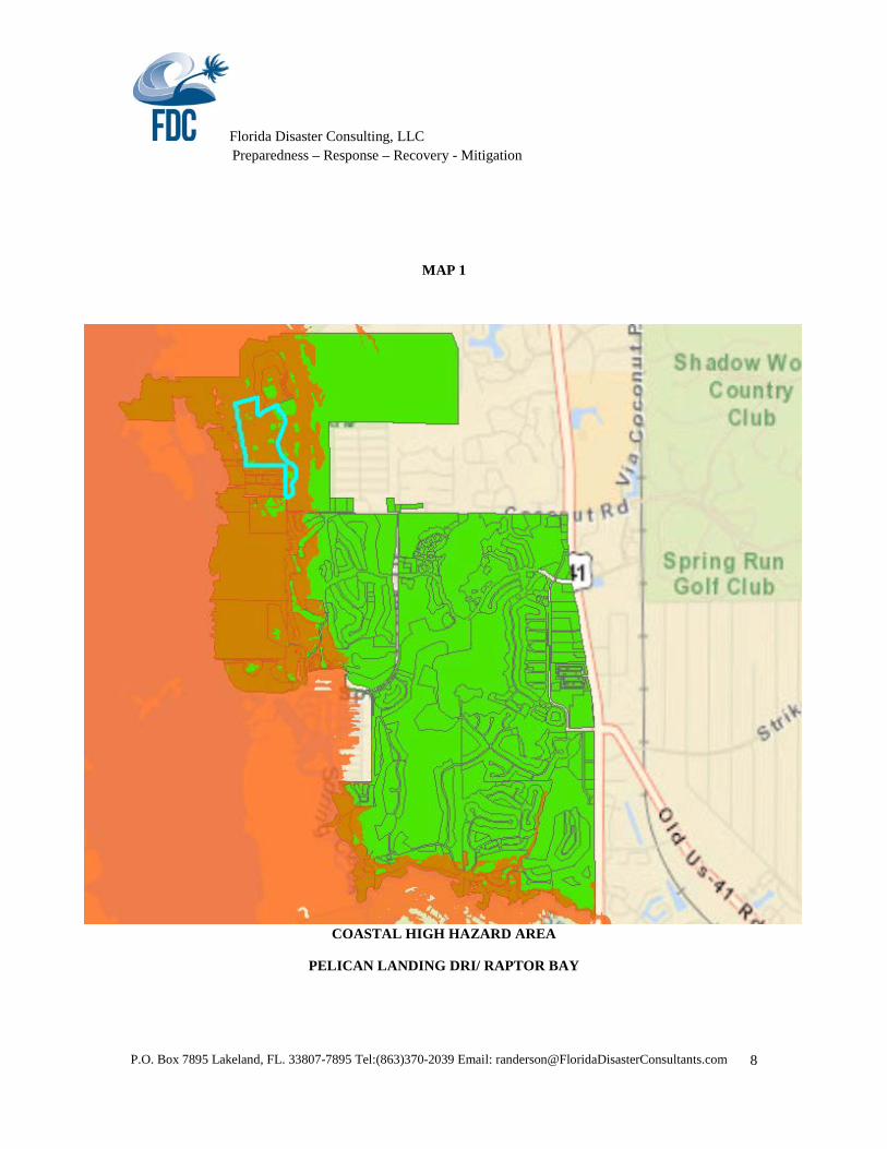
Map 1 illustrates the (new) CHHA within the Pelican Landing DRI based on the most recent Regional Evacuation Study (Volume 7-9, Lee County Storm Tide Atlas, SWFRPC, 2010). Per State Statute, the CHHA is based on the Category 1 hurricane scenario for this area (SLOSH Model, 2010) and uses the most current topographic data (LiDAR).
Florida Disaster Consulting, LLC Preparedness – Response – Recovery - Mitigation
P.O. Box 7895 Lakeland, FL. 33807-7895 Tel:(863)370-2039 Email: [email protected]
4
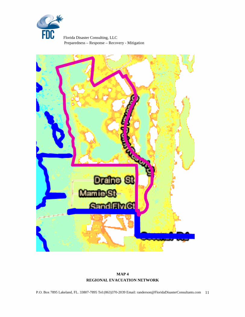
In 2013 the State of Florida, NOAA and the Southwest Florida Regional Planning Council also developed “Depth Maps” to provide emergency managers and planners with additional information with which to make decisions. Map 2 provides the depth analysis of a Category 1 hurricane - making landfall in Bonita Springs for the Raptor Bay site. This map provides the “above ground” storm surge inundation at the site. Prior to any fill or construction grading, the portion of the site where construction is anticipated is estimated to receive 0-1.5 ft. of storm surge in a worst probable Category 1 event.
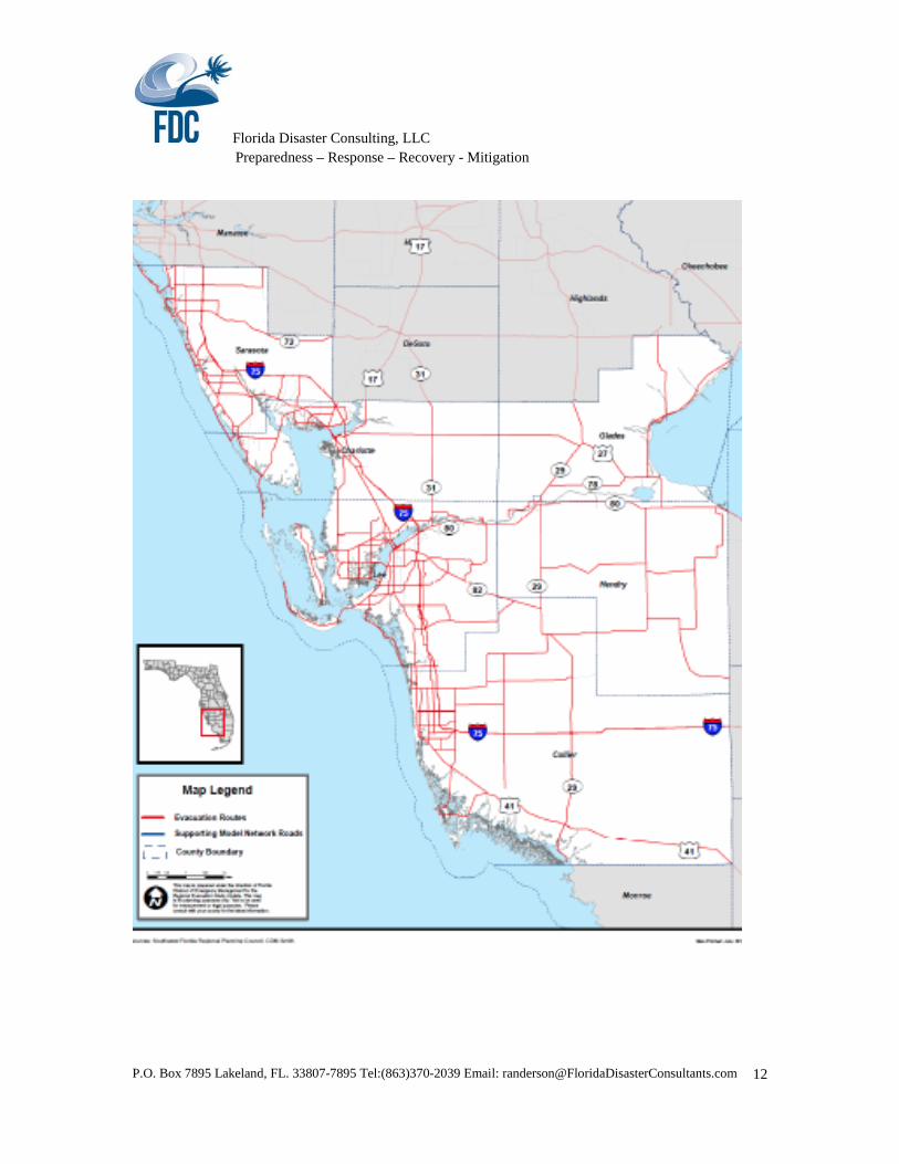
EVACUATION TRANSPORTATION IMPACTS
The Pelican Landing DRI is included in Traffic Evacuation Zone 1601 (SWFRPC, Evacuation Study, Volume 5, Transportation Evacuation Supplemental Report, 2015). It appears that the total number of units approved in 1994 are included in the dwelling unit count for 2020 evacuation projections. However, if we investigate the impact of 400 units north of Coconut Road, we can assume 282 vehicles of the total vehicles on the evacuation network (400 units at 64% occupancy and 1.1 units per unit, there is a maximum of 282 vehicles) will be generated from the proposed Raptor Bay.
The Hurricane Preparedness Policy Rule, 73C-40.0256 (formerly 9J-2.0256 FAC) states the following:
(c) When a development is proposed in a hurricane vulnerability zone and the proposed development’s anticipated evacuation traffic will utilize twenty-five (25) percent or more of an identified hurricane evacuation route’s level of service E hourly directional maximum service volume based on the Florida Department of Transportation’s Generalized Peak Hour/Peak Direction Level of Service Maximum Volumes presented in the Florida Highway Systems Plan Level of Service Standards and Guidelines Manual and hereby incorporated by reference, the proposed development will be determined by the Department to have a significant regional impact on hurricane evacuation.
The 282 vehicles of this portion of the development will not trip the threshold for impact on the regional evacuation network. See Map 4 for Regional Evacuation Routes.
CONSISTENCY WITH THE LEE COUNTY COMPREHENSIVE PLAN (LCCP)
Within the LCCP, there are policies in the Land Use and Coastal and Conservation elements that relate to the CHHA and hurricane vulnerability. Although County, as well as City, State and RPC have reviewed the pending changes with regard to the issue of hurricane mitigation, these policies will be discussed. I don’t know that they looked at the changes in regards to these issues since the mitigation had already been provided.
Conservation and Coastal Management (August 2007)
POLICY 105.1.4: Through the Lee Plan amendment process, future land use designations of undeveloped areas within coastal high hazard areas will be considered for reduced density categories in order to limit the future population exposed to coastal flooding. (Amended by Ordinance No. 92-35, 94-30, 00-22, 05-19)
The Future Land Use designation of the parcel prior to annexation was Outlying Suburban Density (6-9 units per acre), a low-density designation. The owner is requesting units clustered in (4) multi-family buildings on the upland portion of the site. This request is not a proposed increase in density. The overall density will remain at 1.5 units per acre.

Florida Disaster Consulting, LLC Preparedness – Response – Recovery - Mitigation
P.O. Box 7895 Lakeland, FL. 33807-7895 Tel:(863)370-2039 Email: [email protected]
5
POLICY 105.1.5: Zoning requests located in the coastal high hazard area will be considered for reduced or minimum density assignments, in accordance with their future land use category density range. This evaluation should be done in concert with an evaluation of other individual characteristics such as compatibility with existing uses, desired urban form, and availability of urban services. (Added by Ordinance No. 05-19)
The zoning of the parcel is consistent with prior land use designation and compatible with surrounding/ existing land use in the county.
Future Land Use (July 2010)
POLICY 5.2.6: For sites located within the Coastal High Hazard Area, proposed redevelopment (emphasis added) must:
1. Have sufficient elevation to address a storm surge from a land falling category 5 hurricane; 2. Be constructed to withstand winds of 200 mph in accordance with the Florida Building Code; 3. Utilize impact protection for all exterior openings in accordance with the Florida Building Code; 4. Be equipped with emergency power and potable water supplies to last up to five days; 5. Be protected with adequate ventilation, sanitary facilities, and first aid medical equipment; and, 6. Be designed to minimize light pollution, sky glow and light trespass beyond the property lines by
using appropriate light fixtures and other light management techniques to reduce the impact on wildlife such as sea turtles and migrating birds.
The owner has agreed to work with the County Emergency Management Division and to construct the new units to meet the requirements of post-disaster redevelopment policies. The fully engineered structures will be elevated with first floor living above the anticipated storm surge, incorporating wind and impact- resistant construction and exterior opening in accordance with the Florida Building Code, emergency power onsite and other requirements.
GOAL 109: EVACUATION AND SHELTER. To provide evacuation and shelter capabilities adequate to safeguard the public against the effects of hurricanes and tropical storms
POLICY 109.1.1: The county will assess the impact of all new residential development upon the projected hurricane evacuation network and upon projected hurricane evacuation times, and will require mitigation either through structural (on-site, off-site shelter) provisions or through non-structural methods or techniques. (Amended by Ordinance No. 00-22)
The owner has mitigated its impact on hurricane evacuation and shelter as per the DRI Development Order satisfying Policy 109.1.5 (3) and Chapter 163.3178(9), F.S.
POLICY 109.1.5: Comprehensive plan amendments that increase density within coastal high hazard areas must meet one of the following criteria in accordance with Section 163.3178(9), F.S.:
1. The proposed amendment will not exceed a 16 hour out of county hurricane evacuation time for a category 5 storm event; or
2. Maintain a 12 hour evacuation time to shelter for a Category 5 storm event and ensure shelter space is available to accommodate the additional residents of the development allowed by the proposed comprehensive plan amendment; or

Florida Disaster Consulting, LLC Preparedness – Response – Recovery - Mitigation
P.O. Box 7895 Lakeland, FL. 33807-7895 Tel:(863)370-2039 Email: [email protected]
6
3. Provide appropriate mitigation to satisfy the provisions of either of the previous two paragraphs, which may include without limitation, the payment of money, contribution of land, or construction of hurricane shelters and transportation facilities. The developer must enter into a binding agreement to memorialize the mitigation plan prior to adoption of the plan amendment. (Added by Ordinance No. 09-17)
NOTE: There is no Comprehensive plan amendment associated with the PD Amendment.
The owner has mitigated its impact on hurricane evacuation and shelter as per the DRI Development Order satisfying Policy 109.1.5 (3) and Chapter 163.3178(9), F.S.
As indicated above, in 1996, as requested and as per condition of approval in order to mitigate the shelter and evacuation impacts of the project at build-out, WCI provided to the Gateway Elementary School, a generator equipped with a fuel tank, capable of generating enough power to handle the demands of ventilation fans, lighting, life safety equipment (alarms and intercom), and refrigeration and cooking equipment. This also included necessary electrical hook-up costs. The selection of the generator was coordinated with Lee County Emergency Management Staff. In 1996 the cost of purchase and installation totaled approximately $75,000. Subject to applicable inflation rate, the current value of this completed mitigation is approximately $114,000.
GOAL 110: HAZARD MITIGATION. To provide through county plans, programs, and regulations means to minimize future property losses from natural disasters such as flooding, tropical storms and hurricanes. (See also Goal 105.) (Amended by Ordinance No. 94-30)
All property within the County pays the annual All Hazards Tax that helps to address disaster preparedness challenges in the County.
POLICY 110.1.1: Regulations and incentives will be examined for additional setbacks in critical erosion areas, conservation and enhancement of dunes and vegetation, floodproofing of utilities, and appropriate requirements for structural wind resistance and floodplain management.
The owner has set aside 143.8 acres of upland habitat preserve, 678.5 acres of salt and freshwater marsh, 247,49 acres of water management lakes, 162.16 acres of public and private rights of way and 6 acres of utility. As indicated, the proposed units will be clustered on what is currently used as golf course, moving the four holes to another location. All buildings will be constructed east of the conservation area and saltwater wetlands, approximately a half a mile from the Bay.
POLICY 110.1.3: All new residential development of more than 50 units will be required to provide continuing information to residents concerning hurricane evacuation and shelters, through the establishment of a homeowners' or residents' association. (Amended by Ordinance No. 94-30, 00-22, 07-12)
As part of the DRI Development Order, the owner provides residents with the most current information relating to natural disasters and hosts an annual public education event. (see below)

Florida Disaster Consulting, LLC Preparedness – Response – Recovery - Mitigation
P.O. Box 7895 Lakeland, FL. 33807-7895 Tel:(863)370-2039 Email: [email protected]
7
POLICY 110.1.4: All new residential development of more than l00 units will be required to formulate an emergency hurricane preparedness plan; this plan is subject to the approval of the Lee County Division of Public Safety. (Amended by Ordinance No. 94-30, 00-22, 07-12)
As part of the DRI Development Order, the owner has developed and maintains a Hurricane Plan which is submitted to the Lee County Division of Public Safety annually. In addition the owner has complied through the:
1) Notification of all purchasers of real property within the residential portions of development of the potential for storm surge and freshwater flooding.
2) In conjunction with Lee County Emergency Management, and the Division of Natural Resources staff, the preparation and distribution, brochures advising marina owners of the measures that should be taken to minimize damage in the event of a hurricane. This brochure is provided to all boat owners and users at the marina.
3) The Hotel has prepared and maintains a written hurricane preparedness and contingency plan in conjunction with the Lee County Emergency Management. This is consistent with Lee County Comprehensive Plan Policies 10.1.3 and 10.1.4.
4) The Property Owners Association hosts an annual hurricane educational seminar and is responsible for obtaining the venue and coordination with the Lee County Emergency management staff and residents.
5) The Property Owners Association developed and annually updates their hurricane evacuation plan for Pelican Landing DRI. The Plan addresses operational procedures for emergency teams (before, during and after an event), warning and notification of all residents and visitors prior to and during a hurricane watch and warning, the public safety awareness/education program, security issues and the coordination with the local Sheriff’s personnel and the Division of Public Safety. The developer has also developed and distributes additional information to residents regarding Pet Safety and Special Needs.
POLICY 110.1.7: Maintain the current county development regulations requiring that any building that is improved, modified, added on to, or reconstructed by more than twenty five (25) percent of its replacement value and which has recorded a repetitive loss as defined by the Federal Emergency Management Agency will be brought into compliance with current regulatory standards for new construction. (Amended by Ordinance No. 92-35, 94-30, 00-22, 03-04)
All construction within the Pelican Landing DRI to include the proposed development at Raptor Bay meets or exceeds the FEMA current regulatory standards for new construction.
Florida Disaster Consulting, LLC Preparedness – Response – Recovery - Mitigation
P.O. Box 7895 Lakeland, FL. 33807-7895 Tel:(863)370-2039 Email: [email protected]
8
MAP 1
COASTAL HIGH HAZARD AREA
PELICAN LANDING DRI/ RAPTOR BAY

Florida Disaster Consulting, LLC Preparedness – Response – Recovery - Mitigation
P.O. Box 7895 Lakeland, FL. 33807-7895 Tel:(863)370-2039 Email: [email protected]
9
MAP 2 PELICAN LANDING DRI CHHA DEPTH ANALYSIS
Florida Disaster Consulting, LLC Preparedness – Response – Recovery - Mitigation
P.O. Box 7895 Lakeland, FL. 33807-7895 Tel:(863)370-2039 Email: [email protected]
10
MAP 3
RAPTOR BAY STORM SURGE DEPTH ANALYSIS
Florida Disaster Consulting, LLC Preparedness – Response – Recovery - Mitigation
P.O. Box 7895 Lakeland, FL. 33807-7895 Tel:(863)370-2039 Email: [email protected]
11
MAP 4 REGIONAL EVACUATION NETWORK
Florida Disaster Consulting, LLC Preparedness – Response – Recovery - Mitigation
P.O. Box 7895 Lakeland, FL. 33807-7895 Tel:(863)370-2039 Email: [email protected]
12