penndot hpms data collection guide - · pdf file · 2017-09-121 = one-way roadway 2...
TRANSCRIPT

PENNDOTHPMS DATA COLLECTION
GUIDE
Bureau of Planning and Research Transportation Planning Division
April 2016(Updated March 2018)

State Street – Dauphin County

INTRODUCTION
The purpose of this document is to provide you with some additionalguidance for the more troublesome items you may encounter while collecting data for the Highway Performance Monitoring System (HPMS). This document is not intended to replace the current FHWA HPMS Field Manual, but rather give you another tool to aid you in the collection of the HPMS Data.
Please note: Not every data item is included in this document, only the data items we thought needed further clarification.
Several of the data items are generated from the Department’s Roadway Management System (RMS) and do not require any data entry for either the State or Local Federal Aid HPMS samples. After checking the items that are reported from RMS, if you disagree with the coding of these items, notify the coordinator responsible for your area below. If you have any further questions or comments, we encourage you to call one of the coordinators at the following numbers:
HPMS – Coordinator East:Vacant
HPMS – Coordinator West:Mr. John Moloney – (717) 787-2187
Link to December 2016 FHWA HPMS Field Manual:https://www.fhwa.dot.gov/policyinformation/hpms/fieldmanual/
PA Field Manual 2016
51 Bureau of Planning and ResearchTransportation Planning Division
NOTES
____________________________________________________
____________________________________________________
____________________________________________________
____________________________________________________
____________________________________________________
____________________________________________________
____________________________________________________
____________________________________________________
____________________________________________________
____________________________________________________
____________________________________________________
____________________________________________________
____________________________________________________
____________________________________________________
____________________________________________________
____________________________________________________
____________________________________________________
____________________________________________________
____________________________________________________

PA Field Manual 2016
50 Bureau of Planning and ResearchTransportation Planning Division
NOTES
____________________________________________________
____________________________________________________
____________________________________________________
____________________________________________________
____________________________________________________
____________________________________________________
____________________________________________________
____________________________________________________
____________________________________________________
____________________________________________________
____________________________________________________
____________________________________________________
____________________________________________________
____________________________________________________
____________________________________________________
____________________________________________________
____________________________________________________
____________________________________________________
___________________________________________________
PA Field Manual 2016
1 Bureau of Planning and ResearchTransportation Planning Division
District HPMS Coordinators
District 1-0Jacki Deeter 814-678-7359
District 2-0John Schneider 814-765-0473
District 3-0Kevin Schreffler 570-368-4340
District 4-0Sarah Fenton 570-963-4995
District 5-0Jeff Williams 610-871-4521
District 6-0Gregory Vallette 610-205-6822
District 8-0Chris Pedrick 717-787-2305
District 9-0Kevin Boslet 814-696-7115
District 10-0Vacant
District 11-0Tom Adams 412-429-4996
District 12-0Ryan Medvitz 724-439-7271

PA Field Manual 2016
2 Bureau of Planning and ResearchTransportation Planning Division
Item Value Calculation MethodPredominance - The reported value must be based on the most
prevalent value within the limits of the section.
Numbers in parenthesis after the HPMS Items are the corresponding pages for that data item in the December 2016
FHWA HPMS Field Manual
Data Items
Data Item 1 – Functional System (4-16)
The Functional System Code is the responsibility of the Bureau of Planning and Research.
1 = Interstate (01 & 11)2 = Principal Arterial – Other Freeway/Expressway (12)3 = Principal Arterial - Other (02 & 14)4 = Minor Arterial (06 & 16)5 = Major Collector (07 & 17)6 = Minor Collector (08)7 = Local (09 & 19)
(#s) = Functional Class Codes used by PennDOT
Data Item 3 – Facility Type (4-18)
This data item is the operational characteristic of the roadway, regardless of whether the section is on a structure.
PA Field Manual 2016
49 Bureau of Planning and ResearchTransportation Planning Division
NOTES
____________________________________________________
____________________________________________________
____________________________________________________
____________________________________________________
____________________________________________________
____________________________________________________
____________________________________________________
____________________________________________________
____________________________________________________
____________________________________________________
____________________________________________________
____________________________________________________
____________________________________________________
____________________________________________________
____________________________________________________
____________________________________________________
____________________________________________________
____________________________________________________
____________________________________________________

PA Field Manual 2016
48 Bureau of Planning and ResearchTransportation Planning Division
NOTES
____________________________________________________
____________________________________________________
____________________________________________________
____________________________________________________
____________________________________________________
____________________________________________________
____________________________________________________
____________________________________________________
____________________________________________________
____________________________________________________
____________________________________________________
____________________________________________________
____________________________________________________
____________________________________________________
____________________________________________________
____________________________________________________
____________________________________________________
____________________________________________________
____________________________________________________
PA Field Manual 2016
3 Bureau of Planning and ResearchTransportation Planning Division
1 = One-Way Roadway2 = Two-Way Roadway4 = Ramp5 = Non-Mainline6 = Non-Inventory Direction7 = Planned/Unbuilt
1 - One-Way Roadway A roadway or structure section with traffic moving in one direction during non-peak period hours.
2 - Two-Way Roadway A roadway or structure section with traffic moving in both directions during non-peak period hours.

PA Field Manual 2016
4 Bureau of Planning and ResearchTransportation Planning Division
4 - RampA non-mainline junction or connector that is contained within a grade-separated interchange.
Source: Google Maps – Lancaster, PA
5 - Non-Mainline A road or lane that provides access to and from sites that are adjacent to a roadway section such as bus terminals, park-and-ride lots, ramps to truck weigh stations, and rest areas.
Source: FHWA HPMS Field Manual - Bing Maps
PA Field Manual 2016
47 Bureau of Planning and ResearchTransportation Planning Division
Data Item 55 – Year Last Construction (4-117)
The year in which the roadway was constructed or reconstructed.
Reconstruction is the replacement of the existing pavement structure with an equivalent or increased structure. Although recycled materials may be used in the new pavement structure, reconstruction usually requires the complete removal and replacement of at least the old pavement surface, and often also the base.If a new pavement surface were placed without first removing the old pavement surface, the resulting pavement should be considered an overlay (surface improvement, not construction – Data Item 56), even if the existing pavement was rubblized prior to placing the new pavement surface.
Data Item 56 – Last Overlay Thickness (4-118)
Thickness of the most recent pavement overlay.
Reporting should be consistent with IRI inventory direction and lane.Values can also be obtained from construction plans for use in the Table.An overlay is more than 0.5 inch.

PA Field Manual 2016
46 Bureau of Planning and ResearchTransportation Planning Division
Longitudinal Cracking
Alligator Cracking
Data Item 54 – Year Last Improvement (4-116)
The year in which the roadway surface was last improved.
0.5 inch or more of compacted pavement material must be put in place for it to be considered a surface improvement.Completion date is the actual date the construction ended or the date when the project was opened to traffic.Retain the coded improvement year until another improvement affecting the surface is completed.
PA Field Manual 2016
5 Bureau of Planning and ResearchTransportation Planning Division
6 - Non-Inventory Direction The non-inventory side of a multi-road roadway.
Source: FHWA HPMS Field Manual - Bing Maps
Data Item 5 – Access Control (4-26)
This data item is the degree of access control on the section.
1- Full Access ControlGrade separated interchanges with selected public roads. No at-grade crossings.No direct driveway connections.
PA Field Manual 2016
6 Bureau of Planning and ResearchTransportation Planning Division
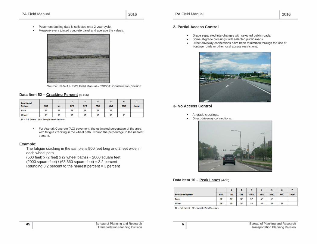
2- Partial Access Control
Grade separated interchanges with selected public roads.Some at-grade crossings with selected public roads. Direct driveway connections have been minimized through the use of frontage roads or other local access restrictions.
3- No Access Control
At-grade crossings.Direct driveway connections.
Data Item 10 – Peak Lanes (4-33)
PA Field Manual 2016
45 Bureau of Planning and ResearchTransportation Planning Division
Pavement faulting data is collected on a 2-year cycle.Measure every jointed concrete panel and average the values.
Source: FHWA HPMS Field Manual – TXDOT, Construction Division
Data Item 52 – Cracking Percent (4-106)
For Asphalt Concrete (AC) pavement, the estimated percentage of the area with fatigue cracking in the wheel path. Round the percentage to the nearest percent.
Example:The fatigue cracking in the sample is 500 feet long and 2 feet wide in each wheel path.(500 feet) x (2 feet) x (2 wheel paths) = 2000 square feet(2000 square feet) / (63,360 square feet) = 3.2 percentRounding 3.2 percent to the nearest percent = 3 percent

PA Field Manual 2016
44 Bureau of Planning and ResearchTransportation Planning Division
Source: FHWA HPMS Field Manual – TXDOT, Construction Division
Data Item 51 – Faulting (4-102)
This data item is the average depth of pavement faulting on the section, rounded to the nearest 0.1 inch.
Pavement faulting is the vertical displacement between adjacent jointed concrete panels in the direction of travel.
Source: FHWA HPMS Field Manual - LTPP Distress & Identification Manual
PA Field Manual 2016
7 Bureau of Planning and ResearchTransportation Planning Division
This data item is the number of through lanes in the peak direction of traffic flow on the section during the peak hour.
Include reversible lanes, parking lanes, and shoulders that are legally used for through traffic for non-High Occupancy Vehicle (HOV) and High Occupancy Vehicle (HOV) operation.If the section is an urban roadway, code the peak direction.If the section is a rural roadway with 2 - 3 lanes, code both directions.If the section is a rural roadway with 4 or more lanes, code the peak direction.[(the number of peak lanes) + (the number of counter peak lanes)]
lanes)The peak period is represented by the period of the day when observed traffic volumes are the highest.
One-Way Through Lanes - Peak Direction
Two-Way Through Lanes - Peak Direction

PA Field Manual 2016
8 Bureau of Planning and ResearchTransportation Planning Division
Data Item 11 – Counter Peak Lanes (4-34)
This data item is the number of through lanes used on the section in the counter peak direction during the peak hour.
Include reversible lanes, parking lanes, and shoulders that are legally used for through traffic.[(the number of peak lanes) + (the number of counter peak lanes)]
lanes)For urban roads, code based on the counter peak direction of travel.For rural 2 or 3-lane roads, do not code this data item.
Data Item 12 – Turn Lanes - Right (4-34)
This data item is the type of right turning lanes or bays on the urban section in the inventory direction during peak-period.
PA Field Manual 2016
43 Bureau of Planning and ResearchTransportation Planning Division
The following data items are to be visually verified in the field and should be noted if they do not appear to be accurate. Actual measurements are not to be completed.
Data Item 50 – Rutting (4-99) This data item is the average depth of pavement rutting on the section, rounded to the nearest 0.1 inch.
A rut is a longitudinal surface depression in the wheel path of the pavement and it may have associated transverse displacement.
Source: FHWA HPMS Field Manual - LTPP Distress & Identification Manual
Measure the pavement rutting and round the value to the nearest 0.1 inch.Measure each wheel path of the pavement in multiple locations and average the values.Pavement rutting data is collected on a 2-year cycle.

PA Field Manual 2016
42 Bureau of Planning and ResearchTransportation Planning Division
Passing Not Allowed in Either Direction of Travel
PA Field Manual 2016
9 Bureau of Planning and ResearchTransportation Planning Division
1 = No Intersections Exist on the Section2 = Multiple Exclusive Right Turning Lanes3 = Continuous Exclusive Right Turning Lane4 = Single Exclusive Right Turning Lane5 = Right Turns Allowed from Through Lane6 = Right Turns not Allowed During Peak Period
If the peak capacity for a section is governed by a controlling intersection, code the type of turning lanes at that controlling intersection.When determining the types of turning lanes on a section, include turning lanes that are located at entrances to shopping centers, industrial parks, and other large traffic generating facilities.Through traffic movement is prohibited in an exclusive turning lane.If a section has a signalized or stop sign intersection that is critical to the flow of traffic, code the type of turning lanes at that critical intersection.If a section does not have a controlling, signalized, or stop sign intersection, code the type of turning lanes during the peak hour for a typical intersection on the section.If an intersection has a continuous turning lane with a painted turn bay, code the intersection as a continuous turning lane.If through traffic and turning movements can be made from a lane at an intersection, it is not an exclusive turning lane.If a section has a roundabout, code the intersection as an intersection where turns are permitted and no exclusive right turning lane exists.Use code 6 when “no right turn permitted” signs are present at the intersection you choose as the busiest (most controlling). It should also be used if right turns cannot physically be made along the sample due to roadway conditions and access control is coded as “2” or “3”.Use code “1” when access control is coded as “1”.
1 - No Intersection No intersections exist in the section.

PA Field Manual 2016
10 Bureau of Planning and ResearchTransportation Planning Division
2 - Multiple Right Turning LanesRight turn is permitted from multiple exclusive right turning lanes. Through traffic movement is prohibited in these lanes. Multiple turning lanes allow for simultaneous turns from all turning lanes.
3 - Continuous Right Turning Lane Right turn is permitted from a continuous exclusive right turning lane. Through traffic movement is prohibited in these lanes.
4 - Single Right Turning Lane Right turn is permitted from a single exclusive right turning lane.
PA Field Manual 2016
41 Bureau of Planning and ResearchTransportation Planning Division
Passing Allowed in Both Directions of Travel
Passing Not Allowed in Inventory Direction of Travel
Passing Not Allowed in Non-Inventory Directions of Travel

PA Field Manual 2016
40 Bureau of Planning and ResearchTransportation Planning Division
3 - Mountainous Terrain Any combination of grades and horizontal or vertical alignment that causes heavy vehicles to operate at extremely low speeds for significant distances or at frequent intervals.
Data Item 46 – Percent Pass Sight (4-90)
This data item is the percentage of a section that meets the sight distance requirement for passing.
When there is a pronounced directional difference, code for the morerestrictive direction.
All rural, paved, 2-lane Sample Panel sections.
The percentage of passing sight distance = [(the length of the section that is striped for passing allowed) / (the length of the section)] * 100
PA Field Manual 2016
11 Bureau of Planning and ResearchTransportation Planning Division
5 - Right Turn Allowed from Through Lane Right turn is allowed from a through lane. There is not an exclusive turning lane.
6 - Right Turns Not Allowed
Data Item 13 – Turn Lanes - Left (4-39)
This data item is the type of left turning lanes or bays on the urban section in the inventory direction during peak period.

PA Field Manual 2016
12 Bureau of Planning and ResearchTransportation Planning Division
1 = No Intersections Exist on the Section2 = Multiple Exclusive Left Turning Lanes3 = Continuous Exclusive Left Turning Lane4 = Single Exclusive Left Turning Lane5 = Left Turns Allowed from Through Lane6 = Left Turns not Allowed During Peak Period
If the peak capacity for a section is governed by a controlling intersection, code the type of turning lanes at that controlling intersection.When determining the types of turning lanes on a section, include turning lanes that are located at entrances to shopping centers, industrial parks, and other large traffic generating facilities.Through traffic movement is prohibited in an exclusive turning lane.If a section has a signalized or stop sign intersection that is critical to the flow of traffic, code the type of turning lanes at that critical intersection.If a section does not have a controlling, signalized, or stop sign intersection, code the type of turning lanes during the peak-hour for a typical intersection on the section.If an intersection has a continuous turning lane with a painted turn bay, code the intersection as a continuous turning lane.If through traffic and turning movements can be made from a lane at an intersection, it is not an exclusive turning lane.Use code 6 when “no left turn permitted” signs are present at the intersection you choose as the busiest (most controlling). It should also be used if left turns cannot physically be made along the sample due to roadway conditionsand access control is coded as “2” or “3”.Use code “1” when access control is coded as “1”.
1 - No Intersection No intersections exist in the section.
PA Field Manual 2016
39 Bureau of Planning and ResearchTransportation Planning Division
1 - Level Terrain Any combination of grades and horizontal or vertical alignment that permits heavy vehicles to maintain the same speed as passenger cars. This includes short grades of not more than 2 percent.
2 - Rolling Terrain Any combination of grades and horizontal or vertical alignment that causes heavy vehicles to reduce their speeds substantially below those of passenger cars, but does not cause heavy vehicles to operate at crawl speeds for any significant length of time.

PA Field Manual 2016
38 Bureau of Planning and ResearchTransportation Planning Division
Data Item 42 – Widening Potential (4-84)
This data item is the number of through lanes that could be potentially added to the roadway, in both directions.
If more than 9 through lanes could be potentially added, code as 9 lanes.Code this item based on how feasible it is to widen the existing roadway, based on the presence of obstacles and the proximity of the obstacle to the roadway.Consider medians, areas within the existing right-of-way, and areas outside the existing right-of-way to be available for widening.Do not consider restriction because of current right-of-way width or projected traffic.Restriping to narrower lanes, resulting in an additional lane on a multi-lane roadway does not constitute widening potential.
Data Item 44 – Terrain Type (4-87)
To determine terrain type, consider that terrain of an extended length of the roadway of the section, rather than the grade on the specific Sample Panel section.
Terrain type should be collected on Rural sample sections only.
1 = Level2 = Rolling3 = Mountainous
PA Field Manual 2016
13 Bureau of Planning and ResearchTransportation Planning Division
2 - Multiple Left Turning Lanes Left turn is permitted from multiple exclusive left turning lanes. Through traffic movement is prohibited in these lanes. Multiple turning lanes allow for simultaneous turns from all turning lanes.
3 - Continuous Left Turning Lane Left turn is permitted from a continuous exclusive left turning lane. Through traffic movement is prohibited in these lanes.
4 - Single Left Turning Lane Left turn is permitted from a single exclusive left turning lane.

PA Field Manual 2016
14 Bureau of Planning and ResearchTransportation Planning Division
5 - Left Turn Allowed from Through Lane Left turn is allowed from a through lane. There is not an exclusive turning lane.
6 - Left Turns Not Allowed
Data Item 14 – Speed Limit (4-44)
Use the Vehicle Code—Title 75 if the speed limit is not posted.
35 mph in any urban district (boroughs, cities)25 mph in a residential district if the roadway is one of the following:o Not a numbered traffic route o Functionally classified as a local highway.
55 mph in other locations
If the speed limit changes within a section, report the predominant speed limit.
PA Field Manual 2016
37 Bureau of Planning and ResearchTransportation Planning Division
F – Environmentally Sensitive Areas
G – Parkland

PA Field Manual 2016
36 Bureau of Planning and ResearchTransportation Planning Division
D – Terrain Restrictions
E – Historic/Archaeological Sites
PA Field Manual 2016
15 Bureau of Planning and ResearchTransportation Planning Division
Data Item 17 – Route Number (4-47)
If two or more routes of the same functional system are signed along a roadway section (i.e. US 11 and US 15), code the lowest route number (i.e., US 11). If two or more routes of differing functional systems are assigned along a roadway section (i.e. Interstate 78 and US 22), code the data item in accordance with the highest functional system on the route (in this example, Interstate 78).
Data Item 18 – Route Signing (4-48)
1 = Not Signed 6 = County2 = Interstate 7 = Township3 = US 8 = Municipal4 = State 9 = Parkway/Forest Marker5 = Off-Interstate Business Marker 10 = None of the Above
When a section is signed with two or more identifiers (i.e. Interstate 83 and US 322), code the highest order identifier on the route (in this example, Interstate 83). Follow the hierarchy as ordered above.

PA Field Manual 2016
16 Bureau of Planning and ResearchTransportation Planning Division
Data Item 19 – Route Qualifier (4-49)
1 = No Qualifier/Not Signed 6 = Loop2 = Alternate 7 = Proposed3 = Business Route 8 = Temporary4 = Bypass Business 9 = Truck Route5 = Spur 10 = None of the Above
PA Field Manual 2016
35 Bureau of Planning and ResearchTransportation Planning Division
A – Dense Development
B – Major Transportation Facilities
C – Other Public Facilities (i.e. School, Hospital, and Library)

PA Field Manual 2016
34 Bureau of Planning and ResearchTransportation Planning Division
Data Item 41 – Widening Obstacle (4-82) This data item is the types of obstacles that prevent the widening of the existing roadway for additional through lanes. One or more types of obstacles can be entered.
Code obstacles that are within approximately 100 feet of the outer edge of the through lanes in either direction on the section.Code all conditions that apply in either direction, on either side of the section.Enter any combination of multiple codes.Code X - no obstacles, cannot be used in combination of another code.If Data Item 42 (Widening Potential) is coded ‘8’ lanes or less, then this data item should be coded “A” through “G”.
X = No ObstaclesA = Dense DevelopmentB = Major Transportation FacilitiesC = Other Public FacilitiesD = Terrain RestrictionsE = Historic/Archaeological SitesF = Environmentally Sensitive AreasG = Parkland
X – No Obstacles
PA Field Manual 2016
17 Bureau of Planning and ResearchTransportation Planning Division
Data Item 20 – Alternate Route Name (4-51)
A non-numeric designation for a route. Examples for this data item would be “Schuylkill Expressway” (PA), “Pacific Coast Highway” (CA) and the “Garden State Parkway” (NJ). Data Item 29 – Signal Type (4-61)
As a best practice, contact the respective PennDOT Engineering Districtfor the signals in question to obtain information on the type of signal andgreen time.
1 = Uncoordinated Fixed Time2 = Uncoordinated Traffic Actuated3 = Coordinated Progressive
(coordinated signals through several intersections)4 = Coordinated Real-time Adaptive5 = No signal system exists

PA Field Manual 2016
18 Bureau of Planning and ResearchTransportation Planning Division
Data Item 30 – Percent Green Time (4-63)
This data item is the percentage of green time allocated during peakperiod (i.e. 7am – 9am or 4pm – 6pm) for through traffic at signalized intersections on the section in the inventory direction.
If the section has more than one signalized intersection, calculate the percent green time at the predominate intersection.If the signal has a green arrow for turning movements, do not include the green arrow time for timing of the green cycle.Uncoordinated Traffic Actuated Signals require a value.
To Calculate Percent Green Time
1. Using a stop watch, time the entire signal cycle (red, amber, and green) in seconds.
2. Using a stop watch, time the green signal cycle in seconds.3. Percent Green Time = [(green signal cycle time)/ (entire signal cycle time)] *
1004. Record the time and repeat Steps 1-3 three times.5. Add the percent green times and divide by 3.6. Average percent green time = [(percent green time) + (percent green time)
+ (percent green time)] / 3
Data Item 31 – Number Signals (4-65)
This data item is the number of signalized at-grade intersections on the section that control traffic in the inventory direction.
A signalized intersection has a traffic signal which cycles through red, amber, and green.If the access point to a large traffic generator (i.e. shopping centers, malls, large work sites, office parks, apartment complexes, and subdivisions) is controlled by a traffic signal, the access point is considered an intersection.If a section begins and ends at a signalized intersection, only count the ending intersection. Do not count the beginning intersection.If the section has a continuous cross street on a divided highway, count the intersections as a single intersection.
PA Field Manual 2016
33 Bureau of Planning and ResearchTransportation Planning Division
1 - Parking Allowed On One Side
2 - Parking Allowed On Both Sides
3 – No Parking Allowed (Rural Roadway)

PA Field Manual 2016
32 Bureau of Planning and ResearchTransportation Planning Division
This data item is the width of the left shoulder on a divided highway, rounded to the nearest foot.
Do not include parking or bicycle lanes in the shoulder width.
Left shoulders are only coded on a divided HighwayIf median width and left shoulder width combined is less than 4 feet, then the left shoulder width is zero.Code left shoulder widths only if median and left shoulder width combined is more than 4 feet.Where the width changes along the sample, code the predominant widthInclude rumple strips and gutter pansMeasure to the nearest foot
Data Item 40 – Peak Parking (4-80) This data item is the type of parking on the section during the peak hour.
If parking is available beyond the shoulder, code as No Parking Allowed (code value 3)Code Interstates and Freeways as No Parking Allowed (code value 3).If parking lanes are used for through traffic or turning lanes during the peak hour, code the in-use condition.
1 = Parking Allowed on One Side2 = Parking Allowed on Both Sides3 = No Parking Allowed
PA Field Manual 2016
19 Bureau of Planning and ResearchTransportation Planning Division
If the section has a non-continuous cross street that is separated by a minimum of 50 feet, count both intersections.
Data Item 32 – Stop Signs (4-66)
This data item is the number of stop sign controlled at-grade intersections on the section that control traffic in the inventory direction.
If an intersection is controlled by a continuously operating flashing red signal, count the intersection as a Stop Sign Controlled Intersection.Do not count stop signs on the intersecting roads.If the access point to a large traffic generator (i.e. shopping centers, malls, large work sites, office parks, apartment complexes, and subdivisions) is controlled by a stop sign, the access point is considered an intersection.If a section begins and ends at a stop-sign controlled intersection, only count the ending intersection. Do not count the beginning intersection.If the section has a non-continuous cross street that is separated by a minimum of 50 feet, count both intersections.
Data Item 33 – At Grade Other (4-68)

PA Field Manual 2016
20 Bureau of Planning and ResearchTransportation Planning Division
This data item is the number of at-grade intersections on the section in the inventory direction where traffic is not controlled by either a signal or a stop sign; is controlled by other types of signage or some other devices.
If an intersection is controlled by a continuously operating flashing yellow signal, count the intersection as an At Grade Other Intersection.If the access point to a large traffic generator (i.e. shopping centers, malls, large work sites, office parks, apartment complexes, and subdivisions) is controlled by a stop sign, the access point is considered an intersection.If a section begins and ends at an intersection controlled by a device other than a traffic signal or stop sign, only count the ending intersection. Do not count the beginning intersection.If an intersection is a roundabout, code as At Grade Other Intersection.At Grade Other intersections are not counted on the opposite side of the sample on divided highways with medians, unless a crossover lane exists.If the cross street is not continuous and is separated by at least 50 feet, then it should be counted as two intersections.
Data Item 34 – Lane Width (4-70)
This data item is the measure of the existing lane width, rounded to the nearest foot.
Although RMS has minimum (6 feet) and maximum (18 feet) allowable entries, please report the actual measured lane widths.
To Measure Lane WidthMeasure the prevailing through lane width. Round the value to the nearest foot.
When striping exists, count the lane width from paint line to paint line.
PA Field Manual 2016
31 Bureau of Planning and ResearchTransportation Planning Division
Data Item 38 – Shoulder Width - Right (4-77)
Do not include parking or bicycle lanes in the shoulder width.
This data item is the width of the right shoulder, rounded to the nearest foot.
Where the width changes along the sample, code the predominant widthInclude rumple strips and gutter pansMeasure to the nearest foot
Data Item 39 – Shoulder Width - Left (4-79)

PA Field Manual 2016
30 Bureau of Planning and ResearchTransportation Planning Division
5- Combination
Source: FHWA HPMS Field Manual
Do not use a code ‘5’ (combination) because 90% of PA shoulders would be a ‘5’.
Example: If the shoulder cross section is 2 foot paved and 3 foot stabilized, record the surface type as stabilized, Type ‘4’.
6- Earth
7- Barrier Curb/No Shoulder
PA Field Manual 2016
21 Bureau of Planning and ResearchTransportation Planning Division
When striping is placed inside the edge of the pavement, to keep traffic from breaking the pavement edge, ignore the striping and measure from the pavement edge to the center of a single center stripe, or, if double striping exists, measure to the center of the two stripes.If parking is allowed, use six to eight feet for parking. The remaining distance would be your lane width. Remain consistent with all samples, unless there are painted parking lines.Where there is no delineation between the through traffic lane and the shoulder or parking lane, or where there is no centerline, measure the entire width of roadway, divide by 2, and deduct the parking width. Report the actual lane width.If more than one lane exists, measure all lanes in the inventory direction and use the average value to the nearest foot. If widths vary over the sample section use the predominant width.
2 Lane Road
Measure from the white stripe to the center of the double yellow stripe. Round the value to the nearest foot.

PA Field Manual 2016
22 Bureau of Planning and ResearchTransportation Planning Division
3 Lane RoadMeasure from the white stripe to the center of the double yellow stripe and divide the value by 2. Round the value to the nearest foot.
4 Lane RoadMeasure from the white stripe to the center of the double yellow stripe and divide the value by 2. Round the value to the nearest foot.
No Shoulder
Measure between the points where the edge of the road appears to break away and slope toward the ditch and divide the value by 2. Round the value to the nearest foot.
PA Field Manual 2016
29 Bureau of Planning and ResearchTransportation Planning Division
2- Surfaced-bituminous
Source: FHWA HPMS Field Manual
3- Surfaced-concrete
4- Stabilized
Source: FHWA HPMS Field Manual

PA Field Manual 2016
28 Bureau of Planning and ResearchTransportation Planning Division
A bike lane must be signed or delineated by pavement markings to be considered a bike lane. If the section has a bike lane abutting the throughlane, there is not an area that is considered a shoulder. Code as No Shoulder (code value 1).If there is parking abutting the through-lane, there is not an area that is considered a shoulder. Code as No Shoulder (code value 1).If there is parking on one side of a divided roadway and a shoulder or a curb on the other side, code the Peak Parking Type, Shoulder Type, and Shoulder Width.If there is a surface type change between the lane and curb or striping is present, code the Shoulder Type and Shoulder Width.Do not use combination shoulder, code “5”.Local Federal Aid Route Samples ONLYo If a barrier curb and paved shoulder appear to exist simultaneously:
If no striping exists, code as Barrier Curb.If striping exists and measurement from curb to white line is less than 6 feet, code as Barrier Curb.If striping exists and measurement from curb to white line is 6 feet or greater, code the Shoulder Type and Shoulder Width.
For State Highway Sampleso Do not change Shoulder Type the District has chosen.
1= None2= Surfaced – bituminous3= Surfaced – concrete 4= Stabilized5= Combination6= Earth7= Barrier Curb – no shoulder in front of curb
1- None
PA Field Manual 2016
23 Bureau of Planning and ResearchTransportation Planning Division
No Center LineMeasure the full width of the road and divide the value by 2. Round the value to the nearest foot.If the gutter has been filled during overlay, measure between the points where the edge of the road meets the curb face and divide the value by 2.
Interstate
Measure one lane. Round the value to the nearest foot.
Bike LanesPennDOT Publication 13M – Defined as a portion of a roadway which has been designated by striping, signing, and pavement markings for the preferential or exclusive use of bicyclists.A bicycle symbol with directional arrows placed on the roadway designate “Marked Shared Lanes” as defined in the AASHTO Guide for the Development of Bicycle Facilities 2012, Fourth Edition and MUTCO. This is not a designated bike lane and should not be marked on the sample sheet as “Y” bike lane exists.Do not include bike lane width in shoulder with if shoulder exists along with a bike lane.Do not include bike lane width in travel lane width.

PA Field Manual 2016
24 Bureau of Planning and ResearchTransportation Planning Division
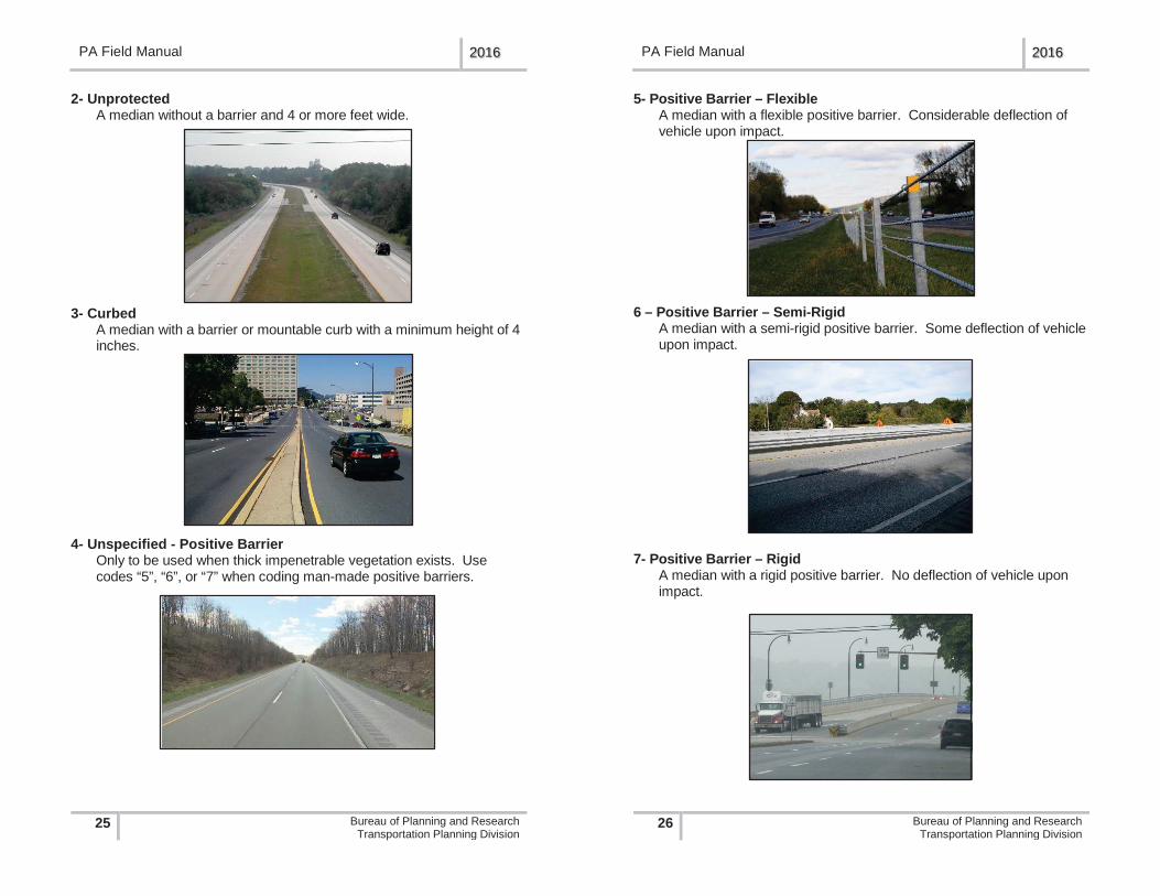
Data Item 35 – Median Type (4-71)
This data item is the type of median on the section.
A median is the portion of a divided highway that is separating the traveled way for traffic in opposing directions.
1 = None2 = Unprotected 3 = Curbed4 = Positive Barrier – Unspecified5 = Positive Barrier – Flexible6 = Positive Barrier – Semi-Rigid7 = Positive Barrier – Rigid
1- None No median or an unprotected area less than 4 feet wide.
PA Field Manual 2016
27 Bureau of Planning and ResearchTransportation Planning Division
Data Item 36 – Median Width (4-73)
This data item is the width of the median on the section, rounded to the nearest foot.
Enter “999” where the median width is 1000 feet or greater. Median width should be the predominant width including any left shoulders. Measure between the inside edges of the through lanes.
Data Item 37 – Shoulder Type (4-74)
If the shoulder type varies over the extent of the section, code the predominant Shoulder Type.If the left and right shoulder types are different shoulder types, code the right shoulder type as the predominant Shoulder Type.If there is a shoulder in front of a barrier curb, code the Shoulder Type and Shoulder Width. Code the shoulder if it is at least one foot (1ft) or greater. Do not code the area behind the barrier curb as a shoulder.Ignore mountable curbs. If there is a shoulder in front of or behind a mountable curb, code the Shoulder Type and Shoulder Width.If the section has parking abutting the through lane, there is not an area that is considered a shoulder. Code as No Shoulder (code value 1).
PA Field Manual 2016
26 Bureau of Planning and ResearchTransportation Planning Division
5- Positive Barrier – FlexibleA median with a flexible positive barrier. Considerable deflection of vehicle upon impact.
6 – Positive Barrier – Semi-RigidA median with a semi-rigid positive barrier. Some deflection of vehicle upon impact.
7- Positive Barrier – RigidA median with a rigid positive barrier. No deflection of vehicle upon impact.
PA Field Manual 2016
25 Bureau of Planning and ResearchTransportation Planning Division
2- Unprotected A median without a barrier and 4 or more feet wide.
3- Curbed A median with a barrier or mountable curb with a minimum height of 4 inches.
4- Unspecified - Positive Barrier Only to be used when thick impenetrable vegetation exists. Use codes “5”, “6”, or “7” when coding man-made positive barriers.