permian – 225 million years ago triassic – 200 million years ago
TRANSCRIPT


Alfred Wegener Continents fit together
like a jigsaw puzzle Named supercontinent
Pangaea.

Continental Drift Theory(Theory of Plate Tectonics)
Theory that continents move slowly about earth’s surface, changing their positions relative to one another.
Not widely accepted He didn’t know why plates move.

Supporting Evidence Continental shelf Geological Features Match Fossils Paleoclimatic data

Continental Shelf
• Gently sloping platform between the shoreline and the steeper slope that leads to the deep ocean floor.
• Found that continents fit even better at shorelines.

Geological Features and Fossils
Rocks on different continents match up. Mountain systems in Africa and South
America show strong evidence of previously being joined.
Fossils of identical land-dwelling animals and identical trees are found in South America, India, Australia, and Antarctica.
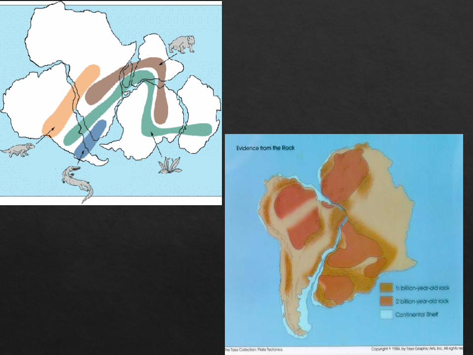

Paleoclimatic Means “ancient
climate” Huge ice sheet
covered parts of South America, south Africa, India, and southern Asia

Permian – 225 Million Years ago

Triassic – 200 Million Years ago

Jurassic – 135 Million Years ago
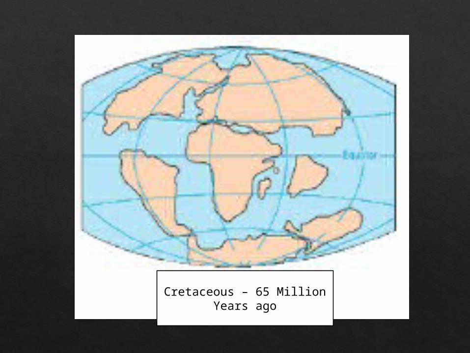
Cretaceous – 65 Million Years ago

Present Day

WHAT WILL THE CONTINETS LOOK LIKE IN THE FUTURE?

Seafloor Spreading Hypothesis presented by H. H. Hess, an
America Geologist. Said seafloor was not permanent Mid-ocean ridges – underwater mountains Located above convection cells in mantle

Supporting Evidence for Hess Paleomagnetism – Study of magnetization in a rock.
Creates a record of dipole changes in Earth’s magnetism.

Provides evidence that poles have flipped overtime
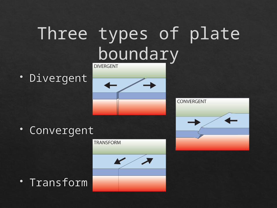
Divergent
Convergent
Transform
Three types of plate boundary

Convergent Plate Boundaries Plates come together Motion due to convection cells pushing plates toward
each other

There are three types of convergent plate boundaries Continent-continent collision
Continent-oceanic crust collision
Ocean-ocean collision
Convergent Boundaries

Forms mountains, e.g. European Alps, Himalayas
Continent-Continent Collision

Called SUBDUCTION
Continent-Oceanic Crust Collision

Oceanic lithosphere subducts underneath the continental lithosphere
Oceanic lithosphere heats and dehydrates as it subsides
The melt rises forming volcanism
E.g. The Andes
Subduction

When two oceanic plates collide, one runs over the other which causes it to sink into the mantle forming a subduction zone.
The subducting plate is bent downward to form a very deep depression in the ocean floor called a trench.
The worlds deepest parts of the ocean are found along trenches. E.g. The Mariana Trench is 11 km deep!
Ocean-Ocean Plate Collision

Spreading ridges As plates move apart new material is
erupted to fill the gap
Divergent Boundaries

Mid-Atlantic RidgeDivergent Boundary

Where plates slide past each other
Transform Boundaries
Above: View of the San Andreas transform fault
…what’s the connection?
Volcanoes and Plate Tectonics…


Volcanoes• Holes or vents where magma can
rise to surface• Magma – below surface• Lava – above surface
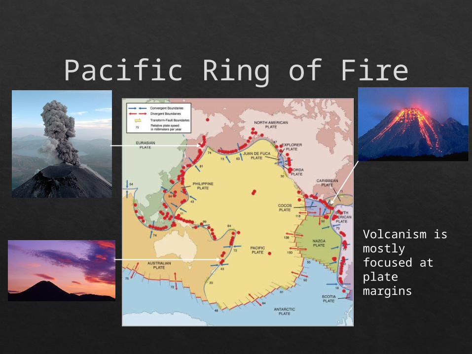
Volcanism is mostly focused at plate margins
Pacific Ring of Fire

- Subduction - Rifting - Hotspots
Volcanoes are formed by:

Rifting Separation at a divergent boundary that is
filled in with magma.

Hot mantle plumes breaching the surface in the middle of a tectonic plate
What are Hotspot Volcanoes?
The Hawaiian island chain are examples of hotspot volcanoes.

The tectonic plate moves over a fixed hotspot forming a chain of volcanoes.
The volcanoes get younger from one end to the other.

Lava Types Pahoehoe lava - smooth and dense A‘a - porous and very jagged.

Factors That affect eruption
• Water Vapor• More water vapor = bigger explosion
• Trapped Gasses• Easy escape = quiet eruption• Difficult to escape = explosive eruption
• Magma Type• Basaltic Magma = quiet explosion • Granitic/Andesitic = violent eruptions

Composite Cone• Alternating layers of lava, ash, and
mud• Most violent eruption• Magma does not flow easily,
pressure builds up• Ex. Mount St. Helens

Shield Volcanoes• Built by a steady supply of easily
flowing lava – broad, gently sloping cone.
• Erupt quietly• Mauna Loa, Hawaii

Cinder Cones• Very steep, rise more than 300
meters above ground level.• Formed from piling up of ash,
thephra (solidified lava), cinders, and rocks.
• Ex. Paricutin, Mexico

Magma Chamber – large underground pool of liquid rock.
Crater – bowl shaped depression that forms around the central vent.
Vent – opening in crust through which magma erupts to the surface.
Lava flow – magma that flows at the summit of a volcano onto the surface of Earth.

Conduit – tube-like structure that allows magma to reach the surface
Caldera – large crater that can form when the summit or side collapse
Sill – pluton that forms when magma intrudes parallel rock layers
Dike – cuts across preexisting rocks
Laccolith – small, mushroom shape, that forms when magma intrudes rock.


…what’s the connection?
Earthquakes and Plate Tectonics…
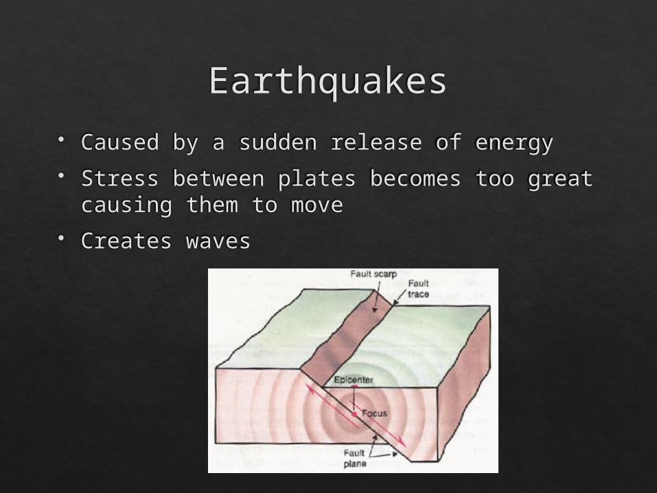
Earthquakes Caused by a sudden release of energy Stress between plates becomes too great
causing them to move Creates waves

As with volcanoes, earthquakes are not randomly distributed over the globe
At the boundaries between plates, friction causes them to stick together. When built up energy causes them to break, earthquakes occur.

Earthquakes occur along plate boundaries and faults. 3 types of faults:
Reverse Normal Strike-slip
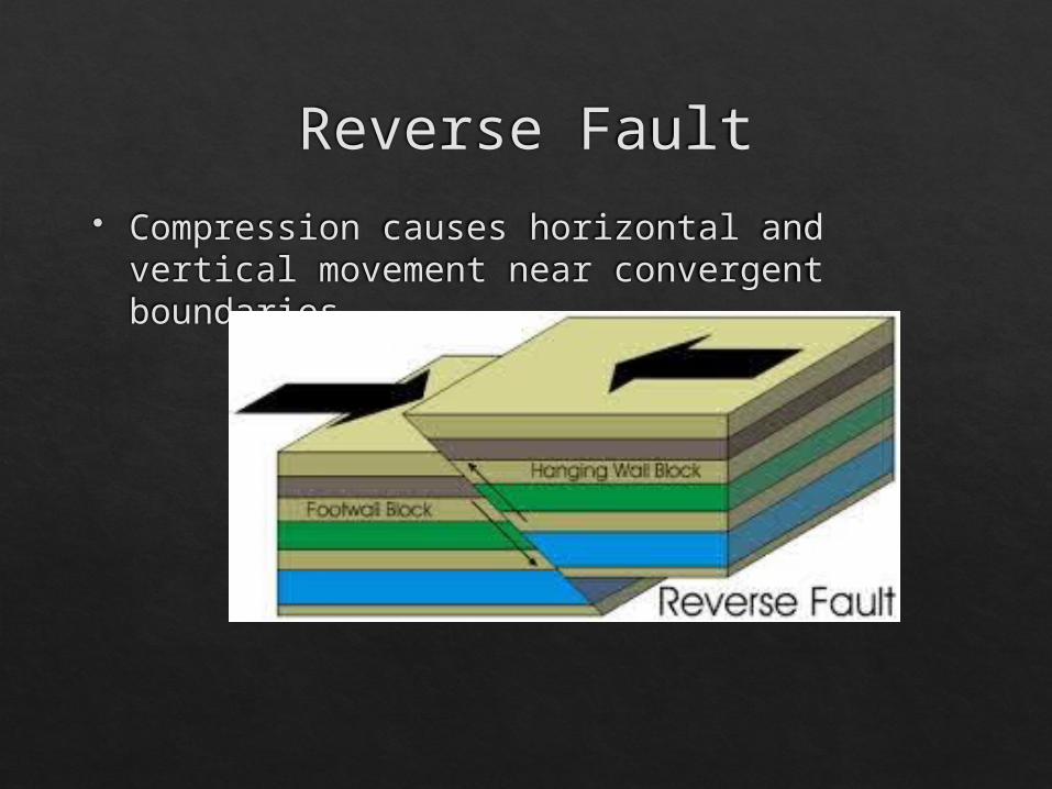
Reverse Fault Compression causes horizontal and vertical
movement near convergent boundaries.

Normal Fault Tension causes horizontal and vertical
movement near divergent boundaries.

Strike-Slip Fault Shear causes horizontal movement near
transform boundaries.

EARTHQUAKE WAVES FOCUS = place deep within the Earth and along the
fault where rupture occurs
EPICENTER = geographic point on surface directly above focus

EARTHQUAKE WAVESSeismographs record earthquake waves
Seismograms show:• Amplitude of seismic waves (how much rock
moves or vibrates)
• Distance to the epicenter
• Earthquake direction

Seismic Waves Earthquake-generated waves that travel
through Earth interior Wave speed depends on medium it travels
through Used to learn about composition of Earth’s
layered interior (ex. Ultrasound)

Primary Waves (P) Like sound waves, are longitudinal – they
compress and expand the rock as they move through it
First detected on seismograph Travel through any type of material
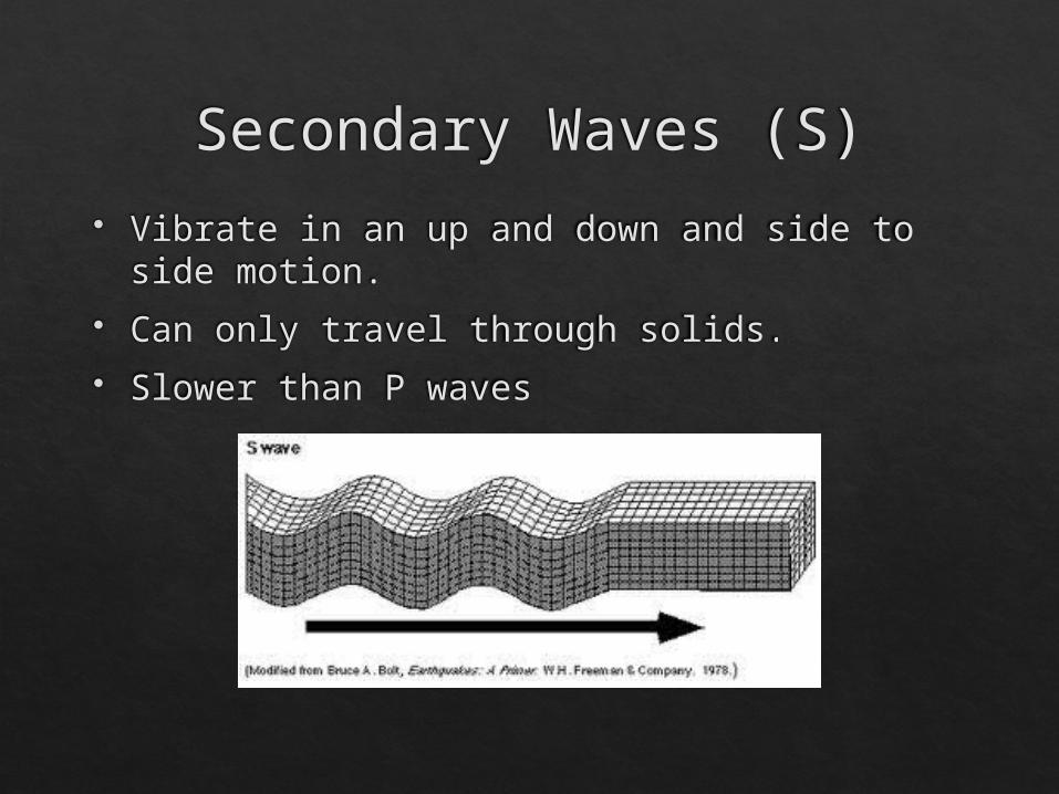
Secondary Waves (S) Vibrate in an up and down and side to side
motion. Can only travel through solids. Slower than P waves


EARTHQUAKE MAGNITUDE measures the size of seismic waves
the energy released by the earthquake
Richter scale=measurement of energy released based upon wave amplitude (size of vibration)
What you need:• Amplitude (size of vibration = wave height)
• Time between arrival of 1st P and 1st S waves

HOW TO READ SEISMOGRAMS
P & S (body waves) move through earth & arrive first• P & S waves used to calculate magnitude of earthquake
• Amplitude = height of wave (how much the rock moves; size of vibration)

MERCALLI VS. RICHTER