permits wisconsin’s forestry - wisconsin department...
TRANSCRIPT
PUB FR-093 2010
Wisconsin Department of Natural Resources
PRINTED ONRECYCLEDPAPER
Wisconsin’s Forestry Best Management Practices for Water Quality / FIELD MANUAL 2
Permits
C H A P T E R
2Lorem ipsum dolor sit amet, consectetuer adipiscing elit, sed diamnonummy nibh euismod tincidunt ut laoreet dolore magna aliquam eratvolutpat. Ut wisi enim ad minim veniam, quis nostrud exerci tationullamcorper suscipit lobortis nisl ut aliquip ex ea commodo consequat.
Duis autem vel eum iriure dolor in hendrerit in vulputate velitesse molestie consequat, vel illum dolore eu feugiat nullafacilisis at vero eros et accumsan et iusto odio dignissim.
Permits for Water Quality
Stream Crossings
Lorem ipsum dolor sit amet, consectetuer adipiscing elit, sed diamnonummy nibh euismod tincidunt ut laoreet dolore magna aliquam eratvolutpat. Ut wisi enim ad minim veniam, quis nostrud exerci tationullamcorper suscipit lobortis nisl ut aliquip ex ea commodo consequat.Duis autem vel eum iriure dolor in hendrerit in vulputate velit essemolestie consequat, vel illum dolore eu feugiat nulla facilisis at vero
Grading
Lorem ipsum dolor sit amet, consectetuer adipiscing elit, sed diamnonummy nibh euismod tincidunt ut laoreet dolore magna aliquam eratvolutpat. Ut wisi enim ad minim veniam, quis nostrud exerci tationullamcorper suscipit lobortis nisl ut aliquip ex ea commodo consequat.Duis autem vel eum iriure dolor in hendrerit in vulputate velit essemolestie consequat, vel illum dolore eu feugiat nulla facilisis at vero
Wetlands and Floodplains
Lorem ipsum dolor sit amet, consectetuer adipiscing elit, sed diamnonummy nibh euismod tincidunt ut laoreet dolore magna aliquam eratvolutpat. Ut wisi enim ad minim veniam, quis nostrud exerci tationullamcorper suscipit lobortis nisl ut aliquip ex ea commodo consequat.Duis autem vel eum iriure dolor in hendrerit in vulputate velit essemolestie consequat, vel illum dolore eu feugiat nulla facilisis at vero
for loggers, landowners, and land managers
Best ManagementPractices forWater Quality
FIELD MANUAL
Wisconsin Department of Natural Resources • Division of Forestry
Wisconsin’s Forestry
Contents
Wisconsin’s Forestry Best Management Practices for Water Quality / FIELD MANUAL 32 Wisconsin’s Forestry Best Management Practices for Water Quality / FIELD MANUAL
This document is a publication of the Wisconsin Department of Natural Resources. It fulfills aportion of the state’s commitment under its Nonpoint Source Program and replaces the 2003edition of “Wisconsin’s Forestry Best Management Practices for Water Quality.”
The development of this manual was directed by the Advisory Committee for Forestry BMPs forWater Quality, which has broad representation from Wisconsin’s forestry community. A field manualsubcommittee helped draft and review the text for this edition of the manual.
Members of the Field Manual Subcommittee were:
• Russ Aszmann, Taylor County Forestry and Recreation
• Patrick Dayton, Southwest Badger Resource Conservation & Development
• Max Erickson, Great Lakes Timber Professionals Association
• Pat Goggin, University of Wisconsin-Extension Lakes Program
• Chris Knotts, US Army Corps of Engineers
• Butch Lobermeier, Bayfield County Land and Water Conservation Department
• Tim Pulskamp, Futurewood Corp.
• Sara Sommer, USDA Forest Service
• Dale Zaug, Wisconsin Woodland Owners Association
The Wisconsin DNR would like to thank the Maine Forest Service for granting permission to use material from its field manual, Best Management Practices for Forestry: Protecting Maine’sWater Quality.
Lead Authors: Steve Holaday and Carmen Wagner, Wisconsin DNR
Graphic Design: Nan Rudd, Rudd Design
Chapter 1: Introduction 7
Forests and Water Quality ....................................................................... 7History of Wisconsin’s Forestry BMPs for Water Quality.......................... 11Using This Field Manual .......................................................................... 13A Closer Look at Modifying BMPs .......................................................... 14Resources ................................................................................................ 14
Chapter 2: Wisconsin’s Water Resources 15
Lakes ....................................................................................................... 16A Closer Look at Beaver Ponds ............................................................... 16Streams ................................................................................................... 17Wetlands ................................................................................................. 18Resources ................................................................................................ 20
Chapter 3: Planning 21
Forest Management Plans....................................................................... 21Mapping Resources................................................................................. 23A Closer Look at the DNR’s Surface Water Data Viewer ......................... 26Permits .................................................................................................... 28Cost-Share Programs............................................................................... 28Planning Checklist................................................................................... 30Resources ................................................................................................ 31
Chapter 4: Forest Roads 33
Regulations ............................................................................................. 34Types of Forest Roads ............................................................................. 35Location and Design BMPs ..................................................................... 36A Closer Look at Balancing Transportation Needs .................................. 38Road Construction................................................................................... 38Road Construction BMPs ........................................................................ 44Drainage Structures................................................................................. 45Drainage Structure BMPs ........................................................................ 53A Closer Look at Road Building Challenges in the Driftless Area............ 55
This publication is available from the Wisconsin Department of Natural Resources,Division of Forestry, PO Box 7921, Madison, WI, 53707. For additional information, call(608) 267-7494 or visit our web-site at: www.dnr.wi.gov/forestry/.The Wisconsin Department of Natural Resources provides equal opportunity in itsemployment, programs, services and functions under an Affirmative Action Plan. If youhave any questions, please write to Equal Employment Opportunity Office, Departmentof Interior, Washington, D.C, 20240.This publication is available in alternative format upon request. For additionalinformation, call (608) 267-7494.
Wisconsin Department of Natural Resources
Wisconsin’s Forestry Best Management Practices for Water Quality / FIELD MANUAL 54 Wisconsin’s Forestry Best Management Practices for Water Quality / FIELD MANUAL
CONTENTS CONTENTS
Soil Stabilization BMPs ........................................................................... 56A Closer Look at Why Roads Fail ............................................................ 60Road Maintenance BMPs........................................................................ 61Resources ................................................................................................ 63
Chapter 5: Stream Crossings 65
Planning .................................................................................................. 65Regulations ............................................................................................. 66General Stream Crossing BMPs............................................................... 67Stream Crossing BMPs for Culverts......................................................... 69Stream Crossing BMPs for Fords ............................................................. 70Temporary Stream Crossing BMPs .......................................................... 71Resources ................................................................................................ 72
Chapter 6: Timber Harvestings 73
Landing BMPs ......................................................................................... 74Skid Trail BMPs........................................................................................ 75General Timber Harvesting BMPs............................................................ 76Dry Wash BMPs....................................................................................... 77A Closer Look at Timber Harvesting Challenges in the
Lake Superior Clay Plain .................................................................... 81Resources ................................................................................................ 82
Chapter 7: Riparian Management Zones 83
Regulations ............................................................................................. 84Riparian Management Zone Categories.................................................. 85A Closer Look at Measuring Stream Width ............................................. 88BMPs Common to All RMZ Categories.................................................... 90BMPs for Lakes, Designated Trout Streams, and Streams 3 Feet Wide and Wider .............................................................. 91BMPs for Streams Less Than 3 Feet Wide................................................ 92BMPS for Streams Less Than 1 Foot Wide ............................................... 93A Closer Look at Managing RMZs Dominated by Aspen......................... 94Resources ................................................................................................ 96
Chapter 8: Wetlands 97
Regulations ............................................................................................. 99Wetland Identification............................................................................. 99
General Wetland BMPs ........................................................................... 100Wetland Filter Strip BMPs ....................................................................... 101A Closer Look at Protecting the Forest Floor........................................... 103Wetland Road, Skid Trail, and Landing BMPs.......................................... 104A Closer Look at Excessive Rutting ......................................................... 109Federal Requirements for Forest Roads in Wetlands ............................... 111Resources ................................................................................................ 113
Chapter 9: Fuels, Lubricants, Waste, and Spills 115
Fuel, Lubricant, and Waste BMPs ............................................................ 115Spill BMPs ............................................................................................... 116Resources ................................................................................................ 118
Chapter 10: Chemicals 119
General Chemical BMPs.......................................................................... 120Aerial Chemical Application BMPs .......................................................... 121Resources ................................................................................................ 121
Chapter 11: Mechanical Site Preparation and Tree Planting 123
Mechanical Site Preparation and Tree Planting BMPs............................. 124Resources ................................................................................................ 124
Chapter 12: Prescribed Burning and Wildfire 125
Regulations ............................................................................................. 125Prescribed Burning BMPs ........................................................................ 126Wildfire BMPs ......................................................................................... 127Post-Fire Maintenance BMPs for Prescribed Burns and Wildfires............ 128Resources ................................................................................................ 128
Appendix A: Permits ................................................................................. 129Appendix B: Regulations ......................................................................... 133Appendix C: Contact Information......................................................... 139Appendix D: Seed Mix Information...................................................... 147Appendix E: Erosion and Sediment Control Products .................... 151Appendix F: Geotextile Fabrics ............................................................. 155Appendix G: Glossary............................................................................... 159
Forests play an important rolein the water cycle, contributingto the high quality of waterfound in Wisconsin’s lakes,streams, and wetlands.
Photo by Kristin Lambert, DNR
Introduction
Wisconsin’s Forestry Best Management Practices for Water Quality / FIELD MANUAL 76 Wisconsin’s Forestry Best Management Practices for Water Quality / FIELD MANUAL
C H A P T E R
1Forests and Water Quality
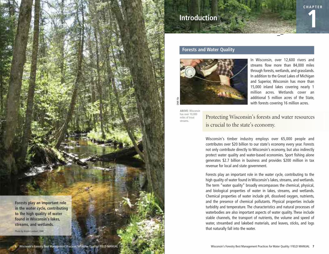
In Wisconsin, over 12,600 rivers andstreams flow more than 84,000 milesthrough forests, wetlands, and grasslands.In addition to the Great Lakes of Michiganand Superior, Wisconsin has more than15,000 inland lakes covering nearly 1million acres. Wetlands cover anadditional 5 million acres of the State,with forests covering 16 million acres.
ABOVE: Wisconsinhas over 10,000miles of troutstreams.
DNR File
Protecting Wisconsin’s forests and water resources
is crucial to the state’s economy.
Wisconsin’s timber industry employs over 65,000 people andcontributes over $20 billion to our state’s economy every year. Forestsnot only contribute directly to Wisconsin’s economy, but also indirectlyprotect water quality and water-based economies. Sport fishing alonegenerates $2.7 billion in business and provides $200 million in taxrevenue for local and state government.
Forests play an important role in the water cycle, contributing to thehigh quality of water found in Wisconsin’s lakes, streams, and wetlands.The term “water quality” broadly encompasses the chemical, physical,and biological properties of water in lakes, streams, and wetlands.Chemical properties of water include pH, dissolved oxygen, nutrients,and the presence of chemical pollutants. Physical properties includeturbidity and temperature. The characteristics and natural processes ofwaterbodies are also important aspects of water quality. These includestable channels, the transport of nutrients, the volume and speed ofwater, streambed and lakebed materials, and leaves, sticks, and logsthat naturally fall into the water.
Wisconsin’s Forestry Best Management Practices for Water Quality / FIELD MANUAL 9
CHAPTER 1: Introduction CHAPTER 1: Introduction
8 Wisconsin’s Forestry Best Management Practices for Water Quality / FIELD MANUAL
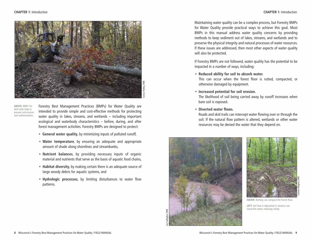
Forestry Best Management Practices (BMPs) for Water Quality areintended to provide simple and cost-effective methods for protectingwater quality in lakes, streams, and wetlands – including importantecological and waterbody characteristics – before, during, and afterforest management activities. Forestry BMPs are designed to protect:
• General water quality, by minimizing inputs of polluted runoff,
• Water temperature, by ensuring an adequate and appropriateamount of shade along shorelines and streambanks,
• Nutrient balances, by providing necessary inputs of organicmaterial and nutrients that serve as the basis of aquatic food chains,
• Habitat diversity, by making certain there is an adequate source oflarge woody debris for aquatic systems, and
• Hydrologic processes, by limiting disturbances to water flowpatterns.
Maintaining water quality can be a complex process, but Forestry BMPsfor Water Quality provide practical ways to achieve this goal. MostBMPs in this manual address water quality concerns by providingmethods to keep sediment out of lakes, streams, and wetlands and topreserve the physical integrity and natural processes of water resources.If these issues are addressed, then most other aspects of water qualitywill also be protected.
If Forestry BMPs are not followed, water quality has the potential to beimpacted in a number of ways, including:
• Reduced ability for soil to absorb water.This can occur when the forest floor is rutted, compacted, orotherwise damaged by equipment.
• Increased potential for soil erosion.The likelihood of soil being carried away by runoff increases whenbare soil is exposed.
• Diverted water flows.Roads and skid trails can intercept water flowing over or through thesoil. If the natural flow pattern is altered, wetlands or other waterresources may be denied the water that they depend on.
Eunice Pad
ley, DN
R
ABOVE: BMPs forskid trails help toprevent soil erosionand sedimentation.
ABOVE: Rutting can compact the forest floor.
LEFT: Soil that is deposited in streams cancloud the water, reducing clarity.
Carm
en W
agner, DN
R
Jay Gallagh
er, D
NR
Wisconsin’s Forestry Best Management Practices for Water Quality / FIELD MANUAL 11
History of Wisconsin’s Forestry BMPs for Water Quality • Concentrated water flows.Roads, skid trails, landings, and drainage structures can collect runoffand funnel it, increasing the speed of runoff, eroding soil, andcreating gullies.
• Increased water flows.Harvesting a significant percentage of the trees in a watershed canincrease the amount of water running off of the land, since fewertrees are left to uptake water. Higher water flows can increase thepotential for streambank erosion and may lead to flooding.
• Reduced cover next to water resources.Harvesting adjacent to streams can open the tree canopy and causemore light to reach the water surface. This may cause watertemperatures to rise. Harvesting next to lakes and streams can alsoremove the natural source of woody debris for aquatic habitat andcan eliminate the leaf litter that is an important food source for manyaquatic insects.
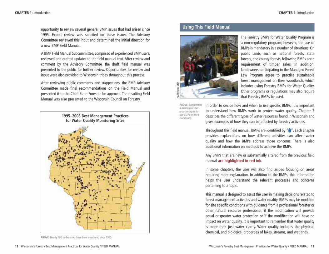
The good news is that BMPs are used correctly over 90% of the time inWisconsin across all landowner categories. Since 1995, nearly 600timber sales have been monitored in Wisconsin to document how oftenpeople are using BMPs, as well as to determine how well the BMPswork. BMP monitoring has also shown that when BMPs are used, waterquality is protected over 99% of the time. On the other hand, if BMPsare not used, water quality impacts have been observed nearly 70% ofthe time.
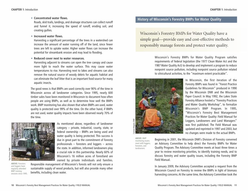
As mentioned above, regardless of landownercategory – private, industrial, county, state, orfederal ownership – BMPs are being used andwater quality is being protected. This success isdue in great part to the commitment of forestryprofessionals – foresters and loggers – acrossthe state. In addition, informed landowners playa crucial role in this partnership. Nearly 60% ofWisconsin’s 16 million acres of forestland areowned by private individuals and families.
Responsible management of Wisconsin’s forests will not only ensure asustainable supply of wood products, but will also provide many otherbenefits, including clean water.
10 Wisconsin’s Forestry Best Management Practices for Water Quality / FIELD MANUAL
CHAPTER 1: Introduction CHAPTER 1: Introduction
Wisconsin’s Forestry BMPs for Water Quality have a
simple goal—provide easy and cost-effective methods to
responsibly manage forests and protect water quality.
Wisconsin’s Forestry BMPs for Water Quality Program satisfiesrequirements of federal legislation (the 1977 Clean Water Act and the1987 Water Quality Act) to develop and implement a program to reducenonpoint source pollution, including nonpoint source pollution relatedto silvicultural activities, to the “maximum extent practicable”.
In Wisconsin, the first iteration of theForestry BMPs was found in “Forest PracticeGuidelines for Wisconsin” produced in 1990by the Wisconsin DNR and the WisconsinPaper Council. In May 1992, the Lakes StateForestry Alliance hosted a “Forestry Practicesand Water Quality Workshop”, to formalizeWisconsin’s BMP Program. In 1995,“Wisconsin’s Forestry Best ManagementPractices for Water Quality: Field Manual forLoggers, Landowners and Land Managers”was first published. The Field Manual wasupdated and reprinted in 1997 and 2003, butno changes were made to the actual BMPs.
Beginning in 2001, the Wisconsin DNR’s Division of Forestry convenedan Advisory Committee to help direct the Forestry BMPs for WaterQuality Program. The Advisory Committee meets at least three times ayear to review monitoring priorities, to identify training needs, and todiscuss forestry and water quality issues, including the Forestry BMPField Manual.
In January 2009, the Advisory Committee accepted a request from theWisconsin Council on Forestry to review the BMPs in light of biomassharvesting concerns. At the same time, the Advisory Committee took the
ABOVE: BMPmonitoring teamsmeet with loggers,foresters, andlandowners.
Carm
en W
agner, DN
R
Paul Pingrey, D
NR
ABOVE: Forestersand loggers haveregularly attendedBMP trainingsessions since 1995.
opportunity to review several general BMP issues that had arisen since1995. Expert review was solicited on these issues. The AdvisoryCommittee reviewed this input and determined the initial direction fora new BMP Field Manual.
A BMP Field Manual Subcommittee, comprised of experienced BMP users,reviewed and drafted updates to the field manual text. After review andcomment by the Advisory Committee, the draft field manual waspresented to the public for further review. Opportunities for review andinput were also provided to Wisconsin tribes throughout this process.
After reviewing public comments and suggestions, the BMP AdvisoryCommittee made final recommendations on the Field Manual andpresented it to the Chief State Forester for approval. The resulting FieldManual was also presented to the Wisconsin Council on Forestry.
Using This Field Manual
The Forestry BMPs for Water Quality Program isa non-regulatory program; however, the use ofBMPs is mandatory in a number of situations. Onpublic lands, such as national forests, stateforests, and county forests, following BMPs are arequirement of timber sales. In addition,landowners participating in the Managed ForestLaw Program agree to practice sustainableforest management on their woodlands, whichincludes using Forestry BMPs for Water Quality.Other programs or regulations may also requirethat Forestry BMPs be used.
In order to decide how and when to use specific BMPs, it is importantto understand how BMPs work to protect water quality. Chapter 2describes the different types of water resources found in Wisconsin andgives examples of how they can be affected by forestry activities.
Throughout this field manual, BMPs are identified by “ “. Each chapterprovides explanations on how different activities can affect waterquality and how the BMPs address those concerns. There is alsoadditional information on methods to achieve the BMPs.
Any BMPs that are new or substantially altered from the previous fieldmanual are highlighted in red ink.
In some chapters, the user will also find asides focusing on areasrequiring more explanation. In addition to the BMPs, this informationhelps the user understand the relevant processes and concernspertaining to a topic.
This manual is designed to assist the user in making decisions related toforest management activities and water quality. BMPs may be modifiedfor site specific conditions with guidance from a professional forester orother natural resource professional, if the modification will provideequal or greater water protection or if the modification will have noimpact on water quality. It is important to remember that water qualityis more than just water clarity. Water quality includes the physical,chemical, and biological properties of lakes, streams, and wetlands.
CHAPTER 1: Introduction CHAPTER 1: Introduction
ABOVE: Nearly 600 timber sales have been monitored since 1995.
Paul Pingrey DNR
ABOVE: Landownersin Wisconsin’s MFLprogram agree to use BMPs on theirwoodlands.
12 Wisconsin’s Forestry Best Management Practices for Water Quality / FIELD MANUAL Wisconsin’s Forestry Best Management Practices for Water Quality / FIELD MANUAL 13
1995–2008 Best Management Practices for Water Quality Monitoring Sites
Wisconsin Water Resources
C H A P T E R
2CHA P T E R
2
Wisconsin’s Forestry Best Management Practices for Water Quality / FIELD MANUAL 15
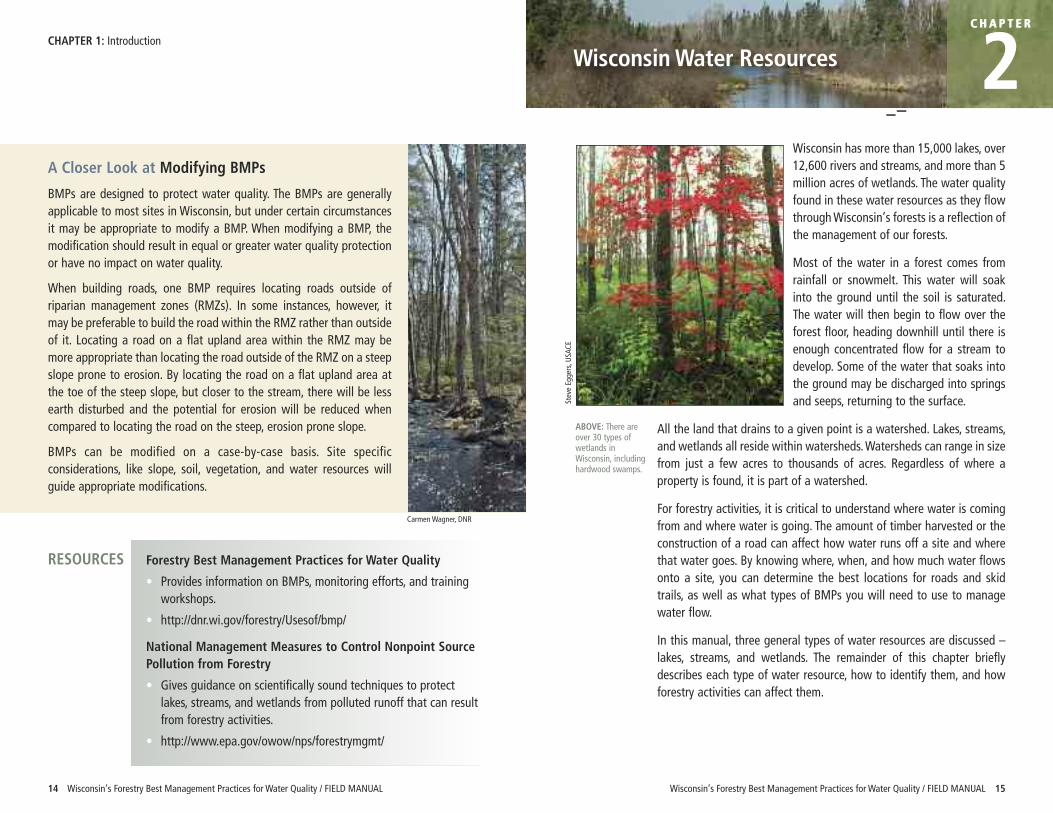
Wisconsin has more than 15,000 lakes, over12,600 rivers and streams, and more than 5million acres of wetlands. The water qualityfound in these water resources as they flowthrough Wisconsin’s forests is a reflection ofthe management of our forests.
Most of the water in a forest comes fromrainfall or snowmelt. This water will soakinto the ground until the soil is saturated.The water will then begin to flow over theforest floor, heading downhill until there isenough concentrated flow for a stream todevelop. Some of the water that soaks intothe ground may be discharged into springsand seeps, returning to the surface.
All the land that drains to a given point is a watershed. Lakes, streams,and wetlands all reside within watersheds. Watersheds can range in sizefrom just a few acres to thousands of acres. Regardless of where aproperty is found, it is part of a watershed.
For forestry activities, it is critical to understand where water is comingfrom and where water is going. The amount of timber harvested or theconstruction of a road can affect how water runs off a site and wherethat water goes. By knowing where, when, and how much water flowsonto a site, you can determine the best locations for roads and skidtrails, as well as what types of BMPs you will need to use to managewater flow.
In this manual, three general types of water resources are discussed –lakes, streams, and wetlands. The remainder of this chapter brieflydescribes each type of water resource, how to identify them, and howforestry activities can affect them.
14 Wisconsin’s Forestry Best Management Practices for Water Quality / FIELD MANUAL
CHAPTER 1: Introduction
A Closer Look at Modifying BMPs
BMPs are designed to protect water quality. The BMPs are generallyapplicable to most sites in Wisconsin, but under certain circumstancesit may be appropriate to modify a BMP. When modifying a BMP, themodification should result in equal or greater water quality protectionor have no impact on water quality.
When building roads, one BMP requires locating roads outside ofriparian management zones (RMZs). In some instances, however, itmay be preferable to build the road within the RMZ rather than outsideof it. Locating a road on a flat upland area within the RMZ may bemore appropriate than locating the road outside of the RMZ on a steepslope prone to erosion. By locating the road on a flat upland area atthe toe of the steep slope, but closer to the stream, there will be lessearth disturbed and the potential for erosion will be reduced whencompared to locating the road on the steep, erosion prone slope.
BMPs can be modified on a case-by-case basis. Site specificconsiderations, like slope, soil, vegetation, and water resources willguide appropriate modifications.
Forestry Best Management Practices for Water Quality
• Provides information on BMPs, monitoring efforts, and trainingworkshops.
• http://dnr.wi.gov/forestry/Usesof/bmp/
National Management Measures to Control Nonpoint SourcePollution from Forestry
• Gives guidance on scientifically sound techniques to protectlakes, streams, and wetlands from polluted runoff that can resultfrom forestry activities.
• http://www.epa.gov/owow/nps/forestrymgmt/
RESOURCES
Carmen Wagner, DNR
Steve Eg
gers, U
SACE
ABOVE: There areover 30 types ofwetlands inWisconsin, includinghardwood swamps.
Wisconsin’s Forestry Best Management Practices for Water Quality / FIELD MANUAL 17
CHAPTER 2: Wisconsin Water Resources
16 Wisconsin’s Forestry Best Management Practices for Water Quality / FIELD MANUAL
Lakes
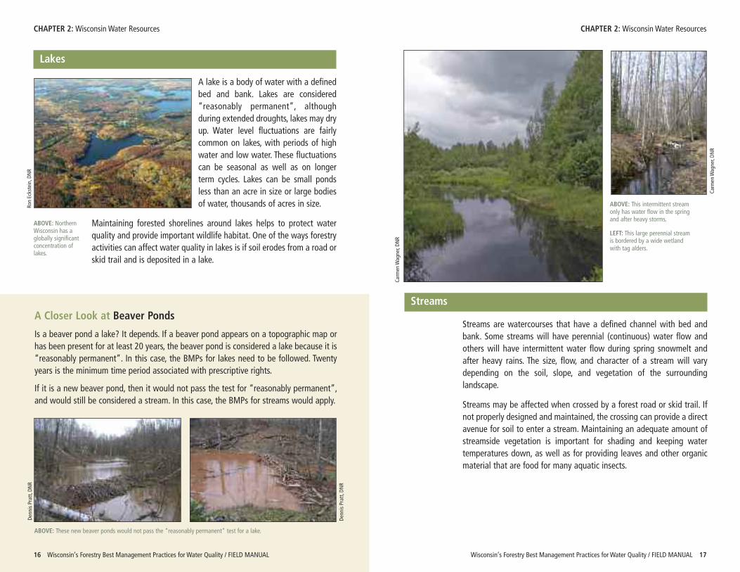
A lake is a body of water with a definedbed and bank. Lakes are considered“reasonably permanent”, althoughduring extended droughts, lakes may dryup. Water level fluctuations are fairlycommon on lakes, with periods of highwater and low water. These fluctuationscan be seasonal as well as on longerterm cycles. Lakes can be small pondsless than an acre in size or large bodiesof water, thousands of acres in size.
Maintaining forested shorelines around lakes helps to protect waterquality and provide important wildlife habitat. One of the ways forestryactivities can affect water quality in lakes is if soil erodes from a road orskid trail and is deposited in a lake.
A Closer Look at Beaver Ponds
Is a beaver pond a lake? It depends. If a beaver pond appears on a topographic map orhas been present for at least 20 years, the beaver pond is considered a lake because it is“reasonably permanent”. In this case, the BMPs for lakes need to be followed. Twentyyears is the minimum time period associated with prescriptive rights.
If it is a new beaver pond, then it would not pass the test for “reasonably permanent”,and would still be considered a stream. In this case, the BMPs for streams would apply.
ABOVE: NorthernWisconsin has aglobally significantconcentration oflakes.
Streams
Streams are watercourses that have a defined channel with bed andbank. Some streams will have perennial (continuous) water flow andothers will have intermittent water flow during spring snowmelt andafter heavy rains. The size, flow, and character of a stream will varydepending on the soil, slope, and vegetation of the surroundinglandscape.
Streams may be affected when crossed by a forest road or skid trail. Ifnot properly designed and maintained, the crossing can provide a directavenue for soil to enter a stream. Maintaining an adequate amount ofstreamside vegetation is important for shading and keeping watertemperatures down, as well as for providing leaves and other organicmaterial that are food for many aquatic insects.
ABOVE: These new beaver ponds would not pass the “reasonably permanent” test for a lake.
CHAPTER 2: Wisconsin Water Resources
ABOVE: This intermittent streamonly has water flow in the springand after heavy storms.
LEFT: This large perennial streamis bordered by a wide wetlandwith tag alders.
Ron Eckstein, D
NR
Denn
is Pratt, D
NR
Carm
en W
agner, DN
R
Carm
en W
agner, DN
R
Denn
is Pratt, D
NR
Wisconsin’s Forestry Best Management Practices for Water Quality / FIELD MANUAL 1918 Wisconsin’s Forestry Best Management Practices for Water Quality / FIELD MANUAL
Wetlands
Wetlands are areas where standing water or saturated soil conditionsare present long enough to support water-loving plants, like marshmarigolds, willows, tag alders, and other species. These wet conditionswill also lead to development of specific soil characteristics that canhelp identify wetlands. Wetland soils develop after repeated cycles ofsaturation which last 14 days or more. These saturated conditions mayonly exist every other year (50% of the time). When there is standingwater or the soil is saturated, anaerobic conditions are present and thesoil pores are filled with water instead of air, leading to thedevelopment of unique wetland soil characteristics.
Wetlands are common along the edges of lakes and streams, but canalso be found in flat areas or depressions which collect water. Wetlandsare also found in unlikely places, such as on hillsides, where water mayseep out of the ground.
Caution should be taken when crossing wetlands and harvesting inwetlands to ensure that both surface and sub-surface water flowpatterns are maintained. Forest roads should provide adequate crossdrainage and skid trails should not exhibit excessive rutting.
There are over 30 different types of wetlands covering more than 5million acres in Wisconsin. Over 47% of the wetlands are forested and22% are dominated by shrubs. Common forested wetlands typesinclude ephemeral ponds, floodplain forests, northern hardwoodswamps, northern wet-mesic forests, and tamarack/spruce swamps.
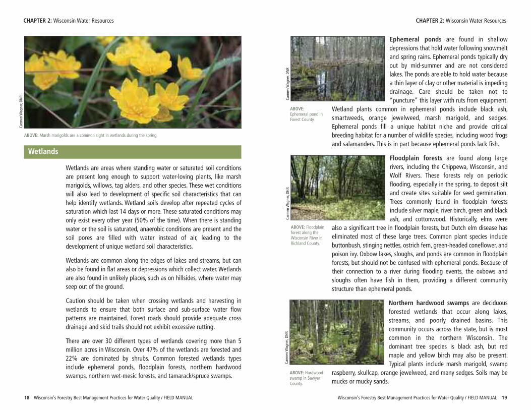
Ephemeral ponds are found in shallowdepressions that hold water following snowmeltand spring rains. Ephemeral ponds typically dryout by mid-summer and are not consideredlakes. The ponds are able to hold water becausea thin layer of clay or other material is impedingdrainage. Care should be taken not to“puncture” this layer with ruts from equipment.
Wetland plants common in ephemeral ponds include black ash,smartweeds, orange jewelweed, marsh marigold, and sedges.Ephemeral ponds fill a unique habitat niche and provide criticalbreeding habitat for a number of wildlife species, including wood frogsand salamanders. This is in part because ephemeral ponds lack fish.
Floodplain forests are found along largerivers, including the Chippewa, Wisconsin, andWolf Rivers. These forests rely on periodicflooding, especially in the spring, to deposit siltand create sites suitable for seed germination.Trees commonly found in floodplain forestsinclude silver maple, river birch, green and blackash, and cottonwood. Historically, elms were
also a significant tree in floodplain forests, but Dutch elm disease haseliminated most of these large trees. Common plant species includebuttonbush, stinging nettles, ostrich fern, green-headed coneflower, andpoison ivy. Oxbow lakes, sloughs, and ponds are common in floodplainforests, but should not be confused with ephemeral ponds. Because oftheir connection to a river during flooding events, the oxbows andsloughs often have fish in them, providing a different communitystructure than ephemeral ponds.
Northern hardwood swamps are deciduousforested wetlands that occur along lakes,streams, and poorly drained basins. Thiscommunity occurs across the state, but is mostcommon in the northern Wisconsin. Thedominant tree species is black ash, but redmaple and yellow birch may also be present.Typical plants include marsh marigold, swamp
raspberry, skullcap, orange jewelweed, and many sedges. Soils may bemucks or mucky sands.
CHAPTER 2: Wisconsin Water Resources CHAPTER 2: Wisconsin Water Resources
ABOVE: Marsh marigolds are a common sight in wetlands during the spring.
Carm
en W
agner, DN
R
Carm
en W
agner, DN
RCa
rmen W
agner, DN
RCa
rmen W
agner, DN
R
ABOVE:Ephemeral pond inForest County.
ABOVE: Floodplainforest along theWisconsin River inRichland County.
ABOVE: Hardwoodswamp in SawyerCounty.
CHAPTER 2: Wisconsin Water Resources
20 Wisconsin’s Forestry Best Management Practices for Water Quality / FIELD MANUAL
Northern wet-mesic forests, also known ascedar swamps, occur on rich peats and mucksthroughout much of northern Wisconsin. Cedarswamps are relatively common in depressionsthat receive mineral-enriched groundwater fromsprings. As the name suggests, northern whitecedar is the dominant tree species, but balsamfir, black ash, and spruce are also common in
these forests. The understory is rich in mosses, lichens, liverworts, ferns,sedges, orchids, and wildflowers such as goldthread, fringed polygala,and naked miterwort. Cedar swamps are considered a hot spot for manyspecies of rare plants. Older cedar swamps are usually structurallycomplex, as the easily wind-thrown cedars are able to root from theirbranch tips. The shrub layer may include speckled alder, alder-leavedbuckthorn, wild currants, and mountain maple, but are susceptible tograzing by high populations of deer.
Tamarack/spruce swamps are found onnutrient-poor, acidic peat soils. Tamarack andblack spruce are the dominant tree species.Common understory species include alder,winterberry, Labrador tea, and sphagnum moss.
Wisconsin’s Forestry Best Management Practices for Water Quality / FIELD MANUAL 21
Planning
CH A P T E R
3Careful planning for forest managementactivities, such as road construction,timber harvesting, and site preparation,will minimize nonpoint source pollution.Having a management plan in place willensure that harvest operations followBMPs, that forest products are removedefficiently and profitably, and thatsustainable forest growth and waterquality protection are achieved.
Forest Management Plans
The first step is to develop a forest management plan that addressesforestry BMPs, among other important plan elements. The plan’sformality and detail should be appropriate to the project size, cost, andenvironmental risk. The plan should include site specific forestmanagement strategies to protect water quality. The plan should also beflexible and adaptable to changing conditions. Wisconsin DNR foresters,consulting foresters, and industrial foresters can work with you todevelop a forest management plan.
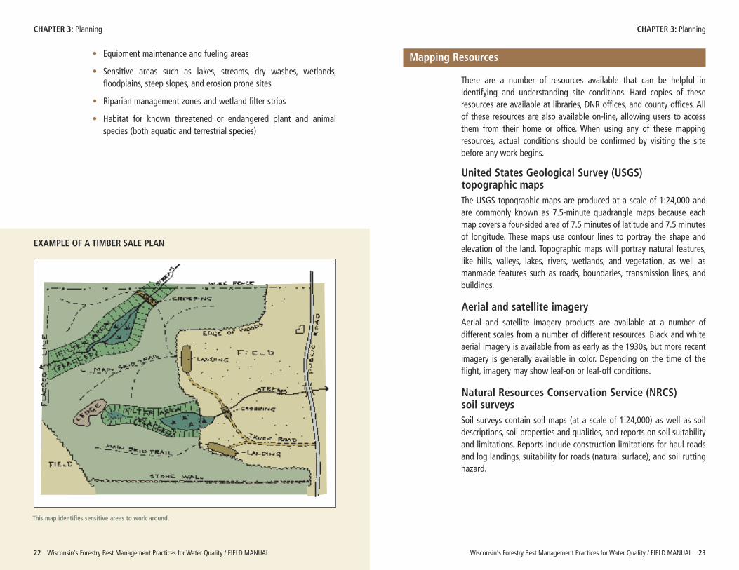
The management plan should include maps that identify areas andissues discussed in the plan. These maps will be especially helpful forbuilding forest roads and conducting timber harvests. Items that may beidentified on a timber sale map include:
• Property boundaries
• Harvest unit boundaries
• Existing and proposed forest roads, skid trails, and landings
• Existing and proposed stream, dry wash, and wetland crossings
Carm
en W
agner, DN
R
LEFT: Discussions with landowners, foresters, and loggershelp to ensure management objectives are met.
Wetland Communities of Wisconsin
• Describes the 33 types of wetlands found in Wisconsin, includingmanagement opportunities, threats, additional considerations,photos, and related habitat types.
• http://dnr.wi.gov/org/land/er/communities
Wetland Plants and Plant Communities of Minnesota andWisconsin
• Provides an easy-to-use, pictorial guide to wetlands primarily forindividuals who are not botanists.
• http://www.npwrc.usgs.gov/resource/plants/mnplant/index.htm
RESOURCES
Steve Eg
gers, U
SACE
Carm
en W
agner, DN
R
ABOVE: Cedarswamp with fernunderstory.
ABOVE: Tamarackswamp in MarathonCounty.
EXAMPLE OF A TIMBER SALE PLAN
Wisconsin’s Forestry Best Management Practices for Water Quality / FIELD MANUAL 23
CHAPTER 3: Planning CHAPTER 3: Planning
22 Wisconsin’s Forestry Best Management Practices for Water Quality / FIELD MANUAL
• Equipment maintenance and fueling areas
• Sensitive areas such as lakes, streams, dry washes, wetlands,floodplains, steep slopes, and erosion prone sites
• Riparian management zones and wetland filter strips
• Habitat for known threatened or endangered plant and animalspecies (both aquatic and terrestrial species)
This map identifies sensitive areas to work around.
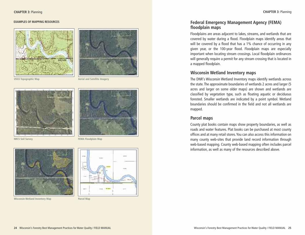
Mapping Resources
There are a number of resources available that can be helpful inidentifying and understanding site conditions. Hard copies of theseresources are available at libraries, DNR offices, and county offices. Allof these resources are also available on-line, allowing users to accessthem from their home or office. When using any of these mappingresources, actual conditions should be confirmed by visiting the sitebefore any work begins.
United States Geological Survey (USGS) topographic maps The USGS topographic maps are produced at a scale of 1:24,000 andare commonly known as 7.5-minute quadrangle maps because eachmap covers a four-sided area of 7.5 minutes of latitude and 7.5 minutesof longitude. These maps use contour lines to portray the shape andelevation of the land. Topographic maps will portray natural features,like hills, valleys, lakes, rivers, wetlands, and vegetation, as well asmanmade features such as roads, boundaries, transmission lines, andbuildings.
Aerial and satellite imagery Aerial and satellite imagery products are available at a number ofdifferent scales from a number of different resources. Black and whiteaerial imagery is available from as early as the 1930s, but more recentimagery is generally available in color. Depending on the time of theflight, imagery may show leaf-on or leaf-off conditions.
Natural Resources Conservation Service (NRCS) soil surveys Soil surveys contain soil maps (at a scale of 1:24,000) as well as soildescriptions, soil properties and qualities, and reports on soil suitabilityand limitations. Reports include construction limitations for haul roadsand log landings, suitability for roads (natural surface), and soil ruttinghazard.
Wisconsin’s Forestry Best Management Practices for Water Quality / FIELD MANUAL 25
CHAPTER 3: Planning
24 Wisconsin’s Forestry Best Management Practices for Water Quality / FIELD MANUAL
EXAMPLES OF MAPPING RESOURCES
USGS Topographic Map Aerial and Satellite Imagery
NRCS Soil Survey FEMA Floodplain Map
Wisconsin Wetland Inventory Map Parcel Map
Federal Emergency Management Agency (FEMA)floodplain mapsFloodplains are areas adjacent to lakes, streams, and wetlands that arecovered by water during a flood. Floodplain maps identify areas thatwill be covered by a flood that has a 1% chance of occurring in anygiven year, or the 100-year flood. Floodplain maps are especiallyimportant when locating stream crossings. Local floodplain ordinanceswill generally require a permit for any stream crossing that is located ina mapped floodplain.
Wisconsin Wetland Inventory mapsThe DNR’s Wisconsin Wetland Inventory maps identify wetlands acrossthe state. The approximate boundaries of wetlands 2 acres and larger (5acres and larger on some older maps) are shown and wetlands areclassified by vegetation type, such as floating aquatic or deciduousforested. Smaller wetlands are indicated by a point symbol. Wetlandboundaries should be confirmed in the field and not all wetlands aremapped.
Parcel mapsCounty plat books contain maps show property boundaries, as well asroads and water features. Plat books can be purchased at most countyoffices and at many retail stores. You can also access this information onmany county web-sites that provide land record information throughweb-based mapping. County web-based mapping often includes parcelinformation, as well as many of the resources described above.
CHAPTER 3: Planning
Wisconsin’s Forestry Best Management Practices for Water Quality / FIELD MANUAL 27
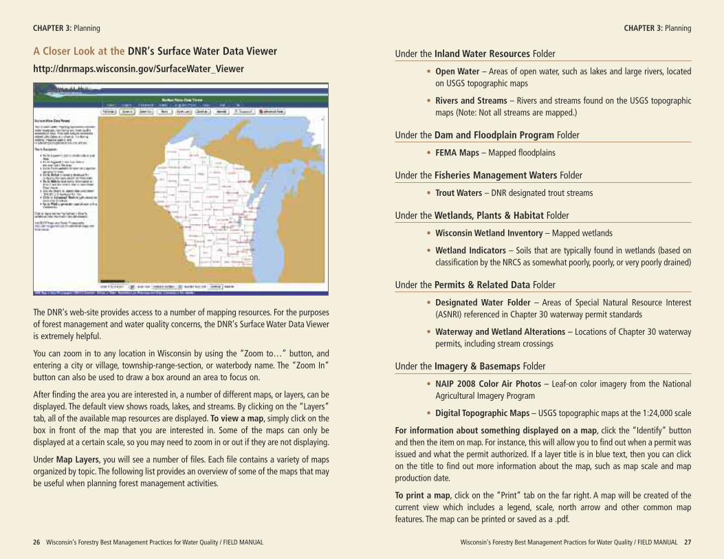
Under the Inland Water Resources Folder
• Open Water – Areas of open water, such as lakes and large rivers, locatedon USGS topographic maps
• Rivers and Streams – Rivers and streams found on the USGS topographicmaps (Note: Not all streams are mapped.)
Under the Dam and Floodplain Program Folder
• FEMA Maps – Mapped floodplains
Under the Fisheries Management Waters Folder
• Trout Waters – DNR designated trout streams
Under the Wetlands, Plants & Habitat Folder
• Wisconsin Wetland Inventory – Mapped wetlands
• Wetland Indicators – Soils that are typically found in wetlands (based onclassification by the NRCS as somewhat poorly, poorly, or very poorly drained)
Under the Permits & Related Data Folder
• Designated Water Folder – Areas of Special Natural Resource Interest(ASNRI) referenced in Chapter 30 waterway permit standards
• Waterway and Wetland Alterations – Locations of Chapter 30 waterwaypermits, including stream crossings
Under the Imagery & Basemaps Folder
• NAIP 2008 Color Air Photos – Leaf-on color imagery from the NationalAgricultural Imagery Program
• Digital Topographic Maps – USGS topographic maps at the 1:24,000 scale
For information about something displayed on a map, click the “Identify” buttonand then the item on map. For instance, this will allow you to find out when a permit wasissued and what the permit authorized. If a layer title is in blue text, then you can clickon the title to find out more information about the map, such as map scale and mapproduction date.
To print a map, click on the “Print” tab on the far right. A map will be created of thecurrent view which includes a legend, scale, north arrow and other common mapfeatures. The map can be printed or saved as a .pdf.
26 Wisconsin’s Forestry Best Management Practices for Water Quality / FIELD MANUAL
CHAPTER 3: Planning CHAPTER 3: Planning
A Closer Look at the DNR’s Surface Water Data Viewer
http://dnrmaps.wisconsin.gov/SurfaceWater_Viewer
The DNR’s web-site provides access to a number of mapping resources. For the purposesof forest management and water quality concerns, the DNR’s Surface Water Data Vieweris extremely helpful.
You can zoom in to any location in Wisconsin by using the “Zoom to…” button, andentering a city or village, township-range-section, or waterbody name. The “Zoom In”button can also be used to draw a box around an area to focus on.
After finding the area you are interested in, a number of different maps, or layers, can bedisplayed. The default view shows roads, lakes, and streams. By clicking on the “Layers”tab, all of the available map resources are displayed. To view a map, simply click on thebox in front of the map that you are interested in. Some of the maps can only bedisplayed at a certain scale, so you may need to zoom in or out if they are not displaying.
Under Map Layers, you will see a number of files. Each file contains a variety of mapsorganized by topic. The following list provides an overview of some of the maps that maybe useful when planning forest management activities.
Wisconsin’s Forestry Best Management Practices for Water Quality / FIELD MANUAL 2928 Wisconsin’s Forestry Best Management Practices for Water Quality / FIELD MANUAL
Permits
Before starting any work, be sure toobtain necessary permits and fileneeded notices. An overview ofpermits that may be required isgiven in Appendix A and a summaryof regulations is found in AppendixB. Appendix C contains a list of localcontacts for permit information.
Cost-Share Programs
Loggers and road builders, working with foresters and landowners, areusually responsible for implementing forestry BMPs. Typically, the loggerbears the cost of implementing BMPs and that cost is reflected in thetimber sale bid. Sometimes the landowner will implement BMPs andcover the costs themselves.
In some situations, cost-share assistance may be available forimplementing conservation practices outlined in this manual. Manyprograms help private landowners plant trees and shrubs, but someprograms also help cover the costs of management plans, forest roadBMPs, and other practices, including construction of drainage structures,repair of stream crossings, and installation of seed mixes. Programrequirements, funding, and availability can vary with time and location,but most programs require that an approved forest management plan bein place. Some of the most common programs are summarized below.Contact your local DNR forester, land conservation department or NRCSoffice (see Appendix C) for current information on these and otherprograms. Eligibility requirements, cost-share standards, and fundingavailability can change. Cost-share opportunities should be investigatedbefore implementing any practices.
CHAPTER 3: Planning CHAPTER 3: Planning
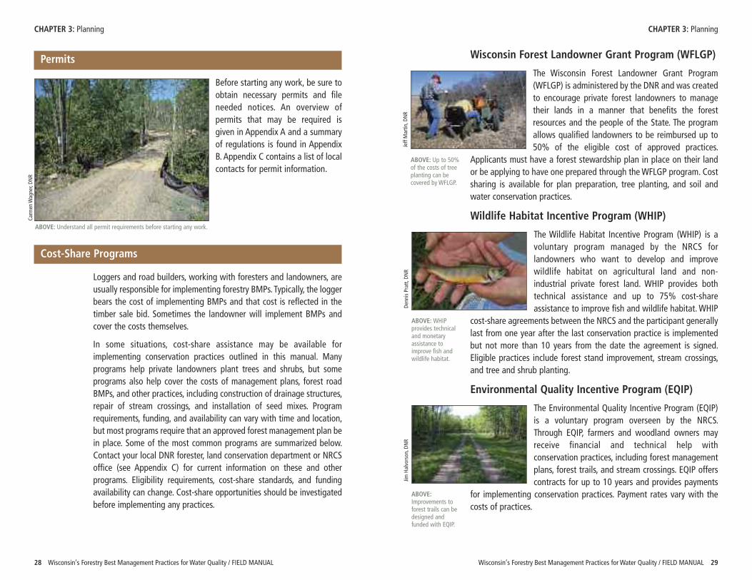
Wisconsin Forest Landowner Grant Program (WFLGP)
The Wisconsin Forest Landowner Grant Program(WFLGP) is administered by the DNR and was createdto encourage private forest landowners to managetheir lands in a manner that benefits the forestresources and the people of the State. The programallows qualified landowners to be reimbursed up to50% of the eligible cost of approved practices.
Applicants must have a forest stewardship plan in place on their landor be applying to have one prepared through the WFLGP program. Costsharing is available for plan preparation, tree planting, and soil andwater conservation practices.
Wildlife Habitat Incentive Program (WHIP)
The Wildlife Habitat Incentive Program (WHIP) is avoluntary program managed by the NRCS forlandowners who want to develop and improvewildlife habitat on agricultural land and non-industrial private forest land. WHIP provides bothtechnical assistance and up to 75% cost-shareassistance to improve fish and wildlife habitat. WHIP
cost-share agreements between the NRCS and the participant generallylast from one year after the last conservation practice is implementedbut not more than 10 years from the date the agreement is signed.Eligible practices include forest stand improvement, stream crossings,and tree and shrub planting.
Environmental Quality Incentive Program (EQIP)
The Environmental Quality Incentive Program (EQIP)is a voluntary program overseen by the NRCS.Through EQIP, farmers and woodland owners mayreceive financial and technical help withconservation practices, including forest managementplans, forest trails, and stream crossings. EQIP offerscontracts for up to 10 years and provides payments
for implementing conservation practices. Payment rates vary with thecosts of practices.
ABOVE: Up to 50%of the costs of treeplanting can becovered by WFLGP.
Jeff Martin
, DNR
ABOVE: WHIPprovides technicaland monetaryassistance toimprove fish andwildlife habitat.
Denn
is Pratt, D
NR
ABOVE:Improvements toforest trails can bedesigned andfunded with EQIP.
Jim Halvorson
, DNR
Carm
en W
agner, DN
R
ABOVE: Understand all permit requirements before starting any work.
Wisconsin’s Forestry Best Management Practices for Water Quality / FIELD MANUAL 3130 Wisconsin’s Forestry Best Management Practices for Water Quality / FIELD MANUAL
Planning Checklist
The following checklist can be used when planning forest management activities.
CHAPTER 3: Planning CHAPTER 3: Planning
� Develop a forest management plan with management objectives for your property.
� Make a list of site-specific BMPs needed to protect water quality. Include in your forest management plan, timber harvest plan, and timber sale contract.
� Investigate cost-share options for implementing BMPs.
� Plan management activities to ensure that habitat of any endangered or threatened plant or animal species is protected.
� Prepare a map of your property to use during forest management activities that identifies sensitive areas and other important features.
� Reference mapping resources and confirm site conditions in the field when identifying sensitive areas.
� Obtain necessary permits and file needed notices before beginning any timber harvesting.
� Stabilize any bare soil as soon as possible to prevent erosion. Critical areas to protect include steep slopes, erosion prone sites, riparian management zones, wetland filter strips, and stream crossings.
� Have a spill containment and clean-up kit on site whenever equipment is present.
Conducting a Successful Timber Sale (UWEX Publication GWQ-036)
• Reviews the steps to follow when planning and conducting atimber harvest
• http://learningstore.uwex.edu/pdf/GWQ036.pdf
DNR Financial Assistance to Landowner
• Gives an overview of forest tax laws and cost-sharing programs
• http://dnr.wi.gov/forestry/private/financial/
DNR Forestry Assistance Locator
• Provides a searchable database with contact information for DNRand cooperating foresters
• http://dnr.wi.gov/forestry/private/assist/coopforesters/
DNR Natural Heritage Inventory County Data by Township
• Offers township level list of rare species (endangered, threatenedand special concern) to use for general planning purposes
• http://dnr.wi.gov/org/land/er/nhi/CountyData/
DNR Surface Water Data Viewer
• Provides access to mapping products, including USGS topographicmaps, aerial imagery, DNR wetland maps, FEMA floodplain maps,and other information.
• http://dnrmaps.wisconsin.gov/SurfaceWater_Viewer
NRCS Web Soil Survey
• Gives access to soil survey maps and related information
• http://websoilsurvey.nrcs.usda.gov/
Planning for Forest Stewardship: A Desk Guide (USDA ForestService Publication #FS-733)
• Discusses the components of a forest stewardship plan
• http://www.fs.fed.us/spf/coop/library/Forest%20Stewardship%20deskguide.pdf
Wisconsin Forest Management Guidelines, Chapter 10: Forest Management Planning (DNR Pub FR-226)
• Describes the different elements of forest management plans
• http://dnr.wi.gov/forestry/publications/Guidelines
RESOURCES
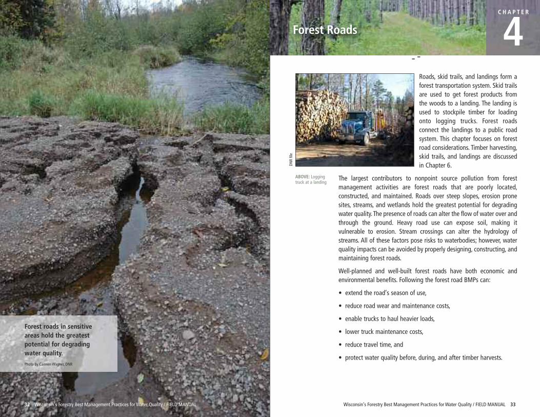
Roads, skid trails, and landings form aforest transportation system. Skid trailsare used to get forest products fromthe woods to a landing. The landing isused to stockpile timber for loadingonto logging trucks. Forest roadsconnect the landings to a public roadsystem. This chapter focuses on forestroad considerations. Timber harvesting,skid trails, and landings are discussedin Chapter 6.
The largest contributors to nonpoint source pollution from forestmanagement activities are forest roads that are poorly located,constructed, and maintained. Roads over steep slopes, erosion pronesites, streams, and wetlands hold the greatest potential for degradingwater quality. The presence of roads can alter the flow of water over andthrough the ground. Heavy road use can expose soil, making itvulnerable to erosion. Stream crossings can alter the hydrology ofstreams. All of these factors pose risks to waterbodies; however, waterquality impacts can be avoided by properly designing, constructing, andmaintaining forest roads.
Well-planned and well-built forest roads have both economic andenvironmental benefits. Following the forest road BMPs can:
• extend the road’s season of use,
• reduce road wear and maintenance costs,
• enable trucks to haul heavier loads,
• lower truck maintenance costs,
• reduce travel time, and
• protect water quality before, during, and after timber harvests.
Forest roads in sensitiveareas hold the greatestpotential for degradingwater quality.
Photo by Carmen Wagner, DNR
32 Wisconsin’s Forestry Best Management Practices for Water Quality / FIELD MANUAL
C H A P T E R
4
Wisconsin’s Forestry Best Management Practices for Water Quality / FIELD MANUAL 33
Forest Roads
ABOVE: Loggingtruck at a landing
DNR file
Types of Forest Roads
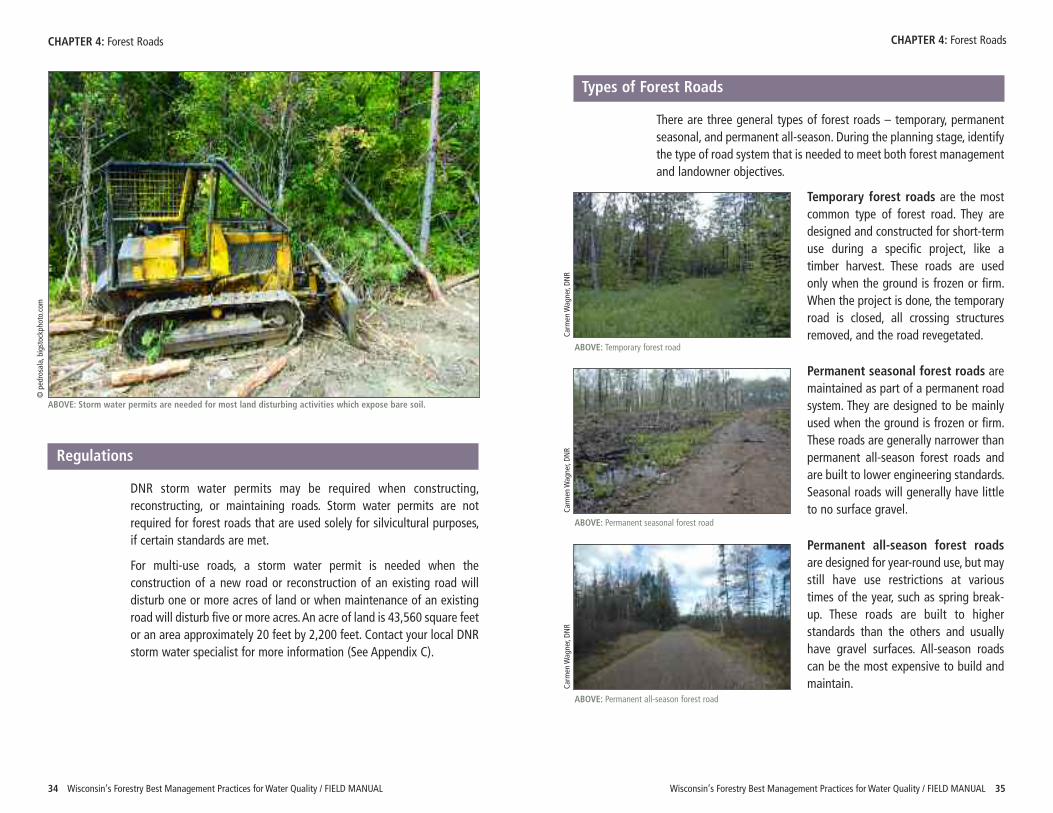
There are three general types of forest roads – temporary, permanentseasonal, and permanent all-season. During the planning stage, identifythe type of road system that is needed to meet both forest managementand landowner objectives.
Temporary forest roads are the mostcommon type of forest road. They aredesigned and constructed for short-termuse during a specific project, like atimber harvest. These roads are usedonly when the ground is frozen or firm.When the project is done, the temporaryroad is closed, all crossing structuresremoved, and the road revegetated.
Permanent seasonal forest roads aremaintained as part of a permanent roadsystem. They are designed to be mainlyused when the ground is frozen or firm.These roads are generally narrower thanpermanent all-season forest roads andare built to lower engineering standards.Seasonal roads will generally have littleto no surface gravel.
Permanent all-season forest roadsare designed for year-round use, but maystill have use restrictions at varioustimes of the year, such as spring break-up. These roads are built to higherstandards than the others and usuallyhave gravel surfaces. All-season roadscan be the most expensive to build andmaintain.
Wisconsin’s Forestry Best Management Practices for Water Quality / FIELD MANUAL 35
Regulations
DNR storm water permits may be required when constructing,reconstructing, or maintaining roads. Storm water permits are notrequired for forest roads that are used solely for silvicultural purposes,if certain standards are met.
For multi-use roads, a storm water permit is needed when theconstruction of a new road or reconstruction of an existing road willdisturb one or more acres of land or when maintenance of an existingroad will disturb five or more acres. An acre of land is 43,560 square feetor an area approximately 20 feet by 2,200 feet. Contact your local DNRstorm water specialist for more information (See Appendix C).
34 Wisconsin’s Forestry Best Management Practices for Water Quality / FIELD MANUAL
CHAPTER 4: Forest Roads CHAPTER 4: Forest Roads
ABOVE: Temporary forest road
ABOVE: Permanent seasonal forest road
ABOVE: Storm water permits are needed for most land disturbing activities which expose bare soil.
ABOVE: Permanent all-season forest road
© pedrosala, bigstockpho
to.com
Carm
en W
agner, DN
RCa
rmen W
agner, DN
RCa
rmen W
agner, DN
R
Wisconsin’s Forestry Best Management Practices for Water Quality / FIELD MANUAL 3736 Wisconsin’s Forestry Best Management Practices for Water Quality / FIELD MANUAL
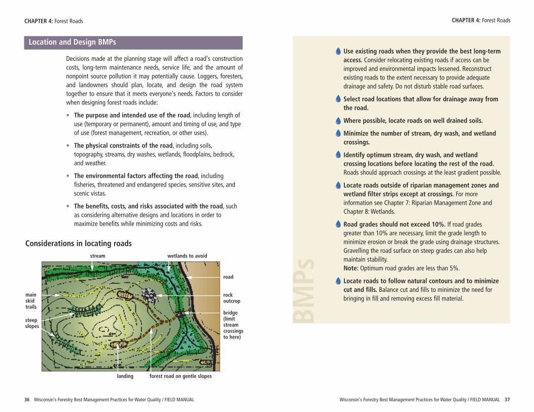
Location and Design BMPs
Decisions made at the planning stage will affect a road’s constructioncosts, long-term maintenance needs, service life, and the amount ofnonpoint source pollution it may potentially cause. Loggers, foresters,and landowners should plan, locate, and design the road systemtogether to ensure that it meets everyone’s needs. Factors to considerwhen designing forest roads include:
• The purpose and intended use of the road, including length ofuse (temporary or permanent), amount and timing of use, and typeof use (forest management, recreation, or other uses).
• The physical constraints of the road, including soils,topography, streams, dry washes, wetlands, floodplains, bedrock,and weather.
• The environmental factors affecting the road, includingfisheries, threatened and endangered species, sensitive sites, andscenic vistas.
• The benefits, costs, and risks associated with the road, suchas considering alternative designs and locations in order tomaximize benefits while minimizing costs and risks.
Use existing roads when they provide the best long-termaccess. Consider relocating existing roads if access can beimproved and environmental impacts lessened. Reconstructexisting roads to the extent necessary to provide adequatedrainage and safety. Do not disturb stable road surfaces.
Select road locations that allow for drainage away fromthe road.
Where possible, locate roads on well drained soils.
Minimize the number of stream, dry wash, and wetlandcrossings.
Identify optimum stream, dry wash, and wetlandcrossing locations before locating the rest of the road.Roads should approach crossings at the least gradient possible.
Locate roads outside of riparian management zones andwetland filter strips except at crossings. For moreinformation see Chapter 7: Riparian Management Zone andChapter 8: Wetlands.
Road grades should not exceed 10%. If road gradesgreater than 10% are necessary, limit the grade length tominimize erosion or break the grade using drainage structures.Gravelling the road surface on steep grades can also helpmaintain stability. Note: Optimum road grades are less than 5%.
Locate roads to follow natural contours and to minimizecut and fills. Balance cut and fills to minimize the need forbringing in fill and removing excess fill material.
CHAPTER 4: Forest Roads CHAPTER 4: Forest Roads
BMPs
landing forest road on gentle slopes
wetlands to avoidstream
bridge(limitstreamcrossingsto here)
road
rockoutcrop
mainskidtrails
steepslopes
Considerations in locating roads
A Closer Look at Balancing Transportation Needs
The BMPs recommend limiting the number, width, and length of both roads and skidtrails. This may seem to be an impossible task because if the length of roads is limited,then the length of the skid trails is increased, and vice-versa. The goal of these seeminglycontradictory BMPs is to have a balanced, well-thought out transportation system.
When planning a forest transportation system, youwill need to consider not only immediate harvestneeds, but also long-term forest management and landowner objectives. Think about the harvestcharacteristics (volume and types of products, terrain, soils),expected uses of the transportation system, and otherfeatures of the property (shape of the property and proximityto neighboring lots).
When making decisions regarding locations of roads,skid trails, and landings, be sure to understand thetrade-offs. Longer skid trails may mean increased fuel costsfor the logger, but skid trails generally have shorter termimpacts on water quality than roads. More roads may providebetter access to a property, but are also more expensive tobuild than skid trails. When planning a forest transportationsystem, take all of these factors into consideration.
Finding the appropriate balance of roads, skid trails, and landings will vary with each site.
Wisconsin’s Forestry Best Management Practices for Water Quality / FIELD MANUAL 3938 Wisconsin’s Forestry Best Management Practices for Water Quality / FIELD MANUAL
Road Construction
Two primary considerations when constructing forest roads are to getwater off the road and then away from the road. The road constructionBMPs focus on the first part – getting water off of the road. Water on aroad can affect:
• Load bearing capacity
• Slope stability, and
• Erosion and sedimentation.
There are three common road profiles – out-sloped, in-sloped, andcrowned. Ideally, the profile of any road surface should be no more than2–6%. Profiles greater than that will make it difficult for vehicles to stayon the road in wet or icy conditions.
CHAPTER 4: Forest Roads CHAPTER 4: Forest RoadsCa
rmen W
agner, DN
R
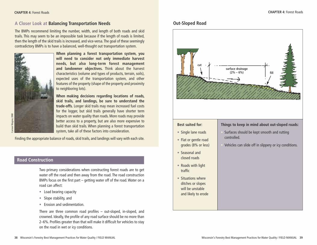
Out-Sloped Road
Best suited for:
• Single lane roads
• Flat or gentle roadgrades (8% or less)
• Seasonal andclosed roads
• Roads with lighttraffic
• Situations whereditches or slopeswill be unstableand likely to erode
Things to keep in mind about out-sloped roads:
• Surfaces should be kept smooth and ruttingcontrolled.
• Vehicles can slide off in slippery or icy conditions.
surface drainage(2% – 6%)
cut
fill
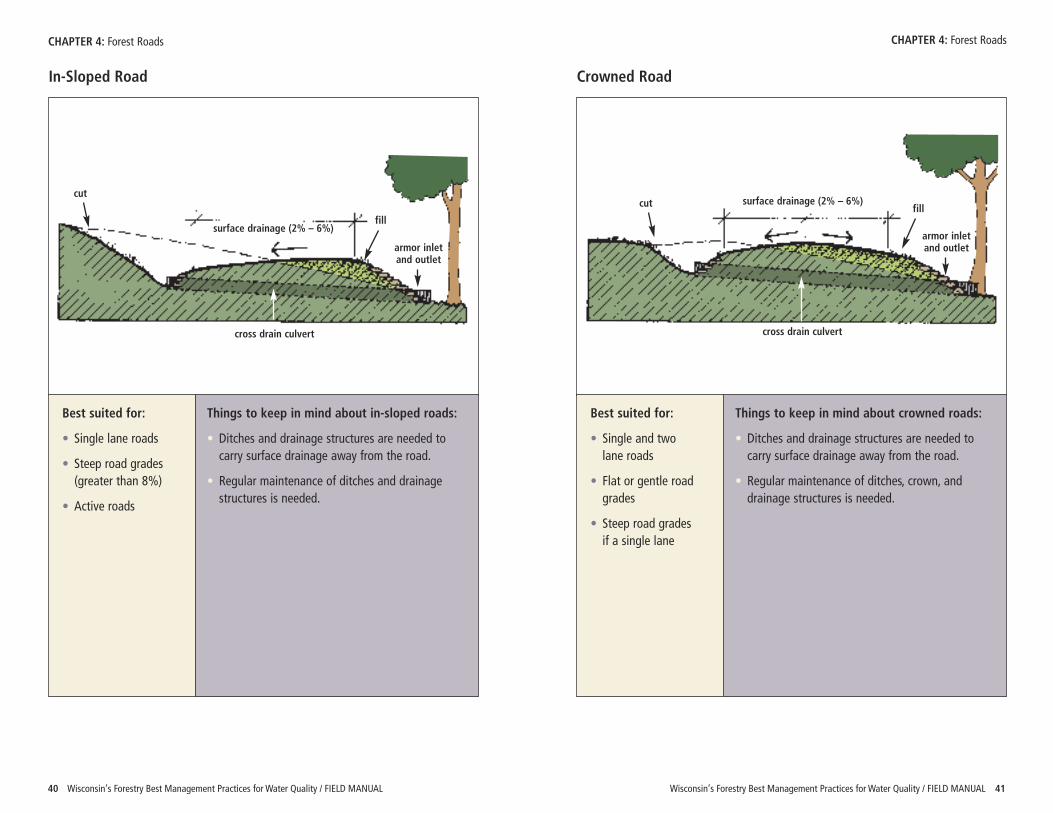
Wisconsin’s Forestry Best Management Practices for Water Quality / FIELD MANUAL 4140 Wisconsin’s Forestry Best Management Practices for Water Quality / FIELD MANUAL
CHAPTER 4: Forest Roads CHAPTER 4: Forest Roads
In-Sloped Road
Best suited for:
• Single lane roads
• Steep road grades(greater than 8%)
• Active roads
Things to keep in mind about in-sloped roads:
• Ditches and drainage structures are needed tocarry surface drainage away from the road.
• Regular maintenance of ditches and drainagestructures is needed.
Crowned Road
Best suited for:
• Single and twolane roads
• Flat or gentle roadgrades
• Steep road gradesif a single lane
Things to keep in mind about crowned roads:
• Ditches and drainage structures are needed tocarry surface drainage away from the road.
• Regular maintenance of ditches, crown, anddrainage structures is needed.
surface drainage (2% – 6%)
cut
fill
cross drain culvert
armor inletand outlet
surface drainage (2% – 6%)cut fill
cross drain culvert
armor inletand outlet
Wisconsin’s Forestry Best Management Practices for Water Quality / FIELD MANUAL 4342 Wisconsin’s Forestry Best Management Practices for Water Quality / FIELD MANUAL
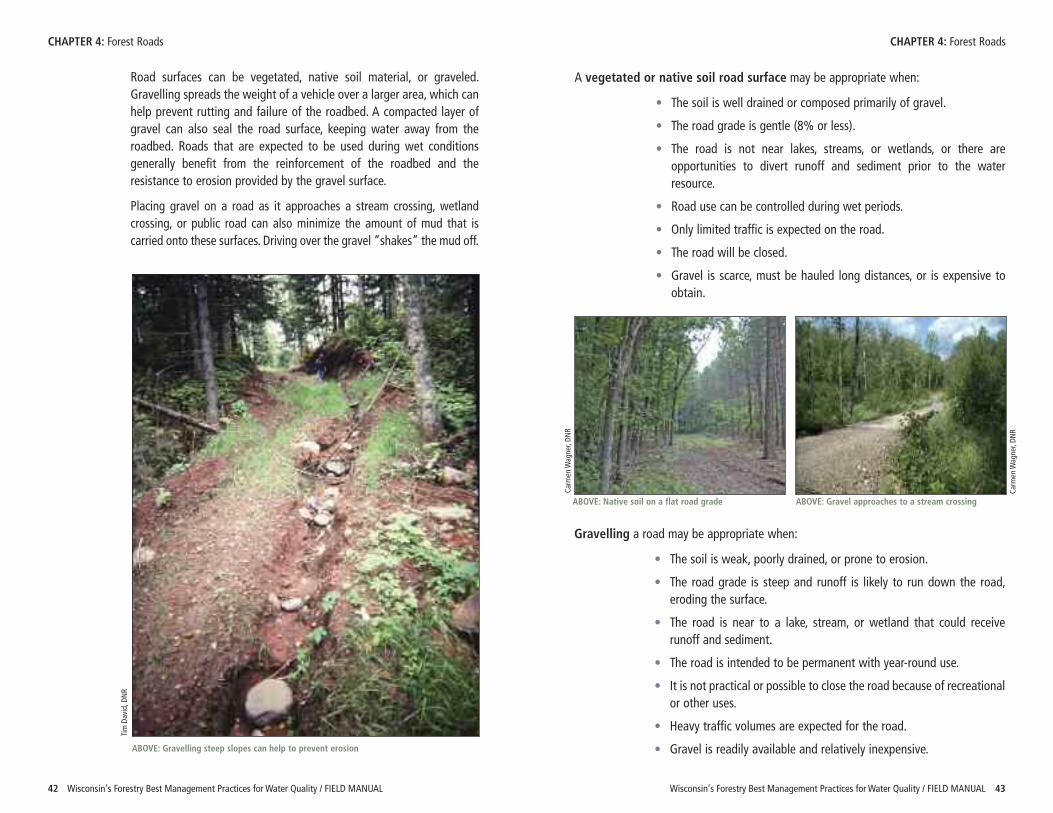
Road surfaces can be vegetated, native soil material, or graveled.Gravelling spreads the weight of a vehicle over a larger area, which canhelp prevent rutting and failure of the roadbed. A compacted layer ofgravel can also seal the road surface, keeping water away from theroadbed. Roads that are expected to be used during wet conditionsgenerally benefit from the reinforcement of the roadbed and theresistance to erosion provided by the gravel surface.
Placing gravel on a road as it approaches a stream crossing, wetlandcrossing, or public road can also minimize the amount of mud that iscarried onto these surfaces. Driving over the gravel “shakes” the mud off.
CHAPTER 4: Forest Roads CHAPTER 4: Forest Roads
A vegetated or native soil road surface may be appropriate when:
• The soil is well drained or composed primarily of gravel.
• The road grade is gentle (8% or less).
• The road is not near lakes, streams, or wetlands, or there areopportunities to divert runoff and sediment prior to the waterresource.
• Road use can be controlled during wet periods.
• Only limited traffic is expected on the road.
• The road will be closed.
• Gravel is scarce, must be hauled long distances, or is expensive toobtain.
Gravelling a road may be appropriate when:
• The soil is weak, poorly drained, or prone to erosion.
• The road grade is steep and runoff is likely to run down the road,eroding the surface.
• The road is near to a lake, stream, or wetland that could receiverunoff and sediment.
• The road is intended to be permanent with year-round use.
• It is not practical or possible to close the road because of recreationalor other uses.
• Heavy traffic volumes are expected for the road.
• Gravel is readily available and relatively inexpensive.
Carm
en W
agner, DN
R
Carm
en W
agner, DN
R
ABOVE: Native soil on a flat road grade ABOVE: Gravel approaches to a stream crossing
Tim David, D
NR
ABOVE: Gravelling steep slopes can help to prevent erosion
Drainage Structures
After the water is off of the road surface, you then need to get it awayfrom the road. If water is confined to ditches along the roadside, twothings will occur. First, the roadbed will become saturated and will notbe able to support heavy traffic. Second, as water accumulates in theditches and gains speed, soil can erode from the ditch, roadbed androad surface. These problems can be avoided by diverting water out ofthe ditches and dispersing it into the adjacent forestland. This will notonly help to prevent erosion, but will also ensure that a high qualityroad system is in place. Placement of drainage structures is oftendictated by the landscape; however, care should be taken to avoiddirecting runoff directly into lakes, streams, dry washes, and wetlands.
Road drainage structures include cross drains and diversion ditches.Cross drains are designed to move water from a roadside ditch on oneside of the road to the other and include cross drain culverts, open-topculverts, rubber belt diverters, broad-based dips, and water bars.Diversion ditches direct water away from the road and disperse thewater across the forest floor.
Wisconsin’s Forestry Best Management Practices for Water Quality / FIELD MANUAL 4544 Wisconsin’s Forestry Best Management Practices for Water Quality / FIELD MANUAL
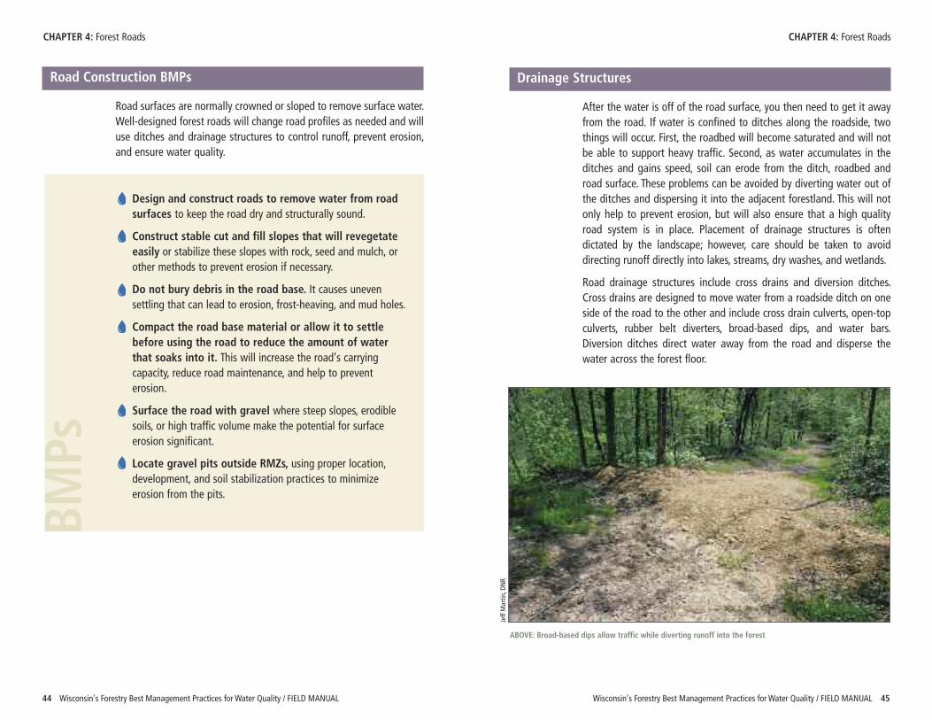
Road Construction BMPs
Road surfaces are normally crowned or sloped to remove surface water.Well-designed forest roads will change road profiles as needed and willuse ditches and drainage structures to control runoff, prevent erosion,and ensure water quality.
CHAPTER 4: Forest Roads CHAPTER 4: Forest Roads
Design and construct roads to remove water from roadsurfaces to keep the road dry and structurally sound.
Construct stable cut and fill slopes that will revegetateeasily or stabilize these slopes with rock, seed and mulch, orother methods to prevent erosion if necessary.
Do not bury debris in the road base. It causes unevensettling that can lead to erosion, frost-heaving, and mud holes.
Compact the road base material or allow it to settlebefore using the road to reduce the amount of waterthat soaks into it. This will increase the road’s carryingcapacity, reduce road maintenance, and help to preventerosion.
Surface the road with gravel where steep slopes, erodiblesoils, or high traffic volume make the potential for surfaceerosion significant.
Locate gravel pits outside RMZs, using proper location,development, and soil stabilization practices to minimizeerosion from the pits.
BMPs
Jeff Martin
, DNR
ABOVE: Broad-based dips allow traffic while diverting runoff into the forest
Wisconsin’s Forestry Best Management Practices for Water Quality / FIELD MANUAL 4746 Wisconsin’s Forestry Best Management Practices for Water Quality / FIELD MANUAL
CHAPTER 4: Forest Roads CHAPTER 4: Forest Roads
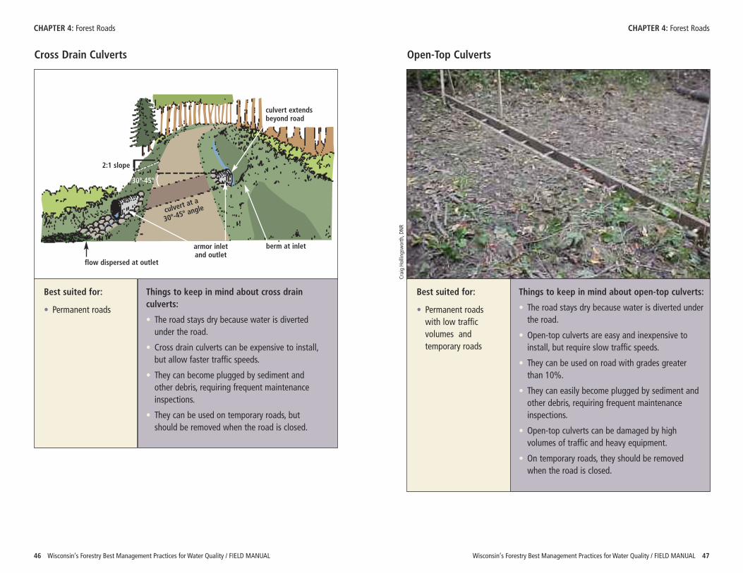
Cross Drain Culverts
Best suited for:
• Permanent roads
Things to keep in mind about cross drainculverts:
• The road stays dry because water is divertedunder the road.
• Cross drain culverts can be expensive to install,but allow faster traffic speeds.
• They can become plugged by sediment andother debris, requiring frequent maintenanceinspections.
• They can be used on temporary roads, butshould be removed when the road is closed.
Open-Top Culverts
Best suited for:
• Permanent roadswith low trafficvolumes andtemporary roads
Things to keep in mind about open-top culverts:
• The road stays dry because water is diverted underthe road.
• Open-top culverts are easy and inexpensive toinstall, but require slow traffic speeds.
• They can be used on road with grades greaterthan 10%.
• They can easily become plugged by sediment andother debris, requiring frequent maintenanceinspections.
• Open-top culverts can be damaged by highvolumes of traffic and heavy equipment.
• On temporary roads, they should be removedwhen the road is closed.
Craig Ho
lling
sworth, D
NR
culvert extendsbeyond road
berm at inletarmor inletand outlet
flow dispersed at outlet
2:1 slope
culvert at a
30º-45º an
gle
30º-45º
Wisconsin’s Forestry Best Management Practices for Water Quality / FIELD MANUAL 4948 Wisconsin’s Forestry Best Management Practices for Water Quality / FIELD MANUAL
CHAPTER 4: Forest Roads CHAPTER 4: Forest Roads
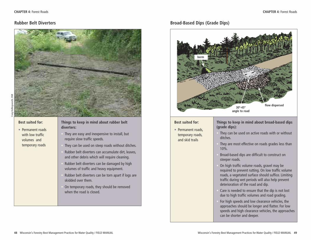
Rubber Belt Diverters
Best suited for:
• Permanent roadswith low trafficvolumes andtemporary roads
Things to keep in mind about rubber beltdiverters:
• They are easy and inexpensive to install, butrequire slow traffic speeds.
• They can be used on steep roads without ditches.
• Rubber belt diverters can accumulate dirt, leaves,and other debris which will require cleaning.
• Rubber belt diverters can be damaged by highvolumes of traffic and heavy equipment.
• Rubber belt diverters can be torn apart if logs areskidded over them.
• On temporary roads, they should be removedwhen the road is closed.
Broad-Based Dips (Grade Dips)
Best suited for:
• Permanent roads,temporary roads,and skid trails
Things to keep in mind about broad-based dips(grade dips):
• They can be used on active roads with or withoutditches.
• They are most effective on roads grades less than10%.
• Broad-based dips are difficult to construct onsteeper roads.
• On high traffic volume roads, gravel may berequired to prevent rutting. On low traffic volumeroads, a vegetated surface should suffice. Limitingtraffic during wet periods will also help preventdeterioration of the road and dip.
• Care is needed to ensure that the dip is not lostdue to high traffic volumes and road grading.
• For high speeds and low clearance vehicles, theapproaches should be longer and flatter. For lowspeeds and high clearance vehicles, the approachescan be shorter and deeper.
Craig Ho
lling
sworth, D
NR
flow dispersed30º-45º
angle to road
berm
Wisconsin’s Forestry Best Management Practices for Water Quality / FIELD MANUAL 5150 Wisconsin’s Forestry Best Management Practices for Water Quality / FIELD MANUAL
CHAPTER 4: Forest Roads CHAPTER 4: Forest Roads
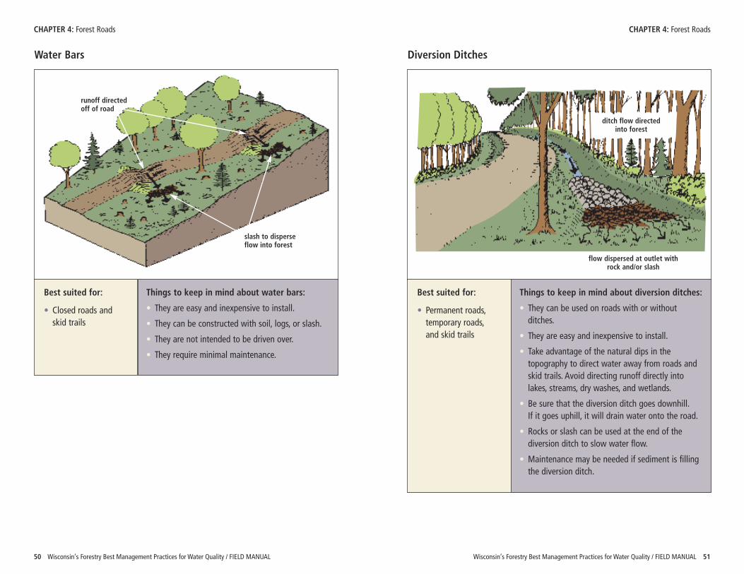
Water Bars
Best suited for:
• Closed roads andskid trails
Things to keep in mind about water bars:
• They are easy and inexpensive to install.
• They can be constructed with soil, logs, or slash.
• They are not intended to be driven over.
• They require minimal maintenance.
Diversion Ditches
Best suited for:
• Permanent roads,temporary roads,and skid trails
Things to keep in mind about diversion ditches:
• They can be used on roads with or withoutditches.
• They are easy and inexpensive to install.
• Take advantage of the natural dips in thetopography to direct water away from roads andskid trails. Avoid directing runoff directly intolakes, streams, dry washes, and wetlands.
• Be sure that the diversion ditch goes downhill. If it goes uphill, it will drain water onto the road.
• Rocks or slash can be used at the end of thediversion ditch to slow water flow.
• Maintenance may be needed if sediment is fillingthe diversion ditch.
slash to disperseflow into forest
runoff directedoff of road
flow dispersed at outlet withrock and/or slash
ditch flow directedinto forest
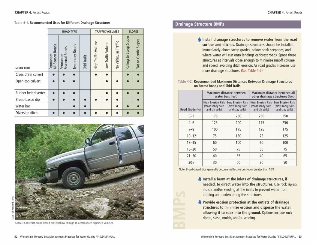
Table 4-1. Recommended Uses for Different Drainage Structures Drainage Structure BMPs
Wisconsin’s Forestry Best Management Practices for Water Quality / FIELD MANUAL 5352 Wisconsin’s Forestry Best Management Practices for Water Quality / FIELD MANUAL
CHAPTER 4: Forest Roads CHAPTER 4: Forest Roads
Perm
anent
All-S
eason Ro
ads
Perm
anent
Season
al Roa
ds
Tempo
rary Roa
ds
Skid Trails
High
Traffic Volum
e
Low Traffic Volum
e
No Ve
hicular Traffic
Rolling
to Steep Slopes
Flat to
Gentle
Slopes Install drainage structures to remove water from the roadsurface and ditches. Drainage structures should be installedimmediately above steep grades, below bank seepages, andwhere water will run onto landings or forest roads. Space thesestructures at intervals close enough to minimize runoff volumeand speed, avoiding ditch erosion. As road grades increase, usemore drainage structures. (See Table 4-2)
BMPs
Table 4-2. Recommended Maximum Distances Between Drainage Structureson Forest Roads and Skid Trails
0–3 175 250 250 350
4–6 125 200 175 250
7–9 100 175 125 175
10–12 75 150 75 125
13–15 60 100 60 100
16–20 50 75 50 75
21–30 40 65 40 65
30+ 30 50 30 50
Note: Broad-based dips generally become ineffective on slopes greater than 10%.
Maximum distance between Maximum distance between allwater bars (feet) other drainage structures (feet)
High Erosion Risk Low Erosion Risk High Erosion Risk Low Erosion Risk(most sandy soils (most rocky soils (most sandy soils (most rocky soils
Road Grade (%) and silt soils) and clay soils) and silt soils) and clay soils)
Install a berm at the inlets of drainage structures, ifneeded, to direct water into the structures. Use rock riprap,mulch, and/or seeding at the inlets to prevent water fromeroding and undercutting the structures.
Provide erosion protection at the outlets of drainagestructures to minimize erosion and disperse the water,allowing it to soak into the ground. Options include rockriprap, slash, mulch, and/or seeding.
ABOVE: Construct broad-based dips shallow enough to accomodate expected vehicles.
Craig Ho
lling
sworth, D
NR
STRUCTURE
Cross drain culvert • • • • • • •Open-top culvert • • • • • • •
Rubber belt diverter • • • • • • •Broad-based dip • • • • • • • •Water bar • • • • •Diversion ditch • • • • • • • • •
ROAD TYPE TRAFFIC VOLUMES SLOPES
Wisconsin’s Forestry Best Management Practices for Water Quality / FIELD MANUAL 5554 Wisconsin’s Forestry Best Management Practices for Water Quality / FIELD MANUAL
CHAPTER 4: Forest Roads CHAPTER 4: Forest Roads
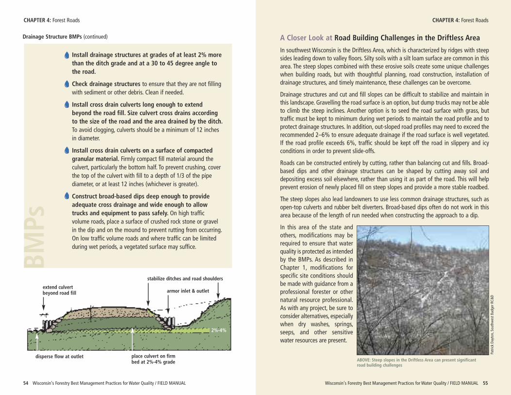
Install drainage structures at grades of at least 2% morethan the ditch grade and at a 30 to 45 degree angle tothe road.
Check drainage structures to ensure that they are not fillingwith sediment or other debris. Clean if needed.
Install cross drain culverts long enough to extendbeyond the road fill. Size culvert cross drains accordingto the size of the road and the area drained by the ditch.To avoid clogging, culverts should be a minimum of 12 inchesin diameter.
Install cross drain culverts on a surface of compactedgranular material. Firmly compact fill material around theculvert, particularly the bottom half. To prevent crushing, coverthe top of the culvert with fill to a depth of 1/3 of the pipediameter, or at least 12 inches (whichever is greater).
Construct broad-based dips deep enough to provideadequate cross drainage and wide enough to allowtrucks and equipment to pass safely. On high trafficvolume roads, place a surface of crushed rock stone or gravelin the dip and on the mound to prevent rutting from occurring.On low traffic volume roads and where traffic can be limitedduring wet periods, a vegetated surface may suffice.
BMPs
Drainage Structure BMPs (continued) A Closer Look at Road Building Challenges in the Driftless Area
In southwest Wisconsin is the Driftless Area, which is characterized by ridges with steepsides leading down to valley floors. Silty soils with a silt loam surface are common in thisarea. The steep slopes combined with these erosive soils create some unique challengeswhen building roads, but with thoughtful planning, road construction, installation ofdrainage structures, and timely maintenance, these challenges can be overcome.
Drainage structures and cut and fill slopes can be difficult to stabilize and maintain inthis landscape. Gravelling the road surface is an option, but dump trucks may not be ableto climb the steep inclines. Another option is to seed the road surface with grass, buttraffic must be kept to minimum during wet periods to maintain the road profile and toprotect drainage structures. In addition, out-sloped road profiles may need to exceed therecommended 2–6% to ensure adequate drainage if the road surface is well vegetated.If the road profile exceeds 6%, traffic should be kept off the road in slippery and icyconditions in order to prevent slide-offs.
Roads can be constructed entirely by cutting, rather than balancing cut and fills. Broad-based dips and other drainage structures can be shaped by cutting away soil anddepositing excess soil elsewhere, rather than using it as part of the road. This will helpprevent erosion of newly placed fill on steep slopes and provide a more stable roadbed.
The steep slopes also lead landowners to use less common drainage structures, such asopen-top culverts and rubber belt diverters. Broad-based dips often do not work in thisarea because of the length of run needed when constructing the approach to a dip.
In this area of the state andothers, modifications may berequired to ensure that waterquality is protected as intendedby the BMPs. As described inChapter 1, modifications forspecific site conditions shouldbe made with guidance from aprofessional forester or othernatural resource professional.As with any project, be sure toconsider alternatives, especiallywhen dry washes, springs,seeps, and other sensitivewater resources are present.
ABOVE: Steep slopes in the Driftless Area can present significantroad building challenges
Patrick Da
yton
, Sou
thwest B
adger R
C&D
armor inlet & outlet
stabilize ditches and road shoulders
extend culvertbeyond road fill
disperse flow at outlet place culvert on firmbed at 2%-4% grade
2%-4%
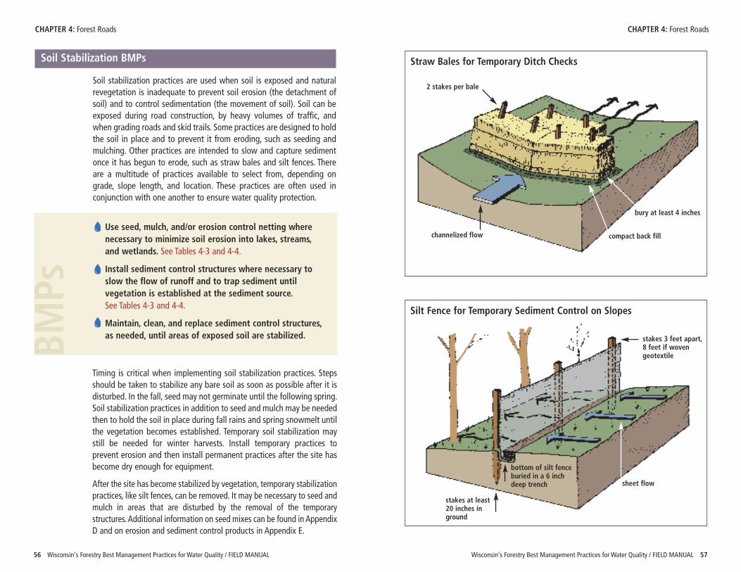
Wisconsin’s Forestry Best Management Practices for Water Quality / FIELD MANUAL 5756 Wisconsin’s Forestry Best Management Practices for Water Quality / FIELD MANUAL
CHAPTER 4: Forest Roads CHAPTER 4: Forest Roads
Soil Stabilization BMPs
Soil stabilization practices are used when soil is exposed and naturalrevegetation is inadequate to prevent soil erosion (the detachment ofsoil) and to control sedimentation (the movement of soil). Soil can beexposed during road construction, by heavy volumes of traffic, andwhen grading roads and skid trails. Some practices are designed to holdthe soil in place and to prevent it from eroding, such as seeding andmulching. Other practices are intended to slow and capture sedimentonce it has begun to erode, such as straw bales and silt fences. Thereare a multitude of practices available to select from, depending ongrade, slope length, and location. These practices are often used inconjunction with one another to ensure water quality protection.
Use seed, mulch, and/or erosion control netting wherenecessary to minimize soil erosion into lakes, streams,and wetlands. See Tables 4-3 and 4-4.
Install sediment control structures where necessary toslow the flow of runoff and to trap sediment untilvegetation is established at the sediment source. See Tables 4-3 and 4-4.
Maintain, clean, and replace sediment control structures,as needed, until areas of exposed soil are stabilized.BM
Ps
Timing is critical when implementing soil stabilization practices. Stepsshould be taken to stabilize any bare soil as soon as possible after it isdisturbed. In the fall, seed may not germinate until the following spring.Soil stabilization practices in addition to seed and mulch may be neededthen to hold the soil in place during fall rains and spring snowmelt untilthe vegetation becomes established. Temporary soil stabilization maystill be needed for winter harvests. Install temporary practices toprevent erosion and then install permanent practices after the site hasbecome dry enough for equipment.
After the site has become stabilized by vegetation, temporary stabilizationpractices, like silt fences, can be removed. It may be necessary to seed andmulch in areas that are disturbed by the removal of the temporarystructures. Additional information on seed mixes can be found in AppendixD and on erosion and sediment control products in Appendix E.
Straw Bales for Temporary Ditch Checks
Silt Fence for Temporary Sediment Control on Slopes
2 stakes per bale
channelized flow compact back fill
bury at least 4 inches
stakes at least20 inches inground
bottom of silt fenceburied in a 6 inchdeep trench
stakes 3 feet apart,8 feet if wovengeotextile
sheet flow
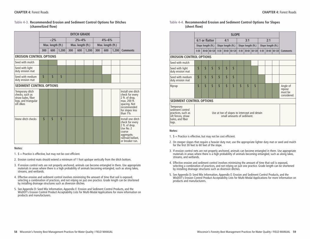
SLOPE
6:1 or flatter 4:1 3:1 2:1Slope length (ft.) Slope length (ft.) Slope length (ft.) Slope length (ft.)
0-30 30-60 60-120 0-30 30-60 60-120 0-30 30-60 60-120 0-30 30-60 60-120 Comments
Wisconsin’s Forestry Best Management Practices for Water Quality / FIELD MANUAL 5958 Wisconsin’s Forestry Best Management Practices for Water Quality / FIELD MANUAL
CHAPTER 4: Forest Roads CHAPTER 4: Forest Roads
Table 4-3. Recommended Erosion and Sediment Control Options for Ditches(channelized flow)
DITCH GRADE
<2% 2%–4% 4%–6%Max. length (ft.) Max. length (ft.) Max. length (ft.)
300 600 1,200 300 600 1,200 300 600 1,200 Comments
EROSION CONTROL OPTIONS
Seed with mulch
Seed with lightduty erosion mat
Seed with medium $ $ $duty erosion mat
SEDIMENT CONTROL OPTIONS
Temporary ditch Install one ditchchecks, such as check for everystraw bales, fiber 2 ft. of drop,logs, and triangular max. 200 ft.silt dikes spacing. Not
recommendedfor slopes lessthan 1%
Stone ditch checks $ $ $ Install one ditchcheck for every2 ft. of drop.Use No. 2coarseaggregate,railroad ballast,or breaker run.
Notes:
1. $ = Practice is effective, but may not be cost efficient.
2. Erosion control mats should extend a minimum of 1 foot upslope vertically from the ditch bottom.
3. If erosion control nets are not properly anchored, animals can become entangled in them. Use appropriatematerials in areas where there is a high probability of animals becoming entangled, such as along lakes,streams, and wetlands.
4. Effective erosion and sediment control involves minimizing the amount of time that soil is exposed,selecting a combination of practices, and not relying on just one practice. Grade length can be shortenedby installing drainage structures such as diversion ditches.
5. See Appendix D: Seed Mix Information, Appendix E: Erosion and Sediment Control Products, and theWisDOT’s Erosion Control Product Acceptability Lists for Multi-Modal Applications for more information onproducts and manufacturers.
Table 4-4. Recommended Erosion and Sediment Control Options for Slopes(sheet flow)
Notes:
1. $ = Practice is effective, but may not be cost efficient.
2. On steeper slopes that require a heavier duty mat, use the appropriate lighter duty mat or seed and mulchfor the first 30 feet to 60 feet of the slope.
3. If erosion control nets are not properly anchored, animals can become entangled in them. Use appropriatematerials in areas where there is a high probability of animals becoming entangled, such as along lakes,streams, and wetlands.
4. Effective erosion and sediment control involves minimizing the amount of time that soil is exposed,selecting a combination of practices, and not relying on just one practice. Grade length can be shortenedby installing drainage structures such as diversion ditches.
5. See Appendix D: Seed Mix Information, Appendix E: Erosion and Sediment Control Products, and theWisDOT’s Erosion Control Product Acceptability Lists for Multi-Modal Applications for more information onproducts and manufacturers.
EROSION CONTROL OPTIONS
Seed with mulch
Seed with light $ $ $ $ $ $duty erosion mat
Seed with medium $ $ $ $ $ $duty erosion mat
Riprap $ $ $ $ $ $ $ $ $ Angle of repose must beconsidered.
SEDIMENT CONTROL OPTIONS
Temporary sediment controlpractices, such as Use at toe of slopes to intercept and detain silt fences, straw small amounts of sediment.bales, and fiberlogs.
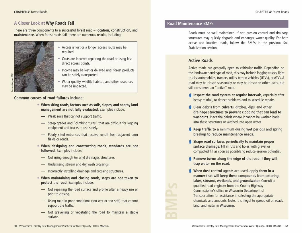
A Closer Look at Why Roads Fail
There are three components to a successful forest road – location, construction, andmaintenance.When forest roads fail, there are numerous results, including:
Wisconsin’s Forestry Best Management Practices for Water Quality / FIELD MANUAL 6160 Wisconsin’s Forestry Best Management Practices for Water Quality / FIELD MANUAL
CHAPTER 4: Forest Roads CHAPTER 4: Forest Roads
Common causes of road failures include:
• When siting roads, factors such as soils, slopes, and nearby landmanagement are not fully evaluated. Examples include:
— Weak soils that cannot support traffic.
— Steep grades and “climbing turns” that are difficult for loggingequipment and trucks to use safely.
— Poorly sited entrances that receive runoff from adjacent farmfields or roads.
• When designing and constructing roads, standards are notfollowed. Examples include:
— Not using enough (or any) drainages structures.
— Undersizing stream and dry wash crossings.
— Incorrectly installing drainage and crossing structures.
• When maintaining and closing roads, steps are not taken toprotect the road. Examples include:
— Not repairing the road surface and profile after a heavy use orprior to closing.
— Using road in poor conditions (too wet or too soft) that cannotsupport the traffic.
— Not gravelling or vegetating the road to maintain a stablesurface.
• Access is lost or a longer access route may berequired.
• Costs are incurred repairing the road or using lessdirect access points.
• Income may be lost or delayed until forest productscan be safely transported.
• Water quality, wildlife habitat, and other resourcesmay be impacted.
Carm
en W
agner, DN
R
Road Maintenance BMPs
Roads must be well maintained. If not, erosion control and drainagestructures may quickly degrade and endanger water quality. For bothactive and inactive roads, follow the BMPs in the previous SoilStabilization section.
Active Roads
Active roads are generally open to vehicular traffic. Depending onthe landowner and type of road, this may include logging trucks, lighttrucks, automobiles, tractors, utility terrain vehicles (UTVs), or ATVs. Aroad may be closed seasonally or may be closed to other users, butstill considered an “active” road.
Inspect the road system at regular intervals, especially afterheavy rainfall, to detect problems and to schedule repairs.
Clear debris from culverts, ditches, dips, and otherdrainage structures to prevent clogging that can lead towashouts. Place the debris where it cannot be washed backinto these structures or washed into open water.
Keep traffic to a minimum during wet periods and springbreakup to reduce maintenance needs.
Shape road surfaces periodically to maintain propersurface drainage. Fill in ruts and holes with gravel orcompacted fill as soon as possible to reduce erosion potential.
Remove berms along the edge of the road if they willtrap water on the road.
When dust control agents are used, apply them in amanner that will keep these compounds from enteringlakes, streams, wetlands, and groundwater. Consult aqualified road engineer from the County HighwayCommissioner’s office or Wisconsin Department ofTransportation for assistance in selecting the appropriatechemicals and amounts. Note: It is illegal to spread oil on roads,land, and water in Wisconsin.
BMPs
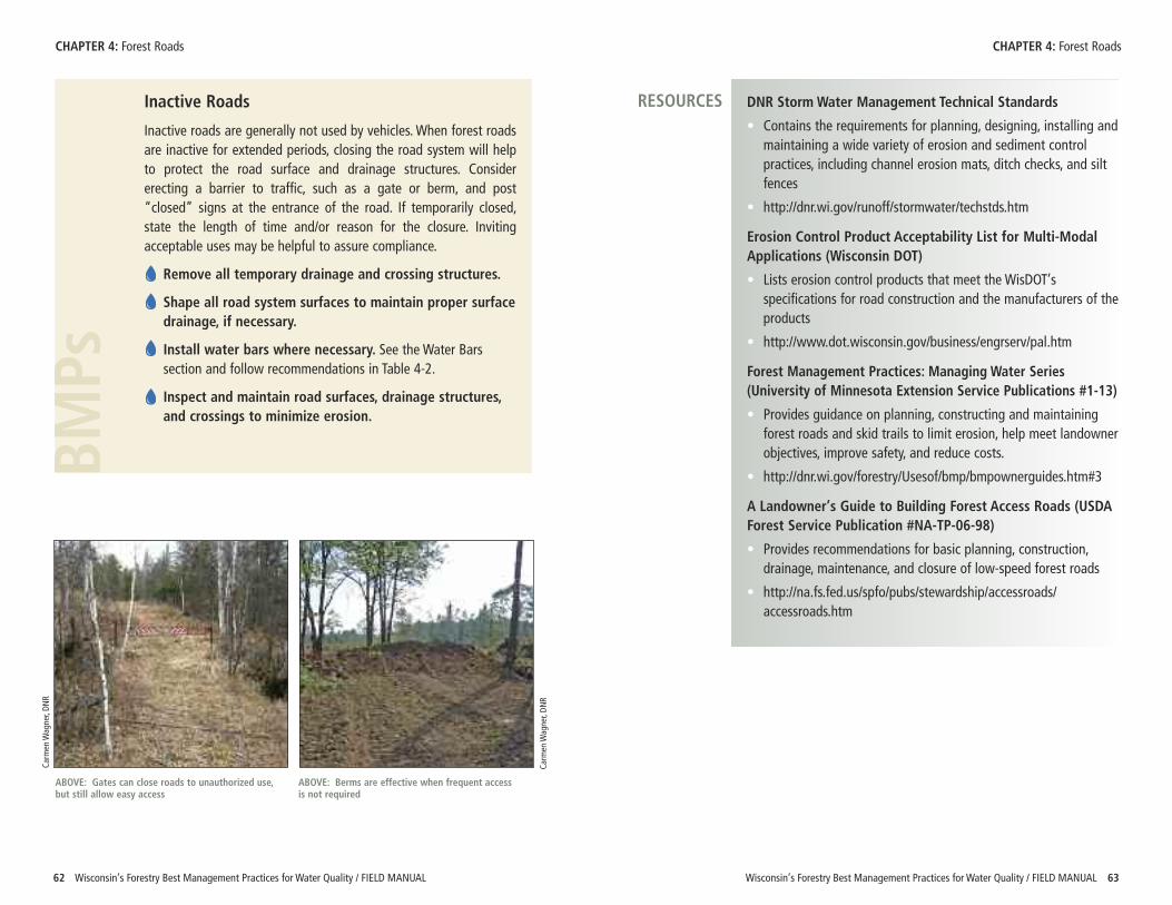
Wisconsin’s Forestry Best Management Practices for Water Quality / FIELD MANUAL 6362 Wisconsin’s Forestry Best Management Practices for Water Quality / FIELD MANUAL
CHAPTER 4: Forest Roads CHAPTER 4: Forest Roads
Inactive Roads
Inactive roads are generally not used by vehicles. When forest roadsare inactive for extended periods, closing the road system will helpto protect the road surface and drainage structures. Considererecting a barrier to traffic, such as a gate or berm, and post“closed” signs at the entrance of the road. If temporarily closed,state the length of time and/or reason for the closure. Invitingacceptable uses may be helpful to assure compliance.
Remove all temporary drainage and crossing structures.
Shape all road system surfaces to maintain proper surfacedrainage, if necessary.
Install water bars where necessary. See the Water Barssection and follow recommendations in Table 4-2.
Inspect and maintain road surfaces, drainage structures,and crossings to minimize erosion.
BMPs
DNR Storm Water Management Technical Standards
• Contains the requirements for planning, designing, installing andmaintaining a wide variety of erosion and sediment controlpractices, including channel erosion mats, ditch checks, and siltfences
• http://dnr.wi.gov/runoff/stormwater/techstds.htm
Erosion Control Product Acceptability List for Multi-ModalApplications (Wisconsin DOT)
• Lists erosion control products that meet the WisDOT’sspecifications for road construction and the manufacturers of theproducts
• http://www.dot.wisconsin.gov/business/engrserv/pal.htm
Forest Management Practices: Managing Water Series(University of Minnesota Extension Service Publications #1-13)
• Provides guidance on planning, constructing and maintainingforest roads and skid trails to limit erosion, help meet landownerobjectives, improve safety, and reduce costs.
• http://dnr.wi.gov/forestry/Usesof/bmp/bmpownerguides.htm#3
A Landowner’s Guide to Building Forest Access Roads (USDAForest Service Publication #NA-TP-06-98)
• Provides recommendations for basic planning, construction,drainage, maintenance, and closure of low-speed forest roads
• http://na.fs.fed.us/spfo/pubs/stewardship/accessroads/accessroads.htm
RESOURCES
ABOVE: Gates can close roads to unauthorized use,but still allow easy access
ABOVE: Berms are effective when frequent accessis not required
Carm
en W
agner, DN
R
Carm
en W
agner, DN
R
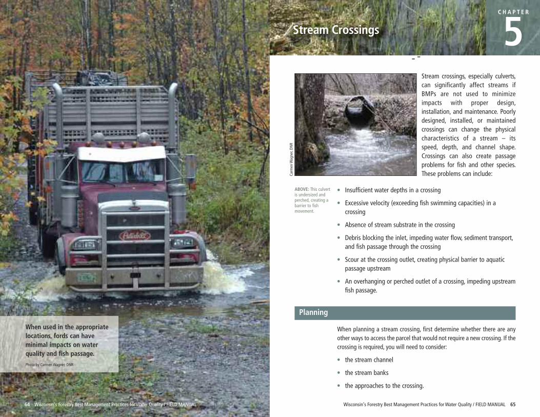
64 Wisconsin’s Forestry Best Management Practices for Water Quality / FIELD MANUAL
Stream crossings, especially culverts,can significantly affect streams ifBMPs are not used to minimizeimpacts with proper design,installation, and maintenance. Poorlydesigned, installed, or maintainedcrossings can change the physicalcharacteristics of a stream – itsspeed, depth, and channel shape.Crossings can also create passageproblems for fish and other species.These problems can include:
• Insufficient water depths in a crossing
• Excessive velocity (exceeding fish swimming capacities) in acrossing
• Absence of stream substrate in the crossing
• Debris blocking the inlet, impeding water flow, sediment transport,and fish passage through the crossing
• Scour at the crossing outlet, creating physical barrier to aquaticpassage upstream
• An overhanging or perched outlet of a crossing, impeding upstreamfish passage.
Planning
When planning a stream crossing, first determine whether there are anyother ways to access the parcel that would not require a new crossing. If thecrossing is required, you will need to consider:
• the stream channel
• the stream banks
• the approaches to the crossing.
ABOVE: This culvertis undersized andperched, creating abarrier to fishmovement.
Carm
en W
agner, DN
R
C H A P T E R
5
Wisconsin’s Forestry Best Management Practices for Water Quality / FIELD MANUAL 65
Stream Crossings
When used in the appropriatelocations, fords can haveminimal impacts on waterquality and fish passage.
Photo by Carmen Wagner, DNR
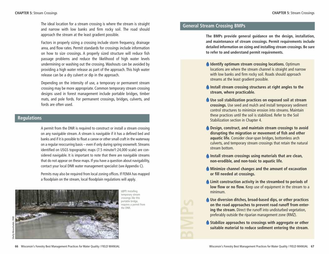
The ideal location for a stream crossing is where the stream is straightand narrow with low banks and firm rocky soil. The road shouldapproach the stream at the least gradient possible.
Factors in properly sizing a crossing include storm frequency, drainagearea, and flow rates. Permit standards for crossings include informationon how to size crossings. A properly sized structure will reduce fishpassage problems and reduce the likelihood of high water levelsundermining or washing out the crossing. Washouts can be avoided byproviding a high water release as part of the approach. This high waterrelease can be a dry culvert or dip in the approach.
Depending on the intensity of use, a temporary or permanent streamcrossing may be more appropriate. Common temporary stream crossingdesigns used in forest management include portable bridges, timbermats, and pole fords. For permanent crossings, bridges, culverts, andfords are often used.
Regulations
A permit from the DNR is required to construct or install a stream crossingon any navigable stream. A stream is navigable if it has a defined bed andbanks and if it is possible to float a canoe or other small craft in the waterwayon a regular reoccurring basis – even if only during spring snowmelt. Streamsidentified on USGS topographic maps (7.5 minute/1:24,000 scale) are con-sidered navigable. It is important to note that there are navigable streamsthat do not appear on these maps. If you have a question about navigability,contact your local DNR water management specialist (see Appendix C).
Permits may also be required from local zoning offices. If FEMA has mappeda floodplain on the stream, local floodplain regulations will apply.
CHAPTER 5: Stream Crossings
LEFT: Installingtemporary streamcrossings like thisportable bridge,requires a permit fromthe DNR.
Shelly W
rzocha
lski, D
NR
BMPs
General Stream Crossing BMPs
The BMPs provide general guidance on the design, installation, and maintenance of stream crossings. Permit requirements includedetailed information on sizing and installing stream crossings. Be sureto refer to and understand permit requirements.
Identify optimum stream crossing locations. Optimumlocations are where the stream channel is straight and narrowwith low banks and firm rocky soil. Roads should approachstreams at the least gradient possible.
Install stream crossing structures at right angles to thestream, where practicable.
Use soil stabilization practices on exposed soil at streamcrossings. Use seed and mulch and install temporary sedimentcontrol structures to minimize erosion into streams. Maintainthese practices until the soil is stabilized. Refer to the SoilStabilization section in Chapter 4.
Design, construct, and maintain stream crossings to avoiddisrupting the migration or movement of fish and otheraquatic life. Consider clear-span bridges, bottomless archculverts, and temporary stream crossings that retain the naturalstream bottom.
Install stream crossings using materials that are clean,non-erodible, and non-toxic to aquatic life.
Minimize channel changes and the amount of excavationor fill needed at crossings.
Limit construction activity in the streambed to periods oflow flow or no flow. Keep use of equipment in the stream to aminimum.
Use diversion ditches, broad-based dips, or other practiceson the road approaches to prevent road runoff from enter-ing the stream. Direct the runoff into undisturbed vegetation,preferably outside the riparian management zone (RMZ).
Stabilize approaches to crossings with aggregate or othersuitable material to reduce sediment entering the stream.
66 Wisconsin’s Forestry Best Management Practices for Water Quality / FIELD MANUAL
CHAPTER 5: Stream Crossings
Wisconsin’s Forestry Best Management Practices for Water Quality / FIELD MANUAL 67
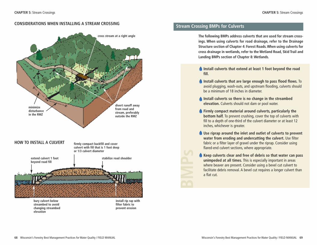
BMPs
Wisconsin’s Forestry Best Management Practices for Water Quality / FIELD MANUAL 69
CHAPTER 5: Stream Crossings
68 Wisconsin’s Forestry Best Management Practices for Water Quality / FIELD MANUAL
Stream Crossing BMPs for Culverts
The following BMPs address culverts that are used for stream cross-ings. When using culverts for road drainage, refer to the DrainageStructure section of Chapter 4: Forest Roads. When using culverts forcross drainage in wetlands, refer to the Wetland Road, Skid Trail andLanding BMPs section of Chapter 8: Wetlands.
Install culverts that extend at least 1 foot beyond the roadfill.
Install culverts that are large enough to pass flood flows. Toavoid plugging, wash-outs, and upstream flooding, culverts shouldbe a minimum of 18 inches in diameter.
Install culverts so there is no change in the streambedelevation. Culverts should not dam or pool water.
Firmly compact material around culverts, particularly thebottom half. To prevent crushing, cover the top of culverts withfill to a depth of one-third of the culvert diameter or at least 12inches, whichever is greater.
Use riprap around the inlet and outlet of culverts to preventwater from eroding and undercutting the culvert. Use filterfabric or a filter layer of gravel under the riprap. Consider usingflared-end culvert sections, where appropriate.
Keep culverts clear and free of debris so that water can passunimpeded at all times. This is especially important in areaswhere beaver are present. Consider using a bevel cut culvert tofacilitate debris removal. A bevel cut requires a longer culvert thana flat cut.
CHAPTER 5: Stream Crossings
HOW TO INSTALL A CULVERT
extend culvert 1 footbeyond road fill
install rip rap withfilter fabric toprevent erosion
firmly compact backfill and coverculvert with fill that is 1 foot deepor 1/3 culvert diameter
bury culvert belowstreambed to avoidchanging streambedelevation
stabilize road shoulder
cross stream at a right angle
divert runoff awayfrom road andstream, preferablyoutside the RMZ
minimizedisturbancein the RMZ
CONSIDERATIONS WHEN INSTALLING A STREAM CROSSING
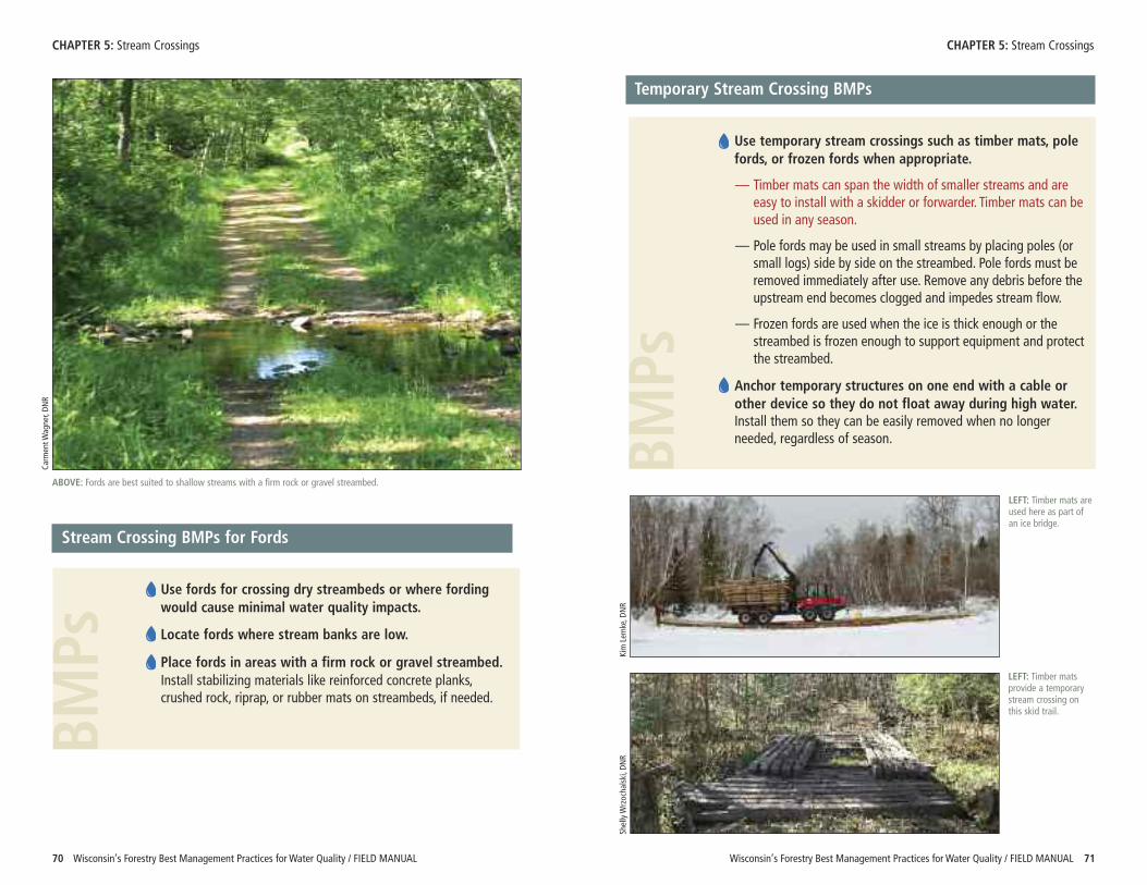
BMPs
BMPs
Wisconsin’s Forestry Best Management Practices for Water Quality / FIELD MANUAL 71
CHAPTER 5: Stream Crossings
70 Wisconsin’s Forestry Best Management Practices for Water Quality / FIELD MANUAL
Stream Crossing BMPs for Fords
Use fords for crossing dry streambeds or where fordingwould cause minimal water quality impacts.
Locate fords where stream banks are low.
Place fords in areas with a firm rock or gravel streambed.Install stabilizing materials like reinforced concrete planks,crushed rock, riprap, or rubber mats on streambeds, if needed.
ABOVE: Fords are best suited to shallow streams with a firm rock or gravel streambed.
Carm
ent W
agner, DN
R
Temporary Stream Crossing BMPs
Use temporary stream crossings such as timber mats, polefords, or frozen fords when appropriate.
— Timber mats can span the width of smaller streams and areeasy to install with a skidder or forwarder. Timber mats can beused in any season.
— Pole fords may be used in small streams by placing poles (orsmall logs) side by side on the streambed. Pole fords must beremoved immediately after use. Remove any debris before theupstream end becomes clogged and impedes stream flow.
— Frozen fords are used when the ice is thick enough or thestreambed is frozen enough to support equipment and protectthe streambed.
Anchor temporary structures on one end with a cable orother device so they do not float away during high water.Install them so they can be easily removed when no longerneeded, regardless of season.
LEFT: Timber mats areused here as part ofan ice bridge.
LEFT: Timber matsprovide a temporarystream crossing onthis skid trail.
Shelly W
rzocha
lski, D
NR
Kim Lem
ke, D
NR
CHAPTER 5: Stream Crossings
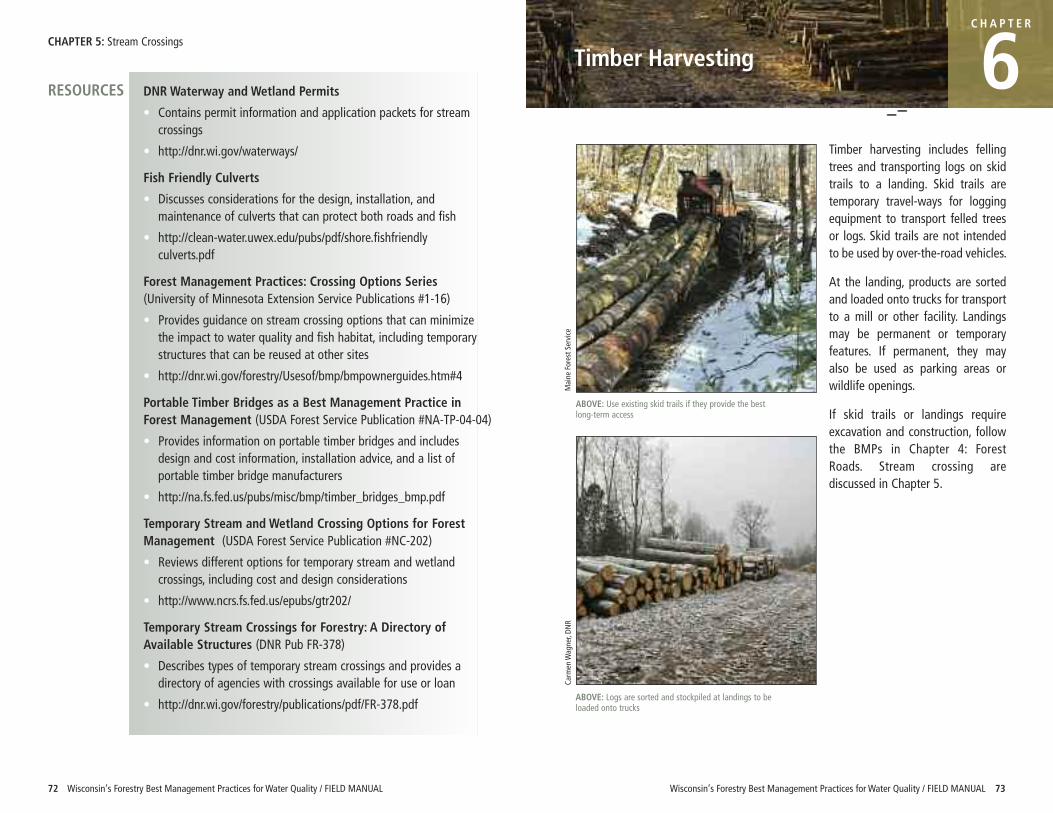
Wisconsin’s Forestry Best Management Practices for Water Quality / FIELD MANUAL 73
Timber Harvesting
CH A P T E R
6Timber harvesting includes fellingtrees and transporting logs on skidtrails to a landing. Skid trails aretemporary travel-ways for loggingequipment to transport felled treesor logs. Skid trails are not intendedto be used by over-the-road vehicles.
At the landing, products are sortedand loaded onto trucks for transportto a mill or other facility. Landingsmay be permanent or temporaryfeatures. If permanent, they mayalso be used as parking areas orwildlife openings.
If skid trails or landings requireexcavation and construction, followthe BMPs in Chapter 4: ForestRoads. Stream crossing arediscussed in Chapter 5.
DNR Waterway and Wetland Permits
• Contains permit information and application packets for streamcrossings
• http://dnr.wi.gov/waterways/
Fish Friendly Culverts
• Discusses considerations for the design, installation, andmaintenance of culverts that can protect both roads and fish
• http://clean-water.uwex.edu/pubs/pdf/shore.fishfriendlyculverts.pdf
Forest Management Practices: Crossing Options Series(University of Minnesota Extension Service Publications #1-16)
• Provides guidance on stream crossing options that can minimizethe impact to water quality and fish habitat, including temporarystructures that can be reused at other sites
• http://dnr.wi.gov/forestry/Usesof/bmp/bmpownerguides.htm#4
Portable Timber Bridges as a Best Management Practice inForest Management (USDA Forest Service Publication #NA-TP-04-04)
• Provides information on portable timber bridges and includesdesign and cost information, installation advice, and a list ofportable timber bridge manufacturers
• http://na.fs.fed.us/pubs/misc/bmp/timber_bridges_bmp.pdf
Temporary Stream and Wetland Crossing Options for ForestManagement (USDA Forest Service Publication #NC-202)
• Reviews different options for temporary stream and wetlandcrossings, including cost and design considerations
• http://www.ncrs.fs.fed.us/epubs/gtr202/
Temporary Stream Crossings for Forestry: A Directory ofAvailable Structures (DNR Pub FR-378)
• Describes types of temporary stream crossings and provides adirectory of agencies with crossings available for use or loan
• http://dnr.wi.gov/forestry/publications/pdf/FR-378.pdf
RESOURCES
72 Wisconsin’s Forestry Best Management Practices for Water Quality / FIELD MANUAL
CHAPTER 5: Stream Crossings
ABOVE: Use existing skid trails if they provide the bestlong-term access
Maine Forest S
ervice
ABOVE: Logs are sorted and stockpiled at landings to beloaded onto trucks
Carm
en W
agner, DN
R
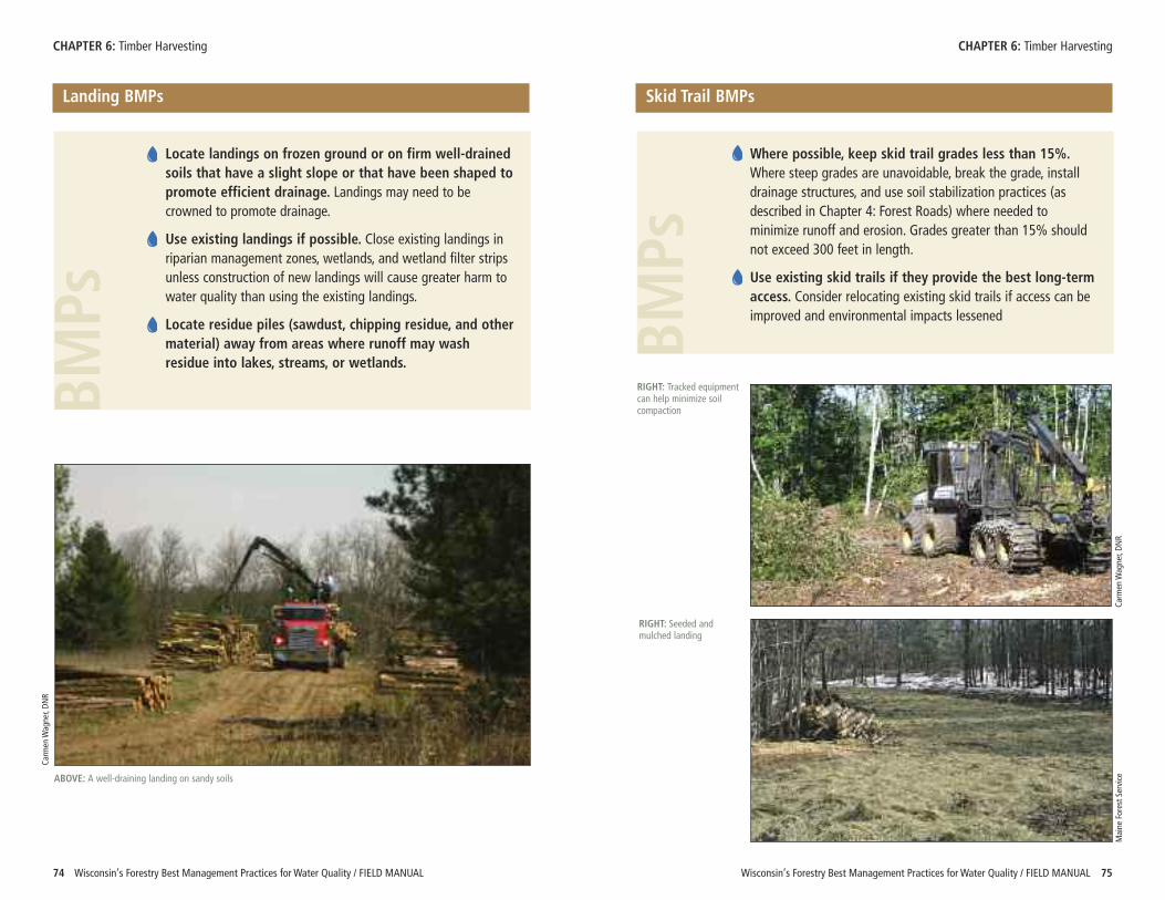
Wisconsin’s Forestry Best Management Practices for Water Quality / FIELD MANUAL 75
CHAPTER 6: Timber Harvesting CHAPTER 6: Timber Harvesting
74 Wisconsin’s Forestry Best Management Practices for Water Quality / FIELD MANUAL
Landing BMPs
� Locate landings on frozen ground or on firm well-drainedsoils that have a slight slope or that have been shaped topromote efficient drainage. Landings may need to becrowned to promote drainage.
� Use existing landings if possible. Close existing landings inriparian management zones, wetlands, and wetland filter stripsunless construction of new landings will cause greater harm towater quality than using the existing landings.
� Locate residue piles (sawdust, chipping residue, and othermaterial) away from areas where runoff may washresidue into lakes, streams, or wetlands.
BMPs
Locate landings on frozen ground or on firm well-drainedsoils that have a slight slope or that have been shaped topromote efficient drainage. Landings may need to becrowned to promote drainage.
Use existing landings if possible. Close existing landings inriparian management zones, wetlands, and wetland filter stripsunless construction of new landings will cause greater harm towater quality than using the existing landings.
Locate residue piles (sawdust, chipping residue, and othermaterial) away from areas where runoff may washresidue into lakes, streams, or wetlands.
BMPs
Skid Trail BMPs
� Locate landings on frozen ground or on firm well-drainedsoils that have a slight slope or that have been shaped topromote efficient drainage. Landings may need to becrowned to promote drainage.
� Use existing landings if possible. Close existing landings inriparian management zones, wetlands, and wetland filter stripsunless construction of new landings will cause greater harm towater quality than using the existing landings.
� Locate residue piles (sawdust, chipping residue, and othermaterial) away from areas where runoff may wash
Where possible, keep skid trail grades less than 15%.Where steep grades are unavoidable, break the grade, installdrainage structures, and use soil stabilization practices (asdescribed in Chapter 4: Forest Roads) where needed tominimize runoff and erosion. Grades greater than 15% shouldnot exceed 300 feet in length.
Use existing skid trails if they provide the best long-termaccess. Consider relocating existing skid trails if access can beimproved and environmental impacts lessenedBM
Ps
ABOVE: A well-draining landing on sandy soils
Carm
en W
agner, DN
R
Carm
en W
agner, DN
R
RIGHT: Tracked equipmentcan help minimize soilcompaction
RIGHT: Seeded andmulched landing
Maine Forest S
ervice
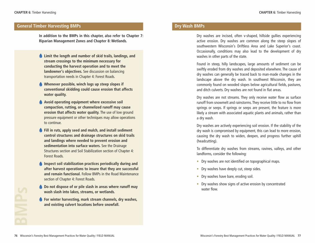
Wisconsin’s Forestry Best Management Practices for Water Quality / FIELD MANUAL 7776 Wisconsin’s Forestry Best Management Practices for Water Quality / FIELD MANUAL
CHAPTER 6: Timber Harvesting CHAPTER 6: Timber Harvesting
General Timber Harvesting BMPs
In addition to the BMPs in this chapter, also refer to Chapter 7:Riparian Management Zones and Chapter 8: Wetlands.
Limit the length and number of skid trails, landings, andstream crossings to the minimum necessary forconducting the harvest operation and to meet thelandowner’s objectives. See discussion on balancingtransportation needs in Chapter 4: Forest Roads.
Whenever possible, winch logs up steep slopes ifconventional skidding could cause erosion that affectswater quality.
Avoid operating equipment where excessive soilcompaction, rutting, or channelized runoff may causeerosion that affects water quality. The use of low groundpressure equipment or other techniques may allow operationsto continue.
Fill in ruts, apply seed and mulch, and install sedimentcontrol structures and drainage structures on skid trailsand landings where needed to prevent erosion andsedimentation into surface waters. See the DrainageStructures section and Soil Stabilization section of Chapter 4:Forest Roads.
Inspect soil stabilization practices periodically during andafter harvest operations to insure that they are successfuland remain functional. Follow BMPs in the Road Maintenancesection of Chapter 4: Forest Roads.
Do not dispose of or pile slash in areas where runoff maywash slash into lakes, streams, or wetlands.
For winter harvesting, mark stream channels, dry washes,and existing culvert locations before snowfall.
BMPs
Dry Wash BMPs
Dry washes are incised, often v-shaped, hillside gullies experiencingactive erosion. Dry washes are common along the steep slopes ofsouthwestern Wisconsin’s Driftless Area and Lake Superior’s coast.Occasionally, conditions may also lead to the development of drywashes in other parts of the state.
Found in steep, hilly landscapes, large amounts of sediment can beswiftly eroded from dry washes and deposited elsewhere. The cause ofdry washes can generally be traced back to man-made changes in thelandscape above the dry wash. In southwest Wisconsin, they arecommonly found on wooded slopes below agricultural fields, pastures,and ditch culverts. Dry washes are not found in flat areas.
Dry washes are not streams. They only receive water flow as surfacerunoff from snowmelt and rainstorms. They receive little to no flow fromsprings or seeps. If springs or seeps are present, the feature is morelikely a stream with associated aquatic plants and animals, rather thana dry wash.
Dry washes are actively experiencing soil erosion. If the stability of thedry wash is compromised by equipment, this can lead to more erosion,causing the dry wash to widen, deepen, and progress further uphill(headcutting).
To differentiate dry washes from streams, ravines, valleys, and otherlandforms, consider the following:
• Dry washes are not identified on topographical maps.
• Dry washes have deeply cut, steep sides.
• Dry washes have bare, eroding soil.
• Dry washes show signs of active erosion by concentrated water flow.
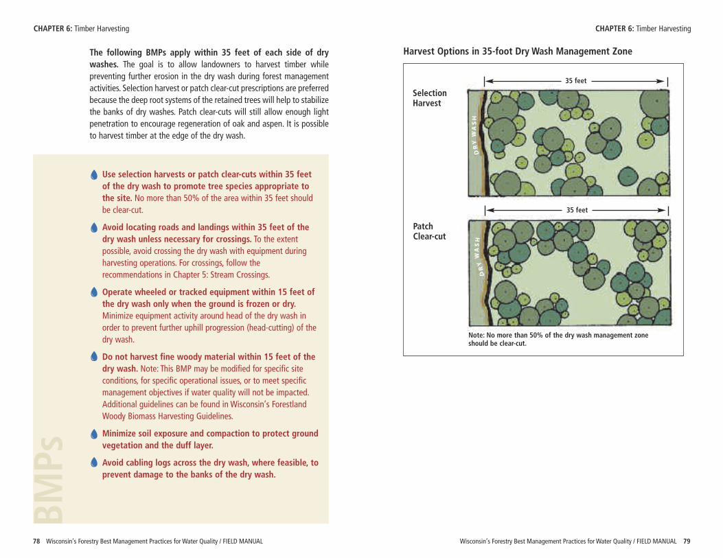
Wisconsin’s Forestry Best Management Practices for Water Quality / FIELD MANUAL 7978 Wisconsin’s Forestry Best Management Practices for Water Quality / FIELD MANUAL
The following BMPs apply within 35 feet of each side of drywashes. The goal is to allow landowners to harvest timber whilepreventing further erosion in the dry wash during forest managementactivities. Selection harvest or patch clear-cut prescriptions are preferredbecause the deep root systems of the retained trees will help to stabilizethe banks of dry washes. Patch clear-cuts will still allow enough lightpenetration to encourage regeneration of oak and aspen. It is possibleto harvest timber at the edge of the dry wash.
CHAPTER 6: Timber Harvesting CHAPTER 6: Timber Harvesting
Use selection harvests or patch clear-cuts within 35 feetof the dry wash to promote tree species appropriate tothe site. No more than 50% of the area within 35 feet shouldbe clear-cut.
Avoid locating roads and landings within 35 feet of thedry wash unless necessary for crossings. To the extentpossible, avoid crossing the dry wash with equipment duringharvesting operations. For crossings, follow therecommendations in Chapter 5: Stream Crossings.
Operate wheeled or tracked equipment within 15 feet ofthe dry wash only when the ground is frozen or dry.Minimize equipment activity around head of the dry wash inorder to prevent further uphill progression (head-cutting) of thedry wash.
Do not harvest fine woody material within 15 feet of thedry wash. Note: This BMP may be modified for specific siteconditions, for specific operational issues, or to meet specificmanagement objectives if water quality will not be impacted.Additional guidelines can be found in Wisconsin’s ForestlandWoody Biomass Harvesting Guidelines.
Minimize soil exposure and compaction to protect groundvegetation and the duff layer.
Avoid cabling logs across the dry wash, where feasible, toprevent damage to the banks of the dry wash.
BMPs
DR
Y W
AS
HD
RY
WA
SH
Harvest Options in 35-foot Dry Wash Management Zone
35 feet
35 feet
SelectionHarvest
PatchClear-cut
Note: No more than 50% of the dry wash management zone should be clear-cut.
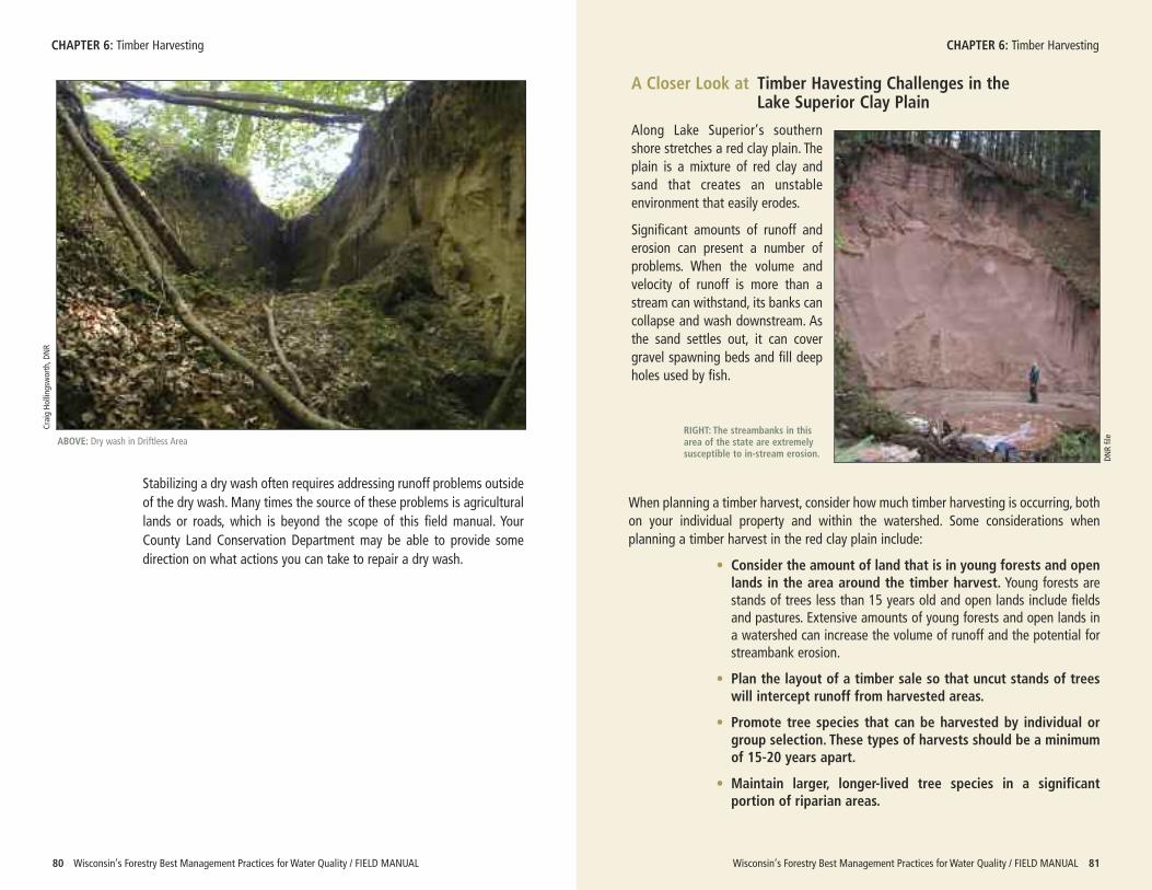
RIGHT: The streambanks in thisarea of the state are extremelysusceptible to in-stream erosion. DN
R file
Wisconsin’s Forestry Best Management Practices for Water Quality / FIELD MANUAL 8180 Wisconsin’s Forestry Best Management Practices for Water Quality / FIELD MANUAL
Stabilizing a dry wash often requires addressing runoff problems outsideof the dry wash. Many times the source of these problems is agriculturallands or roads, which is beyond the scope of this field manual. YourCounty Land Conservation Department may be able to provide somedirection on what actions you can take to repair a dry wash.
CHAPTER 6: Timber Harvesting CHAPTER 6: Timber Harvesting
When planning a timber harvest, consider how much timber harvesting is occurring, bothon your individual property and within the watershed. Some considerations whenplanning a timber harvest in the red clay plain include:
• Consider the amount of land that is in young forests and openlands in the area around the timber harvest. Young forests arestands of trees less than 15 years old and open lands include fieldsand pastures. Extensive amounts of young forests and open lands ina watershed can increase the volume of runoff and the potential forstreambank erosion.
• Plan the layout of a timber sale so that uncut stands of treeswill intercept runoff from harvested areas.
• Promote tree species that can be harvested by individual orgroup selection. These types of harvests should be a minimumof 15-20 years apart.
• Maintain larger, longer-lived tree species in a significantportion of riparian areas.
ABOVE: Dry wash in Driftless Area
Craig Ho
lling
sworth, D
NR
A Closer Look at Timber Havesting Challenges in the Lake Superior Clay Plain
Along Lake Superior’s southernshore stretches a red clay plain. Theplain is a mixture of red clay andsand that creates an unstableenvironment that easily erodes.
Significant amounts of runoff anderosion can present a number ofproblems. When the volume andvelocity of runoff is more than astream can withstand, its banks cancollapse and wash downstream. Asthe sand settles out, it can covergravel spawning beds and fill deepholes used by fish.
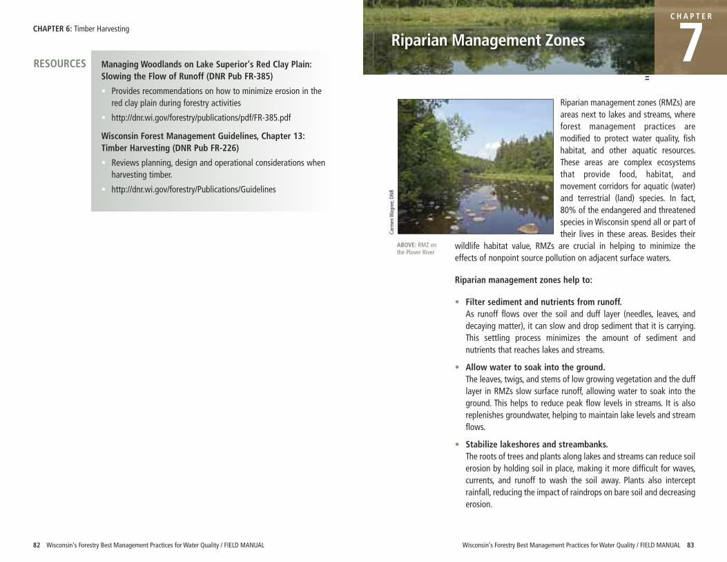
CHAPTER 6: Timber Harvesting
82 Wisconsin’s Forestry Best Management Practices for Water Quality / FIELD MANUAL
Riparian management zones (RMZs) areareas next to lakes and streams, whereforest management practices aremodified to protect water quality, fishhabitat, and other aquatic resources.These areas are complex ecosystemsthat provide food, habitat, andmovement corridors for aquatic (water)and terrestrial (land) species. In fact,80% of the endangered and threatenedspecies in Wisconsin spend all or part oftheir lives in these areas. Besides their
wildlife habitat value, RMZs are crucial in helping to minimize theeffects of nonpoint source pollution on adjacent surface waters.
Riparian management zones help to:
• Filter sediment and nutrients from runoff. As runoff flows over the soil and duff layer (needles, leaves, anddecaying matter), it can slow and drop sediment that it is carrying.This settling process minimizes the amount of sediment andnutrients that reaches lakes and streams.
• Allow water to soak into the ground. The leaves, twigs, and stems of low growing vegetation and the dufflayer in RMZs slow surface runoff, allowing water to soak into theground. This helps to reduce peak flow levels in streams. It is alsoreplenishes groundwater, helping to maintain lake levels and streamflows.
• Stabilize lakeshores and streambanks. The roots of trees and plants along lakes and streams can reduce soilerosion by holding soil in place, making it more difficult for waves,currents, and runoff to wash the soil away. Plants also interceptrainfall, reducing the impact of raindrops on bare soil and decreasingerosion.
C H A P T E R
7
Wisconsin’s Forestry Best Management Practices for Water Quality / FIELD MANUAL 83
Riparian Management ZonesManaging Woodlands on Lake Superior’s Red Clay Plain:Slowing the Flow of Runoff (DNR Pub FR-385)
• Provides recommendations on how to minimize erosion in thered clay plain during forestry activities
• http://dnr.wi.gov/forestry/publications/pdf/FR-385.pdf
Wisconsin Forest Management Guidelines, Chapter 13:Timber Harvesting (DNR Pub FR-226)
• Reviews planning, design and operational considerations whenharvesting timber.
• http://dnr.wi.gov/forestry/Publications/Guidelines
RESOURCES
ABOVE: RMZ onthe Plover River
Carm
en W
agner, DN
R
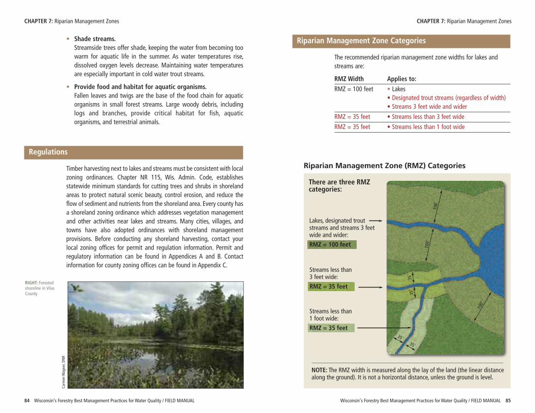
Wisconsin’s Forestry Best Management Practices for Water Quality / FIELD MANUAL 85
• Shade streams. Streamside trees offer shade, keeping the water from becoming toowarm for aquatic life in the summer. As water temperatures rise,dissolved oxygen levels decrease. Maintaining water temperaturesare especially important in cold water trout streams.
• Provide food and habitat for aquatic organisms. Fallen leaves and twigs are the base of the food chain for aquaticorganisms in small forest streams. Large woody debris, includinglogs and branches, provide critical habitat for fish, aquaticorganisms, and terrestrial animals.
Regulations
Timber harvesting next to lakes and streams must be consistent with localzoning ordinances. Chapter NR 115, Wis. Admin. Code, establishesstatewide minimum standards for cutting trees and shrubs in shorelandareas to protect natural scenic beauty, control erosion, and reduce theflow of sediment and nutrients from the shoreland area. Every county hasa shoreland zoning ordinance which addresses vegetation managementand other activities near lakes and streams. Many cities, villages, andtowns have also adopted ordinances with shoreland managementprovisions. Before conducting any shoreland harvesting, contact yourlocal zoning offices for permit and regulation information. Permit andregulatory information can be found in Appendices A and B. Contactinformation for county zoning offices can be found in Appendix C.
84 Wisconsin’s Forestry Best Management Practices for Water Quality / FIELD MANUAL
CHAPTER 7: Riparian Management Zones CHAPTER 7: Riparian Management Zones
Riparian Management Zone Categories
The recommended riparian management zone widths for lakes andstreams are:
RMZ Width Applies to:
RMZ = 100 feet • Lakes• Designated trout streams (regardless of width)• Streams 3 feet wide and wider
RMZ = 35 feet • Streams less than 3 feet wide
RMZ = 35 feet • Streams less than 1 foot wide
RIGHT: Forestedshoreline in VilasCounty
Carm
en W
agner, DN
R
Riparian Management Zone (RMZ) Categories
There are three RMZcategories:
NOTE: The RMZ width is measured along the lay of the land (the linear distancealong the ground). It is not a horizontal distance, unless the ground is level.
100'
100'
35'
35'
100'
35'
35'
Lakes, designated troutstreams and streams 3 feetwide and wider:
RMZ = 100 feet
Streams less than 3 feet wide:
RMZ = 35 feet
Streams less than 1 foot wide:
RMZ = 35 feet
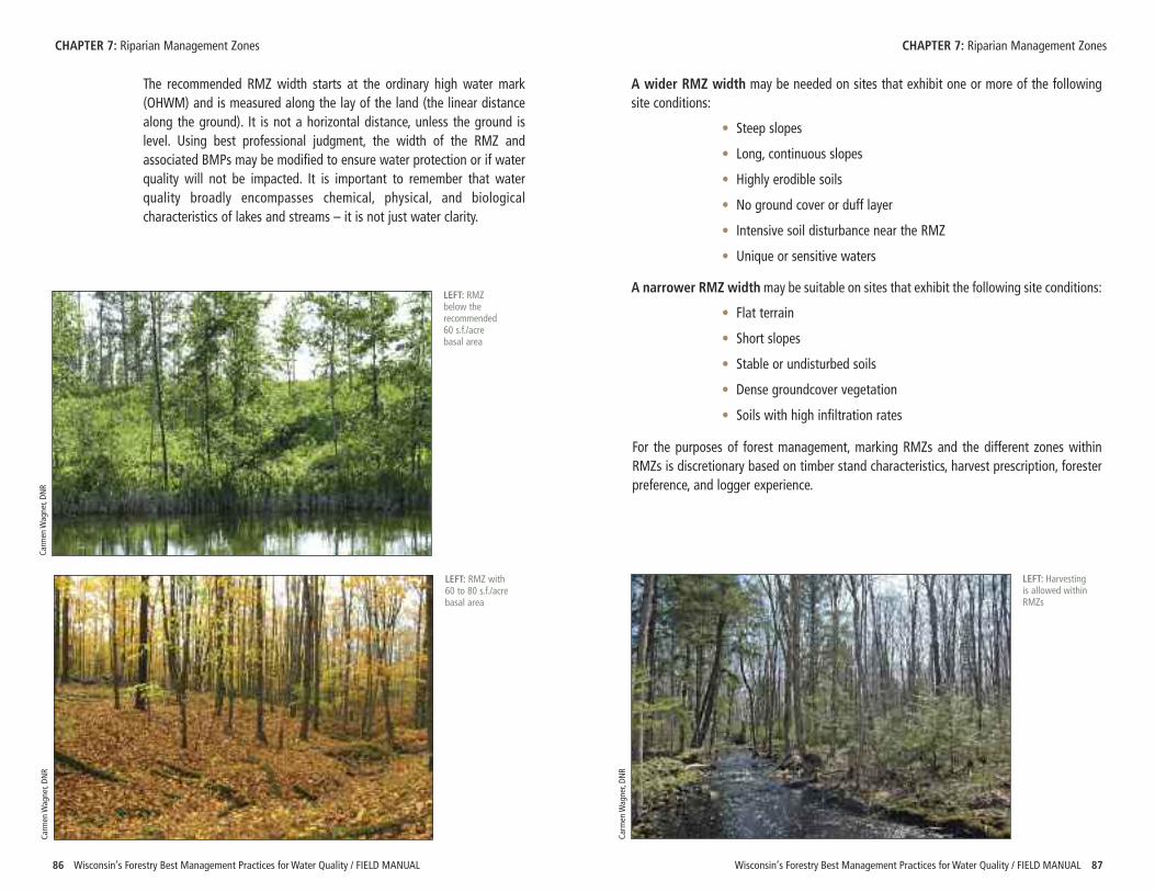
Wisconsin’s Forestry Best Management Practices for Water Quality / FIELD MANUAL 8786 Wisconsin’s Forestry Best Management Practices for Water Quality / FIELD MANUAL
The recommended RMZ width starts at the ordinary high water mark(OHWM) and is measured along the lay of the land (the linear distancealong the ground). It is not a horizontal distance, unless the ground islevel. Using best professional judgment, the width of the RMZ andassociated BMPs may be modified to ensure water protection or if waterquality will not be impacted. It is important to remember that waterquality broadly encompasses chemical, physical, and biologicalcharacteristics of lakes and streams – it is not just water clarity.
CHAPTER 7: Riparian Management Zones CHAPTER 7: Riparian Management ZonesCa
rmen W
agner, DN
R
LEFT: RMZ with60 to 80 s.f./acrebasal area
Carm
en W
agner, DN
R
LEFT: RMZbelow therecommended60 s.f./acrebasal area
Carm
en W
agner, DN
R
LEFT: Harvestingis allowed withinRMZs
A wider RMZ width may be needed on sites that exhibit one or more of the followingsite conditions:
• Steep slopes
• Long, continuous slopes
• Highly erodible soils
• No ground cover or duff layer
• Intensive soil disturbance near the RMZ
• Unique or sensitive waters
A narrower RMZ widthmay be suitable on sites that exhibit the following site conditions:
• Flat terrain
• Short slopes
• Stable or undisturbed soils
• Dense groundcover vegetation
• Soils with high infiltration rates
For the purposes of forest management, marking RMZs and the different zones withinRMZs is discretionary based on timber stand characteristics, harvest prescription, foresterpreference, and logger experience.
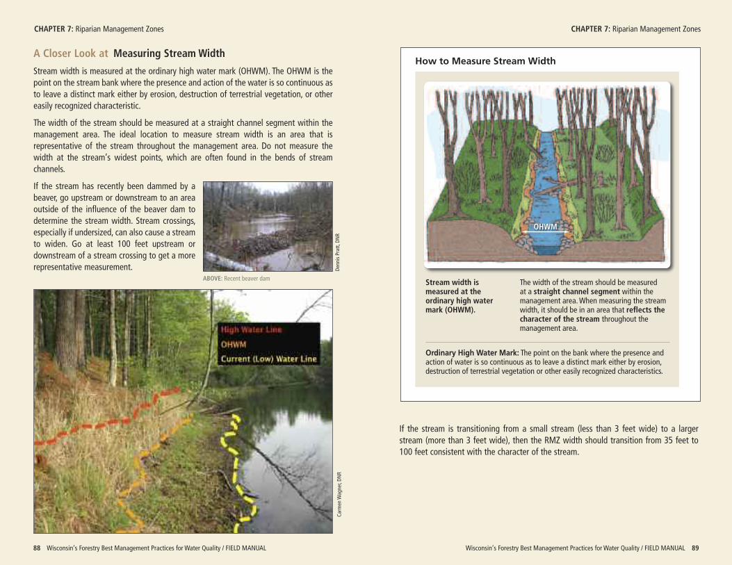
Wisconsin’s Forestry Best Management Practices for Water Quality / FIELD MANUAL 8988 Wisconsin’s Forestry Best Management Practices for Water Quality / FIELD MANUAL
CHAPTER 7: Riparian Management Zones CHAPTER 7: Riparian Management Zones
A Closer Look at Measuring Stream Width
Stream width is measured at the ordinary high water mark (OHWM). The OHWM is thepoint on the stream bank where the presence and action of the water is so continuous asto leave a distinct mark either by erosion, destruction of terrestrial vegetation, or othereasily recognized characteristic.
The width of the stream should be measured at a straight channel segment within themanagement area. The ideal location to measure stream width is an area that isrepresentative of the stream throughout the management area. Do not measure thewidth at the stream’s widest points, which are often found in the bends of streamchannels.
If the stream has recently been dammed by abeaver, go upstream or downstream to an areaoutside of the influence of the beaver dam todetermine the stream width. Stream crossings,especially if undersized, can also cause a streamto widen. Go at least 100 feet upstream ordownstream of a stream crossing to get a morerepresentative measurement.
Carm
en W
agner, DN
R
How to Measure Stream Width
The width of the stream should be measured at a straight channel segment within themanagement area. When measuring the streamwidth, it should be in an area that reflects thecharacter of the stream throughout themanagement area.
OHWM
Stream width ismeasured at theordinary high watermark (OHWM).
Ordinary High Water Mark: The point on the bank where the presence andaction of water is so continuous as to leave a distinct mark either by erosion,destruction of terrestrial vegetation or other easily recognized characteristics.
If the stream is transitioning from a small stream (less than 3 feet wide) to a largerstream (more than 3 feet wide), then the RMZ width should transition from 35 feet to100 feet consistent with the character of the stream.
ABOVE: Recent beaver dam
Denn
is Pratt, D
NR
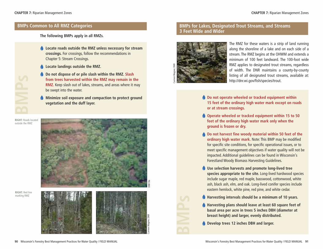
Wisconsin’s Forestry Best Management Practices for Water Quality / FIELD MANUAL 9190 Wisconsin’s Forestry Best Management Practices for Water Quality / FIELD MANUAL
BMPs Common to All RMZ Categories
The following BMPs apply in all RMZs.
Locate roads outside the RMZ unless necessary for streamcrossings. For crossings, follow the recommendations inChapter 5: Stream Crossings.
Locate landings outside the RMZ.
Do not dispose of or pile slash within the RMZ. Slashfrom trees harvested within the RMZ may remain in theRMZ. Keep slash out of lakes, streams, and areas where it maybe swept into the water.
Minimize soil exposure and compaction to protect groundvegetation and the duff layer.
The RMZ for these waters is a strip of land runningalong the shoreline of a lake and on each side of astream. The RMZ begins at the OHWM and extends aminimum of 100 feet landward. The 100-foot wideRMZ applies to designated trout streams, regardlessof width. The DNR maintains a county-by-countylisting of all designated trout streams, available at:http://dnr.wi.gov/fish/species/trout.
Do not operate wheeled or tracked equipment within 15 feet of the ordinary high water mark except on roadsor at stream crossings.
Operate wheeled or tracked equipment within 15 to 50feet of the ordinary high water mark only when theground is frozen or dry.
Do not harvest fine woody material within 50 feet of theordinary high water mark. Note: This BMP may be modifiedfor specific site conditions, for specific operational issues, or tomeet specific management objectives if water quality will not beimpacted. Additional guidelines can be found in Wisconsin’sForestland Woody Biomass Harvesting Guidelines.
Use selection harvests and promote long-lived treespecies appropriate to the site. Long-lived hardwood speciesinclude sugar maple, red maple, basswood, cottonwood, whiteash, black ash, elm, and oak. Long-lived conifer species includeeastern hemlock, white pine, red pine, and white cedar.
Harvesting intervals should be a minimum of 10 years.
Harvesting plans should leave at least 60 square feet ofbasal area per acre in trees 5 inches DBH (diameter atbreast height) and larger, evenly distributed.
Develop trees 12 inches DBH and larger.
BMPs
CHAPTER 7: Riparian Management Zones CHAPTER 7: Riparian Management Zones
BMPs for Lakes, Designated Trout Streams, and Streams 3 Feet Wide and Wider
Carm
en W
agner, DN
R
RIGHT: Roads locatedoutside the RMZ
BMPs
Carm
en W
agner, DN
R
DNR file
RIGHT: Red linemarking RMZ
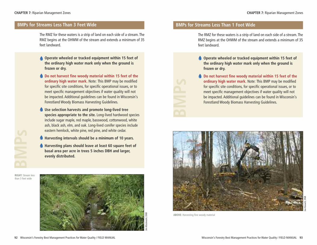
Wisconsin’s Forestry Best Management Practices for Water Quality / FIELD MANUAL 9392 Wisconsin’s Forestry Best Management Practices for Water Quality / FIELD MANUAL
CHAPTER 7: Riparian Management Zones CHAPTER 7: Riparian Management Zones
BMPs for Streams Less Than 3 Feet Wide
The RMZ for these waters is a strip of land on each side of a stream. TheRMZ begins at the OHWM of the stream and extends a minimum of 35feet landward.
Operate wheeled or tracked equipment within 15 feet ofthe ordinary high water mark only when the ground isfrozen or dry.
Do not harvest fine woody material within 15 feet of theordinary high water mark. Note: This BMP may be modifiedfor specific site conditions, for specific operational issues, or tomeet specific management objectives if water quality will notbe impacted. Additional guidelines can be found in Wisconsin’sForestland Woody Biomass Harvesting Guidelines.
Use selection harvests and promote long-lived treespecies appropriate to the site. Long-lived hardwood speciesinclude sugar maple, red maple, basswood, cottonwood, whiteash, black ash, elm, and oak. Long-lived conifer species includeeastern hemlock, white pine, red pine, and white cedar.
Harvesting intervals should be a minimum of 10 years.
Harvesting plans should leave at least 60 square feet ofbasal area per acre in trees 5 inches DBH and larger,evenly distributed.
BMPs
RIGHT: Stream lessthan 3 feet wide
Jim Kloslew
ski, DN
R
BMPs for Streams Less Than 1 Foot Wide
The RMZ for these waters is a strip of land on each side of a stream. TheRMZ begins at the OHWM of the stream and extends a minimum of 35feet landward.
Operate wheeled or tracked equipment within 15 feet ofthe ordinary high water mark only when the ground isfrozen or dry.
Do not harvest fine woody material within 15 feet of theordinary high water mark. Note: This BMP may be modifiedfor specific site conditions, for specific operational issues, or tomeet specific management objectives if water quality will notbe impacted. Additional guidelines can be found in Wisconsin’sForestland Woody Biomass Harvesting Guidelines.
BMPs
Joe Ko
vach, D
NR
ABOVE: Harvesting fine woody material
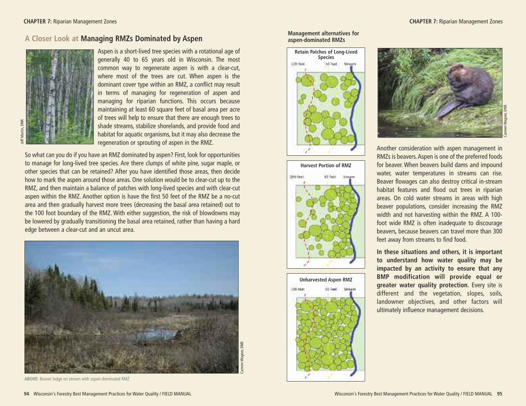
A Closer Look at Managing RMZs Dominated by Aspen
Aspen is a short-lived tree species with a rotational age ofgenerally 40 to 65 years old in Wisconsin. The mostcommon way to regenerate aspen is with a clear-cut,where most of the trees are cut. When aspen is thedominant cover type within an RMZ, a conflict may resultin terms of managing for regeneration of aspen andmanaging for riparian functions. This occurs becausemaintaining at least 60 square feet of basal area per acreof trees will help to ensure that there are enough trees toshade streams, stabilize shorelands, and provide food andhabitat for aquatic organisms, but it may also decrease theregeneration or sprouting of aspen in the RMZ.
So what can you do if you have an RMZ dominated by aspen? First, look for opportunitiesto manage for long-lived tree species. Are there clumps of white pine, sugar maple, orother species that can be retained? After you have identified those areas, then decidehow to mark the aspen around those areas. One solution would be to clear-cut up to theRMZ, and then maintain a balance of patches with long-lived species and with clear-cutaspen within the RMZ. Another option is have the first 50 feet of the RMZ be a no-cutarea and then gradually harvest more trees (decreasing the basal area retained) out tothe 100 foot boundary of the RMZ. With either suggestion, the risk of blowdowns maybe lowered by gradually transitioning the basal area retained, rather than having a hardedge between a clear-cut and an uncut area.
Wisconsin’s Forestry Best Management Practices for Water Quality / FIELD MANUAL 9594 Wisconsin’s Forestry Best Management Practices for Water Quality / FIELD MANUAL
CHAPTER 7: Riparian Management Zones CHAPTER 7: Riparian Management ZonesJeff Martin
, DNR
Management alternatives foraspen-dominated RMZs
ABOVE: Beaver lodge on stream with aspen-dominated RMZ
Carm
en W
agner, DN
R
Another consideration with aspen management inRMZs is beavers. Aspen is one of the preferred foodsfor beaver. When beavers build dams and impoundwater, water temperatures in streams can rise.Beaver flowages can also destroy critical in-streamhabitat features and flood out trees in riparianareas. On cold water streams in areas with highbeaver populations, consider increasing the RMZwidth and not harvesting within the RMZ. A 100-foot wide RMZ is often inadequate to discouragebeavers, because beavers can travel more than 300feet away from streams to find food.
In these situations and others, it is importantto understand how water quality may beimpacted by an activity to ensure that anyBMP modification will provide equal orgreater water quality protection. Every site isdifferent and the vegetation, slopes, soils,landowner objectives, and other factors willultimately influence management decisions.
Carm
en W
agner, DN
R
Harvest Portion of RMZ
Unharvested Aspen RMZ
Retain Patches of Long-Lived Species
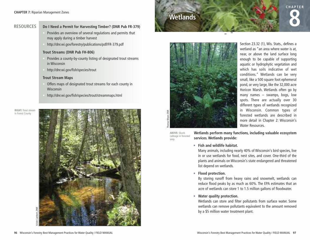
CHAPTER 7: Riparian Management Zones
96 Wisconsin’s Forestry Best Management Practices for Water Quality / FIELD MANUAL
Section 23.32 (1), Wis. Stats., defines awetland as “an area where water is at,near, or above the land surface longenough to be capable of supportingaquatic or hydrophytic vegetation andwhich has soils indicative of wetconditions.” Wetlands can be verysmall, like a 500 square foot ephemeralpond, or very large, like the 32,000 acreHoricon Marsh. Wetlands often go bymany names – swamps, bogs, lowspots. There are actually over 30different types of wetlands recognizedin Wisconsin. Common types offorested wetlands are described inmore detail in Chapter 2: Wisconsin’sWater Resources.
Wetlands perform many functions, including valuable ecosystemservices. Wetlands provide:
• Fish and wildlife habitat. Many animals, including nearly 40% of Wisconsin’s bird species, livein or use wetlands for food, nest sites, and cover. One-third of theplants and animals on Wisconsin’s state endangered and threatenedlist depend on wetlands.
• Flood protection. By storing runoff from heavy rains and snowmelt, wetlands canreduce flood peaks by as much as 60%. The EPA estimates that anacre of wetlands can store 1 to 1.5 million gallons of floodwater.
• Water quality protection. Wetlands can store and filter pollutants from surface water. Somewetlands can remove pollutants equivalent to the amount removedby a $5 million water treatment plant.
C H A P T E R
8
Wisconsin’s Forestry Best Management Practices for Water Quality / FIELD MANUAL 97
Wetlands
Kristin
Lam
bert, D
NR
RIGHT: Trout streamin Forest County
Do I Need a Permit for Harvesting Timber? (DNR Pub FR-379)
• Provides an overview of several regulations and permits thatmay apply during a timber harvest
• http://dnr.wi.gov/forestry/publications/pdf/FR-379.pdf
Trout Streams (DNR Pub FH-806)
• Provides a county-by-county listing of designated trout streamsin Wisconsin
• http://dnr.wi.gov/fish/species/trout
Trout Stream Maps
• Offers maps of designated trout streams for each county inWisconsin
• http://dnr.wi.gov/fish/species/trout/streammaps.html
RESOURCES
ABOVE: Skunkcabbage in forestedseep.
Thom
as M
eyer, D
NR
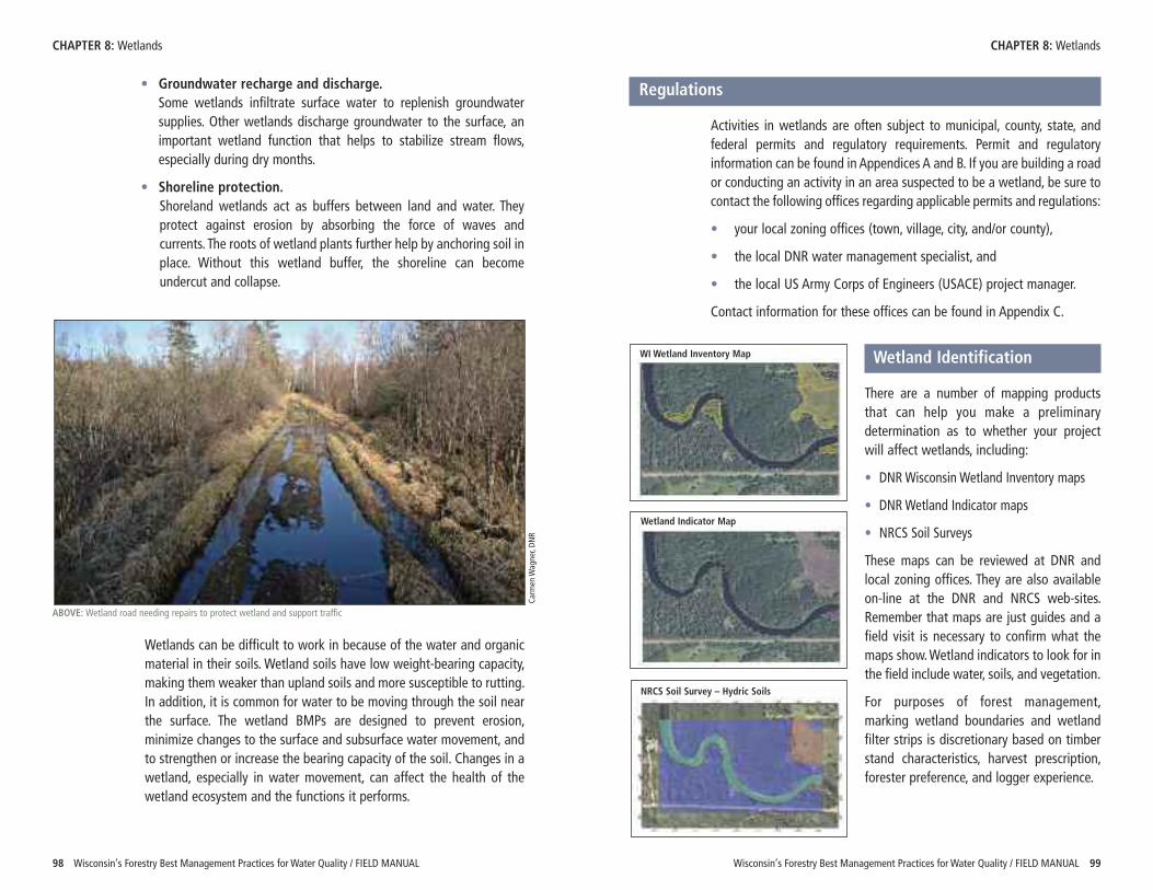
Wisconsin’s Forestry Best Management Practices for Water Quality / FIELD MANUAL 99
CHAPTER 8: Wetlands CHAPTER 8: Wetlands
98 Wisconsin’s Forestry Best Management Practices for Water Quality / FIELD MANUAL
• Groundwater recharge and discharge.Some wetlands infiltrate surface water to replenish groundwatersupplies. Other wetlands discharge groundwater to the surface, animportant wetland function that helps to stabilize stream flows,especially during dry months.
• Shoreline protection. Shoreland wetlands act as buffers between land and water. Theyprotect against erosion by absorbing the force of waves andcurrents. The roots of wetland plants further help by anchoring soil inplace. Without this wetland buffer, the shoreline can becomeundercut and collapse.
Wetlands can be difficult to work in because of the water and organicmaterial in their soils. Wetland soils have low weight-bearing capacity,making them weaker than upland soils and more susceptible to rutting.In addition, it is common for water to be moving through the soil nearthe surface. The wetland BMPs are designed to prevent erosion,minimize changes to the surface and subsurface water movement, andto strengthen or increase the bearing capacity of the soil. Changes in awetland, especially in water movement, can affect the health of thewetland ecosystem and the functions it performs.
ABOVE: Wetland road needing repairs to protect wetland and support traffic
Carm
en W
agner, DN
R
Regulations
Activities in wetlands are often subject to municipal, county, state, andfederal permits and regulatory requirements. Permit and regulatoryinformation can be found in Appendices A and B. If you are building a roador conducting an activity in an area suspected to be a wetland, be sure tocontact the following offices regarding applicable permits and regulations:
• your local zoning offices (town, village, city, and/or county),
• the local DNR water management specialist, and
• the local US Army Corps of Engineers (USACE) project manager.
Contact information for these offices can be found in Appendix C.
Wetland Identification
There are a number of mapping productsthat can help you make a preliminarydetermination as to whether your projectwill affect wetlands, including:
• DNR Wisconsin Wetland Inventory maps
• DNR Wetland Indicator maps
• NRCS Soil Surveys
These maps can be reviewed at DNR andlocal zoning offices. They are also availableon-line at the DNR and NRCS web-sites.Remember that maps are just guides and afield visit is necessary to confirm what themaps show. Wetland indicators to look for inthe field include water, soils, and vegetation.
For purposes of forest management,marking wetland boundaries and wetlandfilter strips is discretionary based on timberstand characteristics, harvest prescription,forester preference, and logger experience.
WI Wetland Inventory Map
Wetland Indicator Map
NRCS Soil Survey – Hydric Soils
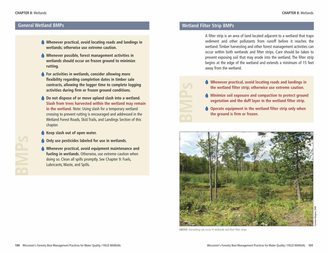
Wisconsin’s Forestry Best Management Practices for Water Quality / FIELD MANUAL 101100 Wisconsin’s Forestry Best Management Practices for Water Quality / FIELD MANUAL
CHAPTER 8: Wetlands CHAPTER 8: Wetlands
General Wetland BMPs
Whenever practical, avoid locating roads and landings inwetlands; otherwise use extreme caution.
Whenever possible, forest management activities inwetlands should occur on frozen ground to minimizerutting.
For activities in wetlands, consider allowing moreflexibility regarding completion dates in timber salecontracts, allowing the logger time to complete loggingactivities during firm or frozen ground conditions.
Do not dispose of or move upland slash into a wetland.Slash from trees harvested within the wetland may remainin the wetland. Note: Using slash for a temporary wetlandcrossing to prevent rutting is encouraged and addressed in theWetland Forest Roads, Skid Trails, and Landings Section of thischapter.
Keep slash out of open water.
Only use pesticides labeled for use in wetlands.
Whenever practical, avoid equipment maintenance andfueling in wetlands. Otherwise, use extreme caution whendoing so. Clean all spills promptly. See Chapter 9: Fuels,Lubricants, Waste, and Spills.BM
PsWetland Filter Strip BMPs
A filter strip is an area of land located adjacent to a wetland that trapssediment and other pollutants from runoff before it reaches thewetland. Timber harvesting and other forest management activities canoccur within both wetlands and filter strips. Care should be taken toprevent exposing soil that may erode into the wetland. The filter stripbegins at the edge of the wetland and extends a minimum of 15 feetaway from the wetland.
Whenever practical, avoid locating roads and landings inthe wetland filter strip; otherwise use extreme caution.
Minimize soil exposure and compaction to protect groundvegetation and the duff layer in the wetland filter strip.
Operate equipment in the wetland filter strip only whenthe ground is firm or frozen.BM
Ps
ABOVE: Harvesting can occur in wetlands and their filter strips
Carm
en W
agner, DN
R
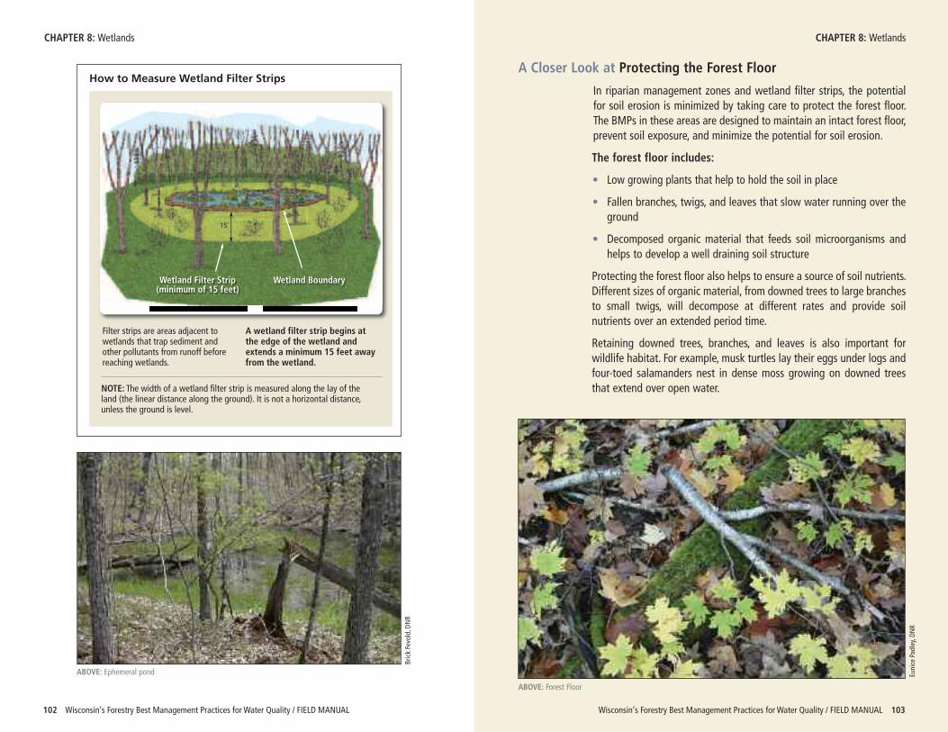
Wisconsin’s Forestry Best Management Practices for Water Quality / FIELD MANUAL 103102 Wisconsin’s Forestry Best Management Practices for Water Quality / FIELD MANUAL
CHAPTER 8: Wetlands CHAPTER 8: Wetlands
How to Measure Wetland Filter Strips
Wetland Filter Strip(minimum of 15 feet)
Wetland Boundary
Filter strips are areas adjacent towetlands that trap sediment andother pollutants from runoff beforereaching wetlands.
A wetland filter strip begins atthe edge of the wetland andextends a minimum 15 feet awayfrom the wetland.
15'
NOTE: The width of a wetland filter strip is measured along the lay of theland (the linear distance along the ground). It is not a horizontal distance,unless the ground is level.
ABOVE: Ephemeral pond
Brick Fevold, D
NR
A Closer Look at Protecting the Forest Floor
In riparian management zones and wetland filter strips, the potentialfor soil erosion is minimized by taking care to protect the forest floor.The BMPs in these areas are designed to maintain an intact forest floor,prevent soil exposure, and minimize the potential for soil erosion.
The forest floor includes:
• Low growing plants that help to hold the soil in place
• Fallen branches, twigs, and leaves that slow water running over theground
• Decomposed organic material that feeds soil microorganisms andhelps to develop a well draining soil structure
Protecting the forest floor also helps to ensure a source of soil nutrients.Different sizes of organic material, from downed trees to large branchesto small twigs, will decompose at different rates and provide soilnutrients over an extended period time.
Retaining downed trees, branches, and leaves is also important forwildlife habitat. For example, musk turtles lay their eggs under logs andfour-toed salamanders nest in dense moss growing on downed treesthat extend over open water.
Eunice Pad
ley, DN
R
ABOVE: Forest Floor
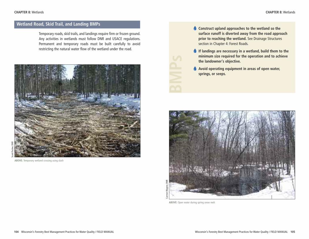
Wisconsin’s Forestry Best Management Practices for Water Quality / FIELD MANUAL 105104 Wisconsin’s Forestry Best Management Practices for Water Quality / FIELD MANUAL
CHAPTER 8: Wetlands CHAPTER 8: Wetlands
Wetland Road, Skid Trail, and Landing BMPs
Temporary roads, skid trails, and landings require firm or frozen ground.Any activities in wetlands must follow DNR and USACE regulations.Permanent and temporary roads must be built carefully to avoidrestricting the natural water flow of the wetland under the road.
ABOVE: Temporary wetland crossing using slash
Scott Fischer, D
NR
Construct upland approaches to the wetland so thesurface runoff is diverted away from the road approachprior to reaching the wetland. See Drainage Structuressection in Chapter 4: Forest Roads.
If landings are necessary in a wetland, build them to theminimum size required for the operation and to achievethe landowner’s objective.
Avoid operating equipment in areas of open water, springs, or seeps.
BMPs
Carm
en W
agner, DN
R
ABOVE: Open water during spring snow melt
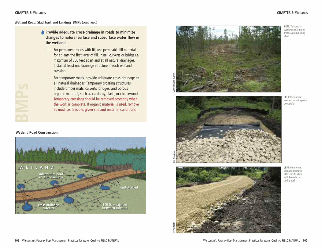
BMPs
Wisconsin’s Forestry Best Management Practices for Water Quality / FIELD MANUAL 107106 Wisconsin’s Forestry Best Management Practices for Water Quality / FIELD MANUAL
Provide adequate cross-drainage in roads to minimizechanges to natural surface and subsurface water flow inthe wetland.
— For permanent roads with fill, use permeable fill materialfor at least the first layer of fill. Install culverts or bridges amaximum of 300 feet apart and at all natural drainages.Install at least one drainage structure in each wetlandcrossing.
— For temporary roads, provide adequate cross-drainage atall natural drainages. Temporary crossing structuresinclude timber mats, culverts, bridges, and porousorganic material, such as corduroy, slash, or chunkwood.Temporary crossings should be removed promptly whenthe work is complete. If organic material is used, removeas much as feasible, given site and material conditions.
W E T L A N D
inlet/outlet pool+/- 4 ft. diameter
300 ft. maximumbetween culverts
undisturbed
cross drainageculverts
EXAMPLE:Add color and texture to existing b/w illustrationsWetland Road Construction
Wetland Road, Skid Trail, and Landing BMPs (continued)
CHAPTER 8: Wetlands CHAPTER 8: Wetlands
LEFT: Temporarywetland crossing onfrozen ground usingslash
Carm
en W
agner, DN
RJoe Arington
Joe Arington
LEFT: Permanentwetland crossing withgeotextile
LEFT: Permanentwetland crossingafter constructionwith breaker runand gravel
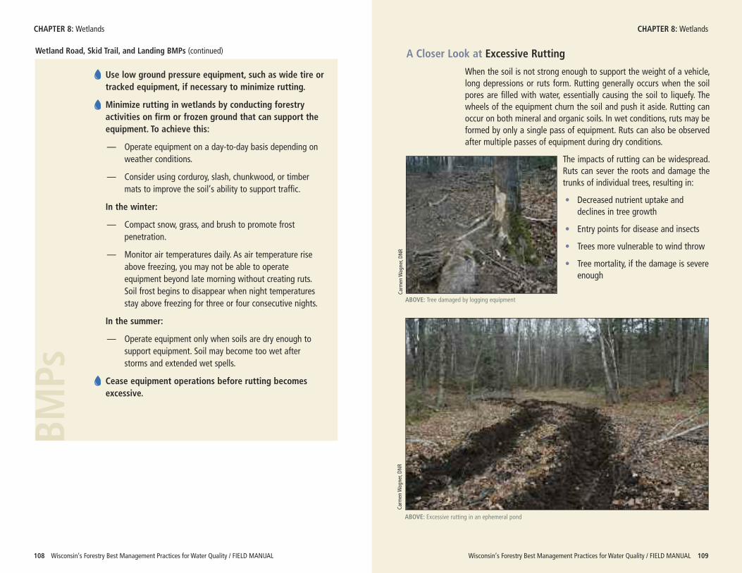
A Closer Look at Excessive Rutting
When the soil is not strong enough to support the weight of a vehicle,long depressions or ruts form. Rutting generally occurs when the soilpores are filled with water, essentially causing the soil to liquefy. Thewheels of the equipment churn the soil and push it aside. Rutting canoccur on both mineral and organic soils. In wet conditions, ruts may beformed by only a single pass of equipment. Ruts can also be observedafter multiple passes of equipment during dry conditions.
The impacts of rutting can be widespread.Ruts can sever the roots and damage thetrunks of individual trees, resulting in:
• Decreased nutrient uptake anddeclines in tree growth
• Entry points for disease and insects
• Trees more vulnerable to wind throw
• Tree mortality, if the damage is severeenough
Wisconsin’s Forestry Best Management Practices for Water Quality / FIELD MANUAL 109108 Wisconsin’s Forestry Best Management Practices for Water Quality / FIELD MANUAL
Wetland Road, Skid Trail, and Landing BMPs (continued)
Use low ground pressure equipment, such as wide tire ortracked equipment, if necessary to minimize rutting.
Minimize rutting in wetlands by conducting forestryactivities on firm or frozen ground that can support theequipment. To achieve this:
— Operate equipment on a day-to-day basis depending onweather conditions.
— Consider using corduroy, slash, chunkwood, or timbermats to improve the soil’s ability to support traffic.
In the winter:
— Compact snow, grass, and brush to promote frostpenetration.
— Monitor air temperatures daily. As air temperature riseabove freezing, you may not be able to operateequipment beyond late morning without creating ruts.Soil frost begins to disappear when night temperaturesstay above freezing for three or four consecutive nights.
In the summer:
— Operate equipment only when soils are dry enough tosupport equipment. Soil may become too wet afterstorms and extended wet spells.
Cease equipment operations before rutting becomesexcessive.
CHAPTER 8: Wetlands CHAPTER 8: Wetlands
BMPs
Carm
en W
agner, DN
R
ABOVE: Excessive rutting in an ephemeral pond
Carm
en W
agner, DN
R
ABOVE: Tree damaged by logging equipment
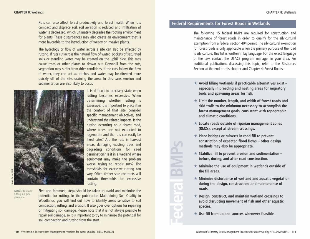
Wisconsin’s Forestry Best Management Practices for Water Quality / FIELD MANUAL 111110 Wisconsin’s Forestry Best Management Practices for Water Quality / FIELD MANUAL
Ruts can also affect forest productivity and forest health. When rutscompact and displace soil, soil aeration is reduced and infiltration ofwater is decreased, which ultimately degrades the rooting environmentfor plants. These disturbances may also create an environment that ismore favorable to the introduction of weedy or invasive plants.
The hydrology or flow of water across a site can also be affected byrutting. If ruts cut across the natural flow of water, pockets of saturatedsoils or standing water may be created on the uphill side. This maycause trees or other plants to drown out. Downhill from the ruts,vegetation may suffer from drier conditions. If the ruts follow the flowof water, they can act as ditches and water may be directed morequickly off of the site, draining the area. In this case, erosion andsedimentation are also likely to occur.
It is difficult to precisely state whenrutting becomes excessive. Whendetermining whether rutting isexcessive, it is important to place it inthe context of that site, considerspecific management objectives, andunderstand the related impacts. Is therutting occurring on a forest road,where trees are not expected toregenerate and the ruts can easily befixed later? Are the ruts in harvestareas, damaging existing trees anddegrading conditions for seedgermination? Is it in a wetland whereequipment may make the problemworse trying to repair ruts? Thethresholds for excessive rutting canvary. Often timber sale contracts willcontain thresholds for excessiverutting.
First and foremost, steps should be taken to avoid and minimize thepotential for rutting. In the publication Maintaining Soil Quality inWoodlands, you will find out how to identify areas sensitive to soilcompaction, rutting, and erosion. It also goes over options for repairingor mitigating soil damage. Please note that it is not always possible torepair soil damage, so it is important to try to minimize the potential forsoil compaction and rutting from the start.
CHAPTER 8: Wetlands CHAPTER 8: WetlandsScott Fischer, D
NR
ABOVE: Excessiverutting in a pineplantation
Federal Requirements for Forest Roads in Wetlands
The following 15 federal BMPs are required for construction andmaintenance of forest roads in order to qualify for the silviculturalexemption from a federal section 404 permit. The silvicultural exemptionfor forest roads is only applicable when the primary purpose of the roadis silviculture. This list is written in lay language. For the exact languageof the law, contact the USACE program manager in your area. Foradditional publications discussing this topic, refer to the ResourcesSection at the end of this chapter and Chapter 4: Forest Roads.
FederalBMPs
� Avoid filling wetlands if practicable alternatives exist –especially in breeding and nesting areas for migratorybirds and spawning areas for fish.
� Limit the number, length, and width of forest roads andskid trails to the minimum necessary to accomplish theforest management goals, consistent with topographicand climatic conditions.
� Locate roads outside of riparian management zones(RMZs), except at stream crossings.
� Place bridges or culverts in road fill to preventconstriction of expected flood flows – other designmethods may also be appropriate.
� Stabilize fill to prevent erosion and sedimentation –before, during, and after road construction.
� Minimize the use of equipment in wetlands outside ofthe fill areas.
� Minimize disturbance of wetland and aquatic vegetationduring the design, construction, and maintenance ofroads.
� Design, construct, and maintain wetland crossings toavoid disrupting movement of fish and other aquaticspecies.
� Use fill from upland sources whenever feasible.
Wisconsin’s Forestry Best Management Practices for Water Quality / FIELD MANUAL 113112 Wisconsin’s Forestry Best Management Practices for Water Quality / FIELD MANUAL
FederalBMPs
Federal Requirements for Forest Roads in Wetlands (continued)
CHAPTER 8: Wetlands CHAPTER 8: Wetlands
� Place fill so as to not affect any threatened orendangered species and to prevent any adversemodification or destruction of critical habitat for thesespecies.
� Do not place fill near public water supply intakes.
� Do not place fill in areas of concentrated shellfishproduction.
� Do not place fill in National Wild and Scenic RiverSystems – in Wisconsin, these are portions of theNamekagon, St. Croix, and Wolf Rivers.
� Use fill that is clean, non-erodible, and non-toxic.
� Remove all temporary fill and restore disturbed areas totheir original elevation.
DNR Wetlands: Locating Wetlands
• Reviews steps in identifying wetlands and provides link to on-line wetland mapping resources
• http://dnr.wi.gov/wetlands/locating.html
Forest Roads and Wetlands: Evaluating Your Options (DNR Pub-408)
• Discusses forest road considerations and includes a checklist onthe silvicultural exemption for forest roads.
• http://dnr.wi.gov/forestry/publications/pdf/FR-408.pdf
Forested Wetlands: Functions, Benefits and the Use of BestManagement Practices (USDA Forest Service Publication#NA-PR-01-95)
• Offers detailed instructions on constructing forest roads inwetlands
• http://na.fs.fed.us/spfo/pubs/n_resource/wetlands/index.htm
Maintaining Soil Quality in Woodlands: A Lake States FieldGuide (DNR Pub FR-409)
• Discusses how to indentify area sensitive to soil compaction,rutting and erosion. Offers methods to maintain soil quality andoptions for repairing or mitigating soil damage.
• http://dnr.wi.gov/forestry/publications/pdf/FR-409.pdf
NRCS Web Soil Survey
• Provides access to NRCS soil maps, soil data and other relatedinformation
• http://websoilsurvey.nrcs.usda.gov
RESOURCES
Carm
en W
agner, DN
R
ABOVE: Carex crinita, or fringed sedge, found in forested wetlands
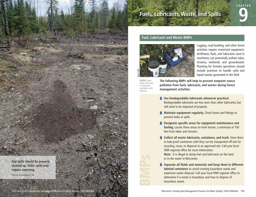
Wisconsin’s Forestry Best Management Practices for Water Quality / FIELD MANUAL 115114 Wisconsin’s Forestry Best Management Practices for Water Quality / FIELD MANUAL
Fuels, Lubricants, Waste, and Spills
C H A P T E R
9Fuel, Lubricant and Waste BMPs
Logging, road building, and other forestactivities require motorized equipment.Antifreeze, fuels, and lubricants used inmachinery can potentially pollute lakes,streams, wetlands, and groundwater.Planning for forestry operations shouldinclude practices to handle solid andliquid wastes generated in the field.
The following BMPs will help to prevent nonpoint sourcepollution from fuels, lubricants, and wastes during forestmanagement activities.
Use biodegradable lubricants whenever practical.Biodegradable lubricants are less toxic than other lubricants, butstill need to be disposed of properly.
Maintain equipment regularly. Check hoses and fittings toprevent leaks or spills.
Designate specific areas for equipment maintenance andfueling. Locate these areas on level terrain, a minimum of 100feet from lakes and streams.
Collect all waste lubricants, containers, and trash. Store themin leak-proof containers until they can be transported off-site forrecycling, reuse, or disposal at an approved site. Call your localDNR regional office for more information.Note: It is illegal to dump fuel and lubricants on the land or in the water in Wisconsin.
Separate all fluids and materials and keep them in differentlabeled containers to avoid creating hazardous waste andexpensive waste disposal. Call your local DNR regional office todetermine if a waste is hazardous and how to dispose ofhazardous waste.BM
PsAny spills should be properlycleaned up. Some spills mayrequire reporting.
Photo by Carmen Wagner, DNR
ABOVE: Storewaste and trashin leak-proofcontainers untildisposal.
Maine DNR
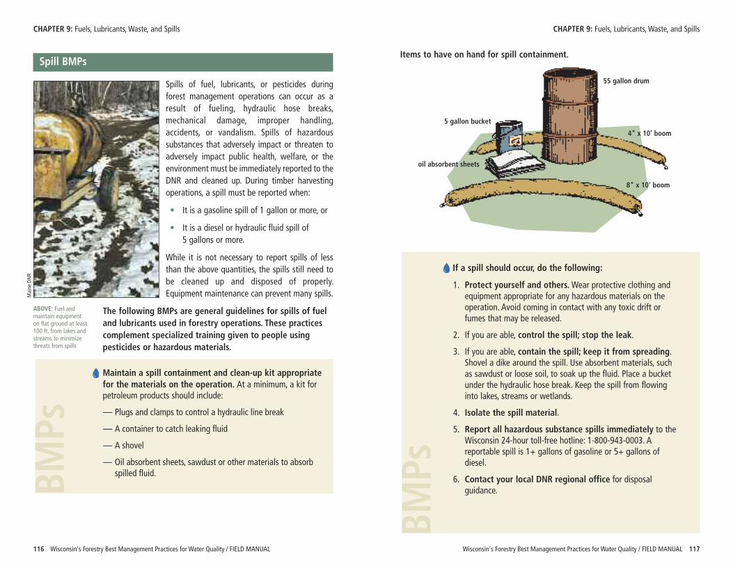
BMPsBMPs
Wisconsin’s Forestry Best Management Practices for Water Quality / FIELD MANUAL 117
If a spill should occur, do the following:
1. Protect yourself and others.Wear protective clothing andequipment appropriate for any hazardous materials on theoperation. Avoid coming in contact with any toxic drift orfumes that may be released.
2. If you are able, control the spill; stop the leak.
3. If you are able, contain the spill; keep it from spreading.Shovel a dike around the spill. Use absorbent materials, suchas sawdust or loose soil, to soak up the fluid. Place a bucketunder the hydraulic hose break. Keep the spill from flowinginto lakes, streams or wetlands.
4. Isolate the spill material.
5. Report all hazardous substance spills immediately to theWisconsin 24-hour toll-free hotline: 1-800-943-0003. Areportable spill is 1+ gallons of gasoline or 5+ gallons ofdiesel.
6. Contact your local DNR regional office for disposalguidance.
CHAPTER 9: Fuels, Lubricants, Waste, and Spills
116 Wisconsin’s Forestry Best Management Practices for Water Quality / FIELD MANUAL
Spill BMPs
Spills of fuel, lubricants, or pesticides duringforest management operations can occur as aresult of fueling, hydraulic hose breaks,mechanical damage, improper handling,accidents, or vandalism. Spills of hazardoussubstances that adversely impact or threaten toadversely impact public health, welfare, or theenvironment must be immediately reported to theDNR and cleaned up. During timber harvestingoperations, a spill must be reported when:
• It is a gasoline spill of 1 gallon or more, or
• It is a diesel or hydraulic fluid spill of 5 gallons or more.
While it is not necessary to report spills of lessthan the above quantities, the spills still need tobe cleaned up and disposed of properly.Equipment maintenance can prevent many spills.
The following BMPs are general guidelines for spills of fuel and lubricants used in forestry operations. These practicescomplement specialized training given to people usingpesticides or hazardous materials.
Maintain a spill containment and clean-up kit appropriatefor the materials on the operation. At a minimum, a kit forpetroleum products should include:
— Plugs and clamps to control a hydraulic line break
— A container to catch leaking fluid
— A shovel
— Oil absorbent sheets, sawdust or other materials to absorbspilled fluid.
CHAPTER 9: Fuels, Lubricants, Waste, and Spills
Items to have on hand for spill containment.
ABOVE: Fuel andmaintain equipmenton flat ground at least100 ft. from lakes andstreams to minimizethreats from spills
Maine DNR
55 gallon drum
5 gallon bucket
oil absorbent sheets
4" x 10' boom
8" x 10' boom
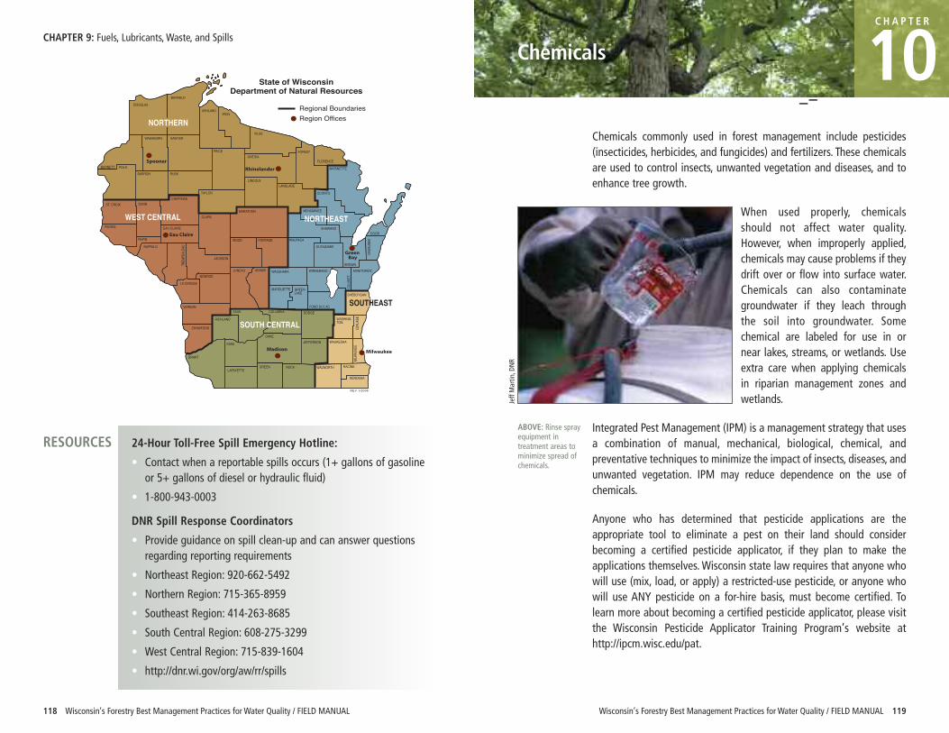
118 Wisconsin’s Forestry Best Management Practices for Water Quality / FIELD MANUAL Wisconsin’s Forestry Best Management Practices for Water Quality / FIELD MANUAL 119
Chemicals
C H A P T E R
10Chemicals commonly used in forest management include pesticides(insecticides, herbicides, and fungicides) and fertilizers. These chemicalsare used to control insects, unwanted vegetation and diseases, and toenhance tree growth.
When used properly, chemicalsshould not affect water quality.However, when improperly applied,chemicals may cause problems if theydrift over or flow into surface water.Chemicals can also contaminategroundwater if they leach throughthe soil into groundwater. Somechemical are labeled for use in ornear lakes, streams, or wetlands. Useextra care when applying chemicalsin riparian management zones andwetlands.
Integrated Pest Management (IPM) is a management strategy that usesa combination of manual, mechanical, biological, chemical, andpreventative techniques to minimize the impact of insects, diseases, andunwanted vegetation. IPM may reduce dependence on the use ofchemicals.
Anyone who has determined that pesticide applications are theappropriate tool to eliminate a pest on their land should considerbecoming a certified pesticide applicator, if they plan to make theapplications themselves. Wisconsin state law requires that anyone whowill use (mix, load, or apply) a restricted-use pesticide, or anyone whowill use ANY pesticide on a for-hire basis, must become certified. Tolearn more about becoming a certified pesticide applicator, please visitthe Wisconsin Pesticide Applicator Training Program’s website athttp://ipcm.wisc.edu/pat.
24-Hour Toll-Free Spill Emergency Hotline:
• Contact when a reportable spills occurs (1+ gallons of gasolineor 5+ gallons of diesel or hydraulic fluid)
• 1-800-943-0003
DNR Spill Response Coordinators
• Provide guidance on spill clean-up and can answer questionsregarding reporting requirements
• Northeast Region: 920-662-5492
• Northern Region: 715-365-8959
• Southeast Region: 414-263-8685
• South Central Region: 608-275-3299
• West Central Region: 715-839-1604
• http://dnr.wi.gov/org/aw/rr/spills
DOUGLASBAYFIELD
ASHLANDIRON
BURNETT
VILASWASHBURN SAWYER
PRICEONEIDA
FOREST
FLORENCE
BARRONPOLK
RUSK
TAYLORCHIPPEWA
DUNNST. CROIX
PIERCE
PEPIN
EAU CLAIRE
CLARK
LINCOLN
MARATHON
LANGLADE
MARINETTE
OCONTO
MENOMINEE
SHAWANODOOR
KEWA
UNEE
BROWN
OUTAGAMIEWAUPACAWOOD PORTAGE
MANITOWOCWINNEBAGO
CALU
MET
WAUSHARA
JACKSON
JUNEAU ADAMS
MARQUETTE GREENLAKE
FOND DU LAC
SHEBOYGAN
MONROE
SAUK COLUMBIA DODGEWASHING-TON
OZAU
KEE
MILW
AUKE
E
WAUKESHAJEFFERSONDANE
KENOSHA
RACINEWALWORTHROCKGREENLAFAYETTE
IOWA
GRANT
RICHLAND
CRAWFORD
VERNON
LA CROSSE
BUFFALO
TREM
PEAL
EAU
WEST CENTRAL
SOUTH CENTRAL
Regional BoundariesRegion Offices
REV 1/2006
State of WisconsinDepartment of Natural Resources
SOUTHEAST
NORTHERN
NORTHEAST
CHAPTER 9: Fuels, Lubricants, Waste, and Spills
ABOVE: Rinse sprayequipment intreatment areas tominimize spread ofchemicals.
Jeff Martin
, DNR
RESOURCES
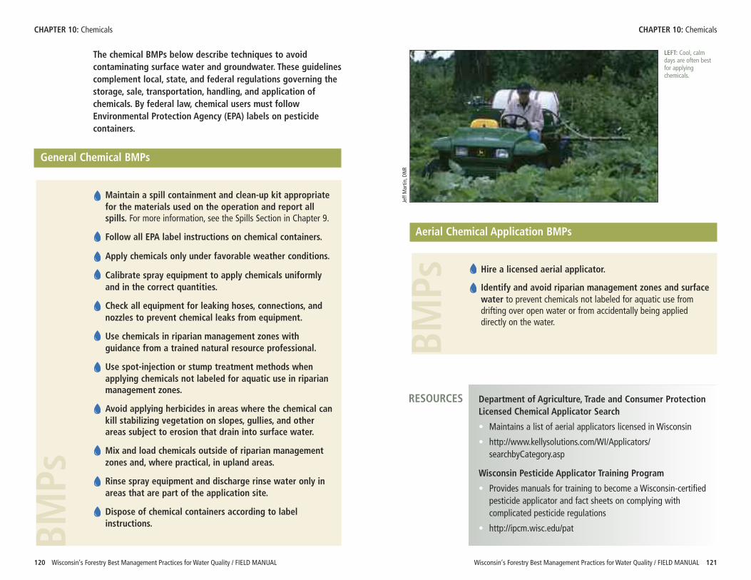
BMPs
Wisconsin’s Forestry Best Management Practices for Water Quality / FIELD MANUAL 121
CHAPTER 10: Chemicals
120 Wisconsin’s Forestry Best Management Practices for Water Quality / FIELD MANUAL
The chemical BMPs below describe techniques to avoidcontaminating surface water and groundwater. These guidelinescomplement local, state, and federal regulations governing thestorage, sale, transportation, handling, and application ofchemicals. By federal law, chemical users must followEnvironmental Protection Agency (EPA) labels on pesticidecontainers.
General Chemical BMPs
Maintain a spill containment and clean-up kit appropriatefor the materials used on the operation and report allspills. For more information, see the Spills Section in Chapter 9.
Follow all EPA label instructions on chemical containers.
Apply chemicals only under favorable weather conditions.
Calibrate spray equipment to apply chemicals uniformlyand in the correct quantities.
Check all equipment for leaking hoses, connections, andnozzles to prevent chemical leaks from equipment.
Use chemicals in riparian management zones withguidance from a trained natural resource professional.
Use spot-injection or stump treatment methods whenapplying chemicals not labeled for aquatic use in riparianmanagement zones.
Avoid applying herbicides in areas where the chemical cankill stabilizing vegetation on slopes, gullies, and otherareas subject to erosion that drain into surface water.
Mix and load chemicals outside of riparian managementzones and, where practical, in upland areas.
Rinse spray equipment and discharge rinse water only inareas that are part of the application site.
Dispose of chemical containers according to labelinstructions.BMPs
CHAPTER 10: Chemicals
Aerial Chemical Application BMPs
Hire a licensed aerial applicator.
Identify and avoid riparian management zones and surfacewater to prevent chemicals not labeled for aquatic use fromdrifting over open water or from accidentally being applieddirectly on the water.
LEFT: Cool, calmdays are often bestfor applyingchemicals.
Jeff Martin
, DNR
Department of Agriculture, Trade and Consumer ProtectionLicensed Chemical Applicator Search
• Maintains a list of aerial applicators licensed in Wisconsin
• http://www.kellysolutions.com/WI/Applicators/searchbyCategory.asp
Wisconsin Pesticide Applicator Training Program
• Provides manuals for training to become a Wisconsin-certifiedpesticide applicator and fact sheets on complying withcomplicated pesticide regulations
• http://ipcm.wisc.edu/pat
RESOURCES
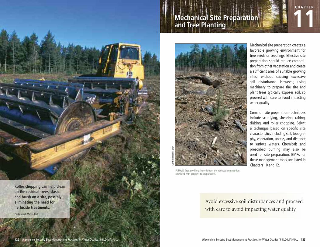
Roller chopping can help cleanup the residual trees, slash,and brush on a site, possiblyeliminating the need forherbicide treatments.
Photo by Jeff Martin, DNR
122 Wisconsin’s Forestry Best Management Practices for Water Quality / FIELD MANUAL Wisconsin’s Forestry Best Management Practices for Water Quality / FIELD MANUAL 123
Mechanical Site Preparation and Tree Planting
CH A P T E R
11Mechanical site preparation creates afavorable growing environment fortree seeds or seedlings. Effective sitepreparation should reduce competi-tion from other vegetation and createa sufficient area of suitable growingsites, without causing excessive soil disturbance. However, using machinery to prepare the site andplant trees typically exposes soil, soproceed with care to avoid impactingwater quality.
Common site preparation techniquesinclude scarifying, shearing, raking,disking, and roller chopping. Select a technique based on specific sitecharacteristics including soil, topogra-phy, vegetation, access, and distanceto surface waters. Chemicals and prescribed burning may also be used for site preparation. BMPs for these management tools are listed in Chapters 10 and 12.Ca
rmen W
agner, DN
RABOVE: Tree seedlings benefit from the reduced competitionprovided with proper site preparation.
Avoid excessive soil disturbances and proceed
with care to avoid impacting water quality.
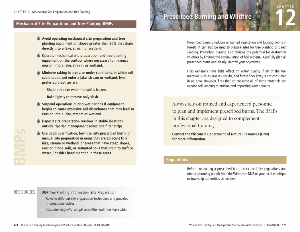
Wisconsin’s Forestry Best Management Practices for Water Quality / FIELD MANUAL 125
CHAPTER 11: Mechanical Site Preparation and Tree Planting
124 Wisconsin’s Forestry Best Management Practices for Water Quality / FIELD MANUAL
Prescribed Burning and Wildfire
C H A P T E R
12Prescribed burning reduces unwanted vegetation and logging debris inforests. It can also be used to prepare sites for tree planting or directseeding. Prescribed burning also reduces the potential for destructivewildfires by limiting the accumulation of fuel material. Carefully plan allprescribed burns and clearly identify your objectives.
Fires generally have little effect on water quality if all of the fuelmaterial, such as grasses, shrubs, and forest floor litter, is not consumedin an area. However, fires that do consume all of these materials canexpose soil, leading to erosion and impacting water quality.
Mechanical Site Preparation and Tree Planting BMPs
Avoid operating mechanical site preparation and treeplanting equipment on slopes greater than 30% that draindirectly into a lake, stream or wetland.
Operate mechanical site preparation and tree plantingequipment on the contour where necessary to minimizeerosion into a lake, stream, or wetland.
Minimize raking in areas, or under conditions, in which soilcould erode and enter a lake, stream or wetland. Twopreferred practices are:
— Shear and rake when the soil is frozen.
— Rake lightly to remove only slash.
Suspend operations during wet periods if equipmentbegins to cause excessive soil disturbance that may lead toerosion into a lake, stream or wetland.
Deposit site preparation residues in stable locationsoutside riparian management zones and filter strips.
Use patch scarification, low intensity prescribed burns, ormanual site preparation in areas that are adjacent to alake, stream or wetland, or areas that have steep slopes,erosion prone soils, or saturated soils that drain to surfacewater. Consider hand planting in these areas.
BMPs
DNR Tree Planting Information: Site Preparation
• Reviews different site preparation techniques and providesinformational videos
• http://dnr.wi.gov/forestry/Nursery/GeneralInfo/siteprep.htm
RESOURCES
Always rely on trained and experienced personnel
to plan and implement prescribed burns. The BMPs
in this chapter are designed to complement
professional training.
Contact the Wisconsin Department of Natural Resources (DNR) for more information.
Regulations
Before conducting a prescribed burn, check local fire regulations andobtain a burning permit from the Wisconsin DNR or your local municipalor township authorities, as needed.
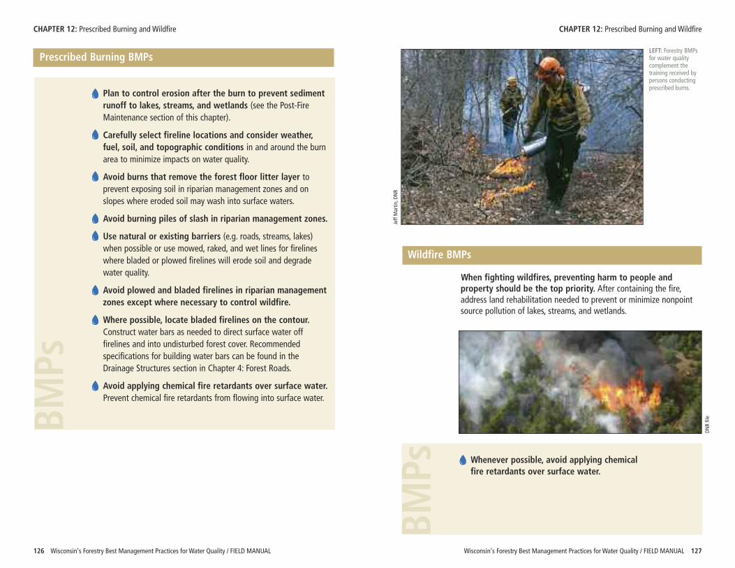
BMPs
BMPs
Wisconsin’s Forestry Best Management Practices for Water Quality / FIELD MANUAL 127
Prescribed Burning BMPs
Plan to control erosion after the burn to prevent sedimentrunoff to lakes, streams, and wetlands (see the Post-FireMaintenance section of this chapter).
Carefully select fireline locations and consider weather,fuel, soil, and topographic conditions in and around the burnarea to minimize impacts on water quality.
Avoid burns that remove the forest floor litter layer toprevent exposing soil in riparian management zones and onslopes where eroded soil may wash into surface waters.
Avoid burning piles of slash in riparian management zones.
Use natural or existing barriers (e.g. roads, streams, lakes)when possible or use mowed, raked, and wet lines for firelineswhere bladed or plowed firelines will erode soil and degradewater quality.
Avoid plowed and bladed firelines in riparian managementzones except where necessary to control wildfire.
Where possible, locate bladed firelines on the contour.Construct water bars as needed to direct surface water offfirelines and into undisturbed forest cover. Recommendedspecifications for building water bars can be found in theDrainage Structures section in Chapter 4: Forest Roads.
Avoid applying chemical fire retardants over surface water.Prevent chemical fire retardants from flowing into surface water.
CHAPTER 12: Prescribed Burning and Wildfire
126 Wisconsin’s Forestry Best Management Practices for Water Quality / FIELD MANUAL
CHAPTER 12: Prescribed Burning and Wildfire
Jeff Martin
, DNR
DNR file
LEFT: Forestry BMPsfor water qualitycomplement thetraining received bypersons conductingprescribed burns.
Wildfire BMPs
When fighting wildfires, preventing harm to people andproperty should be the top priority. After containing the fire,address land rehabilitation needed to prevent or minimize nonpointsource pollution of lakes, streams, and wetlands.
Whenever possible, avoid applying chemical fire retardants over surface water.
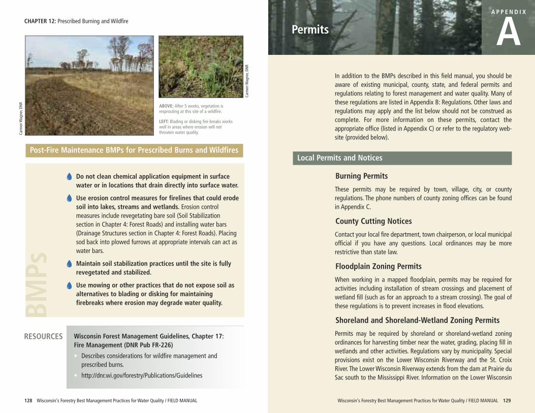
BMPs
CHAPTER 12: Prescribed Burning and Wildfire
128 Wisconsin’s Forestry Best Management Practices for Water Quality / FIELD MANUAL
Post-Fire Maintenance BMPs for Prescribed Burns and Wildfires
Do not clean chemical application equipment in surfacewater or in locations that drain directly into surface water.
Use erosion control measures for firelines that could erodesoil into lakes, streams and wetlands. Erosion controlmeasures include revegetating bare soil (Soil Stabilizationsection in Chapter 4: Forest Roads) and installing water bars(Drainage Structures section in Chapter 4: Forest Roads). Placingsod back into plowed furrows at appropriate intervals can act aswater bars.
Maintain soil stabilization practices until the site is fullyrevegetated and stabilized.
Use mowing or other practices that do not expose soil asalternatives to blading or disking for maintainingfirebreaks where erosion may degrade water quality.
Wisconsin’s Forestry Best Management Practices for Water Quality / FIELD MANUAL 129
Permits
A P P E N D I X
AIn addition to the BMPs described in this field manual, you should beaware of existing municipal, county, state, and federal permits andregulations relating to forest management and water quality. Many ofthese regulations are listed in Appendix B: Regulations. Other laws andregulations may apply and the list below should not be construed ascomplete. For more information on these permits, contact theappropriate office (listed in Appendix C) or refer to the regulatory web-site (provided below).
Local Permits and Notices
Burning Permits
These permits may be required by town, village, city, or countyregulations. The phone numbers of county zoning offices can be foundin Appendix C.
County Cutting Notices
Contact your local fire department, town chairperson, or local municipalofficial if you have any questions. Local ordinances may be morerestrictive than state law.
Floodplain Zoning Permits
When working in a mapped floodplain, permits may be required foractivities including installation of stream crossings and placement ofwetland fill (such as for an approach to a stream crossing). The goal ofthese regulations is to prevent increases in flood elevations.
Shoreland and Shoreland-Wetland Zoning Permits
Permits may be required by shoreland or shoreland-wetland zoningordinances for harvesting timber near the water, grading, placing fill inwetlands and other activities. Regulations vary by municipality. Specialprovisions exist on the Lower Wisconsin Riverway and the St. CroixRiver. The Lower Wisconsin Riverway extends from the dam at Prairie duSac south to the Mississippi River. Information on the Lower Wisconsin
Carm
en W
agner, DN
R
Carm
en W
agner, DN
R
ABOVE: After 5 weeks, vegetation isresprouting at this site of a wildfire.
LEFT: Blading or disking fire breaks workswell in areas where erosion will notthreaten water quality.
Wisconsin Forest Management Guidelines, Chapter 17: Fire Management (DNR Pub FR-226)
• Describes considerations for wildfire management andprescribed burns.
• http://dnr.wi.gov/forestry/Publications/Guidelines
RESOURCES
Waterway and Wetland Permits
DNR waterway and wetland permits are required for activities thataffect lakes, streams, and wetlands. Common activities that occur duringforest management that may require a permit include:
• stream crossings, including bridges, culverts, fords, timber mats, andpole fords
• wetland crossings
• grading more than 10,000 square feet on the bank of a lake orstream
For more information about waterway and wetland permits, contactyour local DNR water management specialist (see Appendix C) or go to:http://dnr.wi.gov/waterways/.
Federal Permits
Waterway and Wetland Permits
The US Army Corp of Engineers (USACE) regulates activities occurring inwaterways and wetlands, including the excavation and placement of fill.When building a road or trail through a wetland, a permit may berequired from the USACE. An exemption for forest roads is available, butcertain design, location, and use standards must be met to qualify forthe exemption. Contact your local USACE program staff (see AppendixC) or visit the USACE web-site at: http://www.mvp.usace.army.mil/regulatory/.
Wisconsin’s Forestry Best Management Practices for Water Quality / FIELD MANUAL 131
APPENDIX A: Permits APPENDIX A: Permits
130 Wisconsin’s Forestry Best Management Practices for Water Quality / FIELD MANUAL
Riverway is available at: http://lwr.state.wi.us/ or by calling (608) 739-3188. Standards along the St. Croix River are available from municipaloffices.
State Permits and Notices
Burning Permits
DNR annual burning permits are intended primarily for vegetativedebris removal. They are issued to landowners for burning on theground and in barrels. These no-cost permits are good for the calendaryear and are non-transferable. More information is available at:http://dnr.wi.gov/forestry/fire/burning-rp.htm.
Cutting Notices and Reports
Landowners that are enrolled in the Managed Forest Law (MFL)Program or the Forest Crop Law (FCL) Program must file a cutting notice(part A of form) with the DNR at least 30 days before harvesting begins(except for cutting firewood for personal use). Within 30 days of thecompletion of the harvest, a report (part B of form) with cutting volumesmust be filed with the DNR. For more information, contact your localDNR forester (see Appendix C) or refer to: http://dnr.wi.gov/forestry/ftax/.
Storm Water Permits
DNR storm water permits may be required when constructing,reconstructing or maintaining roads. Storm water permits are notrequired for forest roads that are used solely for silvicultural purposes,if certain standards are met. For multi-use roads, a storm water permitis needed when the construction of a new road or reconstruction of anexisting road will disturb one or more acres of land or whenmaintenance of an existing road will disturb five or more acres. Contactyour local DNR storm water specialist (see Appendix C) or refer to:http://dnr.wi.gov/runoff/stormwater/const.htm for more informationabout the DNR’s Storm Water Program.
132 Wisconsin’s Forestry Best Management Practices for Water Quality / FIELD MANUAL Wisconsin’s Forestry Best Management Practices for Water Quality / FIELD MANUAL 133
Regulations
A P P E N D I X
BThe list below contains regulations that relate to forest managementand water quality. This is only a summary of laws and their provisionsfor your information. No warranty, expressed or implied, is maderegarding the accuracy, adequacy, completeness, legality, reliability orusefulness of any information contained in this publication. To becertain of the accuracy of summaries, please consult the officiallanguage of the law that is listed.
Department employees shall not be held liable for any improper orincorrect use of the information contained in this publication. In noevent shall the State of Wisconsin, the Department or Departmentemployees be liable for any direct, indirect, incidental, special,exemplary, or consequential damages however caused and on anytheory of liability, whether in contract, strict liability, or tort (includingnegligence or otherwise) arising in any way out of the use of thispublication. Other regulations may also apply.
Local Laws and Ordinances
Local laws and ordinances can be obtained from municipal offices.
Wisconsin State Statutes
Wisconsin State Statutes can be viewed at: http://www.legis.state.wi.us/rsb/stats.html.
Chapter 26, Wis. Stats.: Protection of Forest Lands and ForestProductivity
• S. 26.03, Wis. Stats. – Requires that any person cutting a forestproduct from a private forest file a cutting notice with the countyclerk prior to any harvesting.
• S. 26.12 (6), Wis. Stats. – Any slash which falls into or is depositedin a lake or stream, when harvesting timber or other forest products,shall be immediately removed if, in the opinion of the department,such removal is in the public interest.
Construction of forest roads aresubject to various regulations.
Photo by Kristin Lambert, DNR
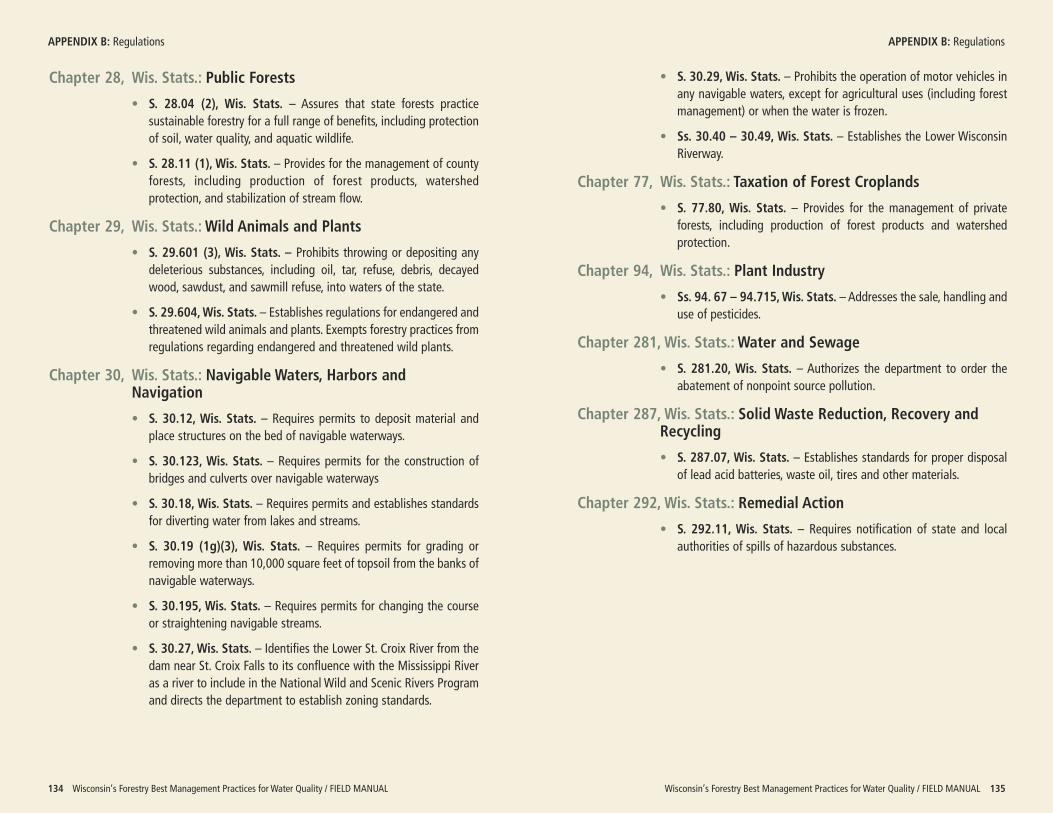
Wisconsin’s Forestry Best Management Practices for Water Quality / FIELD MANUAL 135
APPENDIX B: Regulations APPENDIX B: Regulations
134 Wisconsin’s Forestry Best Management Practices for Water Quality / FIELD MANUAL
Chapter 28, Wis. Stats.: Public Forests
• S. 28.04 (2), Wis. Stats. – Assures that state forests practicesustainable forestry for a full range of benefits, including protectionof soil, water quality, and aquatic wildlife.
• S. 28.11 (1), Wis. Stats. – Provides for the management of countyforests, including production of forest products, watershedprotection, and stabilization of stream flow.
Chapter 29, Wis. Stats.: Wild Animals and Plants
• S. 29.601 (3), Wis. Stats. – Prohibits throwing or depositing anydeleterious substances, including oil, tar, refuse, debris, decayedwood, sawdust, and sawmill refuse, into waters of the state.
• S. 29.604, Wis. Stats. – Establishes regulations for endangered andthreatened wild animals and plants. Exempts forestry practices fromregulations regarding endangered and threatened wild plants.
Chapter 30, Wis. Stats.: Navigable Waters, Harbors andNavigation
• S. 30.12, Wis. Stats. – Requires permits to deposit material andplace structures on the bed of navigable waterways.
• S. 30.123, Wis. Stats. – Requires permits for the construction ofbridges and culverts over navigable waterways
• S. 30.18, Wis. Stats. – Requires permits and establishes standardsfor diverting water from lakes and streams.
• S. 30.19 (1g)(3), Wis. Stats. – Requires permits for grading orremoving more than 10,000 square feet of topsoil from the banks ofnavigable waterways.
• S. 30.195, Wis. Stats. – Requires permits for changing the courseor straightening navigable streams.
• S. 30.27, Wis. Stats. – Identifies the Lower St. Croix River from thedam near St. Croix Falls to its confluence with the Mississippi Riveras a river to include in the National Wild and Scenic Rivers Programand directs the department to establish zoning standards.
• S. 30.29, Wis. Stats. – Prohibits the operation of motor vehicles inany navigable waters, except for agricultural uses (including forestmanagement) or when the water is frozen.
• Ss. 30.40 – 30.49, Wis. Stats. – Establishes the Lower WisconsinRiverway.
Chapter 77, Wis. Stats.: Taxation of Forest Croplands
• S. 77.80, Wis. Stats. – Provides for the management of privateforests, including production of forest products and watershedprotection.
Chapter 94, Wis. Stats.: Plant Industry
• Ss. 94. 67 – 94.715, Wis. Stats. – Addresses the sale, handling anduse of pesticides.
Chapter 281, Wis. Stats.: Water and Sewage
• S. 281.20, Wis. Stats. – Authorizes the department to order theabatement of nonpoint source pollution.
Chapter 287, Wis. Stats.: Solid Waste Reduction, Recovery andRecycling
• S. 287.07, Wis. Stats. – Establishes standards for proper disposalof lead acid batteries, waste oil, tires and other materials.
Chapter 292, Wis. Stats.: Remedial Action
• S. 292.11, Wis. Stats. – Requires notification of state and localauthorities of spills of hazardous substances.
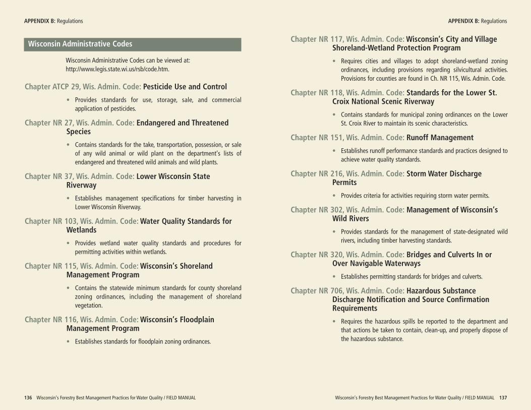
Chapter NR 117, Wis. Admin. Code: Wisconsin’s City and VillageShoreland-Wetland Protection Program
• Requires cities and villages to adopt shoreland-wetland zoningordinances, including provisions regarding silvicultural activities.Provisions for counties are found in Ch. NR 115, Wis. Admin. Code.
Chapter NR 118, Wis. Admin. Code: Standards for the Lower St.Croix National Scenic Riverway
• Contains standards for municipal zoning ordinances on the LowerSt. Croix River to maintain its scenic characteristics.
Chapter NR 151, Wis. Admin. Code: Runoff Management
• Establishes runoff performance standards and practices designed toachieve water quality standards.
Chapter NR 216, Wis. Admin. Code: Storm Water DischargePermits
• Provides criteria for activities requiring storm water permits.
Chapter NR 302, Wis. Admin. Code: Management of Wisconsin’sWild Rivers
• Provides standards for the management of state-designated wildrivers, including timber harvesting standards.
Chapter NR 320, Wis. Admin. Code: Bridges and Culverts In orOver Navigable Waterways
• Establishes permitting standards for bridges and culverts.
Chapter NR 706, Wis. Admin. Code: Hazardous SubstanceDischarge Notification and Source ConfirmationRequirements
• Requires the hazardous spills be reported to the department andthat actions be taken to contain, clean-up, and properly dispose ofthe hazardous substance.
Wisconsin’s Forestry Best Management Practices for Water Quality / FIELD MANUAL 137
APPENDIX B: Regulations
136 Wisconsin’s Forestry Best Management Practices for Water Quality / FIELD MANUAL
Wisconsin Administrative Codes
Wisconsin Administrative Codes can be viewed at:http://www.legis.state.wi.us/rsb/code.htm.
Chapter ATCP 29, Wis. Admin. Code: Pesticide Use and Control
• Provides standards for use, storage, sale, and commercialapplication of pesticides.
Chapter NR 27, Wis. Admin. Code: Endangered and ThreatenedSpecies
• Contains standards for the take, transportation, possession, or saleof any wild animal or wild plant on the department’s lists ofendangered and threatened wild animals and wild plants.
Chapter NR 37, Wis. Admin. Code: Lower Wisconsin StateRiverway
• Establishes management specifications for timber harvesting inLower Wisconsin Riverway.
Chapter NR 103, Wis. Admin. Code: Water Quality Standards forWetlands
• Provides wetland water quality standards and procedures forpermitting activities within wetlands.
Chapter NR 115, Wis. Admin. Code: Wisconsin’s ShorelandManagement Program
• Contains the statewide minimum standards for county shorelandzoning ordinances, including the management of shorelandvegetation.
Chapter NR 116, Wis. Admin. Code: Wisconsin’s FloodplainManagement Program
• Establishes standards for floodplain zoning ordinances.
APPENDIX B: Regulations
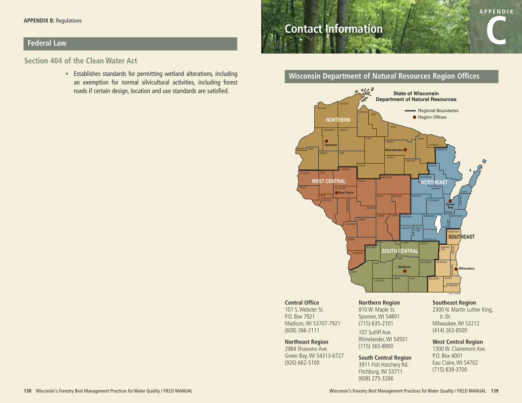
APPENDIX B: Regulations
138 Wisconsin’s Forestry Best Management Practices for Water Quality / FIELD MANUAL
Federal Law
Section 404 of the Clean Water Act
• Establishes standards for permitting wetland alterations, includingan exemption for normal silvicultural activities, including forestroads if certain design, location and use standards are satisfied.
Wisconsin’s Forestry Best Management Practices for Water Quality / FIELD MANUAL 139
Contact Information
A P P E N D I X
C
DOUGLASBAYFIELD
ASHLANDIRON
BURNETT
VILASWASHBURN SAWYER
PRICEONEIDA
FOREST
FLORENCE
BARRONPOLK
RUSK
TAYLORCHIPPEWA
DUNNST. CROIX
PIERCE
PEPIN
EAU CLAIRE
CLARK
LINCOLN
MARATHON
LANGLADE
MARINETTE
OCONTO
MENOMINEE
SHAWANODOOR
KEWA
UNEE
BROWN
OUTAGAMIEWAUPACAWOOD PORTAGE
MANITOWOCWINNEBAGO
CALU
MET
WAUSHARA
JACKSON
JUNEAU ADAMS
MARQUETTE GREENLAKE
FOND DU LAC
SHEBOYGAN
MONROE
SAUK COLUMBIA DODGEWASHING-TON
OZAU
KEE
MILW
AUKE
E
WAUKESHAJEFFERSONDANE
KENOSHA
RACINEWALWORTHROCKGREENLAFAYETTE
IOWA
GRANT
RICHLAND
CRAWFORD
VERNON
LA CROSSE
BUFFALO
TREM
PEAL
EAU
WEST CENTRAL
SOUTH CENTRAL
Regional BoundariesRegion Offices
REV 1/2006
State of WisconsinDepartment of Natural Resources
SOUTHEAST
NORTHERN
NORTHEAST
Wisconsin Department of Natural Resources Region Offices
Central Office101 S. Webster St. P.O. Box 7921Madison, WI 53707-7921(608) 266-2111
Northeast Region2984 Shawano Ave. Green Bay, WI 54313-6727(920) 662-5100
Northern Region810 W. Maple St.Spooner, WI 54801(715) 635-2101
107 Sutliff Ave.Rhinelander, WI 54501(715) 365-8900
South Central Region3911 Fish Hatchery Rd.Fitchburg, WI 53711(608) 275-3266
Southeast Region2300 N. Martin Luther King,
Jr. Dr.Milwaukee, WI 53212(414) 263-8500
West Central Region1300 W. Clairemont Ave. P.O. Box 4001Eau Claire, WI 54702(715) 839-3700
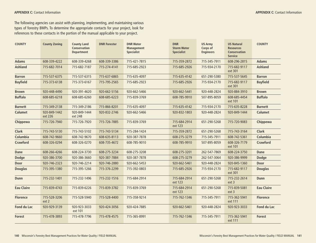
Wisconsin’s Forestry Best Management Practices for Water Quality / FIELD MANUAL 141
APPENDIX C: Contact Information APPENDIX C: Contact Information
140 Wisconsin’s Forestry Best Management Practices for Water Quality / FIELD MANUAL
The following agencies can assist with planning, implementing, and maintaining varioustypes of forestry BMPs. To determine the appropriate contacts for your project, look forreferences to these contacts in the portion of the manual applicable to your project.
COUNTY County Zoning County Land DNR Forester DNR Water DNR US Army US Natural COUNTYConservation Management Storm Water Corps of ResourcesDepartment Specialist Specialist Engineers Conservation
Service
Adams 608-339-4222 608-339-4268 608-339-3386 715-421-7815 715-359-2872 715-345-7911 608-296-2815 Adams
Ashland 715-682-7014 715-682-7187 715-274-4141 715-685-2923 715-685-2926 715-934-2170 715-682-9117 Ashlandext 301
Barron 715-537-6375 715-537-6315 715-637-6865 715-635-4097 715-635-4142 651-290-5380 715-537-5645 Barron
Bayfield 715-373-6138 715-373-6167 715-795-2565 715-685-2923 715-685-2926 715-934-2170 715-682-9117 Bayfieldext 301
Brown 920-448-4490 920-391-4620 920-662-5156 920-662-5466 920-662-5441 920-448-2824 920-884-3910 Brown
Buffalo 608-685-6218 608-685-6260 608-685-6223 715-839-3769 608-785-9910 507-895-8059 608-685-4454 Buffaloext 101
Burnett 715-349-2138 715-349-2186 715-866-8201 715-635-4097 715-635-4142 715-934-2170 715-635-8228 Burnett
Calumet 920-849-1442 920-849-1444 920-832-2746 920-662-5466 920-832-1803 920-448-2824 920-849-1444 Calumetext 226 ext 248
Chippewa 715-726-7940 715-726-7920 715-726-7885 715-839-3769 715-684-2914 651-290-5268 715-720-9083 Chippewaext 123
Clark 715-743-5130 715-743-5102 715-743-5134 715-284-1424 715-359-2872 651-290-5268 715-743-3164 Clark
Columbia 608-742-9660 608-742-9670 608-635-8113 920-387-7878 608-275-3279 715-345-7911 608-742-5361 Columbia
Crawford 608-326-0294 608-326-0270 608-735-4672 608-785-9010 608-785-9910 507-895-8059 608-326-7179 Crawfordext 101
Dane 608-266-4266 608-224-3730 608-275-3234 608-275-3208 608-275-3201 262-547-7869 608-224-3750 Dane
Dodge 920-386-3700 920-386-3660 920-387-7884 920-387-7878 608-275-3279 262-547-3064 920-386-9999 Dodge
Door 920-746-2323 920-746-2214 920-746-2880 920-662-5453 920-662-5461 920-448-2824 920-845-1360 Door
Douglas 715-395-1380 715-395-1266 715-376-2299 715-392-0803 715-685-2926 715-934-2170 715-682-9117 Douglasext 301
Dunn 715-232-1401 715-232-1496 715-232-1516 715-684-2914 715-684-2914 651-290-5268 715-232-2614 Dunnext 123 ext 3
Eau Claire 715-839-4743 715-839-6226 715-839-3782 715-839-3769 715-684-2914 651-290-5268 715-839-5081 Eau Claireext 123 ext 3
Florence 715-528-3206 715-528-5940 715-528-4400 715-358-9214 715-762-1346 715-345-7911 715-362-5941 Florenceext 2 ext 111
Fond du Lac 920-929-3139 920-923-3033 920-424-3056 920-424-7885 920-662-5461 920-448-2824 920-923-3033 Fond du Lacext 101
Forest 715-478-3893 715-478-7796 715-478-4575 715-365-8991 715-762-1346 715-345-7911 715-362-5941 Forestext 111
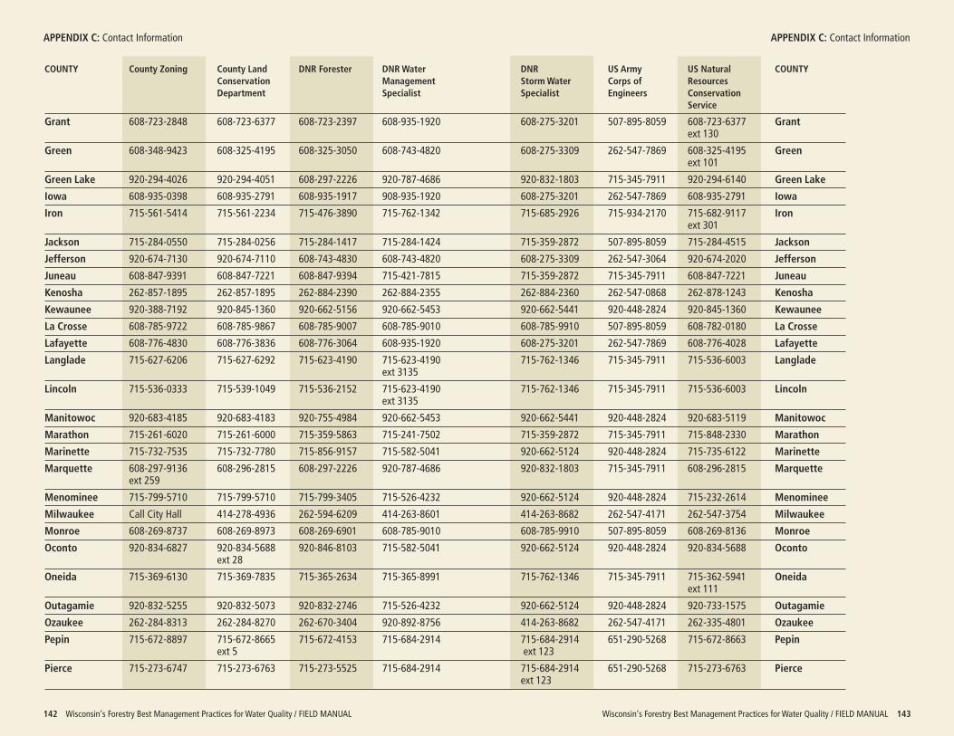
Wisconsin’s Forestry Best Management Practices for Water Quality / FIELD MANUAL 143
APPENDIX C: Contact Information
142 Wisconsin’s Forestry Best Management Practices for Water Quality / FIELD MANUAL
APPENDIX C: Contact Information
COUNTY County Zoning County Land DNR Forester DNR Water DNR US Army US Natural COUNTYConservation Management Storm Water Corps of ResourcesDepartment Specialist Specialist Engineers Conservation
Service
Grant 608-723-2848 608-723-6377 608-723-2397 608-935-1920 608-275-3201 507-895-8059 608-723-6377 Grantext 130
Green 608-348-9423 608-325-4195 608-325-3050 608-743-4820 608-275-3309 262-547-7869 608-325-4195 Greenext 101
Green Lake 920-294-4026 920-294-4051 608-297-2226 920-787-4686 920-832-1803 715-345-7911 920-294-6140 Green Lake
Iowa 608-935-0398 608-935-2791 608-935-1917 908-935-1920 608-275-3201 262-547-7869 608-935-2791 Iowa
Iron 715-561-5414 715-561-2234 715-476-3890 715-762-1342 715-685-2926 715-934-2170 715-682-9117 Ironext 301
Jackson 715-284-0550 715-284-0256 715-284-1417 715-284-1424 715-359-2872 507-895-8059 715-284-4515 Jackson
Jefferson 920-674-7130 920-674-7110 608-743-4830 608-743-4820 608-275-3309 262-547-3064 920-674-2020 Jefferson
Juneau 608-847-9391 608-847-7221 608-847-9394 715-421-7815 715-359-2872 715-345-7911 608-847-7221 Juneau
Kenosha 262-857-1895 262-857-1895 262-884-2390 262-884-2355 262-884-2360 262-547-0868 262-878-1243 Kenosha
Kewaunee 920-388-7192 920-845-1360 920-662-5156 920-662-5453 920-662-5441 920-448-2824 920-845-1360 Kewaunee
La Crosse 608-785-9722 608-785-9867 608-785-9007 608-785-9010 608-785-9910 507-895-8059 608-782-0180 La Crosse
Lafayette 608-776-4830 608-776-3836 608-776-3064 608-935-1920 608-275-3201 262-547-7869 608-776-4028 Lafayette
Langlade 715-627-6206 715-627-6292 715-623-4190 715-623-4190 715-762-1346 715-345-7911 715-536-6003 Langladeext 3135
Lincoln 715-536-0333 715-539-1049 715-536-2152 715-623-4190 715-762-1346 715-345-7911 715-536-6003 Lincolnext 3135
Manitowoc 920-683-4185 920-683-4183 920-755-4984 920-662-5453 920-662-5441 920-448-2824 920-683-5119 Manitowoc
Marathon 715-261-6020 715-261-6000 715-359-5863 715-241-7502 715-359-2872 715-345-7911 715-848-2330 Marathon
Marinette 715-732-7535 715-732-7780 715-856-9157 715-582-5041 920-662-5124 920-448-2824 715-735-6122 Marinette
Marquette 608-297-9136 608-296-2815 608-297-2226 920-787-4686 920-832-1803 715-345-7911 608-296-2815 Marquetteext 259
Menominee 715-799-5710 715-799-5710 715-799-3405 715-526-4232 920-662-5124 920-448-2824 715-232-2614 Menominee
Milwaukee Call City Hall 414-278-4936 262-594-6209 414-263-8601 414-263-8682 262-547-4171 262-547-3754 Milwaukee
Monroe 608-269-8737 608-269-8973 608-269-6901 608-785-9010 608-785-9910 507-895-8059 608-269-8136 Monroe
Oconto 920-834-6827 920-834-5688 920-846-8103 715-582-5041 920-662-5124 920-448-2824 920-834-5688 Ocontoext 28
Oneida 715-369-6130 715-369-7835 715-365-2634 715-365-8991 715-762-1346 715-345-7911 715-362-5941 Oneidaext 111
Outagamie 920-832-5255 920-832-5073 920-832-2746 715-526-4232 920-662-5124 920-448-2824 920-733-1575 Outagamie
Ozaukee 262-284-8313 262-284-8270 262-670-3404 920-892-8756 414-263-8682 262-547-4171 262-335-4801 Ozaukee
Pepin 715-672-8897 715-672-8665 715-672-4153 715-684-2914 715-684-2914 651-290-5268 715-672-8663 Pepinext 5 ext 123
Pierce 715-273-6747 715-273-6763 715-273-5525 715-684-2914 715-684-2914 651-290-5268 715-273-6763 Pierceext 123
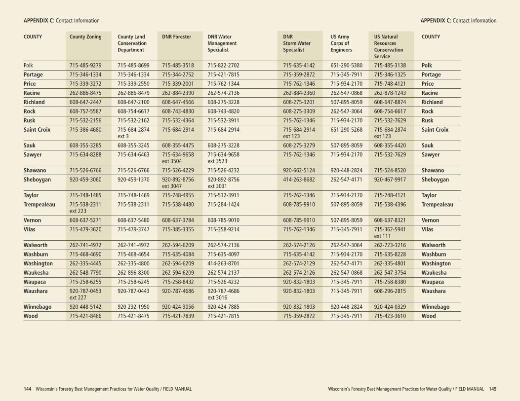
Wisconsin’s Forestry Best Management Practices for Water Quality / FIELD MANUAL 145
APPENDIX C: Contact Information
144 Wisconsin’s Forestry Best Management Practices for Water Quality / FIELD MANUAL
APPENDIX C: Contact Information
COUNTY County Zoning County Land DNR Forester DNR Water DNR US Army US Natural COUNTYConservation Management Storm Water Corps of ResourcesDepartment Specialist Specialist Engineers Conservation
Service
Polk 715-485-9279 715-485-8699 715-485-3518 715-822-2702 715-635-4142 651-290-5380 715-485-3138 Polk
Portage 715-346-1334 715-346-1334 715-344-2752 715-421-7815 715-359-2872 715-345-7911 715-346-1325 Portage
Price 715-339-3272 715-339-2550 715-339-2001 715-762-1344 715-762-1346 715-934-2170 715-748-4121 Price
Racine 262-886-8475 262-886-8479 262-884-2390 262-574-2136 262-884-2360 262-547-0868 262-878-1243 Racine
Richland 608-647-2447 608-647-2100 608-647-4566 608-275-3228 608-275-3201 507-895-8059 608-647-8874 Richland
Rock 608-757-5587 608-754-6617 608-743-4830 608-743-4820 608-275-3309 262-547-3064 608-754-6617 Rock
Rusk 715-532-2156 715-532-2162 715-532-4364 715-532-3911 715-762-1346 715-934-2170 715-532-7629 Rusk
Saint Croix 715-386-4680 715-684-2874 715-684-2914 715-684-2914 715-684-2914 651-290-5268 715-684-2874 Saint Croixext 3 ext 123 ext 123
Sauk 608-355-3285 608-355-3245 608-355-4475 608-275-3228 608-275-3279 507-895-8059 608-355-4420 Sauk
Sawyer 715-634-8288 715-634-6463 715-634-9658 715-634-9658 715-762-1346 715-934-2170 715-532-7629 Sawyerext 3504 ext 3523
Shawano 715-526-6766 715-526-6766 715-526-4229 715-526-4232 920-662-5124 920-448-2824 715-524-8520 Shawano
Sheboygan 920-459-3060 920-459-1370 920-892-8756 920-892-8756 414-263-8682 262-547-4171 920-467-9917 Sheboyganext 3047 ext 3031
Taylor 715-748-1485 715-748-1469 715-748-4955 715-532-3911 715-762-1346 715-934-2170 715-748-4121 Taylor
Trempealeau 715-538-2311 715-538-2311 715-538-4480 715-284-1424 608-785-9910 507-895-8059 715-538-4396 Trempealeauext 223
Vernon 608-637-5271 608-637-5480 608-637-3784 608-785-9010 608-785-9910 507-895-8059 608-637-8321 Vernon
Vilas 715-479-3620 715-479-3747 715-385-3355 715-358-9214 715-762-1346 715-345-7911 715-362-5941 Vilasext 111
Walworth 262-741-4972 262-741-4972 262-594-6209 262-574-2136 262-574-2126 262-547-3064 262-723-3216 Walworth
Washburn 715-468-4690 715-468-4654 715-635-4084 715-635-4097 715-635-4142 715-934-2170 715-635-8228 Washburn
Washington 262-335-4445 262-335-4800 262-594-6209 414-263-8701 262-574-2129 262-547-4171 262-335-4801 Washington
Waukesha 262-548-7790 262-896-8300 262-594-6209 262-574-2137 262-574-2126 262-547-0868 262-547-3754 Waukesha
Waupaca 715-258-6255 715-258-6245 715-258-8432 715-526-4232 920-832-1803 715-345-7911 715-258-8380 Waupaca
Waushara 920-787-0453 920-787-0443 920-787-4686 920-787-4686 920-832-1803 715-345-7911 608-296-2815 Wausharaext 227 ext 3016
Winnebago 920-448-5142 920-232-1950 920-424-3056 920-424-7885 920-832-1803 920-448-2824 920-424-0329 Winnebago
Wood 715-421-8466 715-421-8475 715-421-7839 715-421-7815 715-359-2872 715-345-7911 715-423-3610 Wood
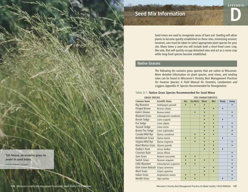
Wisconsin’s Forestry Best Management Practices for Water Quality / FIELD MANUAL 147
Seed Mix Information
A P P E N D I X
D
146 Wisconsin’s Forestry Best Management Practices for Water Quality / FIELD MANUAL
Tall fescue, an invasive grass toavoid in seed mixes.
Photo by Elizabeth J. Czarapata
Seed mixes are used to revegetate areas of bare soil. Seeding will allowplants to become quickly established on these sites, minimizing erosion;however, care must be taken to select appropriate plant species for yoursite. Many times a seed mix will include both a short-lived cover crop,like oats, that will quickly occupy disturbed sites and act as a nurse cropwhile long-lived species become established.
Native Grasses
The following list contains grass species that are native to Wisconsin.More detailed information on plant species, seed mixes, and seedingrates can be found in Wisconsin’s Forestry Best Management Practicesfor Invasive Species: A Field Manual for Foresters, Landowners andLoggers, Appendix H: Species Recommended for Revegetation.
Table D-1. Native Grass Species Recommended for Seed Mixes
GRASS SPECIES SITE CHARACTERISTICSCommon Name Scientific Name Dry Dry-Mesic Mesic Wet Shady SunnyBig Bluestem Andropogon gerardii • • • •Fringed Brome Bromus ciliatus • • •Kalm’s Brome Bromus kalmii • • •Bluejoint Grass Calamagrostis canadensis • • •Broom Sedge Carex scoparia • • •Fox Sedge Carex stipata • • •Tussock Sedge Carex stricta • • • •Brown Fox Sedge Carex vulpinoidea • • •Canada Wild Rye Elymus canadensis • • • •Bottlebrush Grass Elymus hystrix • • • •Virginia Wild Rye Elymus vinginicus • • • •Reed Manna Grass Glyseria grandis • • •Dudley’s Rush Juncus dudleyi • • •Common Rush Juncus effuses • •June Grass Koeleria macrantha • • •Switch Grass Panicum virgatum • • • • •Little Bluestem Schizachyrium scoparium • • •Dark Green Bulrush Scirpus atrovirens • • •Wool Grass Scirpus cyperinus • • •Indian Grass Sorghastrum nutans • • • •Needle Grass Stipa spartea • • • •
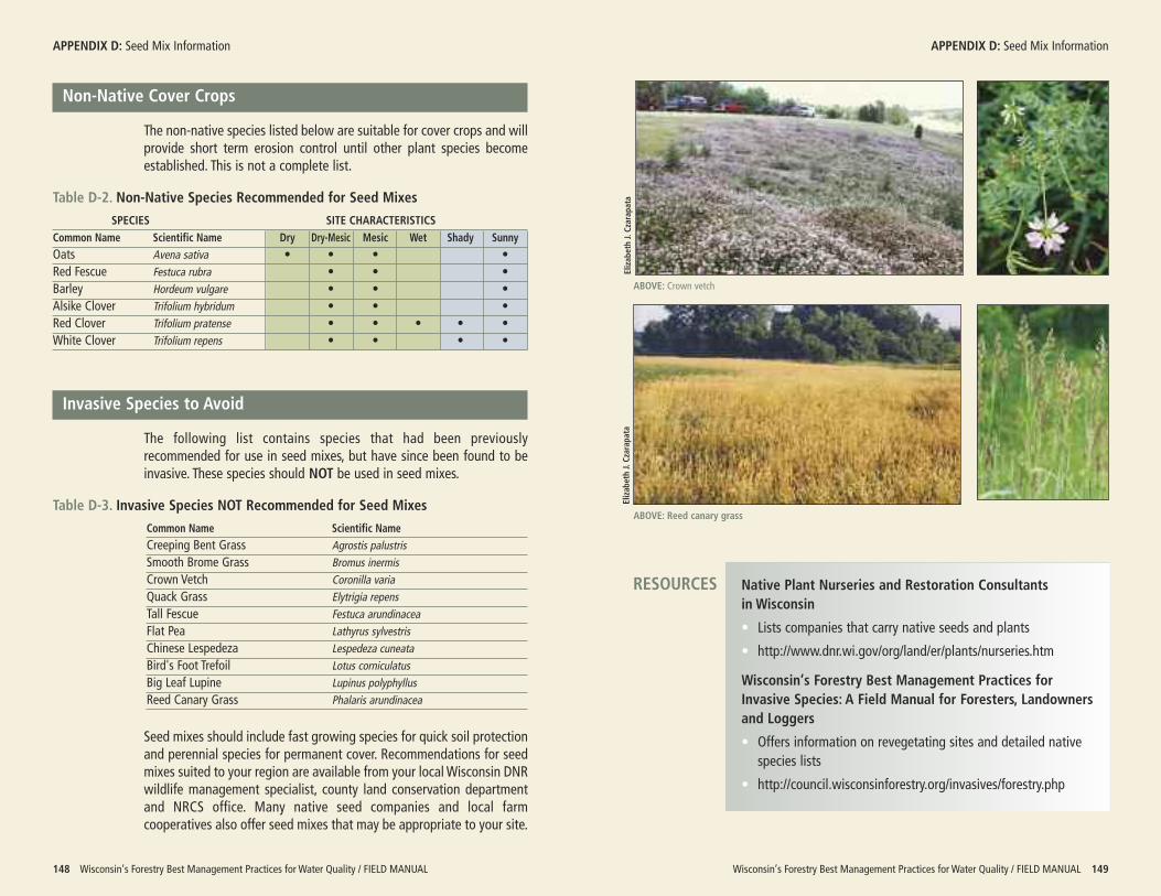
Non-Native Cover Crops
The non-native species listed below are suitable for cover crops and willprovide short term erosion control until other plant species becomeestablished. This is not a complete list.
Table D-2. Non-Native Species Recommended for Seed Mixes
SPECIES SITE CHARACTERISTICSCommon Name Scientific Name Dry Dry-Mesic Mesic Wet Shady SunnyOats Avena sativa • • • •Red Fescue Festuca rubra • • •Barley Hordeum vulgare • • •Alsike Clover Trifolium hybridum • • •Red Clover Trifolium pratense • • • • •White Clover Trifolium repens • • • •
Invasive Species to Avoid
The following list contains species that had been previouslyrecommended for use in seed mixes, but have since been found to beinvasive. These species should NOT be used in seed mixes.
Table D-3. Invasive Species NOT Recommended for Seed Mixes
Common Name Scientific NameCreeping Bent Grass Agrostis palustrisSmooth Brome Grass Bromus inermisCrown Vetch Coronilla variaQuack Grass Elytrigia repensTall Fescue Festuca arundinaceaFlat Pea Lathyrus sylvestrisChinese Lespedeza Lespedeza cuneataBird's Foot Trefoil Lotus corniculatusBig Leaf Lupine Lupinus polyphyllusReed Canary Grass Phalaris arundinacea
Seed mixes should include fast growing species for quick soil protectionand perennial species for permanent cover. Recommendations for seedmixes suited to your region are available from your local Wisconsin DNRwildlife management specialist, county land conservation departmentand NRCS office. Many native seed companies and local farmcooperatives also offer seed mixes that may be appropriate to your site.
Wisconsin’s Forestry Best Management Practices for Water Quality / FIELD MANUAL 149
APPENDIX D: Seed Mix Information
148 Wisconsin’s Forestry Best Management Practices for Water Quality / FIELD MANUAL
APPENDIX D: Seed Mix Information
ABOVE: Crown vetch
Elizabeth J. Czarapata
ABOVE: Reed canary grass
Native Plant Nurseries and Restoration Consultants in Wisconsin
• Lists companies that carry native seeds and plants
• http://www.dnr.wi.gov/org/land/er/plants/nurseries.htm
Wisconsin’s Forestry Best Management Practices for Invasive Species: A Field Manual for Foresters, Landownersand Loggers
• Offers information on revegetating sites and detailed nativespecies lists
• http://council.wisconsinforestry.org/invasives/forestry.php
RESOURCES
Elizabeth J. Czarapata
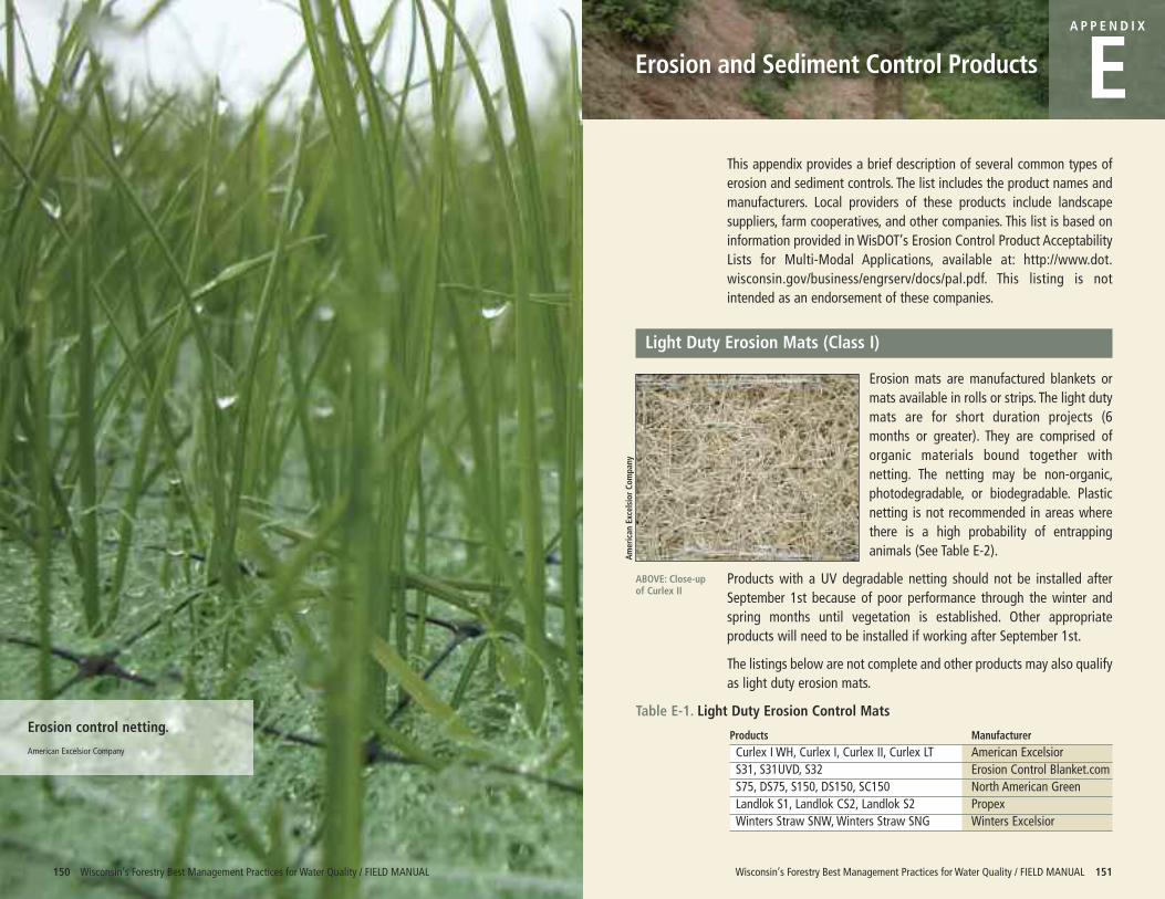
Erosion control netting.
American Excelsior Company
Wisconsin’s Forestry Best Management Practices for Water Quality / FIELD MANUAL 151
Erosion and Sediment Control Products
A P P E N D I X
EThis appendix provides a brief description of several common types oferosion and sediment controls. The list includes the product names andmanufacturers. Local providers of these products include landscapesuppliers, farm cooperatives, and other companies. This list is based oninformation provided in WisDOT’s Erosion Control Product AcceptabilityLists for Multi-Modal Applications, available at: http://www.dot.wisconsin.gov/business/engrserv/docs/pal.pdf. This listing is notintended as an endorsement of these companies.
Light Duty Erosion Mats (Class I)
Erosion mats are manufactured blankets ormats available in rolls or strips. The light dutymats are for short duration projects (6months or greater). They are comprised oforganic materials bound together withnetting. The netting may be non-organic,photodegradable, or biodegradable. Plasticnetting is not recommended in areas wherethere is a high probability of entrappinganimals (See Table E-2).
Products with a UV degradable netting should not be installed afterSeptember 1st because of poor performance through the winter andspring months until vegetation is established. Other appropriateproducts will need to be installed if working after September 1st.
The listings below are not complete and other products may also qualifyas light duty erosion mats.
Table E-1. Light Duty Erosion Control Mats
Products ManufacturerCurlex I WH, Curlex I, Curlex II, Curlex LT American ExcelsiorS31, S31UVD, S32 Erosion Control Blanket.comS75, DS75, S150, DS150, SC150 North American GreenLandlok S1, Landlok CS2, Landlok S2 PropexWinters Straw SNW, Winters Straw SNG Winters Excelsior
150 Wisconsin’s Forestry Best Management Practices for Water Quality / FIELD MANUAL
ABOVE: Close-upof Curlex II
American Excelsior Com
pany
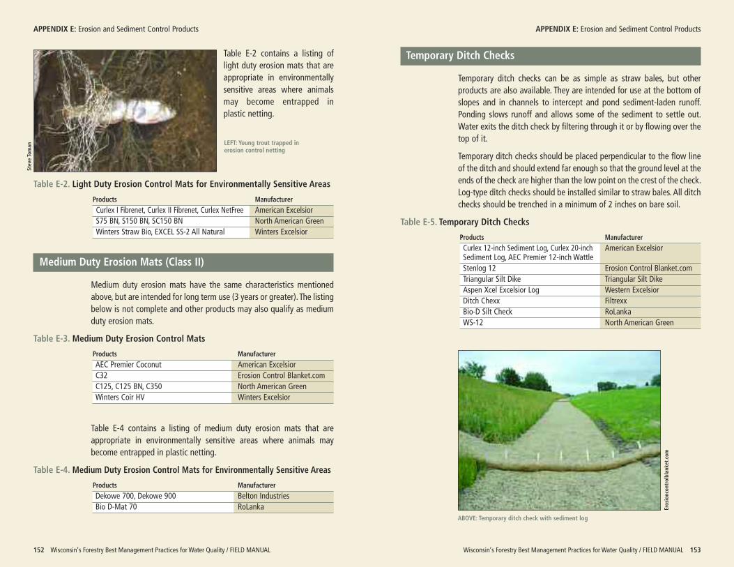
Table E-2 contains a listing oflight duty erosion mats that areappropriate in environmentallysensitive areas where animalsmay become entrapped inplastic netting.
Table E-2. Light Duty Erosion Control Mats for Environmentally Sensitive Areas
Products ManufacturerCurlex I Fibrenet, Curlex II Fibrenet, Curlex NetFree American ExcelsiorS75 BN, S150 BN, SC150 BN North American GreenWinters Straw Bio, EXCEL SS-2 All Natural Winters Excelsior
Medium Duty Erosion Mats (Class II)
Medium duty erosion mats have the same characteristics mentionedabove, but are intended for long term use (3 years or greater). The listingbelow is not complete and other products may also qualify as mediumduty erosion mats.
Table E-3. Medium Duty Erosion Control Mats
Products ManufacturerAEC Premier Coconut American ExcelsiorC32 Erosion Control Blanket.comC125, C125 BN, C350 North American GreenWinters Coir HV Winters Excelsior
Table E-4 contains a listing of medium duty erosion mats that areappropriate in environmentally sensitive areas where animals maybecome entrapped in plastic netting.
Table E-4. Medium Duty Erosion Control Mats for Environmentally Sensitive Areas
Products ManufacturerDekowe 700, Dekowe 900 Belton IndustriesBio D-Mat 70 RoLanka
Wisconsin’s Forestry Best Management Practices for Water Quality / FIELD MANUAL 153
APPENDIX E: Erosion and Sediment Control Products
152 Wisconsin’s Forestry Best Management Practices for Water Quality / FIELD MANUAL
APPENDIX E: Erosion and Sediment Control Products
ABOVE: Temporary ditch check with sediment log
Steve Toman LEFT: Young trout trapped in
erosion control netting
Erosioncontrolblanket.com
Temporary Ditch Checks
Temporary ditch checks can be as simple as straw bales, but otherproducts are also available. They are intended for use at the bottom ofslopes and in channels to intercept and pond sediment-laden runoff.Ponding slows runoff and allows some of the sediment to settle out.Water exits the ditch check by filtering through it or by flowing over thetop of it.
Temporary ditch checks should be placed perpendicular to the flow lineof the ditch and should extend far enough so that the ground level at theends of the check are higher than the low point on the crest of the check.Log-type ditch checks should be installed similar to straw bales. All ditchchecks should be trenched in a minimum of 2 inches on bare soil.
Table E-5. Temporary Ditch Checks
Products ManufacturerCurlex 12-inch Sediment Log, Curlex 20-inch American ExcelsiorSediment Log, AEC Premier 12-inch WattleStenlog 12 Erosion Control Blanket.comTriangular Silt Dike Triangular Silt DikeAspen Xcel Excelsior Log Western ExcelsiorDitch Chexx FiltrexxBio-D Silt Check RoLankaWS-12 North American Green
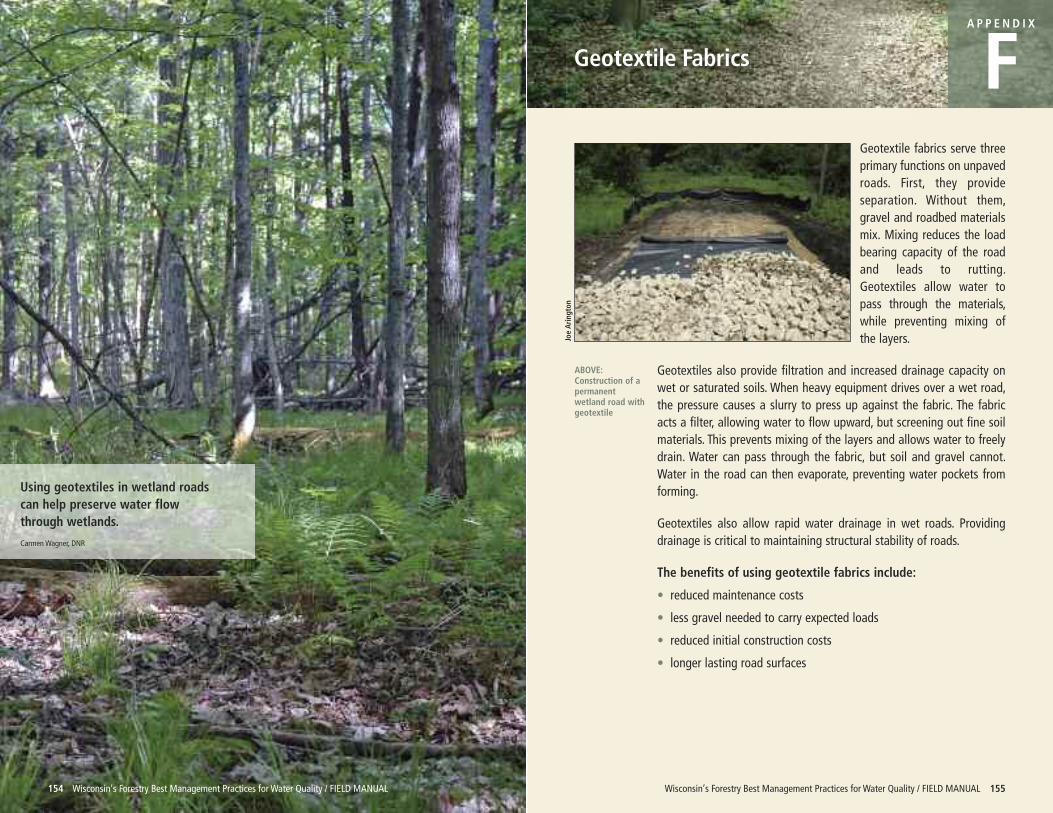
Using geotextiles in wetland roadscan help preserve water flowthrough wetlands.
Carmen Wagner, DNR
Wisconsin’s Forestry Best Management Practices for Water Quality / FIELD MANUAL 155
Geotextile Fabrics
A P P E N D I X
FGeotextile fabrics serve threeprimary functions on unpavedroads. First, they provideseparation. Without them,gravel and roadbed materialsmix. Mixing reduces the loadbearing capacity of the roadand leads to rutting.Geotextiles allow water topass through the materials,while preventing mixing ofthe layers.
Geotextiles also provide filtration and increased drainage capacity onwet or saturated soils. When heavy equipment drives over a wet road,the pressure causes a slurry to press up against the fabric. The fabricacts a filter, allowing water to flow upward, but screening out fine soilmaterials. This prevents mixing of the layers and allows water to freelydrain. Water can pass through the fabric, but soil and gravel cannot.Water in the road can then evaporate, preventing water pockets fromforming.
Geotextiles also allow rapid water drainage in wet roads. Providingdrainage is critical to maintaining structural stability of roads.
The benefits of using geotextile fabrics include:
• reduced maintenance costs
• less gravel needed to carry expected loads
• reduced initial construction costs
• longer lasting road surfaces
154 Wisconsin’s Forestry Best Management Practices for Water Quality / FIELD MANUAL
ABOVE:Construction of apermanentwetland road withgeotextile
Joe Arington
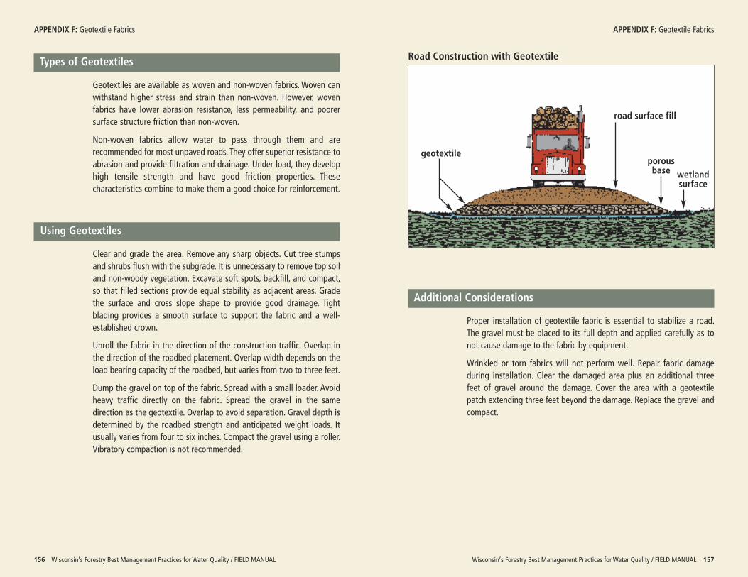
Wisconsin’s Forestry Best Management Practices for Water Quality / FIELD MANUAL 157
APPENDIX F: Geotextile Fabrics
156 Wisconsin’s Forestry Best Management Practices for Water Quality / FIELD MANUAL
Types of Geotextiles
Geotextiles are available as woven and non-woven fabrics. Woven canwithstand higher stress and strain than non-woven. However, wovenfabrics have lower abrasion resistance, less permeability, and poorersurface structure friction than non-woven.
Non-woven fabrics allow water to pass through them and arerecommended for most unpaved roads. They offer superior resistance toabrasion and provide filtration and drainage. Under load, they develophigh tensile strength and have good friction properties. Thesecharacteristics combine to make them a good choice for reinforcement.
Using Geotextiles
Clear and grade the area. Remove any sharp objects. Cut tree stumpsand shrubs flush with the subgrade. It is unnecessary to remove top soiland non-woody vegetation. Excavate soft spots, backfill, and compact,so that filled sections provide equal stability as adjacent areas. Gradethe surface and cross slope shape to provide good drainage. Tightblading provides a smooth surface to support the fabric and a well-established crown.
Unroll the fabric in the direction of the construction traffic. Overlap inthe direction of the roadbed placement. Overlap width depends on theload bearing capacity of the roadbed, but varies from two to three feet.
Dump the gravel on top of the fabric. Spread with a small loader. Avoidheavy traffic directly on the fabric. Spread the gravel in the samedirection as the geotextile. Overlap to avoid separation. Gravel depth isdetermined by the roadbed strength and anticipated weight loads. Itusually varies from four to six inches. Compact the gravel using a roller.Vibratory compaction is not recommended.
APPENDIX F: Geotextile Fabrics
Additional Considerations
Proper installation of geotextile fabric is essential to stabilize a road.The gravel must be placed to its full depth and applied carefully as tonot cause damage to the fabric by equipment.
Wrinkled or torn fabrics will not perform well. Repair fabric damageduring installation. Clear the damaged area plus an additional threefeet of gravel around the damage. Cover the area with a geotextilepatch extending three feet beyond the damage. Replace the gravel andcompact.
Road Construction with Geotextile
geotextile
road surface fill
wetlandsurface
porousbase
Wisconsin’s Forestry Best Management Practices for Water Quality / FIELD MANUAL 159
Glossary
A P P E N D I X
G
158 Wisconsin’s Forestry Best Management Practices for Water Quality / FIELD MANUAL
A riparian management zone (RMZ).
Carmen Wagner, DNR
Basal area: The cross-sectional area 4½ feet above ground expressed insquare feet per acre of all trees with a diameter of 5 inches and larger.
Best management practices (BMPs): Practical and economicallyachievable practices for preventing or reducing nonpoint sourcepollution.
Broad-based dip:A surface drainage structure specifically designed to drainwater from an access road while vehicles maintain normal travelspeeds.
Channelized runoff: Concentrated surface water flow that is causingerosion.
Contour: An imaginary line on the surface of the earth connecting points ofthe same elevation or a line drawn on a map connecting the points ofthe same elevation. The steeper the slope, the closer the contour lineswill be.
Crown:A convex road surface that allows runoff to drain to either side of theroad prism.
Culvert:A metal, wooden, plastic, or concrete conduit through which surfacewater can flow under roads.
Cut and fill: Earth-moving process that entails excavating part of an areaand using the excavated material for adjacent embankments or fillareas.
DBH: Diameter at breast height; the average diameter (outside the bark) of atree 4½ feet above mean ground level.
Disking (harrowing): A mechanical method of scarifying the soil to reducecompeting vegetation and to prepare a site to be seeded or planted.
Drainage structure: Any device or landform constructed to intercept and/oraid surface water drainage.
Dry wash: An erosion feature that is an incised, v-shaped gully on a hillsidethat generally only receives water flow as surface runoff from springsnowmelt and rainstorms.
Duff: The accumulation of needles, leaves, and decaying matter on the forestfloor.
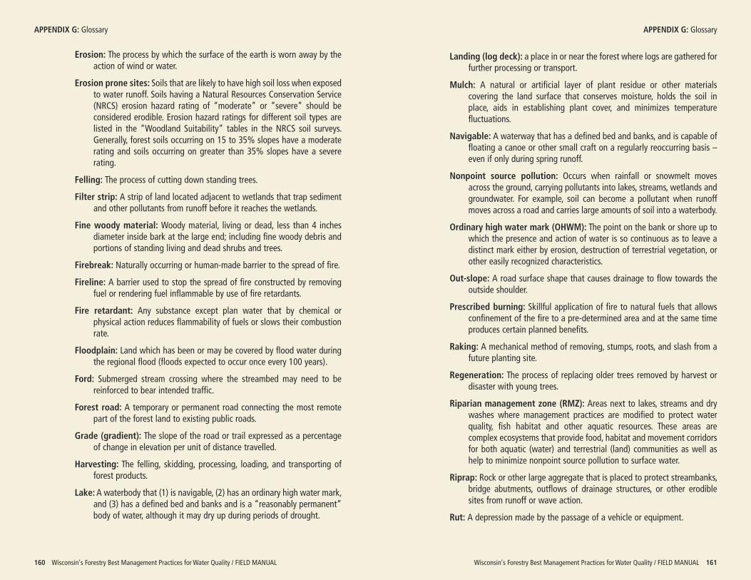
Wisconsin’s Forestry Best Management Practices for Water Quality / FIELD MANUAL 161
APPENDIX G: Glossary
160 Wisconsin’s Forestry Best Management Practices for Water Quality / FIELD MANUAL
Erosion: The process by which the surface of the earth is worn away by theaction of wind or water.
Erosion prone sites: Soils that are likely to have high soil loss when exposedto water runoff. Soils having a Natural Resources Conservation Service(NRCS) erosion hazard rating of “moderate” or “severe” should beconsidered erodible. Erosion hazard ratings for different soil types arelisted in the “Woodland Suitability” tables in the NRCS soil surveys.Generally, forest soils occurring on 15 to 35% slopes have a moderaterating and soils occurring on greater than 35% slopes have a severerating.
Felling: The process of cutting down standing trees.
Filter strip: A strip of land located adjacent to wetlands that trap sedimentand other pollutants from runoff before it reaches the wetlands.
Fine woody material: Woody material, living or dead, less than 4 inchesdiameter inside bark at the large end; including fine woody debris andportions of standing living and dead shrubs and trees.
Firebreak: Naturally occurring or human-made barrier to the spread of fire.
Fireline: A barrier used to stop the spread of fire constructed by removingfuel or rendering fuel inflammable by use of fire retardants.
Fire retardant: Any substance except plan water that by chemical orphysical action reduces flammability of fuels or slows their combustionrate.
Floodplain: Land which has been or may be covered by flood water duringthe regional flood (floods expected to occur once every 100 years).
Ford: Submerged stream crossing where the streambed may need to bereinforced to bear intended traffic.
Forest road: A temporary or permanent road connecting the most remotepart of the forest land to existing public roads.
Grade (gradient): The slope of the road or trail expressed as a percentageof change in elevation per unit of distance travelled.
Harvesting: The felling, skidding, processing, loading, and transporting offorest products.
Lake:A waterbody that (1) is navigable, (2) has an ordinary high water mark,and (3) has a defined bed and banks and is a “reasonably permanent”body of water, although it may dry up during periods of drought.
APPENDIX G: Glossary
Landing (log deck): a place in or near the forest where logs are gathered forfurther processing or transport.
Mulch: A natural or artificial layer of plant residue or other materialscovering the land surface that conserves moisture, holds the soil inplace, aids in establishing plant cover, and minimizes temperaturefluctuations.
Navigable: A waterway that has a defined bed and banks, and is capable offloating a canoe or other small craft on a regularly reoccurring basis –even if only during spring runoff.
Nonpoint source pollution: Occurs when rainfall or snowmelt movesacross the ground, carrying pollutants into lakes, streams, wetlands andgroundwater. For example, soil can become a pollutant when runoffmoves across a road and carries large amounts of soil into a waterbody.
Ordinary high water mark (OHWM): The point on the bank or shore up towhich the presence and action of water is so continuous as to leave adistinct mark either by erosion, destruction of terrestrial vegetation, orother easily recognized characteristics.
Out-slope: A road surface shape that causes drainage to flow towards theoutside shoulder.
Prescribed burning: Skillful application of fire to natural fuels that allowsconfinement of the fire to a pre-determined area and at the same timeproduces certain planned benefits.
Raking: A mechanical method of removing, stumps, roots, and slash from afuture planting site.
Regeneration: The process of replacing older trees removed by harvest ordisaster with young trees.
Riparian management zone (RMZ): Areas next to lakes, streams and drywashes where management practices are modified to protect waterquality, fish habitat and other aquatic resources. These areas arecomplex ecosystems that provide food, habitat and movement corridorsfor both aquatic (water) and terrestrial (land) communities as well ashelp to minimize nonpoint source pollution to surface water.
Riprap: Rock or other large aggregate that is placed to protect streambanks,bridge abutments, outflows of drainage structures, or other erodiblesites from runoff or wave action.
Rut: A depression made by the passage of a vehicle or equipment.
2010 Forestry BMPs for Water Quality Advisory Committee
APPENDIX G: Glosssary
162 Wisconsin’s Forestry Best Management Practices for Water Quality / FIELD MANUAL
Scarification: The process of removing the forest floor or mixing it with themineral soil by mechanical action preparatory to natural or directseeding or the planting of tree seedlings.
Sediment: Soil that has eroded from the land surface, often by overlandwater action, and is then transported and deposited away from itsoriginal location.
Shearing:A site preparation method that involves the cutting of brush, trees,and other vegetation at ground level using tractors equipped withangled or V-shaped cutting blades.
Silt fence: A temporary barrier used to intercept sediment-laden runoff fromsmall areas.
Site preparation:A silvicultural activity to remove unwanted vegetation andother materials, and to cultivate or prepare the soil for regeneration.
Skid trail: A temporary, non-structural travel way for logging equipment,called skidders, to drag felled trees or logs to the landing for furtherprocessing, loading and transport to a mill.
Slash: Any tree tops, limbs, bark, abandoned forest products, windfalls, orother debris left on the land after timber or other forest products havebeen cut.
Stream: A watercourse that (1) has an ordinary high water mark, (2) has adefined bed and banks, (3) flows at least periodically, and (4) does notlose its character as a water course even though it may become braidedin a wetland complex.
Water bar: A shallow trench or diversion dam which diverts roadside ditchand surface water runoff from roads (inactive or closed), firebreaks, orskid trails (active or inactive) into a dispersion area. Water bars are usedto minimize erosion.
Wetland: An area where water is at, near or above the land surface longenough to be capable of supporting aquatic or hydrophytic (waterloving) vegetation and has soils indicative of wet conditions.
Organizations
1000 Friends of Wisconsin
FISTA
Great Lakes Timber ProfessionalsAssociation
Lake States Lumber Association
The Nature Conservancy
Packaging Corporation of America
River Alliance of Wisconsin
SFI SIC
Society of American Foresters
NewPage Corporation
Thilmany Procurement Group
Trout Unlimited
USDA Forest Service
University of Wisconsin–Stevens Point
Wisconsin Association of Lakes
Wisconsin Council on Forestry
Wisconsin County Forests Association
Wisconsin DNR, Division of Water
Wisconsin Paper Council
Wisconsin Wetlands Association
Wisconsin Woodland OwnersAssociation
Members
Ken Adamovich
Aaron Caylor
Matt Dallman
John DuPlissis
Gary Edinger
Mike Gehrke
Earl Gustafson
Theresa Heyer
Steve Kariainen
Kent Mikkelson
Bill O’Brion
Bob Obma
Jim Olive
Dean Pelkey
Bob Rogers
Jane Severt
Tim Tollefson