petroleum and natural gas. - usgs · petroleum and natural gas. the campton oil pool, kentucky. by...
TRANSCRIPT
PETROLEUM AND NATURAL GAS.
THE CAMPTON OIL POOL, KENTUCKY.
By M. J. MUNN.
INTRODUCTION.
HISTORY.
The Campton oil pool, in Wolfe County, Ky., was discovered March 16, 1903, by a well sunk on .the J. S. Cable farm, about a mile south west of Campton. This well, drilled by the Beckett-Iseman Oil & Gas Co., found oil in what is called the Campton sand at a depth of 1,220 feet and began flowing at the rate of about 100 barrels a day. After this discovery the field was rapidly developed, the total number of wells drilled probably exceeding 275, of which about 225 have produced oil in commercial quantities. The field as developed in Oc tober, 1909, is roughly crescent shaped, with a length of about 3J miles and a maximum width of 1| miles, lying to the northeast, north west, and southwest of the village of Campton. (See PI. I.)
Neither the greatest daily output nor the total production of this field can be stated. The production by months for 1909 and 1910 is given below:
Production of the Campton oilfield, 1909 and 1910, in barrels.
April.... ........................................................................May.............................................................................
July.............................................................................
October. ........................................................................
1909
7,7685,8176,1907,2258,0656,6347,5296,8766,3717,7165,8527,393
83,436
1910
4,8405,7506,3496,9974,9895,0184,7465,0454,9856,9384,0504,479
64,192

10 CONTRIBUTIONS TO ECONOMIC GEOLOGY, 1910, PART It.
For the weeks ending April 22 and April 29, 1911, the production reported for this field was 1,142 barrels and 1,035 barrels, respectively, showing the present daily production to be about 196 barrels. The pool has been fully developed for several years, and the few wells now being drilled are at places within the pool where the first wells were too widely spaced.
Very little gas has been found in this field, almost the entire supply having come from about six wells on the Spencer and Campbell farms, north of the oil-bearing area. These wells were small producers when drilled; they declined rapidly and soon were practically exhausted.
FIELD WORK.
About eight days was spent in this field by the writer in October, 1909, during the course of work for a reconnaissance report on the oil and gas fields of eastern Kentucky which is being prepared by the United States Geological Survey in cooperation with the Kentucky Geological Survey. The time was devoted to the collection of material for a sketch map of the field, the determination of the altitude of the mouths of the wells above an assumed datum plane, and the copying of all the well records that could be found for the purpose of construct ing a structure map of the oil-producing sand.
ACKNOWLEDGMENTS.
The writer was assisted by Mr. M. W. Crouch, who did part of the stadia traverse and spirit leveling and assisted in copying logs of wells. The farm lines and some of the roads and locations of houses and wells were taken from a map by Mr. E. J, Creech, county sur veyor, who also rendered other valuable assistance. For well logs and other assistance the writer is indebted to Mr. William Roden,of the Mountain Oil Co,, Mr. T, N. Beckett, of the Beckett-IsemanOil & Gas Co., Mr. C. P. Breckenridge, Mr. T. F. Duff, and a number of others.
TOPOGRAPHY AND DRAINAGE.
Wolfe County lies in what is generally spoken of as the "moun tains" of eastern Kentucky. The county is drained by Kentucky River on the south and Red River, a tributary of the Kentucky, on the north. These rivers are at altitudes of about 650 and 850 feet, respectively, and flow in narrow gorgelike valleys from 300 to 400 feet below the tops of adjacent hills. Their tributaries are deeply entrenched in narrow valleys walled by numerous cliffs of massive sandstone. The hilltops are usually narrow, with considerable relief, but are locally broad and flat topped. In the Campton field the valley of Swift Creek below Campton is a narrow gorge cut in a series of massive sandstones. Above Campton on this creek and its

US. GEOLOGICAL SufiVty
f C.G.Gampbe,;.,,;.:;;
. Came be II
/ ^* *. -^«^M» ~^ m :\ "^^ .'.,-, . >?
Index map of" eastern Kentucky,, shewing, locatiotst . orCampfon or Wol-fe Co-wnfy oi-J. district' OF ;; . -'''.- ''
LEGEND
PH. Pump house
OCTOBEH,i9O9
Structu re conto urs sh.owing "layof the top of'the Clinton oil'sandand its height i.n -feet above a . datum plane assumed to be 1000. f'eet below- sea level .
NChapin
WELL SYMBOLS
^-Gas < Show oil
DE
VO
NIA
NC
AR
BO
NIF
ER
OU
S
"Co
rnif
ero
us
* C
ha
tta
no
og
a
limes
ton
e sh
ale
.-o -
~oM
issis
sip
pia
nP
en
ns
ylv
an
ian
(C
oal
Me
as
ure
s')
c-,
«
'IS'lW
i'l'IS
11W
I'lU
iift:
JiH
HH
jf^.w
vvf|i
ti|ik
i|i|;!
ill P
I Pll
PIIW
i i -
" -" i>
' -" I W
Xy&m
1111
1 H
i I iB
lifi Il
iiliil
ii KK
ffc'-'
-n- -
lib^
^lai
iaila
ila
3 3°$
.*
£ '
Z'T
'Z ^
"f^
f^
^l o
I
c S
-ffl
cn
- *-.
-> .-
< .-<-
--''J
o '
i< i
l£ »
fo
»"o
"? a
?^
^^
a,
2 o
.c.a
a Q
.Q.
CAMPTON OIL POOL, KY. 11
tributaries these sandstones are below drainage level, and the valleys are relatively broad, the streams having developed flood plains. The interstream areas are occupied by steep narrow ridges having eleva tions of 100 to 250 feet above the adjacent valleys.
GEOLOGY.
STRATIGRAPHY.
ROCKS EXPOSED.
The outcropping rocks of the Campton oil field are Pennsylvanian in age, belonging to the lower part of the Pottsville group. They consist of alternating thin sandstones and sandy shales with some coal and clay in the upper part and one or more massive conglomeratic sandstones from 30 to 80 feet thick toward the base. In the short time at his disposal the writer was unable to make a detailed exami nation of the surface stratigraphy, a knowledge of which is, however, unneccessary for the purposes of this paper.
ROCKS NOT EXPOSED.
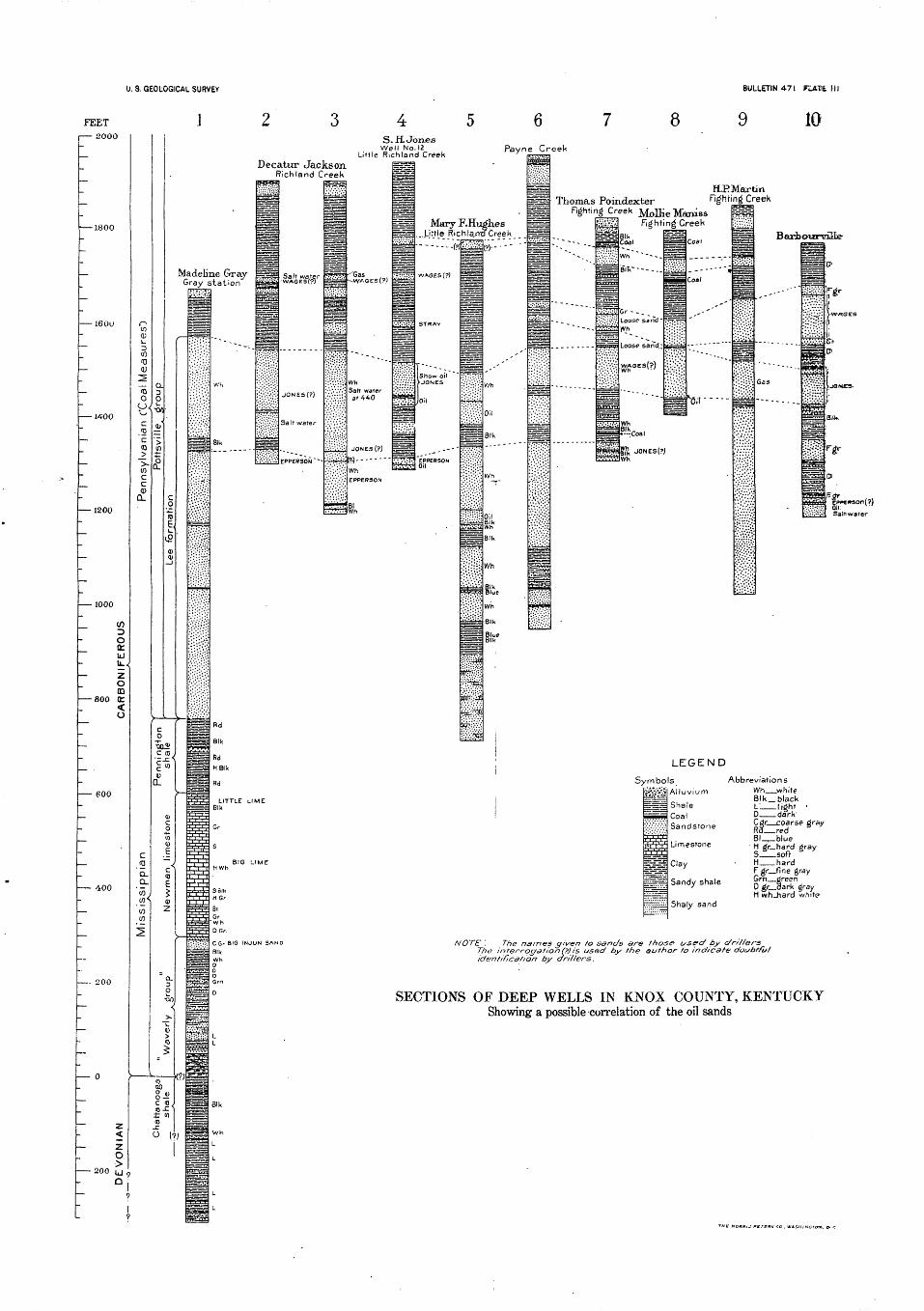
The logs of over 100 wells in the Campton field were procured. Of these only one log, that shown as section 1 on Plate II, is at all com plete. The nature of the remaining records is illustrated by section 2, Plate II, and by the following:
Logs of wells of Beckett-Iseman Oil & Gas Co.
William Spencer well (gas) No. 1.Feet.
Casing, 6}-inch, set at........................................... 520Gas..................................................... 1,206-1,234Total depth.................................................... 1,237Shot with 40 quarts of nitroglycerin.Packer set at.................................................. 1,157
Van Sant well No. 1, June 18,1903.
Casing, 6i-inch, set at......................................... 475Lime, thickness............................................... 69Oil...................................................... 1,244-1,252Total depth.................................................... 1,260Shot with 72 quarts of nitroglycerin.
Roberts well No. 1, June, 1906.
Casing, 6}-indi, set at......................................... 560Top of sand................................................... 1,257Oil..................................... .............. 1,262 to 1,271Total depth..................................................... 1,273Shot with 50 quarts of nitroglycerin.

12 CONTRIBUTIONS TO ECONOMIC GEOLOGY, 1910, PART II.
W. H. Cundlfl well No. 4, Feb. 26, 1907.Feet.
Casing, 6J-inch, set at......................................... 550Top of sand................................................... 1,279Oil................................................... 1,282 to 1,291Total depth.................................................... 1,295Shot with 60 quarts of nitroglycerin.
Reynolds well No. 1, Jan. 2, 1905.
Casing, GJ-inch, set at......................................... 590Top of sand..................................................... 1,313Oil................................................... 1,320 to 1,329Total depth.................................................... 1,334Shot with 90 quarts of nitroglycerin.
Log of J. C. Lykens well No. 6, Mountain Oil Co., Feb. 14,1907.
Feet. Casing, 6f-inch, set on top of " Big lime "....................... 535Top of Clinton lime, first pay streak, some gas................... 1,264
. Bottom of first pay streak....................................... 1,267Top of second pay streak........................................ 1,277Bottom of second pay streak................................... 1,282Shot with 80 quarts of nitroglycerin.
These logs are typical of those received, and from such material no details of the stratigraphy can be given other than those shown on the well-section plate. No drilling was in progress during the writer's visit, and no samples of the rocks encountered in drilling could be obtained. Very few of the drillers who developed the field remain in it and the data given by them relative to the character of the oil sand are conflicting. Some say that the oil sand is a. limestone filled with crevices; other:* bsliev.? it to be a sandstone cemented by lime, or a sandy, porous limestone.
The geologic name for this sand is also somewhat in doubt. . Some of the drillers call it Clinton sand and think it equivalent to an oil sand of the same name in central Ohio, which is a true sandstone of Silurian age. The writer is inclined to think that the Campton oil sand is equivalent to one of the Devonian limestones, probably the "Corniferous."
The well sections of Plate II are, stratigraphically arranged with reference to the top of the Devonian black shale, as identified by the drillers, and the top of this bed is assumed to be the top of the Chat tanooga shale. An examination of the sections, however, shows the identification to be questionable. For example, the soft black shale shown in section 3, at 70 feet above the Devonian black shale of the drillers, may be the top of the Chattanooga shale and equivalent to the Devonian black shale of the other sections. The identification of the other beds is also in doubt. In section 1 the driller calls the oil-bearing bed the Clinton lime. In section 2, where the oil rock is said to be a limestone, the driller termed it "sand." In

CAMPTON OIL POOL- KY. 13
section 3 the first 45 or 50 feet of this bed is identified as the Campton oil sand, which is probably a limestone, but the next 150 feet is mentioned as "sand," leaving doubt as to its true character, for the beds at that horizon in this region may be either limestone or sand stone, including the "Corniferous" limestone at the top, a representa tive of the Oriskany sandstone, as well as Silurian rocks of Niagaran (including Clinton) age. The above statement is also in a measure true of the "oil sands" of sections 4 and 5. In all these sections, however, the so-called oil sand appears to be a representative of the "Corniferous" limestone. These sections show a decided thickening of the Chattanooga shale and the lower Pennsylvanian sandstones from west to east.
The Campton sand has two pay streaks in which oil occurs in the northeastern part of the field. These are usually from 24 to 28 feet apart and each probably ranges from 3 to 10 feet thick. In the central and southern parts of the field rarely more than one pay streak is found. This is from 1 foot to about 14 feet from the top of the "sand." TKe pay streak in the gas wells at the northern edge of the field reaches a maximum of about 28 feet below the top of the "sand."
STRUCTURE.
The principal object of this paper is to call attention to the structure of the oil "sand" in the Campton field. The dip of this bed is shown on Plate I by means of contour lines drawn through points of equal altitude on the top of the "sand." These contours have a vertical interval of 10 feet and are numbered with reference to a datum plane assumed to be 1,000 feet below sea level.
The reconnaissance topographic jnap of the Beattyville quadrangle, in which the Campton field is located, gives no altitudes above sea level, but that of Campton, as shown by contours, is about 1,000 feet. For the structural work it was not thought advisable to bring a line of levels into the oil field from Torrent, Ky., where the nearest primary bench mark of the United States Geological Survey is located, but the top of the east rail of the track in front of the station at Campton was assumed to be 1,000 feet above the sea, and all level lines throughout the field were based on this assumed altitude. Because of lack of time, spirit-level lines were run to only a few of the wells, care being taken to select wells rather uniformly distributed throughout the field. Unfortunately no logs could be obtained,of wells in the northeastern and the extreme western parts of the field, so that no structure contours could be drawn for those areas.
From the contours shown on Plate I it is apparent that the south half of the Campton oil field lies along the axis and sides of a broad, low anticline which pitches gently toward the south. The 800-foot contour on the east limb of this anticline has been definitely located from the
14 CONTRIBUTIONS TO ECONOMIC GEOLOGY, 1910, PAET II.
Evans & Sherman farm southward. This contour closely follows the line between the oil and the salt-water producing territory in this part of the field. The axis of the anticline has been definitely located across the field, but the position of the 800-foot contour on the west side could not be determined. The general trend of the other con tours on the west side of the axis and the location of holes hi which salt water occurs in that vicinity suggests strongly that the anticline is fairly symmetrical, and that the 800-foot contour will be found to border the productive area closely on the west side of the field, as it does on the east side.
This anticline appears to be a minor structural feature of the region. It is probably a short secondary fold extending southward from a larger fold lying north of the Campton field. The trend of the contours in the northern part of the field suggests that the axis of the major anticline trends roughly northeast and southwest. This fold may be either an anticline or a terracelike monocline with the steep dip to the southeast, but in either case the outline of the oil pool conforms closely to the local structure.
GUIDES IN FUTURE PROSPECTING.
The apparently close conformity of the Campton pool to local structure may be of great value to the oil prospector in this region, as areas having similar structure and similar salt-water conditions in the oil-bearing stratum are probably numerous in this portion of the eastern Kentucky coal field.
It is evident that in attempting to locate new pools the prospector should be provided with the most complete structural maps of the region that can be made at a reasonable cost. These maps should not only show the axes of all rock folds, both anticlines and synclines, but also the amount and direction of dip at all points, the locations of all deep holes drilled in the region, the height of the oil sands hi each well above some horizontal datum plane, and the relative amount and head of the water (if any) ,found in the sands. With these data at hand the prospector should be able to eliminate large areas where the probabilities are slight for getting oil or gas and thus restrict his wells to the more favorable areas. In making these selections he should keep in mind certain modifications of the well- known anticlinal theory of oil and gas accumulation that, to the writer, appear to be of such importance as to justify the following statement of them.,
In brief, the anticlinal theory accounts for the accumulation of pools of oil and gas at certain favorable spots (usually the axes of anticlines) by the difference in weight of gas, oil, and salt water, it being assumed that these three substances were once mixed in the porous "oil sand" and that through subsequent folding of the stratum

CAMPION OIL POOL, KY. 15
or other causes the gas, oil, and salt water arranged themselves in the porous bed according to their respective gravities. It is assumed that the gas, being lightest, collected at the tops of the anticlines, or above the water line in the porous bed, that the oil collected below the gas, and the salt water below the oil. Close, hard spots in the oil sand are thought to have offered barriers to the upward movement of the oil and gas, thus forming pools on the lower sides of the barrier in the porous beds that contain wate'r. Conversely, where no salt water is found in an oil or gas bearing stratum, it is assumed by this theory that the oil and gas have drained down the dip through the porous stratum and collected in a pool in the bottom of a syncline or on the upper side of some local barrier of impervious material.
It is evident, therefore, that if an oil prospector follows the anti clinal theory in his operations he should drill either in the highest parts of each anticline or, if the water line does not reach the top of a given anticline, at any point where a given oil sand is at the same structural level as it is in known oil pools. If he finds a given area destitute of water in the oil sands, by this theory he should look for pools in the synclines.
Though the application of this theory has been very successful in many oil fields, it has not proved satisfactory in accounting for (1) the closed pressure of gas pools (sometimes amounting to 1,500 pounds to the square inch); (2) the presence of oil and gas pools that completely occupy sandstone lenses of local extent which are sur rounded on all sides by shale and furnish no salt water; (3) the pres ence of oil and gas pools under high pressure in* porous pay streaks within sandstone of ordinary texture and porosity; (4) the presence in a sand showing no water of large pools of both oil and gas that do not conform to structure lines but extend across minor anticb'nes and synclines alike; (5) the relatively great variation in porosity of pay streaks in which pools occur; (6) the difference in the initial closed pressure of gas wells in a given area, together with many other phenomena of a local nature, the significance of which can not be discussed atjength in this paper. The fact that the anticlinal theory does not provide logical explanations for the above-named phenomena, which are encountered everywhere by producers, leads the writer to believe that the basic idea on which it is founded, namely, accumu lation through difference in gravity of gas, oil, and salt water, is wrong. On the other hand, the writer does not wish to be under stood as denying the very evident fact that structural features have greatly influenced the position of many accumulations of oil and gas, but he can not believe that the known facts regarding the processes of oil and gas accumulation justify the assumption that difference in weight of oil, gas, and water is the principal factor.

16 CONTEIBUTIONS TO ECONOMIC GEOLOGY, 1910, PART IT.
The observed facts give every reason to believe that the process of oil and gas accumulation in the Appalachian region alone is infinitely more complex than that assumed by the anticlinal theory. The phenomena which the writer has observed lead him to believe that such accumulation is due to the action of large bodies of moving water traveling by both hydraulic and capillary pressure. If this is the true mode of accumulation, oil and gas pools of commercial size have been formed by invading, bodies of water moving from one or more points parallel to the bedding planes and collecting ahead of them quantities of oil and gas contained in the porous bed. This oil and gas may have been indigenous; or it may have been forced into the porous sand from above or below by previous invasions of water traveling more or less vertically by capillary pressure through the shale or other fine-grained petrologenic rock, from overlying or underlying water-bearing beds. Favorable places for accumulation according to this theory are points in the porous bed where there is locally great variation in the rate of movement of the invading body of water, thereby confining the oil between conflicting currents of water. The pitching axes of anticlines, structural domes, monoclines of irregular trend, and points where the porosity of the pil sand changes offer favorable conditions for the trapping of portions of the oil and gas accumulated by the moving body or bodies of water. This theory has been stated in more detail elsewhere * and need not be repeated here, attention being called to it simply to make more clear the following suggestions to prospective operators in this region.
The existence of an anticline at a certain location does not neces sarily fix that point as the most desirable place for a test well. It should be kept in mind by the prospector that anticlines have rela tively great length in comparison with their breadth, that the axes of folds vary in altitude from place to place, and that each fold in every prospective oil field has what may be termed a critical altitude for each oil sand, at which pools of oil and gas are most likely to be found. The critical altitudes of an oil sand in a given anticline depend on the water conditions of that sand, which are indicated by the relative heights to which the water from the sand will rise in wells at different points. In areas like the Campton field, where salt water under more or less hydraulic (not hydrostatic) pressure is associated with the oil, the problem of deciding which are the best localities for testing is relatively easy of solution. Test wells should be located in this area on anticlines at places where the water in the sand is estimated to have a head somewhat smaller than that found in the Campton field. This head, or height to which water rises in the wells, is not dependent
1 Munn, M. J., The anticlinal and hydraulic theories of oil and gas accumulation: Econ. Geology, vol. 4, No. 6, October, 1909; Sewickley folio (No. 176), Geol. Atlas U. S., U. S. Geol. Survey, 1911. Munn M. L, and Shaw, E. W., Foxburg-Clarion folio (No. 178), Geol. Atlas U. S., U. S. Geol. Survey, 1911.

CAMPTON OIL POOL, KY. 17
alone on the altitude of the sand at a given point, but is affected by the distance of that point from the source of the pressure and the relative porosity of the rocks through which the pressure is transmitted. Therefore, in tracing the outline of the area of this sand which shows salt water, it will doubtless not be found to be at the same altitude at all pouits.
This water line most probably will be found to become lower and lower on the structural contours in some certain direction from the Campton field and to show a corresponding rise in altitude in the opposite direction. Pouits on the axes of anticlines at or near the edge of the area saturated by water are places most favorable for testing. The average rate of rise or fall of the water line in the sand may be closely approximated by obtaining the altitude above some horizontal plane to which the water rose in the test wells already drilled hi this region.
Regardless of the fact that several test wells have been drilled inWolfe County and the surrounding areas without finding paying quantities of oil in the Campton sand, this region is by no means thoroughly tested, and if this sand is in general sufficiently porous to form a good reservoir rock there is apparently every reason to believe that a sufficient number of other pools of commercial size exist here to justify search for them. Good geologic work in advance of drilling could easily reduce the total cost of thoroughly testing this region by 50 per cent.
9817° Bull. 471 12 2

OIL AND GAS DEVELOPMENT IN KNOX COUNTY,KENTUCKY.
Bv M. J. MUNN.
LOCATION AND TOPOGRAPHY.
Knox County is one of the "mountain counties" of southeastern Kentucky, being well within the boundary of the eastern Kentucky coal field. The altitude of the surface of this county ranges from about 950 feet above sea level along Cumberland River, which flows through the center of the county, to about 2,000 and 2,200 feet in the northeastern and extreme southern parts, respectively.
The hills are generally steep and rocky, not well adapted to agri culture, and mostly covered by forests of hardwood. The valleys of the smaller streams are narrow and gorgelike. The larger valleys furnish most of the farming land, and along them is distributed the greater part of the population.
ACKNOWLEDGMENTS.
The data for the following general sketch of oil developments in this county have been derived very largely from material previously published by the Kentucky Geological Survey or collected from vari ous sources by the writer during a brief visit to the county in the summer of 1910. Thanks are due to Hon. Caleb Powers, of Barbour-ville, for information and suggestions; to Mr. Thomas D. Tinsley, of Barbourville, for a sketch map of the county and a well-prepared description of oil and gas operations there up to and including 1902, from which much of the information given in this paper is taken; to Mr. Gary, of Barbourville, formerly superintendent of the pipe line from this field, for data relative to production; and to Mr., W. R. Hughes and a number of other gentlemen of Barbourville for their considerate assistance.
GEOLOGY.
STRATIGRAPHY..
Probably the lowest rocks penetrated by the drill in Knox County were reached by one of the deep wells on Cumberland River south of Barbourville, but so far as the writer can learn detailed records of
18
.FEET 2000
1800
1600
1400
1200
1000
D O It Uu.zOm
800 (C<O
600
400
- 200
. S. GEOLOGICAL SURVEY
.1
BULLETIN 471: FUWS. Ill
4
0
Decatur JacksonRichland Creek
S-H.Jbn.esWell No.12
Little Richland Creek
6Payne Creek
8 9
Madeline GrayGray station
200
(0tod)
(̂Qo&Sc<0
tocc<D
CL
c
Q_
(/)
CO
wwi
a'3Oxw
to~
+2
£
> C
0
roE,V.
_l
o
fiCL
co
u§c<0E
0)2
~ a.
3O 00
~(D
attanooga shale
c~
0 (
H
ii/''-" :.
JONES(?)
Salt water
EPPERSON'--
LITTLE LIME Blk
CGr BIG INJUN SAND
BlkWh
Blk
"Gas
WhSalt water at 440
JONES (?)
Wh
EPPERSON
MaryF.Hugli.es...LitH_e Richl^np Creek_.. ==^=
VAOES (?)
on
Blk
Oil Blk Wh
Blk
Wh
Ilk lue
Wh
Blk
H.EMartinThomas Poindexter Fighting Creek
righting Creek Mollie ManiasFighting Creek
P#* ****
£'^a ,0
^
LEGEND
Symbols Abbreviations
'$&%$ Alluvium Wh ^whife
^ Shale n Coal , ' .' ' Sandstone
Limestone
Clay
= Sandy shale
E^ Shaly sand
Blk_ blackL'__light D__darkCdr_coarse StrayRl_redBl-.-blueH gr_hard gray5__softH__hardFgr_fine grayGrn_jjreenD gc_dark ^rayM wh_hard white
NOTE '. The names given to sands are those used by c/r/'/fersThe interroyation(?) is used by the author to indicate doubtful identification by drillers.
SECTIONS OF DEEP WELLS IN KNOX COUNTY, KENTUCKYShowing a possible correlation of the oil sands

OIL AND'GAS IN KNOX COUNTY, KY. 19
these wells were not preserved. A section of the deep well drilled by the Atlantic & Pacific Oil Co., on the Madeline Gray farm, near Grays station, is shown on Plate III. This well reached a depth of 1,974 feet, and in it black shale having a thickness of 120 feet was encountered at a depth of 1,665 feet. This is believed to be the Chattanooga shale, which is frequently called by drillers Black shale and Devonian black shale. Below this a white or light-colored shale, in which occur a few thin beds of sandstone and limestone, extends to the bottom of the well, a distance of 189 feet. The age of these beds is in doubt. They are in part at least Devonian. Some of the lower beds may be and probably are of Niagaran (including Clinton) age.
In the section of the Gray well (PI. Ill), 269 feet of limestone, sandstone, and shale overlying the Chattanooga shale is considered to belong to what has been called "Waverly group." At the top of this division is a massive greenish sandstone known to the drillers asBig Injun sand and believed to represent the Big Injun sand of Penn sylvania. Above the sandstone is 316 feet of the Newman limestone, known to drillers as the Mountain limestone, or Big lime. Above the Newman limestone is 170 feet of the Pennington shale, composed of red and black shales and a few thin beds of sandstone and limestone. Above the Pennington; for about 800 feet, the beds are mostly sand stone with some thin beds of shale and a little coal and clay, all of which belong to the Lee formation of the Pottsville group. The sand stones in the lower half of this formation are very thick, coarse, hard, and massive. Toward the top there is an increase in the amount of shale.
All the outcropping rocks of Knox County belong to the Pottsville 'group. They consist chiefly of sandstone and shale, but they also contain several beds of coal, clay, and probably limestone. The sandstones are generally thin bedded, but locally,they may be very massive, forming cliffs along the steeper hillsides and gulches where cut by streams. The total thickness of the exposed beds is not known, as the areal geology and structure of the county have been mapped only in part. The Pottsville may reach a maximum thickness of more than 2,500 feet in this county.
OIL SANDS.
The sands that have furnished oil and gas in paying quantities in Knox County, named in ascending order, are called the Big Injun sand, the Epperson sand, the Lower and Upper Jones sands, and the Lower and Upper Wages sands. With the exception of the Big Injun, all these sands are of Pottsville age. They are all sandstones, white or gray in color, containing soft porous pay streaks in which the oil and gas are found.

20 CONTKIBUT10NS TO ECONOMIC GEOLOGY, 1910, PART II.
These sands are reported to be very erratic in occurrence and to be not continuous over very large areas but small lenses of sand inclosed by beds of sandy shale. The writer is not sufficiently familiar with the stratigraphy of the oil sands and the local structure of the region to verify this report. He has selected somewhat at random the sections of wells shown on Plate III and attempted to correlate the sands in them from the logs alone, without any knowledge of the changes in the local structure from well to well. By comparison of the logs of a number of other wells in this county, he finds much more uni formity in them than he was led to suspect from previous reports, and it seems probable that when the local structure is worked out in detail the sands may be found to be fairly persistent and that much of the uncertainty regarding them is due to local dips and possibly faults which render their identification by drillers difficult. (See PL IV.)
STRUCTURE.
Maps showing the structure of the rocks of Knox County in detail have not been published, and it is believed that no such map has been made. The brief time at the disposal of the writer did not permit even a casual examination of the structure. It is known that the strata in this county have a general dip toward the south or south east. The axis of the syncline which occupies the lowest part of the Appalachian coal basin lies between the southern part of Knox County and Pine Mountain and in this region probably has a trend roughly parallel to the great thrust fault along the mountain. This general southeastward dip of the beds may be interrupted by a num ber of local folds, trending in a general northeast-southwest direction, but there is no material at hand to indicate their positions. I
The relation of the oil and gas pools to the folds in the strata is not known, but it is reported' that "in the Knox County fields thebest wells can be followed on very narrow lines produced by sharp changes in the .dips of the rocks."
HISTORY OF OIL, AND GAS OPERATIONS.
EARLY DISCOVERIES AND TESTS.
Oil was first discovered in quantity in this county in 1840, when a well drilled for brine on Little Richland Creek, about 6 miles north- northeast of Barbourville, began flowing oil at a rate of probably 100 barrels a day from a shallow depth. * In 1864 another well drilled on the Nannie Riley farm, on Hammons Fork, about 9 miles north of Barbourville, flowed oil for a short time, but it was not utilized.
The first well drilled expressly for oil was put down in 1867 on the Hughes farm, on Little Richland Creek, about 5 miles north-
i Hoeing, J. B., Bull. Kentucky Geol. Survey No. 1,1905, p. 21.
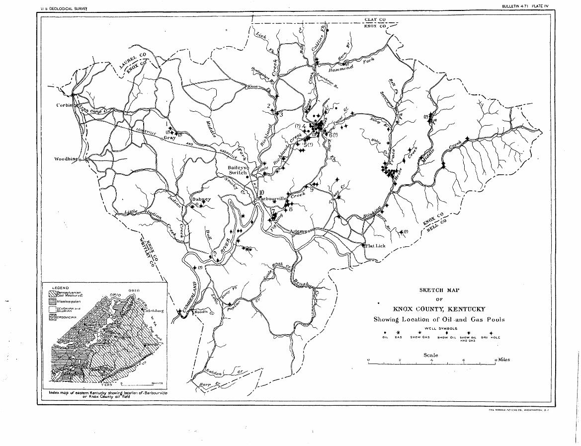
LI. S GEOLOGICAL SURVEYBULLETIN 471 PLATE IV
SKETCH MAP
OK
KNOX COUNTY, KENTUCKY
Showing Location of Oil -arid Gas Pools
Index map of eastern Kentucky showing location of-Barbourville or Knox County oil field

OIL AND GAS IN KNOX COUNTY, KY. 21
northeast of Barbourville. This well is said to have flowed when the drill reached a depth of 400 feet, but the tools were lost in the hole and the well was finally abandoned. Nearly 30 years elapsed before another attempt was made to find oil in this region. In 1896 two wells were drilled on the Road Fork of Stinking Creek, 9 miles east-northeast of Barbourville, the first by S. B. Logan & Co., of Clay City, Ky., the other by Guffey & Gailey, of Pittsburgh, Pa. These weUs were on the Elijah Hammons and R. Williamson farms, respectively. No large amount of oil was encountered and the wells were soon abandoned. The Richland Oil Co. drilled a well in 1900 on the R. Williamson farm near the location of the Guffey & Gailey well, but this was also abandoned, though all of these wells are said to have furnished some oil. The next well was put down by the Knox Gem Oil Co. at Barbourville in 1901. This well found gas in a Sand at 415 feet and a "show" of oil at 528 feet, and filled up 400 feet with oil from a pay streak 40 feet thick, the top of which is at a depth of 535 feet, but in preparing the well for pumping it was invaded by salt water and ruined.
LITTLE HIGHLAND CHEEK.
In 1901 three wells were drilled on Little Richland Creek by the Atlantic & Pacific Oil & Gas Co. Two of these wells, on the R. H. Mays and the Hughes farms, reached depths of 700 and 1,000 feet, respectively, without finding oil in paying quantities. The third well, on the S. H. Jones farm, flowed a stream of oil above the top of the rig from a pay streak at a depth of 380 feet and 30 feet below the top of a sand. The oil caught fire and burned the machinery but continued to'flow for 12 hours before the well could be capped. Three months later the well was pumped and is said to have produced over 100 barrels a day.
The discovery of oil in the Jones well caused considerable excite ment, and more than 100 wells were drilled in the county during the year 1902. The Atlantic & Pacific Oil Co. drilled seven other wells on the S. H. Jones farm during that year, all of which were small oil wells ranging in daily yield from 2 to 10 barrels each. These wells are situated on the west side of Little Richland Creek nearly opposite the mouth of Paynes Creek. On the east side of Little Richland Creek a short distance north of the mouth of Paynes Creek the Atlan tic & Pacific Oil Co. drilled its next well on the John Wages farm. From this well flowed a heavy black oil of 23° B. gravity at a depth of 160 feet. The initial daily production was between 2,000 and 3,000 barrels. No gas accompanied the oil. This well was short lived and soon produced water exclusively. Six other wells were drilled on the Wages farm, all of which were light producers from the Wages

22 CONEfctbtmoirS T6 ECONOMIC GEOLOGY, 1910, frA&T? II.
sand. The water in the shallow wells soon drowned them out* This water had sufficient head to flow after being shut in for a few days.
Just across the line of the Wages farm a well on the Thomas Barnes farm reached a depth of 1,200 feet, finding several "shows" of oil and a large quantity of salt water near the bottom. This well is north of and near the junction of Kellys Fork and Paynes Creek. The next well was drilled 200 yards east of the Barnes well and a short distance from the old well drilled in 1840. This well flowed 250 barrels in seven hours from the Jones sand at a depth of 380 feet. The next well, a dry hole, was drilled on the J. R. Jones farm, 150 feet from the original S. H. Jones well No. 1. Six other wells were put down on this farm as follows: The first by Wm. Dabney & Co., located 200 feet from the original S. H. Jones well, was abandoned at 200 feet. The next, by the Swan Lake Oil Co., was located directly opposite the original Wages well and from a depth of 160 feet furnished several hundred barrels of oil daily for a short time. A well located 100 feet west of this well was practically a dry hole in the Wages sand. The next well, located only a few yards from the two wells just mentioned, passed through both the Wages and Jones sands without finding oil. Another well a short distance away pumped 250 barrels from the Wages sand in the first 24 hours. A well on the George Jones farm, drilled by the Atlantic & Pacific Oil Co., found a pay sand below the Jones sand, at a depth of 525 feet. This well is situated about half a mile northwest of the original S. H. Jones well. >
Numerous wells have since been drilled on Little Richland Creek in and near the above-named farms. Many of these made a good showing when drilled in, but after being pumped a few days or weeks decreased rapidly hi production. Among the better wells are the John R. Payne No. 2, by the Barbourville & Cumberland Valley Oil & Gas Co., which flowed from the Jones sand; the Ellen Jones wells Nos. 1 and 2, by the Atlantic & Pacific Oil Co., and the L. H. Jarvis well No. 1, by the Badger Oil & Gas Co. Few data are available relative to development in this field after December, 1902, but roughly the field on Little Richland Creek may be considered to have included one or more producing wells on the following farms: S. H. Jones, John Wages, George Hammons, J. R. Jones, George Jones, J. R. Payne, Ellen Jones, L. H. Jarvis, Thomas Barnes, Enoch Mays, and Joseph Miller. As a whole, the productive areas on this creek were very small and erratic in occurrence, the oil being confined to open pay streaks at very shallow depths and backed by water under consider able head. Under such conditions the wells were short lived. It is to be regretted that the detailed structure of each pay sand hi this field was not determined when all the data relative to the wells were

OIL AND GAS IN KNOX COUNTY, KY. 23
available, as it is believed that this would have furnished a reliable guide in searching for other shallow sand pools in this vicinity.
BIG HIGHLAND CHEEK.
A well was drilled in 1901 by the Atlantic & Pacific Oil Co. on the J. D. Jarvis farm, on Big Richland Creek, to a depth of about 900 feet, but it was unproductive. In 1902 a deep test well was drilled on the Hutchins farm by the Hutchins Oil Co. This well is said to have reached a depth of about 2,0.00 feet, finding a "show" of black oil at a shallow depth and a good flow of gas at about 1,500 feet. At about the same time a dry hole was drilled by the Atlantic & Pacific Oil Co. on the Trosper farm. Later the Toilers Oil Co. secured a small well in a sand at a depth of about 500 feet'on the A. Y. Anderson farm, about 1| miles from Barbourville. A number of other wells are said to have been drilled in the vicinity of this well, but of these no authentic information could be obtained,
FIGHTING CHEEK.
In 1902 the Atlantic & Pacific Oil Co. drilled five test wells on Fighting Creek. Two of these wells were on the H. P. Martin farm, near the head of the creek, about 4 miles northeast of Barbourville, and one each on the Thomas Poindexter, Dozier, and Bartlow farms. The Martin well No. 1 reached a depth of 823 feet and at the bottom penetrated 398 feet into sand carrying salt water. Some gas was encountered in the top of a sand 80 feet thick at a depth of 410 feet. The Martin well No. 2 reached a depth of 677 feet and was unproduc tive. The Poindexter well, located about 2 miles southeast of Bar bourville, reached what was considered to-be the Wages sand at 363 feet and the Jones sand at 491 feet and was stopped at a depth of 514 feet. The Dozier well, 3£ miles northeast of Barbourville, found what is thought to be the Wages sand at a depth of 190 feet, the Jones sand at 360 feet, the Epperson sand at 475 feet, and the Salt sand at 729 feet, stopping in the last-named sand at 900 feet. No record is available of the Bartlow well. A well was drilled on the William Lock farm to a depth of about 500 feet, without finding oil or gas in paying quantities. Two other wells drilled on the L. lias- nick and Jake Goshen farms are said to have had good "shows " of oil but were abandoned without being pumped.
During 1903, 1904, and 1905 a number of other wells were drilled along Fighting Creek. One of these was on the I. T. Henson farm, about three-fourths of a mile above the mouth of the creek. This well is reported to have furnished a good "show" of both oil and gas at a depth of about 320 feet. Two wells were drilled on the James Grindstaff (or Brindstaff) farm, about 1£ miles above the mouth of this creek. Both of these wells found oil in the Jones sand at a

24 CONTRIBUTIONS TO ECONOMIC GEOLOGY, 1910, PART II.
depth of 448 to 471 feet. The capacity of the wells is not known. A third well on this property proved to be dry in the Jones sand. Two wells on the James Goodin farm were dry in the so-called Jones sand at 416 and 430 feet. Well No. 1 on this farm is said to have fur nished salt water from the bottom of the Jones sand. East of the Goodin wells a test well on the Mary Bartellow farm found oil in the Jones sand, but the amount obtained is not known. Oil was also found on the Mollie Maniss farm at a depth of 355 feet. A number of other wells are said to have been drilled along Fighting Creek since 1905, developing two or more small pools of oil, but data relative to. these operations are not at hand.
INDIAN CREEK.
In 1902 three wells were drilled on the Levi Campbell farm on Indian Creek near Dabney post office. In one of these wells enough gas is reported to have been found, at a depth of about 1,000 feet, to make it worth while to keep the well-shut in. The others are said to have had small "shows" of gas. No records of these wells wereobtained.
CUMBERLAND RIVER.
Two wells were drilled to a depth of about 800 feet by the Tye Bend Oil Co. on the William Tye farm, situated on the south side of Cumberland River, 2 miles west of south from Barbourville. These produced a small amount of oil from a sand about 500 feet below the surface; About half a mile south of the Tye wells, on the Joshua Faulkner farm, a well was put down by the same company to a depth of about 2,700 feet. Besides a "show" of oil at about 500 feet, this well found considerable gas in the Big Injun sand at a depth of about 1,500 feet, which was utilized as fuel for operating the company's leases, It is to be regretted that a detailed record of this well is not available. A well by the Tye Bend Oil Co. on the Henry Tye farm, about 1| miles south of Barbourville, is said to have produced a small amount of oil from a sand at a depth of about 500 feet. Another well, which furnished some gas from a shallow sand, was drilled by this company on the J. D. Faulkner farm, about 3 miles south of Bar bourville. A well on the George Faulkner farm and another on the D. B. Faulkner farm, put down by the Stone Development Co., found some oil at a depth of about 500 feet. Two other wells were drilled by this company on the Clifton McNeal farm and the Barton Moore farm. The former was of no value, but the latter is said to have flowed from a sand about 500 feet below the surface. The daily capacity of all these wells is said to have been small. The first ones were drilled and capped and held until several wells were drilled, but they are said to have been of little value when pumped. The McNeal well is located on the north side of Cumberland River, near the

OIL AND GAS IN KNOX COUNTY, KY. 25
Whitley County line. The Barton and D. B. Faulkner wells are on the north side of the river near the mouth of Bull Creek, and the George M. Faulkner well is on the same side of the river about 1$ miles farther upstream. In Mackay Bend, about 1 mile south of the mouth of Bull Creek and on the south side of Cumberland River, a well was drilled to a depth of about 1,000 feet and abandoned.
All the above-mentioned wells on Cumberland River were drilled prior to 1903. Since that time three wells have been put down on a small tributary of the river at a point about 3£ miles due south of Barbourville. One of these wells, drilled by the Barbourville & Cumberland Valley Oil Co., is said to have reached a depth of 2,300 feet and to have furnished gas from the Big Injun sand at a depth of about 1,490 feet, with a closed pressure of 230 pounds to the square inch and a daily capacity of about 500,000 cubic feet. The other wells were shallow, but furnished good "shows" of gas. A well on the G. W. Mayhew farm, on the north side of Cumberland River,struck a strong flow of gas in the Big Injun sand at about 1,430 feet. The gas had an initial closed pressure of 410 pounds to the square inch and a daily flow of 1,500,000 cubic feet. The present closed pressure of the gas is said to be about 175 pounds. This is the best gas well in the county, and combined with the well mentioned above has furnished an ample supply of gas for Barbourville, both showing only a very gradual decline in production since they were drilled.
LITTLE POPLAR CHEEK.
Only two weUs are known to have been drilled on Little Poplar Creek prior to 1903. One of these was put down on the Caleb Powers farm by the Knox Oil Co., of Lexington, Ky. The other well is said to be on what was then known as the Parrott farm. No data relative to the depths of these wells or the results obtained are available. It is reported that during 1903 several more wells were drilled along this creek, in which more or less oil was found at depths of about 400 feet or less. Some of these wells were pumped, but soon became exhausted and were abandoned.
SWAN POND CHEEK.
Three wells are known to have been put down on Swan Pond Creek, in the southern part of the county, during 1902. One of these, drilled on the L. Hampton farm by the Barbourville & Cumber land Valley Oil Co., reached a depth of about 1,000 feet and found the sands filled with water. Another well, put down by the Swan Lake Oil Co. on the William Riley farm, found oil at a depth of less than 500 feet, which the company reported would furnish 15 barrels a day. The third well was drilled on the C. Hampton farm by the Tye Bend Oil Co., but the depth and results are unknown.
26 CONTRIBUTIONS TO ECONOMIC GEOLOGY, 1916, PART It,
STINKING CHEEK.
Prior to the year 1901 only the three wells on the Elijah Hammons and R. Williamson farms, already mentioned, had been drilled on Stinking Creek. The discovery of oil on Little Richland Creek hi the later part of 1901 revived work on Stinking Creek, resulting in the drilling of more than 20 wells in 1902. Of these a well on the J. H. Warren farm, on Moores Branch, was put down by the Stinking Creek Oil Co. It was a dry hole and after being drilled to a depth of 1,000 feet was abandoned. Another dry hole was drilled by the Mountaineer Oil Co. on the D. B. Fourtney farm, at the head of Turkey Creek, a tributary of Stinking Creek. At the junction of Turkey and Stinking creeks, on the W. S. Woodson farm, a well put down by the Bell Oil Co. was dry. The Carnegie Oil Co. drilled two wells on the Dean farm, finding a little oil in well No. 1, the other being dry. At Flat Lick a well put down by the Postal Oil Co. was a failure. A well drilled on the D. Simpson farm, on the east side of Road Fork of Stinking Creek about three-fourths of a mile above its mouth, is said to have reached a depth of about 2,000 feet, finding a pay streak at about 1,500 feet which is thought to be in the Big Injun sand, but it did not prove to be profitable.
Near the junction of Road Fork and Brices Creek a number of wells were drilled on the Mills property by the Blue Grass Oil Co., which developed a,small oil pool in a sand somewhere between 300 and 800 feet below the surface. All these wells are said to have been small producers after the" initial flow and to have been exhausted in a relatively short time. A third well on the R. Williamson farm was put down by the Bell Oil Co. Three wells drilted by the Wisconsin- Kentucky Oil Co. on the George Hammons farm, from half a mile to a mile north of the Williamson farm, found more or less oil in shallow sands in at least one of the wells. One or twp of these wells weredrilled to the Big Injun sand, but with what result is not known. In this vicinity a well on the Nelson Games farm reached a depth of 800 feet without finding oil. Tools were lost in a well put down on the Hammons farm by the Stinking Creek Oil Co., at a depth of 1,200 feet, after finding a good "show" of oil, and the hole was abandoned.
A well drilled by the Baker Farm Oil Co. on the J. G. Baker farm, on Brices Creek about 1£ miles above the mouth, was stopped by the loss of tools at a depth of about 1,800 feet. At a depth of about 1,400 feet and presumably in the Big Injun sand a good pay streak was found. After being shot this well was pumped for some time. It is the only well in this field that has obtained oil from the Big Injun sand. A well drilled by the Calumet Oil Co. on the Bingham farms, on Middle Fork of Stinking Creek, is said to have reached the

OIL AND GAS IN KNOX COUNTY, £Y. 2?
Baker sand without finding oil or gas. Another well on the T. Wilson farm, near the headwaters of Brices Creek, is also said to have been unproductive in the Big Injun. Two wells were drilled on the Margaret Messer farm, on Stinking Creek about 2\ miles above the mouth of Middle Fork. One of these reached a depth of 1,000 feet and was dry. The other found a "show" of oil at about 800 feet. A number of other wells are said to have been drilled on Stinking Creek and its tributaries since 1902, but the location of these wells and the results obtained are not known.
GOOSE CREEK.
Some oil was found on the Bingham and Epperson farms, on the headwaters t of Goose Creek, but the number of wells drilled and the amount of oil obtained are not known.
MISCELLANEOUS WELLS.
Three wells were drilled by the Atlantic & Pacific Oil Co. on the Madeline Gray farm, near Grays station, in the western part of the county. A section of one of these wells which reached a depth of 1,974 feet is shown on Plate III. The others were shallow, none of them finding oil or gas in paying quantities. During the oil excite ment of 1902 to 1904 many wells were undoubtedly drilled in this county of which the writer has no knowledge.
The reader should bear in mind that the above information rela tive to production has been gathered from many sources and that much of it, having been given largely from memory, can not be con sidered very reliable. Being the best available, it is given for what it may be worth.
CAPACITY AND LIFE OF POOLS.
Figures showing the total production of oil from the pools of Knox County are not at hand. The daily output was greatest during 1903, after the completion of the pipe line into the field. It is said to have then exceeded 1,000 barrels a day. The production gradually de creased through 1904 and 1905. In the month, of January, 1905, it amounted to 2,334 barrels. In July of the same year the produc tion had dropped to about 1,640 barrels, and in December it was about 1,475 barrels. The total production for 1905 was 20,620 bar rels. It is reported that the production of this county had almost entirely ceased three years after the completion of tho pipe line. The line from BarbourviUe to Manchester has been taken up .since that time and the field abandoned.

28 CONTRIBUTIONS TO ECONOMIC GEOLOGY, 1910, PART II.
FUTURE PROSPECTS.
The circumstances attending oil and gas operations in Knox County were most unfortunate. The discovery of oil in the S. H. Jones gusher precipitated an oil boom during which many fraudu lent companies were organized with huge capitalization, usually backed by very slender assets (some of them only by an untested lease of a few acres adjacent to the producing territory). Promo ters advertised the region as one of tremendous possibilities and sold great quantities of stock throughout the country to people ignorant of the true situation. Much of the money secured in this way was not used in the actual work of prospecting. The undue advertising also induced many bona fide operators to come into the field and take a chance in leases at exorbitant figures/ When the pipe line was completed and the wells that had been kept shut in and accredited with enormous daily capacities from short initial flows were turned into the line, the true character of the field was soon revealed. The rapid decrease in production caused a collapse of the oil boom and everyone who could do so left the field. Within a few months the stock-selling companies stopped booming it and operations soon came to an end.
The net result of the development work done in this field has been the finding of several small pools of oil at very shallow depths, which have furnished relatively large amounts of oil for very short periods before being exhausted. A large percentage of the wells were drilled only to shallow depth, thus failing to adequately test the Big Injun and deeper sands, but the few wells that reached the Big Injun sand have developed a valuable supply of gas and have in a small way revealed the value of the deeper sands. Many of the shallow wells were drilled close together on small leases of a few acres near some producing well in .order to justify the companies in claiming a large daily capacity for their wells, thus leaving large areas lying between the different foci of development along the creeks untested.
The few shallow pools discovered should not have been taken seriously, but rather should have been considered as good indications of valuable oil and gas pools somewhere in the region in deeper sands where the structural and water conditions are favorable for large accumulations. So far as the writer can learn, little if any geologic work of a detailed nature was done in this county in an attempt to locate wells at favorable points along anticlines or other structural features. The result is that most of the wells have been shallow wells and they were put down in a haphazard .way without regard to geologic structure. The logs kept of the wells are poor, and on the whole the actual value of the data now available regarding geo-

OIL AND GAS IN KNOX COUNTY, KY. ' 29
logic conditions in this field is very small. The Big Injun sand, which undoubtedly is one of the most promising sands for oil and gas in the region, has been touched in only a few wells. Yet it has supplied sufficient gas to justify the assumption that the conditions are favorable for accumulations of pools of gas as well as oil and that a systematic search for these pools by test wells, after detailed geo logic mapping of this and the adjoining counties to the east, west, and north, can reasonably be expected to be profitable. In addition to the Big Injun sand, the underlying Devonian and Silurian rocks may be found to contain valuable reservoirs of oil.