phase 1 rev deia cover summary nov2018 combined
TRANSCRIPT


Scoping and Envi ronmenta l Impact Assessment for the proposed development of the
Kuruman Phase 1 Wind Energy Fac i l i ty near Kuruman in the Nor thern Cape
CONTENTS & SUMMARY, pg 1
Scoping and Environmental Impact Assessment for the
proposed development of the Kuruman Phase 1 Wind
Energy Facility near Kuruman in the Northern Cape
REVISED DRAFT
ENVIRONMENTAL IMPACT
ASSESSMENT REPORT
November 2018
Prepared for: Mulilo Renewable Project Developments (Pty) Ltd
Prepared by: CSIR
Council for Scientific and Industrial Research (CSIR) PO Box 320
Stellenbosch 7599
Tel: +27 21 888 2495 Fax: +27 21 888 2693
Lead Authors:
Surina Laurie and Minnelise Levendal
© CSIR 2018. All rights to the intellectual property and/or contents of this document remain vested in the CSIR. This document is issued for the sole purpose for which it is supplied. No part of this publication may be
reproduced, stored in a retrieval system or transmitted, in any form or by means electronic, mechanical, photocopying, recording or otherwise without the express written permission of the CSIR. It may also not be lent, resold, hired out or otherwise disposed of by way of trade in any form of binding or cover than that in
which it is published.

Scoping and Envi ronmenta l Impact Assessment for the proposed development of the
Kuruman Phase 1 Wind Energy Fac i l i ty near Kuruman in the Nor thern Cape
CONTENTS & SUMMARY, pg 2
Title: Scoping and Environmental Impact Assessment for the proposed
development of the Kuruman Phase 1 Wind Energy Facility near Kuruman in
the Northern Cape: REVISED DRAFT ENVIRONMENTAL IMPACT ASSESSMENT
REPORT
Purpose of this report: This Environmental Impact Assessment (EIA) Report forms part of a series of reports and information sources that are being provided during the EIA Process for the proposed Kuruman Phase 2 Wind Energy Facility project. In accordance with the 2014 NEMA EIA Regulations, the purpose of the EIA Report is to:
Present the details of and need for the proposed project;
Describe the affected environment, including the planning context, at a sufficient level of detail to facilitate informed decision making;
Provide an overview of the EIA Process being followed, including public consultation;
Assess the predicted positive and negative impacts of the project on the environment;
Provide recommendations to avoid or mitigate negative impacts and to enhance the positive benefits of the project;
Provide an Environmental Management Programme (EMPr) for the design, construction and operational phases of the project.
DURING THE PUBLIC COMMENTING PERIOD OF THE DRAFT EIA REPORT THE DEPARTMENT OF ENVIRONMENT AND NATURE CONSERVATION (DENC) REQUESTED THAT AN OFFSET STUDY BE UNDERTAKEN FOR THIS PROJECT. IN ORDER TO ADDRESS THE REQUIREMENTS, AN OFFSET STUDY ANALYSIS WAS UNDERTAKEN AND INCLUDED IN THIS REPORT. DUE TO THE NEW INFORMATION CONTAINED IN THE REPORT THAT WAS NOT INCLUDED IN THE ORIGINAL REPORT, THIS REVISED DRAFT EIA REPORT IS BEING DISTRIBUTED FOR PUBLIC COMMENT, AS PER REGULATION 23(1)(B) OF THE EIA REGULATIONS, AS AMENDED. ALL CHANGES FROM THE ORIGINAL DRAFT EIA REPORT TO THE REVISED REPORT (THIS REPORT) AS BEEN UNDERLINED, FOR EASE OF REFERENCE.
Prepared for: Mulilo Renewable Project Developments (Pty) Ltd
Contact Person: Karen Low
Prepared by: CSIR
P O Box 320, Stellenbosch, 7599, South Africa
Tel: +27 21 888 2489
Fax: +27 21 888 2693
Authors: Minnelise Levendal and Surina Laurie
CSIR Project Number: EMS0131
CSIR Report Number: CSIR Report No.: CSIR/IU/021SE/ER/2018/0002/B

Scoping and Envi ronmenta l Impact Assessment for the proposed development of the
Kuruman Phase 1 Wind Energy Fac i l i ty near Kuruman in the Nor thern Cape
CONTENTS & SUMMARY, pg 3
DEA Reference Number: 14/12/16/3/3/2/1065
Date: November 2018
To be cited as: CSIR, 2018. Scoping and Environmental Impact Assessment for the proposed development of the Kuruman Wind Energy Facility Phase 1 near Kuruman, Northern Cape: Revised Draft Environmental Impact Assessment Report

Scoping and Envi ronmenta l Impact Assessment for the proposed development of the
Kuruman Phase 1 Wind Energy Fac i l i ty near Kuruman in the Nor thern Cape
CONTENTS & SUMMARY, pg 4
PART A: MAIN REPORT Cover Summary
Chapter 1 Introduction
Chapter 2 Project Description
Chapter 3 Description of the Affected Environment
Chapter 4 Approach to EIA Process
Chapter 5 Impact Assessment
Chapter 6 Environmental Impact Statement
PART B: APPENDICES Appendix A Curriculum Vitae of the Environmental Assessment Practitioner
Appendix B Declaration of the Environmental Assessment Practitioner
Appendix C Database of Interested and Affected Parties
Appendix D Public Participation Process
Appendix E Specialist Studies
Appendix F Environmental Management Programme

Scoping and Envi ronmenta l Impact Assessment for the proposed development of the
Kuruman Phase 1 Wind Energy Fac i l i ty near Kuruman in the Nor thern Cape
CONTENTS & SUMMARY, pg 5
PROJECT OVERVIEW
Mulilo Renewable Project Developments (Pty) Ltd (hereafter, “Mulilo”) is proposing to construct two Wind Energy Facilities (WEFs), namely Kuruman Phase 1 WEF and Kuruman Phase 2 WEF and supporting infrastructure, in the Ga-Segonyana Local Municipality and the John Taolo Gaetsewe District Municipality, 8 km and 37 km south west from Kuruman and from Kathu, respectively, in the Northern Cape Province. The proposed projects are being developed to generate electricity via wind energy which will feed into and supplement the national electricity grid. This report comprises the draft EIAR for the development of the Kuruman Phase 1 WEF (hereafter, “Kuruman WEF”). The proposed Kuruman WEF will be connected to the the Ferrum substation (located in Kathu) or to the Moffat substation (located in Kuruman) and a collector substation, via a 132 kV powerline (this is considered as part of a separate Basic Assessment (BA) process).
The proposed Kuruman WEF will be developed on the following land portions:
Portion 2 of Farm Carrington 440;
Portion 4 of Farm Carrington 440;
Portion 1 of Farm Hartland 381;
Remainder of Farm Woodstock 441; and
Remainder of Farm Rossdale 382. In terms of the National Environmental Management Act (Act 107 of 1998, as amended) (NEMA) and the 2014 NEMA Environmental Impact Assessment (EIA) Regulations (as amended), promulgated in Government Gazette 40772 and Government Notice (GN) R326, R327, R325 and R324 on 7 April 2017, a full Scoping and EIA Process is required for the construction of the proposed Kuruman Phase 1 WEF. Mulilo has appointed the Council for Scientific and Industrial Research (CSIR) to undertake the EIA Process in order to determine the biophysical, social and economic impacts associated with undertaking the proposed activities. Given that energy related projects have been elevated to national strategic importance in terms of the EIA Process, the proposed WEF requires authorisation from the National Department of Environmental Affairs (DEA) as the Competent Authority (CA), acting in consultation with other spheres of government.

Scoping and Envi ronmenta l Impact Assessment for the proposed development of the
Kuruman Phase 1 Wind Energy Fac i l i ty near Kuruman in the Nor thern Cape
CONTENTS & SUMMARY, pg 6
NEED FOR THE PROJECT
The Integrated Resource Plan (IRP) for South Africa for the period 2010 to 2030 (referred to as “IRP2010”) was released by government in 2010, and an updated report was published in 2013, which proposes to secure 17 800 MW of renewable energy capacity by 2030 (including wind, solar and other energy sources)., in August 2011, the Department of Energy (DOE) launched the Renewable Energy Independent Power Producer Procurement Programme (REIPPPP) and invited potential IPPs to submit proposals for the financing, construction, operation and maintenance of the first 3 725 MW of onshore wind, solar thermal, solar photovoltaic (PV), biomass, biogas, landfill gas or small hydropower projects. On 18 August 2015, an additional procurement target of 6 300 MW to be generated from renewable energy sources was added to the REIPPPP for the years 2021 - 2025, as published in Government Gazette 39111. The additional target allocated for wind energy is 3 040 MW. In terms of the REIPPPP, the submitted proposals are currently evaluated according to two main evaluation criteria for compliant proposals, which are price and economic development with a point allocation of 70/30 (DOE, 2013), with other selection criteria including technical feasibility and grid connectivity, environmental acceptability, black economic empowerment, community development, and local economic and manufacturing propositions. The bidders whose responses rank the highest (according to the aforementioned criteria) will have the greatest potential to be appointed as “Preferred Bidders” by the DOE. Mulilo intends to bid this project in the next bidding process to be potentially selected as an IPP. The establishment of the proposed WEF would strengthen the existing electricity grid for the area. Additionally, the project would contribute towards meeting the national energy target as set by the DOE and assist the government in achieving its proposed renewable energy target of 17 800 MW by 2030. Should the proposed site and development identified by Mulilo be acceptable, it is considered viable that long term benefits for the community and society in the Kuruman/Kathu area would be realised. The towns in the Northern Cape are generally small with limited job opportunities, and the proposed project will provide an opportunity for additional employment in an area where job creation is identified as a key priority. Approximately 420 employment opportunities will be created during the construction and 35 during the operational period (including 25 permanent employees) of the proposed Kuruman Phase 1 WEF. The proposed project would also have international significance as it contributes to South Africa being able to meet some of its international obligations by aligning domestic policy with internationally agreed strategies and standards as set by the United Nations Framework Convention on Climate Change (UNFCCC), The Paris Agreement on climate Change, Kyoto Protocol, and United Nations Convention on Biological Diversity (UNCBD), all of which South Africa is a signatory to. Renewable energy is critical to South Africa as this source of energy is recognised as a major contribution to climate protection, has a much lower environmental impact, as well as advancing economic and social development.
PROJECT DESCRIPTION
A summary of the key components of the proposed project is described below. The proposed Kuruman Phase 1 WEF will consist of the following components:
Wind turbines:
Number of turbines: 20-47;
Hub height of 80 - 140 m
Rotor diameter of 100 - 160 m;

Scoping and Envi ronmenta l Impact Assessment for the proposed development of the
Kuruman Phase 1 Wind Energy Fac i l i ty near Kuruman in the Nor thern Cape
CONTENTS & SUMMARY, pg 7
Blade length of 50 - 80 m;
Reinforced Concrete Foundation – 20 m x 20 m (0.04 ha per turbine);
Crane platform: 50 m x 50 m (0.25 ha) for each turbine; and
Turbine capacity: 4.5 – 5.5 MW.
Collector substation:
22/33 kV to 132 kV collector substation of approximately 2 ha to receive, convert and step up electricity from the WEF to the 132 kV grid suitable supply. The substation will be 5 m high.
The facility will house control rooms and grid control yards for both Eskom and the IPP as well as a communication tower of up to 32 m.
Operations and Maintenance Buildings (located next to the proposed substation):
Operations and Maintenance (O&M) Buildings of approximately 1 ha. These buildings will comprise the following: o Parking area, reception area, offices and ablution facilities for operational staff, security
and visitors; o Workshops, storage areas for materials and spare parts; o Water storage; o Septic tanks and sewer lines to service ablution facilities; o Central waste collection and storage area; and o The buildings and other infrastructure, including a communication tower, will be less
than 32 m high.
Construction yards (used during construction and rehabilitated thereafter):
It is proposed that 2 construction yards be established, each with an area of 2 ha. The construction office will occur within the one construction yards w and will consist of the following: o Canteen; o Ablution facilities; o Site offices; o Changing room; o Meeting rooms; o Parking area; o Storage areas including bunded fuel areas, oil storage areas, general stores (containers)
and skips; and an o On-site concrete batching plant: 50 m x 50 m (0.25 ha).
It is proposed that one of the construction yards will be a laydown area utilised as the site compound. Temporary single storey structures (prefab container-type offices) will be used. Approximately five buildings will be used for the main contractor and one or two buildings for sub-contractors.
Access road:
The proposed main route will be along the R31 (Voortrekker Road) and the N14 (Hoof Street). The proposed turbine and internal road layout indicates that the main access road to the WEF will be constructed on D3441, located to the east of the site, approximately 3 km from the N14. No existing access road currently exists along D3441 to the proposed WEF site. An additional option for access to the Phase 1 area would be via gravel road D3420, located south of the site

Scoping and Envi ronmenta l Impact Assessment for the proposed development of the
Kuruman Phase 1 Wind Energy Fac i l i ty near Kuruman in the Nor thern Cape
CONTENTS & SUMMARY, pg 8
and accessed via the R31. This is also the proposed access for the Kuruman Phase 2 WEF. This option, however, is dependent on the approval of Phase 2 in conjunction with Phase 1 and that the main access road of Phase 2 be constructed in advance.
Internal access roads:
New roads will be constructed with a width of approximately 5 m (7 m servitude) and will connect all turbines. The existing roads to be used will be extended to a width of 8 m. The total length of the internal access road is 55 km.
Other infrastructure:
Fencing of 5 m high around the O&M building and the on-site substation;
Cabling (22/33kV internal reticulation lines) between turbines to be laid underground, where practical, which will connect to the on-site substation; and
Stormwater channels and culverts.
The proposed Kuruman Phase 1 WEF will connect to the Ferrum substation (located in Kathu) or to the Moffat substation (located in Kuruman) and a collector substation via a 132 kV overhead transmission line. The proposed transmission line will extend over 50 km to the Ferrum substation or 10 km to the Moffat substation. Note that this transmission infrastructure will be assessed under a separate BA process.
NEED FOR AN ENVIRONMENTAL IMPACT ASSESSMENT
As noted above, in terms of the National Environmental Management Act (Act 107 of 1998, as amended) (NEMA) and the 2014 NEMA Environmental Impact Assessment (EIA) Regulations (as amended), published under Government Notice No. 982 in Gazette No. 38282 of 04 December 2014 and amended by Government Notice 326 of 07 April 2017 published in Gazette No. 40772, a full Scoping and EIA Process is required for the construction of the proposed Kuruman Phase 1 WEF. The need for the full Scoping and EIA is triggered by, amongst others, the inclusion of Activity 1 listed in
GN R984, as amended (Listing Notice 2):
“The development of a facility or infrastructure for the generation of electricity from a renewable resource where the electricity output is 20 megawatts or more, excluding where such development of facility or infrastructure is for photovoltaic installations and occurs (a) within an urban area; or (b) on existing infrastructure”. Chapter 5 of this report contains the detailed list of activities contained in the EIA Regulations, as amended, which may be triggered by the various project components and thus form part of the Scoping and EIA Process. The purpose of the EIA is to identify, assess and report on any potential impacts the proposed project, if implemented, may have on the receiving environment. The environmental assessment, therefore, needs to show the CA, the DEA, and the project applicant, Mulilo, what the consequences of their choices will be in terms of impacts on the biophysical and socio-economic environment and how such impacts can, as far as possible, be enhanced or mitigated and managed as the case may be.

Scoping and Envi ronmenta l Impact Assessment for the proposed development of the
Kuruman Phase 1 Wind Energy Fac i l i ty near Kuruman in the Nor thern Cape
CONTENTS & SUMMARY, pg 9
PURPOSE OF THE EIA REPORT
This EIA Report was preceded by a comprehensive Scoping Process. During the Scoping Phase, the Scoping Reports for the Kuruman Phase 1 and Phase 2 projects were made available to Interested and Affected Parties (I&APs) and stakeholders for a 30-day comment period extending from 18 May 2018 to 21 June 2018. The finalised Scoping Report was submitted to the DEA in July 2018, in accordance with Regulation 21 (1) of the 2014 NEMA EIA Regulations, for decision-making in terms of Regulation 22 of the 2014 NEMA EIA Regulations. It is important to note that (for the purpose of completeness and continuity), the comments received from I&APs during the Scoping Phase are included in Appendix G of this EIA Report. The DEA accepted the finalised Scoping Report and Plan of Study for EIA on 14 August 2018, which marked the end of the Scoping Phase, after which the EIA Process moved into the impact assessment and reporting phase.
The primary objective of this EIA Report is to present stakeholders, I&APs and the Competent Authority, the DEA, with an overview of the predicted impacts and associated management actions required to avoid or mitigate the negative impacts; or to enhance the benefits of the proposed project. In broad terms, the 2014 NEMA EIA Regulations stipulate that the EIA Process must be undertaken in line with the approved Plan of Study for the EIA, and that it must include a description of the potential environmental impacts, mitigation and closure outcomes, as well as the residual risks of the proposed activity.
PROJECT TEAM
NAME ORGANISATION ROLE/STUDY TO BE UNDERTAKEN
Environmental Management Services (CSIR)
Paul Lochner CSIR Technical Advisor and Quality Assurance (EAPSA) Certified
Minnelise Levendal CSIR EAP and Project Leader (Pr. Sci. Nat.)
Surina Laurie CSIR Project Manager (Pr. Sci. Nat)
Specialists
DURING THE PUBLIC COMMENTING PERIOD (02 OCTOBER – 02 NOVEMBER 2018) OF THE
DRAFT EIA REPORT THE DEPARTMENT OF ENVIRONMENT AND NATURE CONSERVATION (DENC)
REQUESTED THAT AN OFFSET STUDY BE UNDERTAKEN FOR THIS PROJECT. IN ORDER TO
ADDRESS THE REQUIREMENTS, AN OFFSET STUDY ANALYSIS WAS UNDERTAKEN (INCLUDED IN
THIS REPORT). DUE TO THE NEW INFORMATION CONTAINED IN THE REPORT THAT WAS NOT
INCLUDED IN THE ORIGINAL REPORT, THIS REVISED DRAFT EIA REPORT IS BEING DISTRIBUTED
FOR PUBLIC COMMENT, AS PER REGULATION 23(1)(B) OF THE EIA REGULATIONS, AS
AMENDED.
ALL CHANGES FROM THE ORIGINAL DRAFT EIA REPORT TO THE REVISED REPORT (THIS REPORT)
AS BEEN UNDERLINED, FOR EASE OF REFERENCE.

Scoping and Envi ronmenta l Impact Assessment for the proposed development of the
Kuruman Phase 1 Wind Energy Fac i l i ty near Kuruman in the Nor thern Cape
CONTENTS & SUMMARY, pg 10
NAME ORGANISATION ROLE/STUDY TO BE UNDERTAKEN
Werner Marais Animalia Consultants (Pty) Ltd Bat Impact Assessment
Chris van Rooyen Chris van Rooyen Consulting Bird Impact Assessment
Natasha van de Haar EnviroSwift (Pty) Ltd Freshwater Impact Assessment
Julian Conrad Geohydrological and Spatial Solutions International (Pty) Ltd
Geohydrology Impact Assessment
Nicholas Wiltshire Cedar Tower Services (Pty) Ltd Heritage Impact Assessment (Archaeology and Cultural Landscape)
Morné de Jager Enviro-Acoustic Research cc Noise Impact Assessment
Dr John Almond Private, sub-contracted by Cedar Tower Services (Pty) Ltd
Palaeontological Impact Assessment
Elena Broughton Urban-Econ Development Economists (Pty) Ltd
Socio-Economic Impact Assessment
Johann Lanz Private Soils and Agricultural Potential Assessment
Simon Todd 3Foxes Biodiversity Solutions Terrestrial Ecology (fauna and flora)
Adrian Johnson JG Afrika (Pty) Ltd Transportation Impact Assessment
Stephan Jacobs SiVEST SA (Pty) Ltd Visual Impact Assessment
Dr Noel van Rooyen and Prof. Gretel van Rooyen
Ekotrust cc Offset Study Analysis
OVERALL FINDINGS OF THE EIA
This EIA Report investigated and assessed the significance of potential positive and negative direct, indirect and cumulative impacts associated with the proposed Kuruman Phase 1 WEF. The EAP considers the information provided in this report as sufficient to enable the DEA to make an informed decision on the application for EA. Section 24 of the Constitutional Act states that “everyone has the right to an environment that is not harmful to their health or well-being and to have the environment protected, for the benefit of present and future generations, through reasonable legislative and other measures, that prevents pollution and ecological degradation; promotes conservation; and secures ecologically sustainable development and use of natural resources while promoting justifiable economic and social development.” Based on this, this EIA was undertaken to ensure that these principles are met through the inclusion of appropriate management and mitigation measures, and monitoring requirements. The mitigation measures necessary to ensure that the project is planned and carried out in an environmentally responsible manner are listed in this EMPr (Appendix F of this report). The EMPr includes the mitigation measures included in this report. The EMPr is a dynamic document that should be updated as required and provides clear and implementable measures for the proposed project. No negative impacts have been identified within this EIA that, in the opinion of the EAP, would be considered “fatal flaws” from an environmental perspective and thereby necessitate substantial re-design or termination of the project.
In terms of the comments received from DENC on the requirement of an offset study for this project, it is suggested that the requirement for a biodiversity offset is revisited. The only support for a biodiversity offset lies in the presence of habitat for a threatened species (southern mountain reedbuck). There are however a number of reasons why a biodiversity offset for the southern mountain reedbuck is probably not a viable option.
Scoping and Envi ronmenta l Impact Assessment for the proposed development of the
Kuruman Phase 1 Wind Energy Fac i l i ty near Kuruman in the Nor thern Cape
CONTENTS & SUMMARY, pg 11
Although the southern mountain reedbuck probably occurred historically in the region, the hills and mountains in this arid region are considered marginal in terms of suitable habitat.
The fact that less than 25% of the 80 mountain reedbuck introduced to the game farm on the WEF site (Phase 1) a few years ago survived, could possibly be seen as evidence of suboptimal habitat.
Translocation success of the southern mountain reedbuck is low and caution should be used when using translocation as a conservation measure for this species. This therefore precludes the option of acquiring a biodiversity offset area and translocating the mountain reedbuck to that area.
Based on the findings of the specialist studies, the proposed project is considered to have an overall low negative environmental impact and an overall low positive socio-economic impact (with the implementation of respective mitigation and enhancement measures). All of the specialists have recommended that the proposed project receive EA if the recommended mitigation measures are implemented. Taking into consideration the findings of the EIA Process, it is the opinion of the EAP, that the project benefits outweigh the costs and that the project will make a positive contribution to sustainable infrastructure development in the Kuruman region. Provided that the specified mitigation measures are applied effectively and the conditions of the EA is adhered to (should it be granted), it is recommended that the proposed project receive EA in terms of the 2014 EIA Regulations, as amended.

Scoping and Environmental Impact Assessment for the proposed development of the Kuruman Phase 1 Wind Energy Facility near Kuruman in the Northern Cape
CONTENTS & SUMMARY, pg 12
Impact Before mitigation After mitigation
Construction Phase
Freshwater
Disturbance of drainage lines Moderate Low
Alteration of flow patterns Moderate Low
Impairment of water quality Moderate Very Low
Operational Phase
Degradation of drainage lines Moderate Low
Alteration of natural hydrological regime Moderate Low
Decommissioning Phase
Degradation of drainage lines Moderate Low
Impairment of water quality Low Very Low
Cumulative impact
Proliferation of alien and invasive species and erosion of drainage lines Low Low
Avifauna
Construction Phase
Displacement of priority species due to habitat transformation Moderate Moderate
Displacement of priority species due to disturbance associated with the construction activities Moderate Low
Operational Phase
Mortality of priority species due to collisions with the turbines Moderate Low
Decommissioning Phase
Displacement of priority species due to disturbance associated with the decommissioning activities Moderate Low
Cumulative impact
Primarily displacement of priority species due to habitat transformation Moderate Moderate
Mortality due to collisions with the wind turbines Moderate Low
Visual intrusion and dust emissions Moderate Low
Visual
Operational Phase
Visual intrusion, dust emissions and light pollution and glare Moderate Moderate
Decommissioning Phase

Scoping and Environmental Impact Assessment for the proposed development of the Kuruman Phase 1 Wind Energy Facility near Kuruman in the Northern Cape
CONTENTS & SUMMARY, pg 13
Impact Before mitigation After mitigation
Visual intrusion and dust emissions Moderate Low
Cumulative impact
Visual intrusion and dust emissions Moderate Moderate
Visual intrusion, dust emission and light pollution and glare Moderate Moderate
Heritage
Construction Phase
Destruction of heritage resources including archaeology palaeontology and cultural landscape resources and burial grounds and graves, and sacred spaces
Moderate Low
Operational Phase
Destruction of heritage resources including archaeology palaeontology and cultural landscape resources and burial grounds and graves, and sacred spaces
Moderate Low
Decommissioning Phase
Destruction of heritage resources including archaeology palaeontology and cultural landscape resources and burial grounds and graves, and sacred spaces
Moderate Low
Cumulative impact
Destruction of heritage resources including archaeology palaeontology and cultural landscape resources and burial grounds and graves, and sacred spaces
Moderate Low
Geohydrological
Construction and Decommissioning Phases
Groundwater impact as a result of groundwater abstraction Low Very low
All Phases
Groundwater impact as a result of increased storm water outflows Low Very low
Potential Impact on Groundwater Quality as a result of Accidental Oil Spillages or Fuel Leakages Low Very low
Agriculture and Soils
Construction Phase
Loss of agricultural land use Low Not applicable
Erosion Very low Very low
Loss of topsoil Very low Very low
Degradation of veld vegetation Very Low Very Low

Scoping and Environmental Impact Assessment for the proposed development of the Kuruman Phase 1 Wind Energy Facility near Kuruman in the Northern Cape
CONTENTS & SUMMARY, pg 14
Impact Before mitigation After mitigation
Operational Phase
Loss of agricultural land use Very low Not applicable
Erosion Very low Very low
Additional land use income Low (+) Not applicable
Decommissioning Phase
Loss of agricultural land use Low Not applicable
Erosion Very low Very low
Loss of topsoil Very low Very low
Degradation of veld vegetation Very Low Very Low
Cumulative impact
Regional loss of agricultural land Low (+) Not applicable
Bats
Construction Phase
Destruction of foraging habitat during infrastructure clearance and other related activities Low Very low Operational Phase
Bat mortalities due to moving turbine blades (resident populations) Moderate Low
Bat mortalities due to moving turbine blades (migrating populations) Moderate Low
Indirect impact: Cave ecosystem collapse due to bat mortalities of cave dwelling bat populations Moderate Low
Light pollution causing increased bat mortalities due to moving turbine blades. Moderate Low
Cumulative impact
Increased area of potential bat mortality impact by turbine blades, due to proposed neighbouring Kuruman Phase 2 WEF Moderate Low
Socio-economic
Construction Phase
Increase in production and GDP-R High (+) High (+)
Temporary employment creation Low (+) Low (+)
Skills development and enhancement Low (+) Moderate (+)
Household income attainment Low (+) Low (+)
Increased demand for housing, services and social facilities Low Very Low
Increase in theft related crimes Moderate Low

Scoping and Environmental Impact Assessment for the proposed development of the Kuruman Phase 1 Wind Energy Facility near Kuruman in the Northern Cape
CONTENTS & SUMMARY, pg 15
Impact Before mitigation After mitigation
Potential health risks for employees due to asbestos prevalence Very low Very low
Increase in government revenue Low (+) Low (+)
Operational Phase
Increase in production and GDP-R Moderate (+) Moderate (+)
Long term employment creation Very Low (+) Very Low (+)
Skills development and enhancement Very low (+) Very low (+)
Household income attainment Very low (+) Very low (+)
Decommissioning Phase
Local Economy stimulation and job creation Very low (+) Very low (+)
Cumulative impact
Influx of job seekers and migrant labour causing pressure on local government service provision Moderate Low
Employment creation High (+) High(+)
Stimulation of Economy High (+) High (+)
Noise
Construction Phase
Increase in ambient sound levels Very Low Very Low
Operational Phase
Increase in ambient sound levels as result of operational wind turbines at night Very Low Very Low
Decommissioning Phase
Increase in ambient sound levels Very Low Very Low
Cumulative impact
Increase in ambient sound levels Low Low
Transportation
Construction Phase
Traffic congestion and delays Moderate Moderate
Decommissioning Phase
Traffic congestion and delays Moderate Moderate
Cumulative impact
Traffic congestion and delays Moderate Moderate

Scoping and Environmental Impact Assessment for the proposed development of the Kuruman Phase 1 Wind Energy Facility near Kuruman in the Northern Cape
CONTENTS & SUMMARY, pg 16
Impact Before mitigation After mitigation
Terrestrial ecology
Construction Phase
Impacts on vegetation and protected tree species Moderate Low
Direct and indirect faunal impacts Moderate Low
Operational Phase
Increased soil erosion Moderate Low
Increased alien plant invasion Moderate Low
Impacts on fauna due to operation Moderate Low
Impacts on CBA and ESAs Moderate Low
Decommissioning Phase
Increased alien plant invasion Moderate Low
Increased soil erosion Moderate Low
Direct and indirect impacts on fauna Moderate Low
Cumulative impact
Habitat loss and broad-scale ecological processes Moderate Low

Scoping and Envi ronmenta l Impact Assessment for the proposed development of the
Kuruman Phase 1 Wind Energy Fac i l i ty near Kuruman in the Nor thern Cape
CONTENTS & SUMMARY, pg 17
PUBLIC PARTICIPATION
In order to notify and inform the public of the proposed project and invite I&APs to register on the project database, the project and EIA Process were advertised in one local newspaper (i.e. “Kathu Gazette” dated 24 February 2018), proof of which can be seen in Appendix D of the report. The newspaper advertisement also provided the details of the project website (i.e. https://www.csir.co.za/environmental-impact-assessment) where information available on the project, could be downloaded from. In addition to the newspaper advertisement, letters regarding the Scoping and EIA Processes were mailed to all pre-identified key stakeholders on the database (see Appendix C for the database), allowing I&APs to register their interest on the project database and comment on the Background Information Document. Regulation 41 (2) (a) of the 2014 EIA Regulations, as amended, requires that a notice board providing information on the project and EIA Process is fixed at a place that is conspicuous to and accessible by the public at the boundary, on the fence or along the corridor of the site where the application will be undertaken or any alternative site. To this end, site notice boards were placed at the farm gates and at various locations in Kathu and Kuruman as reflected in Appendix D of this report. The DSR was released for a 30-day commenting period ending on 21 June 2018. Comments on the DSR were included in the Final Scoping Report which was submitted to DEA for decision-making and subsequently approved. During the Draft EIA Phase, another advert was placed in the Kathu Gazette and all stakeholders notified of the availability of the reports for review. This Draft EIA Report was distributed for a 30 day commenting period commencing on 02 October 2018 until 02 November 2018. This revised Draft EIA Report will also be available for a 30 day commenting period and all comments received included in the Final EIA Report to be submitted to the DEA for decision making.

Scoping and Envi ronmenta l Impact Assessment for the proposed development of the
Kuruman Phase 1 Wind Energy Fac i l i ty near Kuruman in the Nor thern Cape
CONTENTS & SUMMARY, pg 18
AC Alternating Current
ADU Animal Demography Unit
AGIS Agricultural Geo-Referenced Information System
ASL Above Sea Level
BA Basic Assessment
BGIS Biodiversity Geographic Information System
BLSA BirdLife South Africa
CA Competent Authority
CAA Civil Aviation Act (Act 13 of 2009)
CARA Conservation of Agricultural Resources Act ( Act 43 of 1983)
CBA Critical Biodiversity Area
CEMP Construction Environmental Management Plan
CPV Concentrated Photovoltaic
CSIR Council for Scientific and Industrial Research
CWAC The Coordinated Waterbird Count
DAFF National Department of Agriculture, Forestry and Fisheries
DC Direct Current
DEA National Department of Environmental Affairs
DENC Northern Cape Department of Environment and Nature Conservation
DM John Taolo Gaetsewe District Municipality
DMR National Department of Minerals Resources
DOE Department Of Energy
DOT National Department of Transport
DSR Draft Scoping Report
DWAF Department of Water Affairs and Forestry
DWS National Department of Water and Sanitation
EA Environmental Authorization
EAP Environmental Assessment Practitioner
EC Electrical Conductivity
ECO Environmental Control Officer
EI Ecological Importance
EIA Environmental Impact Assessment
EIS Ecological Importance and Sensitivity
EMP Environmental Management Plan
EMPr Environmental Management Programme
EN Endangered
EO Environmental Officer
ES Ecological Sensitivity
ESA Ecological Support Area
EWT Endangered Wildlife Trust
FEPA Freshwater Ecosystem Priority Area
FSR Final Scoping Report
GA General Authorization

Scoping and Envi ronmenta l Impact Assessment for the proposed development of the
Kuruman Phase 1 Wind Energy Fac i l i ty near Kuruman in the Nor thern Cape
CONTENTS & SUMMARY, pg 19
GDP Gross Domestic Product
GG Government Gazette
GIS Geographical Information Systems
GNR Government Notice Regulation
GPS Global Positioning System
HIA Heritage Impact Assessment
I&AP Interested and Affected Party
IAIR Avifaunal Impact Assessment Report
IBA Important Bird Area
IDP Integrated Development Plan
IEM Integrated Environmental Management
IFC International Financial Corporation
IKA Index of Kilometric Abundance
IPP Independent Power Producer
IRP Integrated Resource Plan
IUCN International Union for Conservation of Nature
KMB Kuruman Mountain Bushveld
KT Kuruman Thornveld
KZN KwaZulu-Natal
LED Local Economic Development
LM Local Municipality
LUDS Land Use Decision Support Tool
MAP Mean Annual Precipitation
MetMast Meteorological Mast
MW Megawatt
NCPAES Northern Cape Protected Expansion Strategy
NEMA National Environmental Management Act
NEMBA National Environmental Management: Biodiversity Act
NEMPA National Environmental Management: Protected Areas Act
NFA National Forest Act
NFEPA National Freshwater Ecosystem Priority Areas
NHRA National Heritage Resources Act (Act 25 of 1999)
NP National Park
NPAES National Protected Areas Expansion Strategy
NWA National Water Act (Act No. 36 of 1998)
O&M Operation and Maintenance
ONA Other Natural Areas
PES Present Ecological State
PoS Plan of Study
PPA Power Purchasing Agreement
PPP Public Participation Process
PSDF Provincial Spatial Development Framework
PSEIA Plan of Study for Environmental Impact Assessment
PTY LTD Proprietary Limited
PV Photovoltaic
REDZs Renewable Energy Development Zones
REIPPPP Renewable Energy Independent Power Producer Procurement Programme
S&EIR Scoping and Environmental Impact Reporting
SABAP1 South African Bird Atlas Project 1
SABAP2 South African Bird Atlas Project 2
SACNASP South African Council for Natural Scientific Professions
SAHRA South African Heritage Resources Agency
SAHRIS South African Heritage Resources Information System

Scoping and Envi ronmenta l Impact Assessment for the proposed development of the
Kuruman Phase 1 Wind Energy Fac i l i ty near Kuruman in the Nor thern Cape
CONTENTS & SUMMARY, pg 20
SALA Subdivision of Agricultural Land Act (Act 70 of 1970)
SANBI South African National Biodiversity Institute
SANRAL South African National Roads Agency Limited
SANS South African National Standards
SARERD South African Renewable Energy Resource Database
SCC Species of Conservation Concern
SDF Spatial Development Framework
SKA Square Kilometre Array
SEA Strategic Environmental Assessment
SM Short Mast
TIA Transportation Impact Assessment
ToR Terms of Reference
UNCBD United Nations Convention on Biological Diversity
UNFCCC United Nations Framework Convention on Climate Change
VIA Visual Impact Assessment
VP Vantage Point
WASA Wind Atlas of South Africa
WEF Wind Energy Facility
WMA Water Management Area
WMS Water Management Systems
WULA Water Use License Application
WUL Water Use License


Scoping and Envi ronmenta l Impact Assessment for the proposed development of the
Kuruman Phase 1 Wind Energy Fac i l i ty near Kuruman in the Nor thern Cape
CHAPTER 1 - INTRODUCTION
pg 1-1
1. INTRODUCTION 1-6
1.1. An Overview of the Proposed Kuruman Wind Energy Facility 1-8
1.2. Legal Requirements for an EIA 1-8
1.3. Project Applicant 1-9
1.4. Project Motivation 1-10
1.5. Need and Desirability 1-11
1.6. EIA Team 1-23
1.7. Details and Expertise of the CSIR EIA Project Management Team 1-24
1.8. Objectives for this EIA Report 1-25
Table 1.1: Summary of Project Description 1-2
Table 1.2: Requirements of an EIA Report as defined in terms of Appendix 3 of GNR 326 1-3
Table 1.3: The Guideline on the Need and Desirability’s list of 14 questions to determine the
“Need and Desirability” of a proposed project 1-11
Table 1.4: The EIA Team 1-24
Figure 1.1: Locality map for the proposed Kuruman Phase 1 and Phase 2 Wind Energy Facilities
and supporting electrical infrastructure near Kuruman in the Northern Cape. 1-7
Figure 1.2: Mulilo’s core business activities 1-9

Scoping and Envi ronmenta l Impact Assessment for the proposed development of the
Kuruman Phase 1 Wind Energy Fac i l i ty near Kuruman in the Nor thern Cape
CHAPTER 1 - INTRODUCTION
pg 1-2
KEY INFORMATION TO THIS APPLICATION
Table 1.1: Summary of Project Description
Infrastructure Footprint and dimensions
Location of the site District Municipality – John Taolo Gaetsewe District Municipality
Local Municipality - Ga-Segonyana Local Municipality
Ward number - 11
Farm names and SG 21 Digit Codes Portion 2 of Farm Carrington 440 (C04100000000044000002)
Portion 4 of Farm Carrington 440 (C04100000000044000004)
Portion 1 of Farm Hartland 381 (C04100000000038100001)
Farm Woodstock 441 (C04100000000044100000)
Farm Rossdale 382 (C04100000000038200000)
Number of turbines 20 - 47 turbines
Turbine Capacity 4.5 – 5.5 MW
Hub Height 80 - 140 m
Rotor Diameter 100 - 160 m
Blade length 50 - 80 m
Project Size 50 - 258 MW
Area occupied by on-site substation 2 ha
Height of substation 5 m
Capacity of on-site substation 132 kV
Area occupied by construction lay down areas (including construction camp)
4 ha (2 construction lay down areas required of 2 ha each)
Internal access roads 55 km of internal road linking a maximum of 47 turbine locations 8 m in width
O&M Building 1 ha
General temporary Hardstand Area (boom erection, storage, and assembly area)
15 ha
Turbines Reinforced Concrete Foundation – 20 x 20 m (0.04 ha per turbine) Crane Platform/Pad – 50 m x 50 m (0.25 ha)
Site Access The proposed main route will be along the R31 (Voortrekker Road) and the N14 (Hoof Street). The proposed Kuruman Phase 1 WEF can be accessed via the D3441. No existing access road currently exists along D3441 to the proposed WEF site. The proposed turbine and internal road layout indicates that the main access road to the WEF will be constructed on D3441, located to the east of the site, approximately 3 km from the N14.
An additional option for access to the Phase 1 area would be via gravel road D3420, located south of the site and accessed via the R31. This is also the proposed access for the Kuruman Phase 2 WEF. This option, however, is dependent on the approval of Phase 2 in conjunction with Phase 1 and that the main access road of Phase 2 be constructed in advance.
Proximity to grid connection The proposed Kuruman WEF will link to the Moffat substation (10 km) or to the Segame substation (50 km) (connection not considered as part of this assessment.
Fencing Fencing will be required around the O&M Building and on-site substation and will be a maximum of 5 m high.

Scoping and Envi ronmenta l Impact Assessment for the proposed development of the
Kuruman Phase 1 Wind Energy Fac i l i ty near Kuruman in the Nor thern Cape
CHAPTER 1 - INTRODUCTION
pg 1-3
NEMA REQUIREMENTS WITH REFERENCE TO RELEVANT
SECTIONS OF THIS REPORT
The Environmental Impact Assessment (EIA) process undertaken to date has culminated in the production of this Scoping Report (SR) and a Draft EIA Report (this report). This report provides information relevant to the project and establishes the potential impacts that were assessed in detail from the Scoping Phase to the EIA Phase (up until thus far), as well as a description of appropriate mitigation measures identified by the specialist studies undertaken. This report has been prepared in accordance with the 2014 EIA Regulations, as amended, and associated guidelines promulgated in terms of the National Environmental Management Act (NEMA) (Act 107 of 1998). In terms of legal requirements, a crucial objective of the EIA Report is to satisfy the requirements of Appendix 3 of the 2014 NEMA EIA Regulations (as noted in Regulation 23 (3)). This section regulates and prescribes the content of the EIA Report and specifies the type of supporting information that must accompany the submission of the EIA Report to the Competent Authority. An overview of where the requirements of Appendix 3 of the 2014 NEMA EIA Regulations are addressed in this EIA Report is presented in Table 1.2.
Table 1.2: Requirements of an EIA Report as defined in terms of Appendix 3 of GNR 326
Section of the EIA
Regulations
Requirements for an EIA Report in terms of Appendix 3 of the 2014 NEMA EIA Regulations (GN R982)
Location in this EIA Report
Appendix 3 - (3)(a)
Details of -
i. the EAP who prepared the report; and
ii. the expertise of the EAP, including a curriculum vitae;
Chapter 1 and Appendix A
Appendix 3 - (3)(b)
The location of the activity, including -
i. the 21 digit Surveyor General code of each cadastral land parcel;
ii. where available, the physical address and farm name;
iii. where the required information in items (i) and (ii) is not available, the coordinates of the boundary of the property or properties;
Chapter 2
Appendix 3 - (3)(c)
A plan which locates the proposed activity or activities applied for as well as the associated structures and infrastructure at an appropriate scale, or, if it is -
i. a linear activity, a description and coordinates of the corridor in which the proposed activity or activities is to be undertaken; or
ii. on land where the property has not been defined, the coordinates within which the activity is to be undertaken;
Chapter 2
DURING THE PUBLIC COMMENTING PERIOD OF THE DRAFT EIA REPORT THE DEPARTMENT OF
ENVIRONMENT AND NATURE CONSERVATION (DENC) REQUESTED THAT AN OFFSET STUDY BE
UNDERTAKEN FOR THIS PROJECT. IN ORDER TO ADDRESS THE REQUIREMENTS, AN OFFSET
STUDY ANALYSIS WAS UNDERTAKEN (INCLUDED IN THIS REPORT). DUE TO THE NEW
INFORMATION CONTAINED IN THE REPORT THAT WAS NOT INCLUDED IN THE ORIGINAL
REPORT, THIS REVISED DRAFT EIA REPORT IS BEING DISTRIBUTED FOR PUBLIC COMMENT, AS
PER REGULATION 23(1)(B) OF THE EIA REGULATIONS, AS AMENDED.
ALL CHANGES FROM THE ORIGINAL DRAFT EIA REPORT TO THE REVISED REPORT (THIS REPORT)
AS BEEN UNDERLINED, FOR EASE OF REFERENCE.

Scoping and Envi ronmenta l Impact Assessment for the proposed development of the
Kuruman Phase 1 Wind Energy Fac i l i ty near Kuruman in the Nor thern Cape
CHAPTER 1 - INTRODUCTION
pg 1-4
Section of the EIA
Regulations
Requirements for an EIA Report in terms of Appendix 3 of the 2014 NEMA EIA Regulations (GN R982)
Location in this EIA Report
Appendix 3 - (3)(d)
A description of the scope of the proposed activity, including –
i. all listed and specified activities triggered and being applied for;
ii. a description of the associated structures and infrastructure related to the development;
Chapter 5
Appendix 3 - (3)(e)
A description of the policy and legislative context within which the development is located and an explanation of how the proposed development complies with and responds to the legislation and policy context;
Chapter 5
Appendix 3 - (3)(f)
A motivation for the need and desirability for the proposed development, including the need and desirability of the activity in the context of the preferred location;
Chapter 1
Appendix 3 – (3) (g)
A motivation for the preferred development footprint within the approved site; Chapter 5
Appendix 3 - (3)(h)
A full description of the process followed to reach the proposed development footprint within the approved site, including -
i. details of the development footprint alternatives considered;
ii. details of the public participation process undertaken in terms of regulation 41 of the Regulations, including copies of the supporting documents and inputs;
iii. a summary of the issues raised by interested and affected parties, and an indication of the manner in which the issues were incorporated, or the reasons for not including them;
iv. the environmental attributes associated with the development footprint alternatives focusing on the geographical, physical, biological, social, economic, heritage and cultural aspects;
v. the impacts and risks identified, including the nature, significance, consequence, extent, duration and probability of the impacts, including the degree to which these impacts –
(aa) can be reversed;
(bb) may cause irreplaceable loss of resources; and
(cc) can be avoided, managed or mitigated;
vi. the methodology used in determining and ranking the nature, significance, consequences, extent, duration and probability of potential environmental impacts and risks;
vii. positive and negative impacts that the proposed activity and alternatives will have on the environment and on the community that may be affected focusing on the geographical, physical, biological, social, economic, heritage and cultural aspects;
viii. the possible mitigation measures that could be applied and level of residual risk;
ix. if no alternative development locations for the activity were investigated, the motivation for not considering such; and
x. a concluding statement indicating the preferred alternative development location within the approved site;
Chapter 4, 5 and Appendix E
Appendix 3 - (3)(i)
A full description of the process undertaken to identify, assess and rank the impacts the activity and associated structures and infrastructure will impose on the preferred location through the life of the activity, including -
i. a description of all environmental issues and risks that were identified during the environmental impact assessment process; and
ii. an assessment of the significance of each issue and risk and an indication of the extent to which the issue and risk could be avoided or addressed by the adoption of mitigation measures;
Chapter 5
Appendix 3 – (3) (j)
An assessment of each identified potentially significant impact and risk, including-
i. cumulative impacts;
ii. the nature, significance and consequences of the impact and risk;
iii. the extent and duration of the impact and risk;
iv. the probability of the impact and risk occurring;
Chapter 5

Scoping and Envi ronmenta l Impact Assessment for the proposed development of the
Kuruman Phase 1 Wind Energy Fac i l i ty near Kuruman in the Nor thern Cape
CHAPTER 1 - INTRODUCTION
pg 1-5
Section of the EIA
Regulations
Requirements for an EIA Report in terms of Appendix 3 of the 2014 NEMA EIA Regulations (GN R982)
Location in this EIA Report
v. the degree to which the impact and risk can be reversed;
vi. the degree to which the impact and risk may cause irreplaceable loss of resources; and
vii. the degree to which the impact and risk can be mitigated;
Appendix 3 – (3) (k)
Where applicable, a summary of the findings and recommendations of any specialist report complying with Appendix 6 to these Regulations and an indication as to how these findings and recommendations have been included in the final assessment report;
Chapter 5
Appendix 3 – (3) (l)
An environmental impact statement which contains-
i. a summary of the key findings of the environmental impact assessment:
ii. a map at an appropriate scale which superimposes the proposed activity and its associated structures and infrastructure on the environmental sensitivities of the preferred site indicating any areas that should be avoided, including buffers; and
iii. a summary of the positive and negative impacts and risks of the proposed activity and identified alternatives;
Chapter 6
Appendix 3 – (3) (m)
Based on the assessment, and where applicable, recommendations from specialist reports, the recording of proposed impact management objectives, and the impact management outcomes for the development for inclusion in the EMPr as well as for inclusion as conditions of authorisation;
Chapter 5 and 6
Appendix 3 – (3) (n)
The final proposed alternatives which respond to the impact management measures, avoidance, and mitigation measures identified through the assessment;
Chapter 5 and 6
Appendix 3 – (3) (o)
Any aspects which were conditional to the findings of the assessment either by the EAP or specialist which are to be included as conditions of authorisation;
Chapter 6
Appendix 3 – (3) (p)
A description of any assumptions, uncertainties and gaps in knowledge which relate to the assessment and mitigation measures proposed;
Refer to each specialist study included in Appendix E
Appendix 3 – (3) (q)
A reasoned opinion as to whether the proposed activity should or should not be authorised, and if the opinion is that it should be authorised, any conditions that should be made in respect of that authorisation;
Chapter 6
Appendix 3 – (3) (r)
Where the proposed activity does not include operational aspects, the period for which the environmental authorisation is required and the date on which the activity will be concluded and the post construction monitoring requirements finalised;
Not Applicable
Appendix 3 - (3)(s)
An undertaking under oath or affirmation by the EAP in relation to -
i. the correctness of the information provided in the reports;
ii. the inclusion of comments and inputs from stakeholders and interested and affected parties;
i. the inclusion of inputs and recommendations from the specialist reports where relevant; and
ii. any information provided by the EAP to interested and affected parties and any responses by the EAP to comments or inputs made by interested or affected parties;
Appendix B
Appendix 3 - (3)(t)
Where applicable, details of any financial provisions for the rehabilitation, closure, and ongoing post decommissioning management of negative environmental impacts;
Not Applicable
Appendix 3 – (3) (u)
An indication of any deviation from the approved scoping report, including the plan of study, including -
i. any deviation from the methodology used in determining the significance of potential environmental impacts and risks; and
ii. a motivation for the deviation;
Not Applicable
Appendix 3 - (3)(v)
Any specific information that may be required by the competent authority; and
Not Applicable
Appendix 3 - (3)(w)
Any other matters required in terms of section 24(4)(a) and (b) of the Act. Not applicable

Scoping and Envi ronmenta l Impact Assessment for the proposed development of the
Kuruman Phase 1 Wind Energy Fac i l i ty near Kuruman in the Nor thern Cape
CHAPTER 1 - INTRODUCTION
pg 1-6
1. INTRODUCTION
Mulilo Renewable Project Developments (Pty) Ltd (hereafter, “Mulilo”) is proposing to construct two Wind Energy Facilities (WEFs), namely Kuruman Phase 1 WEF and Kuruman Phase 2 WEF and supporting infrastructure, in the Ga-Segonyana Local Municipality and the John Taolo Gaetsewe District Municipality, 8 km and 37 km south west from Kuruman and from Kathu, respectively, in the Northern Cape Province (see Figure 1.1). The proposed projects are being developed to generate electricity via wind energy which will feed into and supplement the national electricity grid. This report comprises the draft EIAR for the development of the Kuruman Phase 1 WEF (hereafter, “Kuruman WEF”). The proposed Kuruman WEF will be connected to the the Ferrum substation (located in Kathu) or to the Segame substation (located in Kuruman) and a collector substation, via a 132 kV powerline (this is considered as part of a separate Basic Assessment (BA) process). The proposed Kuruman WEF will be developed on the following land portions:
Portion 2 of Farm Carrington 440;
Portion 4 of Farm Carrington 440;
Portion 1 of Farm Hartland 381;
Remainder of Farm Woodstock 441; and
Remainder of Farm Rossdale 382. This chapter provides an introduction (project overview) of the proposed Kuruman WEF, and includes the following:
An overview of the of the proposed WEF;
The legal requirements for an EIA;
Information on the Project Applicant;
Project Motivation;
Need and Desirability;
The EIA team; and the
The objectives of the EIA Report.

Scoping and Envi ronmenta l Impact Assessment for the proposed development of the Kuruman Phase 1 Wind Energy Fac i l i ty near Kuruman in the Northern Cape
CHAPTER 1 - INTRODUCTION
pg 1-7
Figure 1.1: Locality map for the proposed Kuruman Phase 1 and Phase 2 Wind Energy Facilities and supporting electrical infrastructure near Kuruman in the Northern Cape.

Scoping and Envi ronmenta l Impact Assessment for the proposed development of the
Kuruman Phase 1 Wind Energy Fac i l i ty near Kuruman in the Nor thern Cape
CHAPTER 1 - INTRODUCTION
pg 1-8
1.1. An Overview of the Proposed Kuruman Wind Energy Facil ity
The proposed Kuruman WEF will comprise of a maximum of 47 turbines with a hub height and rotor diameter of 80 - 140 m and 100 - 160 m respectively. The blade length is 50 - 80 m with a turbine capacity between 4.5 and 5.5MW. The development footprint of the proposed WEF will be approximately 580 ha. The key components of the Kuruman WEF are discussed in more detail in Chapter 2 of this report.
1.2. Legal Requirements for an EIA
In terms of the National Environmental Management Act (Act 107 of 1998, as amended) (NEMA) and the 2014 NEMA Environmental Impact Assessment (EIA) Regulations published under Government Notice No. 982 in Gazette No. 38282 of 04 December 2014 and amended by Government Notice 326 of 07 April 2017 published in Gazette No. 40772 , a full Scoping and EIA Process is required for the construction of the proposed Kuruman WEF. The need for the full Scoping and EIA is triggered by, amongst others, the inclusion of Activity 1 listed in GN R984, as amended (Listing Notice 2): “The development of facilities or infrastructure for the generation of electricity from a renewable resource where the electricity output is 20 megawatts or more, excluding where such development of facility or infrastructure is for photovoltaic installations and occurs (a) within an urban area; or (b) on existing infrastructure”. Mulilo has appointed the Council for Scientific and Industrial Research (CSIR) to undertake the EIA process in order to determine the biophysical, social and economic impacts associated with undertaking the proposed activities. Given that energy related projects have been elevated to national strategic importance in terms of the EIA Process, the proposed WEF requires Authorisation from the National Department of Environmental Affairs (DEA) as the Competent Authority (CA), acting in consultation with other spheres of government. Chapter 5 of this report contains the detailed list of activities contained in the EIA Regulations, as amended, which may be triggered by the various project components and thus form part of the Scoping and EIA Process. The purpose of the EIA is to identify, assess and report on any potential impacts the proposed project, if constructed and implemented, may have on the receiving environment. The environmental assessment therefore, needs to show the CA, what the biophysical and socio-economic impacts (positive and negative) will be associated with the proposed WEF. It also needs to show the CA how such impacts can be, avoided, remedied, mitigated or managed and how positive impacts can be enhanced.

Scoping and Envi ronmenta l Impact Assessment for the proposed development of the
Kuruman Phase 1 Wind Energy Fac i l i ty near Kuruman in the Nor thern Cape
CHAPTER 1 - INTRODUCTION
pg 1-9
1.3. Project Applicant
Mulilo Renewable Project Developments (PTY) Ltd is a locally owned, South African based renewable energy developer that was formed in 2008. The company focuses on solar, wind and hydro technologies and works with landowners, project developers, technology providers, regulators and investors to source and develop renewable energy projects. Mulilo acts as the project interface, coordinating the research and studies, the site identification, the project structure, environmental impact assessments, selecting the strategic partners, arranging financing, ensuring bid compliance and bidding under the Department of Energy’s (DoE) Renewable Energy Independent Power Producer Procurement Programme (REIPPPP) and reaching financial closure. Mulilo’s core activities are shown in Figure 1.2 below.
Figure 1.2: Mulilo’s core business activities
In December 2011, Mulilo was successful in Round 1 of the DoE REIPPPP, as they were identified as a preferred bidder for two Solar Photovoltaic (PV) Power Facilities of 10 MW and 20 MW located in Copperton and De Aar. In October 2013, during Round 3 of the REIPPPP Mulilo was also identified as a preferred bidder for two wind farms with a combined capacity of 244 MW located in De Aar, and two 75 MW Solar PV Power Facilities located in Prieska. Furthermore, in February 2014, Mulilo was awarded the Selected Bidder for two 5 MW Solar PV Facilities under the DoE’s Small Independent Power Producer Programme and subsequently achieved Preferred Bidder status for its Du Plessis Solar PV4 project in De Aar on the 3rd October 2015. The Applicant is proposing to develop a facility with a possible maximum installed capacity of 225 MW. Once a Power Purchase Agreement (PPA) is awarded, the proposed facility will generate electricity for a minimum period of 20 years. It is proposed that Mulilo will implement the Self-Build Option for the additional electrical infrastructure to be constructed (which includes the 132 kV transmission line and additional feeder bay(s), busbar(s), 400/132kV transformer and a transformer bay at the Eskom Ferrum

Scoping and Envi ronmenta l Impact Assessment for the proposed development of the
Kuruman Phase 1 Wind Energy Fac i l i ty near Kuruman in the Nor thern Cape
CHAPTER 1 - INTRODUCTION
pg 1-10
or Segame substation). Following the construction phase, the proposed transmission line will either be transferred into the ownership of Eskom or remain in the ownership of Mulilo.
1.4. Project Motivation
The need for renewable energy is becoming increasingly apparent, in both local and international context, with South Africa becoming an integral part of the global transition towards renewable sources of electricity generation. The urgency behind this evolution can be appreciated considering that South Africa is the largest emitter of greenhouse gases in Africa, accounting for as much as 42% of the continent’s total emissions, and is also estimated to rank amongst the top 20 largest emitters of greenhouse gases in the world. These emissions are largely a result of an energy-intensive economy and high dependence on coal-based electricity generation. The South African government is therefore committed to supplementing the existing generation capacity of thermal and nuclear power plants with renewable energy power generation, thus creating the framework that will lead to an increase in the supply of clean energy for the nation. The development of renewable energy is important for South Africa to reduce its overall environmental footprint from power generation (including externality costs), and thereby to steer the country on a pathway towards sustainability. The Integrated Resource Plan (IRP) for South Africa for the period 2010 to 2030 (referred to as “IRP2010”) was released by government in 2010, and an updated report was published in 2013, which proposed to secure 17 800 MW of renewable energy capacity by 2030 (including wind, solar and other energy sources). On 27 August 2018, Energy Minister Jeff Radebe released the draft IRP2018 for comment. Within this report it is estimated that by 2030 the total energy mix will consist of 34 000 MW coal, 11 930 MW gas, 11 422 MW wind, and 7 958 MW solar PV. In August 2011, the DoE launched the REIPPPP and invited potential Independent Power Producers (IPPs) to submit proposals for the financing, construction, operation and maintenance of the first 3 725 MW of onshore wind, solar thermal, PV, biomass, biogas, landfill gas or small hydropower projects. On 18 August 2015, an additional procurement target of 6 300 MW to be generated from renewable energy sources was added to the REIPPPP for the years 2021 - 2025, as published in Government Gazette 39111. The additional target allocated for wind energy is 3 040 MW. In terms of the REIPPPP, submitted proposals are then evaluated according to a DoE Request for Proposal (RfP). Currently, the two main evaluation criteria for compliant proposals are price and economic development with a point allocation of 70/30 (DoE, 2013), with other selection criteria including technical feasibility and grid connectivity, environmental acceptability, black economic empowerment, community development, and local economic and manufacturing propositions. The bidders whose responses rank the highest (according to the aforementioned criteria) will have the greatest potential to be appointed as “Preferred Bidders” by the DoE. Mulilo intends to bid this project in the next bidding process to be potentially selected as an IPP. The establishment of the proposed WEF would strengthen the existing electricity grid for the area. Additionally, the project would contribute towards meeting the national energy target as set by the DoE and assist the government in achieving its proposed renewable energy target. Should the proposed Kuruman WEF identified by Mulilo be acceptable, it is considered viable that long term benefits for the community and society in the Kuruman/Kathu area would be realised. The towns in the Northern Cape are generally small with limited job opportunities, and the proposed project will provide an opportunity for additional employment in an area where job creation is identified as a key priority. Approximately 420 employment opportunities will be created during the construction phase and 35 during the operational period (including 25 permanent employees). The proposed Kuruman WEF will make use of local labour as much as possible, and a minimum of 50% of the jobs (during the construction and operational phases) will be filled by the local communities.

Scoping and Envi ronmenta l Impact Assessment for the proposed development of the
Kuruman Phase 1 Wind Energy Fac i l i ty near Kuruman in the Nor thern Cape
CHAPTER 1 - INTRODUCTION
pg 1-11
The proposed project would also have international significance as it contributes to South Africa being able to meet some of its international obligations by aligning domestic policy with internationally agreed strategies and standards as set by the United Nations Framework Convention on Climate Change (UNFCCC), The Paris Agreement on climate Change, Kyoto Protocol, and United Nations Convention on Biological Diversity (UNCBD), all of which South Africa is a signatory to. Renewable energy is critical to South Africa as this source of energy is recognised as a major contributor to climate protection, has a much lower environmental impact, as well as advancing economic and social development.
1.5. Need and Desirabil ity
It is an important requirement in the EIA Process to review the need and desirability of the proposed project. Guidelines on Need and Desirability were published in the Government Gazette of 20 October 2014. These guidelines list specific questions to determine need and desirability of proposed developments. This checklist is a useful tool in addressing specific questions relating to the need and desirability of a project and assists in explaining that need and desirability at the provincial and local context. Need and desirability answer the question of whether the activity is being proposed at the right time and in the right place. Table 1.3 includes a list of questions based on the DEA's Guideline to determine the need and desirability of the proposed project. It should be noted this table will be informed by the outcomes of the Scoping and EIA Processes and will be updated, once the relevant impact assessment has been received. Table 1.3: The Guideline on the Need and Desirability’s list of 14 questions to determine the
“Need and Desirability” of a proposed project
NEED
Question Response
1. How will this development (and its separate elements/aspects) impact on the ecological integrity of the area)? 1.1. How were the following ecological integrity considerations taken into account?:
1.1.1. Threatened Ecosystems, 1.1.2. Sensitive, vulnerable, highly dynamic or
stressed ecosystems, such as coastal shores, estuaries, wetlands, and similar systems require specific attention in management and planning procedures, especially where they are subject to significant human resource usage and development pressure,
1.1.3. Critical Biodiversity Areas ("CBAs") and Ecological Support Areas ("ESAs"),
1.1.4. Conservation targets, 1.1.5. Ecological drivers of the ecosystem, 1.1.6. Environmental Management
Framework, 1.1.7. Spatial Development Framework, and
The environmental sensitivities present on site have been identified and are discussed in Chapter 5 of this Report. The Terrestrial Ecology specialist identified that the northern part of the site falls within a Critical Biodiversity Area (CBA) 2 which forms a buffer area around the Billy Duvenhage Nature Reserve. The majority of the footprint of the development is however within an Ecological Support Area (ESA). The footprint within the CBA 2 area is low and a significant impact on the CBA is not likely. In addition, it is unlikely that the development would compromise the functioning of the ESA. The development of a WEF is considered compatible with the aims and objectives of ESAs, from a terrestrial biodiversity point of view. The overall residual ecological impact after

Scoping and Envi ronmenta l Impact Assessment for the proposed development of the
Kuruman Phase 1 Wind Energy Fac i l i ty near Kuruman in the Nor thern Cape
CHAPTER 1 - INTRODUCTION
pg 1-12
NEED
Question Response
1.1.8 Global and international responsibilities relating to the environment (e.g. RAMSAR sites, Climate Change, etc.).
mitigation will be of low significance.
1.2. How will this development disturb or enhance ecosystems and/or result in the loss or protection of biological diversity? What measures were explored to firstly avoid these negative impacts, and where these negative impacts could not be avoided altogether, what measures were explored to minimise and remedy (including offsetting) the impacts? What measures were explored to enhance positive impacts?
A CBA 2 and ESA are present on site. The footprint of the WEF in the CBA 2 area is limited and a significant impact on the CBA is not likely. In addition, it is unlikely that the development would compromise the functioning of the ESA. The development of a WEF is considered compatible with the aims and objectives of ESAs, from a terrestrial biodiversity point of view. The specialist identified all ecological sensitive areas on site that have to be avoided by the proposed development and proposed mitigation measures to reduce or minimise impacts to ensure that the ecological integrity of the areas is maintained. Please refer to Section 5.3.10 of Chapter 5 outlining the key findings of the assessment and to Appendix E for the full assessment. Measures to avoid, remedy, mitigate and manage impacts are included in the Environmental Management Programme (EMPr) included in Appendix F.
1.3. How will this development pollute and/or degrade the biophysical environment? What measures were explored to firstly avoid these impacts, and where impacts could not be avoided altogether, what measures were explored to minimise and remedy (including offsetting) the impacts? What measures were explored to enhance positive impacts?
Measures to avoid, remedy, mitigate or manage biophysical impacts are included in the EMPr that compiled for this project.
1.4. What waste will be generated by this development? What measures were explored to firstly avoid waste, and where waste could not be avoided altogether; what measures were explored to minimise, reuse and/or recycle the waste? What measures have been explored to safely treat and/or dispose of unavoidable waste?
Waste will mostly be generated during the construction and decommissioning phases of the project. Measures to avoid, remedy, mitigate or manage waste are included within the EMPr. Waste generated on site will be disposed of at a licenced landfill site.
1.5. How will this development disturb or enhance landscapes and/or sites that constitute the nation's cultural heritage? What measures were explored to firstly avoid these impacts, and where impacts could not be avoided altogether, what measures were explored to minimise and remedy (including offsetting) the impacts? What measures were explored to enhance positive impacts?
A Heritage Impact Assessment (HIA) was undertaken to assess potential archaeological, palaeontological and cultural impacts resulting from the proposed development. The HIA concluded that the proposed site is not a sensitive heritage landscape. Please refer to Section 5.3.4 of Chapter 5 outlining the key findings of the assessment and to Appendix E for the full

Scoping and Envi ronmenta l Impact Assessment for the proposed development of the
Kuruman Phase 1 Wind Energy Fac i l i ty near Kuruman in the Nor thern Cape
CHAPTER 1 - INTRODUCTION
pg 1-13
NEED
Question Response
assessment.
1.6. How will this development use and/or impact on non-renewable natural resources? What measures were explored to ensure responsible and equitable use of the resources? How have the consequences of the depletion of the non-renewable natural resources been considered? What measures were explored to firstly avoid these impacts, and where impacts could not be avoided altogether, what measures were explored to minimise and remedy (including offsetting) the impacts? What measures were explored to enhance positive impacts?
Measures to avoid, remedy, mitigate or manage impacts on non-renewable natural resources are included in the EMPr.
1.7. How will this development use and/or impact on renewable natural resources and the ecosystem of which they are part? Will the use of the resources and/or impact on the ecosystem jeopardise the integrity of the resource and/or system taking into account carrying capacity restrictions, limits of acceptable change, and thresholds? What measures were explored to firstly avoid the use of resources, or if avoidance is not possible, to minimise the use of resources? What measures were taken to ensure responsible and equitable use of the resources? What measures were explored to enhance positive impacts?
1.7.1. Does the proposed development exacerbate the increased dependency on increased use of resources to maintain economic growth or does it reduce resource dependency (i.e. de-materialised growth)? (note: sustainability requires that settlements reduce their ecological footprint by using less material and energy demands and reduce the amount of waste they generate, without compromising their quest to improve their quality of life)
1.7.2. Does the proposed use of natural resources constitute the best use thereof? Is the use justifiable when considering intra- and intergenerational equity, and are there more important priorities for which the resources should be used (i.e. what are the opportunity costs of using these resources of the
South Africa has heavily relied on coal as a source of electricity for decades. Due to the nature of coal as a non-renewable resource that causes major environmental degradation, there is therefore a need to identify alternative resources that could promote sustainable energy sources as well as cleaner energy production ways. The proposed project aims to harness the wind resource available in the area for the generation of electricity. This project is seen as a source of ‘clean energy’ and reduces the dependence on non-renewable sources. The proposed project is a sustainable option for the area and the footprint avoids as far as possible, areas of very high environmental sensitivity (please refer to the sensitivity map included in Chapter 5). Where impacts cannot be avoided, the footprint will be placed to minimise, mitigate or manage potential impacts to the receiving environment.

Scoping and Envi ronmenta l Impact Assessment for the proposed development of the
Kuruman Phase 1 Wind Energy Fac i l i ty near Kuruman in the Nor thern Cape
CHAPTER 1 - INTRODUCTION
pg 1-14
NEED
Question Response
proposed development alternative?) 1.7.3. Do the proposed location, type and
scale of development promote a reduced dependency on resources?
1.8. How were a risk-averse and cautious approach applied in terms of ecological impacts?:
1.8.1. What are the limits of current knowledge (note: the gaps, uncertainties and assumptions must be clearly stated)?
1.8.2. What is the level of risk associated with the limits of current knowledge?
1.8.3. Based on the limits of knowledge and the level of risk, how and to what extent was a risk-averse and cautious approach applied to the development?
The precautionary approach has been adopted for this study, i.e. assuming the worst-case scenario will occur and then identifying ways to mitigate or manage these impacts. Current gaps in knowledge include confirmation on the preferred turbine types to be used at this site. Ways in which these gaps are addressed are to consider the worst-case scenarios as noted above in terms of turbine size and generation capacity. A range of specifications has been provided as new technology may also come onto the market closer to the construction period (should the proposed Kuruman WEF be approved).
1.9. How will the ecological impacts resulting from this development impact on people's environmental right in terms following:
1.9.1. Negative impacts: e.g. access to resources, opportunity costs, loss of amenity (e.g. open space), air and water quality impacts, nuisance (noise, odour, etc.), health impacts, visual impacts, etc. What measures were taken to firstly avoid negative impacts, but if avoidance is not possible, to minimise, manage and remedy negative impacts?
1.9.2. Positive impacts: e.g. improved access to resources, improved amenity, improved air or water quality, etc. What measures were taken to enhance positive impacts?
A detailed Socio-Economic Impact Assessment was undertaken to inform the EIA process. The assessment concluded that the net effect of the proposed project is positive as it ultimately leads to improved energy supply, increased energy security and indicates a path towards clean energy generation, which the country is in need of to curb climate change. This subsequently contributes to improved service delivery and socio-economic development. To improve the positive impact particularly for the local municipality, it is highly recommended that local procurement and employment is concentrated herein, as far as is feasible. From a socio-economic perspective therefore, no objections are made with regard to the proposed project. Please refer to Section 5.3.7 of Chapter 5outlining the key findings of the assessment and to Appendix E for the full assessment.
1.10. Describe the linkages and dependencies between human wellbeing, livelihoods and ecosystem services applicable to the area in question and how the development's ecological impacts will result in socio-economic impacts (e.g. on livelihoods, loss of heritage site, opportunity costs, etc.)?
1.11. Based on all of the above, how will this development positively or negatively impact on ecological integrity objectives / targets / considerations of the area?
1.12. Considering the need to secure ecological integrity and a healthy biophysical environment,
Please refer to Section 5.2 of Chapter 5 for a summary of the alternatives identified and the

Scoping and Envi ronmenta l Impact Assessment for the proposed development of the
Kuruman Phase 1 Wind Energy Fac i l i ty near Kuruman in the Nor thern Cape
CHAPTER 1 - INTRODUCTION
pg 1-15
NEED
Question Response
describe how the alternatives identified (in terms of all the different elements of the development and all the different impacts being proposed), resulted in the selection of the "best practicable environmental option" in terms of ecological considerations?
preferred alternatives considered as part of this EIA process. For a full outline of the alternatives considered, please refer to Chapter 5 of the Final Scoping Report available on the CSIR website.
1.13. Describe the positive and negative cumulative ecological/biophysical impacts bearing in mind the size, scale, scope and nature of the project in relation to its location and existing and other planned developments in the area?
Please refer to Chapter 5 of this Report where the potential cumulative impacts are discussed and assessed.
2.1. What is the socio-economic context of the area, based on, amongst other considerations, the following considerations?:
2.1.1. The IDP (and its sector plans' vision, objectives, strategies, indicators and targets) and any other strategic plans, frameworks of policies applicable to the area,
The Ga-Segonyana Local Municipality Integrated Development Plan (IDP) (2017-2018) recognises renewable energy projects (with an emphasis on solar PV projects) as potential new economic development opportunities. The development of the Kuruman WEF will therefore also be in line with the vision of the municipality to diversity the job market by creating sustainable economic growth and development opportunities. One of the economic priority issues identified within the Ga-Segonyana Local Municipality’s IDP (2017-2018) is the fairly high level of unemployment. Although close to three-quarters of the working age population in the Ga-Segonyana LM were employed in the formal sector and approximately 20% in the informal sector (Quantec Easy Data, 2017), the unemployment rate of 35% is much higher than the national unemployment rate. The IDP further states that the Local Municipality constitutes close to a quarter of the adult population with no schooling and are in need of employment opportunities. The proposed WEF project will create job opportunities and economic spin offs during the construction and operational phases (if an EA is granted by the DEA). It is estimated that approximately 420 employment opportunities will be created during the construction phase and approximately 35 during the operational phase. It should, however, be noted that employment during the construction phase will be temporary, whilst 25 employment opportunities being long-term during the operational phase. However, as part of the social responsibility of the Developer, SED spend results in benefits to for instance, Red Cross War Memorial

Scoping and Envi ronmenta l Impact Assessment for the proposed development of the
Kuruman Phase 1 Wind Energy Fac i l i ty near Kuruman in the Nor thern Cape
CHAPTER 1 - INTRODUCTION
pg 1-16
NEED
Question Response
Children’s Hospital, bursaries to scholars and bursary funds. Therefore, the proposed WEF would help to address the need for increased electricity supply while also providing advanced skills transfer and training to the local communities and creating contractual and permanent employment in the area. The proposed project will therefore be supportive of the IDP’s objective of facilitating job creation to address the high unemployment rate.
2.1.2. Spatial priorities and desired spatial patterns (e.g. need for integrated of segregated communities, need to upgrade informal settlements, need for densification, etc.),
N/A- The proposed project is located within a rural area and the site is zoned for agricultural use.
2.1.3. Spatial characteristics (e.g. existing land uses, planned land uses, cultural landscapes, etc.)
As indicated above, the current land use on the site is agriculture, predominantly game farming. The impact of the proposed project on cultural/heritage areas (archaeology and palaeontology) were assessed as part of the EIA, and as indicated previously, the heritage landscape is considered to be of low sensitivity. Should the proposed project proceed, approximately 580 ha (comprising 8 % of the total farm area) of the land will be developed on and it is not expected that this will significantly threaten the agricultural activities present on site. A Soils and Agricultural Potential Study found that that the impact on agricultural resources on site is Low. Please refer to Section 5.3.5 of Chapter 5 outlining the key findings of the assessment and to Appendix E for the full assessment. As noted, an EMPr is included in this report (Appendix F) to ensure that all potentially negative impacts identified are suitably managed and mitigated, and potential positive impacts are enhanced. The impact on the sense of place is difficult to predict and would potentially be ambiguous. This is due to the subjective nature of perceptions regarding the relative attraction or disturbance of the wind facility in a rural landscape. The visual impact concluded that the proposed WEF is expected to have a moderate negative visual impact rating during both construction and operation, with relatively few mitigation measures available. Cumulative impacts associated with the

Scoping and Envi ronmenta l Impact Assessment for the proposed development of the
Kuruman Phase 1 Wind Energy Fac i l i ty near Kuruman in the Nor thern Cape
CHAPTER 1 - INTRODUCTION
pg 1-17
NEED
Question Response
proposed WEF would have a moderate negative visual impact rating during both construction and operation, with relatively few mitigation measures available. These impacts would remain moderate after the implementation of the relevant mitigation measures, due to the nature of the impacts. Please refer to Section 5.3.3 of Chapter 5 outlining the key findings of the assessment and to Appendix E for the full assessment.
2.1.4. Municipal Economic Development Strategy ("LED Strategy").
This was unable for the municipalities affected by the proposed development.
2.2. Considering the socio-economic context, what will the socio-economic impacts be of the development (and its separate elements/aspects), and specifically also on the socio-economic objectives of the area?
2.2.1. Will the development complement the local socio-economic initiatives (such as local economic development (LED) initiatives), or skills development programs?
A detailed Socio-Economic Impact Assessment was undertaken to inform the EIA process. The assessment concluded that the net effect of the proposed project is positive as it ultimately leads to improved energy supply, increased energy security and indicates a path towards clean energy generation, which the country is in need of to curb climate change. This subsequently contributes to improved service delivery and socio-economic development. To improve the positive impact particularly for the local municipality, it is highly recommended that local procurement and employment is concentrated herein, as far as is feasible. From a socio-economic perspective therefore, no objections are made with regard to the proposed project. Please refer to Section 5.3.7 of Chapter 5 outlining the key findings of the assessment and to Appendix E for the full assessment.
2.3. How will this development address the specific physical, psychological, developmental, cultural and social needs and interests of the relevant communities?
2.4. Will the development result in equitable (intra- and inter-generational) impact distribution, in the short- and long term? Will the impact be socially and economically sustainable in the short- and long-term?
2.5. In terms of location, describe how the placement of the proposed development will:
2.5.1. result in the creation of residential and employment opportunities in close proximity to or integrated with each other,
Local employment opportunities will be provided as far as possible. Approximately 420 and 35 employment opportunities will be generated in the construction and operational phases respectively.
2.5.2. reduce the need for transport of people and goods,
N/A- the proposed project is located within a rural area and the development site is zoned for agricultural use.
2.5.3. result in access to public transport or enable non-motorised and pedestrian transport (e.g. will the development result in densification and the achievement of thresholds in terms public transport),
N/A -the proposed project is located within a rural area and the site is zoned for agricultural use. This project is a renewable energy project and not a transportation project.
2.5.4. compliment other uses in the area, The preferred project site is currently being used for agricultural purposes. Should the proposed 2.5.5. be in line with the planning for the area,

Scoping and Envi ronmenta l Impact Assessment for the proposed development of the
Kuruman Phase 1 Wind Energy Fac i l i ty near Kuruman in the Nor thern Cape
CHAPTER 1 - INTRODUCTION
pg 1-18
NEED
Question Response
project proceed, approximately 580 ha of the land will be developed on and it is not expected that this will significantly threaten the agricultural activities undertaken on site.
2.5.6. for urban related development, make use of the underutilised land available with the urban edge,
N/A - the proposed project is located within a rural area and the site is zoned for agricultural use.
2.5.7. optimise the use of existing resources and infrastructure,
The proposed project will connect to the Ferrum substation (located in Kathu) or to the Segame substation (located in Kuruman) and a collector substation via a 132 kV overhead transmission line (the connection routing options are assessed as part of a separate Basic Assessment Process).
2.5.8. opportunity costs in terms of bulk infrastructure expansions in non-priority areas (e.g. not aligned with the bulk infrastructure planning for the settlement that reflects the spatial reconstruction priorities of the settlement),
N/A
2.5.9. discourage "urban sprawl" and contribute to compaction/densification,
N/A
2.5.10. contribute to the correction of the historically distorted spatial patterns of settlements and to the optimum use of existing infrastructure in excess of current needs,
N/A - the proposed project is located within a rural area and the site is zoned for agricultural use.
2.5.11. encourage environmentally sustainable land development practices and processes,
The development of a renewable energy facility is a sustainable land development practice provided it is constructed and operated in an environmentally friendly manner.
2.5.12. take into account special locational factors that might favour the specific location (e.g. the location of a strategic mineral resource, access to the port, access to rail, etc.),
Please refer to Section 5.2 of Chapter 5 for a summary of the alternatives identified and the preferred alternatives considered as part of this EIA process. For a full outline of the alternatives considered, please refer to Chapter 5 of the Final Scoping Report available on the CSIR website
2.5.13. the investment in the settlement or area in question will generate the highest socio-economic returns (i.e. an area with high economic potential),
A detailed Socio-Economic Impact Assessment was undertaken to inform the EIA process. The assessment concluded that the net effect of the proposed project is positive as it ultimately leads to improved energy supply, increased energy security and indicates a path towards clean energy generation, which the country is in need of to curb climate change. This subsequently contributes to improved service delivery and socio-economic development. To improve the positive impact particularly for the local municipality, it is highly recommended that local procurement and

Scoping and Envi ronmenta l Impact Assessment for the proposed development of the
Kuruman Phase 1 Wind Energy Fac i l i ty near Kuruman in the Nor thern Cape
CHAPTER 1 - INTRODUCTION
pg 1-19
NEED
Question Response
employment is concentrated herein, as far as is feasible. From a socio-economic perspective therefore, no objections are made with regard to the proposed project. Please refer to Section 5.3.7 of Chapter 5 outlining the key findings of the assessment and to Appendix E for the full assessment.
2.5.14. impact on the sense of history, sense of place and heritage of the area and the socio-cultural and cultural-historic characteristics and sensitivities of the area, and
The HIA concluded that the proposed site is not a sensitive heritage landscape. Please refer to Section 5.3.4 of Chapter 5 outlining the key findings of the assessment and to Appendix E for the full assessment. The visual impact concluded that the proposed WEF is expected to have a moderate negative visual impact rating during both construction and operation, with relatively few mitigation measures available. Cumulative impacts associated with the proposed WEF would have a moderate negative visual impact rating during both construction and operation, with relatively few mitigation measures available. These impacts would remain moderate after the implementation of the relevant mitigation measures, due to the nature of the impacts. Please refer to Chapter 5 outlining the key findings of the assessment.
2.5.15. in terms of the nature, scale and location of the development promote or act as a catalyst to create a more integrated settlement?
Several Renewable Energy projects (particularly solar energy projects) are proposed and environmentally approved in the area, which lends itself potentially to a renewable energy development area.
2.6. How were a risk-averse and cautious approach applied in terms of socio-economic impacts?
2.6.1. What are the limits of current knowledge (note: the gaps, uncertainties and assumptions must be clearly stated)?
The Socio-Economic Impact Assessment included the following assumptions and limitations:
The secondary data sources used to compile the socio-economic baseline (demographics, dynamics of the economy), although not exhaustive, can be viewed as being indicative of broad trends within the study area.
Possible impacts and stakeholder responses to these impacts cannot be predicted with complete accuracy, even when circumstances are similar, and these predictions are based on research and years of experience, taking the specific set of circumstances into account.
It is assumed that the motivation and ensuing
2.6.2. What is the level of risk (note: related to inequality, social fabric, livelihoods, vulnerable communities, critical resources, economic vulnerability and sustainability) associated with the limits of current knowledge?
2.6.3. Based on the limits of knowledge and the level of risk, how and to what extent was a risk-averse and cautious approach applied to the development?

Scoping and Envi ronmenta l Impact Assessment for the proposed development of the
Kuruman Phase 1 Wind Energy Fac i l i ty near Kuruman in the Nor thern Cape
CHAPTER 1 - INTRODUCTION
pg 1-20
NEED
Question Response
planning and feasibility studies for the project were done with integrity and that all information provided to the specialist by the project proponent and its consultants to date is accurate.
With regard to the telephonic and email interviews undertaken, the following assumptions are made: o Questions asked during the interviews
were answered accurately. o No comments from Interested and
Affected Parties (I&APs) outside the interviews were received to date during the conduct of this study. Therefore, all impacts assessed are premised from primary and secondary data collected as well as previous experience of wind farm development.
Neither the assumptions nor limitations were highlighted to negatively affect the assessment findings of the Socio-Economic Impact Assessment. Please refer to Section 5.3.7 of Chapter 5outlining the key findings of the assessment and to Appendix E for the full assessment.
2.7. How will the socio-economic impacts resulting from this development impact on people's environmental right in terms following:
2.7.1. Negative impacts: e.g. health (e.g. HIV-Aids), safety, social ills, etc. What measures were taken to firstly avoid negative impacts, but if avoidance is not possible, to minimise, manage and remedy negative impacts?
A detailed Socio-Economic Impact Assessment was undertaken to inform the EIA process. Please refer to Section 5.3.7 of Chapter 5outlining the key findings of the assessment and to Appendix E for the full assessment.
2.7.2. Positive impacts. What measures were taken to enhance positive impacts?
2.8. Considering the linkages and dependencies between human wellbeing, livelihoods and ecosystem services, describe the linkages and dependencies applicable to the area in question and how the development's socioeconomic impacts will result in ecological impacts (e.g. over utilisation of natural resources, etc.)?
2.9. What measures were taken to pursue the selection of the "best practicable environmental option" in terms of socio-economic considerations?
2.10. What measures were taken to pursue environmental justice so that adverse environmental impacts shall not be distributed in such a manner as

Scoping and Envi ronmenta l Impact Assessment for the proposed development of the
Kuruman Phase 1 Wind Energy Fac i l i ty near Kuruman in the Nor thern Cape
CHAPTER 1 - INTRODUCTION
pg 1-21
NEED
Question Response
to unfairly discriminate against any person, particularly vulnerable and disadvantaged persons (who are the beneficiaries and is the development located appropriately)? Considering the need for social equity and justice, do the alternatives identified, allow the "best practicable environmental option" to be selected, or is there a need for other alternatives to be considered?
2.11. What measures were taken to pursue equitable access to environmental resources, benefits and services to meet basic human needs and ensure human wellbeing, and what special measures were taken to ensure access thereto by categories of persons disadvantaged by unfair discrimination?
2.12. What measures were taken to ensure that the responsibility for the environmental health and safety consequences of the development has been addressed throughout the development's life cycle?
2.13. What measures were taken to:
2.13.1. ensure the participation of all interested and affected parties,
Various methods were employed to notify potential I&APs of the proposed project and the opportunity to comment on the Scoping Report, namely, through notices in the local newspaper, sites notices emails as well as notification letters.
2.13.2. provide all people with an opportunity to develop the understanding, skills and capacity necessary for achieving equitable and effective participation,
2.13.3. ensure participation by vulnerable and disadvantaged persons,
2.13.4. promote community wellbeing and empowerment through environmental education, the raising of environmental awareness, the sharing of knowledge and experience and other appropriate means,
The EIA process will take cognisance of all interests, needs, and values espoused by all I&APs. Opportunity for public participation will be provided to all I&APs throughout the EIA process in terms of the 2014 NEMA EIA Regulations (as amended).
2.13.5. ensure openness and transparency, and access to information in terms of the process,
Various methods were employed to notify potential I&APs of the proposed project and the opportunity to comment on the Scoping Report, namely, through notices in the local newspaper, sites notices emails as well as notification letters.
2.13.6. ensure that the interests, needs and values of all interested and affected parties were taken into account and that adequate recognition were given to all forms of knowledge, including traditional and ordinary knowledge,
The EIA process will take cognisance of all interests, needs and values adopted by all I&APs.
2.13.7. ensure that the vital role of women and youth in environmental management and development were recognised and their full participation therein was
Public participation of all I&APs will be promoted and opportunities for engagement will be provided during the EIA process.

Scoping and Envi ronmenta l Impact Assessment for the proposed development of the
Kuruman Phase 1 Wind Energy Fac i l i ty near Kuruman in the Nor thern Cape
CHAPTER 1 - INTRODUCTION
pg 1-22
NEED
Question Response
promoted.
2.14. Considering the interests, needs and values of all the interested and affected parties, describe how the development will allow for opportunities for all the segments of the community (e.g. a mixture of low-, middle-, and high-income housing opportunities) that is consistent with the priority needs of the local area (or that is proportional to the needs of an area)?
A detailed Socio-Economic Impact Assessment was undertaken to inform the EIA process. Please refer to Section 5.3.7 of Chapter 5outlining the key findings of the assessment and to Appendix E for the full assessment.
2.15. What measures have been taken to ensure that current and/or future workers will be informed of work that potentially might be harmful to human health or the environment or of dangers associated with the work, and what measures have been taken to ensure that the right of workers to refuse such work will be respected and protected?
An EMPr was developed to address, inter alia, health and safety concerns. An Environmental Control Officer (ECO) will be appointed to monitor compliance.
2.16. Describe how the development will impact on job creation in terms of, amongst other aspects:
2.16.1. the number of temporary versus permanent jobs that will be created,
A detailed Socio-Economic Impact Assessment was undertaken to inform the EIA process. Please refer to Section 5.3.7 of Chapter 5outlining the key findings of the assessment and to Appendix E for the full assessment.
2.16.2. whether the labour available in the area will be able to take up the job opportunities (i.e. do the required skills match the skills available in the area),
2.16.3. the distance from where labourers will have to travel,
2.16.4. the location of jobs opportunities versus the location of impacts (i.e. equitable distribution of costs and benefits),
2.16.5. the opportunity costs in terms of job creation (e.g. a mine might create 100 jobs, but impact on 1000 agricultural jobs, etc.).
2.17. What measures were taken to ensure:
2.17.1. that there were intergovernmental coordination and harmonisation of policies, legislation and actions relating to the environment,
The different government departments have been listed as I&APs and were given the opportunity to comment on the DSR and will be given the opportunity to comment on the Draft EIA Report during the 30 day public participation period.
2.17.2. that actual or potential conflicts of interest between organs of state were resolved through conflict resolution procedures?
2.18. What measures were taken to ensure that the environment will be held in public trust for the people, that the beneficial use of environmental resources will serve the public interest, and that the environment will be protected as the people's
The proposed WEF will adhere to the principles of environmental management. Measures taken to ensure adherence to the principles of NEMA will be determined during the EIA Phase.

Scoping and Envi ronmenta l Impact Assessment for the proposed development of the
Kuruman Phase 1 Wind Energy Fac i l i ty near Kuruman in the Nor thern Cape
CHAPTER 1 - INTRODUCTION
pg 1-23
NEED
Question Response
common heritage?
2.19. Are the mitigation measures proposed realistic and what long-term environmental legacy and managed burden will be left?
The mitigation measures have been informed by detailed specialist studies that have all concluded that the project can go-ahead, with not fatal flaws or unacceptable impacts identified as part of the project’s proposal. Therefore, the mitigation measures are deemed to be realistic.
2.20. What measures were taken to ensure that he costs of remedying pollution, environmental degradation and consequent adverse health effects and of preventing, controlling or minimising further pollution, environmental damage or adverse health effects will be paid for by those responsible for harming the environment?
The EMPr (included in Appendix F) for this proposed project must form part of the contractual agreement and be adhered to by both the contractors/workers and the applicant.
2.21. Considering the need to secure ecological integrity and a healthy bio-physical environment, describe how the alternatives identified (in terms of all the different elements of the development and all the different impacts being proposed), resulted in the selection of the best practicable environmental option in terms of socio-economic considerations?
Agriculture on site is influenced by climatic variables and limitations. Renewable energy development is a suitable land use option for the site. The proposed WEF would be more robust in terms of economic viability and profitability while also being largely uninfluenced by climate change variables. The proposed project would also provide the farm owner with additional income by way of lease agreements (as explained above) and will also contribute to local socio-economic upliftment through job creation.
2.22. Describe the positive and negative cumulative socio-economic impacts bearing in mind the size, scale, scope, and nature of the project in relation to its location and other planned developments in the area?
Please refer Chapter 5 for a summary of each of the specialist studies undertaken. These studies included the assessment of the cumulative impacts.
1.6. EIA Team
As previously noted, the CSIR has been appointed by Mulilo to undertake the EIA required for the proposed project. Public participation forms an integral part of the EIA Process and assists in identifying issues and possible alternatives to be considered during the EIA Process. The CSIR is undertaking the Public Participation Process (PPP) for this EIA. Details on the PPP are included in Chapter 5 of this report. The EIA team which is involved in this Scoping and EIA Processes is listed in Table 1.4 below. This team includes a number of specialists who have extensive experience in conducting specialist studies for renewable energy projects in South Africa.

Scoping and Envi ronmenta l Impact Assessment for the proposed development of the
Kuruman Phase 1 Wind Energy Fac i l i ty near Kuruman in the Nor thern Cape
CHAPTER 1 - INTRODUCTION
pg 1-24
Table 1.4: The EIA Team
NAME ORGANISATION ROLE/SPECIALIST STUDY
Environmental Management Services (CSIR)
Paul Lochner CSIR Technical Advisor and Quality Assurance (EAPSA) Certified
Minnelise Levendal CSIR EAP (Pr. Sci. Nat.)
Surina Laurie CSIR EIA Project Manager (Pr. Sci. Nat.)
Specialists
Simon Todd 3foxes Biodiversity Solutions Ecology Impact Assessment (Terrestrial Ecology including fauna and flora)
Chris van Rooyen Chris van Rooyen Consulting Bird Impact Assessment
Werner Marias Animalia Consultants (Pty) Ltd Bat Impact Assessment
Natasha van der Haar Enviroswift (Pty) Ltd Freshwater Impact Assessment
Julian Conrad
Geohydrological and Spatial
Solutions International (Pty) Ltd Geohydrological Impact Assessment
Stephan Jacobs SiVEST SA (Pty) Ltd Visual Impact Assessment
Nicholas Wiltshire Cedar Tower Services (Pty) Ltd Heritage Impact Assessment
Dr John Almond Private, sub-contracted by
Cedar Tower Services (Pty) Ltd
Palaeontological Impact Assessment
Johann Lanz Private Soils and Agricultural Potential Assessment
Elena Broughton Urban-Econ Development Economists
Socio-Economic Impact Assessment
Morné de Jager Enviro-Acoustic Research Noise Impact Assessment
Adrian Johnson JG Afrika Transportation Impact Assessment
Dr Noel van Rooyen and Prof.
Gretel van Rooyen
Ekotrust cc Offset Study Analyses
Please note that a Wake Effect Analysis is not required as there are no other WEFs in close proximity to the Kuruman WEF site.
1.7. Details and Expertise of the CSIR EIA Project Management Team
Paul Lochner (Technical Advisor and Quality Assurance (EAPSA) Certified:
Paul is the manager of the Environmental Management Services (EMS) Group at CSIR and has 22 years of experience in environmental assessment and management studies, primarily in the leadership and integration functions. This includes Strategic Environmental Assessments (SEAs), EIAs, BAs and EMPrs. In July 2003, he obtained certification as a registered EAP with the Interim Certification Board for EAPs of South Africa (EAPSA). He has been extensively involved in renewable energy projects over the last few years. He was the Project Leader for the Electrawinds BA and EIA project at the Coega Industrial Development Zone (IDZ), and was the Project Leader for the EIA for the Mainstream Kouga WEF (Phase 1) at Jeffrey’s Bay. Phase 1 of this project was granted EA by the Eastern Cape Government in March 2009. He was part of the CSIR team that prepared the EIA and EMP for the Eskom wind energy demonstration facility at Klipheuwel (Western Cape), which was approved by the Western Cape provincial government. Paul was the Project Leader for the SEA for the location and placement of wind and solar energy projects

Scoping and Envi ronmenta l Impact Assessment for the proposed development of the
Kuruman Phase 1 Wind Energy Fac i l i ty near Kuruman in the Nor thern Cape
CHAPTER 1 - INTRODUCTION
pg 1-25
in South Africa. He has also led EIAs for Solar PV projects in the Free State and Northern Cape for Mainstream Renewable Energy, Solaire Direct and Mulilo. Paul has also authored several Guidelines for national and provincial government, such as the Guideline for EMPs published in 2005 by the Western Cape government. Minnelise Levendal, Pri. Sci. Nat. registered, 117078 (EAP):
Minnelise is a Senior Environmental Assessment Practitioner (EAP) in the EMS Group of the CSIR and holds a Master’s degree in Botany from the Stellenbosch University. She also obtained her BSc (Education) and BSc (Honours) degrees at the University of the Western Cape. She has 15 years of experience in Environmental Management (which includes nine years working as an EAP). Before she joined the CSIR she was employed at the Western Cape Department of Environmental Affairs and Development Planning (DEA&DP) where she assessed EIAs, BAs and EMPs. Minnelise is currently managing various EIAs for wind and solar renewable energy projects in South Africa. Minnelise was the CSIR project manager for the 100 MW Ubuntu WEF near Jeffrey’s Bay (EA granted in June 2012), as well as the 50 MW Banna Ba Pifhu WEF proposed by WKN Wind current near Humansdorp in the Eastern Cape (EA granted in July 2014). She was the project manager of ten BAs for wind monitoring masts in South Africa as part of the National Wind Atlas Project of the DoE. EAs for all the ten masts were obtained from DEA in 2010. Minnelise was also the Project Leader for seven solar PV facilities near Kenhardt for Mulilo in the Northern Cape in 2016. Minnelise is currently the Project Manager of the Special Needs and Skills Development Programme of DEA which provides pro bono environmental assessments (BAs) to applicants with special needs. Minnelise is supported by the EIA Project Manager Surina Laurie. Surina Laurie (Pri, Sci. Nat. registered, 400033/15):
Surina has more than 7 years of experience in environmental assessment and management and is a Senior EAP in the EMS group of the CSIR with a Masters degree in Environmental Management from the University of Stellenbosch and a Certificate in Environmental Economics from the University of London. She is a Registered Professional Natural Scientist (Registration Number: 400033/15) with the South African Council for Natural Scientific Professions (SACNASP). Surina has experience in the management and integration of various types of environmental assessments in South Africa for various sectors, including renewable energy, industry and tourism. She has also been part of advisory teams advising on financing, real estate, corporate, construction, environmental and regulatory aspects for various sponsors, developers and lenders during the DOE’s first and second bidding windows in 2012 and 2013. Surina has undertaken several Solar Photovoltaic (PV) and Wind Energy Environmental Assessments (i.e. EIAs, BAs, and Amendment and Appeal Processes) in the Northern Cape, Western Cape and Free State.
1.8. Objectives for this EIA Report
This EIA Report was preceded by a comprehensive Scoping Process. During the Scoping Phase, the Scoping Reports for the Kuruman Phase 1 and Phase 2 projects were made available to Interested and Affected Parties (I&APs) and stakeholders for a 30-day comment period extending from 18 May 2018 to 21 June 2018. The finalised Scoping Report was submitted to the DEA in July 2018, in accordance with Regulation 21 (1) of the 2014 NEMA EIA Regulations, for decision-making in terms of Regulation 22 of the 2014 NEMA EIA Regulations. It is important to note that (for the purpose of completeness and continuity), the comments received from I&APs during the Scoping Phase are included in Appendix G of this EIA Report. The DEA accepted the finalised Scoping Report and Plan of Study for EIA on 14 August 2018, which marked the end of the Scoping Phase, after which the EIA Process moved into the impact assessment and reporting phase.

Scoping and Envi ronmenta l Impact Assessment for the proposed development of the
Kuruman Phase 1 Wind Energy Fac i l i ty near Kuruman in the Nor thern Cape
CHAPTER 1 - INTRODUCTION
pg 1-26
The primary objective of this EIA Report is to present stakeholders, I&APs and the Competent Authority, the DEA, with an overview of the predicted impacts and associated management actions required to avoid or mitigate the negative impacts; or to enhance the benefits of the proposed project. In broad terms, the 2014 NEMA EIA Regulations stipulate that the EIA Process must be undertaken in line with the approved Plan of Study for the EIA, and that it must include a description of the potential environmental impacts, mitigation and closure outcomes, as well as the residual risks of the proposed activity. Based on the 2014 NEMA EIA Regulations, the objectives of the EIA Process is to:
determine the policy and legislative context within which the activity is located and note how the proposed activity complies with and responds to the policy and legislative context;
describe the need and desirability of the proposed activity, including the need and desirability of the activity in the context of the preferred location;
identify the location of the development footprint within the preferred site based on an impact and risk assessment process inclusive of cumulative impacts and a ranking process of all the identified development footprint alternatives focusing on the geographical, physical, biological, social, economic, heritage and cultural aspects of the environment;
determine the nature, significance, consequence, extent, duration and probability of the impacts occurring to inform identified preferred alternatives; and the degree to which these impacts (a) can be reversed; (b) may cause irreplaceable loss of resources, and (c) can be avoided, managed or mitigated;
identify the most ideal location for the activity within the preferred site based on the lowest level of environmental sensitivity identified during the assessment;
identify, assess, and rank the impacts the activity will impose on the preferred location through the life of the activity;
identify suitable measures to avoid, manage or mitigate identified impacts; and
identify residual risks that need to be managed and monitored. As noted in Regulation 23 (4) of the GN R326, the EMPr that is required as part of the EIA Process is provided in Part B of this EIA Report and has been structured to comply with the requirements outlined in Appendix 4 of the 2014 NEMA EIA Regulations, as well as the requirements of DEA’s acceptance of the Scoping Report and Plan of Study for EIA. In addition, the specialist studies that have been conducted as part of the EIA Phase need to comply with Appendix 6 of the 2014 NEMA EIA Regulations.


Scoping and Envi ronmenta l Impact Assessment for the proposed development of the
Kuruman Phase 1 Wind Energy Fac i l i ty near Kuruman in the Nor thern Cape
CHAPTER 2 – PROJECT DESCRIPTION
pg 2-1
2. PROJECT DESCRIPTION 2-3
2.1 Key components of the proposed Kuruman WEF 2-3
2.1.1 Associated Infrastructure 2-8
2.1.1.1 Construction Laydown and Hardstand Areas 2-8
2.1.1.2 Operations and Maintenance Area 2-8
2.1.1.3 Fencing 2-9
2.1.1.4 Stormwater Channels 2-9
2.1.1.5 Batching plant 2-9
2.1.2 Other infrastructure 2-10
2.1.3 Connection to the Grid (separate BA process) 2-10
2.1.4 Site Access and Transportation of Wind Turbine Components to Site 2-10
2.1.4.1 Site access and internal access roads 2-10
2.1.4.2 Port of entry 2-11
2.1.4.3 Transportation of wind turbines 2-13
2.1.5 Water requirements 2-15
2.2 Service Provision: Sewage and Waste Requirements 2-16
2.2.1 Sewage or Liquid Effluent (Hazardous waste) 2-16
2.2.2 Solid Waste Generation (General waste) 2-16
2.3 Overview of Project Development Cycle 2-17
2.3.1 Detailed Planning and Design 2-17
2.3.2 Construction Phase 2-17
2.3.3 Operational Phase 2-18
2.3.4 Decommissioning Phase 2-18
Table 2.1: Co-ordinates of the Corner Points of the project site 2-3

Scoping and Envi ronmenta l Impact Assessment for the proposed development of the
Kuruman Phase 1 Wind Energy Fac i l i ty near Kuruman in the Nor thern Cape
CHAPTER 2 – PROJECT DESCRIPTION
pg 2-2
Figure 2.1: Proposed draft layout of the Kuruman WEF development area (Phase 1) 2-4
Figure 2.2: Components of the Kuruman WEF 2-6
Figure 2.3: Generic design for a wind turbine (Source: Tennessee Valley Authority, Wikimedia). 2-7
Figure 2.4: Example of a typical hard standing area 2-9
Figure 2.5: Access roads to the proposed Kuruman WEF (JG AFRIKA (PTY) LTD, 2018). 2-11
Figure 2.6: Preferred route from Port of Ngqura to the proposed Kuruman WEF (Map from
Transport study: Scoping Report prepared by JG AFRIKA (PTY) LTD, 2018) 2-12
Figure 2.7: Example of cranes at Port of Entry (Image from Transport study: Scoping Report
prepared by JG AFRIKA (PTY) LTD, 2018) 2-13
Figure 2.8: Tower section being transported. 2-14
Figure 2.9: Rotor blade being transported. 2-14
Figure 2.10: Nacelle being transported. 2-15
Figure 2.11: Hub and Rotary units being transported. 2-15

Scoping and Envi ronmenta l Impact Assessment for the proposed development of the
Kuruman Phase 1 Wind Energy Fac i l i ty near Kuruman in the Nor thern Cape
CHAPTER 2 – PROJECT DESCRIPTION
pg 2-3
2. PROJECT DESCRIPTION
This chapter provides an overview of the conceptual project design and an overview of the site and technology selection process for the Kuruman WEF, as provided by Mulilo. The purpose of this chapter is to present sufficient project information on the proposed Kuruman WEF (including the facility itself and the associated infrastructure) to inform the EIA Process in terms of design parameters applicable to the project. As noted in Chapter 1 of this report, Mulilo is proposing to develop the Kuruman WEF and associated infrastructure including a 132 kV distribution line (subject to a separate BA process) and on-site substation near Kuruman in the Northern Cape. While the exact type of the turbines is yet to be finalised, the turbines are expected to have a combined maximum generation capacity of 258 MW. The proposed Kuruman WEF will consist of a maximum of 47 individual turbines which will be positioned at strategic locations that have been informed by the specialist assessments undertaken for this project. The proposed location of the Kuruman WEF is shown in Figure 1.1 in Chapter 1. Table 2.1 shows the co-ordinates of the project site.
Table 2.1: Co-ordinates of the Corner Points of the project site
Site Point Latitude Longitude
Kuruman WEF
North 27°30'5.63"S 23°21'38.16"E
North East 27°30'10.95"S 23°25'17.49"E
East 27°32'42.77"S 23°24'59.92"E
South- West 27°36'32.70"S 23°22'46.18"E
North-west 27°31'51.54"S 23°20'24.66"E
2.1 Key components of the proposed Kuruman WEF
A summary of the key components of the proposed project is described below. It is important to note at the outset that the exact specifications of the proposed project components will be determined during the detailed engineering phase (subsequent to the issuing of an EA, should such an authorisation be granted for the proposed project, and shortly before construction commences). In line with the precautionary approach and in order to ensure that any environmental impacts which may arise as a result of the project are adequately assessed during the EIA Phase, worst-case scenarios and estimates have been provided in this section. For example, the current project description is representative of a worst-case scenario in terms of the total number of turbines proposed for implementation, as it reflects the maximum number of wind turbines which may be implemented, i.e. 47 turbines. The hub height is 80 - 140 m, rotor diameter is 100 - 160 m, the blade length is 50-80 m and the turbine capacity is between 4.5 and 5.5MW. The total physical footprint of the proposed project (i.e. maximum 47 turbines and supporting infrastructure) is estimated to be approximately 64 ha. As mentioned in Chapter 1 of this report once commercial operation date is achieved, the proposed facility will generate electricity for a minimum period of 20 years. The property on which the WEF is to be constructed will be leased by the project owner from the property owners for the life span of the project. As the proposed Kuruman WEF requires approximately 580 ha which comprises 0.8 % of the total affected farm area of approximately 7 239 ha, there is spatial scope to avoid major environmental constraints through optimisation of the final design. Figure 2.1 indicates the draft project layout, including the associated infrastructure.

Scoping and Environmental Impact Assessment for the proposed development of the Kuruman Phase 1 Wind Energy Facility near Kuruman in the Northern Cape
CHAPTER 2 – PROJECT DESCRIPTION
pg 2-4
Figure 2.1: Proposed draft layout of the Kuruman WEF development area (Phase 1) (Please note the grid connection will be assessed as part of a separate BA process)

Scoping and Envi ronmenta l Impact Assessment fo r the proposed development of the
Kuruman Phase 1 Wind Energy Fac i l i ty near Kuruman in the Nor thern Cape
CHAPTER 2 – PROJECT DESCRIPTION
pg 2-5
A summary of the key components of the proposed project is described below. Furthermore, technical components forming part of the proposed WEF are discussed in detail in Sections 2.1.1 to 2.1.3 below.
Wind turbines:
Number of turbines: 20-47;
Hub height of 80 - 140 m
Rotor diameter of 100 - 160 m;
Blade length of 50 - 80 m;
Reinforced Concrete Foundation – 20 m x 20 m (0.04 ha per turbine);
Crane platform: 50 m x 50 m (0.25 ha) for each turbine; and
Turbine capacity: 4.5 – 5.5 MW.
Collector substation:
22/33 kV to 132 kV collector substation of approximately 2 ha to receive, convert and step up electricity from the WEF to the 132 kV grid suitable supply. The substation will be 5 m high.
The facility will house control rooms and grid control yards for both Eskom and the IPP as well as a communication tower of up to 32 m.
Operations and Maintenance Buildings (located next to the proposed substation):
Operations and Maintenance (O&M) Buildings of approximately 1 ha. These buildings will comprise the following: o Parking area, reception area, offices and ablution facilities for operational staff, security
and visitors; o Workshops, storage areas for materials and spare parts; o Water storage; o Septic tanks and sewer lines to service ablution facilities; o Central waste collection and storage area; and o The buildings and other infrastructure, including a communication tower, will be less
than 32 m high.
Construction yards (used during construction and rehabilitated thereafter):
It is proposed that 2 construction yards be established, each with an area of 2 ha. The construction office will occur within the one construction yards w and will consist of the following: o Canteen; o Ablution facilities; o Site offices; o Changing room; o Meeting rooms; o Parking area; o Storage areas including bunded fuel areas, oil storage areas, general stores (containers)
and skips; and an o On-site concrete batching plant: 50 m x 50 m (0.25 ha).
It is proposed that one of the construction yards will be a laydown area utilised as the site compound. Temporary single storey structures (prefab container-type offices) will be used. Approximately five buildings will be used for the main contractor and one or two buildings for sub-contractors.

Scoping and Envi ronmenta l Impact Assessment fo r the proposed development of the
Kuruman Phase 1 Wind Energy Fac i l i ty near Kuruman in the Nor thern Cape
CHAPTER 2 – PROJECT DESCRIPTION
pg 2-6
Access road:
The proposed main route will be along the R31 (Voortrekker Road) and the N14 (Hoof Street). The proposed turbine and internal road layout indicates that the main access road to the WEF will be constructed on D3441, located to the east of the site, approximately 3 km from the N14. No existing access road currently exists along D3441 to the proposed WEF site. An additional option for access to the Phase 1 area would be via gravel road D3420, located south of the site and accessed via the R31. This is also the proposed access for the Kuruman Phase 2 WEF. This option, however, is dependent on the approval of Phase 2 in conjunction with Phase 1 and that the main access road of Phase 2 be constructed in advance.
Internal access roads:
New roads will be constructed with a width of approximately 5 m (7 m servitude) and will connect all turbines. The existing roads to be used will be extended to a width of 8 m. The total length of the internal access roads is 55 km.
Other infrastructure:
Fencing of 5 m high around the O&M building and the on-site substation;
Cabling (22/33kV internal reticulation lines) between turbines to be laid underground, where practical, which will connect to the on-site substation; and
Stormwater channels and culverts. The proposed Kuruman WEF’s collector substation will connect to the Ferrum substation (located in Kathu) or to the Moffat substation (located in Kuruman) via a 132 kV overhead transmission line. The proposed transmission line will extend over 50 km to the Ferrum substation or 10 km to the Moffat substation. Note that this transmission infrastructure (including an Eskom Metering Station) will be assessed under a separate BA process. The Kuruman WEF will consist of the components presented in Figure 2.2 below.
Figure 2.2: Components of the Kuruman WEF

Scoping and Envi ronmenta l Impact Assessment fo r the proposed development of the
Kuruman Phase 1 Wind Energy Fac i l i ty near Kuruman in the Nor thern Cape
CHAPTER 2 – PROJECT DESCRIPTION
pg 2-7
General Description of a Wind Turbine and Wind Turbine Technology Wind turbines generate electricity by converting movement or kinetic energy produced by the wind into electricity. Different turbine technologies achieve this through slightly different means. A typical horizontal-axis wind turbine consists of a number of components, which work together to generate electricity as depicted in Figure 2.3 below. When the rotor spins the shaft, the shaft spins the assembly of magnets, which generate voltage in the coil of wire. This voltage provides alternating electrical current which can then be distributed through powerlines. The wind turbine tower supports the rotor and nacelle and provides the height for the rotor blades to clear the ground safely, and to capitalise on atmospheric wind resources which occur approximately 80 - 200 m above the earth’s surface. It is anticipated that the individual wind turbines will have a hub height of 80 - 140 m, rotor diameter of 100 -160 m and the blade length will be 50 - 80 m.
Figure 2.3: Generic design for a wind turbine (Source: Tennessee Valley Authority, Wikimedia).
The energy output of a wind turbine ultimately depends on the size of the generator, velocity of the wind, the height of the hub, and the length of the rotor blades. Wind turbines operate at a range of wind speeds and have a start-up speed, which is the speed at which the blades and rotor start to rotate, and a cut-in speed, which reflects the minimum wind speed at which usable power is generated. This is typically about 3 - 4 m/s with full power output occurring at higher wind speeds of approximately 10 to 12 m/s. Wind turbines are also equipped with a cut-out speed or pitch control system as a safety feature to prevent mechanical damage at high or turbulent wind speeds. The cut-out speed is the highest wind speed after which a wind turbine will stop producing power, and a braking system will be activated. This is typically between 25 and 28 m/s, depending on the manufacturer, and type of turbine selected for implementation. The pitch control system will turn the rotor out of the mean wind direction and change the orientation of the blades so the rotor will capture lower wind speeds and the output power of generator stays within the allowed range. Once the wind drops below the cut-out speed back to a safe level, the turbine can resume normal operation. Even though wind turbines are relatively tall they do not require extensive land space. Each turbine will have a concrete base. The concrete foundation of each turbine will have a footprint of approximately 20 x 20 m (0.04 ha) and a crane platform of 50 x 50 m (0.25 ha) will be established next to each turbine. It will therefore comprise a total area of approximately 13.63 ha for the 47 turbines. The comparatively small base of the turbine allows other activities to continue uninterrupted in the space underneath and around

Scoping and Envi ronmenta l Impact Assessment fo r the proposed development of the
Kuruman Phase 1 Wind Energy Fac i l i ty near Kuruman in the Nor thern Cape
CHAPTER 2 – PROJECT DESCRIPTION
pg 2-8
the turbine. Conventional large scale development footprints often lead to habitat fragmentation and interference with fauna. As such the micro-siting of the wind turbines will be in an optimum position that minimises the possibility of habitat fragmentation and interference with movement of fauna. In terms of wind turbine technology to be used as part of the proposed development, Mulilo is currently considering a range of wind turbine designs and capacity. The exact turbine specifications have not been determined yet. Some turbine specifications will only be finalised closer to construction. However the “worst-case scenario” was presented and assessed by the specialists. The turbine technology selection process shall be subjected to further wind analysis and is also dependent on technical, commercial and site suitability assessment that will, in part, be informed by the EIA.
2.1.1 Associated Infrastructure
2.1.1.1 Construction Laydown and Hardstand Areas
During construction, a construction laydown area with a footprint of 2 ha, including a construction camp and crane platform (including boom erection, storage and assembly area), will be established. The crane platform areas (50 x 50 m) will be established adjacent to each turbine and will be utilised by cranes to erect the turbines during the construction phase (and also possibly when maintenance is done in the operational phase). The crane platform will support turbine assembly, off-loading and storage during the construction phase. A schematic illustration of a typical hard stand area and crane platform is provided in Figure 2.4 below.
2.1.1.2 Operations and Maintenance Area
The on-site operation and maintenance area is required to support the functioning of the proposed Kuruman WEF and provide services to personnel who will be responsible for the operation and routine maintenance of the facility. The proposed infrastructure entails establishment of an operational control centre, workshop or warehouse, ablution facilities, site offices, on-site substation building, security enclosures, and an area for the storage of maintenance equipment.

Scoping and Envi ronmenta l Impact Assessment fo r the proposed development of the
Kuruman Phase 1 Wind Energy Fac i l i ty near Kuruman in the Nor thern Cape
CHAPTER 2 – PROJECT DESCRIPTION
pg 2-9
Figure 2.4: Example of a typical hard standing area
2.1.1.3 Fencing
For various reasons (such as security, public protection and lawful requirements), selected components of the proposed facility will be secured via the installation of boundary fencing. Permanent fencing will be required around the O&M Building and on-site substation. The fencing is planned to be approximately 5 m high. Access points will be managed and monitored by an appointed security service provider. The type of fencing is yet to be determined and detailed design will follow as the development progresses.
2.1.1.4 Stormwater Channels
Stormwater drainage systems will be constructed on site to ensure that stormwater run-off from site is appropriately managed. Water from these systems will not contain any chemicals or hazardous substances, and will be released into the surrounding environment based on the natural drainage contours.
2.1.1.5 Batching plant
A concrete batching plant is proposed on site with a footprint of approximately 0.25 ha during construction.

Scoping and Envi ronmenta l Impact Assessment fo r the proposed development of the
Kuruman Phase 1 Wind Energy Fac i l i ty near Kuruman in the Nor thern Cape
CHAPTER 2 – PROJECT DESCRIPTION
pg 2-10
2.1.2 Other infrastructure
Where practical and possible, the internal cabling (22/33 kV) will be routed underground between each turbine and will be located alongside on-site access roads as far as possible. This will reduce the visual impact of the proposed project, and the risk of collision with overhead powerlines for birds and provides increased security against cable theft. However, it is important to note that the extent to which cabling may be routed underground would be dependent on site conditions present along the cabling route. Should internal overhead lines be required, the bird specialist would need to assess and approve the design and recommend additional mitigation measures where appropriate. All cabling constructed on site must be bird friendly.
2.1.3 Connection to the Grid (separate BA process)
Note: The electrical components are discussed below serves to provide a holistic overview of the
proposed Kuruman WEF and for the sake of completeness. However, as noted in Chapter 1, the
transmission component to the project forms part of a separate BA process which will be undertaken
for the project.
The supporting electrical infrastructure proposed as part of the BA process includes:
A 132 kV overhead transmission line extending either between the proposed on-site substation
to the Ferrum substation (located in Kathu) or to the Moffat substation (located in Kuruman);
A service road below the line;
An Eskom Metering Station located next to the Kuruman WEF collector substation (2 ha and 5 m high); and
A switching station proposed adjacent to the Eskom substation to enable connection to the substation.
A servitude of approximately 31 m wide will be established for the construction of a 132 kV high transmission lines. Three different route alternatives are considered as part of the separate BA process, depending on the outcome of the EIA processes for Kuruman Phase 1 and Phase 2, and a corridor of 500 m wide is being assessed along each route alternative. The preliminary routing of the powerlines has been proposed in such a way to minimise the length of powerlines required, as well as the total number of properties which would need to be traversed.
2.1.4 Site Access and Transportation of Wind Turbine Components to Site
The nearest towns in relation to the proposed Kuruman WEF site are Kuruman and Kathu. Kuruman is situated within 5 km from the WEF and Kathu at 40 km. The main route linking Kuruman and Kathu to the proposed WEF is the N14. The Transportation study (JK Afrika, 2018) (attached in Appendix E of this report) states that it is envisaged that the majority of materials, plant and labour will be sourced from Kuruman and Kathu and will be transported to the WEF via the N14.
2.1.4.1 Site access and internal access roads
The proposed main route will be along the R31 (Voortrekker Road) and the N14 (Hoof Street). The proposed turbine and internal road layout indicates that the main access road to the WEF will be constructed on D3441, located to the east of the site, approximately 3 km from the N14. No existing access road currently exists along D3441 to the proposed WEF site (Figure 2.5).

Scoping and Envi ronmenta l Impact Assessment fo r the proposed development of the
Kuruman Phase 1 Wind Energy Fac i l i ty near Kuruman in the Nor thern Cape
CHAPTER 2 – PROJECT DESCRIPTION
pg 2-11
Existing roads will be used where possible, and will be widened to 8 m. Internal access road roads will also be constructed for the construction and operational phases. The 55km road will be approximately 5 m wide (with a 7 m servitude) and will connect all the turbines.
Figure 2.5: Access roads to the proposed Kuruman WEF (JG AFRIKA (PTY) LTD, 2018).
2.1.4.2 Port of entry
It is assumed that the wind turbine components will be imported to South Africa via the Port of Ngqura in Port Elizabeth in the Eastern Cape (Figure 2.6). The Port of Ngqura is a world class deep water transhipment hub offering an integrated, efficient and competitive port service for containers on transit. The Port forms part of the Coega Industrial Development Zone and is operated by Transnet National Ports Authority. The Port also services the industrial bulk commodity requirements of the regional and national hinterland. Containers handled include imports and exports from across the globe as well as transhipment cargoes serving primarily East and West coast traffic as well as inter-line traffic from South America to Asia.

Scoping and Envi ronmenta l Impact Assessment fo r the proposed development of the
Kuruman Phase 1 Wind Energy Fac i l i ty near Kuruman in the Nor thern Cape
CHAPTER 2 – PROJECT DESCRIPTION
pg 2-12
Figure 2.6: Preferred route from Port of Ngqura to the proposed Kuruman WEF (Map from Transport study: Scoping Report prepared by JG AFRIKA (PTY) LTD, 2018)
Most shipping vessels importing the turbine components will be equipped with on-board cranes to do all the safe off-loading of wind turbine components to the abnormal transport vehicles, parked adjacent to the shipping vessels (Figure 2.7).

Scoping and Envi ronmenta l Impact Assessment fo r the proposed development of the
Kuruman Phase 1 Wind Energy Fac i l i ty near Kuruman in the Nor thern Cape
CHAPTER 2 – PROJECT DESCRIPTION
pg 2-13
Figure 2.7: Example of cranes at Port of Entry (Image from Transport study: Scoping Report prepared by JG AFRIKA (PTY) LTD, 2018)
2.1.4.3 Transportation of wind turbines
For the transportation of the turbines to the WEF site, it was assumed that the turbine blades will be transported separately to site. Consequently, for each wind turbine three abnormal loads will be required for the blades, seven abnormal loads for the tower sections and another abnormal load for the nacelle. All further components will be transported with normal limitations haulage vehicles. In terms of the Road Traffic Act (Act 29 of 1989) the trucks delivering turbine components will be considered as abnormal loads. Approval may have to be obtained from National, Provincial and Local competent authority for the transportation of abnormal heavy components. This is normally the responsibility of the logistics company in charge of these components. Figures 2.8 to 2.11 below provide examples of transportation of some of the turbine components.

Scoping and Envi ronmenta l Impact Assessment fo r the proposed development of the
Kuruman Phase 1 Wind Energy Fac i l i ty near Kuruman in the Nor thern Cape
CHAPTER 2 – PROJECT DESCRIPTION
pg 2-14
Figure 2.8: Tower section being transported.
Figure 2.9: Rotor blade being transported.

Scoping and Envi ronmenta l Impact Assessment fo r the proposed development of the
Kuruman Phase 1 Wind Energy Fac i l i ty near Kuruman in the Nor thern Cape
CHAPTER 2 – PROJECT DESCRIPTION
pg 2-15
Figure 2.10: Nacelle being transported.
Figure 2.11: Hub and Rotary units being transported.
Note: Photos from Transportation study: prepared by JG AFRIKA (PTY) LTD, 2018
2.1.5 Water requirements
The construction phase will extend over approximately 18 months. The weekly water requirement during this phase is an average of 409, 640 litres (l). High water use is only anticipated for the first six months for the construction of the turbine foundations, roads and dust suppression. Thereafter the water usage will decrease drastically. The weekly water requirement during the operational phase is an average of 100 l. Water will be sourced from borehole(s) on site which will be subject to a Water Use Licence Application (WULA) that will be applied for by the project applicant. A geohydrological assessment was undertaken by GEOSS to inform the feasibility of utilising groundwater for this project. Please refer to Section 5.3.6 of Chapter 5 for an assessment of the impacts related to utilising this resource (full study included in Appendix E of this report). The study found that groundwater is a viable source for use during the construction, operational and decommissioning phases of this project. All boreholes being used during the above mentioned phases should yield tested; sampled (including analysis for asbestos); authorised and equipped with water level and water quality monitoring infrastructure; as well as a flow meter, prior to use. The planned groundwater use is within the General Authorization so the groundwater use need only be registered.

Scoping and Envi ronmenta l Impact Assessment fo r the proposed development of the
Kuruman Phase 1 Wind Energy Fac i l i ty near Kuruman in the Nor thern Cape
CHAPTER 2 – PROJECT DESCRIPTION
pg 2-16
2.2 Service Provision: Sewage and Waste Requirements
Mulilo will make use of private contractors to ensure that the required services are provided. Mulilo will also ensure that adequate waste disposal measures are implemented by obtaining waste disposal slips for waste removed from site (in line with the EMPr). An outline of the services that will be required are discussed below.
2.2.1 Sewage or Liquid Effluent (Hazardous waste)
The proposed project will require sewage services during the construction phase. Sewage volumes of between 160- 3500 litres per month are estimated (this estimate is for both a WEF and transmission line since the one will not be developed without the other). Liquid effluent will be limited to the ablution facilities during the construction phase. Portable sanitation facilities (i.e. chemical toilets) will be used during the construction phase, which will be regularly serviced and emptied by a suitable (private) contractor on a regular basis. The waste water will be transported to a nearby Waste Water Treatment Works for treatment. Due to the remote location of the project site; a conservancy tank or septic tank system could be used on site, which is expected to be serviced by the a private contractor. During the operational phase of the proposed transmission line, sewage generation is not applicable.
2.2.2 Solid Waste Generation (General waste)
The quantity of waste generated will depend on the construction phase, which is estimated is extend 12 to 14 months. However, it is estimated that between 40 kg – 1500 kg of waste will be generated every month during the construction phase (this estimate is for both a WEF and transmission line since the one will not be developed without the other). This will mostly consist of food waste, pallets/wood, polymerizing vinyl chloride (pvc) off cuts, domestic waste, cleared vegetation and to a limited extent paper, plastic and wood.
Solid waste will be managed via the EMPr, which incorporates waste management principles. General waste will be collected and temporarily stockpiled in skips in a designated area on site and thereafter removed, emptied into trucks, and disposed at a registered waste disposal facility on a regular basis by an approved waste disposal contractor. Any hazardous waste (such as contaminated soil as a result of spillages) will be temporarily stockpiled (for less than 90 days) in a designated area on site (i.e. placed in leak-proof storage skips), and thereafter removed off site by a suitable service provider for safe disposal at a registered hazardous waste disposal facility. Waste disposal slips and waybills will be obtained for the collection and disposal of the general and hazardous waste. These disposal slips (i.e. safe disposal certificates) will be kept on file for auditing purposes as proof of disposal. The waste disposal facility selected will be suitable and able to receive the specified waste stream (i.e. hazardous waste will only be disposed of at a registered/licenced waste disposal facility). The details of the disposal facility will be finalised during the contracting process, prior to the commencement of construction. Where possible, recycling and re-use of material will be encouraged. Waste management is further discussed in the EMPr. During the operational phase of the proposed distribution line, waste generation is not applicable.

Scoping and Envi ronmenta l Impact Assessment fo r the proposed development of the
Kuruman Phase 1 Wind Energy Fac i l i ty near Kuruman in the Nor thern Cape
CHAPTER 2 – PROJECT DESCRIPTION
pg 2-17
2.3 Overview of Project Development Cycle
This section provides an outline of the main activities that are proposed during each phase of the proposed project, i.e. extending from the Planning and Design phase through to the Decommissioning phase. The operational life of the wind turbine facility is expected to be approximately 20 years which could be extended through regular maintenance and/or upgrades in technology.
2.3.1 Detailed Planning and Design
The project layout, including the placement of each individual turbine and subsequent proposed access roads will be finalised in the EIA phase (this phase). The project layout will be informed by the findings of the specialist studies, which included the identification of sensitive biophysical areas that need to be avoided. The specialists will be requested to comment on the final layout. The turbine manufacturer and turbine capacity to be used will be dependent on availability of turbines in the international market, suitability to the South African wind climate, and service levels and experience in South Africa.
2.3.2 Construction Phase
The construction phase will take place subsequent to the issuing of an EA from the DEA and once a power purchase agreement (PPA) with a suitable energy off-taker is signed, this could be Government or private. The construction phase for the proposed Kuruman WEF project is expected to extend over 18 months (however the construction period is subject to the actual number of turbines, the final requirements of Eskom and the REIPPPP RfP provisions at that point in time). The main activities that are proposed to take place during the construction phase will entail the removal of vegetation within the footprint of the infrastructure that will be constructed (including but not limited to the turbines, laydown areas, internal access roads and building structures). The temporary laydown area will then be constructed to enable the storage of construction equipment and machinery and will include the establishment of the construction site camp (including site offices and other temporary facilities for the appointed contractors). The wind turbine foundations will then be constructed at each turbine location. As noted above, each turbine will be supported by a concrete foundation of approximately 400 m2, with the aid of a mechanical excavator. Thereafter, the on-site substation, including the substation building will be constructed. The construction of the substation building will entail construction of the foundations and building structure as well as the installation of electrical infrastructure (such as transformers, conductors, etc.). The construction phase will also involve the transportation of personnel, construction material and equipment to and from the site. Subsequently, the trenches will be excavated at a depth of approximately 5 m, between each wind turbine, for the laying of the cables to facilitate the connection of the wind turbines to the on-site substation. All efforts will be made to ensure that all construction work will be undertaken in compliance with local, provincial and national legislation, local and international best practice, as well as the EMPr which will be compiled and included in the EIA Report. An independent Environmental Control Officer (ECO) will be appointed during the construction phase and will monitor compliance with the recommendations and conditions of the EMPr and EA respectively. Skilled as well as unskilled temporary employment opportunities will be created during the construction phase. It is difficult to specify the actual number of employment opportunities that will be created at this stage; however approximately 420 employment opportunities (180 permanent and 240 temporary) are expected to be created during the construction phase. Of these 20 % will comprise highly skilled; 50 % skilled; and 30% will comprise unskilled employment opportunities. The proposed construction and operational phases will make use of local

Scoping and Envi ronmenta l Impact Assessment fo r the proposed development of the
Kuruman Phase 1 Wind Energy Fac i l i ty near Kuruman in the Nor thern Cape
CHAPTER 2 – PROJECT DESCRIPTION
pg 2-18
labour (including female labour) as far as possible and a minimum of 50 % of the workers will be sourced from the local communities. All non-local workers will be housed in rental accommodation in the nearby towns, i.e. Kuruman, Kathu and Danielskuil. Mulilo will transport these workers to and from the site by busses. No workers will be accommodated in workers camps on site.
2.3.3 Operational Phase
The following activities will occur during the operational phase:
Operation of the WEF and generation of electricity to add to the national grid;
Routine maintenance of the WEF; and
Unscheduled maintenance of the WEF. The operational lifespan of the proposed Kuruman WEF is expected to be approximately 20 years. Wind turbines will be operational for this entire period except under circumstances of mechanical breakdown, extreme weather conditions and/or maintenance activities. Wind turbines will be subject to regular maintenance and inspection (i.e. routine servicing) to ensure the continued optimal functioning of the turbine components. It is expected that the WEF will operate throughout the day and night. During the operational phase, most of the WEF project area will continue its current agricultural use. The only development related activities on-site will be routine servicing and maintenance. The projected operations are expected to provide several services and added economic spin offs (as highlighted in Chapter 1 of this report). Approximately 35 employment opportunities (25 permanent and 10 temporary) will be created during the operational phase of the project. Of these, 30 % will comprise highly skilled-; 20% semi-skilled- and 50% unskilled employment opportunities. Approximately 70% of the operations and maintenance team will be sourced from the local community.
2.3.4 Decommissioning Phase
At the end of the operational phase, the WEF may be decommissioned, or may be repowered i.e. redesigned and refitted so as to operate for a longer period. The main aim of decommissioning is to return the land to its original, pre-construction condition. Should the unlikely need for decommissioning arise (i.e. if the facility becomes outdated or the land needs to be used for other purposes), the decommissioning procedures will be undertaken in line with the EMPr and the site will be rehabilitated and returned to its pre-construction state. Various components of the proposed Kuruman WEF which are decommissioned will be reused, recycled or disposed of in accordance with the relevant regulatory requirements. All of the components of the wind turbines are considered to be reusable or recyclable. The turbines may also be traded or sold as there is an active second hand market for wind turbines and/or it may be used as scrap metal. The decommissioning phase of the project is also expected to create skilled and unskilled employment opportunities.


Scoping and Environmental Impact Assessment for the proposed development of the
Kuruman Phase 1 Wind Energy Fac i l i ty near Kuruman in the Northern Cape
CHAPTER 3 - DESCRIPTION OF THE AFFECTED ENVIRONMENT
pg 3-1
3. DESCRIPTION OF THE AFFECTED ENVIRONMENT 3-3
3.1 Background 3-3
3.2 Biophysical Environment 3-6
3.2.1 Climatic Conditions 3-6 3.2.2 Topography and Landscape 3-7 3.2.3 Regional Geology 3-7 3.2.4 Regional Hydrogeology 3-7 3.2.5 Soil Types and Soil Potential 3-1 3.2.6 Agricultural Capability and Sensitivity 3-2 3.2.7 Freshwater Environment (Surface Water, Drainage, and Wetland Ecosystems) 3-2 3.2.8 Terrestrial Environment 3-4
3.2.8.1 General Vegetation Description 3-4
3.2.8.2 Flora 3-5
3.2.8.3 Fauna 3-6 3.2.9 Southern mountain reedbuck Redunca fulvorufula fulvorufula (EN) 3-6
3.2.9.1 Background information regarding vegetation and biodiversity frameworks 3-7
3.2.9.2 Faunal Species of Conservation Concern (SCC) 3-9
3.2.9.3 Biodiversity Offsets: When it is needed? 3-16 3.2.10 Bats 3-19 3.2.11 Birds 3-20
3.3 Heritage, Archaeology and Palaeontology Profile 3-20
3.3.1 Heritage and archaeology 3-20 3.3.2 Palaeontology 3-21
3.4 Socio-Economic Environment 3-22
3.4.1 Land Use Profile in Surrounding Area 3-22 3.4.2 Demographic and Economic Profile 3-22 3.4.3 Education and Skills 3-23 3.4.4 Income Levels 3-23 3.4.5 The Economy 3-24 3.4.6 Labour Force Composition 3-24 3.4.7 Employment Structure 3-24 3.4.8 Services and Infrastructure 3-26 3.4.9 Health risks 3-26

Scoping and Environmental Impact Assessment for the proposed development of the
Kuruman Phase 1 Wind Energy Fac i l i ty near Kuruman in the Northern Cape
CHAPTER 3 - DESCRIPTION OF THE AFFECTED ENVIRONMENT
pg 3-2
Table 3.1: Land Types Soil data for the site (Source: Lanz, 2018) 3-1
Table 3.2: Bat Species recorded at the proposed WEF site and their sensitivity to WEFs 3-19
Figure 3.1: Hilltop image on site taken in a westerly direction. 3-4
Figure 3.2: Locality Map for the proposed Kuruman WEF project within a Regional Setting (Gibb,
2018). 3-5
Figure 3.3: Mean Annual Rainfall Levels of South Africa (Source: Northern Cape PSDF, 2012) 3-6
Figure 3.4: The average monthly distribution of rainfall within the area, including the Kuruman
WEF (Source: Lanz, 2018) 3-7
Figure 3.5: Geological setting of the proposed Kuruman WEF and the surrounding environment
(Source: Mulder et.al. 2018) 3-8
Figure 3.6: Hydrogeological setting of the proposed Kuruman WEF and the surrounding
environment: Aquifer type and yield of the (Source: Mulder et.al. 2018) 3-9
Figure 3.7: Groundwater vulnerability of the proposed Kuruman WEF and the surrounding
environment (Source: Mulder et al. 2018) 3-10
Figure 3.8: Freshwater Ecosystem Priority Areas and major rivers (Source: Van de Haar, 2018). 3-3
Figure 3.9: Wetland vegetation units, wetland habitats and drainage lines (Source: Van de Haar,
2018). 3-3
Figure 3.10: Vegetation mapping for the proposed Kuruman WEF Phase 1 study area (Source:
Todd, 2018) 3-4
Figure 3.11: Critical Biodiversity Areas map for the study area, showing that the site lies partially
within a Tier 2 CBA (Source: Todd, 2018). 3-5
Figure 3.12: Map of the past distribution of the southern mountain reedbuck (Du Plessis 1969).
Red asterisk denotes location of Kuruman WEFs 3-10
Figure 3.13: Distribution map of the southern mountain reedbuck (Mills & Hess 1997). Red
asterisk denotes location of Kuruman WEFs. 3-11
Figure 3.14: Distribution map of the southern mountain reedbuck (Friedman & Daly 2004). Red
asterisk denotes location of Kuruman WEFs. 3-11
Figure 3.15: Distribution map of the southern mountain reedbuck (Skinner & Chimimba 2005).
Red asterisk denotes location of Kuruman WEFs 3-12
Figure 3.16: Recent distribution records for the southern mountain reedbuck (Redunca fulvorufula
fulvorufula) within southern Africa (Taylor et al. 2016 3-13
Figure 3.17: Known heritage features present in the area 3-21
Figure 3.18: Demographic profile of Ga-Segonyana LM (Stats SA, 2017) 3-23
Figure 3.19: Employment figures comparison for the Ga-Segonyana LM between 2011 and 2016
per economic sector (Urban-Econ infographics based on Quantec data, 2017). 3-25
Figure 3.20: Asbestos dumps in the Northern Cape (Liebenberg-Weyers, 2010) 3-27

Scoping and Environmental Impact Assessment for the proposed development of the
Kuruman Phase 1 Wind Energy Fac i l i ty near Kuruman in the Northern Cape
CHAPTER 3 – DESCRIPTION OF THE AFFECTED ENVIRONMENT
pg 3-3
3. DESCRIPTION OF THE AFFECTED ENVIRONMENT
This chapter provides an overview of the affected environment for the proposed Kuruman WEF and the surrounding region. The receiving environment is understood to include biophysical, socio-economic and heritage aspects which could be affected by the proposed development or which in turn might impact on the proposed development. This information is provided an overview of the proposed project’s setting within the receiving environment. The information presented here has been sourced from:
Scoping and EIA inputs from the specialists that form part of the project team;
Review of information available on the South African National Biodiversity Institute (SANBI) Biodiversity Geographical Information System (BGIS) and Agricultural Geo-Referenced Information System (AGIS); and
Gamagara Local Municipality and Ga-Segonyana Local Municipality IDPs, the John Taolo Gaetsewe District Municipality SDF and the Northern Cape PSDF.
It is important to note that this chapter intends to provide a broad overview and does not represent a detailed environmental description of the features identified within the project site. Detailed descriptions of the project site and significant environmental features identified are provided in the relevant specialist studies summarised in Chapter 5 and full studies provided in Appendix E of this report.
3.1 Background
The proposed WEF is located approximately 5km south-west of Kuruman in the Northern Cape Province. The town of Kuruman, named after the Chief who lived in the area called Kudumane and currently the main business / services centre of the Ga-Segonyana municipal area, was at first a mission station of the London Missionary Society founded by Robert Moffat in 1821. It is known for its scenic beauty and the ‘Eye of Kuruman’, a geological feature i.e. mineral spring that brings water from deep underground and gives about 20 million litres of water daily to approximately 10 000 inhabitants. Kuruman is regarded as the “Oasis of the Kalahari” with this spring also known as ‘Die Oog’ (in Afrikaans) or ‘Gasegonyane’ (in Setswana) of the Kalahari region (Ga-Segonyana Local Municipality: 2017/18 IDP). Kuruman is situated on a main route between Gauteng and Namibia/Cape Town via Upington. This route is growing in popularity because of the unspoilt nature and wide variety of tourist attractions found on the route. As a result, the Ga-Segonyana LM is experiencing a growth in game-related tourism with a particular emphasis on hunting. The site lies within the boundaries of Ga-Segonyana Local Municipality, in the John Taolo Gaetsewe District Municipality. The project site comprises six (6) farms and is approximately 7 300 hectares (ha) in extent, although the actual footprint of the proposed development is only expected to occupy some 8% of this area. The farm potions affected are:
Remainder of the Farm Woodstock No. 441;
Remainder Portion 1 of the Farm Hartland No. 381;
Portion 2 of the Farm Hartland No. 381;
Remainder of the Farm Rossdale No. 382;
Remainder Portion 2 of the Farm Carrington No. 440; and
Portion 4 of the Farm Carrington No. 440.

Scoping and Environmental Impact Assessment for the proposed development of the
Kuruman Phase 1 Wind Energy Fac i l i ty near Kuruman in the Northern Cape
CHAPTER 3 – DESCRIPTION OF THE AFFECTED ENVIRONMENT
pg 3-4
Figure 3.1 below represents the regional setting of the proposed Kuruman WEF Phase 1 project. The study area is characterised by rural areas with low densities of human settlement. Agriculture in the form of livestock grazing is the dominant land use, which has transformed the natural vegetation in some areas. The area can be considered to be typical of a Karoo or “platteland” landscape that would characteristically be encountered across the high-lying dry western and central interior of South Africa. Much of South Africa’s dry Karoo interior consists of wide open, uninhabited spaces sparsely punctuated by widely scattered farmsteads and small towns. Traditionally the Karoo has been seen by many as a dull, lifeless part of the country that was to be crossed as quickly as possible on route between the major inland centres and the Cape coast, or between the Cape and Namibia. However, in the last couple of decades this perception has been changing, with the launching of tourism routes within the Karoo. In a context of increasing urbanisation in South Africa’s major centres, the Karoo is being marketed as an undisturbed getaway, especially as a stop on a longer journey from the northern parts of South Africa to the Western and Eastern Cape coasts. Examples of this may be found in the relatively recently published “Getaway Guide to Karoo, Namaqualand and Kalahari”. A contextual image of the region is shown in the figure below (Figure 3.1).
Figure 3.1: Hilltop image on site taken in a westerly direction.
The most prominent anthropogenic elements in these areas include the N14 national route, the R31 main road, power lines and other linear elements, such as telephone poles, communication poles and farm boundary fences. In contrast to the overall rural character is the town of Kuruman, the suburb of Wrenchville and the nearby Bodulong settlement which are distinctly urban and disturbed in character. Although it is a small town, Kuruman has a concentration of housing and other buildings such as schools, hospitals and churches, as well as relatively well established commercial centre to distinguish it from the surrounding rural landscape. It should be noted however that both of these areas have relatively small populations and occupy a limited spatial extent thus resulting in a clearly defined urban edge which contains the urban visual character. The Billy Duvenhage Nature Reserve can also be found in the northern sector of the study area, adjacent to the rural settlement of Budolong. This nature reserve is however no longer operational and has subsequently been closed down. Despite the fact that this reserve is no longer operational and is situated adjacent to an area characterised by significant amounts of urban transformation and/or disturbance (i.e. the rural settlement of Budolong), the area set aside for this nature reserve is still regarded as being largely natural and/or scenic.

Scoping and Environmental Impact Assessment for the proposed development of the Kuruman Phase 1 Wind Energy Facility near Kuruman in the Northern Cape
CHAPTER 3 – DESCRIPTION OF THE AFFECTED ENVIRONMENT
pg 3-5
Figure 3.2: Locality Map for the proposed Kuruman WEF project within a Regional Setting (Gibb, 2018).

Scoping and Environmental Impact Assessment for the proposed development of the
Kuruman Phase 1 Wind Energy Fac i l i ty near Kuruman in the Northern Cape
CHAPTER 3 – DESCRIPTION OF THE AFFECTED ENVIRONMENT
pg 3-6
3.2 Biophysical Environment
3.2.1 Climatic Conditions
The climate of the Northern Cape is semi-arid with a late summer-autumn rainfall regime. The average rainfall of the area varies from 0 mm to 200 mm per year. Evaporation levels within this province exceed the annual rainfall. Climate conditions are extreme (i.e. very cold in winter and extremely hot in summer). The mean annual rainfall of South Africa is shown in Figure 3.3 below.
Figure 3.3: Mean Annual Rainfall Levels of South Africa (Source: Northern Cape PSDF, 2012)
One of the most important climate parameters for agriculture in a South African context is moisture availability, which is the ratio of rainfall to evapotranspiration. According to the World Bank Climate Change Knowledge Portal (2005), the average annual rainfall for the proposed site is low, at 400 mm per annum. The average monthly distribution of rainfall is shown in Figure below.

Scoping and Environmental Impact Assessment for the proposed development of the
Kuruman Phase 1 Wind Energy Fac i l i ty near Kuruman in the Northern Cape
CHAPTER 3 – DESCRIPTION OF THE AFFECTED ENVIRONMENT
pg 3-7
Figure 3.4: The average monthly distribution of rainfall within the area, including the Kuruman WEF (Source: Lanz, 2018)
3.2.2 Topography and Landscape
The proposed development is located on a series of hilly, north-south running ridges which rise from the plateau at varying altitudes of between 1 400 m and 1 700 m. Slopes vary across the area, with maximum slopes of 35% down the sides of the ridges where they are steepest. The proposed turbine locations are along the ridge lines with maximum slopes that would be impacted by any footprint of the development much less and are not likely to exceed 15%.
3.2.3 Regional Geology
The underlying geology of the area is underlain by the Quaternary age alluvial material in the lower lying areas, which overlays the yellow-brown banded or massive jaspilite with crocidolite, and banded ironstone from the Danielskuil Formation with subordinate amphibolite, crocidolite and ferruginous brecciated banded ironstone from the Kuruman Formation (Figure 3.5). These geological units are part of the Griquatown group and form the distinctive north-south trending ironstone mountain ranges of the larger Kuruman area. This is underlain by fine and coarse - grained dolomite with interbedded chert of Ghaaplato Formation part of the Campbell Group (Council for Geoscience, 1:250 000 Map (2722 – Kuruman)).
3.2.4 Regional Hydrogeology
According to the 1:500 000 scale groundwater map of Kuruman (2723) the northern portion of the study area hosts a karst aquifer, whereas the central portion of the study area hosts a fractured aquifer (Figure 3.6). Although groundwater quality in the area is considered to be generally good with greatest recharge occurring in the mountainous areas, the potential for groundwater vulnerability is overall low except for a small portion that is considered high towards the north-east corner of the proposed project area (Figure 3.7).

Scoping and Environmental Impact Assessment for the proposed development of the
Kuruman Phase 1 Wind Energy Fac i l i ty near Kuruman in the Northern Cape
CHAPTER 3 – DESCRIPTION OF THE AFFECTED ENVIRONMENT
pg 3-8
Figure 3.5: Geological setting of the proposed Kuruman WEF and the surrounding environment (Source: Mulder et.al. 2018)

Scoping and Environmental Impact Assessment for the proposed development of the
Kuruman Phase 1 Wind Energy Fac i l i ty near Kuruman in the Northern Cape
CHAPTER 3 – DESCRIPTION OF THE AFFECTED ENVIRONMENT
pg 3-9
Figure 3.6: Hydrogeological setting of the proposed Kuruman WEF and the surrounding environment: Aquifer type and yield of the (Source: Mulder et.al. 2018)

Scoping and Environmental Impact Assessment for the proposed development of the
Kuruman Phase 1 Wind Energy Fac i l i ty near Kuruman in the Northern Cape
CHAPTER 3 – DESCRIPTION OF THE AFFECTED ENVIRONMENT
pg 3-10
Figure 3.7: Groundwater vulnerability of the proposed Kuruman WEF and the surrounding environment
(Source: Mulder et al. 2018)
High (6)
High (6)
Low (2)
Low (2)
Low (2)
Medium (4)
High (6)

Scoping and Environmental Impact Assessment for the proposed development of the
Kuruman Phase 1 Wind Energy Fac i l i ty near Kuruman in the Northern Cape
CHAPTER 3 – DESCRIPTION OF THE AFFECTED ENVIRONMENT
pg 3-1
3.2.5 Soil Types and Soil Potential
The land type classification is a nationwide survey that groups areas of similar soil, terrain and climatic conditions into different land types. The proposed development site is located on land zoned and used for agriculture. The proposed project site characteristic of predominantly only one land type, Ib236, across the hilly terrain of the area with a second, Ae2, extending a small distance into the site up into some of the largest valleys. Land type Ib236 is dominated (71% of the surface) by rock outcrop. The soils between the rock outcrops are red, sandy soils on underlying hard rock, of the Hutton soil form. They are predominantly shallow, but patches of deeper sands occur. The soils of Ae2 are shallow to deep, red, sandy soils on underlying rock or hardpan carbonate and are of the Hutton or Plooysburg soil forms. The soils would fall into the Oxidic and Calcic (underlying hardpan carbonate) soil groups according to the classification of Fey (2010). The environment does not pose a particularly high erosion risk, but due to the sandy texture of the resident soils, they are susceptible to wind erosion (Lanz, 2018). A summary of detailed soil data for land types is provided in Table 3.1.
Table 3.1: Land Types Soil data for the site (Source: Lanz, 2018)
Land
type
Land
capability
class
Soil series
(forms)
Depth
(mm)
Clay %
A horizon
Clay %
B horizon
Depth
limiting
layer
% of
land
type
Ib236 8 Rock outcrop 71
Hutton 50 - 300 2 - 6 4 - 10 R 22
Hutton 300 - 1200 2 - 6 4 - 10 R 6
Ae2 5 Hutton 600 > 1200 2 - 6 4 - 10 R 26
Hutton 750 > 1200 2 - 6 4 - 9 R,ka 23
Hutton 300 - 600 2 - 6 4 - 10 R 16
Hutton 100 - 300 4 - 8 4 - 10 R 15
Hutton 300 - 600 2 - 6 4 - 9 R,ka 10
Rock outcrop 4
Hutton 450 - 750 10 - 15 15 - 20 R,ka 2
Clovelly 750 - 1200 2 - 6 4 - 10 ka 1
Mispah 50 - 250 4 - 10 ka 1
Land capability classes: 5 = non-arable, moderate potential grazing land; 8 = non-utilisable wilderness land. Depth limiting layers: R = hard rock; ka = hardpan carbonate.

Scoping and Environmental Impact Assessment for the proposed development of the
Kuruman Phase 1 Wind Energy Fac i l i ty near Kuruman in the Northern Cape
CHAPTER 3 – DESCRIPTION OF THE AFFECTED ENVIRONMENT
pg 3-2
3.2.6 Agricultural Capabil ity and Sensitivity
Land capability is the combination of soil suitability and climate factors. As noted above, Land type Ib236, which characterises the majority of the site, is classified as Class 8 – non-utilisable wilderness land. The small portion of land type Ae2 included in the site is classified as Class 5, which is defined as non-arable, moderate potential grazing land. Limitations to agriculture are predominantly the shallow, rocky soils on the ridges where the turbines are located, but in the patches of deeper soils, agriculture is still very limited by the low climatic moisture availability. The grazing capacity of the area is classified at approximately 20 hectares per large stock unit. Agricultural potential and conditions are very uniform across the site and the choice of placement of facility infrastructure, including access roads and transmission lines therefore has minimal influence on the significance of agricultural impacts. No sensitive agricultural areas occur within the study area (Lanz, 2018).
3.2.7 Freshwater Environment (Surface Water, Drainage, and Wetland Ecosystems)
The water resources of South Africa have been divided into quaternary catchments, which serve as water management units for the country (DWA, 2015). A Quaternary Catchment is a fourth order catchment in a hierarchical classification system in which the primary catchment is the major unit. The quaternary catchments indicated for the study area are D41L and D41K and the study area falls within the Southern Kalahari Ecoregion and within the Lower Vaal Water Management Area (WMA), as well as the Molopo sub-Water Management Area (sub-WMA) as defined by NFEPA (2011). Only the Kuruman River and one of its larger tributaries, the Ga-Mogara River, traverse the Ga-Segonyana Local Municipality. The Kuruman River originates east of Kuruman where it receives water from several springs of which the Great Koning Eye, Little Koning Eye and the Kuruman Eye are the largest. Both the Kuruman River and the Ga-Mogara River are usually dry, flowing only for short periods following sufficient rainfall. The nearest river system is a tributary of the Kuruman River located approximately 4 km north east of the study area, with the Kuruman River itself located approximately 6.6 km from the study area boundary, both of which are ephemeral watercourses (Figure 3.8). The sub-quaternary catchment in which the study area is located was selected as an Upstream Management Area (Figure 3.8). Upstream Management Areas, are sub -quaternary catchments in which human activities need to be managed to prevent degradation of downstream river Freshwater Ecosystem Priority Areas (FEPAs) and Fish Support Areas (FSAs). The sub-quaternary catchment located downstream of the confluence of the Ga-Mogara River with the Kuruman River was selected as a river FEPA and therefore requires adequate protection. River FEPAs achieve biodiversity targets for river ecosystems and fish species, and are identified in rivers that are currently in a good condition (A or B ecological category). The applicable wetland vegetation unit for seeps and depressions, the only wetland habitat identified within the study area, is the Eastern Kalahari Bushveld Group 3 and 4 (Figure 3.9) both listed as ‘Least Threatened’ (NFEPA, 2011). A single natural seep wetland extending over approximately 13 ha is located within the study area, indicated to fall within an AB wetland condition (natural or good) with only one smaller artificial feature, approximately 0.38 ha, is located within 500 m of the study area boundary (Northern Cape Critical Biodiversity Areas, 2016 and NFEPA, 2011). The topography has however resulted in the formation of numerous small ephemeral drainage lines occurring throughout the study area.

Scoping and Environmental Impact Assessment for the proposed development of the
Kuruman Phase 1 Wind Energy Fac i l i ty near Kuruman in the Northern Cape
CHAPTER 3 – DESCRIPTION OF THE AFFECTED ENVIRONMENT
pg 3-3
Figure 3.8: Freshwater Ecosystem Priority Areas and major rivers (Source: Van de Haar, 2018).
Figure 3.9: Wetland vegetation units, wetland habitats and drainage lines (Source: Van de Haar, 2018).

Scoping and Environmental Impact Assessment for the proposed development of the
Kuruman Phase 1 Wind Energy Fac i l i ty near Kuruman in the Northern Cape
CHAPTER 3 – DESCRIPTION OF THE AFFECTED ENVIRONMENT
pg 3-4
3.2.8 Terrestrial Environment
3.2.8.1 General Vegetation Description
The proposed Kuruman WEF Phase 1 site consists of Kuruman Mountain Bushveld on the rocky hills and Kuruman Thornveld on the lowlands/plains (Figure 3.10). The majority of the site is mapped as Kuruman Mountain Bushveld. Kuruman Mountain Bushveld has a limited distribution in the Northern Cape and North-West provinces with a total mapped extent of 4,360 km2 which is a narrow range for an arid vegetation type. This vegetation type is associated with rolling hills with gentle to moderate slopes and hill pediment areas, and typically consists of an open shrubveld. Kuruman Mountain Bushveld has been little impacted by transformation and is classified as ‘Least Threatened’, but is not currently conserved within any formal conservation areas. The plains areas of the site are mapped as Kuruman Thornveld. This is also a restricted vegetation type which occupies 5,794 km2 of the Northern Cape and North West provinces from the vicinity of Postmasburg and Danielskuil in the south, extending via Kuruman to Tsineng and Dewar in the north. It has been little impacted by transformation with more than 98% of the original extent still intact and it is classified as ‘Least Threatened’. This vegetation type occupies flat rocky plains and sloping hills with a very well-developed, closed shrub layer and well-developed tree stratum usually consisting of Acacia erioloba (Todd, 2018).
Figure 3.10: Vegetation mapping for the proposed Kuruman WEF Phase 1 study area (Source: Todd, 2018)

Scoping and Environmental Impact Assessment for the proposed development of the
Kuruman Phase 1 Wind Energy Fac i l i ty near Kuruman in the Northern Cape
CHAPTER 3 – DESCRIPTION OF THE AFFECTED ENVIRONMENT
pg 3-5
The northern parts of the proposed Kuruman WEF Phase 1 development site fall within the Tier 2 Critical Biodiversity Area (CBA) which forms a buffer area around the Billy Duvenhage Nature Reserve (Figure 3.11). The majority of the footprint of the development is situated within an Ecological Support Area (ESA) with some footprint areas such as the collector substation which are within areas that are classified as ‘other natural areas’. The site does not fall within an area identified as being a priority conservation expansion area under the Northern Cape Protected Area Expansion Strategy (NCPAES) Focus Area (2017) (Todd, 2018).
Figure 3.11: Critical Biodiversity Areas map for the study area, showing that the site lies partially within a
Tier 2 CBA (Source: Todd, 2018).
3.2.8.2 Flora
The SANBI Plants of South Africa (POSA) database indicates that few such threatened plant species are present in the wider area surrounding the proposed development site and since the site is large, and it is possible that some red-listed species are present at the site, but if present they would not be common. Only two endemic species are known to occur in the area, namely the succulent Euphorbia planiceps which is characteristic of the Kuruman Mountain Bushveld vegetation type, and Gnaphalium englerianum which is associated with Kuruman Thornveld. None of these two species was recorded on site. There are however at least three protected tree species present at the site; Boscia albitrunca, which is rare and was not observed within the development footprint; Acacia haematoxylon, which occurs at a low density

Scoping and Environmental Impact Assessment for the proposed development of the
Kuruman Phase 1 Wind Energy Fac i l i ty near Kuruman in the Northern Cape
CHAPTER 3 – DESCRIPTION OF THE AFFECTED ENVIRONMENT
pg 3-6
across the plains and would be affected to some extent by the proposed development; and Acacia erioloba, which is a common to dominant species across the plains present on site and would be impacted to some degree. However, no local populations of any protected species would be compromised by the development (Todd, 2018).
3.2.8.3 Fauna
Important habitats for mammals include rocky outcrops and cliffs which provide shelter and habitat for rock-dwelling species and densely-vegetated lowlands along drainage lines which provide cover for numerous species. There are 39 different mammal species that are known to occur in the broader area around the proposed development site. The affected property is however also used as a game farm and numerous additional large ungulate species such as Oryx are present, but are considered to be part of the farming system as they are not free ranging beyond the property. Naturally-occurring species present at the site includes Kudu, Common Duiker, Cape Hare, Steenbok, Chacma Baboon, Rock Hyrax, Yellow Mongoose, Porcupine and Smith’s Red Rock Rabbit, as well as numerous other species which will be identified through the camera trapping that is currently being conducted at the site. Small mammals trapped or observed at the site include South African Pouched Mouse, Namaqua Rock Mouse, Four-striped Mouse and Multimammate Mouse. The only Species of Conservation Concern (SCC) that may occur in the area includes the Southern African Hedgehog, Atelerix frontalis (Near-Threatened), as well as the Ground Pangolin, Smutsia temminckii (Vulnerable). Although neither of these two species were recorded on site, it is likely that both the Hedgehog and the Pangolin could be present in the area as the habitat is broadly suitable, but as these species usually occur at a low density and the extent of habitat loss for these species would be low. The affected property is also fenced externally and internally with numerous electrified fences, which have a negative impact on this species with the result that it may have been extirpated from the property if previously present. The Mountain Reedbuck Redunca fulvorufula fulvorufula is currently classified as Endangered and is confirmed present at the site where it occurs naturally (please refer to the section below regarding a detailed discussion on the Mountain Reedbuck). As many as 38 reptile species are known to occur in the wider area surrounding the proposed development site. Species observed at the site include the Ground Agama, Boomslang, Rock Monitor, Spotted Sand Lizard, Variegated Skink and Leopard Tortoise. No reptile SCC have been recorded from the area. Overall, impacts of the development on reptiles are likely to be of local significance only as there are no species with a very narrow distribution range or of high conservation concern present on site. The only amphibian species recorded from the area was the Tremelo Sand Frog although some of the other toad species such as Olive Toad are also likely to occur in the area. Given the scarcity of important amphibian habitats at the site i.e. lack of any natural permanent water sources and the low diversity of amphibians, a significant impact on frogs is unlikely.
3.2.9 Southern mountain reedbuck Redunca fulvorufula fulvorufula (EN)
The Offset Analysis Study (full study included in (Appendix E) was undertaken by Ekotrust cc, following the comments received from DENC on the Draft EIA Reports distributed for comment from 02 October to 02 November 2018. The ToR of the study included:
evaluate and respond to the comments provided by DENC on the EIA of the Kuruman WEF; and
make recommendations and consider additional management measures.

Scoping and Environmental Impact Assessment for the proposed development of the
Kuruman Phase 1 Wind Energy Fac i l i ty near Kuruman in the Northern Cape
CHAPTER 3 – DESCRIPTION OF THE AFFECTED ENVIRONMENT
pg 3-7
3.2.9.1 Background information regarding vegetation and biodiversity frameworks
The Kuruman WEFs are located mainly in the Kuruman Mountain Bushveld (KMB), with a small area
falling in the Kuruman Thornveld (KT). The KMB and the KT cover an area of 436 000 ha and 579 400 ha
respectively for a total of 1 015 400 ha (Mucina & Rutherford 2006). The actual direct physical footprint,
which involves clearing of the vegetation for e.g. roads, turbines, crane pads, construction camp, batching
plant, maintenance buildings and substation of the Kuruman WEFs, is estimated to be approximately 70
ha for Phase 1 and 71 ha for Phase 2, i.e. 141 ha in total. This represents 0.03% of the KMB. In the draft
scoping reports (CSIR 2018a & b) the impacted area i.e. the development footprint that was assessed was
estimated as 580 ha for Phase 1 and 400 ha for Phase 2 (total 980 ha) (EIA 2018).
Kuruman Mountain Bushveld:
The Kuruman Mountain Bushveld (KMB) is an open shrubveld to grassland on rolling hills with gentle to
moderate slopes, flat plateaux and rounded crests. The status is ‘least threatened’ (NBA 2012) since it has
not been significantly impacted by transformation to date (<1% transformed). However, none of this
vegetation type is statutorily conserved and none was identified as a focus area for the National
Protected Areas Expansion Strategy (NPAES 2016).
Kuruman Thornveld:
The Kuruman Thornveld (KT) occurs on plains with an open tree and shrub cover. It covers a very small
area of the site. Its status is also ‘least threatened’ (NBA 2012) with only about 2% transformed. However,
none of this vegetation type is statutorily conserved and none was identified as a focus area for the
National Protected Areas Expansion Strategy (NPAES 2016).
Least threatened status:
According to the Mucina & Rutherford (2006) classification of the vegetation types, ecosystem status
focuses on the retention of ecosystem functioning (such as pollination, nutrient cycling) and plant species
diversity at the landscape scale. Vegetation types were classified based on the extent of remaining area
(currently not transformed) of each vegetation type in relation to its biodiversity target and thresholds
for ecosystem functioning. In least threatened vegetation types, it is assumed that no significant
disruption of ecosystem functioning has occurred and that these ecosystems still possess more than 80%
of their original extent intact.
The NEM:BA (2011) provides a listing only for threatened or protected ecosystems, e.g. critically
endangered, endangered and vulnerable ecosystems and consequently none of the two vegetation types
affected by the WEF are listed there.
3.2.9.1.1 Plant and Animal Species of Conservation Concern (SCC)
No threatened plant species were recorded on site by Todd (2018a & b). The nationally protected tree
species include Boscia albitrunca, Vachellia haematoxylon and Vachellia erioloba but these protected tree
species will not be compromised by the development. The number of Species of Conservation Concern is
low and the overall impact of the development on the vegetation would be low (Todd 2018a & b). The

Scoping and Environmental Impact Assessment for the proposed development of the
Kuruman Phase 1 Wind Energy Fac i l i ty near Kuruman in the Northern Cape
CHAPTER 3 – DESCRIPTION OF THE AFFECTED ENVIRONMENT
pg 3-8
near-threatened (NT) forb Cleome conrathii is the only plant species with an IUCN listing on site
(NewPosa SANBI).
The Endangered southern mountain reedbuck Redunca fulvorufula fulvorufula was confirmed on site and
the hedgehog Atelerix frontalis and pangolin Smutsia temminckii could possibly occur.
3.2.9.1.2 Spatial planning categories (CBAs, ESAs & ONAs), management objectives and
compatible land-use
Table 1 of the Offset Analysis Study (Appendix E) include the land management objectives and
qualitative statements about the desired level or amount of biodiversity retained (both biodiversity
pattern and ecological processes and services) in a landscape or the amount of biodiversity one is
prepared to loose in a landscape to other land uses are . Conceptually it is relatively easy to define each
CBA category in relation to a land management objective. CBA categories only begin to make practical
sense once they are linked to a land management objective that can then be related to land-use
activities.
3.2.9.1.3 Critical Biodiversity Areas (CBAs)
CBAs are areas required to meet biodiversity targets for ecosystems, species and ecological processes, as
identified in a systematic biodiversity plan. CBAs are areas in the landscape (either terrestrial or aquatic)
that need to be maintained in a natural or near-natural state in order to ensure the continued existence
and functioning of species and ecosystems and the delivery of ecosystem services (Berliner & Desmet
2007; Desmet et al. 2009). Such CBAs represent the most efficient configuration in the landscape to
protect a region’s biodiversity (Brownlie et al. 2017). Their purpose is to inform biodiversity-inclusive
land-use planning, improve decision-making and support protected area expansion. They ‘red flag’
priority conservation areas and indicate ‘offset receiving areas’. Only low-intensity land uses that are
compatible with maintaining the integrity of the CBA are allowed within a CBA.
Comment: The northern section of the Kuruman WEF (Phase 1) site is located in a CBA 2 according to
the CBA maps of the Northern Cape (Todd 2018a & b; Oosthuysen & Hollness 2016). However, one
construction camp is located within the CBA 2.
3.2.9.1.4 Ecological Support Areas (ESAs)
Ecological Support Areas (ESAs) are areas that are not essential for meeting biodiversity representation
targets/thresholds but which nevertheless play an important role in supporting the ecological functioning
of critical biodiversity areas and/or in delivering ecosystem services that support socio-economic
development, such as water provision, flood mitigation or carbon sequestration. The degree of restriction
on land use and resource use in these areas is lower than that recommended for critical biodiversity
areas. ESAs are supporting zones required to prevent the degradation of CBAs and Protected Areas.
Comment: The majority of the footprint of the Kuruman WEFs is within an Ecological Support Area
(ESA) or Other Natural Area (ONA) associated with the larger ridges on the site.
With appropriate mitigation, the development of the Kuruman WEFs is considered compatible with the
aims and objectives of ESAs, at least from a terrestrial ecological point of view (Todd 2018a & b). As a
result, the overall impact of the development on the ESA is considered to be low and a long-term
significant impact is unlikely.

Scoping and Environmental Impact Assessment for the proposed development of the
Kuruman Phase 1 Wind Energy Fac i l i ty near Kuruman in the Northern Cape
CHAPTER 3 – DESCRIPTION OF THE AFFECTED ENVIRONMENT
pg 3-9
3.2.9.1.5 National Protected Area Expansion Strategy (NPAES)
The goal of the National Protected Area Expansion Strategy (NPAES 2016) is to achieve cost-effective
protected area expansion for ecological sustainability and increased resilience to climate change. The
NPAES uses two factors, importance and urgency, to identify priority or focus areas for protected area
expansion in the terrestrial environment.
Comment: The site does not fall within an area identified as being a priority conservation expansion
area under the Northern Cape Protected Area Expansion Strategy (NCPAES 2017).
3.2.9.2 Faunal Species of Conservation Concern (SCC)
The southern mountain reedbuck Redunca fulvorufula fulvorufula, the South African hedgehog Atelerix frontalis (NT) and the pangolin Smutsia temminckii (VU) are the three faunal SCCs in the area (Todd 2018a & b). For more information on the South African hedgehog and Pangolin, please refer to Chapter 3 of the Offset Analysis Report (Appendix E).
3.2.9.2.1 Southern mountain reedbuck Redunca fulvorufula fulvorufula (EN)
Based on an estimated population decline of 61–73% in all protected areas for which there are long-term count data available, the subspecies is listed as Endangered A2b (Taylor et al. 2016). According to Todd (2018a & b), the southern mountain reedbuck is the terrestrial mammal with the highest potential conflict with the Kuruman WEF due to the overlap in habitat of the mountain reedbuck and the footprint of the wind energy facility. However, Todd (2018a & b) pointed out that in the long-term the mountain reedbuck will tolerate the wind farm development with little long-term consequence for the on-site population. Monitoring of the mountain reedbuck populations on site is, however, recommended because of the decline in their numbers over southern Africa and the resulting ‘endangered’ status given to the species since 2016.
3.2.9.2.1.1 Past and present distribution of the southern mountain reedbuck (Redunca
fulvorufula fulvorufula)
The distribution of the southern mountain reedbuck in southern Africa is indicated in the maps provided by Du Plessis (1969), Mills & Hess 1997, Friedman & Daly 2004, Skinner & Chimimba (2005) and Taylor et al. (2016) (see Figures 3.12 – 3.16). It is important to note that because of their specialized habitat requirements, the distribution of the mountain reedbuck is patchy and discontinuous and that they are found only where there is suitable habitat. Furthermore, the distribution maps of the various authors show large disagreement on where the western boundary of their distribution lies. Most authors agree that the southern mountain reedbuck occurs extensively in the eastern parts of South Africa, being present in all provinces, although only marginally in the eastern Western Cape and eastern Northern Cape provinces (Friedman & Daly 2004; Skinner & Chimimba 2005; Skead 2011; Taylor et al. 2016).
According to Du Plessis (1969) (Figure 1), the past (historic) distribution of the mountain reedbuck in the Northern Cape was approximately east of a north-south line from Prieska northwards past Postmasburg and Kuruman and then northeastwards to Gaberone.
According to the distribution maps of Mills & Hes (1997) (Figure 2), Friedman & Daly (2004) (Figure 3) and Skinner & Chimimba (2005) (Figure 4) the species did not occur in the Kuruman region of the Northern Cape. It was marginally present in the Kimberley area as well as along the Orange River from Colesberg to Hopetown, e.g. Rolfontein and Doornkloof Nature Reserves.

Scoping and Environmental Impact Assessment for the proposed development of the
Kuruman Phase 1 Wind Energy Fac i l i ty near Kuruman in the Northern Cape
CHAPTER 3 – DESCRIPTION OF THE AFFECTED ENVIRONMENT
pg 3-10
Skead (2011) indicated that according to historical information from early travellers, the mountain reedbuck may have occurred in the Langeberge, Kuruman Hills and Asbestos Mountains, because these mountains could have provided suitable habitat for this animal. According to Gus van Dyk1 (pers. comm. 2018), Sarel du Plessis2 (pers. comm. 2018), Clive Albutt3 (pers. comm. 2018) and Piet Lombaard5 (pers.comm. 2018), the southern mountain reedbuck is indigenous to the Korannaberge, e.g. Tswalu Kalahari Reserve, and the Kuruman Hills, but they apparently do not occur in the southern parts of the Langeberge (John Martiens4, pers. comm. 2018). Additional mountain reedbuck were introduced in Tswalu Kalahari Reserve in the late 1990s as well as more recently on the farm of Mr. Clive Albutt, the owner of the property where Kuruman WEF Phase 1 is proposed (Clive Albutt pers. comm. 2018).
Figure 3.12: Map of the past distribution of the southern mountain reedbuck (Du Plessis 1969). Red asterisk denotes location of Kuruman WEFs
1Gus van Dyk, manager Tswalu Kalahari Reserve 2Sarel du Plessis, landowner Kuruman WEF 3Clive Albutt, landowner Kuruman WEF 4John Martiens, manager Witsand Nature Reserve 5Piet Lombard, previous manager Tswalu Kalahari Reserve

Scoping and Environmental Impact Assessment for the proposed development of the
Kuruman Phase 1 Wind Energy Fac i l i ty near Kuruman in the Northern Cape
CHAPTER 3 – DESCRIPTION OF THE AFFECTED ENVIRONMENT
pg 3-11
Figure 3.13: Distribution map of the southern mountain reedbuck (Mills & Hess 1997). Red asterisk denotes location of Kuruman WEFs.
Figure 3.14: Distribution map of the southern mountain reedbuck (Friedman & Daly 2004). Red
asterisk denotes location of Kuruman WEFs.

Scoping and Environmental Impact Assessment for the proposed development of the
Kuruman Phase 1 Wind Energy Fac i l i ty near Kuruman in the Northern Cape
CHAPTER 3 – DESCRIPTION OF THE AFFECTED ENVIRONMENT
pg 3-12
Figure 3.15: Distribution map of the southern mountain reedbuck (Skinner & Chimimba 2005). Red
asterisk denotes location of Kuruman WEFs
The most recent distribution map of the southern mountain reedbuck in southern Africa (Taylor et al. 2016, Figure 5) shows the species to occur predominantly in the central and eastern parts of southern Africa, with some isolated localities in the eastern parts of the Northern Cape, including the Langeberg, Korannaberg and Kuruman mountains. The species has also been extensively reintroduced into parts of its former range.

Scoping and Environmental Impact Assessment for the proposed development of the
Kuruman Phase 1 Wind Energy Fac i l i ty near Kuruman in the Northern Cape
CHAPTER 3 – DESCRIPTION OF THE AFFECTED ENVIRONMENT
pg 3-13
Figure 3.16: Recent distribution records for the southern mountain reedbuck (Redunca fulvorufula
fulvorufula) within southern Africa (Taylor et al. 2016
3.2.9.2.1.2 Habitat requirements of the southern mountain reedbuck
The southern mountain reedbuck is widely, but patchily, distributed within southern Africa. It is restricted to grass-covered ridges and hillsides in broken rocky country and high-altitude grasslands, often with some tree and shrub cover (Avenant 2013; Taylor et al. 2016). It is dependent on steep slopes, a well-developed grass layer and some scattered woody cover to evade predators (Mason 1977; Dunbar & Roberts 1992). According to Rowe-Rowe (1983) the mountain reedbuck favours slopes with a gradient of
20 or more. In regions where cover is locally more abundant in lower valleys than on upper slopes and ridges, it often prefers the lower slopes. They avoid the open conditions with no cover associated with the summits of mountainous areas as well as dense woody cover (Mason 1977; Oliver et al. 1978; Skinner & Chimimba 2005). They also occur in drier hilly areas (such as the Nama Karoo), utilising steep slopes and the bases of hills for grazing. Consequently, the extent of available slopes for predator evasion is regarded as an indicator of the quality of their territory (Dunbar & Roberts 1992). They are predominantly grazers and eat the greenest, softest parts of grasses such as red grass (Themeda triandra) and thatch grass (Hyparrhenia spp.) (Irby 1977). Grasses make up 74% of their diet and 24% consists of other monocotyledon herbs. Only 2% of the diet consists of dicotyledons (Irby 1984). Mountain reedbuck are attracted to burnt areas, especially in winter (Irby 1976; Mason 1977; Rowe-Rowe 1983).

Scoping and Environmental Impact Assessment for the proposed development of the
Kuruman Phase 1 Wind Energy Fac i l i ty near Kuruman in the Northern Cape
CHAPTER 3 – DESCRIPTION OF THE AFFECTED ENVIRONMENT
pg 3-14
The availability of drinking water is crucial. As such, they are often associated with the lower slopes, making use of moister, cooler more southerly aspects than other antelopes (Rowe-Rowe 1983). They spend much time resting and are active at night (Taylor et al. 2006).
3.2.9.2.1.3 Territorial behaviour of the southern mountain reedbuck
The male mountain reedbuck is territorial and stays in the same home range of approximately 5 – 30 ha, while the female herd moves around in an area of up to 100 ha and therefore traverses the territory of different males (Taylor & Skinner 2010). According to Irby (1979), Taylor (2004) and Taylor & Skinner (2010), the territorial male uses a system of resource defence polygyny, i.e. territorial males occupying the same territories all year, while the females are not territorial. The resources that males defend are steep slopes or valley sides with hiding places such as rocks and vegetation cover. In the Loskop Dam Nature Reserve, the mean area of a male territory was 28 ha and that of female herds was 57 ha (Irby 1977). At Sterkfontein Dam Nature Reserve, male territories averaged 15 ha, while females often ranged over areas of >200 ha (Taylor et al. 2007).
3.2.9.2.1.4 Mortalities of the southern mountain reedbuck
Mortalities in mountain reedbuck are primarily the result of malnutrition during winter and spring (dry season from June to November); hypothermia during cold spells such as snowfall events; infectious disease; and predation, e.g. by jackal, caracal and leopard (Irby 1973, 1977; Mason 1977; Oliver et al. 1978). Predation was noted as the cause, or probable cause, of most deaths in the Loskop dam Nature Reserve (Irby 1977) and the Pilanesberg National Park (Gus van Dyk, pers comm. 2018). On the Kuruman WEF site, the owner of the game farm that is part of Phase 1 of the WEF introduced some 80 animals a few years ago. This population adapted poorly and there is currently less than 20% of the original population left (Clive Albutt pers. comm. 2018). The reasons for the decline are thought to be predation and possibly mortalities due to veld fires, but it could also be malnutrition due to the marginal habitat.
3.2.9.2.1.5 Population sizes of the southern mountain reedbuck
Mountain reedbuck breed seasonally, with a birth peak from October to December (Taylor et al. 2006). The herd size of the mountain reedbuck varies from 3-8 individuals (up to 21 individuals), with a mean group size of 3.9 animals. Solitary males make up almost 30% of all observations (Oliver et al. 1978). Densities depend on factors such as the extent of suitable habitat and predator density. Estimated densities in protected areas in South Africa range from less than one individual/km2 in areas such as Karoo, Addo Elephant (the Zuurberg section) and Marakele National Parks; 3–3.5 individuals/km2 in Golden Gate Highlands National Park and the Royal Natal National Park; 7.5 individuals/km2 in Mountain Zebra National Park, to as high as 11.5 individuals/km2 in Sterkfontein Dam Nature Reserve (Irby 1973, 1976, 1977; Mason 1977; Taylor et al. 2007; IUCN SSC Antelope Specialist Group 2008; Taylor et al. 2016.)

Scoping and Environmental Impact Assessment for the proposed development of the
Kuruman Phase 1 Wind Energy Fac i l i ty near Kuruman in the Northern Cape
CHAPTER 3 – DESCRIPTION OF THE AFFECTED ENVIRONMENT
pg 3-15
3.2.9.2.1.6 Use and trade in the southern mountain reedbuck
The mountain reedbuck is hunted for sport and food (IUCN SSC Antelope Specialist Group 2008). Trophy hunting is managed by provincial permit systems, with annual numbers hunted varying from ~400 to 1000 animals across South Africa (Taylor et al. 2016). Live animal translocations occur between provincial reserves and private game farms, but unpublished observations have found that many animals disappear from their new areas, suggesting that translocations may not be very successful (Taylor et al. 2016). Subpopulations apparently recover slowly from translocation and hunting and these factors should be investigated as a cause for the decline in numbers.
3.2.9.2.1.7 Threats to the southern mountain reedbuck
While Friedmann & Daly (2004) listed no threats in the previous assessment, an emerging threat is increased predation levels from higher abundances of predators, such as the black-backed jackal (Canis mesomelas), caracal (Caracal caracal) and leopard (Panthera pardus) (Taylor et al. 2016). Avenant (2013) listed the main threats as the expansion of human settlements, which is likely to increase the rates of poaching, disturbance by cattle herders and their livestock, and hunting by dogs. Reintroduction of larger predators may also be affecting numbers, as the reintroduction of cheetah (Acinonyx jubatus) in the Mountain Zebra National Park (Taylor et al. 2016) and cheetah and wild dogs in the Pilanesberg National Park (G. van Dyk pers. comm. 2018), correlated with the decline in mountain reedbuck numbers. Other possible reasons for the decline in the mountain reedbuck population include increased frequency of drought spells; escapes from protected areas; and illegal hunting, directly or indirectly, for bushmeat or sport (Taylor et al. 2016). Drought indirectly affects southern mountain reedbuck as they move down from suitably protected habitat due to a lack of sufficient food resources to obtain water, and this makes them more vulnerable to predation as they are forced into areas with open habitat. The anti-predator behaviour of the mountain reedbuck is to lie down and freeze, which makes them vulnerable to poaching and predation. Lambs are hidden for up to four weeks to avoid predation (Taylor & Skinner 2010). Formally protected populations are without doubt declining in many protected areas across the country and possibly also outside protected areas, such as in the Magaliesberg in the North-West province (Power 2014). There has been an estimated decline of 61% in 32 formally protected areas across its entire range, with only 10 protected areas showing stable or increasing populations (Taylor et al. 2016). Of particular concern is the decline in the two Northern Cape protected areas (Doornkloof and Rolfontein Nature Reserves) where the estimated population size of 1862 individuals in 1998 declined to 179 individuals in 2013 (see also 3.2.4 above). Thus the subspecies is listed as Endangered A2b, based on available data from formally protected areas (Taylor et al. 2016). Although there are many subpopulations existing on private land, anecdotal reports suggest similar significant declines and it is suspected that threats are similar or more intense outside protected areas and thus privately protected subpopulations are probably not mitigating the losses on formally protected areas.
3.2.9.2.1.8 Conservation of the southern mountain reedbuck Redunca fulvorufula fulvorufula
The most pressing need is research to investigate the causes of the decline and then to outline appropriate interventions (Taylor et al. 2016). It is suggested that private landowners should be encouraged to form conservancies to reduce the edge effects of small areas of suitable natural habitat, such that vulnerability to poaching is lessened. A more detailed analysis of trophy hunting and translocation impacts is also necessary.

Scoping and Environmental Impact Assessment for the proposed development of the
Kuruman Phase 1 Wind Energy Fac i l i ty near Kuruman in the Northern Cape
CHAPTER 3 – DESCRIPTION OF THE AFFECTED ENVIRONMENT
pg 3-16
Success rates of translocations between provincial nature reserves are not high and therefore caution should be used when suggesting translocation as a conservation measure for this species.
3.2.9.3 Biodiversity Offsets: When it is needed?
For a detailed discussion on biodiversity offsets, please refer to Chapter 6 of the Offset Analysis Study included in Appendix E. The use of biodiversity offsets is controversial, due to the risk of abuse and the problems of 'leakage' and 'non-additionality'. There is currently little quantitative evidence that biodiversity offsets are effective in reaching conservation goals and Coetzee et al. (2017) therefore, contended that the use of this measure should be applied with caution if positive biodiversity outcomes are to be achieved. While gaining traction globally as a conservation policy instrument, the approach is criticised primarily in terms of offset design; accounting; governance; compliance and evaluation. In addition, time lags before intervention goals are realised; poor measurability of the interventions; and uncertainty of the biodiversity outcomes all potentially compromise the effectiveness of biodiversity offsets. Biodiversity offsets may be misused in a variety of ways, e.g. if governments meet existing conservation targets using the compensation that developers pay for damaging biodiversity (this is a form of ‘non-additionality’); or if the alternative options are not rigorously explored; or if offsets become a cheap and easy default; or if the use of offsets simply displaces the pressure on biodiversity (‘leakage’). Most offset schemes aim to achieve ‘no net loss’ of biodiversity and this does not necessarily mean that offsets halt declines in biodiversity. However, if properly implemented, biodiversity offsets could potentially contribute to positive conservation outcomes. In order to ensure these desired outcomes, it is critical that the design, implementation and evaluation of biodiversity offset policies be consistently applied across programmes.
3.2.9.3.1 Mitigation sequence or hierarchy
The significance of residual impacts triggers the need for offsets, which are required to address impacts on biodiversity predicted to be of ‘medium’ to ‘high’ significance (Brownlie et al. 2017). Impacts of ‘very high’ significance that may result in loss of irreplaceable biodiversity are considered unacceptable and present a no-go situation and should result in the project being rejected or terminated. Offsets are required mainly for threatened ecosystems which are, by definition, fragmented and severely reduced in extent. The use of biodiversity offsets can only be considered an absolute last resort once all other interventions in a mitigation sequence have been exhausted (Cadman 2016; NEMA 2016). According to Coetzee et al. (2017), biodiversity offsets should only be considered and used:
when all other interventions in a mitigation sequence have been exhausted, as agreed by an independent evaluation and decision process and against a priori defined criteria, ideally by an accredited independent practitioner/consultant;
when the impacted biodiversity and ecosystem values can be explicitly defined and measured, both for the impacted area and for its offset;
when biodiversity benefits are additional to a baseline scenario (what would have happened without the offset), plus an agreed multiplier to act as a disincentive to adopting offsets as an easy and cheap option;
when there is sound evidence that the biodiversity offset will enhance the values of that biodiversity;
when any uncertainties involved are explicitly accounted for in a loss-gain calculation (in other words, the upper uncertainty limit is applied to the biodiversity loss estimate of the impacted area, and the lower uncertainty limit to the biodiversity gain estimate for the offset area); and

Scoping and Environmental Impact Assessment for the proposed development of the
Kuruman Phase 1 Wind Energy Fac i l i ty near Kuruman in the Northern Cape
CHAPTER 3 – DESCRIPTION OF THE AFFECTED ENVIRONMENT
pg 3-17
when comprehensive post-implementation monitoring and evaluation plans are in place following best practice approaches.
It is furthermore important that offsets must be:
monitored and audited in relation to clear targets; and
enforced through explicit binding conditions.
3.2.9.3.2 Criteria for biodiversity offsets in relation to CBA mapping (Olivier 2016)
The criteria for biodiversity offsets in terms of CBA mapping are summarised as follows by Olivier (2016):
If the development falls in a protected area or irreplaceable CBA, with irreplaceable natural areas delivering key ecosystem services and with threatened species, the residual negative impacts are unacceptable, a ‘no-go’ situation applies, and no development is recommended and thus no offset is required.
If the development falls in a ‘best design’ CBA or ESA, with irreplaceable natural areas delivering key ecosystem services and with habitat for rare or threatened species, an offset is required.
If the development falls in other natural areas (ONAs) with some irreplaceable natural areas delivering key ecosystem services, but where the residual negative impacts are not considered to be significant, no offset is required.
3.2.9.3.3 Different types of offsets
Biodiversity offsets can be divided into direct and indirect offsets (De Witt 2015). Direct offsets:
The most preferred form of offset is called ‘like for like’ – losing and gaining the same type of biodiversity, habitat or vegetation type. In this type, calculations need to be made to ensure the same type and size of habitat, vegetation type, species or populations being lost, are replaced.
The second type of offset is called ‘out of kind’, or ‘trading up’, where one type of habitat, vegetation, species or population is lost, but gains are made in another. This will typically be used when the biodiversity being lost is of lower quality than what can be gained by protecting or enhancing a different component of biodiversity that is of higher conservation value.
The third type of offset can be designed to protect an existing piece of the same habitat through, for example, acquiring land for formal protection or entering stewardship agreements with landowners for the protection of intact habitat on their land.
Offsets could be secured on the same site or a different site. It is a topic of debate whether offsets should ideally be implemented on or adjacent to the project site, or further away. The ideal outcome will be determined by where the offsets can add most value.
Indirect offsets:
Funding for research into the habitat or vegetation type that will be destroyed or training of conservation officials are two examples of indirect offsets. There is however not much legal support for indirect offsets.
In some cases a developer can give a financial contribution to secure an area of land that will be suitable in relation to the biodiversity that will be lost through the development.
Mitigation or compensation banking sees developers buying and trading credits for biodiversity to compensate for the biodiversity losses their developments incurred. These contributions can, for example, be used to fund the strategic protection of certain habitat types through ring-fenced trusts.

Scoping and Environmental Impact Assessment for the proposed development of the
Kuruman Phase 1 Wind Energy Fac i l i ty near Kuruman in the Northern Cape
CHAPTER 3 – DESCRIPTION OF THE AFFECTED ENVIRONMENT
pg 3-18
3.2.9.3.4 At what stage should offsets be introduced?
The mitigation hierarchy suggests that offsets cannot be introduced in an EIA before it is known that there will be significant residual impacts that cannot be avoided, minimised or remedied (De Witt 2015). Most of the guidelines and laws that relate offsets to the EIA process, recommend that offsets be considered in an EIA only after the EIA specialist studies have revealed that there will be residual impacts, but before it is submitted for approval. Introducing an offset early in the EIA process has a positive impact on:
the application of the mitigation hierarchy;
the ability to have an agreement in place before the activity starts;
the enforceability of the offset; and
the consideration of long-term effects. In South Africa, the need for offsets often first appears in the conditions of environmental authorization (Brownlie et al. 2017). The late introduction of offset requirements presents numerous challenges:
availability of suitable offset sites has not been investigated;
budgets exclude offset costs;
finding willing landowners can be difficult and involve lengthy negotiations; and
time and other resource implications have not been considered. As a result, the conditions of the authorisation may be weak and unenforceable, for example:
poorly defined offset requirements,
failure to allocate responsibility for implementation, and
a lack of explicit offset parameters, such as: o offset size; o essential biodiversity components; o location; o deadlines for implementation; and o site protection mechanisms.
3.2.9.3.5 Offset management
Offsets have frequently been inadequate to deliver intended biodiversity outcomes as a result of (Brownlie et al. 2017):
the absence of national policy to drive and shape offset implementation (draft policy I 2017);
insufficient capacity to evaluate, design, implement and manage offsets;
inconsistent decision-making;
problems establishing sustainable financing mechanisms; and
inadequate enforcement and monitoring, linked to poor drafting of licencing conditions and/or insufficient capacity to monitor implementation.
Furthermore, the management of offsets proposes a challenge. Inadequate resourcing of government agencies hinders conservation management, performance monitoring and enforcement (Brownlie et al. 2017). Independent service providers can assist in undertaking offset-related functions, such as management, monitoring and auditing; however, some activities (including protected area declaration and stewardship programme support) can only be conducted by the responsible conservation agencies. The additional burden presented by a growing number of offsets is substantial.

Scoping and Environmental Impact Assessment for the proposed development of the
Kuruman Phase 1 Wind Energy Fac i l i ty near Kuruman in the Northern Cape
CHAPTER 3 – DESCRIPTION OF THE AFFECTED ENVIRONMENT
pg 3-19
It is essential that the use of biodiversity offsets must not compromise or replace national conservation targets, as stipulated by South Africa’s commitments to the Convention on Biodiversity (Coetzee et al. 2017). Biodiversity offsets must result in conservation gains above and beyond measures that are already required by law or would have occurred had the offset not taken place (Olivier 2016). Accurate, transparent and independently verified accounting methods must be developed to assess the costs and benefits associated with all biodiversity offset policies (Coetzee et al. 2017).
3.2.10 Bats
The topography of the site consists of a series of rolling ridges with generally gentle to moderate slopes and hill pediment areas characteristic of an open shrubveld with a well-developed grass layer. The dominant vegetation type around the proposed turbine ridges is Kuruman Mountain Bushveld with Kuruman Thornveld occurring on the ridge edges, along the sloping hills and in the valleys. The latter is typical of a closed shrub layer and well-developed open tree stratum dominated by Acacia erioloba. The abundance of trees provides roosting and foraging for several insectivorous bat species. Geologically the area consists of Campbell Group dolomite and chert, as well as mostly younger, superficial Kalahari Group sediments with red wind-blown sand which forms rocky pavements in some places. The landscape features provide roosting space for bat species inhabiting rock crevices, outcrops and hollows, while the grassland provides opportunities for open-air foraging bat species. The project falls within the actual or predicted distribution range of approximately nine bat species (African Chiroptera Report 2016; Monadjem et al. 2010). Analysis of the acoustic monitoring data confirmed the presence of at least five species of bat on site (Table 3.2). The sensitivity of each of these species to the project is a function of their conservation status and the likelihood of risk of fatality to these species from WEF development. The likelihood of risk to impacts of wind energy facility was determined from the South African Good Practice Guidelines for Surveying Bats in Wind Energy Facility Developments, as well as South African Good Practice Guidelines for Operational Monitoring for Bats at Wind Energy Facilities and is based on the foraging and flight ecology of bats and migratory behaviour. Pre-construction bat monitoring is currently undertaken for the site and a marked decrease in bat activity was found with an increase in altitude on site (e.g. low-lying areas compared to hilltops), therefore larger turbines with a higher minimum rotor swept height will decrease the probability of bat mortalities due to moving blades (Marais, 2018).
Table 3.2: Bat Species recorded at the proposed WEF site and their sensitivity to WEFs
Species Species
Code # of Bat Passes
Conservation Status Likelihood of Risk
National Regional
Egyptian free-tailed bat
Tadarida aegyptiaca EFB 14,813 Least Concern Least Concern High
Roberts’s flat-headed bat
Sauromys petrophilus RFB 894 Least Concern Least Concern High
Natal long-fingered bat Miniopterus natalensis
NLB 1,749 Near Threatened Least Concern Medium-
High
Cape serotine
Neoromicia capensis CS 5,983 Least Concern Least Concern
Medium-High
Long-tailed serotine LTS 135 Least Concern Least Concern Medium

Scoping and Environmental Impact Assessment for the proposed development of the
Kuruman Phase 1 Wind Energy Fac i l i ty near Kuruman in the Northern Cape
CHAPTER 3 – DESCRIPTION OF THE AFFECTED ENVIRONMENT
pg 3-20
Eptesicus hottentotus
Dent’s horseshoe bat
Rhinolophus denti DeHB
395
Near Threatened Near Threatened Low
Geoffroy’s horseshoe bat
Rhinolophus clivosus GHB Near Threatened Least Concern Low
Darling’s horseshoe bat
Rhinolophus darlingi DaHB Near Threatened Least Concern Low
Egyptian slit-faced bat
Nycteris thebaica ESB tbc Least Concern Least Concern Low
3.2.11 Birds
The proposed development site does not fall within an Important Bird Area (IBA). The proposed WEF development area is situated in the savanna biome and consists of a series of parallel ridges with a general south-east to north-west orientation, known as the Kuruman Mountains, interspersed with broad valleys. The ridges consist of gentle slopes covered in short grassland with an open shrub layer, and a few exposed rocky ridges, whereas the valleys are covered in tall grassland on red Kalahari sands with scattered trees. The variety in vegetation types can explain the distribution and abundance of an estimated 201 bird species that could potentially occur in the study area, of which 133 were recorded at the proposed WEF development area during pre-construction bird monitoring. Of the 201 species that could occur on site, 18 are classified as priority species for wind farm developments (Retief et al. 2012). Priority species associated with savanna which occur or could potentially occur in the study area include for example the African Rock Pipit (slopes), Black Harrier, Black-chested Snake-Eagle, Double-Banded Courser, Greater Kestrel, Grey-winged Francolin (slopes), Jackal Buzzard, Kori Bustard, Lesser Kestrel, Martial Eagle, Southern Pale Chanting Goshawk, Spotted Eagle-Owl, Verreaux's Eagle (slopes), Steppe Buzzard, Lanner Falcon and Northern Black Korhaan (valleys). Surface water is of specific importance to avifauna in this semi-arid study area. The proposed WEF development area contains several boreholes with water troughs and a number of small, man-made farm dams. Priority species that could attracted to surface water are mostly raptors such as Jackal Buzzard, Steppe Buzzard, Black Harrier, Black-chested Snake-Eagle, Greater Kestrel, Lanner Falcon, Martial Eagle and Verreaux’s Eagle. High voltage lines are an important potential roosting and breeding substrate for large raptors in the study area and although there are no existing high voltage lines crossing the actual WEF development area, the Mercury – Ferrum 400kV line crosses the study area to the north of the proposed WEF development area, running more or less parallel to the N14 national road. The Moffat – Valley 66kV distribution line runs east and south of the WEF development area and terminates at the Valley Substation in the study area. The Gryppoort - Valley 66kV distribution line enters the study area from the south and terminates at the Valley Substation. These powerlines, as well as a number of smaller reticulation lines and telephone lines are used as perches by priority species such as Lesser Kestrel, Jackal Buzzard, Steppe Buzzard, Black Harrier, Black-chested Snake-Eagle, Greater Kestrel, Lanner Falcon, Martial Eagle and Verreaux’s Eagle. No raptor nests were recorded on any of the powerlines in the study area.
3.3 Heritage, Archaeology and Palaeontology Profile
3.3.1 Heritage and archaeology

Scoping and Environmental Impact Assessment for the proposed development of the
Kuruman Phase 1 Wind Energy Fac i l i ty near Kuruman in the Northern Cape
CHAPTER 3 – DESCRIPTION OF THE AFFECTED ENVIRONMENT
pg 3-21
Approximately 35 km to the southwest of the inclusion zone is Kathu, where a large Camel Thorn Tree (Vachellia erioloba) forest is conserved. Known as the Kathu Forest, it is approximately 4000 ha in size and has been declared a National Heritage Site. The Kuruman Hills (on which the proposed wind development is proposed) have historically been used for small scale pastoralist farming activities with goats and sheep, a practice which extends back possibly as much as 2,000 years ago when Khoekhoe herders first entered the area. Three sites with possible herder art were found in association with Later Stone Age artefact assemblages on the Tierkop farm during a survey undertaken by Dave Halkett and Jayson Orton in 2009, when investigating the potential impacts of iron and manganese ore mining on Bramcote farm (No. 446) which is located to the south of the Kuruman WEF Phase 1 development site. However, the proposed WEF Phase 1 development area itself has not been previously surveyed to determine the presence of any sites or structures of heritage, archaeological or palaeonlogical value. It is therefore anticipated that similar findings such as ruined farm infrastructure, possible old mines, open site scatters of artefacts representative of Early, Middle and Later Stone Ages, and possibly more rock art sites in overhangs could be made on site. The Wonderwerk Cave, a National Heritage Site containing archaeological traces stretching back over 2 million years, is located approximately 25 km to the southeast of the proposed WEF (Wiltshire, 2018). All known heritage resources in the area are shown in Figure 3.17 below.
Figure 3.17: Known heritage features present in the area
3.3.2 Palaeontology

Scoping and Environmental Impact Assessment for the proposed development of the
Kuruman Phase 1 Wind Energy Fac i l i ty near Kuruman in the Northern Cape
CHAPTER 3 – DESCRIPTION OF THE AFFECTED ENVIRONMENT
pg 3-22
The proposed WEF development footprint is geologically underlain by Precambrian sediments and lavas of the Transvaal Supergroup, including the Ghaap Group (marine carbonates of the Campbell Rand Subgroup followed by banded iron formations of the Asbestos Hills Subgroup) and Postmasburg Group (Ongeluk Formation lavas). Most of these rock units are of low palaeontological sensitivity. However, the Campbell Rand carbonates near Kuruman may be stromalite-rich and therefore of high sensitivity. Late Caenozoic superficial sediments include windblown sands (Kalahari Group), colluvial and other surface gravels, alluvium and pedocretes (e.g. calcretes). Most of these younger sediments are of low sensitivity but older alluvial deposits along major drainage lines, as well as calcretes need to be inspected for fossils (e.g. mammalian remains).
3.4 Socio-Economic Environment
3.4.1 Land Use Profi le in Surrounding Area
Economic activities are concentrated to the north-east of the proposed project site, wherein the town of Kuruman and the villages Mothibi and Ga-Motlhware are located. Kuruman is less than 5 km away from the proposed project site, and the closest residential communities of Bodulong and Wrenchville are 8 km and 9 km away, respectively. Economic activity, including commercial and retail, is featured in the residential and business district. The north-west section of the project site hosts pockets of mining activity. With regard to social facilities, there are numerous primary, secondary, and intermediate schools serving the communities located to the north-east of the project site. Furthermore, one private hospital is located near Kathu, over 30 km south-west from the project site. Additional health facilities such as clinics and public hospitals are concentrated in Kuruman. Lastly, three police stations are within 15 km from the proposed project site.
3.4.2 Demographic and Economic Profi le
The Ga-Segonyana Local Municipality (LM) has a population of approximately 96 297, with a total of 93 651 households (Stats SA, 2017) (Figure 3.18). This is indicative of an average household size of 3.5 in the municipality. The Ga-Segonyana LM constitutes 8% of the provincial population and two-fifths of the John Taolo Gaetsewe District Municipality (DM) population, making it the largest in the district. Furthermore, 44% of the total households in the John Taolo Gaetsewe DM are located in the Ga-Segonyana LM. The average population growth rate over the past five years has been just over 1%, indicative of stagnant to slow population growth. This could be attributed to the closure of mines and limited job opportunities thus resulting in limited in-migration of job seekers and migrant labour.

Scoping and Environmental Impact Assessment for the proposed development of the
Kuruman Phase 1 Wind Energy Fac i l i ty near Kuruman in the Northern Cape
CHAPTER 3 – DESCRIPTION OF THE AFFECTED ENVIRONMENT
pg 3-23
Figure 3.18: Demographic profile of Ga-Segonyana LM (Stats SA, 2017)
A large portion of the population (85%) resides in tribal areas, followed by 14% located in urban areas, and the remaining 1% reside on farm land (Stats SA, 2017). In the zone of influence, the population density is concentrated in the closest town, Kuruman and the villages of Mothibistadt, Ga-Motlhware, Bankhara Bodulong and Wrenchville. The majority of residents in the Ga Segonyana LM (87%) are Black, 8% are Coloured and 4% are White. Setswana is the most commonly used language in the municipality followed by Afrikaans (Stats SA, 2017). Within the Ga Segonyana Local Municipality, several sectors contribute to the municipality’s economy and the Gross Domestic Product (GDP). These sectors include, amongst others agriculture, mining, manufacturing, electricity, gas and water, construction, trade, transport and communications. From 2006 to 2016, the municipality’s economy grew at a positive compounded annual growth rate (CAGR) of 3% per annum and contributes a quarter to the economy of the John Taolo Gaetsewe DM, as well as 6% to the economy of the Northern Cape Province (Table 3.3). Economic activities currently characteristic of the proposed development area are mainly agriculture, specifically game farming and hunting, and tourism related. Adjacent land uses include livestock farming and irrigated crop production.
3.4.3 Education and Ski l ls
In the John Taolo Gaetsewe DM, Ga-Segonyana LM and the towns of Kuruman, the adult population with no schooling constitutes 14%, 9% and 5%, respectively (Quantec, 2017). Kuruman has the highest population of residents who have completed matric and have higher qualifications, with just over a third of its adult population possessing a matric certificate (Stats SA, 2017). The education levels are therefore moderate but have great room for improvement.
3.4.4 Income Levels
Overall, 45% of the households within the LM earned up to R3 200 per month. In Kuruman, 7% of the households had no income and 29% earned up to R3 200 (Stats SA, 2017). The largest range of income earned in the Northern Cape is between R1 and R3 200. The household income in this area signals the stringent manner in which residents meet their needs and the dependence on government. In contrast, a minority of the population can be classified as middle-income earners and high-income earners, who thus have relatively increased purchasing power, which implies a comfortable livelihood.

Scoping and Environmental Impact Assessment for the proposed development of the
Kuruman Phase 1 Wind Energy Fac i l i ty near Kuruman in the Northern Cape
CHAPTER 3 – DESCRIPTION OF THE AFFECTED ENVIRONMENT
pg 3-24
3.4.5 The Economy
In 2016, The Ga-Segonyana LM economy was valued at R7 101 million in constant prices. The LM contributes a quarter to the economy of the John Taolo District Municipality and 6% to the economy of the Northern Cape (Quantec, 2017). Over a period of six years (2010-2016), the municipality’s economy grew at a positive compounded annual growth rate (CAGR) of 3% per year. This is similar to the district and provincial growth of 2% and 3%, respectively.
The economic sector with the greatest contribution to the GDP-R of the Northern Cape is mining and quarrying. Similarly, mining is the highest contributing economic sector in the Ga-Segonyana LM (Quantec, 2017). This indicates the vulnerability of the municipal economy in the case of a crisis in the mining sector. Electricity, gas and water is the economic sector with the least contribution to the GDP-R of the municipality (Quantec, 2017). Between 2008 and 2010, most economic sectors experienced a decrease in GDP-R as a result of the economic crisis. However, construction, trade, finance and business services and general government did not have a decline in GDP-R during that period.
3.4.6 Labour Force Composition
Employment is the primary means by which individuals who are of working age may earn an income that will enable them to provide for their basic needs and improve their standard of living. As such, employment and unemployment rates are important indicators of socio-economic well-being. The following paragraphs examine the study area’s labour market from a number of perspectives, including the employment rate and sectoral employment patterns. According to Census 2011 data, the working age population of Ga-Segonyana LM was about 59 943. Amongst these, 29 202 were economically active (i.e. labour force) and the balance (29 741) were not economically active (NEA) persons (i.e. those who were neither employed nor unemployed, including discouraged job seekers). The employed labour in the municipality was estimated at 18 945. Close to three-quarters of the employed individuals in the Ga-Segonyana LM were employed in the formal sector and just over a quarter were employed in the informal sector (Quantec Easy Data, 2017). The unemployment rate in the LM was considerably higher than that observed in the district – 355% versus 9%, respectively.
3.4.7 Employment Structure
In both, the John Taolo DM and the Ga-Segonyana LM, the wholesale and retail trade, catering and accommodation economic sector employs the largest number of people, whereas the electricity, gas and water economic sector has the lowest number of employed people. The secondary sector has been the sole sector with gradual growth of employment figures in the past five years. On the contrary, the sector that generates the largest GDP for the LM – mining – has experienced a minute decline in employment for three consecutive years from 2013 to 2015 (Quantec Easy Data, 2017). As indicated in the diagram below, between 2011 and 2016, all economic sectors in the LM, except for mining, have managed to create new employment opportunities and increase their employment absorption capacity (Figure 3.19).

Scoping and Environmental Impact Assessment for the proposed development of the
Kuruman Phase 1 Wind Energy Fac i l i ty near Kuruman in the Northern Cape
CHAPTER 3 – DESCRIPTION OF THE AFFECTED ENVIRONMENT
pg 3-25
Figure 3.19: Employment figures comparison for the Ga-Segonyana LM between 2011 and 2016 per economic sector (Urban-Econ infographics based on Quantec data, 2017).

Scoping and Environmental Impact Assessment for the proposed development of the
Kuruman Phase 1 Wind Energy Fac i l i ty near Kuruman in the Northern Cape
CHAPTER 3 – DESCRIPTION OF THE AFFECTED ENVIRONMENT
pg 3-26
3.4.8 Services and Infrastructure
The Ga-Segonyana LM has backlogs in all basic services, as illustrated in the figure below, with refuse
removal having the largest backlog of 37%. Nonetheless, the overall service delivery is moderate.
3.4.9 Health r isks
Historically, the larger Kuruman area has been mined for iron ore and asbestos (John Taolo Gaetsewe DM SDF, 2017). The mining of iron ore, an ongoing activity occurs towards the south west of the study area (mainly around Kathu) where large quantities of iron ore are still being mined from rocks characteristic of the geological Griquatown Group. Earlier mining of asbestos from rocks of the same geological formation in the vicinity of Kuruman and surrounds was ceased in 2002 and although all of these asbestos mines have been decommissioned, there might still be an ongoing risk of contamination through exposure to remaining mine dumps. The proposed WEF development site is located in close proximity to several rehabilitated, partially rehabilitated and un-rehabilitated asbestos mines, all of which continue to pose potential health risks to surrounding communities and land uses (Liebenberg-Weyers, 2010) (Figure 3.20). Due to the carcinogenic nature of asbestos, numerous diseases can result from exposure to the asbestos fibres in the soil for prolonged periods. Asbestosis is an occupational disease confined to the workplace wherein continuous inhalation of asbestos fibres weakens the lungs. However, an additional disease linked to asbestos is Mesothelioma, which occurs as a result of trivial exposure to asbestos fibres (Journeyman.tv, 2002). The quantification of the risk associated with a specific pollution site is a prerequisite for development in any asbestos polluted region (John Taolo Gaetsewe DM, 2017). As indicated in Figure, the proposed project site is located in close proximity to:
No active asbestos mines located on the envisaged project area
Seven un-rehabilitated asbestos mines
Three partially rehabilitated asbestos mines
Three rehabilitated asbestos mines However, the poor state of rehabilitation of the asbestos industry continues to render previously contaminated areas a serious constraint for development due to the remaining associated health risks (John Taolo Gaetsewe DM, 2017). Un-rehabilitated dumps continue to have the potential to pollute the environment and cause fatal diseases such as mesothelioma. Local government allows minimal land use activities on rehabilitated areas is permitted and does not allow extensive development; the proposed project though is not considered to be an extensive development as it will not be associated with a large number of people present on site for a prolonged duration. Having said this, the risks associated with the proposed development will need to be quantified prior the commencement of the project, as per government requirements.

CHAPTER 3 – DESCRIPTION OF THE AFFECTED ENVIRONMENT
pg 3-27
Figure 3.20: Asbestos dumps in the Northern Cape (Liebenberg-Weyers, 2010)
Project location

CHAPTER 3 – DESCRIPTION OF THE AFFECTED ENVIRONMENT
pg 3-28


Scoping and Envi ronmenta l Impact Assessment for the proposed development of the
Kuruman Phase 1 Wind Energy Fac i l i ty near Kuruman in the Nor thern Cape
CHAPTER 4 - APPROACH TO EIA PROCESS AND PUBLIC PARTICIPATION
pg 4-1
4. APPROACH TO EIA PROCESS AND PUBLIC PARTICIPATION 4-3
4.1 Purpose of the EIA Phase 4-3
4.2 Legal Context for this EIA 4-3
4.3 Legislation and Guidelines Pertinent to this EIA 4-9
4.3.1 National Legislation 4-9 4.3.1.1 The Constitution of the Republic of South Africa (Act 108 of 1996) 4-9 4.3.1.2 NEMA and EIA Regulations published on 8 December 2014 (as amended on 7 April
2017; GN R327, GN R326, GN R325 and GN R324) 4-9 4.3.1.3 National Environmental Management: Biodiversity Act (Act 10 of 2004) 4-10 4.3.1.4 The National Heritage Resources Act (Act 25 of 1999) 4-10 4.3.1.5 National Forests Act (Act 84 of 1998) 4-12 4.3.1.6 Conservation of Agricultural Resources Act (Act 43 of 1983) 4-12 4.3.1.7 National Water Act (Act 36 of 1998) 4-13 4.3.1.8 Subdivision of Agricultural Land Act (Act 70 of 1970) 4-14 4.3.1.9 Development Facilitation Act (Act 67 of 1995) 4-14 4.3.1.10 Other Applicable Legislation 4-14
4.3.2 Provincial Legislation 4-15 4.3.2.1 Northern Cape Nature Conservation (Act 09 of 2009) 4-15 4.3.2.2 The Provincial Spatial Development Framework for the Northern Cape (Office of the
Premier of the Northern Cape, 2012) 4-15 4.3.3 Local Planning Legislation 4-16
4.3.3.1 John Taolo Gaetsewe Spatial Development Framework (John Taolo Gaetsewe District
Municipality 2017) 4-16 4.3.3.2 Ga-Segonyana Integrated Development Plan (Ga-Segonyana Local Municipality 2017-
2018) 4-16 4.3.3.3 Guidelines, Frameworks and Protocols 4-17
4.3.4 International Finance Corporation Performance Standards 4-17
4.4 Overview of Approach to Preparing the EIA Report and EMPr 4-18
4.5 Principles for Public Participation 4-18
4.6 Public Participation Process 4-20
TASK 1: I&AP REVIEW OF THE EIA REPORT AND EMPR 4-20
TASK 2: COMMENTS AND RESPONSES TRAIL 4-21
TASK 3: COMPILATION OF EIA REPORT FOR SUBMISSION TO THE DEA 4-21
TASK 4: EA AND APPEAL PERIOD 4-22
4.7 Authority Consultation during the EIA Phase 4-22

Scoping and Envi ronmenta l Impact Assessment for the proposed development of the
Kuruman Phase 1 Wind Energy Fac i l i ty near Kuruman in the Nor thern Cape
CHAPTER 4 - APPROACH TO EIA PROCESS AND PUBLIC PARTICIPATION
pg 4-2
4.8 Schedule for the EIA 4-23
Table 4.1: Listed Activities in GN R327 GN R325 and GN 324 that are triggered by the proposed
Kuruman Wind Energy Facility 4-5
Table 4.2: Authority Communication Schedule 4-23
Table 4.3: Proposed Schedule for the Proposed Kuruman Wind Energy Facility (including the
Scoping and EIA phases and the BA project) 4-24

Scoping and Envi ronmenta l Impact Assessment for the proposed development of the
Kuruman Phase 1 Wind Energy Fac i l i ty near Kuruman in the Nor thern Cape
CHAPTER 4 - APPROACH TO EIA PROCESS AND PUBLIC PARTICIPATION
pg 4-3
4. APPROACH TO EIA PROCESS AND PUBLIC PARTICIPATION
This chapter presents the approach to the impact assessment phase of the EIA Process. This includes:
The legal context and guidelines that apply to this EIA;
The steps in the Public Participation Process (PPP) of the EIA (in accordance with Regulations 41, 42, 43 and 44 of GN R326); and
The schedule for the EIA Process.
4.1 Purpose of the EIA Phase
The EIA Phase is shaped by the findings of the Scoping Process. For information from the Scoping Phase, including the approach to stakeholder engagement, identification of issues, overview of relevant legislation, and key principles and guidelines that provide the context for this EIA Process, refer to the finalised Scoping Report (CSIR, 2018). The purpose of the EIA Phase is to:
Address issues that have been identified through the Scoping Process;
Assess alternatives identified to be taken forward into the EIA Phase following the outcomes of the Scoping Process;
Assess all identified impacts and determine the significance of each impact; and
Recommend actions to avoid/mitigate negative impacts and enhance benefits. The EIA Phase consists of three parallel and overlapping processes:
Central assessment process through which inputs are integrated and presented in an EIA Report that is submitted for approval to the DEA and other commenting authorities;
Undertaking of a PPP whereby findings of the EIA Phase are communicated and discussed with I&APs and responses are documented;
Undertaking of specialist studies that provide additional information/assessments required to address the issues raised in the Scoping Phase.
The EIA Process is a planning, design and decision making tool used to demonstrate to the responsible authority, DEA, and the project proponent, Mulilo, what the consequences of their choices will be in biophysical, social and economic terms. As such it identifies potential impacts (negative and positive) that the project may have on the environment. The EIA makes recommendations to mitigate negative impacts and enhance positive impacts associated with the proposed project.
4.2 Legal Context for this EIA
Section 24(1) of the NEMA states: "In order to give effect to the general objectives of integrated environmental management laid down
in this Chapter, the potential impact on the environment of listed activities must be considered,

Scoping and Envi ronmenta l Impact Assessment for the proposed development of the
Kuruman Phase 1 Wind Energy Fac i l i ty near Kuruman in the Nor thern Cape
CHAPTER 4 - APPROACH TO EIA PROCESS AND PUBLIC PARTICIPATION
pg 4-4
investigated, assessed and reported to the competent authority charged by this Act with granting the relevant environmental authorization."
The reference to "listed activities" in Section 24 of the NEMA relates to the regulations promulgated in Government Notice No. 982 in Gazette No. 38282 of 04 December 2014 and amended by Government Notice 326 of 07 April 2017 published in Gazette No. 40772. The relevant Government Notices published in terms of the NEMA collectively comprise the NEMA EIA Regulations listed activities that require either a Basic Assessment, or Scoping and EIA (that is a “full EIA”) be conducted. As noted in Chapter 1 of this report, the proposed project requires a full EIA, as it particularly includes, inter alia, the inclusion of Listed Activity Number 1 in GN R984, as amended in GN R325: “The development of facilities or infrastructure for the generation of electricity from a renewable
resource where the electricity output is 20 megawatts or more, excluding where such development of facilities or infrastructure is for photovoltaic installations and occurs within an urban area, or, on existing infrastructure”.
All the listed activities forming part of this proposed development and therefore requiring EA are included in the Application Form for EA that has been submitted to the DEA with the Final Scoping Report. Should any activities be added/removed, an amended EA application form will be submitted to the DEA. The listed activities triggered by the proposed Kuruman WEF are indicated in Table 4.1.

Scoping and Envi ronmenta l Impact Assessment for the proposed development of the
Kuruman Phase 1 Wind Energy Fac i l i ty near Kuruman in the Nor thern Cape
CHAPTER 4 - APPROACH TO EIA PROCESS AND PUBLIC PARTICIPATION
pg 4-5
Table 4.1: Listed Activities in GN R983 GN R984 and GN 985 (as amended in GN R327, 325 and 324) that are
triggered by the proposed Kuruman Wind Energy Facility
Listed Activity Number
Listed Activity Description Description of the project activity
GN R983 (as amended) Activity 11 The development of facilities or infrastructure for
the transmission and distribution of electricity- (i) outside urban areas or industrial complexes with a capacity of more than 33 but less than 275 kilovolts;
The proposed project will entail the construction of a 132 kV on-site substation and underground cabling (22/33kV) to connect the proposed WEF to it. The proposed facility is situated outside of the urban edge.
Activity 12 (ii) The development of- (ii) infrastructure or structures with a physical footprint of 100 square metres or more; where such development occurs- a) within a watercourse;
c) if no development setback exists, within 32 metres of a watercourse, measured from the edge of a watercourse;
The proposed project will take place outside of an urban area. The proposed WEF will entail the construction and operation of the WEF and associated infrastructure (such as internal access roads, underground cabling, an on-site substation and a construction yards). Based on the Freshwater Assessment undertaken for this project, drainage lines are present on site. The assessment provided 32 m buffers around the identified features and based on this, the following infrastructure is located within the identified drainage lines or within 32 m of the feature and will exceed 100 m
2:
The internal access roads; and
Underground cabling.
Activity 14 The development and related operation of facilities or infrastructure, for the storage, or for the storage and handling, of a dangerous good, where such storage occurs in containers with a combined capacity of 80 cubic metres or more but not exceeding 500 cubic metres.
The storage of diesel and fuel in containers during construction phase for construction machinery and trucks may potentially trigger this listed activity.
Activity 19 (i) The infilling or depositing of any material of more than 10 cubic metres into, or the dredging, excavation, removal or moving of soil, sand, shells, shell grit, pebbles or rock of more than 10 cubic metres from a watercourse
The proposed project will take place outside of an urban area. The proposed WEF will entail the construction and operation of the WEF and associated infrastructure (such as internal access roads, underground cabling, an on-site substation and a construction yards). Based on the Freshwater Assessment undertaken for this project, drainage lines are present on site. The assessment provided 32 m buffers around the identified features and based on this, the following infrastructure is located within the identified drainage lines or within 32 m of the feature. The following features occur within watercourse identified on site:
The internal access roads; and

Scoping and Envi ronmenta l Impact Assessment for the proposed development of the
Kuruman Phase 1 Wind Energy Fac i l i ty near Kuruman in the Nor thern Cape
CHAPTER 4 - APPROACH TO EIA PROCESS AND PUBLIC PARTICIPATION
pg 4-6
Listed Activity Number
Listed Activity Description Description of the project activity
Underground cabling. It is therefore expected that more than 10m
2 of
material will infilled or dredged, excavated or removed from the identified features.
Activity 24 (ii) The development of a road– (ii) with a reserve wider than 13,5 meters, or
where no reserve exists where the road is wider than 8 metres;
but excluding a road– a) which is identified and included in activity 27
in Listing Notice 2 of 2014; or b) where the entire road falls within an urban
area; or which is 1 km or shorter.
The proposed main route will be along the R31 (Voortrekker Road) and the N14 (Hoof Street). The proposed Kuruman WEF can be accessed via the D3441. No existing access road currently exists along D3441 to the proposed WEF site. An access road wider than 8 m in some sections may be constructed via the D3441.
Activity 28 (ii) Residential, mixed, retail, commercial, industrial or institutional developments where such land was used for agriculture, game farming, equestrian purposes or afforestation on or after 01 April 1998 and where such development: (ii) will occur outside an urban area, where the
total land to be developed is bigger than 1 hectare;
excluding where such land has already been developed for residential, mixed, retail, commercial, industrial or institutional purposes.
The land is currently used for agricultural purposes (mainly grazing). The proposed Kuruman WEF which is considered to be a commercial/industrial development will have an estimated footprint of approximately 64 ha.
Activity 56 The widening of a road by more than 6 metres, or the lengthening of a road by more than 1 kilometre- (i) where the existing reserve is wider than 13,5 meters; or (ii) where no reserve exists, where the existing road is wider than 8 metres; excluding where widening or lengthening occur inside urban areas.
Existing roads may be widened by more than 6 m in some places to provide access the WEF site.
GN R984 (as amended) Activity 1 The development of facilities or infrastructure for
the generation of electricity from a renewable resource where the electricity output is 20 megawatts or more, excluding where such development of facilities or infrastructure is for photovoltaic installations and occurs - (a) within an urban area or; (b) on existing infrastructure.
The proposed project will entail the construction of a WEF with a maximum of 47 wind turbines with a total maximum output of 258 MW and be located outside an urban area.
Activity 15 The clearance of an area of 20 hectares or more of indigenous vegetation, excluding where such
The proposed Kuruman WEF will have an estimated footprint of 64 ha. As a result, more

Scoping and Envi ronmenta l Impact Assessment for the proposed development of the
Kuruman Phase 1 Wind Energy Fac i l i ty near Kuruman in the Nor thern Cape
CHAPTER 4 - APPROACH TO EIA PROCESS AND PUBLIC PARTICIPATION
pg 4-7
Listed Activity Number
Listed Activity Description Description of the project activity
clearance of indigenous vegetation is required for- (i) the undertaking of a linear activity; or (ii) maintenance purposes undertaken in
accordance with a maintenance management plan.
than 20 ha of indigenous vegetation will be removed for the construction of the proposed WEF.
GN R985 (as amended)
Activity 4 The development of a road wider than 4 metres with a reserve less than 13,5 metres. (g) Northern Cape (ii) Outside urban areas: (ee) Critical biodiversity areas as identified in systematic biodiversity plans adopted by the competent authority or in bioregional plans;
An access road wider than 8 m at some sections will be constructed to provide access to the proposed project site via the D3441. The northern part of the site which includes a portion of the new access road is located within a CBA 2 which forms a buffer area around the Billy Duvenhage Nature Reserve. The majority of the footprint of the development is located within an Ecological Support Area.
Activity 10 The development and related operation of facilities or infrastructure for the storage, or storage and handling of a dangerous good, where such storage occurs in containers with a combined capacity of 30 but not exceeding 80 cubic metres. (g) Northern Cape (ii) Outside urban areas: (ee) Critical biodiversity areas as identified in systematic biodiversity plans adopted by the competent authority or in bioregional plans;
The storage of diesel and fuel in containers during construction phase for construction machinery and trucks may potentially trigger this listed activity.
Activity 12 The clearance of an area of 300 square metres or more of indigenous vegetation except where such clearance of indigenous vegetation is required for maintenance purposes undertaken in accordance with a maintenance management plan. (g) Northern Cape (ii) Within critical biodiversity areas identified in bioregional plans;
The proposed facility's development footprint will result in more than 300 square meters of indigenous vegetation removed. The northern part of the site is located within a CBA 2 which forms a buffer area around the Billy Duvenhage Nature Reserve. The majority of the footprint of the development is located within an Ecological Support Area.

Scoping and Envi ronmenta l Impact Assessment for the proposed development of the
Kuruman Phase 1 Wind Energy Fac i l i ty near Kuruman in the Nor thern Cape
CHAPTER 4 - APPROACH TO EIA PROCESS AND PUBLIC PARTICIPATION
pg 4-8
Listed Activity Number
Listed Activity Description Description of the project activity
Activity 14 The development of: (ii) infrastructure or structures with a physical footprint of 10 square metres or more; where such development occurs-
(a) within a watercourse; (c) if no development setback has been adopted, within 32 metres of a watercourse, measured from the edge of a watercourse;
(g) Northern Cape (ii) Outside Urban Areas: (ff) Critical biodiversity areas or ecosystem service areas as identified in in systematic biodiversity plans adopted by the competent authority or in bioregional plans;
The proposed project will take place outside of an urban area. The proposed WEF will entail the construction and operation of the WEF and associated infrastructure (such as internal access roads, underground cabling, an on-site substation and a construction yards). The proposed project will take place outside of an urban area. Based on the Freshwater Assessment undertaken for this project, drainage lines are present on site. The assessment provided 32 m buffers around the identified features and based on this, the following infrastructure is located within the identified drainage lines or within 32 m of the feature and will exceed 10 m
2:
The internal access roads; and
Underground cabling. The northern part of the site is located within a CBA 2 which forms a buffer area around the Billy Duvenhage Nature Reserve. Only the proposed access road and one construction yard will occur within the CBA, however the majority of the footprint of the development is located within an Ecological Support Area. The footprint within the CBA 2 area is low and a significant impact on the CBA is not likely. In addition, it is unlikely that the development would compromise the functioning of the ESA.
Activity 18 The widening of a road by more than 4 meters, or the lengthening of a road by more than 1 kilometre. g) Northern Cape ii) Outside Urban Areas: (ee) Critical biodiversity areas as identified in in systematic biodiversity plans adopted by the competent authority or in bioregional plans; (ii)Areas within a watercourse or wetland; or within 100 meters from the edge of a watercourse or wetland.
An internal gravel road may be widened by more than 4 m in some sections to provide access to the proposed project site. This road is proposed within 100 m of drainage lines identified by the freshwater specialist. The northern part of the site (in which the proposed road occurs) is located within a CBA 2 which forms a buffer area around the Billy Duvenhage Nature Reserve. The majority of the footprint of the development is however within an Ecological Support Area.
Notes regarding the identification of potential listed activities: The relevant listed activities applicable to the construction of the proposed transmission lines and associated electrical
infrastructure at the Ferrum or Segame substation will be included in the separate BA Report and the Application for EA for the BA Process. As mentioned previously, the Applications for EA for the BA Processes will be lodged with the DEA, in order to comply with the timeframes stipulated in Regulation 19 (1) of the EIA Regulations, as amended

Scoping and Envi ronmenta l Impact Assessment for the proposed development of the
Kuruman Phase 1 Wind Energy Fac i l i ty near Kuruman in the Nor thern Cape
CHAPTER 4 - APPROACH TO EIA PROCESS AND PUBLIC PARTICIPATION
pg 4-9
4.3 Legislation and Guidelines Pertinent to this EIA
The scope and content of this report has been informed by the following legislation, guidelines and information series documents:
4.3.1 National Legislation
4.3.1.1 The Constitution of the Republic of South Africa (Act 108 of 1996)
The Constitution, which is the supreme law of the Republic of South Africa, provides the legal framework for legislation regulating environmental management in general, against the backdrop of the fundamental human rights. Section 24 of the Constitution states that: “Everyone has the right:
- to an environment that is not harmful to their health or well-being; and
- to have the environment protected, for the benefit of present and future generations through reasonable legislative and other measures that –
prevent pollution and ecological degradation; promote conservation; and secure ecologically sustainable development and use of natural resources while
promoting justifiable economic and social development.” Section 24 of the Bill of Rights therefore guarantees the people of South Africa the right to an environment that is not detrimental to human health or well-being, and specifically imposes a duty on the State to promulgate legislation and take other steps that ensure that the right is upheld and that, among other things, ecological degradation and pollution are prevented. In support of the above rights, the environmental management objectives of proposed project is to protect ecologically sensitive areas and support sustainable development and the use of natural resources, whilst promoting justifiable socio-economic development in the towns nearest to the project site.
4.3.1.2 NEMA and EIA Regulations published on 8 December 2014 (as amended on 7 April 2017;
GN R327, GN R326, GN R325 and GN R324)
The NEMA sets out a number of principles (Chapter 1, Section 2) to give guidance to developers, private land owners, members of public and authorities. The proclamation of the NEMA gives expression to an overarching environmental law. Various mechanisms, such as cooperative environmental governance, compliance and non-compliance, enforcement, and regulating government and business impacts on the environment, underpin NEMA. NEMA, as the primary environmental legislation, is complemented by a number of sectoral laws governing marine living resources, mining, forestry, biodiversity, protected areas, pollution, air quality, waste and integrated coastal management. Principle number 3 determines that a development must be socially, environmentally and economically sustainable. Principle Number 4(a) states that all relevant factors must be considered, inter alia i) that the disturbance of ecosystems and loss of biological diversity are avoided, or, where they cannot be altogether avoided, are minimised and remedied; ii) that pollution and degradation of the environment are avoided, or, where they cannot be altogether avoided, are minimised and remedied; vi) that the development, use and exploitation of renewable resources and the ecosystems of which they are part do not exceed the level beyond which their integrity is jeopardised; and viii) that negative impacts on the environment and on peoples’ environmental rights be anticipated and prevented, and where they cannot be altogether prevented, are minimised and remedied.

Scoping and Envi ronmenta l Impact Assessment for the proposed development of the
Kuruman Phase 1 Wind Energy Fac i l i ty near Kuruman in the Nor thern Cape
CHAPTER 4 - APPROACH TO EIA PROCESS AND PUBLIC PARTICIPATION
pg 4-10
4.3.1.3 National Environmental Management: Biodiversity Act (Act 10 of 2004)
The National Environmental Management: Biodiversity Act (Act 10 of 2004) (NEMBA) provides for “the management and conservation of South Africa’s biodiversity within the framework of the NEMA, the protection of species and ecosystems that warrant national protection, and the use of indigenous biological resources in a sustainable manner, amongst other provisions”. The Act states that the state is the custodian of South Africa’s biological diversity and is committed to respect, protect, promote and fulfil the constitutional rights of its citizens. Furthermore, NEMBA states that the loss of biodiversity through habitat loss, degradation or fragmentation must be avoided, minimised or remedied. The loss of biodiversity includes inter alia the loss of threatened or protected species. Chapter 5 of NEMBA (Sections 73 to 75) regulates activities involving invasive species, and lists duty of care as follows:
the land owner/land user must take steps to control and eradicate the invasive species and prevent their spread, which includes targeting offspring, propagating material and regrowth, in order to prevent the production of offspring, formation of seed, regeneration or re-establishment;
take all required steps to prevent or minimise harm to biodiversity; and
ensure that actions taken to control/eradicate invasive species must be executed with caution and in a manner that may cause the least possible harm to biodiversity and damage to the environment.
An amendment to the NEMBA has been promulgated, which lists 225 threatened ecosystems based on vegetation types present within these ecosystems. Should a project fall within a vegetation type or ecosystem that is listed, actions in terms of NEMBA are triggered. Based on the terrestrial ecological specialist study, the site does not fall within a threatened ecosystem. However the site provides habitat to numerous Species of Conservation Concern (SCC).
4.3.1.4 The National Heritage Resources Act (Act 25 of 1999)
The National Heritage Resources Act (Act 25 of 1999) (NHRA) introduces an integrated and interactive system for the managements of national heritage resources (which include landscapes and natural features of cultural significance). Parts of sections 35(4), 36(3) (a) and 38(1) (8) of the NHRA apply to the proposed project: Archaeology, palaeontology and meteorites: Section 35 (4) No person may, without a permit issued by the responsible heritage resources authority: a) destroy, damage, excavate, alter, deface or otherwise disturb any archaeological or palaeontological
site or any meteorite; b) destroy, damage, excavate, remove from its original position, collect or own any archaeological or
palaeontological material or object or any meteorite; c) bring onto or use at an archaeological or palaeontological site any excavation equipment or any
equipment which assist in the detection or recovery of metals or archaeological and palaeontological material or objects, or use such equipment for the recovery of meteorites.

Scoping and Envi ronmenta l Impact Assessment for the proposed development of the
Kuruman Phase 1 Wind Energy Fac i l i ty near Kuruman in the Nor thern Cape
CHAPTER 4 - APPROACH TO EIA PROCESS AND PUBLIC PARTICIPATION
pg 4-11
Burial grounds and graves: Section 36 (3) (a) No person may, without a permit issued by South African Heritage Resources Agency (SAHRA) or a provincial heritage resources authority: a) destroy, damage, alter, exhume or remove from its original position or otherwise disturb the grave of
a victim of conflict, or any burial ground or part thereof which contains such graves; b) destroy, damage, alter, exhume, remove from its original position or otherwise disturb any grave or
burial ground older than 60 years which is situated outside a formal cemetery administered by a local authority; or
c) bring onto or use at a burial ground or grave referred to in paragraph (a) or (b) any excavation equipment, or any equipment which assists in the detection or recovery of metals.
Heritage resources management: 38. (1) Subject to the provisions of subsections (7), (8) and (9), any person who intends to undertake a development categorized as: a) the construction of a road, wall, power line, pipeline, canal or other similar form of linear
development or barrier exceeding 300 m in length; b) the construction of a bridge or similar structure exceeding 50 m in length; c) any development or other activity which will change the character of the site –
(i) exceeding 5000 m2 in extent, or (ii) involving three or more erven or subdivisions thereof; or (iii) involving three or more erven or divisions thereof which have been consolidated within the
past five years; or (iv) the costs of which will exceed a sum set in terms of regulations by SAHRA, or a provincial
resources authority; d) the re-zoning of a site exceeding 10 000 m2 in extent; or e) any other category of development provided for in regulations by SAHRA or a provincial heritage
resources authority, must at the very earliest stages of initiating such a development, notify the responsible heritage resources authority and furnish it with details regarding the location, nature and extent of the proposed development.
While landscapes with cultural significance do not have a dedicated Section in the NHRA, they are protected under the definition of the National Estate (Section 3). Section 3(2)(c) and (d) list “historical settlements and townscapes” and “landscapes and natural features of cultural significance” as part of the National Estate. Furthermore, Section 3(3) describes the reasons a place or object may have cultural heritage value. Section 38 (2a) of the NHRA states that if there is reason to believe that heritage resources will be affected then an impact assessment report must be submitted. Ngwao-Boswa Ya Kapa Bokoni (Heritage Northern Cape) and the SAHRA are required to provide comment on the proposed project in order to facilitate final decision-making by the DEA. To this end and to facilitate comment from the relevant heritage authorities, the proposed project has been loaded onto the South African Heritage Resources Information System (SAHRIS) for comment. Once a final comment has been issued by the heritage authority, the recommendations should be included in the conditions of the EA (should it be granted). This will essentially give ‘permission’ from the heritage authorities to proceed. If any archaeological mitigation is required then this would need to be conducted by an appropriate specialist under a permit issued to that specialist by SAHRA. This permit has no bearing on the developer or development but is purely a way in which the heritage authority can be sure that the mitigation work will be carried out satisfactorily. A Heritage Impact Assessment (including Archaeology and Cultural Landscape) and a Palaeontological Impact Assessment was undertaken as part of the EIA process. No heritage (archaeological or

Scoping and Envi ronmenta l Impact Assessment for the proposed development of the
Kuruman Phase 1 Wind Energy Fac i l i ty near Kuruman in the Nor thern Cape
CHAPTER 4 - APPROACH TO EIA PROCESS AND PUBLIC PARTICIPATION
pg 4-12
palaeontological) features were identified to be impacted on and no permits are required prior to the proposed project being developed.
4.3.1.5 National Forests Act (Act 84 of 1998)
The National Forest Act (Act 84 of 1998) allows for the protection of certain tree species. The Minister has the power to declare a particular tree to be a protected tree. According to Section 12 (1) d (read with Sections (5) 1 and 62 (2) (c)) of the National Forest Act (Act 84 of 1998), a licence is required to remove, cut, disturb, damage or destroy any of the listed protected trees. The most recent list of protected tree species was published in November 2014. The Department of Agriculture, Forestry and Fisheries (DAFF) is authorised to issue licences for any removal, cutting, disturbance, damage to or destruction of any protected trees. The terrestrial ecology field assessment found that there are least three protected tree species present at the site, namely, Boscia albitrunca, which is rare and was not observed within the development footprint; Acacia haematoxylon which occurs at a low density across the plains and would be affected to some extent by the development; and Acacia erioloba, which is a common to dominant species across the plains of the site and would also be impacted to some degree. However, no local populations of any protected species would be compromised by the development and the numbers of individuals lost are well within the tolerable limits. The removal of Acacia erioloba or any other tree listed within the National Forest Act (NFA) 84 of 1998 at watercourse crossing points will require a tree removal permit which can be obtained from the Department of Agriculture, Forestry and Fisheries (DAFF).
4.3.1.6 Conservation of Agricultural Resources Act (Act 43 of 1983)
The objectives of the Conservation of Agricultural Resources Act (Act 43 of 1983) (CARA) are to provide for the conservation of the natural agricultural resources of South Africa by the:
maintenance of the production potential of land;
combating and prevention of erosion and weakening or destruction of the water sources; and
protection of the vegetation and the combating of weeds and invader plants. The CARA states that no land user shall utilise the vegetation of wetlands (a watercourse or pans) in a manner that will cause its deterioration or damage. This includes cultivation, overgrazing, diverting water run-off and other developments that damage the water resource. The CARA includes regulations on alien invasive plants. According to the amended regulations (GN R280 of March 2001), declared weeds and invader plants are divided into three categories:
Category 1 may not be grown and must be eradicated and controlled,
Category 2 may only be grown in an area demarcated for commercial cultivation purposes and for which a permit has been issued, and must be controlled, and
Category 3 plants may no longer be planted and existing plants may remain as long as their spread is prevented, except within the flood line of watercourses and wetlands. It is the legal duty of the land user or land owner to control invasive alien plants occurring on the land under their control.
Should alien plant species occur within the study area; this will be managed in line with the EMPr. Rehabilitation after disturbance to agricultural land is also managed by CARA. The DAFF reviews and

Scoping and Envi ronmenta l Impact Assessment for the proposed development of the
Kuruman Phase 1 Wind Energy Fac i l i ty near Kuruman in the Nor thern Cape
CHAPTER 4 - APPROACH TO EIA PROCESS AND PUBLIC PARTICIPATION
pg 4-13
approves applications in terms of these Acts according to their Guidelines for the evaluation and review of applications pertaining to renewable energy on agricultural land, dated September 2011.
4.3.1.7 National Water Act (Act 36 of 1998)
One of the important objectives of the National Water Act (Act 36 of 1998) (NWA) is to ensure the protection of the aquatic ecosystems of South Africa’s water resources. Section 21 of this Act identifies certain land uses, infrastructural developments, water supply/demand and waste disposal as ‘water uses’ that require authorisation (licensing) by the Department of Water and Sanitation (DWS). Chapter 4 (Part 1) of the NWA sets out general principles for the regulation of water use. Water use is defined broadly in the NWA, and includes taking and storing water, activities which reduce stream flow, waste discharges and disposals, controlled activities (activities which impact detrimentally on a water resource), altering the bed, banks, course or characteristics of a watercourse, removing water found underground for certain purposes, and recreation. In general a water use must be licensed unless it is listed in Schedule I, is an existing lawful use, is permissible under a general authorisation, or if a responsible authority waives the need for a licence. The Minister may limit the amount of water which a responsible authority may allocate. In making regulations the Minister may differentiate between different water resources, classes of water resources and geographical areas. All water users who are using water for agriculture: aquaculture, agriculture: irrigation, agriculture: watering livestock, industrial, mining, power generation, recreation, urban and water supply service must register their water use. This covers the use of surface and ground water. Section 21 of the Act lists the following water uses that need to be licensed: a) taking water from a water resource;
b) storing water;
c) impeding or diverting the flow of water in a watercourse;
d) engaging in a stream flow reduction activity contemplated in section 36;
e) engaging in a controlled activity identified as such in section 37(1) or declared under section 38(1);
f) discharging waste or water containing waste into a water resource through a pipe, canal, sewer, sea outfall or other conduit;
g) disposing of waste in a manner which may detrimentally impact on a water resource;
h) disposing in any manner of water which contains waste from, or which has been heated in, any industrial or power generation process;
i) altering the bed, banks, course or characteristics of a watercourse;
j) removing, discharging or disposing of water found underground if it is necessary for the efficient continuation of an activity or for the safety of people; and
k) using water for recreational purposes.
Any activities that take place within a water course or within 500 m of a wetland boundary require a Water Use Licence (WUL) under the Section 21 (c) and Section 21 (i) of the NWA. The proposed Kuruman WEF requires a WUL in terms of Section 21 (c) and (i) and the relevant application will be submitted to DWS. In terms of groundwater abstraction, WEF is within quaternary catchment D41L. The groundwater General Authorisation (GA) for this catchment is 45 m3/ha/a. The Phase 1 area is approximately 580 hectares, thus 26 100 m3/a of groundwater can be abstracted under the GA. This equates to

Scoping and Envi ronmenta l Impact Assessment for the proposed development of the
Kuruman Phase 1 Wind Energy Fac i l i ty near Kuruman in the Nor thern Cape
CHAPTER 4 - APPROACH TO EIA PROCESS AND PUBLIC PARTICIPATION
pg 4-14
approximately 0.8 L/s (continuous abstraction) for the entire Phase 1 area. The proposed groundwater use is less than this (peak usage is 0.7 L/s for only 6 months) and will thus fall within the GA. Only a registration process will have to be followed for the groundwater use; i.e. Section 39 of the National Water Act, 1998 (Act No. 36 of 1998) is applicable.
4.3.1.8 Subdivision of Agricultural Land Act (Act 70 of 1970)
A change of land use (re-zoning) for the development on agricultural land needs to be approved in terms of the Subdivision of Agricultural Land Act (Act 70 of 1970) (SALA). This is required for long term lease, even if no subdivision is required.
4.3.1.9 Development Facilitation Act (Act 67 of 1995)
The Development Facilitation Act (Act 67 of 1995) (DFA) sets out a number of key planning principles which have a bearing on assessing proposed developments in light of the national planning requirements. The planning principles most applicable to the study area include:
Promoting the integration of the social, economic, institutional and physical aspects of land development;
Promoting integrated land development in rural and urban areas in support of each other;
Promoting the availability of residential and employment opportunities in close proximity to or integrated with each other;
Optimising the use of existing resources including such resources relating to agriculture, land, minerals, bulk infrastructure, roads, transportation and social facilities;
Contributing to the correction of the historically distorted spatial patterns of settlement in the Republic and to the optimum use of existing infrastructure in excess of current needs;
Promoting the establishment of viable communities; and
Promoting sustained protection of the environment.
4.3.1.10 Other Applicable Legislation
Other applicable national legislation that may apply to the proposed project include:
Electricity Act (Act 41 of 1987);
Electricity Regulations Amendments (August 2009);
Energy Efficiency Strategy of the Republic of South Africa (Department of Minerals and Energy (DME) now operating as Department of Mineral Resources (DMR), March, 2005);
Promotion of Administrative Justice Act (Act 2 of 2000);
Civil Aviation Act (Act 13 of 2009) and Civil Aviation Regulations (CAR) of 1997;
Civil Aviation Authority Act (Act 40 of 1998);
White Paper on Renewable Energy (2003);
Integrated Resource Plan for South Africa (2010);
Occupational Health and Safety Act (Act 85 of 1993), as amended by Occupational Health and Safety Amendment (Act 181 of 1993);
Road Safety Act (Act 93 of 1996);
Fencing Act (Act 31 of 1963);
National Environmental Management: Air Quality Act (Act 39 of 2004);
National Environmental Management: Protected Areas Act (NEM:PA) (Act 31 of 2004);
National Environmental Management: Waste Management Act (Act 59 of 2008); and
National Road Traffic Act (Act 93 of 1996).

Scoping and Envi ronmenta l Impact Assessment for the proposed development of the
Kuruman Phase 1 Wind Energy Fac i l i ty near Kuruman in the Nor thern Cape
CHAPTER 4 - APPROACH TO EIA PROCESS AND PUBLIC PARTICIPATION
pg 4-15
4.3.2 Provincial Legislation
4.3.2.1 Northern Cape Nature Conservation (Act 09 of 2009)
The Northern Cape Nature Conservation Act (Act 09 of, 2009) and in particular the Northern Cape Conservation: Schedule 2 – Specially Protected Species has reference to the proposed project. This Act aims at improving the sustainability in terms of balancing natural resource usage and protection or conservation thereof. It includes six schedules, as follow:
Schedule 1 - Specially Protected species;
Schedule 2 - Protected species;
Schedule 3 - Common indigenous species;
Schedule 4 - Damage causing animal species;
Schedule 5 - Pet species; and
Schedule 6 - Invasive Species. With regard to protected flora, the Northern Cape Nature Conservation Act includes a list of protected flora. The plant species potentially present within the proposed project area will be identified as part of the Ecological Impact Assessment specialist study. However, it will be recommended as part of the EMPr, that a detailed plant search and rescue operation be conducted before the final design process and prior to the commencement of the construction phase. If any of the listed species are found, the relevant permits should be obtained by the Project Applicant prior to their relocation or destruction. In addition, the Provincial Department of Environment and Nature Conservation (DENC) should be consulted on whether a permit is required for the clearance of indigenous vegetation on site. DENC have been pre-identified as a key stakeholder and therefore included on the project database.
4.3.2.2 The Provincial Spatial Development Framework for the Northern Cape (Office of the
Premier of the Northern Cape, 2012)
The Provincial Spatial Development Framework (PSDF) prioritises the assessment of the feasibility and desirability of large scale wind energy projects on the coast. Furthermore there is considerable potential for wind energy in the Northern Cape (PGDS, July 2011), in particular, along the Namaqualand coast and in certain parts of the interior of the province. The energy objectives included in the PSDF include the following:
“Promote the development of renewable energy supply schemes. Large-scale renewable energy supply schemes are strategically important for increasing the diversity of domestic energy supplies and avoiding energy imports while minimizing detrimental environmental impacts.
In order to reinforce the existing transmission network and to ensure a reliable electricity supply in the Northern Cape, construct a 400 kV transmission power line from Ferrum Substation (near Kathu/Sishen) to Garona Substation (near Groblershoop). There is a national electricity supply shortage and the country is now in a position where it needs to commission additional plants urgently. Consequently, renewable energy projects are a high priority.
Develop and institute innovative new energy technologies to improve access to reliable, sustainable and affordable energy services with the objective to realize sustainable economic growth and development. The goals of securing supply, providing energy services, tackling climate change, avoiding air pollution and reaching sustainable development in the province

Scoping and Envi ronmenta l Impact Assessment for the proposed development of the
Kuruman Phase 1 Wind Energy Fac i l i ty near Kuruman in the Nor thern Cape
CHAPTER 4 - APPROACH TO EIA PROCESS AND PUBLIC PARTICIPATION
pg 4-16
offer both opportunities and synergies which require joint planning between local and provincial government as well as the private sector.
Develop and institute energy supply schemes with the aim to contribute to the achievement of the targets set by the White Paper on Renewable Energy (2003). This target relates to the delivery of 10 000 GWh of energy from renewable energy sources (mainly biomass, wind, solar, and small-scale hydro) by 2013”.
The PSDF further states that renewable energy sources (e.g. wind, solar thermal, biomass, and domestic hydroelectricity generation) are to comprise 25% of the province's energy generation capacity by 2020. The spatial vision for the Northern Cape constitutes a coherently structured matrix of sustainable land-use zones that collectively support a dynamic provincial economy vested in the primary economic sectors, in particular, mining, agriculture, tourism, and the energy industry. Thus, the proposed project falls in line with the spatial development vision for the province.
4.3.3 Local Planning Legis lation
4.3.3.1 John Taolo Gaetsewe Spatial Development Framework (John Taolo Gaetsewe District
Municipality 2017)
The vision of the JTGDM SDF 2017 is that it will become a district in which all its residents… • … engage in viable and sustainable wealth-generating economic activities. The SDF states that a serious investment in and exploitation of renewable sources of energy will result in the district becoming self-reliant in the generation of electricity which will provide a sizeable injection into the national electricity grid. The SDF notes that Strategic Integrated Project (SIP) 8 (Green Energy in support of the South African economy) of the National Infrastructure Plan (NIP, 2012) has significance to the JTGD with specific reference to mining development, provision of basic infrastructure and green energy (i.e. solar energy) respectively. Although solar energy is referenced specifically, wind energy is also a form of green energy and it is assumed that it would thus be supported by the SDF as it states that new energy sources must be investigated.
4.3.3.2 Ga-Segonyana Integrated Development Plan (Ga-Segonyana Local Municipality 2017-
2018)
The Ga-Segonyana Local Municipality Integrated Development Plan (IDP) (2017-2018) recognises renewable energy projects (with an emphasis on solar PV projects) as potential new economic development opportunities. The development of the Kuruman WEF will therefore also be in line with the vision of the municipality to diversity the job market by creating sustainable economic growth and development opportunities. One of the economic priority issues identified within the Ga-Segonyana Local Municipality Integrated Development Plan (IDP) (2017-2018) is the fairly high level of unemployment. Although close to three-quarters of the working age population in the Ga-Segonyana LM were employed in the formal sector and approximately 20% in the informal sector (Quantec Easy Data, 2017), the unemployment rate of 35% is much higher than the national unemployment rate. The IDP further states that the Local Municipality constitutes close to a quarter of the adult population with no schooling and are in need of employment opportunities. The proposed WEF project will create job opportunities and economic spin offs during the construction and operational phases (if an EA is granted by the DEA). It is estimated that approximately

Scoping and Envi ronmenta l Impact Assessment for the proposed development of the
Kuruman Phase 1 Wind Energy Fac i l i ty near Kuruman in the Nor thern Cape
CHAPTER 4 - APPROACH TO EIA PROCESS AND PUBLIC PARTICIPATION
pg 4-17
420 employment opportunities will be created during the construction phase and approximately 35 during the operational phase. It should, however, be noted that employment during the construction phase will be temporary, whilst 25 employment opportunities being long-term during the operational phase. Therefore, the proposed WEF would help to address the need for increased electricity supply while also providing advanced skills transfer and training to the local communities and creating contractual and permanent employment in the area. The proposed project will therefore be supportive of the IDP’s objective of facilitating job creation to address the high unemployment rate.
4.3.3.3 Guidelines, Frameworks and Protocols
Public Participation Guideline, October 2012 (Government Gazette 35769);
DEADP and DEA Guidelines published in terms of the NEMA EIA Regulations, in particular:
- Guideline on Alternatives (DEA, 2014);
- Guideline on Transitional Arrangements (DEADP, March 2013);
- Guideline on Alternatives (DEADP, March 2013);
- Guideline on Public Participation (DEADP, March 2013);
- National Noise Control Regulations (GN R154 of 1992) and SANS 10103:2008;
- South African Good Practise Guidelines for Surveying Bats in Wind Energy Facility Developments – Pre-Construction (2016);
- South African Good Practise Guidelines for Operational Monitoring for Bats at Wind Energy Facilities (2014);
- Bird and Wind-Energy Best-Practice Guidelines. Best-Practice Guidelines for assessing and monitoring the impact of wind-energy facilities on birds in southern Africa (2015);
- Guideline on Need and Desirability (DEADP, March 2013);
- South African Good Practice Guidelines for Operational Monitoring for Bats at Wind Energy Facilities. 1st Edition;
- South African Good Practise Guidelines for Surveying Bats in Wind Energy Facility Development – Pre-construction. Edition 4.1;
- The South African Bat Fatality Threshold Guidelines Edition 2 (under revision); and
- Mitigation Guidance for Bats at Wind Energy Facilities in South Africa. 2nd Edition.
Information Document on Generic Terms of Reference for EAPs and Project Schedules (March 2013);
Integrated Environmental Management Information Series (Booklets 0 to 23) (Department of Environmental Affairs and Tourism (DEAT), 2002 – 2005);
Guidelines for Involving Specialists in the EIA Processes Series (DEADP; CSIR and Tony Barbour, 2005 – 2007);
United Nations Framework Convention on Climate Change (1997); and
Kyoto Protocol (which South Africa acceded to in 2002).
4.3.4 International Finance Corporation Performance Standards
In order to promote responsible environmental stewardship and socially responsible development, the proposed Kuruman WEF will, as far as practicable, incorporate the environmental and social policies of the International Finance Corporation (IFC). These policies provide a frame of reference for lending institutions to review environmental and social risks of projects, particularly those undertaken in developing countries.

Scoping and Envi ronmenta l Impact Assessment for the proposed development of the
Kuruman Phase 1 Wind Energy Fac i l i ty near Kuruman in the Nor thern Cape
CHAPTER 4 - APPROACH TO EIA PROCESS AND PUBLIC PARTICIPATION
pg 4-18
Through the Equator Principles, the IFC’s standards are now recognised as international best practice in project finance. The IFC screening process categorises projects into A, B or C in order to indicate relative degrees of environmental and social risk. The categories are:
Category A - Projects expected to have significant adverse social and/or environmental impacts that are diverse, irreversible, or unprecedented;
Category B - Projects expected to have limited adverse social and/or environmental impacts that can be readily addressed through mitigation measures; and
Category C - Projects expected to have minimal or no adverse impacts, including certain financial intermediary projects.
Accordingly, projects such as the proposed Kuruman WEF, are categorised as Category B projects. The EA Process for Category B projects examines the project’s potential negative and positive environmental impacts and compares them with those of feasible alternatives (including the ‘without project’ scenario). As required for Category B projects a Scoping and EIA Process is being undertaken for the Kuruman WEF project. Other Acts, standards and/or guidelines which may also be applicable will be reviewed in more detail as part of the specialist studies to be conducted for the EIA.
4.4 Overview of Approach to Preparing the EIA Report and EMPr
The results of the specialist studies and other relevant project information for the Kuruman WEF have been integrated and summarised in this EIA report. The EIA Report (this report) will be released for a 30-day I&AP and authority review period. All registered I&APs on the project database will be notified in writing of the release of the EIA Report for review. Comments raised, through written correspondence (emails, comments, forms) will be captured in a Comments and Responses Report for inclusion in the EIA Report that will be submitted to the DEA for decision-making in terms of Regulation 23 (1) (a) of the 2014 EIA Regulations (as amended). Comments raised will be responded to by the EIA team and/or the applicant. These responses will indicate how the issue has been dealt with in the EIA Process. Should the comment received fall beyond the scope of this EIA, clear reasoning will be provided. All comments received (and the associated responses from the EIA team) will be attached as an appendix to the EIA Report for submission to the DEA. The EIA Report includes an EMPr, prepared in compliance with the relevant regulations (i.e. Appendix 4 of the 2014 NEMA EIA Regulations (as amended)). This EMPr is based broadly on the environmental management philosophy presented in the ISO 14001 standard, which embodies an approach of continual improvement. Actions in the EMPr have been primarily drawn from the management actions in the specialist studies for the construction, operational and decommissioning phases of the project. If the project components are decommissioned or re-developed, this will need to be done in accordance with the relevant environmental standards and clean-up/remediation requirements applicable at the time.
4.5 Principles for Public Participation
The PPP for the EIA Process is being driven by a stakeholder engagement process that will include inputs from authorities, I&APs, technical specialists and the project proponent. Guideline 4 on “Public Participation in support of the EIA Regulations” published by DEAT in May 2006, states that public participation is one of the most important aspects of the EA Process. This stems from the requirement that people have a right to be informed about potential decisions that may affect them and that they

Scoping and Envi ronmenta l Impact Assessment for the proposed development of the
Kuruman Phase 1 Wind Energy Fac i l i ty near Kuruman in the Nor thern Cape
CHAPTER 4 - APPROACH TO EIA PROCESS AND PUBLIC PARTICIPATION
pg 4-19
must be afforded an opportunity to influence those decisions. Effective public participation also improves the ability of the CA to make informed decisions and results in improved decision-making as the view of all parties are considered. An effective PPP could therefore result in stakeholders working together to produce better decisions than if they had worked independently as it:
“Provides an opportunity for I&APs, EAPs and the CA to obtain clear, accurate and understandable information about the environmental impacts of the proposed activity or implications of a decision;
Provides I&APs with an opportunity to voice their support, concern and question regarding the project, application or decision;
Enables an applicant to incorporate the needs, preferences and values of affected parties into its application;
Provides opportunities for clearing up misunderstanding about technical issues, resolving disputes and reconciling conflicting interests;
Is an important aspect of securing transparency and accountability in decision-making; and
Contributes toward maintaining a health, vibrant democracy.” To the above, one can add the following universally recognised principles for public participation:
Inclusive consultation that enables all sectors of society to participate in the consultation and assessment processes;
Provision of accurate and easily accessible information in a language that is clear and sufficiently non-technical for I&APs to understand, and that is sufficient to enable meaningful participation;
Active empowerment of grassroots people to understand concepts and information with a view to active and meaningful participation;
Use of a variety of methods for information dissemination in order to improve accessibility, for example, by way of discussion, documents, meetings, workshops, focus group discussions, and the printed and broadcast media;
Affording I&APs sufficient time to study material, to exchange information, and to make contributions at various stages during the assessment process;
Provision of opportunities for I&APs to provide their inputs via a range of methods, for example, via briefing sessions, public meetings, written submissions or direct contact with members of the EIA team; and
Public participation is a process and vehicle to provide sufficient and accessible information to I&APs in an objective manner to assist I&APs to identify issues of concern, to identify alternatives, to suggest opportunities to reduce potentially negative or enhance potentially positive impacts, and to verify that issues and/or inputs have been captured and addressed during the assessment process.
At the outset it is important to highlight two key aspects of public participation:
There are practical and financial limitations to the involvement of all individuals within a PPP. Hence, the PPP aims to generate issues that are representative of societal sectors, not each individual and will be designed to be inclusive of a broad range of sectors relevant to the proposed project; and
The PPP will aim to raise a diversity of perspectives and will not be designed to force consensus amongst I&APs. Indeed, diversity of opinion rather than consensus building is likely to enrich ultimate decision-making. Therefore, where possible, the PPP will aim to obtain an indication of

Scoping and Envi ronmenta l Impact Assessment for the proposed development of the
Kuruman Phase 1 Wind Energy Fac i l i ty near Kuruman in the Nor thern Cape
CHAPTER 4 - APPROACH TO EIA PROCESS AND PUBLIC PARTICIPATION
pg 4-20
trade-offs that all stakeholders (i.e. I&APs, technical specialists, the authorities and the development proponent) are willing to accept with regard to the ecological sustainability, social equity and economic growth associated with the project.
4.6 Public Participation Process
An integrated PPP is proposed fort Kuruman Phase 1 and Phase 2 EIAs as well as the transmission line BA project. All notification letters and emails will therefore serve to notify the public and organs of state of the joint availability the EIA and BA reports for the above-mentioned projects and will provide I&APs with an opportunity to comment on the reports. As part of the Project Initiation Phase, all potential stakeholders were notified of the commencement of the Kuruman Phase 1 EIA, Kuruman Phase 2 EIA and transmission line BA projects. A 30-day registration/commenting period from 12 March 2018 to 16 April 2018 was undertaken. During the Scoping Phase, the Scoping Reports for the Kuruman Phase 1 and Phase 2 projects were made available to Interested and Affected Parties (I&APs) and stakeholders for a 30-day comment period extending from 18 May 2018 to 21 June 2018. The finalised Scoping Report was submitted to the DEA in July 2018, in accordance with Regulation 21 (1) of the 2014 NEMA EIA Regulations, for decision-making in terms of Regulation 22 of the 2014 NEMA EIA Regulations. Details of the PPP undertaken for the Project Initiation and Scoping Phase are included in the Scoping Report however, proof of the PPP undertaken thus far for the project is included in Appendix D of this report. The proof of PPP included in the appendix includes:
Proof of placement of site notices on site and within Kuruman and Kathu;
Proof of the placement of an advertisement to notify all stakeholders of the commencement of the Kuruman Phase 1 and Phase 2 EIA and transmission line BA processes (during the Project Initiation Phase);
Proof of all correspondence sent (registered letters and emails) to stakeholders; and
An issues trail that includes all comments received during the Project Initiation Phase and the Scoping Phase and responses from the EIA team and/or Mulilo to the comments.
The key steps in the PPP for the EIA Phase are described below. This approach was presented in the Scoping Report that was subsequently approved by the DEA, and is therefore deemed to be considered the appropriate way forward.
TASK 1: I&AP REVIEW OF THE EIA REPORT AND EMPR
The first stage in the EIA PPP will entail the release of the EIA and BA Reports for a 30-day I&AP and stakeholder review period. Relevant organs of state and I&APs will be informed of the review process in the following manner:
Placement of one advertisement in the “Kathu Gazette” local newspaper to notify potential I&APs of the availability of the EIA Report for comment;
A letter will be sent via registered mail and email to all registered I&APs and organs of state (where postal, physical and email addresses are available) on the database. The letter will include notification of the 30-day comment period for the EIA and BA Reports. The letter will include an Executive Summary of the EIA Report and a Comment and Registration Form;
Telephonic consultations with key I&APs will take place, upon request; and

Scoping and Envi ronmenta l Impact Assessment for the proposed development of the
Kuruman Phase 1 Wind Energy Fac i l i ty near Kuruman in the Nor thern Cape
CHAPTER 4 - APPROACH TO EIA PROCESS AND PUBLIC PARTICIPATION
pg 4-21
Focus Group Meeting(s) with key authorities involved in decision-making for this EIA (if required and requested).
The EIA and BA Reports will be made available and distributed through the following mechanisms to ensure access to information on the project and to communicate the outcome of specialist studies:
Copies of the report will be placed at the Kuruman and Kathu local libraries for I&APs to access for viewing;
Key authorities will be provided with either a hard copy and/or CD of the EIA and BA Reports;
The EIA and BA Reports will be uploaded to the project website (i.e.https://www.csir.co.za/environmental-impact-assessment); and
Telephonic consultations will be held with key I&AP and organs of state groups, as necessary.
TASK 2: COMMENTS AND RESPONSES TRAIL
A key component of the EIA Process is documenting and responding to the comments received from I&APs and the authorities. The following comments on the EIA and BA Reports will be documented:
Written and emailed comments (e.g. letters and completed comment and registration forms);
Comments made at public meetings and/or focus group meetings (if required);
Telephonic communication with CSIR project team; and
One-on-one meetings with key authorities and/or I&APs (if required). The comments received during the 30-day review of the EIA and BA Reports will be compiled into a Comments and Responses Trail, each Comments and Responses Trail referring specifically to the relevant project (i.e. Kuruman Phase 1, Phase 2 or the transmission line) for inclusion in an appendix to the EIA and BA Reports that will be submitted to the National DEA in terms of Regulation 23 (1) (a) for decision-making. The Comments and Responses Trail will indicate the nature of the comment, as well as when and who raised the comment. The comments received will be considered by the EIA team and appropriate responses provided by the relevant member of the team and/or specialist. The response provided will indicate how the comment received has been considered in the EIA Report for submission to the National DEA and in the project design or EMPrs.
TASK 3: COMPILATION OF EIA REPORT FOR SUBMISSION TO THE DEA
Following the 30-day commenting period of the EIA and BA Reports and incorporation of the comments received into the reports, the EIA and BA Reports (i.e. hard copies and electronic copies) will be submitted to the DEA for decision-making in line with Regulation 23 (1) of the 2014 EIA Regulations (as Amended). In line with best practice, I&APs on the project database will be notified via email (where email addresses are available) of the submission of the EIA and BA Reports to the DEA for decision-making. A notification was submitted in terms of Regulation 23 (1)(b) to the DEA as significant new information was added to the Draft EIA Reports (DEIARs) following comments received from the Northern Cape Department of Environment and Nature Conservation (DENC) on the DEIARs in their letter dated 22 October 2018 and received 31 October 2018. The requested off-set included in the comment letter and the Ecological Offset Analysis Report compiled to address the DENC comments were not contained in the original DEIARs and EMPrs that were distributed during the initial public participation process that concluded on 2 November 2018. The comments from DENC have been incorporated into the revised DEIARs (these reports) and the revised DEIARs and EMPrs will be subjected to another public participation process of 30 days.

Scoping and Envi ronmenta l Impact Assessment for the proposed development of the
Kuruman Phase 1 Wind Energy Fac i l i ty near Kuruman in the Nor thern Cape
CHAPTER 4 - APPROACH TO EIA PROCESS AND PUBLIC PARTICIPATION
pg 4-22
The EIA and BA Reports that is submitted for decision-making will also include proof of the PPP that was undertaken to inform organs of state and I&APs of the availability of the EIA and BA Reports for the 30 day review (during Task 1, as explained above). To ensure ongoing access to information, copies of the EIA Report that are submitted for decision-making and the Comments and Response Trail (detailing comments received during the EIA and BA Reports and responses thereto) will be placed on the project website https://www.csir.co.za/environmental-impact-assessment). The DEA will have 107 days (from receipt of the EIA and BA Reports) to either grant or refuse EA (in line with Regulation 24 (1) of the 2014 EIA Regulations (as Amended)).
TASK 4: EA AND APPEAL PERIOD
Subsequent to the decision-making phase, all registered I&APs and stakeholders on the project database will receive notification of the issuing or rejection of the EAs and the appeal period. Regulation 4 (1) of the 2014 EIA Regulations (as Amended) states that after the Competent Authority has reached a decision, it must inform the Applicant of the decision, in writing, within 5 days of such decision. Regulation 4 (2) if the 2014 EIA Regulations (as Amended) stipulates that I&APs need to be informed of the EA and associated appeal period within 14 days of the date of the decision. All registered I&APs will be informed of the outcome of the EA and the appeal procedure and its respective timelines. The following process will be followed for the distribution of the EA (should such authorisation be granted by the DEA) and notification of the appeal period:
Placement of one advertisement in the “Kathu Gazette” local newspaper to notify I&APs of the EA and associated appeal process (post Scoping Phase note: please note that this is no longer required and the processes discussed below will be followed to notify the registered I&APs of the outcome of the EA);
A letter will be sent via registered mail and email to all registered I&APs and organs of state (where postal, physical and email addresses are available) on the database. The letter will include information on the appeal period, as well as details regarding where to obtain a copy of the EA;
A copy of the EA will be uploaded to the project website (https://www.csir.co.za/environmental-impact-assessment); and
All I&APs on the project database will be notified of the outcome of the appeal period (if appeals are received) in writing.
4.7 Authority Consultation during the EIA Phase
Authority consultation is integrated into the PPP, with additional one-on-one meetings held with the lead authorities, where necessary. It is proposed that the Competent Authority (DEA) as well as other lead authorities will be consulted at various stages during the EIA Process. At this stage, the following authorities have been identified for the purpose of this EIA Process (additional authorities might be added to this list as the EIA Process proceeds):
National DEA;
Department of Environment and Nature Conservation of the Northern Cape Province;
DWS of the Northern Cape Province;
Department of Energy of the Northern Cape Province;

Scoping and Envi ronmenta l Impact Assessment for the proposed development of the
Kuruman Phase 1 Wind Energy Fac i l i ty near Kuruman in the Nor thern Cape
CHAPTER 4 - APPROACH TO EIA PROCESS AND PUBLIC PARTICIPATION
pg 4-23
Department of Mineral Resources of the Northern Cape Province;
Eskom Holdings SOC Ltd;
Transnet SOC Ltd;
South African National Parks;
World Wildlife Fund (WWF);
Department of Social Development;
National Energy Regulator of South Africa;
National DAFF;
DAFF of the Northern Cape Province;
Department of Agriculture, Land Reform & Rural Development of the Northern Cape Province;
Department of Public Works, Roads and Transport of the Northern Cape Province;
Department of Labour;
Birdlife South Africa;
Square Kilometer Array Radio Telescope (SKA);
South African Radio Astronomy Observatory (SARAO);
South African Heritage Resources Agency (SAHRA);
Ngwao Boswa Kapa Bokoni (Heritage Northern Cape);
South African Civilian Aviation Authority;
South African National Road Agency Limited;
Gamagara Local Municipality;
Ga-Segonyana Local Municipality, and the
John Taolo Gaetsewe District Municipality. The authority consultation process for the EIA Phase is outlined in Table 4.2 below.
Table 4.2: Authority Communication Schedule
4.8 Schedule for the EIA
The proposed schedule for the EIA, based on the legislated EIA Process, is presented in Table 4.3. It should be noted that this schedule could be revised during the EIA Process, depending on factors such as the time required for comments and/or decisions by authorities.
STAGE IN EIA PHASE FORM OF CONSULTATION
During the EIA Process Site visit for authorities (including DEA), if required.
During preparation of EIA Report Communication with the DEA on the outcome of Specialist Studies, if required.
On submission of EIA Report for decision-making
Meetings with dedicated departments, if requested by the DEA, with jurisdiction over particular aspects of the project (e.g. Local Authority) and potentially including relevant specialists.

Scoping and Envi ronmenta l Impact Assessment for the proposed development of the Kuruman Phase 1 Wind Energy Fac i l i ty near Kuruman in the Northern Cape
CHAPTER 4 - APPROACH TO EIA PROCESS AND PUBLIC PARTICIPATION
pg 4-24
Table 4.3: Proposed Schedule for the Proposed Kuruman Wind Energy Facility (including the Scoping and EIA phases and the BA project)
Phase Task Days 1 2 3 4 1 2 3 4 1 2 3 4 1 2 3 4 1 2 3 4 1 2 3 4 1 2 3 4 1 2 3 4 1 2 3 4 1 2 3 4 1 2 3 4 1 2 3 4 1 2 3 4 1 2 3 4 1 2 3 4 1 2 3 4 1 2 3 4
Compilation of Project Announcement (BID, Placement of
Advert, Placement of Site Notice Boards) documentation
Project Announcement (BID, Placement of Advert, Placement
of Site Notice Boards)
Specialists (including bat and bird specialists) to provide
preliminary impact assessment
Prepare Scoping Reports and Plan of Study for EIA (PSEIA)
End of Pre-Application Phase Submission EA Application (EIA project)
Scoping Report public review period
Collate comments received and integrate into Scoping
Report
Submission of Final Scoping Report and PSEIA to Competent
Authority
End of Scoping Phase Competent Authority to Accept Scoping Report or Refuse EA 43
Specialist studies Draft and Final Reports due following
review by CSIR and Mulilo49
Compile Draft EIR, Draft BA Report and EMPRs
Compile Application form for BA
Draft EIR and Draft BA Report public review period; submit BA
application to DEA
50day extension (including 30 day commenting period)
Collate comments received and integrate into Final EIR, Final
BA Report and EMPRs.
Submission of Final EIR and Final BA Reports to Competent
Authority for decision-making
End of EIA Phase Competent Authority to Grant or Refuse EA 107
Competent Authority to provide written feedback
Notify I&APs of the EA decision
**+50days for exceptional circumstances
Public Participation Process
CSIR (EAP) timeframes
DEA (Competent Authority) timeframes
Specialist studies (monitoring and input required)
Compulsory PPP exclusion period
Ma
y-1
9
Ju
n-1
9
Ma
r-1
9
Ap
r-1
9
Ap
r-1
8
Ma
y-1
8
Ju
n-1
8
Ju
l-1
8
Ja
n-1
9
Au
g-1
8
Se
p-1
8
Oc
t-1
8
No
v-1
8
De
c-1
8
Fe
b-1
9
Notification Phase 14
156
KURUMAN WIND ENERGY FACILITY AND ASSOCIATED ELECTRICAL INFRASTRUCTURE PROJECT SCHEDULE
EIA and BA Phase
60
Scoping Phase
Fe
b-1
8
Ma
r-1
8
44


Scoping and Envi ronmenta l Impact Assessment for the proposed development of the
Kuruman Phase 1 Wind Energy Fac i l i ty near Kuruman in the Nor thern Cape
CHAPTER 5 – IMPACT ASSESSMENT
pg 5-1
5. IMPACT ASSESSMENT 5-8
5.1 Impact Assessment Methodology 5-8
5.2 Alternatives Assessment 15
5.3 Impact Assessment 17
5.3.1 Freshwater 17
5.3.1.1 Approach and methodology 17
5.3.1.2 Project aspects relevant to freshwater impacts 19
5.3.1.3 Sensitivity of the site in relation to the proposed activity 20
5.3.1.4 Impact assessment 28
5.3.1.4.1 Construction Phase impacts 29 5.3.1.4.1.1 Disturbance of drainage lines 29 5.3.1.4.1.2 Alteration of flow patterns 31 5.3.1.4.1.3 Impairment of water quality 33
5.3.1.4.2 Operational Phase Impacts 34 5.3.1.4.2.1 Degradation of drainage lines 34 5.3.1.4.2.2 Alteration of the natural hydrological regime 35
5.3.1.4.3 Decommissioning Phase Impact 35 5.3.1.4.3.1 Potential Impact 1 - Degradation of drainage lines 35 5.3.1.4.3.2 Potential Impact 2 – Impairment of water quality 36
5.3.1.4.4 Cumulative Impact 36
5.3.1.5 Concluding statement 37
5.3.2 Avifauna 37
5.3.2.1 Approach and methodology 37
5.3.2.2 Project aspects relevant to avifauna 38
5.3.2.3 Sensitivity of the site in relation to the proposed activity 39
5.3.2.4 Impact assessment 46
5.3.2.4.1 Construction Phase impacts 47 5.3.2.4.1.1 Displacement of priority species due to habitat transformation 47 5.3.2.4.1.2 Displacement of priority species due to disturbance 48
5.3.2.4.2 Operational Phase 50 5.3.2.4.2.1 Mortality of priority species due to collisions with the turbines 50
5.3.2.4.3 Decommissioning Phase 54 5.3.2.4.3.1 Displacement of priority species due to disturbance 54
5.3.2.4.4 Cumulative Impacts 55
5.3.2.5 Concluding statement 57

Scoping and Envi ronmenta l Impact Assessment for the proposed development of the
Kuruman Phase 1 Wind Energy Fac i l i ty near Kuruman in the Nor thern Cape
CHAPTER 5 – IMPACT ASSESSMENT
pg 5-2
5.3.3 Visual 57
5.3.3.1 Approach and methodology 63
5.3.3.2 Project aspects relevant to visual impacts 64
5.3.3.3 Sensitivity of the site in relation to the proposed activity 65
5.3.3.4 Impact assessment 76
5.3.3.4.1 Cumulative impacts 77
5.3.3.4.2 Construction Phase impacts 77 5.3.3.4.2.1 Visual intrusion and dust emissions 77
5.3.3.4.3 Operational Phase Impacts 78 5.3.3.4.3.1 Visual intrusion, dust emissions and light pollution and glare 78
5.3.3.4.4 Cumulative Impact 79
5.3.3.5 Concluding statement 81
5.3.4 Heritage Error! Bookmark not defined.
5.3.4.1 Approach and methodology Error! Bookmark not defined.
5.3.4.2 Project aspects relevant to heritage impacts Error! Bookmark not defined.
5.3.4.3 Sensitivity of the site in relation to the proposed activityError! Bookmark not defined.
5.3.4.4 Impact assessment Error! Bookmark not defined.
5.3.4.4.1 Construction Phase impact Error! Bookmark not defined. 5.3.4.4.1.1 Destruction of heritage resources including archaeology palaeontology
and cultural landscape resources and burial grounds and graves, and
sacred spaces Error! Bookmark not defined. 5.3.4.4.2 Operational Phase Impacts Error! Bookmark not defined.
5.3.4.4.2.1 Destruction of heritage resources including archaeology palaeontology
and cultural landscape resources and burial grounds and graves, and
sacred spaces Error! Bookmark not defined. 5.3.4.4.3 Decommissioning Phase Impact Error! Bookmark not defined.
5.3.4.4.3.1 Destruction of heritage resources including archaeology palaeontology
and cultural landscape resources and burial grounds and graves, and
sacred spaces Error! Bookmark not defined. 5.3.4.4.4 Cumulative Impact Error! Bookmark not defined.
5.3.4.4.4.1 Destruction of heritage resources including archaeology palaeontology
and cultural landscape resources and burial grounds and graves, and
sacred spaces Error! Bookmark not defined. 5.3.4.5 Concluding statement Error! Bookmark not defined.
5.3.5 Soils and Agricultural Potential 82
5.3.5.1 Approach and methodology 82
5.3.5.2 Project aspects relevant to soils and agricultural potential impacts 82
5.3.5.3 Sensitivity of the site in relation to the proposed activity 82
5.3.5.4 Impact assessment 83
5.3.5.4.1 Construction Phase impacts 83 5.3.5.4.1.1 Loss of agricultural land use 83 5.3.5.4.1.2 Soil erosion 84 5.3.5.4.1.3 Loss of top soil 84 5.3.5.4.1.4 Degradation of veld vegetation 84
5.3.5.4.2 Operational Phase Impacts 85 5.3.5.4.2.1 Loss of agricultural land use 85 5.3.5.4.2.2 Soil erosion 85 5.3.5.4.2.3 Additional land use income 85

Scoping and Envi ronmenta l Impact Assessment for the proposed development of the
Kuruman Phase 1 Wind Energy Fac i l i ty near Kuruman in the Nor thern Cape
CHAPTER 5 – IMPACT ASSESSMENT
pg 5-3
5.3.5.4.3 Decommissioning Phase Impact 86 5.3.5.4.3.1 Loss of agricultural land use 86 5.3.5.4.3.2 Soil erosion 86 5.3.5.4.3.3 Degradation of veld vegetation 87
5.3.5.4.4 Cumulative Impact 87 5.3.5.4.4.1 A regional loss of agricultural land 87
5.3.5.5 Concluding statement 88
5.3.6 Geohydrology 88
5.3.6.1 Approach and methodology 88
5.3.6.2 Project aspects relevant to geohydrological impacts 89
5.3.6.3 Sensitivity of the site in relation to the proposed activity 89
5.3.6.4 Impact assessment 92
5.3.6.4.1 All Phases 92 5.3.6.4.1.1 Groundwater impact as a result of increased storm water outflows 92 5.3.6.4.1.2 Potential Impact on Groundwater Quality as a result of Accidental Oil
Spillages or Fuel Leakages 93 5.3.6.4.2 Construction and Decommissioning Phases 93
5.3.6.4.2.1 Groundwater impact as a result of groundwater abstraction 93 5.3.6.5 Concluding statement 94
5.3.7 Socio-economic 94
5.3.7.1 Approach and methodology 94
5.3.7.2 Project aspects relevant to socio-economic impacts 95
5.3.7.3 Impact assessment 96
5.3.7.3.1 Construction Phase impacts 96 5.3.7.3.1.1 Increase in production and GDP-R due to capital expenditure and
investment 96 5.3.7.3.1.2 Temporary employment creation due to construction activities 97 5.3.7.3.1.3 Skills development and enhancement due to construction activities 98 5.3.7.3.1.4 Household income attainment due to employment opportunities 98 5.3.7.3.1.5 Increased demand for housing, services and social facilities due to
influx of migrant labour and job seekers 99 5.3.7.3.1.6 Potential increase in theft related crimes due to high unemployment
rate and increased movement of people in area 100 5.3.7.3.1.7 Potential health risks for employees due to asbestos prevalence in
region 100 5.3.7.3.1.8 Increase in government revenue due to rates and taxes 101
5.3.7.3.2 Operation Phase Impacts 102 5.3.7.3.2.1 Increase in production and GDP-R due to operation expenditure 102 5.3.7.3.2.2 Long-term employment creation due to operation and maintenance
activities 102 5.3.7.3.2.3 Skills development and enhancement due to operation activities 102 5.3.7.3.2.4 Household income attainment due to employment opportunities 103
5.3.7.3.3 Decommissioning Phase Impacts 103 5.3.7.3.3.1 Local economy stimulation and job creation due to decommissioning
costs 103 5.3.7.3.4 Cumulative Impacts 104
5.3.7.3.4.1 Influx of migrant labour and job seekers placing pressure on
government to provide housing, services and social facilities 104 5.3.7.3.4.2 Employment creation due to numerous developments 104

Scoping and Envi ronmenta l Impact Assessment for the proposed development of the
Kuruman Phase 1 Wind Energy Fac i l i ty near Kuruman in the Nor thern Cape
CHAPTER 5 – IMPACT ASSESSMENT
pg 5-4
5.3.7.3.4.3 Stimulation of economy due to capital and operating expenditure from
projects 105 5.3.7.4 Concluding statement 106
5.3.8 Noise 106
5.3.8.1 Approach and methodology 106
5.3.8.2 Project aspects relevant to noise impacts 107
5.3.8.3 Sensitivity of the site in relation to the proposed activity 110
5.3.8.4 Impact assessment 111
5.3.8.4.1 Construction Phase impacts 111 5.3.8.4.1.1 Increase in ambient sound levels as a result of construction activities
during the day 111 5.3.8.4.2 Operational Phase Impacts 111
5.3.8.4.2.1 Increase in ambient sound levels as result of operational wind turbines
at night 111 5.3.8.4.3 Decommissioning Phase Impact 111
5.3.8.4.4 Cumulative Impact 112 5.3.8.4.4.1 Increase in ambient sound levels 112
5.3.8.5 Concluding statement 113
5.3.9 Transportation 113
5.3.9.1 Approach and methodology 113
5.3.9.2 Project aspects relevant to transportation impacts 114
5.3.9.3 Impact assessment 114
5.3.9.3.1 Construction Phase impacts 115 5.3.9.3.1.1 Traffic congestion and delays 115
5.3.9.3.2 Decommissioning Phase Impact 116 5.3.9.3.2.1 Traffic congestion and delays 116
5.3.9.3.3 Cumulative Impact 116 5.3.9.3.3.1 Traffic congestion and delays 116
5.3.9.4 Concluding statement 117
5.3.10 Terrestrial ecology 117
5.3.10.1 Approach and methodology 117
5.3.10.2 Project aspects relevant to terrestrial impacts 118
5.3.10.3 Sensitivity of the site in relation to the proposed activity 118
5.3.10.4 Impact assessment 120
5.3.10.4.1 Construction Phase impacts 120 5.3.10.4.1.1 Impacts on vegetation and plant species of conservation concern 120 5.3.10.4.1.2 Direct and indirect faunal impacts 121
5.3.10.4.2 Operational Phase Impacts 121 5.3.10.4.2.1 Increased Soil Erosion 121 5.3.10.4.2.2 Increased Alien Plant Invasion 122 5.3.10.4.2.3 Operational Impacts on Fauna 122 5.3.10.4.2.4 Impacts on Critical Biodiversity Areas and ESAs 123
5.3.10.4.3 Decommissioning Phase Impact 123 5.3.10.4.3.1 Increased Soil Erosion 123 5.3.10.4.3.2 Increased Alien Plant Invasion 124
5.3.10.4.4 Cumulative Impact 124

Scoping and Envi ronmenta l Impact Assessment for the proposed development of the
Kuruman Phase 1 Wind Energy Fac i l i ty near Kuruman in the Nor thern Cape
CHAPTER 5 – IMPACT ASSESSMENT
pg 5-5
5.3.10.4.4.1 Cumulative habitat loss and impact on broad-scale ecological processes
124 5.3.10.5 Concluding statement 125
5.3.11 Bats 126
5.3.11.1 Approach and methodology 126
5.3.11.2 Project aspects relevant to bat impacts 127
5.3.11.3 Sensitivity of the site in relation to the proposed activity 127
5.3.11.4 Impact assessment 131
5.3.11.4.1 Construction Phase impacts 131 5.3.11.4.1.1 Destruction of foraging habitat during infrastructure clearance and
other related activities 131 5.3.11.4.2 Operational Phase Impacts 131
5.3.11.4.2.1 Bat mortalities due to moving turbine blades (resident populations) 131 5.3.11.4.2.2 Bat mortalities due to moving turbine blades (migrating populations)
132 5.3.11.4.2.3 Indirect impact: Cave ecosystem collapse due to bat mortalities of cave
dwelling bat populations 132 5.3.11.4.2.4 Increased area of potential bat mortality impact by turbine blades, due
to proposed neighbouring Kuruman Phase 2 WEF 132 5.3.11.4.3 Cumulative Impact 133
5.3.11.5 Concluding statement 133
5.4 Environmental sensitivity map 133

Scoping and Envi ronmenta l Impact Assessment for the proposed development of the
Kuruman Phase 1 Wind Energy Fac i l i ty near Kuruman in the Nor thern Cape
CHAPTER 5 – IMPACT ASSESSMENT
pg 5-6
Table 5.1: EIA Processes currently underway within 30 km of the proposed Kuruman WEF project 9
Table 5.2: Specialist studies and reference to section where it is summarised. 17
Table 5.3: Aquatic ecosystem classification (Ollis et al., 2013) 23
Table 5.4: Freshwater Impact Assessment Summary 37
Table 5.5: Priority species potentially occurring in the study area. 40
Table 5.6: The manner in which priority species were recorded during the pre-construction
monitoring 42
Table 5.7: Site specific collision risk rating for all priority species recorded during VP watches in
the development area. 44
Table 5.8: Avifaunal Impact Assessment Summary 57
Table 5.9: Potentially sensitive visual receptor locations in the study area 67
Table 5.10: Summary - Sensitive and Potentially Sensitive Visual Receptor Rating 71
Table 5.11: Visual Impact Assessment Summary 81
Table 5.12: Heritage Impact Assessment Summary Error! Bookmark not defined.
Table 5.13: Soils and Agricultural Potential Impact Assessment Summary 88
Table 5.14: Geohydrological Impact Assessment Summary 94
Table 5.15: Socio-economic Impact Assessment Summary 106
Table 5.16: Noise Impact Assessment Summary 113
Table 5.17: Transportation Impact Assessment Summary 117
Table 5.18: Terrestrial Impact Assessment Summary 125
Table 5.19: Description of parameters used in the construction of the sensitivity map. 128
Table 5.20: Description of sensitivity categories and their significance in the sensitivity map. 128
Table 5.21: Turbines located within bat sensitive areas and their buffers (including turbine blades),
using the 21 September 2018 layout 129
Table 5.22: Bat Impact Assessment Summary 133
Figure 5.1: Guide to assessing risk/impact significance as a result of consequence and probability. 13
Figure 5.2: Preliminary environmental sensitivity map for the proposed Kuruman WEF (Phase 1
and 2) (site’s boundary shown in a bold blue border on the map) 16
Figure 5.3: Representative photos of A Section channels (indicated by white arrows). 21
Figure 5.4: Representative photos of arid drainage lines (a, b, c and d), and representative photos
of the isolated areas along some of the larger drainage lines with ill-defined riparian
zones (c and d). 21
Figure 5.5: Representative photos of artificial pond. 22
Figure 5.6: Ephemeral drainage lines (including A section channels and arid drainage lines)
associated with the study area (northern extent). 22
Figure 5.7: Ephemeral drainage lines (including A section channels and arid drainage lines)
associated with the study area (southern extent). 23

Scoping and Envi ronmenta l Impact Assessment for the proposed development of the
Kuruman Phase 1 Wind Energy Fac i l i ty near Kuruman in the Nor thern Cape
CHAPTER 5 – IMPACT ASSESSMENT
pg 5-7
Figure 5.8: Representative images of ephemeral drainage lines associated with the study area.
Note poorly defined channels utilized when determining the extent of the
watercourses. 24
Figure 5.9: PES of ephemeral drainage lines associated with the study area. 25
Figure 5.10: Ephemeral drainage lines and associated 30m buffer area (northern extent). 27
Figure 5.11: Ephemeral drainage lines and associated 30m buffer area (southern extent). 27
Figure 5.12: Portion of the construction yard extending into an ephemeral drainage line and its
associated buffer area presented with orange (Google Earth Pro, 2018). 29
Figure 5.13: Spatial distribution of sightings of priority species recorded during transect counts
(includes incidental sightings) 43
Figure 5.14: Spatial distribution and concentration of rotor height flights of Lesser Kestrel. 45
Figure 5.15: Spatial distribution and concentration of rotor height flights of Verreaux’s Eagle. 45
Figure 5.16: The location of high sensitivity areas in the WEF development area. The two turbines
indicated in yellow falls within the no-turbine zone. Other infrastructure is allowed
within the high sensitivity areas. 46
Figure 5.17: Visual sensitivity of the Kuruman WEF 70
Figure 5.18: Existing view (to the E) towards the proposed Kuruman Phase 1 WEF application site
(left) from the western section of the visual assessment zone, within 2km of the
proposed application site and visual modelled most construction view (right). 74
Figure 5.19: Existing view (to the ESE) towards the proposed Kuruman Phase 1 WEF application site
(left) from the north-western section of the visual assessment zone (from SR2), within
5km of the proposed application site and visual modelled most construction view
(right) 74
Figure 5.20: Existing view (to the WNW) (left) towards the proposed Kuruman Phase 1 WEF
application site from the south-eastern section of the visual assessment zone (along
the R31), within 8km of the proposed application site and visual modelled most
construction view (right) 75
Figure 5.21: Map of all known significant heritage resources in relation to the proposed Phase 1
WEF development Error! Bookmark not defined.
Figure 5.22. Location of boreholes identified on site 90
Figure 5.23: National groundwater vulnerability (calculated according to the DRASTIC methodology)
and boreholes with groundwater level depths (DWAF, 2005) 91
Figure 5.24: Contours of constant sound levels - projected maximum operational noise rating levels 110
Figure 5.25: Ecological sensitivity map for the study area, showing the target ridges are largely
considered to be moderate sensitivity and considered suitable for development 120
Figure 5.26: Bat sensitivity map for the proposed Kuruman Phase 1 WEF. 130
Figure 5.26: Environmental feature map for the Kuruman WEF 5-135
Figure 5.27: Environmental sensitivity map for the Kuruman WEF 5-136
Figure 5.28: Environmental sensitivity map overlain with the final layout of the proposed Kuruman
Phase 1 WEF 5-137

Scoping and Envi ronmenta l Impact Assessment for the proposed development of the
Kuruman Phase 1 Wind Energy Fac i l i ty near Kuruman in the Nor thern Cape
CHAPTER 5 – IMPACT ASSESSMENT
pg 5-8
5. IMPACT ASSESSMENT
This Chapter includes a summary and anticipated significance of the potential direct, indirect and cumulative impacts that are likely to occur as a result of the planning and design phase, construction phase, operational phase, decommissioning phase, in line with the requirements of the 2014 NEMA EIA Regulations (as amended). In order to provide the reader with appropriate context for this Chapter, the following is also outlined:
Impact assessment methodology followed for the EIA process; and
A summary of the alternatives considered as part of the EIA Phase (as determined in the Scoping Report and subsequently approved by the DEA).
5.1 Impact Assessment Methodology
The identification of potential impacts should include impacts that may occur during the construction, operational and decommissioning phases of the development. The assessment of impacts is to include direct, indirect as well as cumulative impacts. In order to identify potential impacts (both positive and negative) it is important that the nature of the proposed project is well understood so that the impacts associated with the project can be assessed. The process of identification and assessment of impacts will include:
Determining the current environmental conditions in sufficient detail so that there is a baseline against which impacts can be identified and measured;
Determining future changes to the environment that will occur if the activity does not proceed;
Develop an understanding of the activity in sufficient detail to understand its consequences; and
The identification of significant impacts which are likely to occur if the activity is undertaken. As per the DEAT Guideline 5: Assessment of Alternatives and Impacts the following methodology is to be applied to the predication and assessment of impacts. Potential impacts should be rated in terms of the direct, indirect and cumulative: Direct impacts are impacts that are caused directly by the activity and generally occur at the same
time and at the place of the activity. These impacts are usually associated with the construction, operation or maintenance of an activity and are generally obvious and quantifiable.
Indirect impacts of an activity are indirect or induced changes that may occur as a result of the activity. These types of impacts include all the potential impacts that do not manifest immediately when the activity is undertaken or which occur at a different place as a result of the activity.
Cumulative impacts are impacts that result from the incremental impact of the proposed activity on a common resource when added to the impacts of other past, present or reasonably foreseeable future activities. The cumulative impacts will be assessed by identifying other wind and solar energy project proposals and other applicable projects, such as construction and upgrade of electricity generation, and transmission or distribution facilities in the local area (i.e. within 30 km of the proposed Kuruman WEF) that have been approved (i.e. positive EA has been issued) or is currently underway. The proposed and existing relevant projects that were considered as part of the cumulative impacts are detailed in Table 5.1 below.
The projects that are being undertaken or are proposed to be undertaken within 50 km of the proposed project are detailed in Table 5.1.

Scoping and Envi ronmenta l Impact Assessment for the proposed development of the Kuruman Phase 1 Wind Energy Fac i l i ty near Kuruman in
the Northern Cape
CHAPTER 5 – IMPACT ASSESSMENT
pg 9
Table 5.1: EIA Processes currently underway within 30 km of the proposed Kuruman WEF project
DEA Reference number
Project title Applicant EAP MW Status
Wind Energy Projects
14/12/16/3/3/2/1065 Kuruman Wind Energy Facility (WEF) Phase 1 near Kuruman, Northern Cape Province
Mulilo Renewable Project Developments (Pty) Ltd
Council of Scientific and Industrial Research (CSIR)
200 In process
14/12/16/3/3/2/1066 Kuruman Wind Energy Facility (WEF) Phase 2 near Kuruman, Northern Cape Province
Mulilo Renewable Project Developments (Pty) Ltd
Council of Scientific and Industrial Research (CSIR)
200 In process
Solar PV Projects
14/12/16/3/3/2/819 The 75 MW AEP Legoko Photovoltaic Solar Facility on Portion 2 of the Farm Legoko 460, Kuruman Rd within the Gamagara Local Municipality in the Northern Cape Province
AEP Lekogo Solar (Pty) Ltd
Cape Environmental Assessment Practitioners
75 Approved
14/12/16/3/3/2/820 The 75 MW AEP Mogobe Photovoltaic Solar Facility on portion 1 of the farm Legoko 460 and farm Sekgame 461, Kuruman Rd within the Gamagara Local Municipality in the Northern Cape Province
AEP Mogobe Solar (Pty) Ltd
Cape Environmental Assessment Practitioners
75 Approved
12/12/20/1858/1 Kathu Solar Energy Facility near Kathu, Northern Cape Province Renewable Energy Investments South Africa Pty Ltd
Savannah Environmental Consultants (Pty) Ltd
75 In process
12/12/20/1858/2 Kathu Solar Energy Facility 25MW 2 near Kathu, Northern Cape Province
Lokian Trading and Investments
Savannah Environmental Consultants (Pty) Ltd
25 Approved
12/12/20/1860 Proposed establishment of the Sishen Solar Farm on Portion 6 of Wincanton 472 near Kathu, Northern Cape Province VentuSA Energy Pty Ltd
Savannah Environmental Consultants (Pty) Ltd
74 In process
12/12/20/1906 Proposed construction of solar farm for Bestwood, Kgalagadi District Municipality, Northern Cape Province
Katu Property Developers Pty Ltd
Rock Environmental Consulting (Pty) Ltd
0 Approved

Scoping and Envi ronmenta l Impact Assessment for the proposed development of the Kuruman Phase 1 Wind Energy Fac i l i ty near Kuruman in
the Northern Cape
CHAPTER 5 – IMPACT ASSESSMENT
pg 10
DEA Reference number
Project title Applicant EAP MW Status
12/12/20/1994 12/12/20/1994/1 12/12/20/1994/2 12/12/20/1994/3
The Proposed Construction Of Kalahari Solar Power Project On The Farm Kathu 465, Northern Cape Province
Group Five Pty Ltd WSP Environmental (Pty) Ltd
480 Approved
12/12/20/2566 A 19MW Photovoltaic Solar Power Generation Plant On The Farm Adams 328 Near Hotazel, Northern Cape Province To review To review 19 In process
12/12/20/2567 The Proposed 150mw Adams Photo-Voltaic Solar Energy Facility On The Farm Adams 328 Near Hotazel Northern Cape Province To review To review 75 Approved
14/12/16/3/3/1/474 Construction of the Roma Energy Mount Roper Solar Plant on the Farm Moutn Roper 321, Kuruman, Ga-Segonyana Local Municipality
To review EnviroAfrica Environmental Consultants (Pty) Ltd
10 In process
14/12/16/3/3/1/475 The Proposed Construction Of Keren Energy Whitebank Solar Plant On Farm Whitebank 379, Kuruman, Northern Cape Province To review
EnviroAfrica Environmental Consultants (Pty) Ltd
10 Approved
14/12/16/3/3/2/273 The Proposed San Solar Energy Facility And Associated Infrastructure On A Site Near Kathu, Gamagara Local Municipality, Northern Cape Province
To review Savannah Environmental Consultants (Pty) Ltd
75 Approved
14/12/16/3/3/2/616 Proposed renewable energy geneartion project on Portion 1 of the Farm Shirley No. 367, Kuruman RD, Gamagara Local Municipality, Shirley Solar Park
Danax Energy (Pty) Ltd AGES Limpopo (Pty) Ltd 75 Approved
14/12/16/3/3/2/761 Proposed 75 MW Perth-Kuruman Solar Farm on the remainder of the farm Perth 276 within the Joe Morolong Local Municipality, Northern Cape Province
Agulhas-Hotazel Solar Power (Pty) Ltd
Strategic Environmental Focus (Pty) Ltd
75 In process
14/12/16/3/3/2/762 The 75MW Perth-Hotazel Solar Farm and its associated infrastructure on the Remainder of the Farm Perth 276 within the Joe Morolong Local Municipality in Northern Cape Province
Agulhus-Hotazel Solar Power (Pty) Ltd
Strategic Environmental Focus (Pty) Ltd
75 In process
14/12/16/3/3/2/911 Proposed 75MW AEP Kathu Solar PV Energy Facility on the Remainder of the Farm 460 Legoko near Kathu within the Gamagara local Municipality in the Northern Cape Province
AEP Kathu Solar (Pty) Ltd Cape Eprac 75 Approved

Scoping and Envi ronmenta l Impact Assessment for the proposed development of the Kuruman Phase 1 Wind Energy Fac i l i ty near Kuruman in
the Northern Cape
CHAPTER 5 – IMPACT ASSESSMENT
pg 11
DEA Reference number
Project title Applicant EAP MW Status
14/12/16/3/3/2/934 Kagiso Solar Power Plant near Hotazel, Northern Cape Province Kagiso Solar Power Plant (RF) (Pty) Ltd
Environamics cc 115 In process
14/12/16/3/3/2/935 Proposed 115 Megawatt (MW) Boitshoko Solar Power Plant on the Remaining Extent of Portion 1 of The Farm Lime Bank no. 471, near Kathu in the Gamagara Local Municipality, Northern Cape
Boitshoko Solar Power Plant (RF) (Pty) Ltd
Environamics cc 115 Approved
14/12/16/3/3/2/936 Tshepo Solar Power Plant near Hotazel, Northern Cape Tshepo Solar Power Plant (RF) (Pty) Ltd
Environamics cc 115 In process

Scoping and Envi ronmenta l Impact Assessment for the proposed development of the
Kuruman Phase 1 Wind Energy Fac i l i ty near Kuruman in the Nor thern Cape
CHAPTER 5 – IMPACT ASSESSMENT
pg 12
Nature of impact - this reviews the type of effect that a proposed activity will have on the environment and should include “what will be affected and how?”
Status - Whether the impact on the overall environment (social, biophysical and economic) will be:
o Positive - environment overall will benefit from the impact; o Negative - environment overall will be adversely affected by the impact; or o Neutral - environment overall will not be affected.
Spatial extent – The size of the area that will be affected by the impact:
Site specific;
Local (<2 km from site);
Regional (within 30 km of site);
National; or
International (e.g. Greenhouse Gas emissions or migrant birds). Intensity – The anticipated severity of the impact:
High (severe alteration of natural systems, patterns or processes);
Medium (notable alteration of natural systems, patterns or processes); or
Low (negligible alteration of natural systems, patterns or processes). Duration – The timeframe during which the impact will be experienced:
Temporary (less than 1 year);
Short term (1 to 6 years);
Medium term (6 to 15 years);
Long term (the impact will cease after the operational life of the activity); or
Permanent (mitigation will not occur in such a way or in such a time span that the impact can be considered transient).
Reversibility of the Impacts - the extent to which the impacts are reversible assuming that the
project has reached the end of its life cycle (decommissioning phase) will be:
High reversibility of impacts (impact is highly reversible at end of project life, i.e. this is the most favourable assessment for the environment);
Moderate reversibility of impacts;
Low reversibility of impacts; or
Impacts are non-reversible (impact is permanent, i.e. this is the least favourable assessment for the environment).
Irreplaceability of Resource Loss caused by impacts – the degree to which the impact causes
irreplaceable loss of resources assuming that the project has reached the end of its life cycle (decommissioning phase) will be:
High irreplaceability of resources (project will destroy unique resources that cannot be replaced, i.e. this is the least favourable assessment for the environment);
Moderate irreplaceability of resources;
Low irreplaceability of resources; or o Resources are replaceable (the affected resource is easy to replace/rehabilitate, i.e. this
is the most favourable assessment for the environment). Using the criteria above, the impacts will further be assessed in terms of the following:

Scoping and Envi ronmenta l Impact Assessment for the proposed development of the
Kuruman Phase 1 Wind Energy Fac i l i ty near Kuruman in the Nor thern Cape
CHAPTER 5 – IMPACT ASSESSMENT
pg 13
Probability –The probability of the impact occurring:
Improbable (little or no chance of occurring);
Probable (<50% chance of occurring);
Highly probable (50 – 90% chance of occurring); or
Definite (>90% chance of occurring). Consequence–The anticipated severity of the impact:
Extreme (extreme alteration of natural systems, patterns or processes, i.e. where environmental functions and processes are altered such that they permanently cease);
Severe (severe alteration of natural systems, patterns or processes, i.e. where environmental functions and processes are altered such that they temporarily or permanently cease);
Substantial (substantial alteration of natural systems, patterns or processes, i.e. where environmental functions and processes are altered such that they temporarily or permanently cease);
Moderate (notable alteration of natural systems, patterns or processes, i.e. where the environment continues to function but in a modified manner); or
Slight (negligible alteration of natural systems, patterns or processes, i.e. where no natural systems/environmental functions, patterns, or processes are affected).
Significance – To determine the significance of an identified impact/risk, the consequence is
multiplied by probability. The approach incorporates internationally recognised methods from the Intergovernmental Panel on Climate Change (IPCC) (2014) assessment of the effects of climate change and is based on an interpretation of existing information in relation to the proposed activity, to generate an integrated picture of the risks related to a specified activity in a given location, with and without mitigation. Risk is assessed for each significant stressor (e.g. physical disturbance), on each different type of receiving entity (e.g. the municipal capacity, a sensitive wetland), qualitatively (very low, low, moderate, high, very high) against a predefined set of criteria (as shown in Figure 5.1: below).
Figure 5.1: Guide to assessing risk/impact
significance as a result of consequence and probability.

Scoping and Envi ronmenta l Impact Assessment for the proposed development of the
Kuruman Phase 1 Wind Energy Fac i l i ty near Kuruman in the Nor thern Cape
CHAPTER 5 – IMPACT ASSESSMENT
pg 14
Significance – Will the impact cause a notable alteration of the environment? o Very low (the risk/impact may result in very minor alterations of the environment and
can be easily avoided by implementing appropriate mitigation measures, and will not have an influence on decision-making);
o Low (the risk/impact may result in minor alterations of the environment and can be easily avoided by implementing appropriate mitigation measures, and will not have an influence on decision-making);
o Moderate (the risk/impact will result in moderate alteration of the environment and can be reduced or avoided by implementing the appropriate mitigation measures, and will only have an influence on the decision-making if not mitigated); or
o High (the risk/impacts will result in a considerable alteration to the environment even with the implementation on the appropriate mitigation measures and will have an influence on decision-making);
o Very high (the risk/impacts will result in major alteration to the environment even with the implementation on the appropriate mitigation measures and will have an influence on decision-making (i.e. the project cannot be authorised unless major changes to the engineering design are carried out to reduce the significance rating)).
The above assessment must be described in the text (with clear explanation provided on the rationale for the allocation of significance ratings) and summarised in an impact assessment table. Confidence – The degree of confidence in predictions based on available information and specialist
knowledge:
Low;
Medium; or
High. Ranking - With the implementation of mitigation measures, the residual impacts/risks must be
ranked as follow in terms of significance: o Very low = 5; o Low = 4; o Moderate = 3; o High = 2; and o Very high = 1.
Impacts will then be collated into the EMPr and these will include the following:
Quantifiable standards for measuring and monitoring mitigatory measures and enhancements will be set. This will include a programme for monitoring and reviewing the recommendations to ensure their ongoing effectiveness;
Identifying negative impacts and prescribing mitigation measures to avoid or reduce negative impacts. Where no mitigatory measures are possible this will be stated;
Positive impacts will be identified and augmentation measures will be identified to potentially enhance positive impacts where possible.
Other aspects to be taken into consideration in the assessment of impact significance are:
Impacts will be evaluated for the construction and operation phases of the development. The assessment of impacts for the decommissioning phase will be brief, as there is limited understanding at this stage of what this might entail. The relevant rehabilitation guidelines and legal requirements applicable at the time will need to be applied;
Impacts will be evaluated with and without mitigation in order to determine the effectiveness of mitigation measures on reducing the significance of a particular impact;

Scoping and Envi ronmenta l Impact Assessment for the proposed development of the
Kuruman Phase 1 Wind Energy Fac i l i ty near Kuruman in the Nor thern Cape
CHAPTER 5 – IMPACT ASSESSMENT
pg 15
The impact evaluation will, where possible, take into consideration the cumulative effects associated with this and other facilities/projects which are either developed or in the process of being developed in the local area; and
The impact assessment will attempt to quantify the magnitude of potential impacts (direct and cumulative effects) and outline the rationale used. Where appropriate, national standards are to be used as a measure of the level of impact.
5.2 Alternatives Assessment
As discussed in the Scoping Report (CSIR, 2018), Appendix 2 of the 2014 EIA Regulations, as amended, provides the following objectives of the Scoping Process in relation to alternatives:
To identify and confirm the preferred activity and technology alternative through an identification of impacts and risks and ranking process of such impacts and risks; and
To identify and confirm the preferred site, through a detailed site selection process, which includes an identification of impacts and risks inclusive of identification of cumulative impacts and a ranking process of all the identified alternatives focusing on the geographical, physical, biological, social, economic, and cultural aspects of the environment.
The Plan of Study (PoS) included in the Scoping Report and subsequently approved by the DEA outlined the alternatives that would be assessed as part of the EIA Phase. Should more information be required on the identification of the preferred alternatives, the reader is referred to the Final Scoping Report for this project. Based on the outcomes of the alternative assessment included in the Scoping Report, the preferred activity and technology on site was determined to be the generation of electricity through a renewable energy resource using wind technology. The preferred activity and technology is proposed on the preferred site that consists of six farm portions, namely the:
Remainder (RE) of Rossdale Farm 382; Portion 1 of Hartland Farm 381; Portion 2 of Hartland Farm 381, Portion 2 of Carrington Farm 440; Portion 4 of Carrington Farm 440; and RE of Woodstock Farm 441.
The determination of the development footprint within the preferred site was determined through a screening assessment of the site by the specialist team and consultation with the landowners to identify possible areas that should not be proposed for the development (i.e. exclusion zones). This is shown in Figure 5.2 below. The proposed development footprint of the proposed Kuruman WEF is approximately 584 ha. Although not explicitly assessed within the impact assessment, the no-go alternative assumes that the proposed project will not go ahead i.e. it is the option of not constructing the proposed Kuruman WEF. This no-go alternative therefore is always considered to be the status quo of the receiving environment. The only alternative that is therefore considered within this impact assessment is layout alternatives for the WEF (excluding the consideration of alternative access roads that were scoped out of this process (CSIR, 2018)). Following the identification of the development footprint within the preferred site (as

Scoping and Envi ronmenta l Impact Assessment for the proposed development of the
Kuruman Phase 1 Wind Energy Fac i l i ty near Kuruman in the Nor thern Cape
CHAPTER 5 – IMPACT ASSESSMENT
pg 16
shown in Figure 5.2 below), the Project Applicant provided a draft layout to the specialists. This layout was considered within the specialist assessments undertaken and summarised within this Chapter. It should however be noted that unlike the other specialist assessments included in this EIA report, the Bat Impact Assessment considered the final layout (dated 21 September 2018) for the analysis. Following the outcomes of the specialist assessments, further refinements were made to the layout to ensure that the specialist recommendations were incorporated into the final layout presented in this report. The final preferred layout is discussed in Section 5.4 of this Chapter.
Figure 5.2: Preliminary environmental sensitivity map for the proposed Kuruman WEF (Phase 1 and 2) (site’s boundary shown in a bold blue border on the map)

Scoping and Envi ronmenta l Impact Assessment for the proposed development of the
Kuruman Phase 1 Wind Energy Fac i l i ty near Kuruman in the Nor thern Cape
CHAPTER 5 – IMPACT ASSESSMENT
pg 17
5.3 Impact Assessment
The impacts presented in this Chapter have been identified via the environmental status quo of the receiving environment (environmental, social and heritage features present on site - as discussed in Chapter 3 of this report) and input from specialists that form part of the project team. The specialist studies undertaken to inform the EIA process have been summarised in this section. It should be noted that unless otherwise stated, impacts identified and their associated significance are deemed to be negative. The specialist study and reference to where it is discussed within this chapter is detailed below (Table 5.2). Please refer to Appendix E of this report for the full specialist studies undertaken (including the Terms of Reference for each study). All proposed mitigation measures have been carried over into the project’s EMPr, included in Appendix F of this report.
Table 5.2: Specialist studies and reference to section where it is summarised.
SPECIALIST ASSESSMENT Summarised
in Section Freshwater Impact Assessment Section 5.3.1
Bird Impact Assessment Section 5.3.2
Visual Impact Assessment Section 5.3.3
Heritage Impact Assessment (including archaeology and paleontology) Section 5.3.4
Soils and Agricultural Potential Assessment Section 5.3.5
Geohydrological Impact Assessment Section 5.3.6
Socio-Economic Impact Assessment Section 5.3.7
Noise Impact Assessment Section 5.3.8
Transportation Impact Assessment Section 5.3.9
Ecology Impact Assessment (Terrestrial Ecology including fauna and flora) Section 5.3.10
Bat Impact Assessment Section 5.3.11
5.3.1 Freshwater
EnviroSwift undertook the required specialist study to determine the impact that the development of the Kuruman WEF will have on freshwater features present in the area.
5.3.1.1 Approach and methodology
Desktop Assessment Available national and provincial databases were utilised in order to determine the high level conservation significance of wetlands and rivers located within each of the farms earmarked for Phase 1. The information obtained from the various databases was used in combination with Google Earth Pro (2017) digital satellite imagery to desktop delineate all watercourses1. Due to the size of the study area it
1 The National Water Act (Act No. 36 of 1998) defines a watercourse as -
(a) a river or spring;
(b) a natural channel in which water flows regularly or intermittently;
(c) a wetland, lake or dam into which, or from which, water flows; and
Scoping and Envi ronmenta l Impact Assessment for the proposed development of the
Kuruman Phase 1 Wind Energy Fac i l i ty near Kuruman in the Nor thern Cape
CHAPTER 5 – IMPACT ASSESSMENT
pg 18
was not considered practical to do a walkdown of each watercourse. Areas of interest were therefore carefully selected within the study area, as well as within 500m of the study area boundary. The site selection process ensured that at least three representative areas of all variable freshwater habitat, degree of transformation as well as Hydrogeomorphic (HGM) Unit were included. Watercourse Delineation The desktop assessment was followed by a physical site survey undertaken in mid-January 2018 during which each of the areas of interest was investigated in order to groundtruth the accuracy of the desktop delineations, as well as to verify the perceived level of sensitivity. For the purpose of the identification of water resources, the definition as provided by the NWA (Act no. 36, 1998) was used to guide the site survey. The NWA defines a water resource as a watercourse, surface water, estuary or aquifer, of which the latter two are not applicable to this assessment due to an estuary being associated with the sea and, in line with best practice guidelines, wetland and riparian assessments only include the assessment of the first 50 cm from the soil surface, therefore aquifers are excluded. In addition, reference to a watercourse as provided above includes, where relevant, its bed and banks. In order to establish if the watercourses in question can be classified as ‘wetland habitat’ or ‘river habitat’, the definitions as drafted by the NWA (Act no. 36, 1998)2 were taken into consideration:
A ‘wetland’ is land which is transitional between terrestrial and aquatic systems where the water table is usually at or near the surface, or the land is periodically covered with shallow water, and which land in normal circumstances supports or would support vegetation typically adapted to life in saturated soil; and
‘Riparian’ habitat includes the physical structure and associated vegetation of the areas associated with a watercourse which are commonly characterized by alluvial soils, and which are inundated or flooded to an extent and with a frequency sufficient to support vegetation of species with a composition and physical structure distinct from those of adjacent areas’.
Watercourses were identified with the use of the definitions provided above and the delineation took place according to the method supplied by DWAF (2005, updated 2008). No wetland areas as defined by the NWA were encountered within the study area or within 500m of the study area boundary. However, numerous ephemeral drainage lines were encountered. Several indicators are prescribed in the watercourse delineation guideline to facilitate the delineation of the riparian zone of watercourses. Indicators used to determine the boundary of the riparian zone include:
1) Landscape position; 2) Alluvial soils and recently deposited material; 3) Topography associated with riparian areas; and 4) Vegetation associated with riparian areas.
(d) any collection of water which the Minister may, by notice in the Gazette, declare to be a watercourse,
and a reference to a watercourse includes, where relevant, its bed and banks; 2 The definitions as provided by the NWA (Act No. 36 of 1998) are the only legislated definitions of wetlands in South
Africa.

Scoping and Envi ronmenta l Impact Assessment for the proposed development of the
Kuruman Phase 1 Wind Energy Fac i l i ty near Kuruman in the Nor thern Cape
CHAPTER 5 – IMPACT ASSESSMENT
pg 19
Watercourse Classification The ‘Classification System for Wetlands and other Aquatic Ecosystems in South Africa’ developed by Ollis et al., (2013) encompasses all aquatic ecosystems, including wetlands, except for deep marine systems. Ollis et al. defines aquatic ecosystems as ecosystems that are permanently or periodically inundated by flowing or standing water, or which have soils that are permanently or periodically saturated within 0.5 m of the soil surface. River Index of Habitat Integrity The river IHIA is utilised in order to determine the Present Ecological State (PES) of rivers. The river IHIA is based on two components of the watercourse, the riparian zone and the instream channel. Assessments are made separately for both aspects, but data for the riparian zone is primarily interpreted in terms of the potential impact on the instream component. Ecological Importance and Sensitivity The Ecological Importance and Sensitivity (EIS) method applied to rivers is based on the approach adopted by the DWAF as detailed in the document “Resource Directed Measures for Protection of Water Resources” (1999). In the method a series of determinants are assessed on a scale of 0 to 4, where “0” indicates no importance and “4” indicates very high importance. It should be noted that the EIS assessment was done solely based on the attributes found at the study area and immediate surroundings. Furthermore, the precautionary principle was applied during the EIS assessment, due to only one field survey being undertaken and the consequent probability of overlooking faunal and floral species. However, the field survey results were supplemented by background information and therefore the conclusions are considered representative of the features that were assessed. Recommended Ecological Category (REC) The REC is determined by the PES score as well as importance and/or sensitivity. Water resources which have a PES falling within an E or F ecological category are deemed unsustainable. In such cases the REC must automatically be increased to a D. Where the PES is determined to be within an A, B, C or D ecological category, the EIS components must be evaluated to determine if any of the aspects of importance and sensitivity are high or very high. If this is the case, the feasibility of increasing the PES (particularly if the PES is in a low C or D category) should be evaluated and either set at the same ecological category or higher depending on feasibility. This is recommended to enable important and/or sensitive water resources to maintain their functionality and continue to provide the goods and services for the environment and society. Buffer determination The recently published Buffer Zone Guidelines for Rivers, Wetlands and Estuaries (Macfarlane and Bredin, 2016), allows the user to rate key elements such as threats posed by land use / activities on the water resource, climatic factors, the sensitivity of the water resource (i.e. river, wetland or estuary), and buffer zone attributes in order to determine the size a buffer would need to be in order to sufficiently protect a river, wetland or estuary. However, it should be noted that the buffer tool cannot be applied to ephemeral systems which lack active channel characteristics i.e. channels which are not in contact with the zone of saturation and which do not have base flow (Macfarlane et al., 2014).
5.3.1.2 Project aspects relevant to freshwater impacts
WEF construction related aspects (activities) that could result in the identified direct and cumulative impacts include:

Scoping and Envi ronmenta l Impact Assessment for the proposed development of the
Kuruman Phase 1 Wind Energy Fac i l i ty near Kuruman in the Nor thern Cape
CHAPTER 5 – IMPACT ASSESSMENT
pg 20
Clearance of vegetation within drainage lines and the recommended buffer zones prior to the construction of new road crossings (5m wide) or widening of existing roads (8m wide) and placement of underground distribution lines; vegetation clearing for the construction yard, substation, and for each of the sites earmarked for the turbines.
Disturbance of vegetation e.g. edge effects as well as indiscriminate movement of construction vehicles and personnel.
Site preparation following the removal of vegetation such as levelling and compacting of soil, stripping of soil and stockpiling.
Construction or upgrading of the watercourse crossings.
Use of concrete during construction of watercourse crossings as well as accidental spillage of hazardous chemicals.
WEF operation related aspects (activities) that could result in the identified direct and cumulative impacts include:
Inadequate maintenance of watercourse crossings.
Lack of ongoing eradication of alien and invasive vegetation. Decommissioning related aspects (activities) that could result in the identified direct and cumulative impacts, include:
Earth moving activities in the vicinity of drainage lines or associated buffer zones.
Lack of follow-up monitoring and erosion control where needed.
Lack of follow-up management of alien and invasive vegetation within disturbed areas. No aspect that could potentially result in a fatal flaw or indirect impact was identified as part of the Freshwater Impact Assessment.
5.3.1.3 Sensitivity of the site in relation to the proposed activity
Two ridges run along the center of the study area in a north-south direction. Multiple ephemeral drainage lines originate at the crests along the length of the ridges. Some of these drainage lines steadily increase in size as they confluence with each other. However, drainage lines were also encountered which do not accumulate sufficient water volumes and which dissipate at the base of the ridge. Ephemeral drainage lines occurring on steep hillslopes associated with the ridges can be defined as A Section channels. “A sections” are those headward channels that are situated well above the zone of saturation at its highest level and because the channel bed is never in contact with the zone of saturation, these channels do not carry baseflow. They do however carry storm runoff during fairly high rainfall events but the flow is of short duration because there is no baseflow component.” (DWAF, 2005). Many of these channels are located at gradients too steep to allow deposition of alluvial soil or overtopping of banks which in turn would be conducive of the formation of riparian zones. Additional ephemeral drainage lines extend through the flat valleys at the bases of hillslopes and are augmented by the A section channels (Figure 5.3). These ephemeral drainage lines can be defined as ‘arid drainage lines’ and are often characterised by poorly defined or discontinuous channels due to lower annual rainfall, longer rainfall intervals, high evapotranspiration and high infiltration in areas with sandy soils (Lichvar et al., 2004 and Grobler, 2016). The lack of sufficient surface water flow within the majority of the arid drainage lines in combination with the absence of shallow groundwater resources (pers. communication with Mr. du Plessis) is not conducive to the formation of ’riparian zones.

Scoping and Envi ronmenta l Impact Assessment for the proposed development of the
Kuruman Phase 1 Wind Energy Fac i l i ty near Kuruman in the Nor thern Cape
CHAPTER 5 – IMPACT ASSESSMENT
pg 21
Figure 5.3: Representative photos of A Section channels (indicated by white arrows).
Poorly defined riparian zones are only associated with isolated areas along some of the larger arid drainage lines (Figure 5.4). Although the tree community is sparse within these isolated areas, trees such as Vachellia erioloba (Camel thorn) and Ziziphus mucronata (Buffalo thorn) provide shelter for avifauna as well as nutrient concentrations that enable the persistence of understory’s which in turn provide foraging and breeding habitat for ground dwelling faunal species (van Rooyen, 2001).
Figure 5.4: Representative photos of arid drainage lines (a, b, c and d), and representative photos of the isolated areas along some of the larger drainage lines with ill-defined riparian zones (c and d).

Scoping and Envi ronmenta l Impact Assessment for the proposed development of the
Kuruman Phase 1 Wind Energy Fac i l i ty near Kuruman in the Nor thern Cape
CHAPTER 5 – IMPACT ASSESSMENT
pg 22
The natural seep wetland, was also investigated during the field survey. It was found to be a small artificial pond used for recreational purposes (Figure 5.5). Considering the terrain unit and soil matrix3 it is considered possible that this seep existed historically. However, no additional wetland characteristics as defined by DWAF (2008) were identified within the immediate surroundings of the pond or any other area of interest during the field survey. No infrastructure is proposed near the natural seep wetland; therefore, no impact to this feature is expected should, WEF Phase 1 be authorised. Figure 5.6 and Figure 5.7 show the A Section channels and drainage lines present within the in the northern extent and southern extent of the site, respectively.
Figure 5.5: Representative photos of artificial pond.
Figure 5.6: Ephemeral drainage lines (including A section channels and arid drainage lines) associated with
the study area (northern extent).
3 Soil matrix is the portion of the soil layer (usually more than 50%) which has the predominant colour.

Scoping and Envi ronmenta l Impact Assessment for the proposed development of the
Kuruman Phase 1 Wind Energy Fac i l i ty near Kuruman in the Nor thern Cape
CHAPTER 5 – IMPACT ASSESSMENT
pg 23
Figure 5.7: Ephemeral drainage lines (including A section channels and arid drainage lines) associated with
the study area (southern extent).
Aquatic Ecosystem Classification All ephemeral drainage lines are located within a valley floor landscape which occurs at the base of a valley, situated between two distinct valley side-slopes, where alluvial or fluvial processes typically dominate (Ollis et al. 2013). The table below Table 5.3) summarise the results from Level 4 through to Level 6.
Table 5.3: Aquatic ecosystem classification (Ollis et al., 2013)
Ephemeral drainage lines
Level 4 River: a linear landform with clearly discernible bed and banks, which permanently or periodically carries a concentrated flow of water. A river is taken to include both the active channel and the riparian zone as a unit
4.
Level 5 Intermittent: water flows for a relatively short time of less than one season’s duration.
Level 6 Natural: existing in, or produced by nature; not made or caused by humankind.
Watercourse Delineation Due to the size of the study area it was not considered practical to do a walkdown of each of the ephemeral drainage lines. Ephemeral drainage lines were therefore desktop delineated with the use of background information and digital satellite imagery (Google Earth Pro). Vector data obtained from the Chief Directorate Surveys and Mapping (August 2015) was overlain on Google Earth Pro imagery in order to determine the potential locality of watercourses. Changes in topography and evidence of water moving through the landscape, such as channels, changes in soil colour and changes in vegetation structure, were utilized in order to desktop delineate the boundaries of the ephemeral drainage lines.
4 The ephemeral drainage lines encountered are not considered to be representative of typical rivers with riparian zones,
however, of the definitions provided by the classification system, the ‘river’ definition best describes these features.

Scoping and Envi ronmenta l Impact Assessment for the proposed development of the
Kuruman Phase 1 Wind Energy Fac i l i ty near Kuruman in the Nor thern Cape
CHAPTER 5 – IMPACT ASSESSMENT
pg 24
The desktop assessment was followed by a physical site survey undertaken mid-January 2018 during which pre-selected areas of interest was investigated in order to groundtruth the accuracy of the desktop delineations. According to DWAF (2008), indicators used to determine the boundary of the riparian zone of watercourses include: landscape position; alluvial soils and recently deposited material; topography associated with riparian areas; and vegetation associated with riparian areas. However, due to a lack of a distinctive riparian zone, indicators such as landscape position and topography were utilized as the primary indicators when delineating the boundary of ephemeral drainage lines. The majority of the ephemeral drainage lines were characterised by the presence of poorly defined or discontinuous channels and, where present, the banks of these channels were utilised to define the extent of the watercourses. Figure 5.8 shows the typical examples of the ephemeral drainage lines associated with the project site.
Figure 5.8: Representative images of ephemeral drainage lines associated with the study area. Note poorly defined channels utilized when determining the extent of the watercourses.
Present Ecological State (PES) The primary surrounding land use is stock farming (cattle and sheep) and the study area itself is currently utilised as a game farm. The low regional rainfall in combination with the absence of perennial rivers near the study area is not favorable for extensive crop cultivation. As a result, natural vegetation has remained in a good condition within most of the study area, with the exception of isolated areas near watering points, roads and fences where natural vegetation cover decreases. The most noteworthy present impact on ephemeral drainage lines is erosion. This is particularly relevant in areas characterised by poor land use management practices.

Scoping and Envi ronmenta l Impact Assessment for the proposed development of the
Kuruman Phase 1 Wind Energy Fac i l i ty near Kuruman in the Nor thern Cape
CHAPTER 5 – IMPACT ASSESSMENT
pg 25
In order to determine the PES of the ephemeral drainage lines, the river IHIA was applied (refer to methodology). The IHIA is founded on the assessment of two separate modules of a watercourse namely riparian habitat and instream habitat. However, due to a lack of riparian habitat within the ephemeral drainage lines, the riparian habitat module of the IHIA could not be applied and to some degree aspects assessed as part of the instream assessment would not be entirely applicable either. However, to obtain an estimated PES category for these drainage lines, the IHIA instream module was applied. Please refer to Section 1.3.5 of the Freshwater Assessment included in Appendix E of this report for further information on the outcomes of the IHIA results. The PES of the drainage lines identified on site are presented in Figure 5.9.
Figure 5.9: PES of ephemeral drainage lines associated with the study area.
Ecological Importance and Sensitivity (EIS) The EIS method of assessment for rivers is based on the approach adopted by the DWA as detailed in the document “Resource Directed Measures for Protection of Water Resources” (1999). Due to their similar characteristics and nature, all ephemeral drainage lines were considered in a single assessment. Although the PES of the various features differed slightly, this does not have a significant impact on the overall EIS of the features. Ephemeral drainage lines associated with the study area are situated above the zone of saturation and therefore do not carry baseflow. Due to the absence of baseflow these drainage lines only flow for short intervals after sufficient rainfall and are not associated with a diversity of habitat units such as riffles, runs or rapids. Furthermore, the lack sufficient surface water flow in combination with the absence of shallow groundwater resources (pers. communication with Mr. du Plessis) is not conducive to the formation of riparian zones. The poor diversity of instream habitat units and the lack of riparian areas decreases the ability of the drainage lines to support a high diversity of species or to provide refugia to aquatic biota. The poor diversity of habitat units also decreases the sensitivity of the features to flow changes and flow related water quality changes. Furthermore, the lack of flowing water within the features for the majority

Scoping and Envi ronmenta l Impact Assessment for the proposed development of the
Kuruman Phase 1 Wind Energy Fac i l i ty near Kuruman in the Nor thern Cape
CHAPTER 5 – IMPACT ASSESSMENT
pg 26
of the year decreases the importance of the drainage lines in terms of the provision of migration corridors for aquatic biota. The ephemeral drainage lines were not found to support rare and endangered species or unique populations of species. It is also considered highly unlikely that the drainage lines will support biota which are intolerant to changes in flow due to the highly ephemeral nature of the features. However, the drainage lines are located within a natural area and provide the habitat to support individuals of protected species such as Acacia erioloba (Camel Thorn) and Nerine sp. which increases the importance of the features slightly. Although the ephemeral drainage lines calculated an overall low EIS score and are considered to be of low sensitivity in terms of water yield and quality (Macfarlane et al., 2014), these features do still provide valuable functions such as attenuation of floodwaters and retention of excess sediments. Furthermore, the drainage lines provide the habitat to support protected floral species. The unnecessary disturbance of these features must therefore be avoided. Recommended Ecological Category (REC) The development of ephemeral drainage line crossings will result in the removal of vegetation and in the disturbance of soils. The PES of the portions of the ephemeral drainage lines in the vicinity of the crossing areas is therefore likely to decrease. However, it is considered possible to maintain the PES of the features as a whole5 with the implementation of the recommendations outlined within this assessment. These recommendations include amongst others; limiting the extent of the construction footprint area to avoid unnecessary disturbance; making use of existing access roads where possible, construction of roads and underground distribution lines crossing ephemeral drainage lines outside of the rainfall season; alien and invasive species control; rehabilitation of any areas outside of the direct construction footprint which have been disturbed as a result of construction related activities; monitoring of ephemeral drainage line crossings during the operational phase in order to avoid erosion of the features or alteration of the natural flow patterns through the features; and rehabilitation of all crossing areas during the decommissioning phase of the development. Buffer Requirements The most recent guideline for buffer allocation in South Africa does not apply to channels which lack active channel characteristics i.e. channels which are not in contact with the zone of saturation and which do not have base flow (Macfarlane et al., 2014). The minimum buffer zone requirements for electricity generation works is 20 m (Macfarlane and Bredin, 2017). It is however the opinion of the specialist that a buffer of at least 30 m be provided for all drainage lines in order to reduce the risk of erosion. Preferably, no turbine footprints or laydown areas should be sited within any of the 30 m buffers. In addition, the advocated buffers should be designated ‘’No Go’’ zones within the study area wherein only essential activities should be allowed during construction or upgrading of roads and placement of distribution lines. The ephemeral drainage lines and associated buffers are shown in Figure 5.10 and Figure 5.11.
5 The PES of the remainder of the longitudinal systems can be maintained.

Scoping and Envi ronmenta l Impact Assessment for the proposed development of the
Kuruman Phase 1 Wind Energy Fac i l i ty near Kuruman in the Nor thern Cape
CHAPTER 5 – IMPACT ASSESSMENT
pg 27
Figure 5.10: Ephemeral drainage lines and associated 30m buffer area (northern extent).
Figure 5.11: Ephemeral drainage lines and associated 30m buffer area (southern extent).

Scoping and Envi ronmenta l Impact Assessment for the proposed development of the
Kuruman Phase 1 Wind Energy Fac i l i ty near Kuruman in the Nor thern Cape
CHAPTER 5 – IMPACT ASSESSMENT
pg 28
5.3.1.4 Impact assessment
The potential freshwater issues identified during this EIA process include:
Disturbance of the bed and banks of ephemeral drainage lines during the construction of access road and underground distribution line crossing areas;
Alteration of the hydrological regime of ephemeral drainage lines due to an increase in runoff from hardened surfaces, ultimately resulting in the erosion of drainage lines;
Alteration of flow patterns through ephemeral drainage lines at crossing areas;
Water quality impairment at crossing areas due to the runoff of solutes and sediment; and
Proliferation of alien and invasive species. Identification of Potential Impacts Sections 21 (c) and (i) of the NWA, refer to the physical changes that are made to a watercourse. Watercourses in context to this project include all delineated ephemeral drainage lines presented in Figure 5.12. It is a requirement of the WUA (Water Use Authorisation) process that potential impact on the following characteristics be determined:
Impact on the flow regime;
Impact on the water quality;
Impact on biota - the animal and plant life of a particular region or habitat; and
Impact on riparian habitat. These four direct impacts therefore formed the foundation of the freshwater impact assessment however, any additional potential impacts were also identified and assessed. The proponent did not provide an alternative layout plan for Phase 1 of the proposed WEF and therefore only the impact significance for the layout plan provided was assessed. Impacts considered to be likely during the construction, operational and decommissioning phase of the WEF include: Construction Phase
Potential direct impact 1 – Disturbance of drainage lines;
Potential direct impact 2 – Alteration of flow patterns; and
Potential direct impact 3 – Impairment of water quality. Operational Phase
Potential direct impact 1 – Degradation of drainage lines; and
Potential direct impact 2 – Alteration of the natural hydrological regime. Decommissioning Phase
Potential direct impact 1 – Degradation of drainage lines; and
Potential direct impact 2 – Impairment of water quality. Cumulative impacts
Cumulative impact 1 – Proliferation of alien and invasive species; and
Cumulative impact 2 – Erosion of drainage lines. It is the opinion of the specialist that any potential indirect impact can be avoided with strict adherence to mitigation measures provided for direct impacts. No indirect impacts were identified as part of the EIA phase of assessment.

Scoping and Envi ronmenta l Impact Assessment for the proposed development of the
Kuruman Phase 1 Wind Energy Fac i l i ty near Kuruman in the Nor thern Cape
CHAPTER 5 – IMPACT ASSESSMENT
pg 29
5.3.1.4.1 Construction Phase impacts
5.3.1.4.1.1 Disturbance of drainage lines
No turbines will be located within ephemeral drainage lines, however, the construction of drainage line crossings, including access roads as well as trenches for underground distribution lines, will result in disturbance of the bed and banks and the lowering of the PES of ephemeral drainage lines in the vicinity of crossing areas. In addition, the boundary of a construction yard / laydown area is currently located within an ephemeral drainage line and will result in an impact to the bed and banks of the feature (Figure 5.12).
Figure 5.12: Portion of the construction yard extending into an ephemeral drainage line and its associated
buffer area presented with orange (Google Earth Pro, 2018).
Other construction related activities that will cause a disturbance to drainage lines include:
Removal of larger trees, will result in a change in the composition of the understory vegetation assemblage due to increased sunlight as well as proliferation of pioneer and invasive species.
Removal of larger trees and shrubs along drainage lines will also increase accessibility to livestock, leaving banks vulnerable to trampling and erosion.
Movement of construction vehicles through ephemeral drainage lines will result in the compaction of soils which may impact on vegetation and result in erosion.
Edge effects and indiscriminate driving, fires and dumping of construction material and spoil will also result in disturbance, it is therefore important that access into areas bordering the designated crossings is strictly prohibited.
Proliferation of alien vegetation as well as bush encroachment are also considered highly likely if not adequately managed.
Significance of impact without mitigation measures Impact significance was assessed to be of Moderate significance.

Scoping and Envi ronmenta l Impact Assessment for the proposed development of the
Kuruman Phase 1 Wind Energy Fac i l i ty near Kuruman in the Nor thern Cape
CHAPTER 5 – IMPACT ASSESSMENT
pg 30
Proposed mitigation measures The following recommendations are made regarding the removal of vegetation and disturbance of ephemeral drainage lines at crossing areas:
Limit the extent of the construction footprint area to avoid unnecessary disturbance;
If possible, crossing areas should be developed at 90 degree angles to ephemeral drainage lines in order to limit the area of disturbance;
A maximum construction working servitude of 3m should be allowed to either side of ephemeral drainage line crossing areas;
Demarcate each construction footprint located within each drainage line, clearly. All material used for demarcation purposes should be removed after construction has been completed;
Allow only essential construction related activities within the demarcated areas;
Strictly prohibit any construction related activity outside the demarcated areas;
Limit the movement of construction personnel and construction vehicles through ephemeral drainage lines during the construction of road and underground distribution line crossings to that which is absolutely necessary;
Make use of existing access roads where possible and any turning areas required must be located outside of the buffer zone;
Where widening of existing access roads located adjacent to ephemeral drainage lines is required, widening must take place on the opposite side of the existing road to the drainage line only;
Where possible, proposed new roads running along the lengths of drainage lines should be relocated to areas outside of the drainage lines and associated buffer zones;
The requirements for new road crossing structures such as wearing courses, bridges or culverts should be determined upon consultation with an engineer;
Prevent excessive disturbance of the bed and banks during culvert/bridge development (if used);
Limit the number of trees and shrubs removed as far as practically possible;
Minimise the extent of infilling within the drainage lines as far as possible;
The construction yard must be realigned so that its boundaries are located outside of ephemeral drainage line and its buffer area;
Prohibit the dumping of excavated material within the channel. Spoil material must be appropriately disposed of at a registered waste disposal facility;
Store topsoil and vegetation removed from the construction footprint at designated stockpile areas for use in rehabilitation activities. Designated stockpile areas must be located outside of the buffer areas of ephemeral drainage lines, preferably within already disturbed areas. Vegetation should be cut rather than uprooted in order to make way for stockpile areas. This will prevent further disturbance of soils;
Stockpile topsoil and subsoil removed during construction separately for future rehabilitation; and
Appoint an Environmental Control Officer (ECO) to inspect the crossings on a weekly basis (at least) and take measures to address unforeseen disturbances to the ephemeral drainage lines.
The following recommendations are made regarding underground distribution line crossings:
Trenches traversing ephemeral drainage lines must be dug by hand in order to avoid any unnecessary disturbance and compaction of soils.
Topsoil and subsoil removed during excavation of trenches must be stockpiled separately at designated stockpile areas (see above) for future rehabilitation activities.

Scoping and Envi ronmenta l Impact Assessment for the proposed development of the
Kuruman Phase 1 Wind Energy Fac i l i ty near Kuruman in the Nor thern Cape
CHAPTER 5 – IMPACT ASSESSMENT
pg 31
Replace soil in the correct order e.g. subsoil below and topsoil above, as soon as possible after distribution lines have been placed.
Compact subsoil and spread the topsoil as evenly as possible over the subsoil. The creation of permanent depressions or mounds above distribution lines must be avoided;
Revegetate disturbed areas above distribution lines with vegetation assemblages reflecting the general species composition of the area as soon as possible after the application of topsoil. A botanical specialist should advise on appropriate species to be utilized during revegetation.
Rehabilitate any areas outside of the direct construction footprint which have been disturbed as a result of construction related activities. A rehabilitation plan must be developed including rehabilitation measures such as:
o Reshape and reprofile the banks of the drainage line to either side of each crossing so that they tie in with the surrounding channel banks both longitudinally and perpendicularly (height, slope and structure);
o Rip and loosen compacted soils associated with the bank to a depth of 100mm in order to aid in the establishment of vegetation;
o Redistribute stockpiled topsoil across the banks; o Prevent erosion of the channel banks by covering and stabilizing any steep or unstable
reshaped channel banks with a geotextile such as Geojute or BioJute, or with the use of sandbags or silt fences at the break in slope;
o Revegetate disturbed areas with vegetation assemblages reflecting the general species composition of the area as soon as possible after the application of topsoil and stabilizing of soils. A botanical specialist should advise on appropriate species to be utilized during revegetation; and
o Strictly prohibit the use of alien vegetation during rehabilitation activities. Alien and Invasive species control:
Appoint an ECO to check the construction footprint and immediately adjacent areas for alien and invasive species weekly and alien species noted must be removed.
Remove alien species manually, by hand as far as possible. The use of herbicides should be avoided. Should the use of herbicides be required, only herbicides which have been certified safe for use in aquatic environments by an independent testing authority may be considered.
Dispose of removed alien plant material at a registered waste disposal site or burn on a bunded surface where no stormwater runoff is expected.
Remove vegetation before seed is set and released.
Cover removed alien plant material properly when transported, to prevent it from being blown from vehicles.
Appoint an Environmental Officer (EO) to monitor the site, twice a year for three consecutive years once construction has been finalised, in order to determine whether any additional alien vegetation control measures will be required.
Prohibit personnel from starting informal fires for cooking purposes. Significance of impact with mitigation measures Impact significance was assessed to be of Low significance.
5.3.1.4.1.2 Alteration of flow patterns
Due to the ephemeral nature of the drainage lines over which crossings will be required, water flow will likely be restricted to the rainfall season, directly after sufficient rainfall events. Obstruction of surface and subsurface waterflow during construction can therefore be largely avoided if construction of the

Scoping and Envi ronmenta l Impact Assessment for the proposed development of the
Kuruman Phase 1 Wind Energy Fac i l i ty near Kuruman in the Nor thern Cape
CHAPTER 5 – IMPACT ASSESSMENT
pg 32
drainage line crossings takes place outside of the rainfall season. However, in practice this is not always achievable. As a result, impact significance, after mitigation, was rated assuming that this timeframe will not be feasible. Reduction of infiltration capacity and increase in runoff volume and intensity from areas earmarked for buildings, turbine foundations and support structures will result in an increase in the volume of water reaching the ephemeral drainage lines and will ultimately result in an increase in the erosion of drainage lines. Significance of impact without mitigation measures Impact significance was assessed to be of Moderate significance. Proposed mitigation measures Design and planning related mitigation measures:
The ephemeral drainage line crossing designs must allow for sufficient dispersion of water through the ephemeral drainage lines to prevent the concentration of flow and the resultant scouring and incision of the channels of the features.
During the design of crossings, allowance should be made for the movement of subsurface and surface flow.
Erosion control measures at each crossing should be adapted to the velocity and volume of water expected within each drainage line during the operational phase.
Ensure that the crossings are stable and appropriately protected so as to withstand flood events.
Mitigation measures for construction within flowing ephemeral drainage lines: o Strictly prohibit the excavation of a new channel or drainage canals for the diversion of
water away from the construction area; o Utilise sandbags in order to divert surface water from the construction footprint. o Sandbags utilised for the diversion of surface water must be in good condition so as to
avoid the bursting of the bags and sedimentation of downstream areas; o Care must be taken so as to avoid the erosion of the ephemeral drainage line banks due
to the diversion of water; o Once construction of the road crossing is complete the diversion must be removed and
the ephemeral drainage line must follow its natural course. Any disturbance to the ephemeral drainage lines bed and banks as a result of the diversion must be immediately rehabilitated.
General construction related mitigation measures: o Prohibit any vehicle or activity outside of the demarcated construction footprint area. o Minimise the duration of construction activities within the ephemeral drainage lines as
far as possible. o Limit the footprint of construction activities required as far as practically possible. o Strategically divert stormwater away from the construction footprint area. Stormwater
must not be discharged into ephemeral drainage lines and their associated buffer areas. Stormwater should rather be discharged as diffuse flow at multiple discharge points into well vegetated areas outside of the buffer, and energy dissipaters (such as areas of rock riprap grassed with indigenous vegetation or similar structures) must be constructed where stormwater is released in order to reduce the runoff velocity and therefore erosion.
o Install many small, shallow mitre type drains, cut off drains or berms at regular intervals along access roads into ephemeral drainage lines. Drains should be protected from erosion with the use of riprap grassed with indigenous vegetation or similar structures. These drains/berms will direct surface water off the access roads and will prevent the

Scoping and Envi ronmenta l Impact Assessment for the proposed development of the
Kuruman Phase 1 Wind Energy Fac i l i ty near Kuruman in the Nor thern Cape
CHAPTER 5 – IMPACT ASSESSMENT
pg 33
concentration of flows and the erosion of the road surface and the ephemeral drainage lines during both the construction phase and the operational phase.
o Implement erosion control measures where required (e.g. covering steep/unstable/erosion prone areas with geotextiles; stabilising areas susceptible to erosion with sandbags; covering areas prone to erosion with brush packing, straw bales, mulch; diverting stormwater away from areas susceptible to erosion etc). This is of particular importance where roads and crossings are located on steep hillsides which are prone to erosion.
o The bed and the banks of the ephemeral drainage lines must be rehabilitated to as close to their original condition as possible. Ensure that the beds of the features are restored to their natural base level in order to prevent erosion or upstream ponding (i.e. the base of roads/culverts must tie in with the natural base level of the ephemeral drainage lines).
o The ECO must check ephemeral drainage lines for erosion damage after every heavy rainfall event. Should erosion or sedimentation be noted immediate corrective measures must be undertaken. Rehabilitation measures may include filling of erosion gullies and rills and the stabilization of gullies with silt fences. Care must be taken to prevent additional disturbance to the ephemeral drainage lines during the implementation of these measures. Additional erosion control measures must then be applied in order to avoid any further disturbance. Erosion measures will need to be adapted according to each concern.
Significance of impact with mitigation measures Impact significance was assessed to be of Low significance.
5.3.1.4.1.3 Impairment of water quality
The term water quality is used to describe the concentration of dissolved salts (solutes) and of particulate (clastic) sediment (Macfarlane et al., 2007). Therefore, accidental spillage of hazardous material including chemicals and hydrocarbons such as fuel, and oil, the use of cement within watercourses as well as sediment originating from disturbed areas, were all considered contributors to this impact. Construction areas located outside of the delineated drainage lines may also be a source of sedimentation, if the buffer zones6 are not kept intact. It has been assumed that all housekeeping measures listed for the construction phase will be implemented through adherence to the EMPr, by so doing impact resulting from solutes will largely be addressed. However, construction material required at crossings and sediment laden runoff will still need to be adequately managed. Due to the presence of permeable substratum along ephemeral drainage lines, impairment of the quality of surface water may also pose a risk to groundwater resources. Significance of impact without mitigation measures Impact significance was assessed to be of Moderate significance. Proposed mitigation measures Solutes:
6 Buffer zones will intercept sediment laden stormwater and decrease runoff velocities.

Scoping and Envi ronmenta l Impact Assessment for the proposed development of the
Kuruman Phase 1 Wind Energy Fac i l i ty near Kuruman in the Nor thern Cape
CHAPTER 5 – IMPACT ASSESSMENT
pg 34
Avoid the use of infill material or construction material with pollution / leaching potential when constructing or widening roads across drainage lines;
Dispose of concrete and cement-related mortars in an environmental sensitive manner (can be toxic to aquatic life). Washout should not be discharged into drainage lines. A washout area should be designated at least 30m from any buffer zone, and wash water should be treated on-site;
Prohibit the mixing of concrete on exposed soils. Concrete must be mixed on an impermeable surface in an area of low environmental sensitivity identified by the ECO outside of the buffer area;
Construct temporary bunds around areas within drainage lines where cement is to be cast in-situ; and
Develop a construction method statement which indicates how the contractor will minimise the passage of contaminants such as fuel and cement into the ephemeral drainage lines at crossings and ensure it is signed off by the ECO.
Sediment:
Minimise the area of disturbance and the amount of earthworks;
Construct silt fences and earthen dikes / diversions at operation footprint areas where sheet flow is expected, to retain and divert sediment-laden runoff;
Place silt fences / traps strategically on the periphery of the construction footprint area including the construction camp, cleared areas, storage areas, soil stockpile areas and laydown areas. Ensure runoff is not channeled directly into the drainage lines;
Install silt fences / traps downstream of crossings, if construction takes place during the rainfall season, to trap any sediment produced during construction activities. The ECO must be consulted on the number and location of silt fences, and silt fences must not result in any unnecessary disturbance to the ephemeral drainage line channel and banks;
Appoint an ECO to check all sediment trapping devices weekly and to ensure devices are cleared and repaired when needed;
Use gabion baskets / reno mattresses strategically for erosion protection, as required;
Use excavators instead of bulldozers where ephemeral drainage line crossings are constructed / upgraded to reduce sedimentation and consolidate the entry and exit points to reduce scouring;
Engineer disturbed areas to coincide as closely as possible to original contours. Ensure that excavated vegetation and soil mounds are not left unattended (recreate original contours); and
Significance of impact with mitigation measures Impact significance was assessed to be of Very Low significance.
5.3.1.4.2 Operational Phase Impacts
5.3.1.4.2.1 Degradation of drainage lines
Degradation of natural vegetation due to alien vegetation encroachment and erosion of banks both related to lack of effective management will result in ongoing degradation of drainage lines and will likely result in a decrease in the PES of drainage lines. Significance of impact without mitigation measures Impact significance was assessed to be of Moderate significance. Proposed mitigation measures See Alien and Invasive species control mitigation as per the Construction Phase.
Scoping and Envi ronmenta l Impact Assessment for the proposed development of the
Kuruman Phase 1 Wind Energy Fac i l i ty near Kuruman in the Nor thern Cape
CHAPTER 5 – IMPACT ASSESSMENT
pg 35
Significance of impact with mitigation measures Impact significance was assessed to be of Low significance.
5.3.1.4.2.2 Alteration of the natural hydrological regime
It is considered likely that ephemeral drainage line crossings could result in long term obstruction of surface and subsurface flow, if not appropriately catered for as part of design. In addition, culverts/pipes (if needed) not cleared of debris would also hamper the surface flow following adequate rainfall. The impact would not be restricted to the ephemeral drainage line crossing and could potentially impact downstream features. An increase in hardened surfaces developed during the construction phase will result in an increase in the runoff of stormwater into ephemeral drainage lines when compared to the current scenario. An increase in stormwater runoff may result in the erosion and sedimentation of ephemeral drainage lines. Significance of impact without mitigation measures. Impact significance was assessed to be of Moderate significance. Proposed mitigation measures
Implement all construction phase hydrological/flow related mitigation measures in order to prevent operational phase impacts;
Stormwater from the hardened road surfaces traversing the ephemeral drainage lines must be directed to the outer edges of the roads and must be passed through filter strips/energy dissipaters (e.g. areas of rock riprap grassed with indigenous vegetation) before being released into the ephemeral drainage lines.
Appoint an ECO to inspect the crossings twice a year as well as after heavy rainfall events for the duration of the operational phase in order to determine whether there is a build-up of debris and sediment. Any debris noted must be removed.
Significance of impact with mitigation measures Impact significance was assessed to be of Low significance.
5.3.1.4.3 Decommissioning Phase Impact
5.3.1.4.3.1 Potential Impact 1 - Degradation of drainage lines
Any disturbed area, not adequately rehabilitated, will result in proliferation of alien and weed vegetation and erosion. Significance of impact without mitigation measures Impact significance was assessed to be of Moderate significance. Proposed mitigation measures See Construction Phase mitigation measures Significance of impact with mitigation measures Impact significance was assessed to be of Low significance.

Scoping and Envi ronmenta l Impact Assessment for the proposed development of the
Kuruman Phase 1 Wind Energy Fac i l i ty near Kuruman in the Nor thern Cape
CHAPTER 5 – IMPACT ASSESSMENT
pg 36
5.3.1.4.3.2 Potential Impact 2 – Impairment of water quality
It has been assumed that all good housekeeping measures listed for the construction phase will be implemented in the decommissioning phase as well. Therefore, sediment originating from areas where infrastructure is removed is the main concern associated with impairment of water quality during the decommissioning phase. Significance of impact without mitigation measures Impact significance was assessed to be of Low significance. Proposed mitigation measures See Construction Phase mitigation measures Significance of impact with mitigation measures Impact significance was assessed to be of Very Low significance.
5.3.1.4.4 Cumulative Impact
Inherent erosion potential (K factor) of catchment soils were documented as moderately high and erosion within disturbed areas along drainage lines was considered significant at the time of the field survey. Alien vegetation is also a known threat to indigenous floral communities and watercourses within the Northern Cape (Van den Berg, 2010). Numerous solar energy facilities are in the process of being developed within the Northern Cape Province. The development of access roads and the clearing of vegetation for infrastructure development has likely resulted in the spread of alien and invasive species as well as erosion within watercourses associated with these projects. In addition, the proposed development of the Phase 2 Kuruman Wind Energy Facility and associated infrastructure is also likely to result in the disturbance of ephemeral drainage lines and in the spread of alien and invasive species. Exacerbation of erosion in already eroded areas associated with Phase 1 as well as additional erosion of disturbed drainage lines would most likely add to the cumulative impact of alien vegetation encroachment within, and erosion of drainage lines in the Northern Cape. Mitigation measures have been provided in an attempt to limit alien vegetation proliferation and erosion within disturbed areas. It is however considered unlikely to be entirely successful, this project would therefore contribute to the cumulative impact posed by alien and invasive species and erosion along drainage lines within the region. Significance of impact without mitigation measures Impact significance was assessed to be of Low (negative) significance. Proposed mitigation measures No mitigation measures in addition to those advocated for the construction, operational and decommissioning phase are available. Significance of impact with mitigation measures Impact significance will remain Low (negative). A summary of the impact assessment summarised above for freshwater impacts is detailed in Table 5.4 below.

Scoping and Envi ronmenta l Impact Assessment for the proposed development of the
Kuruman Phase 1 Wind Energy Fac i l i ty near Kuruman in the Nor thern Cape
CHAPTER 5 – IMPACT ASSESSMENT
pg 37
Table 5.4: Freshwater Impact Assessment Summary
Impact Before mitigation After mitigation Construction Phase
Disturbance of drainage lines Moderate Low
Alteration of flow patterns Moderate Low
Impairment of water quality Moderate Very Low
Operational Phase
Degradation of drainage lines Moderate Low
Alteration of natural hydrological regime Moderate Low
Decommissioning Phase
Degradation of drainage lines Moderate Low
Impairment of water quality Low Very Low
Cumulative impact
Proliferation of alien and invasive species and erosion of drainage lines
Low Low
5.3.1.5 Concluding statement
The study area is associated with multiple ephemeral drainage lines. The current impact to these features is largely limited to erosion as a result of increased grazing pressure and the development of access roads and fence lines through the features. The drainage lines were therefore calculated to fall within PES Categories A (unmodified, natural) and C (moderately modified). Although the ephemeral drainage lines calculated an overall low EIS score and are considered to be of low sensitivity in terms of water yield and quality (Macfarlane et al., 2014), these features do still provide valuable functions such as attenuation of floodwaters and retention of excess sediments. The unnecessary disturbance of these drainage lines must therefore be avoided, and buffer areas of 30m have been applied to the features wherein only essential activities should be allowed during construction or upgrading of roads and placement of distribution lines. Prior to the implementation of mitigation measures, impacts associated with the proposed development activities were calculated to be of a low to moderate (negative) significance. However, with the effective implementation of the mitigation measures as provided, it is the opinion of the freshwater specialist that all impacts may be reduced to very low and low (negative) significances. It is therefore the opinion of the freshwater specialist that authorisation be granted for the proposed development. It should however be noted that an application for an Environmental Authorisation in terms of the NEMA EIA Regulations (2014, amended in 2017) will be required as proposed development related activities will occur within 32m of a watercourse. Furthermore, the proposed development will require authorisation from the DWS in terms of Section 21 (c) and (i) of the NWA.
5.3.2 Avifauna
Chris van Rooyen consulting undertook the required avifauna impact assessment to inform the outcome of the Kuruman WEF EIA.
5.3.2.1 Approach and methodology
The following approach and methods were applied to compile this report:
Scoping and Envi ronmenta l Impact Assessment for the proposed development of the
Kuruman Phase 1 Wind Energy Fac i l i ty near Kuruman in the Nor thern Cape
CHAPTER 5 – IMPACT ASSESSMENT
pg 38
Bird distribution data of the South African Bird Atlas 2 (SABAP 2) was obtained from the Animal Demography Unit of the University of Cape Town (ADU 2017), as a means to ascertain which avifaunal species occurs within the broader area i.e. within a block consisting of nine pentad grid cells within which the proposed WEF is situated. The nine pentad grid cells are the following: 2725_2315; 2725_2320; 2725_2325; 2730_2315; 2730_2320; 2730_2325; 2735_2315; 2735_2320; 2735_2325. A pentad grid cell covers 5 minutes of latitude by 5 minutes of longitude (5'× 5'). Each pentad is approximately 8 × 7.6 km. From 15 August 2009 to 16 December 2017, 67 full protocol cards (i.e. 67 surveys lasting a minimum of two hours or more each) have been completed for this area. An additional 34 ad hoc protocol cards (surveys lasting less than two hours but still yielding valuable data) and 50 incidental records were completed for this area.
Priority species were identified from the updated list (2014) of priority species for wind farms compiled for the Avian Wind Farm Sensitivity Map (Retief et al. 2012).
The national threatened status of all priority species was determined with the use of the most recent edition of the Red Data Book of Birds of South Africa (Taylor et al. 2015), and the latest authoritative summary of southern African bird biology (Hockey et al. 2005).
The global threatened status of all priority species was determined by consulting the (2017.3) IUCN Red List of Threatened Species (http://www.iucnredlist.org/).
A classification of the vegetation types in the study area was obtained from the Atlas of Southern African Birds 1 (SABAP1) and the National Vegetation Map compiled by the South African National Biodiversity Institute (Mucina & Rutherford 2006).
The Important Bird and Biodiversity Areas of South Africa (Marnewick et al. 2015) was consulted for information on potentially relevant Important Bird Areas (IBAs).
The website of the Coordinated Waterbird Count project of the ADU was interrogated to establish if there are any potentially relevant important waterbodies which could be of relevance to the study.
Information on potentially relevant areas included in the National Protected Areas Expansion Strategy was obtained from the South Africa National Biodiversity Institute (SANBI) website.
Information on potentially relevant protected areas was sourced from the Protected Areas Database from the Department of Environmental Affairs (DEA).
Satellite imagery from Google Earth was used in order to view the broader development area on a landscape level and to help identify sensitive bird habitat.
The main source of information on avifaunal abundance and species diversity was the 12-months pre-construction monitoring which was conducted from September 2015 to January 2017. Data at the WEF and a control site was collected through a combination of drive and walk transects, as well as the recording of flight activity from vantage points (VPs) (See Appendix 2 for a detailed explanation of the methodology employed in the pre-construction monitoring programme).
The number and locality of priority species were recorded during transects surveys and incidental sightings to determine the abundance and spatial distribution of priority species at the WEF and control sites.
The flight lines of priority species recorded during VP watches were mapped. This information was used to develop a basic collision risk index to identify the priority species most likely to collide with the turbines.
One potential focal point of bird activity, a small dam, was identified and was monitored. The power lines running in the vicinity of the project area were also inspected for raptor nests.
Information on the locality of renewable energy project applications within a 50km radius around the proposed WEF was obtained from the Department of Environmental Affairs website.
5.3.2.2 Project aspects relevant to avifauna
The following project aspects are relevant from a bird impact perspective:

Scoping and Envi ronmenta l Impact Assessment for the proposed development of the
Kuruman Phase 1 Wind Energy Fac i l i ty near Kuruman in the Nor thern Cape
CHAPTER 5 – IMPACT ASSESSMENT
pg 39
Wind turbines: Potential risk of priority species mortality due to collisions.
Service roads, hard stands, lay-down areas, substation: Habitat transformation leading to displacement of priority species.
Construction activities: Disturbance leading to displacement of priority species.
5.3.2.3 Sensitivity of the site in relation to the proposed activity
An estimated 201 species could potentially occur in the study area, of which 133 were recorded at the WEF development area during pre-construction monitoring (see Appendix 1 of the Avifauna Impact Assessment). Of the 201 species that could occur at the site, 18 are classified as priority species for wind farm developments (Retief et al. 2012). Table 5.5 lists priority species7 that could potentially occur in the study area. The list is based on a combination of the pre-construction monitoring that was conducted (see Appendix 2 of the Avifauna Impact Assessment), supplemented with other data sources e.g. SABAP2 and personal experience of the avifauna occurring in the study area. Table 5.6 lists the manner in which a specific priority species was recorded during pre-construction monitoring. Data was collected by means of drive transect and walk transects, vantage point (VP) watches, focal point counts and incidental sightings.
7 Priority species were identified from the updated list (2014) of priority species for wind farms compiled for the Avian
Wind Farm Sensitivity Map (Retief et al. 2012).
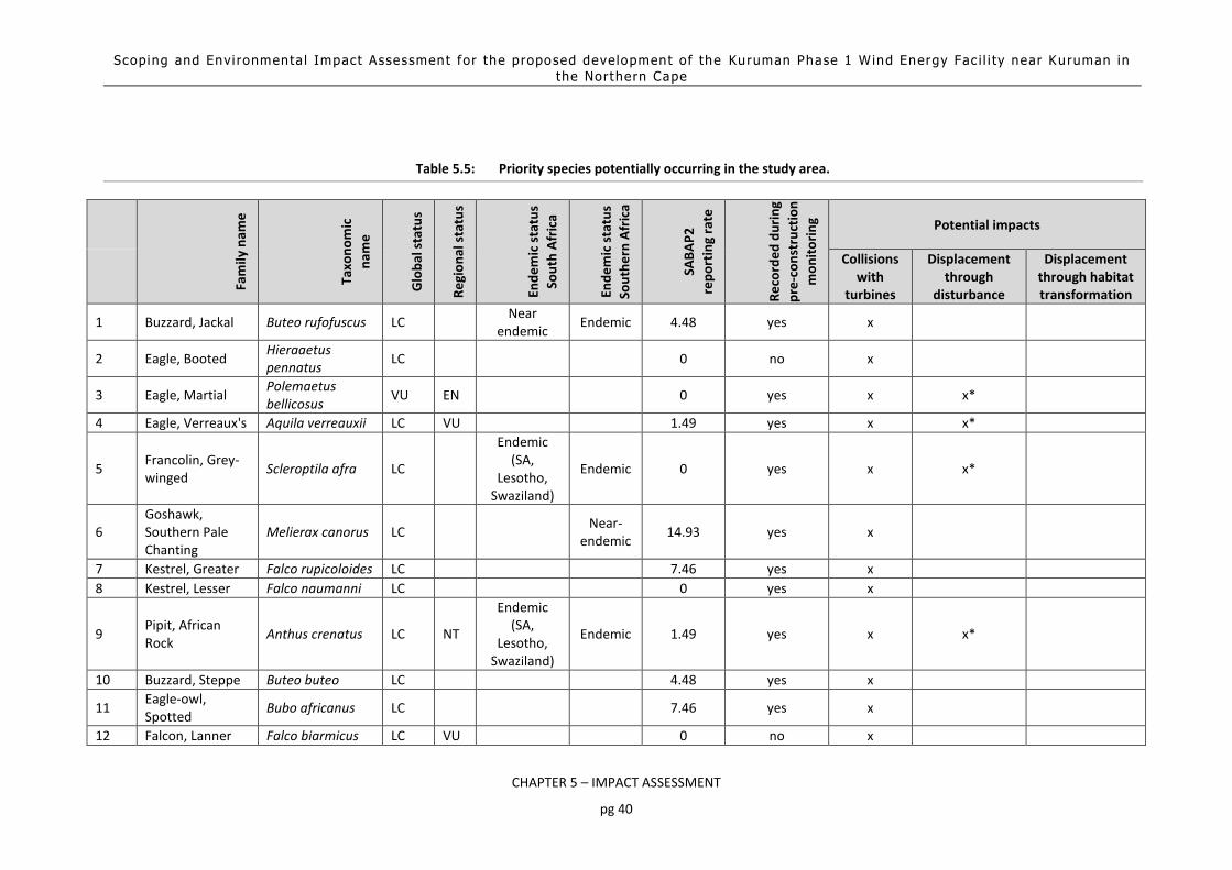
Scoping and Envi ronmenta l Impact Assessment for the proposed development of the Kuruman Phase 1 Wind Energy Fac i l i ty near Kuruman in
the Northern Cape
CHAPTER 5 – IMPACT ASSESSMENT
pg 40
Table 5.5: Priority species potentially occurring in the study area.
Fam
ily n
ame
Taxo
no
mic
nam
e
Glo
bal
sta
tus
Re
gio
nal
sta
tus
End
em
ic s
tatu
s
Sou
th A
fric
a
End
em
ic s
tatu
s
Sou
the
rn A
fric
a
SAB
AP
2
rep
ort
ing
rate
Re
cord
ed
du
rin
g
pre
-co
nst
ruct
ion
mo
nit
ori
ng Potential impacts
Collisions with
turbines
Displacement through
disturbance
Displacement through habitat transformation
1 Buzzard, Jackal Buteo rufofuscus LC
Near endemic
Endemic 4.48 yes x
2 Eagle, Booted Hieraaetus pennatus
LC
0 no x
3 Eagle, Martial Polemaetus bellicosus
VU EN
0 yes x x*
4 Eagle, Verreaux's Aquila verreauxii LC VU
1.49 yes x x*
5 Francolin, Grey-winged
Scleroptila afra LC
Endemic (SA,
Lesotho, Swaziland)
Endemic 0 yes x x*
6 Goshawk, Southern Pale Chanting
Melierax canorus LC
Near-endemic
14.93 yes x
7 Kestrel, Greater Falco rupicoloides LC
7.46 yes x
8 Kestrel, Lesser Falco naumanni LC
0 yes x
9 Pipit, African Rock
Anthus crenatus LC NT
Endemic (SA,
Lesotho, Swaziland)
Endemic 1.49 yes x x*
10 Buzzard, Steppe Buteo buteo LC
4.48 yes x
11 Eagle-owl, Spotted
Bubo africanus LC
7.46 yes x
12 Falcon, Lanner Falco biarmicus LC VU
0 no x

Scoping and Envi ronmenta l Impact Assessment for the proposed development of the Kuruman Phase 1 Wind Energy Fac i l i ty near Kuruman in
the Northern Cape
CHAPTER 5 – IMPACT ASSESSMENT
pg 41
Fam
ily n
ame
Taxo
no
mic
nam
e
Glo
bal
sta
tus
Re
gio
nal
sta
tus
End
em
ic s
tatu
s
Sou
th A
fric
a
End
em
ic s
tatu
s
Sou
the
rn A
fric
a
SAB
AP
2
rep
ort
ing
rate
Re
cord
ed
du
rin
g
pre
-co
nst
ruct
ion
mo
nit
ori
ng Potential impacts
Collisions with
turbines
Displacement through
disturbance
Displacement through habitat transformation
13 Harrier, Black Circus maurus VU EN Near
endemic Endemic 0 yes x x*
14 Korhaan, Northern Black
Afrotis afraoides LC
Endemic 4.48 no x x* x
15 Courser, Double-banded
LC 1.49 yes x*
16 Bustard, Kori NT NT 0 yes x* x
17 Secretarybird Sagittarius serpentarius
VU VU
0 no x x* x
18 Black-chested Snake--Eagle
Circaetus pectoralis
LC LC 0 yes x x*
* This is likely to be a temporary impact associated with the construction phase only

Scoping and Envi ronmenta l Impact Assessment for the proposed development of the
Kuruman Phase 1 Wind Energy Fac i l i ty near Kuruman in the Nor thern Cape
CHAPTER 5 – IMPACT ASSESSMENT
pg 42
Table 5.6: The manner in which priority species were recorded during the pre-construction monitoring
Please refer to Section 1.3.2.1 – 1.3.2.3 of the Avifauna specialist report for an outline of the transect counts undertaken at the project site and an indication of the overall species composition and abundance. Spatial distribution of transect records and incidental sightings in the development area Figure 5.13 below indicates the spatial distribution of priority species recorded during transect counts and incidental sightings.
Priority Species Taxonomic name Tran
sect
s at
th
e W
EF
Tran
sect
s at
th
e c
on
tro
l
Van
tage
po
ints
at
the
WEF
Van
tage
po
int
at t
he
co
ntr
ol
Inci
de
nta
l co
un
ts
African Rock Pipit Anthus crenatus *
Black Harrier Circus maurus *
Black-chested Snake-Eagle Circaetus pectoralis * *
Double-Banded Courser Rhinoptilus africanus *
Greater Kestrel Falco rupicoloides * *
Grey-winged Francolin Scleroptila africanus * *
Jackal Buzzard Buteo rufofuscus * * *
Kori Bustard Ardeotis kori *
Lesser Kestrel Falco naumanni * * *
Martial Eagle Polemaetus bellicosus *
Southern Pale Chanting Goshawk Melierax canorus * * * *
Spotted Eagle-Owl Bubo africanus *
Verreaux's Eagle Aquila verreauxii * *
13 Total: 7 2 4 1 10

Scoping and Envi ronmenta l Impact Assessment for the proposed development of the
Kuruman Phase 1 Wind Energy Fac i l i ty near Kuruman in the Nor thern Cape
CHAPTER 5 – IMPACT ASSESSMENT
pg 43
Figure 5.13: Spatial distribution of sightings of priority species recorded during transect counts (includes incidental sightings)
Collision risk rating Section 1.3.2.5 of the Avifauna specialist report provides information on the vantage point (VP) watches, a total of 192 hours, undertaken on site. A collision risk rating for each priority species recorded during VP watches was calculated to give an indication of the likelihood of an individual of a specific priority species to collide with the turbines. This was calculated taking into account the following factors:
The duration of all rotor height flights;
The susceptibility to collisions, based on morphology (size) and behaviour (soaring, predatory, ranging behaviour, flocking behaviour, night flying, aerial display and habitat preference) using the ratings for priority species in the Avian Wind Farm Sensitivity Map of South Africa (Retief et al. 2012); and
The overall number of proposed turbines. This was done in order to gain some understanding of which species are likely to be most at risk of collision. The formula used is as follows: Collision risk rating = duration of medium altitude flights (decimal hours) x collision susceptibility score calculated as the sum of morphology and behaviour ratings in the Avian Wind Farm Sensitivity Map of South Africa x number of planned turbines ÷ 100. The results are displayed in Table 5.7.

Scoping and Envi ronmenta l Impact Assessment for the proposed development of the
Kuruman Phase 1 Wind Energy Fac i l i ty near Kuruman in the Nor thern Cape
CHAPTER 5 – IMPACT ASSESSMENT
pg 44
Table 5.7: Site specific collision risk rating for all priority species recorded during VP watches in the
development area.
Sample size and representativeness of flight data Please refer to Section 1.2.3.7 of the avifaunal assessment for information on the sample size and representativeness of the flight date. Spatial distribution of flight activity Flight maps were prepared for the two priority species with average to above average collision ratings, indicating the spatial distribution of flights observed from the various vantage points during the 12-month pre-construction monitoring programme (see Figure 5.14 and Figure 5.15 below). This was done by overlaying a 100m x 100m grid over the survey area. Each grid cell was then given a weighting score taking into account the duration and distance of individual flight lines through a grid cell and the number of individual birds associated with each flight crossing the grid cell. It is important to interpret these maps bearing in mind the amount of time that each species spent flying over the site e.g. the “High” (flight concentration) category on the map for Lesser Kestrel is not equivalent to the “High” (flight concentration) category on the map for Verreaux’s Eagle, as the flight duration of flights for Lesser Kestrel is much higher than the flight duration for Verreaux’s Eagle.
SpeciesDuration of
flights (hr)
Avian
Wind Farm
Sensitivity
Map
Collision
rating
Number
of
turbines
Collision
Risk Rating
Grey-winged Francolin 0.00 50 47 0.00
Jackal Buzzard 0.00 95 47 0.00
Verreauxs' Eagle 0.07 110 47 3.45
Lesser Kestrel 0.30 72 47 10.15
Average 0.09 81.75 3.40

Scoping and Envi ronmenta l Impact Assessment for the proposed development of the
Kuruman Phase 1 Wind Energy Fac i l i ty near Kuruman in the Nor thern Cape
CHAPTER 5 – IMPACT ASSESSMENT
pg 45
Figure 5.14: Spatial distribution and concentration of rotor height flights of Lesser Kestrel.
Figure 5.15: Spatial distribution and concentration of rotor height flights of Verreaux’s Eagle.

Scoping and Envi ronmenta l Impact Assessment for the proposed development of the
Kuruman Phase 1 Wind Energy Fac i l i ty near Kuruman in the Nor thern Cape
CHAPTER 5 – IMPACT ASSESSMENT
pg 46
Focal points One potential focal point of bird activity, a small dam, was identified during the initial site inspection and monitored during seasonal field surveys. The power lines in the study area were also inspected for raptor nests during each seasonal survey, but no raptor nests were recorded on the powerlines during any of the seasonal surveys. The small dam never held water during any of the surveys, which accounts for the lack of priority species. Environmental Sensitivity Map The sensitive areas that have been identified from a bird impact perspective, are areas of surface water and ridge edges. A 300m no-turbine-zone (other infrastructure allowed) is recommended around all areas of surface water to reduce the risk of collisions for priority species, particularly raptors which are attracted to the surface water to drink and bath (see Figure 5.16 below). A 100m no turbine setback buffer (other infrastructure allowed) is recommended to reduce the risk of collisions for soaring raptors.
Figure 5.16: The location of high sensitivity areas in the WEF development area. The two turbines indicated
in yellow falls within the no-turbine zone. Other infrastructure is allowed within the high sensitivity areas.
5.3.2.4 Impact assessment
The potential impacts assessed during the EIA assessment are as follows: Construction Phase
Displacement of priority species due to disturbance associated with the construction activities
Displacement of priority species due to habitat transformation Operational Phase
Mortality of priority species due to collisions with the wind turbines

Scoping and Envi ronmenta l Impact Assessment for the proposed development of the
Kuruman Phase 1 Wind Energy Fac i l i ty near Kuruman in the Nor thern Cape
CHAPTER 5 – IMPACT ASSESSMENT
pg 47
Decommissioning Phase
Displacement of priority species due to disturbance associated with the de-commissioning activities
Cumulative impacts
Displacement of priority species due to habitat transformation
Mortality of priority species due to collisions with the wind turbines
5.3.2.4.1 Construction Phase impacts
5.3.2.4.1.1 Displacement of priority species due to habitat transformation
The scale of permanent habitat loss resulting from the construction of a wind farm and associated infrastructure depends on the size of the project but, in general it, is likely to be small per turbine base. Typically, actual habitat loss amounts to 2–5% of the total development area (Fox et al. 2006 as cited by Drewitt & Langston 2006). Some changes could also be beneficial. For example, habitat changes following the development of the Altamont Pass wind farm in California led to increased mammal prey availability for some species of raptor, though this may also have increased collision risk (Thelander et al. 2003 as cited by Drewitt & Langston 2006). However, the results of habitat transformation may be subtler, whereas the actual footprint of the wind farm may be small in absolute terms, the effects of the habitat fragmentation brought about by the associated infrastructure (e.g. power lines and roads) may be more significant. Sometimes Great Bustard can be seen close to or under power lines, but a study done in Spain (Lane et al. 2001 as cited by Raab et al. 2009) indicates that the total observation of Great Bustard flocks were significantly higher further from power lines than at control points. Shaw (2013) found that Ludwig’s Bustard generally avoid the immediate proximity of roads within a 500m buffer. This means that power lines and roads also cause loss and fragmentation of the habitat used by the population in addition to the potential direct mortality. The physical encroachment increases the disturbance and barrier effects that contribute to the overall habitat fragmentation effect of the infrastructure (Raab et al. 2010). It has been shown that fragmentation of natural grassland in Mpumalanga (in that case by afforestation) has had a detrimental impact on the densities and diversity of grassland species (Alan et al. 1997). Raptors are unlikely to be affected by the habitat transformation. Significance of impact without mitigation The physical footprint of the proposed wind farm is likely to be fairly insignificant. The habitat fragmentation is likely to have a more significant displacement impact on priority species. It is expected that the densities of most priority species will decrease due to this impact, but complete displacement is unlikely. Indications are that bustards continue to use the wind farm areas (M. Langlands 2016 pers. comm, Rossouw 2016 pers.comm,). Raptors are unlikely to be affected at all. Species most likely to be affected by the habitat fragmentation are the terrestrial species namely Grey-winged Francolin, Northern Black Korhaan, Kori Bustard and Secretarybird. The overall significance of this impact prior to mitigation is regarded to be moderate. Proposed mitigation measures Mitigation measures to reduce the impact of displacement due to habitat transformation are as follows:
The recommendations of the specialist ecological study must be strictly adhered to.

Scoping and Envi ronmenta l Impact Assessment for the proposed development of the
Kuruman Phase 1 Wind Energy Fac i l i ty near Kuruman in the Nor thern Cape
CHAPTER 5 – IMPACT ASSESSMENT
pg 48
Maximum use should be made of existing access roads and the construction of new roads should be kept to a minimum.
Following construction, rehabilitation of all areas disturbed (e.g. temporary access tracks and laydown areas) must be undertaken and to this end a habitat restoration plan is to be developed by a rehabilitation specialist.
Rationale: The rehabilitation of disturbed areas will help to mitigate the impact of the habitat transformation to some extent, but the fragmentation of the habitat due to the construction of the internal road network cannot be mitigated and will remain an impact for the duration of the operational life-time of the facility. Significance of impact after mitigation While the mitigation will have some effect, very little can be done about the habitat fragmentation, therefore the impact will remain at a moderate level.
5.3.2.4.1.2 Displacement of priority species due to disturbance
The displacement of birds from areas within and surrounding wind farms due to visual intrusion and disturbance in effect can amount to a form of habitat loss. Displacement may occur primarily during the construction phase of wind farms and may occur as a result of construction activities. The scale and degree of disturbance will vary according to site- and species-specific factors and must be assessed on a site-by-site basis (Drewitt & Langston 2006). Unfortunately, few studies of displacement due to disturbance are conclusive, often because of the lack of before-and-after and control-impact (BACI) assessments. Onshore, disturbance distances (in other words the distance from wind farms up to which birds are absent or less abundant than expected) up to 800 m (including zero) have been recorded for wintering waterfowl (Pedersen & Poulsen 1991 as cited by Drewitt & Langston 2006), though 600m is widely accepted as the maximum reliably recorded distance (Drewitt & Langston 2006). The variability of displacement distances is illustrated by one study which found lower post-construction densities of feeding European White-fronted Geese Anser albifrons within 600 m of the turbines at a wind farm in Rheiderland, Germany (Kruckenberg & Jaene 1999 as cited by Drewitt & Langston 2006), while another showed displacement of Pink-footed Geese Anser brachyrhynchus up to only 100–200 m from turbines at a wind farm in Denmark (Larsen & Madsen 2000 as cited by Drewitt & Langston 2006). Indications are that Great Bustard Otis tarda could be displaced by wind farms up to one kilometre from the facility (Langgemach 2008). An Austrian study found displacement for Great Bustards up to 600m (Wurm & Kollar as quoted by Raab et al. 2009). However, there is also evidence to the contrary; information on Great Bustard received from Spain points to the possibility of continued use of leks at operational wind farms (Camiña 2012b). Research on small grassland species in North America indicates that permanent displacement is uncommon and very species specific (e.g. see Stevens et al. 2013, Hale et al. 2014). There also seem to be little evidence for a persistent decline in passerine populations at wind farm sites in the UK (despite some evidence of turbine avoidance), with some species, including Skylark, showing increased populations after wind farm construction (see Pierce-Higgins et al. 2012). Populations of Thekla Lark Galerida theklae were found to be unaffected by wind farm developments in Southern Spain (see Farfan et al. 2009). The consequences of displacement for breeding productivity and survival are crucial to whether or not there is likely to be a significant impact on population size. However, studies of the impact of wind farms on breeding birds are also largely inconclusive or suggest lower disturbance distances, though this apparent lack of effect may be due to the high site fidelity and long life-span of the breeding species studied. This might mean that the true impacts of disturbance on breeding birds will only be evident in

Scoping and Envi ronmenta l Impact Assessment for the proposed development of the
Kuruman Phase 1 Wind Energy Fac i l i ty near Kuruman in the Nor thern Cape
CHAPTER 5 – IMPACT ASSESSMENT
pg 49
the longer term, when new recruits replace existing breeding birds. Few studies have considered the possibility of displacement for short-lived passerines (such as larks), although Leddy et al. (1999) found increased densities of breeding grassland passerines with increased distance from wind turbines, and higher densities in the reference area than within 80m of the turbines. A review of minimum avoidance distances of 11 breeding passerines were found to be generally <100m from a wind turbine ranging from 14 – 93m (Hötker et al. 2006). A comparative study of nine wind farms in Scotland (Pearce-Higgens et al. 2009) found unequivocal evidence of displacement: Seven of the 12 species studied exhibited significantly lower frequencies of occurrence close to the turbines, after accounting for habitat variation, with equivocal evidence of turbine avoidance in a further two. No species were more likely to occur close to the turbines. Levels of turbine avoidance suggest breeding bird densities may be reduced within a 500m buffer of the turbines by 15–53%, with Common Buzzard Buteo buteo, Hen Harrier Circus cyaneus, Golden Plover Pluvialis apricaria, Snipe Gallinago gallinago, Curlew Numenius arquata and Wheatear Oenanthe oenanthe most affected. In a follow-up study, monitoring data from wind farms located on unenclosed upland habitats in the United Kingdom were collated to test whether breeding densities of upland birds were reduced as a result of wind farm construction or during wind farm operation. Red Grouse Lagopus lagopus scoticus, Snipe Gallinago gallinago and Curlew Numenius arquata breeding densities all declined on wind farms during construction. Red Grouse breeding densities recovered after construction, but Snipe and Curlew densities did not. Post-construction Curlew breeding densities on wind farms were also significantly lower than reference sites. Conversely, breeding densities of Skylark Alauda arvensis and Stonechat Saxicola torquata increased on wind farms during construction. Overall, there was little evidence for consistent post-construction population declines in any species, suggesting that wind farm construction can have greater impacts upon birds than wind farm operation (Pierce-Higgens et al. 2012). The effect of birds altering their migration flyways or local flight paths to avoid a wind farm is also a form of displacement. This effect is of concern because of the possibility of increased energy expenditure when birds have to fly further, as a result of avoiding a large array of turbines, and the potential disruption of linkages between distant feeding, roosting, moulting and breeding areas otherwise unaffected by the wind farm. The effect depends on species, type of bird movement, flight height, distance to turbines, the layout and operational status of turbines, time of day and wind force and direction, and can be highly variable, ranging from a slight 'check' in flight direction, height or speed, through to significant diversions which may reduce the numbers of birds using areas beyond the wind farm (Drewitt & Langston 2006). A review of the literature suggests that none of the barrier effects identified so far have significant impacts on populations (Drewitt & Langston 2006). However, there are circumstances where the barrier effect might lead indirectly to population level impacts; for example, where a wind farm effectively blocks a regularly used flight line between nesting and foraging areas, or where several wind farms interact cumulatively to create an extensive barrier which could lead to diversions of many tens of kilometres, thereby incurring increased energy costs. Significance of impact without mitigation None of the priority species are likely to be permanently displaced due to disturbance, although displacement in the short term during the construction phase is very likely. The risk of permanent displacement due to disturbance is bigger for large species such as Kori Bustard and Secretarybird although displacement of the closely related Denham’s Bustard (Neotis denhami) is evidently not happening at existing wind farms in the Eastern Cape (M. Langlands 2016 pers. comm, Rossouw 2016 pers.comm). The overall significance of this impact prior to mitigation is regarded to be moderate, due to its temporary nature.

Scoping and Envi ronmenta l Impact Assessment for the proposed development of the
Kuruman Phase 1 Wind Energy Fac i l i ty near Kuruman in the Nor thern Cape
CHAPTER 5 – IMPACT ASSESSMENT
pg 50
Proposed mitigation measures Mitigation measures to reduce the impact of displacement due to disturbance associated with construction activities are as follows:
Restrict the construction activities to the construction footprint area.
Do not allow any access to the remainder of the property during the construction period.
Measures to control noise and dust should be applied according to current best practice in the industry.
Maximum use should be made of existing access roads and the construction of new roads should be kept to a minimum.
The appointed Environmental Control Officer (ECO) should be trained by an avifaunal specialist to identify the signs that indicate possible breeding by priority species. The ECO must then, during audits/site visits, make a concerted effort to look out for such breeding activities of such species, and such efforts may include the training of construction staff to identify such species, followed by regular questioning of staff as to the regular whereabouts on site of the species. If any priority species are confirmed to be breeding (e.g. if a nest site is found), construction activities within 500m of the breeding site must cease, and the avifaunal specialist will be contacted immediately for further assessment of the situation and instruction on how to proceed.
Significance of impact after mitigation It is envisaged that the impact could be reduced to low with the application of the proposed mitigation measures.
5.3.2.4.2 Operational Phase
5.3.2.4.2.1 Mortality of priority species due to collisions with the turbines
Wind energy generation has experienced rapid worldwide development over recent decades as its environmental impacts are considered to be relatively lower than those caused by traditional energy sources, with reduced environmental pollution and water consumption (Saidur et al., 2011). However, bird fatalities due to collisions with wind turbines have been consistently identified as a main ecological drawback of wind energy (Drewitt and Langston, 2006)8. Collisions with wind turbines appear to kill fewer birds than collisions with other man-made infrastructures, such as power lines, buildings or even traffic (Calvert et al. 2013; Erickson et al. 2005). Nevertheless, estimates of bird deaths from collisions with wind turbines worldwide range from 0 to almost 40 deaths per turbine per year (Sovacool, 2009). The number of birds killed varies greatly between sites, with some sites posing a higher collision risk than others, and with some species being more vulnerable (e.g. Hull et al. 2013; May et al. 2012a). These numbers may not reflect the true magnitude of the problem, as some studies do not account for detectability biases such as those caused by scavenging, searching efficiency and search radius (Bernardino et al. 2013; Erickson et al. 2005; Huso and Dalthorp 2014). Additionally, even for low fatality rates, collisions with wind turbines may have a disproportionate effect on some species. For long-lived species with low productivity and slow maturation rates (e.g. raptors), even low mortality rates can have a significant impact at the population level (e.g. Carrete et al.
8 This section is adapted from a review paper by Ana Teresa Marques, Helena Batalha, Sandra Rodrigues, Hugo Costa,
Maria João Ramos Pereira, Carlos Fonseca, Miguel Mascarenhas, Joana Bernardino. Understanding bird collisions at wind farms: An updated review on the causes and possible mitigation strategies. Biological Conservation 179 (2014) 40–52

Scoping and Envi ronmenta l Impact Assessment for the proposed development of the
Kuruman Phase 1 Wind Energy Fac i l i ty near Kuruman in the Nor thern Cape
CHAPTER 5 – IMPACT ASSESSMENT
pg 51
2009; De Lucas et al. 2012a; Drewitt and Langston, 2006). The situation is even more critical for species of conservation concern, which sometimes are most at risk (e.g. Osborn et al. 1998). High bird fatality rates at several wind farms have raised concerns among the industry and scientific community. High profile examples include the Altamont Pass Wind Resource Area (APWRA) in California because of high fatality of Golden eagles (Aquila chrysaetos), Tarifa in Southern Spain for Griffon vultures (Gyps fulvus), Smøla in Norway for White-tailed eagles (Haliaatus albicilla), and the port of Zeebrugge in Belgium for gulls (Larus sp.) and terns (Sterna sp.) (Barrios and Rodríguez, 2004; Drewitt and Langston, 2006; Everaert and Stienen, 2008; May et al. 2012a; Thelander et al. 2003). Due to their specific features and location, and characteristics of their bird communities, these wind farms have been responsible for a large number of fatalities that culminated in the deployment of additional measures to minimize or compensate for bird collisions. However, currently, no simple formula can be applied to all sites; in fact, mitigation measures must inevitably be defined according to the characteristics of each wind farm and the diversity of species occurring there (Hull et al. 2013; May et al. 2012b). An in-depth understanding of the factors that explain bird collision risk and how they interact with one another is therefore crucial to proposing and implementing valid mitigation measures. Please refer to Section 1.5.2 of the Avifaunal Impact Assessment Report (Appendix E) for a detailed outline of how the following features influence the mortality of priority species due to collisions with the turbines:
Species-specific factors o Morphological features o Sensorial perception o Phenology o Bird behaviour o Avoidance behaviours
Bird abundance
Landscape features
Flight paths
Food availability
Weather
Turbine features
Blade visibility Significance of impact without mitigation Moderate Species-specific factors Priority species that could potentially be vulnerable to wind turbine collisions due to morphological features (high wing loading) are Northern Black Korhaan, Grey-winged Francolin and Kori Bustard. It is noted though that no bustard mortalities have as yet been reported in published literature at wind farms in South Africa, despite initial concerns that they might be vulnerable in this respect (Ralston - Patton et al. 2017). Specific behaviour of some terrestrial species might put them at risk of collision, e.g. display flights of Northern Black Korhaan might place them within the rotor swept zone, but the species was not recorded during pre-construction monitoring, possibly due to hunting pressure. It is also noted that very little flight activity of terrestrial species was recorded during the 12-months pre-construction monitoring. Many of the priority species potentially occurring at the proposed WEF development area probably have high resolution vision areas found in the lateral fields of view, rather than frontally, e.g. Northern Black Korhaan, Grey-winged Francolin, African Rock-Pipit and Double-banded Courser. The possible exceptions to this are the raptors which all have wider binocular fields, although as pointed out by Martin (2011,

Scoping and Envi ronmenta l Impact Assessment for the proposed development of the
Kuruman Phase 1 Wind Energy Fac i l i ty near Kuruman in the Nor thern Cape
CHAPTER 5 – IMPACT ASSESSMENT
pg 52
2012), this does not necessarily result in these species being able to avoid obstacles better. It is therefore unlikely that differences in sensorial perception will play a significant role in the collision risk associated with priority species at the proposed wind farm, as behaviour is more important from a risk perspective. While it is anticipated that birds at the proposed wind farm will successfully avoid the wind turbines most of the time, possible exceptions might be raptors (especially Lesser Kestrel, Jackal Buzzard and possibly Verreaux’s Eagle) engaged in hunting which might serve to distract them and place them at risk of collision, or birds engaged in display behaviour, e.g. Northern Black Korhaan (see earlier point). Based on the potential time spent flying at rotor height, soaring species are likely to be at greater risk of collision, especially Lesser Kestrel, which may be highly vulnerable to turbine collisions (Ralston-Patton et al. 2017). The closely related Amur Falcon is currently the species with the highest confirmed mortality due to collisions with wind turbines at South African wind farms (Ralston-Patton et al. 2017), it is therefore expected that Lesser Kestrel, which has a similar style of foraging, would display a similar high vulnerability to collisions. Verreaux’s Eagle, which was recorded briefly, emerged with the second highest collision risk rating, which indicates that while the risk of collisions for the species may not be as high as a site with an active breeding pair, it cannot be entirely excluded. The risk rating for Jackal Buzzard is very low, compared to wind farm sites elsewhere (Van Rooyen et al. unpublished data)9, yet the species is highly vulnerable to collisions with turbines, therefore the potential for collisions cannot be discounted. The abundance of priority species at the proposed wind farm site will fluctuate depending on season of the year, and particularly in response to rainfall. This is a common phenomenon in arid ecosystems, where stochastic rainfall events can trigger irruptions of insect populations which in turn attract large numbers of birds. This is particularly likely to be the case with Lesser Kestrels. In general, higher populations of priority species are likely to be present when the veld conditions are good, especially in the rainy season. In the case of Verreaux’s Eagles, mortality has been correlated with high flight activity (Ralston-Patton et al. 2017), but at least one Verreaux’s Eagle mortality has been confirmed at a wind farm where no pre-construction flight activity was recorded for the species (Van Rooyen unpubl. data), indicating that for this species, low abundance does not entirely exclude the potential for collision mortality. As far as Jackal Buzzard is concerned, the species has proven to be highly susceptible to wind turbine collisions (Ralston-Patton et al. 2017), and the low reporting rate for the species at the WEF development area therefore does not exclude the possibility of collisions. Site-specific factors Landscape features are likely to play an important role at the WEF development area. The proposed turbine zones at the WEF development area are virtually surrounded by slopes. The slopes are generally not very steep, but in some areas the drop-off from the plateau at the ridge top is more pronounced. The slopes are likely to be important landscape features for soaring species, particularly raptors such as Jackal Buzzard, Booted Eagle, Verreaux’s Eagle and Lesser Kestrel, due to the presence of declivity currents, especially at the steeper slopes, which will require a set-back from the edge to reduce the risk of collision for soaring raptors. The flight activity map for Verreaux’s Eagle points towards a concentration of flight activity along the ridges. In the case of the Lesser Kestrels, the grass covered slopes seems to be the area of choice. It is therefore necessary to buffer the edges of the escarpment, as it is likely to be the area where most of the raptor flight activity will take place at turbine height. Other areas which can be specifically pinpointed as potentially sensitive are the water points, i.e. areas of surface water, which are likely to attract a variety of raptors. See Figure 5.16 indicating proposed avifaunal turbine-free buffer zones, linked to the presence of surface water and slopes.
9 A dataset comprising 12 potential wind farm sites where the species was recorded during monitoring, recorded collision
risk ratings for Jackal Buzzard ranging from 1.38 to 283.

Scoping and Envi ronmenta l Impact Assessment for the proposed development of the
Kuruman Phase 1 Wind Energy Fac i l i ty near Kuruman in the Nor thern Cape
CHAPTER 5 – IMPACT ASSESSMENT
pg 53
The proposed WEF development area is not located on any known migration route. The migratory Lesser Kestrels at the site can be regarded as summer residents as they will remain in the area as long as there are adequate food supplies. In semi-arid zones such as where this proposed wind farm is located, food availability is often linked to rainfall. It is a well-known fact that insect outbreaks may occur after rainfall events, which could draw in various priority species, and particularly Lesser Kestrel. This in turn could heighten the risk of collisions. Rock piles which are created as a result of construction activities at the proposed site could create habitat for Rock Hyrax, which in turn could result in Verreaux’s Eagles being attracted to the area and exposing themselves to collision risk. However, the habitat at the wind farm as it currently stands is not ideal for Rock Hyrax as it lacks the boulder strewn slopes that the animal require for shelter. It is therefore not expected that Verreaux’s Eagles will regularly forage over the site, but occasional forays cannot be excluded. Weather conditions at the proposed wind farm are likely to influence flight behaviour in much the same manner as has been recorded elsewhere at wind farms. Analysis of the flight data collected during the pre-construction monitoring indicates that the majority of soaring flights happened during fresh breezes, in winds with a predominantly easterly orientation (see Appendix 4 tables F and G of the Avifauna specialist report). However, the overall low incidence of priority species flight activity means the confidence in these predictions are low due to paucity of data. Wind farm-specific factors Due to the fact that the turbine dimensions are constantly changing as newer models are introduced, it is best to take a pre-cautionary approach in order to anticipate any future potential changes in the turbine dimensions. The pre-construction monitoring programme worked on a potential rotor swept area of 30m – 220m above ground to incorporate a wide range of models, which accommodates the current proposed turbines. The latest published literature on the subject recommends that to minimize bird collisions, wind farm electricity generation capacity should be met through deploying fewer, large turbines, rather than many, smaller ones (Thaxter et al. 2017). Any reduction of the current complement of 47, 5.5MW proposed turbines should therefore lower the collision risk for birds. Two of the proposed turbines, i.e. No 43 rev1 and No 47, are currently placed within the proposed no-turbine zones, which heightens the risk of collisions for soaring raptors with those turbines. Conclusion The pre-mitigation impact of mortality due to turbine collisions is rated to be of moderate significance. While the topography of the terrain (many slopes) contributes to the risk of collisions, especially for soaring species, the very low reporting rate for priority species10 reduces the chances of the impact materialising with regularity. Proposed mitigation measures The following proposed mitigation measures could reduce the risk of mortality through collisions with the turbines:
A 100m no-turbine set-back buffer zone (other infrastructure is allowed) is recommended around selected ridge edges to minimise the risk of collisions for slope soaring species (see Figure 5.16). Two turbines i.e. No 43rev1 and No 47, are located within this no-turbine zone and will have to be relocated.
10
The passage rate of 0.05 birds/hour is equal to the lowest of all the passage rates for priority species at 36 potential wind farms sites where the authors implemented pre-construction monitoring.

Scoping and Envi ronmenta l Impact Assessment for the proposed development of the
Kuruman Phase 1 Wind Energy Fac i l i ty near Kuruman in the Nor thern Cape
CHAPTER 5 – IMPACT ASSESSMENT
pg 54
A 300m no turbine buffer zone (other infrastructure allowed) is recommended around selected water points (see Figure 5.16). One turbine, No 43rev1, is currently within this no-turbine zone and will have to be relocated.
Care should be taken not to create habitat for prey species that could draw Verreaux’s Eagles into the area and expose them to collision risk. Rock piles must be removed from site or covered with topsoil to prevent them from becoming habitat for Rock Hyrax.
The avifaunal specialist, in consultation with external experts and relevant NGO’s such as BLSA, should determine annual mortality thresholds for priority species anticipated to be at risk of collision mortality, prior to the wind farm going operational.
If estimated collision rates approach the pre-determined threshold levels, curtailment of turbines should be implemented for high risk situations.
In the event of a massive influx of Lesser Kestrels due to an irruption of insects, pro-active curtailment must be implemented under the guidance of the avifaunal specialist. A site-specific regime must be designed in consultation with the wind farm operator which will specify the duration of the curtailment period as well as the specific time of the day when the turbines will be curtailed.
Rationale: The impact is likely to persist for the operational life-time of the project. Implementation of the proposed mitigation measures should reduce the probability and severity of the impact on priority species to such an extent that the overall significance should be reduced to low. Significance of impact after mitigation It is envisaged that the impact could be reduced to low with the application of the proposed mitigation measures.
5.3.2.4.3 Decommissioning Phase
5.3.2.4.3.1 Displacement of priority species due to disturbance
Displacement occurs primarily during the construction phase of wind farms and may occur as a result of construction activities. However, temporary displacement could also happen due to activities related to the dismantling of the wind farm after its operational life-time. In theory, the wind farm’s operational lifetime is about 20 – 25 years, after which it is supposed to be de-commissioned and dismantled. The scale and degree of disturbance will vary according to site- and species-specific factors and must be assessed on a site-by-site basis. Significance of impact without mitigation None of the priority species are likely to be permanently displaced due to disturbance during the de-commissioning phase, although displacement in the short term is very likely. The overall significance of this impact prior to mitigation is regarded to be moderate, due to the temporary nature. Proposed mitigation measures Mitigation measures to reduce the impact of displacement due to disturbance associated with de-commissioning activities are as follows:
Restrict the activities to the footprint area.
Do not allow any access to the remainder of the property during the de-commissioning period.
Measures to control noise and dust should be applied according to current best practice in the industry.

Scoping and Envi ronmenta l Impact Assessment for the proposed development of the
Kuruman Phase 1 Wind Energy Fac i l i ty near Kuruman in the Nor thern Cape
CHAPTER 5 – IMPACT ASSESSMENT
pg 55
Maximum use should be made of existing access roads and the construction of new roads should be kept to a minimum.
The appointed Environmental Control Officer (ECO) should be trained by an avifaunal specialist to identify the signs that indicate possible breeding by priority species. The ECO must then, during audits/site visits, make a concerted effort to look out for such breeding activities of such species, and such efforts may include the training of staff to identify such species, followed by regular questioning of staff as to the regular whereabouts on site of the species. If any priority species are confirmed to be breeding (e.g. if a nest site is found), activities within 500m of the breeding site must cease, and the avifaunal specialist will be contacted immediately for further assessment of the situation and instruction on how to proceed.
Significance of impact after mitigation It is envisaged that the impact could be reduced to low with the application of the proposed mitigation measures.
5.3.2.4.4 Cumulative Impacts
A cumulative impact, in relation to an activity, is the impact of an activity that may not be significant on its own but may become significant when added to the existing and potential impacts arising from similar or other activities in the area. There is currently one wind energy planned within a 50km radius around the proposed WEF, and at least 11 solar PV facilities. The primary potential long-term impact of wind facility is mortality of priority species due to collisions with the turbines, and in the case of the solar facilities, it is displacement due to habitat transformation. Significance of impact before mitigation The fact that only one other wind facility is currently planned within the 50km radius, and the low reporting rate for priority species, reduce the cumulative effect of this impact to a moderate level. The mitigation measures pertaining to avifauna in the existing applications for solar plants do not address the issue of displacement due to habitat transformation, as this impact cannot be effectively mitigated at solar facilities for the majority of avifauna. The question is therefore to what extent the relatively moderate envisaged impact of displacement at the WEF will increase in significance when viewed collectively with the aggregate impact of displacement of all the renewable energy facilities combined. The total land parcel area covered by current solar applications is approximately 222km². This amounts to 2.7% of the total area of 8 136km² contained in the 50km radius around the proposed WEF. The land parcel area for the WEF is approximately 73km². If this is added to the solar applications, it comes to 295km², or approximately 3.6% of the total area encompassed in a 50km radius around the proposed WEF. While this is a significant increase in the area to be potentially transformed, it still only a fraction of the total available habitat. It should also be borne in mind that the actual development footprint for all these applications is usually considerably smaller than the land parcel. It therefore follows that the significance of the cumulative displacement impact of the WEF, viewed with the other potential renewable energy projects, is still relatively moderate. Proposed mitigation measures As mentioned already, the impact of displacement due to habitat transformation is difficult to mitigate in the case of solar plants, because it involves the physical footprint of the infrastructure, which cannot be

Scoping and Envi ronmenta l Impact Assessment for the proposed development of the
Kuruman Phase 1 Wind Energy Fac i l i ty near Kuruman in the Nor thern Cape
CHAPTER 5 – IMPACT ASSESSMENT
pg 56
avoided. In the case of the WEF, the impact not only involves the physical footprint of the infrastructure, which is relatively minor, but also the habitat fragmentation which is caused by the network of roads. The mitigation measures listed below, or variations of them, are recommended at all the proposed renewable energy projects:
The recommendations of the specialist ecological study must be strictly adhered to, to limit the habitat destruction.
Maximum used should be made of existing access roads and the construction of new roads should be kept to a minimum.
Following construction, rehabilitation of all areas disturbed (e.g. temporary access tracks and laydown areas) must be undertaken and to this end a habitat restoration plan is to be developed by a rehabilitation specialist.
Restrict the activities to the footprint area.
Do not allow any access to the remainder of the property during the de-commissioning period.
Measures to control noise and dust should be applied according to current best practice in the industry.
Maximum use should be made of existing access roads and the construction of new roads should be kept to a minimum.
If any priority species are confirmed to be breeding (e.g. if a nest site is found), activities within 500m of the breeding site must cease, and the avifaunal specialist will be contacted immediately for further assessment of the situation and instruction on how to proceed.
100m anti-collision setback buffer zone around selected ridges.
300m anti-collision no-turbine buffer zone around selected water points and powerlines.
Removal of rock piles to prevent them from becoming Rock Hyrax habitat.
Curtailment of turbines if mortality levels exceed pre-determined mortality thresholds.
Curtailment of turbines in the event of an influx of Lesser Kestrels. Significance of impact after mitigation The mitigation measures listed above will address the issue of displacement to some extent, but due to the inherent nature of the displacement impact, the significance of the impacts will likely remain at a moderate level, even after mitigation. In the case of the proposed wind facilities, the mitigation measures aimed at reducing the risk of priority species mortality due to collision with the turbines should reduce the cumulative impact to low, if applied diligently.

Scoping and Envi ronmenta l Impact Assessment for the proposed development of the
Kuruman Phase 1 Wind Energy Fac i l i ty near Kuruman in the Nor thern Cape
CHAPTER 5 – IMPACT ASSESSMENT
pg 57
Table 5.8: Avifaunal Impact Assessment Summary
Impact Before mitigation After mitigation Construction Phase
Displacement of priority species due to habitat transformation
Moderate Moderate
Displacement of priority species due to disturbance associated with the construction activities
Moderate Low
Operational Phase
Mortality of priority species due to collisions with the turbines
Moderate Low
Decommissioning Phase
Displacement of priority species due to disturbance associated with the decommissioning activities
Moderate Low
Cumulative impact
Primarily displacement of priority species due to habitat transformation
Moderate Moderate
Mortality due to collisions with the wind turbines Moderate Low
5.3.2.5 Concluding statement
It is our opinion that the proposed development be approved, subject to the strict implementation of the proposed mitigation measures detailed in this report.
5.3.3 Heritage
CTS Heritage undertook the required Heritage Impact Assessment (including archaeology and palaeontology) for the Kuruman WEF.
5.3.3.1 Approach and methodology
Heritage Screening Assessment As part of the Scoping Phase, a Heritage Screening Assessment was conducted for the proposed development (Appendix A). The Heritage Screener summarises the heritage impact assessments and studies previously undertaken within the area of the proposed development and its surroundings. Heritage resources identified in these reports were then assessed by our team during the screening process. Based on the results of the Heritage Screening Assessment, it was recommended that, as the proposed development is likely to impact on heritage resources, a complete Heritage Impact Assessment including a detailed field assessment is required that assesses impacts to landscape character, secondary (and possibly primary) impacts on built environment resources, archaeological resources, graves and burial grounds, fossil heritage and mining heritage. Field Assessment An archaeologist conducted a survey of the site and its environs in June 2018 to determine what heritage resources are likely to be impacted by the proposed development (Appendix 1 to the HIA report), and a Palaeontological Field Assessment was completed in February 2018 to assess likely impacts to palaeontology (Appendix 2 to the HIA report). The identified heritage resources were assessed to evaluate their heritage significance in terms of the grading system outlined in section 3 of the NHRA (Act

Scoping and Envi ronmenta l Impact Assessment for the proposed development of the
Kuruman Phase 1 Wind Energy Fac i l i ty near Kuruman in the Nor thern Cape
CHAPTER 5 – IMPACT ASSESSMENT
pg 58
25 of 1999). These identified resources have been mapped relative to the proposed development layout to determine likely impacts and to inform relevant buffers areas, no-go zones and other mitigation strategies.
5.3.3.2 Project aspects relevant to heritage impacts
Activities associated with the development of the proposed WEF that are likely to impact on heritage resources include:
Vegetation clearing;
Road construction;
Excavation and dredging activities; and
Infrastructure construction activities.
5.3.3.3 Sensitivity of the site in relation to the proposed activity
The proposed WEF substations and laydown areas do not constitute a sensitive archaeological or palaeontological landscape. Structures and Places No old buildings, ruined structures, typical grave features (i.e. stone mounds), formal farm cemeteries were noted. A modern residential farm house, outbuildings, worker cottages, hunting lodge, butcher, etc are all located way outside the footprint area of the wind energy farm. The ACO (Halkett, 2009) identified a number of farming-related burial grounds as well as historic farm werfs (TK2, 2A, 7, 8 and 9), however these are located outside of the footprint for the Kuruman Phase 1 WEF. In their report, they describe
these resources as:“Older, partly ruined structures represent an earlier farm dwelling (TK2) and a structure related to mining/prospecting (BR8). The building at TK 2 could be the oldest formal structure that we saw and is built with ironstone quarried adjacent to the house. The use of this abundant natural building material is typical for the area and kraals, walls and houses alike are built with it. As is common with farming settlements, a number of graves were identified with the help of the farmers and workers. One grave at BR2 is highly formalised with an engraved headstone, while all others were simple stone covered mounds representing the burial places of the farm workers (6 graves at BR6 and 8 graves at TK7). We believe that another grave is to be found close to the old farmhouse (TK2a), also marked by a stone
covered mound, while another is found close to the existing workers cottages on Tierkop.” Evidence for historical mining does occur (refer to 1:50 000 topographical map 2723CB Strelley), while evidence for more recent mining and / or prospecting is present in the form of pits mostly on hill slopes at lower elevations. These location sites were not visited by us. Archaeology Overall, the results indicate low density/dispersed scatters, and isolated tools, of low (Not Conservation-Worthy or NCW - see Appendix 1 of HIA report) significance. Stone implements are dominated by locally available banded ironstone; gravels are widespread in the surrounding landscape. Some chert and siliceous stone found on Bothaskop (outside study area) and at Rock Art site KUR28. But overall, the numbers are very low. Cultural landscape is dominated by stone tools assigned to the Later Stone Age, with a few Middle Stone and Early Stone Age elements occurring. Rock art sites have been rated as having high significance. Apart from Site KUR28, all the rock art sites are located in the eastern portion of Woodstock Farm, outside the footprint area of the proposed wind energy farm. Art is dominated by late Herder elements (mainly finger paintings, and geometric images, but earlier LSA hunter-gatherer style i.e. indeterminate human figures,

Scoping and Envi ronmenta l Impact Assessment for the proposed development of the
Kuruman Phase 1 Wind Energy Fac i l i ty near Kuruman in the Nor thern Cape
CHAPTER 5 – IMPACT ASSESSMENT
pg 59
`cave scenes’ `formlings, are evident at some of the sites). LSA tools in banded ironstone/jasperlite, chert, CCS occur in all the rock art sites, but no pottery was found. No stone walling/animal enclosures either. Paintings are all comparable to Bramcote rock art sites located by the ACO (Halkett, 2009). Palaeontology The project area for the Kuruman Wind Energy Facility Phase 1, situated in the hilly Kuruman berge region of the Northern Cape, is largely underlain by sedimentary bedrocks of Precambrian (Late
Archaean–Early Proterozoic) age assigned to the Ghaap Group (Transvaal Supergroup). These sediments were laid down in shallow inshore to deep offshore marine settings on the margins of the ancient Kaapvaal Craton some 2.5 to 2.4 Ga (= billion years ago). Carbonate sediments (limestones, dolomites) of the Campbell Rand Subgroup crop out at several points along the eastern edge of the Kurumanberge but outside of the WEF Project area. Good exposures here are very limited due to scree cover. The outcropped sediments are of high palaeobiological significance because they show several unusual and interesting geological and palaeontological features of early Precambrian platform carbonates, including a range of stromatolites (fossil microbial mounds). These fossiliferous carbonates will not be directly impacted by the proposed WEF development. These include a range of stromatolite (microbial mound) forms (e.g . giant elongate stromatolites > 10 m wide), evidence for modified evaporite deposits ( e.g. gypsum), fossil microbial assemblages and datable tuffs (volcanic ashes). These carbonate rock exposures are of high conservation significance (high geo- and palaeosensitivity) but lie entirely outside the WEF footprint. The great majority of the WEF footprint overlies Proterozoic banded iron formation (BIF) of the Asbestos Hills Subgroup (Kuruman and Daniëlskuil Formations). These interlaminated basinal cherts and iron ores may contain microfossils, but no evidence of body fossils, trace fossils or bio-sedimentary structures such as stromatolites has ever been recorded within these units, so their palaeosensitivity is rated as low. The largely unconsolidated superficial sediments that mantle the Precambrian bedrocks in the WEF project area include widespread cherty surface gravels and scree, gravelly to sandy alluvium and soils (e.g. on the floor of the central valley within the Kurumanberge as well as lining drainage courses) and ferricrete. In addition, carbonate-cemented breccias, calcrete and calc-tufa or flowstone overlie the Campbell Rand outcrop outside the project footprint. These Late Caenozoic sediments are generally of low palaeontological sensitivity and no fossils were recorded within them during the present field study.
Pockets of high palaeosensitivity – for example assemblages of micromammal and other vertebrate
remains embedded within karstic fissure-infill and tufa deposits – might occur here, by analogy with Precambrian carbonate outcrops elsewhere in southern Africa ( e.g. Namibia), but are impossible to predict. Small stromatolite-rich outcrop areas of Campbell Rand carbonates to the east of the WEF footprint should be designated as No-Go Areas and protected from any disturbance or development. A map showing the known significant heritage resources present within the WEF footprint is provided in Error! Reference source not found..

Scoping and Envi ronmenta l Impact Assessment for the proposed development of the
Kuruman Phase 1 Wind Energy Fac i l i ty near Kuruman in the Nor thern Cape
CHAPTER 5 – IMPACT ASSESSMENT
pg 60
Figure 5.17: Map of all known significant heritage resources in relation to the proposed Phase 1 WEF
development
5.3.3.4 Impact assessment
5.3.3.4.1 Construction Phase impact
5.3.3.4.1.1 Destruction of heritage resources including archaeology palaeontology and cultural landscape
resources and burial grounds and graves, and sacred spaces
Nature of impact
Destruction of archaeological artefacts.
Destruction of pastoralist cultural landscape of heritage and historical significance.
Destruction of palaeontological material (mainly of Precambrian Stromatolites).
Destruction of burial grounds and graves, and sacred spaces. Significant heritage resources are located within the Phase 1 development area and are in close proximity to the development footprint resulting in high significance of impact prior to mitigation. The heritage impact significance is rated as being low after mitigation. A number of rock art sites were identified during this field assessment. Rock art in this area is rare and as such, these are significant findings. These rock art sites are all located in small caves or rock overhangs. As such, it is very unlikely that the proposed development will directly impact on these sites since none of the sites are located within the proposed footprint of the development.

Scoping and Envi ronmenta l Impact Assessment for the proposed development of the
Kuruman Phase 1 Wind Energy Fac i l i ty near Kuruman in the Nor thern Cape
CHAPTER 5 – IMPACT ASSESSMENT
pg 61
Significance of impact without mitigation measures Moderate - significant heritage resources are located within the Phase 1 development area and are in close proximity to the development footprint. Proposed mitigation measures
Implementing a buffer zone of 20 m around the significant sites identified;
The development of a Heritage Conservation Management Plan for the Rock Art, significant archaeological sites, palaeontological sites, burial grounds and historic farm werfs identified to ensure that heritage resources are continuously managed throughout the construction, operational and decommissioning phases.
Significance of impact with mitigation measures Low
5.3.3.4.2 Operational Phase Impacts
5.3.3.4.2.1 Destruction of heritage resources including archaeology palaeontology and cultural landscape
resources and burial grounds and graves, and sacred spaces
Nature of impact
Destruction of archaeological artefacts during operational activities, maintenance or upgrades.
Destruction of pastoralist cultural landscape of heritage and historical significance. A loss of ‘sense of place’ resulting from the wind turbine placement on the landscape.
Destruction of palaeontological material (mainly of Precambrian Stromatolites) during operational activities, maintenance or upgrades.
Limitations regarding access to burial grounds and graves for friends and family. Significance of impact without mitigation measures Moderate Proposed mitigation measures
The implementation of a Heritage Conservation Management Plan for the Rock Art, significant archaeological sites, palaeontological sites, burial grounds and historic farm werfs identified to ensure that heritage resources are continuously managed throughout the construction, operational and decommissioning phases;
Implementing a buffer zone around significant sites identified; and
Allow access to burial grounds for relatives and friends of deceased Significance of impact with mitigation measures Low
5.3.3.4.3 Decommissioning Phase Impact
5.3.3.4.3.1 Destruction of heritage resources including archaeology palaeontology and cultural
landscape resources and burial grounds and graves, and sacred spaces
Nature of impact Destruction of heritage resources during decommissioning (archaeological and palaeontological resources)

Scoping and Envi ronmenta l Impact Assessment for the proposed development of the
Kuruman Phase 1 Wind Energy Fac i l i ty near Kuruman in the Nor thern Cape
CHAPTER 5 – IMPACT ASSESSMENT
pg 62
Significance of impact without mitigation measures Moderate Proposed mitigation measures
Careful mapping and avoidance of identified heritage resources
The implementation of a Heritage Conservation Management Plan for the Rock Art, significant archaeological sites, palaeontological sites, burial grounds and historic farm werfs identified to ensure that heritage resources are continuously managed throughout the construction, operational and decommissioning phases.
Significance of impact with mitigation measures Low
5.3.3.4.4 Cumulative Impact
5.3.3.4.4.1 Destruction of heritage resources including archaeology palaeontology and cultural
landscape resources and burial grounds and graves, and sacred spaces
Nature of impact
Changes in the aesthetics of the cultural landscape.
Destruction of heritage resources Significance of impact without mitigation measures Low Proposed mitigation measures
Careful mapping and avoidance of identified heritage resources Significance of impact with mitigation measures Low
Table 5.9: Heritage Impact Assessment Summary
Impact Before mitigation After mitigation Construction Phase
Destruction of heritage resources including archaeology palaeontology and cultural landscape resources and burial grounds and graves, and sacred spaces
Moderate Low
Operational Phase
Destruction of heritage resources including archaeology palaeontology and cultural landscape resources and burial grounds and graves, and sacred spaces
Moderate Low
Decommissioning Phase
Destruction of heritage resources including archaeology palaeontology and cultural landscape resources and burial grounds and graves, and sacred spaces
Moderate Low
Cumulative impact
Destruction of heritage resources including Moderate Low

Scoping and Envi ronmenta l Impact Assessment for the proposed development of the
Kuruman Phase 1 Wind Energy Fac i l i ty near Kuruman in the Nor thern Cape
CHAPTER 5 – IMPACT ASSESSMENT
pg 63
Impact Before mitigation After mitigation archaeology palaeontology and cultural landscape resources and burial grounds and graves, and sacred spaces
5.3.3.5 Concluding statement
The study site for the proposed Phase 1 Kuruman WEF (i.e. turbine location sites, access roads, substations, laydown areas) is not a sensitive archaeological landscape. Given the overall low palaeo sensitivity of the proposed footprint, it is concluded that in terms of palaeontological heritage resources the impact significance of the Kuruman WEF Phase 1 is low. There is no heritage objection to the proposed development proceeding on condition that the proposed recommendations and mitigation measures are implemented.
5.3.4 Visual
Sivest undertook the visual impact assessment to identify potential visual issues associated with the development of the proposed WEF and its associated infrastructure, as well as to determine the potential extent of visual impact. This is done by characterising the visual environment of the area and identifying areas of potential visual sensitivity that may be subject to visual impacts.
5.3.4.1 Approach and methodology
This EIA level VIA is based on a combination of desktop-level assessment as well as field-based observation. Physical landscape characteristics Physical landscape characteristics such as topography, vegetation and land use are important factors influencing the visual character and visual sensitivity of the study area. Baseline information about the physical characteristics of the study area was initially sourced from spatial databases provided by National Geospatial Information (NGI), the South African National Biodiversity Institute (SANBI) and the South African National Land Cover Dataset (Geoterraimage – 2014). The characteristics identified via desktop means were later verified during the site visit. Identification of sensitive and potentially sensitive receptor locations Receptor locations and routes that are sensitive and/or potentially sensitive to the visual intrusion of the proposed development were also identified and assessed in order to determine the impact of the proposed development on each of the identified receptor locations. Fieldwork and photographic review A three (3) day site visit was undertaken between the 19th and the 21st of February 2018 (summer). The study area was visited in order to:
verify the landscape characteristics identified via desktop means; capture photos of the proposed study area; verify the sensitivity of visual receptor locations identified via desktop means; eliminate receptor locations that are unlikely to be influenced by the proposed
development; identify any additional visually sensitive receptor locations within the study area; and assist with the impact rating assessment from visually sensitive receptor locations.

Scoping and Envi ronmenta l Impact Assessment for the proposed development of the
Kuruman Phase 1 Wind Energy Fac i l i ty near Kuruman in the Nor thern Cape
CHAPTER 5 – IMPACT ASSESSMENT
pg 64
Impact Assessment A rating matrix was used to objectively evaluate the significance of the visual impacts associated with the proposed development, both before and after implementing mitigation measures. Mitigation measures were identified (where possible) in an attempt to minimise the visual impact of the proposed development. The rating matrix made use of a number of different factors including geographical extent, probability, reversibility, irreplaceable loss of resources, duration and cumulative effect in order to assign a level of significance to the visual impact of the project. A separate rating matrix was used to assess the visual impact of the proposed development on each visual receptor location (both sensitive and potentially sensitive), as identified. This matrix is based on three (3) parameters, namely the distance of an identified visual receptor from the proposed development, the presence of screening factors and the degree to which the proposed development would contrast with the surrounding environment. Visualisation Modelling Visual simulations were produced from specific viewpoints in order to support the findings of the visual assessment. The proposed WEF development was modelled at the correct scale and superimposed onto the landscape photographs which were taken during the site visit. These were used to demonstrate the visibility of the proposed turbines from various locations within the visual assessment zone and to assist with rating the visual impact. Consultation with I&APs Continuous consultation with Interested and Affected Parties (I&APs) undertaken as part of the public participation process for the EIA will be used to help establish how the proposed development will be perceived by the various receptor locations and the degree to which the impact will be regarded as negative. It should be noted that only one (1) comment regarding the visual environment has been received from the public participation process to date, namely Mr. Poolman from the adjoining Farm Spitzberg (see Appendix D). This feedback has subsequently been incorporated into this report. Should any further feedback be provided by I&APs in this regard, the report will be updated to include relevant information as and when it becomes available. In addition, the landowners of the properties within which the proposed WEF development would be constructed were asked to complete a visual impact questionnaire in order to determine whether they would view the proposed development in a negative light and whether the farmsteads / homesteads located on these properties could ultimately be eliminated from the list of identified sensitive and potentially sensitive visual receptors locations. These questionnaires were also used to inform the VIA and have been included in Appendix B of the VIA report.
5.3.4.2 Project aspects relevant to visual impacts
At this stage it is proposed that the WEF, comprising wind turbines and associated infrastructure, will be constructed on several farms comprising the application site with a total area of approximately 7317ha. The total number of turbines proposed is 47, each with a generation capacity of 5.5MW. The generated electricity will be fed into the national grid via a 132kV power line at either the Ferrum Substation or the Segame Substation (subject to a separate BA process). The VIA report detailed a preliminary list in Section 1.2 of the VIAof the key components of the project that have visual implications (all infrastructure discussed in Chapter 2 of this EIA report). Although the associated infrastructure was included in this section, the visual impact of associated infrastructure is generally far less significant than the visual impact associated with wind turbines. The infrastructure

Scoping and Envi ronmenta l Impact Assessment for the proposed development of the
Kuruman Phase 1 Wind Energy Fac i l i ty near Kuruman in the Nor thern Cape
CHAPTER 5 – IMPACT ASSESSMENT
pg 65
would however, magnify the visual prominence of the development if located on ridge tops or flat sites in natural settings where there is limited tall wooded vegetation present to conceal the impact.
5.3.4.3 Sensitivity of the site in relation to the proposed activity
A sensitive receptor location is defined as a location from where receptors would potentially be adversely impacted by a proposed development. This takes into account a subjective factor on behalf of the viewer – i.e. whether the viewer would consider the impact as a negative impact. As described above, the adverse impact is often associated with the alteration of the visual character of the area in terms of the intrusion of the WEF into a ‘view’, which may affect the ‘sense of place’. The identification of sensitive receptor locations is typically undertaken based on a number of factors which include:
the visual character of the area, especially taking into account visually scenic areas and areas of visual sensitivity;
the presence of leisure-based (especially nature-based) tourism in an area;
the presence of sites / routes that are valued for their scenic quality and sense of place;
the presence of homesteads / farmsteads in a largely natural setting where the development may influence the typical character of their views; and
feedback from interested and affected parties, as raised during the public participation process conducted as part of the EIA study.
A distinction must be made between a potentially sensitive receptor location and a sensitive receptor location. A potentially sensitive receptor location is a site from where the proposed wind farm may be visible, but the receptor may not necessarily be adversely affected by any visual intrusion associated with the development. Potentially sensitive receptor locations include locations such as residential dwellings, farmsteads / homesteads, as well as locations of commercial activities and certain movement corridors, such as roads that are not tourism routes. Sensitive receptor locations typically include sites that are likely to be adversely affected by the visual intrusion of the proposed development. They include; tourism facilities, scenic sites and certain residential dwellings and/or farmsteads / homesteads in natural settings. Distance bands were used to delineate zones of visual impact from the nearest proposed turbine position, as the visibility of the development would diminish exponentially over distance. As such, the proposed development would be more visible to receptor locations located within a short distance, and these receptor locations would therefore experience greater adverse visual impact than those located further away. Distance from the nearest proposed turbine position was therefore used to determine zones of visual impact. Based on the height and scale of the project, the radii chosen to assign these zones of visual impact are as follows:
0 < 2km (high impact zone);
2 < 5km (moderate impact zone);
5km < 8km (low impact zone); and
8km (negligible impact zone) The only significant concentrations of human habitation in the study area occur on the northern boundary of the assessment area where the town of Kuruman, the suburb of Wrenchville and the Bodulong settlement encroach into the study area. Although there is a high concentration of receptor locations in this area, they are not regarded as sensitive to the visual impact of the proposed development due to the existing level of visual degradation within these areas. In many cases, roads, along which people travel, are regarded as sensitive receptor locations. The primary thoroughfares in the study area include the N14 national road and R31 main road. The N14 is the primary

Scoping and Envi ronmenta l Impact Assessment for the proposed development of the
Kuruman Phase 1 Wind Energy Fac i l i ty near Kuruman in the Nor thern Cape
CHAPTER 5 – IMPACT ASSESSMENT
pg 66
access road into Upington to the south-west and Vryburg to the north-east, and carries much of the local access traffic to and from these towns. In addition, the road connects Johannesburg/Gauteng with Springbok in the Northern Cape and forms part of a tourism route known as the Kokerboom Food & Wine Route. The Kokerboom Food & Wine Route takes tourists and travelers into one of the most interesting and beautiful areas of South Africa’s Northern Cape Province and embraces the towns and settlements of Keimoes, Kanoneiland, Kenhardt, Augrabies, Upington and Marchand (http://www.openafrica.org/experiences/route/58-kokerboom-food-and-wine-route). This road is therefore valued or utilised for its scenic or tourism potential and as a result it is classed as a sensitive receptor road – i.e. a road along which motorists may object to the potential visual intrusion of the proposed WEF. The R31 is a regional route in the Northern Cape Province that links Kuruman with Kimberley in the south east and carries much of the local access traffic to and from these towns. It is considered unlikely that this road would be widely used by tourists and as such it is not regarded as being visually sensitive. Other thoroughfares in the study area are primarily used by local farmers travelling to and from Kuruman. They are therefore not regarded as visually sensitive as they do not form part of any scenic tourist routes, and are not specifically valued or utilised for their scenic or tourism potential. Details of the visually sensitive receptor locations that were identified for the proposed WEF during the field investigation are provided below. Chapman’s Safaris Game Lodge (SR1) This receptor location is located approximately 7.3km from the nearest proposed turbine position and is thus in the ‘Low’ visual impact zone. This facility consist of a few chalets which are used for overnight accommodation. The area surrounding this receptor location is largely natural and is characterised by limited amounts of visual transformation / disturbance. There are however anthropogenic linear elements present (such as power lines) although the surrounding area is generally characterised by relatively scenic views. Red Sands Country Lodge (SR2) This receptor location is located approximately 4.8km from the nearest proposed turbine positon and is thus in the ‘Moderate’ visual impact zone. This facility consists of a number of accommodations facilities such as camping facilities, Rondawels and chalets. In addition, there are also a number of other facilities such as a restaurant, a pool area, a pool bar and wedding and conference facilities. This lodge is located in the middle of an 1800ha Private Nature Reserve which is home to numerous antelope and other wildlife (http://www.redsands.co.za). As such, this facility also provides various nature based activities such as self-guided game drives and bush / hiking trails. This is due to the largely natural setting of this facility and the low levels of visual transformation / disturbance which make it an appealing destination to undertake these activities. There are however certain linear elements present such as power lines, telephone lines and a tall tower which can be seen on one (1) of the surrounding hills. The surrounding area is however largely natural and is generally characterized by largely scenic views. Oryx Trail Game Lodge (SR3) This receptor location is located approximately 3.1km from the nearest proposed turbine position and is thus in the ‘Moderate’ visual impact zone. This facility was previously operated as a lodge for hunters. However, according to the owner, it is currently used as a wedding and conference venue. Despite the fact that it is located within the site proposed for the WEF, the owner has plans to extend this lodge and

Scoping and Envi ronmenta l Impact Assessment for the proposed development of the
Kuruman Phase 1 Wind Energy Fac i l i ty near Kuruman in the Nor thern Cape
CHAPTER 5 – IMPACT ASSESSMENT
pg 67
keep it in operation and thus it has been included as a sensitive receptor location for the purpose of this visual study. The area surrounding this receptor location is largely natural and is characterized by limited amounts of visual transformation / disturbance. There are however a few linear elements present such as power lines As such, the surrounding area is generally characterized by relatively scenic views. It should be noted that, the field investigation showed that the Billy Duvenhage Nature Reserve (VR67), which is situated adjacent to the rural settlement of Budolong, no longer functions as a nature reserve and is severely degraded. The reserve is however still listed in the South African Protected Areas Database (SAPAD 2017) and as such is regarded as a potentially sensitive receptor location. Many of the potentially sensitive receptor locations were identified as scattered farmsteads / homesteads which house the local farmers as well as their farm workers. These dwellings are regarded as potentially sensitive visual receptor locations as they are located within a mostly rural setting and the proposed development will likely alter natural vistas experienced from these dwellings, however their sentiments toward the development are unknown. Details of the potentially sensitive receptor locations are provided in Table 5.10 below.
Table 5.10: Potentially sensitive visual receptor locations in the study area
Name Details Approximate distance to nearest
proposed turbine Visual Impact Zone
VR1 Rural Settlement of Budolong *10.7km (nearest part of settlement) Negligible
VR2 Town of Kuruman (Smallholdings)
*9.2km (nearest part of smallholdings) Negligible
VR3 Town of Kuruman (Northern Section)
*9.0km (nearest part of town) Negligible
VR4 Town of Kuruman (Central Section)
7.2km (nearest part of town) Low (nearest part of town)
VR5 Suburb of Wrenchville *9.6km (nearest part of suburb) Negligible
VR6 Town of Kuruman (Southern Section)
6.7km (nearest part of town) Low (nearest part of town)
VR7 Kuruman Country Club *8.8km Negligible
VR8 Farmstead / Homestead *8.2km Negligible
VR9 Farmstead / Homestead *8.8km Negligible
VR10 Farmstead / Homestead *8.9km Negligible
VR11 Farmstead / Homestead 5.3km Low
VR14 Farmstead / Homestead 4.8km Moderate
VR18 Farmstead / Homestead 2.6km Moderate
VR19 Farmstead / Homestead 1.5km High
VR20 Farmstead / Homestead 1.7km High
VR21 Farmstead / Homestead 5.6km Low
VR22 Farmstead / Homestead 5.6km Low
VR23 Farmstead / Homestead *8.6km Negligible
VR24 Farmstead / Homestead *8.8km Negligible
VR25 Farmstead / Homestead 7.2km Low

Scoping and Envi ronmenta l Impact Assessment for the proposed development of the
Kuruman Phase 1 Wind Energy Fac i l i ty near Kuruman in the Nor thern Cape
CHAPTER 5 – IMPACT ASSESSMENT
pg 68
Name Details Approximate distance to nearest
proposed turbine Visual Impact Zone
VR26 Farmstead / Homestead 6.7km Low
VR27 Farmstead / Homestead 6.6km Low
VR28 Farmstead / Homestead 3.9km Moderate
VR29 Farmstead / Homestead 5.0km Moderate
VR30 Farmstead / Homestead 5.7km Low
VR31 Farmstead / Homestead 3.3km Moderate
VR32 Farmstead / Homestead 6.7km Low
VR49 Farmstead / Homestead *8.9km Negligible
VR57 Farmstead / Homestead 4.6km Moderate
VR58 Farmstead / Homestead 3.3km Moderate
VR59 Farmstead / Homestead 7.4km Low
VR60 Farmstead / Homestead *8.2km Negligible
VR61 Farmstead / Homestead 5.3km Low
VR62 Farmstead / Homestead *9.7km Negligible
VR63 Farmstead / Homestead 5.4km Low
VR64 Farmstead / Homestead 4.6km Moderate
VR67 Billy Duvenhage Nature Reserve
*8.7km (nearest part of reserve) Negligible
*Despite the fact that the study area or visual assessment zone encompasses a zone of 8km from the boundary of the application site, the distance to the nearest proposed turbine position was used when determining the zones of visual impact for the identified visual receptor locations. As such, even though a receptor location will be located within a negligible visual impact zone (i.e. further than 8km from the nearest turbine), it was still taken into consideration for the purposed of this study. Field investigation also revealed that the section of N14 that traverses the study area is visually degraded in part due to urban development around Kuruman and Wrenchville, as well as the presence of a high voltage power line which is visible from sections of the road. Passing traffic on the N14 is therefore only expected to experience a low level of visual impact as a result of the proposed WEF. It should however be noted that certain parts of this road are characterised by low levels of visual transformation / degradation and therefore parts of this road regarded as being largely natural. Several places of interest identified in the town of Kuruman were assessed during the field investigation and subsequently excluded from the list of potentially sensitive receptor locations. These locations were not regarded as potentially sensitive or sensitive to the visual impact of the proposed development due to the existing visual degradation within the built-up area. The degree of visual impact experienced will vary from one receptor location to another, as it is largely based on the viewer’s perception. Factors influencing the degree of visual impact experienced by the viewer include the following:
Value placed by the viewer on the natural scenic characteristics of the area;
The viewer’s sentiments toward the proposed structures. These may be positive (a symbol of progression toward a less polluted future) or negative (foreign objects degrading the natural landscape); and
Degree to which the viewer will accept a change in the typical Karoo character of the surrounding area.

Scoping and Envi ronmenta l Impact Assessment for the proposed development of the
Kuruman Phase 1 Wind Energy Fac i l i ty near Kuruman in the Nor thern Cape
CHAPTER 5 – IMPACT ASSESSMENT
pg 69
Environmental Sensitivity Map The study area is rated as having a moderately-low visual sensitivity. Please refer to Section 1.6.2 of the VIA report for a detailed description of how the visual sensitivity of the site was determined. Based on the above factors, the study area is rated as having a moderately-low visual sensitivity. This is mainly owing to the rural character of the area. An important factor contributing to the visual sensitivity of an area is the presence, or absence of visual receptor locations that may value the aesthetic quality of the landscape and depend on it to produce revenue and create jobs. As described above, relatively few sensitive and potentially sensitive receptor locations are present in the study area. There are however formally protected areas and leisure / nature-based tourism activities in the study area, and the area would still be valued as a typical Karoo cultural landscape. Although the area is associated with a moderately low visual sensitivity, it should be stressed that the concept of visual sensitivity has been utilised indicatively to provide a broad-scale indication of whether the area is likely to be sensitive to visual impacts, and is based on the physical characteristics of the study area, economic activities and land use that predominates. This does not mean that high visual impacts could not potentially be experienced in areas of low visual sensitivity. The potential presence and perception of sensitive receptor locations as discussed above must also be taken into account. The aim of the assessment was to identify those parts of the application site where locating turbines and other associated infrastructure would result in the greatest probability of visual impacts on sensitive and potentially sensitive visual receptor locations, and should be precluded from the proposed development i.e. areas within the application site that should be avoided. The visual sensitivity of the site is shown in Figure 5.18. The sensitivity map shows a 500m exclusion buffer around the Oryx Trail Game Lodge (SR3) sensitive receptor which is located within the application site. It is recommended that no wind turbines should be allowed to be developed within this buffer zone so as to prevent the impact of shadow flicker on this receptor location. This is due to the fact that this facility is still operated as a wedding and conference venue and will be expanded in the future.

Scoping and Envi ronmenta l Impact Assessment for the proposed development of the
Kuruman Phase 1 Wind Energy Fac i l i ty near Kuruman in the Nor thern Cape
CHAPTER 5 – IMPACT ASSESSMENT
pg 70
Figure 5.18: Visual sensitivity of the Kuruman WEF
Receptor Impact Rating In order to assess the impact of the proposed development on the identified sensitive and potentially sensitive receptor one each receptor was determined. Please refer to Section 1.6.3 of the VIA for an outline of the methodology used to determine the ratings. Table 5.11 presents a summary of the overall visual impact of the proposed development on each of the sensitive and potentially sensitive visual receptor locations which were identified within the viewshed of the proposed WEF development. As previously mentioned, due to access limitations during the field investigation / site visit and the nature of the study area, the identified potentially sensitive visual receptor locations could not be visited and investigated from a visual perspective during the time of the field investigation / site visit. Although the use of these receptor locations could not be investigated further during the field investigation, they were still regarded as being potentially sensitive to the visual impacts associated with the proposed development and were assessed as part of the VIA.

Scoping and Envi ronmenta l Impact Assessment for the proposed development of the Kuruman Phase 1 Wind Energy Fac i l i ty near Kuruman in
the Northern Cape
CHAPTER 5 – IMPACT ASSESSMENT
pg 71
Table 5.11: Summary - Sensitive and Potentially Sensitive Visual Receptor Rating
Receptor Location Distance Screening Contrast Overall
Impact Rating
SR 1 – Chapman Safaris Game Lodge Low (1) Low (1) Medium (2) Low (4)
SR 2 – Red Sands Country Lodge Medium (2) Low (1) Medium (2) MEDIUM (5)
SR 3 – Oryx Trail Game Lodge Medium (2) Medium (2) High (3) MEDIUM (7)
VR 1 – Rural Settlement of Budolong Negligible NEGLIGIBLE
VR 2 – Town of Kuruman (Smallholdings) Negligible NEGLIGIBLE
VR 3 - Town of Kuruman (Northern Section) Negligible NEGLIGIBLE
VR 4 - Town of Kuruman (Central Section) Low (1) Low (1) Low (1) Low (3)
VR 5 - Suburb of Wrenchville Negligible NEGLIGIBLE
VR 6 - Town of Kuruman (Southern Section) Low (1) Low (1) Low (1) LOW (3)
VR 7 - Kuruman Country Club Negligible NEGLIGIBLE
VR 8 - Farmstead / Homestead Negligible NEGLIGIBLE
VR 9 - Farmstead / Homestead Negligible NEGLIGIBLE
VR 10 - Farmstead / Homestead Negligible NEGLIGIBLE
VR 11 - Farmstead / Homestead Low (1) Medium (2) High (3) MEDIUM (7)
VR 14 - Farmstead / Homestead Medium (2) Medium (2) Medium (2) MEDIUM (6)
VR 18 - Farmstead / Homestead Medium (2) Medium (2) High (3) MEDIUM (7)
VR 19 - Farmstead / Homestead High (3) Medium (2) High (3) HIGH (8)
VR 20 - Farmstead / Homestead High (3) Medium (2) High (3) HIGH (8)
VR 21 - Farmstead / Homestead Low (1) Low (1) Medium (2) LOW (4)
VR 22 - Farmstead / Homestead Low (1) Low (1) Medium (2) LOW (4)
VR 23 - Farmstead / Homestead Negligible NEGLIGIBLE
VR 24 - Farmstead / Homestead Negligible NEGLIGIBLE
VR 25 - Farmstead / Homestead Low (1) Low (1) Medium (2) LOW (4)
VR 26 - Farmstead / Homestead Low (1) Low (1) Medium (2) LOW (4)
VR 27 - Farmstead / Homestead Low (1) Low (1) High (3) MEDIUM (5)
VR 28 - Farmstead / Homestead Medium (2) Low (1) High (3) MEDIUM (6)
VR 29 - Farmstead / Homestead Medium (2) Low (1) High (3) MEDIUM (6)
VR 30 - Farmstead / Homestead Low (1) Low (1) High (3) MEDIUM (5)

Scoping and Envi ronmenta l Impact Assessment for the proposed development of the Kuruman Phase 1 Wind Energy Fac i l i ty near Kuruman in
the Northern Cape
CHAPTER 5 – IMPACT ASSESSMENT
pg 72
Receptor Location Distance Screening Contrast Overall
Impact Rating
VR 31 - Farmstead / Homestead Medium (2) Medium (2) High (3) MEDIUM (7)
VR 32 - Farmstead / Homestead Low (1) Low (1) High (3) MEDIUM (5)
VR 49 - Farmstead / Homestead Negligible NEGLIGIBLE
VR 57 - Farmstead / Homestead Medium (2) Low (1) High (3) MEDIUM (6)
VR 58 - Farmstead / Homestead Medium (2) Low (1) High (3) MEDIUM (6)
VR 59 - Farmstead / Homestead Low (1) Medium (2) Medium (2) MEDIUM (5)
VR 60 - Farmstead / Homestead Negligible NEGLIGIBLE
VR 61 - Farmstead / Homestead Low (1) Medium (2) Medium (2) MEDIUM (5)
VR 62 - Farmstead / Homestead Negligible NEGLIGIBLE
VR 63 - Farmstead / Homestead Low (1) Medium (2) Medium (2) MEDIUM (5)
VR 64 - Farmstead / Homestead Medium (2) Medium (2) High (3) MEDIUM (7)
VR 67 - Billy Duvenhage Nature Reserve Negligible NEGLIGIBLE
Receptor Road – N14 National Route Low (1) Medium (2) Medium (2) MEDIUM (5)

Scoping and Envi ronmenta l Impact Assessment for the proposed development of the
Kuruman Phase 1 Wind Energy Fac i l i ty near Kuruman in the Nor thern Cape
CHAPTER 5 – IMPACT ASSESSMENT
pg 73
As indicated in the table above, the proposed WEF development would not result in a high visual impact on any of the identified sensitive visual receptors. The proposed development would however result in a medium visual impact on two (2) of the identified sensitive visual receptors (namely SR2 – Red Sands Country Lodge and SR3 – Oryx Trail Game Lodge), as well as the Receptor Road (namely the N14 National Route). In addition, the proposed development would result in a low visual impact on one (1) of the identified sensitive visual receptors, namely SR1 – Chapman Safaris Game Lodge. In terms of the potentially sensitive visual receptor locations, the proposed development would result in a medium visual impact on majority of the receptor locations (15 in total). It should however be noted that the proposed development would result in a high visual impact on two (2) of the potentially sensitive receptor locations, namely VR 19 and VR 20 (both Farmsteads / Homesteads). In addition, it was found that the proposed development would result in a low visual impact on six (6) of the potentially sensitive receptor locations, while the proposed development would result in negligible visual impacts on fourteen (14) of the potentially sanative receptor locations. Visual Modelling In order to provide an indication of what the proposed WEF development would look like from various chosen viewpoints / vantage points, visual models were created to strengthen the findings of the receptor impact ratings. As mentioned, an indicative range of locations (referred to as “vantage points” or “viewpoints”) were selected for modelling purposes to provide an indication of the possible impacts from different locations within the study area. The models illustrate how views from each selected vantage point will be transformed by the proposed WEF development if the wind turbines are erected on the site as proposed. As mentioned above, the following assumptions and limitations are of relevance for the visual models:
The visual models represent a visual environment that assumes all vegetative clearing undertaken during construction phase will be restored to its current state after the construction phase. This, however, is an improbable scenario as some trees and shrubs may be removed which may reduce the accuracy of the models generated.
At the time of this study the proposed project was still in its planning stages. Therefore, the layout plans of the turbines, as provided by Mulilo and the CSIR, may change. In addition, all infrastructure associated with the WEF has been excluded from the models.
Vantage Point 1 – View towards the proposed Kuruman Phase 1 WEF Application Site from the western section of the visual assessment zone, within 2km of the proposed application site

Scoping and Envi ronmenta l Impact Assessment for the proposed development of the
Kuruman Phase 1 Wind Energy Fac i l i ty near Kuruman in the Nor thern Cape
CHAPTER 5 – IMPACT ASSESSMENT
pg 74
Figure 5.19: Existing view (to the E) towards the proposed Kuruman Phase 1 WEF application site (left) from the western section of the visual assessment zone, within 2km of the proposed application site and
visual modelled most construction view (right).
As indicated in Figure 5.19 above, the close proximity of the proposed turbines (i.e. within 2km) is expected to result in the proposed WEF development being highly visible. In addition, the vegetative screening factors are not significant enough to block out most views of the proposed WEF development and therefore the turbines are expected to be highly visible. The hills found to the east of this viewpoint are also not expected to aid significantly in screening as the wind turbines will be placed on the higher lying plateaus of hills located within the application site and are thus still expected to be largely visible. The visible wind turbines would contrast highly with the dominant natural landscape elements as there are no tall linear elements in view from this viewpoint except for telephone poles and fence poles. Vantage Point 2 - View towards the proposed Kuruman Phase 1 WEF Application Site from the north-western section of the visual assessment zone (from SR2), within 5km of the proposed application site.
Figure 5.20: Existing view (to the ESE) towards the proposed Kuruman Phase 1 WEF application site (left) from the north-western section of the visual assessment zone (from SR2), within 5km of the proposed
application site and visual modelled most construction view (right)

Scoping and Envi ronmenta l Impact Assessment for the proposed development of the
Kuruman Phase 1 Wind Energy Fac i l i ty near Kuruman in the Nor thern Cape
CHAPTER 5 – IMPACT ASSESSMENT
pg 75
As indicated in Figure 5.20 above, the hills surrounding this viewpoint would provide a significant amount of screening and block out most views of the proposed WEF development. As can be seen from above, one would need to be situated on a point of elevation (such as on the top of a hill) in order for the turbines to become highly visible from this area. In addition, the vegetation surrounding this viewpoint is also expected to aid significantly in screening, especially from low-lying areas. As such, views of the turbines from this area are most likely to be significantly screened from lower lying points. The visible wind turbines would however only contrast moderately with the dominant natural landscape elements present as there are some tall linear elements such as telephone poles and a tall tower (Figure ???) present. Vantage Point 3 - View towards the proposed Kuruman Phase 1 WEF Application Site from the south-eastern section of the visual assessment zone (along the R31), within 8km of the proposed application site.
Figure 5.21: Existing view (to the WNW) (left) towards the proposed Kuruman Phase 1 WEF application site from the south-eastern section of the visual assessment zone (along the R31), within 8km of the proposed
application site and visual modelled most construction view (right)
As indicated in Figure 5.21 above, the lack of significant vegetative screening factors in the area surrounding this viewpoint are expected to result in the proposed WEF development being highly visible. In addition, the hills found to the north-west of this viewpoint are not expected to provide any form of screening as the wind turbines will be placed on the higher lying plateaus of these hills (as can be seen in the figure above). The wind turbines are thus expected to be highly visible from areas surrounding this viewpoint, as well as areas along the R31. Despite the high visibility, the distance of the proposed turbines diminished the visual impact. The visible wind turbines would however only contrast moderately with the dominant natural landscape elements as there are tall linear elements such as existing power lines and telephones poles in view from this viewpoint, as well as various areas along the R31. Night-time Impacts The visual impact of lighting on the nightscape is largely dependent on the existing lighting present in the surrounding area at night. The night scene in areas where there are numerous light sources will be visually degraded by the existing light pollution and therefore additional light sources are unlikely have a significant impact on the nightscape. In contrast, introducing light sources into a relatively dark night sky will impact on the visual quality of the area at night. It is thus important to identify a night-time visual baseline before exploring the potential visual impact of the proposed WEF at night.
Scoping and Envi ronmenta l Impact Assessment for the proposed development of the
Kuruman Phase 1 Wind Energy Fac i l i ty near Kuruman in the Nor thern Cape
CHAPTER 5 – IMPACT ASSESSMENT
pg 76
Much of the study area is characterised by rural areas with low densities of human settlement and as a result, relatively few light sources are present in the area surrounding the proposed development site. The town of Kuruman, the suburb of Wrenchville and the rural settlement of Bodulong are however situated in the northern section the study area, relatively close to the proposed application site. These built-up areas will therefore introduce an element of light pollution at night and this part of the study area will thus not be characterised by picturesque dark starry skies. The visual character of the night environment in this area is thus considered to be mostly ‘polluted’ and not pristine. Other prominent light sources within this part of the study area at night include the operational and security lighting at the Segame Substation which is situated on the southern boundary of Kuruman. Other sources of light are limited to, isolated lighting from the surrounding farmsteads / homesteads and transient light from the passing cars travelling along the N14, R31 and gravel access roads. It should however be noted that the southern section of the study area is largely undisturbed / untransformed and therefore there are limited light sources present in this area. As such, these areas will be characterised by a picturesque dark starry sky at night and the visual character of the night environment is considered to be mostly ‘unpolluted’ and pristine. Prominent sources of light in this area are limited to isolated lighting from the surrounding farmsteads / homesteads and transient light from the passing cars travelling along the N14, R31 and gravel access roads. Operational and security lighting at night will be required for the proposed WEF. In addition, a permanent aviation light or hazard light will be placed on the top of each wind turbine, which will create a network of red lights in the largely dark night-time sky. The type and intensity of lighting required was unknown at the time of writing this report and therefore the potential impact of the development at night has been discussed based on the general effect that additional light sources will have on the ambiance of the nightscape. Although the area is not generally renowned as a tourist destination, the largely natural dark character of the nightscape will be sensitive to the impact of additional lighting at night. The operational and security lighting required for the proposed development is likely to intrude on the nightscape and create glare, which will contrast with the largely dark backdrop of the surrounding area. In addition, the red hazard lights may be particularly noticeable as their colour will differ from the lights typically found within the environment and the flashing will draw attention to them. These lights will however have a low intensity and will create less contrast than white lights typically would (Vissering, 2011). However, in the areas where other sources of light are present and the night environment is considered to be largely “polluted” by the effects of existing light sources, the nightscape will not be regarded to be sensitive to the impact of additional lighting at night.
5.3.4.4 Impact assessment
Potential visual issues / impacts resulting from the proposed Kuruman Phase 1 WEF and associated infrastructure are outlined below. Construction Phase
Potential visual intrusion resulting from construction vehicles and equipment; Potential impacts of increased dust emissions from construction activities and related traffic; and Potential visual scarring of the landscape as a result of site clearance and earthworks.
Operational Phase
Potential alteration of the visual character of the area; Potential visual intrusion resulting from wind turbines located on ridge lines and higher plateaus;
and

Scoping and Envi ronmenta l Impact Assessment for the proposed development of the
Kuruman Phase 1 Wind Energy Fac i l i ty near Kuruman in the Nor thern Cape
CHAPTER 5 – IMPACT ASSESSMENT
pg 77
Potential alteration of the night time visual environment as a result operational and security lighting as well as navigational lighting on top of the wind turbines.
Decommissioning Phase
Potential visual intrusion resulting from vehicles and equipment involved in the decommissioning process;
Potential impacts of increased dust emissions from decommissioning activity activities and related traffic; and
Potential visual intrusion of any remaining infrastructure on the site.
5.3.4.4.1 Cumulative impacts
Combined visual impacts from several renewable energy facilities in the broader area could potentially alter the sense of place and visual character of the area; and
Combined visual impacts from several renewable energy facilities in the broader area could potentially exacerbate visual impacts on visual receptors.
5.3.4.4.2 Construction Phase impacts
5.3.4.4.2.1 Visual intrusion and dust emissions
Nature of impact Potential visual intrusion resulting from construction vehicles and equipment. Potential impacts of increased dust emissions from construction activities and related traffic. Potential visual scarring of the landscape as a result of site clearance and earthworks.
Significance of impact without mitigation measures During the construction phase, large construction vehicles and equipment will alter the natural character of the study area and expose visual receptor locations to visual impacts associated with construction. The construction activities may be perceived as an unwelcome visual intrusion, particularly in more natural undisturbed settings. Vehicles and trucks travelling to and from the proposed site on gravel access roads are also expected to increase dust emissions. The increased traffic on gravel roads and the resultant dust plumes could create a visual impact and may evoke negative sentiments from surrounding viewers. Surface disturbance during construction would also expose bare soil which could visually contrast with the surrounding environment. Additionally, temporarily stockpiling soil during construction may alter the landscape. Wind blowing over these disturbed areas could therefore result in dust which would have a visual impact. The significance of visual impacts without mitigation measures during construction are rated as moderate. Proposed mitigation measures
Carefully plan to minimise the construction period and avoid construction delays.
Minimise vegetation clearing and rehabilitate cleared areas as soon as possible.
Make use of existing gravel access roads where possible.
Unless there are water shortages, ensure that dust suppression techniques are implemented on all access roads, especially those leading up steep slopes.
Maintain a neat construction site by removing rubble and waste materials regularly.

Scoping and Envi ronmenta l Impact Assessment for the proposed development of the
Kuruman Phase 1 Wind Energy Fac i l i ty near Kuruman in the Nor thern Cape
CHAPTER 5 – IMPACT ASSESSMENT
pg 78
Significance of impact with mitigation measures Mitigation measures will result in a reduction of visual impacts during construction from moderate to low.
5.3.4.4.3 Operational Phase Impacts
5.3.4.4.3.1 Visual intrusion, dust emissions and light pollution and glare
Nature of the impact
Potential alteration of the visual character of the area.
Potential visual intrusion resulting from wind turbines located on ridge lines and higher plateaus.
Potential alteration of the night time visual environment as a result operational and security lighting as well as navigational lighting on top of the wind turbines.
Significance of impact without mitigation measures During the operation phase, the proposed Kuruman WEF (Phase 1) could exert a visual impact by altering the visual character of the surrounding area and exposing sensitive visual receptor locations to visual impacts. The development may be perceived as an unwelcome visual intrusion, particularly in more natural undisturbed settings. Maintenance vehicles may need to access the WEF via gravel access roads and are expected to increase dust emissions in doing so. The increased traffic on the gravel roads and the dust plumes could create a visual impact and may evoke negative sentiments from surrounding viewers. Security and operational lighting at the proposed WEF could result in light pollution and glare, which could be an annoyance to surrounding viewers. The significance of visual impacts without mitigation measures during operation are rated as moderate. Proposed mitigation measures Design Phase:
Areas of ‘High Sensitivity’ should preferably be precluded from turbine development.
No turbines should be placed within 500m of the N14 national road and R31 main road.
Where possible, fewer but larger turbines with a greater output should be utilised rather than a larger number of smaller turbines with a lower capacity.
Turbines should be painted plain white, as this is a less industrial colour (Vissering, 2011), unless another specialist recommends that one (1) or more of the turbine blades be painted an alternative colour in order to reduce an identified impact (for example as part of the Avifauna specialist’s recommendations / mitigation measures). It is highly recommended that bright colours should not be permitted and that large, clear or obvious logos should preferably not be used or be kept to an absolute minimum.
Operational Phase:
Turbines should be repaired promptly as they are considered more visually appealing when the blades are rotating (Vissering, 2011).
If required, turbines should be replaced with the same model, or one of equal height and scale. Repeating elements of the same height, scale and form can result in unity and lessen the visual impact that would typically be experienced in a chaotic landscapes made up of diverse colours, textures and patterns (Vissering, 2011).
Light fittings for security at night should reflect the light toward the ground and prevent light spill.

Scoping and Envi ronmenta l Impact Assessment for the proposed development of the
Kuruman Phase 1 Wind Energy Fac i l i ty near Kuruman in the Nor thern Cape
CHAPTER 5 – IMPACT ASSESSMENT
pg 79
Where practically possible, the operation and maintenance buildings should not be illuminated at night.
Cables should be buried underground where possible.
The operation and maintenance buildings should be painted with natural tones that fit with the surrounding environment. Non-reflective surfaces should be utilised where possible.
Unless there are water shortages, ensure that dust suppression techniques are implemented on all access roads.
Select the alternatives that will have the least impact on visual receptor locations. Significance of impact with mitigation measures Mitigation measures will result in a minor reduction of visual impacts during operation but the impact rating will remain moderate. The significance of visual impacts without mitigation measures during construction are rated as moderate.
5.3.4.4.4 Cumulative Impact
Nature of the impact
Combined visual impacts from several renewable energy facilities in the broader area during the construction and operation phases could potentially alter the sense of place and visual character of the area; and
Combined visual impacts from several renewable energy facilities in the broader area during construction and operations phases could potentially exacerbate visual impacts on visual receptors.
Significance of impact without mitigation measures The cumulative impacts anticipated as a result of the construction and operation of the proposed WEF include visual impacts on users of arterial and secondary roads, visual impacts on residents of farmsteads / homesteads and settlements, visual impacts of shadow flicker on sensitive and potentially sensitive visual receptor locations, visual impacts of lighting at night on sensitive and potentially sensitive visual receptor locations, visual impacts of construction and operation on sensitive and potentially sensitive visual receptor locations and the visual impacts on the visual quality of the landscape and sense of place. Large construction vehicles and equipment during the construction phase of the surrounding renewable energy facilities will contribute further to the alteration of the natural character of the study area and will also expose a greater number of visual receptor locations to visual impacts associated with the construction phase, especially in if some of the construction phases coincide. This is also true for the operational phase as the surrounding renewable energy facilities and their associated infrastructure would alter the visual character of the surrounding area further and expose a greater number of sensitive and potentially sensitive visual receptor locations to visual impacts. The construction and operational activities may be perceived as unwelcome visual intrusions, particularly in more natural undisturbed settings. Vehicles and trucks travelling to and from the proposed development sites during the construction phases on gravel access roads are also expected to result in an increase in dust emissions in the greater area. In addition, maintenance vehicles may need to access the surrounding renewable energy facilities and their associated infrastructure via gravel access roads and are also expected to increase dust emissions in the surrounding area in doing so. The increased traffic on these roads and the dust plumes could create a greater visual impact within the greater area and may evoke more negative sentiments from surrounding viewers. It should however be noted that the majority of the existing roads in the vicinity of the project site are also gravel. As such, the gravel access roads are not expected to

Scoping and Envi ronmenta l Impact Assessment for the proposed development of the
Kuruman Phase 1 Wind Energy Fac i l i ty near Kuruman in the Nor thern Cape
CHAPTER 5 – IMPACT ASSESSMENT
pg 80
contribute significantly to the overall cumulative visual impact. Surface disturbance during construction of the surrounding renewable energy facilities would also result in a greater amount of bare soil being exposed which could result in a greater visual contrast with the surrounding environment. In addition, temporary stockpiling of soil during construction may alter the landscape further. Wind blowing over these disturbed areas could result in a greater amount of dust which would have a visual impact. Security and operational lighting will be required for the operation of the surrounding renewable energy facilities and their associated infrastructure. This could therefore result in a greater amount of light pollution and glare within the surrounding area, which could be a significant annoyance to surrounding viewers. The significance of the cumulative visual impacts without mitigation measures during construction and operation are rated as moderate. Proposed mitigation measures
Carefully plan to reduce the construction period.
Minimise vegetation clearing and rehabilitate cleared areas as soon as possible.
Vegetation clearing should take place in a phased manner.
Maintain a neat construction site by removing rubble and waste materials regularly.
Make use of existing gravel access roads, where possible.
Limit the number of vehicles and trucks travelling to and from the proposed development site, where possible.
Unless there are water shortages, ensure that dust suppression techniques are implemented on all access roads.
Unless there are water shortages, ensure that dust suppression is implemented in all areas where vegetation clearing has taken place.
Unless there are water shortages, ensure that dust suppression techniques are implemented on all soil stockpiles.
Temporarily fence-off the construction sites (for the duration of the construction period).
All reinstated cable trenches should be re-vegetated with the same vegetation that existed prior to the cable being laid, where possible.
It is not realistic to attempt to screen wind farms visually. Providing a means whereby they can be absorbed into the landscape is more feasible. This can be approached by making use of certain materials and finishes, such as monochromatic dull colours.
Buildings and similar structures must be in keeping with regional planning policy documents, especially the principles of critical regionalism (namely sense of place, sense of history, sense of nature, sense of craft and sense of limits).
Where possible, fewer but larger turbines with a greater output should be utilised rather than a larger number of smaller turbines with a lower capacity.
High visual impact zones should be viewed as zones where the number of turbines should be limited, or precluded where possible.
Light fittings for security at night should reflect the light toward the ground (except for aviation lighting) and prevent light spill.
The operations and maintenance buildings should not be illuminated at night, if possible.
Turbines should be painted plain white, as this is a less industrial colour (Vissering, 2011), unless another specialist recommends that one (1) or more of the turbine blades be painted an alternative colour in order to reduce an identified impact (for example as part of the Avifauna specialist’s recommendations / mitigation measures). It is highly recommended that bright colours should not be permitted and that large, clear or obvious logos preferably not be used or be kept to an absolute minimum.
Turbines should be repaired promptly, as they are considered more visually appealing when the blades are rotating (or at work) (Vissering, 2011).

Scoping and Envi ronmenta l Impact Assessment for the proposed development of the
Kuruman Phase 1 Wind Energy Fac i l i ty near Kuruman in the Nor thern Cape
CHAPTER 5 – IMPACT ASSESSMENT
pg 81
If possible and practically feasible, the operation and maintenance buildings should be painted with natural tones that fit with the surrounding environment11. In addition, non-reflective surfaces should be utilised where possible.
If required, turbines should be replaced with the same model, or one of equal height and scale. Repeating elements of the same height, scale and form can result in unity and lessen the visual impact that would typically be experienced in a chaotic landscapes made up of diverse colours, textures and patterns (Vissering, 2011).
As far as possible, limit the number of maintenance vehicles, which are allowed to access the sites.
Bury cables under the ground where possible.
Select the alternatives that will have the least impact on visual receptor locations. Significance of impact with mitigation measures Mitigation measures will not result in a reduction of cumulative visual impacts during construction and operation. Moderate cumulative visual impacts are still expected during the construction and operational phases.
Table 5.12: Visual Impact Assessment Summary
Impact Before mitigation After mitigation Construction Phase
Visual intrusion and dust emissions Moderate Low
Operational Phase
Visual intrusion, dust emissions and light pollution and glare
Moderate Moderate
Decommissioning Phase
Visual intrusion and dust emissions Moderate Low
Cumulative impact
Visual intrusion and dust emissions Moderate Moderate
Visual intrusion, dust emission and light pollution and glare
Moderate Moderate
5.3.4.5 Concluding statement
It is SiVEST’s opinion that the visual impacts identified in this VIA are not significant enough to prevent the project from proceeding and that an EA should be granted. From a visual impact perspective, only three (3) visually sensitive receptors with tourism significance have been identified within the study area. A total number of thirty-seven (37) potentially sensitive visual receptors were however identified. These included scattered farmsteads / homesteads which house the local farmers as well as their farm workers. These dwellings are regarded as potentially sensitive visual receptors as they are located within a mostly rural setting and the proposed development will likely alter natural vistas experienced from these dwellings. In addition, the proposed development is expected to alter the largely natural / scenic character of much of the study area and contrast highly with the typical land use and/or pattern and form of human elements present in the undisturbed / natural areas of the study area as these areas are largely natural / scenic and untransformed. The visual impact of the proposed development on most of the potentially sensitive visual receptors identified within the study area was rated as being medium (15 in total). The proposed development would however result in a high visual impact on VR 19 and VR 20. In
11
Depending on the building design, the developer may find it preferable to paint the building white in order to reflect heat and keep the interior of the building cool

Scoping and Envi ronmenta l Impact Assessment for the proposed development of the
Kuruman Phase 1 Wind Energy Fac i l i ty near Kuruman in the Nor thern Cape
CHAPTER 5 – IMPACT ASSESSMENT
pg 82
addition, the proposed development would result in a low visual impact on six (6) of the potentially sensitive receptor locations, while the proposed development would result in negligible visual impacts on fourteen (14) of the potentially sanative receptor locations. In terms of the sensitive receptors, the proposed development would result in a medium visual impact on SR2 – Red Sands Country Lodge and SR3 – Oryx Trail Game Lodge, as well as the N14 National Route. In addition, the proposed development would result in a low visual impact on SR1 – Chapman Safaris Game Lodge. In light of the above, SiVEST is of the opinion that the impacts associated with the construction and operation phases can be mitigated to acceptable levels provided the recommended mitigation measures are implemented.
5.3.5 Soils and Agricultural Potential
This section presents the Soil and Agricultural Potential Assessment undertaken by Johann Lanz (an independent consultant).
5.3.5.1 Approach and methodology
The pre-fieldwork assessment was based on the existing Agricultural Geo-Referenced Information System (AGIS) data, as well as Google Earth satellite imagery for the site. The AGIS data was supplemented by a field investigation. This was aimed at ground-proofing the AGIS data and achieving an understanding of specific soil and agricultural conditions, and the variation of these across the site. The field investigation involved a drive and walk over of the site using assessment of surface conditions and existing exposures. The field assessment was done on 20 February 2018, during summer. An assessment of soils (soil mapping) and long term agricultural potential is in no way affected by the season in which the assessment is made, and the timing of the assessment therefore has no bearing on its results. Soils were classified according to Soil Classification Working Group (1991). The field investigation also included a visual assessment of erosion and erosion potential on site, taking into account a probable development layout. The level of field investigation for this assessment is considered more than adequate for the purposes of this study (see section 1.1.2). The potential impacts identified in this specialist study have been assessed based on the criteria and methodology provided in this chapter. The ratings of impacts are based on the specialist's knowledge and experience of the field conditions and the impact of disturbances on those.
5.3.5.2 Project aspects relevant to soils and agricultural potential impacts
The components of the project that can impact on soils, agricultural resources and productivity are:
Occupation of the land by the total physical footprint of the proposed project including all turbines, hard stands, roads and electrical infrastructure.
Construction activities that may disturb the soil profile and vegetation, for example for levelling, excavations, etc.
5.3.5.3 Sensitivity of the site in relation to the proposed activity
The low climatic moisture availability and shallow, rocky soils mean that grazing is the only possible agricultural land use for the site. Agricultural potential and conditions are very uniform across the site and the choice of placement of facility infrastructure, including access roads and transmission lines therefore has minimal influence on the significance of agricultural impacts. No sensitive agricultural areas

Scoping and Envi ronmenta l Impact Assessment for the proposed development of the
Kuruman Phase 1 Wind Energy Fac i l i ty near Kuruman in the Nor thern Cape
CHAPTER 5 – IMPACT ASSESSMENT
pg 83
occur within the study area. From an agricultural point of view, no parts of the site need to be avoided by the proposed development and no buffers are required.
5.3.5.4 Impact assessment
The potential impacts identified during the assessment are: Construction phase
Loss of agricultural land use;
Soil erosion;
Loss of topsoil; and
Degradation of veld vegetation. Operational phase
Loss of agricultural land use;
Generation of alternative land use income; and
Soil erosion. Decommissioning phase
Loss of agricultural land use;
Soil erosion;
Loss of topsoil; and
Degradation of veld vegetation. Cumulative impact
Regional loss of agricultural land
5.3.5.4.1 Construction Phase impacts
Loss of agricultural land use;
Soil erosion;
Loss of topsoil; and
Degradation of veld vegetation.
5.3.5.4.1.1 Loss of agricultural land use
Nature of impact Loss of agricultural land use is due to direct occupation of the land by all development infrastructure. It results in affected portions of land being taken out of agricultural production. This applies to the direct footprint of the development which comprises the turbine foundations, hard standing areas, roads and the footprint of other infrastructure. This represents a small proportion of the land surface area. During the construction phase there will be slightly more disturbance, due to temporary lay down areas and construction camps. Significance of impact prior to mitigation Low Mitigation measures None possible

Scoping and Envi ronmenta l Impact Assessment for the proposed development of the
Kuruman Phase 1 Wind Energy Fac i l i ty near Kuruman in the Nor thern Cape
CHAPTER 5 – IMPACT ASSESSMENT
pg 84
Significance of impact following mitigation Low
5.3.5.4.1.2 Soil erosion
Nature of impact Erosion may be by wind or water. It can occur as a result of the alteration of the land surface run-off characteristics. Alteration of run-off characteristics may be caused by construction related land surface disturbance, vegetation removal, the establishment of hard standing areas and roads. Erosion will cause loss and deterioration of soil resources. Significance of impact prior to mitigation Very low Mitigation measures
Implement an effective system of storm water run-off control.
Maintain, where possible, all vegetation cover and facilitate re-vegetation of denuded areas throughout the site, to stabilize the soil against erosion.
Significance of impact following mitigation Very low
5.3.5.4.1.3 Loss of top soil
Nature of impact Loss of topsoil can result from poor topsoil management (burial, erosion, etc) during construction related soil profile disturbance (levelling, excavations, road surfacing etc.). It will result in a decrease in the soil's capability for supporting vegetation. Significance of impact prior to mitigation Very low Mitigation measures
Strip, stockpile and re-spread topsoil during rehabilitation. Significance of impact following mitigation Very low
5.3.5.4.1.4 Degradation of veld vegetation
Nature of impact Degradation of veld vegetation can occur beyond the direct footprint of the development due to vehicle trampling and dust deposition. Significance of impact prior to mitigation Very low Mitigation measures
Control vehicle passage and control dust.

Scoping and Envi ronmenta l Impact Assessment for the proposed development of the
Kuruman Phase 1 Wind Energy Fac i l i ty near Kuruman in the Nor thern Cape
CHAPTER 5 – IMPACT ASSESSMENT
pg 85
Significance of impact following mitigation Very low
5.3.5.4.2 Operational Phase Impacts
5.3.5.4.2.1 Loss of agricultural land use
Nature of impact Loss of agricultural land use is due to direct occupation of the land by all development infrastructure. It results in affected portions of land being taken out of agricultural production. This applies to the direct footprint of the development which comprises the turbine foundations, hard standing areas, roads and the footprint of other infrastructure. This represents a small proportion of the land surface area. Significance of impact prior to mitigation Very low Mitigation measures
None possible Significance of impact following mitigation N/A
5.3.5.4.2.2 Soil erosion
Nature of impact Erosion may be by wind or water. It can occur as a result of the alteration of the land surface run-off characteristics. Alteration of run-off characteristics may be caused by construction related land surface disturbance, vegetation removal, the establishment of hard standing areas and roads. Erosion will cause loss and deterioration of soil resources. Significance of impact prior to mitigation Very low Mitigation measures
Implement an effective system of storm water run-off control.
Maintain where possible all vegetation cover and facilitate re-vegetation of denuded areas throughout the site, to stabilize the soil against erosion.
Significance of impact following mitigation Very low
5.3.5.4.2.3 Additional land use income
Nature of impact This is a positive impact for agriculture. Alternative / additional land use income will be generated by the farming enterprise through the lease of the land for the WEF. This will provide the farming enterprise with increased cash flow and rural livelihood, and thereby improve its financial sustainability. Significance of impact prior to mitigation

Scoping and Envi ronmenta l Impact Assessment for the proposed development of the
Kuruman Phase 1 Wind Energy Fac i l i ty near Kuruman in the Nor thern Cape
CHAPTER 5 – IMPACT ASSESSMENT
pg 86
Low Mitigation measures N/A Significance of impact following mitigation N/A
5.3.5.4.3 Decommissioning Phase Impact
5.3.5.4.3.1 Loss of agricultural land use
Nature of impact Loss of agricultural land use is due to direct occupation of the land by all development infrastructure. It results in affected portions of land being taken out of agricultural production. This applies to the direct footprint of the development which comprises the turbine foundations, hard standing areas, roads and the footprint of other infrastructure. This represents a small proportion of the land surface area. During the decommissioning phase there is more disturbance. Significance of impact prior to mitigation Low Mitigation measures N/A Significance of impact following mitigation N/A
5.3.5.4.3.2 Soil erosion
Nature of impact Erosion may be by wind or water. It can occur as a result of the alteration of the land surface run-off characteristics. Alteration of run-off characteristics may be caused by construction related land surface disturbance, vegetation removal, the establishment of hard standing areas and roads. Erosion will cause loss and deterioration of soil resources. Significance of impact prior to mitigation Very low Mitigation measures
Implement an effective system of storm water run-off control.
Maintain where possible all vegetation cover and facilitate re-vegetation of denuded areas throughout the site, to stabilize the soil against erosion.
Significance of impact following mitigation Very low Nature of impact Loss of topsoil can result from poor topsoil management (burial, erosion, etc) during construction related soil profile disturbance (levelling, excavations, road surfacing etc.). It will result in a decrease in the soil's capability for supporting vegetation.

Scoping and Envi ronmenta l Impact Assessment for the proposed development of the
Kuruman Phase 1 Wind Energy Fac i l i ty near Kuruman in the Nor thern Cape
CHAPTER 5 – IMPACT ASSESSMENT
pg 87
Significance of impact prior to mitigation Very low Mitigation measures
Strip, stockpile and re-spread topsoil during rehabilitation. Significance of impact following mitigation Very low
5.3.5.4.3.3 Degradation of veld vegetation
Nature of impact Degradation of veld vegetation can occur beyond the direct footprint of the development due to vehicle trampling and dust deposition. Significance of impact prior to mitigation Very low Mitigation measures
Control vehicle passage and control dust. Significance of impact following mitigation Very low
5.3.5.4.4 Cumulative Impact
5.3.5.4.4.1 A regional loss of agricultural land
Nature of impact Cumulative impacts are likely to occur as a result of the regional loss of agricultural land and production because of other developments on agricultural land in the region. Because the proportion of the land surface that is lost is so small, and because the land is of low agricultural potential, the cumulative loss of agricultural resources is of low significance. Significance of impact prior to mitigation Very low Mitigation measures None Significance of impact following mitigation Very low

Scoping and Envi ronmenta l Impact Assessment for the proposed development of the
Kuruman Phase 1 Wind Energy Fac i l i ty near Kuruman in the Nor thern Cape
CHAPTER 5 – IMPACT ASSESSMENT
pg 88
Table 5.13: Soils and Agricultural Potential Impact Assessment Summary
Impact Before mitigation After mitigation Construction Phase
Loss of agricultural land use Low Not applicable
Erosion Very low Very low
Loss of topsoil Very low Very low
Degradation of veld vegetation Very Low Very Low
Operational Phase
Loss of agricultural land use Very low Not applicable
Erosion Very low Very low
Additional land use income Low (+) Not applicable
Decommissioning Phase
Loss of agricultural land use Low Not applicable
Erosion Very low Very low
Loss of topsoil Very low Very low
Degradation of veld vegetation Very Low Very Low
Cumulative impact
Regional loss of agricultural land Low (+) Not applicable
5.3.5.5 Concluding statement
Due to the low agricultural potential of the site, and the consequent low agricultural impact, there are no restrictions relating to agriculture which preclude authorisation of the proposed development and therefore, from an agricultural impact point of view, the development should be authorised.
5.3.6 Geohydrology
Geohydrological Assessment that was prepared by Geohydrological and Spatial Solutions International (PTY) Ltd (GEOSS).
5.3.6.1 Approach and methodology
Task 1: A desktop study and relevant literature review pertaining to the site was completed. Borehole data was obtained from the National Groundwater Archive (NGA) and a project GIS was established. Task 2: A site visit was completed on 23, 24 and 25 January 2018. The field work included a hydrocensus, which extended to 1 km from the outline of the Phase 1 and Phase 2 property boundaries. The objective of this task was three-fold:
To locate the NGA boreholes and complete a borehole field assessment.
To locate boreholes not yet recorded on the NGA and complete field assessments.
To collect anecdotal information from the land owners in the area as well as from discussions with other geohydrologists who have knowkledge of the area. It is essential to collect as much information as possible relating to groundwater quality, groundwater levels and borehole yields.

Scoping and Envi ronmenta l Impact Assessment for the proposed development of the
Kuruman Phase 1 Wind Energy Fac i l i ty near Kuruman in the Nor thern Cape
CHAPTER 5 – IMPACT ASSESSMENT
pg 89
Task 3: All the data obtained from the desktop review and fieldwork was assessed and the impacts relating to the site evaluated. Task 4: The findings of the investigation, potential risks, any potential mitigation measures, monitoring requirements as well as relevant recommendations have been included in this report.
5.3.6.2 Project aspects relevant to geohydrological impacts
Mulilo intends to make use of existing boreholes to source groundwater (if available and suitable) for the construction, operational and decommissioning phases. As a result, water pipelines may need to be constructed in order to distribute groundwater from existing (or new) boreholes to the proposed WEF. In addition, groundwater will need to be stored on site in suitable containers or reservoir tanks.
5.3.6.3 Sensitivity of the site in relation to the proposed activity
Natural groundwater levels (which range from 14 to 87 metres below ground level) within the study area, do not vary much seasonally. Therefore, groundwater information can be gathered any time, irrespective of the season. Groundwater quality also does not vary significantly temporally or spatially across the study area. Boreholes located in the fractured aquifer, which forms the greater portion of the study area have similar yields, whereas boreholes located in the karst aquifer environment are highly variable yields. The boreholes identified on site are shown in Figure 5.22. For more information on the geochemical analysis of the boreholes tested, please refer to Section 1.3.1.5 of the Geohydrological Assessment included in the EIA report.

Scoping and Envi ronmenta l Impact Assessment for the proposed development of the
Kuruman Phase 1 Wind Energy Fac i l i ty near Kuruman in the Nor thern Cape
CHAPTER 5 – IMPACT ASSESSMENT
pg 90
Figure 5.22. Location of boreholes identified on site
Geohydrological Characterisation (Aquifer Vulnerability) The proposed site for the Kuruman WEF hosts both a fractured and karst aquifer that possess water bearing properties due to fracturing and dissolution cavities within the rocks respectively. Due to the secondary porosity of these aquifers contaminants may be transmitted at a higher rate, especially for the karst environment. Several methods have been developed to classify an aquifer’s vulnerability. The DRASTIC method (Aller et al., 1987) has been applied to this study. A national scale map of groundwater vulnerability has been completed for South Africa (DWAF, 2005). The groundwater vulnerability for the study area is shown in Figure 5.23. The larger portion of the study area has low groundwater

Scoping and Envi ronmenta l Impact Assessment for the proposed development of the
Kuruman Phase 1 Wind Energy Fac i l i ty near Kuruman in the Nor thern Cape
CHAPTER 5 – IMPACT ASSESSMENT
pg 91
vulnerability to surface based contamination, however the vulnerability is classified as high towards the north-eastern portion of the study area
Figure 5.23: National groundwater vulnerability (calculated according to the DRASTIC methodology) and
boreholes with groundwater level depths (DWAF, 2005)

Scoping and Envi ronmenta l Impact Assessment for the proposed development of the
Kuruman Phase 1 Wind Energy Fac i l i ty near Kuruman in the Nor thern Cape
CHAPTER 5 – IMPACT ASSESSMENT
pg 92
5.3.6.4 Impact assessment
The following potential impacts on groundwater of the proposed project activities are as follows: Lowering of the groundwater level due to abstraction (during the first 6 months of the
construction phase) Potential impact of increased storm water outflows during the construction, operational
and decommission phases; and Potential impact on groundwater quality as a result of accidental oil spillages or fuel
leakages during the construction, operational and decommissioning phases. Any construction activities such as the excavation and installation of foundations and piling (narrow diameter holes for foundation purposes) will have minimal to no impact on the groundwater of the site or region, as the groundwater level is approximately 15 – 30 mbgl. The potential impacts identified during the EIA Phase are: Construction Phase
Potential lowering of the groundwater level; Potential impact of increased storm water outflows; and Potential impact on groundwater quality as a result of accidental oil spillages or fuel leakages.
Operational Phase
Potential impact of increased storm water outflows; and Potential impact on groundwater quality as a result of accidental oil spillages or fuel leakages.
Decommissioning Phase
Potential lowering of the groundwater level; Potential impact of increased storm water outflows; and Potential impact on groundwater quality as a result of accidental oil spillages and fuel leakages.
Cumulative impacts
None pertaining to the site activities.
5.3.6.4.1 All Phases
5.3.6.4.1.1 Groundwater impact as a result of increased storm water outflows
Nature of impact Due to the nature of the rainfall – which occurs in high intensity summer thunderstorms – the overland flow will be a significant component of the rainfall (and the groundwater recharge will be limited). For this reason the overland flow will have to be properly managed and channeled – ensuring no erosion occurs. It is highly unlikely that the storm water flows will be contaminated (due to the type of activity being proposed) and for this reason alone it poses no threat to the groundwater levels or quality. The Phase 1 area has a low vulnerability to surface based contaminants and the groundwater levels are deep (just to the west of the Phase 1 the groundwater level is 87 mbgl. In the north-east portion of the study area the groundwater vulnerability is high with groundwater levels between 14 and 31 mbgl. This is the also the topographically lower portion of the study area (the dolomites occur in this area and they weather more easily than the banded ironstone formations) so the stormwater will flow towards this area. The dolomite exposure within the study area is very limited and it is mainly beneath an alluvial material. Stormwater run-off will be absorbed by the alluvial material, which will act as a type of sponge and the direct infiltration into the dolomite will be extremely limited.

Scoping and Envi ronmenta l Impact Assessment for the proposed development of the
Kuruman Phase 1 Wind Energy Fac i l i ty near Kuruman in the Nor thern Cape
CHAPTER 5 – IMPACT ASSESSMENT
pg 93
Significance of impact prior to mitigation Low Mitigation measures
All surfaces draining towards the stormwater system should be inspected on a regular basis for any materials that could contaminate groundwater. This includes solvents, paints, oils and fuel products.
Ensure the stormwater does not create any erosion channels. Significance of impact following mitigation Very Low
5.3.6.4.1.2 Potential Impact on Groundwater Quality as a result of Accidental Oil Spillages or Fuel
Leakages
Nature of impact If there is an accidental oil spill or fuel leakage during the construction, operational or decommissioning phases, then the low permeability of the unsaturated zone will provide significant attenuation capacity. In addition the shallowest groundwater level on site is 14 mbgl (within the high vulnerability area) and this is considered deep enough not to be impacted by an accidental spillage. Significance of impact prior to mitigation Low Mitigation measures
A precautionary approach must be implemented and reasonable measures must be undertaken to prevent oil spillages and fuel leakages from occurring.
During the construction phase, vehicles must be regularly serviced and maintained to check and ensure there are no leakages.
Any engines that stand in one place for an excessive length of time must have drip trays.
Diesel fuel storage tanks should be above ground on an impermeable concrete surface in a bunded area.
Construction vehicles and equipment should also be refueled on an impermeable surface.
A designated area should be established at the construction site camp for this purpose, if off-site refueling is not possible.
If spillages occur, they should be contained and removed as rapidly as possible, with correct disposal procedures of the spilled material, and reported. Proof of disposal (waste disposal slips or waybills) should be obtained and retained on file for auditing purposes.
Annually assess the groundwater quality from the production borehole/s and inspect the site to ensure the stormwater run-off is not resulting in erosion channels.
Significance of impact following mitigation Very Low
5.3.6.4.2 Construction and Decommissioning Phases
5.3.6.4.2.1 Groundwater impact as a result of groundwater abstraction
Nature of impact This impact is essentially only applicable during the construction phase and possibly the decommissioning phase (when water for dust suppression may be required due to the additional traffic); as the

Scoping and Envi ronmenta l Impact Assessment for the proposed development of the
Kuruman Phase 1 Wind Energy Fac i l i ty near Kuruman in the Nor thern Cape
CHAPTER 5 – IMPACT ASSESSMENT
pg 94
groundwater use during the operational phase is minimal. Even at the peak requirement the proposed groundwater abstraction is low relative to the aquifer storage and transmissivity. Significance of impact prior to mitigation Low Mitigation measures
Adhere to the borehole’s safe yield and to monitor water levels and flow
If existing or new boreholes are to be used for the Kuruman WEF, they should be yield tested and sampled so that proper borehole management can be implemented and to ensure the groundwater is safe for consumption. The samples should be analysed for the chemical and microbiological content and the presence of asbestos also screened for.
Significance of impact following mitigation Very Low
Table 5.14: Geohydrological Impact Assessment Summary
Impact Before mitigation After mitigation Construction and Decommissioning Phases
Groundwater impact as a result of groundwater abstraction
Low Very low
All Phases
Groundwater impact as a result of increased storm water outflows
Low Very low
Potential Impact on Groundwater Quality as a result of Accidental Oil Spillages or Fuel Leakages
Low Very low
5.3.6.5 Concluding statement
It is highly unlikely the proposed Kuruman WEF will impact on the groundwater resources of the site, especially if all safety and preventative measures are put in place. From a groundwater perspective the Kuruman WEF can proceed.
5.3.7 Socio-economic
Urban-Econ Development Economists (Urban-Econ) undertook the required Socio-Economic Impact Assessment for the proposed Kuruman WEF.
5.3.7.1 Approach and methodology
The following methodology was followed in completing the study: Orientation: The study started with gaining an understanding of the proposed project during various stages of its lifecycle and the potentially affected environment. A review of various data and maps provided for the project, as well as discussions with the project’s environmental consultant, informed the delineation of the potential zone of influence associated with each component of the project. The delineated zone of influence defined the spatial boundaries of the area to be included in the assessment and assisted in identifying likely impacted and beneficiary communities and economic activities, as well as other stakeholders of the project.

Scoping and Envi ronmenta l Impact Assessment for the proposed development of the
Kuruman Phase 1 Wind Energy Fac i l i ty near Kuruman in the Nor thern Cape
CHAPTER 5 – IMPACT ASSESSMENT
pg 95
Policy alignment review: Relevant government policies and other strategic documents were gathered and reviewed to determine the alignment of the proposed project with the strategic plans of various government spheres and highlight any potential red flags, if such exist. Baseline profiling: Following policy review, primary and secondary data were gathered to create the socio-economic profile of the delineated zone of influence. The baseline profile assisted in gaining an understanding of the communities and economic activities likely to be affected or benefit from the proposed project. This included the description of the study area’s composition and locational factors, economic and labour profiles, way of life of communities located within the zone of influence, their demographic trends and cultural references, their health and wellbeing, and their living environment. Specific attention was paid to the socio-economic composition of the area affected by the project’s footprint and its potential environmental effects, i.e. visual, noise, and air pollution. Impact analysis and evaluation: Derived from the review of the project and its need and desirability is the list of various negative and positive socio-economic impacts that can ensue because of the proposed activity during various stages of its life cycle. All identified socio-economic impacts were assessed and categorised in line with the rating provided by the environmental specialist (refer to Annexure A of the Socio-Economic Study). Formulation of mitigation and enhancement measures: Following the analysis and ranking of impact, mitigation, and enhancement measures, where applicable, were formulated whereby recommendations to reduce or eliminate the potential negative effects on the affected parties and enhance positive impacts were provided. The season of the site investigation does not have an effect on the outcomes of the study as data gained from the interviews is representative of all seasons throughout the year (i.e. economic activity during different seasons is obtained). Furthermore, the socio-economic specialist did not conduct any tests on site that could have been affected by the season of investigation.
5.3.7.2 Project aspects relevant to socio-economic impacts
The socio-economic impacts are triggered by aspects emanating from the proposed project. These include the following: During construction:
o Procurement of goods and services required for the construction and development of the project
o Transportation of machinery, equipment and other components from various locations in south Africa to the project site
o Site clearance o Heavy machinery movement on site o Wind turbines assembly and installation o Road construction o Construction of temporary and permanent supporting facilities o Hiring of labour - locally and outside the local area
During operation: o Procurement of goods and services required to maintain and operate the wind farm o Hiring of labour to support operations and maintenance o Visual effect on aesthetics of the place

Scoping and Envi ronmenta l Impact Assessment for the proposed development of the
Kuruman Phase 1 Wind Energy Fac i l i ty near Kuruman in the Nor thern Cape
CHAPTER 5 – IMPACT ASSESSMENT
pg 96
5.3.7.3 Impact assessment
The following issues were identified during the scoping study and were examined during the EIA phase: Construction Phase
Increase in economic production due to capital expenditure
Temporary employment creation due to construction activities
Skills development and enhancement due to construction activities
Household income attainment due to employment opportunities
Increased demand for housing and social facilities due to influx of migrant labour and job seekers
Potential increase in theft related crimes due to high unemployment rate, and increased movement of people in area
Operational Phase
Increase in economic production due to operating expenditure
Long-term employment creation due to operation and maintenance activities
Skills development and enhancement due to operation activities
Household income attainment due to employment opportunities
Increase in local government revenue due to rates and taxes Decommissioning Phase
Local economy stimulation and employment due to decommissioning activities Cumulative impacts
Increase in production and GDP
Employment creation
Demographic changes due to influx of job seekers In order inform the assessment of the potential impacts primary and secondary data were utilised. The primary data gathering for this project was done via telephonic interviews and email questionnaires as these means were indicated to be preferred methods of communication by the key respondents. The interviews took place from the 08th to the 09th of March 2018 and included interviews with the following directly affected land owners: Clive Albutt, the owner of the following potentially directly affected farm portions:
Portion 2 and 4 of Farm Carrington 440
Portion 1 and 2 of Farm Hartland 381
Remainder of Farm Woodstock 441
Remainder of Farm Rossdale 382 Sarel Du Plessis, the owner of the following potentially directly affected farm portions:
Portion 1 of Farm Bramcot 446
5.3.7.3.1 Construction Phase impacts
5.3.7.3.1.1 Increase in production and GDP-R due to capital expenditure and investment
The Ga-Segonyana LM economy was valued at R7 101 million in constant prices and has been growing at an average of 3% per year. The municipality is highly dependent on the mining sector; therefore, the

Scoping and Envi ronmenta l Impact Assessment for the proposed development of the
Kuruman Phase 1 Wind Energy Fac i l i ty near Kuruman in the Nor thern Cape
CHAPTER 5 – IMPACT ASSESSMENT
pg 97
proposed project will to some extent offer a diversification and strengthen other sectors including the construction sector which declined by 2.8% in 2016, albeit for a temporary period. The economic impact arising from the capital investment of R2.4 billion will be felt throughout the economy with windfall effects benefitting related sectors in the economy. The effect is allocated according to direct, indirect and induced impacts, together forming the “multiplier effect”. These spill-over effects spread throughout the economy, contributing to heightened production levels. The initial investment will give rise to a production effect where manufacturers and suppliers of goods and services would experience the need to expand current production levels by ramping up employee numbers and operations. Opportunities for relevant business are thus evident. Down-the-line effects will produce a consumption-induced effect on the wider economy – as total salaries paid-out rise, consumer expenditure will lift, thereby raising the sales of goods and services in the surrounding economy. The investment of R2.4 billion will have a considerable effect on production and GDP prior to enhancement measures. The enhancement measures include the procurement of goods and services at the local level to increase the benefit to the host municipality. Significance prior to mitigation High (+) Mitigation measures Procure goods and services, as far as practically possible, from the local municipality Significance of impact post mitigation With the implementation of enhancement measures, the impact will remain high (+).
5.3.7.3.1.2 Temporary employment creation due to construction activities
The unemployment rate is 35% in the Ga-Segonyana LM, which is much higher than that of the district and national level. The overall employment, however, has increased by 16% in the past six years. The proposed project will thus aid this progressive trend as construction phase activities require human capital and it is envisaged that 70% of labour involved in construction will be procured from the local communities. It is envisaged that about 210 jobs will be created on-site for the duration of the construction activities, which translates to about 315 full-time-equivalent person-years. Since 70% of the above-mentioned jobs is envisaged to be filled by employing local labour, the local municipality’s unemployment is expected to be temporarily reduced by 147 people, which equates to 1.4% of the current unemployed population in the municipality. The creation of 210 temporary jobs will benefit employees in terms of enhanced skills, increased experience and an improved standard of living. To enhance this impact, individuals with relevant skills should be encouraged to apply for construction work associated with the Kuruman WEF and the developers should ensure that the systems and processes enable skilled individuals to access the employment opportunities presented. In addition, a skills desk at the local municipal office and in the nearby communities can be set up to identify skills available in the community and assist in recruiting local labour. Furthermore, a training programme is recommended in order to develop the local skill levels that are largely semi-skilled. This will enable the 70% employability in the local area and additionally decrease the 35% unemployment rate, albeit temporarily.

Scoping and Envi ronmenta l Impact Assessment for the proposed development of the
Kuruman Phase 1 Wind Energy Fac i l i ty near Kuruman in the Nor thern Cape
CHAPTER 5 – IMPACT ASSESSMENT
pg 98
Significance prior to mitigation Low (+) Mitigation measures Advise on the set-up of a skills desk and where it will be situated. Offer training to increase employability. Significance of impact post mitigation Low (+)
5.3.7.3.1.3 Skills development and enhancement due to construction activities
The Kuruman WEF project represents an important opportunity for locals to increase their participation in the labour market and to acquire critical skills and technical qualifications. A variation of skill sets is required ranging from semi-skilled construction workers to highly skilled engineers. The municipality has close to a fifth of skilled residents and a majority of semi-skilled residents. The semi-skilled level duties are, to an extent, attainable from the local municipality; however, skilled labour will not be fully attainable from the local municipality. To successfully employ 70% local labour, it is recommended that a focused training programme and skills transfer occur. This will adequately equip employed individuals to effectively conduct required tasks and develop a local skilled construction labour force. All those employed will either develop new skills or enhance current skills. This insinuates that inexperienced workers will have the opportunity to attain and develop new skills, whilst experienced workers will further enhance their current skills. As production and consumption effects filter through the economy creating a demand for more labour, human resources will be trained and skilled within aligned industries. Ultimately, the wind farm’s construction will lead to enhanced skills through training and experience in the wider national economy. Significance prior to mitigation Low (+) Mitigation measures Devise and implement skills training and skills transfer Significance of impact post mitigation Moderate (+)
5.3.7.3.1.4 Household income attainment due to employment opportunities
Close to half of the population of the Ga-Segonyana LM are classified as low-income earners. The proposed project provides an opportunity to improve the standard of living for benefitting households, albeit temporary. As indicated above, about 147 jobs will be made available for the local population. Considering that the average household size in the Ga-Segonyana LM is 3.59, it can be deduced that up to 530 people will directly benefit from the proposed activity during construction. The directly benefitting individuals and their respective households will incur an improvement in their standard of living due to the income earned. The income earned also results in increased purchasing power in the local community, given that 70% of the employed will come from the municipality. Therefore, the local business owners and individuals employed at these businesses will also likely to experience some improvement in their income and pass this benefit onto their households. In order to augment the impact, the employment of 70% local labour is imperative to meet, so as to improve the dire income levels situation in the municipality.

Scoping and Envi ronmenta l Impact Assessment for the proposed development of the
Kuruman Phase 1 Wind Energy Fac i l i ty near Kuruman in the Nor thern Cape
CHAPTER 5 – IMPACT ASSESSMENT
pg 99
Significance prior to mitigation Low (+) Mitigation measures Hire majority of local residents who will boost local economy through expenditure that empowers local businesses and economy. Significance of impact post mitigation Low (+)
5.3.7.3.1.5 Increased demand for housing, services and social facilities due to influx of migrant labour and
job seekers
In a country with an unemployment rate of 26.7%, job seekers are continuously in search of employment prospects. Consequently, the knowledge of the proposed project will attract job seekers into the region. In addition, 30% of migrant labour will temporarily locate in the area. This influx, depending on its magnitude, can place pressure on local government to provide housing, services and social facilities. Additionally, in the case where employment expectations are not met, the possibility of informal settlement proliferation is high. Therefore, it is recommended that the recruitment process is well communicated and managed. Furthermore, accommodation options for migrant labour should be given due consideration, in order to avoid the imposition of additional pressure on the local housing market The transport of equipment, material and commuting personnel to and from the project site will increase vehicle movements on local roads. This movement is likely to place a strain on road infrastructure – potentially causing roads to deteriorate. Secondary data indicates that inadequate maintenance of roads is already one of the challenges faced by the local residents and businesses. Should the roads not receive the required maintenance, the increased traffic will exacerbate the situation and lead to accelerated degradation of local road infrastructure. The developer will need to engage with the local municipality to discuss various options to mitigate against the potential degradation of roads. A male-dominated influx tends to exacerbate social ills such as prostitution and alcohol abuse which tarnish the social fabric. This may place a strain on public social facilities such as health care facilities and education facilities, as well as may lead to long-term negative effects such as unwanted pregnancies and addictions. Adequate education for workers on the dangers of substance abuse will be required. A consideration could also be given to support employment of a social worker in the area to reach a wider community. In addition, consultation during the planning phase should be undertaken with the local government to effectively plan for the provision of housing, services and social facilities to meet the potential change in demographics. Significance prior to mitigation Low Mitigation measures
Manage recruitment process to control expectations and unnecessary in-migration. Ongoing consultation should be undertaken with the local government to effectively plan for the influx.
Adequate education for workers on the dangers of substance abuse. Significance of impact post mitigation Very low

Scoping and Envi ronmenta l Impact Assessment for the proposed development of the
Kuruman Phase 1 Wind Energy Fac i l i ty near Kuruman in the Nor thern Cape
CHAPTER 5 – IMPACT ASSESSMENT
pg 100
5.3.7.3.1.6 Potential increase in theft related crimes due to high unemployment rate and increased
movement of people in area
As established, the most common incidents in the project area include stock theft, burglary, and theft out of motor vehicle. The influx of labour may exacerbate this status if job expectations are not met. Furthermore, inequality, social ills and insufficient job opportunities have a positive correlation with increase in incidents of various crimes. The construction phase will create additional movement of people and vehicles to the site, which can also increase the chances of theft in the surrounding properties. This negative impact is moderate and can cause the loss of livestock or valuables. As a counter-action, access to the project site should be controlled wherein only authorised staff are permitted entry. Moreover, movement to and from the project site should be controlled wherein construction workers are transported to and from the pick-up area and project site. Potential affected parties have indicated their concerns over their safety and the safety of their property. Therefore, it would also be advisable to set up regular engagements with the surrounding community and land owners on issues of safety and crime in the area. It is proposed that the developer considers forming a local safety forum, which will develop solutions suitable to immediate community members with regard to safety and address any concerns related to possible crime escalation. A community watch could also be set up. Significance prior to mitigation Moderate Mitigation measures
Implement controlled access to project site and monitor activity in immediate surrounding sites.
Set up local community safety forum Significance of impact post mitigation Low
5.3.7.3.1.7 Potential health risks for employees due to asbestos prevalence in region
The proposed project is located in close proximity to several rehabilitated, partially rehabilitated and un-rehabilitated asbestos mines, all of which continue to pose health risks to surrounding communities and land uses (Liebenberg-Weyers, 2010). Due to the carcinogenic nature of asbestos, numerous diseases can result due to exposure to the asbestos fibres for prolonged periods. Asbestosis is an occupational disease confined to the workplace wherein continuous inhalation of asbestos fibres weakens the lungs. An additional disease linked to asbestos is mesothelioma, which occurs as a result of trivial exposure to asbestos fibres (Journeyman.tv, 2002). No health statistics in terms of the number of asbestos-related illnesses are available from the local and regional health facilities. Nonetheless, asbestosis was the third killer disease in the region after HIV and TB, which serves an indication of the possibly high prevalence of the disease (Journeyman.tv, 2002). Moreover, secondary impacts emanating from asbestos pollution in the Northern Cape include materials contaminated with asbestos for a variety of purposes such as school playgrounds, sports fields, roads and buildings. Therefore, exposure has been and continues to be rampant for residents.

Scoping and Envi ronmenta l Impact Assessment for the proposed development of the
Kuruman Phase 1 Wind Energy Fac i l i ty near Kuruman in the Nor thern Cape
CHAPTER 5 – IMPACT ASSESSMENT
pg 101
For the proposed project, therefore, this is a potential negative impact particularly with respect to the exposure of workers during the construction phase of the wind energy facility. From data gathered, it is deduced that prolonged exposure in the area for the workers increases their likelihood of acquiring asbestos-related illnesses but reduces their risks developing asbestosis as they will not be working within the asbestos mines. A portion of the proposed project site is within the asbestos no-go area due to the likelihood of exposure to asbestos. To circumvent the potential health risk posed, it is recommended that an air quality specialist and a health specialist are employed and tasked to determine potential risk levels of exposure and devise an adequate safety and health plan for the employees working on site. Significance prior to mitigation Very low Mitigation measures Undertake a health risks assessment to quantify the potential risks associated with the possible pollution of the site by asbestos; Formulation of an adequate safety and health plan for the employees working on site. Significance of impact post mitigation Very low
5.3.7.3.1.8 Increase in government revenue due to rates and taxes
In 2017/18, government revenue experienced a considerable shortfall with the revenue gap growing from R30.7 experienced in 2016/17 to R48.2 billion (NT, 2018). The shortfall was largely attributed to lower income tax, VAT and customs duties collected as a result of slowing wage increases, weaker consumer spending, and lower import growth (NT, 2018). The situation therefore is considerably grimmer than that observed during the 2008 financial crisis with the gross debt-to-GDP ratio increasing from 26.0% in 2008/09 to unprecedented 53.3% (NT, 2018). Although, collection of tax is also dependent on tax morality in the country, a vibrant growth stimulated by investment into the economy contributes to the growth of the tax base and leads to increase in gross tax revenue. The project will see an investment of R2.4 billion, some of which will be spent on imported goods and services, and some will be spent on goods and services procured in the country. As a result, the project is likely to lead the increase in import tax collections, VAT collections, and personal and company tax collection. Although the spending of the money earned by government through tax collection is difficult to associate with a specific budget item, any revenue received by national government is allocated towards certain budget items, provinces or local municipalities to support and assist with the improvement of their service delivery. Thus, without a doubt this revenue will assist government in the improvement of socio-economic conditions for residents. Significance prior to mitigation Low (+) Mitigation measures N/A Significance of impact post mitigation Low (+)

Scoping and Envi ronmenta l Impact Assessment for the proposed development of the
Kuruman Phase 1 Wind Energy Fac i l i ty near Kuruman in the Nor thern Cape
CHAPTER 5 – IMPACT ASSESSMENT
pg 102
5.3.7.3.2 Operation Phase Impacts
5.3.7.3.2.1 Increase in production and GDP-R due to operation expenditure
The operations and maintenance of the proposed wind farm will cost about R80 million per annum. These costs will be spent on procurement of spares, maintaining the facilities, security, and other line items. Additional and new business sales will be created as a result of the indirect multiplier effect stimulated by the operating activities of the wind farm. The long-term number of business sales and production will have moderate significance as an increase in business sales will take place. To enhance the positive impact on the local area, procurement of selected goods and services from local businesses will serve to boost the local economy. Nonetheless, the enhancement measure will not alter the significance rating but rather concentrate benefits to the local area, which is in need of the consistent injection of expenditure. Significance prior to mitigation Moderate (+) Mitigation measures Maximise benefit for local economy through local procurement Significance of impact post mitigation Moderate (+)
5.3.7.3.2.2 Long-term employment creation due to operation and maintenance activities
Operations and maintenance of the wind farm will lead to the creation of 17 permanent employment opportunities, majority of which will be of technical nature. It is advisable that as many of these jobs as possible are filled by individuals from the local communities. This may require identifying prospective candidates at the construction phase and up-skilling them in time for the project to start operations. Sending them for on-job training or internships at other wind farms owned by the developer could be considered. Alternatively, skills transfer programmes should be put in place to ensure that all jobs created on site during operations are eventually passed onto the individuals from the local communities. Significance prior to mitigation Very low (+) Mitigation measures Offer skills development programme to serve energy market in region and create local employability. Significance of impact post mitigation Very low (+)
5.3.7.3.2.3 Skills development and enhancement due to operation activities
Skills are imperative for satisfying job requirements and adequately performing tasks that ultimately boost the economy. It is envisaged that about 17 jobs will be created. Employees who are new to the market will develop and attain new skills, whilst workers adept in particular skills will sharpen their abilities. In addition, the employees will improve their marketability for future employment and will be perceived positively by future employers. Successful training and development programmes will develop labour capability in wind farm skills within the region.
Scoping and Envi ronmenta l Impact Assessment for the proposed development of the
Kuruman Phase 1 Wind Energy Fac i l i ty near Kuruman in the Nor thern Cape
CHAPTER 5 – IMPACT ASSESSMENT
pg 103
The employment opportunities are for a long-term period of 20 years and are thus sustainable and will have a positive impact on skills for benefitting employees, although the quantity is minor. Significance prior to mitigation Very low (+) Mitigation measures Offer skills development programme to serve energy market in region and create local employability. Significance of impact post mitigation Very low (+)
5.3.7.3.2.4 Household income attainment due to employment opportunities
Household earnings are linked closely with trends in employment and, as such, will be affected positively by the envisaged small increase in employment. The creation of employment during the 20-year operation period will provide sustainable earnings for 17 benefitting households. Resultantly, an improvement in the standard of living based on the additional income will accrue. A portion of this income will be earned by households residing in the local communities, thus positively impacting the local economy. This will improve the current income profile of the Ga-Segonyana LM, which is dominated by low-income earners and could lessen the dependence of selected local households on social grants. Significance prior to mitigation Very low (+) Mitigation measures Employing locally will increase benefit to local households and inadvertently the local economy. Significance of impact post mitigation Very low (+)
5.3.7.3.3 Decommissioning Phase Impacts
5.3.7.3.3.1 Local economy stimulation and job creation due to decommissioning costs
The lifespan of the wind farm is 20 years; thereafter the termination of the project will take place. A certain amount will be allocated towards the dismantling and uninstallation of the wind farm. This expenditure on closure activities will generate positive impacts on production, GDP, employment and household income, albeit relatively small and for a temporary period. Decommissioning activities will stimulate demand for services of transport and construction companies, amongst others. Resultantly, the local economy will be stimulated for the duration of the decommissioning phase. Decommissioning expenditure such as the disassembly of components will increase the demand for construction services and services offered by other industries. Some of the project components will be of recyclable value and therefore will also bring some income to the owner. Importantly, the recovery of valuable metallic and non-metallic materials will lead to the generation of revenue for the owner and allow for savings in production costs of companies that will use the recovered materials in their processes. In addition to the stimulus of the economy, a number of employment opportunities will be created on site of workers who will need to be involved in decommissioning and de-construction activities.

Scoping and Envi ronmenta l Impact Assessment for the proposed development of the
Kuruman Phase 1 Wind Energy Fac i l i ty near Kuruman in the Nor thern Cape
CHAPTER 5 – IMPACT ASSESSMENT
pg 104
Significance prior to mitigation Very low (+) Mitigation measures Develop and implement a material recovery strategy to optimise use of valuable material. Significance of impact post mitigation Very low (+)
5.3.7.3.4 Cumulative Impacts
5.3.7.3.4.1 Influx of migrant labour and job seekers placing pressure on government to provide housing,
services and social facilities
There is a total of 21 renewable energy projects that are proposed (and some already approved), which are located within a 50 km radius from the site of the proposed wind farm. In the case that the proposed projects are constructed and operate at a similar time period, a large number of migrant labour will have to be accommodated in the area. Further to this, job seekers will be drawn to the area due to the numerous job opportunities anticipated from the many developments. This influx of people could lead to a notable shift in demographics in the region. As a result, additional housing, services and the use of social facilities will be required. Given the current backlog in the municipality, it can be said that a significant pressure will be placed on local government to adequately provide for the increased demand. The situation could be exacerbated if the municipality continues experienced challenges with the collection of revenue. Significance prior to mitigation Moderate Mitigation measures Manage recruitment process to control expectations. Engage with local government during planning Significance of impact post mitigation Low
5.3.7.3.4.2 Employment creation due to numerous developments
To conduct and fulfil objectives of all proposed and authorised development, labour will be required. This requirement denotes that employment will be created. The exact number of employment opportunities to be made available by the 20 projects is not known, but it can be stated with confidence that the combined figure would contribute to a notable increase in employment figures. This positive impact can be augmented in the case that the majority of labour is sourced locally, which will then considerably reduce the 35% unemployment rate in the Ga-Segonyana LM. Significance prior to mitigation High (+) Mitigation measures Offer skills development programme to serve energy market in region and create local employability. Significance of impact post mitigation High (+)

Scoping and Envi ronmenta l Impact Assessment for the proposed development of the
Kuruman Phase 1 Wind Energy Fac i l i ty near Kuruman in the Nor thern Cape
CHAPTER 5 – IMPACT ASSESSMENT
pg 105
5.3.7.3.4.3 Stimulation of economy due to capital and operating expenditure from projects
The injection of investment from all proposed projects will have a multiplier effect on the economy, wherein numerous economic sectors such as the transport and manufacturing will benefit. The combined expenditure will be colossal and will have a notable impact on GDP and production. Local business will not have the capacity to supply all required services and materials; therefore, the local economy will only benefit to a limited extent. Nonetheless, the GDP of the Ga-Segonyana will increase as a result of these projects. Significance prior to mitigation High (+) Mitigation measures Procure goods and services, as far as practically possible, from the local municipality Significance of impact post mitigation High (+)

Scoping and Envi ronmenta l Impact Assessment for the proposed development of the
Kuruman Phase 1 Wind Energy Fac i l i ty near Kuruman in the Nor thern Cape
CHAPTER 5 – IMPACT ASSESSMENT
pg 106
Table 5.15: Socio-economic Impact Assessment Summary
Impact Before mitigation After mitigation Construction Phase
Increase in production and GDP-R High (+) High (+)
Temporary employment creation Low (+) Low (+)
Skills development and enhancement Low (+) Moderate (+)
Household income attainment Low (+) Low (+)
Increased demand for housing, services and social facilities
Low Very Low
Increase in theft related crimes Moderate Low
Potential health risks for employees due to asbestos prevalence
Very low Very low
Increase in government revenue Low (+) Low (+)
Operational Phase
Increase in production and GDP-R Moderate (+) Moderate (+)
Long term employment creation Very Low (+) Very Low (+)
Skills development and enhancement Very low (+) Very low (+)
Household income attainment Very low (+) Very low (+)
Decommissioning Phase
Local Economy stimulation and job creation Very low (+) Very low (+)
Cumulative impact
Influx of job seekers and migrant labour causing pressure on local government service provision
Moderate Low
Employment creation High (+) High(+)
Stimulation of Economy High (+) High (+)
5.3.7.4 Concluding statement
The net effect of the proposed project is positive as it ultimately leads to improved energy supply, increased energy security and indicates a path towards clean energy generation, which the country is in need of to curb climate change. This subsequently contributes to improved service delivery and socio-economic development. To improve the positive impact particularly for the local municipality, it is highly recommended that local procurement and employment is concentrated herein, as far as is feasible. From a socio-economic perspective therefore, no objections are made with regard to the proposed project.
5.3.8 Noise
Enviro Acoustic Research (EAR) undertook the Noise Impact Assessment to inform the outcomes of the EIA process.
5.3.8.1 Approach and methodology
The procedure followed in compiling this ENIA is roughly based on the SANS 10328 guideline and involved:
Using aerial images (Google Earth ®) to identify the location of potential noise-sensitive receptors;
A site visit to confirm the status of the identified noise-sensitive receptors as well as to measure ambient sound levels to gauge the soundscape of the area;
Processing of the measurement data for reporting in the Scoping Noise Report (De Jager, 2018);

Scoping and Envi ronmenta l Impact Assessment for the proposed development of the
Kuruman Phase 1 Wind Energy Fac i l i ty near Kuruman in the Nor thern Cape
CHAPTER 5 – IMPACT ASSESSMENT
pg 107
Development of a digital terrain model of the area using the topographical contours of the area. This report use the topographical contours as provided by Mulilo;
Development of a noise propagation model using sound power emission levels of the Acciona AW125/3000 Wind Turbine Generator (WTG) and the layout as received from the developer to estimate the potential noise rating level from the WEF. The noise rating levels were illustrated in graph format (construction phase) and isopleths (contours of equal sound level) on aerial images;
The potential significance of the noise impact was evaluated in terms of the noise rating level that NSD may experience, considering the ambient sound levels as measured in the area to estimate the probability of a noise impact occurring;
The development of an Environmental Management Plan (if required) and a proposal of potential mitigation measures (if required).
Ambient sound levels were measured over a period of a few nights during February 2018 at four locations. Due to the fact that wind energy facilities will only be in operation during periods that the wind is blowing, ambient sound level measurements should reflect expected sound levels at various wind speeds, only possible when sound levels are collected over a longer-time period. Because of the complexity of these measurements the following methodology is followed:
Compliance with the latest version of SANS 10103;
The sound measuring equipment was calibrated directly before, and directly after the measurements was collected. In all cases drift12 was less than 0.2 dBA between these two measurements.
The measurement equipment made use of a windshield specifically designed for outdoor use during increased wind speeds;
The areas where measurements were recorded was selected so as to minimize the risks of direct impacts by the wind on the microphone;
Measurements took place in 10-minute bins for at least two full night-time periods;
Noise data was synchronised with the wind data measured onsite using an anemometer at a 1.5 m height.
While measurements collected in winter are generally slightly quieter, due to less faunal communication, data collected during February provide adequate information to be used to assess the ambient sound levels in the area.
5.3.8.2 Project aspects relevant to noise impacts
Mulilo propose to develop a WEF comprising of up to 47 WTG. Kuruman Phase 2 (subject of a separate ENIA) may have up to 52 WTG. Noise generating activities is different for the various phases of the project, with the noise generating activities of the construction and decommissioning phases similar, with the noise generated during the operational phase different. This will be addressed separately in the following sections. Construction Phase Noises The construction process will consist of the following principal activities:
Site survey and preparation;
12
Changes in instrument readings due to a change in altitude (air pressure), temperature and humidity

Scoping and Envi ronmenta l Impact Assessment for the proposed development of the
Kuruman Phase 1 Wind Energy Fac i l i ty near Kuruman in the Nor thern Cape
CHAPTER 5 – IMPACT ASSESSMENT
pg 108
Establishment of site entrance, internal access roads, contractors compound and passing places;
Civil works to sections of the public roads to facilitate with turbine delivery;
Site preparation activities will include clearance of vegetation at the footprint of each turbine as well as crane hard-standing areas. These activities will require the stripping of topsoil which will need to be stockpiled, backfilled and/or spread on site;
Construct foundations – due to the volume of concrete that will be required, an on-site batching plant will be required to ensure a continuous concreting operation. The source of aggregate is yet undefined but is expected to be derived from an offsite source or brought in as ready-mix. If the stones removed during the digging of foundations are suitable as an aggregate this can be used as the aggregate in the concrete mix.
Transport of components and equipment to site – all components will be brought to site in sections by means of flatbed trucks. Additionally, components of various specialized construction and lifting equipment are required on site to erect the wind turbines and will need to be transported to site. The typical civil engineering construction equipment will need to be brought to the site for the civil works (e.g. excavators, trucks, graders, compaction equipment, cement trucks, etc.). The transportation of ready-mix concrete to site or the materials for onsite concrete batching will result in temporary increase in heavy traffic (one turbine foundation up to 100 concrete trucks, and is undertaken as a continuous pour);
Establishment of laydown and hard standing areas - laydown areas will need to be established at each turbine position for the placement of wind turbine components. Laydown and storage areas will also be required to be established for the civil engineering construction equipment which will be required on site. Hard standing areas will need to be established for operation of the cranes. Cranes of the size required to erect turbines are sensitive to differential movement during lifting operations and require a hard standing area;
Erect turbines - a crane will be used to lift the tower sections into place and then the nacelle will be placed onto the top of the assembled tower. The next step will be to assemble or partially assemble the rotor on the ground; it will then be lifted to the nacelle and bolted in place. A small crane will likely be needed for the assembly of the rotor while the large crane will be needed to put it in place;
Construct substation - the underground cables carrying the generated power from the individual turbines will connect at the substation. The construction of the substation would require a site survey; site clearing and levelling (including the removal / cutting of rock outcrops) and construction of access road/s (where required); construction of a substation terrace and foundation; assembly, erection and installation of equipment (including transformers); connection of conductors to equipment; and rehabilitation of any disturbed areas and protection of erosion sensitive areas;
Establishment of ancillary infrastructure - A workshop as well as a contractor’s equipment camp may be required. The establishment of these facilities/buildings will require the clearing of vegetation and levelling of the development site and the excavation of foundations prior to construction. A laydown area for building materials and equipment associated with these buildings will also be required; and
Site rehabilitation - once construction is completed and all construction equipment are removed; the site will be rehabilitated where practical and reasonable.
There are a number of factors that determine the audibility as well as the potential of a noise impact on receptors. Maximum noises generated can be audible over a large distance, however, are generally of very short duration. If maximum noise levels however exceed 65 dBA at a receptor, or if it is clearly audible with a significant number of instances where the noise level exceeds the prevailing ambient sound level with more than 15 dB the noise can increase annoyance levels and may ultimately result in noise complaints.

Scoping and Envi ronmenta l Impact Assessment for the proposed development of the
Kuruman Phase 1 Wind Energy Fac i l i ty near Kuruman in the Nor thern Cape
CHAPTER 5 – IMPACT ASSESSMENT
pg 109
Average or equivalent sound levels are another factor that impacts on the ambient sound levels and is the constant sound level that the receptor can experience. This is normally the noise descriptor that is used to calculate noise rating levels and to assess the potential for a noise impact. As it is unknown where the different activities may take place it was selected to model the noise level from the potential noisiest activity (laying of foundation totalling 113.6 dBA cumulative noise impact – various equipment operating simultaneously) at all locations where wind turbines may be erected, calculating how this may impact on noise levels at potential noise-sensitive developments. Operational Phase The wind energy market is fast changing and adapting to new technologies and site specific constraints. Optimizing the technical specifications can add value through, for example, minimizing environmental impact and maximizing energy yield. As such the developer has been evaluating several turbine models, however the selection will only be finalized at a later stage once a most optimal wind turbine is identified (factors such as meteorological data, price and financing options, guarantees and maintenance costs, etc. must be considered). As the noise propagation modelling requires the details of a wind turbine, it was selected to use the sound power emission levels of the Acciona AW125 3000 WTG. Noise emitted by wind turbines can be associated with two types of noise sources. These are aerodynamic sources due to the passage of air over the wind turbine blades and mechanical sources which are associated with components of the power train within the turbine, such as the gearbox and generator and control equipment for yaw, blade pitch, etc. Aerodynamic noise is emitted by a wind turbine blade through a number of sources such as:
1. Self-noise due to the interaction of the turbulent boundary layer with the blade trailing edge. 2. Noise due to inflow turbulence (turbulence in the wind interacting with the blades). 3. Discrete frequency noise due to trailing edge thickness. 4. Discrete frequency noise due to laminar boundary layer instabilities (unstable flow close to the
surface of the blade). 5. Noise generated by the rotor tips.
Mechanical noise is normally perceived within the emitted noise from wind turbines as an audible tone(s) which is subjectively more intrusive than a broad band noise of the same sound pressure level. Sources for this noise are normally associated with:
the gearbox and the tooth mesh frequencies of the step up stages; generator noise caused by coil flexure of the generator windings which is associated with
power regulation and control; generator noise caused by cooling fans; and control equipment noise caused by hydraulic compressors for pitch regulation and yaw control.
As the wind speed increases, noises created by the wind turbine also increases. At a low wind speed the noise created by the wind turbine is generally (relatively) low, and increases to a maximum at a certain wind speed when it either remains constant, increase very slightly or even drops. The developer is proposing to use the Acciona AW125 3000 WTG. The Acciona is considered one of the noisiest turbines currently available (noise output 108 dBA). Should a turbine be considered that has lower noise output than 108 dBA, then this would have a reduced noise impact than what was identified within this assessment. However, should a turbine be selected with a higher noise output, then a NIA must be undertaken to assess the noise impact of the turbines.

Scoping and Envi ronmenta l Impact Assessment for the proposed development of the
Kuruman Phase 1 Wind Energy Fac i l i ty near Kuruman in the Nor thern Cape
CHAPTER 5 – IMPACT ASSESSMENT
pg 110
The propagation model also makes use of various frequencies, because these frequencies are affected in different ways as it propagates through air, over barriers and over different ground conditions providing a higher accuracy than models that only use the total sound power level.
5.3.8.3 Sensitivity of the site in relation to the proposed activity
Ambient sound levels were measured over a period of a few nights during February 2018 at four locations. This constituted more than 1,600 10-minute measurements of which approximately 500 measurements were collected during the night-time period. A detailed overview of the ambient sound level measurements as collected during the site visit is discussed in the Scoping Noise Report (de Jager, 2018) with the data summarized in Figure 3 of the NIA (included in Appendix E of this EIA Report) (both night and day data). Figure 5.xxError! Reference source not found. also illustrates ambient sound levels measured at other, similar locations, as well as best fit graphs (of the other measurements) that was used in this report to estimate the probability of a noise impact occurring. Considering the data collected at all four locations, the sound levels were elevated and higher than the sound levels typical for a rural noise district. Excluding one location, this was mainly due to natural sounds (birds, insects and wind-induced), typical of spring and summer seasons. The elevated sound levels at the one measurement location were due to constant noises from the chicken coops that significantly raised the ambient sound levels. There is a high confidence in the information gained from the sound levels measured during the site visit. However, considering the developmental character of the area, the acceptable zone rating level would be typical of a rural noise district (35 dBA at night and 45 dBA during the day) as defined in SANS 10103:2008. The proposed development will cumulatively add to the existing ambient sound levels. The Kuruman WEF’s contour of constant sound levels are shown in Figure 5.24. Noise Sensitive Developments (NSD) are shown with green points below.
Figure 5.24: Contours of constant sound levels - projected maximum operational noise rating levels

Scoping and Envi ronmenta l Impact Assessment for the proposed development of the
Kuruman Phase 1 Wind Energy Fac i l i ty near Kuruman in the Nor thern Cape
CHAPTER 5 – IMPACT ASSESSMENT
pg 111
5.3.8.4 Impact assessment
The following potential noise impacts have been identified during the scoping phase:
Construction Phase o Increase in ambient sound levels as a result of construction activities during the day.
Operational Phase o Increase in ambient sound levels as result of operational wind turbines at night.
Decommissioning Phase o Increase in ambient sound levels as a result of decommissioning activities during the
day; and o Ambient sound levels to return to pre-construction levels as a result of turbines which
ceased operations
5.3.8.4.1 Construction Phase impacts
5.3.8.4.1.1 Increase in ambient sound levels as a result of construction activities during the day
The potential magnitude of the noise levels due to daytime construction activities were calculated in Section 1.5.2.1 of the NIA report. For further information on these calculations, the reader is therefore referred to the relevant section. The projected noise levels are low due to the NSD located far from the potential construction locations. It can be summarised that:
The nature of the impact – Increase in ambient sound levels;
Magnitude of the noise impact – Very low noise levels expected;
Consequence of noise impact - Slight (negligible alteration of natural systems, patterns or processes);
Probability of noise impact occurring – Very low probability;
Significance of impact without mitigation measures – Very low;
Proposed mitigation measures – Mitigation not required due to low significance of noise impact.
5.3.8.4.2 Operational Phase Impacts
5.3.8.4.2.1 Increase in ambient sound levels as result of operational wind turbines at night
The potential magnitude of the noise levels due to night-time operation of the WTG were calculated in Section 1.5.2.2 of the NIA report. The projected noise levels are low due to the NSD located far from the operating WTG. It can be summarised that:
The nature of the impact – Increase in night-time ambient sound levels;
Magnitude of the noise impact – Very low noise levels expected;
Consequence of noise impact - Slight (negligible alteration of natural systems, patterns or processes);
Probability of noise impact occurring – Very low probability;
Significance of impact without mitigation measures – Very low;
Proposed mitigation measures – Mitigation not required due to low significance of noise impact.
5.3.8.4.3 Decommissioning Phase Impact
Increase in ambient sound levels as a result of decommissioning activities during the day; and ambient sound levels to return to pre-construction levels as a result of turbines which ceased operations

Scoping and Envi ronmenta l Impact Assessment for the proposed development of the
Kuruman Phase 1 Wind Energy Fac i l i ty near Kuruman in the Nor thern Cape
CHAPTER 5 – IMPACT ASSESSMENT
pg 112
The potential magnitude of the noise levels due to daytime decommissioning activities were calculated in Section 1.5.2.3 of the NIA report. Noise levels would be similar or less than the construction phase noise levels and the potential noise impact can be summarised as follows:
The nature of the impact – Increase in daytime ambient sound levels;
Magnitude of the noise impact – Very low noise levels expected;
Consequence of noise impact - Slight (negligible alteration of natural systems, patterns or processes);
Probability of noise impact occurring – Very low probability;
Significance of impact without mitigation measures – Very low;
Proposed mitigation measures – Mitigation not required due to low significance of noise impact.
5.3.8.4.4 Cumulative Impact
5.3.8.4.4.1 Increase in ambient sound levels
The potential cumulative impact was considered of all the other proposed renewable energy facilities within 50 km from the proposed project. However, to cumulatively contribute acoustic energy, the noise sources (such as the WTGs) of such a facility will have to be within 2,000 m from this project. As such only the Kuruman Phase 2 WEF was considered. The Kuruman Phase 2 WEF is proposed to the south of the Kuruman Phase 1 WEF. The development of the Kuruman Phase 2 will raise the noise levels at NSD03, but most of the acoustic energy would be due to the sound from the WTG of the Phase 2 development. The potential noise impacts from Phase 2 are discussed in a separate ENIA. Considering ambient sound levels measured as well as the best fit curves on this figure, ambient sound levels may range between 40 – 44 dBA (at a 7 m/s wind). The projected noise level may be slightly higher at NSD03 than the ambient sound levels (quiet periods) and there will be a slight probability that operational noises will raise the existing ambient sound levels. The potential magnitude of the noise levels due to potential cumulative noise levels were calculated in Section 1.5.2.4 of the NIA report. Considering ambient sound levels measured onsite, as well as the best fit curves on this figure, ambient sound levels may range between 40 – 44 dBA (at a 7 m/s wind). The projected noise level may be slightly higher at NSD03 (± 42 dBA) than the ambient sound levels (during quiet periods) and there will be a slight probability that operational noises will raise the existing ambient sound levels. The potential noise impact can be summarised as follows:
The nature of the impact – Increase in night-time ambient sound levels;
Magnitude of the noise impact – Noise levels similar to ambient sound levels. WTG may be audible during quiet periods;
Consequence of noise impact - Moderate (notable alteration of natural systems, patterns or processes);
Probability of noise impact occurring – Likely probability;
Significance of impact without mitigation measures – Low risk;
Proposed mitigation measures – Mitigation not required due to low significance of noise impact.

Scoping and Envi ronmenta l Impact Assessment for the proposed development of the
Kuruman Phase 1 Wind Energy Fac i l i ty near Kuruman in the Nor thern Cape
CHAPTER 5 – IMPACT ASSESSMENT
pg 113
Table 5.16: Noise Impact Assessment Summary
Impact Before mitigation After mitigation Construction Phase
Increase in ambient sound levels Very Low Very Low
Operational Phase
Increase in ambient sound levels as result of operational wind turbines at night
Very Low Very Low
Decommissioning Phase
Increase in ambient sound levels Very Low Very Low
Cumulative impact
Increase in ambient sound levels Low Low
5.3.8.5 Concluding statement
Considering the findings of this assessment, various activities associated with the development of the WEF may have a slight impact on ambient sound levels. This increase is of low significance and it is recommended that the development of the Kuruman Phase 1 WEF be authorised from a noise perspective.
5.3.9 Transportation
JG Afrika undertook the Transportation Study to identify the traffic related impacts associated with the development of the Kuruman WEF.
5.3.9.1 Approach and methodology
The report deals with the traffic impact on the surrounding road network in the vicinity of the site during the construction of the access roads, construction and installation of the turbines, during maintenance and decommissioning. This transport study includes the following tasks: Site Visit and Project Assessment
Site visit and initial meeting with the client to gain sound understanding of the project Overview of project background information including location maps, component specs and any
resulting abnormal loads to be transported Research of all available documentation and information relevant to the proposed windfarm and
substations Correspondence with Authorities
Correspondence with the relevant Authorities dealing with the external road network, such as SANRAL and Province
Traffic and Route Assessment
Trip generation and potential traffic impact Possible haul routes between port of entry / manufacturing location and sites in regards of
o National route o Local route

Scoping and Envi ronmenta l Impact Assessment for the proposed development of the
Kuruman Phase 1 Wind Energy Fac i l i ty near Kuruman in the Nor thern Cape
CHAPTER 5 – IMPACT ASSESSMENT
pg 114
o Site access route (internal roads) o Road limitations due to abnormal loads
Construction and maintenance (operational) vehicle trips o Generated vehicles trips o Abnormal load trips o Access requirements o Possible damaging effects on road surface o Scheduling of transport (i.e. during night)
Station data will be obtained as far as available from SANRAL for the closest national roads. Investigation of the impact of the development traffic generated during construction and
operation. Access and Internal Roads Assessment
Assessment of the proposed access points including: o Feasible location of access points o Motorised and non-motorised access requirements o Queuing analysis and stacking requirements if required o Access geometry o Sight distances and required access spacing
Assessment of the proposed internal roads on site Assessment of internal circulation of trucks and proposed roads layout in regard to turbine
positions and turbine laydown areas Report (Documentation and Figures)
Reporting on all findings and preparation of the report.
5.3.9.2 Project aspects relevant to transportation impacts
The following projects aspects are applicable to the transportation study (for a discussion on each element, please refer to Section 1.2 of the Transportation Study):
Port of Entry
Selected Candidate Turbine
Transportation requirements o Abnormal Load Consideration
Further Guideline Documentation Permitting – General Rules Load Limitations Dimensional Limitations
o Transporting Wind Turbine Components Please refer to Section 2.1.5 of Chapter 2 of the EIA for details on the access roads and port of entry.
5.3.9.3 Impact assessment
The potential transport related impacts are described below: Construction Phase
Construction related traffic including transportation of people, construction materials, water and equipment to the site (Abnormal trucks delivering turbine components to the site).

Scoping and Envi ronmenta l Impact Assessment for the proposed development of the
Kuruman Phase 1 Wind Energy Fac i l i ty near Kuruman in the Nor thern Cape
CHAPTER 5 – IMPACT ASSESSMENT
pg 115
This phase also includes the construction of roads, excavations of turbine footings, trenching for electrical cables and other ancillary construction works that will temporarily generate the most traffic. Operational Phase
During operation, it is expected that staff and security will periodically visit the turbines. It is assumed that approximately five full-time employees will be stationed on site. The traffic generated during this phase will be minimal and will not have an impact on the surrounding road network.
Decommissioning Phase
Construction related traffic including transportation of people, construction materials, water and equipment (Abnormal trucks transporting turbine components).
Cumulative impacts
Traffic congestion/delays on the surrounding road network.
5.3.9.3.1 Construction Phase impacts
5.3.9.3.1.1 Traffic congestion and delays
Nature of the impact Potential traffic congestion and delays on the surrounding road network. Significance of impact without mitigation measures Traffic generated by the construction of the WEF will have a significant impact on the surrounding road network. The exact number of trips generated during construction will be determined by the haulage company transporting the components to site. For the transportation of the turbines to the WEF site, it was assumed that the turbine blades will be transported separately to site. Consequently, for each wind turbine three abnormal loads will be required for the blades, seven abnormal loads for the tower sections and another abnormal load for the nacelle. All further components will be transported with normal limitations haulage vehicles. With approximately 11 abnormal loads trips, the total trips to deliver the components of 47 turbines to the WEF site will be around 517 trips. This would amount to less than 1 vehicle trip per day for a construction period of 18-24 months. The constructions of roads and concrete footings will also have a significant impact on the surrounding road network as vehicles deliver materials to the site. A concrete footing (approximately 500m3) adds over 80 trips by concrete trucks to the surrounding road network. The significance of the transport impact without mitigation measures during the construction phase can be rated as moderate. Proposed mitigation measures
The delivery of wind turbine components to the site can be staggered and trips can be scheduled to occur outside of peak traffic periods.
Reduce the construction period by accelerating tasks that do not generate traffic.
Stagger the construction of the turbines.
The use of mobile batch plants and quarries in close proximity to the site would decrease the impact on the surrounding road network.
Staff and general trips should occur outside of peak traffic periods.

Scoping and Envi ronmenta l Impact Assessment for the proposed development of the
Kuruman Phase 1 Wind Energy Fac i l i ty near Kuruman in the Nor thern Cape
CHAPTER 5 – IMPACT ASSESSMENT
pg 116
Maintenance of haulage routes. It is critical to ensure that the abnormal load vehicle will be able to move safely and without obstruction along the preferred routes. The preferred route should be surveyed to identify problem areas e.g. intersections with limited turning radii and sections of the road with sharp horizontal curves or steep gradients, that may require modification. After the road modifications have been implemented, it is recommended to undertake a “dry-run” with the largest abnormal load vehicle, prior to the transportation of any turbine components, to ensure that the delivery of the turbines will occur without disruptions. This process is to be undertaken by the haulage company transporting the components and the contractor, who will modify the road and intersections to accommodate abnormal vehicles. It needs to be ensured that the gravel sections of the haulage routes remain in good condition and will need to be maintained during the additional loading of the construction phase and reinstated after construction is completed.
Design and maintenance of internal roads. The internal gravel roads will require grading with a road grader to obtain a flat even surface and the geometric design of these gravel roads needs to be confirmed at detailed design stage. This process is to be undertaken by a civil engineering consultant or a geometric design professional. Geometric design constraints might be encountered due to the rolling, hilly topography of the area. The road designer should take cognizance that the turbines are to be positioned at the top of the hills, therefore roads need to be designed with smooth, relatively flat gradients to allow an abnormal load vehicle to ascend to the top of the hill.
It should be noted that Eskom lines along the gravel road will have to be moved to accommodate the abnormal load vehicles.
Significance of impact with mitigation measures The proposed mitigation measures will result in a minor reduction of the impact on the surrounding road network, but the impact on the local traffic will remain moderate.
5.3.9.3.2 Decommissioning Phase Impact
5.3.9.3.2.1 Traffic congestion and delays
This phase will result in the same impact as the Construction Phase as similar trips are expected.
5.3.9.3.3 Cumulative Impact
5.3.9.3.3.1 Traffic congestion and delays
All the projects that occur within 50 km of the project site are solar energy projects (with the exception of the Kuruman Phase 2 WEF). From experience on other projects of a similar nature, the number of heavy vehicles per 7MW installation is estimated to range between 300 and 400 trips depending on the site conditions and requirements. For the 75MW, the total trips can therefore be estimated to be between 3 000 and 4 000 heavy vehicle trips, which will generally be made over a 12-month construction period (depending on size of facility). Choosing the worst-case scenario of 4 000 heavy vehicles over a 12-month period travelling on an average of 22 working days per month, the resulting daily number of vehicle trips is 15. Taking into account that the number of vehicle trips during peak hour traffic in a rural environment can roughly be estimated at around 20-40% of the average daily traffic (assumed at 4000 vehicles/day), the resulting vehicle trips for the construction phase are approximately 3-6 trips. It is very unlikely that all the renewable energy projects will be constructed at the same time. A more realistic scenario would be the construction of five solar facilities that will utilize the same road network as proposed by the Kuruman WEF. The impact on the road network will be around 30 vehicle trips during

Scoping and Envi ronmenta l Impact Assessment for the proposed development of the
Kuruman Phase 1 Wind Energy Fac i l i ty near Kuruman in the Nor thern Cape
CHAPTER 5 – IMPACT ASSESSMENT
pg 117
the peak hour traffic if five 75MW solar energy facilities are developed at the same time. The additional traffic is considered negligible. The construction and decommissioning phases of a WEF are the only significant traffic generators. The duration of these phases is short term i.e. the impact of the WEF traffic on the surrounding road network is temporary and WEFs, when operational, do not add any significant traffic to the road network.
Table 5.17: Transportation Impact Assessment Summary
Impact Before mitigation After mitigation Construction Phase
Traffic congestion and delays Moderate Moderate
Decommissioning Phase
Traffic congestion and delays Moderate Moderate
Cumulative impact
Traffic congestion and delays Moderate Moderate
5.3.9.4 Concluding statement
The main transport impacts will be during the construction and decommissioning phases of a WEF where the delivery of the turbine components, construction and decommissioning of the WEF infrastructure will generate significant traffic. The duration of these phases is short term i.e. the impact of the WEF traffic on the surrounding road network is temporary and WEFs, when operational, do not add any significant traffic to the road network.
5.3.10 Terrestrial ecology
3Foxes Biodiversity Solutions was appointed to undertake the Terrestrial Biodiversity Study of the development as part of the EIA process. The study summarised below is based on the draft Terrestrial Biodiversity Study. The final study will be included in the Final EIA Report and any significant changes to the report will be highlighted.
5.3.10.1 Approach and methodology
This assessment is conducted according to Appendix 6 – GN R326 EIA Regulations, as amended in terms of the NEMA, as well as best-practice guidelines and principles for biodiversity assessment as outlined by Brownlie (2005) and De Villiers et al. (2005). In terms of NEMA, this assessment demonstrates how the proponent intends to comply with the principles contained in Section 2 of NEMA, which amongst other things, indicates that environmental management should:
(In order of priority) aim to: avoid, minimise or remedy disturbance of ecosystems and loss of biodiversity;
Avoid degradation of the environment;
Avoid jeopardising ecosystem integrity;
Pursue the best practicable environmental option by means of integrated environmental management;
Protect the environment as the people’s common heritage;
Scoping and Envi ronmenta l Impact Assessment for the proposed development of the
Kuruman Phase 1 Wind Energy Fac i l i ty near Kuruman in the Nor thern Cape
CHAPTER 5 – IMPACT ASSESSMENT
pg 118
Control and minimise environmental damage; and
Pay specific attention to management and planning procedures pertaining to sensitive, vulnerable, highly dynamic or stressed ecosystems.
Furthermore, in terms of best practice guidelines as outlined by Brownlie (2005) and De Villiers et al. (2005), a precautionary and risk-averse approach should be adopted for projects which may result in substantial detrimental impacts on biodiversity and ecosystems, especially the irreversible loss of habitat and ecological functioning in threatened ecosystems or designated sensitive areas: i.e. Critical Biodiversity Areas (CBAs) (as identified by systematic conservation plans, Biodiversity Sector Plans or Bioregional Plans) and Freshwater Ecosystem Priority Areas. In order to adhere to the above principles and best-practice guidelines, the following approach forms the basis for the study approach and assessment philosophy:
The study includes data searches, desktop studies, site walkovers / field survey of the property and baseline data collection, including:
o A description of the broad ecological characteristics of the site and its surrounds in terms of any mapped spatial components of ecological processes and/or patchiness, patch size, relative isolation of patches, connectivity, corridors, disturbance regimes, ecotones, buffering, viability, etc.
In terms of pattern and process, the following were considered as part of the assessment (please refer to the Section 1.1.3 of Terrestrial Ecology (Appendix E) for a detailed description of each aspect):
Community and ecosystem level
Species level
Fauna
Other pattern issues (including landscape features or rare or important vegetation)
5.3.10.2 Project aspects relevant to terrestrial impacts
The basic components of the development that would require vegetation clearing or generate potential impacts include the following:
A total of up to 50 km of internal gravel surface access roads linking turbines, 8m wide;
Each turbine would have a reinforced foundation of 25 m x 25 m, with an associated Crane Platform of up to 1 ha each;
Operations and maintenance building occupying an area of approximately 2 ha;
Temporary laydown and construction areas of 4 ha;
On-site 22/33 kV to132 kV collector substation of approximately 2 ha;
5.3.10.3 Sensitivity of the site in relation to the proposed activity
Please refer to Section 3.2.8 of Chapter 3 for a description of the terrestrial environment. The ecological sensitivity map for the study area is illustrated below in Figure 5.25. The slopes of the ridges are considered high sensitivity as a result of their vulnerability to disturbance and erosion as well as the higher ecological value of these areas on account of their higher faunal and botanical diversity. The low-lying plains are considered to be low sensitivity, while the plateau and ridge-top habitats are considered to be moderate sensitivity. The substation is located in an area that is considered to be relatively low sensitivity and the site is considered suitable for the substation. Similarly, the batching plant and construction camp areas were specifically checked in the field and fall within lower sensitivity

Scoping and Envi ronmenta l Impact Assessment for the proposed development of the
Kuruman Phase 1 Wind Energy Fac i l i ty near Kuruman in the Nor thern Cape
CHAPTER 5 – IMPACT ASSESSMENT
pg 119
areas, deemed acceptable for such activities. The turbines are restricted to the upper slopes and hill-top plateaus within areas classified as moderate sensitivity. These areas are considered acceptable for turbine placement and would generate relatively low impacts. Some of the access roads traverse high sensitivity slope areas. This is however usually along existing road alignments and is also unavoidable to access the target ridges. With the appropriate erosion control features, the access roads will generate a relatively low impact and are considered to be acceptable. Overall, the site is considered to be an acceptable site for development of a wind energy facility and the impacts associated with the development are likely to be moderate to low and would be of a local nature only as there are no habitats or species of very high conservation concern that are likely to be associated with the development.
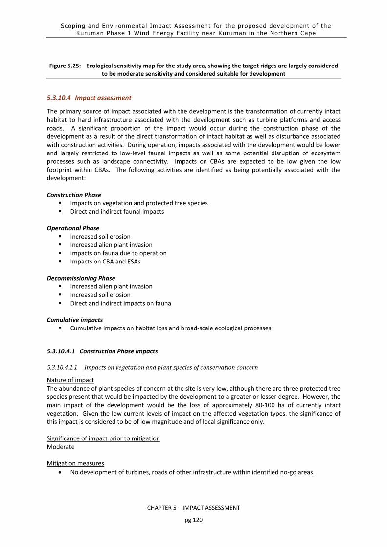
Scoping and Envi ronmenta l Impact Assessment for the proposed development of the
Kuruman Phase 1 Wind Energy Fac i l i ty near Kuruman in the Nor thern Cape
CHAPTER 5 – IMPACT ASSESSMENT
pg 120
Figure 5.25: Ecological sensitivity map for the study area, showing the target ridges are largely considered to be moderate sensitivity and considered suitable for development
5.3.10.4 Impact assessment
The primary source of impact associated with the development is the transformation of currently intact habitat to hard infrastructure associated with the development such as turbine platforms and access roads. A significant proportion of the impact would occur during the construction phase of the development as a result of the direct transformation of intact habitat as well as disturbance associated with construction activities. During operation, impacts associated with the development would be lower and largely restricted to low-level faunal impacts as well as some potential disruption of ecosystem processes such as landscape connectivity. Impacts on CBAs are expected to be low given the low footprint within CBAs. The following activities are identified as being potentially associated with the development: Construction Phase
Impacts on vegetation and protected tree species Direct and indirect faunal impacts
Operational Phase
Increased soil erosion Increased alien plant invasion Impacts on fauna due to operation Impacts on CBA and ESAs
Decommissioning Phase
Increased alien plant invasion Increased soil erosion Direct and indirect impacts on fauna
Cumulative impacts
Cumulative impacts on habitat loss and broad-scale ecological processes
5.3.10.4.1 Construction Phase impacts
5.3.10.4.1.1 Impacts on vegetation and plant species of conservation concern
Nature of impact The abundance of plant species of concern at the site is very low, although there are three protected tree species present that would be impacted by the development to a greater or lesser degree. However, the main impact of the development would be the loss of approximately 80-100 ha of currently intact vegetation. Given the low current levels of impact on the affected vegetation types, the significance of this impact is considered to be of low magnitude and of local significance only. Significance of impact prior to mitigation Moderate Mitigation measures
No development of turbines, roads of other infrastructure within identified no-go areas.

Scoping and Envi ronmenta l Impact Assessment for the proposed development of the
Kuruman Phase 1 Wind Energy Fac i l i ty near Kuruman in the Nor thern Cape
CHAPTER 5 – IMPACT ASSESSMENT
pg 121
Pre-construction walk-through of the development footprint to further refine the layout and further reduce impacts on sensitive habitats and protected species through micro-siting of the turbines and access roads.
Significance of impact post mitigation Low
5.3.10.4.1.2 Direct and indirect faunal impacts
The construction of the development will result in significant habitat loss, noise and disturbance on site. This will lead to direct and indirect disturbance of resident fauna. Some slow-moving or retiring species such as many reptiles would likely not be able to escape the construction machinery and would be killed. There are also several species present at the site which are vulnerable to poaching and there is a risk that these species may be targeted. This impact would be caused by the presence and operation of construction machinery and personnel on the site. This impact would however be transient and restricted to the construction phase, with significantly lower levels of disturbance during the operational phase. Significance of impact prior to mitigation Moderate Mitigation measures
Avoidance of identified areas of high fauna importance.
Search and rescue for reptiles and other vulnerable species during construction, before areas are cleared.
Limiting access to the site and ensuring that construction staff and machinery remain within the demarcated construction areas during the construction phase.
Environmental induction for all staff and contractors on-site.
Demarcate all areas to be cleared with construction tape or other appropriate and effective means. However caution should be exercised to avoid using material that might entangle fauna.
All construction vehicles should adhere to a low speed limit (40km/h for cars and 30km/h for trucks) to avoid collisions with susceptible species such as snakes and tortoises and rabbits or hares. Speed limits should apply within the facility as well as on the public gravel access roads to the site.
If any parts of site such as construction camps must be lit at night, this should be done with low-UV type lights (such as most LEDs) as far as practically possible, which do not attract insects and which should be directed downwards.
Initiate a monitoring programme for the Mountain Reedbuck on the site. This may take the form of structured counts, aerial surveys or camera traps set at designated sites.
Significance of impact post mitigation Moderate
5.3.10.4.2 Operational Phase Impacts
5.3.10.4.2.1 Increased Soil Erosion
The site has steep slopes and sandy soils that are vulnerable to erosion and the disturbance created during construction will increase erosion risk at the site. The access roads onto the ridges pose a particular risk and specific mitigation would be required to manage erosion risk in these vulnerable areas.

Scoping and Envi ronmenta l Impact Assessment for the proposed development of the
Kuruman Phase 1 Wind Energy Fac i l i ty near Kuruman in the Nor thern Cape
CHAPTER 5 – IMPACT ASSESSMENT
pg 122
Significance of impact prior to mitigation Moderate Mitigation measures
Avoiding areas of high erosion vulnerability as much as possible.
Using barriers, geotextiles, active rehabilitation and other measures during and after construction to minimise soil movement at the site.
Significance of impact post mitigation Low
5.3.10.4.2.2 Increased Alien Plant Invasion
There are already several alien species present on the site such as Prosopis glandulosa and disturbance created during construction would leave the site vulnerable to further alien plant invasion, especially along the access roads and other areas which receive additional run-off from the hardened surfaces of the development. Significance of impact prior to mitigation Moderate Mitigation measures
Alien management plan to be implemented during the operational phase of the development, which makes provision for regular alien clearing and monitoring.
Rehabilitation of disturbed areas that are not regularly used after construction. Significance of impact post mitigation Low
5.3.10.4.2.3 Operational Impacts on Fauna
Operational activities as well as the presence of the turbines and the noise they generate may deter some sensitive fauna from the area. In addition, the access roads may function to fragment the habitat for some fauna, which are either unable to or unwilling to traverse open areas. For some species this relates to predation risk as slow-moving species such as tortoises are vulnerable to predation by crows and other predators. In terms of habitat disruption, subterranean species such burrowing snakes and skinks are particularly vulnerable to this type of impact as they are unable to traverse the hardened roads or become very exposed to predation when doing so. This is a low-level continuous impact which could have significant cumulative impact on sensitive species. The majority of the site however consists of rocky terrain where this would have a minimal impact as the soils are already shallow and fragmented. Significance of impact prior to mitigation Moderate Mitigation measures
Open space management plan for the development, which makes provision for favourable management of the facility and the surrounding area for fauna.
Limiting access to the site to staff and contractors only.

Scoping and Envi ronmenta l Impact Assessment for the proposed development of the
Kuruman Phase 1 Wind Energy Fac i l i ty near Kuruman in the Nor thern Cape
CHAPTER 5 – IMPACT ASSESSMENT
pg 123
Appropriate design of roads and other infrastructure where appropriate to minimise faunal impacts and allow fauna to pass through or underneath these features.
No electrical fencing within 30cm of the ground as tortoises become stuck against such fences and are electrocuted to death.
If the site must be lit at night for security purposes, this should be done with downward-directed
low-UV type lights (such as most LEDs) as far as possible, which do not attract insects.
All vehicles should adhere to a low speed limit (max 40km/h) to avoid collisions with susceptible
species.
Annual monitoring of the on-site population of Mountain Reedbuck should be conducted and
reports submitted to DENC every 3-5 years.
Significance of impact post mitigation Low
5.3.10.4.2.4 Impacts on Critical Biodiversity Areas and ESAs
A part of the site is within a CBA 2 and the majority of the development footprint is within an Ecological Support Area. With mitigation, the wind energy facility is considered compatible with the role of the ESA and a long-term significant impact on CBAs and ESAs is not likely. As such impacts on CBA, ESAs and associated ecological processes are considered to be low. The major mitigation requires to reduce impacts on CBAs and ESAs to a low level is actually to ensure that the mitigation measures suggested for the other impacts are adhered to and well applied in the field as it is low overall impact of the development on the general environment that results in sustainable development and a consequent acceptable impact on the CBAs and ESAs of the area. Significance of impact prior to mitigation Moderate Mitigation measures
Minimise the development footprint as far as possible, which includes locating temporary-use areas such as construction camps and lay-down areas in previously disturbed areas.
Avoid impact to restricted and specialised habitats such as large rocky outcrops. Significance of impact post mitigation Low
5.3.10.4.3 Decommissioning Phase Impact
5.3.10.4.3.1 Increased Soil Erosion
As already described, the site has steep slopes that are vulnerable to erosion. Decommissioning will remove the hard infrastructure from the site, generating disturbance and leaving areas that are unvegetated and vulnerable to erosion. Significance of impact prior to mitigation Moderate Mitigation measures

Scoping and Envi ronmenta l Impact Assessment for the proposed development of the
Kuruman Phase 1 Wind Energy Fac i l i ty near Kuruman in the Nor thern Cape
CHAPTER 5 – IMPACT ASSESSMENT
pg 124
Revegetation of cleared areas with monitoring and follow-up to ensure that rehabilitation is successful.
Using net barriers, geotextiles, active rehabilitation and other measures during and after decommissioning to minimise sand movement at the site.
Significance of impact post mitigation Low
5.3.10.4.3.2 Increased Alien Plant Invasion
There are already some alien species present on the site such as Prosopis and disturbance created during decommissioning would leave the site vulnerable to further alien plant invasion. Significance of impact prior to mitigation Moderate Mitigation measures
Alien management plan to be implemented during the decommissioning phase of the development, which makes provision for regular alien clearing and monitoring for up 5 years after decommissioning.
Rehabilitation of disturbed areas that have been generated by decommissioning.
Due to the disturbance at the site alien plant species are likely to be a long-term problem at the site following decommissioning and regular control will need to be implemented until a cover of indigenous species has returned.
Regular monitoring for alien plants within the disturbed areas for at least two years after decommissioning or until alien invasives are no longer a problem at the site.
Regular alien clearing should be conducted using the best-practice methods for the species concerned. The use of herbicides should be avoided as far as possible.
Significance of impact post mitigation Low
5.3.10.4.4 Cumulative Impact
5.3.10.4.4.1 Cumulative habitat loss and impact on broad-scale ecological processes
There are several other renewable energy developments in the wider area and along with the current development, these would contribute to cumulative impacts on habitat loss and fragmentation and negative impact on broad-scale ecological processes such as dispersal and climate change resilience. However, not all of the developments in the area would impact on the same ridge habitat as the current development and overall, the current levels of cumulative development impact in the wider area is relatively low. Significance of impact prior to mitigation Moderate Mitigation measures
Minimise the current development footprint as much as possible and rehabilitate cleared areas after construction.
Ensure that management of the facility occurs in a biodiversity-conscious manner in accordance with an open-space management plan for the facility.

Scoping and Envi ronmenta l Impact Assessment for the proposed development of the
Kuruman Phase 1 Wind Energy Fac i l i ty near Kuruman in the Nor thern Cape
CHAPTER 5 – IMPACT ASSESSMENT
pg 125
Significance of impact post mitigation Low
Table 5.18: Terrestrial Impact Assessment Summary
Impact Before mitigation After mitigation Construction Phase
Impacts on vegetation and protected tree species Moderate Low
Direct and indirect faunal impacts Moderate Low
Operational Phase
Increased soil erosion Moderate Low
Increased alien plant invasion Moderate Low
Impacts on fauna due to operation Moderate Low
Impacts on CBA and ESAs Moderate Low
Decommissioning Phase
Increased alien plant invasion Moderate Low
Increased soil erosion Moderate Low
Direct and indirect impacts on fauna Moderate Low
Cumulative impact
Habitat loss and broad-scale ecological processes Moderate Low
5.3.10.5 Concluding statement
Overall, the Kuruman WEF site is considered to be an acceptable site for development of a wind energy facility and the impacts associated with the development are likely to be of low significance after mitigation. No impacts of broader consequence are likely to occur and as such, there do not appear to be any major issues or impacts that cannot be mitigated to a low level. From a terrestrial ecology perspective, the development can be supported.

Scoping and Envi ronmenta l Impact Assessment for the proposed development of the
Kuruman Phase 1 Wind Energy Fac i l i ty near Kuruman in the Nor thern Cape
CHAPTER 5 – IMPACT ASSESSMENT
pg 126
5.3.11 Bats
The Bat Impact Assessment was undertaken by Werner Marias from Animalia. It considers the 12 months of
passive bat data gathered by the long-term preconstruction assessment. The Bat Impact Asssessment for the
EIA Report serves to inform the project of the expected impacts, mitigation measures and a reasoned opinion
as to whether the proposed activity, or portions of the activity should be authorised
5.3.11.1 Approach and methodology
The study originally started in January 2016, when the two Short Mast systems was set up and a passive bat
detector was installed on Met Mast K1. The study was then put on hold until September 2016 by the
proponent, and it was put on hold again in December 2016. These months gathered some limited passive bat
activity data, but the systems encountered many problems, and some recording parameters were different
from current practices. Therefore, the data set from the 4th visit in May 2017 will be included in this
assessment. The study resumed in May 2017 with a site visit where all the passive systems were overhauled
and repaired (referred to as the 4th site visit) and will continue until May 2018 in order to have gathered a 12-
month data set.
Three factors need to be present for most South African bats to be prevalent in an area: availability of
roosting space, food (insects/arthropods or fruit), and accessible open water sources. However, the
dependence of a bat on each of these factors depends on the species, its behaviour and ecology.
Nevertheless, bat activity, abundance and diversity are likely to be higher in areas supporting all three above
mentioned factors.
Therefore, the site is evaluated by comparing the amount of surface rock (possible roosting space),
topography (influencing surface rock in most cases), vegetation (possible roosting spaces and foraging sites),
climate (can influence insect numbers and availability of fruit), and presence of surface water (influences
insects and acts as a source of drinking water) to identify bat species that may be impacted by wind turbines.
These comparisons are done chiefly by briefly studying the geographic literature of the site, available satellite
imagery and by groundtruthing with site visits. Species probability of occurrence based on the above-
mentioned factors are estimated for the site and the surrounding larger area, but also considers species
already confirmed on site as well as surrounding areas.
Bat activity is monitored using active and passive bat monitoring techniques. Active monitoring is carried out
on site visits by the means of driven transects. A bat detector mounted on a vehicle is used and transect
routes are chosen based on road accessibility. Sampling effort and prevalent weather conditions are
considered for each transect.
Passive detection is continuing by means of passive bat monitoring systems on the meteorological masts and
short masts on site. The data of the passive systems from both Kuruman Phases 1 and 2 was considered in
the EIA study report of each phase, as they are located in terrain and habitat applicable to both phases and
will provide insight into the terrain of both.
During each site visit the passive data of the bat activity are downloaded from the monitoring systems.

Scoping and Envi ronmenta l Impact Assessment for the proposed development of the
Kuruman Phase 1 Wind Energy Fac i l i ty near Kuruman in the Nor thern Cape
CHAPTER 5 – IMPACT ASSESSMENT
pg 127
The data is analysed by classifying (as near to species level as possible) and counting positive bat passes
detected by the systems. A bat pass is defined as a sequence of ≥1 echolocation calls where the duration of
each pulse is ≥2ms (one echolocation call can consist of numerous pulses). A new bat pass is identified by a
>500ms period between pulses. These bat passes are summed into hourly intervals which are used to
calculate nocturnal distribution patterns over time. Times of sunset and sunrise are automatically adjusted
with the time of year. Please refer to Table 1.1-1 of the Bat Impact Assessment for a summary of the
equipment setup.
5.3.11.2 Project aspects relevant to bat impacts
Although most bats are highly capable of advanced navigation through the use of echolocation and excellent sight, they are still at high risk of physical impact with the blades of wind turbines. The corpses of bats have been found in close proximity to wind turbines and, in a case study conducted by Johnson et al. (2003), were found to be directly related to collisions. Despite the high incidence of deaths caused by direct impact with the blades, many bat mortalities have been found to be caused by barotrauma (Baerwald et al. 2008). This is a condition where low air pressure found around the moving blades of wind turbines, causes the lungs of a bat to collapse, resulting in fatal internal haemorrhaging (Kunz et al. 2007). Baerwald et al. (2008) found that 90% of bat fatalities around wind turbines involved internal haemorrhaging consistent with barotrauma. The presence of lights on wind turbines have also been identified as possible causes for increased bat fatalities for non-cave roosting species. This is thought to be due to increased insect densities that are attracted to the lights and subsequently encourage foraging activity of bats (Johnson et al. 2003). South African operational monitoring studies currently point to South African bats being just as vulnerable to mortality from turbines as international studies have previously indicated. The main species of concern are Neoromicia capensis, Tadarida aegyptiaca and Miniopterus natalensis. These species roost in crevices and last-mentioned species in caves and other hollows. They will be foraging more actively in low-lying areas with less wind, as well as the slopes of hills that are well sheltered and rocky. Such as the ‘amphitheater’ topography found at some valley hill slopes on the site. There’s a marked decrease in bat activity with an increase of altitude on site (e.g. low-lying areas vs. hilltops), therefore larger turbines with a higher minimum rotor swept height will decrease the probability of bat mortalities due to moving blades.
5.3.11.3 Sensitivity of the site in relation to the proposed activity
Please refer to Sections 1.5.1 to 1.5.4 of the Bat Impact Assessment for a detailed description of the results of the field study that informed the environmental sensitivity map. As previously noted, unlike the other specialist assessments included in this EIA report, the Bat Impact Assessment considered the final layout (dated 21 September 2018) for the analysis. All other assessments were based on a draft layout dated July 2018. Figure 5.26 depicts the sensitive areas of the site, based on features identified to be important for foraging and roosting of the most prevalent species occurring on site, and which have the highest likelihood of being impacted on by the WEF (Table 5.19 and Table 5.20). Thus, the sensitivity map is based on species ecology and habitat preferences. This map can be used as a pre-construction mitigation in terms of improving turbine placement with regards to bat preferred habitats on site.

Scoping and Envi ronmenta l Impact Assessment for the proposed development of the
Kuruman Phase 1 Wind Energy Fac i l i ty near Kuruman in the Nor thern Cape
CHAPTER 5 – IMPACT ASSESSMENT
pg 128
The area marked as Non-permanent high bat sensitivity is an open water source from a man-made cement
dam. This feature will attract bats and is therefore treated as high sensitive, but it can also be relocated or
closed at its top and thereby be downgraded to Moderate or Low sensitivity.
Table 5.19: Description of parameters used in the construction of the sensitivity map.
Last revision 21 April 2018
High sensitivity
buffer 200m radial buffer
Moderate
sensitivity buffer
150m radial buffer on all Moderate sensitivities
Features used to
develop the
sensitivity map
Manmade structures, such as buildings, houses, barns and sheds. These
structures provide easily accessible roosting sites.
Altitude appears to play a significant role in bat activity levels on this site,
lower lying areas have therefore been deemed as sensitive.
The different vegetation types and landform. Valleys and slopes can offer airspace sheltered from wind for insect prey and subsequently attract insectivorous bats. Larger woody shrubs or small trees can offer similar sheltered airspace or offer some roosting spaces.
Open water sources, be it man-made farm dams or seasonal natural areas. They are important sources of drinking water and provide habitat that host insect prey.
Table 5.20: Description of sensitivity categories and their significance in the sensitivity map.
Sensitivity Description
Moderate Sensitivity and
its buffers
Areas of foraging habitat or roosting sites considered to have
significant roles for bat ecology. Turbines within these areas and
their buffers may acquire priority (not excluding all other turbines)
during post-construction studies, and in some instances, there is a
higher likelihood that mitigation measures may need to be applied
to them. Turbines in these areas may remain but are at a higher risk
of possible costly mitigations.

Scoping and Envi ronmenta l Impact Assessment for the proposed development of the
Kuruman Phase 1 Wind Energy Fac i l i ty near Kuruman in the Nor thern Cape
CHAPTER 5 – IMPACT ASSESSMENT
pg 129
High Sensitivity and its
buffers
Areas that are deemed critical for bat populations, capable of
elevated levels of bat activity and support greater bat
diversity/activity than the rest of the site. These areas are ‘no-go’
zones and turbines (including turbine blades) may not be placed in
these areas and their buffers.
Table 5.21 outlines the turbines that are located within bat sensitive areas and their respective
buffers. No turbines are proposed within high bat sensitivity areas and their respective buffers.
Table 5.21: Turbines located within bat sensitive areas and their buffers (including turbine blades), using the
21 September 2018 layout
Bat sensitive area Proposed turbine layout
High bat sensitivity area None
High bat sensitivity buffer None
Moderate bat sensitivity area None
Moderate bat sensitivity buffer Turbines 3, 4, 5, 6, 7, 14, 15, 20rev1, 21, 29rev3, 36,
40rev1, 4, 43rev2, 44rev2, 45, 46, 47rev1

Scoping and Envi ronmenta l Impact Assessment for the proposed development of the
Kuruman Phase 1 Wind Energy Fac i l i ty near Kuruman in the Nor thern Cape
CHAPTER 5 – IMPACT ASSESSMENT
pg 130
High bat sensitivity area High bat sensitivity buffer 200m
Non-permanent high bat sensitivity area Non-permanent high bat sensitivity buffer
Moderate bat sensitivity area Moderate bat sensitivity buffer 150m
Figure 5.26: Bat sensitivity map for the proposed Kuruman Phase 1 WEF.

Scoping and Envi ronmenta l Impact Assessment for the proposed development of the
Kuruman Phase 1 Wind Energy Fac i l i ty near Kuruman in the Nor thern Cape
CHAPTER 5 – IMPACT ASSESSMENT
pg 131
5.3.11.4 Impact assessment
The potential bat impact issues identified during the scoping phase of this EIA process include:
Destruction of foraging habitat.
Bat mortalities due to moving turbine blades (resident populations).
Bat mortalities due to moving turbine blades (migrating populations).
Indirect impact: Cave ecosystem collapse due to bat mortalities of cave dwelling bat populations.
Light pollution causing increased bat mortalities due to moving turbine blades.
Increased area of potential bat mortality impact by turbine blades, due to proposed neighbouring Kuruman Phase 2 WEF
5.3.11.4.1 Construction Phase impacts
5.3.11.4.1.1 Destruction of foraging habitat during infrastructure clearance and other related activities
Nature of impact During construction some very limited foraging habitat will inevitably be destroyed to clear ground for the WEF. Apart from the hardstands this includes roads, substations, laydown areas, etc. However, this impact is not considered to have a significant effect on bat populations due to the small overall area of vegetation cleared. Significance of impact prior to mitigation Low Mitigation measures
Adhere to the planned footprint areas and attempt to re-use all pathways and laydown/storage areas.
Significance of impact post mitigation Very low
5.3.11.4.2 Operational Phase Impacts
5.3.11.4.2.1 Bat mortalities due to moving turbine blades (resident populations)
Nature of impact Foraging bats can be killed by moving turbine blades, this happens either by direct impact or due to barotrauma (see section 1.3 of the Bat Impact Assessment report). Significance of impact prior to mitigation Moderate Mitigation measures
Keep turbines and turbine blades outside high sensitivity buffers and where needed reduce blade movement at selected turbines and high-risk bat activity times/weather conditions (curtailment).
Acoustic deterrents are developed well enough to be trailed with if needed.
An operational bat mortality study must be conducted during the first 2 years of the wind energy facility’s operation.
Significance of impact post mitigation

Scoping and Envi ronmenta l Impact Assessment for the proposed development of the
Kuruman Phase 1 Wind Energy Fac i l i ty near Kuruman in the Nor thern Cape
CHAPTER 5 – IMPACT ASSESSMENT
pg 132
Low
5.3.11.4.2.2 Bat mortalities due to moving turbine blades (migrating populations)
Nature of impact Migrating bats can be killed by moving turbine blades, this happens either by direct impact or due to barotrauma (see Section 1.3 of the Bat Impact Assessment). Significance of impact prior to mitigation Moderate Mitigation measures
See mitigation provided in 5.3.11.4.2.1. Significance of impact post mitigation Low
5.3.11.4.2.3 Indirect impact: Cave ecosystem collapse due to bat mortalities of cave dwelling bat
populations
Nature of impact Cave ecosystems can collapse if the resident bat colonies that inhabit caves are killed. This is due to the fact that the bat guano is the primary source of energy input into the cave ecosystem. Significance of impact prior to mitigation Moderate Mitigation measures
See mitigation provided in 5.3.11.4.2.1. Significance of impact post mitigation Low
5.3.11.4.2.4 Increased area of potential bat mortality impact by turbine blades, due to proposed
neighbouring Kuruman Phase 2 WEF
Nature of impact Foraging bats can be killed by moving turbine blades, this happens either by direct impact or due to barotrauma (see Section 1.3 of the Bat Impact Assessment Report). If more turbines are present in the area the likelihood of mortalities can increase. Significance of impact prior to mitigation Moderate Mitigation measures
Mitigations must be applied, when needed, for all phases of the Kuruman WEF’s and all turbine layout adjustments must respect sensitivity maps.
Where needed reduce blade movement at selected turbines and high-risk bat activity times/weather conditions (curtailment).
Acoustic deterrents are developed well enough to be trailed with if needed.

Scoping and Envi ronmenta l Impact Assessment for the proposed development of the
Kuruman Phase 1 Wind Energy Fac i l i ty near Kuruman in the Nor thern Cape
CHAPTER 5 – IMPACT ASSESSMENT
pg 133
An operational bat mortality study must be conducted during the first 2 years of the wind energy facility’s operation.
Significance of impact post mitigation Low
5.3.11.4.3 Cumulative Impact
Table 5.22: Bat Impact Assessment Summary
Impact Before mitigation After mitigation Construction Phase
Destruction of foraging habitat during infrastructure clearance and other related activities
Low Very low
Operational Phase
Bat mortalities due to moving turbine blades (resident populations)
Moderate Low
Bat mortalities due to moving turbine blades (migrating populations)
Moderate Low
Indirect impact: Cave ecosystem collapse due to bat mortalities of cave dwelling bat populations
Moderate Low
Light pollution causing increased bat mortalities due to moving turbine blades.
Moderate Low
Cumulative impact
Increased area of potential bat mortality impact by turbine blades, due to proposed neighbouring Kuruman Phase 2 WEF
Moderate Low
5.3.11.5 Concluding statement
If the recommend mitigation measures and the no-go, highly sensitive and buffer areas in the sensitivity map are adhered to, the specialist is of the opinion that the proposed Kuruman Phase 1 wind energy may be authorised.
5.4 Environmental sensitivity map
Based on the specialist studies undertaken and the results of the field studies, all features identified on site are shown in Figure 5.27. The respective features identified vary in sensitivity to the proposed development. The overall environmental sensitivity map for the site is shown in Figure 5.28. The sensitivities informed whether the Kuruman WEF layout may be developed within and/or close to these features. As noted previously, specialists were provided with a draft layout for inclusions in their studies (with the exception of the bat study that assessed the final layout), based on the Scoping Phase input received. The layout presented in Figure 5.29 below is considered the final layout and adheres to, inter alia, the following recommendations made within the specialist studies:

Scoping and Envi ronmenta l Impact Assessment for the proposed development of the
Kuruman Phase 1 Wind Energy Fac i l i ty near Kuruman in the Nor thern Cape
CHAPTER 5 – IMPACT ASSESSMENT
pg 134
Freshwater: the construction yard shown in Figure 5.12 must be moved outside the required 30 buffer.
Avifauna: The two turbines indicated in yellow in Figure 5.16 falls within the no-turbine zone and should be moved to outside the no-turbine zone. Other infrastructure is allowed within the high sensitivity areas.

Scoping and Environmental Impact Assessment for the proposed development of the Kuruman Phase 1 Wind Energy Facility near Kuruman in the Northern Cape
CHAPTER 5 – IMPACT ASSESSMENT
pg 5-135
Figure 5.27: Environmental feature map for the Kuruman WEF

Scoping and Environmental Impact Assessment for the proposed development of the Kuruman Phase 1 Wind Energy Facility near Kuruman in the Northern Cape
CHAPTER 5 – IMPACT ASSESSMENT
pg 5-136
Figure 5.28: Environmental sensitivity map for the Kuruman WEF

Scoping and Environmental Impact Assessment for the proposed development of the Kuruman Phase 1 Wind Energy Facility near Kuruman in the Northern Cape
CHAPTER 5 – IMPACT ASSESSMENT
pg 5-137
Figure 5.29: Environmental sensitivity map overlain with the final layout of the proposed Kuruman Phase 1 WEF


Scoping and Envi ronmenta l Impact Assessment for the proposed development of the
Kuruman Phase 1 Wind Energy Fac i l i ty near Kuruman in the Nor thern Cape
CHAPTER 6 - ENVIRONMENTAL IMPACT STATEMENT
pg 6-1
6. ENVIRONMENTAL IMPACT STATEMENT 6-3
6.1 Summary of the finding of the EIA 6-3
6.1.1 Freshwater assessment 6-5
6.1.2 Bird Impact Assessment 6-6
6.1.3 Visual Impact Assessment 6-7
6.1.4 Heritage Impact Assessment (including archaeology and palaeontology) 6-8
6.1.5 Soils and Agricultural Potential Assessment 6-9
6.1.6 Geohydrological Impact Assessment 6-9
6.1.7 Socio-Economic Impact Assessment 6-10
6.1.8 Noise Impact Assessment 6-11
6.1.9 Transportation Impact Assessment 6-12
6.1.10 Ecology Impact Assessment (Terrestrial Ecology including fauna and flora) 6-12
6.1.11 Bat Impact Assessment 6-14
6.2 Offset requirement 6-14
6.3 Preferred alternatives 6-16
6.4 Reasoned opinion of the EAP 6-18
Table 6.1: Project infrastructure proposed as part of the Kuruman WEF 6-3
Table 6.2: Freshwater impact assessment summary 6-5
Table 6.3: Avifaunal impact assessment summary 6-7
Table 6.4: Visual impact assessment summary 6-7
Table 6.5: Heritage impact assessment summary 6-8
Table 6.6: Agricultural and soils potential impact summary 6-9
Table 6.7: Geohydrological impact assessment summary 6-10
Table 6.8: Socio-economic impact assessment summary 6-11
Table 6.9: Noise impact assessment summary 6-12
Table 6.10. Transportation impact assessment summary 6-12
Table 6.11: Terrestrial Impact Assessment Summary 6-13
Table 6.12: Bats Impact Assessment Summary 6-14

Scoping and Envi ronmenta l Impact Assessment for the proposed development of the
Kuruman Phase 1 Wind Energy Fac i l i ty near Kuruman in the Nor thern Cape
CHAPTER 6 - ENVIRONMENTAL IMPACT STATEMENT
pg 6-2
Figure 6.1: Environmental sensitivity map overlain with the preferred layout of the Kuruman WEF 6-17

Scoping and Envi ronmenta l Impact Assessment for the proposed development of the
Kuruman Phase 1 Wind Energy Fac i l i ty near Kuruman in the Nor thern Cape
CHAPTER 6 - ENVIRONMENTAL IMPACT STATEMENT
pg 6-3
6. ENVIRONMENTAL IMPACT STATEMENT
This chapter is provides the Environmental Impact Statement as per Appendix 6 (3) (l) of the EIA Regulations, as amended. The Environmental Impact Statement has to be provided and must contain:
A summary of the finding of the EIA;
A map at an appropriate scale which superimposes the proposed activity and its associated structures and infrastructure on the environmental sensitivities of the preferred development footprint on the approved site as contemplated in the scoping report indicating areas that should be avoided (including buffers); and
A summary of the positive and negative impacts and risks of the proposed activity and identified alternatives.
In addition, this chapter provides a reasoned opinion as to whether the proposed activity should or should not be authorised, and if the opinion is that it should be authorised, any conditions that should be made in respect to that authorisation (Appendix 6 (3)(q).
6.1 Summary of the finding of the EIA
The proposed Kuruman WEF entails the development of wind turbines and associated infrastructure on farm portions located close to Kuruman, Northern Cape Province. Table 6.1 details the elements proposed and assessed as part of the Kuruman WEF.
Table 6.1: Project infrastructure proposed as part of the Kuruman WEF
Infrastructure Footprint and dimensions Location of the site District Municipality – John Taolo Gaetsewe District Municipality
Local Municipality - Ga-Segonyana Local Municipality
Ward number - 11
Farm names and SG 21 Digit Codes Portion 2 of Farm Carrington 440 (C04100000000044000002)
Portion 4 of Farm Carrington 440 (C04100000000044000004)
Portion 1 of Farm Hartland 381 (C04100000000038100001)
Farm Woodstock 441 (C04100000000044100000)
Farm Rossdale 382 (C04100000000038200000)
Number of turbines 20 - 47 turbines
Turbine Capacity 4.5 – 5.5 MW
Hub Height 80 - 140 m
Rotor Diameter 100 - 160 m
Blade length 50 - 80 m
Project Size 50 - 258 MW
Area occupied by on-site substation 2 ha
Height of substation 5 m
Capacity of on-site substation 132 kV
Area occupied by construction lay down areas (including construction camp)
4 ha (2 construction lay down areas required of 2 ha each)
Internal access roads 55 km of internal road linking a maximum of 47 turbine locations

Scoping and Envi ronmenta l Impact Assessment for the proposed development of the
Kuruman Phase 1 Wind Energy Fac i l i ty near Kuruman in the Nor thern Cape
CHAPTER 6 - ENVIRONMENTAL IMPACT STATEMENT
pg 6-4
Infrastructure Footprint and dimensions 8 m in width
O&M Building 1 ha
General temporary Hardstand Area (boom erection, storage, and assembly area)
15 ha
Turbines Reinforced Concrete Foundation – 20 x 20 m (0.04 ha per turbine) Crane Platform/Pad – 50 m x 50 m (0.25 ha)
Site Access The proposed main route will be along the R31 (Voortrekker Road) and the N14 (Hoof Street). The proposed Kuruman Phase 1 WEF can be accessed via the D3441. No existing access road currently exists along D3441 to the proposed WEF site. The proposed turbine and internal road layout indicates that the main access road to the WEF will be constructed on D3441, located to the east of the site, approximately 3 km from the N14. An additional option for access to the Phase 1 area would be via gravel road D3420, located south of the site and accessed via the R31. This is also the proposed access for the Kuruman Phase 2 WEF. This option, however, is dependent on the approval of Phase 2 in conjunction with Phase 1 and that the main access road of Phase 2 be constructed in advance.
Proximity to grid connection The proposed Kuruman WEF will link to the Moffat substation (10 km) or to the Segame substation (50 km) (connection not considered as part of this assessment.
Fencing Fencing will be required around the O&M Building and on-site substation and will be a maximum of 5 m high.
Following the Scoping Phase, a draft layout of the Kuruman WEF was provided to all specialists for considerations in their studies. Following this, a final preferred layout was determined which avoids the environmental sensitive features identified by the specialist (discussed in Section 6.2 below). It should be noted that all specialist studies adopted the precautionary approach whereby the worst case scenario was assumed for the proposed WEF. This include the maximum hub height of 140 m, turbine capacity of 5.5 MW, rotor diameter of 160 m and also the noisiest turbines, the Acciona AW125 3000 WTG (noise output: 108 dBA). This impact assessment outcome is therefore considered to be the worst case scenario for this development but also provides flexibility to the Developer, with the specifications provided in the table above, to select the best turbine technology available in the market, once the project reaches the design phase. Therefore, during detailed design, a turbine with a hub height between 80 -140 m, capacity between 4.5- 5.5 MW, rotor diameter between 100 - 160 m and lower noise output than 108 dBA, is considered to have been assessed and should authorisation be granted, be deemed acceptable for this development. However, should a turbine be selected that is not within the ranges provided above or that has a higher noise output, then the necessary assessments should be undertaken to determine whether the outcomes of this EIA assessment will change. Any such change can then be considered as an amendment to this EIA report. A summary of the specialist studies have been included in Chapter 5 of this report. The key conclusion and impact assessment summary prior to and following mitigation, as outlined within each specialist study, are discussed below.

Scoping and Envi ronmenta l Impact Assessment for the proposed development of the
Kuruman Phase 1 Wind Energy Fac i l i ty near Kuruman in the Nor thern Cape
CHAPTER 6 - ENVIRONMENTAL IMPACT STATEMENT
pg 6-5
6.1.1 Freshwater assessment
The study area is associated with multiple ephemeral drainage lines. The current impact to these features is largely limited to erosion as a result of increased grazing pressure and the development of access roads and fence lines through the features. The drainage lines were therefore calculated to fall within PES Categories A (unmodified, natural) and C (moderately modified). Although the ephemeral drainage lines calculated an overall low EIS score and are considered to be of low sensitivity in terms of water yield and quality, these features do still provide valuable functions such as attenuation of floodwaters and retention of excess sediments. The unnecessary disturbance of these drainage lines must therefore be avoided, and buffer areas of 30m have been applied to the features wherein only essential activities should be allowed during construction or upgrading of roads and placement of distribution lines. Prior to the implementation of mitigation measures, impacts associated with the proposed development activities were calculated to be of a low to moderate (negative) significance (Table 6.2). However, with the effective implementation of the mitigation measures as provided, it is the opinion of the freshwater specialist that all impacts may be reduced to very low and low (negative) significances. It is therefore the opinion of the freshwater specialist that authorisation be granted for the proposed development. It should however be noted that an application for an Environmental Authorisation in terms of the NEMA EIA Regulations (2014, amended in 2017) will be required as proposed development related activities will occur within 32m of a watercourse. Furthermore, the proposed development will require authorisation from the DWS in terms of Section 21 (c) and (i) of the NWA. Key mitigation measures include:
If possible, crossing areas should be developed at 90 degree angles to ephemeral drainage lines in order to limit the area of disturbance;
A maximum construction working servitude of 3m should be allowed to either side of ephemeral drainage line crossing areas;
Make use of existing access roads where possible and any turning areas required must be located outside of the buffer zone;
Where widening of existing access roads located adjacent to ephemeral drainage lines is required, widening must take place on the opposite side of the existing road to the drainage line only;
Appoint an Environmental Control Officer (ECO) to inspect the crossings on a weekly basis (at least) and take measures to address unforeseen disturbances to the ephemeral drainage lines;
Revegetate disturbed areas above distribution lines with vegetation assemblages reflecting the general species composition of the area as soon as possible after the application of topsoil. A botanical specialist should advise on appropriate species to be utilized during revegetation.
Table 6.2: Freshwater impact assessment summary
Impact Before mitigation After mitigation Construction Phase
Disturbance of drainage lines Moderate Low
Alteration of flow patterns Moderate Low
Impairment of water quality Moderate Very Low
Operational Phase
Degradation of drainage lines Moderate Low
Alteration of natural hydrological regime Moderate Low
Decommissioning Phase

Scoping and Envi ronmenta l Impact Assessment for the proposed development of the
Kuruman Phase 1 Wind Energy Fac i l i ty near Kuruman in the Nor thern Cape
CHAPTER 6 - ENVIRONMENTAL IMPACT STATEMENT
pg 6-6
Degradation of drainage lines Moderate Low
Impairment of water quality Low Very Low
Cumulative impact
Proliferation of alien and invasive species and erosion of drainage lines
Low Low
6.1.2 Bird Impact Assessment
An estimated 201 species could potentially occur in the study area, of which 133 were recorded at the WEF development area during pre-construction monitoring. Of the 201 species that could occur at the site, 17 are classified as priority species for wind farm developments. The results of the transect counts indicate a moderate diversity of avifauna at both the WEF development area and the control site. While this is to be expected to some extent of a fairly arid area such as this, the very low numbers or absence of some species e.g. Northern Black Korhaan is an indication that the avian populations might be under pressure from external factors, e.g. hunting. Flight activity of priority species at the WEF development area was also very low, with a passage rate of 0.05 birds/hour. It is anticipated that the proposed Kuruman Phase 1 WEF will have a moderate impact on priority avifauna (Table 6.3). Key mitigation measures include:
Maximum use should be made of existing access roads and the construction of new roads should be kept to a minimum.
Following construction, rehabilitation of all areas disturbed (e.g. temporary access tracks and laydown areas) must be undertaken and to this end a habitat restoration plan is to be developed by a rehabilitation specialist.
The appointed Environmental Control Officer (ECO) should be trained by an avifaunal specialist to identify the signs that indicate possible breeding by priority species. The ECO must then, during audits/site visits, make a concerted effort to look out for such breeding activities of such species, and such efforts may include the training of construction staff to identify such species, followed by regular questioning of staff as to the regular whereabouts on site of the species. If any priority species are confirmed to be breeding (e.g. if a nest site is found), construction activities within 500m of the breeding site must cease, and the avifaunal specialist will be contacted immediately for further assessment of the situation and instruction on how to proceed.
A 100m no-turbine set-back buffer zone (other infrastructure is allowed) is recommended around selected ridge edges to minimise the risk of collisions for slope soaring species.
Care should be taken not to create habitat for prey species that could draw Verreaux’s Eagles into the area and expose them to collision risk. Rock piles must be removed from site or covered with topsoil to prevent them from becoming habitat for Rock Hyrax.
The avifaunal specialist, in consultation with external experts and relevant NGOs such as BLSA, should determine annual mortality thresholds for priority species anticipated to be at risk of collision mortality, prior to the wind farm going operational.
Once the turbines have been constructed, operational monitoring should be implemented to record actual collision rates.
If actual collision rates approach the pre-determined threshold levels, curtailment of turbines should be implemented for high risk turbines.
In the event of a massive influx of Lesser Kestrels due to an irruption of insects, pro-active curtailment must be implemented under the guidance of the avifaunal specialist. A site-specific

Scoping and Envi ronmenta l Impact Assessment for the proposed development of the
Kuruman Phase 1 Wind Energy Fac i l i ty near Kuruman in the Nor thern Cape
CHAPTER 6 - ENVIRONMENTAL IMPACT STATEMENT
pg 6-7
regime must be designed in consultation with the wind farm operator which will specify the duration of the curtailment period as well as the specific time of the day when the turbines will be curtailed.
It is our opinion that the proposed development be approved, subject to the strict implementation of the proposed mitigation measures detailed in this avifaunal impact assessment report.
Table 6.3: Avifaunal impact assessment summary
Impact Before mitigation After mitigation Construction Phase
Displacement of priority species due to habitat transformation
Moderate Moderate
Displacement of priority species due to disturbance associated with the construction activities
Moderate Low
Operational Phase
Mortality of priority species due to collisions with the turbines
Moderate Low
Decommissioning Phase
Displacement of priority species due to disturbance associated with the decommissioning activities
Moderate Low
Cumulative impact
Primarily displacement of priority species due to habitat transformation
Moderate Moderate
Mortality due to collisions with the wind turbines Moderate Low
6.1.3 Visual Impact Assessment
From a visual impact perspective, only three (3) visually sensitive receptors with tourism significance have been identified within the study area. A total number of thirty-seven (37) potentially sensitive visual receptors were however identified. These included scattered farmsteads / homesteads which house the local farmers as well as their farm workers. These dwellings are regarded as potentially sensitive visual receptors as they are located within a mostly rural setting and the proposed development will likely alter natural vistas experienced from these dwellings. SiVEST is of the opinion that the impacts associated with the construction and operation phases can be mitigated to acceptable levels provided the recommended mitigation measures are implemented (Table 6.4). Key mitigation measures include:
No turbines should be placed within 500m of the N14 national road and R31 main road.
Light fittings for security at night should reflect the light toward the ground and prevent light spill.
Where practically possible, the operation and maintenance buildings should not be illuminated at night.
It is SiVEST’s opinion that the visual impacts identified in this VIA are not significant enough to prevent the project from proceeding and that an EA should be granted.
Table 6.4: Visual impact assessment summary

Scoping and Envi ronmenta l Impact Assessment for the proposed development of the
Kuruman Phase 1 Wind Energy Fac i l i ty near Kuruman in the Nor thern Cape
CHAPTER 6 - ENVIRONMENTAL IMPACT STATEMENT
pg 6-8
Impact Before mitigation After mitigation Construction Phase
Visual intrusion and dust emissions Moderate Low
Operational Phase
Visual intrusion, dust emissions and light pollution and glare
Moderate Moderate
Decommissioning Phase
Visual intrusion and dust emissions Moderate Low
Cumulative impact
Visual intrusion and dust emissions Moderate Moderate
Visual intrusion, dust emission and light pollution and glare Moderate Moderate
6.1.4 Heritage Impact Assessment ( including archaeology and palaeontology)
The study site for the proposed Kuruman Phase 1 WEF (i.e. turbine location sites, access roads, substations, laydown areas) is not a sensitive archaeological landscape. Given the overall low palaeosensitivity of the proposed footprint, it is concluded that in terms of palaeontological heritage resources the impact significance of the Kuruman WEF Phase 1 is low (Table 6.5). Key mitigation measures include:
Careful mapping and avoidance of identified heritage resources
The implementation of a Heritage Conservation Management Plan for the Rock Art, significant archaeological sites, palaeontological sites, burial grounds and historic farm werfs identified to ensure that heritage resources are continuously managed throughout the construction, operational and decommissioning phases.
There is no heritage objection to the proposed development proceeding on condition that the proposed recommendations and mitigation measures are implemented.
Table 6.5: Heritage impact assessment summary
Impact Before mitigation After mitigation Construction Phase
Destruction of heritage resources including archaeology palaeontology and cultural landscape resources and burial grounds and graves, and sacred spaces
Moderate Low
Operational Phase
Destruction of heritage resources including archaeology palaeontology and cultural landscape resources and burial grounds and graves, and sacred spaces
Moderate Low
Decommissioning Phase
Destruction of heritage resources including archaeology palaeontology and cultural landscape resources and burial grounds and graves, and sacred spaces
Moderate Low
Cumulative impact
Destruction of heritage resources including archaeology palaeontology and cultural landscape
Moderate Low

Scoping and Envi ronmenta l Impact Assessment for the proposed development of the
Kuruman Phase 1 Wind Energy Fac i l i ty near Kuruman in the Nor thern Cape
CHAPTER 6 - ENVIRONMENTAL IMPACT STATEMENT
pg 6-9
resources and burial grounds and graves, and sacred spaces
6.1.5 Soils and Agricultural Potential Assessment
The significance of all agricultural impacts is low due to two important factors. Firstly, the actual footprint of disturbance of the wind farm (including associated infrastructure and roads) is very small in relation to the available grazing land on the effected farm portions (<2% of the surface area). All agricultural activities will be able to continue unaffectedly on all parts of the farm other than the small development footprint for the duration of and after the project. Secondly, the proposed site is on land of limited agricultural potential that is only viable for grazing. These two factors also mean that cumulative regional effects as a result of other surrounding developments, also have low significance. There are no agriculturally sensitive areas that need to be avoided by the development. Due to the low agricultural potential of the site, and the consequent low agricultural impact (Table 6.6), there are no restrictions relating to agriculture which preclude authorisation of the proposed development and therefore, from an agricultural impact point of view, the development should be authorised.
Table 6.6: Agricultural and soils potential impact summary
Impact Before mitigation After mitigation Construction Phase
Loss of agricultural land use Low Not applicable
Erosion Very low Very low
Loss of topsoil Very low Very low
Degradation of veld vegetation Very Low Very Low
Operational Phase
Loss of agricultural land use Very low Not applicable
Erosion Very low Very low
Additional land use income Low (+) Not applicable
Decommissioning Phase
Loss of agricultural land use Low Not applicable
Erosion Very low Very low
Loss of topsoil Very low Very low
Degradation of veld vegetation Very Low Very Low
Cumulative impact
Regional loss of agricultural land Low (+) Not applicable
6.1.6 Geohydrological Impact Assessment
The groundwater vulnerability rating is low for the main portion of the study area, including where all the facilities are to be constructed. The dolomitic area the groundwater vulnerability is high – however no facilities are to be constructed in this area.
The water requirements for the Kuruman WEF can be met by using groundwater. If existing or new boreholes are to be used for the Kuruman WEF, they should be yield tested and sampled so that proper borehole management can be implemented and to ensure the groundwater is safe for consumption. The samples should be analysed for the chemical and microbiological content and the presence of asbestos also screened for.

Scoping and Envi ronmenta l Impact Assessment for the proposed development of the
Kuruman Phase 1 Wind Energy Fac i l i ty near Kuruman in the Nor thern Cape
CHAPTER 6 - ENVIRONMENTAL IMPACT STATEMENT
pg 6-10
With regard to the potential impacts – it must be ensured the groundwater use is sustainable and authorised. Attention needs to be given to the storm water run-off as the extent of hardened and impermeable surfaces will be increased, thus increasing the run-off to above natural conditions. It is highly unlikely the proposed Kuruman WEF will impact on the groundwater resources of the site, especially if all safety and preventative measures are put in place (Table 6.7). Key mitigation measures include:
A precautionary approach must be implemented and reasonable measures must be undertaken to prevent oil spillages and fuel leakages from occurring.
A designated area should be established at the construction site camp for this purpose, if off-site refuelling is not possible.
Annually assess the groundwater quality from the production borehole/s and inspect the site to ensure the stormwater run-off is not resulting in erosion channels.
Adhere to the borehole’s safe yield and to monitor water levels and flow
If existing or new boreholes are to be used for the Kuruman WEF, they should be yield tested and sampled so that proper borehole management can be implemented and to ensure the groundwater is safe for consumption. The samples should be analysed for the chemical and microbiological content and the presence of asbestos also screened for.
From a groundwater perspective the Kuruman WEF can proceed.
Table 6.7: Geohydrological impact assessment summary
Impact Before mitigation After mitigation Construction and Decommissioning Phases
Groundwater impact as a result of groundwater abstraction
Low Very low
All Phases
Groundwater impact as a result of increased storm water outflows
Low Very low
Potential Impact on Groundwater Quality as a result of Accidental Oil Spillages or Fuel Leakages
Low Very low
6.1.7 Socio-Economic Impact Assessment
The net effect of the proposed project is positive (Table 6.8) as it ultimately leads to improved energy supply, increased energy security and indicates a path towards clean energy generation, which the country is in need of to curb climate change. This subsequently contributes to improved service delivery and socio-economic development. To improve the positive impact particularly for the local municipality, it is highly recommended that local procurement and employment is concentrated herein, as far as is feasible. Key mitigation measures include:
Manage recruitment process to control expectations and unnecessary in-migration. Ongoing consultation should be undertaken with the local government to effectively plan for the influx.
Adequate education for workers on the dangers of substance abuse.
Implement controlled access to project site and monitor activity in immediate surrounding sites.

Scoping and Envi ronmenta l Impact Assessment for the proposed development of the
Kuruman Phase 1 Wind Energy Fac i l i ty near Kuruman in the Nor thern Cape
CHAPTER 6 - ENVIRONMENTAL IMPACT STATEMENT
pg 6-11
Set up local community safety forum. Undertake a health risks assessment to quantify the potential risks associated with the possible pollution of the site by asbestos; Formulation of an adequate safety and health plan for the employees working on site.
From a socio-economic perspective therefore, no objections are made with regard to the proposed project.
Table 6.8: Socio-economic impact assessment summary
Impact Before mitigation After mitigation Construction Phase
Increase in production and GDP-R High (+) High (+)
Temporary employment creation Low (+) Low (+)
Skills development and enhancement Low (+) Moderate (+)
Household income attainment Low (+) Low (+)
Increased demand for housing, services and social facilities
Low Very Low
Increase in theft related crimes Moderate Low
Potential health risks for employees due to asbestos prevalence
Very low Very low
Increase in government revenue Low (+) Low (+)
Operational Phase
Increase in production and GDP-R Moderate (+) Moderate (+)
Long term employment creation Very Low (+) Very Low (+)
Skills development and enhancement Very low (+) Very low (+)
Household income attainment Very low (+) Very low (+)
Decommissioning Phase
Local Economy stimulation and job creation Very low (+) Very low (+)
Cumulative impact
Influx of job seekers and migrant labour causing pressure on local government service provision
Moderate Low
Employment creation High (+) High(+)
Stimulation of Economy High (+) High (+)
6.1.8 Noise Impact Assessment
The various activities associated with the development of the WEF may have a slight impact on ambient sound levels. This increase is of low significance (Table 6.9) and it is recommended that the development of the Kuruman Phase 1 WEF be authorised from a noise perspective. Because of the low significance of a potential noise impact during all phases of this development, no specific monitoring or management measures are required for inclusion into the EMPr.

Scoping and Envi ronmenta l Impact Assessment for the proposed development of the
Kuruman Phase 1 Wind Energy Fac i l i ty near Kuruman in the Nor thern Cape
CHAPTER 6 - ENVIRONMENTAL IMPACT STATEMENT
pg 6-12
Table 6.9: Noise impact assessment summary
Impact Before mitigation After mitigation Construction Phase
Increase in ambient sound levels Very Low Very Low
Operational Phase
Increase in ambient sound levels as result of operational wind turbines at night
Very Low Very Low
Decommissioning Phase
Increase in ambient sound levels Very Low Very Low
Cumulative impact
Increase in ambient sound levels Low Low
6.1.9 Transportation Impact Assessment
The main transport impacts will be during the construction and decommissioning phases of a WEF where the delivery of the turbine components, construction and decommissioning of the WEF infrastructure will generate significant traffic (Table 6.10). Key mitigation measures include:
Design and maintenance of internal roads. The internal gravel roads will require grading with a road grader to obtain a flat even surface and the geometric design of these gravel roads needs to be confirmed at detailed design stage. This process is to be undertaken by a civil engineering consultant or a geometric design professional. Geometric design constraints might be encountered due to the rolling, hilly topography of the area. The road designer should take cognizance that the turbines are to be positioned at the top of the hills, therefore roads need to be designed with smooth, relatively flat gradients to allow an abnormal load vehicle to ascend to the top of the hill.
The duration of these phases is short term i.e. the impact of the WEF traffic on the surrounding road network is temporary and WEFs, when operational, do not add any significant traffic to the road network.
Table 6.10. Transportation impact assessment summary
Impact Before mitigation After mitigation Construction Phase
Traffic congestion and delays Moderate Moderate
Decommissioning Phase
Traffic congestion and delays Moderate Moderate
Cumulative impact
Traffic congestion and delays Moderate Moderate
6.1.10 Ecology Impact Assessment (Terrestrial Ecology including fauna and flora)
The slopes of the ridges are considered high sensitivity as a result of their vulnerability to disturbance and erosion as well as the higher ecological value of these areas on account of their higher faunal and botanical diversity. The low-lying plains are considered to be low sensitivity, while the plateau and ridge-top habitats are considered to be moderate sensitivity. The turbines are restricted to the upper slopes

Scoping and Envi ronmenta l Impact Assessment for the proposed development of the
Kuruman Phase 1 Wind Energy Fac i l i ty near Kuruman in the Nor thern Cape
CHAPTER 6 - ENVIRONMENTAL IMPACT STATEMENT
pg 6-13
and hill-top plateaus within areas classified as moderate sensitivity. These areas are considered acceptable for turbine placement and would generate relatively low impacts. Some of the access roads traverse high sensitivity slope areas. This is however usually along existing road alignments and is also unavoidable to access the target ridges. With the appropriate erosion control features, the access roads will generate a relatively low impact and are considered to be acceptable. Overall, the Kuruman WEF site is considered to be an acceptable site for development of a wind energy facility and the impacts associated with the development are likely to be of moderate to low significance after mitigation (Table 6.11). Key mitigation measures include:
No development of turbines, roads of other infrastructure within identified no-go areas (i.e areas of high sensitivity).
Pre-construction walk-through of the development footprint to further refine the layout and further reduce impacts on sensitive habitats and protected species through micro-siting of the turbines and access roads.
Demarcate all areas to be cleared with construction tape or other appropriate and effective means. However caution should be exercised to avoid using material that might entangle fauna.
Search and rescue for reptiles and other vulnerable species during construction, before areas are cleared.
Limiting access to the site and ensuring that construction staff and machinery remain within the demarcated construction areas during the construction phase.
Environmental induction for all staff and contractors on-site.
Initiate a monitoring programme for the Mountain Reedbuck on the site. This may take the form of structured counts, aerial surveys or camera traps set at designated sites.
All construction vehicles should adhere to a low speed limit (40km/h for cars and 30km/h for trucks) to avoid collisions with susceptible species such as snakes and tortoises and rabbits or hares. Speed limits should apply within the facility as well as on the public gravel access roads to the site.
During the operational phase, annual monitoring of the on-site population of Mountain
Reedbuck should be conducted and reports submitted to DENC every 3-5 years.
No impacts of broader consequence are likely to occur and as such, there do not appear to be any major issues or impacts that cannot be mitigated to a low level. From a terrestrial ecology perspective, the development can be supported.
Table 6.11: Terrestrial Impact Assessment Summary
Impact Before mitigation After mitigation Construction Phase
Impacts on vegetation and protected tree species Moderate Low
Direct and indirect faunal impacts Moderate Low
Operational Phase
Increased soil erosion Moderate Low
Increased alien plant invasion Moderate Low
Impacts on fauna due to operation Moderate Low
Impacts on CBA and ESAs Moderate Low
Decommissioning Phase
Increased alien plant invasion Moderate Low
Increased soil erosion Moderate Low

Scoping and Envi ronmenta l Impact Assessment for the proposed development of the
Kuruman Phase 1 Wind Energy Fac i l i ty near Kuruman in the Nor thern Cape
CHAPTER 6 - ENVIRONMENTAL IMPACT STATEMENT
pg 6-14
Direct and indirect impacts on fauna Moderate Low
Cumulative impact
Habitat loss and broad-scale ecological processes Moderate Low
6.1.11 Bat Impact Assessment
The preconstruction bat monitoring study concluded in May 2018 and informs this Bat Impact Assessment for the EIA report. The passive data indicate that three bat species are most likely to be impacted on by the proposed WEF are Neoromicia capensis, Tadarida aegyptiaca and Miniopterus natalensis. These more abundant species are of a large value to the local ecosystems as they provide a greater contribution to most ecological services than the rarer species, due to their higher numbers. A sensitivity map was drawn up indicating potential roosting and foraging areas. The High Bat Sensitivity areas are expected to have elevated levels of bat activity and support greater bat diversity. High Bat Sensitivity areas and their buffers are ‘no – go’ areas due to expected elevated rates of bat fatalities due to wind turbines. No turbines or turbine blades are within high sensitivities or high sensitivity buffers. The overall impact significance, following mitigation is considered to be low (Table 6.12). Key mitigation measures:
Keep turbines and turbine blades outside high sensitivity buffers and where needed reduce blade movement at selected turbines and high-risk bat activity times/weather conditions (curtailment).
Acoustic deterrents are developed well enough to be trailed with if needed.
An operational bat mortality study must be conducted during the first 2 years of the wind energy facility’s operation.
If the recommend mitigation measures and the no-go, highly sensitive and buffer areas in the sensitivity map are adhered to, the specialist is of the opinion that the proposed Kuruman Phase 1 wind energy may be authorised.
Table 6.12: Bats Impact Assessment Summary
Impact Before mitigation After mitigation Construction Phase
Destruction of foraging habitat during infrastructure clearance and other related activities
Low Very low
Operational Phase
Bat mortalities due to moving turbine blades (resident populations)
Moderate Low
Bat mortalities due to moving turbine blades (migrating populations)
Moderate Low
Indirect impact: Cave ecosystem collapse due to bat mortalities of cave dwelling bat populations
Moderate Low
Light pollution causing increased bat mortalities due to moving turbine blades.
Moderate Low
Cumulative impact
Increased area of potential bat mortality impact by turbine blades, due to proposed neighbouring Kuruman Phase 2 WEF
Moderate Low
6.2 Offset requirement

Scoping and Envi ronmenta l Impact Assessment for the proposed development of the
Kuruman Phase 1 Wind Energy Fac i l i ty near Kuruman in the Nor thern Cape
CHAPTER 6 - ENVIRONMENTAL IMPACT STATEMENT
pg 6-15
As per the comments received from DENC regarding the need for an offset study, Ekotrust
undertook an analysis on whether an offset would viable and fit for purpose. DENC’s requirement
included that “If the development should proceed as is, an offset is proposed to compensate for the
irreversible loss of habitat of the endangered mountain reedbuck, the loss in Kuruman Mountain
Bushveld with its small range and no formal protection status, the fragmentation of the KMB and
hindering of ecosystem functions and processes as well as the loss in bird and bat habitat and entities.”
Ekotrust indicated that based on the information presented in their study (included in Appendix E of this
report), the proposal for a biodiversity offset is reconsidered based on the following reasons:
Kuruman Mountain Bushveld (KMB):
Although the proposed Kuruman WEF will cause irreversible loss of vegetation of the KMB, the
loss will be less than 200 ha (it is estimated at 0.03% of the vegetation unit).
The status of the KBM is Least Threatened with >98% of the original extent remaining. Offsets
are required mainly for threatened ecosystems which are, by definition, fragmented and severely
reduced in extent and not for Least Threatened ecosystems.
The absence of a CBA within the development footprint, with the exception of the one batching
plant. With appropriate mitigation, the development of the WEF is considered compatible with
the aims and objectives of ESAs, at least from a terrestrial ecological point of view.
The WEF infrastructure will dissect the KMB, but this will not constitute habitat fragmentation
and is unlikely to disrupt ecosystem process and functions in the vegetation type.
The KMB was not considered as a priority in the NCPAES.
The impact on plant SCCs is minimal because of the lack of threatened plant species on site.
The presence of protected tree species on the footprint of the development should be
determined and the necessary authorisation should be obtained to deal with these trees.
Southern mountain reedbuck:
Based on the known distribution and habitat preference of southern mountain reedbuck for
steep slopes and some woody cover, the habitat on site seems to be marginal.
Because the development is centred on the crests of the hills and there will be minimal loss of
habitat on the slopes of the hills, it seems that the survival of the mountain reedbuck should not
be compromised.
Translocation success of the southern mountain reedbuck is low and caution should be used
when using translocation as a conservation measure for this species. This therefore precludes the
option of acquiring a biodiversity offset area and translocating the mountain reedbuck to that
area.
There will be minimal overlap of habitat between the WEF and the mountain reedbuck.
Mountain reedbuck will however be temporarily disrupted during the construction phase.
The development of an open space management plan, which makes provision for the
favourable management of the facility and the surrounding area for fauna (see mitigation
measures in reports Todd 2018a & B) is essential.
Bird and bat habitat:

Scoping and Envi ronmenta l Impact Assessment for the proposed development of the
Kuruman Phase 1 Wind Energy Fac i l i ty near Kuruman in the Nor thern Cape
CHAPTER 6 - ENVIRONMENTAL IMPACT STATEMENT
pg 6-16
The impacts of the WEF on both bird and bat components were evaluated as very
low/low/moderate after mitigation and the requirement of a biodiversity offset on the part of
these components does therefore not seem to be warranted.
6.3 Preferred alternatives
Based on the outcomes of the alternative assessment included in the Scoping Report (CSIR, 2018), the preferred activity and technology on site was determined to be the generation of electricity through a renewable energy resource using wind technology. The preferred activity and technology is proposed on the preferred site that consists of six farm portions, namely the:
Remainder (RE) of Rossdale Farm 382; Portion 1 of Hartland Farm 381; Portion 2 of Hartland Farm 381, Portion 2 of Carrington Farm 440; Portion 4 of Carrington Farm 440; and RE of Woodstock Farm 441.
The determination of the development footprint within the preferred site was determined through a screening assessment of the site by the specialist team and consultation with the landowners to identify possible areas that should not be proposed for the development (i.e. exclusion zones). The determination of the development footprint within the preferred site was concluded as part of the Scoping process. The proposed development footprint of the proposed Kuruman WEF is approximately 64 ha. As previously noted, the specialists were provided with a draft layout within the development footprint to consider as part of their assessments. Following the outcome of the assessments, various specialists made recommendations in terms of layout amendments. These include the freshwater specialist indicating that one of the construction yards must be moved to ensure avoidance of the drainage line and the avifaunal specialist recommendation the movement of two turbines to avoid high avifaunal sensitive areas. These recommendations have been incorporated into the layout. The preferred layout for this facility is shown below (Figure 6.1). It should be noted that based on the scale at which the layout is presented, some of the proposed turbines may seem to be located within areas that were identified as having a high sensitivity. However, on a smaller scale, all turbines are located outside of high sensitivity areas and only the supporting infrastructure occurs within these high sensitivity areas. This is in line with the findings of the avifaunal, terrestrial ecology and freshwater specialists assessments that indicated that supporting infrastructure may be located within areas of high sensitivity but not turbines may be located within these areas.

Scoping and Envi ronmenta l Impact Assessment for the proposed development of the
Kuruman Phase 1 Wind Energy Fac i l i ty near Kuruman in the Nor thern Cape
CHAPTER 6 - ENVIRONMENTAL IMPACT STATEMENT
pg 6-17
Figure 6.1: Environmental sensitivity map overlain with the preferred layout of the Kuruman WEF

Scoping and Envi ronmenta l Impact Assessment for the proposed development of the
Kuruman Phase 1 Wind Energy Fac i l i ty near Kuruman in the Nor thern Cape
CHAPTER 6 - ENVIRONMENTAL IMPACT STATEMENT
pg 6-18
6.4 Reasoned opinion of the EAP
This EIA Report investigated and assessed the significance of potential positive and negative direct, indirect and cumulative impacts associated with the proposed Kuruman WEF. The EAP considers the information provided in this report as sufficient to enable the DEA to make an informed decision on the application for EA. Section 24 of the Constitutional Act states that “everyone has the right to an environment that is not harmful to their health or well-being and to have the environment protected, for the benefit of present and future generations, through reasonable legislative and other measures, that prevents pollution and ecological degradation; promotes conservation; and secures ecologically sustainable development and use of natural resources while promoting justifiable economic and social development.” Based on this, this EIA was undertaken to ensure that these principles are met through the inclusion of appropriate management and mitigation measures, and monitoring requirements. The mitigation measures necessary to ensure that the project is planned and carried out in an environmentally responsible manner are listed in this EMPr (Appendix F of this report). The EMPr includes the mitigation measures included in this report. The EMPr is a dynamic document that should be updated as required and provides clear and implementable measures for the proposed project. No negative impacts have been identified within this EIA that, in the opinion of the EAP, would be considered “fatal flaws” from an environmental perspective and thereby necessitate substantial re-design or termination of the project. Listed below are the conditions that should be considered (in addition to those in the EMPr and EIA Report) for inclusion in the EA (should such authorisation be granted by the DEA). All the amendments to the layout recommended by the specialists have been incorporated into the final layout (Figure 6.1) of the project and, as such, have not been listed as conditions of the EA. In terms of the comments received from DENC on the requirement of an offset study for this project, it is suggested that the requirement for a biodiversity offset is revisited. The only support for a biodiversity offset lies in the presence of habitat for a threatened species (southern mountain reedbuck). There are however a number of reasons why a biodiversity offset for the southern mountain reedbuck is probably not a viable option.
Although the southern mountain reedbuck probably occurred historically in the region, the hills and mountains in this arid region are considered marginal in terms of suitable habitat.
The fact that less than 25% of the 80 mountain reedbuck introduced to the game farm on the WEF site (Phase 1) a few years ago survived, could possibly be seen as evidence of suboptimal habitat.
Translocation success of the southern mountain reedbuck is low and caution should be used when using translocation as a conservation measure for this species. This therefore precludes the option of acquiring a biodiversity offset area and translocating the mountain reedbuck to that area.
Strict compliance with the following mitigation measures provided in the specialist’s reports (Todd 2018a & b)
would be essential to avoid the requirement of a biodiversity offset specifically for the endangered southern
mountain reedbuck:
Initiate a monitoring programme for the Mountain Reedbuck on the site for at least two years
prior to construction.
Develop an open space management plan, which makes provision for the favourable

Scoping and Envi ronmenta l Impact Assessment for the proposed development of the
Kuruman Phase 1 Wind Energy Fac i l i ty near Kuruman in the Nor thern Cape
CHAPTER 6 - ENVIRONMENTAL IMPACT STATEMENT
pg 6-19
management of the facility and the surrounding area for fauna.
Annual monitoring of the on-site population of Mountain Reedbuck should be conducted and
reports submitted to DENC every 3-5 years.
In addition to the above, the EAP recommends that following the results obtained from the required
monitoring programme, active engagement with DENC and DEA Biodiversity must be undertaken to
determine what further monitoring or conservation measures (if practical) could be implemented on site
to protect the Mountain Reedbuck present on site.
Avifauna
The avifaunal specialist, in consultation with external experts and relevant NGOs such as BLSA, should determine annual mortality thresholds for priority species anticipated to be at risk of collision mortality, prior to the wind farm going operational.
If estimated collision rates approach the pre-determined threshold levels, curtailment of turbines should be implemented for high risk situations.
The appointed Environmental Control Officer (ECO) should be trained by an avifaunal specialist to identify the signs that indicate possible breeding by priority species. The ECO must then, during audits/site visits, make a concerted effort to look out for such breeding activities of such species, and such efforts may include the training of construction staff to identify such species, followed by regular questioning of staff as to the regular whereabouts on site of the species. If any priority species are confirmed to be breeding (e.g. if a nest site is found), construction activities within 500m of the breeding site must cease, and the avifaunal specialist will be contacted immediately for further assessment of the situation and instruction on how to proceed.
Groundwater
If existing or new boreholes are to be used for the Kuruman WEF, they should be yield tested and sampled so that proper borehole management can be implemented and to ensure the groundwater is safe for consumption. The samples should be analysed for the chemical and microbiological content and the presence of asbestos also screened for.
Heritage
A Heritage Conservation Management Plan must be developed for the Rock Art, significant archaeological sites, palaeontological sites, burial grounds and historic farm werfs identified to ensure that heritage resources are continuously managed throughout the construction, operational and decommissioning phases.
Transportation
Ensure that the abnormal load vehicle will be able to move safely and without obstruction along the preferred haulage routes. The preferred haulage route should be surveyed to identify problem areas e.g. intersections with limited turning radii and sections of the road with sharp horizontal curves or steep gradients, that may require modification.
Bats
An operational bat monitoring programme to detect or monitor bat mortality must be conducted during the first 2 years of the wind energy facility’s operation.
Level 3 mitigation must be applied to all turbines on site from the start of operation, from sunset until sunrise every night for the months of September, December, January and February.

Scoping and Envi ronmenta l Impact Assessment for the proposed development of the
Kuruman Phase 1 Wind Energy Fac i l i ty near Kuruman in the Nor thern Cape
CHAPTER 6 - ENVIRONMENTAL IMPACT STATEMENT
pg 6-20
If found during the operational bat mortality monitoring study that bats are being killed in unsustainable numbers, specific and more stringent curtailment or acoustic deterrent regimes may be recommended by a bat specialist at the most applicable turbines and most applicable date periods.
Terrestrial
No development of turbines, roads of other infrastructure within identified no-go areas (i.e areas of high sensitivity).
Pre-construction walk-through of the development footprint to further refine the layout and further reduce impacts on sensitive habitats and protected species through micro-siting of the turbines and access roads.
Demarcate all areas to be cleared with construction tape or other appropriate and effective means. However caution should be exercised to avoid using material that might entangle fauna.
Search and rescue for reptiles and other vulnerable species during construction, before areas are cleared.
Limiting access to the site and ensuring that construction staff and machinery remain within the demarcated construction areas during the construction phase.
Environmental induction for all staff and contractors on-site.
Initiate a monitoring programme for the Mountain Reedbuck on the site. This may take the form of structured counts, aerial surveys or camera traps set at designated sites.
All construction vehicles should adhere to a low speed limit (40km/h for cars and 30km/h for trucks) to avoid collisions with susceptible species such as snakes and tortoises and rabbits or hares. Speed limits should apply within the facility as well as on the public gravel access roads to the site.
During the operational phase, annual monitoring of the on-site population of Mountain
Reedbuck should be conducted and reports submitted to DENC every 3-5 years.
Based on the findings of the specialist studies, the proposed project is considered to have an overall low negative environmental impact and an overall low positive socio-economic impact (with the implementation of respective mitigation and enhancement measures). All of the specialists have recommended that the proposed project receive EA if the recommended mitigation measures are implemented. Taking into consideration the findings of the EIA Process, it is the opinion of the EAP, that the project benefits outweigh the costs and that the project will make a positive contribution to sustainable infrastructure development in the Kuruman region. Provided that the specified mitigation measures are applied effectively and the conditions of the EA is adhered to (should it be granted), it is recommended that the proposed project receive EA in terms of the 2014 EIA Regulations, as amended.