phase i environmental site assessment … i...phase i environmental site assessment south lincoln...
TRANSCRIPT

PHASE I ENVIRONMENTAL SITE ASSESSMENT
SOUTH LINCOLN PARK WEST 10TH AVENUE AND NAVAJO STREET
DENVER, COLORADO 80204
Prepared fo r
C i ty and Coun ty o f Denver , Denver , Co lo rado
January 29 , 2010
1697 Cole Blvd., Ste. 200
Golden, CO 80401

Table of Contents Phase I Environmental Site Assessment South Lincoln Park
TABLE OF CONTENTS
LIST OF FIGURES........................................................................................................................................................ V
LIST OF TABLES.......................................................................................................................................................... V
LIST OF ACRONYMS.................................................................................................................................................. VI
EXECUTIVE SUMMARY ...............................................................................................................................................1
Property Description ........................................................................................................................................1
Records Review...............................................................................................................................................1
Physical Setting ...............................................................................................................................................2
Site Reconnaissance .......................................................................................................................................2
Interviews.........................................................................................................................................................2
Findings, Opinions, and Conclusions ..............................................................................................................2
1. INTRODUCTION.....................................................................................................................................................1-1
1.1 Purpose ........................................................................................................................................................1-1
1.2 Scope OF Services.......................................................................................................................................1-1
1.3 Limiting Conditions .......................................................................................................................................1-2
1.4 Exceptions or Deviations from Standard.......................................................................................................1-3
2. USER PROVIDED INFORMATION ........................................................................................................................2-1
2.1 Reason for Performing Phase I ESA ............................................................................................................2-1
2.2 Commonly Known or Reasonably Ascertainable Information.......................................................................2-1
2.3 Property Value Comparison to Purchase Price ............................................................................................2-1
2.4 Specialized Knowledge.................................................................................................................................2-1
2.5 Title Records.................................................................................................................................................2-1
2.6 Environmental Liens or Activity and Use Limitations ....................................................................................2-2
2.7 Owner, Property Manager, or Occupant Information ....................................................................................2-2
3. SITE PHYSICAL SETTING OVERVIEW.................................................................................................................3-1
3.1 Location ........................................................................................................................................................3-1
3.2 Current Ownership/Use of Site and Adjoining Properties .............................................................................3-1
3.2.1 Current Site Uses..............................................................................................................................3-1
3.2.2 Current Adjoining Property Uses ......................................................................................................3-1
3.3 Physical Characteristics................................................................................................................................3-2
3.3.1 Physical Features and Topography ..................................................................................................3-2
3.3.2 Geology and Hydrology ....................................................................................................................3-2
3.4 Site Physical Summary.................................................................................................................................3-3
4. RECORDS REVIEW...............................................................................................................................................4-1
4.1 Historical Use Information.............................................................................................................................4-1
4.1.1 Chain of Title Report (50 Years)/Property Deed Review/Environmental Lien Search ......................4-1
4.1.2 Historical Aerial Photographs............................................................................................................4-1

Table of Contents Phase I Environmental Site Assessment South Lincoln Park
4.1.3 Historical City Directories..................................................................................................................4-2
4.1.4 Historical Topographic Maps ............................................................................................................4-3
4.1.5 Sanborn Fire Insurance Maps...........................................................................................................4-4
4.1.6 Historic Use Summary ......................................................................................................................4-5
4.2 Previous Investigations and Assessments....................................................................................................4-5
4.2.1 Phase II ESA, 944 and 1001 Osage Street ......................................................................................4-5
4.2.2 10th and Osage Brownfield Site Subsurface Investigation Report ...................................................4-5
4.3 Standard Environmental Regulatory Record Sources ..................................................................................4-6
4.3.1 Site Listings ......................................................................................................................................4-9
4.3.2 Federal NPL......................................................................................................................................4-9
4.3.3 Proposed NPL Sites..........................................................................................................................4-9
4.3.4 Delisted NPL Sites............................................................................................................................4-9
4.3.5 Federal CERCLIS .............................................................................................................................4-9
4.3.6 Federal CERCLIS-NFRAP..............................................................................................................4-10
4.3.7 Federal CORRACTS.......................................................................................................................4-10
4.3.8 Federal RCRIS List .........................................................................................................................4-14
4.3.9 Federal ERNS List ..........................................................................................................................4-14
4.3.10 HMIRS ............................................................................................................................................4-15
4.3.11 United States Engineering and Institutional Controls......................................................................4-15
4.3.12 Federal DOD Sites..........................................................................................................................4-15
4.3.13 United States/State/Tribal Brownfields Sites ..................................................................................4-15
4.3.14 State and/or Tribal Voluntary Clean-Up Sites .................................................................................4-15
4.3.15 State Solid Waste Disposal Facility (SWLF) Listings ......................................................................4-15
4.3.16 LUSTs.............................................................................................................................................4-16
4.3.17 USTs...............................................................................................................................................4-20
4.3.18 ASTs ...............................................................................................................................................4-21
4.3.19 State and Tribal Institutional Control / Engineering Control Registries (AUL) .................................4-22
4.3.20 ROD................................................................................................................................................4-22
4.3.21 Superfund (CERCLA) Consent Decrees (Consent) ........................................................................4-22
4.3.22 EDR Proprietary Records ...............................................................................................................4-22
4.3.23 Regulatory Records Review Summary ...........................................................................................4-22
5. INTERVIEWS..........................................................................................................................................................5-1
5.1 Interviews with Owners, Occupants, and Others Knowledgeable of the Site ...............................................5-1
5.2 Local Government Agency Interviews ..........................................................................................................5-1
5.3 Summary of Interviews .................................................................................................................................5-2
6. SITE RECONNAISSANCE .....................................................................................................................................6-1
6.1 Methodology and Limiting Conditions...........................................................................................................6-1
6.2 Site Observations .........................................................................................................................................6-1
6.2.1 Site Improvements and Features......................................................................................................6-1
6.2.2 Site Physical Observations ...............................................................................................................6-1
6.2.3 Surface and Drainage Observations.................................................................................................6-2

Table of Contents Phase I Environmental Site Assessment South Lincoln Park
6.2.4 Water Wells, Dry Wells, and Monitoring Wells..................................................................................6-2
6.2.5 Material and Waste Storage Areas ...................................................................................................6-2
6.2.6 Wastewater Systems ........................................................................................................................6-3
6.2.7 Site Utilities .......................................................................................................................................6-3
6.2.8 Environmental Concerns Observed on Adjoining Properties ............................................................6-3
6.3 Summary of Site Observations .....................................................................................................................6-4
7. FINDINGS, OPINIONS, CONCLUSIONS, AND RECOMMENDATIONS ...............................................................7-1
7.1 Summary of Findings....................................................................................................................................7-1
7.2 Data Failures and Gaps................................................................................................................................7-2
7.2.1 Data Failures ....................................................................................................................................7-2
7.2.2 Data Gaps.........................................................................................................................................7-2
7.3 Conclusions ..................................................................................................................................................7-3
7.3.1 Historical Recognized Environmental Conditions .............................................................................7-3
7.3.2 Environmental Concerns and De Minimis Conditions .......................................................................7-3
7.4 Recommendations........................................................................................................................................7-3
7.5 Environmental Professional’s(s’) Statement and Signature(s).....................................................................7-5
8. ENVIRONMENTAL PROFESSIONAL’S (S’) QUALIFICATIONS............................................................................8-1
REFERENCES ..............................................................................................................................................................1
APPENDIX A ................................................................................................................................................................ A
Detailed Scope of Work........................................................................................................................................... A
APPENDIX B ................................................................................................................................................................ B
Definitions and Description of Terms Specific to the ASTM Standard..................................................................... B
APPENDIX C ................................................................................................................................................................ C
User Questionnaire ................................................................................................................................................. C
APPENDIX D ................................................................................................................................................................ D
50-Year Chain of Title Report and Legal Description .............................................................................................. D
APPENDIX E ................................................................................................................................................................ E
Environmental Lien Search ..................................................................................................................................... E
APPENDIX F..................................................................................................................................................................F
Site Visit Checklist....................................................................................................................................................F
APPENDIX G ................................................................................................................................................................G
Historical Topographic Maps...................................................................................................................................G
APPENDIX H ................................................................................................................................................................ H
Database Search Report/ Radius Map.................................................................................................................... H
APPENDIX I ....................................................................................................................................................................I
Historical Aerial Photographs ....................................................................................................................................I
APPENDIX J .................................................................................................................................................................. J
Table of Contents Phase I Environmental Site Assessment South Lincoln Park
Historical City Directories ......................................................................................................................................... J
APPENDIX K ................................................................................................................................................................ K
Sanborn Maps......................................................................................................................................................... K
APPENDIX L................................................................................................................................................................. K
Interview Documentation (the specified interviews must be performed, but appending notes or forms is optional) K
APPENDIX M................................................................................................................................................................ K
Site and Surrounding Property Photographs........................................................................................................... K
APPENDIX N ................................................................................................................................................................ K
Qualifications of Environmental Professional(s) ...................................................................................................... K
LIST OF FIGURES
Figure 1. Site Vicinity Map
Figure 2. Site Plan
LIST OF TABLES
Uses of Adjoining Properties .................................................................................................................................3-2
Table 4-1. Aerial Photograph Summary ...............................................................................................................4-2
Table 4-2. Historical City Directory Summary........................................................................................................4-3
Table 4-3. Historical USGS Topographic Map Summary ......................................................................................4-3
Table 4-4. Sanborn Map Summary .......................................................................................................................4-4
Table 4-5. Environmental Database Descriptions and Search Distances ............................................................4-6
Table 4-6. CERCLIS Facilities within MSD of Site ................................................................................................4-9
Table 4-7. CORRACTS Facilities within MSD of Site..........................................................................................4-10
Table 4-8. SWLFs within MSD of Site .................................................................................................................4-15
Table 4-9. LUST Facilities within MSD of Site.....................................................................................................4-16
Table 4-10. UST Facilities within MSD of Site.....................................................................................................4-20
Table 4-11. AST Facilities within MSD of Site .....................................................................................................4-21
Summary of Interviews with Owners, Occupants, and Others ..............................................................................5-1
Summary of Interviews with Local Government Agencies ....................................................................................5-1
Adjoining Properties Environmental Concerns ......................................................................................................6-3

Table of Contents Phase I Environmental Site Assessment South Lincoln Park
LIST OF ACRONYMS
AAI All Appropriate Inquiries
ACM Asbestos Containing Material
amsl above mean sea level
AST aboveground storage tank
ASTM American Society for Testing and Materials
AUL activity and use limitation
bgs below ground surface
CCoD City and County of Denver
CDL Clandestine Drug Lab
CDPHE Colorado Department of Public Health and Environment
CERCLA Comprehensive Environmental Response, Compensation and Liability Act
CERCLIS Comprehensive Environmental Response, Compensation and Liability Information System
CESQG Conditionally Exempt Small Quantity Generator
CFR Code of Federal Regulations
Client CCoD
CORRACTS Corrective Action Report
CSEV Colorado Soil Evaluation Values
DEUR Declaration of Environmental Use Restriction
DHA Denver Housing Authority
DOD Department of Defense
DOT Department of Transportation
EDR Environmental Data Resources, Inc.
EP Environmental Professional
EPA Environmental Protection Agency
ERNS Emergency Response Notification System
ESA Environmental Site Assessment
FUDS Formerly Used Defense Sites
HMIRS Hazardous Material Information Resource System
LAST Leaking Aboveground Storage Tank
LQG Large Quantity Generator
LUCIS Land Use Control Information System
LUST leaking underground storage tank
mg/kg milligrams per kilogram
msd minimum search distance
NFRAP No Further Remedial Action Planned
NPL National Priorities List
ODI Open Dump Inventory
PAH polynuclear aromatic hydrocarbon
PA/SI Preliminary Assessment/Site Investigation
PCB polychlorinated biphenyl
PCE tetrachloroethene
RCRA Resource Conservation and Recovery Act
RCRIS Resource Conservation and Recovery Information System
REC recognized environmental condition
ROD Record of Decision
RTD Regional Transportation District

Table of Contents Phase I Environmental Site Assessment South Lincoln Park
Site South Lincoln Park property
SQG Small Quantity Generator
SWLF Solid Waste Facility
TSD treatment, storage, and disposal
UMTRA Uranium Mill Tailings Sites
UPRR Union Pacific Railroad
U.S.C. United States Code
USGS United States Geologic Survey
UST underground storage tank
VCP Voluntary Cleanup
VEMURS Voluntary Environmental Mitigation Use Restriction
VOC volatile organic compound

ES-1
Use of contents on this sheet is subject to the limitations specified at the end of this document. P:\Data\GEN\CCOD\136978 - CCoD On-Call Services 2009-2011\005 - South Lincoln Park\rev FINAL_SLP_Phase I ESA.doc
Privileged and Confidential Attorney Work Product
PHASE I ENV I RONMENTAL S I TE ASSESSMENT SOUTH L I NCOLN PARK
EXECUT I VE SUMMARY
Brown and Caldwell performed a Phase I Environmental Site Assessment (ESA) for the South Lincoln Park property approximately located between West 9th Avenue and West 11th Avenue, Osage Street and Mariposa Street, Denver, Colorado (Site). This Phase I ESA is intended to serve as an appropriate, commercially prudent, and reasonable inquiry regarding the potential for recognized environmental conditions (RECs) in connection with the Site.
Property Description
The Site consists of approximately 16.5 acres of residential-developed land. The Site is located in an area generally developed for commercial, residential, and industrial use in Denver, Colorado. The Site is irregular in shape. See Figures 1 and 2 for a Site Vicinity Map and Site Plan, respectively. The topography of the Site is generally level. The geographic coordinates at the center of the Site are approximately longitude 105° 0’ 14.8” West and latitude 39° 43’ 55.9” North.
The current owner of the Site, according to the property deed and/or the 50-year chain of title report, is the Denver Housing Authority (DHA). The current owner has owned the Site since 1952. The Site has been developed as residential and commercial properties since at least 1890 according to the Sanborn Maps provided by Environmental Data Resources (EDR). The Site is generally flat, with surface water drainage toward the northwest onto the adjoining property. The regional topographic gradient is generally toward the northwest to the South Platte River.
Records Review
There is one NPL site, two CERCLIS sites, two NFRAP sites, seven CORRACTS sites, one RCRIS-SQG, five RCRIS-CESQG, 10 RCRIS-Non-Gen sites, one US Engineering Controls site, one US Institutional Controls site, one CONSENT site, one ROD, three SWF/LF, one AUL site, and four Colorado Voluntary Remediation sites within the minimum search distance (msd) of the site. Since these sites do not adjoin the Site, are located hydraulically cross-gradient or down-gradient from the Site, it appears that they do not represent recognized environmental conditions at this time.
There are 17 UST sites, 52 LUST sites, 10 LUST TRUST sites, and four AST sites within the msd of the Site. These facilities appear to have a low probability of impacting the Site. Since these sites do not adjoin the Site, are located hydraulically cross-gradient or down-gradient from the Site, or the facility status is closed, it appears that they do not represent recognized environmental conditions at this time.
There are seven Historical Dry Cleaners and 29 Historical Auto Stations within the msd of the Site. Of these, three historical auto stations and one historical dry cleaner sites are located on the Site. Two of the 29 sites in the Historical Auto Station database are also included on the LUST site list with a closed status, but are not located on the target property. These facilities appear to have a low probability of impacting the Site. Since these sites do not adjoin the Site, are located hydraulically cross-gradient or down-gradient from the Site, or the facility status is closed, it appears that they do not represent recognized environmental conditions at this time. Previous investigations conducted at 944 and 1001 Osage Street by Brown and Caldwell (BC 2005 and 2008) adjacent to and west of the Site indicated the presence of elevated concentrations of polynuclear aromatic
Executive Summary Phase I Environmental Site Assessment South Lincoln Park
ES-2
Use of contents on this sheet is subject to the limitations specified at the end of this document. P:\Data\GEN\CCOD\136978 - CCoD On-Call Services 2009-2011\005 - South Lincoln Park\rev FINAL_SLP_Phase I ESA.doc
Privileged and Confidential Attorney Work Product
hydrocarbons (PAHs) in surface soils. The proximity of these addresses to the Site may indicate the potential presence of elevated concentrations of PAHs in surface soils at the Site and may represent an environmental concern.
Physical Setting
The general flow direction of storm water run-off across the Site appears to be toward the northwest. The reported depth to groundwater in the vicinity of the Site is approximately 25 feet below ground surface (bgs) and the regional flow direction is approximately northwest.
Site Reconnaissance
Brown and Caldwell conducted a Site visit on December 17, 2009. The Site visit conducted as part of this Phase I ESA did not indicate the potential for recognized environmental conditions at the Site. The Site contains a multi-family residential housing development owned and operated by the DHA since 1952. Access inside the individual private residences was not possible during the Site visit; however an asbestos investigation will be conducted in the individual residences after this report has been submitted. The only hazardous materials observed during the Site visit were located at the maintenance facility at 1000 Navajo Street. These materials were either stored in a flammables cabinet located immediately outside of the maintenance building or on shelves inside the building. Staining was not observed on the ground or floors in the vicinity of these materials. Housekeeping procedures appeared to be good.
Interviews
Brown and Caldwell conducted interviews of regulatory agency staff and persons knowledgeable about the current and past uses of the Site during this Phase I ESA. Interviews conducted as part of this Phase I ESA did not indicate the potential for recognized environmental conditions at the Site. However, based on information obtained from these interviews, any subsequent subsurface investigations to be conducted at the Site should be conducted with the awareness of the potential for asbestos containing material (ACM) in soil and the potential for low levels of tetrachloroethene (PCE) in groundwater.
Findings, Opinions, and Conclusions
Based on the results of this Phase I ESA, Brown and Caldwell provides the following findings, opinions, and conclusions in connection with the Site.
This Phase I ESA has revealed no evidence of recognized environmental conditions in connection with the property, except for the following:
� The buildings demolished at the Site to make way for the existing housing project may have contained ACM. Since the final disposition of the demolished materials can not be determined, the potential ACM in soils at the Site constitutes a REC.
� The identification of historical dry cleaners and auto stations formerly located at the Site may indicate the potential presence of volatile organic compounds (VOCs) in soil or groundwater. While no regulatory records were identified indicating direct evidence of a release, subsequent subsurface investigations at the Site should be conducted with the awareness of the potential for VOCs in soil and/or groundwater.
� The presence of the three former cleaners at 1225 West 9th Ave, 1003 Mariposa (St), and 951 Mariposa St identified in the city directory search constitutes a REC.
This Phase I ESA has revealed no evidence of historical recognized environmental conditions in connection with the property.

Executive Summary Phase I Environmental Site Assessment South Lincoln Park
ES-3
Use of contents on this sheet is subject to the limitations specified at the end of this document. P:\Data\GEN\CCOD\136978 - CCoD On-Call Services 2009-2011\005 - South Lincoln Park\rev FINAL_SLP_Phase I ESA.doc
Privileged and Confidential Attorney Work Product
This Phase I ESA has revealed no de minimis conditions or environmental concerns in connection with the property; except for the following:
� The presence of railroad tracks and associated facilities to the west of the Site shown beginning with the 1901 map may be an environmental concern as a result of potential surface soil impacts due to railroad activities and the surface soil impacts identified during previous investigations conducted at 944 and 1001 Osage Streets discussed in section 4.2.
Based on our understanding of the City and County of Denver’s (CCoD’s) unique interests in this Site and based on the results of this Phase I ESA, Brown and Caldwell provides the following recommendations:
� Conduct a subsurface investigation at the Site to address the REC indicating the potential for ACM in soil. A qualified person should be available to identify ACM if demolished building debris is encountered. Samples should be submitted for laboratory analysis if potential ACM is identified.
� During the course of the subsurface investigation at the Site, collect surface soil samples (between zero and two feet bgs) for laboratory analysis to address the potential for PAHs in soil based on the results of the sampling conducted at 944 and 1001 Osage Street.
� During the course of the subsurface investigation at the Site, field screen soil samples for VOCs to address the potential for impacts from the historical auto stations and dry cleaners identified to have existed at the Site. If field screening indicates potentially elevated VOC concentrations, submit soil samples for laboratory analysis. Additionally, collect groundwater samples for laboratory VOC analysis. These borings should be focused at locations where the highest potential for impacts may occur as indicated by the historical use investigation and database review in this report.

1-1
Use of contents on this sheet is subject to the limitations specified at the end of this document. P:\Data\GEN\CCOD\136978 - CCoD On-Call Services 2009-2011\005 - South Lincoln Park\rev FINAL_SLP_Phase I ESA.doc
Privileged and Confidential Attorney Work Product
PHASE I ENV I RONMENTAL S I TE ASSESSMENT SOUTH L I NCOLN PARK
1 . I N TRODUCT ION
1.1 Purpose
The City and County of Denver (CCoD) has retained Brown and Caldwell to perform a Phase I Environmental Site Assessment (ESA) for the property located between West 9th Avenue and West 11th Avenue, Osage Street and Mariposa Street, Denver, Colorado (Site). The Site consists of approximately 16.5 acres of residential-developed land. The Site is currently owned by the Denver Housing Authority (DHA) who has owned the Site since 1952. CCoD (Client) stated that the specific reason for this Phase I ESA was to evaluate environmental conditions at the Site in support of the Client redeveloping the Site. This Phase I ESA is intended to serve as an appropriate, commercially prudent, and reasonable inquiry regarding the potential for recognized environmental conditions in connection with the Site. This report is intended to satisfy the Phase I ESA portion of “all appropriate inquiry” into the previous ownership and uses of the Site as defined under the Comprehensive Environmental Response, Compensation, and Liability Act (CERCLA) at Title 42 of the United States Code (U.S.C.) §9601(35)(B) and in accordance with 40 Code of Federal Regulations (CFR) Part 312, Standards and Practices for All Appropriate Inquiries; Final Rule (AAI Rule).
1.2 Scope OF Services
Based on the requirements presented in the American Society for Testing and Materials (ASTM) Standard Practice E 1527-05, Brown and Caldwell performed the following tasks as part of this Phase I ESA. At the Client’s request, the scope of services included the following tasks to provide them with a baseline evaluation of the environmental conditions at the Site.
Task 1 - Records Review. Obtain and review records that identify potential recognized environmental conditions or historical recognized environmental conditions in connection with the Site. The minimum search distance (msd) followed ASTM recommendations for standard and additional environmental record sources. This includes a review of the Site’s deed of record to identify environmental liens that may have been recorded for the Site and a 50-year Chain-of-Title report.
Task 2 - Site Reconnaissance. Conduct a Site visit to determine the potential for a recognized environmental condition present at the Site. Also, observe neighboring properties, to the degree possible, for land uses or other aspects that indicate potential recognized environmental conditions that could adversely affect the Site.
Task 3 – Interviews. Interview people with knowledge of the Site to obtain information regarding the potential for recognized environmental conditions or historical recognized environmental conditions.
Task 4 - Evaluation and Report Preparation. Brown and Caldwell prepared this report detailing the findings associated with each of the above-listed tasks.
The detailed scope of Brown and Caldwell’s services for this project is included as Appendix A.

1: Introduction Phase I Environmental Site Assessment South Lincoln Park
1-2
Use of contents on this sheet is subject to the limitations specified at the end of this document. P:\Data\GEN\CCOD\136978 - CCoD On-Call Services 2009-2011\005 - South Lincoln Park\rev FINAL_SLP_Phase I ESA.doc
Privileged and Confidential Attorney Work Product
1.3 Limiting Conditions
This Phase I ESA report has been prepared for the exclusive use of the CCoD and their assignees in accordance with the standards of the environmental consulting industry at the time the services were performed, and in general accordance with the master services agreement between CCoD and Brown and Caldwell dated February 3, 2009. This work has been performed for the sole purpose of assisting in the evaluation of recognized environmental conditions associated with the Site. This Phase I ESA report is governed by the specific scope of work authorized by CCoD and is not intended to be relied upon by any other party. The findings presented herein are based upon observations of Site conditions as of the date the assessment was performed and a review of reasonably ascertainable standard records sources. The findings and conclusions presented herein should not be assumed to apply to conditions or operating practices on this property occurring subsequent to Brown and Caldwell’s actual Site visit.
The findings of the Phase I ESA, as represented within this report, must be viewed in recognition of certain limiting conditions. The scope of work commissioned for this project does not represent an exhaustive study, but rather a reasonable inquiry, consistent with good commercial practice, in general accordance with ASTM Practice E 1527-05. In the course of this assessment, Brown and Caldwell has relied on information provided by outside parties, such as regulatory agencies and interview sources. Brown and Caldwell has made no independent investigation as to the validity, completeness, or accuracy of such information provided by third-party sources. For the purposes of this assessment, such third-party information is assumed to be accurate unless contradictory evidence is noted, and Brown and Caldwell does not express or imply any warranty regarding information provided by third-party sources. This Phase I ESA report makes no representation that environmental contamination does not exist at this Site beyond that described in this report.
Throughout this Phase I ESA report, italicized terms refer to specific definitions set forth in Section 3.2 of the ASTM Standard. Some of the specific definitions relating to Phase I ESAs are included in Appendix B.
The purpose of this Phase I ESA is to identify, to the extent feasible, pursuant to the scope and limitation of the guidelines set forth in the ASTM Practice E 1527-05, recognized environmental conditions or historical recognized environmental conditions in connection with the property. The term recognized environmental condition is defined by ASTM (2005) as:
The presence or likely presence of any hazardous substances or petroleum products on a property under conditions that indicate an existing release, a past release, or a material threat of a release of any hazardous substance or petroleum products into structures on the property or into the ground, groundwater, or surface water of the property. The term includes hazardous substances or petroleum products even under conditions in compliance with laws. The term is not intended to include de minimis conditions that generally do not present a material risk of harm to public health or to the environment and that generally would not be the subject of an enforcement action if brought to the attention of appropriate governmental agencies.
The term historical recognized environmental condition is defined by ASTM (2005) as:
An environmental condition which in the past would have been considered a recognized environmental condition, but which may or may not be considered a recognized environmental condition currently. The final decision rests with the environmental professional and will be influenced by the current impact of the historical recognized environmental condition on the property. If a past release of any hazardous substances or petroleum products has occurred in connection with the property and has been remediated, with such remediation accepted by the responsible regulatory agency (for example, as evidenced by the issuance of a no further

1: Introduction Phase I Environmental Site Assessment South Lincoln Park
1-3
Use of contents on this sheet is subject to the limitations specified at the end of this document. P:\Data\GEN\CCOD\136978 - CCoD On-Call Services 2009-2011\005 - South Lincoln Park\rev FINAL_SLP_Phase I ESA.doc
Privileged and Confidential Attorney Work Product
action letter or equivalent), this condition shall be considered an historical recognized environmental condition and included in the findings section of the Phase I Environmental Site Assessment report.
The term reasonably ascertainable is defined by ASTM (E 1527-05) as:
Information that is publicly available to anyone upon request, obtainable from its source within reasonable time and cost constraints, and practically reviewable.
The term practically reviewable is defined by ASTM (E 1527-05) as:
Information is provided by the source in a manner and in a form that, upon examination, yields information relevant to the property without the need for extraordinary analysis of irrelevant data. The form of the information shall be such that the user can review the records for a limited geographic area. Records that cannot be feasibly retrieved by reference to the location of the property or a geographic area in which the property is located are not generally practically reviewable.
Reasonable time and cost means that the information will be provided by the source within 20 calendar days of receiving a written, telephone, or in-person request at no more than a nominal cost intended to cover the source’s cost of retrieving and duplicating the information.
1.4 Exceptions or Deviations from Standard
Exceptions or deviations for this assessment include the following:
� Aerial photographs and other historical records were not available at 5 year intervals as required under the ASTM E 1527-05 standard. This resulted in a data gap for years that records were not available regarding the area of the Site. However, it appears that based on the information provided by the owner of the property and the chain-of-title report, the Site has been owned by DHA since 1952. Therefore, this data gap is not considered to be significant in determining recognized environmental conditions at the Site.

2-1
Use of contents on this sheet is subject to the limitations specified at the end of this document. P:\Data\GEN\CCOD\136978 - CCoD On-Call Services 2009-2011\005 - South Lincoln Park\rev FINAL_SLP_Phase I ESA.doc
Privileged and Confidential Attorney Work Product
PHASE I ENV I RONMENTAL S I TE ASSESSMENT SOUTH L I NCOLN PARK
2 . USER PROV IDED I NFORMAT ION
The Client is the party seeking to use Practice E1527 to complete an environmental site assessment of the property. The user has specific obligations for completing a successful application of the Practice.
The Client obtained a completed ASTM User Questionnaire from CCoD. A copy of the completed form is included in Appendix C. The following summarizes the information provided to Brown and Caldwell regarding the Site.
2.1 Reason for Performing Phase I ESA
CCoD has informed Brown and Caldwell that the specific reason for this Phase I ESA was to evaluate the potential for recognized environmental conditions at the Site in support of the Client redeveloping the Site. This Phase I ESA is therefore intended to serve as an appropriate, commercially prudent, and reasonable inquiry regarding the potential for recognized environmental conditions in connection with the Site. This report will provide the Client an “all appropriate inquiry” into the previous ownership and uses of the Site defined under CERCLA at Title 42 of the U.S.C. §9601(35)(B), as clarified by 40 CFR 312.
2.2 Commonly Known or Reasonably Ascertainable
Information
DHA completed the User Questionnaire and indicated the following in regards to the Site:
� DHA is unaware of any other commonly known or reasonably ascertainable information regarding the Site.
2.3 Property Value Comparison to Purchase Price
DHA reported to Brown and Caldwell in the User Questionnaire that the anticipated purchase or lease price of the property is not applicable since a property transfer will not occur. The Site will remain the property of the DHA as part of the South Lincoln Park redevelopment plan.
2.4 Specialized Knowledge
In the User Questionnaire, DHA indicated that they did not have specialized knowledge regarding environmental conditions at the Site.
2.5 Title Records
DHA did not provide title records for the Site. Brown and Caldwell was contracted to obtain a 50-year chain-of-title report to provide historic ownership information and to conduct a search for environmental liens for the Site. The information regarding the title records is further discussed in Section 4.1.1 and can be found in Appendix D.

2: User Provided Information Phase I Environmental Site Assessment South Lincoln Park
2-2
Use of contents on this sheet is subject to the limitations specified at the end of this document. P:\Data\GEN\CCOD\136978 - CCoD On-Call Services 2009-2011\005 - South Lincoln Park\rev FINAL_SLP_Phase I ESA.doc
Privileged and Confidential Attorney Work Product
2.6 Environmental Liens or Activity and Use Limitations
Brown and Caldwell contracted Environmental Data Resources (EDR) to perform an environmental lien search on the property (Site). According to EDR, there are no environmental liens associated with the Site. The environmental lien search report is included in Appendix E.
2.7 Owner, Property Manager, or Occupant Information
CCoD indicated that the DHA, a quasi-municipal corporation governed by a nine-member Board of Commissioners appointed by the Mayor of Denver, currently owns, manages, and conducts operations at the Site. The contact names, numbers and other information are as follows:
Kimball Crangle
DHA Redevelopment Project Manager
720-932-3123
Cathy Martinez
Maintenace Supervisor
South Lincoln Homes
303-534-3731 office
720-854-8214 -work cell
303-893-4237 - fax #
Dave Wilmoth, PE, PG
City and County of Denver
Dept. Of Environmental Health
Env. Quality Division
200 W. 14th Ave, Dept. 310
Denver, CO 80204
Phone: (720) 865-5438
Fax: (720) 865-5534
Mobile: (303) 619-9685
The nature of these operations is low income housing.

3-1
Use of contents on this sheet is subject to the limitations specified at the end of this document. P:\Data\GEN\CCOD\136978 - CCoD On-Call Services 2009-2011\005 - South Lincoln Park\rev FINAL_SLP_Phase I ESA.doc
Privileged and Confidential Attorney Work Product
PHASE I ENV I RONMENTAL S I TE ASSESSMENT SOUTH L I NCOLN PARK
3 . S I TE PHYS ICAL SETT ING OVERV I EW
3.1 Location
The Site is located in an area generally developed for commercial, residential, and industrial use in Denver, Colorado. See Figure 1 for a Site Vicinity Map. Brown and Caldwell completed a site visit checklist for the Site that is included as Appendix F.
Site Address: Located between West 9th Avenue and West 11th Avenue, Osage Street and Mariposa Street, Denver, Colorado.
Legal Description: The description is included in the 50-year Chain-of-Title report in Appendix D.
Property Uses in Surrounding Area: The Site is situated within a developed urban area, mainly with residential areas nearby.
Zoning: According to the Denver County Assessor’s website, the Site is currently zoned R3. This is “a residential structure which is the primary residence of eight or fewer persons, but housing a number of unrelated persons in excess of the number of unrelated persons allowed per dwelling unit in the zone district or transitional housing of any size. This use shall not include a residence for older adults, community corrections facility, shelter for the homeless, rooming and/or boarding house, nursing home, safehouse or large special care home.”
3.2 Current Ownership/Use of Site and Adjoining Properties
3.2.1 Current Site Uses
The current owner of the Site, according to the property deed and/or the 50-year chain of title report, is the DHA. The DHA has owned the Site since 1952. The current use of the Site is multi-family residential housing. The Site has been developed as residential and commercial properties since at least 1890 according to the Sanborn Maps provided by EDR.
3.2.2 Current Adjoining Property Uses
For the purpose of this Phase I ESA, the term adjoining property, as defined by ASTM E-1527-05 Standard, refers to properties that border, or are contiguous or partially contiguous to the Site, or properties that would be if a street, road, or other public thoroughfare did not separate them.
Adjoining properties were visually observed from public access right-of-ways to make a cursory assessment of current land use and its potential for recognized environmental conditions that may have an impact on the Site. Reconnaissance of adjoining properties was performed by review of vicinity records, viewing land use from legal boundaries, or by walking upon the adjoining properties that were legally accessible. Uses of the adjoining properties to the Site are as follows:

3: Site Physical Setting Overview Phase I Environmental Site Assessment South Lincoln Park
3-2
Use of contents on this sheet is subject to the limitations specified at the end of this document. P:\Data\GEN\CCOD\136978 - CCoD On-Call Services 2009-2011\005 - South Lincoln Park\rev FINAL_SLP_Phase I ESA.doc
Privileged and Confidential Attorney Work Product
Uses of Adjoining Properties
North Lincoln Park (CCoD park)
East Single and multi-family residential housing
West Railroad tracks (Regional Transportation District [RTD] and Union Pacific Railroad [UPRR])
South Commercial property and residential housing
3.3 Physical Characteristics
3.3.1 Physical Features and Topography
Approximate Size of Site (acres): The Site is approximately 16.5 acres.
Approximate Shape of Site: The Site is irregular in shape. See Figure 2 for a general Site Plan.
Site Topography: The topography of the Site is generally level, but slopes slightly to the northwest. Geographic coordinates are approximately: longitude 105° 0’ 14.8” West and latitude 39° 43’ 55.9” North. Please refer to Figure 1, Site Vicinity Map.
Regional Surface Topography and Manmade Features: Brown and Caldwell reviewed available United States Geological Survey (USGS) 7.5-minute topographic quadrangle maps for the Site and vicinity to determine the physical setting of the Site. The 1994, 7.5-minute USGS topographic quadrangle map of Fort Logan indicates the general direction of surface slope to be northwest. See Site Topographic Map included in Appendix G.
The 1994, 7.5-minute USGS topographic quadrangle map of Fort Logan indicates the general area of the Site is a developed urban area. There is a railroad track along the western border and the South Platte River is located approximately 0.5 miles west of the Site.
Approximate Elevation of Site: Surface elevation for the Site is approximately 5,240 feet above mean sea level (amsl) based on information from the EDR report.
Surface Drainage on the Site: The general flow direction of surface storm water across the Site appears to be toward the northwest into the adjoining property. However, storm water drains are present throughout most of the Site (see Figure 2).
Drainage from Adjacent Sites: It is not believed that storm water from adjacent sites drain on to the Site due to existing storm water collection infrastructure to the north, east, and south of the Site.
Flood Zones: According to the Radius Map provided by EDR, the Site does not lie within a 100-year or 500-year flood plain.
3.3.2 Geology and Hydrology
General Regional Geology: The Site is located within the South Platte River Valley, a broad alluvial basin which includes much of the greater Denver area. The underlying bedrock is generally referred to as the Denver Formation.
The South Platte River is located approximately 0.5 miles to the west of the Site.

3: Site Physical Setting Overview Phase I Environmental Site Assessment South Lincoln Park
3-3
Use of contents on this sheet is subject to the limitations specified at the end of this document. P:\Data\GEN\CCOD\136978 - CCoD On-Call Services 2009-2011\005 - South Lincoln Park\rev FINAL_SLP_Phase I ESA.doc
Privileged and Confidential Attorney Work Product
Soil Conditions: According to the Soil Conservation Service information provided in the EDR report, the soil component at the Site is named Nederland.
Approximate Depth and Flow Direction of Groundwater: The depth to groundwater reported in Brown and Caldwell’s 2005 soil and groundwater investigation for 944 and 1001 Osage Street (BC 2005) is approximately 25 feet bgs and the apparent groundwater flow direction is likely to the northwest.
Regional Groundwater Conditions: Information received from EDR regarding wells in the vicinity of the Site was used to infer the potential depth to groundwater in the vicinity of the Site. There were 446 wells identified within one mile of the Site. The average water levels reported for these wells ranged from 5.06 feet to 375 feet below ground level. The EDR radius map report is included in Appendix H.
It should be noted that regional hydrogeologic data may not predict site-specific conditions, such as isolated perched-water systems or local variations in groundwater flow due to recent precipitation or high-volume pumping in the area.
3.4 Site Physical Summary
The Site is a primarily a residential developed property located within the City limits of Denver, Colorado. The Site is owned by the DHA who has owned the property for the last 58 years and has operated multi-family residential housing there. Prior to this, the Site was residential property. The surrounding properties are mixed residential, commercial, and industrial property. The Site is generally flat, with surface water drainage toward the northwest into the adjoining property. The regional topographic gradient is generally toward the northwest toward the South Platte River. The soils in the general area of the Site are a sandy loam with moderate infiltration and intermediate water holding capacity. The depth to groundwater reported in Brown and Caldwell’s 2005 soil and groundwater investigation for 944 and 1001 Osage Street (BC 2005) is approximately 25 feet bgs. The approximate groundwater flow direction for the Site is toward the northwest. There were 446 wells identified within one mile of the Site. The average water levels reported for these wells ranged from 5.06 feet to 375 feet below ground level.

4-1
Use of contents on this sheet is subject to the limitations specified at the end of this document. P:\Data\GEN\CCOD\136978 - CCoD On-Call Services 2009-2011\005 - South Lincoln Park\rev FINAL_SLP_Phase I ESA.doc
Privileged and Confidential Attorney Work Product
PHASE I ENV I RONMENTAL S I TE ASSESSMENT SOUTH L I NCOLN PARK
4 . RECORDS REV IEW
4.1 Historical Use Information
Brown and Caldwell reviewed reasonably ascertainable standard historical sources in an attempt to develop a history of the previous uses or occupancies of the Site and surrounding area. The objective was to identify those uses or occupancies that were likely to have led to recognized environmental conditions or historical recognized environmental conditions in connection with the Site. Brown and Caldwell attempted to identify uses or occupancies of the Site dating from the present back to when the property was first developed, or dating to at least 1940. These sources and findings are summarized in the sections which follow.
4.1.1 Chain of Title Report (50 Years)/Property Deed
Review/Environmental Lien Search
Denver County warranty deeds were reviewed by EDR to obtain a 50-year Chain-of-Title report for the Site. Supporting information is included in Appendix D.
According to the ownership information, the current owner of the Site is the DHA.
The ownership information did not reveal past owners of the Site whose company titles or individual names suggest activities typically associated with the use, generation, storage, or disposal of hazardous materials or petroleum products. In addition, no petroleum pipeline easements were identified on the Site.
Based on the results of the title inquiry by EDR, the Site has had no activity and use limitations, leases, Notices of Voluntary Environmental Mitigation Use Restriction (VEMURs), Declarations of Environmental Use Restriction (DEURs), or Environmental liens.
4.1.2 Historical Aerial Photographs
Brown and Caldwell reviewed reasonably ascertainable aerial photographs depicting development of the Site and vicinity at a minimum of 5-year intervals, as summarized in Table 4-1. Aerial photographs and other historical records were not available at 5 year intervals as required under the ASTM E 1527-05 standard. However, it appears that based on the information provided by the owner of the property and the chain-of-title report, the Site has been owned by DHA since 1952. The aerial photographs were provided for review by EDR. The quality of evaluation of aerial photographs is controlled by the photograph’s scale and quality. Copies of the aerial photographs provided by EDR have been included in Appendix I.

4: Records Review Phase I Environmental Site Assessment South Lincoln Park
4-2
Use of contents on this sheet is subject to the limitations specified at the end of this document. P:\Data\GEN\CCOD\136978 - CCoD On-Call Services 2009-2011\005 - South Lincoln Park\rev FINAL_SLP_Phase I ESA.doc
Privileged and Confidential Attorney Work Product
Table 4-1. Aerial Photograph Summary
Date Source of Aerial Photo ID No. (if available) Site Adjacent Properties
1937 EDR NA The Site appears to be developed residential property.
The property to the north appears to be a park (Lincoln Park). Properties to the east and south appear to be primarily residential with some likely commercial and industrial. To the west are multiple railroad tracks and maintenance facilities. A roundhouse can be seen on railroad property southwest of the Site,
1954 EDR NA The Site appears to be redeveloped into the housing project that currently exists.
Little or no change from the previous photograph. The adjoining properties to the south are not visible.
1963 EDR NA Little or no change from the previous photograph.
Little or no change from the previous photograph.
1977 EDR NA Little or no change from the previous photograph.
Little or no change from the previous photograph except that the roundhouse appears to have been removed, though some remnants remain.
1983 EDR NA Little or no change from the previous photograph.
Little or no change from the previous photograph.
1988 EDR NA Little or no change from the previous photograph.
Little or no change from the previous photograph.
1994 EDR NA Little or no change from the previous photograph.
Little or no change from the previous photograph.
2005 EDR NA Little or no change from the previous photograph.
Little or no change from the previous photograph.
NA – Not Applicable
No environmental concerns were observed at the Site in the aerial photographs reviewed, nor were there likely RECs or HRECs with the following exceptions:
� The presence of multiple railroad tracks, the maintenance facility, and the roundhouse on adjacent properties to the west and southwest likely constitute an environmental concern based on soil sampling results from previous investigations conducted on portions of the Site (BC 2005 and 2007). However, it is not anticipated that groundwater beneath the Site would be impacted due to the suspected northwest groundwater flow direction.
� The buildings demolished at the Site to make way for the existing housing project may have contained asbestos containing material (ACM). Since the final disposition of the demolished materials can not be determined, the potential ACM in soils at the Site constitutes a REC.
4.1.3 Historical City Directories
EDR conducted a review of available City Directories within the vicinity of the Site. Brown and Caldwell reviewed the results and identified in Table 4-2 pertinent information relating to the historic use of the Site. Copies of the City directory review by EDR have been included in Appendix J.

4: Records Review Phase I Environmental Site Assessment South Lincoln Park
4-3
Use of contents on this sheet is subject to the limitations specified at the end of this document. P:\Data\GEN\CCOD\136978 - CCoD On-Call Services 2009-2011\005 - South Lincoln Park\rev FINAL_SLP_Phase I ESA.doc
Privileged and Confidential Attorney Work Product
Table 4-2. Historical City Directory Summary
Year Listing Address Listing Name Approximate Distance and
Direction from Site
1926 1225 (West) 9th Ave. Martin Lee Lula B clothes cleaner TP
1921 1003 Mariposa Way Cleaners & Dyers TP
1940 1020 Osage St. Beger John F mach General Machy & Sup Co TP
1951 951 Mariposa St. Mariposa Cleaners TP
1966-1986 1101 Osage St. Mountain Bell Telephone Co Garage Adjoining north
1966-1970 944 Osage St. Pinkard Construction Co Genl Contr On Site
1985 1325 N (West) 9th Ave. W American Coal/Abba Rock 0.1 miles south
1970 1325 West 9th Ave. Fulton Distributing Co Auto Parts, Central Tire & Oil Co, Giant Oil Co Ofs
0.1 miles south
1966 1325 West 9th Ave. Giant Oil Co Ofs, Fulton Distributing Co Auto Parts, Central Tire & Oil Co
0.1 miles south
1956 1325 West 9th Ave. Central Tire & Oil Co 0.1 miles south
1951 1325 West 9th Ave. Phillips Petroleum Co sis dept 0.1 miles south
1940 1325 West 9th Ave. Phillips Petroleum Co L G Wilke mgr of 0.1 miles south
1936 1325 West 9th Ave. Phillips Petroleum Co office R F Householter city mgr 0.1 miles south
TP – Target Property
Based on a review of the City Directory report provided by EDR, the Site appears to have been primarily used as residential property. The adjoining property to the south (1325 West 9th Ave) may have been associated with the storage and use of petroleum products since at least 1936 and may represent an environmental concern. However, a groundwater sample from a previous investigation (BC 2005) collected at the southern end of the 944 Osage Street property, presumably in the downgradient direction from 1325 West 9th Ave., did not show elevated concentrations of volatile organic compounds (VOCs) or semivolatile organic compounds (SVOCs) at the time it was sampled. The presence of the three former cleaners at 1225 West 9th Ave, 1003 Mariposa (St), and 951 Mariposa St constitutes a REC.
4.1.4 Historical Topographic Maps
Brown and Caldwell reviewed available historical topographic maps for the vicinity of the Site. The topographic maps were provided by EDR. A brief discussion of each map reviewed is included in Table 4-3. Copies of the maps are provided in Appendix G.
Table 4-3. Historical USGS Topographic Map Summary
Date Map Name Site Adjacent Properties
1901 Denver City streets shown. Lincoln Park may be shown to the north (based on lack of streets shown on the map). Railroads adjoining to the west and farther away south and east. City streets to the south and east.
1957 Denver Vicinity NW
Residential over most of the Site. Some commercial/ industrial property and buildings are on the western portions of the Site.
Lincoln Park to the north. Railroads are adjoining to the west and farther away south with some buildings . Residential/ commercial property to the south and east.
1965 Fort Logan Little change from previous map. Little change from previous map.
1971 Fort Logan Little change from previous map. Little change from previous map.

4: Records Review Phase I Environmental Site Assessment South Lincoln Park
4-4
Use of contents on this sheet is subject to the limitations specified at the end of this document. P:\Data\GEN\CCOD\136978 - CCoD On-Call Services 2009-2011\005 - South Lincoln Park\rev FINAL_SLP_Phase I ESA.doc
Privileged and Confidential Attorney Work Product
Table 4-3. Historical USGS Topographic Map Summary
Date Map Name Site Adjacent Properties
1980 Fort Logan Little change from previous map. Little change from previous map.
1994 Fort Logan Fewer buildings are on the western portions of the Site.
Fewer buildings on the adjacent properties.
1957 Englewood Not shown. Shows area east of the Site. Mainly residential. Some commercial/ industrial properties with buildings to the south along the railroad. West High School is to the East of the Site.
1965 Englewood Not shown. Little change from previous map.
1980 Englewood Not shown. Little change from previous map.
1994 Englewood Not shown. Little change from previous map.
1997 Englewood Not shown. Little change from previous map.
No environmental concerns were observed in the topographic maps reviewed with the following exceptions:
� The presence of railroad tracks and associated facilities to the west of the Site shown beginning with the 1901 map may be an environmental concern as a result of potential impacts due to railroad activities and the surface soil impacts identified during previous investigations conducted at 944 and 1001 Osage Streets (BC 2005 and 2008).
4.1.5 Sanborn Fire Insurance Maps
The Sanborn Fire Insurance Map series illustrates detailed historical development in some older areas of the metropolitan areas. EDR maps were requested for the Site and the adjoining properties. EDR identified 5 maps available for the Site and vicinity. The listing of each map and a brief review are provided in Table 4-4. The EDR document is provided in Appendix K.
Table 4-4. Sanborn Map Summary
Year ID Site Adjacent and Surrounding Areas
1890 C706-4E6A-9C5C Mainly residential housing is shown. Several boarding houses and hotels along Osage Street (referred to as South Seventh St. on map). A tobacco store on Navajo Street (South Eighth St.). The Mill Ditch runs south to north through the center of the Site.
Railroad tracks to the west of the Site. Lincoln Park is to the north. Residential properties are to the east. South of the Site is not shown.
1903 C706-4E6A-9C5C A stone cutting shop on the northern portion of the 1001 Osage Street property. Fewer boarding houses are along Osage Street. The tobacco store is no longer shown
Little change from previous map.
1929 C706-4E6A-9C5C The Mill Ditch is no longer shown. An additional stone cutting shop is on the southern portion of the 1001 Osage Street property.
Little change from previous map.
1951 C706-4E6A-9C5C The 1001 Osage Street property contains a Western Electric Co. facility instead of the stone cutting operations. An auto repair shop is on the northeast portion of the Site. A facility with an “Oil and Grease” label is in the southwestern portion of the Site.
Little change from previous map.
1974 C706-4E6A-9C5C The Site is now in the current configuration of multi-family housing units covering most of the property.
Little change from previous map.
No environmental concerns were observed in the Sanborn maps reviewed with the following exceptions:

4: Records Review Phase I Environmental Site Assessment South Lincoln Park
4-5
Use of contents on this sheet is subject to the limitations specified at the end of this document. P:\Data\GEN\CCOD\136978 - CCoD On-Call Services 2009-2011\005 - South Lincoln Park\rev FINAL_SLP_Phase I ESA.doc
Privileged and Confidential Attorney Work Product
� The presence of railroad tracks and associated facilities to the west of the Site shown beginning with the 1901 map may be an environmental concern as a result of potential impacts due to railroad activities and the surface soil impacts identified during previous investigations conducted at 944 and 1001 Osage Streets (BC 2005 and 2008).
� The buildings demolished at the Site to make way for the existing housing project may have contained ACM. Since the final disposition of the demolished materials can not be determined, the potential ACM in soils at the Site constitutes a REC.
4.1.6 Historical Use Summary
The Site appears to have been at least partially developed since the first available records (1890 Sanborn map) for residential and commercial use. The Site was apparently redeveloped in 1952 as a low income residential area by the DHA, which is its current configuration. The following summarizes the environmental concerns identified at the Site in the historical use investigation section:
� The presence of railroad tracks and associated facilities to the west of the Site shown beginning with the 1901 map may be an environmental concern as a result of potential impacts due to railroad activities.
� The buildings demolished at the Site to make way for the existing housing project may have contained ACM. Since the final disposition of the demolished materials can not be determined, the potential ACM in soils at the Site constitutes a REC.
� The presence of the three former cleaners at 1225 West 9th Ave, 1003 Mariposa (St), and 951 Mariposa St identified in the city directory search constitutes a REC.
4.2 Previous Investigations and Assessments
Brown and Caldwell obtained and reviewed documents, which describe research, investigative, and remedial activities that have been conducted at the Site. The following discussion provides a summary of information presented in these documents.
4.2.1 Phase II ESA, 944 and 1001 Osage Street
Brown and Caldwell conducted soil and groundwater characterization activities at these properties adjoining the Site on October 28 and 31, 2005. Specific tasks and observations included soil and groundwater sampling. The characterization activities were completed to determine the nature and extent of contamination present at the site. Based on the results of assessment activities described in this report and previous reports, Brown and Caldwell concluded the following:
� One of the soil samples exceeded the CCoD Soil Screening Level of 24 milligrams per kilogram (mg/kg) for arsenic. Seven soil samples also exceeded the draft Colorado Department of Public Health and Environment (CDPHE) direct exposure soil standard (and CCoD Screening Level) for benzo(a)pyrene and one soil sample exceeded the standard for benzo(b)fluoranthene and dibenzo(a,h)anthracene.
� No CDPHE groundwater standards were exceeded in the five samples collected across the site.
4.2.2 10th and Osage Brownfield Site Subsurface Investigation Report
Brown and Caldwell performed a subsurface investigation for the CCoD at 944 and 1001 Osage Street located in Denver, Colorado in support of a redevelopment effort. These activities were conducted on February 11, 2008. The purpose of this investigation was to identify and evaluate potential soil impacts associated with historical activities on the site. Specific tasks included soil sampling.

4: Records Review Phase I Environmental Site Assessment South Lincoln Park
4-6
Use of contents on this sheet is subject to the limitations specified at the end of this document. P:\Data\GEN\CCOD\136978 - CCoD On-Call Services 2009-2011\005 - South Lincoln Park\rev FINAL_SLP_Phase I ESA.doc
Privileged and Confidential Attorney Work Product
� Field headspace screening results with a PID did not indicate the presence of VOCs in soils at the site.
� Soil sample results for two samples exceeded the CCoD Residential/ Unrestricted Use Soil Screening Level and the Colorado Soil Evaluation Values (CSEV) of 400 mg/kg for lead as well as the screening level for the Maximum Concentration of Contaminants for Toxicity Characteristics of 100 mg/kg. One soil sample result also exceeded the CCoD Special Case Soil Screening Level for arsenic of 24 mg/kg. Each soil sample had results exceeding the CCoD Residential/Unrestricted Use Soil Screening Level and the CSEV of 0.39 mg/kg for arsenic, but these results likely represent background conditions for the Denver area.
� Analytical results for 11 of 28 samples in 9 of 14 exceeded one or more CCoD Residential/ Unrestricted Use Soil Screening Levels for polynuclear aromatic hydrocarbons (PAHs). Analytical results for 15 of 28 samples in 11 of 14 borings exceeded one or more CSEV for PAHs.
4.3 Standard Environmental Regulatory Record Sources
The purpose of the records review is to obtain and review reasonably ascertainable records that will help identify recognized environmental conditions or historical recognized environmental conditions in connection with the Site. For this review, records were obtained from EDR. As noted under ASTM E 1527-05, information that is not reasonably ascertainable may not be incorporated into this Phase I ESA report. The msd for the Site vicinity review is noted under each database listed in Table 4-5 based on the ASTM E 1527-05 Standard and the AAI Rule. The EDR report with a complete listing is included in Appendix H.
The review of records was performed keeping in mind that the groundwater flow direction in the vicinity of the Site is approximately toward the northwest.
Table 4-5. Environmental Database Descriptions and Search Distances
Database Name Date of Last Update
Minimum Search Distance (Miles) Agency
Number of Listed Sites
National Priorities List (NPL) 10/01/2009 1.0 Environmental Protection Agency (EPA) 1
Proposed NPL Sites 10/01/2009 1.0 EPA 0
NPL Liens 10/15/1991 TP EPA 0
Delisted NPL Sites 10/01/2009 0.5 EPA 0
Comprehensive Environmental Response, Compensation, and Liability Information System (CERCLIS)
6/30/2009 0.50 EPA 2
CERCLIS-No Further Remedial Actions Planned (NFRAP)
6/23/2009 0.50 EPA 2
Corrective Action Report (CORRACTS)-TSD
9/15/2009 1.0 EPA 7
Resource Conservation and Recovery Information System (RCRIS) – Transporters, Storage and Disposal (TSD)
11/12/2008 0.5 EPA 0
RCRIS- Large Quantity Generators (LQG)
11/12/2008 0.25 EPA 0
RCRIS- Small Quantity Generators (SQG)
11/12/2008 0.25 EPA 1

4: Records Review Phase I Environmental Site Assessment South Lincoln Park
4-7
Use of contents on this sheet is subject to the limitations specified at the end of this document. P:\Data\GEN\CCOD\136978 - CCoD On-Call Services 2009-2011\005 - South Lincoln Park\rev FINAL_SLP_Phase I ESA.doc
Privileged and Confidential Attorney Work Product
Table 4-5. Environmental Database Descriptions and Search Distances
Database Name Date of Last Update
Minimum Search Distance (Miles) Agency
Number of Listed Sites
RCRIS- Conditionally Exempt Small Quantity Generators (CESQG)
11/12/2008 0.25 EPA 5
Emergency Response Notification System (ERNS)
8/31/2009 TP USCG 0
Hazardous Materials Information Reporting System (HMIRS) Database*
10/5/2009 TP US DOT 0
US Engineering Controls 10/01/2009 TP EPA 1
US Institutional Controls 10/01/2009 TP EPA 1
Federal Department of Defense (DOD) Sites*
12/31/2005 1.0 USGS 0
State Hazardous Waste Sites N/A 1.0 CDPHE 0
Colorado Solid Waste Facility (SWF) List
8/3/2009 0.50 CDPHE 3
Underground Storage Tank (UST) Program
6/8/2009 0.25 Department of Labor and Employment, Oil Inspection Section
17
Leaking Underground Storage Tank (LUST) Program
9/29/2009 0.50 Department of Labor and Employment, Oil Inspection Section
52
Lust Trust Sites (Trust) 10/20/2009 0.50 Department of Labor and Employment, Oil Inspection Section
10
Aboveground Tank List (AST) 6/8/2009 TP Department of Labor and Employment, Oil Inspection Section
4
Leaking Aboveground Storage Tank (LAST) Listing
10/19/2009 TP Department of Labor & Employment 0
Environmental Real Covenants List (AULs)
8/26/2009 0.50 CDPHE 1
Colorado Voluntary Remediation Program (VCP) Sites
4/1/2008 0.50 CDPHE 4
US Brownfields Sites 7/1/2009 0.50 EPA 0
Debris Region 9 1/12/2009 0.50 EPA 0
Open Dump Inventory (ODI) 6/30/1985 0.50 EPA 0
Historical Landfill List 1/31/1993 0.50 CDPHE 0
Indian ODI 12/31/1998 0.50 EPA 0
US Clandestine Drug Labs (CDL) 3/1/2009 TP DEA 0
Colorado CDL 8/20/2007 TP CDPHE 0
US Historical CDL 9/1/2007 TP DEA 0
CERCLA Liens 2 8/18/2009 TP EPA 0
Land Use Control Information System (LUCIS)
12/9/2005 0.50 Department of the Navy 0
Spills Database (CO ERNS ) 10/8/2009 TP CDPHE 0
Department of Transportation, Office of Pipeline Safety (DOT OPS)
5/14/2008 TP Department of Transportation, Office of
Pipeline Safety 0
Formerly Used Defense Sites (FUDS) 12/31/2007 1.0 US Army Corps of Engineers 0

4: Records Review Phase I Environmental Site Assessment South Lincoln Park
4-8
Use of contents on this sheet is subject to the limitations specified at the end of this document. P:\Data\GEN\CCOD\136978 - CCoD On-Call Services 2009-2011\005 - South Lincoln Park\rev FINAL_SLP_Phase I ESA.doc
Privileged and Confidential Attorney Work Product
Table 4-5. Environmental Database Descriptions and Search Distances
Database Name Date of Last Update
Minimum Search Distance (Miles) Agency
Number of Listed Sites
Superfund Consent Decrees (CONSENT)
8/3/2009 1.0 Department of Justice, Consent Decree
Library 1
Records of Decision (ROD) 9/1/2009 1.0 EPA 1
Uranium Mill Tailings Sites (UMTRA) 1/5/2009 0.50 Department of Energy 0
Mines Master Index File (MINES) 8/7/2009 0.25 Department of Labor, Mine Safety and
Health Administration 0
TRIS 12/31/2007 TP EPA 0
TSCA 12/31/2002 TP EPA 0
FTTS 4/9/2009 TP EPA / Office of Prevention, Pesticides and
Toxic Substances 0
HIST FTTS 10/19/2006 TP EPA 0
SSTS 12/31/2007 TP EPA 0
ICIS 8/21/2009 TP EPA 0
PADS 5/27/2009 TP EPA 0
MLTS 7/6/2009 TP NRC 0
RADINFO 7/28/2009 TP EPA 0
FINDS 7/23/2009 TP EPA 0
RAATS 4/17/1995 TP EPA 0
Methane Site 12/31/1980 TP Jefferson County Health Department 0
Methane Investigation 3/15/1979 TP Colorado Department of Health 0
NPDES 9/9/2009 TP CDPHE 0
Colorado Dry Cleaners List* 10/1/2009 0.25 CDPHE 0
SCRD Drycleaners 9/9/2009 0.50 EPA 0
AIRS Permitted Facility & Emissions Listing
10/1/2009 TP CDPHE 0
Resource Conservation and Recovery Act (RCRA) – Non Generators (NonGen)
11/12/2008 0.25 EPA 10
UMTRA 11/23/2004 0.50 CDPHE 0
Asbestos Abatement & Demolition Projects (ASBESTOS)
8/31/2009 TP CDPHE 0
PCB Transformer 1/1/2008 TP EPA 0
Indian Reservations* 12/31/2005 1.0 USGS 0
Indian LUST 824/2009 0.50 EPA 0
Indian UST 8/24/2009 0.25 EPA 0
EDR Historic Dry Cleaners* 0.25 7
EDR Historic Gasoline Stations* 0.25 29
SG – small quantity generators
LG – large quantity generators
TSD – treatment, storage, disposal facilities
TP – target property (Site)
* Denotes additional environmental record sources, not required by E1527-05

4: Records Review Phase I Environmental Site Assessment South Lincoln Park
4-9
Use of contents on this sheet is subject to the limitations specified at the end of this document. P:\Data\GEN\CCOD\136978 - CCoD On-Call Services 2009-2011\005 - South Lincoln Park\rev FINAL_SLP_Phase I ESA.doc
Privileged and Confidential Attorney Work Product
Results of the search of the various applicable government agencies by EDR resulted in 159 listings at the Site or within the msd of the Site. The majority of the identified facilities are located either at a lower elevation to the Site or are hydraulically cross- or down-gradient of the Site. Those facilities identified with a potential to impact soil and/or groundwater beneath the Site are further discussed below within the applicable subsections.
4.3.1 Site Listings
The Site was identified on the following databases searched by EDR:
� EDR Historical Auto Stations
� EDR Historical Cleaners
� LUST
� UST
A detailed discussion regarding each of the Site listings is included under the following appropriate sections.
4.3.2 Federal NPL
EDR identified one NPL site within the msd of the Site; Denver Radium Site, <⅛ mile northwest at the area of 12th Avenue and Quivas Street.
4.3.3 Proposed NPL Sites
This list includes facilities that have been proposed for listing on the NPL by the EPA. EDR identified no proposed NPL sites within the msd of the Site.
4.3.4 Delisted NPL Sites
This list includes facilities that have been removed from the NPL by the EPA. EDR identified no delisted NPL sites within the msd of the Site
4.3.5 Federal CERCLIS
The Federal CERCLIS List was reviewed to identify EPA potentially hazardous waste sites pursuant to Section 103 of CERCLA within the msd of the Site. EDR identified two CERCLIS sites within the msd of the Site. These sites are listed in Table 4-6 below.
Table 4-6. CERCLIS Facilities within MSD of Site
Facility Name/Location Identification Number
Approximated Distance and Direction from the Site
Apparent Hydraulic Gradient from the Site Status and Status Date
Denver Radium, 12th Avenue and Quivas Street, Denver, CO CERCLIS ID No. 1000430696
<⅛ mile northwest Downgradient Five-Year Review – 9/30/2008
Denver Toluene, 13th and Rio Court, Denver, CO CERCLIS ID No. 1000430699
⅛ - ¼ mile north-northwest Downgradient Lien of PRP Property – 9/29/2004
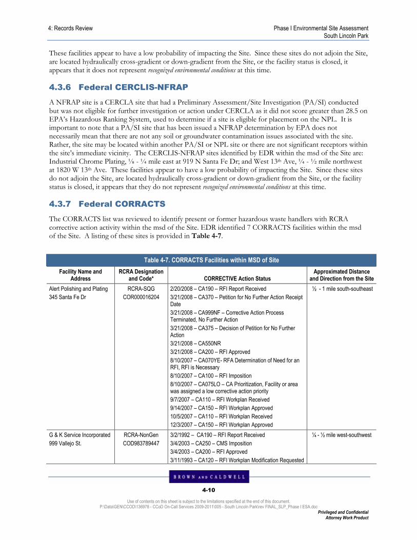
4: Records Review Phase I Environmental Site Assessment South Lincoln Park
4-10
Use of contents on this sheet is subject to the limitations specified at the end of this document. P:\Data\GEN\CCOD\136978 - CCoD On-Call Services 2009-2011\005 - South Lincoln Park\rev FINAL_SLP_Phase I ESA.doc
Privileged and Confidential Attorney Work Product
These facilities appear to have a low probability of impacting the Site. Since these sites do not adjoin the Site, are located hydraulically cross-gradient or down-gradient from the Site, or the facility status is closed, it appears that it does not represent recognized environmental conditions at this time.
4.3.6 Federal CERCLIS-NFRAP
A NFRAP site is a CERCLA site that had a Preliminary Assessment/Site Investigation (PA/SI) conducted but was not eligible for further investigation or action under CERCLA as it did not score greater than 28.5 on EPA’s Hazardous Ranking System, used to determine if a site is eligible for placement on the NPL. It is important to note that a PA/SI site that has been issued a NFRAP determination by EPA does not necessarily mean that there are not any soil or groundwater contamination issues associated with the site. Rather, the site may be located within another PA/SI or NPL site or there are not significant receptors within the site’s immediate vicinity. The CERCLIS-NFRAP sites identified by EDR within the msd of the Site are: Industrial Chrome Plating, ⅛ - ¼ mile east at 919 N Santa Fe Dr; and West 13th Ave, ¼ - ½ mile northwest at 1820 W 13th Ave. These facilities appear to have a low probability of impacting the Site. Since these sites do not adjoin the Site, are located hydraulically cross-gradient or down-gradient from the Site, or the facility status is closed, it appears that they do not represent recognized environmental conditions at this time.
4.3.7 Federal CORRACTS
The CORRACTS list was reviewed to identify present or former hazardous waste handlers with RCRA corrective action activity within the msd of the Site. EDR identified 7 CORRACTS facilities within the msd of the Site. A listing of these sites is provided in Table 4-7.
Table 4-7. CORRACTS Facilities within MSD of Site
Facility Name and Address
RCRA Designation and Code* CORRECTIVE Action Status
Approximated Distance and Direction from the Site
Alert Polishing and Plating
345 Santa Fe Dr
RCRA-SQG
COR000016204
2/20/2008 – CA190 – RFI Report Received
3/21/2008 – CA370 – Petition for No Further Action Receipt Date
3/21/2008 – CA999NF – Corrective Action Process Terminated, No Further Action
3/21/2008 – CA375 – Decision of Petition for No Further Action
3/21/2008 – CA550NR
3/21/2008 – CA200 – RFI Approved
8/10/2007 – CA070YE- RFA Determination of Need for an RFI, RFI is Necessary
8/10/2007 – CA100 – RFI Imposition
8/10/2007 – CA075LO – CA Prioritization, Facility or area was assigned a low corrective action priority
9/7/2007 – CA110 – RFI Workplan Received
9/14/2007 – CA150 – RFI Workplan Approved
10/5/2007 – CA110 – RFI Workplan Received
12/3/2007 – CA150 – RFI Workplan Approved
½ - 1 mile south-southeast
G & K Service Incorporated
999 Vallejo St.
RCRA-NonGen
COD983789447
3/2/1992 – CA190 – RFI Report Received
3/4/2003 – CA250 – CMS Imposition
3/4/2003 – CA200 – RFI Approved
3/11/1993 – CA120 – RFI Workplan Modification Requested
¼ - ½ mile west-southwest

4: Records Review Phase I Environmental Site Assessment South Lincoln Park
4-11
Use of contents on this sheet is subject to the limitations specified at the end of this document. P:\Data\GEN\CCOD\136978 - CCoD On-Call Services 2009-2011\005 - South Lincoln Park\rev FINAL_SLP_Phase I ESA.doc
Privileged and Confidential Attorney Work Product
by Agency
5/13/1993 – CA150 – RFI Workplan Approved
5/13/1993 – CA110 – RFI Workplan Received
7/9/1993 – CA180 – RFI Supplemental Implementation Begun
7/17/1990 – CA110 – RFI Workplan Received
7/17/1990 – CA060 – Notice of Contamination
8/1/1995 – CA725YE – Current Human Exposures Under Control, Yes, Current Human Exposures Under Control has been verified
8/1/1995 – CA225IN – Stabilization Measures Evaluation
8/3/1993 – CA195 – FI Progress Reports Received
8/11/1995 – CA075ME – CA Prioritization, Facility or area was assigned a medium correction action priority
8/28/1990 – CA100 – RFI Imposition
8/28/1990 – CA150 – RFI Workplan Approved
10/16/2006 – CA260 – CMS Workplan Received
10/16/2006 – CA190 – RFI Report Received
10/16/2006 – CA260 – CMS Workplan Received
10/16/2006 – CA195 – FI Progress Reports Received
11/21/2002 – CA190 – RFI Report Received
11/30/2006 – CA270 – CMS Workplan Modification Requested by Agency
11/30/2006 – CA200 – RFI Approved
Katzson Brothers Inc
960 Vallejo St.
RCRA- CESQG
COD031992225
1/11/1993 – CA110 – RFI Workplan Received
1/23/1996 – CA110 – RFI Workplan Received
1/27/1993 – CA120 – RFI Workplan Modification Requested by Agency
3/11/1993 – CA150 – RFI Workplan Approved
4/14/1994 – CA195 – FI Progress Reports Received
5/15/1993 – CA180 – RFI Supplemental Implementation Begun
6/9/1994 – CA195 – FI Progress Reports Received
6/17/1993 – CA110 – RFI Workplan Received
6/17/1993 – CA190 – RFI Report Received
6/18/1993 – CA150 – RFI Workplan Approved
6/18/1993 – CA120 – RFI Workplan Modification Requested by Agency
8/1/1995 –CA225YE – Stabilization Measures Evaluation
8/1/1995 – CA725YE – Current Human Exposures Under Control, Yes, Current Human Exposures Under Control has been verified
9/26/1994 – CA195 – FI Progress Reports Received
11/3/1992 – CA060 – Notice of Contamination
12/7/1992 – CA100 – RFI Imposition
12/7/1992 – CA075ME – CA Prioritization, Facility or area was assigned a medium correction action priority
12/7/1992 – CA070YE- RFA Determination of Need for an RFI, RFI is Necessary
¼ - ½ mile west-southwest
Lincoln Plating Company
777 Umatilla St
RCRA-NonGen
COD007073901
3/14/2002 – CA100 – RFI Imposition
3/15/2007 – CA999RM – Corrective Action Process
¼ - ½ mile west-southwest
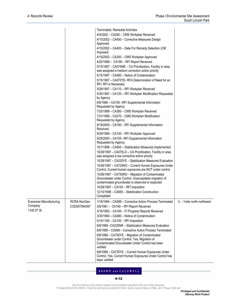
4: Records Review Phase I Environmental Site Assessment South Lincoln Park
4-12
Use of contents on this sheet is subject to the limitations specified at the end of this document. P:\Data\GEN\CCOD\136978 - CCoD On-Call Services 2009-2011\005 - South Lincoln Park\rev FINAL_SLP_Phase I ESA.doc
Privileged and Confidential Attorney Work Product
Terminated, Remedial Activities
4/4/2002 – CA260 – CMS Workplan Received
4/15/2002 – CA450 – Corrective Measures Design Approved
4/15/2002 – CA400 – Date For Remedy Selection (CM Imposed)
4/15/2002 – CA300 – CMS Workplan Approved
4/22/1998 – CA190 – RFI Report Received
5/15/1997 – CA075ME – CA Prioritization, Facility or area was assigned a medium correction action priority
5/15/1997 – CA060 – Notice of Contamination
5/15/1997 – CA070YE- RFA Determination of Need for an RFI, RFI is Necessary
5/28/1997 – CA110 – RFI Workplan Received
5/30/1997 – CA120 – RFI Workplan Modification Requested by Agency
6/8/1998 – CA155 –RFI Supplemental Information Requested by Agency
7/20/1998 – CA260 – CMS Workplan Received
7/31/1998 – CA270 – CMS Workplan Modification Requested by Agency
9/19/2000 – CA160 – RFI Supplemental Information Received
9/29/1998 – CA150 – RFI Workplan Approved
9/29/2000 – CA155 –RFI Supplemental Information Requested by Agency
10/1/1998 – CA600 – Stabilization Measures Implemented
10/28/1997 – CA075LO – CA Prioritization, Facility or area was assigned a low corrective action priority
10/28/1997 – CA225YE – Stabilization Measures Evaluation
10/28/1997 – CA725NO – Current Human Exposures Under Control, Current human exposures are NOT under control
10/28/1997 – CA750NO – Migration of Contaminated Groundwater under Control, Unacceptable migration of contaminated groundwater is observed or expected
10/28/1997 – CA100 – RFI Imposition
12/15/1998 – CA650 – Stabilization Construction Completed
Eversman Manufacturing Company
1145 5th St
RCRA-NonGen
COD007064397
1/19/1994 – CA999 – Corrective Action Process Terminated
3/8/1991 – CA190 – RFI Report Received
3/16/1992 – CA195 – FI Progress Reports Received
3/30/1990 – CA060 – Notice of Contamination
5/14/1190 – CA100 – RFI Imposition
6/8/1999 –CA225NR – Stabilization Measures Evaluation
6/8/1999 – CA999 – Corrective Action Process Terminated
6/8/1999 – CA750YE – Migration of Contaminated Groundwater under Control, Yes, Migration of Contaminated Groundwater Under Control has been verified
6/8/1999 – CA725YE – Current Human Exposures Under Control, Yes, Current Human Exposures Under Control has been verified
½ - 1mile north-northwest
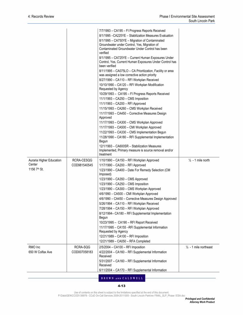
4: Records Review Phase I Environmental Site Assessment South Lincoln Park
4-13
Use of contents on this sheet is subject to the limitations specified at the end of this document. P:\Data\GEN\CCOD\136978 - CCoD On-Call Services 2009-2011\005 - South Lincoln Park\rev FINAL_SLP_Phase I ESA.doc
Privileged and Confidential Attorney Work Product
7/7/1993 – CA195 – FI Progress Reports Received
8/1/1995 –CA225YE – Stabilization Measures Evaluation
8/1/1995 – CA750YE – Migration of Contaminated Groundwater under Control, Yes, Migration of Contaminated Groundwater Under Control has been verified
8/1/1995 – CA725YE – Current Human Exposures Under Control, Yes, Current Human Exposures Under Control has been verified
8/11/1995 – CA075LO – CA Prioritization, Facility or area was assigned a low corrective action priority
8/27/1990 – CA110 – RFI Workplan Received
10/10/1990 – CA120 – RFI Workplan Modification Requested by Agency
10/29/1993 – CA195 – FI Progress Reports Received
11/1/1993 – CA250 – CMS Imposition
11/1/1993 – CA200 – RFI Approved
11/15/1993 – CA260 – CMS Workplan Received
11/17/1993 – CA450 – Corrective Measures Design Approved
11/17/1993 – CA300 – CMS Workplan Approved
11/17/1993 – CA500 – CMI Workplan Approved
11/22/1993 – CA330 – CMS Implementation Begun
11/28/1990 – CA180 – RFI Supplemental Implementation Begun
12/1/1993 – CA600SR – Stabilization Measures Implemented, Primary measure is source removal and/or treatment
Auraria Higher Education Center
1156 7th St.
RCRA-CESQG
COD981540545
1/10/1990 – CA150 – RFI Workplan Approved
1/17/1990 – CA200 – RFI Approved
1/23/1990 – CA400 – Date For Remedy Selection (CM Imposed)
1/23/1990 – CA350 – CMS Approved
1/23/1990 – CA250 – CMS Imposition
1/23/1990 – CA300 – CMS Workplan Approved
4/6/1990 – CA500 – CMI Workplan Approved
4/6/1990 – CA450 – Corrective Measures Design Approved
5/26/1994 – CA110 – RFI Workplan Received
7/28/1994 – CA150 – RFI Workplan Approved
8/12/1994– CA180 – RFI Supplemental Implementation Begun
10/23/1995 – CA190 – RFI Report Received
11/17/1995 – CA155 –RFI Supplemental Information Requested by Agency
12/21/1989 – CA100 – RFI Imposition
12/21/1989 – CA050 – RFA Completed
½ - 1 mile north
RMO Inc
650 W Colfax Ave
RCRA-SQG
COD007058183
2/5/2004 – CA100 – RFI Imposition
4/22/2004 – CA160 – RFI Supplemental Information Received
5/31/2007 – CA160 – RFI Supplemental Information Received
6/11/2004 – CA170 – RFI Supplemental Information
½ - 1 mile northeast

4: Records Review Phase I Environmental Site Assessment South Lincoln Park
4-14
Use of contents on this sheet is subject to the limitations specified at the end of this document. P:\Data\GEN\CCOD\136978 - CCoD On-Call Services 2009-2011\005 - South Lincoln Park\rev FINAL_SLP_Phase I ESA.doc
Privileged and Confidential Attorney Work Product
Deemed Satisfactory
6/15/2007 – CA155 –RFI Supplemental Information Requested by Agency
6/20/2005 – CA250 – CMS Imposition
7/23/2004 – CA100 – RFI Imposition
7/26/2004 – CA190 – RFI Report Received
8/5/2005 – CA260 – CMS Workplan Received
8/24/2004 – CA155 –RFI Supplemental Information Requested by Agency
10/25/2005 – CA300 – CMS Workplan Approved
*TSDF – Treatment, Storage, and Disposal Facility, SQG – Small quantity generator, LQG – Large quantity generator, CESQG – Conditionally Exempt Small Quantity Generator
These facilities appear to have a low probability of impacting the Site. Since these sites do not adjoin the Site, or are located hydraulically cross-gradient or down-gradient from the Site, it appears that they do not represent recognized environmental conditions at this time. Furthermore, previous soil and groundwater sampling conducted at 944 and 1001 Osage Street (BC 2005 and 2008) did not indicate the presence of impacts that may have been the result of activities at the one site identified in the potentially upgradient direction (Alert Polishing and Plating) of the Site.
4.3.8 Federal RCRIS List
Facilities listed in the RCRIS database are designated as hazardous waste TSD facilities, hazardous waste generators, or hazardous waste transporters. This database was searched for facilities within the msd from the Site. There were no RCRA hazardous waste TSD facilities or RCRA hazardous waste large-quantity generators located within the msd of the Site. There was one RCRA hazardous waste small-quantity generator located within the msd of the Site: Denver Water – Westside, <⅛ mile north-northwest at 1600 W 12th Ave. There are five RCRA hazardous waste conditionally exempt small-quantity generators located within the msd of the Site: B&R Screen Graphics, ⅛ - ¼ mile southeast at 1045 W 8th Ave; DPS Greenlee, <⅛ mile northeast at 1150 Lipan St; Lafarge Quivas Garage, ⅛ - ¼ mile northwest at 1145 Quivas St; Lafarge Regional QA/QC Lab, ⅛ - ¼ mile northwest at 1195 Quivas St; and Flame Spray, Inc, ⅛ - ¼ mile west-northwest at 1900 W 12th Ave. There are 10 RCRA hazardous waste non-generators located within the msd of the Site: Southern Pacific – 9th and Navajo, <⅛ mile at 1325 W 9th Ave; Industrial Chrome Plating, ⅛ - ¼ mile east at 919 N Santa Fe Dr; Industrial hard Chrome Plating, ⅛ - ¼ mile east at 919 N Santa Fe Dr; Textile Emporium Inc, ⅛ - ¼ mile east at 900 Santa Fe Dr; Property owned by E & H Stoner, ⅛ - ¼ mile east-southeast at 821 Santa Fe Dr (rear); Osage Resource Recovery, <⅛ mile north at 1111 Osage St; Komac Paint Inc, <⅛ mile north at 1201 Osage St; Neiman’s Industrial Recycling, ⅛ - ¼ mile south at 730 Navajo; Union Oil Company of California, ⅛ - ¼ mile north at 1535 W 13th Ave; and J-8 Equipment Co, ⅛ - ¼ mile north at 1305 Osage St.
4.3.9 Federal ERNS List
A review of the Federal ERNS database was conducted to identify reported releases of oil and hazardous substances on the Site. The database contains information from spill reports made to federal agencies, including the EPA, the U.S. Coast Guard, the National Response Center, and the DOT. The EDR search report of the databases identified no ERNS incidents reported for the Site.

4: Records Review Phase I Environmental Site Assessment South Lincoln Park
4-15
Use of contents on this sheet is subject to the limitations specified at the end of this document. P:\Data\GEN\CCOD\136978 - CCoD On-Call Services 2009-2011\005 - South Lincoln Park\rev FINAL_SLP_Phase I ESA.doc
Privileged and Confidential Attorney Work Product
4.3.10 HMIRS
HMIRS is the US DOT listing of hazardous material spill incidents reported to DOT. A review of the HMIRS database was conducted to identify reported hazardous materials spills on the Site. A search of the databases identified no incidents on the Site.
4.3.11 United States Engineering and Institutional Controls
These databases contain lists of recorded engineering and institutional controls for properties relating to environmental remediation. According to the AAI Rule, institutional controls are to be reviewed for the Site, and engineering controls for the Site and surrounding areas within 0.5 miles of the Site boundaries. These databases were searched by EDR for properties within 0.5 miles of the Site boundaries. EDR conducted a search of both engineering and institutional controls within 0.5 miles of the Site boundaries and identified institutional or engineering controls for the Site or surrounding properties within 0.5 miles of the Site boundaries: Denver Radium Site, <⅛ mile northwest at the area of 12th Avenue and Quivas Street.
4.3.12 Federal DOD Sites
EDR conducted a search of the DOD sites located within the msd of the Site. No DOD sites were identified within the msd of the Site.
4.3.13 United States/State/Tribal Brownfields Sites
EDR conducted a search of the EPA’s list of Brownfields remediation sites for sites located within the msd of the Site. Brownfields are remediation sites that are conducting investigations and remedial activities in accordance with the Small Business Liability Relief and Brownfields Revitalization Act of 2002, Title 42 of the U.S.C. §§9601 (Brownfields Act). EDR’s search of the list identified no Federal Brownfields sites within the msd of the Site.
4.3.14 State and/or Tribal Voluntary Clean-Up Sites
EDR conducted a search for sites being cleaned up under state and/or tribal voluntary clean-up programs. The following sites were reported within the msd of the property: Denver Toluene, ⅛ - ¼ mile north at 1535 13th Ave; Denver Toluene, ⅛ - ¼ mile north-northwest at 1635 W 13th Ave; Denver Toluene, ⅛ - ¼ mile north-northwest at 1709 W 13th Ave; and Rocky Mountain News, ¼ - ½ mile north at 1350 Rio Court.
4.3.15 State Solid Waste Disposal Facility (SWLF) Listings
EDR conducted a search of the CDPHE list of SWLFs within the msd of the Site. EDR’s report identified the following SWLFs within the msd of the Site, listed in Table 4-8..
Table 4-8. SWLFs within MSD of Site
Facility Name and Address
Approximated Distance and Direction from
the Site Apparent Hydrologic Gradient from the Site
Status (Closed vs. Active)
Not reported
1300 Osage St.
⅛ - ¼ mile north Cross gradient Not reported
Not reported
13th and Rio Court
⅛ - ¼ mile north-northwest Cross gradient Not reported

4: Records Review Phase I Environmental Site Assessment South Lincoln Park
4-16
Use of contents on this sheet is subject to the limitations specified at the end of this document. P:\Data\GEN\CCOD\136978 - CCoD On-Call Services 2009-2011\005 - South Lincoln Park\rev FINAL_SLP_Phase I ESA.doc
Privileged and Confidential Attorney Work Product
Not reported
490 Osage St
¼ - ½ mile south Cross gradient Not reported
These facilities appear to have a low probability of impacting the Site. Since these sites do not adjoin the Site, or are located hydraulically cross-gradient or down-gradient from the Site, it appears that they do not represent recognized environmental conditions at this time.
4.3.16 LUSTs
EDR conducted a search of the Colorado Department of Labor and Employment, Oil Inspection Section list of LUSTs within the msd of the Site. EDR identified 52 LUST incidents within the msd of the Site, listed in Table 4-9.
Table 4-9. LUST Facilities within MSD of Site
Facility Name/Location Identification Number
Distance and Direction from the Site
Apparent Hydrologic Gradient from the Site Case Status
City and County of Denver Property
1001 Osage St
LUST: S109351130
TP TP Closed
ADCO General Corp
1080 Kalamath St
LUST: U003120029
⅛ - ¼ mile east Up-gradient Closed
ADCO General Corporation Property
1021 W 8th Ave
LUST: U003517935
⅛ - ¼ mile southeast Cross-gradient Closed
Carlo’s 66
800 Kalamath St
LUST: U003124735
⅛ - ¼ mile southeast Cross gradient Closed
Craig and Associates
745 Lipan St
LUST: U003197374
LUST Trust
⅛ - ¼ mile south-southeast Cross gradient Closed
Amick Moving and Storage
1029 Santa Fe Dr
LUST: U004007222
⅛ - ¼ mile east Up-gradient Closed
H & M Investments
900 Santa Fe
LUST: S105143667
⅛ - ¼ mile east Up-gradient Closed
Carter Lubrication AKA Grease Monkey
901 W 8th Ave
LUST: S103852419
⅛ - ¼ mile east-southeast Cross gradient Closed
Neighborhood Gas
801 W 8th Ave
LUST Trust
¼ - ½ mile east-southeast Cross gradient
TS Gas
801 W 8th Ave
LUST: 1001268540
¼ - ½ mile east-southeast Cross gradient Closed

4: Records Review Phase I Environmental Site Assessment South Lincoln Park
4-17
Use of contents on this sheet is subject to the limitations specified at the end of this document. P:\Data\GEN\CCOD\136978 - CCoD On-Call Services 2009-2011\005 - South Lincoln Park\rev FINAL_SLP_Phase I ESA.doc
Privileged and Confidential Attorney Work Product
Art Leisenring
1025 Galapago St
LUST: S10279851
¼ - ½ mile east Up-gradient Closed
Kalamath Associates Property
570 Kalamath St
LUST: S102719064
¼ - ½ mile south-southeast Cross gradient Closed
Sixth & Santa Fe Car Wash
603 Santa Fe Dr
LUST: U003241096
¼ - ½ mile southeast Cross gradient Closed
Conoco SS
571 Santa Fe Dr
LUST: S107555175
¼ - ½ mile south-southeast Cross gradient Closed
Masters Studio
1140 W 5th St
LUST: U003241058
¼ - ½ mile south Cross gradient Closed
Formerly Amoco Oil Co
875 Navajo St
LUST Trust
<⅛ mile south Cross gradient
Stout Street Foundation
875 Navajo St
LUST: S102327549
<⅛ mile south Cross gradient State Lead
Mobil Premix Concrete Inc
1590 W 12th St
LUST: S103852292
LUST Trust
<⅛ mile north-northwest Down-gradient Open
Westside Yard
1600 W 12th St
LUST: S107556392
<⅛ mile north-northwest Down-gradient Closed
Pennzoil Products Co
1520 W 13th Ave
LUST: S107982370
⅛ - ¼ mile north Cross gradient Closed
Pennzoil Products Co
1520 W 13th Ave
LUST: U003123383
⅛ - ¼ mile north Cross gradient Closed
7-Eleven #1823-13194
1104 Santa Fe
LUST: S105566852
⅛ - ¼ mile east Cross gradient Closed
Materials Handling
1740 W 13th Ave
LUST: S102719134
⅛ - ¼ mile north-northwest Down-gradient Closed
RTD-LRT Maintenance Facility
655 Mariposa
LUST: COD983770488
¼ - ½ mile south Cross gradient Closed
Jebco Heating & Air Conditioning
666 Lipan St
LUST: U003400715
¼ - ½ mile south-southeast Cross gradient Closed

4: Records Review Phase I Environmental Site Assessment South Lincoln Park
4-18
Use of contents on this sheet is subject to the limitations specified at the end of this document. P:\Data\GEN\CCOD\136978 - CCoD On-Call Services 2009-2011\005 - South Lincoln Park\rev FINAL_SLP_Phase I ESA.doc
Privileged and Confidential Attorney Work Product
United Materials Inc
1777 W 13th Ave
LUST: U003120611
LUST Trust
¼ - ½ mile north-northwest Down-gradient Closed
K L Bliss
1081 W 13th Ave
LUST: S102719969
¼ - ½ mile northeast Cross gradient Closed
Floyd Pool Property
1365 Osage St
LUST: U003124822
LUST Trust
¼ - ½ mile north Cross gradient Closed
Belcon Mechanical
630 Lipan
LUST: S102719933
¼ - ½ mile south-southeast Cross gradient Closed
United Western Supply
1365 Rio Ct
LUST: S107556296
¼ - ½ mile north Down-gradient Closed
CEI West Roofing Inc
1881 W 13th Ave
LUST: S102052782
¼ - ½ mile northwest Down-gradient Closed
Boys & Girls Club of Denver
901 Tejon St
LUST: S102530446
LUST Trust
¼ - ½ mile west-southwest Down-gradient Closed
Newstrom-Davis Construction Co
2000 W 8th Ave
LUST: U004007486
¼ - ½ mile west-southwest Down-gradient Closed
Conrads Warehouse
595 Quivas
LUST: S102719907
LUST Trust
¼ - ½ mile south-southwest Down-gradient Closed
Katzson Brothers Inc
960 Vallejo St
LUST: COD031992225
¼ - ½ mile west-southwest Down-gradient Closed
Sears Roebuck & Co
1701 W 6th Ave
LUST: U003401686
¼ - ½ mile south-southwest Down-gradient LUST Trust
740 Investors
740 Umatilla St
LUST: S102052722
LUST Trust
¼ - ½ mile west-southwest Down-gradient Closed
Elms Investment Property
730 Umatilla St
LUST: U003124060
LUST Trust
¼ - ½ mile west-southwest Down-gradient Closed
Southeastern Public Service Co
1450 Cottonwood Dr
¼ - ½ mile north-northwest Down-gradient Closed
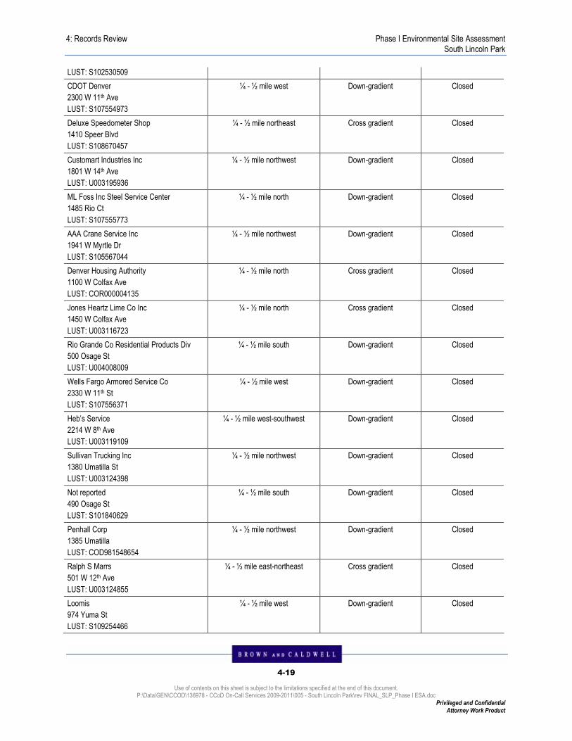
4: Records Review Phase I Environmental Site Assessment South Lincoln Park
4-19
Use of contents on this sheet is subject to the limitations specified at the end of this document. P:\Data\GEN\CCOD\136978 - CCoD On-Call Services 2009-2011\005 - South Lincoln Park\rev FINAL_SLP_Phase I ESA.doc
Privileged and Confidential Attorney Work Product
LUST: S102530509
CDOT Denver
2300 W 11th Ave
LUST: S107554973
¼ - ½ mile west Down-gradient Closed
Deluxe Speedometer Shop
1410 Speer Blvd
LUST: S108670457
¼ - ½ mile northeast Cross gradient Closed
Customart Industries Inc
1801 W 14th Ave
LUST: U003195936
¼ - ½ mile northwest Down-gradient Closed
ML Foss Inc Steel Service Center
1485 Rio Ct
LUST: S107555773
¼ - ½ mile north Down-gradient Closed
AAA Crane Service Inc
1941 W Myrtle Dr
LUST: S105567044
¼ - ½ mile northwest Down-gradient Closed
Denver Housing Authority
1100 W Colfax Ave
LUST: COR000004135
¼ - ½ mile north Cross gradient Closed
Jones Heartz Lime Co Inc
1450 W Colfax Ave
LUST: U003116723
¼ - ½ mile north Cross gradient Closed
Rio Grande Co Residential Products Div
500 Osage St
LUST: U004008009
¼ - ½ mile south Down-gradient Closed
Wells Fargo Armored Service Co
2330 W 11th St
LUST: S107556371
¼ - ½ mile west Down-gradient Closed
Heb’s Service
2214 W 8th Ave
LUST: U003119109
¼ - ½ mile west-southwest Down-gradient Closed
Sullivan Trucking Inc
1380 Umatilla St
LUST: U003124398
¼ - ½ mile northwest Down-gradient Closed
Not reported
490 Osage St
LUST: S101840629
¼ - ½ mile south Down-gradient Closed
Penhall Corp
1385 Umatilla
LUST: COD981548654
¼ - ½ mile northwest Down-gradient Closed
Ralph S Marrs
501 W 12th Ave
LUST: U003124855
¼ - ½ mile east-northeast Cross gradient Closed
Loomis
974 Yuma St
LUST: S109254466
¼ - ½ mile west Down-gradient Closed

4: Records Review Phase I Environmental Site Assessment South Lincoln Park
4-20
Use of contents on this sheet is subject to the limitations specified at the end of this document. P:\Data\GEN\CCOD\136978 - CCoD On-Call Services 2009-2011\005 - South Lincoln Park\rev FINAL_SLP_Phase I ESA.doc
Privileged and Confidential Attorney Work Product
The 52 LUST sites listed in Table 4-9 appear to have a low probability of impacting the Site, since these sites do not adjoin the Site, are located greater than ½-mile from the Site with defined groundwater impacts, or are located hydraulically cross-gradient or down-gradient from the Site and it appears that they do not represent recognized environmental conditions at this time. Furthermore, a previous BC soil and groundwater investigation conducted at the 944 and 1001 Osage Street properties did not indicate the presence of petroleum hydrocarbon impacts. Of the sites listed, 10 sites are also on the LUST Trust list. The 1989 Colorado General Assembly established Colorado’s Petroleum Storage Tank Fund. The Fund reimburses eligible applicants for allowable costs incurred in cleaning up petroleum contamination from underground and aboveground petroleum storage tanks, as well as the third-party liability expenses.
4.3.17 USTs
EDR conducted a search of the Colorado Department of Labor and Employment, Oil Inspection Section list of facilities with registered USTs within the msd of the Site. EDR identified the following registered UST facilities within the msd of the Site, listed in Table 4-10.
Table 4-10. UST Facilities within MSD of Site
Facility Name/Location Identification Number
Distance and Direction from the Site
Apparent Hydrologic Gradient from the Site Case Status
City and County of Denver Property
1001 Osage St
UST: U004127674
TP TP Closed
ADCO General Corp
1080 Kalamath St
⅛ - ¼ mile Up-gradient Closed
ADCO General Corporation Property
1021 W 8th Ave
⅛ - ¼ mile southeast Cross-gradient Closed
Carlo’s 66
800 Kalamath St
⅛ - ¼ mile southeast Cross gradient Closed
Craig and Associates
745 Lipan St
⅛ - ¼ mile south-southeast Cross gradient Closed
Amick Moving and Storage
1029 Santa Fe Dr
⅛ - ¼ mile east Up-gradient Closed
Formerly Amoco Oil Co
875 Navajo St
UST: U003196144
<⅛ mile south Cross gradient Closed
SPEC AGG MPM S & G
1590 W 12th Ave
UST: U003123789
<⅛ mile north-northwest Down-gradient Closed
Lafarge West Inc
1590 W 12th Ave
UST: U003517947
<⅛ mile north-northwest Down-gradient Closed
Denver Water BD – Westside
1600 W 12th Ave
UST: U003123919
<⅛ mile north-northwest Down-gradient Open
Neiman Industrial Recycling
730 Navajo St
<⅛ mile south Cross gradient Closed

4: Records Review Phase I Environmental Site Assessment South Lincoln Park
4-21
Use of contents on this sheet is subject to the limitations specified at the end of this document. P:\Data\GEN\CCOD\136978 - CCoD On-Call Services 2009-2011\005 - South Lincoln Park\rev FINAL_SLP_Phase I ESA.doc
Privileged and Confidential Attorney Work Product
UST: U003121979
Roderick R Brown Property
751-775 Mariposa St
UST: U003116591
<⅛ mile south Cross gradient Closed
Pennzoil Products Co
1520 W 13th Ave
⅛ - ¼ mile north Cross gradient Closed
Unocal Chemicals Divisions
1535 W 13th Ave
UST: U003124316
⅛ - ¼ mile north Cross gradient Closed
Burnham Shops
800 Seminole Rd
UST: U003240522
⅛ - ¼ mile southwest Down-gradient Closed
7-Eleven #13194
1107 Santa Fe Dr
UST: U003748472
⅛ - ¼ mile east Cross gradient Open
Unknown Owner
1740 W 13th Ave
⅛ - ¼ mile north-northwest Down-gradient Closed
These facilities appear to have a low probability of impacting the Site. Since these sites do not adjoin the Site, are located hydraulically cross-gradient or down-gradient from the Site, or the facility status is closed, it appears that they do not represent recognized environmental conditions at this time. Furthermore, a previous BC soil and groundwater investigation conducted at the 944 and 1001 Osage Street properties did not indicate the presence of petroleum hydrocarbon impacts as a result of the UST located at 1001 Osage Street.
4.3.18 ASTs
EDR conducted a search of the Colorado Department of Labor and Employment, Oil Inspection Section list of facilities with registered ASTs within the msd of the Site. EDR identified the following registered AST facilities within the msd of the Site, listed in Table 4-11.
Table 4-11. AST Facilities within MSD of Site
Facility Name/Location Identification Number
Distance and Direction from the Site
Apparent Hydrologic Gradient from the Site Case Status
Denver Water BD – Westside
1600 W 12th Ave
<⅛ mile north-northwest Down-gradient Open
Quivas Ready Mix
1151 Quivas St
AST: A100280875
⅛ - ¼ mile northwest Down-gradient Open
Pennzoil Products Co
1520 W 13th Ave
⅛ - ¼ mile north Cross gradient Closed
Burnham Shops
800 Seminole Rd
⅛ - ¼ mile southwest Down-gradient Open
These facilities appear to have a low probability of impacting the Site. Since these sites do not adjoin the Site, are located hydraulically cross-gradient or down-gradient from the Site, or the facility status is closed, it appears that they do not represent recognized environmental conditions at this time.

4: Records Review Phase I Environmental Site Assessment South Lincoln Park
4-22
Use of contents on this sheet is subject to the limitations specified at the end of this document. P:\Data\GEN\CCOD\136978 - CCoD On-Call Services 2009-2011\005 - South Lincoln Park\rev FINAL_SLP_Phase I ESA.doc
Privileged and Confidential Attorney Work Product
4.3.19 State and Tribal Institutional Control / Engineering Control
Registries (AUL)
The CDPHE Environmental Real Covenants List contains contaminated sites that are not cleaned up completely and where land use restrictions may be used to ensure that the selected cleanup remedy is adequately protective of human health and the environment. EDR’s search of the list identified the following AUL site within the msd of the Site: Atlas Metals, ¼ - ½ mile west-northwest at 1100 Umatilla St.
4.3.20 ROD
EDR conducted a search of the EPA list of facilities with a Record of Decision within the msd of the Site. EDR identified one within the msd of the Site: Denver Radium Site, Denver Radium Site, <⅛ mile northwest at the area of 12th Avenue and Quivas Street.
4.3.21 Superfund (CERCLA) Consent Decrees (Consent)
EDR conducted a search of the Department of Justice, Consent Decree Library list of facilities that have had major legal settlements that establish responsibility and standards for cleanup at Superfund sites within the msd of the Site. EDR identified one within the msd of the Site: Denver Radium Site, Denver Radium Site, <⅛ mile northwest at the area of 12th Avenue and Quivas Street.
4.3.22 EDR Proprietary Records
EDR has searched selected national collections of business directories and has collected listings of potential gas stations and potential dry cleaner sites. EDR identified two historical auto stations and one historical cleaners sites at the target property of the Site: Newell Elmer R Rear, 965 Navajo, auto station; Legler Garage Rear, 1061 Mariposa Way, auto station; and Mariposa Cleaners, 951 Mariposa Way, cleaner.
4.3.23 Regulatory Records Review Summary
There is one NPL site within the msd of the Site but this facility appears to have a low probability of impacting the Site. Since this site does not adjoin the Site, is located hydraulically cross-gradient or down-gradient from the Site, it appears that it does not represent recognized environmental conditions at this time.
There are two CERCLIS sites, two NFRAP sites and seven CORRACTS sites within the msd of the Site. These facilities appear to have a low probability of impacting the Site. Since these sites do not adjoin the Site, are located hydraulically cross-gradient or down-gradient from the Site, or the facility status is closed, it appears that they do not represent recognized environmental conditions at this time.
There are one RCRIS-SQG, five RCRIS-CESQG and 10 RCRIS-Non-Gen sites within the msd of the Site. Since these sites do not adjoin the Site, are located hydraulically cross-gradient or down-gradient from the Site, it appears that they do not represent recognized environmental conditions at this time.
There is one US Engineering Controls site, one US Institutional Controls site, one CONSENT site and one ROD site within the msd of the Site. Since these sites do not adjoin the Site, are located hydraulically cross-gradient or down-gradient from the Site, it appears that they do not represent recognized environmental conditions at this time.
There are three SWF/LF sites within the msd of the Site. Since these sites do not adjoin the Site, are located hydraulically cross-gradient or down-gradient from the Site, it appears that they do not represent recognized environmental conditions at this time.

4: Records Review Phase I Environmental Site Assessment South Lincoln Park
4-23
Use of contents on this sheet is subject to the limitations specified at the end of this document. P:\Data\GEN\CCOD\136978 - CCoD On-Call Services 2009-2011\005 - South Lincoln Park\rev FINAL_SLP_Phase I ESA.doc
Privileged and Confidential Attorney Work Product
There are 17 UST sites, 52 LUST sites, 10 LUST TRUST sites, and four AST sites within the msd of the Site. These facilities appear to have a low probability of impacting the Site. Since these sites do not adjoin the Site, are located hydraulically cross-gradient or down-gradient from the Site, or the facility status is closed, it appears that they do not represent recognized environmental conditions at this time. Furthermore, a previous BC soil and groundwater investigation conducted at the 944 and 1001 Osage Street properties did not indicate the presence of petroleum hydrocarbon impacts.
There is one AUL site and four Colorado Voluntary Remediation sites within the msd of the Site. Since these sites do not adjoin the Site, are located hydraulically cross-gradient or down-gradient from the Site, it appears that they do not represent recognized environmental conditions at this time.
There are seven Historical Dry Cleaners and 29 Historical Auto Stations within the msd of the Site. Of these, two historical auto stations and one historical dry cleaner sites are located at the target property. These sites represent recognized environmental conditions due to the potential for past releases of petroleum hydrocarbons and/or chlorinated solvents into the soil and groundwater.

5-1
Use of contents on this sheet is subject to the limitations specified at the end of this document. P:\Data\GEN\CCOD\136978 - CCoD On-Call Services 2009-2011\005 - South Lincoln Park\rev FINAL_SLP_Phase I ESA.doc
Privileged and Confidential Attorney Work Product
PHASE I ENV I RONMENTAL S I TE ASSESSMENT SOUTH L I NCOLN PARK
5 . I N TERV IEWS
The purpose of interviews is to obtain information indicating recognized environmental conditions or historical recognized environmental conditions in connection with the Site, as described in the ASTM Standard. Selected individuals who were knowledgeable about current and past Site operations were interviewed. The following is a brief summary of the information obtained about the Site. The completed supporting documentation, if applicable, is included in Appendix L.
5.1 Interviews with Owners, Occupants, and Others
Knowledgeable of the Site
The following is a summary of interviews of individuals who may have knowledge concerning the Site. The interviews were conducted by Brown and Caldwell either in person or over the telephone.
Summary of Interviews with Owners, Occupants, and Others
Owner, Occupant or Other Cathy Martinez
Date 12/17/2009
Knowledge of Site Maintenance Supervisor
Pertinent Information
Ms. Martinez indicated that she was not aware of any conditions that could represent recognized environmental condition at the Site. She identified a natural gas structure located next to the Site a maintenance headquarters that is owned and operated by Xcel Energy. She identified the materials stored at the Site maintenance headquarters during the Site visit as the only known potentially hazardous materials stored at the Site.
5.2 Local Government Agency Interviews
Brown and Caldwell conducted several interviews with local government officials to obtain information regarding hazardous or petroleum materials at the Site. The results of the interviews are provided below.
Summary of Interviews with Local Government Agencies
Interview Subject Dave Wilmoth – City and County of Denver, Department of Environmental Health
Date 1/6/2010
Knowledge of Site Working with DHA on the Site redevelopment
Pertinent Information
Mr. Wilmoth is unaware of any hazardous materials stored at the Site or of any existing environmental reports or documents relevant to the Site other than those listed in section 4.2.2. He indicated that an asbestos survey of the Site buildings will be conducted shortly. The redevelopment will include townhomes with basements and a parking structure with a subsurface level, therefore a subsurface soil and groundwater investigation will be conducted.
Interview Subject Fonda Apostolopoulos - CDPHE
Date 1/6/2010
Knowledge of Site Reviewed 10th & Osage VCUP Application

5: Interviews Phase I Environmental Site Assessment South Lincoln Park
5-2
Use of contents on this sheet is subject to the limitations specified at the end of this document. P:\Data\GEN\CCOD\136978 - CCoD On-Call Services 2009-2011\005 - South Lincoln Park\rev FINAL_SLP_Phase I ESA.doc
Privileged and Confidential Attorney Work Product
Pertinent Information Mr. Apostolopoulos indicated that there may be a regional groundwater plume with low levels of tetrachloroethene (PCE), but was unsure if it travels through the Site. He did recall the VCUP application for the 10th & Osage site for addressing the PAHs in soil.
5.3 Summary of Interviews
Interviews conducted as part of this Phase I ESA did not indicate the potential for recognized environmental conditions at the Site. However, any subsequent subsurface investigations at the Site should be conducted with the awareness of the potential for ACM in soil and the potential for low levels of PCE in groundwater.

6-1
Use of contents on this sheet is subject to the limitations specified at the end of this document. P:\Data\GEN\CCOD\136978 - CCoD On-Call Services 2009-2011\005 - South Lincoln Park\rev FINAL_SLP_Phase I ESA.doc
Privileged and Confidential Attorney Work Product
PHASE I ENV I RONMENTAL S I TE ASSESSMENT SOUTH L I NCOLN PARK
6 . S I TE RECONNA ISSANCE
6.1 Methodology and Limiting Conditions
The Site was inspected by transecting the Site by foot at such intervals that the entire Site could be viewed, except areas that were blocked by debris and materials. The Site boundaries and adjacent properties were viewed and observations noted during the Site visit.
The objective of the Site reconnaissance was to identify potential recognized environmental conditions in connection with the Site. This can be limited by weather conditions, bodies of water, adjacent buildings, or other obstacles. Limitations are noted below:
� Brown and Caldwell was unable to observe all areas of the Site, as the majority of the buildings are currently in use as private residences. Based on observation made during a walk through on public access at the Site, there does not appear to be surface stains or hidden objects such as wells, drains, etc., beneath the trash and debris at the Site.
6.2 Site Observations
The purpose of the Site reconnaissance was to note evidence of potential recognized environmental conditions. Additionally, observations of adjoining properties were performed to identify uses and associated potential recognized environmental conditions that might impact the Site. Site photographs are included in Appendix M. The Site Vicinity Map is illustrated in Figure 1 and the general Site Plan as Figure 2.
Brown and Caldwell conducted a Site visit on December 12, 2009. The weather conditions were noted as sunny. The Site visit was conducted by Brown and Caldwell Environmental Professional Todd Pomerantz.
6.2.1 Site Improvements and Features
Structures: The Site is comprised of 39 buildings designated as follows: one office/maintenance shop, one community common building, and 37 multi-family residences.
Pavement, Roads, and Driveways: The Site is composed of several city blocks and has city streets throughout. Concrete walkways and driveways provide access to the housing throughout the Site.
Fences or Walls: Several low fences are found throughout the Site. A larger chain link fence is found surrounding the maintenance facility located at 1000 Navajo Street.
Other Features: Brown and Caldwell did not observe any other notable features at the Site.
6.2.2 Site Physical Observations
Surface Stains: Brown and Caldwell did not observe any surface stains at the Site during the Site visit.

6: Site Reconnaissance Phase I Environmental Site Assessment South Lincoln Park
6-2
Use of contents on this sheet is subject to the limitations specified at the end of this document. P:\Data\GEN\CCOD\136978 - CCoD On-Call Services 2009-2011\005 - South Lincoln Park\rev FINAL_SLP_Phase I ESA.doc
Privileged and Confidential Attorney Work Product
Unusual Odors: Brown and Caldwell did not observe any unusual odors at the Site during the Site visit with the exception of a slight natural gas odor next to the Xcel Energy natural gas pipeline house located next to the maintenance facility.
Stressed Vegetation: Stressed vegetation due to conditions other than climate was not observed by Brown and Caldwell during the Site visit.
Storage Tanks: Indications of storage tanks were not observed at the Site during the Site visit.
Drums, Other Containers: Brown and Caldwell did not observe any drums or containers at the Site during the Site visit. A flammable storage cabinet was observed outside of the maintenance facility located at 1000 Navajo Street.
Floor Drains, Grates, Sumps, Catch Basins, Oil Water Separators: Brown and Caldwell did not observe any floor drains, grates, sumps, catch basins or oil/water separators at the Site during the Site visit.
Stationary Hydraulic Lifts or Elevators (below grade or above grade): Brown and Caldwell did not observe any hydraulic lifts or elevators at the Site during the Site visit.
Transformers or Other Sources of Polychlorinated Biphenyls: Brown and Caldwell did not observe any capacitors or other sources of polychlorinated biphenyls (PCBs) at the Site during the Site visit. PCB free transformers were observed on telephone poles at the Site.
Paint Booth, Wash Rack, Other: Brown and Caldwell did not observe any paint booths, wash racks, or sand blasting at the Site during the Site visit.
6.2.3 Surface and Drainage Observations
Pavement Cracks or Patching: Some cracks and patches in the street pavement and concrete walkways of the Site were observed.
Fill Dirt or Previous Fill Activities: Earth-moving Activities (past and present): There were no indications of past or present fill dirt at the Site.
Ponds, Pits, Lagoons, Retention Basins: There were no ponds, pits, lagoons, or retention basins observed or reported at Site or the adjoining properties.
Storm Sewer (Flow of Storm Water across Site): Municipal storm sewers are found throughout the Site. The general flow direction of surface storm water across the Site appears to be toward the northwest.
6.2.4 Water Wells, Dry Wells, and Monitoring Wells
Brown and Caldwell did not observe any indications of wells at the Site.
6.2.5 Material and Waste Storage Areas
Solid Waste: Dumpsters for residential trash were observed throughout the Site.
Hazardous Materials, Petroleum Products, and/or Waste Storage Areas: A flammable storage cabinet was observed outside of the maintenance facility located at 1000 Navajo Street.

6: Site Reconnaissance Phase I Environmental Site Assessment South Lincoln Park
6-3
Use of contents on this sheet is subject to the limitations specified at the end of this document. P:\Data\GEN\CCOD\136978 - CCoD On-Call Services 2009-2011\005 - South Lincoln Park\rev FINAL_SLP_Phase I ESA.doc
Privileged and Confidential Attorney Work Product
6.2.6 Wastewater Systems
Septic Systems, Leach Fields, or Other On-site Disposal Systems: Brown and Caldwell did not observe evidence of former or current septic systems at the Site.
Municipal or Other Sewer: Brown and Caldwell did not observe any indications of municipal or other sanitary sewer systems at the Site; however it is assumed that the buildings at the Site are connected to the municipal sanitary sewer system.
6.2.7 Site Utilities
The following utility services were observed or reported for the Site.
Drinking Water: Denver Water provides potable drinking water to the Site.
Wastewater: Metro Wastewater provides wastewater services to the Site.
Electricity: Xcel Energy provides electrical power to the Site.
Garbage Removal: Waste Management provides domestic garbage removal services at the Site.
Propane or Natural Gas: Xcel Energy provides natural gas at the Site.
6.2.8 Environmental Concerns Observed on Adjoining Properties
Adjoining properties were visually observed to the degree possible without trespass for potential recognized environmental conditions that may cause an impact on the Site. Reconnaissance of adjoining properties was performed by viewing each property from the legal boundaries, or by walking upon the adjoining properties that were legally accessible. Adjoining properties environmental concerns are noted as follows:
Adjoining Properties Environmental Concerns
North – Lincoln Park The park consists of an outdoor park, a recreation center, and an outdoor swimming pool. Containers marked “corrosive” were observed as part of the swimming pool maintenance facility. The containers did not appear to be leaking.
East – Residential Private residential housing was observed to the east of the Site
West – Buckhorn Exchange restaurant, RTD light rail 10th & Osage Station, Union Pacific Railroad tracks
The Buckhorn Exchange restaurant, RTD light rail 10th & Osage Station, Union Pacific Railroad (UPRR) tracks were observed to the west of the Site. A business with no posted name was observed at 901 Osage Street.
South – WesTest, Castle Works WesTest geotechnical testing and Castle Works architectural company were observed to the South of the Site.
Other Concerns Raised by Site Visit: No other environmental concerns were observed during the Site visit.
Observations of Adjacent Sites: Brown and Caldwell observed the adjacent properties to the degree possible during the Site visit. Environmental concerns were not observed on the adjacent properties during the Site visit With the exception of an RTD maintenance facility and a UPRR maintenance facility located south and east of the Site. The current and/or past uses of the adjacent properties, to the extent that these uses were visually and/or physically observable, have been noted in Section 3.6.

6: Site Reconnaissance Phase I Environmental Site Assessment South Lincoln Park
6-4
Use of contents on this sheet is subject to the limitations specified at the end of this document. P:\Data\GEN\CCOD\136978 - CCoD On-Call Services 2009-2011\005 - South Lincoln Park\rev FINAL_SLP_Phase I ESA.doc
Privileged and Confidential Attorney Work Product
6.3 Summary of Site Observations
The Site visit conducted as part of this Phase I ESA did not indicate the potential for recognized environmental conditions at the Site. The Site contains a multi-family residential housing development owned and operated by the DHA since 1952. Access inside the individual private residences was not possible during the Site visit; however an asbestos investigation will be conducted in the individual residences after this report has been submitted. The only hazardous materials observed during the Site visit were located at the maintenance facility at 1000 Navajo Street. These materials were either stored in a flammables cabinet located immediately outside of the maintenance building or on shelves inside the building. Staining was not observed on the ground or floors in the vicinity of these materials. Housekeeping procedures appeared to be good.

7-1
Use of contents on this sheet is subject to the limitations specified at the end of this document. P:\Data\GEN\CCOD\136978 - CCoD On-Call Services 2009-2011\005 - South Lincoln Park\rev FINAL_SLP_Phase I ESA.doc
Privileged and Confidential Attorney Work Product
PHASE I ENV I RONMENTAL S I TE ASSESSMENT
7 . F I ND INGS , OP IN IONS , CONCLUS IONS , AND RECOMMENDAT IONS
7.1 Summary of Findings
Brown and Caldwell has performed a Phase I ESA of the Site located at West 9th Avenue and West 11th Avenue, Osage Street and Mariposa Street, in Denver, Denver County, Colorado in conformance with the scope and limitations of ASTM Practice E 1527-05. Any exceptions to, or deviations from, this practice are described in Section 1.4 of this Phase I ESA report.
The Site is located in an area generally developed for commercial, residential, and industrial use in Denver, Colorado. It is located between West 9th Avenue and West 11th Avenue, Osage Street and Mariposa Street, Denver, Colorado. The Site is situated within a developed urban area, mainly with residential areas nearby. The current owner of the Site, according to the property deed and/or the 50-year chain of title report, is the DHA. The current owner has owned the Site since 1952. The current use of the Site is as multi-family residential housing. The Site has been developed as residential and commercial properties since at least 1890 according to the Sanborn Maps provided by EDR. The Site is generally flat, with surface water drainage toward the northwest onto the adjoining property. The regional topographic gradient is generally toward the northwest to the South Platte River.
CCoD has informed Brown and Caldwell that the specific reason for this Phase I ESA was to evaluate the potential for recognized environmental conditions at the Site in support of the Client redeveloping the Site. In the User Questionnaire, CCoD indicated that they did not have specialized knowledge regarding environmental conditions at the Site.
The following summarizes the environmental concerns identified at the Site in the historical use investigation section:
� The presence of railroad tracks and associated facilities to the west of the Site shown beginning with the 1901 map may be an environmental concern as a result of potential impacts due to railroad activities and the surface soil impacts identified during previous investigations conducted at 944 and 1001 Osage Streets.
� The buildings demolished at the Site to make way for the existing housing project may have contained ACM. Since the final disposition of the demolished materials can not be determined, the potential ACM in soils at the Site constitutes a REC.
Previous investigations conducted at 944 and 1001 Osage Street by Brown and Caldwell (BC 2005 and 2008) indicated the presence of elevated concentrations of PAHs in surface soils. The proximity of these addresses to the Site may indicate the potential presence of elevated concentrations of PAHs in surface soils at the Site and may represent an environmental concern.
There is one NPL site within the msd of the site but this facility appears to have a low probability of impacting the Site. There are two CERCLIS sites, two NFRAP sites, seven CORRACTS sites, one RCRIS-SQG, five RCRIS-CESQG, 10 RCRIS-Non-Gen sites, one US Engineering Controls site, one US Institutional Controls site, one CONSENT site, one ROD, three SWF/LF, one AUL site, and four Colorado Voluntary Remediation sites within the msd of the Site. Since these sites do not adjoin the Site, are located

7: Findings, Opinions, Conclusions, and Recommendations Phase I Environmental Site Assessment South Lincoln Park
7-2
Use of contents on this sheet is subject to the limitations specified at the end of this document. P:\Data\GEN\CCOD\136978 - CCoD On-Call Services 2009-2011\005 - South Lincoln Park\rev FINAL_SLP_Phase I ESA.doc
Privileged and Confidential Attorney Work Product
hydraulically cross-gradient or down-gradient from the Site, it appears that they do not represent recognized environmental conditions at this time.
There are 17 UST sites, 52 LUST sites, 10 LUST TRUST sites, and four AST sites within the msd of the Site. These facilities appear to have a low probability of impacting the Site. Since these sites do not adjoin the Site, are located hydraulically cross-gradient or down-gradient from the Site, or the facility status is closed, it appears that they do not represent recognized environmental conditions at this time. Furthermore, a previous BC soil and groundwater investigation conducted at the 944 and 1001 Osage Street properties did not indicate the presence of petroleum hydrocarbon impacts.
There are seven Historical Dry Cleaners and 29 Historical Auto Stations within the msd of the Site. Of these, three historical auto stations and one historical dry cleaner sites are located at the target property. These sites represent recognized environmental conditions due to the potential for past releases of petroleum hydrocarbons and/or chlorinated solvents into the soil and groundwater.
Interviews conducted as part of this Phase I ESA did not indicate the potential for recognized environmental conditions at the Site. However, any subsequent subsurface investigations to be conducted at the Site should be conducted with the awareness of the potential for ACM in soil and the potential for low levels of PCE in groundwater.
The Site visit conducted as part of this Phase I ESA did not indicate the potential for recognized environmental conditions at the Site. The Site contains a multi-family residential housing development owned and operated by the DHA since 1952. Access inside the individual private residences was not possible during the Site visit,; however an asbestos investigation will be conducted in the individual residences after this report has been submitted. The only hazardous materials observed during the Site visit were located at the maintenance facility at 1000 Navajo Street. These materials were either stored in a flammables cabinet located immediately outside of the maintenance building or on shelves inside the building. Staining was not observed on the ground or floors in the vicinity of these materials. Housekeeping procedures appeared to be good.
7.2 Data Failures and Gaps
Through the course of this assessment, Brown and Caldwell may have encountered data failures or data gaps. These failures or gaps, if any, are discussed below. The following provides the opinion of the Environmental Professional as to the significance of the data gaps in terms of defining recognized environmental conditions at the Site. Data failures may or may not be significant data gaps, and the discussion also provides information pertaining to whether the data failures resulted in significant data gaps.
7.2.1 Data Failures
Data failure is a failure to achieve the historical (property use) research objectives specified in the ASTM Standard Practice even after reviewing the eight standard historical sources that are reasonably ascertainable and likely to be useful. Data failure is one type of data gap.
No data failures were encountered during this investigation.
7.2.2 Data Gaps
A data gap is a lack of or inability to obtain information required by the ASTM Standard Practice, despite good faith efforts by the EP to gather such information. This could include any component of the Practice, e.g., standard environmental records, interviews, or a complete reconnaissance. A data gap by itself is not inherently significant, but if other information and/or the EP’s experience raises reasonable concerns about the gap, it may be judged to be significant.

7: Findings, Opinions, Conclusions, and Recommendations Phase I Environmental Site Assessment South Lincoln Park
7-3
Use of contents on this sheet is subject to the limitations specified at the end of this document. P:\Data\GEN\CCOD\136978 - CCoD On-Call Services 2009-2011\005 - South Lincoln Park\rev FINAL_SLP_Phase I ESA.doc
Privileged and Confidential Attorney Work Product
� Aerial photographs and other historical records were not available at 5 year intervals as required under the ASTM E 1527-05 standard. This resulted in a data gap for years that records were not available regarding the area of the Site. However, it appears that based on the information provided by the owner of the property and the chain-of-title report, the Site has been owned by DHA since 1952. Therefore, this data gap is not considered to be significant in determining recognized environmental conditions at the Site.
7.3 Conclusions
The following summarizes the environmental concerns identified at the Site:
� The presence of railroad tracks and associated facilities to the west of the Site shown beginning with the 1901 map may be an environmental concern as a result of potential impacts due to railroad activities and the surface soil impacts identified during previous BC investigations conducted at 944 and 1001 Osage Streets.
Based on the results of this Phase I Environmental Site Assessment, Brown and Caldwell provides the following conclusions with regard to the Site.
Recognized Environmental Conditions
This Phase I ESA has revealed no evidence of recognized environmental conditions in connection with the Site, except for the following:
� The buildings demolished at the Site to make way for the existing housing project may have contained ACM. Since the final disposition of the demolished materials can not be determined, the potential ACM in soils at the Site constitutes a REC.
� The identification of historical dry cleaners and auto stations at the Site may indicate the potential presence of VOCs in soil or groundwater. While no regulatory records were identified indicating direct evidence of a release, subsequent subsurface investigations at the Site should be conducted with the awareness of the potential for VOCs in soil and/or groundwater.
� The presence of the three former cleaners at 1225 West 9th Ave, 1003 Mariposa (St), and 951 Mariposa St identified in the city directory search constitutes a REC.
7.3.1 Historical Recognized Environmental Conditions
This Phase I ESA has revealed no evidence of historical recognized environmental conditions in connection with the Site.
7.3.2 Environmental Concerns and De Minimis Conditions
This Phase I ESA has revealed no de minimis conditions or environmental concerns in connection with the Site, except for the following:
� The presence of railroad tracks and associated facilities to the west of the Site shown beginning with the 1901 map may be an environmental concern as a result of potential impacts due to railroad activities and the surface soil impacts identified during previous BC investigations conducted at 944 and 1001 Osage Streets.
7.4 Recommendations
Based on our understanding of CCoD’s unique interests in this Site and based on the results of this Phase I ESA, Brown and Caldwell provides the following recommendations:

7: Findings, Opinions, Conclusions, and Recommendations Phase I Environmental Site Assessment South Lincoln Park
7-4
Use of contents on this sheet is subject to the limitations specified at the end of this document. P:\Data\GEN\CCOD\136978 - CCoD On-Call Services 2009-2011\005 - South Lincoln Park\rev FINAL_SLP_Phase I ESA.doc
Privileged and Confidential Attorney Work Product
� Conduct a subsurface investigation at the Site to address the REC indicating the potential for ACM in soil. A qualified person should be available to identify ACM if demolished building debris is encountered. Samples should be submitted for laboratory analysis if potential ACM is identified.
� During the course of the subsurface investigation at the Site, collect surface soil samples (between zero and two feet bgs) for laboratory analysis to address the potential for PAHs in soil based on the results of the sampling conducted at 944 and 1001 Osage Street.
� During the course of the subsurface investigation at the Site, field screen soil samples for VOCs to address the potential for impacts from the historical auto stations and dry cleaners identified to have existed at the Site. If field screening indicates potentially elevated VOC concentrations, submit soil samples for laboratory analysis. Additionally, collect groundwater samples for laboratory VOC analysis. These borings should be focused at locations where the highest potential for impacts may occur as indicated by the historical use investigation and database review in this report.
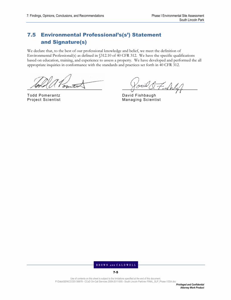
7: Findings, Opinions, Conclusions, and Recommendations Phase I Environmental Site Assessment South Lincoln Park
7-5
Use of contents on this sheet is subject to the limitations specified at the end of this document. P:\Data\GEN\CCOD\136978 - CCoD On-Call Services 2009-2011\005 - South Lincoln Park\rev FINAL_SLP_Phase I ESA.doc
Privileged and Confidential Attorney Work Product
7.5 Environmental Professional’s(s’) Statement
and Signature(s)
We declare that, to the best of our professional knowledge and belief, we meet the definition of Environmental Professional(s) as defined in §312.10 of 40 CFR 312. We have the specific qualifications based on education, training, and experience to assess a property. We have developed and performed the all appropriate inquiries in conformance with the standards and practices set forth in 40 CFR 312.
Todd Pomerantz Projec t Sc ient is t
David F ishbaugh Managing Sc ient is t

8-1
Use of contents on this sheet is subject to the limitations specified at the end of this document. P:\Data\GEN\CCOD\136978 - CCoD On-Call Services 2009-2011\005 - South Lincoln Park\FINAL_SLP_Phase I ESA.doc
Privileged and Confidential Attorney Work Product
PHASE I ENV I RONMENTAL S I TE ASSESSMENT SOUTH L I NCOLN PARK
8 . ENV IRONMENTAL PROFESS I O N A L ’ S ( S ’ ) Q U A L I F I C A T I O N S
Brown and Caldwell personnel involved with this project are listed below along with pertinent information regarding their qualifications and specialized knowledge. Additional details regarding each listed professional have been included in Appendix N.
Brown and Caldwell Environmental Professionals conducting the assessment include:
Mr. Todd Pomerantz
Mr. David Fishbaugh

Phase I Environmental Site Assessment South Lincoln Park
REF-1
Use of contents on this sheet is subject to the limitations specified at the end of this document. P:\Data\GEN\CCOD\136978 - CCoD On-Call Services 2009-2011\005 - South Lincoln Park\FINAL_SLP_Phase I ESA.doc
Privileged and Confidential Attorney Work Product
REFERENCES
American Society for Testing and Materials (ASTM), November 2005. Standard Practice E1527 05 for Environmental Site Assessments: Phase I Environmental Site Assessment Process.
40 CFR 312, Standards and Practices for All Appropriate Inquiries; Final Rule, November 2005 (AAI Rule).
Fox and Sprader Enterprises, LLC, CHAIN AND ENVIRONMENTAL LIEN SEARCH. December 23, 2009. 2637799.9.
Environmental Data Resources, Inc., The EDR Radius Map with Geocheck. Inquiry number 2637799.2s November 13, 2009.
Environmental Data Resources, Inc., The EDR-City Directory Abstract. Inquiry number 2637799.6 November 13, 2009
Environmental Data Resources, Inc., EDR Historical Topographic Map Report. Inquiry number 2637799.4 November 13, 2009
Environmental Data Resources, Inc., The EDR Aerial Photo Decade Package. Inquiry number 2637799.5 November 13, 2009.
Environmental Data Resources, Inc., Sanborn Map Report. Inquiry number 2637799.3 November 13, 2009.
Environmental Data Resources, Inc., The EDR Property Tax Map Report. Inquiry number 2637799.8 November 13, 2009.
Brown and Caldwell, Phase II Environmental Site Assessment, 944 and 1001 Osage Street, December 2, 2005.
Brown and Caldwell, 10th and Osage Brownfield Site Subsurface Investigation Report, December 2, 2005.