phase i environmental site assessment sanborn pond …
TRANSCRIPT
PHASE I ENVIRONMENTAL SITE ASSESSMENT
SANBORN POND OUTLET DAM PROPERTY BROOKS, MAINE
Property Owner: JOHN AND ROSE BOYNTON 36 Crocker Road Belfast, Maine 04915
Prepared For: MAINE DEPRTMENT OF ENVIRONMENTAL PROTECTION
17 State House Station Augusta, Maine 04333
MAY 30, 2019
REVISED JUNE 14, 2019 JN: 10193.052
Report Prepared By: CES, Inc.
PO Box 639 465 South Main Street Brooks, Maine 04412
207.989.4824
JN: 10193.052 — I — Sanborn Pond Outlet Dam Property Brooks, Maine
PHASE I ENVIRONMENTAL SITE ASSESSMENT
SANBORN POND OUTLET DAM PROPERTY BROOKS, MAINE
EXECUTIVE SUMMARY CES, Inc. (CES) completed a Phase I Environmental Site Assessment (ESA) for a portion of the 39 Sanborn Pond Drive property located in Brooks, Maine (the Site), to determine whether the Site has Recognized Environmental Conditions (RECs), as defined by the ASTM International (ASTM) Standard E 1527-13, Standard Practice for Environmental Site Assessments: Phase I Environmental Site Assessment Process, and in compliance with the All Appropriate Inquiry (AAI) Rule. This Phase I ESA was completed by Mr. Bradley Sloat, and Mr. Dennis Kingman. Mr. Sloat and Mr. Kingman are considered Environmental Professionals as defined in §312.10 of 40 CFR 312. The Site, located at 39 Sanborn Pond Drive in Brooks, Maine, consists of a concrete dam and the land immediately surrounding the dam. The Site is identified as a portion of Lot 40 on the Town of Brooks Property Tax Maps 1 and 2. A legal description is recorded in the Waldo County Registry of Deeds on Page 582 of Book 677 and is currently owned by John and Rose Boynton. The Site is not currently developed with any structures other than the dam located at the outlet of Sanborn Pond. Historical records reviewed, information provided by the Town of Brooks, and interviews with the current property owner indicate that Sanborn Pond Outlet Dam structure was initially constructed as a wooden dam in the 1920’s. In the early 1960’s, a concrete dam was constructed. An Envirosite® Government Records Report of Federal and State records completed for the Site, vicinity, and review of Maine Department of Environmental Protection (MDEP) records identified:
◆ Federal National Priority List (NPL) properties were not identified within a 1.0-mile radius of the Site, and there are no de-listed Federal NPL sites within a 0.5-mile radius of the Site;
◆ Federal Comprehensive Environmental Response, Compensation, and Liability Information System (CERCLIS) listing did not identify properties within a 0.5-mile radius of the Site;
◆ Federal CERCLIS NFRAP (no further remedial action is planned) listings were not identified within a 0.5-mile radius of the Site.
◆ The Site and the adjoining properties were not identified as a Resource Conservation and Recovery Act (RCRA) hazardous waste generator facilities;
◆ RCRA Corrective Action (CORRACTS) properties were not identified within a 1.0-mile radius of the Site;

JN: 10193.052 — II — Sanborn Pond Outlet Dam Property Brooks, Maine
◆ RCRA non-CORRACTS treatment, storage, and disposal (TSD) listings were not identified within a 0.5-mile radius of the Site;
◆ The Site was not identified as an Emergency Response Notification System (ERNS) facility;
◆ The Site and the adjoining properties were not identified on the Federal Institutional Control/Engineering Control Registries. Other properties within a 0.5-mile radius of the Site were not identified as State Institutional Control facilities;
◆ State and Tribal hazardous waste listings were not identified within a 1.0-mile radius of the Site;
◆ State and Tribal landfill/solid waste disposal facilities were not identified within a 0.5-mile radius of the Site;
◆ The Site was not identified as a State and Tribal leaking storage tank property. Other properties within a 0.5-mile radius of the Site were not identified as spill properties involving a leaking storage tank;
◆ The Site was not identified as a State and Tribal registered underground storage tank property. Other properties within a 0.25-mile radius of the Site were not identified as State and Tribal registered underground storage tank properties.
◆ The Site was not identified as a State and Tribal Voluntary Clean-up property. Other State and Tribal voluntary clean-up properties were not identified within a 0.5-mile radius of the Site;
The Site was identified as a portion of a State and Tribal Spill property (Sanborn Pond), one other property within a 0.5-mile radius of the Site was identified as a State and Tribal Spill property; and
The Site was not identified as a State and Tribal Brownfield property. Other properties within a 0.5-mile radius of the Site were not identified as State and Tribal Brownfield properties.
During the completion of this Phase I ESA, the following REC was identified at the Site: In 2001 a motor vehicle accident involving a tanker truck resulted in the discharge of approximately 5,600-gallons of #6 fuel oil into Sanborn Pond approximately 0.29 miles to the northwest of the Site. According to the Final Restoration Plan/Environmental Assessment prepared by the U.S. Fish and Wildlife Service (2010) sorbent materials, floating boom and vacuum trucks were utilized to recover the #6 fuel oil before some of the oil sunk to the bottom of the Pond. From 2002 to 2006 remedial efforts (impacted vegetation removal, sorbent booms, etc.) were completed throughout the Pond. From 2007 to 2009 little oil was observed floating on the Pond and additional remediation was not undertaken. According to the current owner of the Site (Mr. John Boynton), a petroleum sheen is occasionally observed on the pond surface when the shoreline is disturbed. The Site is the Sanborn Pond Outlet Dam structure, and the predominant flow of surface water toward the Site, residual petroleum (i.e., #6 fuel oil) may have accumulated or are present in the sediment associated with the upstream side of the dam as well as in the downstream sediments.

JN: 10193.052 — III — Sanborn Pond Outlet Dam Property Brooks, Maine
During the completion of this Phase I ESA, Historical RECs (HRECs), Controlled RECs (CRECS) or de minimis conditions were not identified at the Site. Based on the Tier 1 assessment of the Site, potential Vapor Encroachment Conditions (VECs) may exist at the Site due to the movement of water toward the Site, and areas of residual petroleum products present beneath sediment on the bottom of Sanborn Pond. At the time of the Site visit, CES was not able to visually observe the condition of sediment or soil beneath the waters of Sanborn Pond or in the outfall below the Sanborn Pond Outlet Dam to determine if petroleum impacts existed at the Site. Other limiting conditions were not encountered at the time of the Site visit that would prevent the assessment of potential environmental impacts to the Site. Based upon the findings of this Phase I ESA, in the event of construction or improvements in the area of the Site, an investigation should be completed on both the upstream and downstream sides of the dam structure to determine if petroleum and petroleum impacted soil/sediment are present, and the extent of impacts, if present to the Site and adjacent properties. In addition, if the dam structure is impacted by planned construction projects, the associated building materials (i.e., concrete) should be evaluated for the presence of asbestos. CES did not identify significant data gaps as part of this Phase I ESA that would affect our ability to identify RECs. CES has performed this Phase I Environmental Site Assessment in conformance with the scope and limitations of ASTM Practice E 1527-13 on the Site located at the Sanborn Pond Outlet Dam Property in Brooks, Maine.

JN: 10193.052 — IV — Sanborn Pond Outlet Dam Property Brooks, Maine
Table of Contents SECTION PAGE
SECTION 1 | INTRODUCTION .................................................................................................. 1 1.1 Purpose ....................................................................................................................... 1 1.2 Detailed Scope of Services .......................................................................................... 1 1.3 Significant Assumptions ............................................................................................... 2 1.4 Limitations and Exceptions .......................................................................................... 2 1.5 Special Terms and Conditions ..................................................................................... 3 1.6 User Reliance .............................................................................................................. 3
SECTION 2 | SITE DESCRIPTION ............................................................................................ 4 2.1 Site Location and Legal Description............................................................................. 4 2.2 Site and Vicinity General Characteristics ..................................................................... 4 2.3 Property Use ............................................................................................................... 4
2.3.1 Current Use of Property .......................................................................... 4 2.3.2 Past Use of Property ............................................................................... 4
2.4 Description of Structures, Roads, and Other Improvements ........................................ 5 2.4.1 Structures ................................................................................................ 5 2.4.2 Parking Areas and Roads ....................................................................... 5 2.4.3 Heating and Air Conditioning................................................................... 5 2.4.4 Utilities .................................................................................................... 5
2.5 Use of Adjoining Properties ......................................................................................... 5 2.5.1 Current Use of Adjoining Properties ........................................................ 5 2.5.2 Past Use of Adjoining Properties ............................................................. 5
SECTION 3 | USER PROVIDED INFORMATION ...................................................................... 5 3.1 Property Transaction Records ..................................................................................... 6 3.2 Information Reported by User Regarding Environmental Liens or Activity and Use
Limitations ................................................................................................................... 6 3.3 Specialized Knowledge ................................................................................................ 6 3.4 Commonly Known or Reasonably Ascertainable Information ....................................... 6 3.5 Valuation Reduction for Environmental Issues ............................................................. 6 3.6 Owner, Property Manager, and Occupant Information ................................................. 6 3.7 Reason for Performing Phase I .................................................................................... 6
3.8.1 Previous Environmental Assessments .......................................................... 7 3.8.2 Environmental Permits and/or Violations ................................................ 7
SECTION 4 | RECORDS REVIEW ............................................................................................ 7 4.1 Standard Environmental Record Sources .................................................................... 7
4.1.1 Federal Sources ............................................................................................................ 7 4.1.1.1 National Priority List Sites ................................................................................ 7 4.1.1.2 CERCLIS Listings ............................................................................................ 7 4.1.1.4 ERNS Sites ...................................................................................................... 8 4.1.1.5 Federal Institutional Control/Engineering Control Registries ............................ 8 4.1.2 State and Tribal Sources .................................................................................. 8 4.1.2.1 State and Tribal Listed Sites ............................................................................ 8 4.1.2.3 State and Tribal Leaking Storage Tanks .......................................................... 8 4.1.2.4 State and Tribal Registered Storage Tanks ..................................................... 8
JN: 10193.052 — V — Sanborn Pond Outlet Dam Property Brooks, Maine
4.1.2.5 State and Tribal Voluntary Clean-up Sites ....................................................... 9 4.1.2.6 State and Tribal Brownfield Sites ..................................................................... 9 4.1.2.7 Hazardous Material and Oil Spill Sites ............................................................. 9
4.2 Additional Environmental Record Sources ................................................................... 9 4.2.1 Database Search of Unmapped Properties ...................................................... 9 4.2.2 Local Environmental Record Sources .............................................................10
4.3 Physical Setting Sources ............................................................................................10 4.3.1 Topography .....................................................................................................10 4.3.2 Geology ..........................................................................................................10 4.3.3 Hydrology ........................................................................................................10 4.3.3.1 Surface Water .................................................................................................10 4.3.3.2 Flood Zone .....................................................................................................10 4.3.3.3 Wetlands .........................................................................................................11 4.3.3.4 Hydrogeology..................................................................................................11
4.4 Historical Use Information on the Property ..................................................................11 4.4.1 Property Transaction Records .........................................................................11 4.4.2 Sanborn Fire Insurance Rate Maps .................................................................11 4.4.3 Aerial Photographs .........................................................................................11 4.4.4 Historic Atlases ...............................................................................................12 4.4.6 Property Tax Files ...........................................................................................12 4.4.7 Code Enforcement Files ..................................................................................12
4.5 Historical Information on Adjoining Properties ............................................................12 4.5.1 Sanborn Fire Insurance Rate Maps .................................................................12 4.5.2 Aerial Photographs .........................................................................................12 4.5.3 Historic Atlases ...............................................................................................13 4.5.4 Historic Topographic Maps..............................................................................13 4.5.5 Property Tax Files ...........................................................................................13 4.5.6 Code Enforcement Files ..................................................................................13
SECTION 5 | ENVIRONMENTAL SITE RECONNAISSANCE ..................................................13 5.1 Methodology and Limiting Conditions .........................................................................13 5.2 Hazardous Substances and Petroleum Products ........................................................14 5.3 Storage Tanks ............................................................................................................14
5.3.1 Aboveground Storage Tanks (ASTs) ....................................................................... 14 5.3.2 Underground Storage Tanks (USTs) ....................................................................... 14
5.4 Strong, Pungent, or Noxious Odors ............................................................................14 5.5 Pools or Sumps Containing Liquid ..............................................................................14 5.6 Drums .........................................................................................................................14 5.7 Unidentified Substance Containers .............................................................................14 5.8 Polychlorinated Biphenyls (PCBs) ..............................................................................15 5.9 Pits, Lakes, or Lagoons ..............................................................................................15 5.10 Stained Surfaces or Distressed Vegetation .................................................................15 5.11 Underground Structures .............................................................................................15 5.12 Floor Drains and Sumps .............................................................................................15 5.13 Heating and Cooling ...................................................................................................15 5.14 Solid Waste Disposal ..................................................................................................15 5.15 Wastewater Disposal ..................................................................................................15
5.16 Wells .......................................................................................................................................... 15 5.17 Septic Systems .........................................................................................................15
5.18 Universal Waste .........................................................................................................16
JN: 10193.052 — VI — Sanborn Pond Outlet Dam Property Brooks, Maine
SECTION 6 | INTERVIEWS ......................................................................................................16 6.1 Interview with Site Owner ...........................................................................................16 6.2 Interview with Site Manager ........................................................................................16 6.3 Interview with Occupants ............................................................................................16 6.4 Interview with Local Government Officials ..................................................................16 6.5 User Interview ............................................................................................................16 6.6 Interviews with others .................................................................................................16
SECTION 7 | ADDITIONAL SERVICES ...................................................................................17 7.1 Vapor Encroachment Screening .................................................................................17 7.2 Asbestos-Containing Materials ...................................................................................17 7.3 Lead-Based Paint .......................................................................................................17
SECTION 8 | FINDINGS ...........................................................................................................17
SECTION 9 | OPINION 18
SECTION 10 | LIMITING CONDITIONS AND DEVIATIONS ....................................................19
SECTION 11 | DATA GAPS .....................................................................................................19
SECTION 12 | CONCLUSION ..................................................................................................19
SECTION 13 | ADDITIONAL INVESTIGATIONS .....................................................................19
SECTION 14 | REFERENCES ..................................................................................................20
SECTION 15 | SIGNATURE AND QUALIFICATIONS OF CES ENVIRONMENTAL PROFESSIONAL(S) ..........................................................................................21
FIGURES Figure 1 Site Location Map Figure 2 Site Sketch APPENDICES
Appendix A Site Photographs Appendix B Aerial Photographs Appendix C Database Search Results Appendix D Regulatory Files Appendix E Flood Insurance Rate Map Appendix F National Wetlands Inventory Map Appendix G Drinking Water Supply Well Map Appendix H Deed and Tax Information Appendix I Historic Atlas Appendix J Historic Topographic Maps Appendix K Environmental Questionnaires Appendix L Environmental Professional Qualifications

JN: 10193.052 — 1 — Sanborn Pond Outlet Dam Property Brooks, Maine
PHASE I ENVIRONMENTAL SITE ASSESSMENT
SANBORN POND OUTLET DAM PROPERTY BROOKS, MAINE
SECTION 1 | INTRODUCTION This report describes the Phase I Environmental Site Assessment (ESA) completed by CES, Inc. (CES) for the property located at the Sanborn Pond Outlet Dam in Brooks, Maine and identified as a portion of Lot 40 on the Town of Brooks Property Tax Maps 1 and 2 (the Site). This Phase I ESA was completed by CES for the Maine Department of Environmental Protection (MDEP) (the Client). 1.1 Purpose
The purpose of this Phase I ESA is to identify, to the extent feasible, evidence of existing or past release(s) or a material threat of a future release of hazardous substances, pollutants, contaminants, petroleum and petroleum products, and/or controlled substances at, or in the immediate vicinity of the Site (i.e., “Recognized Environmental Conditions” (RECs), as defined by the ASTM International (ASTM) Standard Practice for Environmental Site Assessments: Phase I Environmental Site Assessment Process E 1527-13). This practice is intended to permit a user to satisfy one of the requirements to qualify for the innocent landowner, contiguous property owner, or bona fide prospective purchaser limitations on CERCLA (Comprehensive Environmental Response, Compensation, and Liability Act of 1980 (as amended, 42 USC §9601 et. seq.)) liability (hereinafter, the “landowner liability protections,” or “LLPs”); that is, the practice that constitutes all appropriate inquiry into the previous ownership and uses of the property consistent with good commercial or customary practice as defined in 42 U.S.C. §9601(35)(B).
Not all aspects of ASTM E 1527-13 may be applicable to the property being assessed.
1.2 Detailed Scope of Services This assessment was conducted in accordance with the ASTM E 1527-13 standard practice unless otherwise noted. The findings presented in this Phase I ESA report are based on the following activities completed by CES: 1) A Site visit on May 15, 2019, to observe environmental conditions at the Site and
adjacent properties; 2) Database searches of government environmental records on May 20, 2019, to
identify Federal or State-listed properties within the search radii specified in the ASTM E 1527-13 standard;
3) Completion of a public and private drinking water well survey to identify wells within a 2,500-foot radius of the Site on May 15, 2019 and May 23, 2019;
JN: 10193.052 — 2 — Sanborn Pond Outlet Dam Property Brooks, Maine
4) Review of property transaction records in the form of deeds on the Waldo County Registry of Deeds website on May 23, 2019. (CES’ review of deeds does not constitute a legal title search for the property);
5) Review of selected on-line State records maintained by MDEP on May 20, 2019, to research Sites identified by the database search and MDEP files;
6) Review of property records from the Town of Brooks municipal offices for the Site and adjoining properties on May 15, 2019, regarding property history;
7) Review of completed All Appropriate Inquiry (AAI) “User” questionnaire from Mr. Eric Sroka, on behalf of the MDEP, dated May 24, 2019;
8) Review of the current Code Enforcement files and interviewed Mr. Randy Hall, the Code Enforcement Officer for the Town of Brooks on May 15, 2019, regarding current environmental conditions relating to the Site.
1.3 Significant Assumptions
This assessment report considers the Site to be identified as the Sanborn Pond Outlet Dam Property in Brooks, Maine. The Site is identified as a portion of Lot 40 on the Town of Brooks Property Tax Maps 1 and 2. A copy of this property tax map is included in Appendix H of this report. As part of the Phase I ESA process and in accordance with the ASTM E 1527-13, the Site, including the periphery of the property and associated structures, as well as the accessible and representative interiors of the structures, were visually and/or physically observed to the extent not obstructed by existing site features (i.e.; bodies of water, adjacent buildings, etc.) by CES personnel in order to obtain an understanding of issues which have or may have impacted this property. Site conditions which obstructed the investigator’s ability to observe Site conditions are considered “limiting conditions” and are noted in Section 1.4 of this report. CES assumes that the assessment of accessible areas of the Site provides an overview of the condition of the property and even though it may not identify all concerns, it represents the type and magnitude of impacts on the property as the result of past and present uses. Property pins were not identified that may define the boundaries of the Site. Property boundaries which were not clearly identified for the Site were estimated using existing roads, survey plans, and adjacent properties/structures. CES did not make any other significant assumptions while conducting the Phase I ESA of the Site.
1.4 Limitations and Exceptions CES prepared this report for the exclusive use of the Client and their assigns, and it should not be reproduced or disseminated without the written approval of CES or the Client. CES has retained a copy of this report. Additions and/or deletions are not authorized without the written consent of CES. Use of this report in whole or in part by any party other than the Client or his/her authorized agent is prohibited.
JN: 10193.052 — 3 — Sanborn Pond Outlet Dam Property Brooks, Maine
At the time of the Site visit, CES was not able to visually observe the condition of sediment or soil beneath the waters of Sanborn Pond or the outfall below the Sanborn Pond Outlet Dam to determine if petroleum impacts existed at the Site. Other limiting conditions were not encountered at the time of the Site visit that would prevent the assessment of potential environmental impacts to the Site. Assessment of the Site (including the collection of samples for laboratory analysis) for the following potential environmental concerns are beyond the scope of the Phase I ESA and are not necessarily included within the scope of this report: ◆ Lead-Based Paint ◆ Regulatory compliance ◆ Radon ◆ Industrial hygiene and health and safety ◆ Asbestos-Containing Materials ◆ Endangered species ◆ Wetlands ◆ Biological agents ◆ Ecological, cultural, and historic
resources ◆ Controlled substance
◆ Indoor Air Quality (IAQ) (including mold, fungi or microbial growth)
1.5 Special Terms and Conditions
Special terms or conditions associated with the Site or CES’ abilities to complete the Scope of Services were not established or imposed by the Client/Owner during the completion of this Phase I ESA.
1.6 User Reliance
User, as defined in ASTM Practice E 1527-13, is the party seeking to use the ASTM Practice E 1527 to complete an environmental site assessment of the property. A User may include, without limitation, a potential purchaser of property, a potential tenant of property, an owner of property, a lender, or a property manager.
This report does not necessarily address requirements of any State or local laws or of any Federal laws other than the All Appropriate Inquiry (AAI) provisions of the LLPs. Users are cautioned that Federal, State, and local laws may impose environmental assessment obligations that are beyond the scope of this report. Users should also be aware that there are likely to be other legal obligations with regard to hazardous substances or petroleum products discovered on the property that are not addressed in this report and that may pose risks of civil and/or criminal sanctions for non-compliance. This report does not purport to address all the safety concerns, if any, associated with its use. It is the responsibility of the User of this report to establish appropriate safety and health practices and determine the applicability of regulatory limitations prior to use.

JN: 10193.052 — 4 — Sanborn Pond Outlet Dam Property Brooks, Maine
Mr. Eric Sroka, on behalf of the MDEP, requested this Phase I ESA be performed and therefore the MDEP qualifies as the User. The User is hereby permitted to rely upon this report and the conclusion therein and limitations stated in the report. The conclusions discussed herein are based solely and in reliance upon information collected as a result of the activities detailed in Section 1.2 of this report. Testing and/or sampling of materials was not conducted as part of this Phase I ESA. Guarantee cannot be made on the property subsurface conditions present at the Site. CES neither attests nor renders an opinion as to the accuracy or comprehensiveness of the statements of the individuals interviewed, available governmental records, environmental reports conducted by other consultants, analytical results, or the database search results provided by the database contractor. The conclusions contained within this report remain valid for 180 days from the date of the report, assuming conditions at the Site remain unchanged.
SECTION 2 | SITE DESCRIPTION 2.1 Site Location and Legal Description
The Site, located at 39 Sanborn Pond Drive in Brooks, Maine, consists of a poured concrete dam and the land immediately surrounding the dam. The Site is identified as a portion of Lot 40 on the Town of Brooks Property Tax Maps 1 and 2. A legal description is recorded in the Waldo County Registry of Deeds on Page 582 of Book 677 and is currently owned by John and Rose Boynton. The Site is not currently developed with any structures other than the dam located at the outlet of Sanborn Pond.
2.2 Site and Vicinity General Characteristics
The Site is located to the north of Route 137 and south of the southern extent of Sanborn Pond in an area of residential and seasonally residential properties in Brooks, Maine. General topography at the Site and surrounding properties slopes downward to the south toward the Passagassawakeag River. Photographs of the Site and surrounding properties are included in Appendix A. Aerial photographs of the Site and surrounding properties are included in Appendix B.
2.3 Property Use 2.3.1 Current Use of Property
The Site is developed with a privately owned and maintained, concrete dam that is used to regulate water levels in Sanborn Pond.
2.3.2 Past Use of Property Historical records reviewed, information provided by the Town of Brooks personnel, and the current property owner indicate that the Site was initially developed with a wooden dam in the early 1920’s. In the 1960’s the wooden dam was replaced by a concrete dam which remains at the Site.
JN: 10193.052 — 5 — Sanborn Pond Outlet Dam Property Brooks, Maine
2.4 Description of Structures, Roads, and Other Improvements 2.4.1 Structures
The Site is currently developed with a concrete dam. According to Mr. John Boynton, the current owner of the Site, the dam extends approximately seven feet below the seasonal high-water line (approximately the top of the dam) and extends approximately 85 feet, across the Sanborn Pond outlet. The dam is currently used to regulate water levels in Sanborn Pond. Refer to Figure 2 for a Site Sketch and Appendix A for photographs of the Site.
2.4.2 Parking Areas and Roads
Sanborn Pond Drive provides access to the property from the south.
2.4.3 Heating and Air Conditioning Heating and air conditioning systems were not observed at the time of the Site visit.
2.4.4 Utilities Electrical service is not currently provided to the Site. CES did not identify evidence of drinking water wells or septic systems at the Site.
2.5 Use of Adjoining Properties 2.5.1 Current Use of Adjoining Properties
The Site adjoins Sanborn Pond to the north. Sanborn Pond is a 98-acre pond that is developed with both seasonal and full-time residences and is used for recreational activities. The adjoining property to the south is currently undeveloped. The adjoining property to the east of the Site is a seasonal residence. The adjoining property to the west of the Site is a full-time residential property. Details on the current ownership of the adjoining properties are included in Section 4.5.5 of this report.
2.5.2 Past Use of Adjoining Properties The adjoining properties were undeveloped or have been utilized as seasonal residential properties. Other historical uses of the adjoining properties and properties in the immediate vicinity of the Site were not identified during the research completed as part of this Phase I ESA.
SECTION 3 | USER PROVIDED INFORMATION In accordance with ASTM Practice E 1527-13, in order to qualify for one of the Landowner Liability Protections (LLPs) offered by the Small Business Liability Relief and Brownfields Revitalization Act of 2001, the User of this ASTM standard must provide the following information (if available) to the environmental professional. Failure to provide this information could result in a determination that “All Appropriate Inquiry” (AAI) is not complete. Information summarized in this

JN: 10193.052 — 6 — Sanborn Pond Outlet Dam Property Brooks, Maine
section is based upon the AAI “User” questionnaire completed by the entity/person responsible for requesting this Phase I ESA for this Site and is included in Appendix K. 3.1 Property Transaction Records
A copy of the current recorded deed was not provided by the User. CES’ review of deeds is included in Section 4.4.1 of this report.
3.2 Information Reported by User Regarding Environmental Liens or Activity and Use
Limitations The User has no knowledge regarding environmental clean-up or other liens against the property that are filed or recorded under Federal, State, Tribal, or local law relating to current or past violations of environmental laws with respect to the Site. Activity and Use Limitations (AULs) that would be filed or recorded in a registry under Federal, State, Tribal, or local law are not known in connection with the Site.
3.3 Specialized Knowledge
The User is aware that the Site consists of a poured concrete dam. The User does not have specialized knowledge regarding current or past uses and practices at the Site.
3.4 Commonly Known or Reasonably Ascertainable Information
The availability of commonly known or reasonably ascertainable information associated with the Site was investigated through the completion of the AAI User Questionnaire. The User indicated that they are aware of a petroleum discharge to Sanborn Pond. Other commonly known or reasonably ascertainable information about the Site was not provided in the user questionnaire completed.
3.5 Valuation Reduction for Environmental Issues
Known potential environmental concerns or issues that could potentially affect the value of the Site were not identified by the User.
3.6 Owner, Property Manager, and Occupant Information The User has provided contact information regarding the Site representative. The Site is currently owned by John and Rose Boynton. Access to the Site was provided by Mr. John Boynton.
3.7 Reason for Performing Phase I
This Phase I ESA was completed to identify RECs at or in the immediate vicinity of the Site, and to qualify the User for one of the LLPs under the Comprehensive Environmental Response, Compensation, and Liability Act (CERCLA). CES understands that the Phase I ESA is being conducted in preparation for a potential fish passage and dam upgrades at the Site.
3.8 Other

JN: 10193.052 — 7 — Sanborn Pond Outlet Dam Property Brooks, Maine
3.8.1 Previous Environmental Assessments In February of 2010 the U.S. Fish and Wildlife Service published a Final Restoration Plan/Environmental Assessment (FRP/EA) associated with the September 23, 2001 Sanborn Pond Oil Spill. The FRP/EA documented the petroleum spill, which occurred in 2001, the clean-up effort that was completed and the remaining impacts and hazards that remain on Sanborn Pond. A copy of the FRP/EA is included in Appendix D. Additional information pertaining to the Sanborn Pond Oil Spill can be found in Section 4.1.2.7 and Section 4.2.2 of this report. Other environmental assessment reports were not provided to CES as part of this Phase I ESA.
3.8.2 Environmental Permits and/or Violations Environmental permits and/or violations associated with the Site were not identified by the User.
SECTION 4 | RECORDS REVIEW 4.1 Standard Environmental Record Sources
CES obtained radius searches of the Federal and State environmental regulatory databases in accordance with ASTM E 1527-13 standards. Pertinent information is presented in the following sections. The database search report (including databases searched, radius search distances, and detailed information regarding listed properties) is presented as Appendix C. Files reviewed at MDEP are included as Appendix D.
4.1.1 Federal Sources 4.1.1.1 National Priority List Sites
The database search did not identify National Priority List (NPL) (i.e., Superfund) properties within a 1.0-mile radius of the Site or any de-listed NPL properties within a 0.5-mile radius of the Site.
4.1.1.2 CERCLIS Listings The database search did not identify the Site as a Comprehensive Environmental Response, Compensation, and Liability Information System (CERCLIS) listing. The database search did not identify properties within a 0.5-mile radius of the Site as CERCLIS NFRAP (no further remedial action is planned) facilities.
4.1.1.3 RCRA Facilities (RCRA TSDF) The Site was not identified as a Resource Conservation and Recovery Act (RCRA) hazardous waste generator facility. The database review did not identify RCRA Corrective Action (CORRACTS) facilities within a 1.0-mile radius of the Site.

JN: 10193.052 — 8 — Sanborn Pond Outlet Dam Property Brooks, Maine
The database search did not identify RCRA non-CORRACTS treatment, storage, and disposal (TSD) facilities within a 0.5-mile radius of the Site.
4.1.1.4 ERNS Sites
The database search did not identify the Site as an Emergency Response Notification System (ERNS) site.
4.1.1.5 Federal Institutional Control/Engineering Control Registries Federal Institutional Controls and Engineering Controls for the Site were not identified by the database search or in property deeds reviewed on-line from the Waldo County Registry of Deeds in Brooks, Maine on May 23, 2019.
4.1.2 State and Tribal Sources 4.1.2.1 State and Tribal Listed Sites
The database did not identify the Site as a State hazardous waste site. Other properties within a 1.0-mile radius of the Site were not identified as a state hazardous waste site.
4.1.2.2 State and Tribal Landfill/Solid Waste Disposal Sites The database search did not identify the Site as a landfill or solid waste disposal property. Other properties within a 0.5-mile radius of the Site were not identified as state landfill facilities.
4.1.2.3 State and Tribal Leaking Storage Tanks
The database search did not identify spills from leaking storage tanks associated with the Site. Other properties within a 0.5-mile radius of the Site were not identified as Leaking Underground Storage Tank (LUST) facilities. The MDEP does not currently maintain a LUST database. See Section 4.1.2.7 for more information pertaining to applicable spills in the area of the Site.
4.1.2.4 State and Tribal Registered Storage Tanks The Site was not identified as a State and Tribal Registered Storage Tank facility. The database search did not identify properties within a 0.25-mile radius of the Site as UST facilities. Above Ground Storage Tanks (ASTs) Local and State records did not identify ASTs currently or previously located at the Site.
JN: 10193.052 — 9 — Sanborn Pond Outlet Dam Property Brooks, Maine
4.1.2.5 State and Tribal Voluntary Clean-up Sites The database search did not identify the Site as a voluntary clean-up site. Other properties located within a 0.5-mile radius of the Site were not identified as a voluntary clean-up sites under the MDEP’s VRAP.
4.1.2.6 State and Tribal Brownfield Sites
The database search did not identify the Site as a Brownfields Site. Other properties within a 0.5-mile radius of the Site were not identified as state or tribal listed Brownfield sites.
4.1.2.7 Hazardous Material and Oil Spill Sites
The database search identified the Site as a portion of a hazardous material and/or oil spill property. One other property within a 0.5-mile radius of the Site was listed as hazardous material or oil spill property. The following spill reports were considered applicable to the Site: Sanborn Pond – (0.29 miles northwest of the Site) According to the spill report (A-623-2001) approximately 5,600-gallons of #6 fuel oil discharged into Sanborn Pond as a result of an accident involving a tanker truck approximately 0.29 miles to the northwest of the Site. The spill report summarizes the remediation effort utilizing floating booms, and skimmer units. During the remedial effort, petroleum impacts were identified below the water at a depth of 12-25 feet below the surface of the water. A vacuum truck and a commercial dive team attempted to recover the largest of the observed pockets of oil beneath the water. Additional information was not identified in the spill report that documented sampling or laboratory analysis completed following the initial spill clean-up. A copy of the Spill Report is included in Residual petroleum impacted sediment, soil and water are likely to remain and may be migrating toward the Site. Knox Vehicle Accident – (0.35 miles northwest of the Site) According to the spill report (A-441-2009) following a vehicle accident, an odor of gasoline was identified in the area. The spill report did not indicate that staining was identified. Evidence of field screening and/or confirmation laboratory analysis was not identified within the spill report. Based on the potential volume of petroleum that may have discharged during the vehicle accident, the verified distance to the Site, it is unlikely that this spill has negatively impacted the Site.
4.2 Additional Environmental Record Sources
4.2.1 Database Search of Unmapped Properties
Unmapped properties located in the general vicinity of the Site are included in the database search. However, due to inaccurate or missing information provided by the appropriate governmental agency, the database search contractor was unable to definitively plot the location of these properties or incidents.

JN: 10193.052 — 10 — Sanborn Pond Outlet Dam Property Brooks, Maine
The unmapped property list was reviewed in an attempt to definitively locate these properties. Based upon a practical review of the information, it was determined that no other properties within the vicinity of the Site are listed as unmapped property.
4.2.2 Local Environmental Record Sources In February of 2010 the U.S. Fish and Wildlife Service published an FRP/EA for the 2001 Oil Spill on Sanborn Pond. The FRP/EA documented the petroleum spill, the clean-up effort that was completed and the remaining impacts and hazards that remain on Sanborn Pond. Additional investigation, remediation or activity use limitations were not recommended in the FRP/EA. A copy of the FRP/EA is included in Appendix D. Additional local records associated with the Site were not identified.
4.3 Physical Setting Sources 4.3.1 Topography
The United States Geological Survey (USGS) Morrill, Maine 7.5-minute Quadrangle Topographic Map (2018) indicates that the subject property is approximately 290 feet above mean sea level and slopes downward to the south toward the Passagassawakeag River. Figure 1 includes a portion of the topographic map of the Site and the surrounding area.
4.3.2 Geology Bedrock outcrops were not observed on or in the vicinity of the Site. According to the Bedrock Geologic Map of Brooks (Pollock, 2011), the Site is underlain by the Passagassawakeag Block Member. The Surficial Geologic Map of the Morrill Quadrangle (Weddle, 2014) identifies the area of the subject property as till. The Maine Geological Survey (MGS) describes till as a mixture of silt, sand and clay that has been deposited by glacial ice.
4.3.3 Hydrology 4.3.3.1 Surface Water
The Site is considered to include a portion of Sanborn Pond and the outlet stream. Other surface water was not observed at the Site.
4.3.3.2 Flood Zone
Federal Emergency Management Agency Flood Insurance Rate Map (FIRM) 23027C0410E, effective July 6, 2015, indicates that the Site is considered outside of the 100-year floodplain. Refer to Appendix E for excerpts of the FIRM depicting the Site.

JN: 10193.052 — 11 — Sanborn Pond Outlet Dam Property Brooks, Maine
4.3.3.3 Wetlands According to the National Wetlands Inventory (NWI) Map for the Brooks, Maine area, the Site is located in an area of a lake and a forester scrub/shrub wetland. Refer to Appendix F for a copy of a map showing the NWI mapped wetlands.
4.3.3.4 Hydrogeology According to the Significant Sand and Gravel Aquifer Map for Brooks, Maine a significant sand and gravel aquifer (10-50 gallons per minute) has been mapped in the southern portion of the Site, below the dam outfall.
4.4 Historical Use Information on the Property Historical sources associated with the Site and adjoining properties were reviewed to develop a history of the previous uses in order to help identify the likelihood of past uses having led to RECs at the Site. Historical sources from the present to the Site’s first developed use or back to 1940 (whichever is earlier), were reviewed where available. Based on CES’ review of the available historical use documents, the Site appears to have been initially developed with a wooden dam structure in the 1920’s. The original dam was replaced with a concrete dam in the early 1960’s. The following historical sources were reviewed during the completion of this Phase I ESA:
4.4.1 Property Transaction Records
CES reviewed on-line property transaction records for the Site in the form of deeds at the Waldo County Registry of Deeds website on May 24, 2019. The compiled information was used to evaluate historical property ownership and land use and does not represent a legal title search. The current deed for the Site is recorded in Book 677 on Page 582, and the current owner is listed as John and Rose Boynton. Table 1 summarizes Historical Ownership of the Site. A copy of the current deed is included in Appendix H.
TABLE 1 | HISTORICAL OWNERSHIP
OWNER BOOK/PAGE DATE OF TRANSACTION
John and Rose Boynton 582/677 September 20, 1968 Charles L. Boynton - June 19, 1950 John L. Boynton 419/406 September 12, 1940 John R. Dunton - -
4.4.2 Sanborn Fire Insurance Rate Maps
A review of the Sanborn Fire Insurance Rate Maps (Sanborn Maps) indicates that this portion of the Town of Brooks was not mapped.
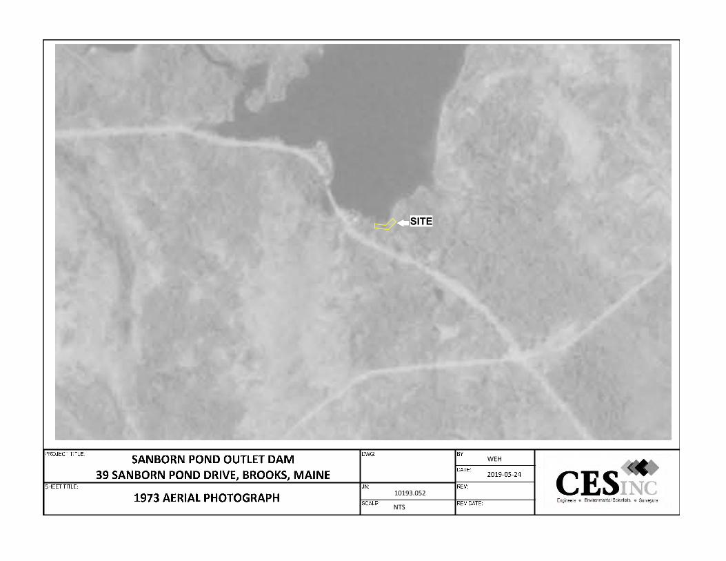
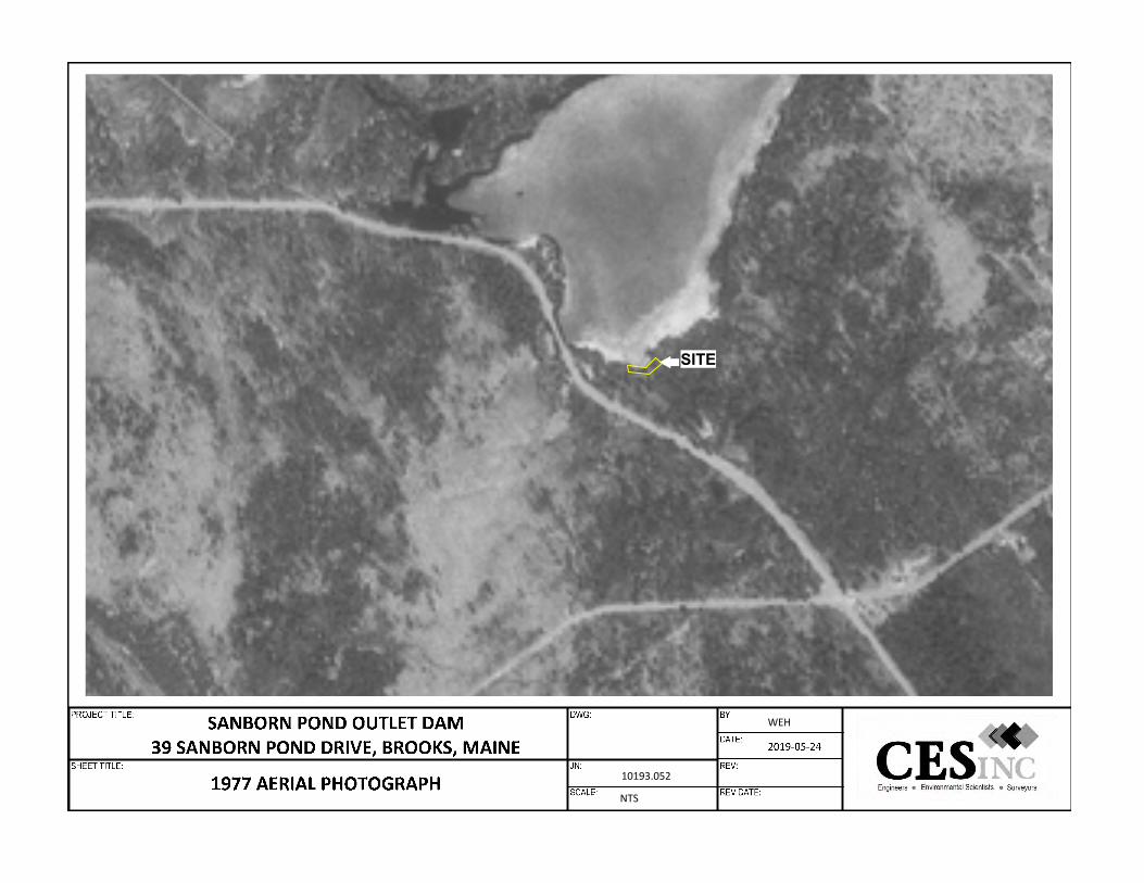
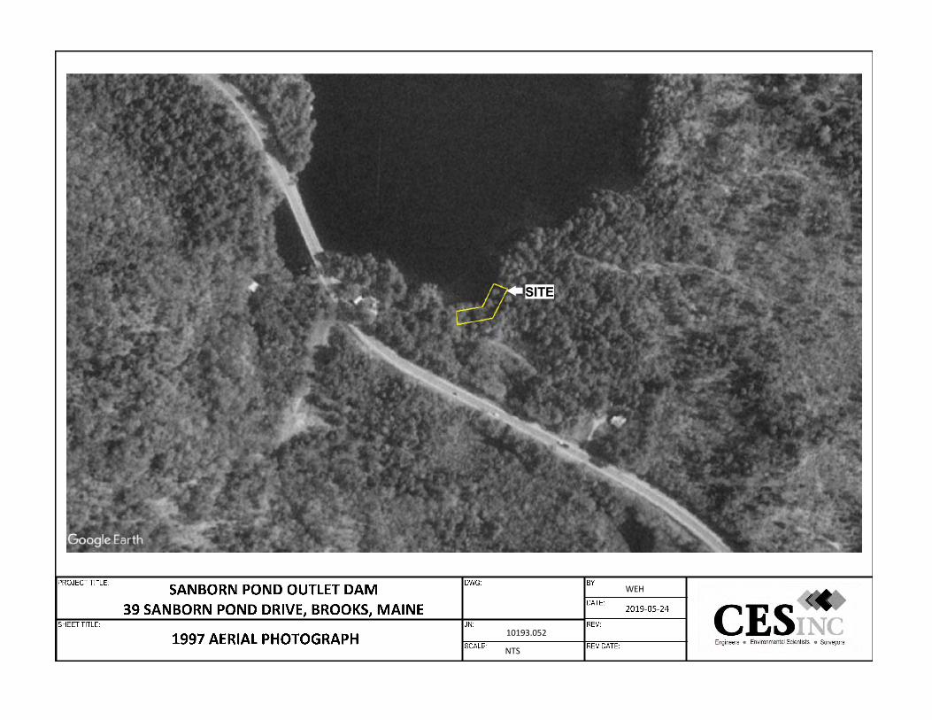
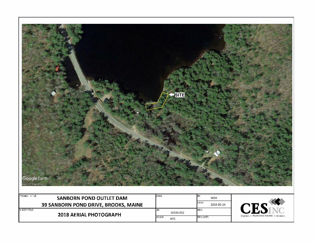
4.4.3 Aerial Photographs
Aerial photographs from the years 1956, 1973, 1977, 1997, 2010 and 2018 of the Site and the surrounding area were reviewed by CES. Based on the resolution of the aerial
JN: 10193.052 — 12 — Sanborn Pond Outlet Dam Property Brooks, Maine
photographs, and the presence of overstory vegetation in the aerial photographs, indications of the Site being developed was not identified. Aerial photographs from 1956, 1973, 1977, 1997, 2010 and 2018 are included in Appendix B.
4.4.4 Historic Atlases
The 1887 Atlas of Waldo County, Maine published by Colby & Stuart does not indicate significant development at the Site. A copy of the historic atlas is included in Appendix I.
4.4.5 Historic Topographic Maps
Historical topographic maps of the Merrill, Maine quadrangle from 1960 and 2014 were reviewed. Evidence of significant development at the Site was not identified in the topographic maps reviewed. Copies of the historic topographic maps are included in Appendix J.
4.4.6 Property Tax Files
The Site is identified as a portion of Lot 40 on the Town of Brooks Property Tax Maps 1 and 2. Property records indicate that the Site is a portion of a larger six-acre parcel that includes a seasonal structure. The structure (and the majority of the remainder of the parcel is not considered to be part of the Site for the purposes of this Phase I ESA. Copies of the Site’s property tax files are included in Appendix H.
4.4.7 Code Enforcement Files CES reviewed the Code Enforcement files maintained by the Town of Brooks regarding the current status of code violations and environmental conditions relating to the Site on May 15, 2019. Current or historic code violations were not identified for the Site. Other details pertaining to historic site use were not identified in the files reviewed.
4.5 Historical Information on Adjoining Properties Historical sources associated with the Site and adjoining properties were reviewed to develop a history of the previous uses in order to help identify the likelihood of past uses having led to RECs at the Site. Based on CES’ review of the available historical use documents, the properties adjoining the Site appear to have been undeveloped or developed with seasonal residential structures. The following historical sources were reviewed during the completion of this Phase I ESA:
4.5.1 Sanborn Fire Insurance Rate Maps A review of the Sanborn Maps indicates that this portion of the Town of Brooks was not mapped.
4.5.2 Aerial Photographs Aerial photographs from the years 1956, 1973, 1977, 1997, 2010 and 2018 of the Site and the surrounding area were reviewed by CES. The 1956, 1973 and 1977 aerial
JN: 10193.052 — 13 — Sanborn Pond Outlet Dam Property Brooks, Maine
photographs did not depict significant development on the properties adjoining the Site. The 1997 aerial photograph depicts a structure on the adjoining property to the west. The 2010 aerial photograph depicts a structure to the east of the Site. Significant changes to the properties adjoining the Site were not identified on the 2018 aerial photograph. Aerial photographs from 1956, 1973, 1977, 1997, 2010 and 2018 are included in Appendix B.
4.5.3 Historic Atlases The 1887 Atlas of Waldo County, Maine published by Colby & Stuart does not indicate significant development at the Site. A copy of the historic atlas is included in Appendix I.
4.5.4 Historic Topographic Maps
Historical topographic maps of the Merrill, Maine quadrangle from 1960 and 2014 were reviewed. Evidence of significant development at the Site was not identified in the topographic maps reviewed. Copies of the historic topographic maps are included in Appendix J.
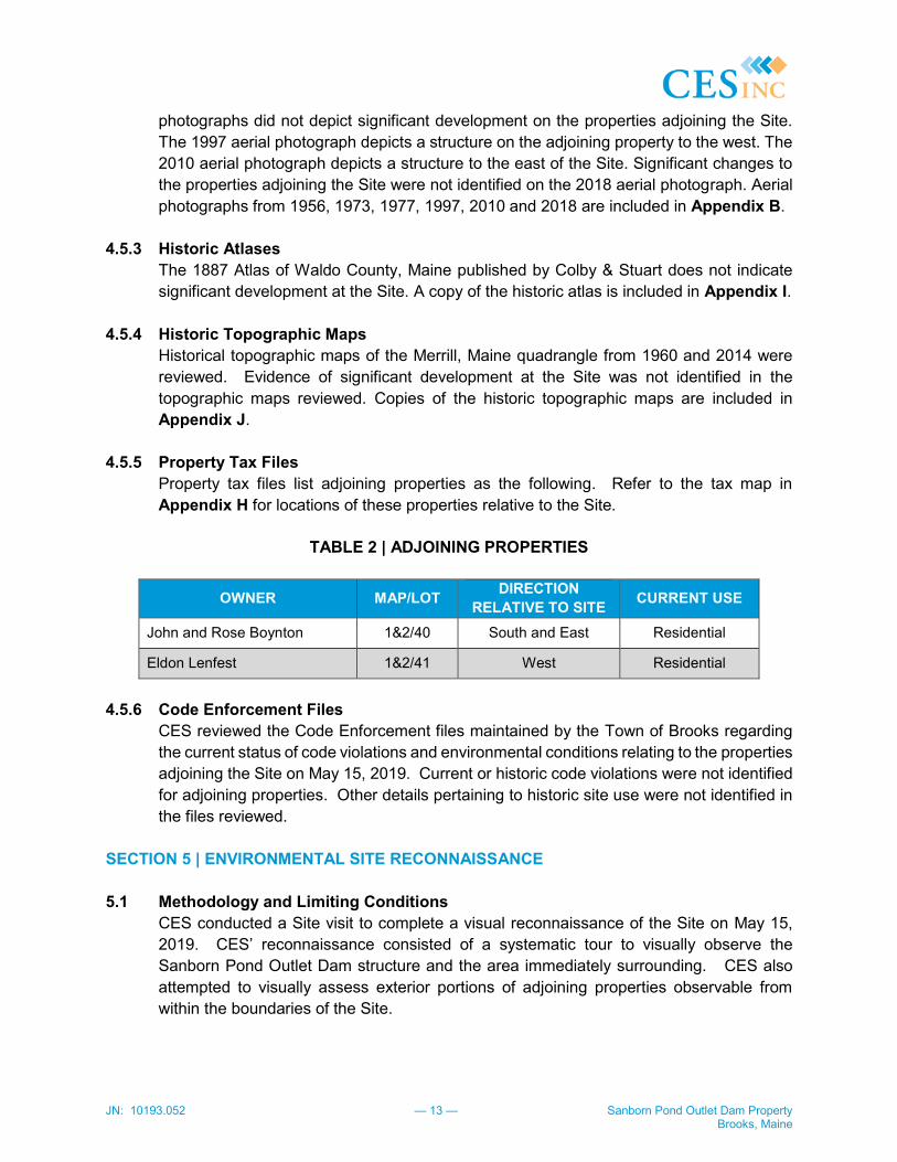
4.5.5 Property Tax Files Property tax files list adjoining properties as the following. Refer to the tax map in Appendix H for locations of these properties relative to the Site.
TABLE 2 | ADJOINING PROPERTIES
OWNER MAP/LOT DIRECTION RELATIVE TO SITE CURRENT USE
John and Rose Boynton 1&2/40 South and East Residential
Eldon Lenfest 1&2/41 West Residential
4.5.6 Code Enforcement Files
CES reviewed the Code Enforcement files maintained by the Town of Brooks regarding the current status of code violations and environmental conditions relating to the properties adjoining the Site on May 15, 2019. Current or historic code violations were not identified for adjoining properties. Other details pertaining to historic site use were not identified in the files reviewed.
SECTION 5 | ENVIRONMENTAL SITE RECONNAISSANCE 5.1 Methodology and Limiting Conditions
CES conducted a Site visit to complete a visual reconnaissance of the Site on May 15, 2019. CES’ reconnaissance consisted of a systematic tour to visually observe the Sanborn Pond Outlet Dam structure and the area immediately surrounding. CES also attempted to visually assess exterior portions of adjoining properties observable from within the boundaries of the Site.
JN: 10193.052 — 14 — Sanborn Pond Outlet Dam Property Brooks, Maine
At the time of the Site visit, CES was not able to visually observe the condition of sediment or soil beneath the waters of Sanborn Pond or the outfall below the Sanborn Pond Outlet Dam to determine if petroleum impacts existed at the Site. Other limiting conditions were not encountered at the time of the Site visit that would prevent the assessment of potential environmental impacts to the Site. Refer to Appendix A for photographs of the Site from the Site visit.
The following sections regarding the general Site setting are intended to address those items listed in Sections 9.4.1 through 9.4.4.7 in ASTM E 1527-13. The items listed below were visually observed during the May 15, 2019 Site visit by CES and have not been discussed in previous sections of this Phase I ESA.
5.2 Hazardous Substances and Petroleum Products
Hazardous substances and petroleum products were not observed at the time of the Site visit. However, based on interviews conducted with Mr. John Boynton, the current owner of the Site, when the sediment beneath the water is disturbed (swimming, watercraft), a petroleum sheen will occasionally be observed on the surface of the water as a result of the 2001 petroleum spill 0.29-miles to the northwest of the Site. See Section 4.2.1.7 for more information pertaining to the 2001 petroleum spill.
5.3 Storage Tanks 5.3.1 Aboveground Storage Tanks (ASTs)
ASTs were not observed at the time of the Site visit. 5.3.2 Underground Storage Tanks (USTs)
Evidence of USTs (i.e. fill ports of vents) and dispensers were not observed at the time of the Site visit.
5.4 Strong, Pungent, or Noxious Odors
Strong, pungent, or noxious odors indicative of hazardous substances and/or petroleum product releases were not identified at the time of the Site visit.
5.5 Pools or Sumps Containing Liquid Pools or sumps containing liquids or unidentified oil, or hazardous materials were not observed at the time of the Site visit.
5.6 Drums Drums were not observed at the time of the Site visit.
5.7 Unidentified Substance Containers Unidentified substance containers were not observed on the Site during the Site visit.

JN: 10193.052 — 15 — Sanborn Pond Outlet Dam Property Brooks, Maine
5.8 Polychlorinated Biphenyls (PCBs) PCB-containing building materials, such as caulks and sealants were commonly available and used from 1950 to 1978. Based on the poured concrete dam structure at the Site, it is unlikely that PCBs would have been utilized during its construction, or during maintenance activities at the Site. Other sources of potential PCB containing materials were not observed at the time of the Site visit.
5.9 Pits, Lakes, or Lagoons
Waste disposal and/or waste treatment pits, lakes, or lagoons or evidence of their presence (i.e., staining, corrosion) were not observed at the Site at the time of the Site visit.
5.10 Stained Surfaces or Distressed Vegetation
Stained surfaced or distressed vegetation were not observed at the time of the Site visit.
5.11 Underground Structures Evidence of underground structures other than the dam structure were not observed at the Site.
5.12 Floor Drains and Sumps CES did not observed floor drains or sumps at the time of the Site visit.
5.13 Heating and Cooling
Heating or air conditioning units were not observed at the time of the Site visit.
5.14 Solid Waste Disposal Solid waste is not currently being generated at the Site.
5.15 Wastewater Disposal Sanitary wastewater is discharged directly to the municipal sanitary sewer system.
5.16 Wells
Wells were not observed at the site at the time of the Site visit. Water supply wells are not known to have existed at the Site. A public and private drinking water supply evaluation was completed as part of this Phase I ESA. CES completed a visual inspection of the nearby properties, in addition to the Maine Geological Survey: Water Well Database to identify 13 private water supply well within a 2,500-foot radius of the Site. Public drinking water supply wells were not identified within 2,500-feet of the Site. A figure depicting the identified private water supply well locations is included in Appendix G.
5.17 Septic Systems CES did not observe evidence of a septic system at the Site.

JN: 10193.052 — 16 — Sanborn Pond Outlet Dam Property Brooks, Maine
5.18 Universal Waste Universal waste was not identified at the Site at the time of the Site visit.
SECTION 6 | INTERVIEWS 6.1 Interview with Site Owner
CES Interviewed Mr. John Boynton, the current owner of the Site, on May 15, 2019, with respect to his knowledge of the Site. Mr. Boynton provided access to the Site and discussed his experience with the Site and the nearby properties. Pertinent information provided by Mr. Boynton has been included in previous sections of the report.
6.2 Interview with Site Manager
The Site is currently undeveloped (with the exception of a dam). CES did not conduct interviews with a current Site Manager during the Phase I ESA.
6.3 Interview with Occupants The Site is currently vacant. CES did not conduct interviews with an occupant during the Phase I ESA.
6.4 Interview with Local Government Officials CES reviewed the Code Enforcement files for the Town of Brooks on May 15, 2019. CES Also interviewed Mr. Randy Hall, the Code Enforcement Officer for the Town of Brooks. Environmental concerns or violations pertaining to the Site or adjoining properties were not identified in the files reviewed.
6.5 User Interview
CES received a completed AAI User Questionnaire from Mr. Eric Sroka on behalf of the Maine Department of Environmental Protection, on May 24, 2019. The User Questionnaire stated that he is unaware of environmental liens, activity and use limitations, or environmental concerns associated with the Site other than the 2001 petroleum spill to Sanborn Pond. A copy of the completed questionnaire is included in Appendix K.
6.6 Interviews with others CES interviewed Mr. Robert Dutton, a nearby property owner and relative of Mr. John Boynton on May 15, 2019. Mr. Dutton described the 2001 petroleum spill to Sanborn Pond and indicated that a petroleum sheen is occasionally observed in portions of Sanborn Pond. CES interviewed Mr. Eldon Lenfest, a property owner to the west of the Site. Mr. Lenfest indicated that a petroleum sheen is occasionally observed in portions of Sanborn Pond. CES did not conduct additional interviews as part of the Phase I ESA.

JN: 10193.052 — 17 — Sanborn Pond Outlet Dam Property Brooks, Maine
SECTION 7 | ADDITIONAL SERVICES 7.1 Vapor Encroachment Screening
In accordance with ASTM E 2600-10, Standard Guide for Vapor Encroachment Screening on Property Involved in Real Estate Transactions, a supplemental (Tier 1) assessment of the Site, was completed as part of the Phase I ESA investigation to identify potential Vapor Encroachment Conditions (VECs) at the Site. The purpose of the Tier 1 assessment is to conduct a non-invasive, initial screen of the Site, including review of historic information, to determine if a VEC is present in connection with the Site. Based on the Tier 1 assessment of the Site, VECs may exist at the Site. Due to the movement of water toward the Site, and areas of residual petroleum products present beneath sediment on the bottom of Sanborn Pond.
7.2 Asbestos-Containing Materials An inspection and laboratory analyses for Asbestos-Containing Materials (ACM) is beyond the scope of this Phase I ESA; however, pursuant to 29 Code of Federal Regulations (CFR) 1926.1101, for buildings constructed prior to 1980, all suspect building materials are assumed to contain asbestos until laboratory analysis proves otherwise. In addition, MDEP regulations require testing or assumption of positive for suspect materials that may be disturbed during renovation, demolition, and/or maintenance activities unless documentation is available showing the materials are non-ACM. Based on the age and construction of the on-site dam structure, ACM may have been used in its construction and may exist at the Site.
7.3 Lead-Based Paint An inspection, sampling, and laboratory analysis for the presence of Lead-Based Paint (LBP) is beyond the scope of this Phase I ESA. The use of LBP was discontinued in 1978. Based on the construction of the on-site dam structure, LBP is not likely to have been used at the Site.
SECTION 8 | FINDINGS A Recognized Environmental Condition (REC) is defined as the presence or likely presence of any hazardous substances or petroleum products on a property under conditions that indicate an existing release, a past release, or a material threat of a release of any hazardous substances or petroleum products in, on, or at a property. A Controlled Recognized Environmental Condition (CREC) is defined as a REC resulting from a past release of hazardous substances or petroleum products that has been addressed to the satisfaction of the applicable regulatory authority, with hazardous substances or petroleum products allowed to remain in place subject to the implementation of required controls.
JN: 10193.052 — 18 — Sanborn Pond Outlet Dam Property Brooks, Maine
A Historical Recognized Environmental Condition (HREC) is defined as a past release of any hazardous substances or petroleum products that has occurred in connection with the property and has been addressed to the satisfaction of the applicable regulatory authority, without subjecting the property to any required controls. HRECs are not considered to be RECs as defined under ASTM E 1527-13. De minimis conditions are defined as a condition that generally does not present a threat to human health or the environment and that generally would not be the subject of an enforcement action if brought to the attention of appropriate governmental agencies. De minimis conditions are not considered to be RECs as defined under ASTM E 1527-13.
During the completion of this Phase I ESA, the following RECs were identified at the Site:
◆ In 2001 a motor vehicle accident involving a tanker truck resulted in the discharge of approximately 5,600-gallons of #6 fuel oil into Sanborn Pond approximately 0.29 miles to the northwest of the Site. According to the Final Restoration Plan/Environmental Assessment prepared by the U.S. Fish and Wildlife Service (2010) sorbent materials, floating boom and vacuum trucks were utilized to recover the #6 fuel oil before some of the oil sunk to the bottom of the Pond. From 2002 to 2006 remedial efforts (impacted vegetation removal, sorbent booms, etc.) were completed throughout the Pond. From 2007 to 2009 little oil was observed floating on the Pond and additional remediation was not undertaken. According to the current owner of the Site (Mr. John Boynton), a petroleum sheen is occasionally observed on the pond surface when the shoreline is disturbed. The Site is the Sanborn Pond Outlet Dam structure, and the predominant flow of surface water toward the Site, residual petroleum (i.e., #6 fuel oil) may have accumulated or are present in the sediment associated with the upstream side of the dam as well as in the downstream sediments.
During the completion of this Phase I ESA, Historical RECs (HRECs), Controlled RECs (CRECs) or de minimis conditions were not identified at the Site. Based on the Tier 1 Vapor Encroachment Screening of the Site, potential VECs may exist at the Site. SECTION 9 | OPINION Based on the investigations conducted for this Phase I ESA, conditions indicative of releases or threatened releases of hazardous substances, pollutants, contaminants, petroleum or petroleum products, and/or controlled substances on, at, in, or to the Site were identified at the Site. It is the opinion of CES that residual petroleum (i.e., #6 fuel oil) may have migrated from the spill location (0.29 miles northwest of the Site) to the outlet of Sanborn Pond (the Site), and may exist in the sediment in the areas of the pond adjoining the Site, as well as in the sediments on the downstream side of the dam (the Site). Based on interviews conducted with the current property
JN: 10193.052 — 19 — Sanborn Pond Outlet Dam Property Brooks, Maine
owner and owners of nearby property owners, when disturbed, evidence of petroleum products (sheen) are observed on the surface of Sanborn Pond.
SECTION 10 | LIMITING CONDITIONS AND DEVIATIONS At the time of the Site visit, CES was not able to visually observe the condition of sediment or soil beneath the waters of Sanborn Pond or the outfall below the Sanborn Pond Outlet Dam to determine if petroleum impacts existed at the Site. Other limiting conditions were not encountered at the time of the Site visit that would prevent the assessment of potential environmental impacts to the Site. SECTION 11 | DATA GAPS CES did not identify significant data gaps as part of this Phase I ESA that would affect our ability to identify RECs. SECTION 12 | CONCLUSION We have completed this Phase I Environmental Site Assessment in conformance with the scope and limitations of ASTM Practice E 1527-13 for the Sanborn Pond Outlet Dam Property located in Brooks, Maine. The information included in this environmental assessment report is based upon conditions observed at the time of the Site visit. Any exceptions to, or deletions from this practice and/or limiting conditions affecting our ability to observe Site conditions are described in Section 1 of this report. This assessment has revealed evidence of one REC in connection with the property. SECTION 13 | ADDITIONAL INVESTIGATIONS
Based upon the findings of this Phase I ESA, in the event of construction or improvements in the area of the Site, an investigation should be completed on both the upstream and downstream sides of the dam structure to determine if petroleum and petroleum impacted soil/sediment are present, and the extent of impacts, if present to the Site and adjacent properties. In addition, if the dam structure is impacted by planned construction projects, repaired or removed, the concrete, and other building components should be sampled to determine if they are asbestos containing.

JN: 10193.052 — 20 — Sanborn Pond Outlet Dam Property Brooks, Maine
SECTION 14 | REFERENCES The following sources of information and published references were relied upon in preparing this Phase I ESA: Town of Brooks:
Code Enforcement Office; records reviewed May 15, 2019. Waldo County, Maine:
Registry of Deeds; records reviewed May 23, 2019.
State of Maine: Department of Environmental Protection; records reviewed May 20, 2019.
Database Search: Envirosite Corporation; “Government Records Report,” May 20, 2019.
Resources:
United States Geological Survey; Merrill, Maine Quadrangle 7.5-minute series topographic quadrangle, 1996.
Federal Emergency Management Agency; website http://store.msc.fema.gov. 23027C0410E, effective July 6, 2015.
Maine Geological Survey, Department of Conservation; Bedrock Geologic Map of Maine, Phiilip Osberg, dated 1985.
Maine Geological Survey, Department of Conservation; Surficial Geologic Map of Morrill by Thomas Weddle, dated 2014.
United States Fish and Wildlife Service, National Wetlands Inventory Mapper available on-line at http://wetlandsfws.er.usgs.gov.
JN: 10193.052 — 21 — Sanborn Pond Outlet Dam Property Brooks, Maine
SECTION 15 | SIGNATURE AND QUALIFICATIONS OF CES ENVIRONMENTAL PROFESSIONAL(S)
CES performed services in a manner consistent with the guidelines set forth in the ASTM E 1527-13 standard. We declare that the undersigned meet the definition of Environmental Professional as defined in §312.10 of 40 CFR 312, and we have the specific qualifications based on education, training, and experience to assess a property of the nature, history, and setting of the subject property. We have developed and performed all appropriate inquiries in conformance with the standards and practices set forth in 40 CFR Part 312. Individual qualifications for CES personnel performing work associated with this Phase I ESA are included in Appendix L. Bradley Sloat Dennis B. Kingman, Jr. CHMM Project Scientist Vice President/Senior Project Manager BS/DBK/cmc

JN: 10193.052 Sanborn Pond Outlet Dam Property Brooks, Maine
FIGURE 1
SITE LOCATION MAP

SANBORN POND OUTLET DAM39 SANBORN POND DRIVE, BROOKS, MAINE
FIGURE 1: SITE LOCATION MAP5/31/2019
10193.052
SOURCE:U.S.G.S TOPOGRAPHIC QUADRANGLEMORRILL, MAINE@ 1:2400
SITE

JN: 10193.052 Sanborn Pond Outlet Dam Property Brooks, Maine
FIGURE 2
SITE SKETCH
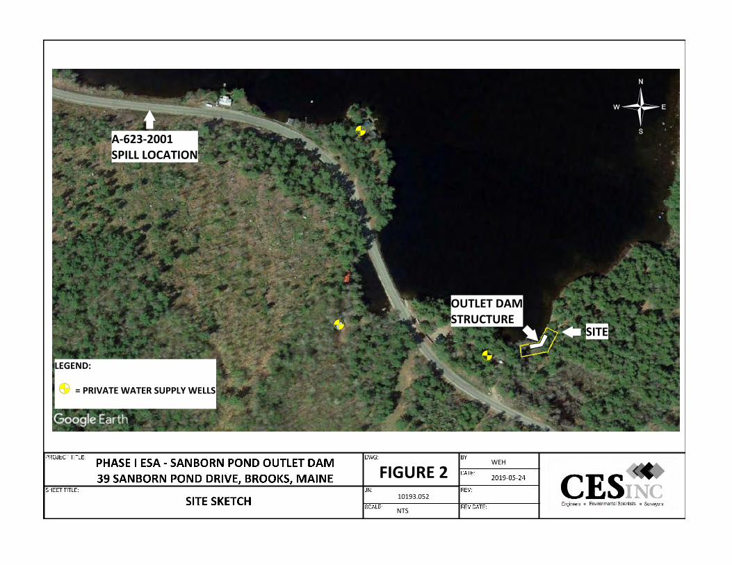
FIGURE 210193.052
NTS
WEH
SITE
OUTLET DAMSTRUCTURE
A-623-2001SPILL LOCATION
LEGEND:
= PRIVATE WATER SUPPLY WELLS

JN: 10193.052 Sanborn Pond Outlet Dam Property Brooks, Maine
APPENDIX A
SITE PHOTOGRAPHS

JN: 10193.052 PAGE 1
SANBORN POND OUTLET DAM PROPERTY PHASE I ENVIRONMENTAL SITE ASSESSMENT
Photo No. 1
Photo Date: May 15, 2019
Site Location: 39 Sanborn Pond Dr. Brooks, Maine
Description: View of the dam structure.
Photo By: BDS
Photo No. 2
Photo Date: May 15, 2019
Site Location: 39 Sanborn Pond Dr. Brooks, Maine
Description: View of the dam structure.
Photo By: BDS
JN: 10193.052 PAGE 2
Photo No. 3
Photo Date: May 15, 2019
Site Location: 39 Sanborn Pond Dr. Brooks, Maine
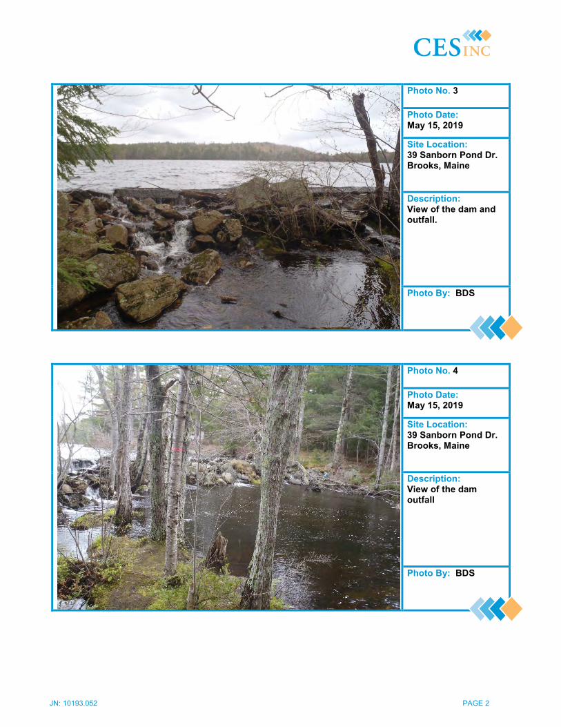
Description: View of the dam and outfall.
Photo By: BDS
Photo No. 4
Photo Date: May 15, 2019
Site Location: 39 Sanborn Pond Dr. Brooks, Maine
Description: View of the dam outfall
Photo By: BDS
JN: 10193.052 PAGE 3
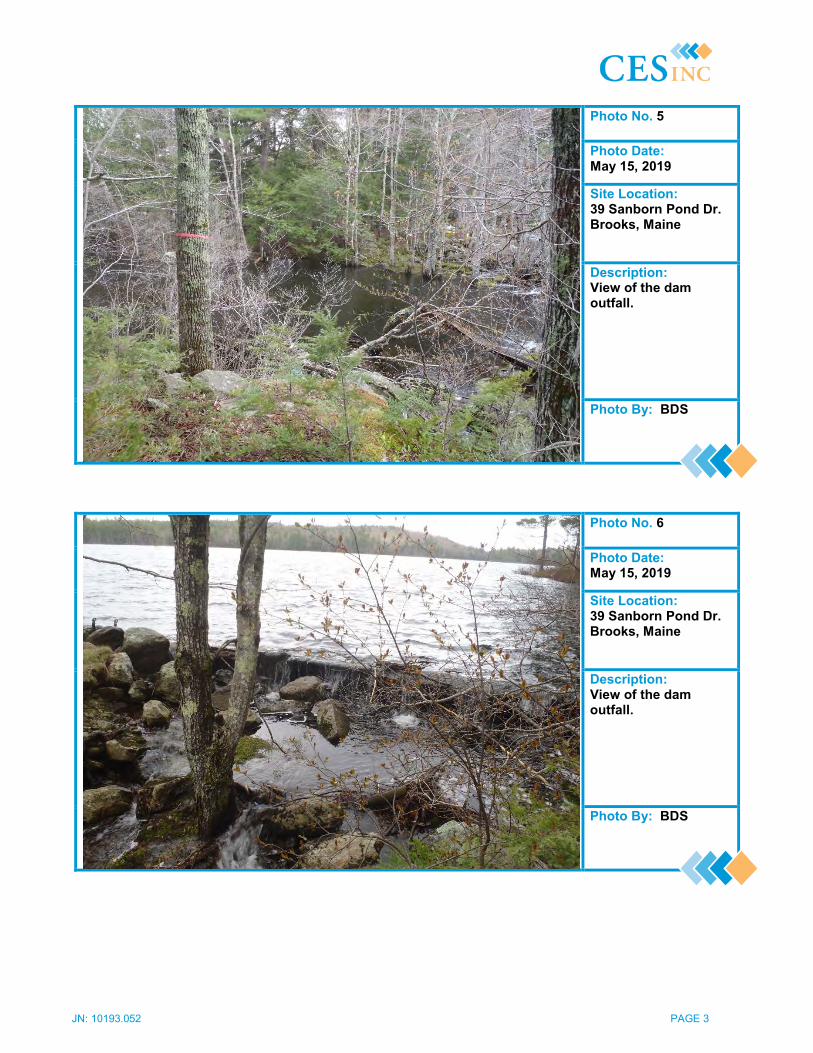
Photo No. 5
Photo Date: May 15, 2019
Site Location: 39 Sanborn Pond Dr. Brooks, Maine
Description: View of the dam outfall.
Photo By: BDS
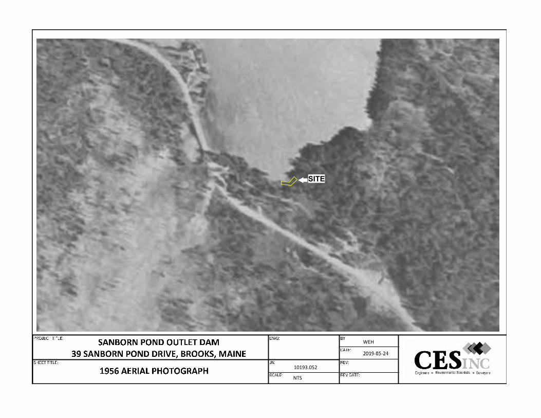
Photo No. 6
Photo Date: May 15, 2019
Site Location: 39 Sanborn Pond Dr. Brooks, Maine
Description: View of the dam outfall.
Photo By: BDS

JN: 10193.052 Sanborn Pond Outlet Dam Property Brooks, Maine
APPENDIX B
AERIAL PHOTOGRAPHS
10193.052
NTS
WEH
SITE
10193.052
NTS
WEH
SITE
10193.052
NTS
WEH
SITE
10193.052
NTS
WEH
SITE

10193.052
NTS
WEH
SITE
10193.052
NTS
WEH
SITE
JN: 10193.052 Sanborn Pond Outlet Dam Property Brooks, Maine
APPENDIX C
DATABASE SEARCH RESULTS

Government Records Report | 2019
Order Number: 30195Report Generated: 05/20/2019
Project Name: Sanborn Pond Outlet DamProject Number: 10193.052
Sanborn Pond Outlet Dam39 Sanborn Pond Dr.
Brooks, ME
2 Corporate DriveSuite 450
Shelton, CT 06484Toll Free: 866-211-2028www.envirositecorp.com

Table of Contents 2019
Section Page
Executive Summary 1
Executive Summary by Distance 2
Executive Summary by Database 3
Property Proximity Map 8
Area Map 9
Map Findings Summary 10
Map Findings 16
Unmappable Summary 17
Environmental Records Searched 18
Geological Landscape Section 35
Geological Landscape Section Summary 38
Geological Findings Map 39
Geological Landscape Section Map Findings 40
Geological Landscape Section Map Findings Radon 42
Geological Landscape Records Searched 43
Disclaimer - Copyright and Trademark Notice
All information contained in this report are based on data available from various public, government and other sources and are based upon the best data available from those sources. The information available in this report may be available from other sources and is not exclusive or the exclusive property of Envirosite Corporation.
NO WARRANTY EXPRESSED OR IMPLIED, IS MADE IN CONNECTION WITH THIS REPORT, INCLUDING WITHOUT LIMITATION, MERCHANTABILITY OR FITNESS FOR A PARTICULAR PURPOSE. ALL RISK IS ASSUMED BY USER AND Envirosite assumes no liability for faulty or inaccurate information. The Reports may utilize a variety of public and other sources reasonably available to Envirosite. Envirosite cannot, and does not assure, warrant, guarantee or assume any liability for the correctness, comprehensiveness, timeliness or completeness of any of such information, nor is the information in any Report to be construed as legal advice with respect to environmental risks associated with any property. Envirosite shall not be liable to anyone for any claims, causes of action, suits, damages, losses, costs and expenses (including, without limitation, attorneys’ fees and costs) arising out of or caused by this report regardless of the acts, errors or omissions, or negligence of Envirosite. Any damages shall be limited to the purchase price of the report.
Purchaser of the report accepts the report “As Is”. The report is intended only to provide information only and should not be considered as providing any legal advice, prediction, forecast, or fact as to the environmental risk for any specific property. Reports are proprietary to Envirosite, and contain copyrighted material and trademarks of Envirosite. All other trademarks used herein are the property of their respective owners. All rights of Envirosite as to the Reports are reserved.

Executive Summary 2019
Envirosite Corporation has conducted a search of all reasonably ascertainable records in accordance with EPA’s AAI (40 CFR Part 312) requirements and the ASTM E-1527-13 Environmental Site Assessments standard.
SUBJECT PROPERTY INFORMATION:
ADDRESS:Sanborn Pond Outlet Dam39 Sanborn Pond Dr.Brooks, ME
COORDINATES:Latitude (North): 44.477165 - 44°28'37.8"Longitude (West): -69.142884 - -69°8'34.4"Universal Transverse Mercator: Zone 19NUTM X (Meters): 488636.61UTM Y (Meters): 4924882.69
ELEVATION:Elevation: 290.505 ft. above sea level
USGS TOPOGRAPHIC MAP ASSOCIATED WITH SUBJECT PROPERTY:
Subject Property Map: 44069-D2 Morrill, MEMost Recent Revision: 2018
Page 1 of 44
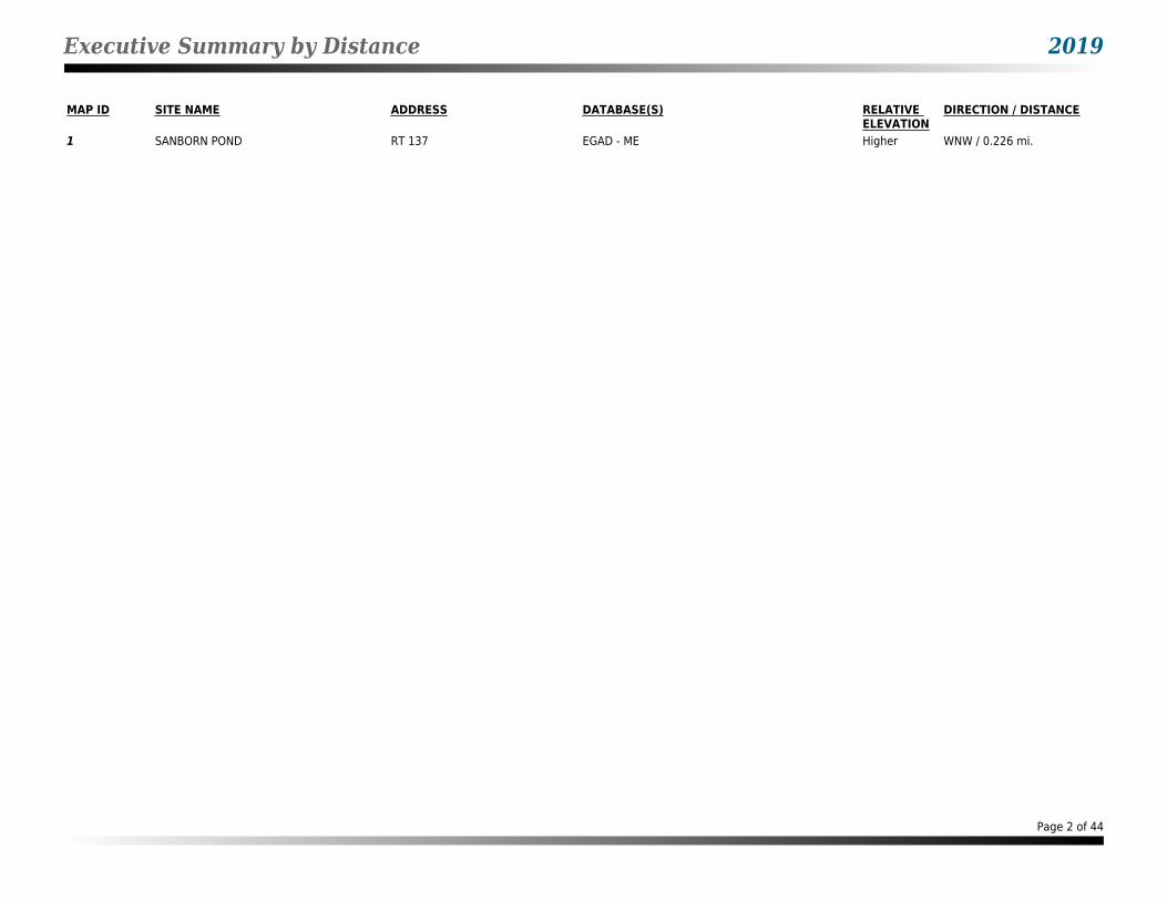
Executive Summary by Distance 2019
MAP ID SITE NAME ADDRESS DATABASE(S) RELATIVE ELEVATION
DIRECTION / DISTANCE
1 SANBORN POND RT 137 EGAD - ME Higher WNW / 0.226 mi.
Page 2 of 44
Executive Summary by Database 2019
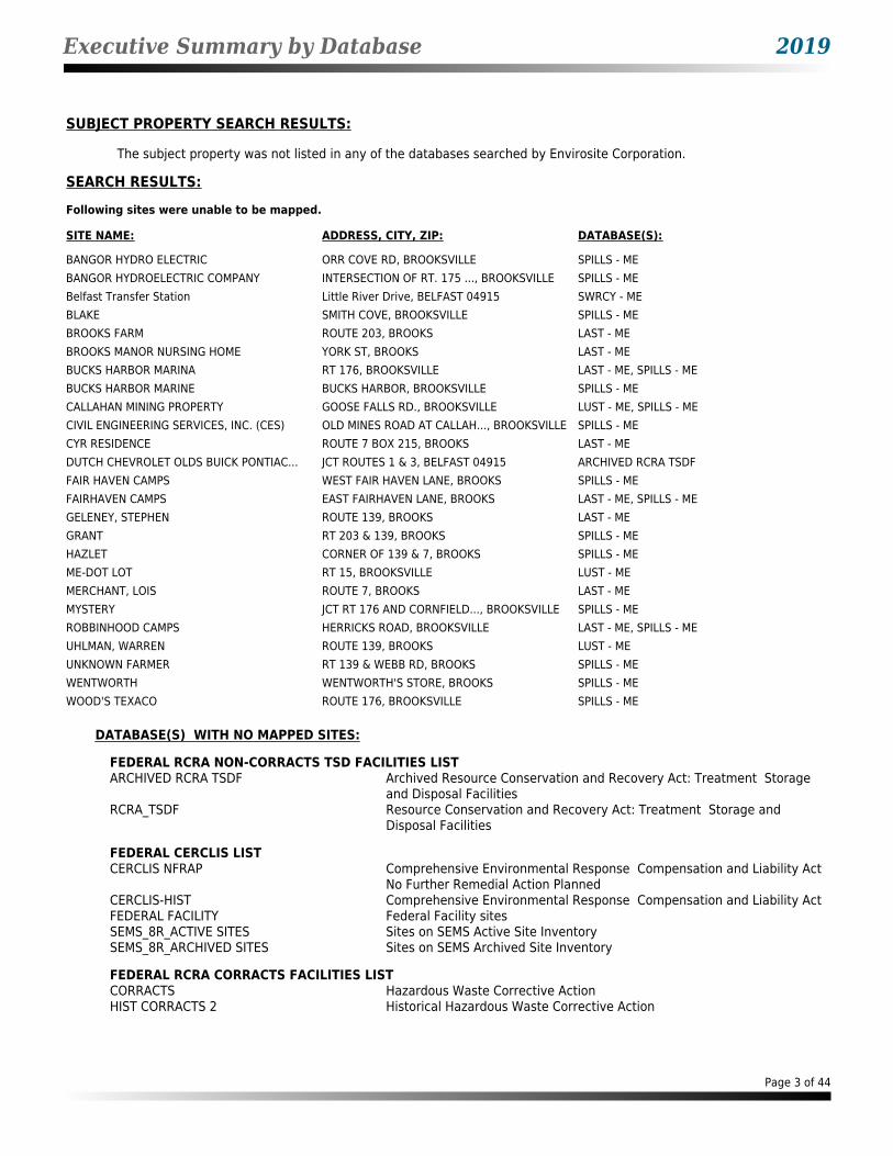
SUBJECT PROPERTY SEARCH RESULTS:
The subject property was not listed in any of the databases searched by Envirosite Corporation.
SEARCH RESULTS:
Following sites were unable to be mapped.
SITE NAME: ADDRESS, CITY, ZIP: DATABASE(S):
BANGOR HYDRO ELECTRIC ORR COVE RD, BROOKSVILLE SPILLS - MEBANGOR HYDROELECTRIC COMPANY INTERSECTION OF RT. 175 ..., BROOKSVILLE SPILLS - MEBelfast Transfer Station Little River Drive, BELFAST 04915 SWRCY - MEBLAKE SMITH COVE, BROOKSVILLE SPILLS - MEBROOKS FARM ROUTE 203, BROOKS LAST - MEBROOKS MANOR NURSING HOME YORK ST, BROOKS LAST - MEBUCKS HARBOR MARINA RT 176, BROOKSVILLE LAST - ME, SPILLS - MEBUCKS HARBOR MARINE BUCKS HARBOR, BROOKSVILLE SPILLS - MECALLAHAN MINING PROPERTY GOOSE FALLS RD., BROOKSVILLE LUST - ME, SPILLS - MECIVIL ENGINEERING SERVICES, INC. (CES) OLD MINES ROAD AT CALLAH..., BROOKSVILLE SPILLS - MECYR RESIDENCE ROUTE 7 BOX 215, BROOKS LAST - MEDUTCH CHEVROLET OLDS BUICK PONTIAC... JCT ROUTES 1 & 3, BELFAST 04915 ARCHIVED RCRA TSDFFAIR HAVEN CAMPS WEST FAIR HAVEN LANE, BROOKS SPILLS - MEFAIRHAVEN CAMPS EAST FAIRHAVEN LANE, BROOKS LAST - ME, SPILLS - MEGELENEY, STEPHEN ROUTE 139, BROOKS LAST - MEGRANT RT 203 & 139, BROOKS SPILLS - MEHAZLET CORNER OF 139 & 7, BROOKS SPILLS - MEME-DOT LOT RT 15, BROOKSVILLE LUST - MEMERCHANT, LOIS ROUTE 7, BROOKS LAST - MEMYSTERY JCT RT 176 AND CORNFIELD..., BROOKSVILLE SPILLS - MEROBBINHOOD CAMPS HERRICKS ROAD, BROOKSVILLE LAST - ME, SPILLS - MEUHLMAN, WARREN ROUTE 139, BROOKS LUST - MEUNKNOWN FARMER RT 139 & WEBB RD, BROOKS SPILLS - MEWENTWORTH WENTWORTH'S STORE, BROOKS SPILLS - MEWOOD'S TEXACO ROUTE 176, BROOKSVILLE SPILLS - ME
DATABASE(S) WITH NO MAPPED SITES:
FEDERAL RCRA NON-CORRACTS TSD FACILITIES LISTARCHIVED RCRA TSDF Archived Resource Conservation and Recovery Act: Treatment Storage
and Disposal FacilitiesRCRA_TSDF Resource Conservation and Recovery Act: Treatment Storage and
Disposal Facilities
FEDERAL CERCLIS LISTCERCLIS NFRAP Comprehensive Environmental Response Compensation and Liability Act
No Further Remedial Action PlannedCERCLIS-HIST Comprehensive Environmental Response Compensation and Liability ActFEDERAL FACILITY Federal Facility sitesSEMS_8R_ACTIVE SITES Sites on SEMS Active Site InventorySEMS_8R_ARCHIVED SITES Sites on SEMS Archived Site Inventory
FEDERAL RCRA CORRACTS FACILITIES LISTCORRACTS Hazardous Waste Corrective ActionHIST CORRACTS 2 Historical Hazardous Waste Corrective Action
Page 3 of 44
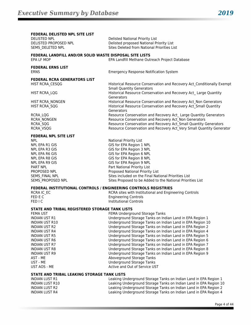
Executive Summary by Database 2019
FEDERAL DELISTED NPL SITE LISTDELISTED NPL Delisted National Priority ListDELISTED PROPOSED NPL Delisted proposed National Priority ListSEMS_DELETED NPL Sites Deleted from National Priorities List
FEDERAL LANDFILL AND/OR SOLID WASTE DISPOSAL SITE LISTSEPA LF MOP EPA Landfill Methane Outreach Project Database
FEDERAL ERNS LISTERNS Emergency Response Notification System
FEDERAL RCRA GENERATORS LISTHIST RCRA_CESQG Historical Resource Conservation and Recovery Act_Conditionally Exempt
Small Quantity GeneratorsHIST RCRA_LQG Historical Resource Conservation and Recovery Act_ Large Quantity
GeneratorsHIST RCRA_NONGEN Historical Resource Conservation and Recovery Act_Non GeneratorsHIST RCRA_SQG Historical Resource Conservation and Recovery Act_Small Quantity
GeneratorsRCRA_LQG Resource Conservation and Recovery Act_ Large Quantity GeneratorsRCRA_NONGEN Resource Conservation and Recovery Act_Non GeneratorsRCRA_SQG Resource Conservation and Recovery Act_Small Quantity GeneratorsRCRA_VSQG Resource Conservation and Recovery Act_Very Small Quantity Generator
FEDERAL NPL SITE LISTNPL National Priority ListNPL EPA R1 GIS GIS for EPA Region 1 NPLNPL EPA R3 GIS GIS for EPA Region 3 NPLNPL EPA R6 GIS GIS for EPA Region 6 NPLNPL EPA R8 GIS GIS for EPA Region 8 NPLNPL EPA R9 GIS GIS for EPA Region 9 NPLPART NPL Part National Priority ListPROPOSED NPL Proposed National Priority ListSEMS_FINAL NPL Sites included on the Final National Priorities ListSEMS_PROPOSED NPL Sites Proposed to be Added to the National Priorities List
FEDERAL INSTITUTIONAL CONTROLS / ENGINEERING CONTROLS REGISTRIESRCRA IC_EC RCRA sites with Institutional and Engineering ControlsFED E C Engineering ControlsFED I C Institutional Controls
STATE AND TRIBAL REGISTERED STORAGE TANK LISTSFEMA UST FEMA Underground Storage TanksINDIAN UST R1 Underground Storage Tanks on Indian Land in EPA Region 1INDIAN UST R10 Underground Storage Tanks on Indian Land in EPA Region 10INDIAN UST R2 Underground Storage Tanks on Indian Land in EPA Region 2INDIAN UST R4 Underground Storage Tanks on Indian Land in EPA Region 4INDIAN UST R5 Underground Storage Tanks on Indian Land in EPA Region 5INDIAN UST R6 Underground Storage Tanks on Indian Land in EPA Region 6INDIAN UST R7 Underground Storage Tanks on Indian Land in EPA Region 7INDIAN UST R8 Underground Storage Tanks on Indian Land in EPA Region 8INDIAN UST R9 Underground Storage Tanks on Indian Land in EPA Region 9AST - ME Aboveground Storage TanksUST - ME Underground Storage TanksUST AOS - ME Active and Out of Service UST
STATE AND TRIBAL LEAKING STORAGE TANK LISTSINDIAN LUST R1 Leaking Underground Storage Tanks on Indian Land in EPA Region 1INDIAN LUST R10 Leaking Underground Storage Tanks on Indian Land in EPA Region 10INDIAN LUST R2 Leaking Underground Storage Tanks on Indian Land in EPA Region 2INDIAN LUST R4 Leaking Underground Storage Tanks on Indian Land in EPA Region 4
Page 4 of 44
Executive Summary by Database 2019
STATE AND TRIBAL LEAKING STORAGE TANK LISTS (cont.)INDIAN LUST R5 Leaking Underground Storage Tanks on Indian Land in EPA Region 5INDIAN LUST R6 Leaking Underground Storage Tanks on Indian Land in EPA Region 6INDIAN LUST R7 Leaking Underground Storage Tanks on Indian Land in EPA Region 7INDIAN LUST R8 Leaking Underground Storage Tanks on Indian Land in EPA Region 8INDIAN LUST R9 Leaking Underground Storage Tanks on Indian Land in EPA Region 9LAST - ME Leaking Aboveground Storage TanksLUST - ME Leaking Underground Storage Tanks
STATE AND TRIBAL BROWNFIELD SITESTRIBAL BROWNFIELDS Tribal BrownfieldsBROWNFIELDS - ME Brownfields
STATE- AND TRIBAL - EQUIVALENT CERCLISDEL HWS - ME Delisted Hazardous Waste SitesSHWS - ME State Hazardous Waste Sites
STATE INSTITUTIONAL CONTROLS / ENGINEERING CONTROLS REGISTRIESI C - ME Institutional Controls
STATE AND TRIBAL LANDFILL AND/OR SOLID WASTE DISPOSAL SITE LISTSLCP - ME Municipal Landfill ClosureSWF/LF - ME Solid Waste Facilities and Landfills
STATE AND TRIBAL VOLUNTARY CLEANUP SITESVCP - ME Voluntary Cleanup Program
LOCAL BROWNFIELD LISTSBROWNFIELDS-ACRES EPA ACRES BrownfieldsFED BROWNFIELDS Federal Brownfields
LOCAL LISTS OF HAZARDOUS WASTE / CONTAMINATED SITESFED CDL DOJ Clandestine Drug LabsUS HIST CDL Historical Clandestine Drug Labs
LOCAL LISTS OF LANDFILL / SOLID WASTE DISPOSAL SITESHIST INDIAN ODI R8 Historical Open Dump InventoryINDIAN ODI R8 Open Dump InventoryODI Open Dump InventoryTRIBAL ODI Indian Open Dump Inventory SitesSWRCY - ME Solid Waste Recycling
RECORDS OF EMERGENCY RELEASE REPORTSHMIRS (DOT) Hazardous Materials Information Reporting SystemsSPILLS - ME Spills
LOCAL LAND RECORDSLIENS 2 CERCLA Lien InformationLIENS - ME Environmental Liens
OTHER ASCERTAINABLE RECORDSAFS Air Facility SystemsBRS Biennial Reporting SystemsCDC HAZDAT Hazardous Substance Release and Health Effects InformationCOAL ASH DOE Coal Ash: Department of EnergyCOAL ASH EPA Coal Ash: Environmental Protection AgencyCOAL GAS Coal Gas PlantsCONSENT (DECREES) Superfund Consent DecreeDEBRIS R5 LF Disaster Debris Landfill DataDEBRIS R5 SWRCY Disaster Debris Recovery DataDOD Department of DefenseDOT OPS Department of Transportation Office of Pipeline Safety
Page 5 of 44

Executive Summary by Database 2019
OTHER ASCERTAINABLE RECORDS (cont.)ECHO EPA Enforcement and Compliance History OnlineENOI Electronic Notice of IntentEPA FUELS EPA Fuels Registration, Reporting, and Compliance ListEPA OSC EPA On-Site CoordinatorEPA WATCH EPA Watch ListFA HWF Financial Assurance for Hazardous Waste FacilitiesFEDLAND Federal LandsFRS Facility Index SystemsFTTS FIFRA/TSCA Tracking SystemFTTS INSP FIFRA/TSCA Tracking System: InspectionsFUDS Formerly Used Defense SitesHIST AFS Historical Air Facility SystemsHIST AFS 2 Historical Air Facility SystemsHIST DOD Department of Defense historical sitesHIST LEAD_SMELTER Historical Lead Smelter SitesHIST MLTS Historical Material Licensing Tracking SystemsHIST PCB TRANS Historical Polychlorinated Biphenyl (PCB) FacilitiesHIST PCS ENF Historical Enforced Permit Compliance FacilitiesHIST PCS FACILITY Historical Permit Compliance FacilitiesHIST SSTS Historical Section 7 Tracking SystemsICIS Integrated Compliance Information SystemINACTIVE PCS Inactive Permit Compliance FacilitiesINDIAN RESERVATION Indian ReservationsLEAD_SMELTER Lead Smelter SitesLUCIS Land Use Control Information SystemsLUCIS 2 Land Use Control Information Systems 2MINES MinesMLTS Material Licensing Tracking SystemsNPL AOC Areas related to NPL remediation sitesNPL LIENS National Priority List LiensOSHA Occupational Safety & Health AdministrationPADS PCB Activity Database SystemsPCB TRANSFORMER Polychlorinated Biphenyl (PCB) WastePCS ENF Enforced Permit Compliance FacilitiesPCS FACILITY Permit Compliance FacilitiesPRP Potentially Responsible PartiesRAATS RCRA Administrative Action Tracking SystemsRADINFO Radiation Information SystemsRMP Risk Management PlansROD Record of DecisionSCRD DRYCLEANERS SCRD DrycleanersSEMS_SMELTER Sites on SEMS Potential Smelter ActivitySSTS Section 7 Tracking SystemsSTORMWATER Storm Water PermitsTOSCA-PLANT Toxic Substance Control Act: PlantsTRIS Toxic Release Inventory SystemsUMTRA Uranium Mill Tailing SitesVAPOR EPA Vapor IntrusionCORRECTIVE ACTIONS_2020 Wastes - Hazardous Waste - Corrective ActionAIRS - ME Air Monitoring Stations and PermitsALL SITES - ME Remediation SitesDAYCARE - ME Daycare FacilitiesDRYCLEANERS - ME DrycleanersEGAD - ME EGAD Spill SitesHIST AIRS - ME Historical Air PermitsHIST DRYCLEANERS - ME Historical DrycleanersHIST NPDES - ME Past State Wastewater Discharge PermitsNPDES - ME State Wastewater and NPDES Permits
Page 6 of 44

Executive Summary by Database 2019
OTHER ASCERTAINABLE RECORDS (cont.)T 2 - ME Tier 2UIC - ME Underground Injection Controls
Page 7 of 44
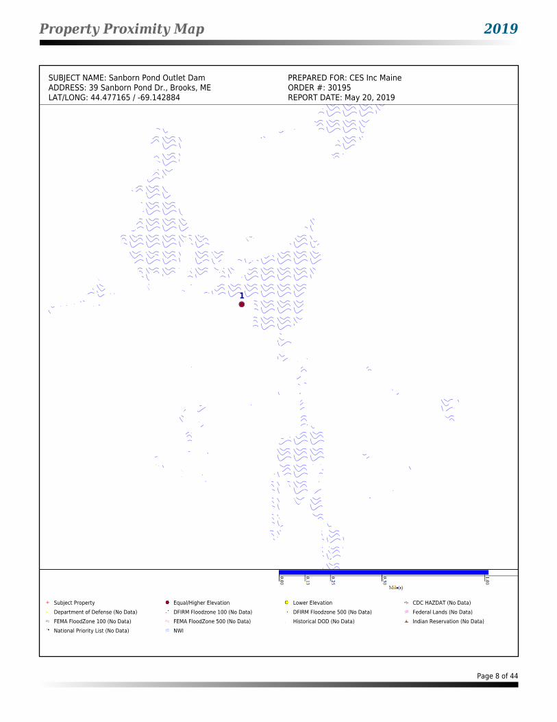
Property Proximity Map 2019
SUBJECT NAME: Sanborn Pond Outlet Dam PREPARED FOR: CES Inc MaineADDRESS: 39 Sanborn Pond Dr., Brooks, ME ORDER #: 30195LAT/LONG: 44.477165 / -69.142884 REPORT DATE: May 20, 2019
1
A
Subject Property Equal/Higher Elevation Lower Elevation CDC HAZDAT (No Data)Department of Defense (No Data) DFIRM Floodzone 100 (No Data) DFIRM Floodzone 500 (No Data) Federal Lands (No Data)FEMA FloodZone 100 (No Data) FEMA FloodZone 500 (No Data) Historical DOD (No Data) Indian Reservation (No Data)National Priority List (No Data) NWI
Page 8 of 44
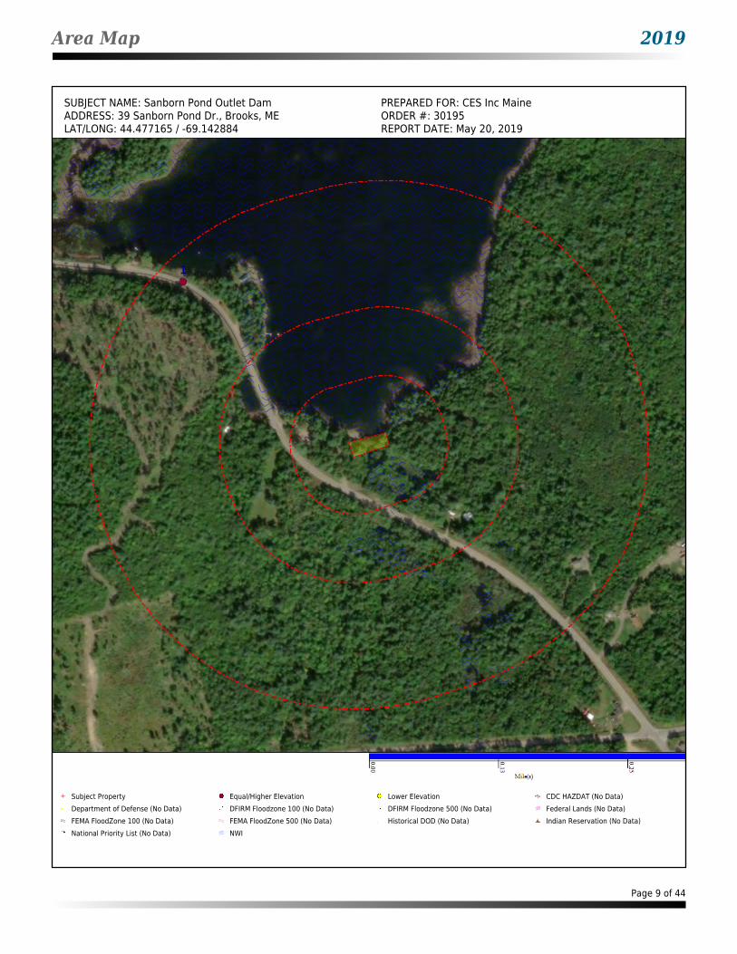
Area Map 2019
SUBJECT NAME: Sanborn Pond Outlet Dam PREPARED FOR: CES Inc MaineADDRESS: 39 Sanborn Pond Dr., Brooks, ME ORDER #: 30195LAT/LONG: 44.477165 / -69.142884 REPORT DATE: May 20, 2019
1
Subject Property Equal/Higher Elevation Lower Elevation CDC HAZDAT (No Data)Department of Defense (No Data) DFIRM Floodzone 100 (No Data) DFIRM Floodzone 500 (No Data) Federal Lands (No Data)FEMA FloodZone 100 (No Data) FEMA FloodZone 500 (No Data) Historical DOD (No Data) Indian Reservation (No Data)National Priority List (No Data) NWI
Page 9 of 44
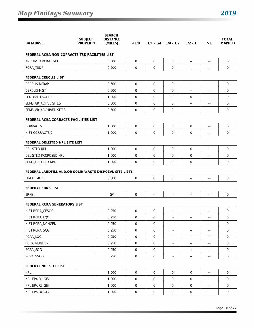
Map Findings Summary 2019
DATABASESUBJECT
PROPERTY
SEARCH DISTANCE(MILES) <1/8 1/8 - 1/4 1/4 - 1/2 1/2 - 1 >1
TOTAL MAPPED
FEDERAL RCRA NON-CORRACTS TSD FACILITIES LIST
ARCHIVED RCRA TSDF 0.500 0 0 0 -- -- 0
RCRA_TSDF 0.500 0 0 0 -- -- 0
FEDERAL CERCLIS LIST
CERCLIS NFRAP 0.500 0 0 0 -- -- 0
CERCLIS-HIST 0.500 0 0 0 -- -- 0
FEDERAL FACILITY 1.000 0 0 0 0 -- 0
SEMS_8R_ACTIVE SITES 0.500 0 0 0 -- -- 0
SEMS_8R_ARCHIVED SITES 0.500 0 0 0 -- -- 0
FEDERAL RCRA CORRACTS FACILITIES LIST
CORRACTS 1.000 0 0 0 0 -- 0
HIST CORRACTS 2 1.000 0 0 0 0 -- 0
FEDERAL DELISTED NPL SITE LIST
DELISTED NPL 1.000 0 0 0 0 -- 0
DELISTED PROPOSED NPL 1.000 0 0 0 0 -- 0
SEMS_DELETED NPL 1.000 0 0 0 0 -- 0
FEDERAL LANDFILL AND/OR SOLID WASTE DISPOSAL SITE LISTS
EPA LF MOP 0.500 0 0 0 -- -- 0
FEDERAL ERNS LIST
ERNS SP 0 -- -- -- -- 0
FEDERAL RCRA GENERATORS LIST
HIST RCRA_CESQG 0.250 0 0 -- -- -- 0
HIST RCRA_LQG 0.250 0 0 -- -- -- 0
HIST RCRA_NONGEN 0.250 0 0 -- -- -- 0
HIST RCRA_SQG 0.250 0 0 -- -- -- 0
RCRA_LQG 0.250 0 0 -- -- -- 0
RCRA_NONGEN 0.250 0 0 -- -- -- 0
RCRA_SQG 0.250 0 0 -- -- -- 0
RCRA_VSQG 0.250 0 0 -- -- -- 0
FEDERAL NPL SITE LIST
NPL 1.000 0 0 0 0 -- 0
NPL EPA R1 GIS 1.000 0 0 0 0 -- 0
NPL EPA R3 GIS 1.000 0 0 0 0 -- 0
NPL EPA R6 GIS 1.000 0 0 0 0 -- 0
Page 10 of 44

Map Findings Summary 2019
DATABASESUBJECT
PROPERTY
SEARCH DISTANCE(MILES) <1/8 1/8 - 1/4 1/4 - 1/2 1/2 - 1 >1
TOTAL MAPPED
FEDERAL NPL SITE LIST (cont.)
NPL EPA R8 GIS 1.000 0 0 0 0 -- 0
NPL EPA R9 GIS 1.000 0 0 0 0 -- 0
PART NPL 1.000 0 0 0 0 -- 0
PROPOSED NPL 1.000 0 0 0 0 -- 0
SEMS_FINAL NPL 1.000 0 0 0 0 -- 0
SEMS_PROPOSED NPL 1.000 0 0 0 0 -- 0
FEDERAL INSTITUTIONAL CONTROLS / ENGINEERING CONTROLS REGISTRIES
RCRA IC_EC 0.250 0 0 -- -- -- 0
FED E C 0.500 0 0 0 -- -- 0
FED I C 0.500 0 0 0 -- -- 0
STATE AND TRIBAL REGISTERED STORAGE TANK LISTS
FEMA UST 0.250 0 0 -- -- -- 0
INDIAN UST R1 0.250 0 0 -- -- -- 0
INDIAN UST R10 0.250 0 0 -- -- -- 0
INDIAN UST R2 0.250 0 0 -- -- -- 0
INDIAN UST R4 0.250 0 0 -- -- -- 0
INDIAN UST R5 0.250 0 0 -- -- -- 0
INDIAN UST R6 0.250 0 0 -- -- -- 0
INDIAN UST R7 0.250 0 0 -- -- -- 0
INDIAN UST R8 0.250 0 0 -- -- -- 0
INDIAN UST R9 0.250 0 0 -- -- -- 0
AST - ME 0.250 0 0 -- -- -- 0
UST - ME 0.250 0 0 -- -- -- 0
UST AOS - ME 0.250 0 0 -- -- -- 0
STATE AND TRIBAL LEAKING STORAGE TANK LISTS
INDIAN LUST R1 0.500 0 0 0 -- -- 0
INDIAN LUST R10 0.500 0 0 0 -- -- 0
INDIAN LUST R2 0.500 0 0 0 -- -- 0
INDIAN LUST R4 0.500 0 0 0 -- -- 0
INDIAN LUST R5 0.500 0 0 0 -- -- 0
INDIAN LUST R6 0.500 0 0 0 -- -- 0
INDIAN LUST R7 0.500 0 0 0 -- -- 0
INDIAN LUST R8 0.500 0 0 0 -- -- 0
INDIAN LUST R9 0.500 0 0 0 -- -- 0
LAST - ME 0.500 0 0 0 -- -- 0
Page 11 of 44

Map Findings Summary 2019
DATABASESUBJECT
PROPERTY
SEARCH DISTANCE(MILES) <1/8 1/8 - 1/4 1/4 - 1/2 1/2 - 1 >1
TOTAL MAPPED
STATE AND TRIBAL LEAKING STORAGE TANK LISTS (cont.)
LUST - ME 0.500 0 0 0 -- -- 0
STATE AND TRIBAL BROWNFIELD SITES
TRIBAL BROWNFIELDS 0.500 0 0 0 -- -- 0
BROWNFIELDS - ME 0.500 0 0 0 -- -- 0
STATE- AND TRIBAL - EQUIVALENT CERCLIS
DEL HWS - ME 1.000 0 0 0 0 -- 0
SHWS - ME 1.000 0 0 0 0 -- 0
STATE INSTITUTIONAL CONTROLS / ENGINEERING CONTROLS REGISTRIES
I C - ME 0.500 0 0 0 -- -- 0
STATE AND TRIBAL LANDFILL AND/OR SOLID WASTE DISPOSAL SITE LISTS
LCP - ME 0.500 0 0 0 -- -- 0
SWF/LF - ME 0.500 0 0 0 -- -- 0
STATE AND TRIBAL VOLUNTARY CLEANUP SITES
VCP - ME 0.500 0 0 0 -- -- 0
LOCAL BROWNFIELD LISTS
BROWNFIELDS-ACRES 0.500 0 0 0 -- -- 0
FED BROWNFIELDS 0.500 0 0 0 -- -- 0
LOCAL LISTS OF HAZARDOUS WASTE / CONTAMINATED SITES
FED CDL SP 0 -- -- -- -- 0
US HIST CDL SP 0 -- -- -- -- 0
LOCAL LISTS OF LANDFILL / SOLID WASTE DISPOSAL SITES
HIST INDIAN ODI R8 0.500 0 0 0 -- -- 0
INDIAN ODI R8 0.500 0 0 0 -- -- 0
ODI 0.500 0 0 0 -- -- 0
TRIBAL ODI 0.500 0 0 0 -- -- 0
SWRCY - ME 0.500 0 0 0 -- -- 0
RECORDS OF EMERGENCY RELEASE REPORTS
HMIRS (DOT) SP 0 -- -- -- -- 0
SPILLS - ME 0.500 0 0 0 -- -- 0
LOCAL LAND RECORDS
LIENS 2 SP 0 -- -- -- -- 0
Page 12 of 44
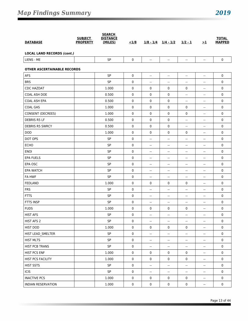
Map Findings Summary 2019
DATABASESUBJECT
PROPERTY
SEARCH DISTANCE(MILES) <1/8 1/8 - 1/4 1/4 - 1/2 1/2 - 1 >1
TOTAL MAPPED
LOCAL LAND RECORDS (cont.)
LIENS - ME SP 0 -- -- -- -- 0
OTHER ASCERTAINABLE RECORDS
AFS SP 0 -- -- -- -- 0
BRS SP 0 -- -- -- -- 0
CDC HAZDAT 1.000 0 0 0 0 -- 0
COAL ASH DOE 0.500 0 0 0 -- -- 0
COAL ASH EPA 0.500 0 0 0 -- -- 0
COAL GAS 1.000 0 0 0 0 -- 0
CONSENT (DECREES) 1.000 0 0 0 0 -- 0
DEBRIS R5 LF 0.500 0 0 0 -- -- 0
DEBRIS R5 SWRCY 0.500 0 0 0 -- -- 0
DOD 1.000 0 0 0 0 -- 0
DOT OPS SP 0 -- -- -- -- 0
ECHO SP 0 -- -- -- -- 0
ENOI SP 0 -- -- -- -- 0
EPA FUELS SP 0 -- -- -- -- 0
EPA OSC SP 0 -- -- -- -- 0
EPA WATCH SP 0 -- -- -- -- 0
FA HWF SP 0 -- -- -- -- 0
FEDLAND 1.000 0 0 0 0 -- 0
FRS SP 0 -- -- -- -- 0
FTTS SP 0 -- -- -- -- 0
FTTS INSP SP 0 -- -- -- -- 0
FUDS 1.000 0 0 0 0 -- 0
HIST AFS SP 0 -- -- -- -- 0
HIST AFS 2 SP 0 -- -- -- -- 0
HIST DOD 1.000 0 0 0 0 -- 0
HIST LEAD_SMELTER SP 0 -- -- -- -- 0
HIST MLTS SP 0 -- -- -- -- 0
HIST PCB TRANS SP 0 -- -- -- -- 0
HIST PCS ENF 1.000 0 0 0 0 -- 0
HIST PCS FACILITY 1.000 0 0 0 0 -- 0
HIST SSTS SP 0 -- -- -- -- 0
ICIS SP 0 -- -- -- -- 0
INACTIVE PCS 1.000 0 0 0 0 -- 0
INDIAN RESERVATION 1.000 0 0 0 0 -- 0
Page 13 of 44

Map Findings Summary 2019
DATABASESUBJECT
PROPERTY
SEARCH DISTANCE(MILES) <1/8 1/8 - 1/4 1/4 - 1/2 1/2 - 1 >1
TOTAL MAPPED
OTHER ASCERTAINABLE RECORDS (cont.)
LEAD_SMELTER SP 0 -- -- -- -- 0
LUCIS 0.500 0 0 0 -- -- 0
LUCIS 2 0.500 0 0 0 -- -- 0
MINES 0.250 0 0 -- -- -- 0
MLTS SP 0 -- -- -- -- 0
NPL AOC 1.000 0 0 0 0 -- 0
NPL LIENS SP 0 -- -- -- -- 0
OSHA SP 0 -- -- -- -- 0
PADS SP 0 -- -- -- -- 0
PCB TRANSFORMER SP 0 -- -- -- -- 0
PCS ENF 1.000 0 0 0 0 -- 0
PCS FACILITY 1.000 0 0 0 0 -- 0
PRP SP 0 -- -- -- -- 0
RAATS SP 0 -- -- -- -- 0
RADINFO SP 0 -- -- -- -- 0
RMP 0.500 0 0 0 -- -- 0
ROD 1.000 0 0 0 0 -- 0
SCRD DRYCLEANERS 0.250 0 0 -- -- -- 0
SEMS_SMELTER SP 0 -- -- -- -- 0
SSTS SP 0 -- -- -- -- 0
STORMWATER SP 0 -- -- -- -- 0
TOSCA-PLANT SP 0 -- -- -- -- 0
TRIS SP 0 -- -- -- -- 0
UMTRA 0.500 0 0 0 -- -- 0
VAPOR 0.500 0 0 0 -- -- 0
CORRECTIVE ACTIONS_2020 0.500 0 0 0 -- -- 0
AIRS - ME SP 0 -- -- -- -- 0
ALL SITES - ME 1.000 0 0 0 0 -- 0
DAYCARE - ME SP 0 -- -- -- -- 0
DRYCLEANERS - ME 0.250 0 0 -- -- -- 0
EGAD - ME 0.125 0 -- -- -- -- 0
HIST AIRS - ME SP 0 -- -- -- -- 0
HIST DRYCLEANERS - ME 0.250 0 0 -- -- -- 0
HIST NPDES - ME SP 0 -- -- -- -- 0
NPDES - ME SP 0 -- -- -- -- 0
T 2 - ME 0.250 0 0 -- -- -- 0
Page 14 of 44
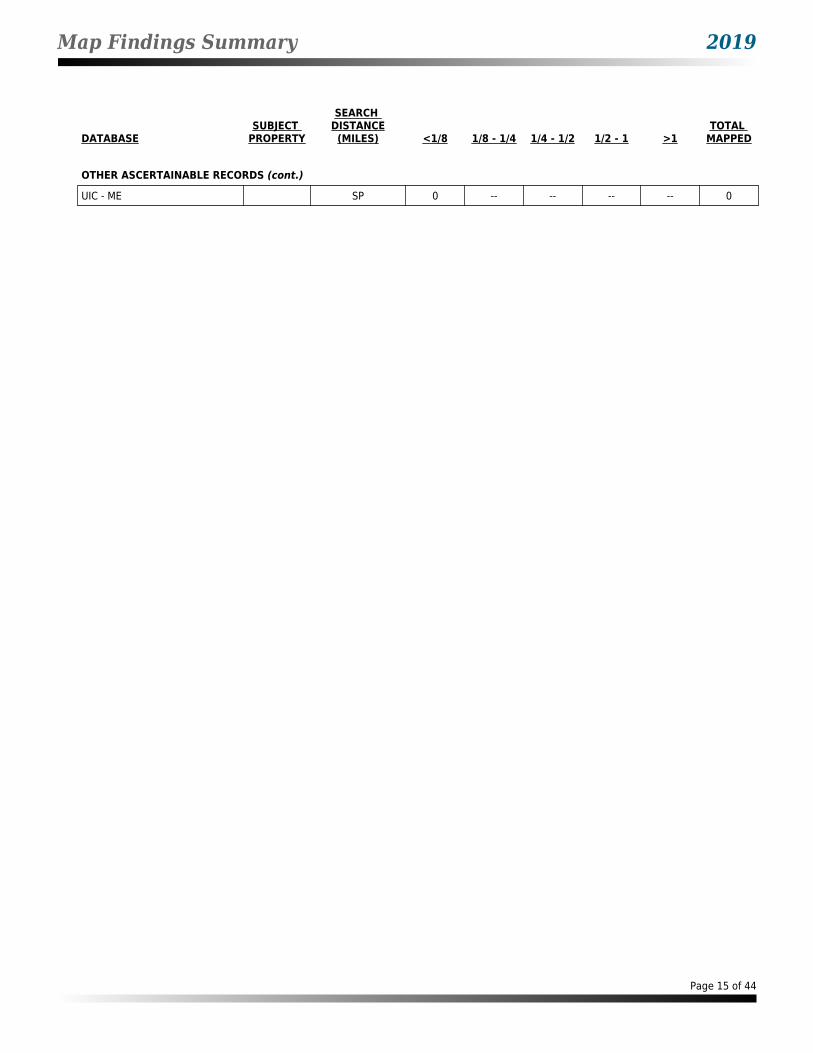
Map Findings Summary 2019
DATABASESUBJECT
PROPERTY
SEARCH DISTANCE(MILES) <1/8 1/8 - 1/4 1/4 - 1/2 1/2 - 1 >1
TOTAL MAPPED
OTHER ASCERTAINABLE RECORDS (cont.)
UIC - ME SP 0 -- -- -- -- 0
Page 15 of 44

Map Findings 2019
Map Id: 1Direction: WNWDistance: 0.226 mi.Actual: 1192.482 ft.Elevation: 0.057 mi. / 299.193 ft.Relative: Higher
Envirosite ID: 330463147EPA ID: N/RSite Name : SANBORN POND
RT 137BROOKS, ME
Database(s) : [EGAD - ME]
EGAD - ME
Facility Name : SANBORN PONDFacility Address : RT 137, BROOKS
Site DetailsEffective Date : 10/19/2004Site Number : 37794Site Type : SURFACE SPILLProgram ID : A-623-2001Related Program : HAZARDOUS OIL SPILLSDescription : N/RSummary : SEE SSTS OR SPILL REPORT FOR A DETAILED NARRATIVE SUMMARY.Latitude : 44.4795088Longitude : -69.146444Last Date in Agency List : 04/15/2019
Page 16 of 44
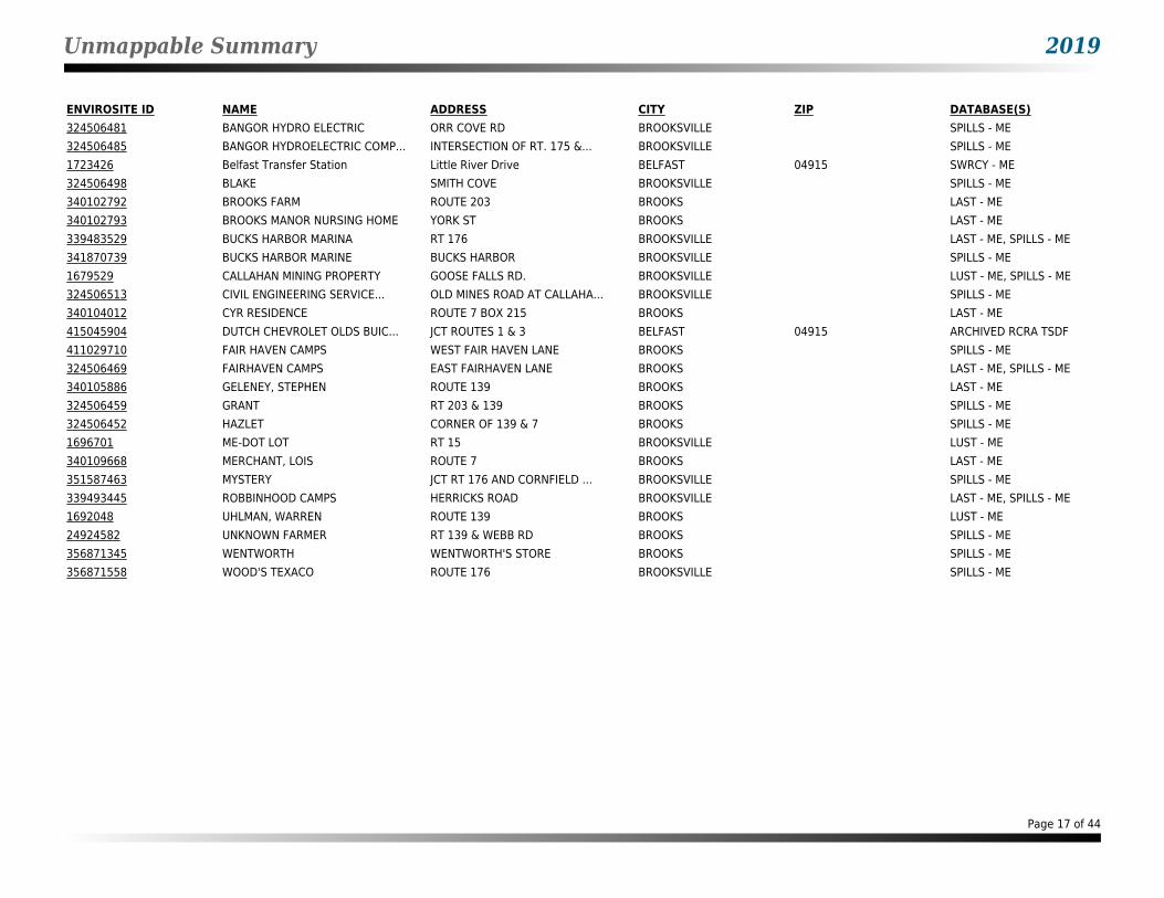
Unmappable Summary 2019
ENVIROSITE ID NAME ADDRESS CITY ZIP DATABASE(S)324506481 BANGOR HYDRO ELECTRIC ORR COVE RD BROOKSVILLE SPILLS - ME324506485 BANGOR HYDROELECTRIC COMP... INTERSECTION OF RT. 175 &... BROOKSVILLE SPILLS - ME1723426 Belfast Transfer Station Little River Drive BELFAST 04915 SWRCY - ME324506498 BLAKE SMITH COVE BROOKSVILLE SPILLS - ME340102792 BROOKS FARM ROUTE 203 BROOKS LAST - ME340102793 BROOKS MANOR NURSING HOME YORK ST BROOKS LAST - ME339483529 BUCKS HARBOR MARINA RT 176 BROOKSVILLE LAST - ME, SPILLS - ME341870739 BUCKS HARBOR MARINE BUCKS HARBOR BROOKSVILLE SPILLS - ME1679529 CALLAHAN MINING PROPERTY GOOSE FALLS RD. BROOKSVILLE LUST - ME, SPILLS - ME324506513 CIVIL ENGINEERING SERVICE... OLD MINES ROAD AT CALLAHA... BROOKSVILLE SPILLS - ME340104012 CYR RESIDENCE ROUTE 7 BOX 215 BROOKS LAST - ME415045904 DUTCH CHEVROLET OLDS BUIC... JCT ROUTES 1 & 3 BELFAST 04915 ARCHIVED RCRA TSDF411029710 FAIR HAVEN CAMPS WEST FAIR HAVEN LANE BROOKS SPILLS - ME324506469 FAIRHAVEN CAMPS EAST FAIRHAVEN LANE BROOKS LAST - ME, SPILLS - ME340105886 GELENEY, STEPHEN ROUTE 139 BROOKS LAST - ME324506459 GRANT RT 203 & 139 BROOKS SPILLS - ME324506452 HAZLET CORNER OF 139 & 7 BROOKS SPILLS - ME1696701 ME-DOT LOT RT 15 BROOKSVILLE LUST - ME340109668 MERCHANT, LOIS ROUTE 7 BROOKS LAST - ME351587463 MYSTERY JCT RT 176 AND CORNFIELD ... BROOKSVILLE SPILLS - ME339493445 ROBBINHOOD CAMPS HERRICKS ROAD BROOKSVILLE LAST - ME, SPILLS - ME1692048 UHLMAN, WARREN ROUTE 139 BROOKS LUST - ME24924582 UNKNOWN FARMER RT 139 & WEBB RD BROOKS SPILLS - ME356871345 WENTWORTH WENTWORTH'S STORE BROOKS SPILLS - ME356871558 WOOD'S TEXACO ROUTE 176 BROOKSVILLE SPILLS - ME
Page 17 of 44

Environmental Records Searched 2019
FEDERAL RCRA NON-CORRACTS TSD FACILITIES LIST
ARCHIVED RCRA TSDF: Resource Conservation and Recovery Act hazardous waste transportation storage disposal and treatment facilities
Agency Version Date: 03/01/2019Agency Update Frequency: QuarterlyPlanned Next Contact: 07/19/2019
Agency: U.S. Environmental Protection AgencyAgency Contact: 215-814-2469Most Recent Contact: 05/10/2019
RCRA_TSDF: Resource Conservation and Recovery Act hazardous waste transportation storage disposal and treatment facilities
Agency Version Date: 03/01/2019Agency Update Frequency: QuarterlyPlanned Next Contact: 07/19/2019
Agency: U.S. Environmental Protection AgencyAgency Contact: 215-814-2469Most Recent Contact: 05/10/2019
FEDERAL CERCLIS LIST
CERCLIS NFRAP: The CERCLIS sites with No Further Remedial Action Planned from the CERCLIS program database. The Environmental Protection Agency decommissioned the CERCLIS data in 2014. The last update was November 12, 2013.
Agency Version Date: 04/01/2019Agency Update Frequency: QuarterlyPlanned Next Contact: 06/10/2019
Agency: U.S. Environmental Protection AgencyAgency Contact: 800-424-9346Most Recent Contact: 04/01/2019
CERCLIS-HIST: The CERCLIS program database contains information on the assessment and remediation of federal hazardous waste sites. The Environmental Protection Agency decommissioned the CERCLIS data in 2014. The last update was November 12, 2013.
Agency Version Date: 04/01/2019Agency Update Frequency: QuarterlyPlanned Next Contact: 06/10/2019
Agency: U.S. Environmental Protection AgencyAgency Contact: 800-424-9346Most Recent Contact: 04/01/2019
FEDERAL FACILITY: Sites where Federal Facilities Restoration and Reuse Office (FFRRO) arranged cleanup for Base Closure and Property Transfer at Federal Facilities
Agency Version Date: 03/11/2019Agency Update Frequency: VariesPlanned Next Contact: 06/10/2019
Agency: U.S. Environmental Protection AgencyAgency Contact: 703-603-8712Most Recent Contact: 04/01/2019
SEMS_8R_ACTIVE SITES: The Active Site Inventory Report displays site and location information at active SEMS sites. An active site is one at which site assessment, removal, remedial, enforcement, cost recovery, or oversight activities are being planned or conducted. NPL sites include latitude and longitude information. For non-NPL sites, a brief site status is provided.
Agency Version Date: 03/11/2019Agency Update Frequency: QuarterlyPlanned Next Contact: 06/10/2019
Agency: U.S. Environmental Protection AgencyAgency Contact: 703-603-8867Most Recent Contact: 04/01/2019
SEMS_8R_ARCHIVED SITES: The Archived Site Inventory displays site and location information at sites archived from SEMS. An archived site is one at which EPA has determined that assessment has been completed and no further remedial action is planned under the Superfund program at this time.
Agency Version Date: 03/11/2019Agency Update Frequency: QuarterlyPlanned Next Contact: 06/10/2019
Agency: U.S. Environmental Protection AgencyAgency Contact: 703-603-8867Most Recent Contact: 04/01/2019
Page 18 of 44

Environmental Records Searched 2019
FEDERAL RCRA CORRACTS FACILITIES LIST
CORRACTS: List of facilities where Resource Conservation and Recovery Act Corrective Action Program used to investigate and remediate hazardous releases
Agency Version Date: 03/01/2019Agency Update Frequency: QuarterlyPlanned Next Contact: 07/19/2019
Agency: U.S. Environmental Protection AgencyAgency Contact: 202-566-1667Most Recent Contact: 05/10/2019
HIST CORRACTS 2: List of facilities where Resource Conservation and Recovery Act Corrective Action Program used to investigate and remediate hazardous releases that are no longer in current agency list.
Agency Version Date: 10/12/2018Agency Update Frequency: AnnuallyPlanned Next Contact: 08/02/2019
Agency: U.S. Environmental Protection AgencyAgency Contact: 202-566-1667Most Recent Contact: 05/06/2019
FEDERAL DELISTED NPL SITE LIST
DELISTED NPL: National Priority List of sites that were delisted and no longer require action
Agency Version Date: 04/01/2019Agency Update Frequency: QuarterlyPlanned Next Contact: 06/10/2019
Agency: U.S. Environmental Protection AgencyAgency Contact: 703-603-8867Most Recent Contact: 04/01/2019
DELISTED PROPOSED NPL: Sites that have been delisted from the proposed National Priority List
Agency Version Date: 04/01/2019Agency Update Frequency: QuarterlyPlanned Next Contact: 06/10/2019
Agency: U.S. Environmental Protection AgencyAgency Contact: 703-603-8867Most Recent Contact: 04/01/2019
SEMS_DELETED NPL: All Deleted National Priority List Sties
Agency Version Date: 03/11/2019Agency Update Frequency: QuarterlyPlanned Next Contact: 06/10/2019
Agency: U.S. Environmental Protection AgencyAgency Contact: 703-603-8867Most Recent Contact: 04/01/2019
FEDERAL LANDFILL AND/OR SOLID WASTE DISPOSAL SITE LISTS
EPA LF MOP: Sites in the EPA Landfill Methane Outreach Program
Agency Version Date: 02/25/2019Agency Update Frequency: QuarterlyPlanned Next Contact: 07/15/2019
Agency: U.S. Environmental Protection AgencyAgency Contact: 703-603-8867Most Recent Contact: 05/06/2019
FEDERAL ERNS LIST
ERNS: Emergency Response Notification System records of reported spills
Agency Version Date: 04/03/2019Agency Update Frequency: AnnuallyPlanned Next Contact: 06/12/2019
Agency: National Response Center United States Coast GuardAgency Contact: N/RMost Recent Contact: 04/03/2019
FEDERAL RCRA GENERATORS LIST
HIST RCRA_CESQG: List of Resource Conservation and Recovery Act licensed conditionally exempt small quantity generators that are no longer in current agency list.
Agency Version Date: 10/12/2018Agency Update Frequency: AnnuallyPlanned Next Contact: 08/02/2019
Agency: U.S. Environmental Protection AgencyAgency Contact: 215-814-2469Most Recent Contact: 05/06/2019
Page 19 of 44
Environmental Records Searched 2019
FEDERAL RCRA GENERATORS LIST (cont.)
HIST RCRA_LQG: List of Resource Conservation and Recovery Act licensed large quantity generators that are no longer in current agency list.
Agency Version Date: 10/12/2018Agency Update Frequency: AnnuallyPlanned Next Contact: 08/02/2019
Agency: U.S. Environmental Protection AgencyAgency Contact: 215-814-2469Most Recent Contact: 05/06/2019
HIST RCRA_NONGEN: List of Resource Conservation and Recovery Act licensed non-generators that are no longer in current agency list.
Agency Version Date: 10/12/2018Agency Update Frequency: AnnuallyPlanned Next Contact: 08/02/2019
Agency: U.S. Environmental Protection AgencyAgency Contact: 215-814-2469Most Recent Contact: 05/06/2019
HIST RCRA_SQG: List of Resource Conservation and Recovery Act licensed small quantity generators that are no longer in current agency list.
Agency Version Date: 10/12/2018Agency Update Frequency: AnnuallyPlanned Next Contact: 08/02/2019
Agency: U.S. Environmental Protection AgencyAgency Contact: 215-814-2469Most Recent Contact: 05/06/2019
RCRA_LQG: Resource Conservation and Recovery Act listing of licensed large quantity generators
Agency Version Date: 03/01/2019Agency Update Frequency: QuarterlyPlanned Next Contact: 07/19/2019
Agency: U.S. Environmental Protection AgencyAgency Contact: 215-814-2469Most Recent Contact: 05/10/2019
RCRA_NONGEN: Resource Conservation and Recovery Act listing of licensed non-generators
Agency Version Date: 03/01/2019Agency Update Frequency: VariesPlanned Next Contact: 07/19/2019
Agency: U.S. Environmental Protection AgencyAgency Contact: 215-814-2469Most Recent Contact: 05/10/2019
RCRA_SQG: Resource Conservation and Recovery Act listing of licensed small quantity generators
Agency Version Date: 03/01/2019Agency Update Frequency: QuarterlyPlanned Next Contact: 07/19/2019
Agency: U.S. Environmental Protection AgencyAgency Contact: 215-814-2469Most Recent Contact: 05/10/2019
RCRA_VSQG: Resource Conservation and Recovery Act listing of licensed very small quantity generators.
Agency Version Date: 03/01/2019Agency Update Frequency: VariesPlanned Next Contact: 07/19/2019
Agency: U.S. Environmental Protection AgencyAgency Contact: 215-814-2469Most Recent Contact: 05/10/2019
FEDERAL NPL SITE LIST
NPL: List of priority contaminated sites among identified releases or threatened releases of hazardous substances pollutants or contaminants nationally
Agency Version Date: 04/01/2019Agency Update Frequency: QuarterlyPlanned Next Contact: 06/10/2019
Agency: U.S. Environmental Protection AgencyAgency Contact: 703-603-8867Most Recent Contact: 04/01/2019
NPL EPA R1 GIS: Geospatial data for the Environmental Protection Agency Region 1 National Priority List subject to environmental regulation
Agency Version Date: 04/01/2019Agency Update Frequency: QuarterlyPlanned Next Contact: 06/10/2019
Agency: U.S. Environmental Protection AgencyAgency Contact: 202-566-2132Most Recent Contact: 04/01/2019
Page 20 of 44

Environmental Records Searched 2019
FEDERAL NPL SITE LIST (cont.)
NPL EPA R3 GIS: Geospatial data for the Environmental Protection Agency Region 3 National Priority List subject to environmental regulation
Agency Version Date: 04/01/2019Agency Update Frequency: QuarterlyPlanned Next Contact: 06/10/2019
Agency: U.S. Environmental Protection AgencyAgency Contact: 202-566-2132Most Recent Contact: 04/01/2019
NPL EPA R6 GIS: Geospatial data for the Environmental Protection Agency Region 6 National Priority List subject to environmental regulation
Agency Version Date: 04/01/2019Agency Update Frequency: QuarterlyPlanned Next Contact: 06/10/2019
Agency: U.S. Environmental Protection AgencyAgency Contact: 202-566-2132Most Recent Contact: 04/01/2019
NPL EPA R8 GIS: Geospatial data for the Environmental Protection Agency Region 8 National Priority List subject to environmental regulation
Agency Version Date: 04/01/2019Agency Update Frequency: QuarterlyPlanned Next Contact: 06/10/2019
Agency: U.S. Environmental Protection AgencyAgency Contact: 202-566-2132Most Recent Contact: 04/01/2019
NPL EPA R9 GIS: Geospatial data for the Environmental Protection Agency Region 9 National Priority List subject to environmental regulation
Agency Version Date: 04/01/2019Agency Update Frequency: QuarterlyPlanned Next Contact: 06/10/2019
Agency: U.S. Environmental Protection AgencyAgency Contact: 202-566-2132Most Recent Contact: 04/01/2019
PART NPL: Sites that are a part of an National Priority List site referred to as the parent site
Agency Version Date: 04/01/2019Agency Update Frequency: QuarterlyPlanned Next Contact: 06/10/2019
Agency: U.S. Environmental Protection AgencyAgency Contact: 703-603-8867Most Recent Contact: 04/01/2019
PROPOSED NPL: Sites that have been proposed for the National Priority List
Agency Version Date: 04/01/2019Agency Update Frequency: QuarterlyPlanned Next Contact: 06/10/2019
Agency: U.S. Environmental Protection AgencyAgency Contact: 703-603-8867Most Recent Contact: 04/01/2019
SEMS_FINAL NPL: All Included National Priority List Sites
Agency Version Date: 03/11/2019Agency Update Frequency: QuarterlyPlanned Next Contact: 06/10/2019
Agency: U.S. Environmental Protection AgencyAgency Contact: 703-603-8867Most Recent Contact: 04/01/2019
SEMS_PROPOSED NPL: All Proposed National Priority List Sites
Agency Version Date: 03/11/2019Agency Update Frequency: QuarterlyPlanned Next Contact: 06/10/2019
Agency: U.S. Environmental Protection AgencyAgency Contact: 703-603-8867Most Recent Contact: 04/01/2019
FEDERAL INSTITUTIONAL CONTROLS / ENGINEERING CONTROLS REGISTRIES
RCRA IC_EC: Sites with institutional or engineering controls related to Resource Conservation and Recovery Act
Agency Version Date: 04/09/2019Agency Update Frequency: VariesPlanned Next Contact: 06/18/2019
Agency: U.S. Environmental Protection AgencyAgency Contact: 215-814-2469Most Recent Contact: 04/09/2019
Page 21 of 44
Environmental Records Searched 2019
FEDERAL INSTITUTIONAL CONTROLS / ENGINEERING CONTROLS REGISTRIES (cont.)
Fed E C: Federal listing of remediation sites with engineering controls
Agency Version Date: 04/17/2019Agency Update Frequency: VariesPlanned Next Contact: 06/26/2019
Agency: U.S. Environmental Protection AgencyAgency Contact: 800-424-9346Most Recent Contact: 04/17/2019
Fed I C: Federal listing of remediation sites with institutional controls
Agency Version Date: 04/17/2019Agency Update Frequency: VariesPlanned Next Contact: 06/26/2019
Agency: U.S. Environmental Protection AgencyAgency Contact: 800-424-9346Most Recent Contact: 04/17/2019
STATE AND TRIBAL REGISTERED STORAGE TANK LISTS
FEMA UST: FEMA underground storage tank listing
Agency Version Date: 12/17/2018Agency Update Frequency: VariesPlanned Next Contact: 06/05/2019
Agency: FEMAAgency Contact: 202-212-5283Most Recent Contact: 03/07/2019
INDIAN UST R1: Underground Storage Tanks on Indian Land in EPA Region 1
Agency Version Date: 10/03/2018Agency Update Frequency: QuarterlyPlanned Next Contact: 05/28/2019
Agency: U.S. Environmental Protection Agency Region 1Agency Contact: 855-246-3642Most Recent Contact: 03/19/2019
INDIAN UST R10: Underground Storage Tanks on Indian Land in EPA Region 10
Agency Version Date: 10/17/2018Agency Update Frequency: QuarterlyPlanned Next Contact: 06/24/2019
Agency: U.S. Environmental Protection Agency Region 10Agency Contact: 855-246-3642Most Recent Contact: 04/15/2019
INDIAN UST R2: Underground Storage Tanks on Indian Land in EPA Region 2
Agency Version Date: 12/07/2016Agency Update Frequency: QuarterlyPlanned Next Contact: 06/03/2019
Agency: U.S. Environmental Protection Agency Region 2Agency Contact: 855-246-3642Most Recent Contact: 03/25/2019
INDIAN UST R4: Underground Storage Tanks on Indian Land in EPA Region 4
Agency Version Date: 05/08/2018Agency Update Frequency: Semi AnnuallyPlanned Next Contact: 06/24/2019
Agency: U.S. Environmental Protection Agency Region 4Agency Contact: 855-246-3642Most Recent Contact: 04/15/2019
INDIAN UST R5: Underground Storage Tanks on Indian Land in EPA Region 5
Agency Version Date: 10/12/2018Agency Update Frequency: VariesPlanned Next Contact: 06/13/2019
Agency: U.S. Environmental Protection Agency Region 5Agency Contact: 855-246-3642Most Recent Contact: 04/04/2019
INDIAN UST R6: Underground Storage Tanks on Indian Land in EPA Region 6
Agency Version Date: 04/01/2018Agency Update Frequency: Semi AnnuallyPlanned Next Contact: 06/27/2019
Agency: U.S. Environmental Protection Agency Region 6Agency Contact: 855-246-3642Most Recent Contact: 04/18/2019
Page 22 of 44
Environmental Records Searched 2019
STATE AND TRIBAL REGISTERED STORAGE TANK LISTS (cont.)
INDIAN UST R7: Underground Storage Tanks on Indian Land in EPA Region 7
Agency Version Date: 11/07/2018Agency Update Frequency: VariesPlanned Next Contact: 06/13/2019
Agency: U.S. Environmental Protection Agency Region 7Agency Contact: 855-246-3642Most Recent Contact: 04/04/2019
INDIAN UST R8: Underground Storage Tanks on Indian Land in EPA Region 8
Agency Version Date: 10/16/2018Agency Update Frequency: QuarterlyPlanned Next Contact: 05/27/2019
Agency: U.S. Environmental Protection Agency Region 8Agency Contact: 855-246-3642Most Recent Contact: 03/18/2019
INDIAN UST R9: Underground Storage Tanks on Indian Land in EPA Region 9
Agency Version Date: 10/10/2018Agency Update Frequency: QuarterlyPlanned Next Contact: 05/27/2019
Agency: U.S. Environmental Protection Agency Region 9Agency Contact: 855-246-3642Most Recent Contact: 03/18/2019
AST - ME: Registered Aboveground Storage Tanks
Agency Version Date: 03/06/2019Agency Update Frequency: QuarterlyPlanned Next Contact: 07/24/2019
Agency: Department of Environmental ProtectionAgency Contact: (207) 287-7843Most Recent Contact: 05/15/2019
UST - ME: Underground storage tank listing
Agency Version Date: 03/06/2019Agency Update Frequency: MonthlyPlanned Next Contact: 07/24/2019
Agency: Maine Department of Environmental ProtectionAgency Contact: 207-287-2651Most Recent Contact: 05/15/2019
UST AOS - ME: Active and out of service registered underground storage tanks including tanks that have not been properly abandoned
Agency Version Date: 11/05/2018Agency Update Frequency: MonthlyPlanned Next Contact: 06/27/2019
Agency: Maine Department of Environmental ProtectionAgency Contact: 207-287-2651Most Recent Contact: 04/18/2019
STATE AND TRIBAL LEAKING STORAGE TANK LISTS
INDIAN LUST R1: Leaking Underground Storage Tanks on Indian Land in EPA Region 1
Agency Version Date: 10/03/2018Agency Update Frequency: QuarterlyPlanned Next Contact: 05/28/2019
Agency: U.S. Environmental Protection Agency Region 1Agency Contact: 855-246-3642Most Recent Contact: 03/19/2019
INDIAN LUST R10: Leaking Underground Storage Tanks on Indian Land in EPA Region 10
Agency Version Date: 10/17/2018Agency Update Frequency: QuarterlyPlanned Next Contact: 06/24/2019
Agency: U.S. Environmental Protection Agency Region 10Agency Contact: 855-246-3642Most Recent Contact: 04/15/2019
INDIAN LUST R2: Leaking Underground Storage Tanks on Indian Land in EPA Region 2
Agency Version Date: 12/07/2016Agency Update Frequency: QuarterlyPlanned Next Contact: 06/03/2019
Agency: U.S. Environmental Protection Agency Region 2Agency Contact: 855-246-3642Most Recent Contact: 03/25/2019
Page 23 of 44

Environmental Records Searched 2019
STATE AND TRIBAL LEAKING STORAGE TANK LISTS (cont.)
INDIAN LUST R4: Leaking Underground Storage Tanks on Indian Land in EPA Region 4
Agency Version Date: 05/08/2018Agency Update Frequency: Semi AnnuallyPlanned Next Contact: 06/24/2019
Agency: U.S. Environmental Protection Agency Region 4Agency Contact: 855-246-3642Most Recent Contact: 04/15/2019
INDIAN LUST R5: Leaking Underground Storage Tanks on Indian Land in EPA Region 5
Agency Version Date: 10/12/2018Agency Update Frequency: VariesPlanned Next Contact: 06/13/2019
Agency: U.S. Environmental Protection Agency Region 5Agency Contact: 855-246-3642Most Recent Contact: 04/04/2019
INDIAN LUST R6: Leaking Underground Storage Tanks on Indian Land in EPA Region 6
Agency Version Date: 11/01/2018Agency Update Frequency: QuarterlyPlanned Next Contact: 06/17/2019
Agency: U.S. Environmental Protection Agency Region 6Agency Contact: 855-246-3642Most Recent Contact: 04/08/2019
INDIAN LUST R7: Leaking Underground Storage Tanks on Indian Land in EPA Region 7
Agency Version Date: 04/04/2019Agency Update Frequency: VariesPlanned Next Contact: 06/13/2019
Agency: U.S. Environmental Protection Agency Region 7Agency Contact: 855-246-3642Most Recent Contact: 04/04/2019
INDIAN LUST R8: Leaking Underground Storage Tanks on Indian Land in EPA Region 8
Agency Version Date: 10/16/2018Agency Update Frequency: QuarterlyPlanned Next Contact: 06/14/2019
Agency: U.S. Environmental Protection Agency Region 8Agency Contact: 855-246-3642Most Recent Contact: 04/05/2019
INDIAN LUST R9: Leaking Underground Storage Tanks on Indian Land in EPA Region 9
Agency Version Date: 10/10/2018Agency Update Frequency: QuarterlyPlanned Next Contact: 05/27/2019
Agency: U.S. Environmental Protection Agency Region 9Agency Contact: 855-246-3642Most Recent Contact: 03/18/2019
LAST - ME: HOSS database
Agency Version Date: 03/27/2019Agency Update Frequency: VariesPlanned Next Contact: 06/05/2019
Agency: Department of Environmental ProtectionAgency Contact: (207) 287-2651Most Recent Contact: 03/27/2019
LUST - ME: Leaking undersround storage tank site listing
Agency Version Date: 02/11/2019Agency Update Frequency: QuarterlyPlanned Next Contact: 07/01/2019
Agency: Maine Department of Environmental ProtectionAgency Contact: 207-287-2651Most Recent Contact: 04/22/2019
STATE AND TRIBAL BROWNFIELD SITES
TRIBAL BROWNFIELDS: Tribal brownfield remediation site listing
Agency Version Date: 02/10/2014Agency Update Frequency: No Longer MaintainedPlanned Next Contact: 08/13/2019
Agency: U.S. Environmental Protection AgencyAgency Contact: 855-246-3642Most Recent Contact: 05/15/2019
Page 24 of 44
Environmental Records Searched 2019
STATE AND TRIBAL BROWNFIELD SITES (cont.)
BROWNFIELDS - ME: Brownfield remediation sites listing
Agency Version Date: 04/19/2019Agency Update Frequency: QuarterlyPlanned Next Contact: 06/28/2019
Agency: Maine Department of Environmental ProtectionAgency Contact: 207-287-4854Most Recent Contact: 04/19/2019
STATE- AND TRIBAL - EQUIVALENT CERCLIS
DEL HWS - ME: Sites delisted/deleted from the Uncontrolled Sites list
Agency Version Date: 04/19/2019Agency Update Frequency: QuarterlyPlanned Next Contact: 06/28/2019
Agency: Department of Environmental ProtectionAgency Contact: (207) 287-4858Most Recent Contact: 04/19/2019
SHWS - ME: Uncontrolled site location listing
Agency Version Date: 04/19/2019Agency Update Frequency: QuarterlyPlanned Next Contact: 06/28/2019
Agency: Maine Department of Environmental ProtectionAgency Contact: 207-287-4858Most Recent Contact: 04/19/2019
STATE INSTITUTIONAL CONTROLS / ENGINEERING CONTROLS REGISTRIES
I C - ME: Remediation sites with institutional controls
Agency Version Date: 04/19/2019Agency Update Frequency: QuarterlyPlanned Next Contact: 06/28/2019
Agency: Maine Department of Environmental ProtectionAgency Contact: 207-287-4854Most Recent Contact: 04/19/2019
STATE AND TRIBAL LANDFILL AND/OR SOLID WASTE DISPOSAL SITE LISTS
LCP - ME: Municipal landfill closure database site listing
Agency Version Date: 04/19/2019Agency Update Frequency: QuarterlyPlanned Next Contact: 06/28/2019
Agency: Maine Department of Environmental ProtectionAgency Contact: 207-287-4858Most Recent Contact: 04/19/2019
SWF/LF - ME: Solid waste and facility listing
Agency Version Date: 07/13/2018Agency Update Frequency: AnnuallyPlanned Next Contact: 06/28/2019
Agency: Maine Department of Environmental ProtectionAgency Contact: 207-287-2651Most Recent Contact: 04/19/2019
STATE AND TRIBAL VOLUNTARY CLEANUP SITES
VCP - ME: Voluntary program remediation sites listing
Agency Version Date: 04/19/2019Agency Update Frequency: QuarterlyPlanned Next Contact: 06/28/2019
Agency: Maine Department of Environmental ProtectionAgency Contact: 207-287-4854Most Recent Contact: 04/19/2019
LOCAL BROWNFIELD LISTS
BROWNFIELDS-ACRES: EPA Brownfields Assessment, Cleanup and Redevelopment Exchange System.
Agency Version Date: 02/14/2019Agency Update Frequency: QuarterlyPlanned Next Contact: 07/04/2019
Agency: U.S. Environmental Protection AgencyAgency Contact: 855-246-3642Most Recent Contact: 04/25/2019
Page 25 of 44

Environmental Records Searched 2019
LOCAL BROWNFIELD LISTS (cont.)
Fed Brownfields: Federal brownfield remediation sites
Agency Version Date: 03/26/2019Agency Update Frequency: Semi AnnuallyPlanned Next Contact: 06/04/2019
Agency: U.S. Environmental Protection AgencyAgency Contact: 855-246-3642Most Recent Contact: 03/26/2019
LOCAL LISTS OF HAZARDOUS WASTE / CONTAMINATED SITES
FED CDL: The U.S. Department of Justice listing of clandestine drug lab locations
Agency Version Date: 03/18/2019Agency Update Frequency: QuarterlyPlanned Next Contact: 05/27/2019
Agency: U.S. Department of JusticeAgency Contact: 202-307-7610Most Recent Contact: 03/18/2019
US HIST CDL: The U.S. Department of Justice historical listing of clandestine drug lab locations
Agency Version Date: 03/18/2019Agency Update Frequency: QuarterlyPlanned Next Contact: 05/27/2019
Agency: U.S. Department of JusticeAgency Contact: 202-307-7610Most Recent Contact: 03/18/2019
LOCAL LISTS OF LANDFILL / SOLID WASTE DISPOSAL SITES
HIST INDIAN ODI R8: List of Region 8 Indian land open dump inventory sites maintained within the STARS program that is no longer in current agency list.
Agency Version Date: 11/12/2018Agency Update Frequency: AnnuallyPlanned Next Contact: 06/21/2019
Agency: Indian Health ServiceAgency Contact: 855-246-3642Most Recent Contact: 03/25/2019
INDIAN ODI R8: Region 8 Indian land open dump inventory sites maintained within the STARS program
Agency Version Date: 04/01/2019Agency Update Frequency: VariesPlanned Next Contact: 06/10/2019
Agency: Indian Health ServiceAgency Contact: 855-246-3642Most Recent Contact: 04/01/2019
ODI: Open dump inventory sites
Agency Version Date: 10/03/2017Agency Update Frequency: No UpdatePlanned Next Contact: 06/25/2019
Agency: U.S. Environmental Protection AgencyAgency Contact: 855-246-3642Most Recent Contact: 04/16/2019
TRIBAL ODI: Indian land open dump inventory for all regions
Agency Version Date: 04/18/2019Agency Update Frequency: VariesPlanned Next Contact: 06/27/2019
Agency: Indian Health ServiceAgency Contact: 301-443-3593Most Recent Contact: 04/18/2019
SWRCY - ME: Recycling facilities
Agency Version Date: 02/08/2019Agency Update Frequency: VariesPlanned Next Contact: 06/28/2019
Agency: Department of Environmental ProtectionAgency Contact: (207) 287-2870Most Recent Contact: 04/19/2019
RECORDS OF EMERGENCY RELEASE REPORTS
HMIRS (DOT): Hazardous Material spills reported by the Department of Transportation
Agency Version Date: 02/20/2019Agency Update Frequency: VariesPlanned Next Contact: 07/10/2019
Agency: U.S. Department of TransportationAgency Contact: (202) 366-4996Most Recent Contact: 05/01/2019
Page 26 of 44

Environmental Records Searched 2019
RECORDS OF EMERGENCY RELEASE REPORTS (cont.)
SPILLS - ME: Reported hazardous material and oils spill site listing
Agency Version Date: 11/13/2018Agency Update Frequency: QuarterlyPlanned Next Contact: 06/11/2019
Agency: Maine Department of Environmental ProtectionAgency Contact: 207-287-7688Most Recent Contact: 04/02/2019
LOCAL LAND RECORDS
LIENS 2: Comprehensive Environmental Response Compensation and Liability Act sites with liens
Agency Version Date: 05/11/2017Agency Update Frequency: No Longer MaintainedPlanned Next Contact: 08/13/2019
Agency: U.S. Environmental Protection AgencyAgency Contact: 800-424-9346Most Recent Contact: 05/15/2019
LIENS - ME: Sites with Environmental liens
Agency Version Date: 01/03/2019Agency Update Frequency: VariesPlanned Next Contact: 08/02/2019
Agency: Department of Environmental ProtectionAgency Contact: (207) 287-5902Most Recent Contact: 05/06/2019
OTHER ASCERTAINABLE RECORDS
AFS: Air Facility Systems Quarterly Extract
Agency Version Date: 01/25/2019Agency Update Frequency: QuarterlyPlanned Next Contact: 06/14/2019
Agency: Environmental Protection AgencyAgency Contact: (202) 566-1667Most Recent Contact: 04/05/2019
BRS: Reporting of hazardous waste generation and management from large quantity generators
Agency Version Date: 03/01/2019Agency Update Frequency: BiennialPlanned Next Contact: 07/19/2019
Agency: Environmental Protection AgencyAgency Contact: (202) 566-1667Most Recent Contact: 05/10/2019
CDC HAZDAT: The Agency for Toxic Substances and Disease Registry's Hazardous Substance Release/Health Effects Database.
Agency Version Date: 04/01/2019Agency Update Frequency: VariesPlanned Next Contact: 06/10/2019
Agency: Agency for Toxic Substances and Disease RegistryAgency Contact: 770-488-6399Most Recent Contact: 04/01/2019
COAL ASH DOE: List of existing and planned generators with 1 megawatt or greater of combined capacity that are utilizing coal ash impoundments.
Agency Version Date: 02/21/2019Agency Update Frequency: VariesPlanned Next Contact: 07/11/2019
Agency: Department of EnergyAgency Contact: (202) 586-8800Most Recent Contact: 05/02/2019
COAL ASH EPA: Coal Combustion Residues Surface Impoundments List
Agency Version Date: 07/31/2014Agency Update Frequency: VariesPlanned Next Contact: 06/17/2019
Agency: Environmental Protection AgencyAgency Contact: (202) 566-1667Most Recent Contact: 04/08/2019
COAL GAS: Manufactured Gas Plant locations
Agency Version Date: 01/02/2019Agency Update Frequency: QuarterlyPlanned Next Contact: 06/20/2019
Agency: U.S. Environmental Protection AgencyAgency Contact: 855-246-3642Most Recent Contact: 03/22/2019
Page 27 of 44

Environmental Records Searched 2019
OTHER ASCERTAINABLE RECORDS (cont.)
CONSENT (DECREES): Legal decisions regarding responsibility for Superfund locations
Agency Version Date: 03/31/2019Agency Update Frequency: VariesPlanned Next Contact: 06/10/2019
Agency: Environmental Protection AgencyAgency Contact: (800) 424-9346Most Recent Contact: 04/01/2019
DEBRIS R5 LF: US EPA Region 5 Disaster Debris Recovery Database is a list of public facilities for disaster construction and demolition materials, electronics, household hazardous waste, metals, tires, and vehicles in EPA Region 5.
Agency Version Date: 03/15/2019Agency Update Frequency: QuarterlyPlanned Next Contact: 05/24/2019
Agency: U.S. Environmental Protection AgencyAgency Contact: 855-246-3642Most Recent Contact: 03/15/2019
DEBRIS R5 SWRCY: US EPA Region 5 Disaster Debris Recovery Database is a list of public facilities for disaster construction and demolition materials, electronics, household hazardous waste, metals, tires, and vehicles in EPA Region 5.
Agency Version Date: 03/15/2019Agency Update Frequency: QuarterlyPlanned Next Contact: 05/24/2019
Agency: U.S. Environmental Protection AgencyAgency Contact: 855-246-3642Most Recent Contact: 03/15/2019
DOD: Department of Defense sites
Agency Version Date: 04/01/2019Agency Update Frequency: VariesPlanned Next Contact: 06/10/2019
Agency: Environmental Protection AgencyAgency Contact: (800) 424-9346Most Recent Contact: 04/01/2019
DOT OPS: Incident Data Report
Agency Version Date: 02/04/2019Agency Update Frequency: VariesPlanned Next Contact: 06/24/2019
Agency: U.S. Department of TransportationAgency Contact: (202) 366-4996Most Recent Contact: 04/15/2019
ECHO: ECHO is EPA Enforcement and Compliance History Online website to search for facilities in your community to assess their compliance with environmental regulations related to CAA, CWA, RCRA, & SDWA.
Agency Version Date: 02/25/2019Agency Update Frequency: QuarterlyPlanned Next Contact: 07/15/2019
Agency: U.S. Environmental Protection AgencyAgency Contact: 202-566-1667Most Recent Contact: 05/06/2019
ENOI: The Electronic Notice of Intent (eNOI) database contains construction sites and industrial facilities that submit permit requests to EPA for Construction General Permits (CGP) and Multi-Sector General Permits (MSGP).
Agency Version Date: 02/08/2019Agency Update Frequency: QuarterlyPlanned Next Contact: 06/28/2019
Agency: Environmental Protection AgencyAgency Contact: (202) 566-1667Most Recent Contact: 04/19/2019
EPA FUELS: List of companies and facilities registered to participate in EPA Fuel Programs under Title 40 CFR Part 80.
Agency Version Date: 04/05/2019Agency Update Frequency: QuarterlyPlanned Next Contact: 06/14/2019
Agency: U.S. Environmental Protection AgencyAgency Contact: (202) 564-2307Most Recent Contact: 04/05/2019
EPA OSC: Listing of oil spills and hazardous substance release sites requiring EPA On-Site Coordinators.
Agency Version Date: 02/20/2019Agency Update Frequency: QuarterlyPlanned Next Contact: 07/10/2019
Agency: U.S. Environmental Protection AgencyAgency Contact: (202) 564-2307Most Recent Contact: 05/01/2019
Page 28 of 44
Environmental Records Searched 2019
OTHER ASCERTAINABLE RECORDS (cont.)
EPA WATCH: The EPA Watch List was used to facilitate dialogue between EPA, state and local environmental agencies on enforcement matters relating to facilities with alleged violations identified as either significant or high priority. EPA maintained the lists from 2011 - 2013.
Agency Version Date: 02/09/2018Agency Update Frequency: QuarterlyPlanned Next Contact: 06/14/2019
Agency: U.S. Environmental Protection AgencyAgency Contact: (202) 564-2307Most Recent Contact: 04/05/2019
FA HWF: Hazardous Waste Facilities with Financial Assurance
Agency Version Date: 03/12/2019Agency Update Frequency: VariesPlanned Next Contact: 05/21/2019
Agency: Environmental Protection AgencyAgency Contact: (800) 424-9346Most Recent Contact: 03/12/2019
FEDLAND: Federal land locations
Agency Version Date: 04/01/2019Agency Update Frequency: VariesPlanned Next Contact: 06/10/2019
Agency: Environmental Protection AgencyAgency Contact: (800) 424-9346Most Recent Contact: 04/01/2019
FRS: Facility Registry Systems
Agency Version Date: 01/31/2019Agency Update Frequency: VariesPlanned Next Contact: 06/20/2019
Agency: Environmental Protection AgencyAgency Contact: (202) 566-1667Most Recent Contact: 04/11/2019
FTTS: Tracking of administrative and enforcement activities related to FIFRA/TSCA
Agency Version Date: 04/16/2013Agency Update Frequency: No Longer MaintainedPlanned Next Contact: 06/13/2019
Agency: Environmental Protection AgencyAgency Contact: (202) 564-2280Most Recent Contact: 03/15/2019
FTTS INSP: Tracking of inspections related to FIFRA/TSCA
Agency Version Date: 05/08/2017Agency Update Frequency: No Longer MaintainedPlanned Next Contact: 06/04/2019
Agency: Environmental Protection AgencyAgency Contact: (202) 564-2280Most Recent Contact: 03/06/2019
FUDS: Defense sites that require cleanup
Agency Version Date: 09/30/2015Agency Update Frequency: VariesPlanned Next Contact: 06/17/2019
Agency: US Army Corps of EngineeringAgency Contact: (202) 761-0011Most Recent Contact: 04/08/2019
HIST AFS: List of Air Facility Systems Quarterly Extract that are no longer in current agency list.
Agency Version Date: 01/25/2019Agency Update Frequency: QuarterlyPlanned Next Contact: 06/14/2019
Agency: Environmental Protection AgencyAgency Contact: (202) 566-1667Most Recent Contact: 04/05/2019
HIST AFS 2: List of Air Facility Systems Quarterly Extract that are no longer in current agency list.
Agency Version Date: 11/26/2018Agency Update Frequency: QuarterlyPlanned Next Contact: 06/27/2019
Agency: Environmental Protection AgencyAgency Contact: (202) 566-1667Most Recent Contact: 03/29/2019
Page 29 of 44

Environmental Records Searched 2019
OTHER ASCERTAINABLE RECORDS (cont.)
HIST DOD: Department of Defense historical sites
Agency Version Date: 08/17/2018Agency Update Frequency: No Longer MaintainedPlanned Next Contact: 06/26/2019
Agency: Environmental Protection AgencyAgency Contact: (800) 424-9346Most Recent Contact: 03/28/2019
HIST LEAD_SMELTER: List of former lead smelter sites that is no longer in current agency list.
Agency Version Date: 12/12/2018Agency Update Frequency: AnnuallyPlanned Next Contact: 07/05/2019
Agency: Environmental Protection AgencyAgency Contact: (202) 566-1667Most Recent Contact: 04/09/2019
HIST MLTS: List of sites in possession/use of radioactive materials regulated by NRC that is no longer in current agency list.
Agency Version Date: 07/13/2016Agency Update Frequency: AnnuallyPlanned Next Contact: 06/20/2019
Agency: Nuclear Regulatory CommissionAgency Contact: (800) 397-4209Most Recent Contact: 03/22/2019
HIST PCB TRANS: List of PCB Disposal Facilities that are no longer in current agency list.
Agency Version Date: 01/18/2018Agency Update Frequency: No UpdatePlanned Next Contact: 07/09/2019
Agency: Environmental Protection AgencyAgency Contact: (703) 308-8404Most Recent Contact: 04/11/2019
HIST PCS ENF: List of permitted facilities to discharge wastewater (Federal equivalent to NPDES) that are no longer in current agency list.
Agency Version Date: 12/08/2018Agency Update Frequency: AnnuallyPlanned Next Contact: 07/26/2019
Agency: Environmental Protection AgencyAgency Contact: (202) 564-6582Most Recent Contact: 04/30/2019
HIST PCS FACILITY: List of Permitted facilities to discharge wastewater (Federal equivalent to NPDES) that are no longer in current agency list.
Agency Version Date: 12/18/2018Agency Update Frequency: AnnuallyPlanned Next Contact: 07/26/2019
Agency: Environmental Protection AgencyAgency Contact: (202) 564-6582Most Recent Contact: 04/30/2019
HIST SSTS: List of tracking of facilities who produce pesticides and their quantity that are no longer in current agency list.
Agency Version Date: 02/13/2019Agency Update Frequency: AnnuallyPlanned Next Contact: 07/15/2019
Agency: Environmental Protection AgencyAgency Contact: (202) 566-1667Most Recent Contact: 04/17/2019
ICIS: Comprised of all Federal Administrative and Judicial enforcement information [intended to replace PCS] by tracking enforcement and compliance information (also contains what used to be known as FFTS)
Agency Version Date: 02/26/2019Agency Update Frequency: VariesPlanned Next Contact: 07/16/2019
Agency: Environmental Protection AgencyAgency Contact: (202) 566-1667Most Recent Contact: 05/07/2019
INACTIVE PCS: Inactive Permitted facilities to discharge wastewater
Agency Version Date: 02/26/2019Agency Update Frequency: VariesPlanned Next Contact: 07/16/2019
Agency: Environmental Protection AgencyAgency Contact: (202) 564-6582Most Recent Contact: 05/07/2019
Page 30 of 44

Environmental Records Searched 2019
OTHER ASCERTAINABLE RECORDS (cont.)
INDIAN RESERVATION: Indian Reservation sites
Agency Version Date: 03/12/2019Agency Update Frequency: VariesPlanned Next Contact: 05/21/2019
Agency: Environmental Protection AgencyAgency Contact: (800) 424-9346Most Recent Contact: 03/12/2019
LEAD_SMELTER: Listing of former Lead Smelter Sites
Agency Version Date: 12/12/2018Agency Update Frequency: VariesPlanned Next Contact: 06/25/2019
Agency: Environmental Protection AgencyAgency Contact: (202) 566-1667Most Recent Contact: 04/16/2019
LUCIS: Land Use Control Information Systems
Agency Version Date: 02/20/2019Agency Update Frequency: No Longer MaintainedPlanned Next Contact: 08/13/2019
Agency: Department of the Navy: BRAC PMOAgency Contact: (619) 532-0900Most Recent Contact: 05/15/2019
LUCIS 2: Land Use Control Information Systems
Agency Version Date: 01/17/2018Agency Update Frequency: No Longer MaintainedPlanned Next Contact: 09/30/2019
Agency: Department of the Navy: BRAC PMOAgency Contact: (619) 532-0900Most Recent Contact: 10/02/2018
MINES: Mines Master Index Files
Agency Version Date: 02/27/2019Agency Update Frequency: VariesPlanned Next Contact: 07/17/2019
Agency: Department of LaborAgency Contact: (202) 693-9400Most Recent Contact: 05/08/2019
MLTS: Sites in possession/use of radioactive materials regulated by NRC
Agency Version Date: 03/28/2019Agency Update Frequency: VariesPlanned Next Contact: 06/20/2019
Agency: Nuclear Regulatory CommissionAgency Contact: (800) 397-4209Most Recent Contact: 03/22/2019
NPL AOC: Areas of Concern related to NPL remediation sites
Agency Version Date: 04/01/2019Agency Update Frequency: QuarterlyPlanned Next Contact: 06/10/2019
Agency: Environmental Protection AgencyAgency Contact: N/RMost Recent Contact: 04/01/2019
NPL LIENS: National Priority List of sites with Liens
Agency Version Date: 03/11/2019Agency Update Frequency: VariesPlanned Next Contact: 06/10/2019
Agency: U.S. Environmental Protection AgencyAgency Contact: 703-603-8867Most Recent Contact: 04/01/2019
OSHA: OSHA's listing of inspections violations and fatality information
Agency Version Date: 02/26/2019Agency Update Frequency: VariesPlanned Next Contact: 07/16/2019
Agency: Occupational Safety & Health AdministrationAgency Contact: 800-321-6742Most Recent Contact: 05/07/2019
PADS: Listing of generators transporters commercial store/ brokers and disposers of PCB
Agency Version Date: 03/29/2019Agency Update Frequency: VariesPlanned Next Contact: 06/07/2019
Agency: Environmental Protection AgencyAgency Contact: (703) 308-8404Most Recent Contact: 03/29/2019
Page 31 of 44
Environmental Records Searched 2019
OTHER ASCERTAINABLE RECORDS (cont.)
PCB TRANSFORMER: Disposal and Storage of Polychlorinated Biphenyl (PCB) Waste
Agency Version Date: 04/10/2019Agency Update Frequency: QuarterlyPlanned Next Contact: 06/19/2019
Agency: Environmental Protection AgencyAgency Contact: (703) 308-8404Most Recent Contact: 04/10/2019
PCS ENF: Permitted facilities to discharge wastewater (Federal equivalent to NPDES)
Agency Version Date: 02/26/2019Agency Update Frequency: VariesPlanned Next Contact: 07/16/2019
Agency: Environmental Protection AgencyAgency Contact: (202) 564-6582Most Recent Contact: 05/07/2019
PCS FACILITY: Permitted facilities to discharge wastewater (Federal equivalent to NPDES)
Agency Version Date: 02/26/2019Agency Update Frequency: VariesPlanned Next Contact: 07/16/2019
Agency: Environmental Protection AgencyAgency Contact: (202) 564-6582Most Recent Contact: 05/07/2019
PRP: A listing of verified Potentially Responsible Parties at CERCLIS sites
Agency Version Date: 02/25/2019Agency Update Frequency: QuarterlyPlanned Next Contact: 07/15/2019
Agency: U.S. Environmental Protection AgencyAgency Contact: 800-424-9346Most Recent Contact: 05/06/2019
RAATS: Listing of major violators with enforcement actions issued under RCRA. Includes administrative and civil actions filed by the EPA. This dataset is no longer maintained.
Agency Version Date: 12/17/2018Agency Update Frequency: VariesPlanned Next Contact: 08/07/2019
Agency: Environmental Protection AgencyAgency Contact: (202) 566-1667Most Recent Contact: 05/09/2019
RADINFO: EPA regulated facilities with radiation and radioactive materials
Agency Version Date: 03/14/2019Agency Update Frequency: VariesPlanned Next Contact: 05/23/2019
Agency: Environmental Protection AgencyAgency Contact: (202) 566-1667Most Recent Contact: 03/14/2019
RMP: Facilities producing/handling/ process/ distribute/ store specific chemicals report plans required by the Clean Air Act
Agency Version Date: 03/15/2019Agency Update Frequency: MonthlyPlanned Next Contact: 06/05/2019
Agency: Environmental Protection AgencyAgency Contact: (202) 564-2534Most Recent Contact: 03/07/2019
ROD: Permanent remedy at an NPL site
Agency Version Date: 04/01/2019Agency Update Frequency: VariesPlanned Next Contact: 06/10/2019
Agency: Environmental Protection AgencyAgency Contact: (800) 424-9346Most Recent Contact: 04/01/2019
SCRD DRYCLEANERS: State Coalition for Remediation of Drycleaners
Agency Version Date: 02/07/2019Agency Update Frequency: No UpdatePlanned Next Contact: 06/27/2019
Agency: Environmental Protection AgencyAgency Contact: (202) 566-1667Most Recent Contact: 04/18/2019
Page 32 of 44
Environmental Records Searched 2019
OTHER ASCERTAINABLE RECORDS (cont.)
SEMS_SMELTER: This report includes sites that have smelting-related, or potentially smelting-related, indicators in the SEMS database. The report includes information on the site location as well as contaminants of concern.
Agency Version Date: 03/11/2019Agency Update Frequency: QuarterlyPlanned Next Contact: 06/10/2019
Agency: U.S. Environmental Protection AgencyAgency Contact: 703-603-8867Most Recent Contact: 04/01/2019
SSTS: Tracking of facilities who produce pesticides and their quantity
Agency Version Date: 02/13/2019Agency Update Frequency: AnnuallyPlanned Next Contact: 07/03/2019
Agency: Environmental Protection AgencyAgency Contact: (202) 566-1667Most Recent Contact: 04/24/2019
STORMWATER: Permitted storm water sites
Agency Version Date: 02/26/2019Agency Update Frequency: VariesPlanned Next Contact: 07/16/2019
Agency: Environmental Protection AgencyAgency Contact: (202) 566-1667Most Recent Contact: 05/07/2019
TOSCA-PLANT: Plants controlled by the Toxic Substance Control Act
Agency Version Date: 02/13/2019Agency Update Frequency: VariesPlanned Next Contact: 07/03/2019
Agency: Environmental Protection AgencyAgency Contact: (202) 566-1667Most Recent Contact: 04/24/2019
TRIS: Information regarding toxic chemicals that are being used/manufactured/ treated/ transported/released into the environment
Agency Version Date: 12/17/2018Agency Update Frequency: VariesPlanned Next Contact: 07/15/2019
Agency: Environmental Protection AgencyAgency Contact: (202) 566-1667Most Recent Contact: 05/06/2019
UMTRA: Uranium Recovery Sites
Agency Version Date: 02/28/2019Agency Update Frequency: VariesPlanned Next Contact: 07/18/2019
Agency: United States Nuclear Regulatory CommissionAgency Contact: (301) 415-8200Most Recent Contact: 05/09/2019
VAPOR: EPA Vapor Intrusion Database
Agency Version Date: 02/08/2019Agency Update Frequency: VariesPlanned Next Contact: 06/28/2019
Agency: U.S. Environmental Protection AgencyAgency Contact: 855-246-3642Most Recent Contact: 04/19/2019
Corrective Actions_2020: The RCRA cleanup baseline includes facilities expected to need corrective action.
Agency Version Date: 12/21/2018Agency Update Frequency: QuarterlyPlanned Next Contact: 07/19/2019
Agency: U.S. Environmental Protection AgencyAgency Contact: N/RMost Recent Contact: 05/10/2019
AIRS - ME: Air Monitoring Stations and Permits Data
Agency Version Date: 12/03/2018Agency Update Frequency: QuarterlyPlanned Next Contact: 07/30/2019
Agency: Department of Environmental ProtectionAgency Contact: (207) 287-7036Most Recent Contact: 05/01/2019
Page 33 of 44

Environmental Records Searched 2019
OTHER ASCERTAINABLE RECORDS (cont.)
ALL SITES - ME: All remediation sites listing
Agency Version Date: 04/19/2019Agency Update Frequency: QuarterlyPlanned Next Contact: 06/28/2019
Agency: Maine Department of Environmental ProtectionAgency Contact: 207-287-4854Most Recent Contact: 04/19/2019
DAYCARE - ME: Daycare facility sites
Agency Version Date: 02/12/2019Agency Update Frequency: QuarterlyPlanned Next Contact: 07/30/2019
Agency: Maine Department of Health and Human ServicesAgency Contact: (207) 287-9300Most Recent Contact: 05/01/2019
DRYCLEANERS - ME: Drycleaner Facilities that use perchloroethylene
Agency Version Date: 02/25/2019Agency Update Frequency: VariesPlanned Next Contact: 08/09/2019
Agency: Department of Environmental ProtectionAgency Contact: (207) 287-5902Most Recent Contact: 05/13/2019
EGAD - ME: List of spill events and monitoring sites that threaten water.
Agency Version Date: 04/15/2019Agency Update Frequency: QuarterlyPlanned Next Contact: 06/24/2019
Agency: Maine Department of Environmental ProtectionAgency Contact: 207.287.5767Most Recent Contact: 04/15/2019
HIST AIRS - ME: List of facilities with air permits that are no longer in current agency list.
Agency Version Date: 02/26/2019Agency Update Frequency: AnnuallyPlanned Next Contact: 07/22/2019
Agency: Department of Environmental ProtectionAgency Contact: (207) 287-7036Most Recent Contact: 04/24/2019
HIST DRYCLEANERS - ME: List of drycleaner facilities that use perchloroethylene that are no longer in current agency list.
Agency Version Date: 12/04/2018Agency Update Frequency: AnnuallyPlanned Next Contact: 08/08/2019
Agency: Department of Environmental ProtectionAgency Contact: (207) 287-5902Most Recent Contact: 05/10/2019
HIST NPDES - ME: List of past NPDES, storm water, and industrial wastewater permits
Agency Version Date: 01/02/2018Agency Update Frequency: No Longer MaintainedPlanned Next Contact: 06/26/2019
Agency: Department of Environmental ProtectionAgency Contact: (207) 287-5902Most Recent Contact: 03/28/2019
NPDES - ME: Listing of facilities with wastewater and NPDES permits
Agency Version Date: 10/05/2018Agency Update Frequency: VariesPlanned Next Contact: 05/30/2019
Agency: Department of Environmental ProtectionAgency Contact: (207) 287-5902Most Recent Contact: 03/01/2019
T 2 - ME: List of facilities that submit an Emergency and Hazardous Chemical Inventory Form
Agency Version Date: 11/30/2018Agency Update Frequency: VariesPlanned Next Contact: 07/04/2019
Agency: Maine Emergency Management AgencyAgency Contact: (207) 624-4441Most Recent Contact: 04/08/2019
UIC - ME: Underground Injection Wells Database List
Agency Version Date: 02/19/2019Agency Update Frequency: VariesPlanned Next Contact: 08/09/2019
Agency: Department of Environmental ProtectionAgency Contact: (207) 287-7814Most Recent Contact: 05/13/2019
Page 34 of 44

Geological Landscape Section 2019
SUBJECT PROPERTY ADDRESS:Sanborn Pond Outlet Dam39 Sanborn Pond Dr.Brooks, ME
SUBJECT PROPERTY COORDINATES:
Latitude(North): 44.477165 - 44°28'37.8"Longitude(West): -69.142884 - -69°8'34.4"Universal Transverse Mercator: Zone 19NUTM X (Meters): 488636.61UTM Y (Meters): 4924882.69
ELEVATION:Elevation: 290.505 ft. above sea level
USGS TOPOGRAPHIC MAP:
Subject Property Map:Most Recent Revision:
44069-D2 Morrill, ME2018
GEOHYDROLOGY DATA:
SUBJECT PROPERTY TOPOGRAPHY:
Topographic Gradient: South
DFIRM FLOOD ZONE:
DFIRM Flood
Subject Property County: Electronic Data:
WALDO No available data.
Flood Plain Panel at Subject Property: 23027C
Additional Panels in search area: No available data
FEMA FLOOD ZONE:
FEMA Flood
Subject Property County: Electronic Data:
WALDO No available data.
Flood Plain Panel at Subject Property: 2302530002A
Additional Panels in search area: 2302580008A2302700002A2302580010A2302620003A
Page 35 of 44
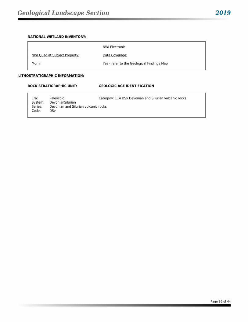
Geological Landscape Section 2019
NATIONAL WETLAND INVENTORY:
NWI Electronic
NWI Quad at Subject Property: Data Coverage:
Morrill Yes - refer to the Geological Findings Map
LITHOSTRATIGRAPHIC INFORMATION:
ROCK STRATIGRAPHIC UNIT: GEOLOGIC AGE IDENTIFICATION
Era: Paleozoic Category: 114 DSv Devonian and Silurian volcanic rocksSystem: DevonianSilurianSeries: Devonian and Silurian volcanic rocksCode: DSv
Page 36 of 44
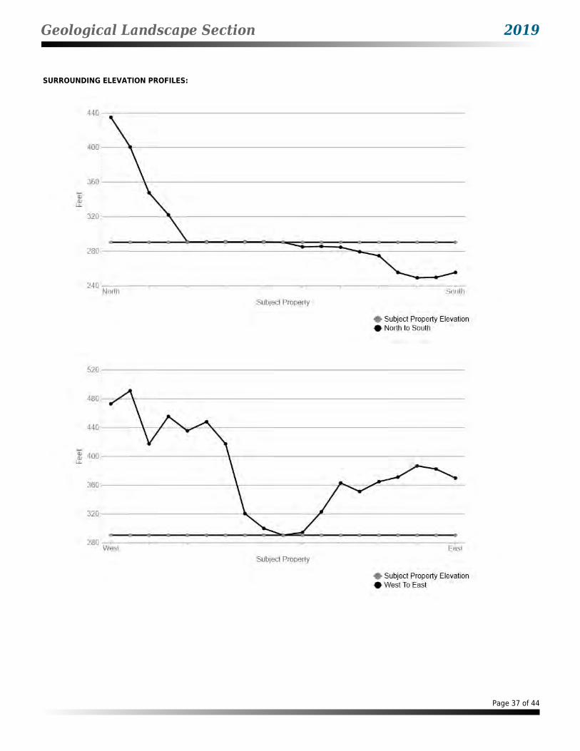
Geological Landscape Section 2019
SURROUNDING ELEVATION PROFILES:
Page 37 of 44
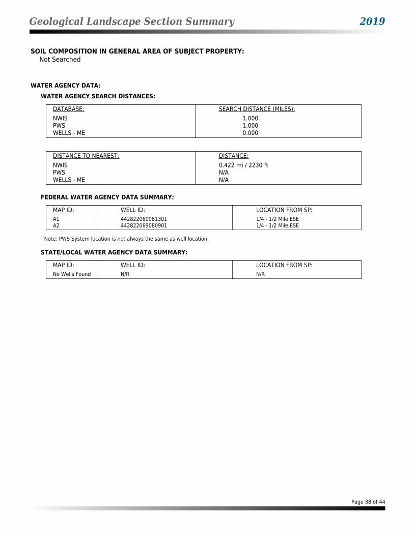
Geological Landscape Section Summary 2019
SOIL COMPOSITION IN GENERAL AREA OF SUBJECT PROPERTY:Not Searched
WATER AGENCY DATA:WATER AGENCY SEARCH DISTANCES:
DATABASE: SEARCH DISTANCE (MILES):NWIS 1.000PWS 1.000WELLS - ME 0.000
DISTANCE TO NEAREST: DISTANCE:NWIS 0.422 mi / 2230 ftPWS N/AWELLS - ME N/A
FEDERAL WATER AGENCY DATA SUMMARY:
MAP ID: WELL ID: LOCATION FROM SP:A1 442822069081301 1/4 - 1/2 Mile ESEA2 442822069080901 1/4 - 1/2 Mile ESE
Note: PWS System location is not always the same as well location.
STATE/LOCAL WATER AGENCY DATA SUMMARY:
MAP ID: WELL ID: LOCATION FROM SP:No Wells Found N/R N/R
Page 38 of 44
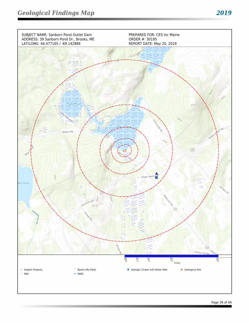
Geological Findings Map 2019
SUBJECT NAME: Sanborn Pond Outlet Dam PREPARED FOR: CES Inc MaineADDRESS: 39 Sanborn Pond Dr., Brooks, ME ORDER #: 30195LAT/LONG: 44.477165 / -69.142884 REPORT DATE: May 20, 2019
A
Subject Property Basins (No Data) Geologic Cluster with Water Well Geological Site NWI NWIS
Page 39 of 44
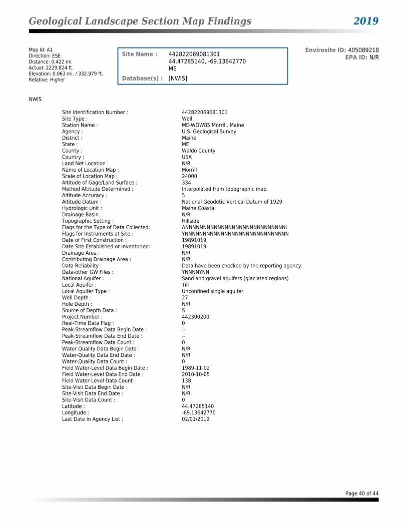
Geological Landscape Section Map Findings 2019
Map Id: A1Direction: ESEDistance: 0.422 mi.Actual: 2229.824 ft.Elevation: 0.063 mi. / 332.979 ft.Relative: Higher
Envirosite ID: 405089218EPA ID: N/RSite Name : 442822069081301
44.47285140, -69.13642770ME
Database(s) : [NWIS]
NWIS
Site Identification Number : 442822069081301Site Type : WellStation Name : ME-WOW85 Morrill, MaineAgency : U.S. Geological SurveyDistrict : MaineState : MECounty : Waldo CountyCountry : USALand Net Location : N/RName of Location Map : MorrillScale of Location Map : 24000Altitude of Gage/Land Surface : 334Method Altitude Determined : Interpolated from topographic map.Altitude Accuracy : 5Altitude Datum : National Geodetic Vertical Datum of 1929Hydrologic Unit : Maine CoastalDrainage Basin : N/RTopographic Setting : HillsideFlags for the Type of Data Collected: ANNNNNNNNNNNNNNNNNNNNNNNNNNNNIFlags for Instruments at Site : YNNNNNNNNNNNNNNNNNNNNNNNNNNNNNDate of First Construction : 19891019Date Site Established or Inventoried: 19891019Drainage Area : N/RContributing Drainage Area : N/RData Reliability : Data have been checked by the reporting agency.Data-other GW Files : YNNNNYNNNational Aquifer : Sand and gravel aquifers (glaciated regions)Local Aquifer : TillLocal Aquifer Type : Unconfined single aquiferWell Depth : 27Hole Depth : N/RSource of Depth Data : SProject Number : 442300200Real-Time Data Flag : 0Peak-Streamflow Data Begin Date : --Peak-Streamflow Data End Date : --Peak-Streamflow Data Count : 0Water-Quality Data Begin Date : N/RWater-Quality Data End Date : N/RWater-Quality Data Count : 0Field Water-Level Data Begin Date : 1989-11-02Field Water-Level Data End Date : 2010-10-05Field Water-Level Data Count : 138Site-Visit Data Begin Date : N/RSite-Visit Data End Date : N/RSite-Visit Data Count : 0Latitude : 44.47285140Longitude : -69.13642770Last Date in Agency List : 02/01/2019
Page 40 of 44

Geological Landscape Section Map Findings 2019
Map Id: A2Direction: ESEDistance: 0.463 mi.Actual: 2444.395 ft.Elevation: 0.065 mi. / 343.396 ft.Relative: Higher
Envirosite ID: 405113078EPA ID: N/RSite Name : 442822069080901
44.47285140, -69.13531650ME
Database(s) : [NWIS]
NWIS
Site Identification Number : 442822069080901Site Type : WellStation Name : WOW 84 WALDO-HILLTOP-MFS1Agency : U.S. Geological SurveyDistrict : MaineState : MECounty : Waldo CountyCountry : USALand Net Location : N/RName of Location Map : MORRILLScale of Location Map : 24000Altitude of Gage/Land Surface : 342Method Altitude Determined : Interpolated from topographic map.Altitude Accuracy : 5Altitude Datum : National Geodetic Vertical Datum of 1929Hydrologic Unit : Maine CoastalDrainage Basin : N/RTopographic Setting : HilltopFlags for the Type of Data Collected: NANNNNNNNNNNNNNNNNNNNNNNNNNNNOFlags for Instruments at Site : NNNNNNNNNNNNNNNNNNNNNNNNNNNNNNDate of First Construction : 19891019Date Site Established or Inventoried: 19891019Drainage Area : N/RContributing Drainage Area : N/RData Reliability : Data have been checked by the reporting agency.Data-other GW Files : YNNNNYNNNational Aquifer : N/RLocal Aquifer : N/RLocal Aquifer Type : Unconfined single aquiferWell Depth : 19Hole Depth : 19.0Source of Depth Data : SProject Number : 442300200Real-Time Data Flag : 0Peak-Streamflow Data Begin Date : --Peak-Streamflow Data End Date : --Peak-Streamflow Data Count : 0Water-Quality Data Begin Date : 08/28/1990Water-Quality Data End Date : 08/28/1990Water-Quality Data Count : 1Field Water-Level Data Begin Date : 1989-10-19Field Water-Level Data End Date : 1997-07-24Field Water-Level Data Count : 31Site-Visit Data Begin Date : N/RSite-Visit Data End Date : N/RSite-Visit Data Count : 0Latitude : 44.47285140Longitude : -69.13531650Last Date in Agency List : 02/01/2019
Page 41 of 44
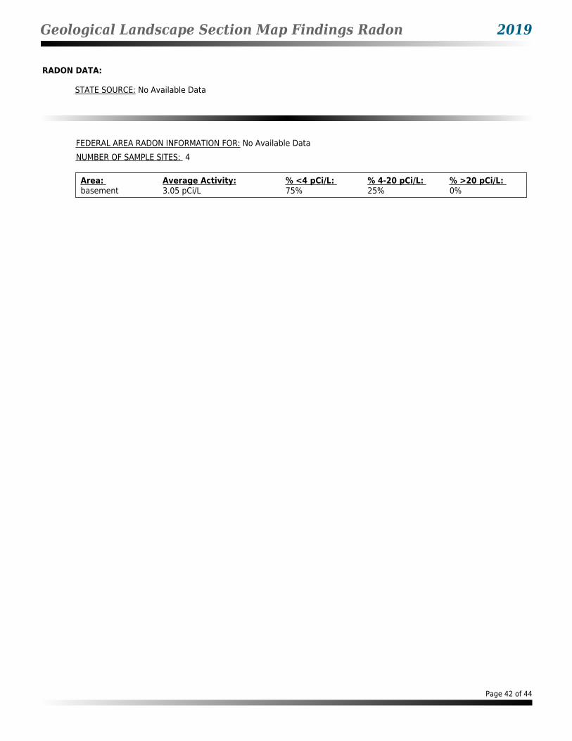
Geological Landscape Section Map Findings Radon 2019
RADON DATA:
STATE SOURCE: No Available Data
FEDERAL AREA RADON INFORMATION FOR: No Available DataNUMBER OF SAMPLE SITES: 4
Area: Average Activity: % <4 pCi/L: % 4-20 pCi/L: % >20 pCi/L: basement 3.05 pCi/L 75% 25% 0%
Page 42 of 44

Geological Landscape Records Searched 2019
HIST PWS ENFHistorical Public Water Supply locations with Enforcement ViolationsEnvironmental Protection Agency(800) 426-4791List of Safe Drinking Water Information Systems (SDWIS) with enforcement violations that are no longer in current agency list.
NWISNational Water Information SystemsUnited States Geological Society(703) 648-5953Information on all water resources for the United States. This database contains all current and historical data for the nation.
PWSPublic Water SupplyEnvironmental Protection Agency(800) 426-4791Safe drinking water information Systems
PWS ENFPublic Water Supply locations with Enforcement ViolationsEnvironmental Protection Agency(800) 426-4791Safe drinking water information Systems with enforcememnt violations
WELLS - MEState Water Well SitesDepartment of Health and Human Services207.287.7171Inventory of Water Wells
FLOOD Q3Flood dataEnvironmental Protection Agency(202) 566-1667Q3 Flood Data
HYDROLOGIC UNITHydrologic Unit MapsUSGSThe United States Geological Survey created a hierarchical system of hydrologic units originally called regions, sub-regions, accounting units, and cataloging units. Each unit was assigned a unique Hydrologic Unit Code (HUC). As first implemented the system had 21 regions, 221 subregions, 378 accounting units, and 2,264 cataloging units. Over time the system was changed and expanded. As of 2010 there are six levels in the hierarchy, represented by hydrologic unit codes from 2 to 12 digits long, called regions, subregions, basins, subbasins, watersheds, and subwatersheds. The table below describes the system's hydrologic unit levels and their characteristics, along with example names and codes.
WETLANDS NWINational Wetland InventoryU.S. Fish and Wildlife Service(703) 358-2171Wetland Inventory for the United States
Page 43 of 44

Geological Landscape Records Searched 2019
USGS GEOLOGIC AGEUSGS Digital Data Series DDSNatural Resources Conservation Service: U.S. Department of Agriculture(202) 690-4985USGS Digital Data Series DDS: Geologic Age and Rock Stratigraphic Unit
RADONNational Radon DatabaseUSGS703-605-6008A study of the EPA/State Residential Radon Survey and the National Residential Radon Survey.
AIRPORT FACILITIESAirport landing facilitiesFederal Aviation Administration(866) 835-5322Airport landing facilities
BASINSBetter Assessment Science Integrating point & Non-point SourcesU.S. Environmental Protection Agency855-246-3642Integrated geographical information system national watershed data and environmental assessment known as Better Assessment Science Integrating point & Non-point Sources
DIGITAL OBSTACLEObstacles of interest to aviation usersFederal Aviation Administration855-379-6518The Digital Obstacle File describes all known obstacles of interest to aviation users in the U.S. with limited coverage of the Pacific the Caribbean Canada and Mexico. The obstacles are assigned unique numerical identifiers; accuracy codes and listed in order of ascending latitude within each state or area by FAA Region.
EPICENTERSNational Geographical Data CenterNational Geographical Data Center303-497-6826Data on over four million earthquakes dating from 2100 B.C. to 1995 A.D.
FLOOD DFIRMNational Flood Hazard Layer DatabaseFederal Emergency Management AgencyThe National Flood Hazard Layer Database (NFHL) is a computer database that contains the flood hazard map information from FEMAs Flood Map Modernization program. These map data are from Digital Flood Insurance Rate Map (DFIRM) databases and Letters of Map Revision.
Page 44 of 44

JN: 10193.052 Sanborn Pond Outlet Dam Property Brooks, Maine
APPENDIX D
REGULATORY FILES
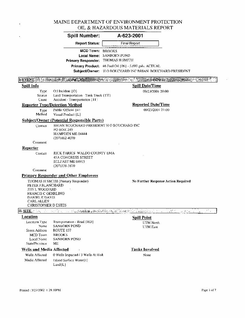
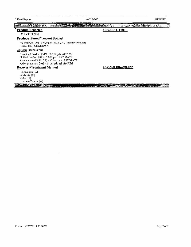


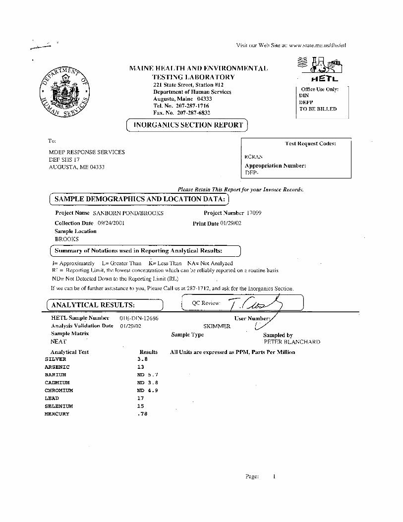
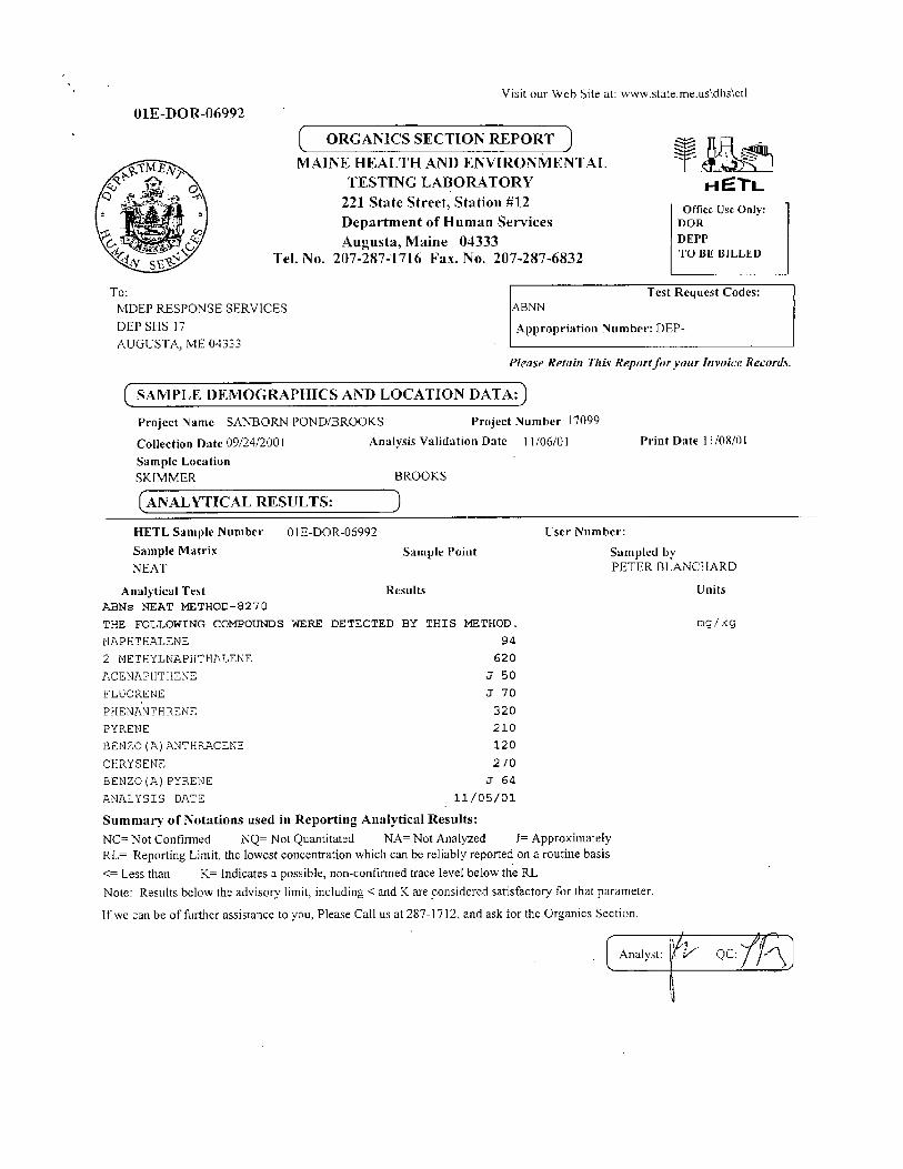
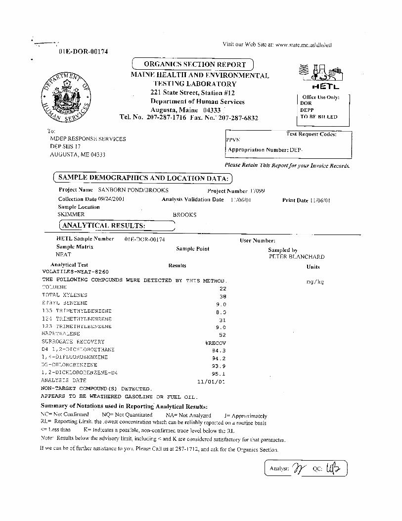

Final Restoration Plan / Environmental Assessment
for the September 23, 2001 Sanborn Pond Oil Spill
Town of Brooks, Waldo County, Maine
February 2010
Prepared by:
U.S. Fish and Wildlife Service and
State of Maine: Department of Environmental Protection
Department of Inland Fisheries and Wildlife Department of Conservation

Lead Administrative Trustee Agency: Maine Department of Environmental Protection Eastern Maine Regional Office 106 Hogan Road Bangor, Maine 04401 (207) 941-4570
Lead Agency for Compliance with the National Environmental Policy Act: U.S. Fish and Wildlife Service New England Field Office 70 Commercial Street, Suite 300 Concord, New Hampshire 03301 (603) 223-2541 Other Co-Trustees Maine Department of Inland Fisheries and Wildlife 650 State Street Bangor, ME 04401 Maine Department of Conservation 22 State House Station Augusta, ME 04333 Cover page photos: Common loon: Steve Mierzykowski, U.S. Fish and Wildlife Service Sanborn Pond crash site with hard boom deployed: Veronica Varela, U.S. Fish and Wildlife Service
TABLE OF CONTENTS
1.0 INTRODUCTION AND PURPOSE ................................................................................... 1
1.1 Overview of the Incident .................................................................................................. 2 1.2 Natural Resource Damage Assessment ........................................................................... 4 1.3 Coordination ...................................................................................................................... 5
1.3.1 Trustee Council Organization and Activities ............................................................... 5 1.3.2 Responsible Party Involvement .................................................................................... 5 1.3.3 Public Notification and Involvement ........................................................................... 5 1.3.4 Administrative Record ................................................................................................. 5
2.0 AFFECTED ENVIRONMENT AND SUMMARY OF NATURAL RESOURCE INJURIES ............................................................................................................................. 6
2.1 Lake Ecosystem ................................................................................................................. 6 2.1.1 Surface Water ............................................................................................................... 6 2.1.2 Sediment ....................................................................................................................... 7 2.1.3 Fish Tissue ................................................................................................................... 7 2.1.4 Trophic Condition ........................................................................................................ 7 2.1.5 Shoreline habitat .......................................................................................................... 8
2.2 Fisheries ............................................................................................................................. 8 2.3 Wildlife ............................................................................................................................... 9 2.4 Lost Recreational Uses of Natural Resources .............................................................. 11
3.0 SUMMARY OF SETTLEMENT FOR NATURAL RESOURCE DAMAGES ........... 11
4.0 RESTORATION ALTERNATIVES ................................................................................ 11
4.1 Allocation of Natural Resource Damages Among Restoration Categories ............... 11 4.2 Criteria for Identifying and Selecting Alternatives ..................................................... 12 4.3 Restoration Alternatives for Wildlife (Common Loon) .............................................. 13
4.3.1 Alternative 1: No Action / Natural Recovery ............................................................ 13 4.3.2 Alternative 2: Protection of Nesting Habitat ............................................................ 13 4.3.3 Alternative 3: Enhancement of Reproductive Success of Common Loons in Waldo County (Preferred Alternative) ............................................................................................. 14
4.4 Restoration Alternatives for Recreational Uses ........................................................... 15 4.4.1 Alternative 1: No Action / Natural Recovery ............................................................ 15 4.4.2 Alternative 2: Enhancement of Public Access to Sanborn Pond .............................. 15 4.4.3 Alternative 3: Establishing Public Access to Hurds Pond (Preferred Alternative) .. 15
5.0 ENVIRONMENTAL CONSEQUENCES OF RESTORATION ALTERNATIVES .. 16
5.1 Restoration Alternatives for Wildlife (Common Loon) .............................................. 16 5.1.1 Alternative 1: No Action / Natural Recovery ............................................................ 16 5.1.2 Alternative 2: Protection of Nesting Habitat ............................................................ 16 5.1.3 Alternative 3: Enhancement of Reproductive Success of Common Loons in Waldo County (Preferred Alternative) ............................................................................................. 17
5.2 Restoration Alternatives for Recreational Uses ........................................................... 18 5.2.1 Alternative 1: No Action / Natural Recovery ............................................................ 18
5.2.2 Alternative 2: Enhancement of Public Access to Sanborn Pond .............................. 18 5.2.3 Alternative 3: Establishing Public Access to Hurds Pond (Preferred Alternative) .. 18
5.3 Cumulative Impacts of Preferred Alternatives ............................................................ 18
6.0 LIST OF PREPARERS ...................................................................................................... 21
7.0 LIST OF AGENCIES, ORGANIZATIONS, AND PARTIES CONSULTED FOR INFORMATION ................................................................................................................ 21
9.0 LITERATURE CITED ...................................................................................................... 23
APPENDIX A: Trustee Agency Approvals on the Final Restoration Plan / Environmental
Assessment APPENDIX B: Finding of No Significant Impact

1
EXECUTIVE SUMMARY
The U.S. Fish and Wildlife Service and the State of Maine (i.e., the Natural Resource Trustees) have prepared this Restoration Plan / Environmental Assessment (RP/EA) to describe the compensatory restoration to be implemented in response to the September 23, 2001 oil spill at Sanborn Pond in the Town of Brooks, Waldo County, Maine. The purpose of compensatory restoration is to make the environment and the public whole for environmental harm caused by the oil spill. The Trustees’ natural resource damage assessment concluded that wildlife (particularly common loons), fisheries, and the lake ecosystem were adversely affected by the oil spill. In addition, the public’s recreational use of the natural resources in Sanborn Pond (e.g., recreational boating, fishing, and other uses) was impaired as a result of the spill. As compensation for this harm, the Trustees reached a negotiated settlement with H.O. Bouchard, Inc. for payment of natural resource damages in the amount of $125,000 to be used for compensatory restoration projects. This RP/EA describes the suite of restoration alternatives that the Trustees considered and explains the Trustees’ rationale behind choosing the alternatives preferred for funding. The preferred alternatives focus on compensatory restoration for common loons and lost recreational uses. Specifically, the Trustees will (1) implement a common loon artificial nesting platform management program on several lakes in Waldo County, Maine, to boost loon reproductive success in the area and (2) secure public access to Hurds Pond in the Town of Swanville, Maine, through land acquisition. 1.0 INTRODUCTION AND PURPOSE The U.S. Fish and Wildlife Service (USFWS) and the State of Maine have prepared this Restoration Plan / Environmental Assessment (RP/EA) to describe the compensatory restoration to be implemented in response to the September 23, 2001 oil spill at Sanborn Pond in the Town of Brooks, Waldo County, Maine. The USFWS and the State of Maine Department of Environmental Protection (ME DEP), the Maine Department of Inland Fisheries and Wildlife (ME IF&W), and the Maine Department of Conservation (ME DOC) are the Natural Resource Trustees (“Trustees”) responsible for restoring natural resources1 and resource services2
injured by the oil spill, as authorized by the Oil Pollution Act of 1990 (“OPA,” 33 U.S.C. §§ 2701 et seq.) and Maine Oil Discharge Prevention and Pollution Control law (38 M.R.S.A. §§ 541 et seq.). As a designated Trustee, each agency is authorized to act on behalf of the public under state and/or federal law to assess and recover natural resource damages and to plan and implement actions to restore, rehabilitate, replace, or acquire the equivalent of the natural resources or services injured as a result of an unpermitted discharge of oil.
1 Natural resources are defined under the Oil Pollution Act (OPA) as "land, fish, wildlife, biota, air, water, groundwater, drinking water supplies, and other such resources belonging to, managed by, held in trust by, appertaining to, or otherwise controlled by the United States, any State or local government or Indian tribe, or any foreign government.” 2 “Services” (or “natural resources services”) means the functions performed by a natural resource for the benefit of another natural resource and/or the public.

2
The purpose of natural resource restoration is to make the environment and the public whole for natural resource injuries resulting from the oil spill by implementing restoration actions that return injured natural resources and services to baseline conditions3 and compensate for interim losses4. Consistent with the OPA and the National Environmental Policy Act (“NEPA,” 42 U.S.C. 4321 et seq.), the purpose of this document is to disclose to the public the Trustees’ decision-making process regarding the identification and evaluation of restoration alternatives that would compensate for the oil spill at Sanborn Pond. The Trustees issued a draft version of this document to provide the public with an opportunity for review and comment on the proposed restoration alternatives. This Final RP/EA describes the restoration activities that the Trustees identified as the preferred restoration activities. 1.1 Overview of the Incident On the evening of September 23, 2001, a 10,000-gallon capacity tanker truck failed to navigate a curve on Route 137 purportedly to avoid hitting a deer, veered off the road, crashed through a guardrail and small building, and came to rest along the southwest shore of Sanborn Pond in the Town of Brooks, Maine (Figure 1). The accident punctured the tanker, and an estimated 5,600 gallons of Number 6 fuel oil flowed onto the 98-acre pond covering approximately three-quarters of it with oil. H.O. Bouchard, Inc, of Hampden, Maine, owned the tanker truck and is the Responsible Party for the incident. Bouchard contracted Clean Harbors Environmental Services to implement the cleanup. The ME DEP supervised the cleanup. Spill cleanup effort was concentrated over the first week following the spill and continued at lower levels through early November 2001. Clean-up techniques used during the incident response consisted of containing the oil with hard, floating boom and removing oil using sorbent material (snare/pom-poms), sorbent boom, and vacuum trucks. Some oil apparently adhered to small amounts of sand and gravel which helped to carry the oil to the bottom of the pond. Some of the sunken oil was removed by divers using underwater vacuums. As colder temperatures arrived in November, the oil became less apt to produce sheens and thus less of an immediate environmental hazard. The cleanup was suspended in November 2001 with a plan to return during warmer weather in 2002 to assess whether sheening had resumed and whether additional cleanup would be necessary. Beginning in July 2002, #6 oil from this spill was observed refloating to the surface with the onset of hot summer weather. The corresponding rise in water temperature allowed globules of oil sunken to the bottom to float to the surface. Shoreline vegetation became impacted as well as small boats, docks/floats, and some reports of swimmers getting into this oil as well. In response, the DEP contacted Bouchard and requested appropriate response to address these impacts. Bouchard did hire a contractor who performed hand removal of impacted vegetation along the shore, cleaned boats, docks, and floats, and removed oil. The DEP also requested that a section of hard floating boom be deployed between the point of land now or formerly owned
3 “Baseline conditions” are the environmental conditions that would have existed had the oil spill not happened. 4 “Interim losses” are the losses of natural resources or services that ensued from the time of the oil spill until baseline conditions were regained.
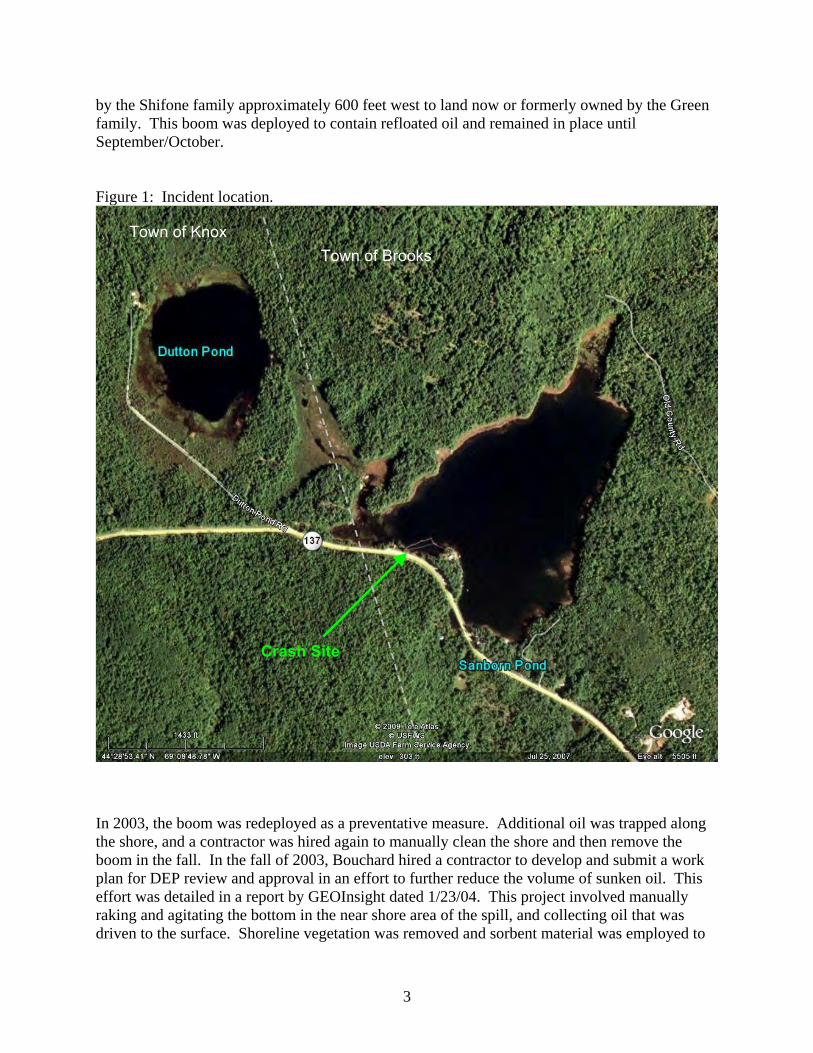
3
by the Shifone family approximately 600 feet west to land now or formerly owned by the Green family. This boom was deployed to contain refloated oil and remained in place until September/October. Figure 1: Incident location.
In 2003, the boom was redeployed as a preventative measure. Additional oil was trapped along the shore, and a contractor was hired again to manually clean the shore and then remove the boom in the fall. In the fall of 2003, Bouchard hired a contractor to develop and submit a work plan for DEP review and approval in an effort to further reduce the volume of sunken oil. This effort was detailed in a report by GEOInsight dated 1/23/04. This project involved manually raking and agitating the bottom in the near shore area of the spill, and collecting oil that was driven to the surface. Shoreline vegetation was removed and sorbent material was employed to
Crash Site
Town of Brooks Town of Knox
4
snare free oil. This effort only had limited success due to the cold water temperature in the fall when the work was performed. Pre- and post-work surveys were completed by divers to document stranded oil on the bottom. Some oil was removed but some remained on the bottom. In 2004, 2005, and 2006, the boom was placed in the spring and collected in the fall, and again hand labor was employed to remove residual oil that impacted plants and vegetation along the shoreline, but the amount of oil resurfacing seemed to be reduced. In 2007, it was a cool summer and very little oil was observed refloating, no cleanup was necessary. In 2008 Bouchard negotiated a memorandum of agreement with DEP whereby the Pond spill site will be monitored for 4 years. If oil refloats, the DEP will direct cleanup to be performed by Bouchard. In 2008 and 2009 no additional oil was observed, and no cleanup was necessary. If this trend continues, the MOA will terminate in the fall of 2011, and Bouchard will make a final payment to DEP towards any future cleanup costs which may arise. The effects of the oil spill on wildlife and the resulting natural resource injuries, as well as impacts of the spill on the recreational uses of Sanborn Pond’s natural resources, are described in Section 2. 1.2 Natural Resource Damage Assessment Immediately after the spill occurred, the Trustees commenced the Pre-assessment Phase of the natural resource damage assessment (NRDA) in accordance with the OPA NRDA regulations (the “OPA regulations”) (15 CFR § 990.40) to determine if they had jurisdiction to pursue restoration under OPA and, if so, whether it was appropriate to do so. Based on their analyses of initial data collected during the response and the Pre-assessment Phase, the Trustees found that they had jurisdiction to pursue restoration under the OPA as well as State of Maine environmental regulations. The Trustees further determined that response actions had not adequately addressed the injuries resulting from the incident, and that feasible primary5 and/or compensatory6 restoration actions existed to address the potential injuries. These determinations were memorialized in a Notice of Intent to Conduct Restoration Planning. The Notice was signed on 2/14/2002 by DEP Commissioner Kirkpatrick and public notice was published in area newspapers, sent to the Town of Brooks and State legislators representing this area in March, 2002. Consequently, the Trustees initiated the Restoration Planning Phase of the NRDA, in accordance with Section 990.50 of OPA, which includes evaluating and quantifying potential injuries (injury assessment) and using that information to determine the need for and scale (or size) of restoration actions. In August 2002, Bouchard entered into a cooperative NRDA agreement with the Trustees (a.k.a., “Memorandum of Agreement between the Trustees and the Responsible Party Governing Cooperative Natural Resource Damage Assessment and Restoration Planning Activities for the H.O. Bouchard Oil Spill at Sanborn Pond, Brooks, Maine” or “Trustee-RP MOA”), which included a reimbursement agreement that supported the Trustees’ role in injury assessment studies.
5 “Primary restoration” is the restoration of injured natural resources and services to the baseline condition, i.e., the conditions that which would have existed had the oil spill not occurred, and usually consists of the cleanup efforts. 6 “Compensatory restoration” is the compensation provided to offset the natural resource injuries that accrued from the time that the oil spill occurred until the baseline condition was re-established.

5
1.3 Coordination
1.3.1 Trustee Council Organization and Activities The USFWS and the ME DEP, the ME IF&W, and the ME DOC are the Natural Resource Trustees for the Sanborn Pond case. To facilitate working together to accomplish the common goals of natural resource damage assessment and restoration, the Trustees entered into a Memorandum of Agreement (Trustee MOA) in January 2002. The Trustee MOA indentified the ME DEP as the Lead Administrative Trustee agency for the case. The Trustees worked together to assess the natural resource injuries and develop this Restoration Plan. 1.3.2 Responsible Party Involvement The Trustees provided the Responsible Party with scopes of work for assessment studies, according to the procedures for cooperative studies outlined in the Trustee-RP MOA. The Responsible Party hired Kleinschmidt Associates, Inc. to conduct the fisheries assessment studies in 2003. Other than this, the Responsible Party, by choice, did not participate in the field data collection activities during the assessment. The Trustees and Responsible Party negotiated a mutually agreeable settlement for natural resource damages in 2007 (see Section 3.0 for details).
1.3.3 Public Notification and Involvement The Trustees held a public informational meeting on June 18, 2003, in Brooks, Maine, to inform the public of the Trustees’ activities to assess natural resource injuries. Another goal of the meeting was to gather input from the public on injury assessment activities and on ideas for future compensatory restoration projects. The public provided useful information to the Trustees, particularly regarding the recreational values of Sanborn Pond and potential restoration options. The Trustees published the draft Restoration Plan / Environmental Assessment for public review and comment on December 16, 2009. Notices of Availability were published in the Bangor Daily News and the Republican Journal (Belfast, Maine). Hard copies of the draft RP/EA were available for viewing at the Maine DEP office in Bangor and the Brooks Town Office. The draft RP/EA could also be downloaded from the Maine DEP website. The comment period closed on January 31, 2010. No comments were received.
1.3.4 Administrative Record
The Trustees established an Administrative Record in compliance with the requirement of the federal regulations for natural resource damage assessments of oil spills (15 CFR §900.45). The Record includes documents relied upon by the Trustees during the injury assessment. The Record is on file at ME DEP, Eastern Maine Regional Office, 106 Hogan Road, Bangor, Maine 04401. Arrangements may be made to review the Record by contacting Edward Logue, ME DEP Regional Director, at the same address or calling him at 207-941-4570.

6
2.0 AFFECTED ENVIRONMENT AND SUMMARY OF NATURAL RESOURCE
INJURIES Sanborn Pond is located primarily in the Town of Brooks, Waldo County, Maine. However, the tip of the western cove crosses the border into the Town of Knox. As of the 2000 Census, Brooks had 1,022 residents, with a median household income of $30,104 (MCRPC 2003). The area of Sanborn Pond is surrounded by forest or otherwise relatively undeveloped lands. The Town of Brooks is rural, with most of the land use in agricultural, forestry, or otherwise undeveloped lands. An area of candidate significant habitat for wintering deer is located on the land bordering Sanborn Pond to the northwest. The Trustees evaluated potential injuries in the following categories: wildlife, fisheries, lake ecosystem, and lost recreational use of natural resources. 2.1 Lake Ecosystem Sanborn Pond is a relatively small (98 acre) and deep (66 feet maximum depth; average depth of 28 feet) 'second order' pond on a tributary to the Passagassawaukeag River. The size of Sanborn Pond is partly attributable to its small dam. The pond’s direct drainage area is approximately 0.63 square miles, and total drainage area is estimated at 3.44 square miles. Water flushes Sanborn Pond twice during a year of average rainfall. Upstream of Sanborn Pond is Dutton Pond, the watershed of which accounts for most of the total drainage area to Sanborn (2.81 square miles). Dutton Pond has a surface area of approximately 37 acres, an average depth of 15 feet and maximum depth of 22 feet. Dutton Pond flushes approximately 8 times in a year having average rainfall. The year of 2001 is considered to be one of the driest on record, thus the water flowing through the pond ecosystem is likely to have been one of the lowest on record (estimated outlet flow of less than one cubic foot per second). Dutton Pond was not affected by the oil spill and was used as a reference site to compare to Sanborn Pond. The Trustees investigated the following aspects of the pond’s ecological characteristics to determine whether the oil spill adversely affected the lake ecosystem of Sanborn Pond: water quality, sediment contamination, fish tissue contamination, trophic condition, and shoreline oiling. 2.1.1 Surface Water The Trustees sampled water from Sanborn and Dutton Ponds on September 26, 2001; October 31, 2001; and in May and August of 2002. The water samples were analyzed for volatile organic compounds (VOCs) and polycyclic aromatic hydrocarbons (PAHs). No VOCs were detected in Dutton Pond samples, but a few VOCs were detected in Sanborn Pond samples, at very low levels, only in samples collected a few days after the spill. No PAHs were detected in any of the water samples.

7
2.1.2 Sediment The Trustees sampled sediments from the deepest areas of Sanborn and Dutton Ponds on September 26, 2001; October 31, 2001; and in August of 2002 and tested these for VOCs, PAHs, and various heavy metals. No VOCs were detected in any of the sediment samples. Although metal concentrations were slightly higher in Sanborn Pond sediment than in Dutton Pond, the concentrations were within the background range for lakes in Maine. Concentrations of several PAHs were elevated in the 2002 Sanborn Pond sample that was taken from the area near the crash site, compared to Dutton Pond samples and other areas within Sanborn Pond. However, even these concentrations, the highest measured in Sanborn Pond, are approximately 2 orders of magnitude less than the sediment quality guidelines developed for the protection of freshwater aquatic invertebrates (MacDonald et al. 2000). 2.1.3 Fish Tissue The Trustees collected fish from Sanborn Pond in fall 2001 and in spring and fall of 2002 to investigate whether fish had accumulated spill-related contaminants in their tissues to levels that would be hazardous to humans or wildlife that might consume the fish. Fillets of brown trout were collected to evaluate hazards to human health. Whole white suckers and yellow perch were collected to evaluate hazards to piscivorous birds (e.g., common loons, osprey, and bald eagles). Reference samples for brown trout came from Alford Pond (20 miles away from Sanborn Pond), while reference samples for white sucker came from the Penobscot River at Woodville (approximately 80 miles from Sanborn Pond). All fish were analyzed for PAHs, mercury, lead, and arsenic. Levels of arsenic and lead were not detected in any of the fish from the reference sites or Sanborn Pond. Levels of mercury in white sucker composites from Sanborn were half of those determined at the Penobscot River (Woodland) site. The maximum and average levels of mercury in brown trout from the Alford Pond reference site (max = 0.66 mg/kg, average = 0.42 mg/kg) are very similar to levels at Sanborn Pond (max = 0.67 mg/kg, average = 0.44 mg/kg). The range of mercury levels in 354 fish obtained from 123 Maine lakes in 1993 was 0.002 mg/kg to 2.5 mg/kg. Thus, results from the 2001 mercury analyses did not indicate levels warranting additional consumption restrictions beyond the existing statewide advisory. None of the PAH concentrations in Sanborn Pond fish exceeded any action levels in relation to the State’s cancer and non-cancer actions levels for the protection of human health. 2.1.4 Trophic Condition Oil spills can cause oxygen depletion in waters. While breaking down various substances in the water column, aquatic microbial populations consume oxygen. An oil spill adds compounds to the natural system that can create an additional biological oxygen demand. Adequate oxygen levels are critical for the health of all biological populations in lake ecosystems. Oxygen depletion in a lake can stress cold-water fish and may cause sediment bound phosphorus to be released into the water column ultimately causing deterioration of trophic status. Concern over the potential for such deterioration prompted evaluation of parameters related to trophic state. Before the spill, Sanborn Pond’s trophic condition would have fallen at the oligotrophic end of the mesotrophic scale, having better than average transparencies and low to moderate oxygen depletion in bottom waters. The Trustees found no detectable or significant change in water
8
transparency, dissolved oxygen, phosphorus, or chlorophyll, and thus no shift in trophic condition, following the oil spill. 2.1.5 Shoreline Habitat During the time of the oil spill, the water level in Sanborn Pond was approximately three feet lower than normal. The shoreline of Sanborn Pond consists of boulder-to-cobble sized rock interspersed with sand/silt deposits. Submerged and emergent aquatic vegetation, dominated by water-shield, water lily, pickerelweed, Potomogeton natans, various rush species, and Eriocaulon, was plentiful along the shoreline. The aquatic vegetation provides habitat, particularly foraging area and shelter, for many aquatic animals. The three-dimensional habitat complexity formed by the vegetation and rocks along the shoreline provides habitat for aquatic invertebrates and fish. Although oil recovery booms were deployed across the western and northern coves of the pond, some oil managed to pass the booms in 2001. The cove shoreline protected by the two booms, estimated to be approximately 39% of the total pond shoreline (4,587 feet), was considered slightly oiled. Lightly oiled areas in Sanborn Pond totaled about 13% of the shoreline length (1,529 feet) and varied in width from 8 inches to 11 inches. Within heavily oiled areas (52% of shore, 5,646 feet), the width of oiling on the shoreline varied between 8 inches and 25 feet depending on the substrate and slope of the shore. The Trustees estimated that a total of 73,477 square feet (approximately 1.7 acres) of shoreline habitat was adversely impacted to various degrees by the oil spill in 2001. During the spill clean-up, oiled vegetation (floating and emergent) was removed from littoral areas of Sanborn Pond as a means of removing oil from the pond ecosystem. Subsequent qualitative surveys were conducted to verify persistence of previously recorded species despite removal of oiled foliage during the spill clean-up and subsequent resurfacing of oil. The dominant species were not adversely affected in the long-term. 2.2 Fisheries Sanborn Pond is home to a variety of coldwater and warmwater fish species, which provide recreational fishing opportunities to Maine’s anglers, as well as food for aquatic, avian, and terrestrial predators. As of the last survey in 1998 (ME IF&W 1998), the pond supports brown bullhead, American eel, minnow species, white and yellow perch, chain pickerel, golden shiner, rainbow smelt, common sucker, pumpkinseed sunfish, and brown trout (stocked by ME IF&W). The 1998 fish survey listed smallmouth bass as occurring in Sanborn Pond; however, the injury assessment studies documented only largemouth bass. The brown trout, bass, and pickerel are the main recreational fishing attractions at Sanborn Pond. Commercial bait dealers harvest rainbow smelt from Sanborn Pond for resale. To determine whether the H.O. Bouchard oil spill affected fisheries production of recreationally important species in Sanborn Pond, rainbow smelt and bass were sampled to document the age class structure of the populations. By examining the age class structure for anomalies, one can

9
identify periods of abnormally low reproductive success in the population or abnormally high mortality in an age class. The ME IF&W selected rainbow smelt as an important species to examine post-spill for the following reasons: smelt are an important prey item for brown trout; smelt provide important recreational and commercial winter fisheries in Sanborn Pond; and the smelt spawning habitat was at high risk of being impacted by the oil spill. Smelt spawn by broadcasting their eggs over the substrate, and the adhesive eggs develop there for a number of days, depending on water temperature; the substrate was heavily oiled near shore prior to clean up efforts. The Responsible Party’s contractor, Kleinschmidt Associates, Inc., subcontracted commercial smelt fishers in March 2003 to obtain a sampling of their commercial catches. The commercial fishers used drop net through the pond ice. Sampled smelt did not show any anomalies in gross morphology. However, the age class distribution was disrupted, with higher proportions of older fish found than young-of-year (this was deemed not to be a result of sampling technique). Kleinschmidt and ME IF&W also attempted to collect smelt by gillnetting in October 2003. The resulting catch was much less than anticipated considering the level of fishing effort. Therefore, several pieces of information indicate some impacts on the rainbow smelt population subsequent to the spill. These factors include the decreased relative abundance of age I smelt compared to age II smelt in the drop net samples and the lack of a significant number of smelt observed during the 2003 spawning season (which was very well sampled). The Trustees did not pursue further sampling of the smelt, since the cost of continued sampling would likely outstrip potential restoration costs. The ME IF&W selected smallmouth and largemouth bass as important fishes to examine in the assessment because both bass species support important recreational fisheries in Maine waters, and the spawning habitats of both bass species were at high risk of adverse impact due to the spill. The bass spawn by constructing nests in the substrate, in which the eggs develop over several days; this shallow substrate was particularly badly oiled in Sanborn Pond prior to clean up efforts. Kleinschmidt used boat electrofishing to sample young-of-year/juvenile and adult bass in August 2003. No smallmouth bass were found, and ME IF&W suspects the 1998 survey report was in error and that smallmouth bass do not exist in Sanborn Pond. Largemouth bass were plentiful, outnumbered only by American eel. Sampled largemouth bass did not show any gross morphological anomalies, and the age class distribution appeared appropriate. Thus, there was no evidence found to indicate that the oil spill adversely impacted largemouth bass. 2.3 Wildlife The shoreline of Sanborn Pond is relatively undeveloped; a few summer cottages are located primarily along Route 137 and on the pond’s eastern shore. The informal, primitive recreational access area is also in this area. More than half of the pond’s shoreline provides unaltered freshwater riparian wildlife habitat, with mostly expansive stands of forested upland outside of the riparian zone. No formal surveys of wildlife exist for Sanborn Pond for the time before the 2001 oil spill. However, since the spill, the following wildlife have been noted at the pond: common loons (nesting pair), double-crested cormorants, bald eagles, ospreys, great blue herons, Canada geese, mallards, black duck, wood duck, blue jays, American crows, common ravens, hairy woodpeckers, yellow-bellied sapsucker, belted kingfisher, various warbler species, black-
10
capped chickadees, several other passerine species, spotted sandpipers, gulls, painted turtles, snapping turtles, green frogs, beavers, muskrats, and white-tailed deer.
In addition to their roles in natural resource damage assessment, the ME DEP and the USFWS have responsibilities in ensuring that the remedial actions are sufficient to contain and remove the oil and to prevent or minimize additional impacts to natural resources. In this capacity, the Trustee agencies began surveys for oiled wildlife (i.e., mammals, amphibians, reptiles, birds) immediately after the spill occurred. Surveys consisted of searching for dead or live oiled debilitated wildlife by walking along the shoreline, inspecting the shoreline from a boat, and/or scanning the pond and shoreline with binoculars. The Trustee response crew conducted surveys daily for the first nine days immediately after the spill and twice more in 2001.
The surveys identified the following oiled wildlife: three common loons (one adult and its two young-of-year juveniles that were hatched and raised on Sanborn Pond in July 2001), one great blue heron, one double-crested cormorant, several muskrats (four found dead), several painted turtles, and several snapping turtles (one found dead). The three loons, one cormorant, and fifteen painted turtles were captured and sent for rehabilitation at the Center for Wildlife in York, Maine. Two of the loons (one adult and one young-of-year juvenile) and the cormorant died during rehabilitation, while one loon (second young-of-year juvenile) and the fifteen painted turtles were rehabilitated successfully. The rehabilitated loon was released in the Rachel Carson National Wildlife Refuge in Wells, Maine, and the fifteen painted turtles were released in the north cove of Sanborn Pond after most of the free floating oil in the pond had been captured.
The fate of the second loon parent was unknown. By the time wildlife personnel were able to survey Sanborn Pond, one day after the spill, only the three loons were observed. It is possible that the second adult was present during the time of the spill, became oiled, and (1) flew elsewhere and died or (2) died at Sanborn Pond, was scavenged, and was not detected by wildlife personnel. However, due to the uncertainty regarding the presence of a second parent immediately prior to the spill, only one parent was included in the injury assessment for 2001.
In 2002, a pair of loons nested at Sanborn Pond and produced one chick. Re-surfacing of sunken oil during the summer caused the demise of all three of these loons. In 2003, two pairs of loons inhabited Sanborn Pond. However, no nesting attempts were made. Common loons have high fidelity to their nesting territories, they are long-lived species, and they have a high annual survival rate (Evers 2007). If not for the spill and the subsequent re-oilings, Sanborn Pond would have supported the production of some number of loon offspring in 2003. Average loon productivity is 0.53 fledglings per territorial pair per year (Evers 2007). Thus, the Trustees considered 0.53 chicks were lost in 2003 due to the lack of successful territory establishment and nesting by a new pair of loons. The Trustees did not conduct wildlife surveys in 2004 and, for purposes of the natural resource damage assessment, assumed that normal loon nesting and reproduction resumed at Sanborn Pond in 2004. No species other than the common loon were observed to be affected by the re-surfacing oil in 2002 or 2003. In summary, the Trustees estimated a total of 5-6 common loons were lost as a result of the oil spill.
The Trustees focused the natural resource damage assessment for wildlife on common loons, because loons were affected by the oil spill significantly more than any other species of wildlife. Common loons are long-lived birds that have a delayed age at first breeding (6 yrs old) and low annual productivity (Evers 2007). Loons are fairly monogamous from year to year and have high nest site fidelity (Evers 2007). These characteristics indicate that human intervention would
11
facilitate the recovery of local loon community to baseline conditions and compensatory restoration would be needed to offset the interim losses.
2.4 Lost Recreational Uses of Natural Resources Sanborn Pond offers recreational (and commercial) fishing, recreational boating, and waterfowl hunting opportunities as well as passive recreational opportunities (e.g, wildlife viewing). The pond has no formal public access, since all of the land along the shore is privately owned. However, the public has historically enjoyed access through private property immediately adjacent to Route 137. This area informally provides opportunities for recreators to park vehicles, picnic, swim, and launch small boats and canoes. Sanborn Pond attracts recreational users from within a five-mile radius of the pond and is the only non-fee recreational pond opportunity within ten miles. During the active cleanup of the 2001 oil spill, all active recreational activities at the pond were restricted. After oil began resurfacing during the summer of 2002, water samples were collected in July and August 2002 to evaluate suitability of the water in Sanborn Pond for swimming and the potential health risks from involuntary ingestion of water. These samples deliberately included surface sheens as swimmers would be in contact with this layer. Analyses revealed elevated levels of the higher molecular weight, more toxic, PAHs. These results prompted the ME DEP to post signs in 2002 around Sanborn Pond advising people that swimming in areas having visible sheens was not advised due to the possibility of ingesting these substances or contracting a skin irritation.
3.0 SUMMARY OF SETTLEMENT FOR NATURAL RESOURCE DAMAGES
Under the OPA rules, the Responsible Party is liable for the costs of conducting a natural resource damage assessment, as well as the costs of implementing restoration projects to restore the injured resources. In 2007, the Trustees negotiated a settlement with the Responsible Party that consisted of payment of $125,000, to be used for compensatory restoration projects for wildlife, fisheries, lake ecosystem habitat, and lost recreational uses. Specific uses for the settlement funds were to be identified subsequently (i.e., via this Restoration Plan) and according to the restoration planning process outlined in the federal natural resource damage assessment and restoration regulations. The Responsible Party also reimbursed the Trustees for all of their past assessment costs.
4.0 RESTORATION ALTERNATIVES 4.1 Allocation of Natural Resource Damages Among Restoration Categories The Trustees’ claim for natural resource damages was based on concerns about injuries to loons, shoreline ecosystem, fishery impacts, and lost recreation uses of natural resources. The Trustees propose to focus compensatory restoration activities on common loons and recreational uses,
12
because they were significantly affected by the spill and are amenable to meaningful restoration with the funds available. In light of the limited nature of the impacts to the lake ecosystem and fisheries, the Trustees believe that the lake ecosystem and fisheries were fully returned to baseline by or prior to the time of settlement in 2007 and that restoration efforts are best directed towards loon and recreational use restoration. Based in large part on the damage assessment work performed, the Trustees have determined that $96,000 of the damages paid by the Responsible Party will be allocated for loon restoration, and $25,000 will be allocated for restoration of lost recreational uses. The remainder of the settlement funds will be used to support the Trustees’ development and administration of a final Restoration Plan. 4.2 Criteria for Identifying and Selecting Alternatives According to Section 990.53(2) of the OPA natural resource damage assessment regulations (15 CFR §990.53(2)), the Trustees must consider a reasonable range of restoration alternatives before selecting their preferred alternative(s) for compensatory restoration. The Trustees used the following criteria for developing compensatory restoration alternatives. Action must be technically feasible. Action must be in accordance with applicable laws, regulations, or permits. Action should provide natural resource services of the same type and quality, and of
comparable value, as those injured, or if such is not possible, then actions should provide natural resource services of comparable type, quality, and value as those injured.
A “no-action” alternative must be considered. Once the list of potential alternatives was compiled, the Trustees considered the following factors when evaluating the alternatives and selecting one or more as the preferred alternative(s) (15 CFR §990.54(a)): the cost to carry out the alternative; the extent to which the alternative was expected to meet the Trustees’ goals and objectives in
compensating for interim losses; the likelihood of success of the alternative; the extent to which the alternative will prevent future injury as a result of the oil spill and will
avoid collateral injury as a result of implementing the alternative; the extent to which the alternative would benefit more than one natural resource and/or
service; and the effect of the alternative on public health and safety.
Each alternative should address both primary and compensatory restoration options (15 CFR §990.53(2)). The primary restoration for this oil spill consists of the cleanup efforts implemented by the Responsible Party and the ME DEP. The Trustees considered all primary restoration to be adequately addressed by the remedial activities, and therefore, this Restoration Plan focuses on alternatives for compensatory restoration.

13
4.3 Restoration Alternatives for Wildlife (Common Loon) The Trustees estimated that at least five to six common loons were lost over three breeding seasons due to the oil spill. 4.3.1 Alternative 1: No Action / Natural Recovery In this alternative, the Trustees provide no human intervention to directly restore injured natural resources and services. Primary restoration would not address the loss of the common loons, and notable compensatory restoration would remain warranted. Therefore, this alternative is not appropriate as it does not achieve the Trustees’ goal regarding providing restitution to the public for the natural resource injuries incurred due to the oil spill. 4.3.2 Alternative 2: Protection of Nesting Habitat This alternative consists of the perpetual protection of common loon nesting habitat via land acquisition or conservation easement. Common loons build nests on the ground near the water’s edge, preferably on the sheltered side of lake islands facing the mainland, the lee side of mainland on small lakes with no islands, or floating bog islets with a screened view to open water (Mcintyre and Barr 1997). The Trustees considered protecting loon nesting habitat on Sanborn Pond, but no properties were available within the Trustees’ price range. There were some properties for sale on Sanborn Pond, but these did not provide loon nesting habitat. Therefore, habitat protection at Sanborn Pond was not a feasible option. The Trustees considered protecting the land surrounding Hurds Pond in Swanville, Waldo County, Maine, approximately 5.5 miles east of Sanborn Pond. During the time the Trustees were identifying potential restoration alternatives, a local land conservation organization was already coordinating with the private landowner to complete the protection of all remaining privately owned land surrounding Hurds Pond (the ME IF&W already owned half of the land surrounding Hurds Pond). However, the organization had yet to secure adequate funding for the land transaction. The cost of the project was generally within the Trustees’ budget. The project would have protected 65.2 acres of upland from development but would have allowed timber activities on 63 acres; protected 32 acres of wetlands; and provided an area to construct primitive recreational access to the pond. Although the pond provided pristine lake and wetland habitat to probably all of the bird species found at Sanborn Pond, the value of the pond with respect to common loon reproduction was uncertain. Hurds Pond may potentially offer some nesting habitat for common loons. However, anecdotal information available to the Trustees from the landowner, a local citizen, loon biologists, and state and federal wildlife professionals suggested that, although loon pairs had been observed at Hurds Pond, successful loon nesting (i.e., chick production) was not an annual occurrence. The pond is potentially only marginal loon habitat, as it is shallow, weedy, and of poor water quality (ME IF&W 2006) and is in the lower range for minimum lake size for supporting one “whole-lake” nesting territory (Evers 2007, USFWS 2001). The pond may have enough open water to attract foraging adult loons, but the pond may

14
not be preferred nesting habitat. Therefore, land protection at Hurds Pond, while it may potentially provide some benefits to loon reproduction, it would not provide adequate restoration benefits within a short time to offset the natural resource injuries incurred by loons at Sanborn Pond. The Trustees scoped local real estate listings from May 2008 until May 2009 for other opportunities for protecting loon nesting habitat in Waldo County but no cost-effective properties were found that would fit within the Trustees’ budget. 4.3.3 Alternative 3: Enhancement of Reproductive Success of Common Loons in Waldo
County (Preferred Alternative) Because common loons nest on the ground in low-lying areas adjacent to water, the nests are at risk of being flooded by fluctuating lake water levels (e.g., from hydroelectric dam water management, leaky dams, or episodic heavy rain events) or human recreational activities (e.g., boat wakes). Floating platforms have been successfully used to increase loon hatching success by as much as 119% on lakes with greatly fluctuating water levels and 51% on lakes with relatively stable water levels (DeSorbo et al. 2007). Under this alternative, the Trustees would work with local loon conservation groups and loon experts to manage nesting rafts on several common loon nesting lakes in the vicinity of Sanborn Pond that would benefit from such management. The project would include a survey of the loon nesting lakes in Waldo County, including Sanborn Pond, to determine which lakes would benefit from nesting rafts. The project team would construct, deploy, and monitor nesting rafts. The project team would manage the rafts (e.g., their locations and design) to ensure that the rafts have the highest potential for being used by nesting loons and that no negative population dynamics result (e.g., increased territorial aggression from territories being too close). The project team would provide environmental (loon) education to local lake associations and landowners to generate stewards for the rafts. The stewards would ideally learn to monitor the reproductive success of the nesting loons, become local environmental educators regarding loon conservation issues, and volunteer to remove the rafts before winter and replace them in the spring. Thus, the stewards would allow the benefits of the rafts to persist even after the compensatory restoration funding runs out. Restoration success would be measured by the direct quantification of the reproductive success of the loons using the nesting rafts compared either to the average “natural nest” productivity of DeSorbo et al. (2007) or site-specific data on pre-raft reproductive success. The Trustees considered the available, published data for information on loon reproductive success under various conditions, likelihood that loons would use nest rafts, and the increase in reproductive success when using nest rafts to estimate the restoration benefit that would result from implementing a nest raft management project. In order to fully offset the natural resource injuries that the Trustees calculated for loons, (i) nesting rafts would need to be established in 7 nesting territories on lakes with stable water levels and managed for 5 years, (ii) rafts would need to be established in 5 nesting territories on lakes with fluctuating water levels and managed for 4 years, or (iii) some intermediate combination between these two scenarios would be necessary. The Trustees should have sufficient restoration funds available to implement a 4-year monitoring project. The magnitude of restoration benefits will most heavily depend on the lakes chosen for
15
the project and whether their water levels fluctuate. The project will be designed and managed to yield as many restoration benefits as possible with the allocated funds. Of the alternatives considered for loon restoration, this alternative is most appropriate, as it has the potential to fully achieve the Trustees’ goals regarding loon restoration. The Trustees propose to allocate $96,000 toward implementing this alternative. 4.4 Restoration Alternatives for Recreational Uses Recreational uses of Sanborn Pond were restricted during the summer and fall from the time of the oil spill in September 2001 through 2003. 4.4.1 Alternative 1: No Action / Natural Recovery In this alternative, the Trustees provide no human intervention to directly offset the natural resource services (recreational uses) lost as a result of the oil spill. Although the recreational uses of Sanborn Pond have returned to pre-spill conditions as of the issuance of this Restoration Plan, compensatory restoration remains warranted. Therefore, this alternative is not appropriate as it does not achieve the Trustees’ goal regarding providing restitution to the public for the natural resource service injuries incurred due to the oil spill. 4.4.2 Alternative 2: Enhancement of Public Access to Sanborn Pond Under this alternative, the Trustees would secure public access to Sanborn Pond by purchasing the private land that currently provides the informal access area (between Route 137 and the dam). This parcel covers 40 acres with approximately 2000 feet of shore frontage along the southeast shoreline of Sanborn Pond. This idea was supported by some members of the public that attended the Trustees’ June 18, 2003 public scoping meeting in Brooks, Maine. However, there was also sentiment from the Sanborn Pond landowners that too much public access would be detrimental to the recreational value of the pond. The land would be owned and managed by the State of Maine. This alternative would not include structural improvements to the area, because the Trustees’ would not have sufficient funds; however, such amenities could be constructed at a later time should funding become available to the State. The subject parcel of land was up for sale during the time that the Trustees were developing the restoration alternatives. However, the available restoration funds were insufficient to purchase the 40-acre parcel, and discussions with the landowner about purchasing only a portion of the parcel proved not fruitful. Additionally, the parcel included a dam, the condition and maintenance requirements of which created additional Trustee concerns. Therefore, this alternative is not feasible. 4.4.3 Alternative 3: Establishing Public Access to Hurds Pond (Preferred Alternative) A larger land protection alternative regarding Hurds Pond was described in Section 4.2.2. Alternative 4 involves securing public access to Hurds Pond by contributing the funds that the
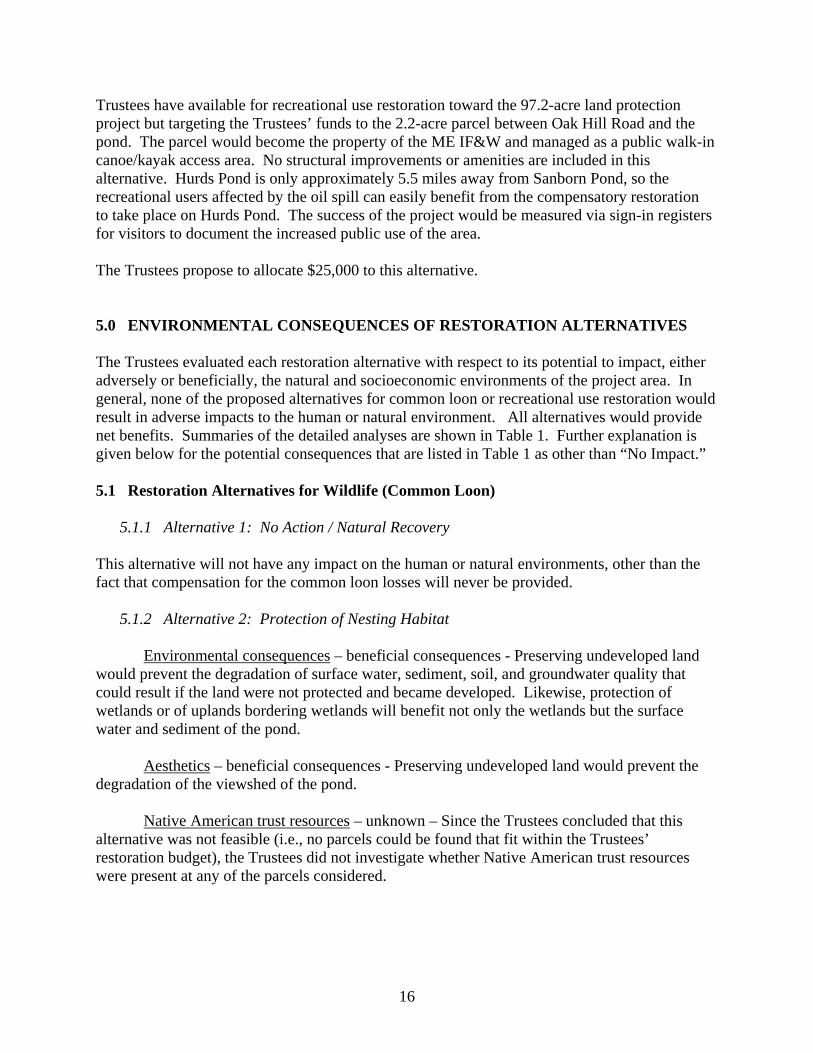
16
Trustees have available for recreational use restoration toward the 97.2-acre land protection project but targeting the Trustees’ funds to the 2.2-acre parcel between Oak Hill Road and the pond. The parcel would become the property of the ME IF&W and managed as a public walk-in canoe/kayak access area. No structural improvements or amenities are included in this alternative. Hurds Pond is only approximately 5.5 miles away from Sanborn Pond, so the recreational users affected by the oil spill can easily benefit from the compensatory restoration to take place on Hurds Pond. The success of the project would be measured via sign-in registers for visitors to document the increased public use of the area. The Trustees propose to allocate $25,000 to this alternative. 5.0 ENVIRONMENTAL CONSEQUENCES OF RESTORATION ALTERNATIVES The Trustees evaluated each restoration alternative with respect to its potential to impact, either adversely or beneficially, the natural and socioeconomic environments of the project area. In general, none of the proposed alternatives for common loon or recreational use restoration would result in adverse impacts to the human or natural environment. All alternatives would provide net benefits. Summaries of the detailed analyses are shown in Table 1. Further explanation is given below for the potential consequences that are listed in Table 1 as other than “No Impact.” 5.1 Restoration Alternatives for Wildlife (Common Loon) 5.1.1 Alternative 1: No Action / Natural Recovery This alternative will not have any impact on the human or natural environments, other than the fact that compensation for the common loon losses will never be provided. 5.1.2 Alternative 2: Protection of Nesting Habitat Environmental consequences – beneficial consequences - Preserving undeveloped land would prevent the degradation of surface water, sediment, soil, and groundwater quality that could result if the land were not protected and became developed. Likewise, protection of wetlands or of uplands bordering wetlands will benefit not only the wetlands but the surface water and sediment of the pond. Aesthetics – beneficial consequences - Preserving undeveloped land would prevent the degradation of the viewshed of the pond. Native American trust resources – unknown – Since the Trustees concluded that this alternative was not feasible (i.e., no parcels could be found that fit within the Trustees’ restoration budget), the Trustees did not investigate whether Native American trust resources were present at any of the parcels considered.
17
5.1.3 Alternative 3: Enhancement of Reproductive Success of Common Loons in Waldo County (Preferred Alternative)
Biodiversity and abundance – beneficial consequence - The purpose of this alternative is to increase the number of loons in the project area by increasing their reproductive success over several years. Significant adverse impacts could occur if the placement of nesting rafts is not carefully planned and monitored (e.g., improperly located rafts can result in an increase in territorial aggression and potentially the death of loon competitors). However, the alternative includes a careful process to evaluate the lakes proposed for rafts, to plan the appropriate locations to minimize the chances of adverse loon reactions, and to monitor the reactions of loons to the rafts so that corrective actions can be taken should adverse impacts occur. Therefore, adverse effects will be avoided. Aesthetics – minimal adverse consequence - The nesting rafts will be constructed according to the guidance provided by DeSorbo et al. (2008) - primarily consisting of cedar logs and plastic snow fence. The avian predator screen, if constructed, is made of wire fencing and camouflage material. If the lake is frequented by recreational boaters that have a high potential of disturbing the nesting raft, floating ropes and signs might be deployed to advise boaters to avoid disturbing the raft. These structures may disrupt the natural-looking quality of the lake for some observers. However, the number of rafts on any one lake will be very small (1 to 3), so the aesthetic effect will be small. Recreational activity – minimal adverse consequence – Recreational boating may be slightly impacted if nesting raft areas are cordoned off with floating rope and signs requesting that boaters stay away from the nesting raft. Often the loon nesting areas are along the shoreline in a cove, which are places that canoes and kayaks often explore. However, the areas requested as “off-limits” are a very small fraction of the entire shoreline of the lake. Thus, there may be some small inconvenience to recreational boaters during a few months of the summer. Education – beneficial consequence – The alternative aims to include local college students as some of the project personnel. In addition, public education regarding loon conservation issues will be provided to lake associations and other stakeholders. Local partnerships and collaborative efforts – beneficial consequence – Ancillary benefits can be created through bringing together local stakeholders to work together to achieve conservation goals. The alternative will bring together local academia, conservation organizations, lake associations, landowners, and others to provide common loon conservation. Partnerships are likely to persist past the performance period of this alternative. Recreational expenditures and related businesses – beneficial consequence – Birdwatchers are one of the largest groups of ecotourists in the United States, and in 2001, birders spent $32 billion in retail sales on wildlife-watching (Sekercioglu 2002, USFWS 2003). Birdwatchers are attracted to the majestic common loon, and a nesting pair accompanied by adorable chicks can be a local ecotourism attraction. Since this alterative aims to increase the chick population on the targeted lakes, ecotourism benefits may be realized.
18
5.2 Restoration Alternatives for Recreational Uses 5.2.1 Alternative 1: No Action / Natural Recovery This alternative will not have any impact on the human or natural environments, other than the fact that compensation to the affected public for the lost recreational uses will never be provided. 5.2.2 Alternative 2: Enhancement of Public Access to Sanborn Pond Recreational activity – beneficial consequence – The purpose of the alternative is to provide formal public access. Native American trust resources – unknown – Since the Trustees concluded that this alternative was not feasible (i.e., parcel did not fit within the Trustees’ restoration budget), the Trustees did not investigate whether Native American trust resources were present. Non-tribal cultural sites – unknown – Most of the shoreline and area immediately around Sanborn Pond is identified as “potential archeological resources areas” (MCRPC 2003). However, the Trustees did not investigate the exact nature of the potential archeological resources and whether this alternative could affect them, since this alternative was not feasible. Nuisances – minimal adverse consequence – The Trustees have heard some sentiment from recreational users of Sanborn Pond that too much additional public use could potentially be detrimental to the recreational value of the pond. Recreational expenditures and related businesses – beneficial consequence – Recreational users drawn to the area could add to the local economy through expenditures for food, fuel, supplies, etc. 5.2.3 Alternative 3: Establishing Public Access to Hurds Pond (Preferred Alternative) Recreational activity – beneficial consequence – The purpose of the alternative is to provide formal public access. Local partnerships and collaborative efforts – beneficial consequence – The purchase of the 2.2 acre parcel that would provide the access area would be part of a larger conservation effort being lead by local conservation groups. Recreational expenditures and related businesses – beneficial consequence – Recreational users drawn to the area could add to the local economy through expenditures for food, fuel, supplies, etc. 5.3 Cumulative Impacts of Preferred Alternatives The Preferred Alternatives are to implement a multi-year, common loon nest raft management program in the vicinity of Sanborn Pond and to provide public recreational access to Hurds Pond.

19
Cumulative impacts are the effects of the preferred alternatives added to, or in combination with, other actions implemented outside of this restoration program in the foreseeable future. The nesting raft management program may result in increased awareness of loon conservation in areas other than the lakes receiving nesting rafts. Community volunteers and other local stakeholders will be some of the partners in the project and can share and apply their knowledge to others and other areas. In addition, recreational boaters using the lakes receiving the nesting rafts may also travel to other loon lakes, carrying their conservation ethic with them. The public access project at Hurds Pond is part of a larger conservation effort to protect the entire shoreline of the pond from development. The entire northern shore of Hurds Pond is already owned by the ME IF&W, and public access at Hurds Pond will allow the ME IF&W to achieve its goals of protecting the ecological resources at Hurds Pond and providing public access to such resources. Increasing the recreational use of Hurds Pond increases the risk that the pond may become invaded by non-native, aquatic invasive vegetation, if such vegetation is not already present. Vegetation such as Eurasian milfoil (Myriophyllum spicatum) can be introduced into ponds by plant fragments stuck onto boats and fishing gear that have previously been used in infested waters. Educating the public (e.g., advisory signs posted at the access point) to be cautious about the potential for transporting plant fragments is the best method to protect Hurds Pond. The risk of invasive aquatic vegetation infestation is also relevant to the loon raft management project if boats or other gear will be shared between lakes. The project participants will be educated to inspect and clean any gear that is shared between lakes.
20
Table 1: Potential Environmental and Socioeconomic Consequences
Loons
Recreational Use
1 – No Action
2 – Protection of
Nesting Habitat
3 – Nest Rafts
1 – No Action
2 – Access to Sanborn
Pond
3 – Access to Hurds
Pond
En
viro
nm
enta
l
Air quality NI NI NI NI NI NI
Surface water quality NI + + NI NI NI NI
Sediment quality NI + + NI NI NI NI
Soil quality NI + + NI NI NI NI
Groundwater quality NI + + NI NI NI NI
Wetlands quality and services
NI + + NI NI NI NI
Biodiversity and abundance
NI + + + + NI NI NI
Soc
ial
Minority or low income populations
NI NI NI NI NI NI
Aesthetics NI NI Min Adv NI NI NI Public health or safety
NI NI NI NI NI NI
Recreational activity NI NI Min Adv NI + + + + Native American trust resources
NI unk NI NI unk unk
Non-tribal cultural sites
NI NI NI NI unk NI
Education NI NI + + NI NI NI Local partnerships and collaborative efforts
NI NI + + NI NI + +
Subsistence activity NI NI NI NI NI NI
Nuisances NI NI NI NI Min Adv NI
Eco
nom
ic
Short-term commercial economic impact
NI NI NI NI NI NI
Property values NI NI NI NI NI NI Recreational expenditures and related businesses
NI NI + + NI + + + +
Resource-based industries, commercial users
NI NI NI NI NI NI
NI = no impact Min Adv = minimal adverse consequences Sig Adv = significant adverse consequences + + = Beneficial consequences unk = unknown

21
6.0 LIST OF PREPARERS Veronica Varela, U.S. Fish and Wildlife Service, New England Field Office Mark Barash, U.S. Department of the Interior, Office of the Solicitor, Northeast Region Ed Logue, Maine Department of Environmental Protection, Eastern Maine Regional Office Richard Dressler, Maine Department of Inland Fisheries and Wildlife Dan Prichard, Maine Department of Conservation Linda Bacon, Maine Department of Environmental Protection Danielle D’Auria, Maine Department of Inland Fisheries and Wildlife Jordan Bailey, Maine Department of Inland Fisheries and Wildlife 7.0 LIST OF AGENCIES, ORGANIZATIONS, AND PARTIES CONSULTED FOR
INFORMATION BioDiversity Research Institute 19 Flaggy Meadow Road Gorham, ME 04038 Coastal Mountains Land Trust 101 Mt. Battie Street Camden, Maine 04843 G.R.F. Real Estate Company 230 Searsport Avenue Belfast, Maine 04915 Town of Brooks, Maine

22
8.0 PUBLIC COMMENT ON THE DRAFT RESTORATION PLAN The Trustees published the draft Restoration Plan / Environmental Assessment for public review and comment on December 16, 2009. Notices of Availability were published in the Bangor Daily News and the Republican Journal (Belfast, Maine). Hard copies of the draft RP/EA were available for viewing at the Maine DEP office in Bangor and the Brooks Town Office. The draft RP/EA could also be downloaded from the Maine DEP website. The comment period closed on January 31, 2010. No comments were received.
23
9.0 LITERATURE CITED DeSorbo, C. R., J. Fair, K. Taylor, W. Hanson, D. C. Evers, H. S. Vogel, and J. H. Cooley, Jr.
2008. Guidelines for constructing and deploying common loon nesting rafts. Northeastern Naturalist 15(1):75-86.
DeSorbo, C. R., K. M. Taylor, D. E. Kramar, J. Fair, J. H. Cooley, Jr., D. C. Evers, W. Hanson,
H. S. Vogel, and J. L. Atwood. 2007. Reproductive advantages for common loons using rafts. J. Wildl. Manag. 71(4):1206-1213.
Evers, D. C. 2007. Status assessment and conservation plan for the Common Loon (Gavia
immer) in North America. BRI Report 2007-20. U.S. Fish and Wildlife Service, Hadley, MA. 127 pp.
Maine Department of Inland Fisheries and Wildlife (ME IF&W). 2006. Maine Lake Survey
Maps – Waldo County – Hurds Pond. Available online: http://www.state.me.us/ifw/fishing/lakesurvey_maps/waldo/index.htm
Maine Department of Inland Fisheries and Wildlife (ME IF&W). 1998. Maine Lake Survey
Maps – Waldo County – Sanborn Pond. Available online: http://www.state.me.us/ifw/fishing/lakesurvey_maps/waldo/index.htm
MacDonald, D. D., C. G. Ingersoll, and T. A. Berger. 2000. Development and evaluation of
consensus-based sediment quality guidelines for freshwater systems. Arch. Environ. Contam. Tox. 39:20-31.
Mcintyre, J. W., and J. F. Barr. 1997. Common Loon (Gavia immer), The Birds of North
America Online (A. Poole, Ed.). Ithaca: Cornell Lab of Ornithology; Retrieved from the Birds of North America Online: http://bna.birds.cornell.edu/bna/species/313
Mid-Coast Regional Planning Commission (MCRPC). 2003. Town of Brooks Comprehensive
Plan. Available at: http://brooks.govoffice2.com/index.asp?Type=B_BASIC&SEC={358E40B4-E572-4DEC-9239-847E8E98260C}
Sekercioglu, C. H. 2002. Impacts of birdwatching on human and avian communities. Environ.
Conserv. 29(3):282-289 U.S. Fish and Wildlife Service (USFWS). 2003. Birding in the United States: A demographic
and economic analysis. Addendum to the 2001 National Survey of Fishing, Hunting and Wildlife-Associated Recreation. Report 2001-1. Division of Federal Aid, U.S. Fish and Wildlife Service, Washington, D.C.
USFWS. 2001. Common Loon Habitat in the Gulf of Maine (LOONHAB2). U.S. Fish and
Wildlife Service, Gulf of Maine Program. http://www.fws.gov/r5gomp/gom/habitatstudy/metadata/common_loon_model.htm

APPENDIX A Trustee Agency Approvals on the Final Restoration Plan / Environmental Assessment
U.S. Department of the Interior Approval
of the Final Restoration Plan / Environmental Assessment
for the September 23, 2001 Sanborn Pond Oil Spill
Town of Brooks, Waldo County, Maine In accordance with U.S. Department of the Interior policy regarding documentation for natural resource damage assessment and restoration projects (521 DM 3), the Authorized Official for the Department must demonstrate approval of draft and final Restoration Plans and their associated National Environmental Policy Act documentation, with concurrence from the Department’s Office of the Solicitor. The Authorized Official for the Sanborn Pond oil spill case is the Regional Director for the U.S. Fish and Wildlife Service’s Northeast Region. By the signatures below, the Final Restoration Plan/Environmental Assessment is hereby approved.
Maine Department of Environmental Protection
Approval of the Final Restoration Plan / Environmental Assessment
for the September 23, 2001 Sanborn Pond Oil Spill
Town of Brooks, Waldo County, Maine By the signature below, the Final Restoration Plan/Environmental Assessment is hereby approved by the Maine Department of Environmental Protection:
Maine Department of Inland Fisheries and Wildlife
Approval of the Final Restoration Plan / Environmental Assessment
for the September 23, 2001 Sanborn Pond Oil Spill
Town of Brooks, Waldo County, Maine By the signature below, the Final Restoration Plan/Environmental Assessment is hereby approved by the Maine Department of Inland Fisheries and Wildlife:
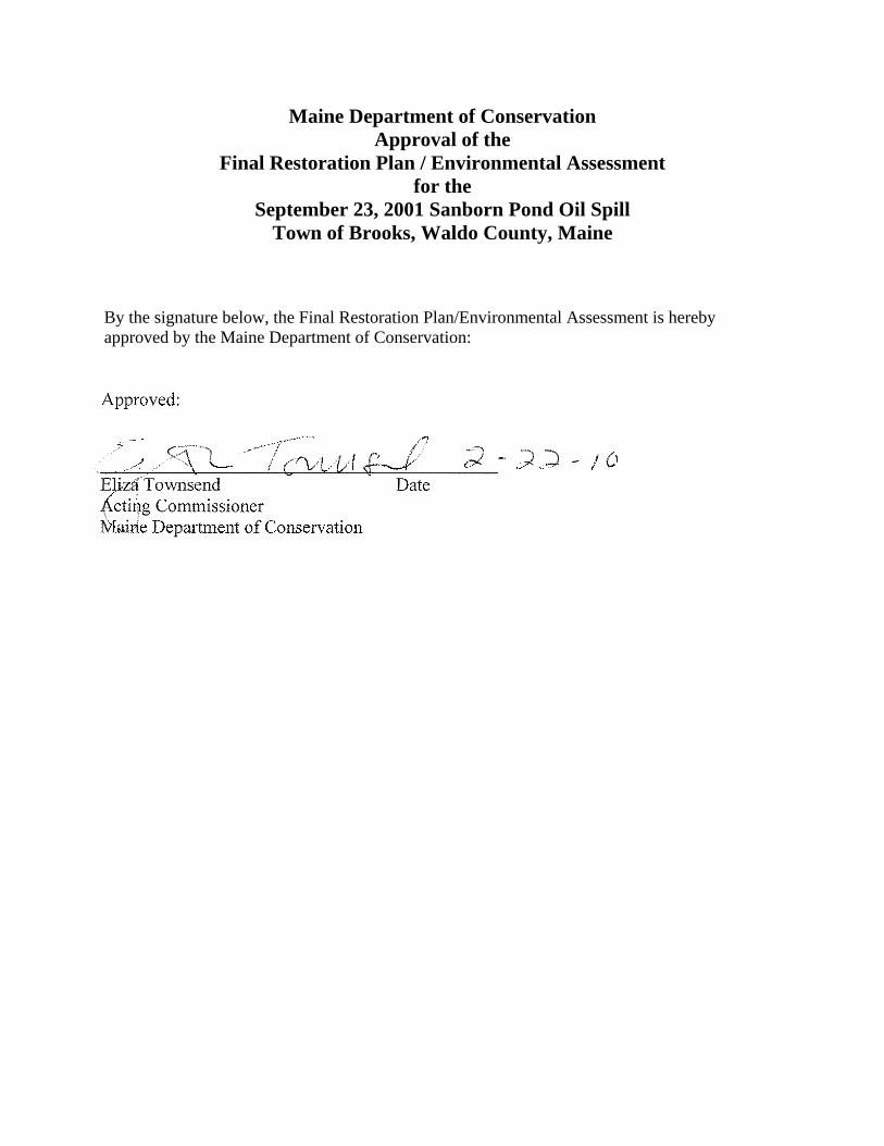
Maine Department of Conservation Approval of the
Final Restoration Plan / Environmental Assessment for the
September 23, 2001 Sanborn Pond Oil Spill Town of Brooks, Waldo County, Maine
By the signature below, the Final Restoration Plan/Environmental Assessment is hereby approved by the Maine Department of Conservation:

APPENDIX B Finding of No Significant Impact
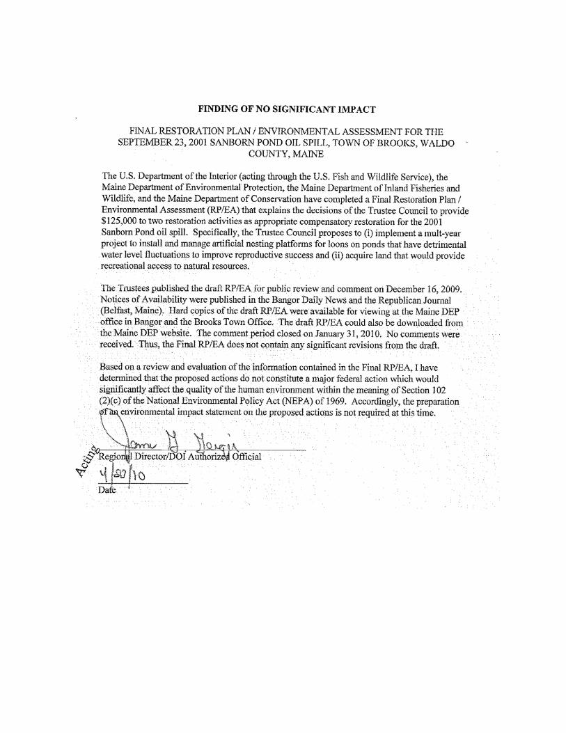

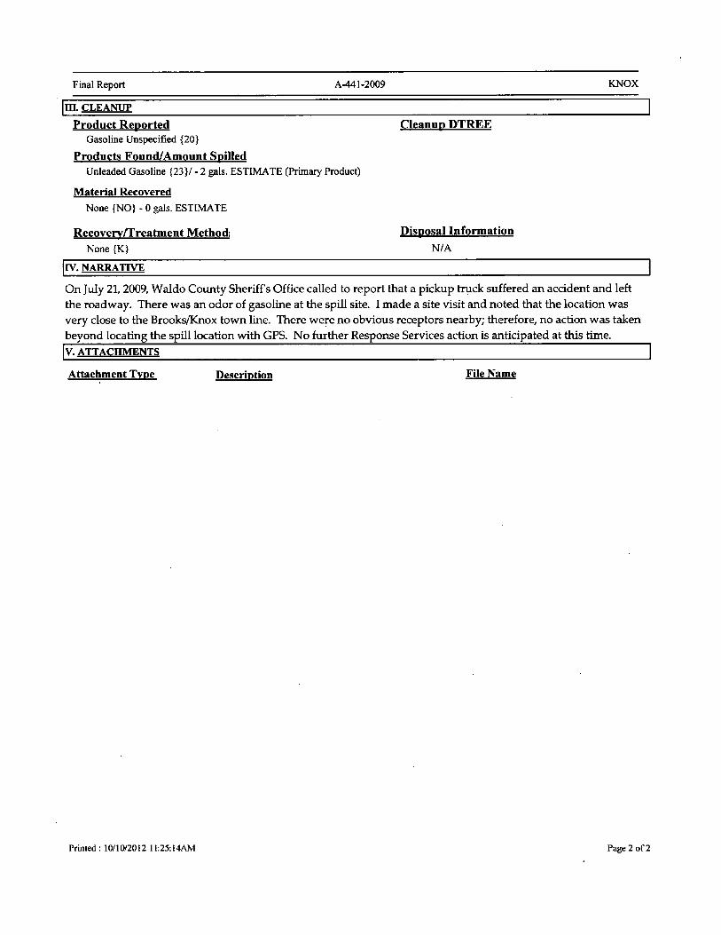

JN: 10193.052 Sanborn Pond Outlet Dam Property Brooks, Maine
APPENDIX E
FLOOD INSURANCE RATE MAP
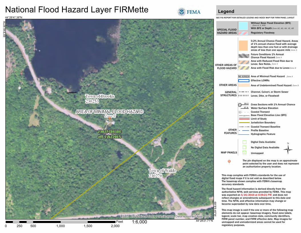
USGS The National Map: Orthoimagery. Data refreshed April, 2019.
National Flood Hazard Layer FIRMette
0 500 1,000 1,500 2,000250Feet
Ü
69°8
'46.
90"W
44°28'47.38"N
69°8'9.45"W
44°28'21.71"N
SEE FIS REPORT FOR DETAILED LEGEND AND INDEX MAP FOR FIRM PANEL LAYOUT
SPECIAL FLOODHAZARD AREAS
Without Base Flood Elevation (BFE)Zone A, V, A99
With BFE or Depth Zone AE, AO, AH, VE, ARRegulatory Floodway
0.2% Annual Chance Flood Hazard, Areasof 1% annual chance flood with averagedepth less than one foot or with drainageareas of less than one square mile Zone XFuture Conditions 1% AnnualChance Flood Hazard Zone XArea with Reduced Flood Risk due toLevee. See Notes. Zone XArea with Flood Risk due to Levee Zone D
NO SCREEN Area of Minimal Flood Hazard Zone X
Area of Undetermined Flood Hazard Zone D
Channel, Culvert, or Storm SewerLevee, Dike, or Floodwall
Cross Sections with 1% Annual Chance17.5 Water Surface Elevation
Coastal Transect
Coastal Transect BaselineProfile BaselineHydrographic Feature
Base Flood Elevation Line (BFE)
Effective LOMRs
Limit of StudyJurisdiction Boundary
Digital Data AvailableNo Digital Data AvailableUnmapped
This map complies with FEMA's standards for the use of digital flood maps if it is not void as described below. The basemap shown complies with FEMA's basemap accuracy standardsThe flood hazard information is derived directly from theauthoritative NFHL web services provided by FEMA. This mapwas exported on 5/20/2019 at 4:09:21 PM and does notreflect changes or amendments subsequent to this date andtime. The NFHL and effective information may change orbecome superseded by new data over time.This map image is void if the one or more of the following mapelements do not appear: basemap imagery, flood zone labels,legend, scale bar, map creation date, community identifiers,FIRM panel number, and FIRM effective date. Map images forunmapped and unmodernized areas cannot be used forregulatory purposes.
Legend
OTHER AREAS OFFLOOD HAZARD
OTHER AREAS
GENERALSTRUCTURES
OTHERFEATURES
MAP PANELS
8
1:6,000
B20.2
The pin displayed on the map is an approximate point selected by the user and does not represent an authoritative property location.

JN: 10193.052 Sanborn Pond Outlet Dam Property Brooks, Maine
APPENDIX F
NATIONAL WETLANDS INVENTORY MAP
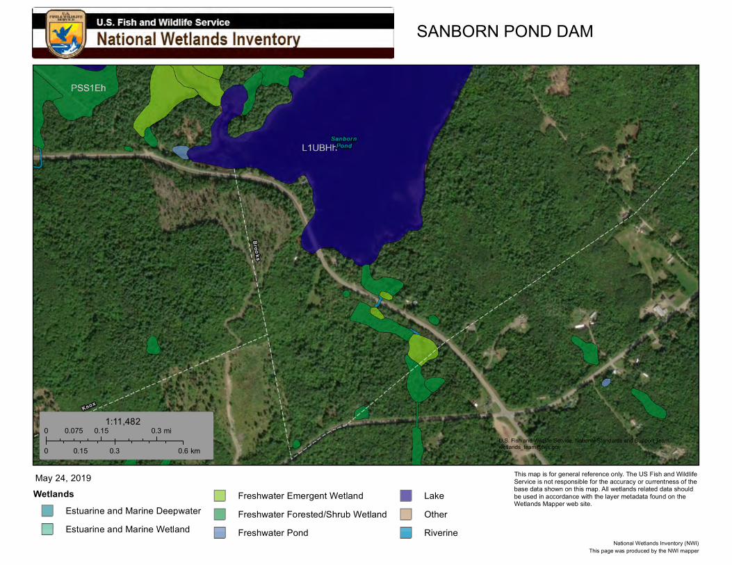
SANBORN POND DAM
U.S. Fish and Wildlife Service, National Standards and Support Team,[email protected]
Wetlands
Estuarine and Marine Deepwater
Estuarine and Marine Wetland
Freshwater Emergent Wetland
Freshwater Forested/Shrub Wetland
Freshwater Pond
Lake
Other
Riverine
May 24, 2019
0 0.15 0.30.075 mi
0 0.3 0.60.15 km
1:11,482
This page was produced by the NWI mapperNational Wetlands Inventory (NWI)
This map is for general reference only. The US Fish and Wildlife Service is not responsible for the accuracy or currentness of the base data shown on this map. All wetlands related data should be used in accordance with the layer metadata found on the Wetlands Mapper web site.
JN: 10193.052 Sanborn Pond Outlet Dam Property Brooks, Maine
APPENDIX G
DRINKING WATER SUPPLY WELL MAP
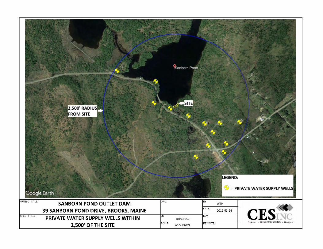
10193.052
AS SHOWN
WEH
2,500' RADIUSFROM SITE
SITE
LEGEND:
= PRIVATE WATER SUPPLY WELLS

JN: 10193.052 Sanborn Pond Outlet Dam Property Brooks, Maine
APPENDIX H
DEED AND TAX INFORMATION

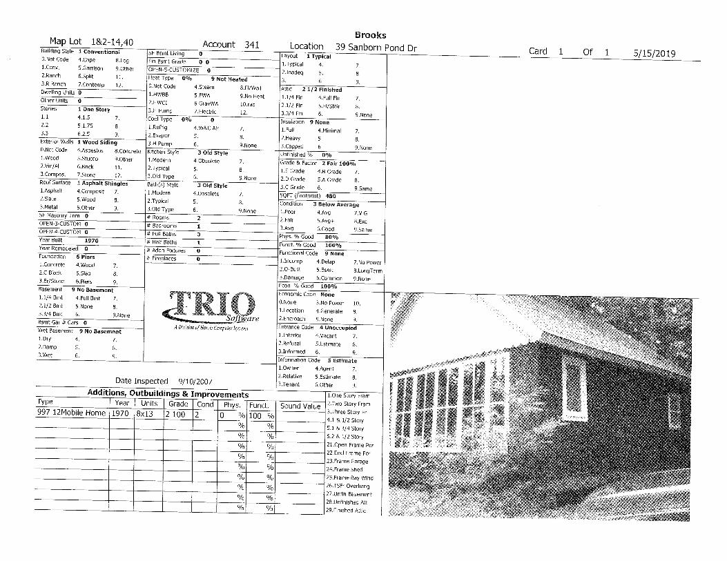
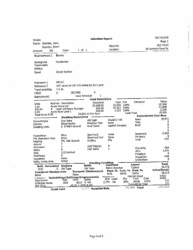
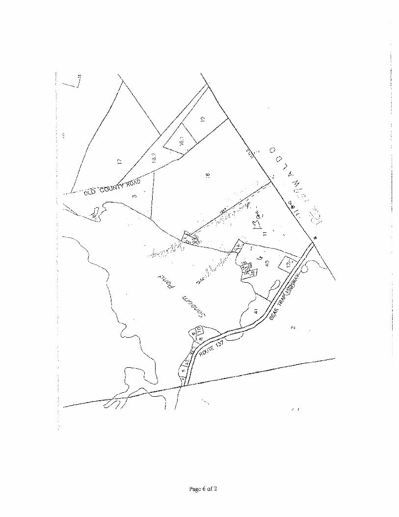
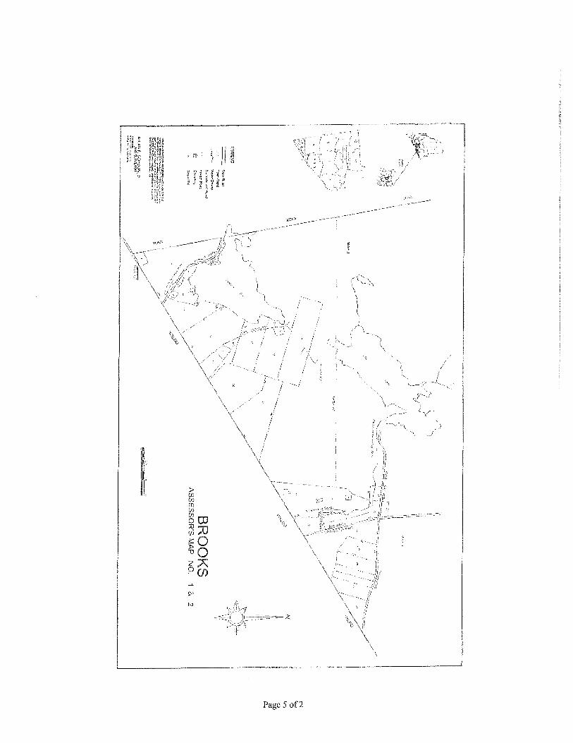


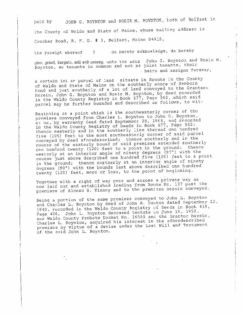
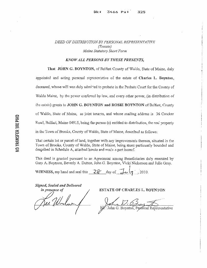

JN: 10193.052 Sanborn Pond Outlet Dam Property Brooks, Maine
APPENDIX I
HISTORIC ATLAS
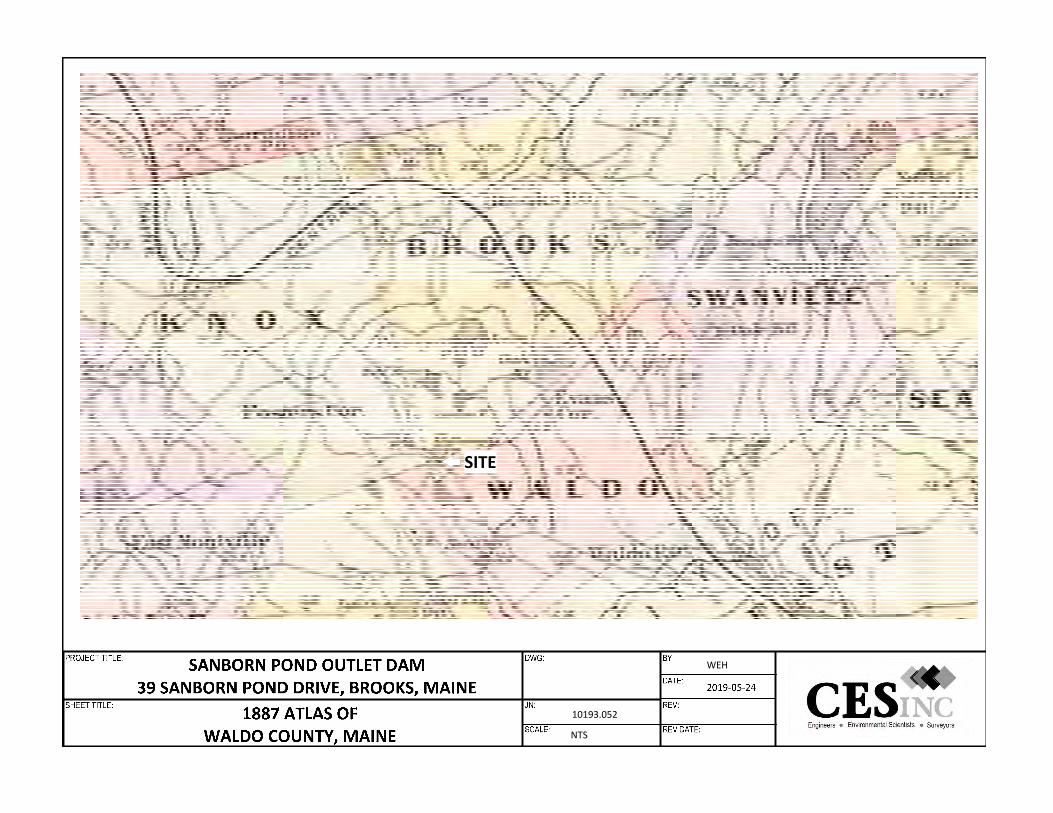
10193.052
NTS
WEH
SITE

JN: 10193.052 Sanborn Pond Outlet Dam Property Brooks, Maine
APPENDIX J
HISTORIC TOPOGRAPHIC MAPS
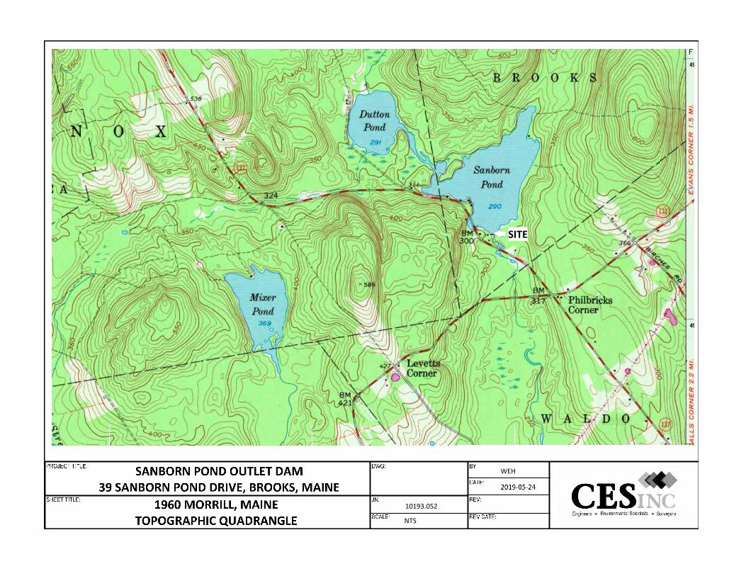
10193.052
NTS
WEH
SITE

JN: 10193.052 Sanborn Pond Outlet Dam Property Brooks, Maine
APPENDIX K
ENVIRONMENTAL QUESTIONNAIRES
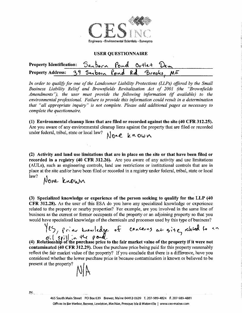
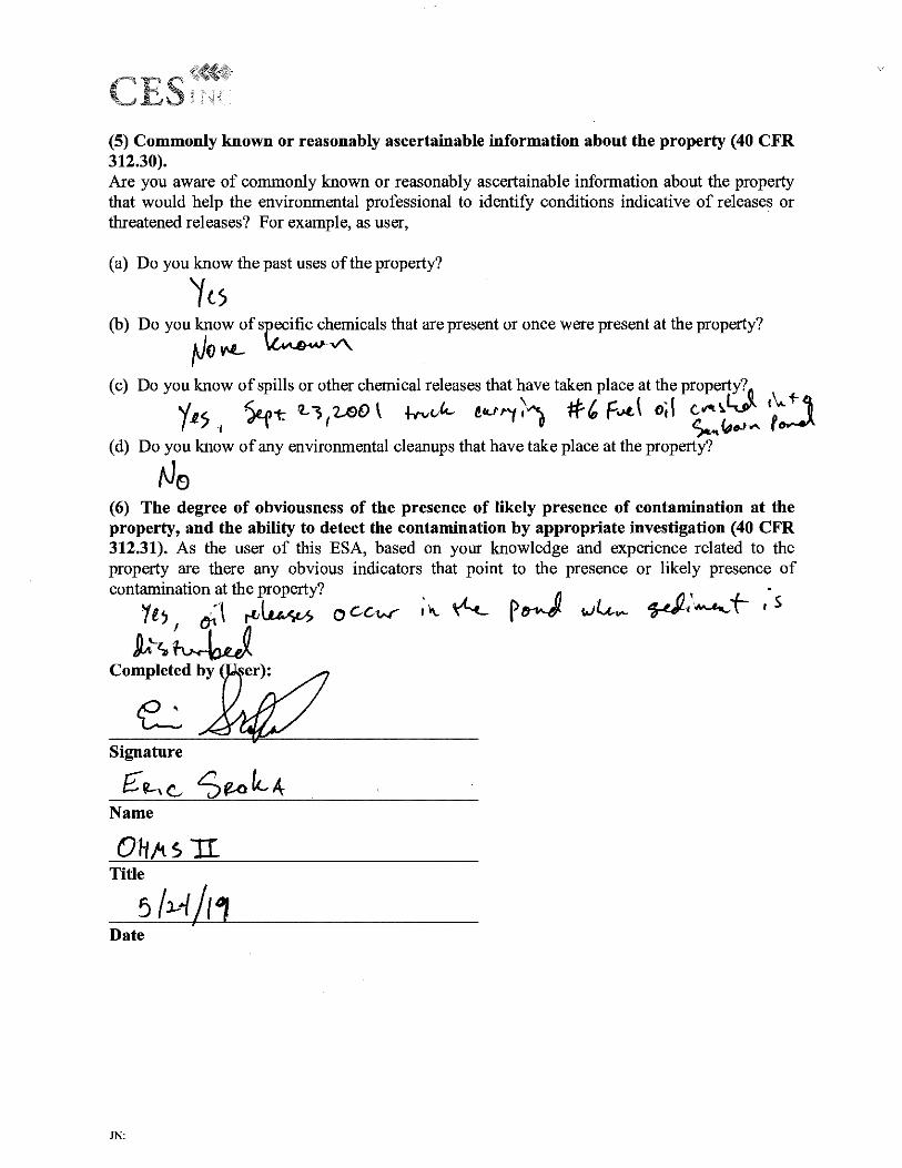

JN: 10193.052 Sanborn Pond Outlet Dam Property Brooks, Maine
APPENDIX L
ENVIRONMENTAL PROFESSIONAL QUALIFICATIONS

Mr. Dennis Kingman | Page 1 of 3
Dennis B. Kingman, Jr., CHMM Vice President / Senior Project Manager Dennis Kingman has 33 years of experience providing asbestos, lead and PCB management, occupational health and safety consultation; and environmental management services to industry, public and private academic institutions, as well as local, state, and federal governments. As a Senior Project Manager and Senior Environmental Scientist, Dennis oversees, coordinates, and completes environmental, asbestos, lead-based paint (PCB), Industrial Hygiene, and Indoor Air Quality (IAQ) projects. Dennis is experienced in conducting Phase I Environmental Site Assessments and associated HUD related documentation, OSHA compliance audits, industrial hygiene monitoring, IAQ assessments, development and implementation of health and safety programs and associated training. Additionally, Dennis has served as an in-house safety manager for a large academic institution and has developed and implemented exposure assessment programs and managed asbestos management programs for a broad range of public and private sector facilities.
Professional History
2013 – Present CES, Inc. Senior Project Manager/Vice President
2003 – 2013 Summit Environmental Consultants, Inc. Manager, Environmental Services
1999 – 2003 URS Corporation Senior Project Manager, Office Manager
1997 – 1999 University of Maine. Assistant Director Environmental Health and Safety
Core Expertise: Environmental Management
OSHA/Health & Safety Regulatory Compliance
Asbestos, PCB, & Lead-based Paint Management
Industrial Hygiene & Indoor Air Quality Consulting
Education B.S. (1983) Wildlife Biology, University of Maine
Registrations Asbestos Design Consultant/Inspector/ Management Planner – MDEP
Certified Hazardous Materials Manager (CHMM) #12061
Affiliations Maine Indoor Air Quality Council (MIAQC) – Past President/ Former Board Member
[email protected] (207) 989-4824 ext. 2223
Mr. Dennis Kingman | Page 2 of 3
Project Experience Former Verso Paper Mill Environmental Management | Bucksport, Maine
Dennis has worked with the current owners of the Verso Paper Mill (Bucksport Mill LLC) to provide a wide range of environmental management consulting to support the demolition and planned redevelopment of the facility. These services included preparation and submission of MDEP SLODA application, completion of hazardous materials assessment for the impacted facility, preparation of asbestos abatement specifications and contractor bidding documents, preparation of demolition contractor specifications and contractor bidding documents, preparation of a partial RCRA closure program, stormwater management, Polychlorinated Biphenyl (PCB) assessment and management, and landfill monitoring and management. Dennis continues to provide support services on an as needed basis to support the on-going demolition and facility transition.
Powers Hall PCB Assessment and Remediation, UMaine at Machias | Machias, Maine
Dennis managed a PCB assessment for the exterior of Powers Hall affected by planned building envelope repair project. Based upon the findings of the assessment, Dennis developed PCB remediation work plans for contaminated caulk and soils remediation which was reviewed and approved by the USEPA. Dennis oversaw on-site remediation oversight and post-remediation clearance inspections and verification testing. Upon completion of remediation work, Dennis developed an Environmental Covenant and long-term Monitoring and Maintenance Inspection Plan (MMIP), which was submitted to USEPA for review and approval.
Phase I Environmental Site Assessment (ESA) – Various Clients | New England
Dennis manages Phase I and Phase II ESAs for public and private sector clients throughout Maine and northern New England. Clients range from local and national lending institutions, attorneys, woodland property managers, developers, commercial and industrial organizations, and public and private housing development agencies. Dennis has managed and performed ESAs for properties ranging from single family residential lots, housing developments, and commercial buildings, to woodland parcels encompassing entire townships.
Margaret Chase Smith Federal Building Hazardous Materials Management | Bangor, Maine
Dennis completed Asbestos, Lead-Based Paint (LBP), and Polychlorinated Biphenyl (PCB) assessments of the MC Smith Federal Building to support current building renovations and upgrades. Dennis developed site specific remediation specifications, PCB remediation work plans for bidding, provided remediation oversight and quality control testing, and inspection services.
Blake Library PCB Assessment and Remediation, UMaine at Fort Kent | Fort Kent, Maine
Dennis completed a PCB assessment for portions of the Blake Library affected by planned renovations. Based upon the findings of the assessment, Dennis developed a PCB remediation work plan which was reviewed and approved by the USEPA. Dennis also performed on-site post-remediation clearance inspections and verification testing. Upon completion of remediation work, Dennis developed an Environmental Covenant and long-term Monitoring and Maintenance Inspection Plan (MMIP), which was submitted to USEPA for review and approval.
Mr. Dennis Kingman | Page 3 of 3
Indoor Air Quality and Health & Safety Assessment | Private Health Care Facility, Maine
Dennis completed an in-depth assessment of a private health care facility as a result of employee and client concerns. The assessment included evaluation of treatment processes, building utilities, employee interviews and ambient air testing. The assessment resulted in the implementation of facility improvements and process modifications, which improved workplace conditions and the quality of client care. Bureau of General Services, State of Maine-Client Coordinator for Asbestos | Projects at Various Locations throughout Maine
Dennis acted as Senior Project Manager for asbestos-related work for various public school and state government facilities throughout the state of Maine. Work involved all aspects of Asbestos management including oversight and performance of surveys, re-inspections and development of management plans, abatement design, contract management, including the development of air monitoring plans. Dennis also conducted abatement management and provided logistical support and interaction with building occupants, parents, and employees as a representative of the client.

Mr. Bradley Sloat | Page 1 of 2
Bradley D. Sloat Project Scientist Brad Sloat holds a BS in Ecology and Environmental Studies, with a concentration in Soil and Water Science. As a Project Scientist with CES, Inc., Brad has experience in performing Phase I and II Environmental Site Assessments, developing and performing soil, groundwater and vapor investigations, Brownfields and Superfund investigation and remediation, data collection and analysis (field and lab), construction quality assurance (CQA), waste water treatment and heavy equipment operation. Brad has been conducting Phase I and Phase II ESAs in accordance with the American Society for Testing and Materials (ASTM) Standard Practice for Environmental Site Assessments: Phase I Environmental Site Assessment Process (E 1527-13) and Standard Guide for Environmental Site Assessments: Phase II Environmental Site Assessment (ESA) Process (E 1903-97) since 2005. Brad maintains and operates the CES owned Geoprobe® 5410 Direct Push Unit.
Professional History
2006 – Present CES, Inc. Project Scientist
2005 – 2006 Environmental Assessments & Consulting Environmental Specialist
2001 – 2004 University of Maine Bryan Dail, Research Intern
Core Expertise Phase I & Phase II ESAs Brownfields & Superfund Assessments, Investigations, & Remediation Superfund O & M Direct Push Services
Education B.S. (2004) Ecology & Environmental Studies, University of Maine, Orono
Certifications Loss Prevention System (LPS) 40 Hour OSHA HAZWOPER Training Geoprobe® Equipment & Tools
[email protected] (207) 764-8412

Mr. Bradley Sloat | Page 2 of 2
Project Experience
Hows Corner Superfund Site | Plymouth, Maine
Brad has been involved with the Hows Corner Superfund Site in Plymouth, Maine since 2012 and has been acting as the Site Manager since 2014. As part of the CES Team, Brad has been responsible for the Operations and Maintenance (O&M) of a groundwater treatment and injection system that treats and remediates chlorinated compounds and PCB’s in groundwater surrounding a historic waste oil storage facility.
Callahan Mine Superfund Site | Brooksville, Maine
As part of the CES team, Brad participated in the PCB investigation and remediation efforts at the Callahan Mine Superfund Site in Brooksville, Maine over the course of several years. During excavation activities, Brad acted as the Construction Quality Assurance officer working with the regulators and the contractor during the excavation of soils containing hazardous levels of PCBs.
Phase I/II ESA, VRAP, Brownfields Remediation | Former Bomarc Missile Facility | Bangor, Maine
Brad identified environmental conditions (RECs) during a Phase I ESA on a property within the former Bomarc Missile Facility in Bangor, part of the former Dow Air Force Base. Brad completed a Limited Phase II ESA and assisted the client in application to the State of Maine Brownfields Program. Following an extensive Brownfields Investigation, Brad and the CES Team conducted a remediation of contaminated soils and a Risk Assessment for the site. The property is in the process of being redeveloped.
Phase I/II ESA, VRAP | Union Street Citgo | Bangor, Maine
A Phase I was completed at a historical gas station and auto repair shop in Bangor, Maine. This investigation resulted in the identification of RECs including evidence of contaminated soil being left on the property after underground storage tank removal. Brad conducted the Phase II ESA and a Soil Vapor Investigation. Through the VRAP program and the placement of institutional controls on the site, the property remains operational.
Phase I/II ESA, VRAP Remediation | Automobile Processing Facility/Junkyard | Brewer, Maine
Brad completed a Phase I ESA for an active automobile processing facility and junkyard in Brewer, Maine. In coordination with VRAP personnel, the CES team completed Phase II ESA investigations on the property and completed limited soil removals to address impacted materials identified during the previous investigations.