phase ii: dheye - kam for sud · chang locally brewed beer, mostly using barley or oat; also called...
TRANSCRIPT
Moving down or not? PHASE II: Dheye
Water supply related technical support for the necessary resettlement of Dheye village in Thangchung
KAM FOR SUD
February 2014
KAM FOR SUD
The second phase of the project “Moving down or not?” was undertaken by
Kam For Sud (KFS) Swiss NGO working for a sustainable development in Nepal since 1998, www.kamforsud.org
comprises the report at hand, as well as a second report concerning Yara, was written by
Daniel Bernet, Marco Baumer, Fidel Devkota and revised by Silvia Lafranchi Pittet who are
briefly introduced hereafter:
Daniel Bernet: Technical advisor at Kam For Sud with a Master’s degree in Environmental
Engineering from the Swiss Federal Institute of Technology in Zurich, Switzerland (ETHZ);
Sound working experience in Nepal and India;
In-field project coordination, hydrology and hydraulic related aspects, editing the report.
Marco Baumer: Consultant geologist at Dr. Baumer SA Geologi Consulenti in Ascona, Swit-
zerland with a Master’s degree in Geology from the Swiss Institute of Technology in Zurich,
Switzerland (ETHZ); Many years of practical field experience in the range of engineering ge-
ology and hydrogeology, namely with dams, tunnels, roads, railway lines, bridges and small
to large building projects, as well as slope stability, ground contamination and groundwater
problems.
Responsible for all geology and hydro-geology related issues.
Fidel Devkota: Visual Anthropologist and postgraduate at the Freie University Berlin, Ger-
many; Scientific advisor of the French association Du Bessin Au Nepal; Many years of first-
hand practical field work experience in Dheye;
Responsible for all social and cultural aspects of the project.
Silvia Lafranchi Pittet: Founder and projects coordinator of Kam For Sud with a Master’s
degree in Environmental Sciences from the Swiss Institute of Technology in Zurich, Switzer-
land (ETHZ); Extensive working experience in Nepal;
Overall coordination of the projects, review and revision of the report.
Imprint:
Title photos: Marco Baumer, Fidel Devkota, Tsering Gurung and Pema Chewang busy
with field work in Chawale, the vast plain below the relocation site of
Dheye (photo: 21/09/2013, Daniel Bernet)
Date: 24/02/2014
Place: Avegno, Switzerland
Pages: 46
Appendices: 28
KAM FOR SUD
iii
Table of Content
Summary vi
Spellings vii
Glossary viii
Abbreviations and acronyms ix
Acknowledgments xi
Preface xii
1 Introduction 1
1.1 Objectives .................................................................................................................... 2
1.2 Resources ..................................................................................................................... 2
2 Background 3
2.1 Demographic and cultural aspects .............................................................................. 3
2.2 Political and intercommunal aspects........................................................................... 4
2.2.1 Land property issues ........................................................................................ 4
2.2.2 Intercommunal conflicts with Charang ............................................................ 5
2.3 Characterization of the relocation site ........................................................................ 6
2.3.1 Completed steps toward relocation ................................................................. 6
2.3.2 Topography and area availability ..................................................................... 8
2.3.3 Partitioning of Thangchung .............................................................................. 9
2.3.4 Accessibility .................................................................................................... 10
3 Water demand 12
3.1 Irrigation water demand ............................................................................................ 12
3.2 Drinking water demand ............................................................................................. 13
4 Irrigation water supply options 15
4.1 Dam feeding long pressure pipeline .......................................................................... 15
4.1.1 Investigations ................................................................................................. 16
4.1.2 Assessment ..................................................................................................... 17
4.2 Short pressure pipeline .............................................................................................. 18
4.2.1 Investigations ................................................................................................. 18
4.2.2 Assessment ..................................................................................................... 20
4.3 Pressure pipeline fed by spring from opposing valley .............................................. 20
4.3.1 Investigations ................................................................................................. 20
4.3.2 Assessment ..................................................................................................... 22
4.4 Pumping water up to the plain .................................................................................. 23
4.4.1 Investigations ................................................................................................. 23
4.4.2 Assessment ..................................................................................................... 24

KAM FOR SUD
iv
4.5 Identification of the best option................................................................................ 25
5 Drinking water supply options 26
5.1 Pressure pipeline fed by spring currently supplying Dheye ...................................... 26
5.1.1 Investigations ................................................................................................. 27
5.1.2 Assessment ..................................................................................................... 28
5.2 Pressure pipeline fed by spring from opposing valley .............................................. 29
5.2.1 Investigations ................................................................................................. 29
5.2.2 Assessment ..................................................................................................... 29
5.3 Pumping water up to the plain .................................................................................. 30
5.3.1 Investigations ................................................................................................. 30
5.3.2 Assessment ..................................................................................................... 32
5.4 Conjunctive use of irrigation water supply system ................................................... 33
5.4.1 Investigations ................................................................................................. 33
5.4.2 Assessment ..................................................................................................... 34
5.5 Identification of the best option................................................................................ 34
6 Water supply plan 36
6.1 Irrigation water supply plan ...................................................................................... 36
6.1.1 Abstraction ..................................................................................................... 36
6.1.2 Settlement pond ............................................................................................. 37
6.1.3 Pressure pipeline ............................................................................................ 39
6.1.4 Drainage and hydropower ............................................................................. 43
6.2 Drinking water supply plan ........................................................................................ 43
6.2.1 Water source .................................................................................................. 44
6.2.2 Location .......................................................................................................... 44
6.2.3 System characteristics .................................................................................... 44
6.3 Exposure to flooding .................................................................................................. 45
7 Outlook 46
8 Bibliography 47
9 List of figures 49
10 List of tables 51
KAM FOR SUD
v
Appendix
A Experiments and measurements 52
A.1 Leveling ...................................................................................................................... 52
A.2 GPS measurements .................................................................................................... 56
A.3 Yield estimation of the spring in Chawale with the tracer method .......................... 59
A.4 Estimation of the hydraulic conductivity ................................................................... 61
A.5 Filterability of Dhey Chang Khola’s surface water ..................................................... 63
A.6 Suspension stability of Dhey Chang Khola’s surface water ....................................... 65
A.7 Settleable solids of Dhey Chang Khola’s surface water............................................. 67
A.8 Assessment of the horizon at different places in and around Thangchung .............. 68
B Data and calculations 72
B.1 Population and households from Dheye ................................................................... 72
B.2 Estimation of crop water requirement with CROPWAT 8.0 ...................................... 73
B.3 Solar pumping scheme for irrigation ......................................................................... 76
B.4 Solar pumping scheme for drinking water ................................................................ 77
B.5 Comparison between HDPE and MS pipes ................................................................ 78
C Prize lists 79
C.1 HDPE pipes, Panchakanya ......................................................................................... 79
KAM FOR SUD
vi
Summary
The first phase of the project “Moving down or not?”, initiated by Kam For Sud, elaborated
the best adaptation strategy for the three heavily water-stressed villages Dheye, Samzong
and Yara, all located in Upper Mustang, Nepal. The study highlighted several technical key
questions, which had to be left unanswered within the limited scope of the project’s first
phase, posing major obstacles for the communities to proceed with the implementation of
the recommended strategies. For that matter, Kam For Sud undertook the project’s second
phase, aimed at providing the missing technical expertise, concluding in two self-standing
reports: one about Yara and one, the report at hand, concerning Dheye. The initially planned
technical investigations regarding Samzong’s relocation had to be abandoned, as the recon-
struction of the village, locally supported by the Lo Mustang Foundation, was suddenly initi-
ated at a location exposed to hydro-geological risks, unlike the one assessed in the project’s
first phase. Therefore, the field work had to be focused on raising awareness about the asso-
ciated hazards. As of January 2014, this effort has proven to be fruitful, as the new village is
going to be reconstructed at the initially identified, safe location.
Concerning Dheye, the project’s first phase highlighted that above all, water for irrigating the
fields, a crucial precondition for the resettlement, cannot be supplied by traditional means,
which constitutes the main obstacle for the villagers to initiate the resettlement. For that
matter, suitable solutions securing the provision of irrigation and drinking water in Thang-
chung were investigated by an interdisciplinary team in the fall of 2013.
From all investigated options, a relatively short pressure pipeline operated by gravity flow
and fed by the current water abstraction, tapping the Dhey Chang Khola, was found to be
the best solution to supply irrigation water to Thangchung. The only disadvantage is that the
water merely reaches the lowest levels of the relocation site. However, this is acceptable, as
this section is recommended to be used exclusively for agriculture, anyway. On the other
hand, this option has the striking advantage not to rely on a dam, which is found not to be a
suitable measure in the first place. The proposed High-Density Polyethylene pipeline, in-
tended to convey the design flow of 44 l/s, is proposed to be buried underground and routed
along the access path at the northwestern corner of Thangchung. To prevent erosion dam-
age by the irrigation water, a drain along the lowest level of the plain, collecting the surplus
water and conveying it securely back to the Kali Gandaki, is recommended. An independent
drinking water supply system is proposed. The required water demand of 13 m3/d including
losses, is suggested to be lifted up to the highest levels of Thangchung by a solar pumping
system comprised by a single pump powered by a 1’200 W Photovoltaic panel array.
Groundwater, spring or if necessary even river water may be tapped for that matter, de-
pending on further necessary yield and quality assessments, yet to be carried out.
In conclusion, the best solution for providing the required amount of water to Thangchung
was identified. The report at hand should be the basis, on which the water supply scheme is
elaborated on implementation level in the next step.
KAM FOR SUD
vii
Spellings
Many different spellings of places, water bodies and names can be found in Upper Mustang.
This is mainly due to the fact, that many names were translated from the local languages
into Nepali and/or English. In the report at hand the spellings from the documentation of the
project’s first phase are adopted and are consistently used hereafter. This section lists other
common spellings.
Dheye Dhe, Dhey, Dhye, Dewa
Dhee Dhi, Dri
Chawale Tsambale
Charang Chrang, Tsarang
Samzong Sam Dzong, Samdzong
Tangge Tange
Tsusang Chuksang, Chhusang
KAM FOR SUD
viii
Glossary
Aquifer Part of geological strata below the ground suitable to hold and
route water
Arak Locally distilled alcohol, also called raksi
Bhote Pipal Himalayan Poplar tree
Chang Locally brewed beer, mostly using barley or oat; also called Arak
Crop evapotranspiration Evapotranspiration from disease-free, well-fertilized crops,
grown in large fields, under optimum soil water conditions, and
achieving full production under the given climatic conditions (Al-
len et al. 1998)
Evapotranspiration Water loss by evaporation from the soil surface and by transpira-
tion of the crop (Allen et al. 1998)
Hydraulic conductivity Describes the capability of water to pass through the soil meas-
ured in m/s and usually denoted by the letter k
Leh Simple animal enclosure used to protect the animals during the
night when they are let to graze in the area; Leh is also the name
of a city in Ladakh, India
Magpa Common practice in Upper Mustang when the husband moves to
his wife’s house instead of vice versa, often due to the fact that
the wife’s parents did not have any sons
Phorang-morang According to Ramble (2007) usually landless people, earning
their income by working for others, or by leasing fields from the
village or from estates
Raksi Locally distilled alcohol, also called arak
KAM FOR SUD
ix
Abbreviations and acronyms
ACAP Annapurna Conservation Area Project
asl Above sea level
AU$ Australian dollar
CSRS Canadian Spatial Reference System
CWR Crop Water Requirement
DDC District Development Committee
EEPROM Flash Electrically Erasable Programmable Read-Only Memory
EGM08SEA Earth Geoid Model 2008 of South Eastern Asia
ET Evapotranspiration
ETc Crop Evapotranspiration
FAI Fondation Assistance Internationale
FAO Food and Agriculture Organization of the United Nations
GLOF Glacier Lake Outburst Flood
GNSS Global Navigation Satellite System
GPS Global Positioning System
HDPE High-Density Polyethylene
ILO International Labor Office
KFS Kam For Sud
LMF Lo Mustang Foundation
LSTB Long Span Trail Bridge
MFSC Ministry of Forests and Soil Conservation
MOSTE Ministry of Science, Technology and Environment
MS Mild Steel
NGO Non-Governmental Organization
NPO Non-Profit Organization
NPR Nepalese Rupees
OD Outer Diameter
PPP Precise Point Positioning
SSTB Short Span Trail Bridge

KAM FOR SUD
x
SUPSI University of Applied Science of Southern Switzerland
USB Universal Serial Bus
US$ US Dollar
VDC Village Development Committee
VRS Virtual Reference Station
KAM FOR SUD
xi
Acknowledgments
One of Kam For Sud’s main principles concerning all undertaken projects is to achieve a sus-
tainable impact. Consequently, it was clear that Kam For Sud would try to continue the sup-
port for the three heavily water-stressed villages in Upper Mustang, after the conclusion of
the project’s first phase. Despite realistic hopes for a further funding, the donor decided to
withdraw, not willing to fund the proposed second phase aiming at providing crucial tech-
nical support for the villages. Therefore, different other possibilities to fund the project were
elaborated.
Kam For Sud is very grateful that after all, the project could be financed with a few very gen-
erous donations, namely from Bruno Häfliger, Laura Aboli and the Jacob foundation. Fur-
thermore, Marco Baumer, part of the expert team, offered to contribute his expertise as a
volunteer. Moreover, Fidel Devkota, who is concluding his PhD, agreed – on virtually short-
est possible notice – to complete the expert team as a volunteer, as well. Kam For Sud would
like to express its gratitude for these contributions, without which the project could not have
been realized.

KAM FOR SUD
xii
Preface
To have a better understanding of the topography, especially height differences, which are
crucial for all water supply options, different methods were applied to quantify the desired
variables. However, as explained in detail in Appendix A.1 and A.2, the measurements are
associated with high uncertainty. Moreover, the conversion of the heights to absolute eleva-
tions turned out to be ambiguous. To prevent possible misinterpretations, only relative
heights, always in relations to the northern end of the first level in Thangchung (GPS point
G3: 29°04'08.5247"N / 83°56'42.8990"E), are used in this report.
In order to lead the reader comprehensibly through the report at hand, it is structured as
follows: First, the goals and objectives of the project’s second phase are presented (Chap-
ter 1). To embed the project in the given context, background information is provided in
Chapter 2. Thereafter, the water demand, crucial for the dimensioning of water supply sys-
tems, is elaborated in Chapter 3. Chapter 4 discusses all irrigation and Chapter 5 all drinking
water supply options. The best solutions are then presented in more detail in Chapter 6. A
short outlook is finally provided in Chapter 7.
KAM FOR SUD
Page 1/46
1 Introduction
It is hard to believe that “(…) until around the sixteenth century, most of Lo/Mustang had an
abundance of water from the surrounding snow-covered mountains, diverse vegetation, and
dense forest from which Lo-pa people built monumental structures, (…)” (Dhungel 2002)
when trekking through Upper Mustang nowadays. In fact, hydrological conditions have been
changing severely (Bernet et al. 2012a). In the course, numerous settlements in Upper Mus-
tang, the northern part of the Mustang District in Nepal, which consists of a north-south ori-
ented valley opening up to the Himalayan plateau in the north (Figure 1.1), have been sub-
jected to heavy water stress in addition to several other issues such as geological risks, over-
all weakening the livelihoods of the concerned communities.
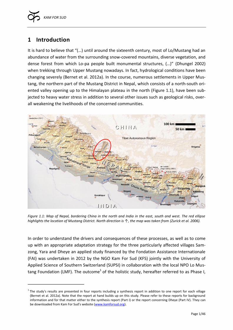
Figure 1.1: Map of Nepal, bordering China in the north and India in the east, south and west. The red ellipse highlights the location of Mustang District. North direction is ↑, the map was taken from (Zurick et al. 2006).
In order to understand the drivers and consequences of these processes, as well as to come
up with an appropriate adaptation strategy for the three particularly affected villages Sam-
zong, Yara and Dheye an applied study financed by the Fondation Assistance Internationale
(FAI) was undertaken in 2012 by the NGO Kam For Sud (KFS) jointly with the University of
Applied Science of Southern Switzerland (SUPSI) in collaboration with the local NPO Lo Mus-
tang Foundation (LMF). The outcome1 of the holistic study, hereafter referred to as Phase I,
1 The study’s results are presented in four reports including a synthesis report in addition to one report for each village (Bernet et al. 2012a). Note that the report at hand builds up on this study. Please refer to these reports for background information and for that matter either to the synthesis report (Part I) or the report concerning Dheye (Part IV). They can be downloaded from Kam For Sud’s website (www.kamforsud.org).
100 km
50 km
KAM FOR SUD
Page 2/46
was the recommendation of a specific adaptation strategy for each village. For two out of
the three studied villages a resettlement of the whole village was proposed.
Within the limited scope of Phase I the suggested adaptation strategies could not be elabo-
rated in a way to investigate and resolve all issues in detail. In particular, some technical key
questions had to be left open which pose a major obstacle for the communities to proceed
with the implementation of the recommended measures. Since the current conditions are
pushing the communities to take immediate action, suboptimal decisions could be made.
Therefore, KFS initiated the second phase of the project “Moving down or not?”, hereafter
referred to as Phase II, and assembled an interdisciplinary expert team once more to provide
missing technical expertise in order to advance the successful adaptation process. The pro-
ject’s written output includes two self-standing reports: one about Yara and one, the report
at hand, concerning Dheye.
The initially planned technical investigations concerning Samzong’s relocation had to be
abandoned, as shortly before the field work started, it became apparent that the reconstruc-
tion of the village, supported by the Lo Mustang Foundation (LMF), the local partner of the
project’s first phase, was initiated at a different location than the one assessed in Phase I. As
this location is an unsuitable place for the future village, mainly because it is exposed to hy-
dro-geological risks, KFS’s field work had to be focused on raising awareness about the asso-
ciated hazards of the changed resettlement plan. This effort has proven to be fruitful, as the
new village is going to be rebuilt at the safe location investigated in Phase I, as of January
2014.
1.1 Objectives
The main goal of Phase II concerning Dheye is to elaborate and report the solutions of specif-
ic technical problems in order to promote the successful resettlement of the villagers at the
relocation site called Thangchung. The key issues investigated within the scope of this pro-
ject can be summarized as follows:
Compare different options for supplying irrigation and drinking water to the relocation
site, identify the optimal solutions, elaborate and report them in more detail thereafter.
1.2 Resources
The report at hand is based on the following resources:
Study “Moving down or not?” (Bernet et al. 2012a)
Field work of Daniel Bernet, Marco Baumer and Fidel Devkota, accompanied by Tsering
Gurung in the fall 2013
Satellite imagery provided by Google Earth Pro
Literature (cited separately; see Bibliography in Chapter 8)
KAM FOR SUD
Page 3/46
2 Background
The following sections provide relevant background information concerning different as-
pects of the resettlement of Dheye in Thangchung.
2.1 Demographic and cultural aspects
According to Devkota (2013) Dheye used to consist of 24 households, whereof ten dislocated
within the past two decades to Charang (3), Tsusang (1), Muktinath (1), Jomsom (1), Pokha-
ra (2), Kathmandu (1) and India (1) respectively. The population in 2013, including the dis-
placed families, amounted to 158 (Table 10.4 in Appendix B.1).
All but one family (Tashi Phuntosk Gurung’s family living in Charang; Table 10.4 in Appen-
dix B.1) intend to move their families to Thangchung. The displaced families are a vital part
of the whole resettlement project as they are engaging themselves both financially and or-
ganizationally in the whole process.
In addition, the family of Karchung Gurung2, who comes from Dheye but lives with her hus-
band and two children in Pokhara, would like to rejoin the community in Thangchung.
Another special case is the family of Karma Gurung (Table 10.4 in Appendix B.1), who did not
own any land in the village before 2012. They were living a nomadic life, which can be char-
acterized as phorang-morang denoting people, who are “(…) usually landless, and make their
income by working for others, or by leasing fields from the village or from estates (…)”
(Ramble 2007, 127). In 2012 Karma acquired some land in Dheye. The new state of a land-
owner is also associated with certain obligations. Now, his family, like all other landowners,
has to provide a worker for helping other landowners during sowing and harvest or for labor
in the new orchard for instance. If Karma and his family cannot fulfill their duty, they have to
pay a fine of about NPR 500.00 which equals roughly US$ 5.00 and corresponds to an aver-
age daily wage for unskilled labor. In this way, some of the families living in the cities are
contributing quite a high amount of money to the community.
For the elaboration of the resettlement plan, it is important to know how many houses the
new settlement has to accommodate. Counting all families still living in Dheye as well as the
displaced households willing to rejoin the community, the total number of households
amounts to 24 and 150 people, respectively (Table 10.4 in Appendix B.1).
2 Karchung Gurung’s family is magpa denoting the particular tradition when the husband moves to his wife’s house instead of vice versa. In Upper Mustang this is often practiced in case a family has no male children. In Karchung Gurung’s case the reason are different though, as she has brothers, whereof one went to Tangge in Upper Mustang as a magpa himself.

KAM FOR SUD
Page 4/46
2.2 Political and intercommunal aspects
Nepal is going through a process of massive political transformations. Currently, the gov-
ernment and major political parties are focused on the new constitution. The second elec-
tion of the constitutional assembly was held in November 2013. However, elections for the
local bodies, namely the District and Village Development Committees (DDC and VDC), as
well as the municipalities, have not been held for more than a decade. The last local election
took place in 1997 and the respective term expired in 2001/02. In the absence of elected
representatives, civil servants have been running these offices ever since. This state of affairs
is the reason for a lack of participation by the locals in planning processes and governance.
2.2.1 Land property issues
To have legal ground for the resettlement of Dheye village in Thangchung, the land at the
new location has to be privatized. Although there are no legal papers to prove it, Thang-
chung is commonly considered to be Dheye’s communal land because of the following rea-
sons:
According to the Convention 169 of the International Labor Office (ILO), of which Nepal is
a member since 1966, the plain of Thangchung belongs to the people of Dheye, because it
has been used by the community for generations.
Local Self-governance Act 2055 (corresponding to the year 1999 AD) addressing the rights
of locals.
However, several issues, listed below, are complicating the question of land property:
Dheye lies in Upper Mustang, which is part of the Annapurna Conservation Area Project
(ACAP). Hence, the traditional rules settling land property issues are more complicated
and are sometimes overruled.
Normally, land that is not owned by an individual or an institution with official land right
papers belongs to the Government. As there are no legal papers stating that Thangchung
belongs to the community of Dheye, basically the Nepalese Government is the official
landowner and for that matter the Ministry of Science, Technology and Environment
(MOSTE), as well as the Ministry of Forests and Soil Conservation (MFSC) are concerned.
According to Nepalese Law there cannot be an exclusive ruling just for Dheye. There are
uncountable issues similar to the case of Dheye concerning public/governmental land
property conflicts. A special ruling for Dheye could be precedent-setting. Thus, a general
ruling from the Government cannot be expected. However, the cabinet could make an
exclusive decision for Dheye, but this requires strong lobbying and a lot of political sup-
port.
Currently, there seem to be two different strategies to cope with the unresolved land prop-
erty issues related to the resettlement of Dheye’s people in Thangchung:
One simple solution is that the villagers keep on doing what they are doing. The local level
politicians, civil servants and community leaders exhibit a positive attitude towards the
KAM FOR SUD
Page 5/46
resettlement of Dhey in Thangchung. The support from the local Government in the form
of small funds is highlighting this fact. In the meantime, the ongoing endeavor to get the
official approval of the Government should be continued.
The other strategy is to perform a land exchange. The villagers could give up their land
ownership papers in Dheye and get the same amount of land in Thangchung in return.
However, Thangchung should accommodate the ten families currently living elsewhere
with no land ownership in Dheye in addition to the 14 families properly owning land. This
would require an accepted procedure to divide the land amongst all the 24 families plan-
ning to move to Thangchung.
2.2.2 Intercommunal conflicts with Charang
In Upper Mustang, it is common that neighboring villages have disputes over pasturelands.
Charang and Dheye are no exception.
Counting roughly eighty households, Charang is one of the biggest villages of Upper Mustang
and has always played an important part in the history of Lo. In contrast, Dheye has always
been a small isolated village.
Charang with its many animals has a high demand for extra pastureland. Consequently,
Thangchung’s valuable pasture land, located close to Charang, was fancied by the latter’s
inhabitants. Political games evolved, where Charang exploited its power and influence to
acquire the rights to use Thangchung as additional pasture land. The conflict culminated in a
confrontation in Thangchung, where the heavily outnumbered men from Dheye were about
to meet Charang’s armed men for a fight to death, as the latter were apparently intending to
raid the remote village of Dheye to settle the matter once and for all. Only through a myste-
rious incident scaring the people of Charang away did the confrontation end without blood-
shed.
In a long tug-of-war, a deal was finally made that the people of Charang can collect the ani-
mal droppings from the plain adjacent to Thangchung named Nakthi, where Dheye’s villag-
ers let their animals graze for several months each year. As traditionally a river or a moun-
tain cuts the border between villages, Charang, being separated from Thangchung by the Kali
Gandaki, never had the rights to claim the plain of Thangchung. The fact that even today
Charang’s people can collect the animal droppings yearly amounting to six to seven tractor
loads of manure, exemplifies the power and influence of Charang.
Even though three migrated families from Dheye are living in Charang nowadays (Tashi
Phuntsok, Chetup Gurung and Norbu Wangchuk, see Table 10.4 in Appendix B.1), the rela-
tionship between Charang and Dheye keeps being difficult. This is highlighted by the fact
that the villagers from Dheye are still not very comfortable with visiting Charang.
In the near future this old conflict between Charang and Dheye could escalate again, espe-
cially in the light of increasing demand for manure due to Dheye’s new plantation in Chawale
(Section 2.3).
KAM FOR SUD
Page 6/46
2.3 Characterization of the relocation site
The people of Dheye decided to move to Thangchung, a vast plain overlooking the conflu-
ence of the Dhey Chang Khola and Charang Khola with the Kali Gandaki, due to the worsen-
ing living conditions at the present location. The decision is supported by the results of
Phase I (Bernet et al. 2012a). In the following sections the already completed steps towards
relocation and the relocation site itself are characterized.
2.3.1 Completed steps toward relocation
Since 2009, when the villagers decided to take the initiative against the water crisis, the
people of Dheye started to invest a lot of effort, labor and money in the cultivation of a tree
plantation. It is located in Chawale, a plain constituting the left riverbank of the Dhey Chang
Khola upstream of the junction with the Kali Gandaki. Up to now, roughly six thousand apple
trees and hundreds of Himalayan Poplar trees, called Bhote Pipal, were planted (Figure 2.1).
The plantation also includes pine, walnut, peach and other local trees.
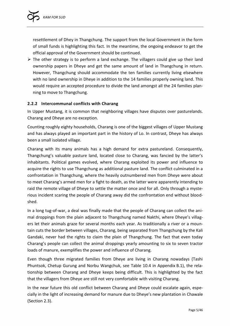
Figure 2.1: A vast area in Chawale was fenced with a rock wall. Within the delineated area, small pits were excavated with the community-owned dozer. Soil, mostly taken from the elevated plain of Thangchung, was added and the trees were plant-ed and cultivated. In 2013 the first apple matured (photo: 19/09/2013, Daniel Bernet).
The villagers plan to sell the apples or products thereof, such as ciders, juice, vinegar, brandy
etc., which will help to finance the resettlement. The Bhote Pipal trees are used in construc-
tion and could therefore help to meet the large demand for sparse and expensive resource
timber needed for the new houses in Thangchung. Furthermore, the villagers envisage pre-
paring Raksi, a locally distilled alcohol, from the orchard’s fruits, which is already successfully
practiced in other villages like Marpha and Tukuche, both located in lower Mustang. In Mus-
tangi culture, alcohol is very important, as it is used in almost every ritual. Presently, a local
beer called Chang or Arak is brewed from barley and oat. A considerable part of the harvest
is thus not processed into food. Substituting grains with apples for the alcohol production
would elongate the self-sufficiency period related to staple food.
KAM FOR SUD
Page 7/46
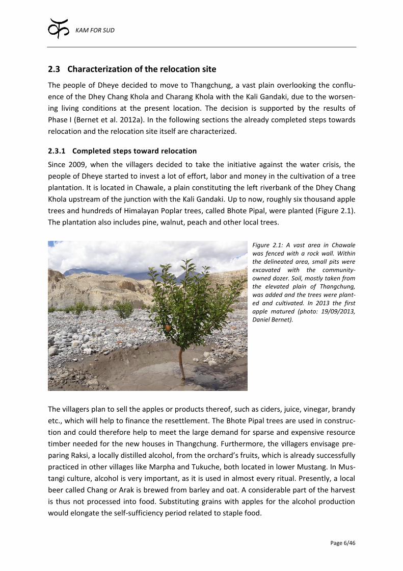
Currently, the plantation includes three different sections. The first section is finished, in the
second and third one most of the pits are excavated. A wall protecting the third section still
has to be built (Figure 2.2). The third section will be divided into 24 individual plots later,
whereof one will be allocated to each family by lottery.
Figure 2.2: The first section of the plantation is finished, of which the northeastern end can be seen (S1, yellow). The wall around the second section (S2, orange area) is completed and most of the pits for the trees are exca-vated. The wall around the third section (S3, red area) is not built yet, but most of the pits are prepared already. Within the uncolored corridor between S1 and S3 some houses were constructed. In the same corridor, plots for temporary housing of each family during the resettlement process were delineated and marked (photo: 23/09/2013, Daniel Bernet).
There are a couple of small houses in Chawale and a few more under construction (Figure
2.2). A small house was constructed for the caretakers of the orchard. Recently, Topri
Gurung and Kunga Angmo were elected by the community to take care of the orchard for
the five years. For that matter, Topri’s family has moved out of Dheye in 2013. A house with
two rooms within the first section of the plantation serves as a sleeping and cooking place,
when villagers gather for the work in the plantation. A storeroom harbors communal goods
and spare parts for the community-owned dozer. Pema Chewang rented another room,
which is planned to be turned into an office later. His own temporary house is almost com-
pleted. Other villagers are planning to construct their temporary accommodation in 2014. It
is estimated that such a dwelling costs roughly US$ 1’000.00 per house. It will serve as a
home until the villagers can move permanently to their new houses at the relocation site.
The materials of these temporary dwellings can be reused.
In 2013, a club comprising almost all the young people from Dheye, initiated and financed
the construction of a club house located at the eastern end of Chawale, along a popular
trekking route connecting Yara and Tangge (e.g. Figure 4.2 in Section 4.1.1). After comple-
S1
S2
S3

KAM FOR SUD
Page 8/46
tion, the house was auctioned. Tsering Largey, who had migrated to Pokhara, could win the
auction. He committed himself to pay annually NPR 70’000.00, roughly equaling US$ 700.00,
for the next five years. Right next to the club-owned house Dorje Chopten runs a tent hotel.
2.3.2 Topography and area availability
An important characteristic of the relocation site is the area availability, which has to be in
accordance with the area requirement of the community of Dheye. In the following para-
graphs, the area of Chawale and Thangchung (Figure 2.3) are characterized.
Figure 2.3: Bird’s eye view of the usable area in Chawale and Thangchung. In Chawale, the first section of the plantation is finished (S1, yellow). The second (S2, orange) and the third section (S3, red) are being prepared for cultivation. The fourth (S4, violet) and the fifth section (S5, pink) have not been subjected to any constructional work so far. Thangchung comprises four different levels ranging from the lowest and largest one (L1, green) over two intermediate ones (L2, bright blue and L3, blue) to the highest one (L4, dark blue). Note that effective areas were considered respecting safety distance to scarps and steep slopes (source: Google Earth Pro, accessed 15/01/2014).
Chawale
As described before in Section 2.3.1 and Figure 2.3, different parts of Chawale are already
used or at least allocated for the plantation.
Thangchung
In Phase I, Thangchung was analyzed with regards to the area at disposal. In Phase II, the
analysis was refined by assessing the usable area. Namely, steep slopes as well as safety dis-
tance to the scarp are excluded from the gross area availability.
Simplified, Thangchung is composed by four different levels, while each step is rather flat,
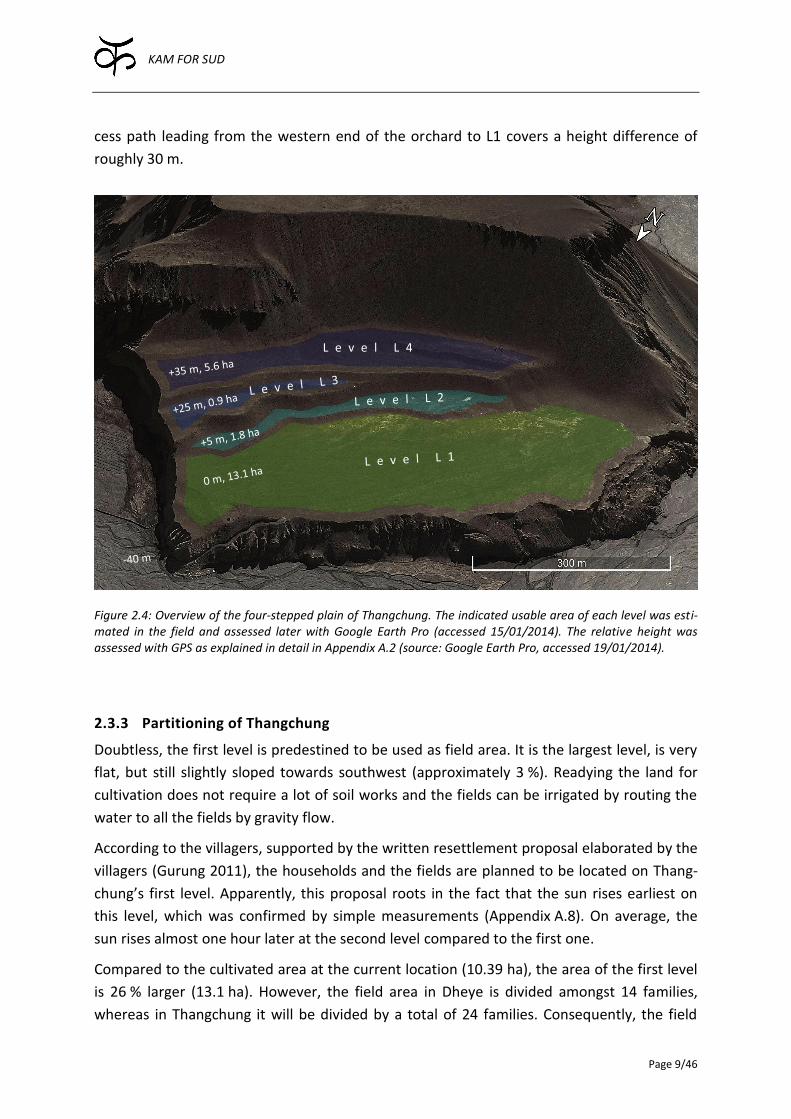
but slightly sloped towards southwest. Figure 2.4 indicates the usable area of each level, as
well as the approximated relative elevation using the first level (L1) as a reference. The ac-
KAM FOR SUD
Page 9/46
cess path leading from the western end of the orchard to L1 covers a height difference of
roughly 30 m.
Figure 2.4: Overview of the four-stepped plain of Thangchung. The indicated usable area of each level was esti-mated in the field and assessed later with Google Earth Pro (accessed 15/01/2014). The relative height was assessed with GPS as explained in detail in Appendix A.2 (source: Google Earth Pro, accessed 19/01/2014).
2.3.3 Partitioning of Thangchung
Doubtless, the first level is predestined to be used as field area. It is the largest level, is very
flat, but still slightly sloped towards southwest (approximately 3 %). Readying the land for
cultivation does not require a lot of soil works and the fields can be irrigated by routing the
water to all the fields by gravity flow.
According to the villagers, supported by the written resettlement proposal elaborated by the
villagers (Gurung 2011), the households and the fields are planned to be located on Thang-
chung’s first level. Apparently, this proposal roots in the fact that the sun rises earliest on
this level, which was confirmed by simple measurements (Appendix A.8). On average, the
sun rises almost one hour later at the second level compared to the first one.
Compared to the cultivated area at the current location (10.39 ha), the area of the first level
is 26 % larger (13.1 ha). However, the field area in Dheye is divided amongst 14 families,
whereas in Thangchung it will be divided by a total of 24 families. Consequently, the field
S1
L3
L e v e l L 4

KAM FOR SUD
Page 10/46
area per family is decreasing. Constructing the village on the first level is in direct competi-
tion with the limited area most suitable for agriculture and will decrease each family’s share
of field area even more. Thus, it is very important to partition and use the available area in
Thangchung as efficiently as possible.
As elaborated in the next chapters, the best solution to supply irrigation water to Thang-
chung is by a pressure pipeline, which cannot provide water higher than to the second level.
Consequently, it makes sense to dedicate the whole first level solely to agriculture, and to
build the village on the second level instead. This would also have the desirable side-effect
that the houses could be built against the slope uphill, in order to protect the dwellings more
naturally against the strong valley winds. Therefore, the houses are suggested to be located
on the second level, even if it comes at the expense of a belated sunrise.
2.3.4 Accessibility
In the monsoon season, when the larger rivers in Upper Mustang carry a lot of surface wa-
ter, they are difficult if not impossible to cross without a bridge (Bernet et al. 2012b). Cur-
rently there is no bridge in the vicinity of Thangchung making a crossing of the Kali Gandaki
possible throughout the year. Only when the rivers are low enough to be crossed by foot,
Charang can be reached easily. In the other case, it is necessary to cross the Dhey Chang
Khola by foot (if possible), then to go further up to Dhee, where an all-season pedestrian
bridge crossing the Kali Gandaki is in place. Using this detour, going to Charang takes a day’s
walk. A bridge would therefore make Thangchung more accessible during the year.
Pedestrian bridges have a long tradition in Nepal, where several thousand bridges have been
realized until today3. Such bridges are categorized into two main types. The Short Span Trail
Bridge (SSTB) measuring less than 120 m and the Long Span Trail Bridge (LSTB) with a span
exceeding 120 m. The latter is considerably more expensive than the former. The longest
bridge built in Nepal is 350 m long (Tuladhar 2007). In Upper Mustang several such bridges
can be found (e.g. south of Kagbeni, Tsusang, and Ghyakar). The span of these exemplary
bridges ranges between 100 and 150 m.
To possibly make Thangchung accessible throughout the year, a coarse assessment of a suit-
able place for a bridge has been carried out. However, the examination on site as well as the
survey using Google Earth did not reveal an obvious location for a pedestrian bridge. South
of Thangchung is a place, where the Kali Gandaki is only 110 m wide. However, the slopes on
both sides are very steep and unstable. Moreover, the access to the bridge heads would be
very difficult to realize as both sides of the riverbank are constituted of steep, unstable cliffs.
North of Thangchung, the Kali Gandaki is measuring roughly 190 m at its narrowest place. As
the bridge head would have to be located further up on solid ground, the bridge would need
to be at least 250 m long, considerably longer than the other bridges seen in Upper Mus-
3 For information see http://www.nepaltrailbridges.org, accessed 11/12/2013
KAM FOR SUD
Page 11/46
tang. Furthermore, the right riverbank of the Kali Gandaki at this spot is close to vertical
making the construction of the bridge head as well as the access path very difficult, if not
impossible in the given context. Moreover, to reach the bridge head on the left riverbank of
the Kali Gandaki, the Dhey Chang Khola would still have to be crossed by foot.
Most conveniently, the bridge would span from Thangchung to the other side of the valley
crossing the Kali Gandaki. Unfortunately, the riverbed below Thangchung is very wide, so
that a bridge would have to be at least 500 m long, longer than the longest realized trail
bridge in Nepal (Tuladhar 2007). Though technically even this span can likely be crossed by
means of a trail bridge, the question is rather whether the financial investment can be justi-
fied. Assuming an effective length of 550 m and a rate of 350.00 $/m (Tuladhar 2007), the
total cost of the bridge would amount to $ 192’500.00
KAM FOR SUD
Page 12/46
3 Water demand
Before talking about water supply, it is important to have an idea about the desired water
demand. However, the assessment of the actual water demand is not a simple task, mainly
because the demand relies on many different factors. For instance, the irrigation water de-
mand depends on the cultivated crops, the way these crops are managed, climatic factors
such as temperature, wind and precipitation and last but not least on the characteristics of
the soil. There are virtually no data available, so that coarse estimations have to suffice.
3.1 Irrigation water demand
The relevant parameter, which has to be determined, is the necessary irrigation intensity
expressed as an irrigation depth per agricultural area (mm/d). Multiplying the intensity with
the maximal area used for agricultural activities results in the required water volume per
day.
In this context, using the concept of evapotranspiration (ET) is helpful. It is defined as the
water loss by evaporation from the soil surface and by transpiration of the crop (Allen et al.
1998). If the water loss from the agricultural field due to ET is compensated by irrigation, the
crop should yield its full potential under the prevalent climatic conditions.
For that matter, the crop evapotranspiration (ETc), defined as “(…) evapotranspiration from
disease-free, well-fertilized crops, grown in large fields, under optimum soil water condi-
tions, and achieving full production under the given climatic conditions” (Allen et al. 1998),
was estimated. Since there are no reliable rainfall data in Upper Mustang and the precipita-
tion rates are extremely low (Bernet et al. 2012b), precipitation is not considered. Other-
wise, the crop water requirement would be lowered by the effective rainfall, but in this case
it corresponds to the ETc.
At least mean monthly minimum and maximum temperatures are needed for the calculation
of the ET. As there are no temperature records available in the area, Giovanni Kappenberger,
experienced meteorologist and climatologist, made an educated guess based on data from
Mustang, Lobuche (Nepal) and Leh (India). These temperature values were then fed into the
FAO’s CROPWAT 8.04. Furthermore, the wind speeds were set to the maximum value
(9.9 m/s) as Upper Mustang is subject to extreme wind conditions (Bernet et al. 2012b;
Zängl, Egger, and Wirth 2001). Moreover, the relative humidity was adjusted to reflect the
harsh, dry climate of Upper Mustang. Using the standard crop factors for barley and oat,
adapting them slightly to match local harvest practices, the monthly crop water requirement
could be calculated.
4 CROPWAT 8.0 can be downloaded from http://www.fao.org/nr/water/infores_databases_cropwat.html, accessed on 13/12/2013.
KAM FOR SUD
Page 13/46
The irrigation system has to be able to provide sufficient water at all times. Therefore, only
the maximal water requirement is relevant for the system design. Based on these considera-
tions, the maximal crop water requirement equals 7.3 mm/d (see Appendix B.2 for details).
This value can be compared to the potential irrigation intensity, which was estimated during
Phase I, documented in Bernet et al. (2012b). The amount of water which could potentially
be used in the fields was estimated by measuring the water abstracted from the river and
dividing it by the cultivated field area. The value amounted to 4.3 mm/d, while the effective
irrigation intensity was certainly lower, as the losses associated with the quite permeable
open distribution channels were not taken into account in this estimation. Nevertheless, the
villagers stated that under such circumstances all the fields under cultivation could just be
sufficiently irrigated. Therefore this value can be considered as a lower boundary.
It has to be clear however that the value measured in Dheye is likely not representing the
water demand in Thangchung, which is subject to a different climatic setting. For instance
the temperatures are higher due to the lower altitude and the area is more exposed to wind.
Both factors are increasing ET, thus also increasing the irrigation demand.
In spite of the fact that the estimated crop water requirement in Thangchung is associated
with large uncertainty, it can be considered as an upper boundary. In the light of all these
uncertainties, a conservative value is certainly appropriate. Thus, the crop water require-
ment of 7.3 mm/d is taken as a reference5. It considers the different climatic setting of
Thangchung and offers additional safety related to unforeseen issues.
Considering the maximal available area of the first level in Thangchung measuring 13.1 ha,
the daily required water volume is 957 m3/d. Note that this volume corresponds to the wa-
ter requirement at the field level. Thus, for each possible water supply system the inherent
losses have to be taken into account on top of that.
3.2 Drinking water demand
Clearly, drinking water demand is not a fixed number, but it is strongly linked to culture and
local habits. At first sight it is less obvious however that the drinking water demand is linked
to the way the water is distributed (Wegelin 1996). If the water has to be brought to the
dwelling from a distant well, the consumption is naturally very low. On the other hand, if a
household is equipped with multiple tap connections, the water consumption will be very
high. Therefore, it is important to have an idea what kind of installations will be put in place
at the relocation site of Dheye, as this is also strongly affecting the water demand.
5 Note that in the reports of Phase I, the preliminary irrigation demand estimation was adopted from Wacker and Fröhlich (1997). Within the scope of Phase II the estimation was refined. The analysis revealed that the considered values in Wack-er and Fröhlich (1997) are very low. However, the reasons for that circumstance remain unclear.
KAM FOR SUD
Page 14/46
In Dheye, there are several fountains distributed within the village. Consequently, the inhab-
itants fill their water canisters at the taps and carry the water home. The water demand is
therefore very low (Bernet et al. 2012b) and is expected to be in the range of public stand-
pipes as defined in Wegelin (1996) and reproduced in Table 3.1.
Table 3.1: Per capita daily drinking water demand depending on the supply system taken from Wegelin (1996).
Supply with… Demand range (l/p/d)
… public hand pumps 15 – 25
… public standpipes 20 – 30
… yard connections 40 – 80
… multiple taps in each house 80 – 120
Reconstructing the village in a different place also opens up the possibility to improve the
infrastructure in general. Related to drinking water supply, this means that instead of a few
taps in the whole village, the plots could be equipped with a connection in the yard or even
with a tap in each house.
The upper limit of the demand presented in Table 3.1 is almost as high as the consumption
in Switzerland or Germany (Gujer 2006). Thus, the upper limit also includes the consumption
of flush toilets, showers etc.
Considering the possibility of a more convenient drinking water distribution, as well as po-
tential for further developments, but still taking the local context and standard of living into
account, a maximal drinking water demand of roughly 80 l per person per day seems appro-
priate.
As the new settlement is designed to house 150 inhabitants, the daily drinking water re-
quirement is 12.0 m3/d. Comparing this number to the water requirement of the crops, it
becomes apparent that in terms of volume, the drinking water demand is marginal, namely
1.3 % of the irrigation water demand.
KAM FOR SUD
Page 15/46
4 Irrigation water supply options
Different technical options for the irrigation water supply at the relocation site of Dheye
were investigated, as elaborated in the following sections. Based on this preliminary assess-
ment, the best suitable option was identified.
4.1 Dam feeding long pressure pipeline
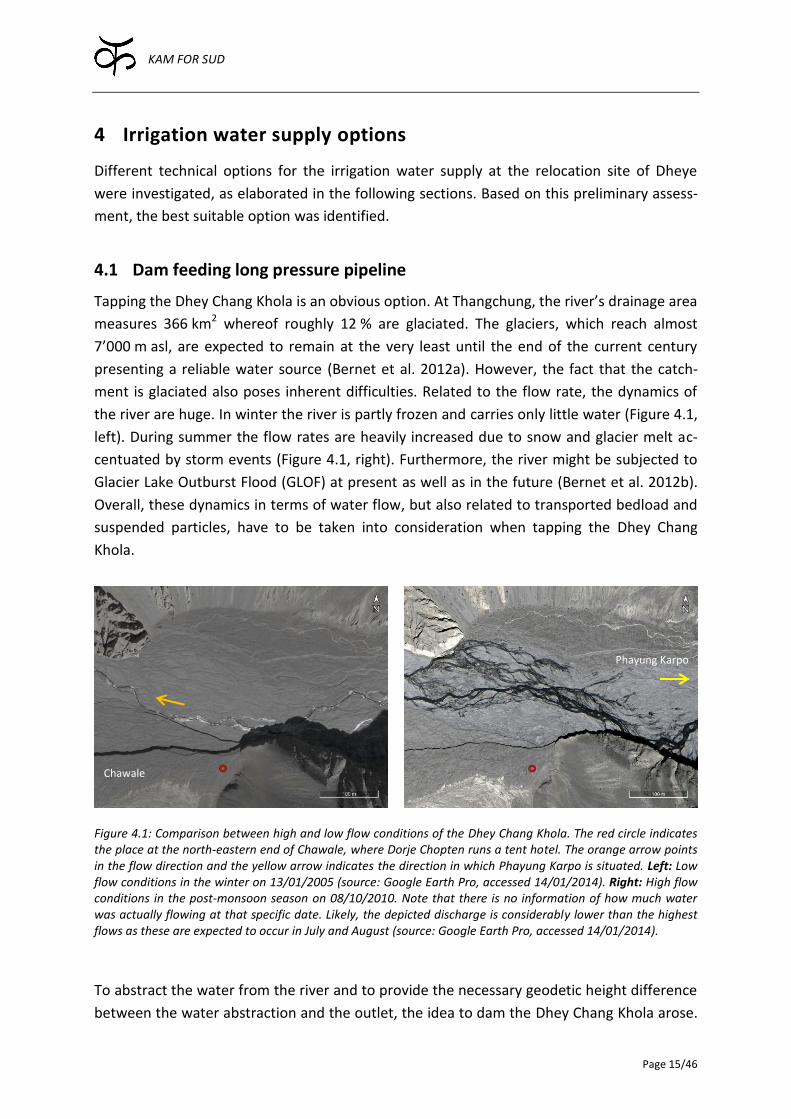
Tapping the Dhey Chang Khola is an obvious option. At Thangchung, the river’s drainage area
measures 366 km2 whereof roughly 12 % are glaciated. The glaciers, which reach almost
7’000 m asl, are expected to remain at the very least until the end of the current century
presenting a reliable water source (Bernet et al. 2012a). However, the fact that the catch-
ment is glaciated also poses inherent difficulties. Related to the flow rate, the dynamics of
the river are huge. In winter the river is partly frozen and carries only little water (Figure 4.1,
left). During summer the flow rates are heavily increased due to snow and glacier melt ac-
centuated by storm events (Figure 4.1, right). Furthermore, the river might be subjected to
Glacier Lake Outburst Flood (GLOF) at present as well as in the future (Bernet et al. 2012b).
Overall, these dynamics in terms of water flow, but also related to transported bedload and
suspended particles, have to be taken into consideration when tapping the Dhey Chang
Khola.
Figure 4.1: Comparison between high and low flow conditions of the Dhey Chang Khola. The red circle indicates the place at the north-eastern end of Chawale, where Dorje Chopten runs a tent hotel. The orange arrow points in the flow direction and the yellow arrow indicates the direction in which Phayung Karpo is situated. Left: Low flow conditions in the winter on 13/01/2005 (source: Google Earth Pro, accessed 14/01/2014). Right: High flow conditions in the post-monsoon season on 08/10/2010. Note that there is no information of how much water was actually flowing at that specific date. Likely, the depicted discharge is considerably lower than the highest flows as these are expected to occur in July and August (source: Google Earth Pro, accessed 14/01/2014).
To abstract the water from the river and to provide the necessary geodetic height difference
between the water abstraction and the outlet, the idea to dam the Dhey Chang Khola arose.
Chawale
Phayung Karpo
KAM FOR SUD
Page 16/46
The retained water could be transported to the elevated plain of Thangchung through a
pressure pipeline by means of gravity flow.
4.1.1 Investigations
Location of the dam at Phayung Karpo
The dam was envisaged in a cut called Phayung Karpo referring to a big white outcropping
rock on the right riverbank. At this location the deep gorge conveying the Dhey Chang Khola
is only roughly forty meters wide. Rock is exposed on either side of the river. On the right
hand side the surface is smooth due to water and possibly glacier erosion. On the left hand
side, which corresponds to the inner side of the curve, the surface is rougher. The rock for-
mation is composed by conglomerates with a greyish silty matrix with dark limestone ele-
ments. The bedding is dipping steep in south – southeast direction (average 150/80) and is
heavily folded. Other discontinuities dipping towards northwest (310/40 and 290/40) and
southwest (215/85) were identified. Due to competence contrasts between limestone and
silt matrix the hinge of the folds can spread open, possibly causing the rock to be permeable.
The bedrock level in the alluvial plain could not be determined during this survey as it is filled
with loose material.
Characterization of the alluvial plain
The alluvial plain of the Dhey Chang Khola is mostly composed of gravel, with some boulder
and local lenses of very fine sand and silt (Table 4.1).
Table 4.1: List of the most common sediments in the alluvial plain below Thangchung. The numbers in the right columns describe the composition of the sediments in percent.
Lithology Frequency Clay Silt Sand Gravel Stone
Coarse gravel Most common (60 % of all material) - - 20 30 50
Gravel Quite frequent (30 %) - 10 30 50 10
Fine sand Only at isolated locations 0 – 5 20 70 5 – 10 -
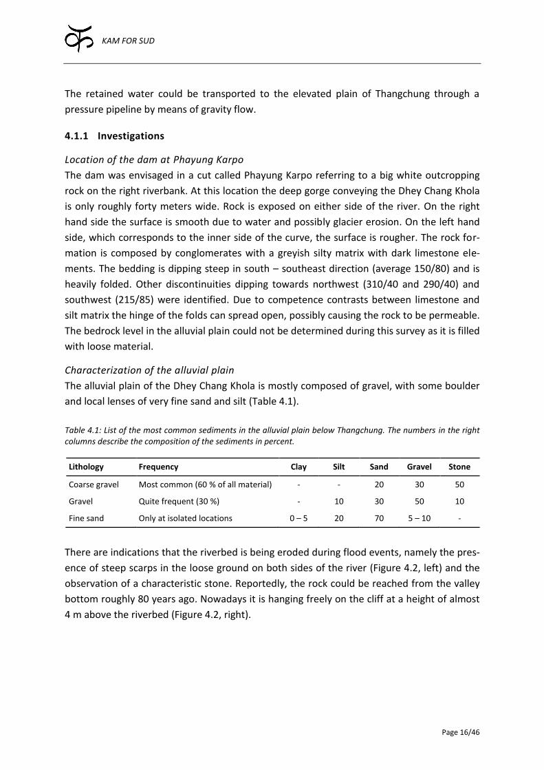
There are indications that the riverbed is being eroded during flood events, namely the pres-
ence of steep scarps in the loose ground on both sides of the river (Figure 4.2, left) and the
observation of a characteristic stone. Reportedly, the rock could be reached from the valley
bottom roughly 80 years ago. Nowadays it is hanging freely on the cliff at a height of almost
4 m above the riverbed (Figure 4.2, right).
KAM FOR SUD
Page 17/46
Figure 4.2: There are indications that the Dhey Chang Khola is eroding the riverbed during flood events. Left: The alluvial plain between Thangchung and the tent hotel and club house located a little bit downstream of Phayung Karpo is illustrated. The steep scarps on both sides of the active riverbed of the Dhey Chang Khola are highlighted with dotted lines. The flow direction is indicated by the blue arrow (photo: 25/09/2013, Daniel Bernet). Right: Marco Baumer standing below the stone, which reportedly was level with the riverbed some 80 years ago. As a reference, the 5 m long measuring pole was placed next to it (photo: 24/09/2013, Daniel Bernet).
Suitability of the topography
To find out whether the topography allows operating a pipeline with gravity flow, the eleva-
tion of Thangchung and Phayung Karpo had to be assessed. For that matter, using a theodo-
lite a leveling from Phayung Karpo to the orchard just below Thangchung was undertaken
(Appendix A.1). The height of the scarp was then approximated by measuring the angle be-
tween the horizontal plane and a fixed-point on top of the scarp in Thangchung from differ-
ent locations. Additionally, the most important points were measured with a Precise Point
Positioning (PPP) Global Positioning System (GPS) module from u-blox. The analysis of these
different measurement methods revealed that they are not matching well and are associat-
ed with unexpectedly high uncertainties (Appendix A.2). Nevertheless, combining all availa-
ble information, the relative elevation of the necessary points, while respecting reasonable
uncertainty ranges, could be assessed. Thus, the measurements show clearly that the height
difference between Phayung Karpo and the highest level in Thangchung is large enough that
a pipeline operated by gravity flow is feasible.
4.1.2 Assessment
With this option, water from the river could be transported to the highest levels of Thang-
chung. However, this option cannot be recommended and is discarded. Any structure built in
the active riverbed of the Dhey Chang Khola would be fully exposed to the high dynamics of
the river including floods, erosion and sediment transport making it difficult to maintain and
prone to failure. Moreover, the dam might not be impermeable due to the geological setting
of Phayung Karpo. Also from an economic perspective this option is not sensible. The costs
of a well-functioning dam are expected to be, relatively speaking, exorbitant. In addition, the
pipeline’s minimal length of 3.5 km would increase the cost of this option.
Thangchung
Tent hotel and club house
KAM FOR SUD
Page 18/46
4.2 Short pressure pipeline
As envisaged by the villagers (Gurung 2011) and reasoned in Section 2.3.3, all fields are best
located on the lowest level in Thangchung (L1, Figure 2.3 in Section 2.3.2). Consequently, it is
most important that the water reaches at least to the first level and not necessarily to the
higher ones. This realization offers an alternative option: The water could be brought to the
first or the second level of Thangchung without the necessity to build a dam, through a rela-
tively short pressure pipeline. Moreover, the pipeline might be fed by alternative water
sources, which was investigated in the field, as described in the following sections.
4.2.1 Investigations
Tapping groundwater
Like spring water, using groundwater has several advantages. In case a sustainable manage-
ment of the groundwater resources is possible, the groundwater table remains fairly con-
stant throughout the year and water can be abstracted even in the winter. Furthermore the
water quality, especially in terms of turbidity, is favorable, as the water is cleaned whilst
flowing through the aquifer.
The abstraction of groundwater with a gravity flow pipeline might be technically challenging,
but likely, solutions could be found. One of the main advantages of tapping groundwater is
the possibility to build the abstraction in a place relatively safe from flooding.
However, the properties of the aquifer have to be such that enough water can be abstract-
ed. An important parameter in this context is the hydraulic conductivity (k) of the aquifer.
The determination of this number demands for rather elaborate measurements, which were
not possible in the given context. Instead, a simple experiment was conducted (Appen-
dix A.4).
Due to the large uncertainty inherent to the measurement method, the k values range from
3·10-3 to 3·10-4 m/s. Thus, the experiment was not accurate enough to obtain valuable re-
sults. Nevertheless, it seems that the permeability is too low to satisfy the irrigation demand
as defined in Section 3.1.
Tapping the Dhey Chang Khola
The pipeline might be fed by the trench, which is currently diverting abundant water from
the Dhey Chang Khola and supplies the orchard with additional water. The abstraction is
washed away regularly in the monsoon season, but, reportedly, it takes a day at most to re-
pair the abstraction by hand or with the aid of the community-owned dozer (Figure 4.3).
The abstraction consisting of a simple diversion with piled up rocks, gravel and sludge, has
the striking advantage that it is highly adaptive. This is a crucial point related to the abstrac-
tion of water from a river as dynamic as the Dhey Chang Khola. For instance, if the riverbed
of the main river is eroded or lifted, the abstraction can be adapted very easily, which is not
true for rigid structures.
KAM FOR SUD
Page 19/46
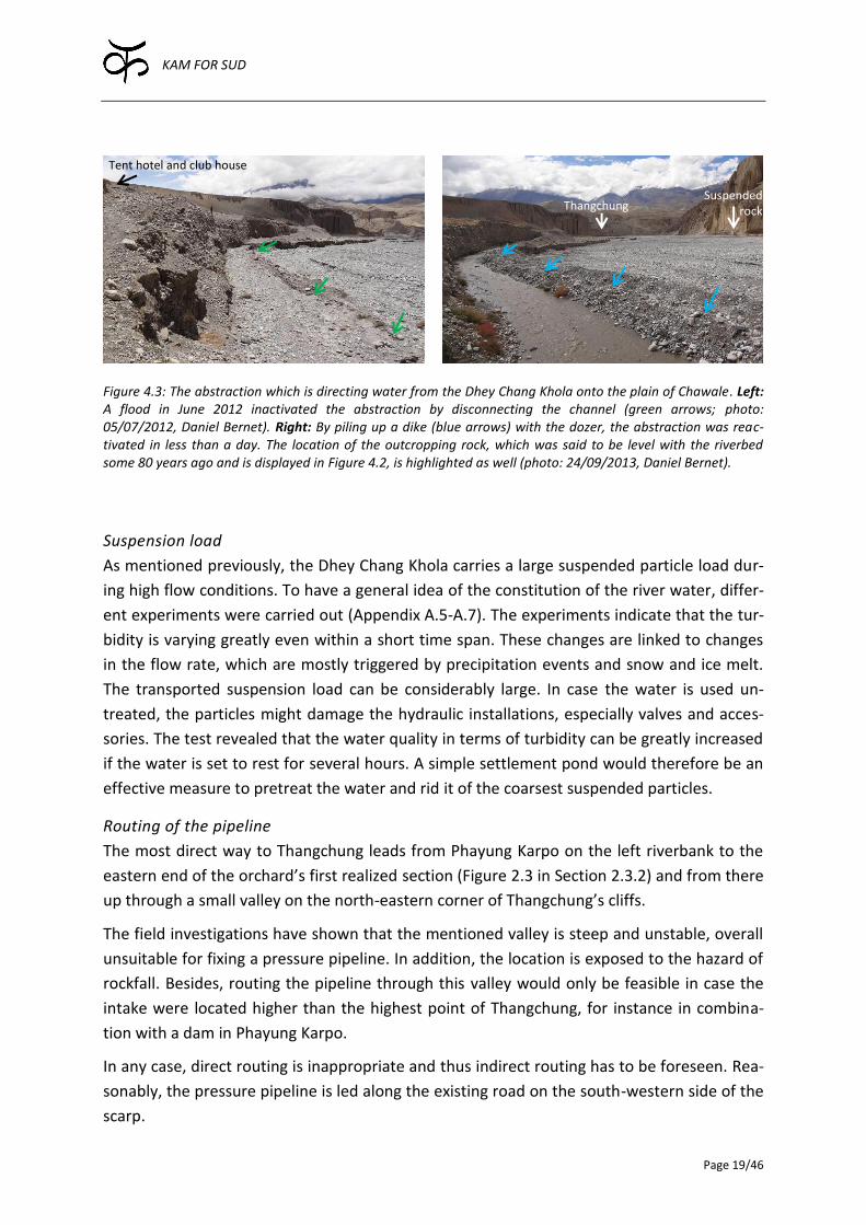
Figure 4.3: The abstraction which is directing water from the Dhey Chang Khola onto the plain of Chawale. Left: A flood in June 2012 inactivated the abstraction by disconnecting the channel (green arrows; photo: 05/07/2012, Daniel Bernet). Right: By piling up a dike (blue arrows) with the dozer, the abstraction was reac-tivated in less than a day. The location of the outcropping rock, which was said to be level with the riverbed some 80 years ago and is displayed in Figure 4.2, is highlighted as well (photo: 24/09/2013, Daniel Bernet).
Suspension load
As mentioned previously, the Dhey Chang Khola carries a large suspended particle load dur-
ing high flow conditions. To have a general idea of the constitution of the river water, differ-
ent experiments were carried out (Appendix A.5-A.7). The experiments indicate that the tur-
bidity is varying greatly even within a short time span. These changes are linked to changes
in the flow rate, which are mostly triggered by precipitation events and snow and ice melt.
The transported suspension load can be considerably large. In case the water is used un-
treated, the particles might damage the hydraulic installations, especially valves and acces-
sories. The test revealed that the water quality in terms of turbidity can be greatly increased
if the water is set to rest for several hours. A simple settlement pond would therefore be an
effective measure to pretreat the water and rid it of the coarsest suspended particles.
Routing of the pipeline
The most direct way to Thangchung leads from Phayung Karpo on the left riverbank to the
eastern end of the orchard’s first realized section (Figure 2.3 in Section 2.3.2) and from there
up through a small valley on the north-eastern corner of Thangchung’s cliffs.
The field investigations have shown that the mentioned valley is steep and unstable, overall
unsuitable for fixing a pressure pipeline. In addition, the location is exposed to the hazard of
rockfall. Besides, routing the pipeline through this valley would only be feasible in case the
intake were located higher than the highest point of Thangchung, for instance in combina-
tion with a dam in Phayung Karpo.
In any case, direct routing is inappropriate and thus indirect routing has to be foreseen. Rea-
sonably, the pressure pipeline is led along the existing road on the south-western side of the
scarp.
Suspended rock Thangchung
Tent hotel and club house
KAM FOR SUD
Page 20/46
4.2.2 Assessment
Realizing that the irrigation water is mostly needed on the first level of Thangchung, a very
promising solution becomes available. The water can be taken in from the Dhey Chang Khola
with the dynamic abstraction currently in use. Though it needs regular fixing and repair, it is
considered to be the best solution in this context. It is low-cost, very adaptive and can be
easily maintained by the locals. Building any rigid structures to take in the water is highly
discouraged.
On the other hand, the use of groundwater is discarded as well, as the yield does not seem
to be sufficient to supply the demanded amount of water.
A settlement pond is a simple and effective measure to reduce the high expected suspension
load of the water to prevent the hydraulic installations from damage.
Though direct routing of the pipeline up through the steep valley was foreseen by the peo-
ple, it is inappropriate in terms of steepness, stability and exposure to rockfall. Moreover,
direct routing is not compatible with a short pressure pipeline involving an intake located
lower than the highest levels of Thangchung in the first place.
4.3 Pressure pipeline fed by spring from opposing valley
Charang, one of the main villages of Upper Mustang, is located north of Thangchung on a
southwards sloping plain. Below the village, a considerable amount of water emerges from a
crack in the rock. The idea is to convey this water to Thangchung within a pressure pipeline.
4.3.1 Investigations
Water source
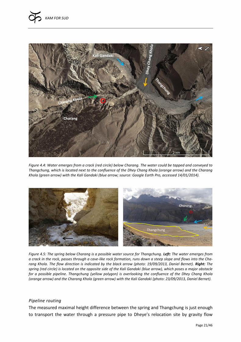
To reach the spring (Figure 4.4), a cave-like structure has to be passed (Figure 4.5, left), from
where the water can be seen emerging from a crack in the rock. Little is known about the
dynamics of the spring’s yield. It is said that the spring does not dry out even during the win-
ter. In the morning, when the spring was visited, the riverbed of the streamlet was wetted
above the observed water table suggesting a higher water table during the night. Likely, the
flow of the spring is subjected to diurnal variations in addition to probable seasonal fluctua-
tions. Furthermore, the location of the spring suggests that at least part of the water is con-
stituted by infiltrated irrigation water from Charang’s fields.
KAM FOR SUD
Page 21/46
Figure 4.4: Water emerges from a crack (red circle) below Charang. The water could be tapped and conveyed to Thangchung, which is located next to the confluence of the Dhey Chang Khola (orange arrow) and the Charang Khola (green arrow) with the Kali Gandaki (blue arrow; source: Google Earth Pro, accessed 14/01/2014).
Figure 4.5: The spring below Charang is a possible water source for Thangchung. Left: The water emerges from a crack in the rock, passes through a cave-like rock formation, runs down a steep slope and flows into the Cha-rang Khola. The flow direction is indicated by the black arrow (photo: 19/09/2013, Daniel Bernet). Right: The spring (red circle) is located on the opposite side of the Kali Gandaki (blue arrow), which poses a major obstacle for a possible pipeline. Thangchung (yellow polygon) is overlooking the confluence of the Dhey Chang Khola (orange arrow) and the Charang Khola (green arrow) with the Kali Gandaki (photo: 23/09/2013, Daniel Bernet).
Pipeline routing
The measured maximal height difference between the spring and Thangchung is just enough
to transport the water through a pressure pipe to Dheye’s relocation site by gravity flow
Charang
Thangchung
Kali Gandaki
Charang

KAM FOR SUD
Page 22/46
(Figure 10.4 in Appendix A.2). However, a major obstacle is posed by the main river of the
Mustang valley, the Kali Gandaki (Figure 4.5, right). Routing the pipeline along the right
riverbank of the Charang Khola, the pipeline has to cross the Kali Gandaki. A different routing
would mean that all three rivers shown in Figure 4.5 would have to be crossed.
In case a pedestrian bridge is built (see Section 2.3.2), a pipeline could easily be mounted
securing it against floods from the Kali Gandaki. However, this solution is only possible if
certain basic conditions are met. For instance, the bridge head has to be lower than the inlet
of the pipeline otherwise the water could not be transported by means of gravity flow. Fur-
thermore, such an arrangement would only be sensible, if a rather direct routing of the pipe-
line was feasible else the pipeline would be unnecessarily long and expensive.
Another possibility is to hang the pipeline on a steel wire suspended over the river. Though
cheaper than a bridge, the pipeline would not be accessible for maintenance. Suspending
the pipeline on evenly spaced pillars placed into the riverbed of the Kali Gandaki constitutes
another option. However, the pillars would be situated within the very dynamic riverbed of
the Kali Gandaki directly exposed to high flow conditions and floods. Burying the pipes into
the riverbed would be sensible if the trench can be dug deep enough and if the Kali Gandaki
can be diverted sufficiently to do the necessary construction work.
Cultural and social aspects
It is very important to note that the option of tapping water from Charang is only thinkable if
it is socially and culturally accepted by all stakeholders. As described in Section 2.2.2, the
relationship between Dheye and Charang was and is problematic. Thus, in this context, the
abstraction of the water would most likely not be accepted by the people of Charang.
4.3.2 Assessment
The advantage of using spring water to meet the irrigation water demand is the superior
constitution of the water mainly in terms of turbidity. Generally, floods and high flow condi-
tions, due to snow and ice melt, do not heavily affect the yield and the water quality of
springs. Thus, the abstraction of the water is simple and a pretreatment of the water be-
cause of turbidity peaks during high flow conditions is often superfluous.
On the other hand, the topographic and geological setting is posing a major constraint for
this option. Especially the crossing of the Kali Gandaki is very difficult. The mentioned op-
tions are either very expensive (bridge), unpractical (pipe suspended on steel wired), difficult
to construct (buried pipeline) or prone to fail (pipeline mounted on pillars).
Above all, the usage of the water would most likely not be accepted by the people of Cha-
rang. Therefore, the option of transporting spring water from Charang to Thangchung is dis-
carded.
KAM FOR SUD
Page 23/46
4.4 Pumping water up to the plain
An obvious way to bring the water to Thangchung is to lift it up with a pump. This option has
the advantage that a rather short pipeline can be realized. The water to be pumped is col-
lected or transported to a suitable place as close to the destination as possible. Different
water sources could be tapped. However, the most critical issue is how to come up with suf-
ficient power to be able to run the pumps.
4.4.1 Investigations
After the first priority, namely to provide road access to all villages in Upper Mustang, it is
planned to connect the villages to the national electricity grid. Due to the central Govern-
ment’s inefficiency in remote places like Upper Mustang, intrigues and local powers of the
local centers such as Charang and Lo-Manthang play an important role in such large infra-
structure projects to the effect that remote places like Dheye and Samzong are disadvan-
taged. In this light, it will take years, if not decades, before Dheye will be connected to the
electricity grid. However, as Thangchung is not nearly as remote as the current location,
connecting the resettled village will be easier and thus quicker than connecting Dheye. Nev-
ertheless, it cannot be expected that a connection to the national electricity grid will be
available in the near future. Consequently alternative power sources are necessary for a po-
tential pumping scheme.
The water could be pumped up to the elevated plain of Thangchung using solar power. Pho-
tovoltaic (PV) panels in combination with solar pumps are a widely-used and well-tested
technology, especially in areas that are not connected to the power grid. For that matter, an
exemplary calculation with pumps from NOV Mono6 was undertaken to assess the suitability
of this option. The main input parameters and the results of this simulation are summarized
in Table 4.2. All CASS simulation results are presented in Appendix B.3.
6 Many different companies offering solar pumps exist. NOV Mono (http://www.monopumps.com.au) was chosen for ref-erence as they offer a freeware calculation tool named CASS (Computer Aided Solar Simulation) to assess the best suitable pump. Furthermore, two solar pumps had been installed at KFS’s orphanage in Tathali, Bhaktapur, and have proven to be very reliable.
KAM FOR SUD
Page 24/46
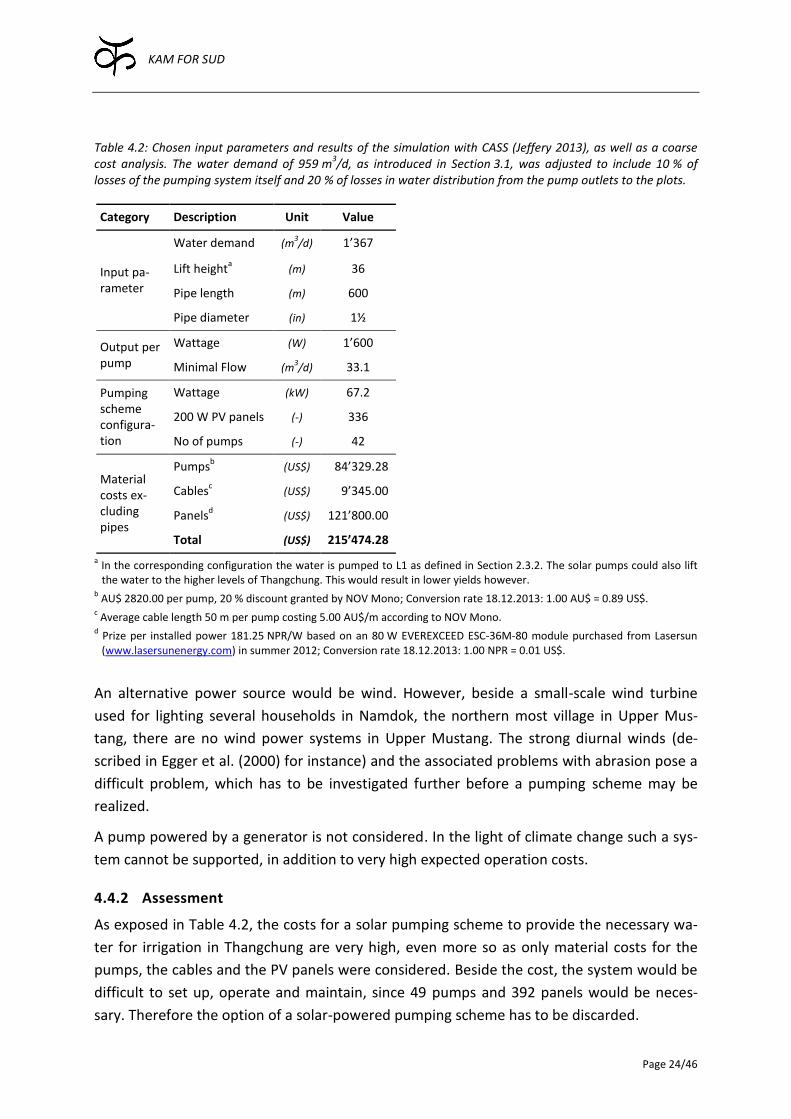
Table 4.2: Chosen input parameters and results of the simulation with CASS (Jeffery 2013), as well as a coarse cost analysis. The water demand of 959 m
3/d, as introduced in Section 3.1, was adjusted to include 10 % of
losses of the pumping system itself and 20 % of losses in water distribution from the pump outlets to the plots.
Category Description Unit Value
Input pa-rameter
Water demand (m3/d) 1’367
Lift heighta (m) 36
Pipe length (m) 600
Pipe diameter (in) 1½
Output per pump
Wattage (W) 1’600
Minimal Flow (m3/d) 33.1
Pumping scheme configura-tion
Wattage (kW) 67.2
200 W PV panels (-) 336
No of pumps (-) 42
Material costs ex-cluding pipes
Pumpsb (US$) 184’329.28
Cablesc (US$) 109’345.00
Panelsd (US$) 121’800.00
Total (US$) 215’474.28
a In the corresponding configuration the water is pumped to L1 as defined in Section 2.3.2. The solar pumps could also lift the water to the higher levels of Thangchung. This would result in lower yields however.
b AU$ 2820.00 per pump, 20 % discount granted by NOV Mono; Conversion rate 18.12.2013: 1.00 AU$ = 0.89 US$.
c Average cable length 50 m per pump costing 5.00 AU$/m according to NOV Mono.
d Prize per installed power 181.25 NPR/W based on an 80 W EVEREXCEED ESC-36M-80 module purchased from Lasersun (www.lasersunenergy.com) in summer 2012; Conversion rate 18.12.2013: 1.00 NPR = 0.01 US$.
An alternative power source would be wind. However, beside a small-scale wind turbine
used for lighting several households in Namdok, the northern most village in Upper Mus-
tang, there are no wind power systems in Upper Mustang. The strong diurnal winds (de-
scribed in Egger et al. (2000) for instance) and the associated problems with abrasion pose a
difficult problem, which has to be investigated further before a pumping scheme may be
realized.
A pump powered by a generator is not considered. In the light of climate change such a sys-
tem cannot be supported, in addition to very high expected operation costs.
4.4.2 Assessment
As exposed in Table 4.2, the costs for a solar pumping scheme to provide the necessary wa-
ter for irrigation in Thangchung are very high, even more so as only material costs for the
pumps, the cables and the PV panels were considered. Beside the cost, the system would be
difficult to set up, operate and maintain, since 49 pumps and 392 panels would be neces-
sary. Therefore the option of a solar-powered pumping scheme has to be discarded.
KAM FOR SUD
Page 25/46
Due to the exceptional diurnal wind patterns in Upper Mustang, the wind potential is gener-
ally high. However, to be applicable in a context such as the relocation of a whole village, the
system has to be well-studied, practice-approved and readily available. Since these require-
ments are not met, installation of a wind-powered scheme is no option either.
Summarized, only in case Thangchung were connected to the general power grid, a pumping
scheme could be a realistic alternative. As this is neither the case at present nor in the near
future, the option of a pumping scheme is discarded.
4.5 Identification of the best option
In general, it is very important that the recommended option is accepted by the community.
The discussions with the villagers revealed that they would accept any solution. Their para-
mount demand is simply that the chosen option serves its purpose.
Table 4.3: Comparison of the studied options to supply irrigation water to Thangchung. The recommended op-tion is marked with a tick.
Irrigation Sup-ply Option
Advantages Disadvantages Best option
Dam feeding long pressure pipeline
Water can be transported to the highest levels in Thangchung
Unfavorable geological setting for a dam Dam very expensive Abstraction fully exposed to the river’s
dynamics making it prone to failure Very long pipeline necessary
Short pressure pipeline
Dynamic abstraction Relatively short pipeline Easy to maintain
Water cannot be brought to the highest levels in Thangchung
Pressure pipe-line fed by spring from opposing valley
Abstraction safe from floods etc. Very good water quality in terms
of turbidity and suspended solids Water can be transported to the
highest levels in Thangchung
Difficult routing due to unfavorable topo-graphic setting
Kali Gandaki has to be crossed Water usage would most likely not be
accepted by Charang’s people
Pumping water up to the plain
Short pipeline Not expected to be connected to the power grid in the near future, thus, au-tonomous power source necessary
High power consumption Very technical solution Expensive equipment necessary Labor intensive option
The different options to supply Thangchung with irrigation water have been outlined in the
preceding sections. Comparing the four options (Table 4.3), it becomes clear that the best
solution is to construct a small pipeline while using the present method of abstracting the
water from the Dhey Chang Khola. This option is based on simple, well-known technology, is
adaptable to future changes of the riverbed’s elevation, is easy to maintain and it is relative-
ly cheap. In Section 6.1 the option is outlined in detail.
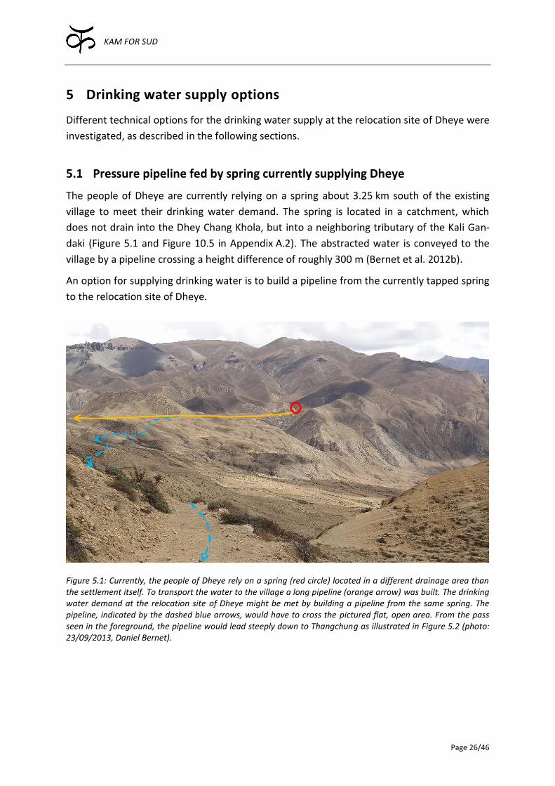
KAM FOR SUD
Page 26/46
5 Drinking water supply options
Different technical options for the drinking water supply at the relocation site of Dheye were
investigated, as described in the following sections.
5.1 Pressure pipeline fed by spring currently supplying Dheye
The people of Dheye are currently relying on a spring about 3.25 km south of the existing
village to meet their drinking water demand. The spring is located in a catchment, which
does not drain into the Dhey Chang Khola, but into a neighboring tributary of the Kali Gan-
daki (Figure 5.1 and Figure 10.5 in Appendix A.2). The abstracted water is conveyed to the
village by a pipeline crossing a height difference of roughly 300 m (Bernet et al. 2012b).
An option for supplying drinking water is to build a pipeline from the currently tapped spring
to the relocation site of Dheye.
Figure 5.1: Currently, the people of Dheye rely on a spring (red circle) located in a different drainage area than the settlement itself. To transport the water to the village a long pipeline (orange arrow) was built. The drinking water demand at the relocation site of Dheye might be met by building a pipeline from the same spring. The pipeline, indicated by the dashed blue arrows, would have to cross the pictured flat, open area. From the pass seen in the foreground, the pipeline would lead steeply down to Thangchung as illustrated in Figure 5.2 (photo: 23/09/2013, Daniel Bernet).

KAM FOR SUD
Page 27/46
5.1.1 Investigations
Water source
During the field survey the spring was visited. According to the villagers, the point where the
water emerges from the soil had been shifting. Consequently, the cemented abstraction
chamber had to be altered several times, so that the water could still be captured and trans-
ported to the village. The yield of the spring is very low and is currently just enough to meet
the demand of the village. Furthermore, the yield seems to be decreasing generally.
Pipeline routing
To bring the water from the spring to Thangchung, the pipeline has first to be led along a
rather flat, open plain crossing several high points until a major pass is reached (Figure 5.1
and Figure 5.2). This pass accommodates the way to the old village, which is used once the
Dhey Chang Khola carries too much water inactivating the shorter access through the riv-
erbed. From this pass the pipeline would lead steeply down to a vast plain adjoining Thang-
chung.
Figure 5.2: Possible routing of the pressure pipe transporting the water from the existing drinking water ab-straction to Thangchung. The longitudinal profile of the pressure pipe created with Google Earth is indicated as well. The first roughly 4 km are sloped only slightly, thereafter the pipe is leading steeply down to Thangchung (source: Google Earth Pro, accessed 14/01/2014).
The elevation of the spring, the intermediate high points and the pass are suitable to allow
gravity flow (Figure 10.5 in Appendix A.2). However, the topography is such that several as-
cending slopes have to be surmounted. Consequently, air vents as well as drains at these
9.8 km 7.5 6.0 4.5 3.0 1.5 0
Dheye
KAM FOR SUD
Page 28/46
local depressions would be necessary, so that the pipe can be emptied during winter time to
prevent bursting of the pipes.
The length of the pipe would be at least ten kilometers and cover a height difference of al-
most one kilometer (Figure 5.2). Due to the large height difference and distance, intermedi-
ate basins are certainly necessary to break the high static pressure as well as to prevent
bursting due to pressure surges.
Flow calculations
Simple, preliminary flow calculations give some indications about the suitability of the op-
tion. Using a half inch High-Density Polyethylene (HDPE) pipe (20 mm OD), the resulting flow
(assuming one single pipe without basins and any water losses) is approximately 0.2 l/s,
13 l/min or 19’172 l/d. Considering a population of 150 people in Thangchung (Section 2.1),
this would amount to 128 l/p/d, which is well above the defined water demand of 80 l/p/d
(Section 3.2). However, the question is rather whether the spring’s yield would be sufficient
to supply that much water.
The material cost of the pipeline constituted by Panchakanya HDPE pipes (Figure 10.23 in
Appendix C.1) would amount to NPR 307’972.20 considering a prize of NPR 31.49 per meter
and a pipeline length of almost ten kilometers. The effective cost would be higher of course
since air vents, intermediate basins and armatures need to be included in addition to trans-
portation and installation costs.
Operation and maintenance
This option has the big disadvantage that the pipeline is difficult and very laborious to main-
tain. As a total length of ten kilometers is very long it is difficult to locate any problem, most
of all because the pipe should be buried underground to prevent freezing.
5.1.2 Assessment
The advantage of tapping the spring currently supplying drinking water to Dheye is that the
water has proven to be suitable for drinking purposes. Furthermore, the spring water is ac-
cepted by the villagers, which does not go without saying. The spring water in Chawale for
instance is currently rejected by the villagers (Section 5.3.1).
However, it is likely that the yield of the spring will decrease in the future. If the yield is not
insufficient already, it might become so in the future. Furthermore, a pipeline with a total
length of 10 km is very difficult to operate and maintain, especially in the harsh conditions of
Upper Mustang. Therefore, the option of tapping Dheye’s spring to meet the drinking water
demand in Thangchung is discarded.
KAM FOR SUD
Page 29/46
5.2 Pressure pipeline fed by spring from opposing valley
The spring below Charang, described in Section 4.3, might also be suitable to yield water
useable for domestic purposes. The idea is to abstract the spring water and convey it in a
pressure pipeline to Thangchung.
Note that in case the irrigation water demand were met by abstracting water from the
spring below Charang, part of the water could be used for domestic purposes. As the domes-
tic water demand is roughly two orders smaller than the irrigation demand (Chapter 3) the
design would remain the same. For this option refer to Section 4.3 and 5.4. In the following,
the option of a pure drinking water pipeline is discussed, which has slightly different param-
eters, as the pipeline can be designed much smaller and more flexible due to much lower
flow rates.
5.2.1 Investigations
Water source
Generally, spring water is a suitable source for drinking water: The flow rates are usually
quite constant throughout the year, even in the winter months the spring yields running wa-
ter and the water quality is often good.
Although little is known about the dynamics of the spring, it is probable that the yield is suf-
ficient to meet Thangchung’s demand for drinking water. However, there are some concerns
about the water quality. As mentioned in Section 4.3.1, the spring seems to be linked to the
water use in Charang, at least partly. Thus, water used in agriculture, degenerated by ma-
nure for instance, might infiltrate and emerge again from the spring. In such a case the water
has to be treated before it can be used. To be sure that the water quality is suitable for do-
mestic use, water quality tests should be carried out.
Pipeline routing
Compared to a larger pipeline conveying irrigation water (Section 4.3.1), the routing of the
drinking water pipeline is more flexible, since the pipe diameter can be chosen much small-
er. Thus, the crossing of the Kali Gandaki is generally simpler and cheaper, but remains a
main obstacle.
Cultural and social aspects
The same cultural and social aspects as discussed in Section 4.3.1 have to be considered for a
pipeline conveying drinking water.
5.2.2 Assessment
In the light of the reservations related to the water quality, alongside with the persisting
difficulties crossing the Kali Gandaki and above all, the unfavorable cultural and social ac-
ceptance, the option of a pressure pipeline abstracting water from the spring below Charang
is discarded.
KAM FOR SUD
Page 30/46
5.3 Pumping water up to the plain
An obvious way to supply Thangchung with drinking water is to lift it up with a pump. For
that matter, a suitable power source has to be installed and a suitable water source has to
be tapped. The different options are discussed in the following section.
5.3.1 Investigations
Tapping spring water
Generally, using a spring as a water source would be preferable. As already mentioned in
Section 4.3.1, the yields of springs are usually quite constant throughout the year, even in
the winter. Furthermore, the emerging water is usually very clear, which is an asset in regard
to the lifespan of the pumps, for water with a high suspended particle load can heavily dam-
age mechanical parts of a pump.
In Chawale at the base of the cliffs located on the left riverbank of the Dhey Chang Khola,
water emerges from several small springs constituting to a considerable amount of water.
During the field survey, the water flow from these springs has been measured using a salt
tracer and a conductivity meter. The yield of all these springs combined was estimated to be
16 l/s or 1382 m3/d at the end of September 2013 (Appendix A.3). Thus, the spring yields far
more water than the demand of 12 m3/d as defined in Section 3.1.
However, the people of Dheye explained that the water was not drinkable. Even after boil-
ing, the water would cause stomach ache when consumed. It is imaginable that not the
spring water itself, but rather a mixture of spring and river water was consumed, as close to
the spring water abstracted from the Dhey Chang Khola flows by and is mixed with the for-
mer.
Doubtlessly, the supplied water has to be of impeccable quality, but the social acceptance of
the water source is crucial as well and has to be considered before a system is implemented.
Tapping groundwater
The potential of using groundwater as a source has already been discussed in Section 4.2.1.
As outlined, groundwater favorable properties has similar to spring water, as the yield is fair-
ly constant over the year and the water quality is generally high.
As reported, a simple experiment was conducted to assess the conductivity of the aquifer
(Appendix A.4), which is a crucial variable related to groundwater yields. Due to the large
uncertainty of the experiment, the k value ranges from 3·10-3 to 3·10-4 m/s and could not be
assessed more precisely. However, the drinking water demand is marginal compared to the
irrigation water demand (Section 3.2). The aquifer could therefore be permeable enough to
satisfy the drinking water demand of 12 m3/d, as defined in Section 3.2.
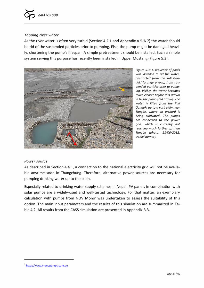
KAM FOR SUD
Page 31/46
Tapping river water
As the river water is often very turbid (Section 4.2.1 and Appendix A.5-A.7) the water should
be rid of the suspended particles prior to pumping. Else, the pump might be damaged heavi-
ly, shortening the pump’s lifespan. A simple pretreatment should be installed. Such a simple
system serving this purpose has recently been installed in Upper Mustang (Figure 5.3).
Figure 5.3: A sequence of pools was installed to rid the water, abstracted from the Kali Gan-daki (orange arrow), from sus-pended particles prior to pump-ing. Visibly, the water becomes much clearer before it is drawn in by the pump (red arrow). The water is lifted from the Kali Gandaki up to a vast plain near Tangbe, where an orchard is being cultivated. The pumps are connected to the power grid, which is currently not reaching much further up than Tangbe (photo: 21/06/2012, Daniel Bernet).
Power source
As described in Section 4.4.1, a connection to the national electricity grid will not be availa-
ble anytime soon in Thangchung. Therefore, alternative power sources are necessary for
pumping drinking water up to the plain.
Especially related to drinking water supply schemes in Nepal, PV panels in combination with
solar pumps are a widely-used and well-tested technology. For that matter, an exemplary
calculation with pumps from NOV Mono7 was undertaken to assess the suitability of this
option. The main input parameters and the results of this simulation are summarized in Ta-
ble 4.2. All results from the CASS simulation are presented in Appendix B.3.
7 http://www.monopumps.com.au
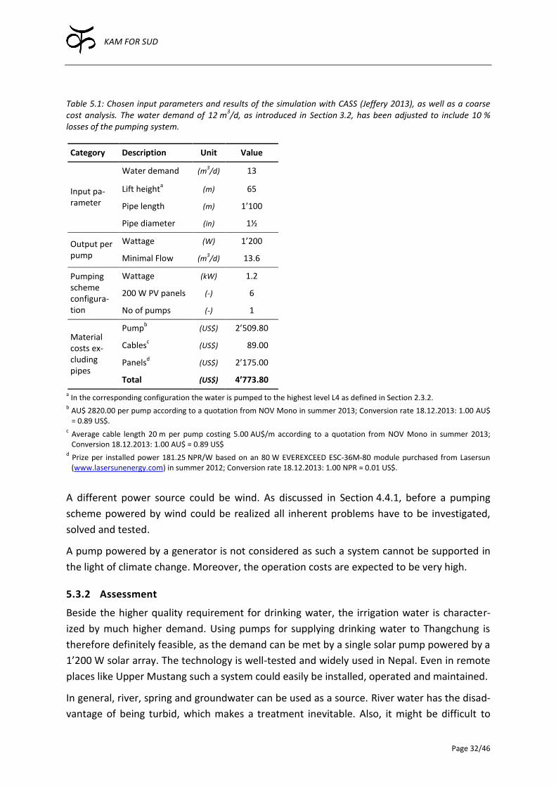
KAM FOR SUD
Page 32/46
Table 5.1: Chosen input parameters and results of the simulation with CASS (Jeffery 2013), as well as a coarse cost analysis. The water demand of 12 m
3/d, as introduced in Section 3.2, has been adjusted to include 10 %
losses of the pumping system.
Category Description Unit Value
Input pa-rameter
Water demand (m3/d) 13
Lift heighta (m) 65
Pipe length (m) 1’100
Pipe diameter (in) 1½
Output per pump
Wattage (W) 1’200
Minimal Flow (m3/d) 13.6
Pumping scheme configura-tion
Wattage (kW) 1.2
200 W PV panels (-) 6
No of pumps (-) 1
Material costs ex-cluding pipes
Pumpb (US$) 2’509.80
Cablesc (US$) 00’89.00
Panelsd (US$) 2’175.00
Total (US$) 4’773.80
a In the corresponding configuration the water is pumped to the highest level L4 as defined in Section 2.3.2.
b AU$ 2820.00 per pump according to a quotation from NOV Mono in summer 2013; Conversion rate 18.12.2013: 1.00 AU$ = 0.89 US$.
c Average cable length 20 m per pump costing 5.00 AU$/m according to a quotation from NOV Mono in summer 2013; Conversion 18.12.2013: 1.00 AU$ = 0.89 US$
d Prize per installed power 181.25 NPR/W based on an 80 W EVEREXCEED ESC-36M-80 module purchased from Lasersun (www.lasersunenergy.com) in summer 2012; Conversion rate 18.12.2013: 1.00 NPR = 0.01 US$.
A different power source could be wind. As discussed in Section 4.4.1, before a pumping
scheme powered by wind could be realized all inherent problems have to be investigated,
solved and tested.
A pump powered by a generator is not considered as such a system cannot be supported in
the light of climate change. Moreover, the operation costs are expected to be very high.
5.3.2 Assessment
Beside the higher quality requirement for drinking water, the irrigation water is character-
ized by much higher demand. Using pumps for supplying drinking water to Thangchung is
therefore definitely feasible, as the demand can be met by a single solar pump powered by a
1’200 W solar array. The technology is well-tested and widely used in Nepal. Even in remote
places like Upper Mustang such a system could easily be installed, operated and maintained.
In general, river, spring and groundwater can be used as a source. River water has the disad-
vantage of being turbid, which makes a treatment inevitable. Also, it might be difficult to
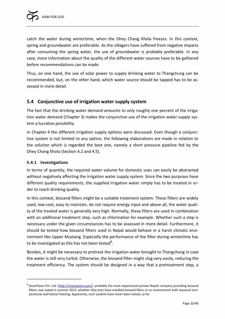
KAM FOR SUD
Page 33/46
catch the water during wintertime, when the Dhey Chang Khola freezes. In this context,
spring and groundwater are preferable. As the villagers have suffered from negative impacts
after consuming the spring water, the use of groundwater is probably preferable. In any
case, more information about the quality of the different water sources have to be gathered
before recommendations can be made.
Thus, on one hand, the use of solar power to supply drinking water to Thangchung can be
recommended, but, on the other hand, which water source should be tapped has to be as-
sessed in more detail.
5.4 Conjunctive use of irrigation water supply system
The fact that the drinking water demand amounts to only roughly one percent of the irriga-
tion water demand (Chapter 3) makes the conjunctive use of the irrigation water supply sys-
tem a lucrative possibility.
In Chapter 4 the different irrigation supply options were discussed. Even though a conjunc-
tive system is not limited to any option, the following elaborations are made in relation to
the solution which is regarded the best one, namely a short pressure pipeline fed by the
Dhey Chang Khola (Section 4.2 and 4.5).
5.4.1 Investigations
In terms of quantity, the required water volume for domestic uses can easily be abstracted
without negatively affecting the irrigation water supply system. Since the two purposes have
different quality requirements, the supplied irrigation water simply has to be treated in or-
der to reach drinking quality.
In this context, biosand filters might be a suitable treatment system. These filters are widely
used, low-cost, easy to maintain, do not require energy input and above all, the water quali-
ty of the treated water is generally very high. Normally, these filters are used in combination
with an additional treatment step, such as chlorination for example. Whether such a step is
necessary under the given circumstances has to be assessed in more detail. Furthermore, it
should be tested how biosand filters used in Nepal would behave in a harsh climatic envi-
ronment like Upper Mustang. Especially the performance of the filter during wintertime has
to be investigated as this has not been tested8.
Besides, it might be necessary to pretreat the irrigation water brought to Thangchung in case
the water is still very turbid. Otherwise, the biosand filter might clog very easily, reducing the
treatment efficiency. The system should be designed in a way that a pretreatment step, a
8 SmartPaani Pvt. Ltd. (http://smartpaani.com/), probably the most experienced private Nepali company providing biosand filters, was asked in summer 2013, whether they ever have installed biosand filters in an environment with seasonal tem-peratures well below freezing. Apparently, such systems have never been tested, so far.

KAM FOR SUD
Page 34/46
roughing filter as described in Wegelin (1996) for instance, could be incorporated if neces-
sary.
Another issue to consider is that the irrigation supply system only needs to be operated dur-
ing the growing season, while drinking water is required during the whole year. Consequent-
ly, the irrigation system would need to keep running just to provide the comparatively small
amount of drinking water. Although generally nothing speaks against running the system at a
reduced capacity, it has to be ensured that the water in the pipes does not freeze as this
could lead to bursting pipes.
Furthermore, since the irrigation water, conveyed by a short pipeline as described in Sec-
tion 4.2, can only be brought to the second level, a pump might be necessary to bring the
water up to higher levels in order to supply buildings on higher elevations and to provide the
necessary pipe pressure in the drinking water distribution system. For that matter a solar
pumping system, as described in Section 5.3, could be used.
5.4.2 Assessment
Conjunctively using the irrigation supply system certainly makes sense, especially in econom-
ic terms. However, the drawback is that the systems are not independent anymore. If the
system breaks down neither irrigation nor drinking water is available in Thangchung. This
issue weights even more in remote places such as Upper Mustang since it may take longer to
repair the system especially if spare parts are needed.
Furthermore, in combination with the recommended irrigation supply system (Section 4.5), a
pumping system might be necessary in order to provide the necessary pressure in the drink-
ing water distribution system and therefore the installation of a separate drinking water
pumping system might be more appropriate.
5.5 Identification of the best option
In the preceding sections different options to cover the drinking water demand were elabo-
rated. Tapping the spring currently supplying Dheye with drinking water as well as the spring
below Charang are discarded (Table 5.2). Conjunctively using the short pressure pipeline,
regarded as the best solution for supplying irrigation water to Thangchung (Section 4.2), is
an option, but it is not considered to be the best one. Mainly the fact that it is not independ-
ent from the irrigation system is a drawback. Furthermore, a pump may be needed to lift the
water further up to provide the necessary pressure in the drinking water distribution system.
Pumping the water up to Thangchung with a solar system is found to be the best option
(Table 5.2). Different water sources can be tapped, only a short pipeline is necessary and the
water can be brought to virtually all levels of Thangchung. However, for deciding which wa-
ter source should be tapped, further investigations are necessary.
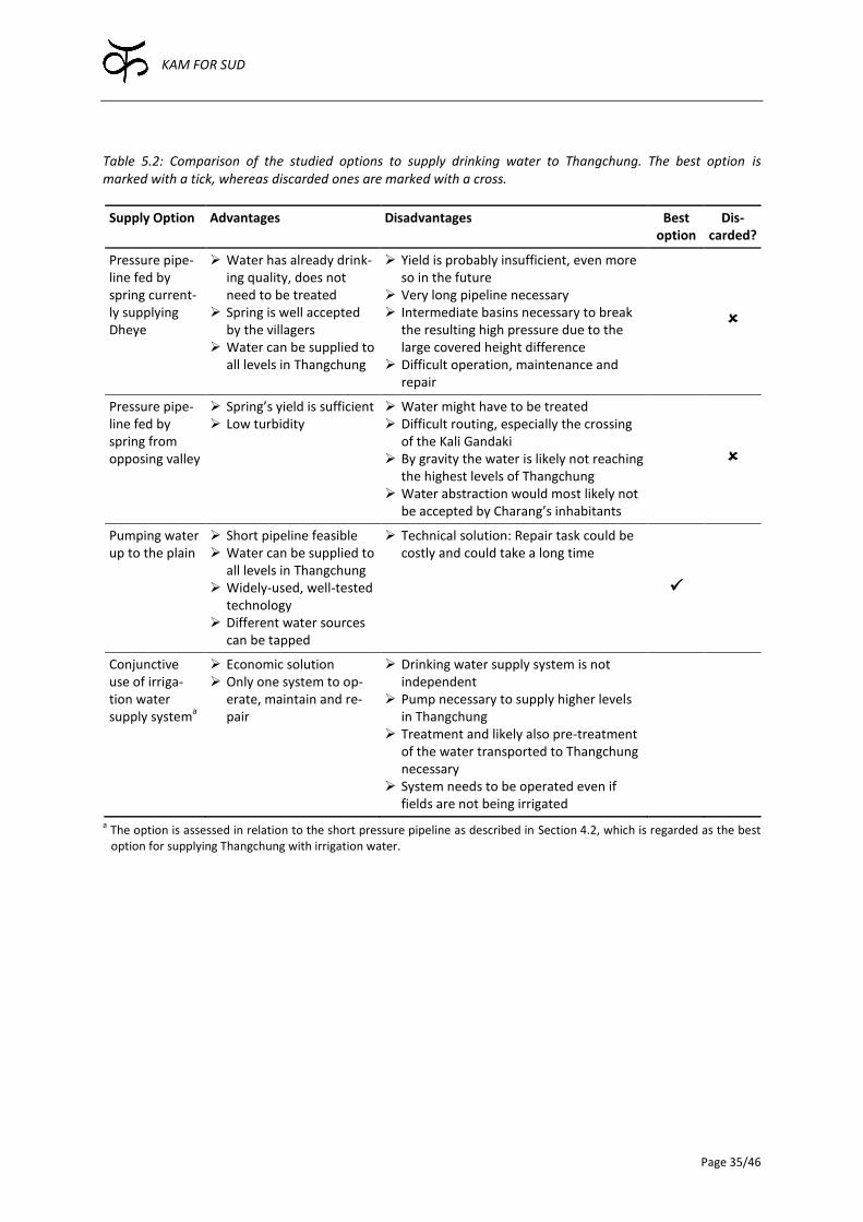
KAM FOR SUD
Page 35/46
Table 5.2: Comparison of the studied options to supply drinking water to Thangchung. The best option is marked with a tick, whereas discarded ones are marked with a cross.
Supply Option Advantages Disadvantages Best option
Dis-carded?
Pressure pipe-line fed by spring current-ly supplying Dheye
Water has already drink-ing quality, does not need to be treated
Spring is well accepted by the villagers
Water can be supplied to all levels in Thangchung
Yield is probably insufficient, even more so in the future
Very long pipeline necessary Intermediate basins necessary to break
the resulting high pressure due to the large covered height difference
Difficult operation, maintenance and repair
Pressure pipe-line fed by spring from opposing valley
Spring’s yield is sufficient Low turbidity
Water might have to be treated Difficult routing, especially the crossing
of the Kali Gandaki By gravity the water is likely not reaching
the highest levels of Thangchung Water abstraction would most likely not
be accepted by Charang’s inhabitants
Pumping water up to the plain
Short pipeline feasible Water can be supplied to
all levels in Thangchung Widely-used, well-tested
technology Different water sources
can be tapped
Technical solution: Repair task could be costly and could take a long time
Conjunctive use of irriga-tion water supply system
a
Economic solution Only one system to op-
erate, maintain and re-pair
Drinking water supply system is not independent
Pump necessary to supply higher levels in Thangchung
Treatment and likely also pre-treatment of the water transported to Thangchung necessary
System needs to be operated even if fields are not being irrigated
a The option is assessed in relation to the short pressure pipeline as described in Section 4.2, which is regarded as the best option for supplying Thangchung with irrigation water.
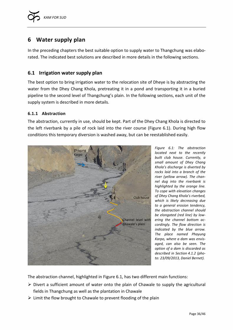
KAM FOR SUD
Page 36/46
6 Water supply plan
In the preceding chapters the best suitable option to supply water to Thangchung was elabo-
rated. The indicated best solutions are described in more details in the following sections.
6.1 Irrigation water supply plan
The best option to bring irrigation water to the relocation site of Dheye is by abstracting the
water from the Dhey Chang Khola, pretreating it in a pond and transporting it in a buried
pipeline to the second level of Thangchung’s plain. In the following sections, each unit of the
supply system is described in more details.
6.1.1 Abstraction
The abstraction, currently in use, should be kept. Part of the Dhey Chang Khola is directed to
the left riverbank by a pile of rock laid into the river course (Figure 6.1). During high flow
conditions this temporary diversion is washed away, but can be reestablished easily.
Figure 6.1: The abstraction located next to the recently built club house. Currently, a small amount of Dhey Chang Khola’s discharge is diverted by rocks laid into a branch of the river (yellow arrow). The chan-nel dug into the riverbank is highlighted by the orange line. To cope with elevation changes of Dhey Chang Khola’s riverbed, which is likely decreasing due to a general erosion tendency, the abstraction channel should be elongated (red line) by low-ering the channel bottom ac-cordingly. The flow direction is indicated by the blue arrow. The place named Phayung Karpo, where a dam was envis-aged, can also be seen. The option of a dam is discarded as described in Section 4.1.2 (pho-to: 23/09/2013, Daniel Bernet).
The abstraction channel, highlighted in Figure 6.1, has two different main functions:
Divert a sufficient amount of water onto the plain of Chawale to supply the agricultural
fields in Thangchung as well as the plantation in Chawale
Limit the flow brought to Chawale to prevent flooding of the plain
Phayung Karpo
Club house
Channel level with Chawale’s plain
KAM FOR SUD
Page 37/46
The latter point is less obvious than the former one. To achieve a flow regulation, the
transport capacity of the channel should not be much larger than the amount of water
needed in Chawale and Thangchung. If too much water is brought to Chawale, the orchard
might be flooded or the installation of the pipeline could be damaged. Therefore, the dikes
at the inlet of the channel should not be higher than 20 to 30 cm in relation to the normal
water table within the channel. This mechanism, intended or coincidental, has proven to
work, as shown in Figure 4.3 in Section 4.2.1.
Lowering Dhey Chang Khola’s active riverbed can be met by two strategies. First, the water
can be taken in further up in the valley. In that case the point where the channel bottom is
level with Chawale’s plain is kept as a fixed point and the channel has to be extended up-
stream. Second, the bottom of the channel can be adjusted according to the elevation varia-
tions of the riverbed. In that case, the water keeps entering the channel at the same point
but extends further downstream, as depicted in Figure 6.1.
The second strategy is strongly recommended. Adjusting the bottom of the channel accord-
ing to the elevation changes of the riverbed makes sure the channel bottom as well as the
dikes are kept at the same relative height. If more water than the channel can carry is di-
rected towards it, the dikes are overflown. Thus, at most the prescribed amount of water is
transported onto Chawale. In case the dikes are damaged and the channel disconnected, the
bottom of the channel should be lowered carefully until the water flows into the channel
naturally again. The dikes should then be reestablished. With the first strategy the channel
bottom would be increasingly above the riverbed leading to higher leakage and much more
difficult maintenance and repair works. Furthermore, the channel would have to be elongat-
ed upstream, where the river is narrower and thus, the channel would be more exposed.
With the second strategy, the channel intake stays at the same spot, which is protected by
rather solid rock, and only a very small portion of the channel is directly exposed to the Dhey
Chang Khola.
An important issue, which has to be kept in mind, is that the point where the channel is level
with the plain of Chawale (Figure 6.1) cannot be lower than the inlet of the pressure pipe-
line. In order to have sufficient reserve for future adjustments of the bottom of the channel,
the pipeline inlet has to be well below the point where the channel currently reaches the
plain.
6.1.2 Settlement pond
To prevent the pressure pipeline from damage and to reduce the amount of solids deposited
in the fields, the abstracted water should be rid of settleable solids, before it is brought to
Thangchung by the pressure pipeline. A very simple structure for that purpose is a settle-
ment pond, where water rests for a certain time allowing small suspended particles to sedi-
ment. The longer the stopping time, the more suspended particles can be removed. As high-
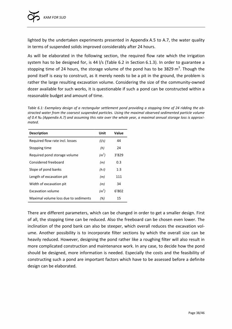
KAM FOR SUD
Page 38/46
lighted by the undertaken experiments presented in Appendix A.5 to A.7, the water quality
in terms of suspended solids improved considerably after 24 hours.
As will be elaborated in the following section, the required flow rate which the irrigation
system has to be designed for, is 44 l/s (Table 6.2 in Section 6.1.3). In order to guarantee a
stopping time of 24 hours, the storage volume of the pond has to be 3829 m3. Though the
pond itself is easy to construct, as it merely needs to be a pit in the ground, the problem is
rather the large resulting excavation volume. Considering the size of the community-owned
dozer available for such works, it is questionable if such a pond can be constructed within a
reasonable budget and amount of time.
Table 6.1: Exemplary design of a rectangular settlement pond providing a stopping time of 24 ridding the ab-stracted water from the coarsest suspended particles. Using the maximal observed sedimented particle volume of 0.4 ‰ (Appendix A.7) and assuming this rate over the whole year, a maximal annual storage loss is approxi-mated.
Description Unit Value
Required flow rate incl. losses (l/s) 44
Stopping time (h) 24
Required pond storage volume (m3) 3’829
Considered freeboard (m) 0.3
Slope of pond banks (h:l) 1:3
Length of excavation pit (m) 111
Width of excavation pit (m) 34
Excavation volume (m3) 6’802
Maximal volume loss due to sediments (%) 15
There are different parameters, which can be changed in order to get a smaller design. First
of all, the stopping time can be reduced. Also the freeboard can be chosen even lower. The
inclination of the pond bank can also be steeper, which overall reduces the excavation vol-
ume. Another possibility is to incorporate filter sections by which the overall size can be
heavily reduced. However, designing the pond rather like a roughing filter will also result in
more complicated construction and maintenance work. In any case, to decide how the pond
should be designed, more information is needed. Especially the costs and the feasibility of
constructing such a pond are important factors which have to be assessed before a definite
design can be elaborated.
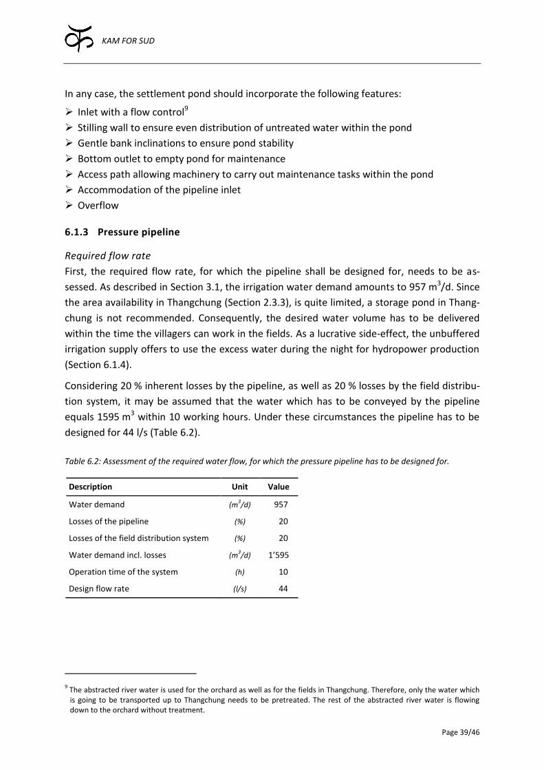
KAM FOR SUD
Page 39/46
In any case, the settlement pond should incorporate the following features:
Inlet with a flow control9
Stilling wall to ensure even distribution of untreated water within the pond
Gentle bank inclinations to ensure pond stability
Bottom outlet to empty pond for maintenance
Access path allowing machinery to carry out maintenance tasks within the pond
Accommodation of the pipeline inlet
Overflow
6.1.3 Pressure pipeline
Required flow rate
First, the required flow rate, for which the pipeline shall be designed for, needs to be as-
sessed. As described in Section 3.1, the irrigation water demand amounts to 957 m3/d. Since
the area availability in Thangchung (Section 2.3.3), is quite limited, a storage pond in Thang-
chung is not recommended. Consequently, the desired water volume has to be delivered
within the time the villagers can work in the fields. As a lucrative side-effect, the unbuffered
irrigation supply offers to use the excess water during the night for hydropower production
(Section 6.1.4).
Considering 20 % inherent losses by the pipeline, as well as 20 % losses by the field distribu-
tion system, it may be assumed that the water which has to be conveyed by the pipeline
equals 1595 m3 within 10 working hours. Under these circumstances the pipeline has to be
designed for 44 l/s (Table 6.2).
Table 6.2: Assessment of the required water flow, for which the pressure pipeline has to be designed for.
Description Unit Value
Water demand (m3/d) 0957
Losses of the pipeline (%) 0020
Losses of the field distribution system (%) 0020
Water demand incl. losses (m3/d) 1’595
Operation time of the system (h) 0010
Design flow rate (l/s) 0044
9 The abstracted river water is used for the orchard as well as for the fields in Thangchung. Therefore, only the water which is going to be transported up to Thangchung needs to be pretreated. The rest of the abstracted river water is flowing down to the orchard without treatment.
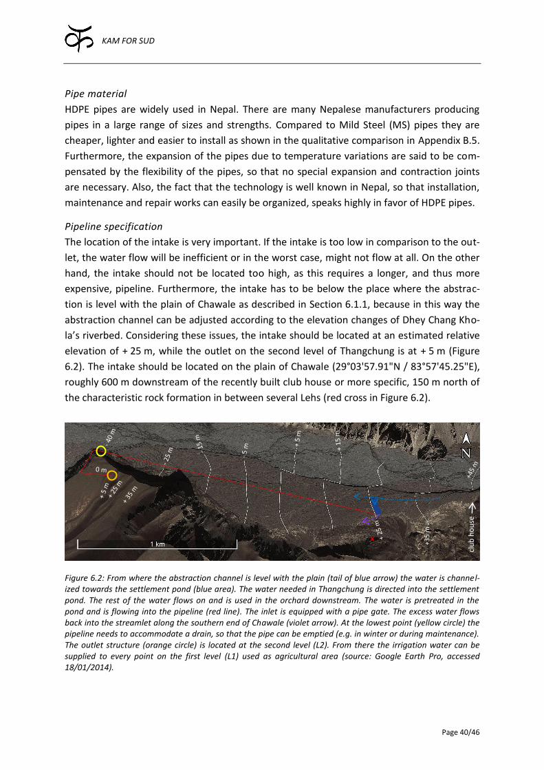
KAM FOR SUD
Page 40/46
Pipe material
HDPE pipes are widely used in Nepal. There are many Nepalese manufacturers producing
pipes in a large range of sizes and strengths. Compared to Mild Steel (MS) pipes they are
cheaper, lighter and easier to install as shown in the qualitative comparison in Appendix B.5.
Furthermore, the expansion of the pipes due to temperature variations are said to be com-
pensated by the flexibility of the pipes, so that no special expansion and contraction joints
are necessary. Also, the fact that the technology is well known in Nepal, so that installation,
maintenance and repair works can easily be organized, speaks highly in favor of HDPE pipes.
Pipeline specification
The location of the intake is very important. If the intake is too low in comparison to the out-
let, the water flow will be inefficient or in the worst case, might not flow at all. On the other
hand, the intake should not be located too high, as this requires a longer, and thus more
expensive, pipeline. Furthermore, the intake has to be below the place where the abstrac-
tion is level with the plain of Chawale as described in Section 6.1.1, because in this way the
abstraction channel can be adjusted according to the elevation changes of Dhey Chang Kho-
la’s riverbed. Considering these issues, the intake should be located at an estimated relative
elevation of + 25 m, while the outlet on the second level of Thangchung is at + 5 m (Figure
6.2). The intake should be located on the plain of Chawale (29°03'57.91"N / 83°57'45.25"E),
roughly 600 m downstream of the recently built club house or more specific, 150 m north of
the characteristic rock formation in between several Lehs (red cross in Figure 6.2).
Figure 6.2: From where the abstraction channel is level with the plain (tail of blue arrow) the water is channel-ized towards the settlement pond (blue area). The water needed in Thangchung is directed into the settlement pond. The rest of the water flows on and is used in the orchard downstream. The water is pretreated in the pond and is flowing into the pipeline (red line). The inlet is equipped with a pipe gate. The excess water flows back into the streamlet along the southern end of Chawale (violet arrow). At the lowest point (yellow circle) the pipeline needs to accommodate a drain, so that the pipe can be emptied (e.g. in winter or during maintenance). The outlet structure (orange circle) is located at the second level (L2). From there the irrigation water can be supplied to every point on the first level (L1) used as agricultural area (source: Google Earth Pro, accessed 18/01/2014).
clu
b h
ou
se
+35
m
x
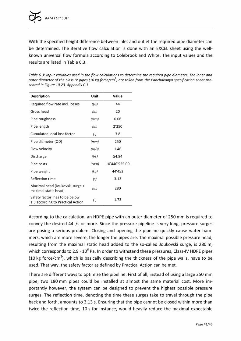
KAM FOR SUD
Page 41/46
With the specified height difference between inlet and outlet the required pipe diameter can
be determined. The iterative flow calculation is done with an EXCEL sheet using the well-
known universal flow formula according to Colebrook and White. The input values and the
results are listed in Table 6.3.
Table 6.3: Input variables used in the flow calculations to determine the required pipe diameter. The inner and outer diameter of the class IV pipes (10 kg force/cm
2) are taken from the Panchakanya specification sheet pre-
sented in Figure 10.23, Appendix C.1
Description Unit Value
Required flow rate incl. losses (l/s) 44
Gross head (m) 20
Pipe roughness (mm) 0.06
Pipe length (m) 2’250
Cumulated local loss factor (-) 3.8
Pipe diameter (OD) (mm) 250
Flow velocity (m/s) 1.46
Discharge (l/s) 54.84
Pipe costs (NPR) 10’446’525.00
Pipe weight (kg) 44’453
Reflection time (s) 3.13
Maximal head (Joukovski surge + maximal static head)
(m) 280
Safety factor: has to be below 1.5 according to Practical Action
(-) 1.73
According to the calculation, an HDPE pipe with an outer diameter of 250 mm is required to
convey the desired 44 l/s or more. Since the pressure pipeline is very long, pressure surges
are posing a serious problem. Closing and opening the pipeline quickly cause water ham-
mers, which are more severe, the longer the pipes are. The maximal possible pressure head,
resulting from the maximal static head added to the so-called Joukovski surge, is 280 m,
which corresponds to 2.9 · 106 Pa. In order to withstand these pressures, Class-IV HDPE pipes
(10 kg force/cm2), which is basically describing the thickness of the pipe walls, have to be
used. That way, the safety factor as defined by Practical Action can be met.
There are different ways to optimize the pipeline. First of all, instead of using a large 250 mm
pipe, two 180 mm pipes could be installed at almost the same material cost. More im-
portantly however, the system can be designed to prevent the highest possible pressure
surges. The reflection time, denoting the time these surges take to travel through the pipe
back and forth, amounts to 3.13 s. Ensuring that the pipe cannot be closed within more than
twice the reflection time, 10 s for instance, would heavily reduce the maximal expectable
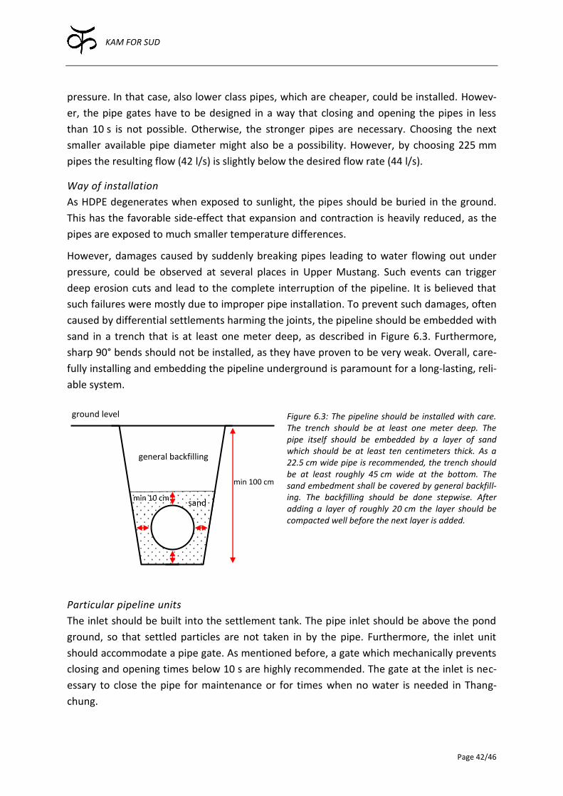
KAM FOR SUD
Page 42/46
pressure. In that case, also lower class pipes, which are cheaper, could be installed. Howev-
er, the pipe gates have to be designed in a way that closing and opening the pipes in less
than 10 s is not possible. Otherwise, the stronger pipes are necessary. Choosing the next
smaller available pipe diameter might also be a possibility. However, by choosing 225 mm
pipes the resulting flow (42 l/s) is slightly below the desired flow rate (44 l/s).
Way of installation
As HDPE degenerates when exposed to sunlight, the pipes should be buried in the ground.
This has the favorable side-effect that expansion and contraction is heavily reduced, as the
pipes are exposed to much smaller temperature differences.
However, damages caused by suddenly breaking pipes leading to water flowing out under
pressure, could be observed at several places in Upper Mustang. Such events can trigger
deep erosion cuts and lead to the complete interruption of the pipeline. It is believed that
such failures were mostly due to improper pipe installation. To prevent such damages, often
caused by differential settlements harming the joints, the pipeline should be embedded with
sand in a trench that is at least one meter deep, as described in Figure 6.3. Furthermore,
sharp 90° bends should not be installed, as they have proven to be very weak. Overall, care-
fully installing and embedding the pipeline underground is paramount for a long-lasting, reli-
able system.
Figure 6.3: The pipeline should be installed with care. The trench should be at least one meter deep. The pipe itself should be embedded by a layer of sand which should be at least ten centimeters thick. As a 22.5 cm wide pipe is recommended, the trench should be at least roughly 45 cm wide at the bottom. The sand embedment shall be covered by general backfill-ing. The backfilling should be done stepwise. After adding a layer of roughly 20 cm the layer should be compacted well before the next layer is added.
Particular pipeline units
The inlet should be built into the settlement tank. The pipe inlet should be above the pond
ground, so that settled particles are not taken in by the pipe. Furthermore, the inlet unit
should accommodate a pipe gate. As mentioned before, a gate which mechanically prevents
closing and opening times below 10 s are highly recommended. The gate at the inlet is nec-
essary to close the pipe for maintenance or for times when no water is needed in Thang-
chung.
min 10 cm
min 100 cm
general backfilling
sand
ground level
KAM FOR SUD
Page 43/46
At the lowest point of the pipeline, which corresponds to the beginning of the access track to
Thangchung, a drain has to be accommodated to be able to empty the pipe when needed.
For instance, it is recommended to use the pipeline during the growing season only. During
the winter, when the Dhey Chang Khola is likely freezing over anyway, the pipe should be
emptied. It might be necessary to suspend the pipeline slightly in that section, so as to make
sure the pipe can be emptied completely by gravity.
The outlet is planned to be situated at the northern end of the second level (L2) respecting a
safe distance to the scarp, as water erosion could have devastating effects. Ideally, the out-
let is also equipped with a pipe gate. That way the water flow can be stopped without having
to walk all the way to the inlet, which is two kilometers away. However, as mentioned be-
fore, it should not be possible to close the pipe quickly, as this leads to heavy pressure surg-
es, possibly damaging the pipe.
6.1.4 Drainage and hydropower
Currently, the ridge of the cliff is quite stable. Nevertheless, bringing a considerable amount
of water to the plain of Thangchung could cause erosion, similar to the serious ones, which
can be observed on the ridge southeast of Charang. To prevent uncontrolled discharge over
the scarp, which will certainly cause erosion damage possibly even beyond repair, a drainage
trench all along the scarp of the first level of Thangchung is crucial. At the lowest point, lo-
cated at the southwestern end of Thangchung, a channel or even better a pipeline should be
envisaged to transport the surplus water securely back to the Kali Gandaki without causing
any damage to the plain.
As mentioned before, the surplus water could also be turbinated to produce power for the
resettled village of Dheye. Ideally, the water would be brought to Thangchung, used for agri-
culture during the day and producing power during the night. As the water conveyed to
Thangchung by a pressure pipeline, would be available in abundance, it would be easy to
capture the water, put it to a penstock pipe and turbinate it. Assuming an overall efficiency
of 85 %, a flow rate of 44 l/s and a net head of 30 m, a hydropower plant would produce
roughly 11 kW. The main problem however is to find a suitable location for the penstock
pipe and the power house. The scarp is very steep and unstable and the valley ground is
prone to flooding.
6.2 Drinking water supply plan
As discussed in Section 5.5, a solar pumping system is considered as the best solution to pro-
vide drinking water to Thangchung. In the following, the recommended system is described
in more detail.
KAM FOR SUD
Page 44/46
6.2.1 Water source
As summarized in Section 5.5, the water source, which is most suitable for drinking water,
could either be groundwater or Chawale’s spring. Only in case both options are found to be
unsuitable, river water should be considered as an alternative source.
In case the permeability of the soil is found to be sufficient to yield the desired water
amount, tapping groundwater is recommended. A well should be constructed, in which the
submersible solar pump can be fixed directly.
If the groundwater yield is too low, but the spring water is found to be of acceptable drinking
quality, for instance by treating it with a biosand filter, the spring water should be captured
in a cavern. It is important that only the spring water is abstracted, so that it is not mixed
with surface water, which would degenerate the overall water quality. From the cavern, the
water should be conveyed in a pipeline to a pumping chamber located next to the PV array,
from where the water would be lifted up to Thangchung.
To decide which water source is most suitable, a refined groundwater assessment at the
proposed pump location (Section 6.2.2) should be carried out to answer the question
whether a well could cover the drinking water demand. Furthermore, both the groundwa-
ter’s as well as the spring water’s quality should be analyzed.
6.2.2 Location
The location of the solar pump and the panels (Figure 6.4) are proposed to be outside of the
orchard next to the recently built houses due to the following reasons:
No shading of the panels by the plantation
Located far enough from Thangchung’s cliffs to have a sufficiently open sky
Water collected outside of agricultural area preventing direct water intrusion of contami-
nated water
Located far enough from the scarp, delineating the active riverbed from the plain, which
may be subjected to side erosion
6.2.3 System characteristics
The solar system is described in Section 5.3.1. The input data as well as the results of the
simulation can be found in Appendix B.4. The pipeline, with a total length of roughly 1’100 m
and a diameter of 1 ½ inch, is proposed to be laid into the same trench as the irrigation pipe-
line (Section 6.1.3). Furthermore, the pipeline should lead up to the highest level in Thang-
chung (L4). This ensures that water can be brought to any place in Thangchung with gravity
flow. Besides supplying water to each household, this water could be used for small-scale
gardening or for a school and other public buildings.
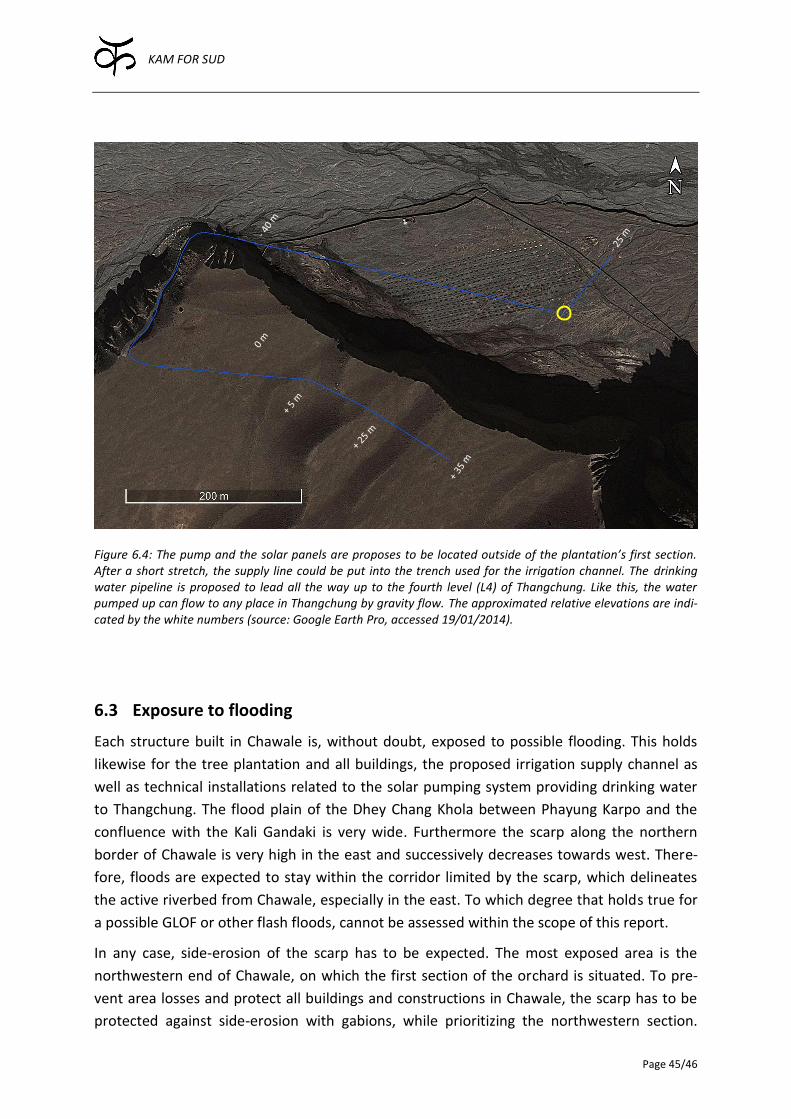
KAM FOR SUD
Page 45/46
Figure 6.4: The pump and the solar panels are proposes to be located outside of the plantation’s first section. After a short stretch, the supply line could be put into the trench used for the irrigation channel. The drinking water pipeline is proposed to lead all the way up to the fourth level (L4) of Thangchung. Like this, the water pumped up can flow to any place in Thangchung by gravity flow. The approximated relative elevations are indi-cated by the white numbers (source: Google Earth Pro, accessed 19/01/2014).
6.3 Exposure to flooding
Each structure built in Chawale is, without doubt, exposed to possible flooding. This holds
likewise for the tree plantation and all buildings, the proposed irrigation supply channel as
well as technical installations related to the solar pumping system providing drinking water
to Thangchung. The flood plain of the Dhey Chang Khola between Phayung Karpo and the
confluence with the Kali Gandaki is very wide. Furthermore the scarp along the northern
border of Chawale is very high in the east and successively decreases towards west. There-
fore, floods are expected to stay within the corridor limited by the scarp, which delineates
the active riverbed from Chawale, especially in the east. To which degree that holds true for
a possible GLOF or other flash floods, cannot be assessed within the scope of this report.
In any case, side-erosion of the scarp has to be expected. The most exposed area is the
northwestern end of Chawale, on which the first section of the orchard is situated. To pre-
vent area losses and protect all buildings and constructions in Chawale, the scarp has to be
protected against side-erosion with gabions, while prioritizing the northwestern section.
KAM FOR SUD
Page 46/46
Note that generally matured trees are quite a good measure against erosion, however most-
ly to reduce bank erosion and not to prevent flooding itself.
Overall, the protection of Chawale against side-erosion should receive upmost priority, as
the investments could be in vain if a large flood heavily damages the completed structures
and the young orchard.
7 Outlook
The report at hand should be considered as the base for any further investigations concern-
ing technical aspects. It is recommended that the proposed irrigation and drinking water
supply systems are investigated on implementation level together with the villagers and lo-
cal contractors and suppliers. Especially the exact costs, including contributions of the villag-
ers in terms of labor, skilled labor costs, transportation etc., should be evaluated in a next
step.
KAM FOR SUD
Indices Page 47
8 Bibliography
Allen, Richard G, Luis S Pereira, Dirk Raes, Martin Smith, and others. 1998. “Crop Evapotran-
spiration - Guidelines for Computing Crop Water Requirements - FAO Irrigation and
Drainage Paper 56.” FAO, Rome 300: 6541.
Bernet, D., D. Pittet, C. Ambrosi, G. Kappenberger, and M. Passardi. 2012a. “Moving down or
not? A key question for Samzong, Yara and Dheye, three villages in Upper Mustang,
Mustang District, Nepal”. Ticino, Switzerland: Kam For Sud / SUPSI.
———. 2012b. “Moving down or not? Part IV: Dheye”. Ticino, Switzerland: Kam For Sud /
SUPSI.
Devkota, Fidel. 2013. “Climate Change and its socio-cultural impact in the Himalayan region
of Nepal – A Visual Documentation.” Anthrovision. Vaneasa Online Journal (1.2).
http://anthrovision.revues.org/589.
Dhungel, Ramesh K. 2002. The Kingdom of Lo (Mustang): A Historical Study. Kathmandu:
Tashi Gephel Foundation.
Egger, J., S. Bajrachaya, U. Egger, R. Heinrich, J. Reuder, P. Shayka, H. Wendt, and V. Wirth.
2000. “Diurnal winds in the Himalayan Kali Gandaki Valley. Part I: Observations.”
Monthly weather review 128 (4): 1106–22.
Gujer, W. 2006. Siedlungswasserwirtschaft. 3rd ed. Springer DE.
Gurung, T.G. 2011. “Proposal on resettlement and development plan of Dhye village.”
Jeffery, Paul. 2013. Computer Aided Solar Simulation (CASS). Windows (version 4.0.3.0).
Practical Action. Civil Works Guidelines for Micro-Hydropower in Nepal.
http://practicalaction.org/civil-works-guidelines-for-micro-hydropower-in-nepal.
Ramble, Charles Albert Edward. 2007. The Navel of the Demoness: Tibetan Buddhism and
Civil Religion in Highland Nepal. USA: Oxford University Press.
Tuladhar, Artha. 2007. “Trail Bridge Building in the Himalayas - Enhanced Access, Improved
Livelihoods”. Brochure No. 5. Experience and Learning in International Co-operation.
Zurich: Helvetas, Swiss Association for International Co-operation.
Wacker, C., and U. Fröhlich. 1997. “Traditional Water Management System in Ladakh: Case
study of Tagmachik village, factors of sustainability and adaptation to change and
some observations on modern water development”. Zürich.
Wegelin, Martin. 1996. “Surface Water Treatment by Roughing Filters - A Design, Construc-
tion and Operation Manual”. SANDEC Report No 2/96. Duebendorf: Swiss Centre for
Development Cooperation in Technology and Management (SKAT).

KAM FOR SUD
Indices Page 48
Wernli, Hans Rudolf. 2011. “Einführung in die Tacerhydrologie”. Skript zum Hydrologisches
Praktikum. Bern: Universität Bern.
http://www.geography.unibe.ch/content/e9504/e9593/e9888/e9890/TR-
Hydro_ger.pdf.
Zängl, G., J. Egger, and V. Wirth. 2001. “Diurnal winds in the Himalayan Kali Gandaki valley.
Part II: Modeling.” Monthly weather review 129 (5): 1062–80.
Zurick, D., J. Pacheco, B.R. Shrestha, and B. Bajracharya. 2006. Illustrated atlas of the Hima-
laya. India Research Press.

KAM FOR SUD
Indices Page 49
9 List of figures
Figure 1.1: Map of Nepal ............................................................................................................ 1
Figure 2.1: The orchard’s first apple .......................................................................................... 6
Figure 2.2: Different sections of the tree plantation in Chawale............................................... 7
Figure 2.3: Bird’s eye view of the usable area in Chawale and Thangchung ............................. 8
Figure 2.4: Overview of the four-stepped plain of Thangchung ................................................ 9
Figure 4.1: Comparison between high and low flow conditions of the Dhey Chang Khola .... 15
Figure 4.2: Indications about erosion tendencies of the Dhey Chang Khola ........................... 17
Figure 4.3: Overview of the current abstraction of the Dhey Chang Khola ............................. 19
Figure 4.4: The location of Charang’s spring ............................................................................ 21
Figure 4.5: Charang’s spring as a possible water source ......................................................... 21
Figure 5.1: Dheye’s current drinking water source .................................................................. 26
Figure 5.2: Possible routing of the pipeline tapping Dheye’s spring ....................................... 27
Figure 5.3: Riverwater pretreatment in Upper Mustang ......................................................... 31
Figure 6.1: Current abstraction of the Dhey Chang Khola ....................................................... 36
Figure 6.2: Overview of the water supply plan ........................................................................ 40
Figure 6.3: Installation of the HDPE pipes ................................................................................ 42
Figure 6.4: Overview of the drinking supply plan .................................................................... 45
Figure 10.1: Overview of the leveling’s paths .......................................................................... 52
Figure 10.2: Longitudinal leveling profile ................................................................................. 53
Figure 10.3: Lateral leveling profile .......................................................................................... 53
Figure 10.4: Illustration of the GPS measurement points around Chawale ............................ 56
Figure 10.5: Illustration of the GPS measurement points around Dheye’s spring .................. 58
Figure 10.6: Relationship between salt concentration and conductivity ................................ 59
Figure 10.7: Discharge assessement ........................................................................................ 60
Figure 10.8: Assessement of the hydraulic conductivity ......................................................... 61
Figure 10.9: Input data and results of the Lefranc test ............................................................ 62
Figure 10.10: Filterability test .................................................................................................. 63
Figure 10.11: Results of the filterability test ............................................................................ 64
Figure 10.12: Results of the suspension stability test .............................................................. 65
KAM FOR SUD
Indices Page 50
Figure 10.13: Results of the settleable solids test ................................................................... 67
Figure 10.14: Location for which sun path diagrams were assessed ....................................... 68
Figure 10.15: Sun path diagram for the first place .................................................................. 69
Figure 10.16: Sun path diagram for the second place ............................................................. 70
Figure 10.17: Sun path diagram for the third place ................................................................. 71
Figure 10.18: Screenshot of the Climate Tab of CROPWAT 8.0 ............................................... 73
Figure 10.19: Screenshot of the Crop Tab of CROPWAT 8.0 .................................................... 74
Figure 10.20: Screenshot of the crop water requirement Tab of CROPWAT 8.0 .................... 75
Figure 10.21: Calculation result of the CASS reagarding irrigation water supply .................... 76
Figure 10.22: Calculation result of the CASS regarding drinking water supply ....................... 77
Figure 10.23: Panchakanya HDPE pipe prize list ...................................................................... 79

KAM FOR SUD
Indices Page 51
10 List of tables
Table 3.1: Per capita daily drinking water demand ................................................................. 14
Table 4.1: List of the most common sediments in the alluvial plain below Thangchung ........ 16
Table 4.2: Input parameters and results of the CASS regarding irrigation water supply ........ 24
Table 4.3: Comparison of the studied irrigation water supply options ................................... 25
Table 5.1: Input parameters and results of the CASS regarding drinking water supply .......... 32
Table 5.2: Comparison of the studied drinking water supply options ..................................... 35
Table 6.1: Exemplary design of a rectangular settlement pond .............................................. 38
Table 6.2: Required water flow for the short pressure pipeline .............................................. 39
Table 6.3: Flow calculations’ input variables ........................................................................... 41
Table 10.1: Longitudinal leveling’s data ................................................................................... 54
Table 10.2: Lateral leveling’s data ............................................................................................ 55
Table 10.3: Data of the measured GPS points ......................................................................... 57
Table 10.4: List of households in Dheye ................................................................................... 72
Table 10.5: Qualitative comparison between MS and HDPE pipes. ........................................ 78
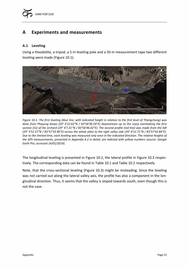
KAM FOR SUD
Appendix Page 52
A Experiments and measurements
A.1 Leveling
Using a theodolite, a tripod, a 5 m leveling pole and a 50 m measurement tape two different
leveling were made (Figure 10.1).
Figure 10.1: The first leveling (blue line, with indicated height in relation to the first level of Thangchung) was done from Phayung Karpo (29° 4'12.62"N / 83°58'36.59"E) downstream up to the scarp overlooking the first section (S1) of the orchard (29° 4'7.31"N / 83°56'46.02"E). The second profile (red line) was made from the left (29° 3'51.57"N / 83°57'33.90"E) across the whole plain to the right valley side (29° 4'12.71"N / 83°57'42.84"E). Due to the limited time, each leveling was measured only once in the indicated direction. The relative heights of the GPS measurements, presented in Appendix A.2 in detail, are indicted with yellow numbers (source: Google Earth Pro, accessed 14/01/2014).
The longitudinal leveling is presented in Figure 10.2, the lateral profile in Figure 10.3 respec-
tively. The corresponding data can be found in Table 10.1 and Table 10.2 respectively.
Note, that the cross-sectional leveling (Figure 10.3) might be misleading. Since the leveling
was not carried out along the lateral valley axis, the profile has also a component in the lon-
gitudinal direction. Thus, it seems that the valley is sloped towards south, even though this is
not the case.
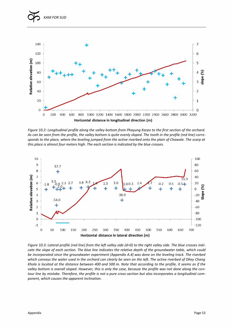
KAM FOR SUD
Appendix Page 53
Figure 10.2: Longitudinal profile along the valley bottom from Phayung Karpo to the first section of the orchard. As can be seen from the profile, the valley bottom is quite evenly sloped. The tooth in the profile (red line) corre-sponds to the place, where the leveling jumped from the active riverbed onto the plain of Chawale. The scarp at this place is almost four meters high. The each section is indicated by the blue crosses.
Figure 10.3: Lateral profile (red line) from the left valley side (d=0) to the right valley side. The blue crosses indi-cate the slope of each section. The blue line indicates the relative depth of the groundwater table, which could be incorporated since the groundwater experiment (Appendix A.4) was done on the leveling track. The riverbed which conveys the water used in the orchard can clearly be seen on the left. The active riverbed of Dhey Chang Khola is located at the distance between 400 and 500 m. Note that according to the profile, it seems as if the valley bottom is overall sloped. However, this is only the case, because the profile was not done along the con-tour line by mistake. Therefore, the profile is not a pure cross-section but also incorporates a longitudinal com-ponent, which causes the apparent inclination.
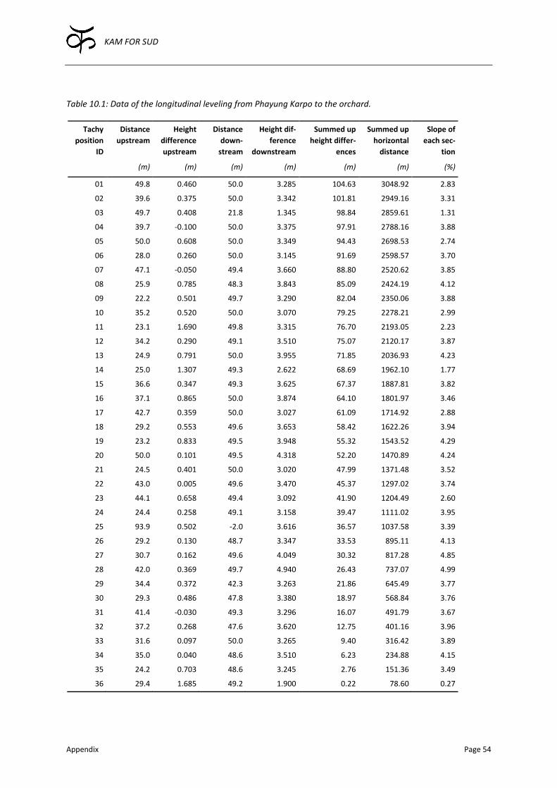
KAM FOR SUD
Appendix Page 54
Table 10.1: Data of the longitudinal leveling from Phayung Karpo to the orchard.
Tachy
position
ID
Distance
upstream
Height
difference
upstream
Distance
down-
stream
Height dif-
ference
downstream
Summed up
height differ-
ences
Summed up
horizontal
distance
Slope of
each sec-
tion
(m) (m) (m) (m) (m) (m) (%)
01 49.8 0.460 50.0 3.285 104.63 3048.92 2.83
02 39.6 0.375 50.0 3.342 101.81 2949.16 3.31
03 49.7 0.408 21.8 1.345 98.84 2859.61 1.31
04 39.7 -0.100 50.0 3.375 97.91 2788.16 3.88
05 50.0 0.608 50.0 3.349 94.43 2698.53 2.74
06 28.0 0.260 50.0 3.145 91.69 2598.57 3.70
07 47.1 -0.050 49.4 3.660 88.80 2520.62 3.85
08 25.9 0.785 48.3 3.843 85.09 2424.19 4.12
09 22.2 0.501 49.7 3.290 82.04 2350.06 3.88
10 35.2 0.520 50.0 3.070 79.25 2278.21 2.99
11 23.1 1.690 49.8 3.315 76.70 2193.05 2.23
12 34.2 0.290 49.1 3.510 75.07 2120.17 3.87
13 24.9 0.791 50.0 3.955 71.85 2036.93 4.23
14 25.0 1.307 49.3 2.622 68.69 1962.10 1.77
15 36.6 0.347 49.3 3.625 67.37 1887.81 3.82
16 37.1 0.865 50.0 3.874 64.10 1801.97 3.46
17 42.7 0.359 50.0 3.027 61.09 1714.92 2.88
18 29.2 0.553 49.6 3.653 58.42 1622.26 3.94
19 23.2 0.833 49.5 3.948 55.32 1543.52 4.29
20 50.0 0.101 49.5 4.318 52.20 1470.89 4.24
21 24.5 0.401 50.0 3.020 47.99 1371.48 3.52
22 43.0 0.005 49.6 3.470 45.37 1297.02 3.74
23 44.1 0.658 49.4 3.092 41.90 1204.49 2.60
24 24.4 0.258 49.1 3.158 39.47 1111.02 3.95
25 93.9 0.502 -2.0 3.616 36.57 1037.58 3.39
26 29.2 0.130 48.7 3.347 33.53 895.11 4.13
27 30.7 0.162 49.6 4.049 30.32 817.28 4.85
28 42.0 0.369 49.7 4.940 26.43 737.07 4.99
29 34.4 0.372 42.3 3.263 21.86 645.49 3.77
30 29.3 0.486 47.8 3.380 18.97 568.84 3.76
31 41.4 -0.030 49.3 3.296 16.07 491.79 3.67
32 37.2 0.268 47.6 3.620 12.75 401.16 3.96
33 31.6 0.097 50.0 3.265 9.40 316.42 3.89
34 35.0 0.040 48.6 3.510 6.23 234.88 4.15
35 24.2 0.703 48.6 3.245 2.76 151.36 3.49
36 29.4 1.685 49.2 1.900 0.22 78.60 0.27
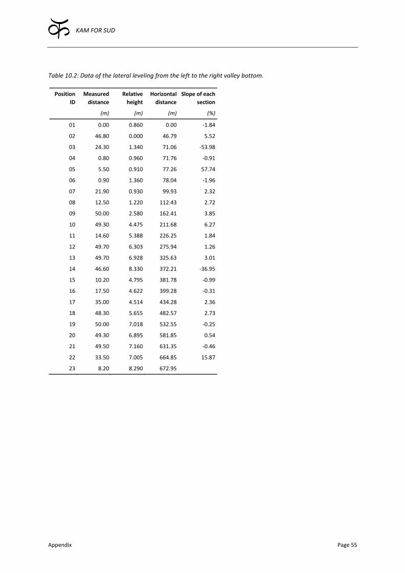
KAM FOR SUD
Appendix Page 55
Table 10.2: Data of the lateral leveling from the left to the right valley bottom.
Position
ID
Measured
distance
Relative
height
Horizontal
distance
Slope of each
section
(m) (m) (m) (%)
01 0.00 0.860 0.00 -1.84
02 46.80 0.000 46.79 5.52
03 24.30 1.340 71.06 -53.98
04 0.80 0.960 71.76 -0.91
05 5.50 0.910 77.26 57.74
06 0.90 1.360 78.04 -1.96
07 21.90 0.930 99.93 2.32
08 12.50 1.220 112.43 2.72
09 50.00 2.580 162.41 3.85
10 49.30 4.475 211.68 6.27
11 14.60 5.388 226.25 1.84
12 49.70 6.303 275.94 1.26
13 49.70 6.928 325.63 3.01
14 46.60 8.330 372.21 -36.95
15 10.20 4.795 381.78 -0.99
16 17.50 4.622 399.28 -0.31
17 35.00 4.514 434.28 2.36
18 48.30 5.655 482.57 2.73
19 50.00 7.018 532.55 -0.25
20 49.30 6.895 581.85 0.54
21 49.50 7.160 631.35 -0.46
22 33.50 7.005 664.85 15.87
23 8.20 8.290 672.95
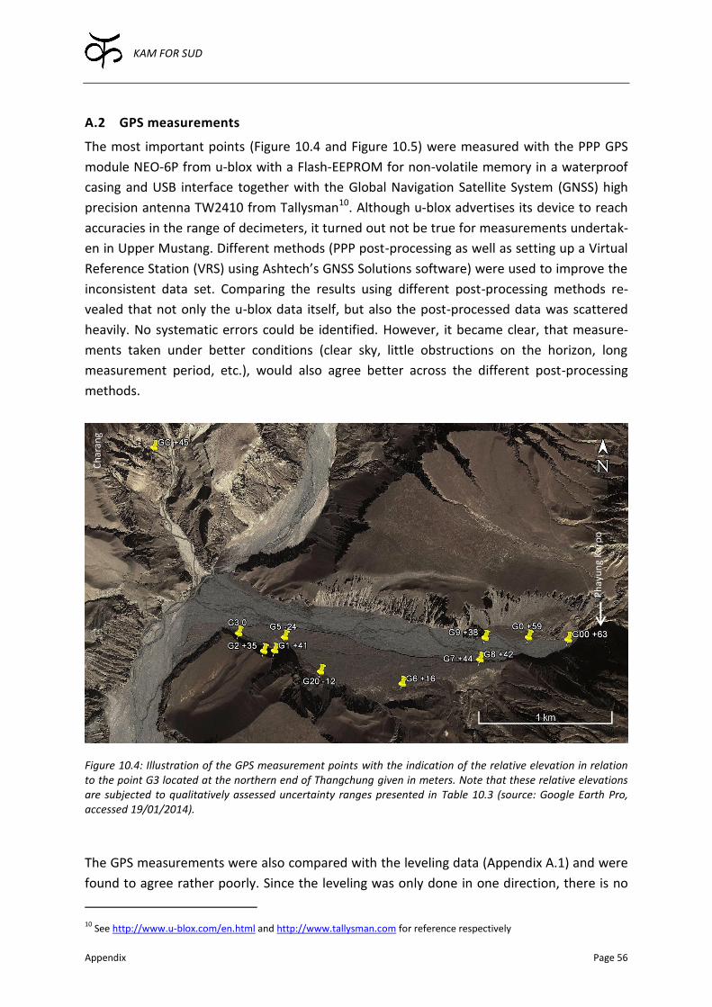
KAM FOR SUD
Appendix Page 56
A.2 GPS measurements
The most important points (Figure 10.4 and Figure 10.5) were measured with the PPP GPS
module NEO-6P from u-blox with a Flash-EEPROM for non-volatile memory in a waterproof
casing and USB interface together with the Global Navigation Satellite System (GNSS) high
precision antenna TW2410 from Tallysman10. Although u-blox advertises its device to reach
accuracies in the range of decimeters, it turned out not be true for measurements undertak-
en in Upper Mustang. Different methods (PPP post-processing as well as setting up a Virtual
Reference Station (VRS) using Ashtech’s GNSS Solutions software) were used to improve the
inconsistent data set. Comparing the results using different post-processing methods re-
vealed that not only the u-blox data itself, but also the post-processed data was scattered
heavily. No systematic errors could be identified. However, it became clear, that measure-
ments taken under better conditions (clear sky, little obstructions on the horizon, long
measurement period, etc.), would also agree better across the different post-processing
methods.
Figure 10.4: Illustration of the GPS measurement points with the indication of the relative elevation in relation to the point G3 located at the northern end of Thangchung given in meters. Note that these relative elevations are subjected to qualitatively assessed uncertainty ranges presented in Table 10.3 (source: Google Earth Pro, accessed 19/01/2014).
The GPS measurements were also compared with the leveling data (Appendix A.1) and were
found to agree rather poorly. Since the leveling was only done in one direction, there is no
10
See http://www.u-blox.com/en.html and http://www.tallysman.com for reference respectively
Ph
ayu
ng
Kar
po
Ch
aran
g
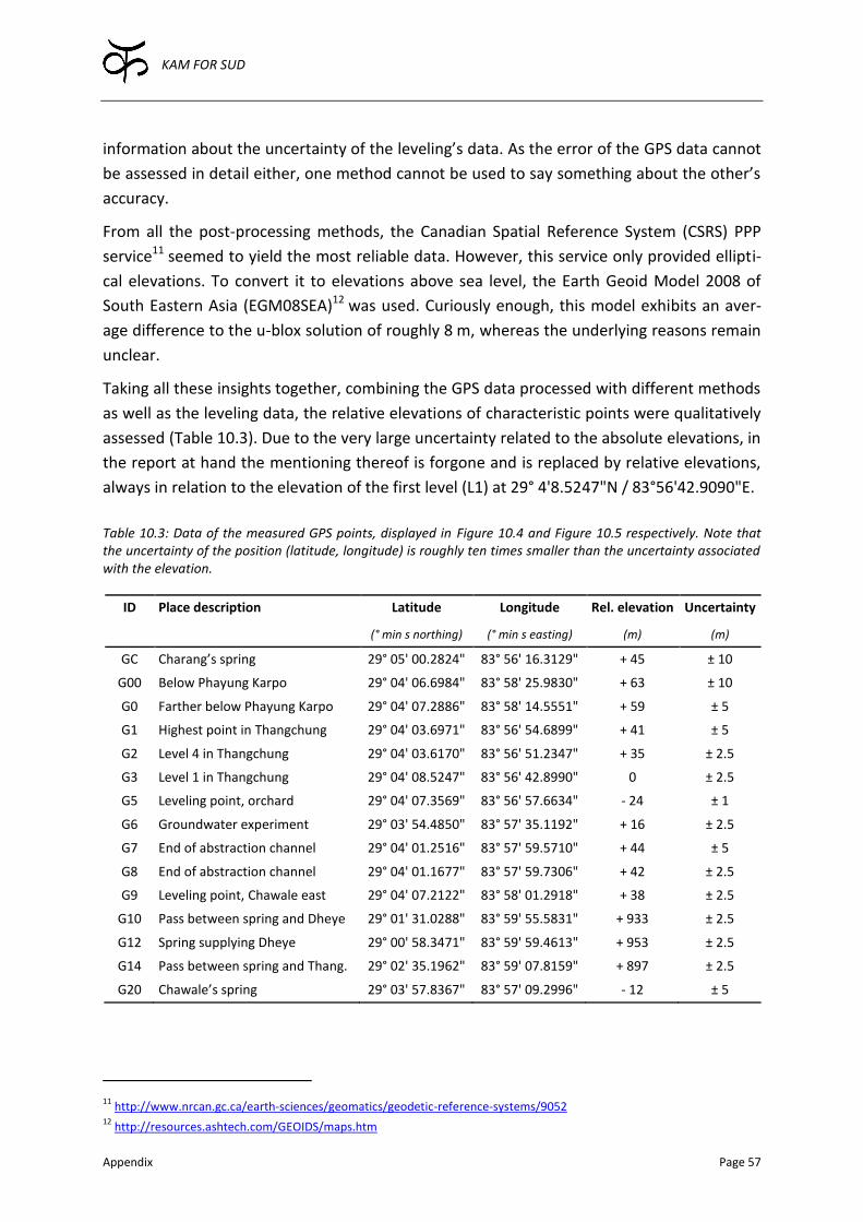
KAM FOR SUD
Appendix Page 57
information about the uncertainty of the leveling’s data. As the error of the GPS data cannot
be assessed in detail either, one method cannot be used to say something about the other’s
accuracy.
From all the post-processing methods, the Canadian Spatial Reference System (CSRS) PPP
service11 seemed to yield the most reliable data. However, this service only provided ellipti-
cal elevations. To convert it to elevations above sea level, the Earth Geoid Model 2008 of
South Eastern Asia (EGM08SEA)12 was used. Curiously enough, this model exhibits an aver-
age difference to the u-blox solution of roughly 8 m, whereas the underlying reasons remain
unclear.
Taking all these insights together, combining the GPS data processed with different methods
as well as the leveling data, the relative elevations of characteristic points were qualitatively
assessed (Table 10.3). Due to the very large uncertainty related to the absolute elevations, in
the report at hand the mentioning thereof is forgone and is replaced by relative elevations,
always in relation to the elevation of the first level (L1) at 29° 4'8.5247"N / 83°56'42.9090"E.
Table 10.3: Data of the measured GPS points, displayed in Figure 10.4 and Figure 10.5 respectively. Note that the uncertainty of the position (latitude, longitude) is roughly ten times smaller than the uncertainty associated with the elevation.
ID Place description Latitude Longitude Rel. elevation Uncertainty
(° min s northing) (° min s easting) (m) (m)
GC Charang’s spring 29° 05' 00.2824" 83° 56' 16.3129" + 45 ± 10
G00 Below Phayung Karpo 29° 04' 06.6984" 83° 58' 25.9830" + 63 ± 10
G0 Farther below Phayung Karpo 29° 04' 07.2886" 83° 58' 14.5551" + 59 ± 5
G1 Highest point in Thangchung 29° 04' 03.6971" 83° 56' 54.6899" + 41 ± 5
G2 Level 4 in Thangchung 29° 04' 03.6170" 83° 56' 51.2347" + 35 ± 2.5
G3 Level 1 in Thangchung 29° 04' 08.5247" 83° 56' 42.8990" 0 ± 2.5
G5 Leveling point, orchard 29° 04' 07.3569" 83° 56' 57.6634" - 24 ± 1
G6 Groundwater experiment 29° 03' 54.4850" 83° 57' 35.1192" + 16 ± 2.5
G7 End of abstraction channel 29° 04' 01.2516" 83° 57' 59.5710" + 44 ± 5
G8 End of abstraction channel 29° 04' 01.1677" 83° 57' 59.7306" + 42 ± 2.5
G9 Leveling point, Chawale east 29° 04' 07.2122" 83° 58' 01.2918" + 38 ± 2.5
G10 Pass between spring and Dheye 29° 01' 31.0288" 83° 59' 55.5831" + 933 ± 2.5
G12 Spring supplying Dheye 29° 00' 58.3471" 83° 59' 59.4613" + 953 ± 2.5
G14 Pass between spring and Thang. 29° 02' 35.1962" 83° 59' 07.8159" + 897 ± 2.5
G20 Chawale’s spring 29° 03' 57.8367" 83° 57' 09.2996" - 12 ± 5
11
http://www.nrcan.gc.ca/earth-sciences/geomatics/geodetic-reference-systems/9052 12
http://resources.ashtech.com/GEOIDS/maps.htm

KAM FOR SUD
Appendix Page 58
Figure 10.5: Illustration of the GPS measurement points, which were assessed in the context of the possible pipeline tapping the spring currently supplying drinking water to Dheye. The numbers beside the measurements’ ID indicates the relative elevation compared to the point G3 located at the northern end of Thangchung. The associated uncertainty ranges, together with the coordinates, are presented in Table 10.3 (source: Google Earth Pro, accessed 19/01/2014).
Phayung Karpo
Spring
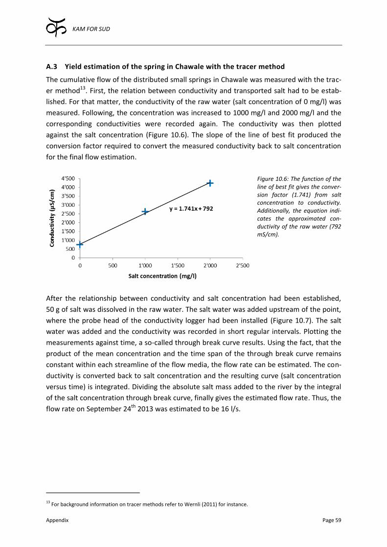
KAM FOR SUD
Appendix Page 59
A.3 Yield estimation of the spring in Chawale with the tracer method
The cumulative flow of the distributed small springs in Chawale was measured with the trac-
er method13. First, the relation between conductivity and transported salt had to be estab-
lished. For that matter, the conductivity of the raw water (salt concentration of 0 mg/l) was
measured. Following, the concentration was increased to 1000 mg/l and 2000 mg/l and the
corresponding conductivities were recorded again. The conductivity was then plotted
against the salt concentration (Figure 10.6). The slope of the line of best fit produced the
conversion factor required to convert the measured conductivity back to salt concentration
for the final flow estimation.
Figure 10.6: The function of the line of best fit gives the conver-sion factor (1.741) from salt concentration to conductivity. Additionally, the equation indi-cates the approximated con-ductivity of the raw water (792 mS/cm).
After the relationship between conductivity and salt concentration had been established,
50 g of salt was dissolved in the raw water. The salt water was added upstream of the point,
where the probe head of the conductivity logger had been installed (Figure 10.7). The salt
water was added and the conductivity was recorded in short regular intervals. Plotting the
measurements against time, a so-called through break curve results. Using the fact, that the
product of the mean concentration and the time span of the through break curve remains
constant within each streamline of the flow media, the flow rate can be estimated. The con-
ductivity is converted back to salt concentration and the resulting curve (salt concentration
versus time) is integrated. Dividing the absolute salt mass added to the river by the integral
of the salt concentration through break curve, finally gives the estimated flow rate. Thus, the
flow rate on September 24th 2013 was estimated to be 16 l/s.
13
For background information on tracer methods refer to Wernli (2011) for instance.
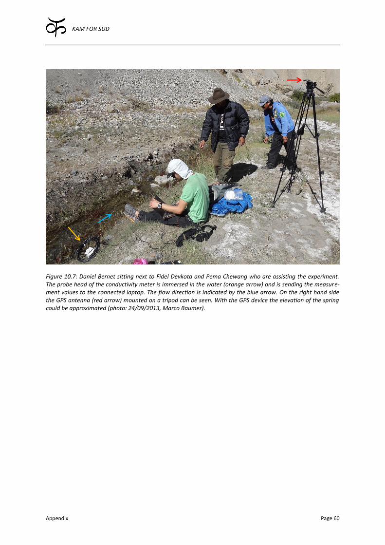
KAM FOR SUD
Appendix Page 60
Figure 10.7: Daniel Bernet sitting next to Fidel Devkota and Pema Chewang who are assisting the experiment. The probe head of the conductivity meter is immersed in the water (orange arrow) and is sending the measure-ment values to the connected laptop. The flow direction is indicated by the blue arrow. On the right hand side the GPS antenna (red arrow) mounted on a tripod can be seen. With the GPS device the elevation of the spring could be approximated (photo: 24/09/2013, Marco Baumer).
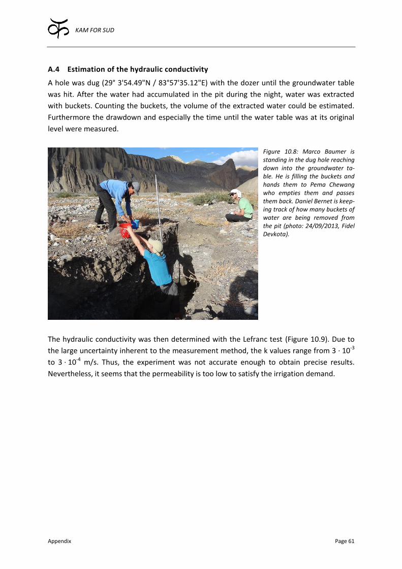
KAM FOR SUD
Appendix Page 61
A.4 Estimation of the hydraulic conductivity
A hole was dug (29° 3'54.49"N / 83°57'35.12"E) with the dozer until the groundwater table
was hit. After the water had accumulated in the pit during the night, water was extracted
with buckets. Counting the buckets, the volume of the extracted water could be estimated.
Furthermore the drawdown and especially the time until the water table was at its original
level were measured.
Figure 10.8: Marco Baumer is standing in the dug hole reaching down into the groundwater ta-ble. He is filling the buckets and hands them to Pema Chewang who empties them and passes them back. Daniel Bernet is keep-ing track of how many buckets of water are being removed from the pit (photo: 24/09/2013, Fidel Devkota).
The hydraulic conductivity was then determined with the Lefranc test (Figure 10.9). Due to
the large uncertainty inherent to the measurement method, the k values range from 3 · 10-3
to 3 · 10-4 m/s. Thus, the experiment was not accurate enough to obtain precise results.
Nevertheless, it seems that the permeability is too low to satisfy the irrigation demand.
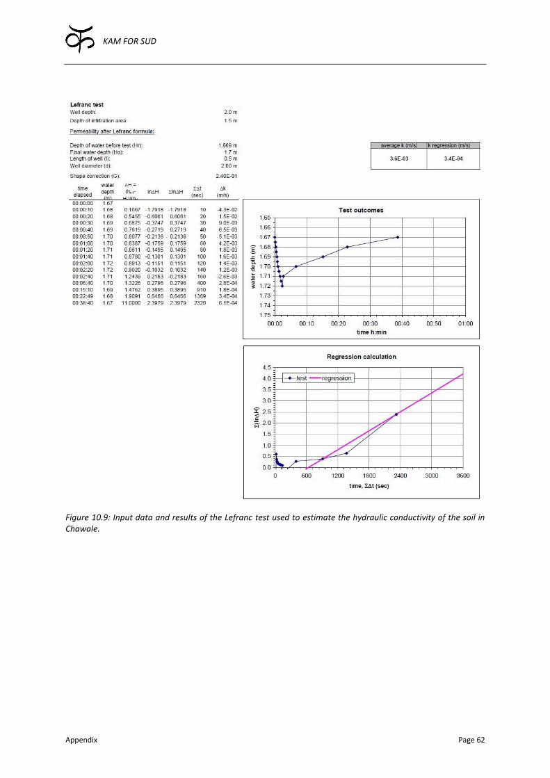
KAM FOR SUD
Appendix Page 62
Figure 10.9: Input data and results of the Lefranc test used to estimate the hydraulic conductivity of the soil in Chawale.

KAM FOR SUD
Appendix Page 63
A.5 Filterability of Dhey Chang Khola’s surface water
Water was abstracted from the Dhey Chang Khola (29° 4'5.04"N / 83°58'10.04"E) and put
into a bucket. The turbidity of the raw water was determined visually with turbidity tubes.
Then, the raw water was filtered by inserting filter papers with decreasing pores (15-12, 12-
8, 8-5, 5-3, 2-3, 1.2 µm). For the filtration a syringe and a filter holder were used. The raw
water in the bucket was stirred, taken in with the syringe and directly filtered into the tur-
bidity tube until the black ring at the bottom of the tube disappeared. The corresponding
turbidity was recorded (Figure 10.10).
Figure 10.10: Marco Baumer using the syringe (red arrow) to successively filtering the abstracted water with the graded filter paper inserted into the filter holder (orange arrow). Daniel Bernet is holding on to the turbidity tube with which the turbidity can be assessed visually (photo: 24/09/2013, Fidel Devkota).
Due to the coarse measurement method, the experiment’s results are difficult to interpret.
The absolute turbidity distribution (top, Figure 10.11) shows that the turbidity of the ab-
stracted water was much higher during the later two experiments. This considerable change
in turbidity was due to rain- and snowfall in the mountains on September 23rd 2013. After
that day, the color of the river water changed from previously grey to dark brown, which is
supported by the turbidity measurements. It does not seem possible to draw conclusions

KAM FOR SUD
Appendix Page 64
about the particle distributions using the relative turbidity distribution (bottom, Figure
10.11) due to the coarse measurement method.
Figure 10.11: Absolute (top) and relative turbidity distribution (bottom) of the filterability tests with samples taken on different days at different times.
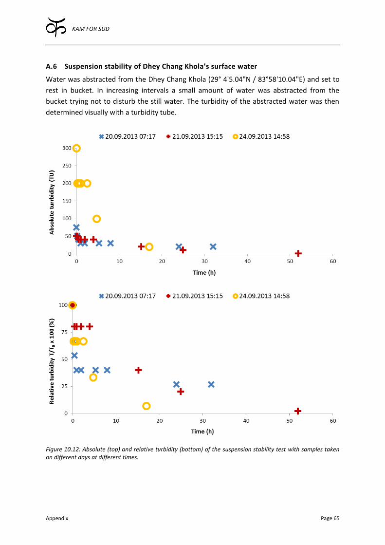
KAM FOR SUD
Appendix Page 65
A.6 Suspension stability of Dhey Chang Khola’s surface water
Water was abstracted from the Dhey Chang Khola (29° 4'5.04"N / 83°58'10.04"E) and set to
rest in bucket. In increasing intervals a small amount of water was abstracted from the
bucket trying not to disturb the still water. The turbidity of the abstracted water was then
determined visually with a turbidity tube.
Figure 10.12: Absolute (top) and relative turbidity (bottom) of the suspension stability test with samples taken on different days at different times.

KAM FOR SUD
Appendix Page 66
The results show nicely that the turbidity, after the before mentioned precipitation event
(Appendix A.5), was much higher than during the two previous measurements (top, Figure
10.12).
The experiment also shows that especially in case the turbidity is increased due to higher
discharges in the river, for instance caused by rainfall or snow and ice melt, letting the water
sit is a very efficient method to increase the water quality (bottom, Figure 10.12). However,
if the turbidity is smaller during normal flow conditions for example, the relative turbidity
only decreases very slowly. This suggests that the suspension is very stable during normal
flow conditions. However, if the discharge is increased, small particles get mobilized and are
transported along. These particles are settling down quickly again, once the water is moving
slower or even stops completely. Therefore, a settlement pond is particularly efficient to
remove suspended particles during turbidity peaks.
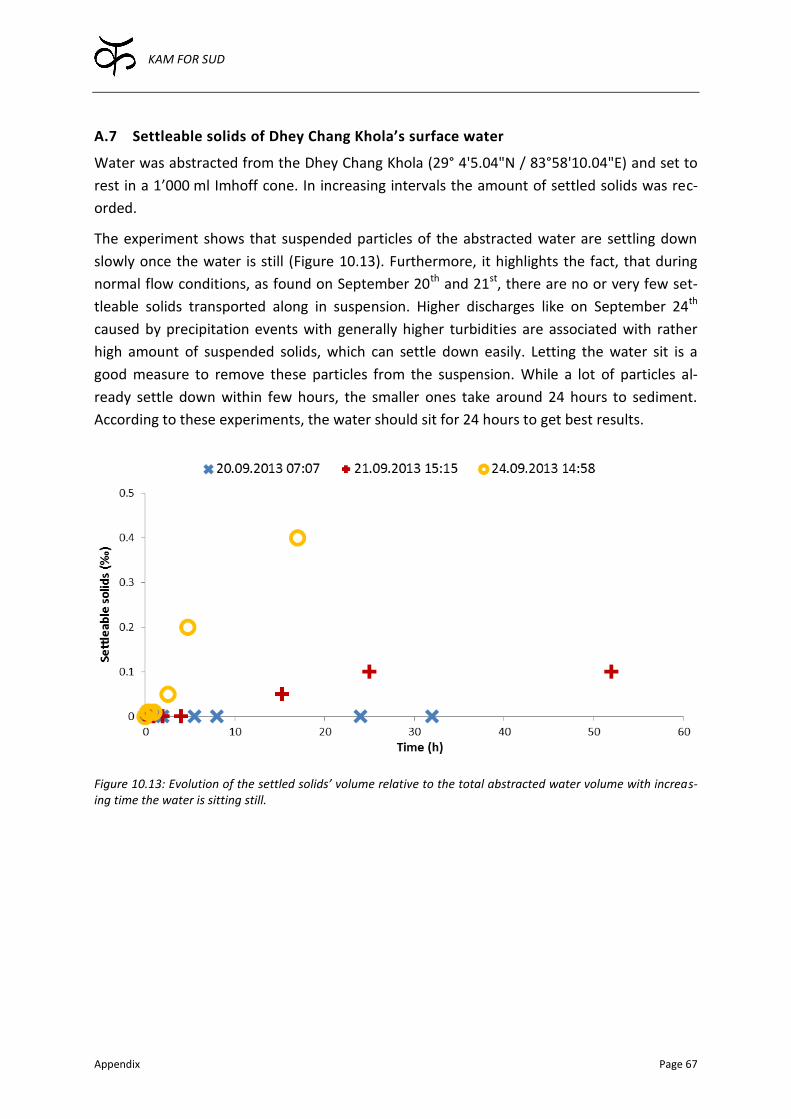
KAM FOR SUD
Appendix Page 67
A.7 Settleable solids of Dhey Chang Khola’s surface water
Water was abstracted from the Dhey Chang Khola (29° 4'5.04"N / 83°58'10.04"E) and set to
rest in a 1’000 ml Imhoff cone. In increasing intervals the amount of settled solids was rec-
orded.
The experiment shows that suspended particles of the abstracted water are settling down
slowly once the water is still (Figure 10.13). Furthermore, it highlights the fact, that during
normal flow conditions, as found on September 20th and 21st, there are no or very few set-
tleable solids transported along in suspension. Higher discharges like on September 24th
caused by precipitation events with generally higher turbidities are associated with rather
high amount of suspended solids, which can settle down easily. Letting the water sit is a
good measure to remove these particles from the suspension. While a lot of particles al-
ready settle down within few hours, the smaller ones take around 24 hours to sediment.
According to these experiments, the water should sit for 24 hours to get best results.
Figure 10.13: Evolution of the settled solids’ volume relative to the total abstracted water volume with increas-ing time the water is sitting still.
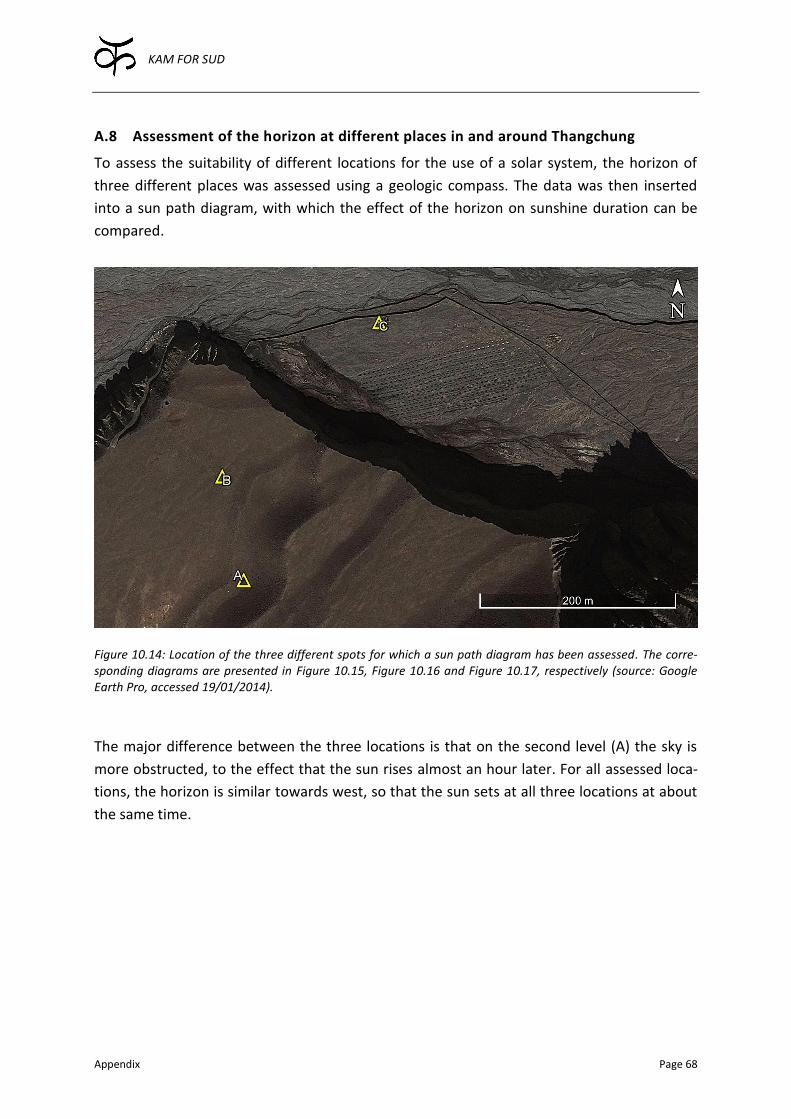
KAM FOR SUD
Appendix Page 68
A.8 Assessment of the horizon at different places in and around Thangchung
To assess the suitability of different locations for the use of a solar system, the horizon of
three different places was assessed using a geologic compass. The data was then inserted
into a sun path diagram, with which the effect of the horizon on sunshine duration can be
compared.
Figure 10.14: Location of the three different spots for which a sun path diagram has been assessed. The corre-sponding diagrams are presented in Figure 10.15, Figure 10.16 and Figure 10.17, respectively (source: Google Earth Pro, accessed 19/01/2014).
The major difference between the three locations is that on the second level (A) the sky is
more obstructed, to the effect that the sun rises almost an hour later. For all assessed loca-
tions, the horizon is similar towards west, so that the sun sets at all three locations at about
the same time.

KAM FOR SUD
Appendix Page 69
Figure 10.15: Sun path diagram for the place A (29°04'01.81"N / 83°56'41.40"E) located on the second level of Thangchung (L2), as further specified in Figure 10.14. The orange dotted line indicates the horizon of location B (Figure 10.16), and the blue line of the location C (Figure 10.17).
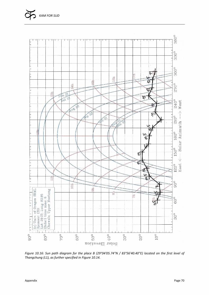
KAM FOR SUD
Appendix Page 70
Figure 10.16: Sun path diagram for the place B (29°04'05.74"N / 83°56'40.40"E) located on the first level of Thangchung (L1), as further specified in Figure 10.14.
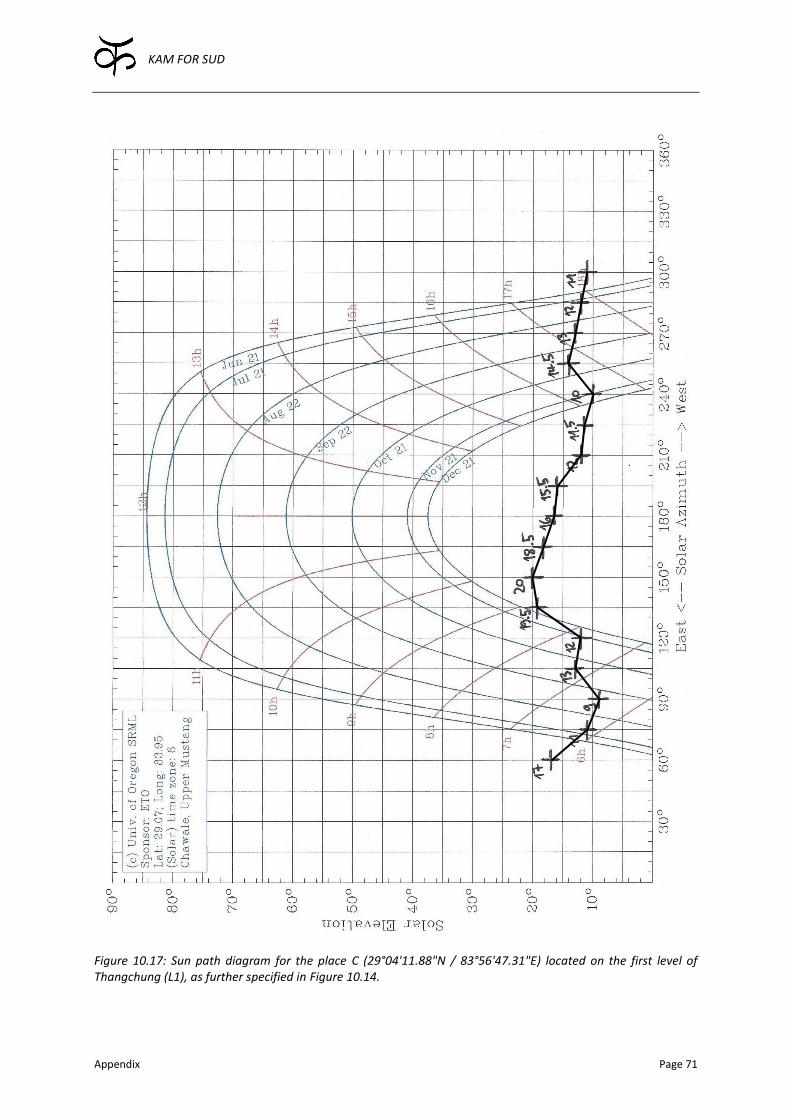
KAM FOR SUD
Appendix Page 71
Figure 10.17: Sun path diagram for the place C (29°04'11.88"N / 83°56'47.31"E) located on the first level of Thangchung (L1), as further specified in Figure 10.14.
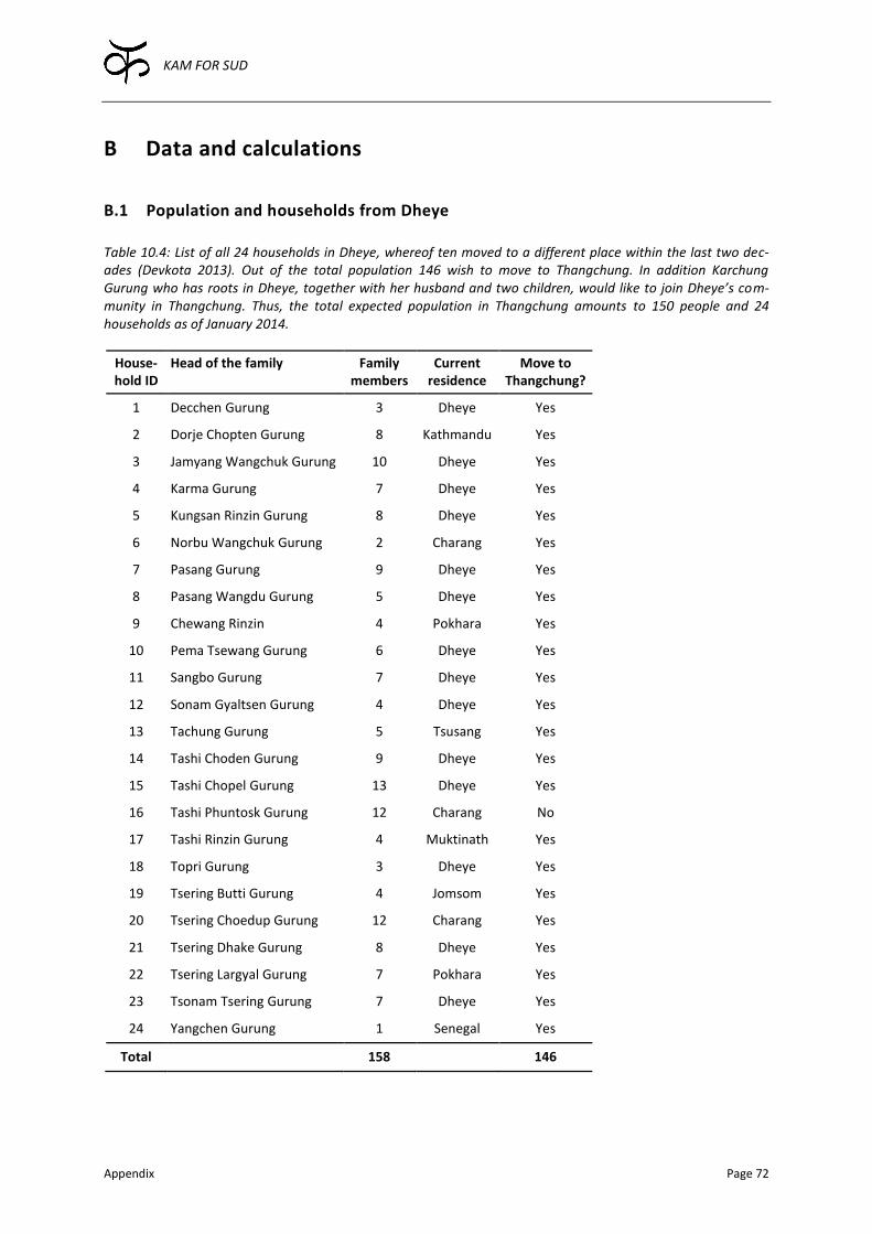
KAM FOR SUD
Appendix Page 72
B Data and calculations
B.1 Population and households from Dheye
Table 10.4: List of all 24 households in Dheye, whereof ten moved to a different place within the last two dec-ades (Devkota 2013). Out of the total population 146 wish to move to Thangchung. In addition Karchung Gurung who has roots in Dheye, together with her husband and two children, would like to join Dheye’s com-munity in Thangchung. Thus, the total expected population in Thangchung amounts to 150 people and 24 households as of January 2014.
House-hold ID
Head of the family Family members
Current residence
Move to Thangchung?
1 Decchen Gurung 3 Dheye Yes
2 Dorje Chopten Gurung 8 Kathmandu Yes
3 Jamyang Wangchuk Gurung 10 Dheye Yes
4 Karma Gurung 7 Dheye Yes
5 Kungsan Rinzin Gurung 8 Dheye Yes
6 Norbu Wangchuk Gurung 2 Charang Yes
7 Pasang Gurung 9 Dheye Yes
8 Pasang Wangdu Gurung 5 Dheye Yes
9 Chewang Rinzin 4 Pokhara Yes
10 Pema Tsewang Gurung 6 Dheye Yes
11 Sangbo Gurung 7 Dheye Yes
12 Sonam Gyaltsen Gurung 4 Dheye Yes
13 Tachung Gurung 5 Tsusang Yes
14 Tashi Choden Gurung 9 Dheye Yes
15 Tashi Chopel Gurung 13 Dheye Yes
16 Tashi Phuntosk Gurung 12 Charang No
17 Tashi Rinzin Gurung 4 Muktinath Yes
18 Topri Gurung 3 Dheye Yes
19 Tsering Butti Gurung 4 Jomsom Yes
20 Tsering Choedup Gurung 12 Charang Yes
21 Tsering Dhake Gurung 8 Dheye Yes
22 Tsering Largyal Gurung 7 Pokhara Yes
23 Tsonam Tsering Gurung 7 Dheye Yes
24 Yangchen Gurung 1 Senegal Yes
Total 158 146

KAM FOR SUD
Appendix Page 73
B.2 Estimation of crop water requirement with CROPWAT 8.0
As mentioned in Section 3.1, the required mean monthly minimum and maximum tempera-
tures were guessed based on data from Mustang, Lobuche (Nepal) and Leh (India) by Gio-
vanni Kappenberger, an experienced meteorologist and climatologist. These temperature
values were fed into FAO’s CROPWAT 8.0 (Figure 10.18). Furthermore, the humidity and the
maximal wind speed were adjusted to reflect the observed conditions in Upper Mustang.
Figure 10.18: Screenshot of the climate tab of CROPWAT 8.0. Note that first only the mean monthly minimal and maximal temperatures were entered. All other values were automatically calculated according to (Allen et al. 1998) based on temperature, as well as altitude, latitude and longitude of the chosen location. The standard values for humidity and wind were adjusted afterwards to reflect the harsh climatic conditions in Upper Mus-tang (source: CROPWAT 8.0, downloaded from http://www.fao.org/nr/water/infores_databases_cropwat.html, accessed 13/12/2013).
As the precipitation rates are extremely low (Bernet et al. 2012b) in Upper Mustang, the
effective rainfall, which can be entered in the rain tab in CROPWAT (Figure 10.18), were set
to zero.
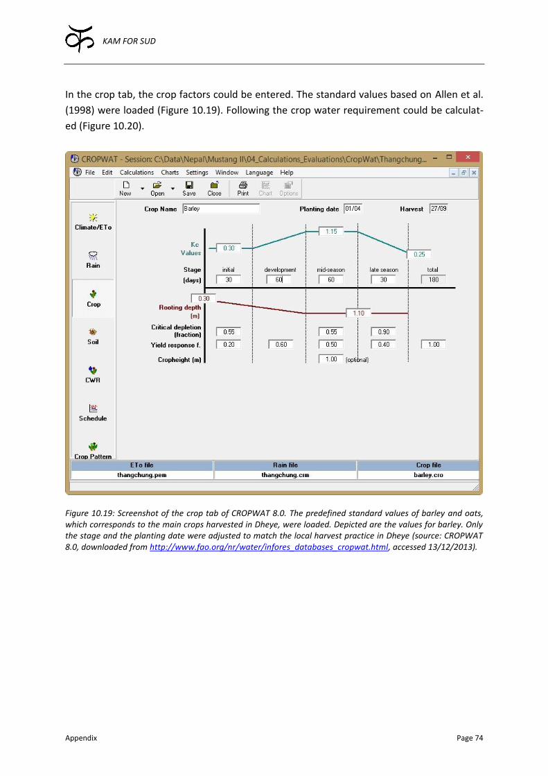
KAM FOR SUD
Appendix Page 74
In the crop tab, the crop factors could be entered. The standard values based on Allen et al.
(1998) were loaded (Figure 10.19). Following the crop water requirement could be calculat-
ed (Figure 10.20).
Figure 10.19: Screenshot of the crop tab of CROPWAT 8.0. The predefined standard values of barley and oats, which corresponds to the main crops harvested in Dheye, were loaded. Depicted are the values for barley. Only the stage and the planting date were adjusted to match the local harvest practice in Dheye (source: CROPWAT 8.0, downloaded from http://www.fao.org/nr/water/infores_databases_cropwat.html, accessed 13/12/2013).

KAM FOR SUD
Appendix Page 75
Figure 10.20: Screenshot of the crop water requirement (CWR) tab of CROPWAT 8.0. The maximal daily irriga-tion water requirement (in this case corresponding to ETc) was needed. Under the given conditions, the maximal irrigation intensity corresponds to 7.33 mm/d, as highlighted by the red circle (source: CROPWAT 8.0, down-loaded from http://www.fao.org/nr/water/infores_databases_cropwat.html, accessed 13/12/2013).
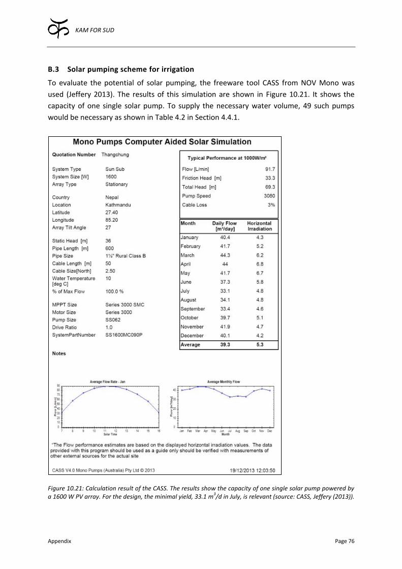
KAM FOR SUD
Appendix Page 76
B.3 Solar pumping scheme for irrigation
To evaluate the potential of solar pumping, the freeware tool CASS from NOV Mono was
used (Jeffery 2013). The results of this simulation are shown in Figure 10.21. It shows the
capacity of one single solar pump. To supply the necessary water volume, 49 such pumps
would be necessary as shown in Table 4.2 in Section 4.4.1.
Figure 10.21: Calculation result of the CASS. The results show the capacity of one single solar pump powered by a 1600 W PV array. For the design, the minimal yield, 33.1 m
3/d in July, is relevant (source: CASS, Jeffery (2013)).
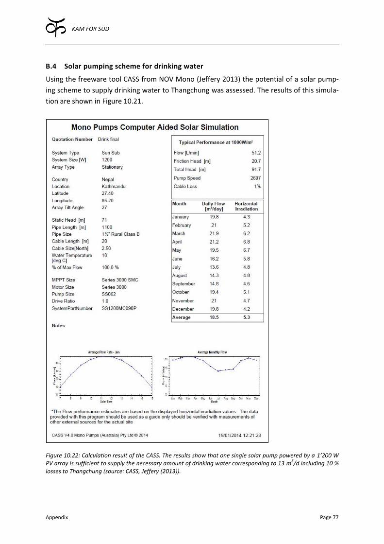
KAM FOR SUD
Appendix Page 77
B.4 Solar pumping scheme for drinking water
Using the freeware tool CASS from NOV Mono (Jeffery 2013) the potential of a solar pump-
ing scheme to supply drinking water to Thangchung was assessed. The results of this simula-
tion are shown in Figure 10.21.
Figure 10.22: Calculation result of the CASS. The results show that one single solar pump powered by a 1’200 W PV array is sufficient to supply the necessary amount of drinking water corresponding to 13 m
3/d including 10 %
losses to Thangchung (source: CASS, Jeffery (2013)).

KAM FOR SUD
Appendix Page 78
B.5 Comparison between HDPE and MS pipes
Table 10.5: Qualitative comparison between Mild Steel (MS) and High-Density Polyethylene (HDPE) pipes.
Property MS HDPE Comments
Buried / Above ground Both Buried HDPE degenerates exposed to sun
Flexibility Rigid Flexible
Expansion joints Necessary Not necessary HDPE is flexible enough to accom-modate thermal expansion and contraction
Joining on site Welding or via flanges
Welding (heating plate) or via flanges
If not welded, pipes require extra flanges
Weight Heavy Light Important related to transportation
Length Up to max 6 m Up to maximal 6 m
Prize High Medium – Low
Durability Corrosion is an issue
Rather high
High pressure Suitable Not suitable
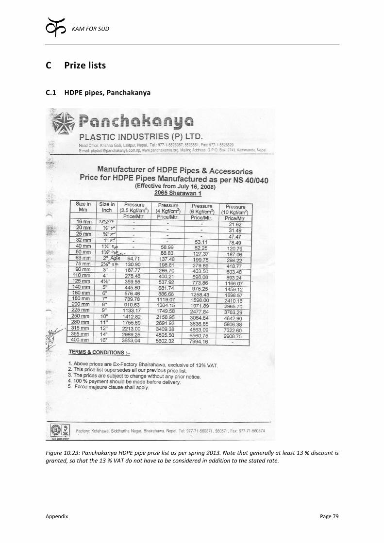
KAM FOR SUD
Appendix Page 79
C Prize lists
C.1 HDPE pipes, Panchakanya
Figure 10.23: Panchakanya HDPE pipe prize list as per spring 2013. Note that generally at least 13 % discount is granted, so that the 13 % VAT do not have to be considered in addition to the stated rate.