philippines | jun-16 | human-environmental security in asia-pacific ring of fire -water-energy-food...
TRANSCRIPT
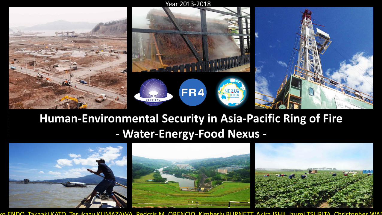
Human-Environmental Security in Asia-Pacific Ring of Fire - Water-Energy-Food Nexus -
Year 2013-2018
ko ENDO Takaaki KATO Terukazu KUMAZAWA Pedcris M ORENCIO Kimberly BURNETT Akira ISHII Izumi TSURITA Christopher WAD1
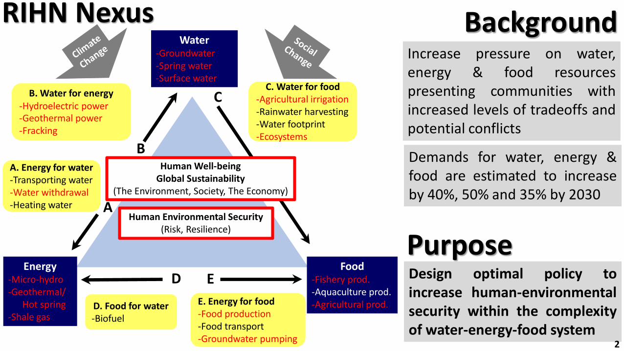
A
B
C
D E
Human Well-beingGlobal Sustainability
(The Environment, Society, The Economy)
C. Water for food-Agricultural irrigation-Rainwater harvesting-Water footprint-Ecosystems
E. Energy for food-Food production-Food transport-Groundwater pumping
D. Food for water-Biofuel
B. Water for energy-Hydroelectric power-Geothermal power-Fracking
A. Energy for water-Transporting water-Water withdrawal-Heating water
Human Environmental Security (Risk, Resilience)
Water-Groundwater-Spring water-Surface water
Energy-Micro-hydro-Geothermal/
Hot spring-Shale gas
Food-Fishery prod.-Aquaculture prod.-Agricultural prod.
RIHN Nexus Background
Demands for water, energy &food are estimated to increaseby 40%, 50% and 35% by 2030
Increase pressure on water,energy & food resourcespresenting communities withincreased levels of tradeoffs andpotential conflicts
PurposeDesign optimal policy toincrease human-environmentalsecurity within the complexityof water-energy-food system
2
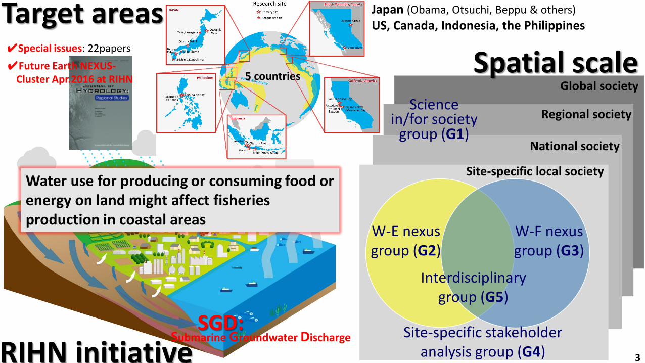
National society
Regional society
Global society
Site-specific local society
W-E nexus group (G2)
W-F nexus group (G3)
Interdisciplinary group (G5)
Site-specific stakeholder analysis group (G4)
Science in/for society
group (G1)
Spatial scale Target areas
RIHN initiative
Japan (Obama, Otsuchi, Beppu & others) US, Canada, Indonesia, the Philippines
Water use for producing or consuming food or energy on land might affect fisheries production in coastal areas
SGD:Submarine Groundwater Discharge
✔Special issues: 22papers✔Future Earth NEXUS-
Cluster Apr.2016 at RIHN 5 countries
3
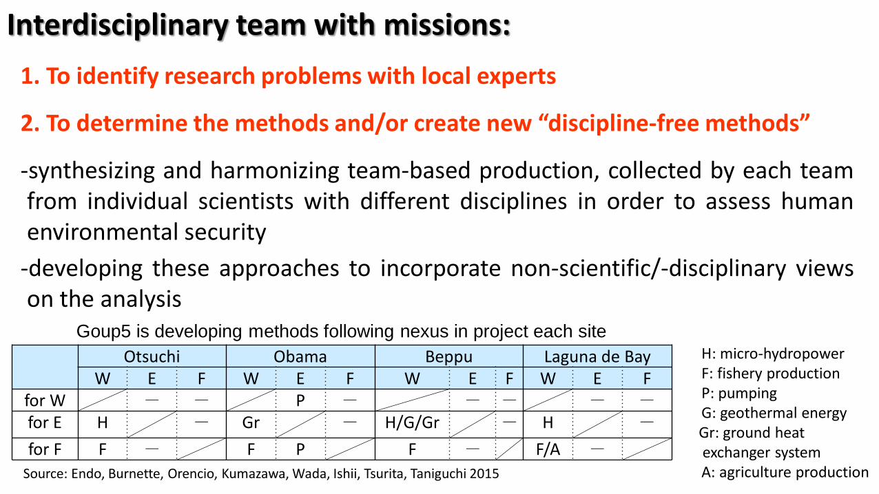
Interdisciplinary team with missions:1. To identify research problems with local experts
2. To determine the methods and/or create new “discipline-free methods”
-synthesizing and harmonizing team-based production, collected by each teamfrom individual scientists with different disciplines in order to assess humanenvironmental security
-developing these approaches to incorporate non-scientific/-disciplinary viewson the analysis
Otsuchi Obama Beppu Laguna de BayW E F W E F W E F W E F
for W - - P - - - - -for E H - Gr - H/G/Gr - H -
for F F - F P F - F/A -
H: micro-hydropowerF: fishery productionP: pumpingG: geothermal energyGr: ground heatexchanger systemA: agriculture production
Goup5 is developing methods following nexus in project each site
Source: Endo, Burnette, Orencio, Kumazawa, Wada, Ishii, Tsurita, Taniguchi 2015
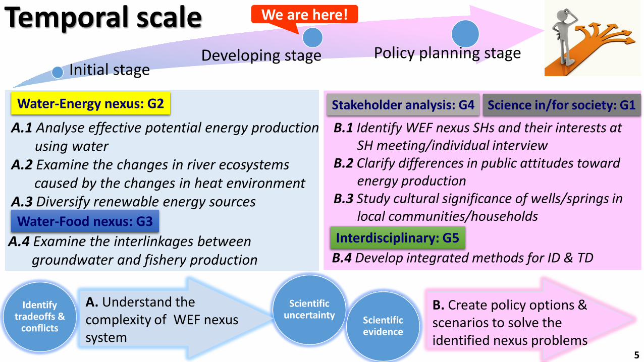
Developing stage Policy planning stage
We are here!Temporal scale
Water-Energy nexus: G2
A.1 Analyse effective potential energy production using water
A.2 Examine the changes in river ecosystems caused by the changes in heat environment
A.3 Diversify renewable energy sources
A.4 Examine the interlinkages between groundwater and fishery production
Water-Food nexus: G3
Stakeholder analysis: G4 Science in/for society: G1
B.1 Identify WEF nexus SHs and their interests at SH meeting/individual interview
B.2 Clarify differences in public attitudes toward energy production
B.3 Study cultural significance of wells/springs in local communities/households
B.4 Develop integrated methods for ID & TDInterdisciplinary: G5
Identify tradeoffs &
conflicts
Scientific uncertainty Scientific
evidence
A. Understand the complexity of WEF nexus system
B. Create policy options & scenarios to solve the identified nexus problems
Initial stage
5
Source: Endo, Orencio, Kumazawa, Burnett
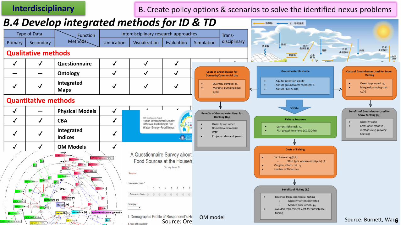
B. Create policy options & scenarios to solve the identified nexus problemsInterdisciplinary
B.4 Develop integrated methods for ID & TDType of Data Function
Methods Interdisciplinary research approaches Trans-
disciplinaryPrimary Secondary Unification Visualization Evaluation Simulation
Qualitative methods✔ ✔ Questionnaire ✔ ✔ ✔ — ✔— — Ontology ✔ ✔ ✔ ✔ ✔
✔ ✔ IntegratedMaps ✔ ✔ ✔ ✔ ✔
Quantitative methods✔ — Physical Models ✔ ✔ ✔ ✔ ✔✔ ✔ CBA ✔ ✔ ✔ - ✔
✔ ✔ IntegratedIndices ✔ ✔ ✔ ✔ ✔
✔ ✔ OM Models ✔ ✔ ✔ ✔ ✔
Source: Endo, Ishii, Sugimoto, Honda
Legend
Common fishery rights area
Spring point
Licensed fishery areas
Coastal conservation area
Tidal flat
Commercial port
Right of demarcated fishery
Fishing port area
Port area
Overlay Multiple Map
Commercial port
Coastal conservation area
Common fishery rights area
Licensed fishery areas
Fishing port
Source: Ishii
Source: Orencio
Costs of Groundwater for Domestic/Commercial Use
• Quantity pumped: qD
• Marginal pumping cost: cw(h)
Groundwater Resource
• Aquifer retention ability• Annual groundwater recharge: R• Annual SGD: SGD(h)
Costs of Groundwater Used for Snow-Melting
• Quantity pumped: qS
• Marginal pumping cost: cw(h)
SGD(h)
Benefits of Groundwater Used for Drinking (BD)
• Quantity consumed• Domestic/commercial
WTP• Projected demand growth
Benefits of Groundwater Used for Snow-Melting (BS)
• Quantity used• Costs of alternative
methods (e.g. plowing, heating)
Fishery Resource
• Current fish stock: X0
• Fish growth function: G(X,SGD(h))
Costs of Fishing
• Fish harvest: qX(E,X)o Effort (per week/month/year): E
• Marginal effort cost: cE
• Number of fishermen
Benefits of Fishing (BS)
• Revenue from commercial fishingo Quantity of fish harvestedo Market price of fish: pX
• Avoided replacement cost for subsistence fishing
Source: Burnett, WadaOM model 6
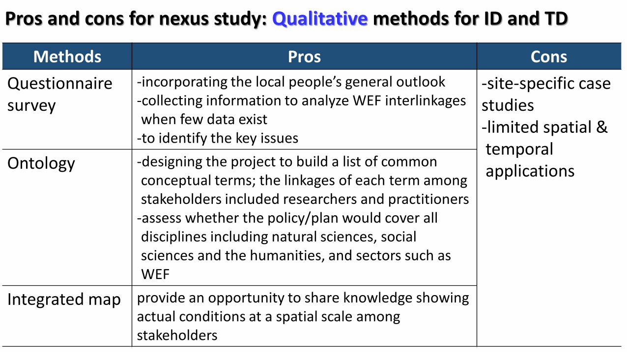
Pros and cons for nexus study: Qualitative methods for ID and TD
Methods Pros ConsQuestionnaire survey
-incorporating the local people’s general outlook-collecting information to analyze WEF interlinkages when few data exist
-to identify the key issues
-site-specific case studies-limited spatial &temporal applicationsOntology -designing the project to build a list of common
conceptual terms; the linkages of each term among stakeholders included researchers and practitioners
-assess whether the policy/plan would cover all disciplines including natural sciences, social sciences and the humanities, and sectors such as WEF
Integrated map provide an opportunity to share knowledge showing actual conditions at a spatial scale amongstakeholders
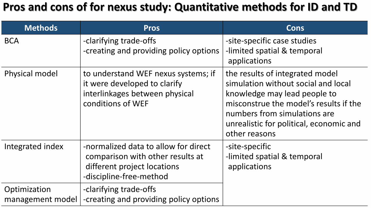
Pros and cons of for nexus study: Quantitative methods for ID and TD
Methods Pros ConsBCA -clarifying trade-offs
-creating and providing policy options-site-specific case studies-limited spatial & temporal applications
Physical model to understand WEF nexus systems; if it were developed to clarify interlinkages between physical conditions of WEF
the results of integrated model simulation without social and local knowledge may lead people to misconstrue the model’s results if the numbers from simulations are unrealistic for political, economic and other reasons
Integrated index -normalized data to allow for direct comparison with other results at different project locations
-discipline-free-method
-site-specific-limited spatial & temporal applications
Optimizationmanagement model
-clarifying trade-offs-creating and providing policy options
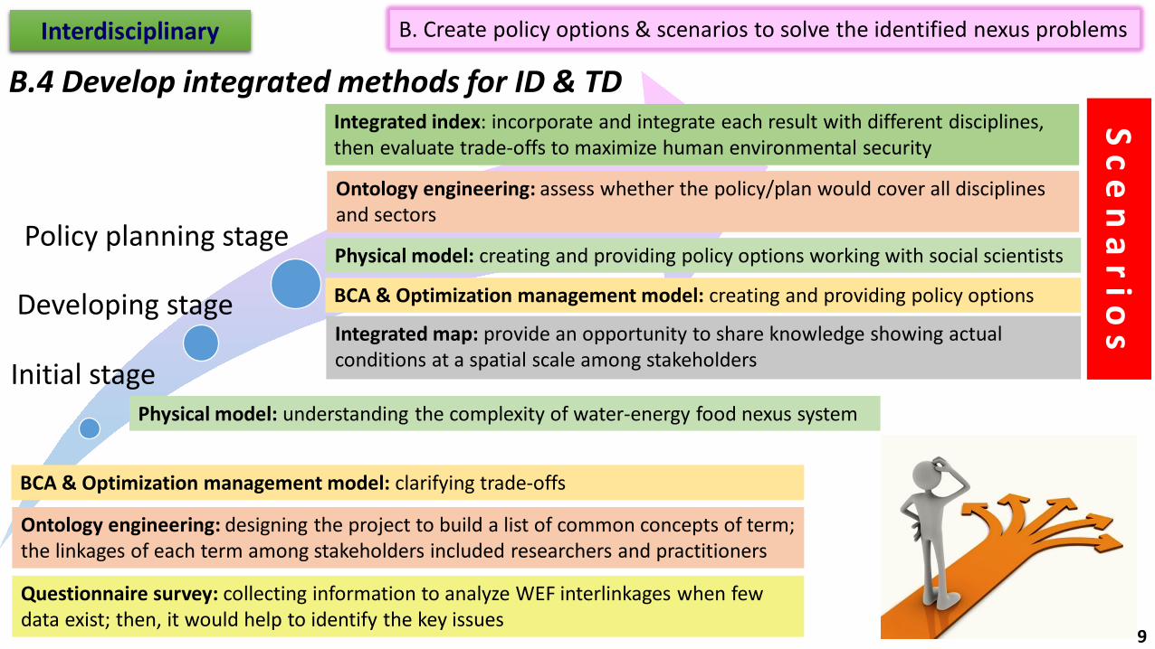
B. Create policy options & scenarios to solve the identified nexus problemsInterdisciplinary
B.4 Develop integrated methods for ID & TD
Initial stage
Developing stage
Policy planning stage
Questionnaire survey: collecting information to analyze WEF interlinkages when few data exist; then, it would help to identify the key issues
Ontology engineering: designing the project to build a list of common concepts of term; the linkages of each term among stakeholders included researchers and practitioners
BCA & Optimization management model: clarifying trade-offs
Physical model: understanding the complexity of water-energy food nexus system
BCA & Optimization management model: creating and providing policy options
Physical model: creating and providing policy options working with social scientists
Integrated map: provide an opportunity to share knowledge showing actual conditions at a spatial scale among stakeholders
Integrated index: incorporate and integrate each result with different disciplines, then evaluate trade-offs to maximize human environmental security
Ontology engineering: assess whether the policy/plan would cover all disciplines and sectors
S c e n a r i o s
9
Thank you very much.
The 3rd WEF nexus meeting in Kyoto (October 2015) 10