philipstown planning board vfw hall, kemble avenue, cold spring
TRANSCRIPT

Philipstown Planning Board VFW Hall, Kemble Avenue, Cold Spring, New York
March 15, 2012 Agenda
Pledge of Allegiance Roll Call
1. Drake Petroleum - Site plan approval- 1122 Route 9D, Garrison: Request for return of escrow funds
2. ESP - Site plan approval and request to re-zone - 3330 Route 9, Cold Spring: New submission
3. Garrison Properties, LLC (Garrison Station Plaza) - Site plan approval- 7 Garrison Landing, Garrison: Full EAF Parts 1, 2, & 3
4. Viewsave, LLC/Hudson Valley 2009 Trust/Gerald E. Morris- Subdivision plat showing merger and lot line adjustment - Beverly Warren Road, Garrison: Final approval (no submission)
5. Mary Ellen FingerlEntergy - 3 Horsemen's Trail, Cold Spring: Landscape plan a. Approval of three-lot subdivisionlb. Approval of site plan (Entergy): Full EAF
Parts 1,2, & 3
Adjourn
Michael Leonard, Chairman
Note: All items may not be called. Items may not always be called in order.

February 8, 2012
Planning Board Town of Philipstown 238 Main Street P.O. Box 155 Cold Spring, NY 10516
Re: Application by Nancy Olnick Spanu for lot line adjustments and approval of residential site plan
Members of the Planning Board:
We are residents of Indian Brook Rd, Garrison, Tax Map # 49.-1-70. Our property fronts on Indian Brook Rd and Avery Rd adjacent to the NYC Aqueduct, in close proximity to the property of the above referenced applicant. We shall be away and, therefore, unable to attend the Public hearing on the referenced application scheduled for February 16, 2012.
We wish to express our strident opposition to the Planning Board's granting approval to the referenced application due to the further negative impact it will have on our right to the peaceful enjoyment of our property. That right to peaceful enjoyment has been seriously compromised already by the activity, incessant noise pollution, and light pollution emanating from the Olnick Spanu property for the past several years. We have written to the owners of the property, copy of the letter enclosed, requesting redress from the egregious disturbance of our lives by their actions but have received no reply nor relief. We enlisted the assistance of former Town Board Member, Barbara Scuccimarra in addressing the problem but, she was unable to effect a solution during her tenure.
As you will note from reading the letter, sent by us to Olnick Spanu, their keeping of donkeys, along witb.,-weafe·Tolcr,--~ny other animals in a once quiet, idyllic neighborhood has serlOuSIydegraae-d the lives of their neighbors on a constant basis, both day & night. In addition to the unbearable noise, the light pollution at night is extremely disturbing and in opposition to the thrust of Philipstown environmental policies. Granting approval to the referenced application would result in additional visual disturbance, noise, scenic degradation, and increased traffic in a quiet residential zone serviced only by unpaved roads and unsafe bridges in need of repair.

As we are sure that you are aware, both Avery Road and Indian Brook Road were severely damaged by recent stonns. Indian Brook Road remains seriously compromised by the failure of the bridge over Indian Brook and its weight limit. As well, the bridge over Indian Brook on Avery Road, near the junction of Indian Brook Road is in need of repair. Further, Indian Brook Road remains closed to through traffic due to the collapse of the bank in front of our home. The large volume of heavy truck traffic that will be generated during the construction of this immense structure, and the inevitable increase in vehicular traffic resulting from those traveling these roads to view the art collection proposed to be housed in the structure cannot be supported.
Another significant reason to deny this application is that the size and scope of the proposed project is antithetical to the recently enacted Zoning Regulations in the Town of Philipstown.
We call upon you, therefore, to deny this application. Further, we request that an investigation of the property by the Philipstown Building Department be conducted to detennine if current uses are legal. The peaceful enjoyment of our property and that of our neighbors has been seriously impacted by this property. As well, we believe the resulting diminution of our quality of life and that of our neighbors by this property has negatively affected our property values. Granting approval to this application for such a huge structure that, in all likelihood, will require constant lighting and be visible from Avery Road and all of the properties in the surrounding area, will increase the negative impact of this property on all of the neighboring properties and on the town ofPhilipstown and on the quality of life in the area.
Sincerely,
~vrLJ AfbOuAP~ Jerry & Vicki Albanese Tel: 845-424-3451 215 Indian Brook Rd email: [email protected] Garrison, NY 10524
cc: Town Board, Town of Philipstown Kevin Donahue, Code Enforcement Officer, Philipstown Building Department Richard Shea, Supervisor, Town of Philipstown Roger Chirico, Highway Superintendant, Philipstown Highway Department
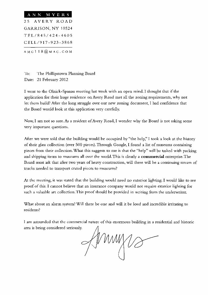
ANN MYERS
25 AVERY ROAD
GARRISON, NY 10524
TEL/845/424-4605
CELL/917-923-3868
To: The Phillipstown Planning Board
Date: 21 February 2012
I went to the Olnick-Spanau meeting last week with an open mind. I thought that if the
application for their huge residence on Avery Road met all the zoning requirements, why not
let them build? After the long struggle over our new zoning document, I had confidence that
the Board would look at this application very carefully.
Now, I am not so sure. As a resident ofAvery Road, I wonder why the Board is not asking some
very important questions.
Mter we were told that the building would be occupied by "the help," I took a look at the history
of their glass collection (over 500 pieces). Through Coogle, I found a list of museums containing
pieces from their collection. What this suggests to me is that the "help" will be tasked with packing
and shipping items to museums all over the world. This is clearly a cotntnercial enterprise. The
Board must ask that after two years of heavy construction, will there will be a continuing stream of
trucks needed to transport crated pieces to museums?
At the meeting, it was stated that the building would need no exterior lighting. I would like to see
proof of this. I cannot believe that an insurance company would not require exterior lighting for
such a valuable art collection. This proof should be provided in writing from the underwriter.
What about an alarm system? Will there be one and will it be loud and incredible irritating to
residents?
I am astounded that the commercial nature of this enormous building in a residential and historic
area is being considered seriously.

ANN MYERS
25 AVERY ROAD
GARRISON, NY 10524
TEL/845/424-4605
CELL/917-923-3868
Partial list of exhibitions listed on Olnick-Spanau site (about one a year):
Musee des Arts Decoratifs in Montreal, May 27 - October 3, 1999.
American Craft Museum, January, 2000
Museum of Fine Arts Houston, June 6 - August 1, 2004
Museum of Glass, September 4 - November 7,2004
Detroit Institute ofArts, December, 2004 - February, 2005
Mint Museum, April, 2005
Museums &Institutions listed on OInick-Spanau site: Art Media Cultural Centre
Brescia Mostre
Casa Italiana Zerilli-Marimo
Centro Studio Vetro
Chrysler Museum ofArt
Corning Museum of Glass
Denver Art Museum
The Detroit Institute ofArts
Exhibitions International
Frist Center for the Visual Arts
Instituto Italiano di Cultura - New York
Italian Cultural Institute UK
Mingei International Museum
The Mint Museums
Museo del Vidrio
Museum ofArts & Design
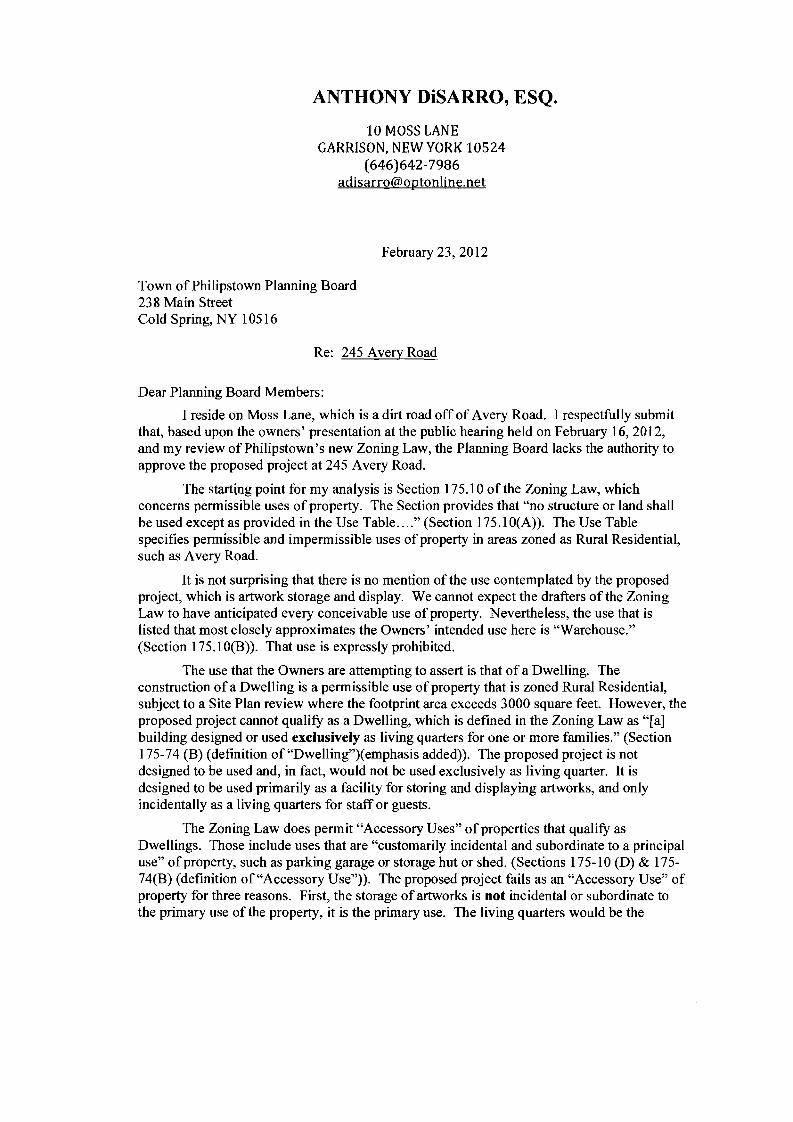
ANTHONY DiSARRO, ESQ.
10 MOSS LANE GARRISON, NEW YORK 10524
(646)642-7986 [email protected]
February 23,2012
Town of Philipstown Planning Board 238 Main Street Cold Spring, NY 10516
Re: 245 Avery Road
Dear Planning Board Members:
I reside on Moss Lane, which is a dirt road off of Avery Road. I respectfully submit that, based upon the owners' presentation at the public hearing held on February 16,2012, and my review of Philipstown's new Zoning Law, the Planning Board lacks the authority to approve the proposed project at 245 Avery Road.
The starting point for my analysis is Section 175.10 of the Zoning Law, which concerns permissible uses of property. The Section provides that "no structure or land shall be used except as provided in the Use Table ...." (Section 175.1 O(A)). The Use Table specifies permissible and impermissible uses of property in areas zoned as Rural Residential, such as Avery Road.
It is not surprising that there is no mention of the use contemplated by the proposed project, which is artwork storage and display. We cannot expect the drafters of the Zoning Law to have anticipated every conceivable use of property. Nevertheless, the use that is listed that most closely approximates the Owners' intended use here is "Warehouse." (Section 175.10(B)). That use is expressly prohibited.
The use that the Owners are attempting to assert is that of a Dwelling. The construction of a Dwelling is a permissible use ofproperty that is zoned Rural Residential, subject to a Site Plan review where the footprint area exceeds 3000 square feet. However, the proposed project cannot qualifY as a Dwelling, which is defmed in the Zoning Law as "[a] building designed or used exclusively as living quarters for one or more families." (Section 175-74 (B) (definition of "Dwelling")(emphasis added)). The proposed project is not designed to be used and, in fact, would not be used exclusively as living quarter. It is designed to be used primarily as a facility for storing and displaying artworks, and only incidentally as a living quarters for staff or guests.
The Zoning Law does permit "Accessory Uses" of properties that qualify as Dwellings. Those include uses that are "customarily incidental and subordinate to a principal use" of property, such as parking garage or storage hut or shed. (Sections 175-10 (D) & 17574(B) (definition of "Accessory Use")). The proposed project fails as an "Accessory Use" of property for three reasons. First, the storage of artworks is not incidental or subordinate to the primary use of the property, it is the primary use. The living quarters would be the

incidental and subordinate use of the property, which is the converse of the situation authorized under the Zoning Law.
Second, Accessory Structures must be limited in proportionate size to less than half of the floor space of the principal use area. (Section 175-74 (B)(definition of "Accessory Structure")). The proposed project cannot meet this test, as the area that will store and display artworks will be substantially greater--indeed, it will dwarf--the area devoted to living quarters.
Third, accessory use structures, such as garages, whether they are attached or detached, may not "exceed 1000 square feet in footprint area" and may not create "noise, traffic, dust, odor or other impacts that exceed those normally associated with single-family residential uses". (Section 175-10 (D)). The proposed project would seem to fail these tests as well.
The only other provision of the Zoning Law that might arguably apply by analogy here pertains to Home Occupations. This is where a resident seeks to conduct a "small-scale low-impact business and professional use" on a residential property." (Section 175-41). Home Occupations are permissible as of right where (i) less than 30% of the floor space will be use by the Home Occupation activity and (ii) the floor space occupied by such activity will be less than 1000 square feet. (Section 175-41(B)(l)(a)). The proposed project fails to meet either condition. Moreover, the proposed project cannot qualify as a Home Occupation because such usage must be "incidental and secondary to the use of a dwelling unit for residential purposes" and must be "conducted in a manner that does not give the outward appearance of a business, does not infringe on the right of neighboring residents to enjoy the peaceful occupancy of their dwelling units, and does not alter the character of the neighborhood." (Section 175-41(B)(l )(b)). The proposed project fails to satisfy each of these conditions.
Significantly, a Home Occupation utilizing more than 30% of the available floor space or more than 1000 square feet can be authorized by Special Permit. (Section 17541 (B)(2)). However, the Zoning Law unequivocally states: "In no case shall the area occupied by the home occupations allowed by special permit exceed the lesser of 40% of the floor space of the primary dwelling unit or 2,000 square feet". (Section 175-41(B)(2)(a)). Consequently, the proposed project cannot even be authorized by Special Permit. It is most telling that the Zoning Law precludes the municipal boards from exercising discretion to allow large or predominant Home Occupations. It clearly indicates that the lawmakers intended to deprive the Planning Board of the power to authorize projects such as the one proposed here.
In sum, the thrust of the new Zoning Law is that, for purposes of determining whether a structure constitutes a dwelling or residence, the residential portion of the structure must predominate over the portion devoted to other uses. If the square footage devoted to the residence does not substantially exceed the square footage allocated to other functions, the building is not a residence. The proposed project clearly fails in this regard.
Sincerely,
().. {1, /] Ant1i(;~y DiSarro

Daniel P. Paduano 24 Quiet Acres Lane
PO Box 135 Garrison, NY 10524
Mr. Michael Leonard Chairman The Philipstown Planning Board 238 Main Street Cold Spring, NY 10516
Dear Mr. Leonard and the Members of the Philipstown Planning Board,
We are writing you on behalf of Nancy Olnick's and Giorgio Spanu's building proposal that is being presented to you on 2-16-12. We would like you to know that they showed us the renderings for the proposal and we feel that once again Nancy and Giorgio have commissioned a subtle but elegant structure hidden among the trees. We are confident their choice of site, building materials, and landscaping will result in a minimal impact on Avery Road.
Nancy and Giorgio have always been caring neighbors. We have contiguous acreage and have an extremely amicable relationship. We all respect our properties and the surrounding neighborhood. As citizens of Philipstown, we appreciate their proposed addition to the tax base.
Respectfully,
Daniel P. Paduano Nancy C. Paduano

mown of Jt,ilipafoWll HIGHWAY DEPARTMENT
50 Fishkill Road Cold Spring, New York 10516
(845) 265-3530 Roger M. Ch1rtco Fax (8451 265-7886 Highway Super1ntendent
February 8, 2012
Anthony Merante, Chairman, and Planning Board TOWN OF PHILIPSTOWI'J PLAI'JNING BOARD PO Box 55 Cold Spring, NY 10516
RE: Entergy Emergency Operations Center - Site Plan Horsemen's Trail
Dear Chairman and Board members:
This letter is being sent to correct an error in the original. In the first paragraph it should have read the applicant's proposal for Entergy Emergency Operations Facility. Also, on note #2 the end of the sentence should have read north instead of south. Attached is the corrected letter.
Thank you Maureen Etta Highway Clerk
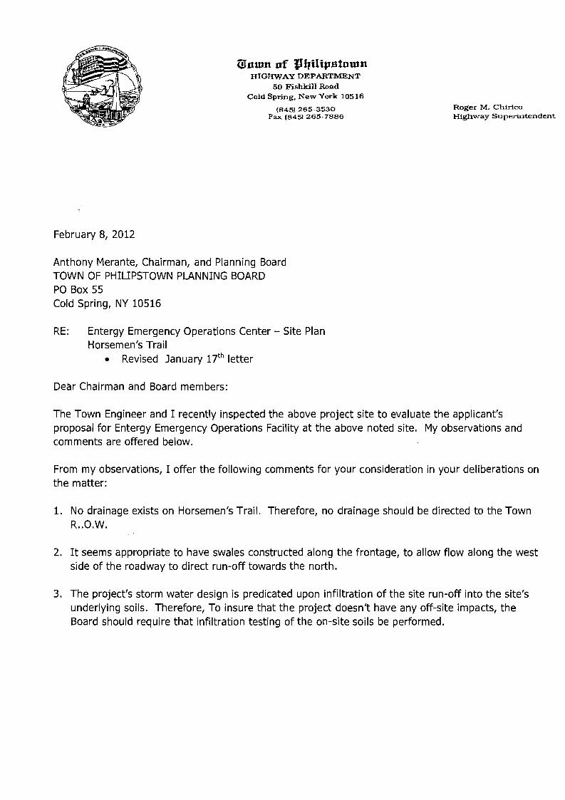
IDnmn of JqUtpatontll HIGHWAY DEPARTMENT
50 Fishkill Road Cold Spring. New York 10516
Roger M. Chirico(845) 265-3530 Fax (8451 265-7886 HighW"ay Superintendent
February 8, 2012
Anthony Merante, Chairman, and Planning Board TOWN OF PHILIPSTOWN PLANNING BOARD PO Box 55 Cold Spring, NY 10516
RE: Entergy Emergency Operations Center - Site Plan Horsemen's Trail
• Revised January 17th letter
Dear Chairman and Board members:
The Town Engineer and I recently inspected the above project site to evaluate the applicant's proposal for Entergy Emergency Operations Facility at the above noted site. My observations and comments are offered below.
From my observations, I offer the following comments for your consideration in your deliberations on the matter:
1. No drainage exists on Horsemen's Trail. Therefore, no drainage should be directed to the Town R..O.W.
2. It seems appropriate to have swales constructed along the frontage, to allow flow along the west side of the roadway to direct run-off towards the north.
3. The project's storm water design is predicated upon infiltration of the site run-off into the site's underlying soils. Therefore, To insure that the project doesn't have any off-site impacts, the Board should require that infiltration testing of the on-site soils be performed.

I trust that these comments are adequate for your needs, and thank you for referring this project to my office, to allow me to review and inspect the site's activities and potential impacts to Town facilities. If you have any questions, please contact me.
Sincerely, ---;>
:::p;r~~ R~~hiric( Highway Superintendent
cc: Ronald J. Gainer, PE, PLLC
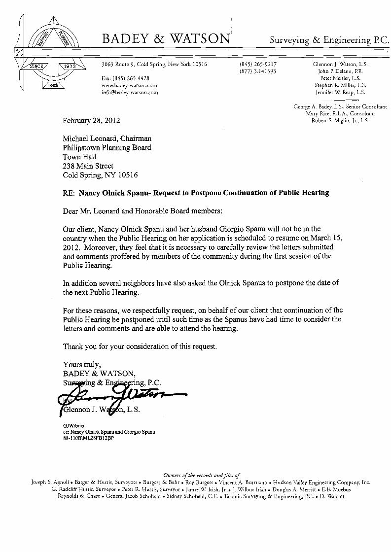
BADEY & WATSON Surveying & Engineering PC.
3063 Route 9, Cold Spring, New York 10516 (845) 265-9217 Glennon J. Watson, L.S. (877) 3141593 John P Delano, PE.
Fax: (845) 265-4428 Peter Meisler, L.S. www.badey-watson.com Stephen R. Miller, L.S. [email protected] Jennifer W Reap, L.S.
February 28,2012
George A. Badey, L.S., Senior Consultant Mary Rice, R.L.A., Consultant
Robert S. Miglin, Jr., L.S.
Michael Leonard, Chainnan Philipstown Planning Board Town Hall 238 Main Street Cold Spring, NY 10516
RE: Nancy Olnick Spanu- Request to Postpone Continuation of Public Hearing
Dear Mr. Leonard and Honorable Board members:
Our client, Nancy Olnick Spanu and her husband Giorgio Spanu will not be in the country when the Public Hearing on her application is scheduled to resume on March 15, 2012. Moreover, they feel that it is necessary to carefully review the letters submitted and comments proffered by members of the community during the first session of the Publi~ Hearing.
In addition several neighbors have also asked the Olnick Spanus to postpone the date of the next PublIc Hearing.
For these reasons, we respectfully request, on behalf of our client that continuation of the Public Hearing be postponed until such time as the Spanus have had time to consider the letters and comments and are able to attend the hearing.
Thank you for your consideration of this request.
GJWlbms cc: Nancy Olnick Spanu and Giorgio Spanu 88-110B\ML28FB12];lP
Owners ofthe records and files of Joseph S. Agnoli • Barger & Hustis, Surveyors. Burgess & Behr • Roy Burgess. Vincent A Burruano • Hudson Valley Engineering Company, Inc.
G. Radcliff Hustis, Surveyor. Peter R. Hustis, Surveyor. James W Irish, Jr.• J. Wilbur Irish. Douglas A Merritt. E.B. Moebus Reynolds & Chase. General Jacob Schofield. Sidney Schofield, C.E.• Taconic Surveying & Engineering, Pc. • D. Wa1cutt
Town of Philipstown 238 Main Street
Cold Spring New York 10516
PLANNING BOARD
SITE PLAN APPLICATION PACKAGE
MINOR PROJECT
~ r~, ,.m'" /'.20 - J-Ii
Proj ect Narne: es;:?
Date: / z-- .2--3 -- ! I
112811
----
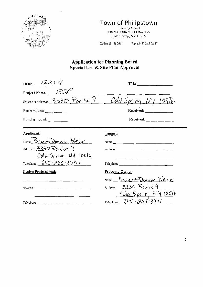
Town of Philipstown Planning Board
238 Main Street, PO Box 155 Cold Spring, NY 105] 6
Office (845) 265- Fax (845) 265-2687
Application for Planning Board Special Use & Site Plan Approval
/)..23"// TM# _Date:
Project Name: _--=£=.:5:.........:.-f/ _
Street Address: 3330 ROtA+e 9 &/d Sf!CWj M( loSTG Fee Amount: Received: _
Bond Amount: ---- Received: _
Applicant:
Name:3c().l'~~o\'wV\ t<-ehy Address 3330 ~O<A+e g
Co\ cJ. S\9V1 n~ 1\J\f Io~ ~
Telephone ~4\/(fihr· 3 7'7 /
Design Professional:
Address _
Telephone _
Tenant:
Name _
Address _
Telephone _
Property Owner
Name fn·{A~-<-+3)6VlnV\. I<e.-hr Address 3330 \<OlA~ e. cr _
l!,o\c1 S~(, Ylj N\/ 10 (/~
Telephone ~lfS"" ~ CJ,.(p r, 3?1/
2
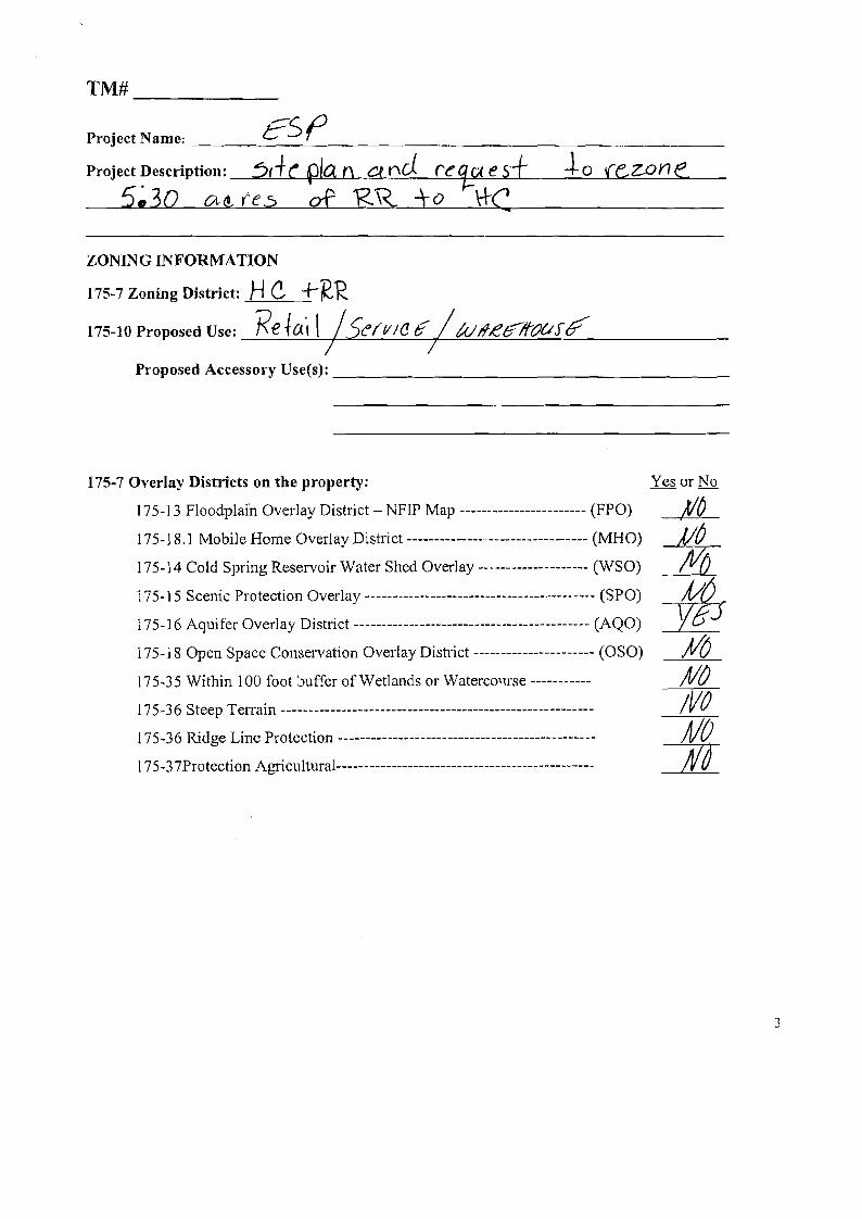
TM# _
?SLJProject Name: '--_~r _
Project Description: :5,+e pIa (\ a nd re q..c< e s±_--,,~-.:::o,,----,--,(e.~ZO=.=....;,.n---:le _
5~30 C!.tt res of 'RR +0 ttC
ZONIN G INFORMATION
175-7 Zoning District: Hc. +R-"R,
175-10 Proposed Use: Reto.·, \ ISe(fI/(J Ii' /tull,e6?f(JUJ~ I /
Proposed Accessory Use(s): _
175-7 Overlay Districts on the property:
175-13 Floodplain Overlay District - NFIP Map ----------------------- (FPO)
175-18.1 Mobile Home Overlay District ------------------------------- (MHO)
175-14 Cold Spring Reservoir Water Shed Overlay -_ ...---------------- (WSO)
175-15 Scenic Protection Overlay ------------------------------------------ (SPO)
175-16 Aquifer Overlay District ------------------------------------------- (AQO)
175-18 Open Space Conservation Overlay District ---------------------- (OSO)
175-35 Within 100 foot buffer of Wetlands or Waterco'1rse ----------
175-36 Steep Terrain --------------------------------------------------------
175-36 Ridge Line Protection ----------------------------------------------
175-37Protection Agricu1tural------ ----------------------------------------
3

------
TM# _
Project Name: t?_-yJ _
175-11 Density and Dimensional Regulations
Zoning District /ft;fKf< Required Existing Proposed Complies Variance
Minimum front yard setback
Measured from the travel way Town Road
Measured from the travel way County/State
Minimum side yard setback f,£" Minimum side yard setback (2) f!I
~6(
t9.o I
If
~or-
J..O~~\
10
"55 I
Z,O
IS
\/C~
ye.S (Pl
Minimum side yard setback (3)
Minimum rear yard setback
Maximum impervious surface coverage
Maximum height
Maximum footprint non-residential structures,
3~'
~I)%
~h() ~
I ~rflfO ! I
I
to7 rfJJ6 PJO tf7C7
to? J/fJ/ )/)f
" filA !
/~J fj If:)
!I(f
SUBMISSION:
13 copies with one electronic file in .pdf format of the following;
I. Pre-Application meeting decision and comments 2. Application 3. Proof of Ownership 4. Site Plan 5. A long-fonn Environmental Assessment Form or Draft Environmental Impact Statement. 6. An agricultural data statement as defined in §175-74, if required by §175-37C. 7. The Site Plan application fee, as established by the Town Board and any required escrow
deposit for review costs, as required by the Planning Board. 8. FEE: Received: ------ 9. Escrow: Received:
4
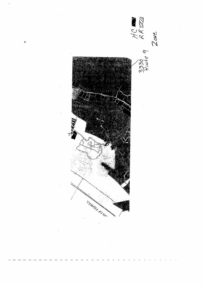
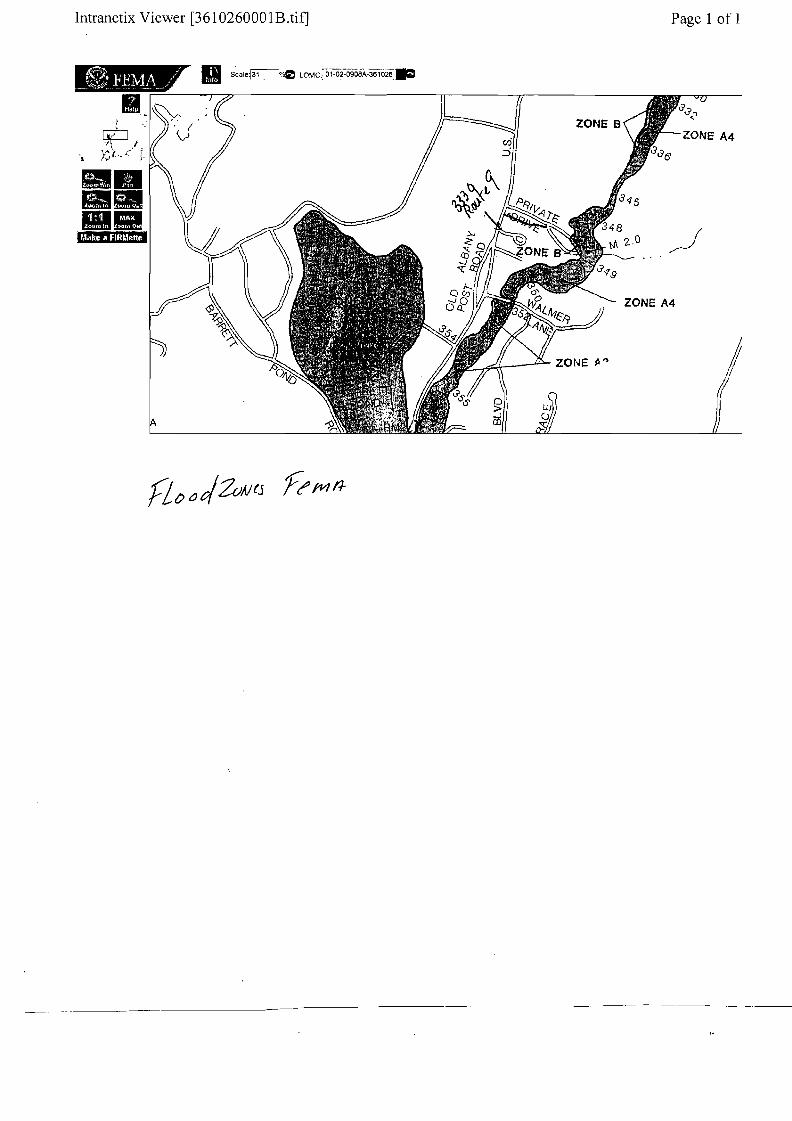
Intranetix Viewer [3610260001B.tif] Page 1 of 1
••••••'MbmihJ,f,tMl
o > as
','
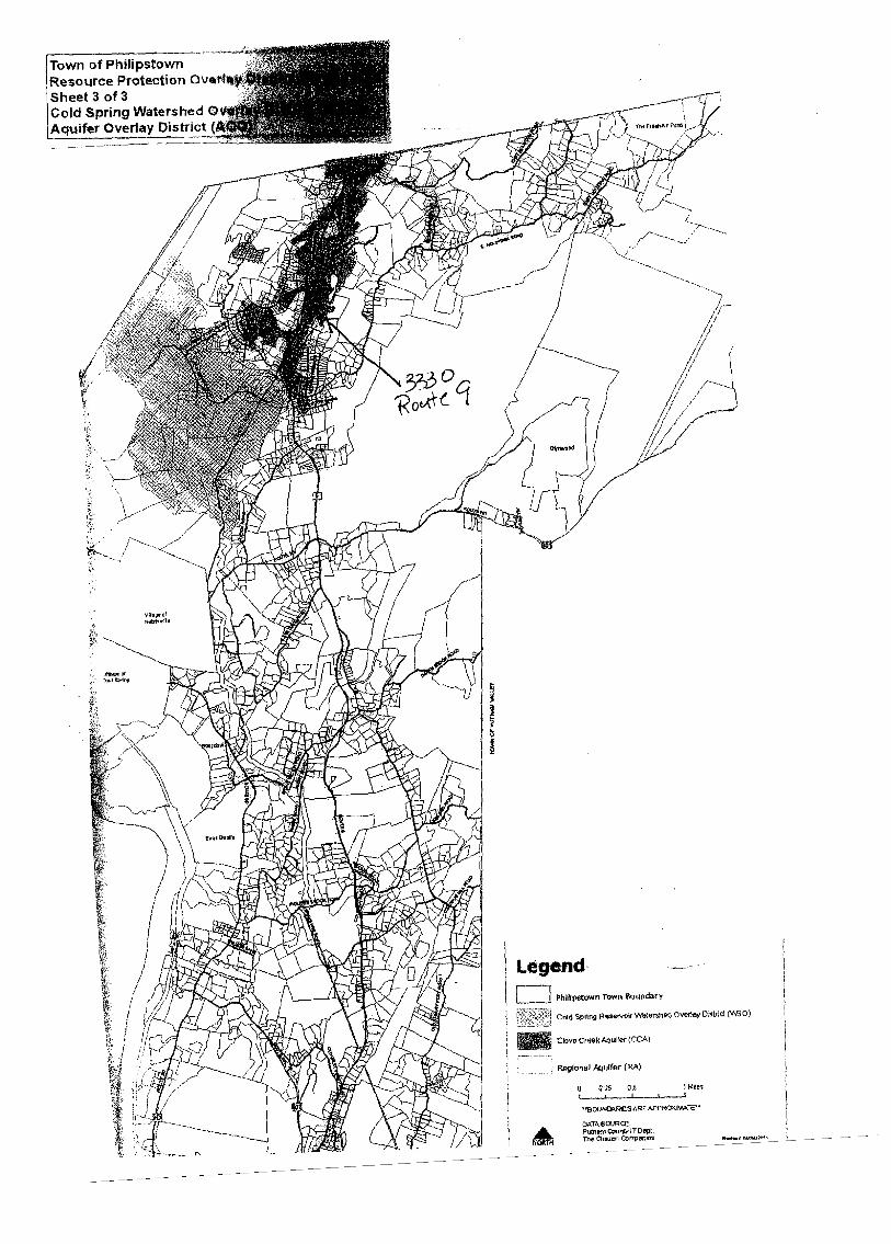
h"lipstown I'f Town of P ~rotection OV6 .'Resource
Sheet 3 ~f 3 Watershed 0 Cold SpnngrI Y Distric~J Aquifer ov_e.--a-
I
\ Legend-II -I TQwn !l<>undary . 0)I PhlKpstown ovortoy D~lncl (W>L.._.. . R~erv'OirWal:llrstleQ j Cold spong
, lJter(CCAIi _ ClovQCre13kAQ
) ,..--'-~.-: I hlulfer (RA)
i 'RE9IQnO 1M...I --.. 05 I I 0 0.15 I ,
I I ' EAPPROXIMATE! "Bc<JN!lI'RI""AR
\ OAThS~~:ITDept ' PlJI:narn CorT1ltlfll!lSI • ~Ch.,on
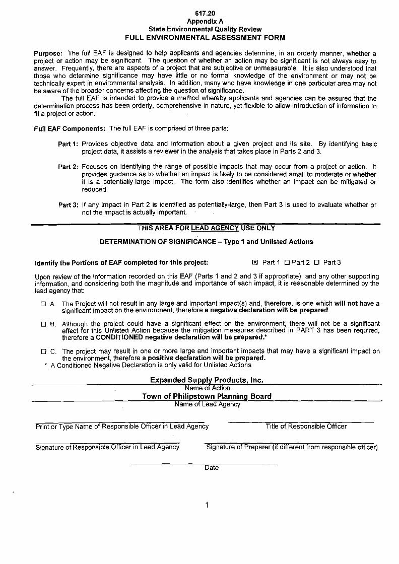
617.20 Appendix A
State Environmental Quality Review FULL ENVIRONMENTAL ASSESSMENT FORM
Purpose: The full EAF is designed to help applicants and agencies determine, in an orderly manner, whether a project or action may be significant. The question of whether an action may be significant is not always easy to answer. Frequently, there are aspects of a project that are sUbjeotive or unmeasurable. It is also understood that those who determine significance may have little or no formal knowledge of the environment or may not be technically expert in environmental analysis. In addition, many who have knowledge in one particular area may not be aware of the broader concerns affecting the question of significance.
The full EAF is intended to provide a method Whereby applicants and agencies can be assured that the determination process has been orderly, comprehensive in nature, yet flexible to allow introduction of information to fit a project or action.
Full EAF Components: The full EAF is comprised of three parts:
Part 1: Provides objective data and information about a given project and its site. By identifying basic project data, it assists a reviewer in the analysis that takes place in Parts 2 and 3.
Part 2: Focuses on identifying the range of possible impacts that may occur from a project or action. It provides guidance as to whether an impact is likely to be considered small to moderate or whether it is a potentially-large impact. The form also identifies whether an impact can be mitigated or reduced.
Part 3: If any impact in Part 2 is identified as potentially-large, then Part 3 is used to evaluate whether or not the impact is actually important.
THIS AREA FOR LEAD AGENCY USE ONLY
DETERMINATION OF SIGNIFICANCE - Type 1 and Unlisted Actions
Identify the Portions of EAF completed for this project: IRI Part 1 0 Part 2 0 Part 3
Upon review of the information recorded on this EAF (Parts 1 and 2 and 3 if appropriate), and any other supporting information, and considering both the magnitude and importance of each impact, it is reasonable determined by the lead agency that:
o A. The Project will not result in any large and important impact(s) and, therefore, is one which will not have a significant impact on the environment, therefore a negative declaration will be prepared.
o B. Although the project could have a significant effect on the environment, there will not be a significant effect for this Unlisted Action because the mitigation measures described in PART 3 has been required, therefore a CONDITIONED negative declaration will be prepared.*
o C. The project may result in one or more large and important impacts that may have a significant impact on the environment, therefore a positive declaration will be prepared.
* A Conditioned Negative Declaration is only valid for Unlisted Actions
Expanded Supply Products, Inc. Name of Action
Town of Philipstown Planning Board Name of Lead Agency
Print or Type Name of Responsible Officer in Lead Agency Title of Responsible Officer
Signature of Responsible Officer in Lead Agency Signature of Preparer (if different from responsible officer)
Date
1

PART 1 - PROJECT INFORMATION Prepared by Project Sponsor
NOTICE: This document is designed to assist in determining whether the action proposed may have a significant effect on the environment. Please complete the entire Form, Parts A through E. Answers to these questions will be considered as part of the application for approval and may sUbject to further verification and public review. Provide any additional information you believe will be needed to complete Parts 2 and 3.
It is expected that completion of the full EAF will be dependent on information currently available and will not involve new studies, research or investigation. If information requiring such additional work is unavailable, so indicate and specify each instance. NAME OF ACTION Expanded Supply Products LOCATION OF ACTION (include Street Address. Municipality and County) 3330 Route 9, Town Philipstown, Putnam County, NY NAME OF APPLICANT/SPONSOR Expanded Supply Products, Inc. ADDRESS 3330 Route 9 CITY/PO Cold Spring, New York BUSINESS TELEPHONE (845) 265-3771 NAME OF OWNER (if different) Same as above ADDRESS
CITY/PO
BUSINESS TELEPHONE
DESCRIPTION OF ACTION: Modification of Approved Site Plan for the proposed cobuilding addition and a new 6,400 SF storage building. ~eMoi/~d
nstruction of a 1000 SF
STATE ZIP CODE 10516
STATE ZIP CODE
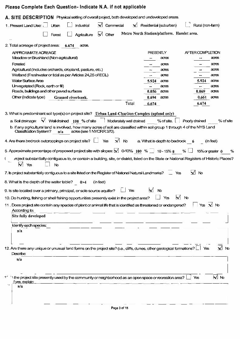
Please Complete Each Question - Indicate N.A. if not applicable
A. Site Description
Physical setting of overall project, both developed and undeveloped areas.
1. Present land use: 0 Urban Dlndustrial l:RI Commercial 0 Residential (SUburban) 0 Rural (non-farm) o Forest 0 Agriculture DOther _
2. Total acreage of project area: 3.569 acres:
APPROXIMATE ACREAGE PRESENTLY AFTER COMPLETION
____acresMeadow or Brushland (Non-agricultural) acres Forested Landscaping 0.10 acres .....::.0.:.::8~0__acres
____acresAgricultural (includes orchards, cropland, pasture, etc.) acres Wetland (Freshwater or tidal as per Article 24, 25 of ECl) acres ____acres
____acresWater Surface Area acres Unvegetated (Rock, earth or fill) (gravel drive) 1.73 acres --!.1~.6~6:....-_acres
Roads, Buildings and Other Paved Surfaces 0.28 acres ~0~.4~0:....-_acres
Other (Indicate type) Outdoor storage 1.46 acres .....::.0.:.:,7...:.1__acres
3. What is predominant soil type(s) on project site?~U~rb~a~n.:...:::C~u'_=_t~&:..:F~i~II ------------- a. Soil drainage l:RI Well drained 100 % of site 0 Moderately well drained % of site
o Poorly drained % of site b. If any agricultural land is involved, how many acres ef soil are classified within soil group 1 through 4 of the
NYS land Classification System? acres. (See 1 NYCRR 370)
4. Are there bedrock outcroppings on the project site? 0 Yes l:RI No a. What is depth to bedrock? 6+ (in feet)
2
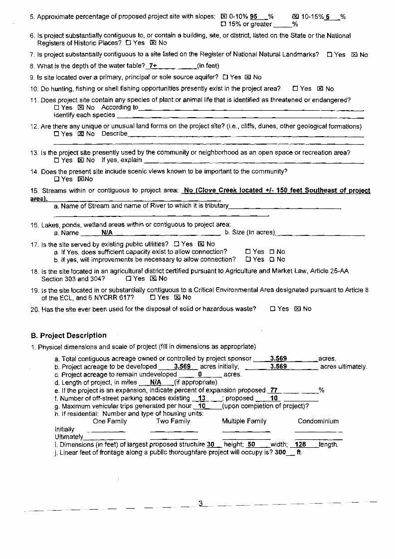
5. Approximate percentage of proposed project site with slopes: [E) 0-10% ~% [E) 10-15%_5_% o 15% or greater __%
6. Is project substantially contiguous to, or contain a building, site, or district, listed on the State or the National Registers of Historic Places? 0 Yes [E) No
7. Is project substantially contiguous to a site listed on the Register of National Natural Landmarks? 0 Yes I:RI No
8. What is the depth of the water table? 7+ (in feet)
9. Is site located over a primary, principal or sole source aquifer? 0 Yes lEI No
10. Do hunting, fishing or shell fishing opportunities presently exist in the project area? 0 Yes lEI No
11. Does project site contain any species of plant or animal life that is identified as threatened or endangered? DYes [E) No According to _ Identify each species _
12. Are there any unique or unusual land forms on the project site? (Le., cliffs, dunes, other geological formations) DYes l:&I No Describe, _
13. Is the project site presently used by the community or neighborhood as an open space or recreation area? DYes [E) No If yes, explain _
14. Does the present site include scenic views known to be important to the community? DYes [E)No
15. Streams within or contiguous to project area: No (Clove Creek located +1- 150 feet Southeast of project area).
a. Name of Stream and name of River to which it is tributary -'-- _
16. lakes, ponds, wetland areas within or contiguous to project area: a. Name N/A b. Size (In acres) _
17. Is the site served by existing public utilities? 0 Yes [E) No a. If Yes, does sufficient capacity exist to allow connection? 0 Yes 0 No b. If yes, will improvements be necessary to allow connection? 0 Yes 0 No
18. Is the site located in an agricultural district certified pursuant to Agriculture and Market law, Article 25-AA Section 303 and 304? 0 Yes [8) No
19. Is the site located in or substantially contiguous to a Critical Environmental Area designated pursuant to Article 8 of the ECl, and 6 NYCRR 61?? 0 Yes l&l No
20. Has the site ever been used for the disposal of solid or hazardous waste? 0 Yes [8) No
B. Project Description
1. Physical dimensions and scale of project (fill in dimensions as appropriate)
a. Total contiguous acreage owned or controlled by project sponsor __~3.:.::.5~6~9'--- acres. b. Project acreage to be developed 3.569 acres initially; 3.569 acres ultimately. c. Project acreage to remain undeveloped 0 acres. d. length of project, in miles N/A (if appropriate) e. If the project is an expansion, indicate percent of expansion proposed _7~7,-- % f. Number of off-street parking spaces existing 13 ; proposed __1",,0'-- _ g. Maximum vehicular trips generated per hour 10 (upon completion of project)? h. If residential: Number and type of housing units:
One Family Two Family Multiple Family Condominium Initially Ultimately _ L Dimensions (in feet) of largest proposed structu're ~ height; 50 width; 128 length. j. Linear feet of frontage along a pUblic thoroughfare project will occupy is? 300_ ft.
3
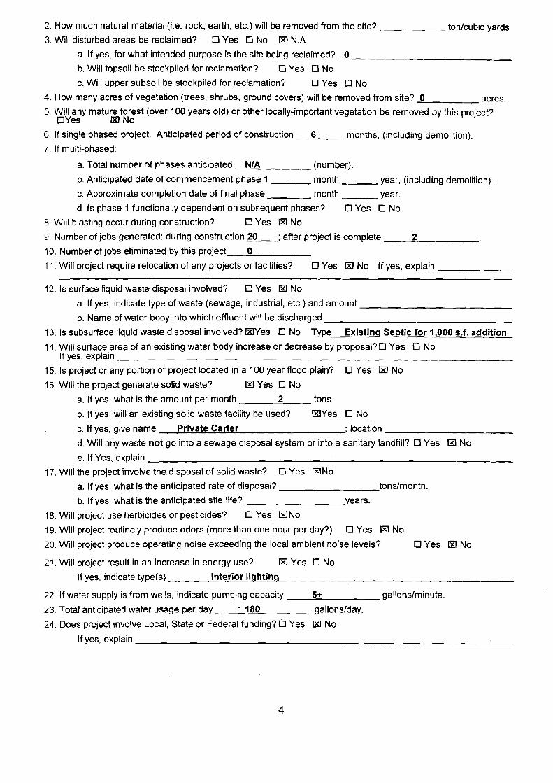
2. How much natural material (i.e. rock, earth, etc.) will be removed from the site? ton/cubic yards
3. Will disturbed areas be reclaimed? 0 Yes 0 No 00 NA a. If yes, for what intended purpose is the site being reclaimed? .......=,0 _
b. Will topsoil be stockpiled for reclamation? 0 Yes 0 No
c. Will upper subsoil be stockpiled for reclamation? 0 Yes 0 No
°4. How many acres of vegetation (trees, shrubs, ground covers) will be removed from site? acres.
5. Will any mature forest (over 100 years old) or other locally-important vegetation be removed by this project? DYes 00 No
6. If single phased project: Anticipated period of construction 6 months, (including demolition).
7. If multi-phased:
a. Total number of phases anticipated N/A (number).
b. Anticipated date of commencement phase 1 month year, (including demolition).
c. Approximate completion date of final phase month year.
d. Is phase 1 functionally dependent on sUbsequent phases? 0 Yes 0 No
8. Will blasting occur during construction? 0 Yes 00 No
9. Number of jobs generated: during construction 20 ; after project is complete __--'2"-- _
10. Number of jobs eliminated by this project_----'O:.- _
11. Will project require relocation of any projects or facilities? DYes 00 No If yes, explain _
12. Is surface liquid waste disposal involved? 0 Yes 00 No
a. If yes, indicate type of waste (sewage, industrial, etc.) and amount _
b. Name of water body into which effluent will be discharged _
13. Is subsurface liquid waste disposal involved? ooYes 0 No Type Existing Septic for 1,000 s.f. addition
14. Will surface area of an existing water body increase or decrease by proposal? 0 Yes If yes, explain
0 No _
15. Is project or any portion of project located in a 100 year flood plain? 0 Yes 00 No
16. Will the project generate solid waste? 00 Yes 0 No
a. If yes, what is the amount per month 2 tons
b. If yes, will an existing solid waste facility be used? ooYes 0 No
c. If yes, give name Private Carter ; location _
d. Will any waste not go into a sewage disposal system or into a sanitary landfill? 0 Yes 00 No e. If Yes, explain _
17. Will the project involve the disposal of solid waste? 0 Yes ooNo
a. If yes, what is the anticipated rate of disposal? tons/month.
b. If yes, what is the anticipated site life? years.
18. Will project use herbicides or pesticides? 0 Yes ooNo
19. Will project routinely produce odors (more than one hour per day?) 0 Yes 00 No
20. Will project produce opefating noise exceeding the local ambient noise levels? 0 Yes 00 No
21. Will project result in an increase in energy use? 1RI Yes 0 No
If yes, indicate type(s) interior lighting
22. If water supply is from wells, indicate pumping capacity __....:5""'+ gallons/minute.
23. Total anticipated water usage per day __·-.=..18:.;0:.... gallons/day.
24. Does project involve Local, State or Federal funding? [] Yes 1KI No If yes, explain ~_
4
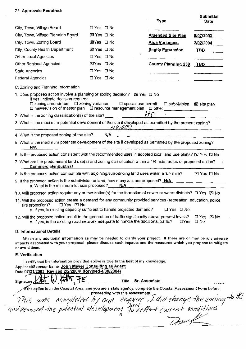
25. Approvals Required:
Submittal Type Date
City, Town, Village Board DYes DNa
City, Town, Village Planning Board IXI Yes DNa Amended Site Plan 8/07/2003
City, Town, Zoning Board IXIYes o No Area Variances 2/02/2004
City, County Health Department IXI Yes D No Septic Expansion TBD
Other Local Agencies DYes oNo
Other Regional Agencies IXIYes o No County Planning 239 TBD
State Agencies DYes DNa
Federal Agencies DYes o No
C. Zoning and Planning Information
1. Does proposed action involve a planning or zoning decision? lID Yes 0 No If yes, indicate decision required: D zoning amendment 0 zoning variance 0 special use permit 0 subdivision IXI site plan o new/revision of master plan D resource management plan 0 other _~ _
2. What is the zoning c1assification(s) of the site? .. -I-H~·_C. ~ _ 3. What is the maximum potential development of the site if developed as permitted by the present zoning?
.. ..... Hfh d7J1) ~ I
4. What is the proposed zoning of the site? __:.::N::..:./A~ ~ _
5. What is the maximum potential development of the site if developed as permitted by the proposed zoning? N/A
6. Is the proposed action consistent with the recommended uses in adopted local land use plans? IXI Yes 0 No
7. What are the predominant land use(s) and zoning classification within a 1/4 mile radius of proposed action? Commercial/industrial
8. Is the proposed action compatible with adjoining/surrounding land uses within a 1/4 mile? IXI Yes 0 No
9. If the proposed action is the subdivision of land, how many lots are proposed? --=N=/",-A~ _ a. What is the minimum lot size proposed?__....:.N~/A~ _
'10. Will proposed action require any authorization(s) for the formation of sewer or water districts? D Yes lID No
11. Will the proposed action create a demand for any community provided services (recreation, education, police, fire protection)? 0 Yes I&J No
a. If yes, is existing capacity sufficient to handle projected demand? 0 Yes CI No
12. Will the proposed action result in the generation of traffic significantly above present levels? 0 Yes I&J No a. If yes, is the existing road network adequate to handle the additional traffic? DYes D No
D. Informational Details
Attach any additional information as may be needed to clarify your project. If there are or may be any adverse impacts associated with your 'proposal, please discuss such impacts and the measures which you propose to mitigate or avoid them.
E. Verification
Sign~ ~ Title ---,S:;.;r..;,.._A...s.;:;.so.;:;.c_i;.;::a.;:.;te,,-_~ _
~he a tion is in the Coastal Area, and you are a state agency, complete the Coastal Assessment Form before
';l1r S wl1l (10 MjJ/t'1(",« ::;y~~;"h ;;,~~;;e~;-del iJl7<t/711<': -f!le. ZtJIJ;n'j -/r; Ii! 4t1dl2eMol/t'A .--J)J e lurltJ/llia/ 4e ~ e/cp/JJ~n-) '1~~I1~c:+ curft'11 f ~11t/il/~/1..5
5 ~

BADEY & WATSON Surveying & Engineering PC.
3063 Rouee 9, Cold Spring, New York 10516 (845) 265-9217 Glennon J. Watson, L.S. (877) 3.141593 John r. Delano, P. E.
Fax: (845) 265-4428 Perer Meisler, 1..S. www.badey-watson.com Srephen R. Miller, L.S. [email protected] Jennifer W Reap, L.S.
George A. Badey, L.S., Senior Consulranr Mary Rice, R.I..A., Consultant
Robert S. Miglin, Jr., L.S.
February 27, 2012
Michael Leonard, Chainnan Philipstown Planning Board Town Hall 238 Main Street Cold Spring, NY 10516
RE: Application of Garrison Properties, LLC Submission of Full Environmental Assessment Form Parts 1, 2 & 3
Dear Mr. Leonard & Honorable Board Members:
Enclosed you will find 12 copies ofthe following document prepared for Garrison Properties, LLC.
• Full Environmental Assessment Fonn Parts 1,2 & 3
Please place this matter on the agenda for the March 15,2012 meeting ofthe Pl~ng
Board. As always, thank you for your continued attention to and concern for thIS application.
Yours truly, BADEY & WATSON, Surveying & Engineering, P. C.
cc: Marti Ajello, Garrison Properties, LLC Margaret O'Sullivan, Garrison Station Plaza
U:78-118IMU7FBl2QP
Owners ofthe records andfiles of ]oscpn s. Agnoli • Bargcr & Husris, Survcyors • Burgess & Benr • Roy Burgess. Vincenr A. Burruano • Hudson Vallcy Engineering Company, Inc.
G. Radcliff Husris, Surveyor. Peter R. Hustis, Surveyor. James W Irisn, Jr.• J. Wilbur Irisn. Douglas A. Merritr. E.B. Moebus Reynolds & Cnase • General Jacob Scnofield • Sidney Scnofield, C.E . • Taconic Surveying & Engineering, r.e. • D. Walcurr
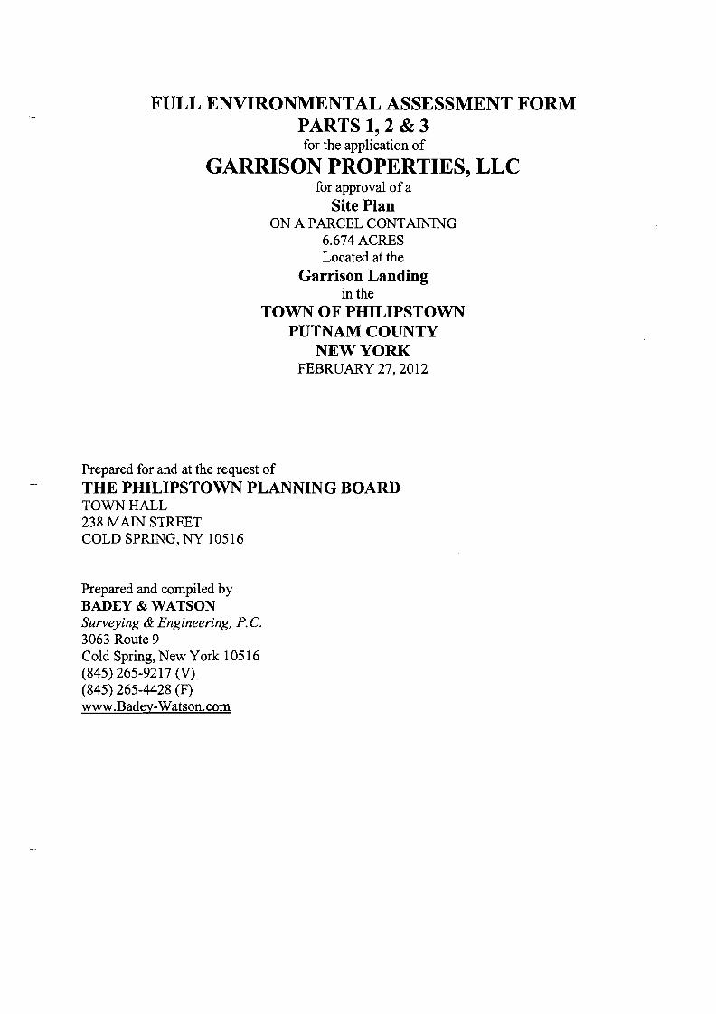
FULL ENVIRONMENTAL ASSESSMENT FORM PARTS 1,2&3 for the application of
GARRISON PROPERTIES, LLC for approval of a
Site Plan ON A PARCEL CONTAINING
6.674 ACRES Located at the
Garrison Landing in the
TOWN OF PHILIPSTOWN PUTNAM COUNTY
NEW YORK FEBRUARY 27, 2012
Prepared for and at the request of
THE PIDLIPSTOWN PLANNING BOARD TOWN HALL 238 MAIN STREET COLD SPRING, NY 10516
Prepared and compiled by BADEY & WATSON Surveying & Engineering, P. C. 3063 Route 9 Cold Spring, New York 10516 (845) 265-9217 (V) (845) 265-4428 (F) www.Badey-Watson.com

TABLE OF CONTENTS
Environmental Assessment Fonn Part 1 Environmental Assessment Fonn Part 2 Environmental Assessment Fonn Part 3 Appendices
1. Manufacturer's cut sheet for Filter Bag 2. Conservation Advisory Board
File

617.20 Appendix A
State Environmental Quality Review FULL ENVIRONMENTAL ASSESSMENT FORM
Purpose: The full EAF is designed to help applicants and agendes determine, in an orderly manner, whether a project or action may be significant. The question ofwhether an action may be significant is not always easy to answer. Frequently, there are aspects of a project that are subjective or unmeasurable. It is also understcx:x:l that those who determine significance may have litUe or no formal knowledge of the environment or may not be technically expert in environmental analysis. In addition, many who have knowledge in one partiaJlar area may not be aware of the broader concerns affecting the question of significance.
The full EAF is intended to provide a method whereby applicants and agencies can be assured that the determination process has been order1y, comprehensive in nature, yet flexible enough to allow introduction of information to fit a project oraction.
Full EAF Components: The full EAF is comprised of three parts:
Part 1 Provides objective data and information about a given project and its site. By identifying basic project data, it assists a reviewer in the analysis that takes place in Parts 2 and 3.
Part 2 Focuses on identifying the range of possible impacts that may OCQ.Jr from a projectoraction. It provides guidance as to whether an impact is likely to be considered small to moderate or whether it is a potentially-large impact The form also identifies whetheran impact can be mitigated or reduced.
Part 3 Ifany impact in Part 2 is identified as potentially-large, then Part 3 is used to evaluate whether or not the impact is actually important
THIS AREA FOR LEAD AGENCY USE ONLY
DETERMINATION OF SIGNIFICANCE •• Type 1 and Unlisted Actions
1entify the Portions of EAF completed for this project: ~ Part2 D Part3
Upon review of the information recorded on this EAF (Parts 1 and 2 and 3 ifappropriate), and anyother supporting information, and considering both the magnitude and importance ofeach impact, it is reasonably determined by the lead agency that
D A The project will not result in any large and important impact(s) and, therefore, is one which will not have a significant impact on the environment, therefore a negative declaration will be prepared.
D B. Although the project could have a significant effect on the environment, there will not be a significant effect for this Unlisted Action because the mitigation measures desaibed in PART 3 have been required, therefore a CONDITIONED negative declaration will be prepared!
D C. The project may result in one or more large and important impacts that may have a significant impact on the environment, therefore a positive declaration will be prepared.
*A Conditioned Negative Declaration is only valid for Unlisted Actions
Site Plan - Garrison Properties, LLC NameofAction
Town of Philipstown Planning Board NameofL..ead~
Mr. Anthony Merante Planning Board Chairman=-::-=---::-:,-------:::-::-
Print orType Name ofResponsible Officer in Lead ~ency Trtle of Responsible Officer
- -Signature of Responsible Officer in Lead ~ency Signature ofPreparer (Ifdifferent from responsible officer)
Page 1 of 15
------------
---------- -------
----------------
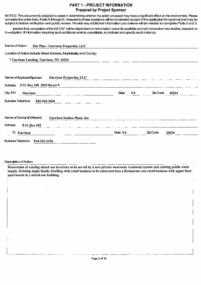
PART 1 --PROJECT INFORMATION Prepared by Project Sponsor
NOTICE: This dOQJment is desig'ned to assist in determining whether the action proposed may have a significant effect on the environment. Please oomplete the entire form, Parts A through E. Ansvvers to these questions will be oonsidered as part of the application for approval and may be subject to further verification and public review. Provide any additional information you believe will be needed to oomplete Parts 2 and 3.
cpected that oompletion of the full EAF will be dependent on information currently available and will not involve new studies, research or i~iigation. If information requiring such additional \NOrk is unavailable, so indicate and specify each instance.
Name ofAction Site Plan - Garrison Properties, LLC
Location ofAction (indude Street Address, Municipality and County)
7 Garrison Landing Garrison, NY 10524
Name ofApplicant/Sponsor Garrison Properties, LLC
Address P.O. Box 348 2015 Route 9
Oty/PO Garrison Slate NY ZpCode 10524
BusinessTelephone 845-424-3604
Name ofOM1er (ifdifferent) Garrison Station Plaza, Inc.
Address P.O. Box 205
JQ Garrison Slate NY ZpCode 10524
BusinessTelephone 914-262-2156
Description ofAction:
IRenovation of existing mixed use structure to be served by a new private wastwater treatment system and existing public water supply. Existing single family dwelling with retail business to be renovated into a Restaurant and retail business with upper floor apartments in a mixed-use building.
Page 2 of 15
Please Complete Each Question- Indicate N.A. if not applicable
A. SITE DESCRIPTION Physical setting ofoverall project, both developed and undeveloped areas.
1 . Present Land Use: 0 Ut:H1 0 Industrial ~ Commerdal ~ Residential (suburban) 0 Rural (non-farm)
o Fa-est 0 AgriC1.llture 1;21 Other Metro North Stationfplatform. Hamlet area.
2. Total acreage of project area: 6.674 acres.
APPROXIMATE ACREAGE PRESENTlY AFTER COMPLETION
Meadow or Brushland (Non-agriC1.lltural) acres 00"ElS
Fa'ested 00"ElS 00"ElS
AgriC1.lltural (Indudes orchards, cropland, pasture. etc.) 00"ElS 00"ElS
Wetland (Freshwateror tidal as perMdes 24,25 of Eel) 00"ElS 00"ElS
WcN2r SurfacePrea 5.924 00"ElS 5.924 00"ElS
Unvegetated (Rock, earth or fill) 00"ElS 00"ElS
Roads, buildings and other paved surfaoos 0.056 00"ElS 0.069 ---
00"ElS
Other (Indicate type) Grassed riverbank. 0.694 00"ElS 0.661 00"ElS
Total 6.674 6.674
3. What is predominant soil type(s) on project site? Urban Land-Charlton Complex (upland only)
a. Soil drainage: 1;21 Well drained 100 % of site 0 Moderately well drained % ofsite. 0 Poorly drained % ofsite
b. If any agriC1.llturalland is involved, how many aaes of soil are dassified within soil group 1 through 4 of the NYS Land Classification System? nfa aaes(see 1 NYCRR370).
4. Are there bedrock outcroppings on project site? 0 YES 1;21 N::> a. What is depth to bedrOO< 6 (in feet)
5. Approximate percentage of proposed project site with slopes: 1;21 D-100/o 100 % 0 10 -15% 0 % 0 15%a-geata" 0 %
Jroject substantially contiguous to, or contain a building, site, or district, listed on the State or National Registers of Historic Places?
1;21 YES 0 N::>
7. Is project substantially rontiguous to a site listed on the Register ofNational Natural Landmar1<s? 0 YES
8. What is the depth of the water table? 0>4 (in feet)
9. Is site located over a primary, principal, or sole source aquifer? 0 YES 1;21 N::>
10. Do hunting, fishing or shell fishing opportunities presently exist in the project area? 0 YES 1;21 N::>
11 . Does project site contain any species of plant oranimal life that is identified as threatened or endangered? o YES 1;21 N::> Aax>rding to:
Site fully developed J Identify each species:
I nla
L l 12. Are there any unique or unusual land forms on the project site? (Le., diffs, dunes, other geological formations? 0 YES 1;21 N::>
Describe:
nfa
I
I
1 r • ~ the project site presently used by the rommunity or neighborhood as an open space or recreation area? 0 YES 1;21 N::> bt-es, explain:
nfa
Page 3 of 15

----
I
14. Does the present site indude scenic vievvs known to be important to the community? ON:>IHudson mghland.,
15. Streams within or contiguous to project area: I No.
-I ---,:-:--------=c=-----,------:;-=-,-------,----:-:-~_,__~___,____-------------------------
a. Name of Stream and name of River to which it is tributary
The site is on the easterly bank of the Hudson River.
16. Lakes, ponds, wetland areas within or contiguous to project area:
I nfa
I
b. Size (in acres):
nfa
17. Is the site served by existing public utilities? [y;'J Yes 0 N:> a. IfYES, does suffident capadty exist to allow connection? [y;'J Yes 0 N:> b. IfYES, will improvements be necessary to allow connection? 0 Yes [y;'J N:>
18. Is the site located in an~riculturaldistrict certified pursuant to Agriculture and Mar1<ets Law, Moo 25-AA, section 303 and 304? o Yes IYJ N:>
19. Is the site located in or SUbstantially contiguous to a Critical Environmental hea designated pursuant to Mde 8 of the ECl, and 6 NYCRR 61?? o Yes [y;'J N:> 20. Has the site ever been used for the disposal of solid or hazardous wastes? 0 Yes [y;'J N:>
B:r>ROJECT DESCRIPTION
1. Physical dimensions and scale of project (fill in dimensions as appropriate).
a. Total contiguous acreage owned or controlled by project sponsor. 6.674 acres.
b. Project acreage to be developed: 0.166 acres initially; 0.166 acres ultimately.
c. Project acreage to remain undeveloped: 6.568 acres.
d. Length of project, in miles: nfa (ifappropriate) --
e. If the project is an expansion, indicate percent of expansion proposed. nfa %
f. Number of off-street parking spaces eXisting 17 ,proposed 18
g. Maximum vehicular trips generated per hour. 13 (upon completion of project)? h. If residential: Number and type of housing units:
One Family Tw:::> Family Multiple Family Cordorni1l.m
Initially 1 0 0 0
Ultimately 2 0 0 0
i. Dimensions (in feet) of largest proposed structure: 38 height; 30.5 width; 54 length.
j. Unear feet of frontage along a public thoroughfare project will occupy is? 0 ft.
2. How much natural material (i.e. rock, earth, etc.) will be removed from the site? 0 tons/cubic yards.
3. Will disturbed areas be reclaimed [y;'J Yes 0 N:> o !'VA --
a. If yes, for what intended purpose is the site being reclaimed?
ILawns, Gardens and Hardscape
------=----------=---------b. Will topsoil be stockpiled for reclamation? [y;'J Yes 0 N:> c. Will upper subsoil be stockpiled for reclamation? [y;'J Yes 0 N:>
Page 4 of 15
1
---
---------------------
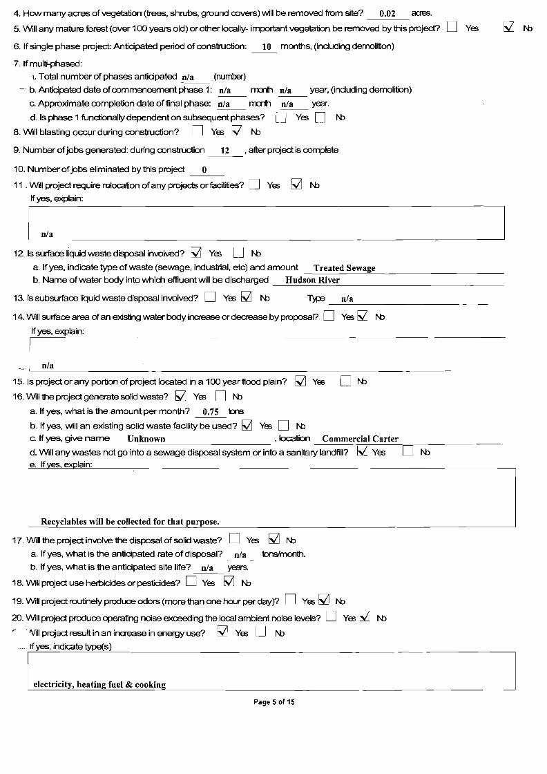
4. How many acres of vegetation (trees, shrubs, ground covers) will be removed from site? 0.02 acres.
5. Will any mature forest (over 100 years old) orother Iocally- important vegetation be removed by this project? 0 Yes
6. If single phase project: Antidpated period of construction: 10 months, (induding demolition)
7. If multi-phased:
1. Total number of phases antidpated n/a (number)
- b. Antidpated date ofcommencement phase 1: n/a m:rt1 n/a year, (induding demolition)
c. Approximate completion date of final phase: n/a m:rt1 n/a year.
d. Is phase 1 functionally dependent on subsequent phases? 0 Yes 0 NJ
8. Will blasting occur during construction? 0 Yes ~ N:>
9. Number of jobs generated: during construction 12 , after project is complete
10. Number of jobs eliminated by this project 0
11 . Will project require relocation ofany projects or fadlities? 0 Yes M N:>
Ifyes, eXplain:
12. Is surface liquid waste disposal involved? ~ Yes D N:>
a. If yes, indicate type of waste (sewage, industrial, etc) and amount Treated Sewage-----------"''--------------
b. Name ofwater body into which effluent will be discharged Hudson River
13.lssubsurfaceliquidwastedisposalinvolved? 0 Yes M N:> T~ n/a-~-'----------------
14. Will surface area ofan existing water body increase or decrease by proposal? 0 Yes ~ N:>
If yes, explain:
__ ,,---'_n_/a _
15. Is project or any portion of project located in a 100 year flood plain? ~ Yes 0 N:>
16. Will the project generate solid waste? ~ Yes D N:>
a. If yes, what is the amount per month? 0.75 tons
b. If yes, will an existing solid waste fadlity be used? ~ Yes 0 NJ c. If yes, give name Unknown , location Commercial Carter
-----;===;;----;==;-------
d. Will any wastes not go into a sewage disposal system or into a sanitary landfill? ~ Yes 0 N:>
17. Will the project involve the disposal of solid waste? D Yes ~ N:>
a. If yes, what is the antidpated rate of disposal? n/a tons'month.
b. If yes, what is the antidpated site life? n/a years.
18. Will project use herbicides or pestiddes? 0 Yes ~ N:>
19. Will project routinely produce odors (more than one hour per day)? 0 Yes ~ N:>
20. Will project produce operating noise exceeding the local ambient noise levels? D Yes ~ N:>
~ . 'ViII project result in an increase in energy use? ~ Yes 0 N:>
_ If yes, indicate type(s)
~ l_e_l_ec_t_ri_C_ity,,--,,---h_e_a_ti_o..£g_f_Ue_I_&_C_Oo_ki_·_n.Q.g J
Page 5 of 15
I
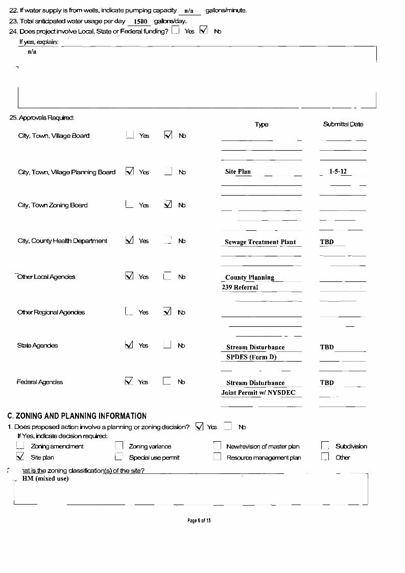
I
22. Ifwater supply is from wells, indicate pumping capadty nla gallons/minute.
23. Total antidpated water usage per day 1500 galbns'day.
24. Does project involve Local, State or Federal funding? D Yes ~ N::J
Ifyes, explain:
n/a
1 1
25. Approvals Required:
City, Town, Village Board D Yes
T~
_
Submittal Date
City, Town, Village Planning Board ~ Yes D N::J Site Plan 1-5-12
City, Town Zoning Board D Yes
City, County Health Department ~ Yes D N::J Sewage Treatment Plant TBD
-Other LocaI,Ag3ndes ~ Yes D N::J County Planning
239 Referral
Other Regialal,Ag3ndes D Yes
Slate Agerdes ~ Yes D N::J Stream Disturbance
SPDES (Form D)
TBD
Federal Agendes ~ Yes D N::J Stream Disturbance
Joint Permit wi NYSDEC
TBD
Special use permit
C. ZONING AND PLANNING INFORMATION
D Zoning variance
D
1. Does proposed action involve a planning or zoning dedsion?
If Yes, indicate decision required:
D Zeri1g arnErdrnent
~ Siteplan
lat is the zoning dassification(s) of the site?
~
D Newlrevision of master plan
D Resource management plan
Yes D N::J
D Sutx:lMsion
DOther
f ~-------------.-----_____H_M_(m_l_.x_ed_U_Se_) L,
Page 6of 15
I
--------------
---------------------------
i
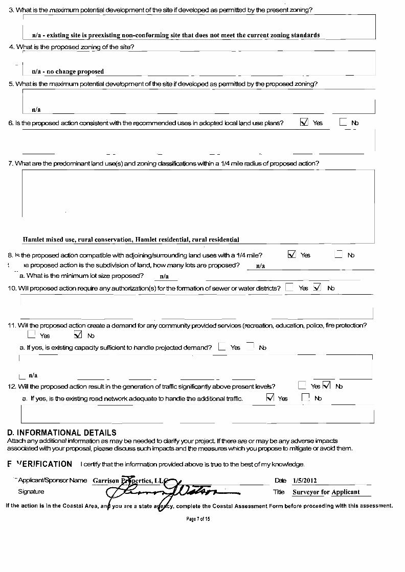
3. What is the maximum potential development of the site if developed as permitted by the present zoning?
n/a - existing site is preexisting non-conforming site that does not meet the current loning standards
4. What is the proposed zoning of the site?
- I n/a - no change proposed
5. What is the maximum potential development of the site if developed as permitted by the proposed zoning? -
I n/.
6. Is the proposed action oonsistent with the rerommended uses in adopted local land use plans?
7. What are the predominant land use(s) and zoning classifications within a 1/4 mile radius of proposed action?
Hamlet mixed use, rural conservation, Hamlet residential, rural residential
8. I~ the proposed action oompatible with adjoining/surrounding land uses with a 1/4 mile? ON:> Ie proposed action is the subdivision of land, how many lots are proposed? n/a
---------------a. What is the minimum lot size proposed? n/a
10. Will proposed action require any authorization(s) for the formation of sewer or water districts? 0 Yes I;Z] N:>
I ~_~----11. Will the proposed action create a demand for any oommunity provided services (recreation, education, police, fire protection?
o Yes I;Z] N:> a. If yes, is existing capadty suffident to handle projected demand? 0 Yes 0 N:>
n/a
12. Will the proposed action result in the generation of traffic significantly above present levels? o Yes I;Z] N:> a. If yes, is the existing road network adequate to handle the additional traffic. I;Z] Ye; ON:>
D. INFORMATIONAL DETAILS Attach any additional information as may be needed to darify your project. If there are or may be any adverse impacts associated with your proposal, please discuss such impacts and the measures which you propose to mitigate or avok:l them.
F "E RJ FJ CATJ 0 N I certify that the information provided above is true to the best of my knowledge.
--ApplicantlSponsor Name [)je 1/5/2012
Signature Title Surveyor for Applicant
If the action is in the Coastal Area, an cy, complete the Coastal Assessment Form before proceeding with this assessment.
Page 7of 15

GARRISON PROPERTIES, LLC ENVIRONMENTAL ASSESSMENT FORM
PART 2

------
-------------------
Suggested by Badey & Watson February 3, 2012 PART 2 • PROJECT IMPACTS AND THEIR MAGNITUDE Responsibility of Lead Agency Recommended Date 2/16/12 by RG (int.)
Adopted Date 2/16/12 byPPBGeneral Information (Read Carefully)
In completing the form the reviewer should be guided by the question: Have my responses and determinations been reasonable? The reviewer ;s not expected to be an expert environmental analyst. I-he Examples provided are to assist the reviewer by showing types of impacts and wherever possible the threshold of magnitude that would trigger a response in column 2. The examples are generally applicable throughout the State and for most situations. But, for any specific project or site other examples and/or lovver thresholds may be appropriate for a Potential Large Impact response, thus requiring evaluation in Part 3. The impacts ofeadl project, on eadl site, in eadllocality, will vary. Therefore, the examples are illustrative and have been offered as guidance. They do not constitute an exhaustive listof impactsand thresholds to answereadl question. TIle numberofexamples per question does not indicate the importance ofeach question.
In identifying impacts, consider long term, short term and cumulative effects.
Instructions (Read carefully) a AA9Ner eadl of the 20 questions in PART 2. AAsvver Yes if there will be i!rI'J impact.
b. Maybe answers should be considered as Yes answers.
e Ifanswering Yes to a question then d1eck the appropriate box (column 1 or 2) to indicate the potential size ofthe impact. If impact threshold equals or exceeds any example provided, check column 2. If impact will occur but threshold is lower than example, check 1.
d. Identifying that an Impact will be potentially large (column 2) does not mean that it is also necessarily significant. Any large impact must be evaluated in PART 3 to determine significance. Identifying an impact in column 2 simply asks that it be looked at further.
e. If re"';8\M9r has doubt about size of the impact then consider the impact as potentially large and proceed to PART 3.
f. If a potentially large impact checked in column 2 can be mitigated by change{s) in the project to a small to moderate impact, also check the Yes box in column 3. A No response indicates that sud1 a reduction is not possible. This must be explained in Part 3.
1 2 3 Small to Potential can Impact Be
IMPACT ON LAND MOOerate
Irrpoct Large Impact
Mitigated by Rqa:t~
1. Will the Proposed Action result in a physical change to the project site?
1'0 D 'rffi~
. 'Examples that \M)uld apply to column 2
Any construction on slopes of 15% or greater, (15 foot rise per 100 foot of length), D D Dyes D N:> or where the general slopes in the project area exceed 10%.
Construction on land where the depth to the water table is less than 3 feet. ~ D Dyes D N:>
Construction of paved parking area for 1 ,000 or more vehicles. D D Dyes D N:>
Construction on land where bedrock is exposed orgenerally within 3 feet D D Dyes D N:> ofexisting ground surface.
Construction that will continue for more than 1 year or involve more than D D Dyes D N:> one phase or stage.
Excavation for mining purposes that \/VOuld remove more than 1,000 tons D D Dyes D N:> of natural material (i.e., rock or soil) per year.
Construction orexpansion ofa sanitary landfill. D D Dyes D N:>
Construction in a designated 1loodvvay. D D Dyes D N:>
Other impacts:
I D D Dyes D N:>
=--l 2. Will there be an effect to any unique or unusual land forms found on the site?
(Le., cliffs, dunes, geological formations, etc.)
~1'0 D'rffi Specific land forms:
L--'--------------~---'=------..----------D
:::=---D
-------'D Yes
=--D N:>l

1 2 3 Small 10 Potential Can Impact Be
Moderate Large Mitigated by IMPACT ON WATER Irrp:d Impact F'rqa:tCharge
3. Will Proposed Action affect anywater I:x:x:Iy designated as protected? (Under ~ rtides 15, 24, 25 of the Environmental Conservation law, ECl)
o 1'0 ~ YES
ExafTllIes that would apply to column 2 Developable area of site contains a protected water body. 0 0 o YES 0 N:> Dredging more than 1 00 OJbic yards of material from channel of a protected stream.
Extension of utility disbibution facilities through a protected water body.
Construction in a designated freshwater or tidal wetland.
0 0 0
0 0 0
o YES
o YES
o YES
0 N:> 0 N:> 0 N:>
Other impacts: ~ 0 o YES 0 N:> Potential impacts associated with the proximity of the project to the Hudson River.
L 4. Will Proposed Action affect any non-proteded existing or new body of water?
~I'O o YES
Exa1lJIes that would apply to column 2
A 10% increase ordecrease in the surface area ofany body ofwater or more than a 10 acre inaease ordecrease.
0 0 o YES 0 N:>
Construction ofa body ofwater that exreeds 10 acres ofsurface area.
Other impacts:
0 0
0 0
o YES
o YES
0 N:> 0 N:>
5.V'l11i Proposed .Adion affa::t surface or gwnclvvater qualityor quantity? 0 1'0 ~ YES
Examples that would apply to column 2
Proposed Action will require a discharge permit. o o YES 0 N:> Proposed Action requires use ofa source ofwater that does not have approval o o YES 0 N:> to serve proposed (project) action. Proposed Action requires water supply from wells with greater than 45 gallons o o o YES ON:> per minute pumping capacity.
Cons1ruction or operation causing any contamination ofa water supply system. o o o YES ON:> Proposed Action will adversely affect groundwater. o o o YES ON:> Liquid effluent will be conveyed off the site to facilities which presently do not o o o YES ON:> exist or have inadequate capacity.
Proposed Action would use water in excess of 20,000 gallons per day. o o o YES ON:>
Proposed Action will likely cause siltation or other discharge into an existing body of o o o YES ON:> water to the extent that there will be an obvious visual contrast to natural conditions.
Proposed Action will require the storage of petroleum or chemical products o o o YES ON:> greater than 1,100 gallons.
Proposed Action will allow residential uses in areas without water and/or o o o YES ON:> sevver services. Proposed Action locates commercial and/or indusbial uses which may require o o o YES 0 N:> new or expansion of existing waste treatment and/or storage facilities.
her impacts: M o o YES ON:>
Potential impacts associated with construction of waste water treatment facility adjacent to Hudson River.
------~
I

3 1 2
Small to Potential can Impact Be Moderate Large Mitigated by
II'llX'Id Impact PrqErt01arge
6. Will Proposed Action alter drainage flow or patterns, or surface water run off? D/'OM YES F-Xaf1l)Ies that \NOuld apply to column 2
oposed Action \M:>U1d change flood water flows D D D YES D I'D
Proposed Action may cause substantial erosion. M D D YES D I'D
Proposed Action is incompatible \Nith existing drainage pattems. D D D YES D I'D
Proposed Action will allow development in a designated floodway. D D D YES D I'D
Other impac:ls: D D D YES D I'D
[ I
~
IMPACT ON AIR
7. Will Proposed Action affect air quality? M/'O DYES Ex.a1lJIes that \NOuld apply to column 2
Proposed Action will induce 1,000or more vehicle trips in any given hour. n D D YES D I'D
Proposed Action will result in the inaneration of more than 1 ton of refuse per hour. D D D YES D I'D
Emission rate of total contaminants will exceed 5 Ibs. per houror a heat D D D YES D I'D source prodUcing more than 10 million BTU's per hour.
Proposed Action will allow an increase in the amount of land committed D D D YES D I'D to industrial use.
ProjX)S6d Action will allow an increase in the density of industrial D D D YES D I'D
development\Nithin existing industrial areas.
'"""her impac:ls: D D D YES D I'D
I
I L- ~
IMPACT ON PLANTS AND ANIMALS
8. Will Proposed Action affect any threatened orendangered spades? M/'OD YES Examples that\MJuld apply to column 2
Reduction of one or more species listed on the New York or Federal list, using the site, overor near the site, or found on the site. Removal ofany portion ofa critical or significant wildlife habitat
D D
D D
D YES
D YES
D I'D
D I'D
Application of pesticide or herbicide more than twice a year, other than for agricultural purposes.
Other impac:ls:
D
D
D
D
D YES
D YES
D I'D
D I'D
-~
9. Will Proposed Action substantially affe::.t non-threatened or non-endangered species? M /'0 Ex.a1lJIes that \NOuld apply to column 2
Proposed Action would substantially interfere with any resident or migratory fish, shellfish or wildlife species.
D YES
D D D YES D I'D
Proposed Action requires the removal of more than 10 acres of mature forest ver 100 years ofage) orother k:>cally important vegetation.
.-Aher impac:ls:
D
D
D
D
D YES
D YES
D I'D
D I'D
l
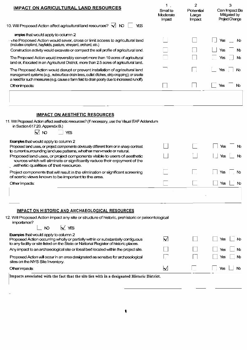
IMPACT ON AGRICULTURAL LAND RESOURCES 1
Small to 2
Potential
3 Can Impact Be
rv10derate Large Mitigated by Im~ Impact Prqoci~
10. Will Proposed Action affect agricultural land resources? ~ I'{) 0 YES
ampIes that would apply to oolumn 2
---, he Proposed Action would sever, cross or limit access to agricultural land 0 0 0 Yes 0 N:> (indudes cropland, hayfields, pasture, vineyard, orchard, etc.)
Construction activity would excavate or oompact the soil profile of agriOJlturalland. 0 0 0 Yes 0 N:>
The Proposed Action would irreversibly oonvert more than 10 acres of agriOJltural 0 0 0 Yes 0 N:> land or, if located in an AgriOJltural District, more than 2.5 acres of agriOJlturalland.
The Proposed Action would disrupt or prevent installation of agricultural land 0 0 o Yes 0 N:> management systems (e.g., subsurface drain lines, outlet d~ches, strip cropping); or create a need for such measures (e.g. cause a farm field to drain poJ1y due to increased runoff).
Other impacts: 0 0 o Yes 0 N:>
IMPACT ON AESTHETIC RESOURCES
11. Will Proposed Action affect aesthetic resources? (If necessary, use the Visual EAF Addendum in Section 617.20, Appendix S.)
~I'{) OYES
Exa1lJIes that would apply to oolumn 2 Proposed land uses, cr project canpooehts obvioosly different from cr in sharp a:>ntrast to a.UTent sunounding land use patterns, whether man-made or natural. Proposed land uses, or project components visible to users of aesthetic
>ources which will eliminate or significantly reduce their enjoyment of the _ -*ithetic qualities of that resource.
Project oomponents that will result in the elimination or significant screening of scenic views known to be important to the area.
Other impacts:
0
0
0
0
0
0
0
0
o Yes
o Yes
o Yes
o Yes
0
0
0
0
N:>
N:>
N:>
N:>
I
L IMPACT ON HISTORIC AND ARCHAEOLOGICAL RESOURCES
12. Will Proposed Action impact any site or structure of historic, prehistoric or paleontological importance?
Exa1lJIes that would apply to oolumn 2 Proposed Action oa:urring wholly or partially within or substantially oontiguous to any fudlity or site listed on the State or National Register of historic places.
Any impact to an archaeological site or fossil bed located within the project site.
~
0
0
0
0
0
Yes
Yes
ON:>
ON:>
Proposed Action will oa:ur in an area desi!;Jnated as sensitive for archaeological sites on the NYS Site Inventory.
0 0 0 Yes ON:>
Other impacts: ~ 0 o Yes ON:>
Impacts associated with the fact that the site lies with in a designated Historic District.
IMPACT ON OPEN SPACE AND RECREATION 1 2 3
Small 10 Potential Can Impact Be Moderate Large Mitigated by
Irnpcd Impact Pn::jErt 01arg:l 13. Will proposed Action affect the quantity or quality ofexisting or future open spaces
or recreational opportunities?
~I'D DYES ~ that would apply to column 2 The permanent foreclosure of a Mure recreational opportunity. D D D Yes D NJ A major reduction ofan open space important10 the community. D D D Yes D NJ Other impacts: D D D Yes D NJ
IMPACT ON CRITICAL ENVIRONMENTAL AREAS
14. Will Proposed Action impact the exceptional or unique dlaracteristics ofa attical environmen1a1 area (CEA) established pursuant10 subdivision 6 NYCRR 617.14(g)?
~ I'D D YES
Ex.ar1llJes that would apply to column 2
Proposed Adion to locate within the CEA?
Droposed Action will result in a reduction in the quantity ofthe ourre?
'Proposed Action will result in a reduction in the quality of the resoul'09?
Proposed Action will impact the use, function or eQjoyment of the resoul'09?
Other impacts:
D D
D
D
D
D D
D
D
D
Dyes Dyes
Dyes
Dyes
Dyes
DNJ DNJ
DNJ
DNJ
DNJ
[ ] IMPACT ON TRANSPORTATION
15. Will there be an effect to existing transportation systems? ~ I'D DYES Exa1llJes that would apply to column 2
Alteration of present pattems of movement of people and/or goOOs.
Proposed Action will result in major traffic problems.
Other impacts:
D D D
D D D
D Yes DNJ D Yes DNJ D Yes DNJ
_I
1 2 3
IMPACT ON ENERGY Small to
Moderate IrllHi
Potential Large Impact
Can Impact Be Mitigated by
PrqedCJ"larw
16. Will Proposed Action affect the a:>mmunity's sources of fuel or energy supply?
~ N) 0 YeS ~ that would apply to a:>lumn 2 Proposed Man 'Nill cause a greater than 5% il1Q"ease in the useofany form ofenergy 0 0 DYe;; DNJ in the munidpality.
ProposOO .Adion VVlll require the creation or extension cian energy transmission or supply 0 0 DYe;; DNJ system to serve more than 50 single or t.vI.o family residenoos or to serve a mapr a:>mmerdal or industrial use.
Other impads: 0 0 DYe;; DNJ
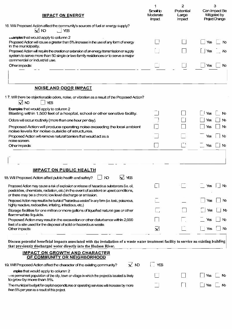
~ NOISE AND ODOR IMPACT
1 7. Will there be objectionable odors, noise, or vibration as a result of the Proposed Action?
~N) DYeS Exa1lJIes that would apply to a:>lumn 2 Blasting within 1 ,500 feet of a hospital, school or other sensitive facility. D 0 DYe;; DNJ Odors will ocx::ur routinely (more than one hour per day). D 0 DYe;; DNJ Proposed Action will produce operating noise exceeding the local ambient D 0 DYe;; DNJ noise levels for noise outside of structures.
Proposed Action will remove natural barriers that \MJuk:l act as a 0 0 DYe;; DNJ noise screen. Other impads: D 0 DYe;; DNJ
I- I
I
IMPACT ON PUBLIC HEALTH
18. Will Proposed Action affect public health and safety? D N) ~YeS
Proposed Action may cause a risk of explosion or release of hazardous substances (i.e. oil, 0 -0 DYe;; 0 NJ pestiddes, dlemicals, radiation, etc.) in the event ofacrident or upset a:>ndilions, or there may be a chronic low level discharge or emission.
Proposed .A.ction may resu~ in the burial of 'hazardous was..es" in any form (i.e. toxic, poisonous, 0 0 DYe;; DNJ highly reactive, radioactive, irritating, infectious, etc.)
Storage fadlities for one million or more gallons of liquefied natural gas or other 0 0 DYe;; DNJ flammable liquids.
Proposed Action may result in the excavation or other disturbanoo within 2,000 0 0 DYe;; DNJ feet ofa site used for the disposal of solid or hazardous waste. Other impads: M 0 DYe;; DNJ
!.:scuss potential beneficial impacts associated with the installation of a waste water treatment facility to service an existing building that previously discharged water directly into the Hudson River.
IMPACT ON GROWTH AND CHARACTER OF COMMUNITY OR NEIGHBORHOOD
19. W~I Proposed Action affect the character of the existing a:>mmunity? M N)
IIllJIes that would apply to oolumn 2 Tlle permanent population of the city, town or village in which the project is located is likely to grow by more than 5%.
The municipal budget for capital expenditures or operating services 'Nill increase by more than 5% peryear as a result of this project.
D
o o D
DYe;;
DYe;;
0 NJ
0 NJ
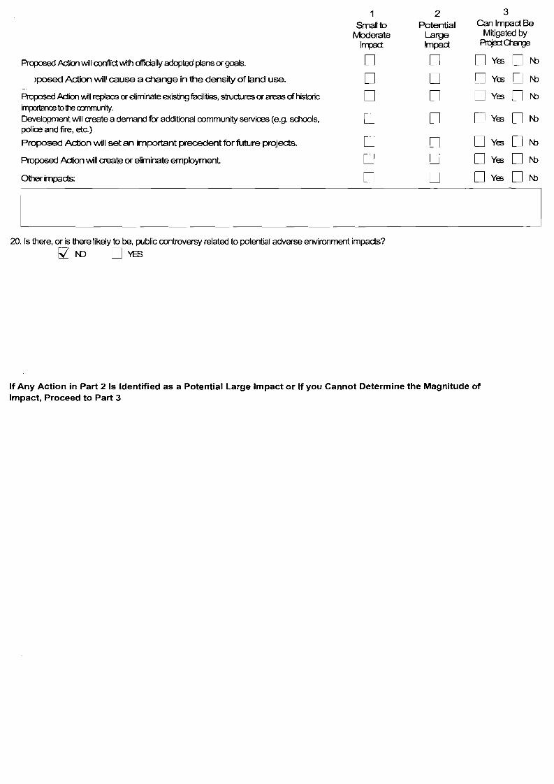
1 2 3
Small to Potential Can Impact Be Mitigated by fv10derate Large
I~ Impact Prqa:iO'larw
Propooed Action INiIl oonflict with ofIidaJly adopted plans or goals. D D D Yes D N:>
>posed Action will cause a change in the density of land use. D D D Yes D N:>
Proposed .Adion will replace or eliminate existing facilities, structures or areas of historic D D D Yes D N:> importance to the cxrnmunity. Development INiIl create a demand for additional oommunity services (e.g. schools, D D D Ya;; D N:> police and fire, etc.)
Proposed Action will set an important precedent for future projects. D D D Ya;; D N:>
Prop:>sed .Action INiIl create or eliminate ernpbymenl D D D Ya;; D N:>
Other impacls: D D D Yes D N:>
I 20. Is there, or is there likely to be, public controversy related to potential adverse environment impacls?
~f'D DYES
If Any Action in Part 2 Is Identified as a Potential Large Impact or If you Cannot Determine the Magnitude of Impact, Proceed to Part 3

Part 3· EVALUATION OF THE IMPORTANCE OF IMPACTS
Responsibility of Lead Agency
Part 3 must be prepared if one or more impact(s) is considered to be potentially large, even if the impact(s) may be mitigated.
Instruclions (If you need more space, attach additional sheets)
Disa.JSS the following for each impact identified in Column 2 of Part 2
1 . Briefly describe the impact.
2. Describe (if applicable) how the impact could be mitigated or reduced to a small to moderate impact by project change(s).
3. Based on the information available, decide if it is reasonable to condude that this impact is important
To answer the question of importanoo, consider.
The probabilityofthe impact ocaming The duration ofthe impact lis irreversibility, induding permanently lost resources of value Whetherthe impact can orwill be controlled The regional consequence of the impact lis potential divergence from kx:al needs and goals Whether kno\Ml objections to the project relate to this impact
______~ J

GARRISON PROPERTIES, LLC ENVIRONMENTAL ASSESSMENT FORM
PART 3
INTRODUCTION & BACKGROUND
Garrison Station Plaza, Inc., is the owner of 6.674 acres located at the southerly end of Garrison's Landing in the Town of Philipstown. Most of the property lies under the waters of the Hudson River. There is approximately 0.75 acres of improved upland. The property is located at 7 Garrison Landing and has been designated on the Putnam County Tax Map for the Town ofPhilipstown as Sheet 60.17, Block 1, Lot 7 (60.17-1-7).
The property is improved with a 3-story building that for many years housed "Guinan's," a pub/country store that served a local clientele and commuters. "Guinan's" was located in commercial space on the first floor. The second and third floors contain an apartment in which the proprietor Jim Guinan and his. family resided. When the now late Jim Guinan retired, the business closed.
The property received site plan approval from the Philipstown Planning Board in 2010. This approval allowed the conversion of the building into commercial office space. The approval was granted only after the applicant made a yearlong attempt to identify a tenant with a viable business plan to re-establish the pub/country store in the building. This effort was made in response to comments at the Public Hearing during which many local residents expressed a preference for the pub/country store over the office space that was the subject of the 2009 application.
Garrison Station Plaza, Inc. has now found a tenant that it believes will be successful in re-establishing the pub/country store. That tenant is the applicant, Garrison Properties, LLC, a firm with demonstrated experience in operating successful local restaurants. Specifically, Garrison Properties, LLC owns and operates Valley Restrurant at The Garrison and operates Tavern at the Highlands Country Club. Accordingly, Garrison Station Plaza granted permission to Garrison Properties, LLC to submit plans and an application for site plan approval that would establish a convenience store, restaurant and 2 apartments in the former Guinan's building.
The required parking is shown on the plan adjacent to the site. The Garrison Landing Water District supplies potable water. Until now sewage has been untreated and has been discharged directly into the Hudson River. When this project is built it will be collected and treated in a new on-site sewage treatment system before being discharged.
The following table provides a chronology of the significant events associated with this application.
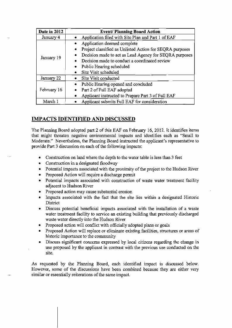
Date in 2012 Event! Planning Board Action January 4 • Application filed with Site Plan and Part 1 of EAF
• Application deemed complete
• Project classified as Unlisted Action for SEQRA purposes
• Decision made to act as Lead Agency for SEQRA purposes
• Decision made to conduct a coordinated review
• Public Hearing scheduled
• Site Visit scheduled
• Site Visit conducted
• Public Hearing opened and concluded
• Part 2 of Full EAF adopted
• Applicant instructed to Prepare Part 3 of Full EAF
• Applicant submits Full EAF for consideration
January 19
January 22
February 16
March 1
IMPACTS IDENTIFIED AND DISCUSSED
The Planning Board adopted part 2 of this EAF on February 16, 2012. It identifies items that might threaten negative environmental impacts and identifies each as "Small to Moderate." Nevertheless, the Planning Board instructed the applicant's representative to provide Part 3 discussion on each of the following impacts:
• Construction on land where the depth to the water table is less than 3 feet • Construction in a designated floodway • Potential impacts associated with the proximity of the project to the Hudson River • Proposed Action will require a discharge permit • Potential impacts associated with construction of waste water treatment facility
adjacent to Hudson River • Proposed action may cause substantial erosion • Impacts associated with the fact that the site lies within a designated Historic
District • Discuss potential beneficial impacts associated with the installation of a waste
water treatment facility to service an existing building that previously discharged waste water directly into the Hudson River
• Proposed action will conflict with officially adopted plans or goals • Proposed Action will replace or eliminate existing facilities, structures or areas of
historic importance to the community • Discuss significant concerns expressed by local citizens regarding the change in
use proposed by the applicant in contrast with the previous use conducted on the site.
As requested by the Planning Board, each identified impact is discussed below. However, some of the discussions have been combined because they are either very similar or essentially reiterations of the same impact.
IMPACTS DISCUSSED
• Construction on land where the depth to the water table is less than 3 feet • Potential impacts associated with the proximity ofthe project to the Hudson River • Construction in a designatedflo0 dway • Proposed action may cause substantial erosion
Construction where the depth to the water table is less than 3 feet, which in the instant case is a direct result of the proximity to the Hudson River and the anticipated construction in its floodway, increases the chances that substantial erosion will occur. It also increases construction problems associated with the greater likelihood that any excavation will be inundated with ground water.
Because the building is not supported by a septic system and untreated sewage is discharged directly into the Hudson River, it has been concluded that it is more important to install a sewage treatment system than to completely avoid these minor impacts by allowing the untreated sewage to continue being discharged. Still, reasonable measures should be taken to minimize the potential impacts.
The applicant's plans specify the use of silt fence to capture and contain any disturbed soil that might otherwise escape from the site and be carried into the river.
Because the excavation is likely to require dewatering during construction, the discharge from the pumps used for this purpose will be equipped with filtration bags l that will filter the water and capture disturbed soils picked up during the dewatering process. These sacks will then be removed from the site and be deposited and stabilized in a place less susceptible to erosion.
The applicant's plans include a set of standard erosion control notes designed to minimize the amount and duration of any required soil disturbance. Among other things these notes require that any disturbed soils be temporarily stockpiled and stored in a manner that minimizes the threat of erosion and that the area be stabilized in a timely manner using standard techniques.
Part of the submission is an application for a Freshwater Wetland and Water Course Permit from the Planning Board. As required, the Planning Board referred the matter to the Town's Conservation Advisory Board (CAB). The CAB reviewed the matter on February 14,2012, and recommended granting the permit. A copy of the CAB report is attached as Appendix 2. Moreover, the NYS Department ofEnvironmental Conservation (NYSDEC) and Army Corps of Engineers (ACOE) will review the plans before issuing the required State Pollution Discharge Elimination Permit SPDES, Protection of Waters and 404 Clean Waters Act permits that are required to install the treatment system.
I See cut sheet attached as Appendix 1
Considering the minimal area of anticipated disturbance, the necessity to install a sewage treatment system, the protective measures specified on the applicants plans, and the positive recommendation from the CAB, it appears that the small to moderate impacts identified above have been minimized to the greatest practical extent and are preferable to the continued discharge of untreated sewage directly into the Hudson River. The additional reviews that must be conducted by the NYSDEC and ACOE before they issue the SPDES (NYSDEC), Protection of Waters (NYSDEC) and 404 Clean Waters Act (ACOE) permits provide an added layer of assurance that the potential impacts will be minimized.
• Proposed Action will require a discharge permit • Potential impacts associated with construction ofa wastewater treatment facility
adjacent to Hudson River • Discuss potential beneficial impacts associated with the installation of a
wastewater treatment facility to service an existing building that previously discharged wastewater directly into the Hudson River
As previously stated, waste from the sinks and toilets in the existing building on the site is currently being discharged directly into the Hudson River. The applicant's plans call for the elimination of this discharge in favor of the installation of a sewage treatment system that will substitute treated discharge for the untreated discharge. The net result will be an improvement ofthe current condition.
The NYSDEC requires that a SPDES Permit be obtained for any planned discharge into the streams and rivers of the State. The fact that the proposed discharge is anticipated to improve the current condition does not exempt the applicant from the requirement. The fact that the applicant must obtain a SPDES permit is not itself a potentially negative impact. Rather, it subjects the applicant's plan to a rigorous review process designed to minimize the potential impact of discharging wastewater into the River. The Planning Board will condition any approval it might give upon the applicant's obtaining both a SPDES permit and approval of the Putnam County Department of Health. The issuance of the permit and the approval will assure the Planning Board that the threatened impacts that trigger the need for them have been professionally and independently addressed and minimized.
As discussed above, the installation of the treatment system so close to the river threatens impacts associated with erosion. Additionally, since the installation is planned for within the 1DO-year flood plain, the possibility that the system will be flooded must be addressed. The applicant's plans specify that the access covers will be raised above the IDO-year flood plain. They also specify that a backflow preventor be installed to prevent river water from entering the treatment system. These measures and those discussed above have minimized the impacts associated with construction within the river's 100year floodplain. .
The actual construction of the treatment system adjacent to the Hudson River will cause minimal visual impact for a relatively short period of time. Because of the proximity and
short duration, effective screening of the activity is not practical. When weighed against the improvement in the discharge to the river, the benefit of the activity is obvious, the water will be cleaner and the site will be restored in relatively short order.
• Impacts associated with the fact that the site lies within a designated Historic District
• Proposed Action will replace or eliminate existingfacilities, structures or areas of historic importance to the community
The project lies within the National Register's Garrison Landing Historic District, but is not a listed building. Generally speaking, radical changes to a building might have a negative impact on the district by introducing sharply contrasting architectural elements that detract from the aesthetic of the district. Such activities should be avoided. The applicant has engaged the services of an architect to prepare the plans for the adaptive reuse of the building. The architect made a significant effort to minimize changes to the architectural elements of the building and assure that the required changes are sympathetic to the style of the building while responding to the applicant's needs and environmental conditions along the river's edge.
It is noted that the applicant's plans do not call for the replacement or elimination of any structures. Nevertheless, the Planning Board has requested comments from the NYS Office ofParks Recreation and Historic Places (OPRHP) regarding the architectural plans for this project.
During the previous site plan review, the OPRHP concluded that certain elements of the original architectural plans, most notably the removal of the existing stucco siding and the removal of a bay window were not appropriate to the building and the district due to the age of those elements. Accordingly, after significant study and discussion with OPRHP staff, the owner concluded that the plans had to be changed to eliminate the removal of the siding and window. OPRHP cited "acquired significance" as the reason for the siding and window to remain. After the original plans were changed to retain the stucco and siding, OPRHP withdrew its objection allowing the project to obtain full approvals from all Involved Agencies.
The plans submitted by the applicant with the pending application are substantially the same as the revised plans from the previous application. It is therefore expected that the plans will receive a similar positive recommendation from OPRHP. As with the previous approval, a NYSDEC SPDES permit must be obtained. The NYSDEC may not issue a permit unless OPRHP has approved the architectural plans.
During the Public Hearing several citizens spoke about the stucco siding. They wondered why OPRHP would have insisted that it remain. Several people commented that the original siding, which is in severe disrepair should be replaced because it is in sharp contract to other buildings in the district. The project architect explained that OPRHP had found the appearance of the building had "acquired significance" and what that meant. Nevertheless, the applicant agreed to make another effort to convince OPRHP
that siding such as the original siding that exists under the stucco would be more appropriate.
Where the applicant is successful or not, the Planning Board is assured that plans will conform to the standards suggested by OPRHP. TAs mentioned before, this recommendation is a required element of the NYSDEC approval process. Accordingly, eventual concurrence of the OPRHP regarding the appearance of the renovated building will assure that the building's appearance within the Historic District will not be an impediment to approving this project.
• Proposed action will conflict with officially adopted plans or goals • Discuss significant concerns expressed by local citizens regarding the change in
use proposed by the applicant in contrast with the previous use conducted on the site.
The Public Hearing conducted on March 19, 2009, regarding the previous application revealed considerable public concern for the loss of "Guinan's" pub and country store. Those who spoke implored the Planning Board to find a way to replace "Guinan's" with a similar facility and stated that the proposed use did not conform to the Town's Comprehensive Plan. It appeared that all agreed that "Guinan's" was of such character and history that it could not be duplicated, but if they could not have it, local residents wanted something similar.
The present application conforms to the current zoning, which was adopted for the purpose of implementing the Town's Comprehensive Plan. The present application provides a convenience store and a restaurant. The proposed use therefore conforms to both the Comprehensive Plan and the wishes of those who spoke at the previous public hearing. As a result it is reasonable to conclude that approval of this project will not negatively impact either the Comprehensive Plan or the expressed wishes of the community. Accordingly, the perceived impact no longer exists and is not an impediment to approval ofthis project.
CONCLUSION
The Planning Board has reviewed the plans and this EAF. It has consulted with its planning and engineering consultant and its attorney_ It reviewed Parts 1, 2 and 3 of this EAF with its engineering consultant. Based on all of the foregoing, it is reasonable for the Planning Board to conclude that the applicant's plans satisfactorily address those small to moderate environmental impacts it has identified to the greatest practical extent and that a Negative Declaration can be adopted.
U:\78-118B\GP21FBI2GL Pt. 3 eaf.doc
GARRISON PROPERTIES, LLC ENVIRONMENTAL ASSESSMENT FORM
APPENDIXl

US Filter Bags ·-·~.~l.v:-e ..._.__·"L~:)o-':-:-
3904 Virginia Ave. Cincinnati, Ohio 45227. Phone (513) 271-6000. Fax (513) 271-4420
US Filter Bags are designed to collect silt and sediment from pumped water and are ideal for construction site dewatering applications. To begin dewatering, simply cut an opening into the bag, insert the discharge hose and secure the connection with a clamp, tie or tape. US Filter Bags are made from a nonwoven, needlepunched, polypropylene geotextile designed to meet or exceed the properties listed below. Our standard bag sizes are 15 'x 15' and 15'x 10'. Custom sizes are available upon request.
PROPERTY
Tensile Strength
Elongation @ Break
Mullen Burst
Puncture Strength
Trapezoidal Tear
Apparent Opening Size
Permittivity
UV Resistance, % Retained
Flow Rate
TEST METHOD
ASTM D-4632
ASTM D-4632
ASTM D-3786
ASTM D-4833
ASTM D-4533
ASTM D-4751
ASTM D-4491
ASTM D-4355
ASTM D-4491
ENGLISH
205lbs
50 %
400 psi
130lbs
85lbs
80 US Sieve
1.40 Sec!
70%
90 gaIlminisf
METRIC
910N
50%
2756 kPa
578N
378N
0.180 mm
1.40 Sec-!
70%
3657 1/min.m2
The above ill/ormation is to lire be,\" oj our Knowledge accurate, but is 1I0{ ill/ended to be cOJ/sidered as a guarUJIIee. Any implied warruf1ly!or a parlieular lHe or purpose iii excluded. lfflw Product doe!J JlO! meet the obare properties, llnd notice i.li gil'en to US Fabricy, lltc., tile product will be replaced or refunded. (10/2007).
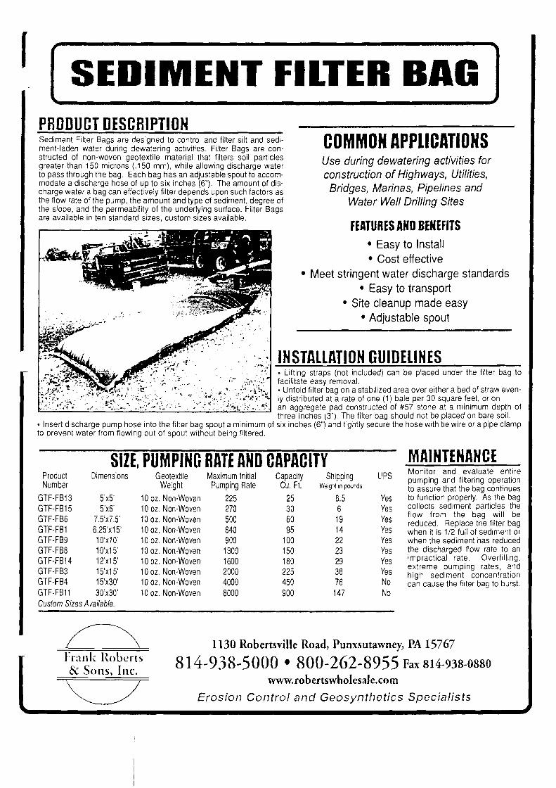
-''''',.' ~. .
r SEDIMENT FILTER BAG PRODUCT DESCRIPTION Sediment Filter Bags are designed to control and filter silt and sedi COMMON APPLICATIONSmenHaden water during dewatering activities. Filter Bags are constructed of non-woven geotextile material that filters soil particles Use during dewatering activities for greater than 150 microns (.150 mm), while allowing discharge water to pass through the bag. Each bag has an adjustable spout to accom construction of Highways, Utilities, modate a discharge hose of up to six inches (6"). The amount of dis Bridges, Marinas, Pipelines and charge water a bag can effectively filter depends upon such factors as the flow rate of the pump, the amount and type of sediment, degree of Water Well Drilling Sites the slope, and the permeability of the underlying surface. Filter Bags are available in ten standard sizes, custom sizes available.
fEATURES AND BENEFITS • Easy to Install • Cost effective
• Meet stringent water discharge standards • Easy to transport
• Site cleanup made easy • Adjustable spout
INSTALLATION GUIDELINES ~...;.";;;...;.;~=";,.;;..:..;;;~.....;..;...;;;..;;",;;;..;,,,;;.;;~,;,,,;..~-------
• Lifting straps (not included) can be placed under the filter bag to facilitate easy removal . • Unfold filter bag on a stabilized area over either a bed of straw evenly distributed at a rate of one (1 i bale per 30 square feet, or on an aggregate pad constructed of #57 stone at a minimum depth of three inches (3"). The filter bag should not be placed on bare soil.
• Insert discharge pump hose into the filter bag spout a minimum of six inches (6") and tightly secure the hose with tie wire or a pipe clamp to prevent water from flowing out of spout without being filtered.
MAINTENANCESIZE, PUMPING RATE AND CAPACITY Monitor and evaluate entire
Product Dimensions Geotex!ile Maximum Initial Capacity Shipping UPS pumping and filtering operation Number Weight Pumping Rate Cu. Ft. Weigrt 10 pOLnds to assure that the bag continues
GTF-FB13 5'x5' 10 oz. Non-Woven 225 25 6.5 Yes to function properly. As the bag collects sediment particles theGTF-FB15 5'x6' 10 oz. Non-Woven 270 30 6 Yes flow from the bag will be
GTF-FB6 7.5'x7.5' 10 oz. Non-Woven 500 60 19 Yes reduced. Replace the filter bagGTF-FB1 6.25'x15' 10 oz. Non-Woven 840 95 14 Yes when it is 1/2 full of sediment or GTF-FB9 10'x1 O' 10 oz. Non-Woven 900 100 22 Yes when the sediment has reduced GTF-FB8 10'x15' 10 oz. Non-Woven 1300 150 23 Yes the discharged flow rate to an
impractical rate. Overfilling,GTF-FB14 12'x15' 10 oz. Non-Woven 1600 180 29 Yes extreme pumping rates, and
GTF-FB3 15'x15' 10 oz. Non-Woven 2000 225 38 Yes high sediment concentration GTF-FB4 15'x30' 10 oz. Non-Woven 4000 450 76 No can cause the filter bag to burst. GTF-FB11 30'x30' 10 oz. Non-Woven 8000 900 147 No Custom Sizes Available.
~\ 1130 Robertsville Road, PllILxslltawney, PA 15767 Frank Roberts 814-938-5000 • 800-262-8955 Fax 814-938-0880 & Sons, Inc.
www.robertswholesale.com
Erosion Control and Geosynthetics Specialists
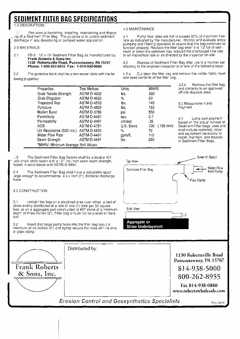
SEDIMENT FILTER BAG SPECIFICATIONS 1.0 DESCRIPTION:
.1 This work is furnishing, installing, maintaining and dispos,ng of a Sediment Filter Bag. The purpose is to control sediment discharge in any dewatering or pumped water application.
2.0 MATERIALS:
2.1 FB-3 15' x 15' Sediment Filter Bag as manufactured by: Frank Roberts & Sons Inc. 1130 Robertsville Road, Punxsutawney, PA 15767 Phone: 1·800·262·8955 Fax: 1-814-938-0880
2.2 The geotextile fabric shall be a non-woven fabric with the fol
lowing properties:
Properties Test Method
Grab Tensile Strength ASTM 0-4632 Grab Elogation ASTM 0-4632 Trapezoid Tear ASTM 0-4533 Puncture ASTM 0-4833
Mullen Burst ASTM 0-3786 Permittivity ASTM 0-4491
Permeability ASTM-0-4491 AOS ASTM-0-4751
UV Resistance (500 hrs.) ASTM 0-4355 Water Flow Rate ASTM-0-4491 Seam Strength ASTM-0-4491
*MARV: Minimum Average Roll Values
4.0 MAINTENANCE
4.1 Pump flow rates are not to exceed 50% of maximum flow rate as indicated by the manufacturer. Monitor and evaluate entire pumping and filtering operation to assure that the bag continues to function properly. Replace the filter bag when it is 1/2 full of sediment or when the sediment has reduced the discharged flow rate to an impractical rate or as directed by the inspector on-site.
4.2 Dispose of Sediment Filter Bag after use in a manner satisfactory to the engineer/inspector or in one of the following ways:
42.a Cut open the filter bag and remove the visible fabric, level and seed contents of the filter bag.
4.2.b Remove the filter bag Units MARV and contents to an approved
Ibs. 290 off-site disposal area.
% 50 Ibs. 145 5.0 Measurement and Ibs. 165 Payment
psi 550
sec.
em/sec
0.7 .35
5.1 Lump sum payment based on the actual number of
U.S. Sieve 100 (.150 mm) Sediment Filter Bags used and
% 70 shall include materials, labor,
gpm/ft. Ibs.
110
250
and equipment necessary to install, maintain, and dispose of Sediment Filter Bags.
:.3 The Sediment Filter Bag Seams shall be a double 401 - lock chain stitch seam with a 121 Ibs./inch sewn seam strength,
tested in accordance with ASTM 0-4884.
2.4 The Sediment Filter Bag shall have a adjustable spout large enough to accommodate a six inch (6") diameter discharge hose.
3.0 CONSTRUCTION
3.1 Unfold filter bag on a stabilized area over either a bed of straw evenly distributed at a rate of one (1) bale per 30 square feet, or on a aggregate pad constructed of #57 stone at a minimum depth of three inches (3"). Filter bag should not be placed on bare soil.
3.2 Insert discharge pump hose into the filter bag spout a minimum of six inches (6") and tightly secure the hose with tie wire or pipe clamp.
____ Sewn In Spout
Top View ~
i-------------r----,
I Water Flow Sediment Filter Bag ~ from Pump
I ~ '\Pip, CI,mp
l_______J Side View
.. .... ..iIIiIIIiiIDistributed by:
1130 Robertsville Road Punxsutawney, PA 15767
Frank n.obcrts 814-938-5000 & Sons, Inc. 800-262-8955
Fax 814-938-0880 www.robertswholesale.com
Erosion Control and Geosynthetics Specialists Rev. 09/06
GARRISON PROPERTIES, LLC ENVIRONMENTAL ASSESSMENT FORM
,-. APPENDIX 2

To: Philipstown Planning Board From: Conservation Board (CB) Date: 2-16-12 RE: Garrison Station Plaza, Inc. 7 Garrison Landing, Garrison, NY TM #60.17-1-7
The Philipstown Conservation Board was referred the application for renovation and improvement of the commercial property at 7 Garrison Landing (locally known as Guinan's) owned by Garrison Station Plaza. The building is immediately proximate to the Hudson River and for any future use requires a complete overhaul ofthe waste treatment system located within the 100 ft. regulated buffer area. This property was approved for renovation of interior, exterior and waste treatment in 2010(?) when the building was going to be reconfigured as office and apartment space. Now the plan calls for appropriate and necessary renovation of the site and reconfiguration of the waste treatment system to appropriately accommodate a barfrestaurant and apartment units on the upper floor.
During the CB's February 14th meeting, the application was discussed. Discussion focused on the manner and method of the new duel waste system and the level of water treatment achieved through the new technology to be installed, since outflow will be directly into the river. Additionally, the CB questioned the owner representative (Glenn Watson of Badey & Watson) on the planned maintenance of the septic tank. We were assured that the system would be pumped out and inspected on a regular schedule and reports would be forwarded to the appropriate agencies for oversight. Some concern was expressed regarding a significant rain event like Hurricane Irene, which would potentially raise the water level of the river over the outflow pipe and cause backwashing into the system. We were assured that the outflow pipe had a check valve that would prevent this from happening.
TheCB further recommends that these plans be referred to our Flood Plain Administrator who is essentially Kevin Donohue as some of this property is in the FP of the Hudson Estuary. A motion to recommend the granting of a wetland permit for this project was unanimously passed by the board. Thank you for allowing us the opportunity to comment on this proposal.

BADEY & WATSON Surveying & Engineering P.C.
3063 Route 9. Cold Spting, New Yotk 10516 (845) 265-9217 Glennon J. Watson, 1.5. (877) 3141593 John P Delano, PE.
Fax: (845) 265-4428 Petet Meisler, 1.5. www.badey-watson.com Stephen R. Miller, 1.5. [email protected] Jennifer W Reap, 1.5.
February 27,2012
George A. Badey, 1.5., Senior Consultant Mary Rice, R.L.A., Consultant
Robert S. Miglin, Jr., 1.5.
Michael Leonard, Chairman Philipstown Planning Board Town Hall 238 Main Street Cold Spring, NY 10516
RE: Application of Mary Ellen FingerlEntergy Nuclear Indian Point 2, LLC Submission of Full Environmental. Assessment Form Parts 1, 2 & 3
Dear Mr. Leonard & Honorable Board Members:
Enclosed you will find 12 copies of the following materials prepar~d for the above captioned application:
• Full Environmental Assessment Form Parts 1,2 & 3 • l1x17 color rendering of proposed building by REL Architects and Engineers Inc., P.C. • Revised plans prepared by REL Architects and Engineers Inc., P.C.
• Site Plan- last dated, February 27,2012 • Paving Grading and Drainage Plans - last dated; February 27, 2012 • Landscape Plans -last dated, February 27,2012 • Site Details -last dated, February 27,2012
Please place this matter on the agenda for the March 15,2012 meeting of the Planning Board. As always, thank you for your continued attention to and concern for this application.
cc: File Mary Ellen Finger WmJosiger, Entergy
U: 91-1041ML27FB12QP
Owners ofthe records and files of Joseph S. Agnoli • Barger. & Husris, Surveyors. Burgess & Behr • Roy Burgess. Vincent A. Burruano • Hudson VaHey Engineering Company, Inc.
G. RadchfTHusns, Surveyor. Peter R. HustIs, Surveyor. James W Irish. Jr.• ]. Wilbur Irish. Douglas A. Merrin. E.B. Moebus Reynolds & Chase. General Jacob Schofield. Sidney Schofield, C.E.• Taconic Surveying & Engineering, Pc. • D. Walcun
FULL ENVIRONMENTAL ASSESSMENT FORM PARTS 1,2 &3 for the application of
Mary Ellen Finger/ Entergy Nuclear Indian Point 2, LLC for approval of a
Re-Subdivision & Site Plan ON A PARCEL CONTAINING
20.00 ACRES AT THE INTERSECTION OF
Route 9 & Horsemen's Trail in the
TOWN OF PHILIPSTOWN PUTNAM COUNTY
NEW YORK FEBRUARY 27, 2012
Prepared for and at the request of
THE PIDLIPSTOWN PLANNING BOARD TOWN HALL 238 MAIN STREET COLD SPRING, NY 10516
Prepared and compiled by BADEY & WATSON Surveying & Engineering, P. C. 3063 Route 9 Cold Spring, New York 10516 (845) 265-9217 (V) (845) 265-4428 (F) www.Badey-Watson.com

TABLE OF CONTENTS
Environmental Assessment Fonn Part I Environmental Assessment Fonn Part 2 Environmental Assessment Fonn Part 3 Appendices
la. Letter from Steve Marino Ib. Letter to David Klotzel to Request Wetlands Determination Ie. Wetlands Determination 2. Aquifer Report 3. Traffic Study 4. Conservation Advisory Board Report
File

MARY ELLEN FINGERIENTERGY NUCLEAR INDIAN POINT 2, LLC
ENVIRONMENTAL ASSESSMENT FORM PARTl

617.20 Appendix A
State Environmental Quality Review FULL ENVIRONMENTAL ASSESSMENT FORM
Purpose: The full EAF is designed to help applicants and agencies determine, in an orderly manner, whether a project or action may be significant. The question of whether an action may be significant is not always easy to answer. Frequently, there are aspects of a project that are subjective or unmeasurable. It is also understood that those who determine significance may have little or no formal knowledge of the environment or may not be technically expert in environmental analysis. In addition, many who have knowledge in one particular area may not be aware of the broader concerns affecting the question of significance.
The full EAF is intended to prOVide a method whereby applicants and agencies can be assured that the determination process has been orderly, comprehensive in nature, yet flexible enough to allow introduction of information to fit a project or action.
Full EAF Components: The full EAF is comprised of three parts:
Provides objective data and information about a given project and its site. By identifying basic project data, it assists a reviewer in the analysis that takes place in Parts 2 and 3.
Focuses on identifying the range of possible impacts that may occur from a project or action. It provides guidance as to whether an impact is likely to be considered small to moderate or whether it is a potentially-large impact. The form also identifies whether an impact can be mitigated or reduced.
If any impact in Part 2 is identified as potentially-large, then Part 3 is used to evaluate whether or not the impact is actually important.
THIS AREA FOR LEAD AGENCY USE ONLY
DETERMINATION OF SIGNIFICANCE •. Type 1 and Unlisted Actions
Identify the Portions of EAF completed for this project: [;zj Part 1 U Part 2 Upon review of the information recorded on this EAF (Parts 1 and 2 and 3 if appropriate), and any other supporting information, and considering both the magnitude and importance of each impact, it is reasonably determined by the lead agency that:
The project will not result in any large and important impact(s) and, therefore, is one which will not have a significant impact on the environment, therefore a negative declaration will be prepared.
Although the project could have a significant effect on the environment, there will not be a significant effect for this Unlisted Action because the mitigation measures described in PART 3 have been required, therefore a CONDITIONED negative declaration will be prepared"
The" project may result in one or more large and important impacts that may have a significant impact on the environment, therefore a positive declaration will be prepared.
*A Conditioned Negative Declaration is only valid for Unlisted Actions
Approval of Preliminary Subdivision Plat Showing Re-Subdivision of Property for Mary Ellen Finger Name of Action
Philipstown Planning Board Name of Lead Agency
Anthony Merante Chairman Print or Type Name of Responsible Officer in Lead Agency Title of Responsible Officer
Signature of Responsible Officer in Lead Agency Signature of Preparer (If different from responsible officer)
Date
617 PART I- PROJECT INFORMATION
Prepared by Project Sponsor
NOTICE: This document is designed to assist in determining whether the action proposed may have a significant effect on the environment. Please complete the entire form, Parts A through E. Answers to these questions will be considered as part of the application for approval and may be subject to further verification and public review. Provide any additional information you believe will be needed to complete Parts 2 and 3.
It is expected that completion of the full EAF will be dependent on information currently available and will not involve new studies, research or investigation. If information requiring such additional work is unavailable, so indicate and specify each instance.
NAME OF ACTION Approval of a 3 lot subdivision for Mary Ellen Finger
LOCATluN UF At;TluN (include Street Address, Municipality and County)
3 Horsemen's Trail, Town of Philipstown, Putnam County NAME OF APPLICANT/SPONSOR BUSINESS TELEPHONE
Mary Ellen Finger 845-265-2665 ADDRESS
3 Horsemen's Trail CITY/PO
Cold Spring STATE
NY ' ZIP CODE i 10516
NAME OF OWNER (if different) " BUSINESS TELEPHONE Same as Applicant
i ADDRESS
i--=C=-=IT=-=Y--=/c=P0c:-=::-:-=-:-:-==-::-::-:::c-=-:~ ~ I_S_T_A_T_E --J1_Z_'_P_C_O_D_E_ " DESCRIPTION OF ACTION
Approval of a three (3) lot subdivision of 20.00 acres. The 20.00 acres was the subject of a recent approval of a 5 lot subdivision of which Phase 1, a 3 lot , subdivision, has been filed. Approval will change the alignment of the 3 lots and substitute a shorter private road for the previously approved longer Town , Specification Road. Approval will also facilitate the approval of a simultaneous application by Entergy Nuclear Indian Point 2, LLC for site plan approval to
construct a 19,952 square foot building to house its Emergency Operations Facility on Lot 1 of the proposed subdivision. Lot 1 contains 6.768 acres and has I
frontage and access along Horsemen's Trail, Town Highway. The Emergency Operations Facility will NOT utilize the Private Road.
Please Complete Each Question· Indicate N. A. if not applicable
A. Site Description
Physical setting of overall project, both developed and undeveloped areas.
1. Present land use: u Urban G Industrial 0 Commercial u Residential (SUburban) LJ Rural (non-farm)
LJ Forest ~ Agriculture LJ Other
2. Total acreage of project area: 20.000 acres.
APPROXIMATE ACREAGE PRESENTLY AFTER COMPLETION
Meadow or Bushland (Non-agricultural) 0 acres 2.7 acres
Forested 5.5 acres 5.5 acres
Agricultural (Includes orchards, cropland, pastures, etc.) 12.2 acres 4.5 acres
Wetland (Freshwater or tidal as per Articles 24, 25 or ECl 0 acres 0 acres
Water Surface Area 0 acres 0 acres
Unvegetated (Rock, earth or fill) 1.5 acres 1.5 acres
Roads, buildings an other paved surfaces 0.8 acres 3.7 acres
Other (Indicate type) Lawns, gardens, landscaped areas 0 acres 2.1 acres
TOTALS 20 acres 20 acres
3. What is predominant soil type(s) on project site? Riverhead Loam a. Soil drainage: ~ Well Drained 84 % of site ~ Moderately well drained 16 %of site
U Poorly Drained 0 %of site
b. If any agricultural land is involved, how many acres of soil are classified within soil group 1 through 4 of the NYS
Land Classification System? 6 acres. (See 1 NYCRR 3700.)
--4. Are there bedrock outcroppings on project site? ~ Yes LJ No a. What is the depth to bedrock? 0->7' (in feet)
2

5. Approximate percentage of proposed site with slopes: ~ 0-10% 51 % ~ 10-15% 19 %
~ 15% or greater 30 %
6. Is project substantially contiguous to, or contain a building, site, or district, listed on the State or National Registers of Historic
Places? 0 Yes ~ No
7.ls project substantially contiguous to a site listed on the Register of National Natural Landmarks? 0 Yes ~ No
8. What is the depth of the water table? 0 - >7' (in feet)
9. Is site located over a primary, principal, or sole source aquifer? 0 Yes ~ No
10. Do hunting. fishing or shell fishing opportunities presently exist in the project area? 0 Yes ~ No
11. Does project site contain any species of plant or animal life that is identified as threatened or endangered? [J Ves ~ No According to Site Inspection, More to follow Identify each species N/A
12. Are there any unique or unusual land forms on the project site? (Le., cliffs, dunes, other geological formations.) U Yes ~ No Describe N/A
13. Is the project site presently used by the community or neighborhood as an open space or recreational area? Li Yes ~ No If yes, explain N/A
14. Does the present site include scenic views known to be important to the community? o Yes ~ No
15. Streams within or contiguous to project area: None
a. Name of Stream and name of River to which it is tributary N/A
16. Lakes, ponds, wetland areas within or contiguous to project area: a. Name None b. Size (in acres) N_I_A _
17. Is the site served by existing public utilities? ~ Yes 0 No
a) IfVes, does sufficient capacity existto allow connection? iZi Yes '0 No b) If Ves, will improvements be necessary to allow connection? 0 Yes ~ No
18. Is the site located in an agricultural district certified pursuant to Agriculture and Markets law, Article 25-M, Section 303 and 304? ~ Ves uNo
19. Is the site located in or substantially contiguous to a Critical Environmental Area designated pursuant to Article 8 of the ECl, and 6 NYCRR 617? LI Yes X No
20. Has the site ever been used for the disposal of solid or hazardous wastes? LJ Yes ~ No
B. Project Description
1. Physical dimensions and scale of project (fill in dimensions as appropriate) a. Total contiguous acreage owned or controlled by project sponsor 20.00 ----- acres
b. Project acreage to be developed: 4.2 acres initially; 5.8 c. Project acreage to remain undeveloped 7 acres. d. Length of project. in miles: N/A (if appropriate)
e. If the project is an expansion, indicate percent of expansion proposed? N/A %
f. Number of off-street parking spaces existing 4 , proposed 186
g. Maximum vehicular trips generated per hour 170 (upon completion of project)? h. If residential: Number and type of housing units:
One Family Two Family Multiple Family Condominium Initially 1 _ o o o IJltimately 2 o o o I. Dimensions (in feet) of largest proposed structure 23 height; 116 --- width; 172 length.
3
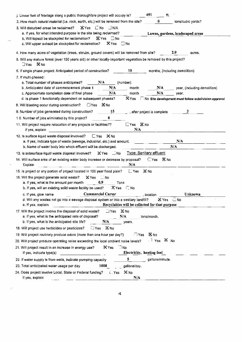
j. Linear feet of frontage along a public thoroughfare project will occupy is? 691 ft.
2. How much natural material (Le. rock, earth, etc.) will be removed from the site? 0 tons/cubic yards?
3. Will disturbed areas be reclaimed? ~Yes D No D N/A
a. If yes, for what intended purpose is the site being reclaimed? Lawns, gardens, landscaped areas b. Will topsoil be stockpiled for reclamation? ~ Yes D No
c. Will upper subsoil be stockpiled for reclamation? ~ Yes D No
4. How many acres of vegetation (trees, shrubs, ground covers) will be removed from site? 2.9 acres.
5. Will any mature forest (over 100 years old) or other locally-important vegetation be removed by this project?
DYes ~No
6. If single phase project: Anticipated period of construction? 10 months, (including demolition).
7. If multi-phased:
a. Total number of phases anticipated? N/A (number).
b. Anticipated date of commencement phase 1 N/A month ___N_I_A year, (including demolition)
c. Approximate completion date of final phase N/A month ___N_I_A year.
d. Is phase 1 functionally dependent on subsequent phases? ~ Yes o No Site development must follow subdivision approval
8. Will blasting occur during construction? [J Yes ~ No
9. Number of jobs generated during construction? 15 , after project is complete 3
1 O. Number of jobs eliminated by this project? 0
11. Will project require relocation of any projects or facilities?? DYes 1& No
If yes, explain N/A
12. Is surface liquid waste disposal involved? 0 Yes i& No
a. If yes, indicate type of waste (sewage, industrial, etc.) and amount. N/A
b. Name of water body into which effluent will be discharged. N/A
13. Is subsurface liquid waste disposal involved? i& Yes D No Type: Sanitary effluent
14. Will surface area of an existing water body increase or decrease by proposal? DYes i& No
Explain N/A
15. Is project or any portion of project located in 100 year flood plain? 0 Yes ,X No
16. Will the project generate solid waste? ~ Yes [J No
a. If yes, what is the amount per month 0.9 Tons
b. If yes, will an existing solid waste facility be used? X Yes LJ No
c. If yes, give name Commercial Carter , location Unknown
d. Will any wastes not go into a sewage disposal system or into a sanitary landfill? X Yes L; No
e. If yes, explain Recyclables will be collected for that purpose
17. Will the project involve the disposal of solid waste? 0 Yes X No
a. If yes, what is the anticipated rate of disposal? N/A tons/month.
b. If yes, what is the anticipated site life? N/A years.
18. Will project use herbicides or pesticides? [J Yes i& No
19. Will project routinely produce odors (more than one hour per day?) DYes i& No
20. Will project produce operating noise exceeding the local ambient noise levels? DYes 1& No
21. Will project result in an increase in energy use? 1& Yes 0 No
If yes, indicate type(s) Electricity, heating fuel,
22. If water supply is from wells, indicate pumping capacity ___5.:.- gallons/minute.
23. Total anticipated water usage per day 1000 gallons/day.
24. Does project involve Local, State or Federal funding? 0 Yes 1& No
If yes, explain N/A
4
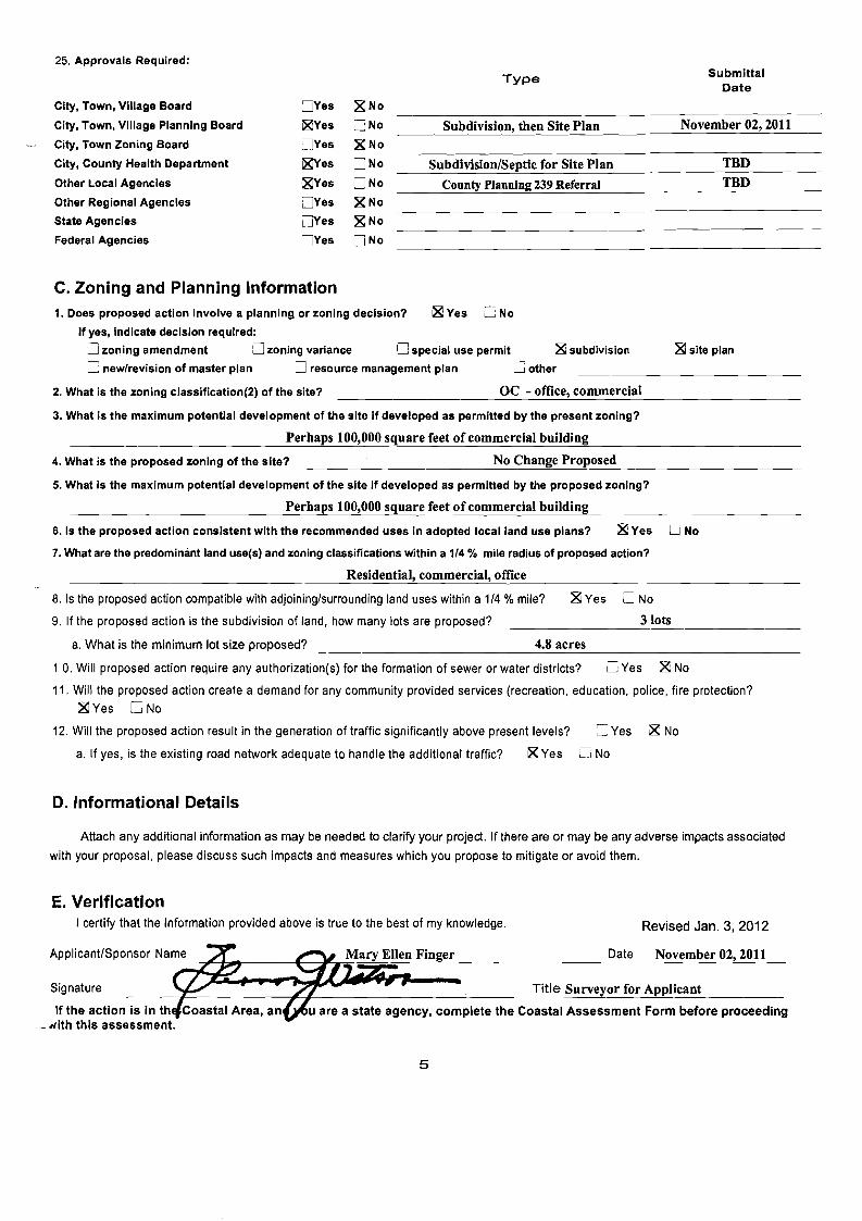
25. Approvals Required: SubmittalType
Date
City, Town, Village Board DYes ~No
City, Town, Village Planning Board ~Yes DNo Subdivision, then Site Plan November 02, 2011
City, Town Zoning Board DYes ~No
City, County Health Department ~es DNo Subdivision/Septic for Site Plan TBD
Other Local Agencies ~Yes DNo County Planning 239 Referral TBD
Other Regional Agencies DYes ~No
State Agencies DYes ·181 No
Federal Agencies DYes DNo
C. Zoning and Planning Information 1. Does proposed action involve a planning or zoning decision? ~ Yes [J No
If yes, indicate decision required:
LJ zoning amendment [] zoning variance [] special use permit ~ subdivision ~site plan
C new/revision of master plan 0 resource management plan C other
2. What is the zoning classification(2) of the site? DC - office, commercial
3. What is the maximum potential development of the site if developed as permitted by the present zoning?
Perhaps 100,000 square feet of commercial building
4. What is the proposed zoning of the site? No Change Proposed
5. What is the maximum potential development of the site if developed as permitted by the proposed zoning?
Perhaps 100,000 square feet of commercial building
6. Is the proposed action consistent with the recommended uses in adopted local land use plans? 181 Yes 0 No
7. What are the predominant land use(s) and zoning classifications within a 1/4 % mile radius of proposed action?
Residential, commercial, office
8. Is the proposed action compatible with adjoining/surrounding land uses within a 1/4 % mile? ~Yes LJ No
9. If the proposed action is the subdivision of land, how many lots are proposed? 3 lots
a. What is the minimum lot size proposed? 4.8 acres
1 O. Will proposed action require any authorization(s) for the formation of sewer or water districts? U Yes ~ No
11. Will the proposed action create a demand for any community provided services (recreation, education, police, fire protection?
~Yes C No
12. Will the proposed action result in the generation of traffic significantly above present levels?
a. If yes, is the existing road network adequate to handle the additional traffic? ~ Yes
== Yes
LJ No
g No
D. Informational Details
Attach any additional information as may be needed to clarify your project. If there are or may be any adverse impacts associated
with your proposal, please discuss such impacts and measures which you propose to mitigate or avoid them.
E. Verification I certify that the information provided above is true to the best of my knowledge. Revised Jan. 3, 2012
u are a state agency, complete the Coastal Assessment Form before proceeding
~'--I:;; __-----'------:"........---.o;:;==-=-----=---------
Signature
If the action is in th Nith this assessment.
Date November 02, 2011
Title Surveyor for Applicant
~_
5
MARY ELLEN FINGERJENTERGY NUCLEAR INDIAN POINT 2, LLC
ENVIRONMENTAL ASSESSMENT FORM PART 2
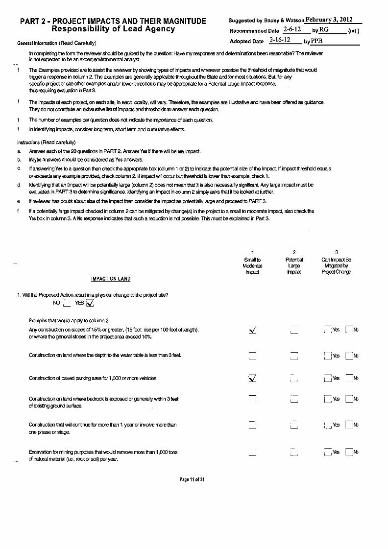
------
Suggested by Badey &Watson February 3, 2012PART 2 • PROJECT IMPACTS AND THEIR MAGNITUDE Responsibility of Lead Agency Recommended Date 2-6-12 by RG (int.)
Adopted Date 2-16-12 byPPBGeneral Information (Read Carefully)
In oompleting the form the reviewer should be guided by the question: Have my responses and determinations been reasonable? The reviewer is not expected to be an expert environmental analyst.
The Examples provided are to assist the reviewer by showing types of impacts and wherever possible the threshold of magnitude that would trigger a response in column 2. The examples are generally applicable throughout the State and for most situations. But, for any specific project or site other examples ardIor lower thresholds may be appropriate for a Potential Large Impact response, thus requiring evalua1ia1 in Part 3.
The impacts of each project, on each site, in each locality, will vary. Therefore, the examples are illustrative and have been offered as guidance. They do not constitute an exhaustive list of impacts and thresholds to answer each question.
The number of examples per question does not indicate the importance of each question.
In identifying impacts, consider long term, short term and cumulative effects.
Instructions (Read carefully)
a Answer each of the 20 questions in PART 2. Answer Yes if there will be any impact.
b. Maybe answers should be considered as Yes answers.
c. If answering Yes to a question then check the appropriate box (column 1or 2) to indicate the potential size of the impact. If impact threshold equals or exceeds any example provided, check column 2. If impact will occur but threshold is lower than example, check 1.
d Identifying that an Impact will be potentially large (column 2) does not mean that it is also necessarily significant. Any large impact must be evaluated in PART 3 to determine significance. Identifying an impact in column 2 simply asks that it be looked at further.
e. If reviewer has doubt about size of the impact then consider the impact as potentially large and proceed to PART 3.
f. If a potentially large impact checked in column 2 can be mitigated by change(s) in the project to a small to moderate impact, also check the Yes box in column 3. A No response indicates that such a reduction is not possible. This must be explained in Part 3.
IMPACT ON LAND
1 Small to
Moderate Impact
2
Potential Large Impact
3 Can Impact Be
Mitigated l7i Project Change
1. Will the Proposed Action result in a physical change to the project site?
f\O '------.. YES ~
Examples that would apply to column 2
Any construction on slopes of 15% or greater, (15 foot rise per 100 foot of length), or where the general slopes in the project area exceed 10%.
'------" Yes ON:>
Construction on land where the depth to the water table is less than 3 feet l-.J '------.J ~Yes ON:>
Construction of paved parking area for 1,000 or more vehicles. ~ '------.J LJYes ON:>
Construction on land where bedrock is exposed or generally within 3 feet of existing ground surface.
LJ LJYes ON:>
Construction that will continue for more than 1 year or involve more than one phase or stage.
I
l-.J l-.J LJYes ON:>
Excavation for mining purposes that would remove more than 1,000 tons of natural material (i.e., rock or soi~ per year.
'-----I Yes ON:>
Page 11 of 21
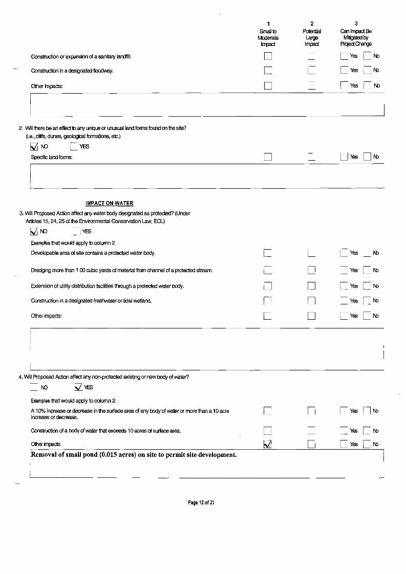
1 2 3 Small 10 Potential can Impact Be
fv10derale Large Miligatedl:11 Impac:l Impac:l PrqedO-arge
Construction or expansion of a sanitary landfill. 0 0 o Yes LJI'C
Construction in a designated floodway. 0 0 o YES LJf\b
Other impacts: 0 0 o YES UI'C
~ 2. WiIl1here be an effect10 any Ulk:lue or unusual land forms fOlm on 1he site?
(I.e., cliffs, dunes, geological foonations, etc.)
Mf\O DYES
Specific land forms: 0 0 o YES ON:>
IMPACT ON WATER
3. Will Proposed Action affect any water body designated as protected? (Under Articles 15, 24, 25 of the Environmental Conservation Law, Eel)
Examples that would apply to column 2
Developable area of site conlains a protected water body.
Dredging more than 100 cubic yards of material from channel of a protected stream.
Extension of utility distribution facilities through a protected water body.
Construction in a designated freshwater or tidal wetland.
Other impacts:
0 0 DyES ON:>
0 0 o YES ON:> 0 0 o YES ON> 0 0 o YES ON> 0 0 DyES ON:>
4. Will Proposed Action affect any ron-protected existing or new body of water?
01\0 ~'1'ES
Examples that would apply to column 2
A 10"/0 increase or decrease in the surface area of any body of water or more than a 10 acre o o o YES 0 N> increase or decrease.
Construction of a body of water that exceeds 10 acres of surface area. o Other impacts: o Removal of smaU pond (0.015 acres) on site to permit site development.
Page 12 of 21
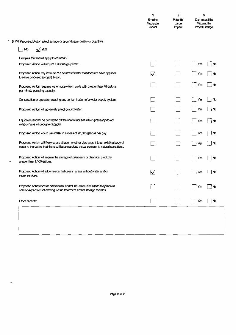
1 2 3 Small 10 Potential Canlm~Be
rv10derate Large Mitigated by Im~ Impact PrqaiOmge
- 5. \Nill Proposed Action affect surface or groLJr'dNater quality or quantity?
Of\!) ~YES
Examples that would apply to column 2
Proposed Action will require a discharge penni!. 0 0 U Yes ON::>
Proposed Action requires use of a source of water that does not have approval 10 serve proposed (project) action.
Proposed Action requires water supply from wells with greater than 45 gallons per minute pumping capacity.
Construction or operation causing any contamination of a water supply system.
Proposed Action will adversely affect groundwater.
M
0
0
0
0
0
0
0
Dyes
LJ Yes
o Yes
o Yes
ON:>
ON::>
ON:>
ON:>
Liquid effluent will be conveyed off the site to facilities \'k1ich presently do not exist or have inadequate capacity.
Proposed Action would use water in excess of 20,000 gallons per day.
0
0
0
0
o Yes
o Yes
ON:>
ON:>
Proposed Action will likely cause siltation or other discharge into an existing body of water to the extent that there will be an obvious visual contrast to natural conditions.
0 0 o Yes ON:>
Proposed Action will require the storage of petroleum or chemical products greater than 1,100 gallons.
0 0 o Yes ON::>
Proposed Action will allow residential uses in areas without water and/or sewer services.
[;j LJ o Yes ON:>
Proposed Action locates commercial and/or industrial uses \'k1ich may require new or expansion of existing waste treatment and/or storage facilities.
0 0 Dyes ON:>
Other impacts: 0 0 Dyes ON:>
Page 13 of 21
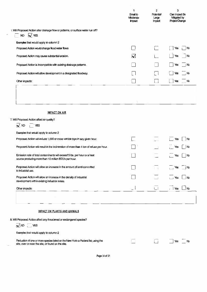
1 2 3 Small 10 Potential Can Impact Be
Moderate Large Mitigated by Impact ImIBct Project01ange
I. Will Proposed Action alter drainage flow or pattems, or surface water run off?
[]r-o ~YES
Examples that would apply to column 2
Proposed Action oouId change flood water flow.; 0 0 DYes UN> Proposed Action may cause substantial erosion. ~ 0 DYes UN>
Proposed Action is incompatible with existing drainage pattems. 0 U DYes UN>
Proposed Action will allow development in a designated floodway. 0 U DYes :iN>l-J
Other impacts: r--I
0 i i
LJ DYes LJN>
I I L I
IMPACT ON AIR
7. Will Proposed Action affect air quality?
~f\O l]YES
Examples that would apply to column 2
Proposed Action will induce 1,000 or more vehide trips in any given hour. 0 LJ LJ Yes ON> Proposed Action will resu~ in the incineration of more than 1ton of refuse per hour. 0 l-J L..-...J Yes ON>
Emission rate of total contaminants will exceed 5 100. per hour or a heat source producing more than 10 million BTU's per hour.
0 L-----.J L.-.. Yes ON>
Proposed Action will allow an increase in the amount of land committed to industrial use.
0 ~ ~ Yes ON>
Proposed Action will allow an increase in the density of industrial development within existing industrial areas.
Other impacts:
0
D
L-.!
i~
l-J Yes
LJ Yes
ON>
ON>
IMPACT ON PLANTS AND ANIMALS
8. Will Proposed Action affect any threatened or endangered species?
~f\O L-J YES
Examples that would apply to column 2
Reduction of one or more species listed on the New York or Federal list, using the Dyes 0 t-bD usite, over or near the site, or found on the site.
Page 14 of 21
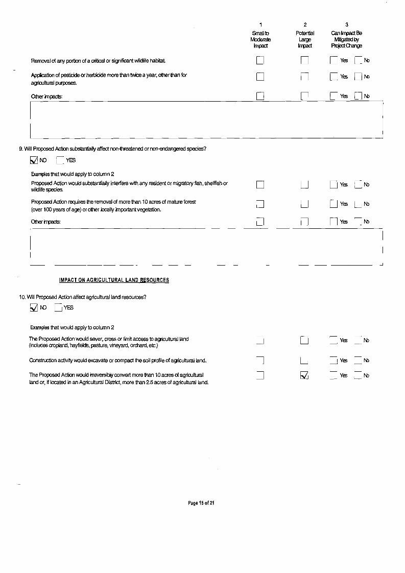
1
SrnaIlto Moderate I~
2
Potential Large Impact
3
Ganlm~8e
Mitgated~ Project Q-ange
Removal of any portion of a cri1icaI or significant 'Nildlife habitat 0 0 DYES lJN>
Application of pesticide or herticide more than twice a year, other than for agricultural purposes.
Other impacts:
0
D
0
0
DYES
DYES
ON>
UN>
I
l 9. Will Proposed Action substantially affect non-threatened or non-endangered species?
[;2Jr-n DYES Examples that would apply to column 2
Proposed Action would substantially interfere with any resident or migratory fish, shellfish or \'<ildlife species.
Proposed Action requires the removal of more than 10 acres of mature forest (over 100 years of age) or other locally important vegetation.
Other impacts:
0
0
0
0
0
0
DyES
DyES
DyES
uN>
LJN>
UN> -L
I
I ~
IMPACT ON AGRICULTURAL LAND RESOURCES
10. Will Proposed Action affect agricultural land resources?
MN) DYES
Examples that would apply to column 2
The Proposed Action would sever, cross or limit access to agricultural land (incll.des cropland, hayfields, pasture, vineyard, orchard, etc.) 0 D DYES L.JN>
Construction activity would excavate or compact the soil profile of agricultural land.
The Proposed Action would irreversibly convert more than 10 acres of agricultural land or, if located in an Agricultural District, more than 2.5 acres of agricultural land.
0 0
0 [;2J
DyES DyES
~ N>
UN>
Page 15 of 21

The Proposed Action 'IIoOuld disrupt or prevent installation of agricultural land management systems (e.g., subsurface drain lines, ouUet ditches, strip cropping); or create a need for su:h measures (e.g. cause a falm field to drain poorly due to increased nnofl).
Other impacts:
IMPACT ON AESTHETIC RESOURCES
11. Will Proposed Action affect aesthetic resources? (If necessary, use the VISual EAF Addendum in Section 61720, Appendix S.)
Examples that would apply to column 2
Proposed land uses, or project components obviously different from or in sharp contmst to current surrounding land use patterns, 'M1ether man-made or natural.
Proposed land uses, or project components visible to users of aesthetic resources 'M1ich will eliminate or significantly reduce their enjoyment of the aesthetic qualities of that resource.
Project components that will resutt in the elimination or significant screening of scenic views known to be important to the area.
Other impacts:
IMPACT ON HISTORIC AND ARCHAEOLOGICAL RESOURCES
12. Will Proposed Action impact any site or structure of historic, prehistoric or paleontological importance?
~ t{) LJ YES
Examples that would apply to column 2
Proposed Action occurring wholly or partially ~in or substantially contiguous to any facility or site listed on the State or National Register of historic places.
Any impact to an archaeological site or fossil bed located ~in the project site.
Proposed Action will occur in an area designated as sensitive for archaeological sites on the NVS Site Inventory.
1
Small to Moderate
Impact
D
D
u
r'u
~
U
2 3
Potential Can Impact Be Large Mitigated by Impact PrqocI 01aJlle
D DYe:; D N:>
D Dye:; D N:>
D DYe:; UN:>
1lN:>D DYe:; L-J
D DYe:; LJN:>
D DYe:; IN:>L-J
D DYe:; LJN:>
D DYe:; UN:>
D DYe:; UN:>
Page 16of21
1 2 3
SrnaJllo Potential can Impact Be Moderate Large Mitigated by
Impact Impact PrqoclO-ange
Olher impacts; 0 0 [J Yes Dr-b
IMPACT ON OPEN SPACE AND RECREATION
13. Will proposed Action affect the quantity or quality of existing or future open spaces or recreational opportunities?
Examples that would apply to column 2
The permanent foreclosure of a future recreational opportunity.
A major reduction of an open space important to the community.
Other impacts:
-----, LJ
LJ -----, U
0 0
0
U Yes
LJ Yes
LJ Yes
~r-b
LJr-b
LJr-b
IMPACT ON CRITICAL ENVIRONMENTAL AREAS
t Will Proposed Action impact the exceptional or unique characteristics of a critical environmental area (CEA) establisha:! pursuant 10 Sli:x:1ivisicrl6 NYCRR 617.14(g)?
LJYES
List the environmental characteristics that caused the designation of the CEA.
Examples that would apply to column 2
Proposed Action 10 locate within the CEA? U 0 iUYes ~r-b
Proposed Action will result in a reduction in the quantity of the resource?
LJ 0 LJ Yes LJr-b
Proposed Action will result in a reduction in the quality of the resource?
LJ 0 ,LJ Yes LJr-b
Proposed Action will impact the use, function or enjoyment of the resource?
LJ 0 LJ Yes Ur-b
Other impacts: LJ 0 U Yes LJr-b
Page 17 of 21
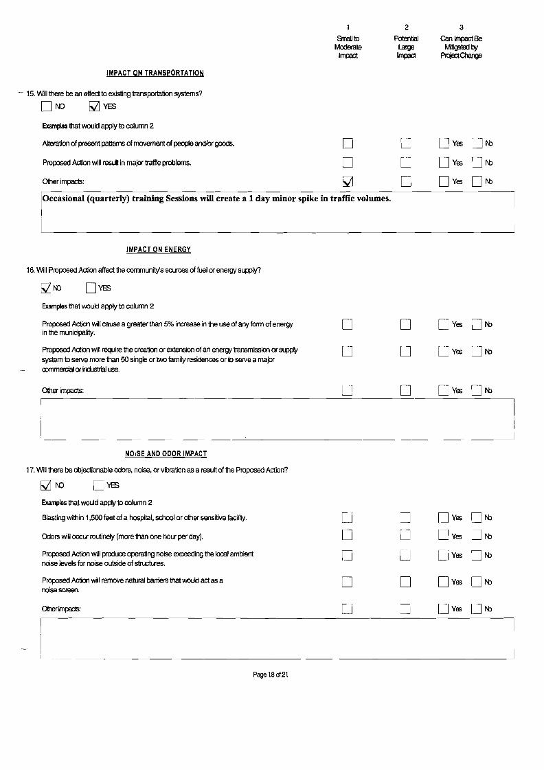
1 2 3
SrnaUIo Moderate
Impact
Potential Large Impact
can Impact Be Mitiga1ed I:7f ~01arge
IMPACT ON TRANSPORTATION
- 15. Will there be an effect to existing transportation systems?
01'0 ~YES
Examples that would apply to column 2
A1temtion of present pattems of movement of people and/or goods. 0 0 o Yes ON:> Proposed Action will result in major traffic problems.
OIher impacts:
0 ~
0 0
o Yes
o Yes
ON:> ON:>
Occasional (quarterly) training Sessions will create a 1 day minor spike in traffic volumes.
IMPACT ON ENERGY
16. Will Proposed Action affect the community's sources of fuel or energy supply?
Examples that would apply to column 2
Proposed Action will cause a greater than 5% increase in the use of any form of energy o Yes 0 N:>o o in the municipality.
Proposed Action will require the creation or extension of an energy transmission or supply o o system 10 serve more than 50 single or two family residences or 10 serve a major commerc:ial or industrial use.
Page 18 0121
1 2 3
SmaJllO Potential can Impact Be Moderate Large Mitigated by
ImIEd ImlEd PrqectQ1arge
IMPACT ON PUBLIC HEALTH
18. Will Proposed Action affect public heallh and safety?
~f'O D\1:S
Proposed Action may cause a risk of explosion or release of hazardous substances (i.e. oil, pesticides, chemicals, radiation, etc.) in the event of accident or LPSElt conditions, or there may be a chronic low level discharge or emission.
D U U Yes DN:J
Propcsed AcIioo may resUt in the burial of 'hazardous wastes' h anyform (i.e. 1OlOC, poisorous, hi!f11y reactive, radioactive, irritating, infectious, etc.)
I"' LJ 0 i, Yes
LJ DN:J
Storage facilities for one million or more gallons of liquefied natural gas or other flammable liquids.
'------J r-I~
r---1y,LJes DN:J
Proposed Action may result in the excavation or other disturbance within 2,000 feet of a site used for the disposal of solid or hazardous waste.
I ~
Ii LJ LJ Yes DN:J
0Iher impacts: LJ i-----' I~ LJ Yes DN:J
IMPACT ON GROWTH AND CHARACTER OF COMMUNITY OR NEIGHBORHOOD
19. Will Proposed Action affect the character of the existing community?
MN) LJYES
Examples that would apply to column 2
The permanent population of the city, town or village in which the project is located is likely to grow by more than 5%. ~ LJ
.. L~ Yes
~
'---' N:J
The municipal budget for capital expenditures or operating services will increase by more than 5% per year as a result of this project
L-.! LJ L----! Yes L-.J N:J
Proposed Action will conflict with officially adopted plans or goals. L-J L....; Yes L-.J N:J
Proposed Action will cause a change in the density of land use. '--- '-----' U Yes L...; N:J
Proposed Action will replace or eliminate existing facilities, structures or areas of historic importance to the community.
'-----.; LJ ~~
Yes L...J N:J
Development will create a demand for additional community services (e.g. schools, police and fire, etc.)
LJ LJ ~ Yes LJ N:J
Page 190f21
1 2 3
Small to Moderate Im~
Potential Large Impact
Can Impact Be Mitigated by
Pn:joct01arge
Proposed Action will set an important precedent for future projects. D D Dyes DN:> Proposed Action will create or eliminate employment D D Dyes ON:> Other impacls: D D Dyes DN:>
20. Is there, or is there likely to be, public controversy related to potential adverse environment impacts?
~f\O DYES
- Ii Any Action in Part 2 Is Identified as aPotential Large Impact or If you Cannot Determine the Magnitude of Impact, Proceed to Part 3
Page 20 of 21
Part 3· EVALUATION OF THE IMPORTANCE OF IMPACTS
Responsibility of Lead Agency
Part 3 must be prepared if one or more impact(s) is considered 10 be potentially large, even if 1I1e impact(s) may be mitigated.
Instructions (If you need more space, attach additional sheets)
Discuss 1I1e folkming for each impact identified in Column 2 of Part 2:
1. Briefly describe 1I1e impact.
2. Describe (if applicable) how1l1e impact could be mitigated or reduced 10 a small to moderate impact by project change(s).
3. Based on 1I1e information available, decide if it is reasonable to conclude that 1I1is impact is important.
To answer 1I1e question of importance, consider:
! The probability of 1I1e impact occurring
! The duration of 1I1e impact
! Its irreversibility, including permanently lost resources of value
! lNhe1l1er 1I1e impact can or will be controlled
! The regional consequence of 1I1e impact
! Its potential divergence from local needs and goals
! lNhe1l1er known objections 10 1I1e project relate to 1I1is impact.
l__ Page 21 of 21

MARY ELLEN FINGERJENTERGY NUCLEAR INDIAN POINT 2, LLC
ENVmONMENTAL ASSESSMENT FORM PART 3
INTRODUCTION & BACKGROUND
Dr. Mary Ellen Finger has applied to the Philipstown Planning Board to re-subdivide her property into 3 lots. The property consists of 3 parcels that constitute Phase 1 of a previously approved 5 lot phased subdivision. It contains a total of 20 acres and is currently designated on the Putnam County Tax Map for the Town of Philipstown as Tax Map Sheet 16.12, Block 1, Lots 5.1,5.2 and 5.3. It is located on the westerly side of Horsemen's Trail in the North Highlands section of the Town of Philipstown. The property is located in an Office/Commercial/Industry Mixed Use Zone established under the Philipstown Zoning Law adopted in May of 2011. It is presently occupied by Dr. Finger's residence and fann.
If approved, Dr. Finger intends to abandon the 5-10t subdivision approval in favor of a new 3-10t subdivision. The new 3-10t subdivision will be configured differently from the 3 lots in Phase 1 of the previously approved plat, which has been filed in the Putnam County Clerk's office as Map No. 3109. The following table compares the areas of the filed subdivision, the approved, but as yet not filed plat, and the subdivision that is the subject ofthis EAF.
Lot Lot Areas in Acres As Filed As Approved Pending
1 1.9 1.9 6.8 2 1.9 1.9 2.4 3 16.2 11.5 4.8 4 Pending 1.8 N/A 5 Pending 1.8 N/A Road Pending 1.1 N/A1
Total 20.0 20.0 20.0
Dr. Finger's purpose in applying for the new 3-10t subdivision is to enable her to sell a 6.8-acre parcel with frontage on Horsemen's Trail to Entergy Nuclear Indian Point, LLC (Entergy).
Entergy has made a simultaneous application to the Philipstown Planning Board for approval of a Site Plan that would allow the construction of a 20,000 square foot commercial building and related infrastructure on the 6.8 acres it has contracted to purchase from Dr. Finger.
The applications were submitted for consideration at the November 2011 Planning Board meeting, which had to be postponed until December 8, 2011. During this meeting, the Planning Board: accepted both applications; declared its intention to serve as Lead Agency for the purposes of SEQRA; instructed its clerk to circulate the applications and notice to other Involved and Interested Agencies; and scheduled a site visit for January
1 The O.4-acre Private Road shown on the pending plat is part of Lot 2. As such, its area is included in Lot 2.
U:\91-104B\MF2IFBI2GL_ PI. 3 EAF.doc

15, 2012. The Planning Board also concluded that, because the Entergy site plan is dependent upon the approval of the 3-lot subdivision, for the purposes of SEQRA the applications should be reviewed as a unit.
The Planning Board made its site visit as scheduled. It reviewed the applications and entertained presentations from the applicants' consultants during its January 19 and February 16,2012, meetings. During its January 19,2012, meeting the Planning Board directed its engineer/planner Ron Gainer to review the applicants' consultant's suggested Part 2 of the EAF and recommend any appropriate additions or changes. This assignment was completed. During the February 16,2012, meeting of the Planning Board Mr. Gainer presented the results of his work. Following Mr. Gainer's presentation, the Planning Board adopted Part 2 of the EAF and directed the applicants' consultant to prepare Part 3 of this EAF for its consideration.
IMPACTS IDENTIFIED AND DISCUSSED
Part 2 of this EAF identifies the following potential negative impacts. Each is presented as it appears in Part 2. It is then followed by a discussion relating to the impact.
IMPACTS ON LAND o Any construction on slopes of15 % or greater, (15 foot rise per 100 foot oflength), or where the general slopes in the projection area exceed 10%.
The subdivision plan reveals that Dr. Finger anticipates construction on Class I Steep Slopes that exist on Lot 3. Most of the proposed construction on this lot is necessary to reach the developable portion of the lot. Accordingly, it is necessary to construct the driveway and related improvements. The developable portion of Lot 3 is traversed by a narrow band of Class I Steep Slopes, upon which the designers anticipate part of the garage and parking area will be constructed. The applicant's plan avoids construction on Class II and Class III Steep Slopes.
The only anticipated construction on Lot 2, which is limited to the construction of the Private Road and related improvements, including drainage infrastructure, will not occur on Steep Slopes.
With the exception of a small area where grading is required adjacent to the main driveway, and 5 or 6 individual trees which have been added to the plan in response to the Planning Board's request for additional landscaping, the site plan submitted by Entergy for Lot 1 avoids any construction on steep slopes.
A review of the plans for the project reveals that the applicants have avoided development on steep slopes, except as noted above. The proposed driveway into Lot 3 has been located in virtually the same place as that shown on the approved plat. Additionally, the applicants' designers have avoided any new construction on Class II and III Steep Slopes.
U:\91-104B\MF2IFBI2GL_Pt. 3 EAF.doc
Nevertheless, construction on steep slopes is generally conceded to have increased potential for slope failure and erosion. If these potential impacts were not anticipated and mitigated, environmental damage could occur. In the instant case, among other requirements, the applicants' designers have specified that during construction:
D Silt fence is to be installed and maintained; D Drainage devices, including catch basins and cross culverts are to be protected
with inlet barriers; D Stabilized Construction Entries are to be installed to minimize tracking of mud
from the site onto Horsemen's Trail and Route 9; D Exposed earth and stockpiled materials are to be stabilized; and D Regular inspections of the erosion control measures are to be conducted.
The measures noted above are shown and/or noted on the applicants' plans. The notes also specifY that permanent erosion measures be installed as construction is completed. These notes limit the time that a slope may remain in a disturbed condition. Permanent erosion control measures include planting of slopes to prevent or minimize future erosion.
All of the erosion control measures have been designed and will be installed in accordance with the NYS Department of Environmental Conservation's (NYSDEC) regulations and guidelines regarding stormwater pollution prevention. These guidelines include preparation of a Stormwater Pollution Prevention Plan (SWPPP), Filing the Plan with the NYSDEC, Filing of a Notice of Intent to begin construction prior to commencing it, regular inspection of the site, and reporting of the results of the inspection to the NYSDEC by a qualified inspector.
Based on the plans presented by the applicants and knowing that they are required to submit a SWPPP to the NYSDEC, the execution of which will be regularly inspected, the Planning Board can reasonably conclude that the potential impacts associated with construction on steep slopes has been avoided and/or mitigated to the greatest practical extent and, as such, does not present an impediment to the approval of the project.
o Construction ofpavedparking areafor 1,000 or more vehicles
The plans presented by Entergy propose the construction of a parking lot that will accommodate approximately 180 cars. This represents less than 20% of the threshold that would automatically result in the identification ofa potentially large impact.
Construction of large parking areas where fields and other pervious surfaces exist will increase the quantity and speed of stormwater runoff. It will also decrease the quality of the runoff. Unchecked, the stormwater runoff is likely to be concentrated. If not managed properly, concentrated runoff can increase the possibility of erosion, flooding and the fouling of streams, lakes and rivers.
In the instant situation, to mitigate these potential impacts, the designers have specified the installation of devices to treat and control any increase in stormwater runoff from the proposed parking lot and the site. Most notable among these devices is the installation of
U:\91-104B\MF21FB12GL_ Pt. 3 EAF.doc
a system of chambers under the parking lot designed to capture and infiltrate the runoff from the parking into the ground.
To keep stormwater from escaping, the parking lot will be graded and curbed in a manner that will direct runoff into the catch basins that the engineers have specified. After entering the catch basins, the stormwater will be carried in pipes to treatment chambers designed to capture and hold the "Stormwater Quality Volume" (previously called the "first flush"). The Stormwater Quality Volume is the amount of water produced during the beginning of a storm that washes off and carries the majority of surface pollutants downstream. After the Stormwater Quality Volume has been captured, the rest of the runoff, which is relatively clean, overflows into another series of bottomles~ chambers where it will be stored and allowed to gradually infiltrate into the ground beneath and adjacent to the parking lot. Additional devices are provided to allow the excess stormwater produced by an event larger than a 1DO-year storm to protect the system when it might be taxed beyond its capacity.
It is noted that the applicant's engineers have tested the soils in the area in accordance with the recommendation of the Town Wetland Inspector. The results of the tests revealed ideal conditions for a stormwater infiltration system. It is also noted that Entergy's engineers REL Design, Inc. prepared and submitted a detailed "Storm Water Management Report for Entergy Emergency Operations Center," dated November 1, 2011, to the Planning Board. .This report provided all of the supporting drainage calculations for the site and the system that will capture, treat and infiltrate stormwater runoff from the site.
Because of the soil conditions, the applicant's engineers have been able to design a system that will capture and hold a 100-year storm. Accordingly, the loss of pervious surface and the corresponding impact associated with the increase in runoff has been adequately addressed. For this reason, the small to moderate impact associated with the construction of a l80-space parking lot will be effectively mitigated. Therefore it is reasonable for the Planning Board to conclude that the construction of the proposed parking lot is not an impediment to approval of the project.
o Other Impacts-Removal ofsmall pond (0.015 acres) on site to permit site development.
A small "pond" exists on the site in the immediate vicinity of the building Entergy is proposing to construct. It has no outlet. Construction of the building will require the filling of this "pond". Accordingly, questions were raised regarding whether this "pond" is regulated under the Town of Philipstown's Freshwater Wetlands and Watercourse Law. Dr. Finger stated that the "pond" was actually a watering hole that she created for use by her livestock. David Vickery, Dr. Finger's husband stated that there are occasions when he must fill the pond from a well.
The applicant commissioned Steve Marino, PWS of Tim Miller Associates, Inc., to evaluate the pond. Mr. Marino's Report is attached as Appendix la. Subsequent to receiving Mr. Marino's report, the applicant's consultant made a formal request to David
U:\91-104B\MF2IFB12GL_Pt. 3 EAF.doc

Klotzle, Town Wetland Inspector for a detennination as to whether the pond was indeed regulated. Mr. Klotzle responded with a detennination that Dr. Finger's property does not contain any regulated wetland of interest to the Town. The request for a detennination and Mr. Klotzle's letter is attached as Appendix Ib and lc, respectively.
Because the "pond" or "watering hole" is not regulated, the proposed filling is not the destruction of a regulated body of water. Because there is no outlet, the filling the pond will not reduce natural flow to any stream, watercourse or wetland. Therefore, it is reasonable to conclude that the filling of the "watering hole" constructed by Dr. Finger to allow construction of the building is not an impediment to approval of this project.
0' Proposed Action requires use of a source of water that does not have approval to serve proposed (project) action.
According to maps contained in the December 1991 "Route 9 Aquifer Study and Town Wide Aquifer Review" prepared by Tim Miller Associates, Inc. for the Town of Philipstown Conservation Advisory Council, a "Potentially High Yielding Aquifer" runs beneath the eastern portion of Dr. Fingers property. See Appendix 2, which shows relevant portions of the map attached to the Miller report.
The intensity of the proposed new uses, one (1) additional dwelling and an infrequently used commercial building, together with the demands of the existing building on 20 acres is not likely to place extraordinary demand on the ground water. The on-site infiltration of stormwater from the commercial building and parking lot will serve to maintain the recharge capacity of the property. Nevertheless, the new house and the commercial building will require construction of wells for potable water because a public water source is not available and the necessary wells do not exist.
To construct the wells, the applicants must obtain pennits from the Putnam County Department of Health (PCDH). After the wells are constructed, the water they produce must be tested for yield (gallons per minute) and quality. To put the well into service, the test must be reviewed and pass the minimum standards of the PCDH. If the wells do not test satisfactorily, there are remedial actions that can be taken, such as water storage to offset low yield and water treatment to improve its quality. When the well testing satisfies the requirements of the PCDH a certificate authorizing the use of the well is issued and the well may be put into service.
The Planning Board recognizes the jurisdiction, purpose and expertise of the PCDH. It understands that the PCDH has established rigorous standards that must be satisfied before a well. It also understands that a pennit to construct a building will not be issued until the PCDH has issued a permit for the construction of its well Moreover, the PCDH will not allow the well to be use until the it produces water of sufficient quality and quantity to serve the proposed use. Knowing that this process is in place and will be followed, the Planning Board can reasonably conclude that the lack of public water in the area is not an impediment to the approval ofthis project.
U:\91-104B\MF21FBI2GL_ Pt. 3 EAF.doc
o Proposed Action will allow residential uses in areas without water and/or sewer services.
Neither public sewer nor public water is available to serve the project. It is very unlikely that either will be available in the future. Lack of these facilities can result in substandard individual wells and septic systems ifthey are not properly regulated.
Please see the discussion regarding water in the previous section.
A testing and permitting process established by the PCDH, parallel to that required for the installation and use of wells, regulates the installation and use of septic systems. Before a septic system can be installed the ground must be tested to determine the suitability of the soil for its construction. Deep tests are conducted to determine the general characteristics of the soil and its depth above ground water and bedrock. Percolation tests are conducted according to a regime prescribed by the PCDH. The PCDH witnesses all deep tests and frequently witnesses percolation tests to insure that the reported results are accurate.
Following the tests, a Registered Architect or Professional Engineer must design the system. The design and an application are submitted to the PCDH whose staff of Professional Engineers and Sanitarians review and comment regarding the design.
When the design is approved by the PCDH a permit is issued for construction of the system. The permit is tied to a particular building plan to assure that the design is adequate to serve the proposed use.
After the system is installed, a Certificate of Construction Compliance must be issued by the PCDH before it may be put into service. To obtain this certificate a Registered Architect or Professional Engineer, usually the designer, must inspect, measure and certify that the system has been built in accordance with the approved plan. Additionally, a representative of the PCDH must inspect the system before it is covered. Finally, when the building is complete, a representative of the PCDH inspects the building to be certain that it has been built in accordance with the approved floor plan. Only after this is all satisfactorily accomplished will a Certificate of Construction Compliance be issued.
The Planning Board restates its recognition of the jurisdiction, purpose and expertise of the PCDH. It understands that the PCDH has established rigorous standards that must be satisfied before a septic system can be put into service. It also understands that a permit to construct either the new home or the commercial building will not be issued until the PCDH has issued a permit for the construction of the septic system and will not allow the use of the building until the septic system has been approved and a Certificate of Construction Compliance has been issued. Knowing that this process is in place and will be followed, the Planning Board can reasonably conclude that the lack of public sewers in the area is not an impediment to the approval of this project.
o Proposed Action may cause substantial erosion.
U:\91-104B\MF21FB12GL_Pt. 3 EAF.doc

The erosion control plans discussed in the section regarding Construction on Steep Slopes has also been specified for those areas of the site where construction will take place on land that is not classified as steep. Please see that section.
IMPACTS ON TRANSPORTATION
o Other Impacts- Occasional (quarterly) training sessions will create a one-day minor spike in traffic volumes.
Were it not for the Entergy application for site plan approval, the re-subdivision would result in less traffic than the previously approved subdivision.
The Entergy proposal and statement of use indicates that daily traffic will be limited to two or three employees. Statements by representatives from Entergy made during its presentation to the Planning Board indicate that these two or three visits may actually occur less frequently. However, there will be quarterly drills and training conducted on the site when approximately 60 people will arrive at and depart from the site. Finally, applicant Entergy has stated that in an actual emergency as many as 180 people might visit the site.
The Planning Board may not have raised the issue of impacts on traffic based solely on the projected daily visits. The Planning Board accepts the applicant's representation that, were an actual emergency to occur, there would be police present to control traffic at the site. Nevertheless, the Planning Board has expressed concerns that the traffic generated during the quarterly drills may have a negative impact on the intersections of Horsemen's Trail with Route 9.
In response, the applicant commissioned John Collins Engineers to conduct a traffic study and recommend measures that would mitigate potential impacts from the traffic generated during the quarterly drills. The study forms Appendix 3 to this EAF.
The traffic study concerns itself with the two intersections of Horsemen's Trail and Route 9. It also takes into account the traffic that will be generated if the pending application of Polhemus Enterprise, which is located on the westerly side of Horsemen's Trail near its northerly intersection with Route 9, is also approved.
While the report shows that neither intersection will fail as a result of the increased quarterly traffic, it indicates that there is inadequate sight distance at the south intersection for a vehicle entering the northbound lane of (turning left onto) Route 9 from Horsemen's Trail. It recommends that signage should be provided at the exit from the Entergy site onto Horsemen's Trail directing northbound traffic to tum left and enter Route 9 from the north intersection, while directing southbound traffic to tum right and enter Route 9 from the south intersection. Accordingly, the site plan has been revised to specify the recommended signage.
U:\91-104B\MF21FB12GL_ Pt. 3 EAF.doc
Based on the above discussion and the supporting traffic study, it is reasonable for the Planning Board to conclude that the negative impact associated with the increased quarterly traffic has been sufficiently mitigated as to not be an impediment to the approval of this project.
SUlVIMARY & CONCLUSION
The Planning Board received the application of Dr. Finger and the application of Entergy and first reviewed them on December 8,2011. The application contained multi-sheet sets of plans for the subdivision proposed by Dr. Finger and the Site Plan proposed by Entergy. It listened to presentations from the applicants' designers and representatives and required certain modifications to the plan that had been submitted.
The Planning Board referred the matter to the Conservation Advisory Board and received a positive response regarding the project. See Appendix 4, hereto.
The Planning Board conducted a site visit on January 15,2012.
The Planning Board reviewed Part 1 ofthis EAF. After consultation with its engineer and planner Ron Gainer, it reviewed and adopted Part 2 of this EAF. The Board then instructed the applicants' consultant to prepare Part 3 of this EAF for its consideration. Finally, it reviewed and adopted Part 3 of this EAF.
Based on all of the foregoing, it is reasonable for the Planning Board to conclude that it has taken the required "hard look" at the potential negative environmental impacts associated with approval of the Finger and Entergy applications and is in a position to make a determination of significance in regard thereto.
U:\91-104B\MF21FBI2GL_ Pt. 3 EAF.doc
MARY ELLEN FINGERIENTERGY NUCLEAR INDIAN . POINT 2, LLC
ENVIRONMENTAL ASSESSMENT FORM APPENDIXla
File
TIM MILLER ASSOCIATES, INC.
10 North Street, Cold Spring, NY 10516 (845) 265-4400 265-4418fax ww. timmillerassociates. com
November 3, 2011
Mr. Glenn Watson Badey & Watson Surveying and Engineering, P.C. 3063 Route 9 Cold Spring, NY 10516
Re: Mary Ellen Finger Property Horsemen's Trail Town of Philipstown
Dear Mr. Watson:
On Saturday, October 29, I inspected the property at 3 Horsemen's Trail to determine if, in my opinion, the shallow ponded area on proposed Lot 1 is a regulated wetland or waterbody as defined by the Town of Philipstown Freshwater Wetlands and Watercourses law (Chapter 93 of the Town Code. These are my initial observations:
1. The feature in question is clearly man-made. A shallow excavation was created with an excavator, presumably to create a watering hole for the farm's livestock. The spoils from that excavation form the berm that surrounds the hole on the south, east and west sides. The north side is bordered by the existing farm road.
2. The feature is small, approximately 20 feet by 30 feet, or less than 600 square feet in size.
3. There is no indication of hydric soils. The bottom of the pond is made up of compacted sands and gravels, with a thin layer of silt at the surface. It is reported by the property owner that livestock use this pond to cool off in hot weather, and the trampling of the pond bottom likely contributes significantly to the compacted layer.
4. No significant wetland vegetation was observed. One cattail plant was observed under the water at the west end of the pond. Without a significant organic component, it is unlikely that a hydrophytic vegetation community could develop in this feature.
5. There is no inlet to the pond, and only evidence of an infrequent overflow when the pond is full from intense rain events or snow melts. Hydrology appears to be provided by direct precipitation and some intermittent groundwater component, likely shallow lateral flow riding along the compacted subsoil from the upper part of the watershed. It is reported that the pond dries and becomes a shallow mud pit in hot, dry weather.
Chapter 93 of the Phllipstown Code defines a wetland as having hydric soils, wetland hydrology and either support or is capable of supporting hydrophytic vegetation. In this

particular feature, hydric soils are absent, and while the hydrology is capable of supporting wetland vegetation, the organic component necessary for the success of such vegetation is also absent. Finally, the feature is significantly smaller than the Yo! acre size limit required by the statute. Therefore, the feature does not meet the criteria for being a "wetland" under the Town law.
It is certainly an impoundment of water, however, and in some cases the law does allow for the regulation of a "pond" as a watercourse. Specifically, the law defines a watercourse as "Rivers, streams, brooks, ponds, lakes, reservoirs and waterways, whether running constantly or intermittently, which are delineated on the current edition of the United States Department of Interior, Geological Survey, 7.5 Minute Series (Topographic) maps bearing the date 1981 (Peekskill Quadrangle), 1981 (West Point Quadrangle) and 1979 (Oscawana Lake Quadrangle), covering the Town of Philipstown; and any other streams, brooks and waterways which are contained within, flow through, or border on the Town of Philipstown, and any additional streams, brooks and waterways which are delineated on the map" (Sec 93-4). The important point here is that the pond, being such a small feature and without an identified inlet or outlet, is not shown on the referenced USGS or Town wetlands maps. Therefore, based on this definition, the pond is not regulated by the Town under the current law.
Regardless, some provision for protection could be warranted if the pond had unusual or important functions that it provided to the overall landscape of the site, Le., sensitive wildlife habitat, water quality treatment, etc. However, this pond does not provide any such functions, and with the exception of providing some seasonal habitat for locally common frogs (green frogs mostly) does not meet any such criteria for preservation.
It Is important to also note that in the Town's "Land Development" law (Chapter 112 of the code), it is required of an applicant to preserve environmentally sensitive area and natural features on a parcel. This requirement includes "avoiding relocation of or encroachment upon natural watercourses, including ponds and lakes and watercourse buffer zones" (Sec. 112-32(A)(3»). This small pond however, is not natural, and does not appear to be protected by Town Law.
I hope this answers any questions you may have about the wet area on this property. I have included both a copy of the Town wetland map of the area in question as well as a blow up of the USGS map. Photos of the pond are also attached. Please contact me if you have any further questions, or if Mr. Klotzle as the Town's representative would like to discuss this matter.
Sincerely,
Steve Marino, PWS Senior Wetland Ecologist Tim Miller Associates, Inc

Note: No wetlands or watercourses are shown on the Finger parcel on the Town's official wetlands map
Town Wetlands Map Mary Ellen Finger Property
Horsemen's Trail Town of Philipstown, NY
Source: Philipstown Wetland Map, 2008

.,..' .' -,'
USGS Mapping Mary Ellen Finger Property ~.>
Note: No wetlands or watercourses are shown on Horsemen's Trail ;) ~
the Finger parcel on the USGS mapping Town of Philipstown, NY ,', i~ •
,j Source: USGS ~ --,. r , ~ :" ~ "
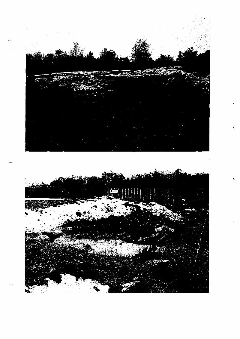
MARY ELLEN FINGERIENTERGY NUCLEAR INDIAN POINT 2, LLC .
ENVIRONMENTAL ASSESSMENT FORM APPENDIXlb
File
r'ooi=:!'7='=:!:!:.:=========':::::::.=f
BADEY & WATSON Surveying & Engineering P.C. ~~=========:::"..:::::-=-=-~-==._-=~-=~::.~-=-=._-=.- =.=-=====__:~... 3
3063 Roure 9, Cold Spring, New York 10516 (845) 265-9217 Glennon J. Watson, L.S. (845) 225-3312 John Po Delano, P.E.
Fax: (845) 265-4428 (845) 831-0100 Peter Meisler, 1.5. www.badey-watson.com (845) 562-0060 Stephen R Miller, 1.S. [email protected] (914) 628-1800 Jennifer w: Reap, 1.S.
November 16, 2011 (914) 739-3577 (877) 3.141593 George A. Badey, 1.S., Senior Consultant
Mary Rice, R.L.A., ConsultantDavid Klotzle, Wetlands Inspector Raben S. Miglin, Jr., L.S. Town of Philipstown 238 Main Street Cold Spring, NY 10516 By hand and via email [email protected]
RE: Application for Wetlands Detennination- Lands of Mary Ellen Finger Tax Map ID 16.12-1-5
Dear Mr. Klotzle:
As you know, Dr. Mary Ellen Finger has applied to re-subdivide her property from the previously approved 5 lots to 3 lots. I believe you are also aware that Entergy has simultaneously applied for site plan approval to build a 20,000 square foot building on one of the newly proposed lots.
Ifthe site plan is approved, a small "watering hole," measuring approximately 20 by 30 feet, will . be removed. I usc the tenTI "watering hole" because, as Dr. Finger has told me, it was created specifically to provide for the animals she keeps on her property. However, for the remainder of this letter, I will refer to it as "the pond." During earlier conversations you told me that you thought that the pond was a regulated watercourse and its removal would require a Freshwater Wetlands/Watercourse Permit ft'om the Town of Philipstown. The attached application seeks your official determination as to whether a permit is required. In doing so, we respectfully request that you consider the following:
• The letter report by Paul H. Ciminello, President of Ecosystems Strategies, Inc., dated October 31,2011, and its attachments;
• The report by Stephen Marino, PWS, of Tim Miller Associates, Inc., dated November 3, 2011, and its attachments, both of which are attached hereto; and
• My comments regarding the definition of a Watercourse found in Chapter 93 of the Code of the Town of Philipstown that follows.
While Mr. Ciminello's report does not address whether the "watering hole" is a regulated watercourse, he does conclude that there are neither aquatic plants nor hydric soils associated with it. He also concludes that it is neither a State nor a federally regulated wetland.
In addition to findings that agree with Mr. Ciminello, Mr. Marino's report goes on to opine that the pond is not regulated. His point regarding the definition of a watercourse is similar to that which 1 previollsly offered and repeat below, namely that the pond does not fall within the
_ Ownm ofthe records andfiles of Joseph S. Agnoli • Barger & Hustis, Surveyors. Burgess & Behr • Roy Burgess. Vincent A. Burruano • Hudson Valley Engineering Company, Inc.
G. Radcliff Hustis, Surveyor. Peter R. Hustis, Surveyor. James w: Irish, Jr.• J. Wilbur Irish. Douglas A. Merritt. E.B. Moebus Reynolds & Chase. General Jacob Schofield. Sidney Schofield, C.E.• Taconic Surveying & Engineering, P.e. • D. Walcutt
November 16,2011 David Klotzle, Wetlands Inspector Page 2 of2
definition in the code. M.r. Marino also cites other sections of the Town Code that might indicate some regulation of the pond under certain circumstances. Finally, he discusses why he has concluded that they do not apply.
As you know, I also believe that the pond does not fall within the definition provided in Chapter 93. I would go so far as to say that it appears the defmition was crafted to avoid regulation of a pond of the type and size of the pond, Following are my reasons.
The definition clearly includes ponds shown on the USGS Quadrangle Maps covering the town. The definition also includes "any other streams, brooks and waterways which are contained within, flow through, or border on the Town of Philipstown, and any additional streams, brooks and waterways which are delineated on the (official town wetland) map."
It seems clear that including any pond that appears on the Quadrangle Map is intended to capture larger ponds. Quadrangles are small-scale maps made from relatively high altitude photographs. As a result, very small bodies of water, such as the pond, cannot be seen and would therefore not be regulated as a consequence of their size,
The rest of the definition is conspicuously absent of the words ponds, lakes and reservoirs. Instead, it focuses on water features that flow, i.e.: "streams, brooks and waterways." For this reason, Tbelieve the ddinition seeks to capture any water that is flowing, including ponds that are fed and emptied by a stream regardless of size, as well as larger bodies of water regardless of whether there is a stream fet:ding amVor emptying it. At the same time, I believe the code is trying to avoid regulating small bodies of water that have neither inlets nor outlets.
I hope this lettcr and the attachcd reports are helpful. If you need anything more, please do not hesitate to contact me, Meanwhile, we look forward to your determination. Thank you for your consideration of our request.
Yours truly, BADEY & WATSON, surlJe.'" &Engineerin~. C. ,-.
_...... Cf/J \~ cft~~non J. Watson, I. F . ..
;: , Errc!osures (4)
GJW/bms ee: William Josiger, via email only
Craig MaeLatehie, via email only Mary Ellen Finger, via email only Paul H. Ciminello, via email only Stephen Malino, via email only File 91-104B\DKI6NVII BP_RecLJ"or_Detcllllinalion,doc
BADEY & WATSONFile Form Letters I Surveying & Engineering pc.
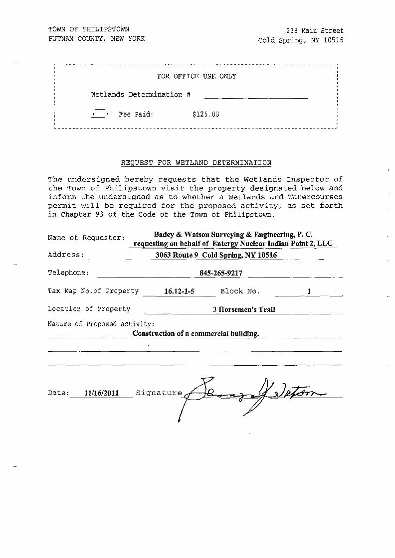
TOWN OF PHILIPSTOWN 238 Main Street PUTNAM COUNTY, NEW YORK Cold Spring, NY 10516
I
IFOR OFFICE USE ONLY I
I I I
IWetlands Determination # I
I I I I
Fee Paid: $125.00 I I I
IL
I ~
REQUEST FOR WETLAND DETERMINATION
The undersi.gned hereby requests that the Wetlands Inspector of the Town of Philipstown visit the property designated below and inform the undersigned as to whether a Wetlands and Watercourses permit will be required for the proposed activity, as set forth in Chapter 93 of the Code of the Town of Philipstown.
Badey & 'Vatson Surveying & Engineering, P. C. Name of Requester: requesting on behalf of Entergy Nuclear Indian Point 2, LLC
Address: 3063 Route 9 Cold Spring, N_Y_1_0_5_16 _
Telephone: 845-265-9217
Tax Map No.of Property 16.12-1-5 Block No. 1
Location of Property 3 Horsemen's Trail
Nature of Proposed activity: Construction of a commercial building.
-~-----~--------
Date: 11/16/2011
MARY ELLEN FINGERIENTERGY NUCLEAR INDIAN POINT2,LLC
ENVIRONMENTAL ASSESSMENT FORM APPENDIX Ie
File

rror! Reference source not found.
cc: Philipstown Building Dept.
Philipstown CB
2
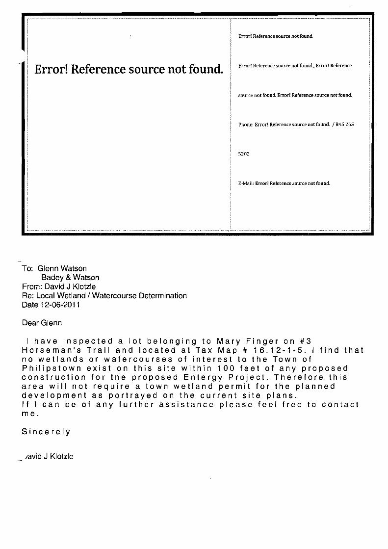
Error! Reference source not found.
Error! Reference source not found.
Error! Reference source not found., Error! Reference
source not found. Error! Reference source not found.
Phone: Error! Reference source not found. /845 265
5202
E-Mail: Error! Reference source not found.
To: Glenn Watson Badey & Watson
From: David J Klotzle Re: Local Wetland / Watercourse Determination Date 12-06-2011
Dear Glenn
I have inspected a lot belonging to Mary Finger on #3 Horseman's Trail and located at Tax Map # 16.12-1-5. I find that no wetlands or watercourses of interest to the Town of Philipstown exist on this site within 100 feet of any proposed construction for the proposed Entergy Project. Therefore this area will not require a town wetland permit for the planned development as portrayed on the current site plans. If I can be of any further assistance please feel free to contact me.
Sincerely
)8vid J Klotzle

MARY ELLEN FINGERIENTERGY NUCLEAR INDIAN POINT 2, LLC
ENVIRONMENTAL ASSESSMENT FORM APPENDIX 2
File
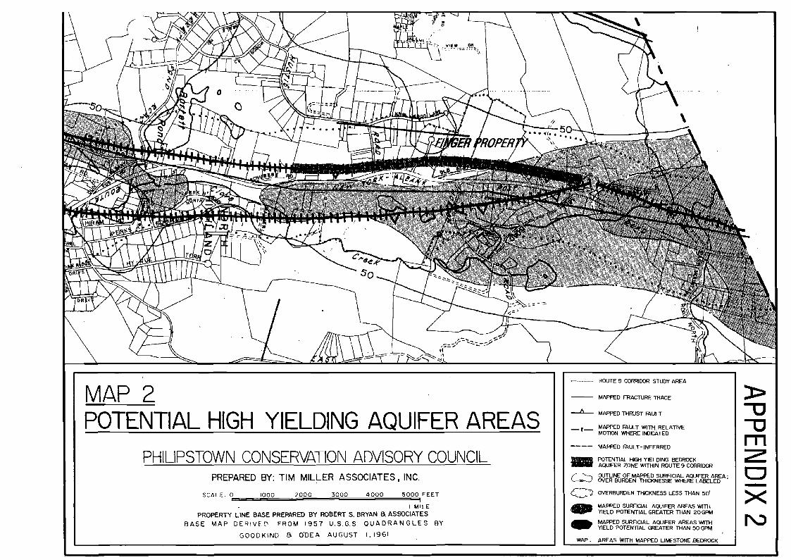
MAP 2 POTENTIAL HIGH YIELDING AQUIFER AREAS
PHILIPSTOWN CONSERVATION ADVISORY COUNCIL PREPARED BY: TIM MILLER ASSOCIATES. INC.
SCALE 0 1000 2000 3000 4000 5000 FEET 1
I MILE
PROPERTY LINE BASE PREPARED BY ROBERT S. BRYAN a ASSOCIATES BASE MAP DE~IVE[\ FROM 1957 U.S.G.S. QUADRANGLES BY
GOODKIND B O'OEA AUGUST 1,1961
MARY ELLEN FINGERIENTERGY NUCLEAR INDIAN POINT2,LLC
ENVIRONMENTAL ASSESSMENT FORM APPENDIX 3
File
JOHN COLLINS ENGINEERS, P.C. TRAFFIC' TRANSPORTATION ENGINEERS
=== II BRADHURST AVENUE • HAWTHORNE, N.Y. • 10532' (914) 347·7500 • FAX (914) 347·7266 ==
February 24,2011
Mr. Glennon J. Watson, L. S. Badey & Watson Surveying & Engineering, p.e. 3063 Route 9 Cold Spring, NY 10516
RE: Entergy Emergency Operation Center Route 9 and Horseman's Trail Town ofPhilipstown, New York
Dear Glenn:
As requested, we have completed our field investigation and traffic analysis for the proposed Entergy
Emergency Operation Center, which is planned to be constructed on Lot 1ofthe Finger Subdivision
(see Figure No.1). The proposed 20,000 s.f. building will be used on a daily basis by a limited staff
oftwo or three people. The site will be used quarterly for emergency drills, which would involve up
to 60 people at the site. In addition, in the event of an emergency, there could be as many as 180
people at this location. The following summarizes the tasks undertaken in our review and our
recommendations as a result ofour analysis.
1. 2012 Existing Traffic Volumes (Figures No.2 and 3)
Turning movement traffic counts were collected at the intersections of Horseman's Trail
North and Horseman's Trail South intersections with Route 9. These counts were conducted
during the weekday peak hours from 3:30 to 6:30PM on February 2, 2012 and between 7:00
and 9:15 AM on February 3, 2012. In addition, traffic data available from the New York
State Department ofTransportation (NYSDOT) as well as from other studies completed in
the area were referenced to identify the existing peak hour traffic volumes. The resulting
2012 Existing Traffic Volumes are shown on Figures No.2 and 3.
Page 2
2. 2014 No-Build Traffic Volumes (Figures No.4 and 5)
The Existing Traffic Volumes were projected to a future design year utilizing a background
growth factor of 1% per year. This factor was used to account for other development traffic
as well as normal background growth in the corridor. In addition, traffic associated with the
proposed E. Polhemus Enterprises, LLC contractor's yard to be located along Horseman's
Trail has also been considered. Figures No.4 and 5 show the volumes for the AM and PM
Peak Hours.
3. Site Generated Traffic Volumes (Table No.1)
As indicated previously, the site is expected to only have two to three people present under
normal conditions while on a quarterly basis (Le., four times per year) there would be as
many as 60 people at the site. Based on the data published by the Institute ofTransportation
Engineers (ITE) as contained in their report entitled Trip Generation, 8th Edition, 2008 for
this type ofuse, during those event conditions the peak hour trip generation rates and volume
were estimated and are shown in Table No.1. It should also be noted that in the case of an
emergency, the occupancy of the building could be as many as 180 people. However, this
would only be in the case of an actual emergency at which time this facility would be
occupied to handle the situation. For the purposes of the analysis it was assumed that 60
vehicles would enter the site during the AM Peak Hour and 60 Vehicles would exit the site
during the PM Peak Hour to present a conservative analysis.
4. Arrival and Departure Distributions (Figures No.6 and 7)
The expected arrival and departure distributions of trips to this site for typical and the
quarterly event conditions are shown on Figures No.6 and 7.
5. 2014 Build Traffic Volumes (Figures No.8, 9, 10 and 11)
The Site Generated Traffic Volumes shown on Table No.1 for the quarterly event conditions
were assigned to the roadway network and added together with the No-Build Traffic
Volumes to obtain the Build Traffic Volumes. The Site Generated Traffic Volwnes are

Page 3
shown on Figures No.8 and 9 while the Build Traffic Volumes are shown on Figures No. 10
and 11.
6. Sight Distance Considerations and Access
Measurements ofexisting sight distances at the intersections ofHorseman's Trail and Route
9 were collected in order to determine existing and potential future sight distances. It should
be noted that the posted speed limit in the vicinity ofthis intersection is 45 MPH. Due to the
alignment ofHorseman's Trail south and the current grades and roadway features, the sight
distance looking to the south is currently restricted by a combination ofvegetation, grading
as well as the vertical alignment ofD.S. Route 9. The current sight distance for left turns
exiting Horeseman's Trail south onto U.S. Route 9 is approximately 300 ft., which is less
that the American Association of State Highway Transportation Officials (AASHTO)
required Stopping Sight Distance for 55 MPH which is 495 ft. For right turns, the current
sight distance is approximately 1400 ft. Therefore, we would recommend that signs be
installed on the site exit driveway directing motorists destined to the north to tum left on to
Horseman's Trail and proceed to the north leg to access U.S. Route 9 northbound. It should
also be noted that at the Horseman's Trail south intersection, the left tum rear end stopping
sight distance for approaching vehicles is approximately 500 ft. This distance satisfies the
AASHTO stopping sight distan~e for 55 MPH.
7. Description of Analysis Procedures
In order to determine existing and future traffic operating conditions at the study area
intersections, it was necessary to perform capacity analyses. The unsignalized intersection
capacity analysis method utilized in this report was also performed in accordance with the
procedures described in the 2010 Highway Capacity Manual. The procedure is based on
total elapsed time from when a vehicle stops at the end ofthe queue until the vehicle departs
from the stop line. The average total delay for any particular critical movement is a function
of the service rate or capacity of the approach and the degree of saturation. In order to
identify the Level of Service, the average amount of vehicle delay is computed for each
critical movement to the intersection.
Page 4
Additional information concerning unsignalized Levels ofService can be found in Appendix
"0" of this report.
8. Findings and Recommendations
Capacity analysis was conducted for the U.S. Route 9 and Horseman's Trail north and south
leg intersections. Each of these intersections is a "T' type unsignalized intersection, which
are controlled by "stop" signs on the Horseman's Trail approaches.
The capacity analysis results, which accounted for the traffic associated with both the
proposed Entergy Emergency Operations Center and the Polhemus contractor's yard, are
summarized in Table No.2. These results indicate that the Horseman's Trail south
intersection currently operates at a Level ofService "B" during the AM and PM Peak. Hours.
The analysis conducted for the 2014 No-Build and Build Traffic Volumes indicates that the
intersection will continue to experience similar Levels ofService in the future both with and
without the project.
The capacity analysis conducted for the Horseman's Trail north intersection indicates that the
intersection currently operates at a Level of Service "C" during each ofthe peak hours. The
analysis was recomputed with the 2014 No-Build Traffic Volumes which indicates that the
intersection will continue to experience a Level of Service "C" during the AM Peak Hour
and will operate at a Level of Service "0" during the PM Peak Hour. The intersection was
again analyzed with the 2014 Build Traffic Volumes which indicates that a Level ofService
"C" will be maintained during the AM Peak Hour. while a Level of Service "E" will be
experienced during the PM Peak Hour under quarterly event conditions and a Level of
Service "0" for other typical days.

PageS
9. Summmy and Conclusions
Based on the results of the capacity analysis contained herein, the Levels of Service are
consistent with other locations along this area of U.S. Route 9. The left turns exiting onto
U.S. Route 9 northbound should be directed to the Horseman's Trail north leg intersection as
discussed above. Again, it should be noted that these conditions will only be experienced
four times per year when emergency drills are conducted.
Respectfully submitted,
JOHN COLLINS ENGINEERS, P.C.
I876.Ltr Rpt.doc

APPENDIX "A"
FIGURES

ENTERGY HILIPSTOWN, NEW YORK
JOHN COLLINS ENGINEERS. P.C. HAWTHORNE NEW YORKI
NOTE: LINE DIAGRAM NOT TO SCALE
51 TE LOCATI ON MAP
PROJECT NO. 1876 DATE: FEB. 2012 FIG. NO. 1
NOTE: LINE DIAGRAM NOT TO SCALE
ENTERGY 2012 EXISTING TRAFFIC VOLUMES '-lILiPSTOWN, NEW YORK WEEKDAY PEAK AM HOUR
JOHN COLLINS ENGINEERS, P.C. HAWTHORNE , NEW YORK PROJECT NO. 1876 DATE: FEB. 2012 FIG. NO. 2
NOTE: LINE DIAGRAM NOT TO SCALE
ENTERGY 'HILIPSTOWN, NEW YORK
JOHN COLLINS ENGINEERS, P.C. HAWTHORNE • NEW YORK
2012 EXISTING TRAFFIC VOLUMES WEEKDAY PEAK PM HOUR
PROJECT NO. 1876 DATE: FEB. 2012 FIG. NO. 3
(f)
Q a (f) a::: o :r:
NOTE: LINE DIAGRAM NOT TO SCALE
ENTERGY 'HILIPSTOWN. NEW YORK
JOHN COLLINS ENGINEERS. P.C. HAWTHORNE • NEW YORK
2014 NO-BUILD TRAFFIC VOLUMES WEEKDAY PEAK AM HOUR
PROJECT NO. 1876 DATE: FEB. 2012 FIG. NO. 4
NOTE: LINE DIAGRAM NOT TO SCALE
ENTERGY 2014 NO-BUILD TRAFFIC VOLUMES HILIPSTOWN, NEW YORK WEEKDAY PEAK PM HOUR
JOHN COLLINS ENGINEERS, P.C. HAWTHORNE, NEW YORK PROJECT NO. 1876 DATE: FEB. 2012 FIG. NO. 5

NOTE: LINE DIAGRAM NOT TO SCALE
ENTERGY ARRIVAL DISTRIBUTION HILIPSTOWN, NEW YORK (EXPRESSED AS A %)
JOHN COLLINS ENGINEERS, P.C. HAWTHORNE , NEW YORK PROJECT NO. 1876 DATE: FEB. 2012 FIG. NO. 6
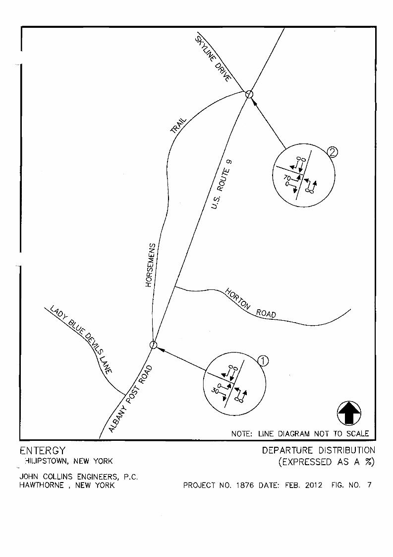
ENTERGY :-lILlPSTOWN. NEW YORK
JOHN COLLINS ENGINEERS. P.C. HAWTHORNE • NEW YORK
NOTE: LINE DIAGRAM NOT TO SCALE
DEPARTURE DISTRIBUTION (EXPRESSED AS A %)
PRO~JECT NO. 1876 DATE: FEB. 2012 FIG. NO. 7
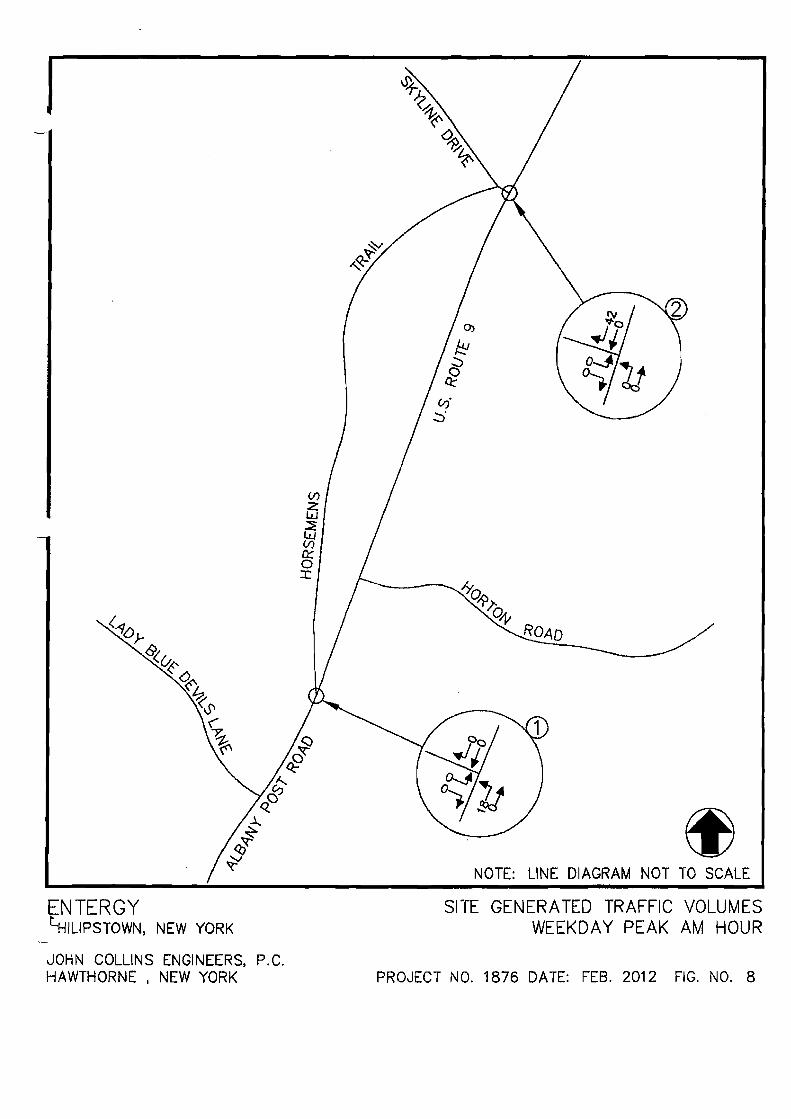
NOTE: LINE DIAGRAM NOT TO SCALE
ENTERGY 411L1PSTOWN, NEW YORK
JOHN COLLINS ENGINEERS, P.C. HAWTHORNE NEW YORKI
SITE GENERA TED TRAFFIC VOLUMES WEEKDAY PEAK AM HOUR
PROJECT NO. 1876 DATE: FEB. 2012 FIG. NO. 8
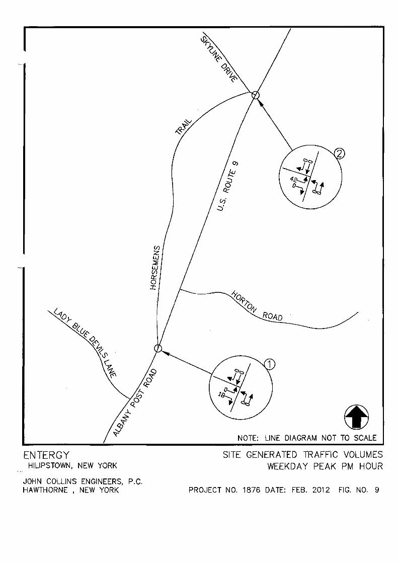
NOTE: LINE DIAGRAM NOT TO SCALE
ENTERGY HILIPSTOWN, NEW YORK
JOHN COLLINS ENGINEERS, P.C. HAWTHORNE , NEW YORK
SITE GENERATED TRAFFIC VOLUMES WEEKDAY PEAK PM HOUR
PRO,JEeT NO. 1876 DATE: FEB. 2012 FIG. NO. 9

NOTE: LINE DIAGRAM NOT TO SCALE
ENTERGY IHILIPSTOWN, NEW YORK
2014 BUILD TRAFFIC WEEKDAY PEAK
VOLUMES AM HOUR
JOHN COLLINS ENGINEERS, HAWTHORNE , NEW YORK
P.C. PROJECT NO. 1876 DATE: FEB. 2012 FIG. NO. 10
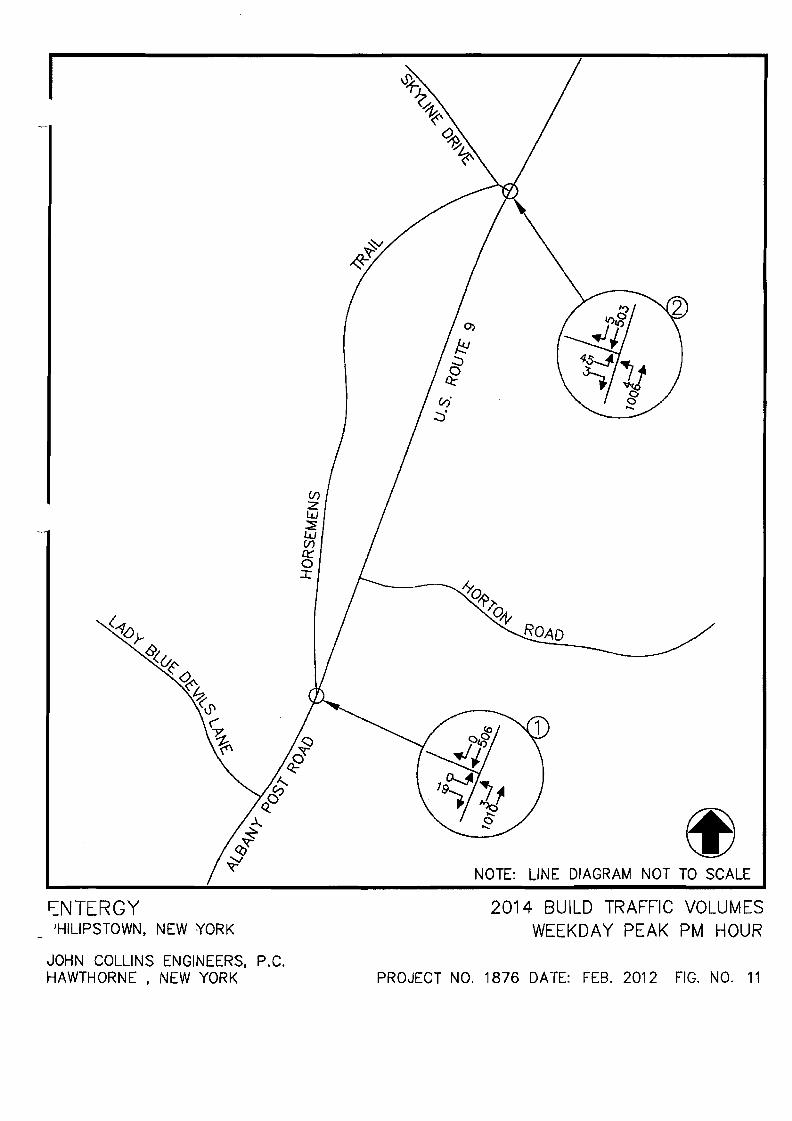
NOTE: LINE DIAGRAM NOT TO SCALE
r::NTERGY JHILIPSTOWN. NEW YORK
JOHN COLLINS ENGINEERS. P.C. HAWTHORNE • NEW YORK
2014 BUILD TRAFFIC VOLUMES WEEKDAY PEAK PM HOUR
PROJECT NO. 1876 DATE: FEB. 2012 FIG. NO. 11

APPENDIX "B"
TABLES
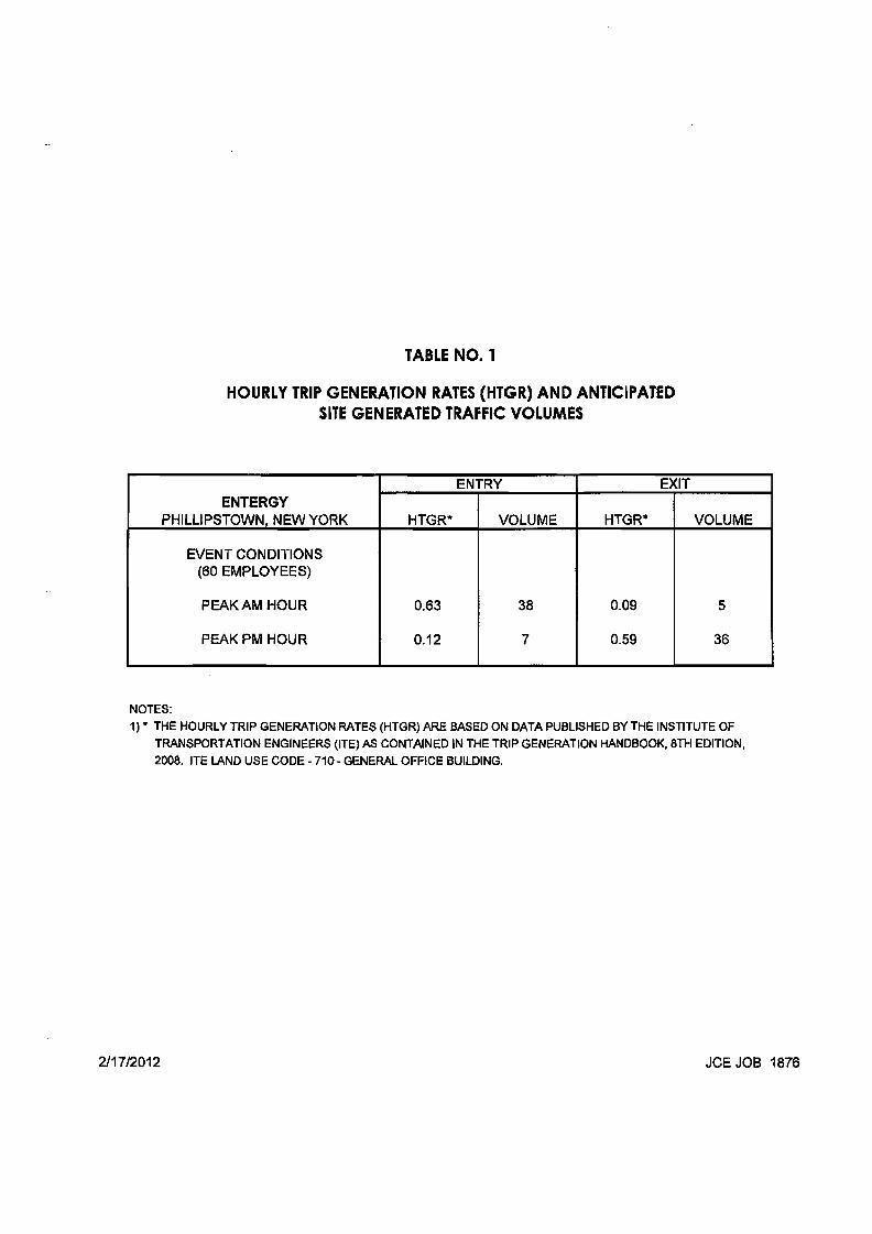
TABLE NO.1
HOURLY TRIP GENERATION RATES (HTGR) AND ANTICIPATED SITE GENERATED TRAFFIC VOLUMES
ENTERGY PHILLIPSTOWN NEW YORK
ENTRY EXIT
HTGR* VOLUME HTGR* VOLUME
EVENT CONDITIONS (60 EMPLOYEES)
PEAK AM HOUR
PEAK PM HOUR
0.63
0.12
38
7
0.09
0.59
5
36
NOTES: 1) * THE HOURLY TRIP GENERATION RATES (HTGR) ARE BASED ON DATA PUBLISHED BY THE INSTITUTE OF
TRANSPORTATION ENGINEERS (ITE) AS CONTAINED IN THE TRIP GENERATION HANDBOOK, 8TH EDITION, 2008. ITE LAND USE CODE - 710 - GENERAL OFFICE BUILDING.
211712012 JCE JOB 1876
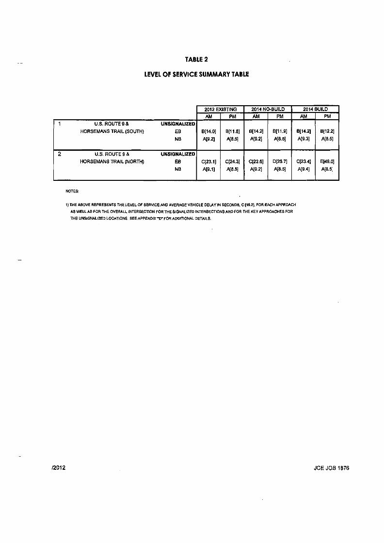
TABLE 2
LEVEL OF SERVICE SUMMARY TABLE
1 U.S. ROUTE 9 &
HORSEMANS TRAIL (SOUTH)
UNSIGNALIZED
EB
NB
2 U.S. ROUTE 9 &
HORSEMANS TRAIL (NORTH)
UNSIGNALIZED
EB
NB
2012 EXISTING 2014 NO·BUILD 2014 BUILD AM PM AM. PM AM PM
8[14.0]
A(9.2]
6111.8]
A[8.51
B[14.2]
AI9.2]
B[11.9]
A[8.5]
BI14.2]
A[9.3]
8(12.2]
AI8.5]
C[23.1]
AI9.1]
C[24.3]
A(8.5]
C[22.6]
A(9.2)
D[25.7]
AI8·51
CI23.4]
AI9.4]
E[49.0]
AlB.5]
NOTES:
1) THE ABOVE REPRESENTS THE LEVEL OF SERVICE AND AVERAGE VEHICLE DELAY IN SECONDS, C [16.2), FOR EACH APPROACH
AS WELL AS FOR THE OVERALL INTERSECTION FOR THE SIGNALIZED INTERSECTIONS AND FOR THE KEY APPROACHES FOR
THE UNSIGNALIZED LOCATIONS. SEE APPENDIX ~O" FOR ADDITIONAL DETAILS.
12012 JCE JOB 1876
APPENDIX "CII
CAPACITY ANALYSIS
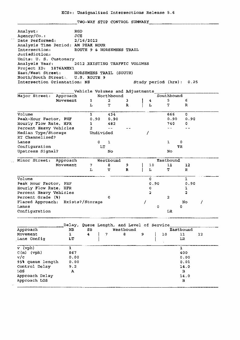
HCS+: Unsignalized Intersections Release 5.6
TWO-WAY STOP CONTROL SUMMARY __
Analyst: RGD Agency/Co.: JCE Date performed: 2/16/2012 Analysis Time Period: AM PEAK HOUR Intersection: ROUTE 9 & HORSEMENS TRAIL Jurisdiction: Units: U. S. Customary Analysis Year: 2012 ,EXISTING TRAFFIC VOLUMES Project ID: 1876AMEX1 East/West Street: HORSEMENS TRAIL (SOUTH) North/South Street:. U.S. ROUTE 9 Intersection Orientation: NS Study period (hrs): 0.25
Adjustments _Vehicle Volumes and Major Street: Approach Northbound Southbound
Movement 1 2 3 4 5 6 L T R L T R
volume 1 434 666 0 Peak-Hour Factor, PHF 0.90 0.90 0.90 0.90 Hourly Flow Rate, HFR 1 482 740 0 Percent Heavy Vehicles 2 Median Type/Storage Undivided / RT Channelized? Lanes 0 1 1 0 Configuration LT TR Upstream Signal? No No
Minor Street: Approach Westbound Eastbound Movement 7 8 9 lO 11 12
L T R L T R
Volume 0 1 Peak Hour Factor, PHF 0.90 0.90 Hourly Flow Rate, HFR 0 1 Percent Heavy Vehicles 2 2 Percent Grade (%) 0 2 Flared Approach: Exists?/Storage / No / Lanes 0 0 Configuration LR
__________________Delay, Queue Length, and Level of Service Approach NB S8 Westbound Eastbound Movement 1 4 7 8 9 10 11 12 Lane Config LT LR
v (vph) 1 1 C(m) (vph) 867 400 vic 0.00 0.00 95% queue length 0.00 0.01 Control Delay 9.2 14.0 LOS A B Approach Delay 14.0 Approach LOS B

------------------
HCS+: Unsignalized Intersections Release 5.6
___. TWO-WAY STOP CONTROL SUMMARY __
Analyst: RGD Agency/Co. : JCE Date Performed: 2/16/2012 Analysis Time Period: PM PEAK HOUR Intersection: ROUTE 9 & HORSEMENS TRAIL Jurisdiction: Units: U. S. Customary Analysis Year: 2012 EXISTING TRAFFIC VOLUMES Project ID: 1876PMEX1 East/West Street: HORSEMENS TRAIL (SOUTH) North/South Street: U.S. ROUTE 9 Intersection Orientation: NS Study period (hrs): 0.25
Vehicle Volumes and Adjustments ~~-~ Major Street: Approach Northbound Southbound
Movement 1 2 3 4 5 6 L T R L T R
Volume 3 98B 494 o Peak-Hour Factor, PHF 0.92 0.92 0.92 0.92 Hourly Flow Rate, HFR 3 1073 536 o Percent Heavy Vehicles 2 Median Type/Storage Undivided / RT Channelized? Lanes o 1 1 0 Configuration LT TR Upstream Signal? No No
Minor Street: Approach Westbound Eastbound Movement 7 B 9 10 11 12
L T R L T R
Volume o 1 Peak Hour Factor, PHF 0.92 0.92 Hourly Flow Rate, HFR o 1 Percent Heavy Vehicles 2 2 Percent Grade (%) 0 2 Flared Approach: Exists?/Storage / No / Lanes o o Configuration LR
____. Delay, Queue Length, and Level of Service Approach NB SB Westbound Eastbound Movement 1 4 7 8 9 10 11 12 Lane Config LT LR
v (vph) 3 1 C(m) (vph) 1032 529 vic 0.00 0.00 95% queue length 0.01 0.01 Control Delay 8.5 11. B LOS A B Approach Delay 11. B !\.pproach LOS B
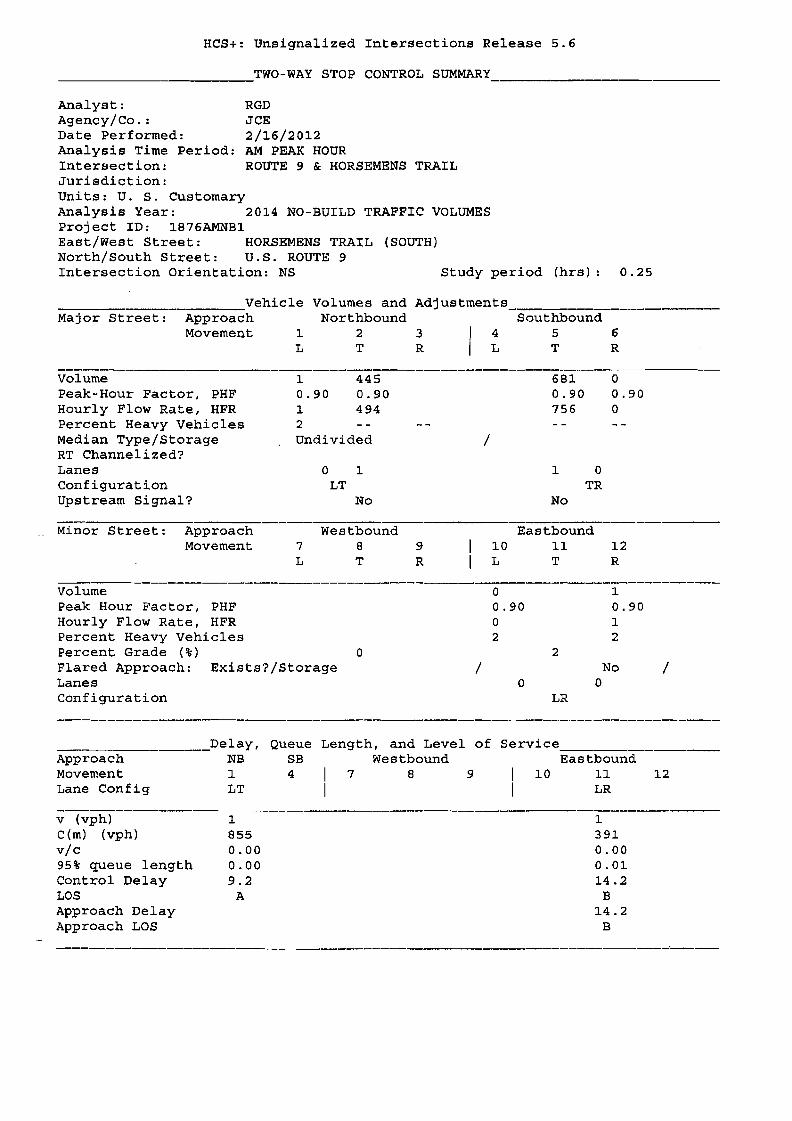
HCS+: Unsignalized Intersections Release 5.6
____________TWO-WAY STOP CONTROL SUMMARY _
Analyst: RGD Agency/ Co. : JCE Date Performed: 2/16/2012 Analysis Time Period: AM PEAK HOUR Intersection: ROUTE 9 & HORSEMBNS TRAIL Jurisdiction: Units: U. S. Customary Analysis Year: 2014 NO-BUILD TRAFFIC VOLUMES Project ID: 1876AMNBl East/West Street: HORSEMENS TRAIL (SOUTH) North/South Street: U.S. ROUTE 9 Intersection Orientation: NS Study period (hrs) 0.25
Vehicle Volumes and Adjustments Major Street: Approach Northbound Southbound
Movement 1 2 3 4 5 6 L T R L T R
Volume 1 445 681 0 Peak-Hour Factor, PHF 0.90 0.90 0.90 0.90 Hourly Flow Rate, HFR 1 494 756 0 Percent Heavy Vehicles 2 Median Type/Storage Undivided /RT Channelized? Lanes o 1 1 0 Configuration LT TR Upstream Signal? No No
Minor Street: Approach Westbound Eastbound Movement 789 10 11 12
L T R L T R
Volume 0 1 Peak Hour Factor, PHF 0.90 0.90 Hourly Flow Rate, HFR 0 1 Percent Heavy Vehicles 2 2 Percent Grade (%) 0 2 Flared Approach: Exists?/Storage / No / Lanes 0 0 Configuration LR
Delay, Queue Length, and Level of Service Approach NB SB westbound Eastbound Movement 1 4 7 8 9 10 11 12 Lane Config LT LR
v (vph) c(m) (vph) vic 95% queue length Control Delay LOS Approach Delay Approach LOS
1 855 0.00 0.00 9.2
A
1
391 0.00 0.01 14.2
B 14.2
B
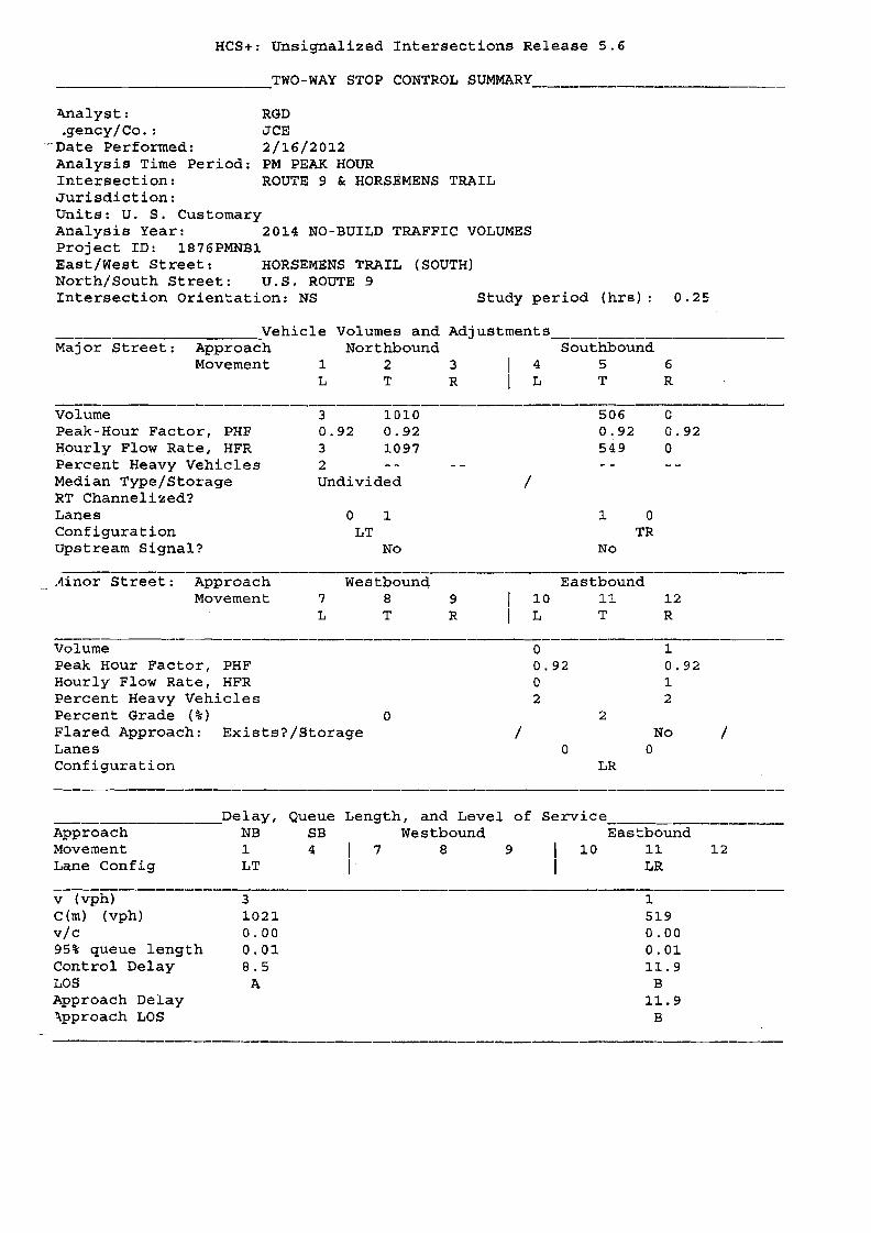
HCS+: Unsignalized Intersections Release 5.6
TWO-WAY STOP CONTROL SUMMARY
~alyst: RGD .gency/ Co. : JCE
--Date Performed: 2/16/2012 Analysis Time Period: PM PEAK HOUR Intersection: ROUTE 9 & HORSEMENS TRAIL Jurisdiction: Units: U. S. Customary Analysis Year: 2014 NO-BUILD TRAFFIC VOLUMES project ID: 1B76PMNB1 East/West Street: HORSEMENS TRAIL (SOUTH) North/South Street: U.S. ROUTE 9 Intersection Orientation: NS Study period (hrs): 0.25
Volumes and Adjustments-------Vehicle Major Street: Approach Northbound Southbound
Movement 1 2 3 4 5 6 L T R L T R
Volume 3 1010 506 o Peak-Hour Factor, PHF 0.92 0.92 0.92 0.92 Hourly Flow Rate, HFR 3 1097 549 o Percent Heavy Vehicles 2 Median Type/Storage RT Channelized?
Undivided /
Lanes o 1 1 0 Configuration LT TR upstream Signal? No No
Ainor Street: Approach Westbounq Eastbound Movement 789 10 11 12
L T R L T R
Volume 0 1 Peak Hour Factor, PHF 0.92 0.92 Hourly Flow Rate, HFR 0 1 Percent Heavy Vehicles 2 2 Percent Grade (%) 0 2 Flared Approach: Lanes
Exists?/Storage / 0
No 0
/
Configuration LR
Delay, Queue Length, and Level of Service Approach Movement
NB 1
SB 4 I 7
Westbound 8 9 10
Eastbound 11 12
Lane Config LT I LR
v (vph) 3 1 C(m) (vph) 1021 519 vic 0.00 0.00 95% queue length 0.01 0.01 Control Delay 8.5 11. 9 LOS A B Approach Delay 11.9 ~pproach LOS B
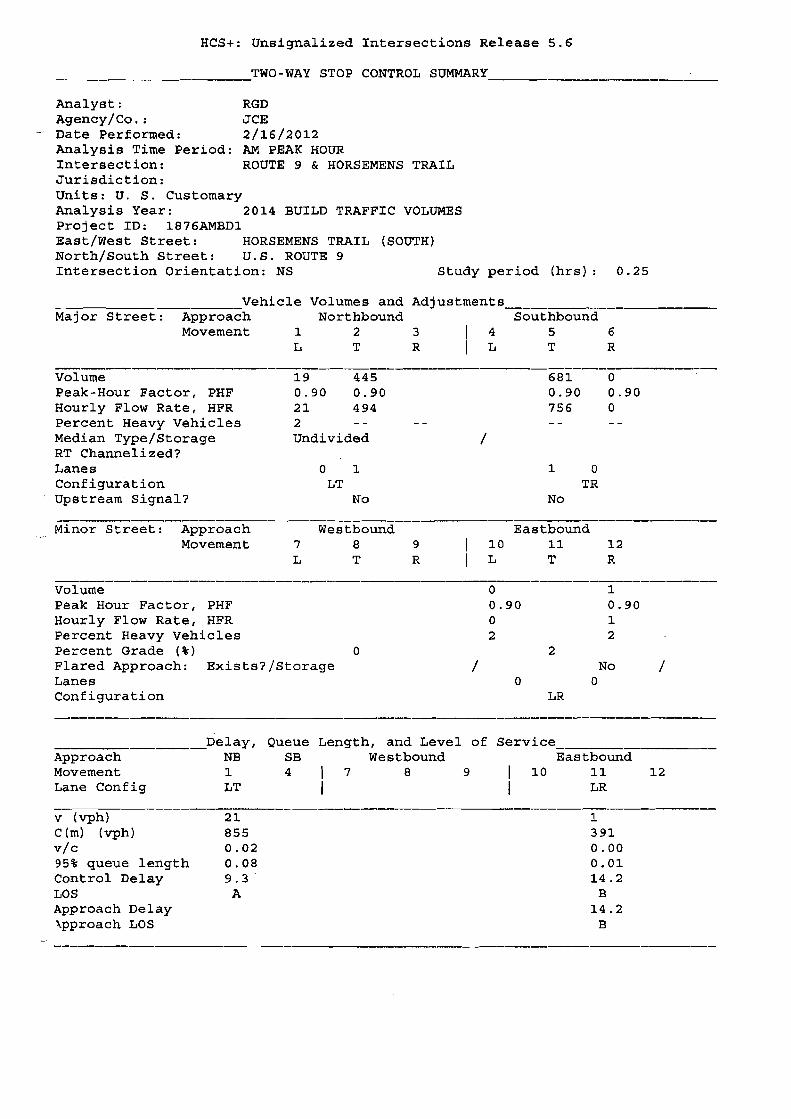
------------
HCS+: Unsignalized Intersections Release 5.6
____________TWO-WAY STOP CONTROL SUMMARY _
Analyst: RGD Agency/Co.: JCE
- Date Performed: 2/16/2012 Analysis Time Period: AM PEAK HOUR Intersection: ROUTE 9 & HORSEMENS TRAIL Jurisdiction: Units: U. S. Customary Analysis Year: 2014 BUILD TRAFFIC VOLUMES Project 10: 1876AMBD1 East/West Street: HORSEMENS TRAIL (SOUTH) North/South Street: U.S. ROUTE 9 Intersection Orientation: NS Study period (hrs): 0.25
Vehicle Volumes and Adjustments ~
Major Street: Approach Northbound Southbound Movement 1 2 3 4 5 6
L T R L T R
Volume 19 445 681 0 Peak-Hour Factor, PHF 0.90 0.90 0.90 0.90 Hourly Flow Rate, HFR 21 494 756 0 Percent Heavy Vehicles 2 Median Type/Storage Undivided /RT Channelized? Lanes o 1 1 0 Configuration LT TR Upstream Signal? No No
Minor Street: Approach Westbound Eastbound Movement 789 10 11 12
L T R L T R
Volume 0 1 Peak Hour Factor, PHF 0.90 0.90 Hourly FloW Rate, HFR 0 1 Percent Heavy Vehicles 2 2 Percent Grade (%) 0 2 Flared Approach: Exists?jStorage / No / Lanes 0 0 Configuration LR
Delay, Queue Length, and Level of Service Approach NB SB Westbound Eastbound Movement 1 4 7 8 9 10 11 12 Lane Config LT LR
v (vph) 21 1 C (m) (vph) 855 391 vic 0.02 0.00 95% queue length 0.08 0.01 Control Delay 9.3 14.2 LOS A B Approach Delay 14.2 \pproach LOS B
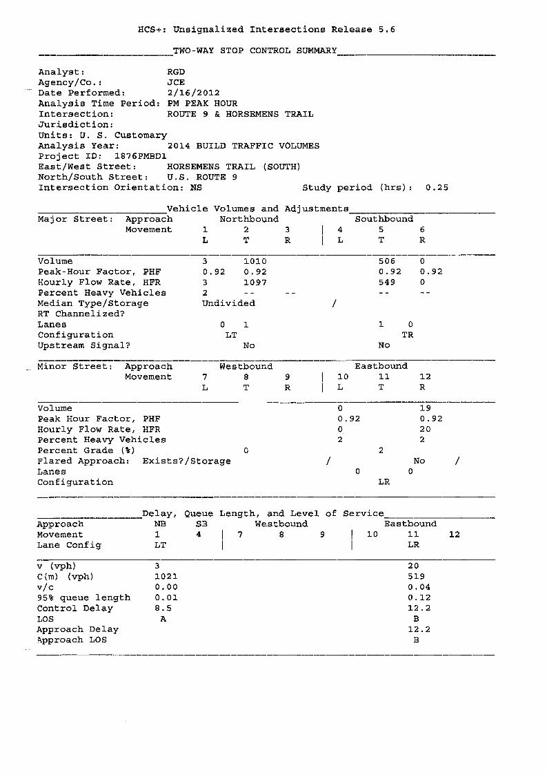
HCS+: Unsignalized Intersections Release 5.6
. TWO-WAY STOP CONTROL SUMMARY
Analyst: RGD Agency/Co.: JCE
- Date Performed: 2/16/2012 Analysis Time Period: PM PEAK HOUR Intersection: ROUTE 9 & HORSEMENS TRAIL Jurisdiction: Units: U. S. Customary Analysis Year: 2014 BUILD TRAFFIC VOLUMES Project ID: 1876PMBD1 East/West Street: HORSEMENS TRAIL (SOUTH) North/South Street: U.S. ROUTE 9 Intersection Orientation: NS Study period (hrs): 0.25
Volumes and Adjustments __ Major Street: Northbound
2 3 T R
Volume 3 1.010 Peak-Hour Factor, PHF 0.92 0.92 Hourly Flow Rate, HFR 3 1097 Percent Heavy Vehicles 2 Median Type/Storage Undivided RT Channelized? Lanes o 1 Configuration LT Upstream Signal? No
Minor Street: Approach Westbound Movement 789
L T R
Volume Peak Hour Factor, PHF Hourly Flow Rate, HFR Percent Heavy Vehicles Percent Grade (%) 0 Flared Approach: Exists?/Storage Lanes Configuration
____Delay, Queue Length, and Level of Service---,------ Approach NB SB Westbound Eastbound Movement 1. 4 7 8 9 10 11 12 Lane Config LT LR
v (vph) 3 20 C (m) (vph) 1021 519 vic 0.00 0.04 95% queue length 0.01 0.12 Control Delay a.5 12.2 LOS A B Approach Delay 12.2 A.pproach LOS B

HCS+: Unsignalized Intersections Release 5.6
_________________TWO-WAY STOP CONTROL SUMMARY . __
-
Analyst: RGD Agency/Co.: JCE Date Performed: 2/16/2012 Analysis Time Period: AM PEAK HOUR Intersection: ROUTE 9 & HORSEMENS TRAIL Jurisdiction: Units: U. S. Customary Analysis Year: 2012 EXISTING TRAFFIC VOLUMES Project ID: 1876AMEX2 East/West Street: HORSEMENS TRAIL (NORTH) North/South Street: U.s. ROUTE 9 Intersection Orientation: NS Study period (hrs): 0.25
Major Street: Vehicle
Approach Movement 1
Volumes and Northbound
2
Adjustments
3 4 Southbound
5 6 L T R L T R
Volume Peak-Hour Factor, PHF Hourly Flow Rate, HFR Percent Heavy Vehicles Median Type/Storage RT Channelized? Lanes Configuration Upstream Signal?
~inor Street: Approach Movement
No
434 0.90 482
o 0.90 o 2 Undivided
o 1 LT
Westbound 789 L T R
/
10 L
665 0.90 738
1 0 TR
No
Eastbound 11 T
0 0.90 0
12 R
Volume Peak Hour Factor, PHF Hourly Flow Rate, HFR Percent Heavy Vehicles Percent Grade (%) Flared Approach: Exists?/Storage Lanes Configuration
0 /
3 0.90 3 2
0
2
LR
1 0.90 1 2
No 0
I
__________________Delay, Queue Length, and Level of Service Approach NB SB Westbound Eastbound Movement 1 4 7 8 9 10 11 12 Lane Config LT LR
v (vph) o 4 C (m) (vph) B68 203 vic 0.00 0.02 95% queue length 0.00 0.06 control Delay 9.1 23.1 LOS A C Approach Delay 23.1 .pproach LOS C
------------

HCS+: Unsignalized Intersections Release 5.6
_____________TWO-WAY STOP CONTROL SUMMARY _
Analyst: RGD Agency/Co.: JCE
. Date Performed: 2/16/2012 Analysis Time Period: PM PEAK HOUR Intersection: ROUTE 9 & HORSEMENS TRAIL Jurisdiction: Units: U. S. Customary Analysis Year: 2012 EXISTING TRAFFIC VOLUMES Project ID: 1876PMEX2 East/West Street: HORSEMENS TRAIL (NORTH) North/South Street: U.S. ROUTE 9 Intersection Orientation: NS Study period (hrs): 0.25
Vehicle-- Volumes and Adjustments __ Major Street: Approach Northbound Southbound
Movement 1 2 3 4 5 6 L T R L T R
Volume 2 986 493 3 Peak-Hour Factor, PHF 0.92 0.92 0.92 0.92 Hourly Flow Rate, HFR 2 1071 535 3 Percent Heavy Vehicles 2 Median Type/Storage Undivided /RT Channelized? Lanes o 1 1 0 Configuration LT TR Upstream Signal? No No
Minor Street: Approach westbound Eastbound Movement 789 10 11 12
L T R L T R
Volume 1 1 Peak Hour Factor, PHF 0.92 0.92 Hourly Flow Rate, HFR 1 1 Percent Heavy Vehicles 2 2 Percent Grade (%) 0 2 Flared Approach: Exists?/Storage / No /Lanes 0 0 Configuration LR
___Delay, Queue Length, and Level of Service __ Approach NB SB Westbound Eastbound Movement 1 4 789 10 11 12 Lane Config LT LR
v (vph) 2 2 C (m) (vph) l030 189 vIc 0.00 0.01 95% queue length O.Ol 0.03 Control Delay 8.5 24.3 LOS A C Approach Delay 24.3 ~pproach LOS C

HCS+: Unsignalized Intersections Release 5.6
___________TWO-WAY STOP CONTROL SUMMARY _
Analyst: RGD Agency/Co. : JCE Date Performed: 2/16/2012 Analysis Time Period: AM PEAK HOUR Intersection: ROUTE 9 & HORSEMENS TRAIL Jurisdiction: Units: U. S. Customary Analysis Year: 2014 NO-BUILD TRAFFIC VOLUMES Project ID: 1B76AMNB2 East/West Street: HORSEMENS TRAIL (NORTH) North/South Street: U.S. ROUTE 9 Intersection Orientation: NS Study period (hra): 0.25
Vehicle Volumes and Adjustments Major street: Approach Northbound Southbound
Movement 1 2 3 4 5 6 L T R L T R
Volume 2 443 678 2 Peak-Hour Factor, PHF 0.90 0.90 0.90 0.90 Hourly Flow Rate, HFR 2 492 753 2 Percent Heavy Vehicles 2 Median Type/Storage Undivided / RT Channelized? Lanes o 1 1 0 Configuration LT TR Upstream Signal? NO No
-Minor Street: Approach Westbound Eastbound
Movement 789 1.0 1.1 12 L T R L T R
Volume 5 3 Peak Hour Factor, PHF 0.90 0.90 Hourly Flow Rate, HFR 5 3 Percent Heavy Vehicles 2 2 Percent Grade (%) 0 2 Flared Approach: Exists?/Storage / No / Lanes o o Configuration LR
Delay, Queue Length, and Level of Service Approach NB SB Westbound Eastbound Movement 1. 4 789 10 11 12 Lane Config LT LR
v (vph) 2 8 C(m) (vph) 855 212 vic 0.00 0.04 95% queue length 0.01 0.12 Control Delay 9.2 22.6 LOS A C Approach Delay 22.6 \pproach LOS C
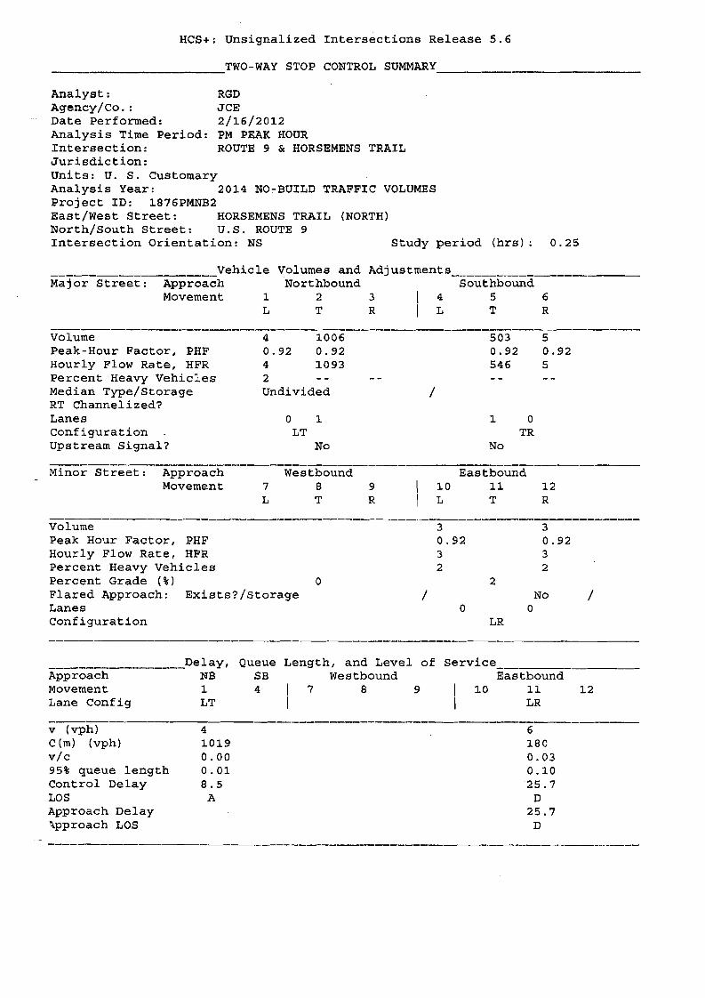
HCS+: Unsignalized Intersections Release 5.6
__________________TWO-WAY STOP CONTROL SUMMARY . ___
Analyst: RGD Agency/Co. : JCE Date Performed: 2/16/2012 Analysis Time Period: PM PEAK HOUR Intersection: ROUTE 9 & HORSEMENS TRAIL Jurisdiction: Units: U. S. Customary Analysis Year: 2014 NO~BUILD TRAFFIC VOLUMES Project ID: 1876PMNB2 East/West Street: HORSEMENS TRAIL (NORTH) North/South Street: U.S. ROUTE 9 Intersection Orientation: NS Study period (hrs): 0.25
Vehicle Volumes and Adjustments ~
Major Street: Approach Northbound Southbound Movement 1 2 3 4 5 6
L T R L T R
Volume 4 1006 503 5 Peak-Hour Factor, PHF 0.92 0.92 0.92 0.92 Hourly Flow Rate, HFR 4 1093 546 5 Percent Heavy Vehicles 2 Median Type/Storage Undivided /RT Channelized? Lanes o 1 1 0 configuration LT TR Upstream Signal? No No
Minor Street: Approach Westbound Eastbound Movement 789 10 11 12
L T R L T R
Volume 3 3 Peak Hour Factor, PHF 0.92 0.92 Hourly Flow Rate, HFR 3 3 Percent Heavy Vehicles 2 2 Percent Grade (%) 0 2 Flared Approach: Exists?/Storage / No /Lanes 0 0 Configuration LR
Delay, Queue Length, and Level of service Approach NB SB Westbound Eastbound Movement 1 4 7 8 9 10 11 12 Lane Config LT LR
v (vph) 4 6 C (m) (vph) 1019 180 vic 0.00 0.03 95% queue length 0.01 0.10 Control Delay 8.5 '25.7 LOS A D Approach Delay 25.7 '\pproach LOS D

HCS+: Unsignalized Intersections Release 5.6
_____________TWO-WAY STOP CONTROL SUMMARY .
Analyst: RGD Agency/Co.: JCE Date Performed: 2/16/2012 Analysis Time Period: AM PEAK HOUR Intersection: ROUTE 9 & HORSEMENS TRAIL Jurisdiction: units: U. S. Customary Analysis Year: 2014 BUILD TRAFFIC VOLUMES Project ID: 1876AMBD2 East/West Street: HORSEMENS TRAIL (NORTH) North/South Street: U.S. ROUTE 9 Intersection Orientation: NS Study period (hrs): 0.25
___Vehicle Volumes and Adjustments _ Major Street: Approach Northbound Southbound
Movement 1 2 3 4 5 6 L T R L T R
Volume 2 443 678 44 Peak-Hour Factor, PHF 0.90 0.90 0.90 0.90 Hourly Flow Rate, HFR 2 492 753 48 Percent Heavy Vehicles 2 Median Type/Storage Undivided / RT Channelized? Lanes o 1 1 0 Configuration LT TR Upstream Signal? No No
Minor Street: Approach Westbound Eastbound Movement 789 10 11 12
L T R L T R
volume 5 3 Peak Hour Factor, PHF 0.90 0.90 Hourly Flow Rate, HFR 5 3 Percent Heavy Vehicles 2 2 Percent Grade (%) 0 2 Flared Approach: Exists?/Storage / No / Lanes 0 0 Configuration LR
________________Delay, Queue Length, and Level of Service _ Approach NB SB Westbound Eastbound Movement 1 4 7 8 9 10 11 12 Lane Config LT LR
v (vph) 2 8 C(m) (vph) 822 204 vic 0.00 0.04 95% queue length 0.01 0.12 Control Delay 9.4 23.4 LOS A C Approach Delay 23.4 \pproach LOS C

HCS+: Unsignalized Intersections Release 5.6
TWO-WAY STOP CONTROL SUMMARY __
Analyst: RGD Agency/Co. : JCE Date Performed: 2/16/2012 Analysis Time Period: PM PEAK HOUR Intersection: ROUTE 9 & HORSEMENS TRAIL Jurisdiction: Units: U. S. Customary Analysis Year: 2014 BUILD TRAFFIC VOLUMES Project ID: 1876PMBD2 East/West Street: HORSBMBNS TRAIL (NORTH) North/South Street: U.S. ROUTE 9 Intersection Orientation: NS Study period (hrs): 0.25
______________________Vehicle Volumes and Adjustments _ Major Street: Approach Northbound Southbound
Movement 1 2 3 4 5 6 L T R L T R
Volume 4 1006 503 5 Peak-Hour Factor, PHF 0.92 0.92 0.92 0.92 Hourly Flow Rate, HFR 4 1093 546 5 Percent Heavy Vehicles 2 Median Type/Storage Undivided / RT Channelized? Lanes o 1 1 0 Configuration LT TR Upstream Signal? No No
Minor Street: Approach Westbound Eastbound Movement 789 10 11 12
L T R L T R
Volume 45 3 Peak Hour Factor, PHF 0.92 0.92 Hourly Flow Rate, HFR 48 3 Percent Heavy Vehicles 2 2 Percent Grade (%) 0 2 Flared Approach: Exists?/Storage / No /Lanes 0 0 Configuration LR
______Delay, Queue Length, and Level of Service Approach NB SB Westbound Eastbound Movement 1 4 7 8 9 10 11 12 Lane Config LT LR
v (vph) 4 51 C(m) (vph) 1019 131 vic 0.00 0.39 95% queue length 0.01 1. 64 Control Delay 8.5 49.0 LOS A E Approach Delay 49.0 \pproach LOS E

APPENDIX liD"
STANDARDS

LEVEL OF SERVICE STANDARDS
LEVEL OF SERVICE FOR SIGNALIZED INTERSECTIONS
Level of Service (LOS) can be characterized for the entire intersection, each intersection
approach, and each lane group. Control delay alone is used to characterize LOS for the entire
intersection or an approach. Control delay and volume-to-capacity (vIc) ratio are used to
characterize LOS for a lane group. Delay quantifies the increase in travel time due to traffic
signal control. It is also a measure of driver discomfort and fuel consumption. The volume-to
capacity ratio quantifies the degree to which a phase's capacity is utilized by a lane group.
LOS A describes operations with a control delay of 10 s/veh or less and a volume-to-capacity
ratio no greater than 1.0. This level is typically assigned when the volume-to-eapacity ratio is
low and either progression is exceptionally favorable or the cycle length is very short. If it is due
to favorable progression, most vehicles arrive during the green indication and travel through the
intersection without stopping.
LOS B describes operations with control delay between 10 and 20 s/veh and a volume-to
capacity ratio no greater than 1.0. This level is typically assigned when the volume-to-capacity
ratio is low and either progression is highly favorable or the cycle length is short. More vehicles
stop than with LOS A.
LOS C describes operations with control delay between 20 and 35 s/veh and a volume-to
capacity ratio no greater tha,rl 1.0. This level is typically assigned when progression is favorable
or the cycle length is moderate.
LOS D describes operations with control delay between 35 and 55 s/veh and a volume·to~
capacity ratio no greater than 1.0. This level is typically assigned when the volume-to-capacity
ratio is high and either progression is ineffective or the cycle length is long.
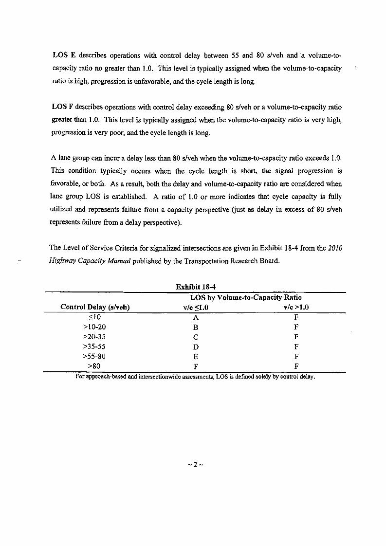
LOS E describes operations with control delay between 55 and 80 slveh and a volume-to
capacity ratio no greater than 1.0. This level is typically assigned when the volume-to-capacity
ratio is high, progression is unfavorable, and the cycle length is long.
LOS F describes operations with control delay exceeding 80 slveh or a volume-to-capacity ratio
greater than 1.0. This level is typically assigned when the volume-to-capacity ratio is very high,
progression is very poor, and the cycle length is long.
A lane group can incur a delay less than 80 s/veh when the volume-to-capacity ratio exceeds 1.0.
This condition typically occurs when the cycle length is short, the signal progression is
favorable, or both. As a result, both the delay and volume-to-capacity ratio are considered when
lane group LOS is established. A ratio of 1.0 or more indicates that cycle capacity is fully
utilized and represents failure from a capacity perspective Gust as delay in excess of 80 slveh
represents failure from a delay perspective).
The Level of Service Criteria for signalized intersections are given in Exhibit 18-4 from the 2010
Highway Capacity Manual published by the Transportation Research Board.
Exhibit 18-4
LOS by Volume~to-Capacity Ratio Control Delay (s/veh) vIc <1.0 vIc >1.0
::;10 A F >10-20 B F >20-35 C F >35-55 D F >55-80 E F
>80 F F For approach-based and intersectionwide assessments, LOS is defmed solely by control delay.
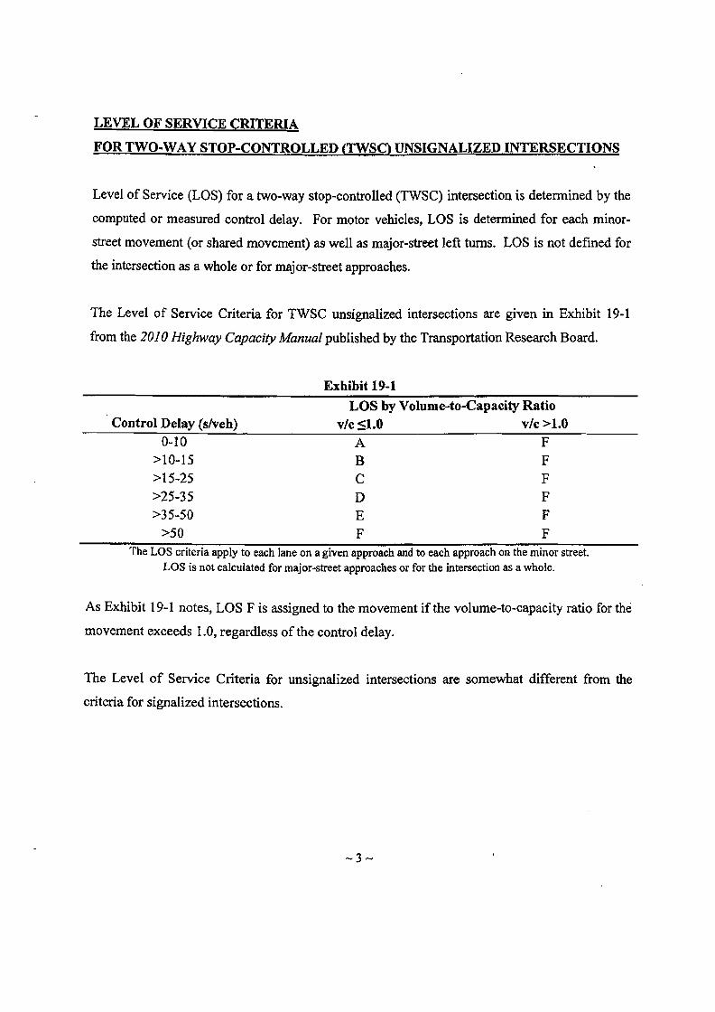
LEVEL OF SERVICE CRITERIA
FOR TWO-WAY STOP-CONTROLLED (TWSg UNSIGNALIZED INTERSECTIONS
Level of Service (LOS) for a two-way stop-controlled (TWSC) intersection is detennined by the
computed or measured control delay. For motor vehicles, LOS is determined for each minor
street movement (or shared movement) as well as major-street left turns. LOS is not defined for
the intersection as a whole or for major-street approaches.
The Level of Service Criteria for TWSC unsignalized intersections are given in Exhibit 19-1
from the 2010 Highway Capacity Manual published by the Transportation Research Board.
Exhibit 19-1
LOS by Volume-to-Capacity Ratio Control Delay (s/veh) vic ::51.0 vic >1.0
0-10 A F >10-15 B F >15-25 C F >25-35 D F >35-50 E F
>50 F F The LOS criteria apply to each lane on a given approach and to each approach on the minor street.
LOS is not calculated for major-street approaches or for the intersection as a whole.
As Exhibit 19-1 notes, LOS F is assigned to the movement if the volume-to-capacity ratio for the
movement exceeds 1.0, regardless of the control delay.
The Level of Service Criteria for unsignalized intersections are somewhat different from the
criteria for signalized intersections.

LEVEL OF SERVICE CRITERIA
FOR ALL-WAY STOP-CONTROLLED fAWSC) UNSIGNALIZED INTERSECfIONS
The Levels of Service (LOS) for all-way stop-controlled (AWSC) intersections are given in
Exhibit 20-2. As the exhibit notes, LOS F is assigned if the volume-to-capacity (vIc) ratio of a
lane exceeds 1.0, regardless of the control delay. For assessment of LOS at the approach and
intersection levels, LOS is based solely on control delay.
The Level of Service Criteria for AWSC unsignalized intersections are given in Exhibit 20-2
from the 2010 Highway Capacity Manual published by the Transportation Research Board.
Exhibit 20-2
LOS by Volume-to-Capacity Ratio Control Delay (s/veh) vIc S1.0 vIc >1.0
0-10 A F >10-15 B F >15-25 C F >25-35 D F >35-50 E F
>50 F F For approaches and intersectionwide assessment, LOS is defined solely by control delay.

MARYELLEN FINGERIENTERGY NUCLEAR INDIAN POINT 2, LLC
ENVIRONMENTAL ASSESSMENT FORM APPENDIX 4
File
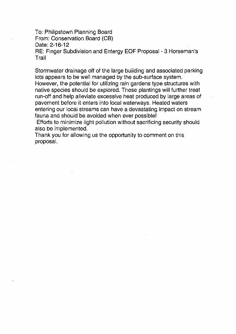
To: Philipstown Planning Board From: Conservation Board (CB) Date: 2-16-12 RE: Finger Subdivision and Entergy EOF Proposal - 3 Horseman's Trail
Stormwater drainage off of the large building and associated parking lots appears to be well managed by the sub-surface system. However, the potential for utilizing rain gardens type structures with native species should be explored. These plantings will further treat run-off and help alleviate excessive heat produced by large areas of pavement before it enters into local waterways. Heated waters entering our local streams can have a devastating impact on stream fauna and should be avoided when ever possible! Efforts to minimize light pollution without sacrificing security should
also be implemented. Thank you for allowing us the opportunity to comment on this proposal.