physical assessment work rpt mining claim so1150872 ... · this work required minor overburden...
TRANSCRIPT
Physical Assessment Work Report Mining Claim SO 1150872, SouthHalf Lots 15 and 16, Concession XI, Monmouth Township (G-1298),
Haliburton County, Southern Ontario Mining Division for thePeriod of April 4 to April 19, 1998
31D16NW2001 2.18426 MONMOUTH 010
S. Harper, Hon. B.Se., M. Se. Crd. Exploration Geologist Toronto, Ontario April 1998
itefa,
31D16KW2001 2.18426
TABLE OF CONTENTS
INTRODUCTION
1.1 LOCATION
1.2 ACCESS
1.3 PROPERTY
1.4 PHYSIOGRAPHY, VEGETATION AND WILDLIFE
1.5 HISTORY AND PREVIOUS WORK
GEOLOGY AND OBSERVATIONS
2.1 REGIONAL GEOLOGY
2.2 LOCAL GEOLOGY
CONCLUSIONS AND RECOMMENDATIONS
REFERENCES
STATEMENT OF COST
DATES OF EXPLORATION ACTIVITY
MONMOUTH
4
4
4
7
7
7
8
8
9
10
10
010C

LIST OF FIGURES
Property Location Map 5 Claim Location Map 6

INTRODUCTION
1.1 BRIEF PHYSICAL WORK DESCRIPTION
One old trench was 'cleaned up' to permit geological examination. In addition, some work was done along strike of the vein to reveal the vein contact. This work required minor overburden stripping and bedrock trenching. Most work was done using hand equipment including picks, shovels, crowbars, winches, hammers and chisels. A Pionjar 120 rock drill/breaker ('jackhammer') was also used. All work was done under the supervision of S. Harper (author). On average 12 hours were worked per person per day.
The work done revealed the vein to consist of areas of massive, coarse grained anhedral to subhedral black to green amphibole, massive coarse grained anhedral white calcite, massive medium grained anhedral reddish apatite, and rarely pinkish subhedral to euhedral microcline that ranged up to a few inches in size. The country rock consisted of grey colored massive, banded quartzite. The northern vein contact was discovered and exposed. The vein dipped vertical in the exposed area. The strike of the vein was not measured at this time. The vein is at least 10 feet wide, however, the southern vein contact was not found so the vein could be substantially wider.
1 .2 LOCATION
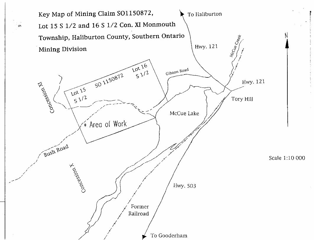
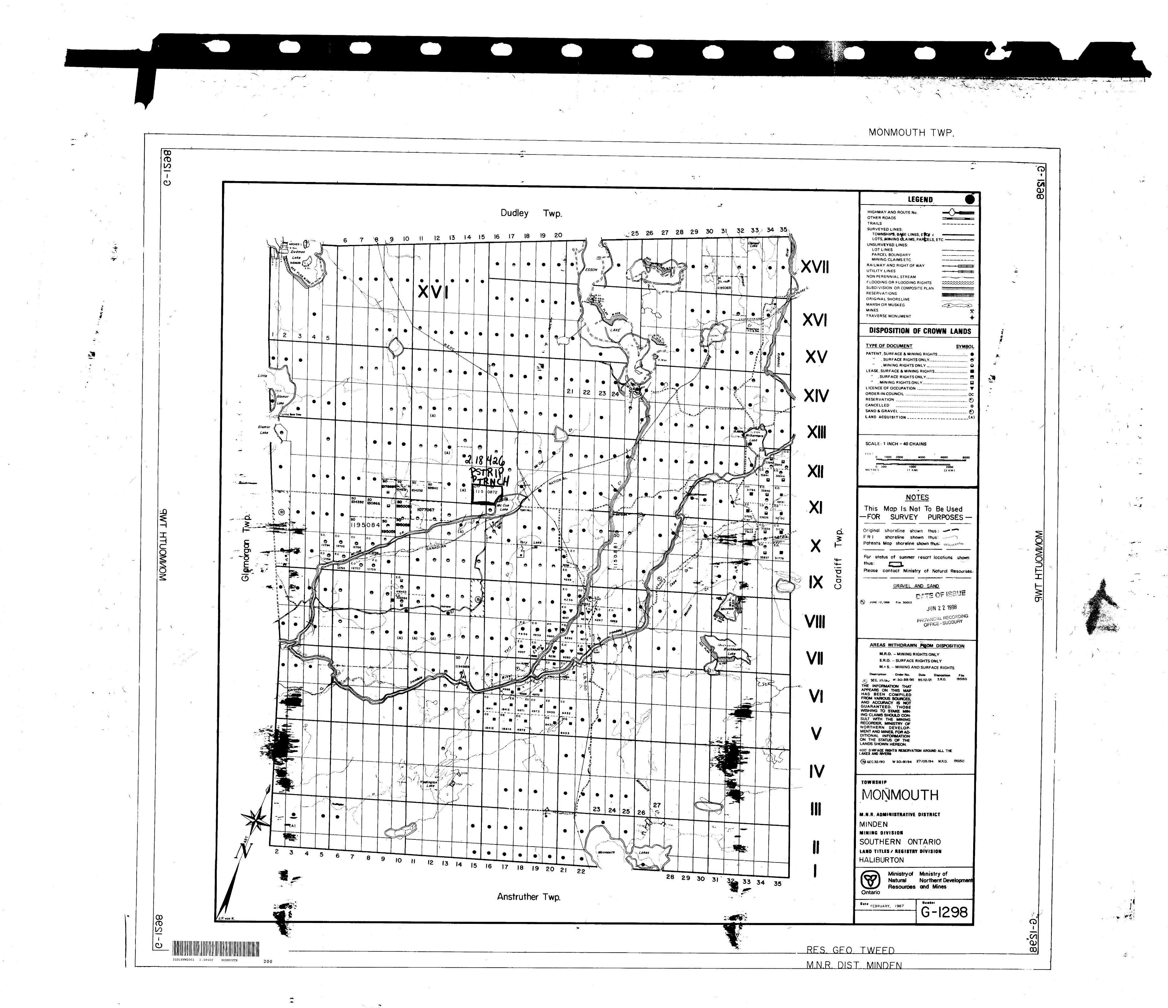
The property consists of a single mining claim of two units having mining claim number SO 1150872. The mining claim is located on Lot 1 5 South half, and Lot 16 South half, Concession XI, Monmouth Township (G-1298), Haliburton County, Southern Ontario Mining Division at Latitude 44- 58' 40" N and Longitude 78' 17' 23" W, UTM 713008mE, 4983003mN, Zone 17, NTS 31 D/16 (Gooderham). Figure 1 shows the mining claim location within southern Ontario.
1.3 ACCESS
There is good road access to the mining claim. To reach the property travel north on Highway 121 from the village of Tory Hill for 0.2 km to Gibson Road. Turn left onto Gibson Road and continue for 0.95 km (Sabina, 1986). At this point the road deteriorates and is only suitable for vehicles with high clearance. Continue for another 460 metres. Most of the showings are located to the south (left) of the road.
1.4 PROPERTY
The property consists of a single mining claim SO 1150872 that comprises two mining units (500mN-S X 800m E-W). The mining claim is located on the south halves of Lots 15 and 16, Concession XI, Monmouth Township (G-1298), Haliburton County, Southern Ontario Mining Division (Figure 2). The mining claim was staked by S. Harper and O. Bolton, both of Toronto, on September 2, 1992 and recorded on October 2, 1992 for Sharpmin Developments Incorporated, 153 St. George Street, Suite 407, Toronto, Ontario M5R 2L9. The mining rights are still held by Sharpmin Developments Incorporated.
The surface rights are privately owned. Surface rights ownership was investigated in the fall of 1992 at which time it was held by E. Bradamore, Box 603, Minden, Ontario, KOM 2KO; R. and W. Andrew, 24 Strathy Road, Ajax, Ontario, L1S 2V1; D. Cowie, 309 Elgin Street East, Oshawa, Ontario, L1G 1T5; and P. Madill, Box 136, Londesborough, Ontario, NOM 2HO. The surface rights owners were advised of intention to perform assessment work in the fall of 1992 as required by the Ontario Mining Act.
During claim staking it was found that the southern boundary of Lots 15 and 16 had been recently surveyed.

M A f,_l s u o o u n Y
f^v
t' A L G O H q U l K \V .. ... \ Mining Claim
'
,,,,^-^v^i r y^ o \
\ iivnisvflii A \\ (frAX
^MU s ^ r " MA^. V r-A
r^K- tT^--, 3 \
Mining Claim Location withii-Aj.jiij.jiA^ v-iniAJLi juv^o.i..iv^.iji within Ontario
(Monmouth Township, Southern Ontario Mining Division)
Figure lt (O
*r
To Haliburton
CTi
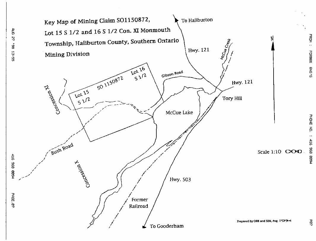
Key Map of Mining Claim SOI 150872,
Lot 15 S 1/2 and 16 S 1/2 Con. XI Monmouth
Township, Haliburton County, Southern Ontario
Mining Division Hw - 1 21
503
Tory Hill
Former Railroad
Hwy. 121
Scale 1:10000
To Gooderham

1.5 PHYSIOGRAPHY, VEGETATION AND WILDLIFE
The property consists of land with moderate relief. Low areas are swampy and the property borders McCue Lake at the southeastern corner. An intermittent stream crosses the property from the northwest to the southeast corner exiting into McCue Lake. The lowest elevation on the property is along the southeastern corner (approximately 370 metres). The highest elevation is along the northern boundary of the property where an east-northeast trending ridge occurs. This ridge has an elevation of appoximately 440 metres.
The property is tree covered. The trees are primarily hardwoods consisting mostly of small to medium sized maple. Spruce and cedar occupy low areas. The spruce are commonly 6 to 10 feet high and very abundant, obscuring the geology, pits, trenches and the adit.
Black bear, deer, ruffed grouse and blue jays have been encountered on the property by Sharpmin Developments Incorporated personnel in the past. During this work nothing was observed but ruffed grouse were heard drumming.
The climate is typical of south-central Ontario with warm relatively dry summers and mild accumulations of snow in the winters.
1.6 HISTORY AND PREVIOUS WORK
The mining claim contains several pits and trenches. These were excavated around the turn of the century during exploration for phospate.
In the southwest corner of the property there are several pits, trenches and an adit. The adit has been driven 30 feet north into the side of a hill (Satterly, 1943, p. 20; Armstrong and Gittins, 1968).
In 1976 Imperial Oil Limited conducted a geological and radiometric survey for uranium which included Lot 15, Concession XI (Lowe, 1977).
Sharpmin Developments Incorporated performed minor assessment work between July 28 and August 8, 1993. This work consisted of minor excavation and geological sampling. They also prepared a geological report for part of the property in August 1994.
No additional assessment files were found on record at the Ministry of Northern Development and Mines, Mines Library, 2nd floor, MacDonald Block, Toronto.
There has been considerable unrecorded overburden stripping and bedrock trenching (some trenches of considerable size) done by mineral collectors in recent years. Work done by mineral collectors has included the use of portable drills and explosives.
In addition to the above work, there are several references to the property in published literature which are summarized as follows:
Satterly (1943) describes previous work performed on the property.Hewitt (1967) summerizes Satterly (1943).Armstrong and Gittins (1968) reprint Satterly's description.Hewitt (1969) gives directions to the showing and shows its location ona small, simplified regional geology map.Bancroft Chamber of Commerce (1982) gives directions and lists minerals.Sabina (1986) gives directions to the site describes the workings andassociated minerals.Trueman (1993) summaries the Bancroft Chamber of Commerce (1982) andSabina (1986).
GEOLOGY AND OBSERVATIONS
2.1 REGIONAL GEOLOGY
The mining claim is located in the Bancroft Terrane of the Central Metasedimentary Belt of the Grenville Structural Province. Most of the Bancroft Terrane has been subjected to middle to upper amphibolite facies metamorphism (Easton, 1992).

2.2 LOCAL GEOLOGY
Rock exposure on the property is poor, with few outcrops whch are of small size. In addition, rock exposure at the showings is poor as the showings are overgrown and any exposed rock is generally heavily stained or moss-, lichen-, or soil-covered.
Country rocks exposed at surface on the property consist of quartzite, marble, syenite (possibly a feldspar rich metasedimentary rock or a fenitized rock rather than a true igneous syenite), amphibolite and feldspathic gneiss.
Several coarsely crystalline calcite veins containing large anhedral to euhedral crystals of biotite, hornblende, microcline, apatite and minor quartz occur on the property. In addition to these minerals, Sabina (1986) reports thorite, thorianite, uranophane, serpentine, pyroxene and chondrodite for the property. These minerals weren't found during the present survey and Sabina does not describe their occurrence so it is unknown if these minerals occur in the calcite veins. The calcite veins strike northwest and dip steeply, crosscutting the foliation of the country rocks. Most of the veins are narrow in width but some are several feet in width.
CONCLUSIONS AND RECOMMENDATIONS
The trenches, pits and adit on the property are overgrown and obscured by staining, moss and rock and soil debris. They need to be cleaned, brush in the vicinity of the showings needs to be cut, overburden stripped, and bedrock trenching done to allow examination of the mineralization. The work done during this exploration was done on one trench. It revealed additonal information about part of one vein. It is recommended that detailed geological mapping and lithogeochemical sampling be done on the exposed portion of the vein. As well, additional "clean up work' needs to be done on this vein and other veins.
REFERENCES
Armstrong, H.S. and J. Gittins (1968) Geology of Glamorgan andMonmouth Townships, Haliburton County. Ontario Department of Mines, Open File Report No. 5021, p. 111-112
Bancroft Chamber of Commerce (1982) Bancroft's Guide to Rockhounding, p. 12.
Easton, R. M. (1992) The Grenville Province and the ProterozoicHistory of Central and Southern Ontario; in Geology of Ontario. Ontario Geological Survey, Special Volume 4, part 2, p. 714-904.
Hewitt, D. F. (1969) Geology and Scenery, Peterborough, Bancroft and Madoc Area; Ontario Deptment of Mines, Geology Guide Book 3, p. 56, 61.
(1967) Phosphate in Canada. Ontario Department of Mines, Mineral Resources Circular No. 6, p. 42.
Lowe, B. (1977) Geological and Radiometric Surveys of Claims E.O. 460880 to 460883 inclusive E.O. 463209 to 463216 inclusive, Monmouth Township, Ontario. Imperial Oil Limited, Toronto, Ontario
Sabina, A. P. (1986) Rocks and Minerals for the Collector: Bancroft - Parry Sound area and Southern Ontario. Geological Survey of Canada, Miscellaneous Report 39, p. 57-59.
Satterly, J. (1943) Mineral Occurences in the Haliburton Area.Ontario Department of Mines, Annual Report Volume Lil, PartII, p . 20.
Trueman, B., (1993) A Rockhound's Paradise 1; Bancroft and Region.WWEC, North York, Ontario.
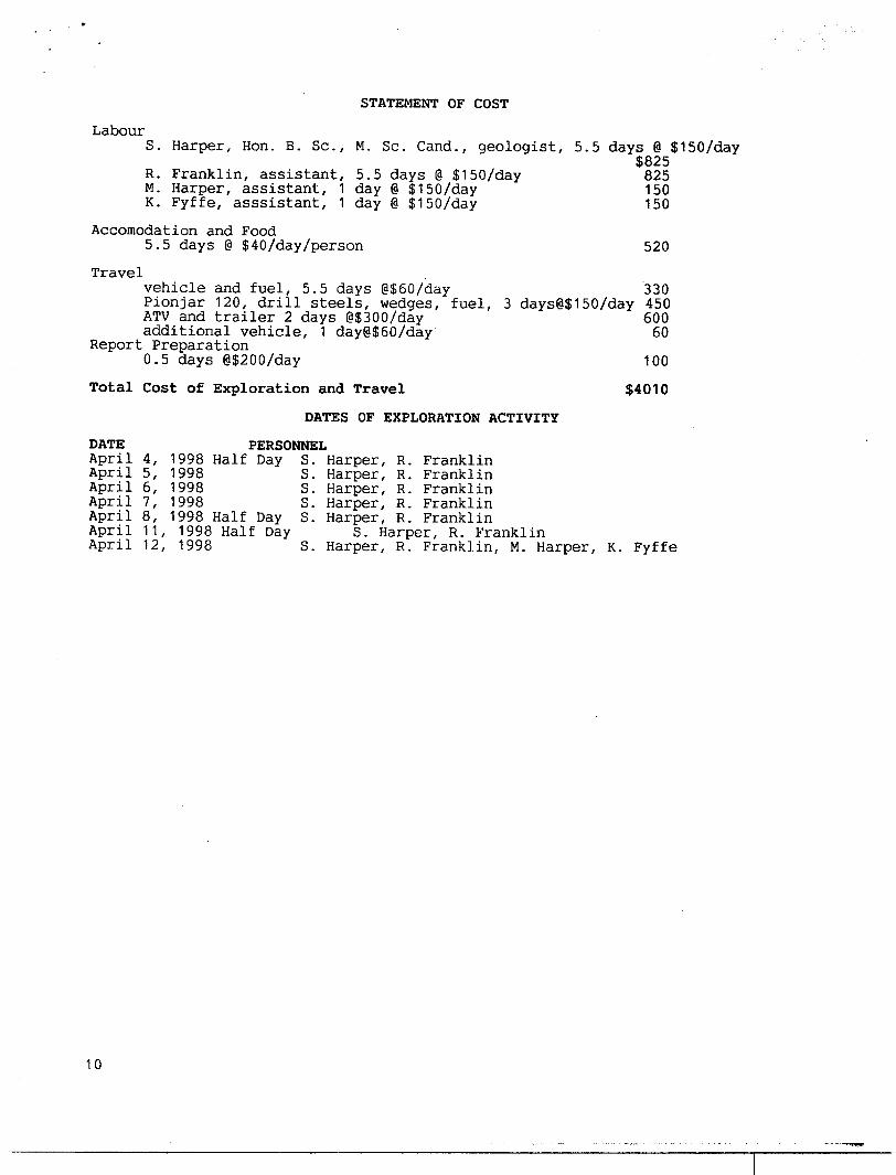
STATEMENT OF COST
LabourS. Harper, Hon. B. Se., M. Se. Cand., geologist, 5.5 days @ SISO/day
$825 R. Franklin, assistant, 5.5 days @ SISO/day 825M. Harper, assistant, 1 day @ ^ISO/day K. Fyffe, asssistant, 1 day @ SISO/day
Accomodation and Food5.5 days @ S407dayXperson
Travelvehicle and fuel, 5.5 days @S607day Pionjar 120, drill steels, wedges, fuel, ATV and trailer 2 days iSSOO/day additional vehicle, 1 day@S607day
Report Preparation0.5 days @S200Xday
150150
520
3303 days@S150Xday 450
60060
Total Cost of Exploration and Travel
DATES OF EXPLORATION ACTIVITY
100
S4010
DATE PERSONNELApril 4, 1998 Half Day S. Harper, R. FranklinApril 5, 1998 S. Harper, R. FranklinApril 6, 1998 S. Harper, R. FranklinApril 7, 1998 S. Harper, R. FranklinApril 8, 1998 Half Day S. Harper, R. FranklinApril 11, 1998 Half Day S. Harper, R. FranklinApril 12, 1998 S. Harper, R. Franklin, M. Harper, K. Fyffe
10

S0'33bd t*00 896
SHARPMIN DEVELOPMENTS INCORPORATEDSuite 407. l S3 Rt. George Street, Toronto, Ontario. CA M4O4 MSR 2L9
Telephone (416) 712-2738. FAX" (416) 968-0094 (9AM M 5PMONLY)
This may contain PRTVILEDGED AND CONFIDENTi At, INFORMATION intended for the addressee. If you are
not the addressee or someone responsible for delivering it to the addressee, you are hereby notified that any
dissemination or copying of this is rtrickly prohibited Tf you have received this in error, please notify us
immediately by telephone for further instructions. Thank you.
NUMBER OF PAGES, INCLUDING THIS PAGE: 4, IN DUPLICATE
ATTENTION: Geoscience Assessment Office933 Ramsey Lake Road6th FloorSudbury, OularioP3E 6B5Telephone 888-415-9846, or 705-670-5858 (I.ucille Jerome)Fax 705-670-5881
REGARDING: TRANSACTION NUMBER W9890.00015, SUBMISSION NUMBER 2.18426
August 27, 1998
Dear Sir/Madam,
1) Please find following maps for the above transaction number.
2) The work consisting of cleaning part of an old trench, and work along the strike of the vein to
reveal the vein contact (minor stripping and trenching) WAS DONE OVER A DISTANCE OF
APPROXIMATELY 30 FEET (9.1 METRES) BY 10 FEET (3.0 METRES).
3) The nature of the rocks and mineralization exposed was in the submitted report, "The work
done revealed the vein to consist of areas of massive, coarse grained anhedral to subhedral black
to green amphibole, massive coarse grained anhedral white calcite, massive medium grained
anhedral reddish apatite, and rarely pinkish subhedral to euhedral microcline that ranged up to a
few inches in size. The country rock consisted of grey colored massive, banded quartzite. The
northern vein contact was discovered and exposed. The vein dipped vertical in the exposed area.
The strike of the vein was not measured at this time. The vein is at least 10 feet wide, however,
the southern vein contact was not found so the vein could bc substantially wider."
4) No sampling was done at the time. Sampling and additional work may be done in the future.
5) A graphic and/or a bar scale are on the following maps. The north direction are on the maps,
with the sketch map of Area of Work having a Magnetic North.
Respectfully,
Scott Harper
—^~L15 G l 1 1338
GEOSCIENCE ASSESSMENT _____OFFICE______
S0d t-600 896 9Tt? : 'ON 3NOHd 3.9N3

w -a
O)m
LJ
(T*
O)
SO
g
m
8
Mining data
U. S A.
^ V * ' "
^-^ V
Mining Claim Location within Ontario(Monmouth Township, Southern Ontario Mining Division)
K fPrepared ty SEM and OBB, Aug. 1 994
Scvte rf Hiltsw L-
VTC3I f*im GriWH**
IfO .J
Figure l
•q
l
m in
m
m
en
en mQ
S
CO
ffiO)en CD
m
-o
Key Map of Mining Claim SOI 150872,
Lot 15 S 1/2 and 16 S 1/2 Con. XI Monmouth
Township, Haliburton County, Southern Ontario
Mining Division
To Haliburton
Scale 1:10 OOO
373
m5CT
T)
O
rn o
.b.i-^ en
en CD
Prepared by OBB and SEH. Aug.
To GooderhamS-J

FROM : FORBES ENG'GPHONE NO. : 416 968 0094P0S
ftUG 27 '98 13=55416 968 0094r*pftGE.0e

CVJ Ontario BMabbyof Northern Develop* and MOM
Declaration of , Performed on Mining Land
1MO
. oootsAssessment riss Research Imaging
31D16NW2001 2.18426 MONMOUTH 900
Mections 65(2) and 66(3) oT the Mining Act. Under section 8 of the Mining Act, this ent work and correspond wtth the mining land holder. Questions about this collection nent and Mines, 3rd Floor, 933 Ramsey Lake Road, Sudbury, Ontario, P3E 6BS.
Instructions: - For work performed on Crown Lands before recording a claim, use form 0240. - Please type or print in ink.
2 1 8 4 2 fi .. .^,-.—..—.,., v ~~~. - ..~....——.,, * A O *± ^ VJClient Number
-\53Fax Number
Name Client Number
Address Telephone Number
Fax Number
2. Type of work performed: Check (S) and report on only ONE of the following groups for this declaration.
D Geotechnical: prospecting, surveys, assays and work under section 18 (regs)
Physical: drilling stripping, trenching and associated assays D Rehabilitation
Work Type Office UseCommodityTotal S Value ofWork Claimed 4 ,010
D*e. Work From fy' Y, Performed Dty | Month | Ywr
To fl^'f /2yDiy | Month | Yew
NTS Reference
Global Positioning System Data (H available) Mining DivisionM or G-Ptan Number Resident Geologist
Please remember to: - obtain a work permit from the Ministry of Natural Resources as required;- provide proper notice to surface rights holders before starting work;- complete and attach a Statement of Costs, form 0212;- provide a map showing contiguous mining lands that are linked for assigning work;- include two copies of your technical report.
3. Person or companies who prepared the technical report (Attach a list if necessary)Name -. / I
y , l~J(JfflJl,Y
Address * /if / n
Name
Address
Name
Address
Telephone Number
Fax Number
Telephone Number
Fax Number
Telephone Number
Fax Number
4. Certification by Recorded Holder or Agenti. , do hereby certify that l have personal knowledge of the facts set forth in
(Print Name)this Declaration of Assessment Work having caused the work to be performed or witnessed the same during or after its completion and, to the best of my knowledge, the annexed report is true.Signature of Recorded Holder or Agent a' /?T
Agent's Address
0241 (03/97)
M"elephone Number
RECEIVED 3 i34
APR 2 2 I998
Fax Number
RECEIVED\^ VO'.Oo
APR 24 1998GEOSCIENCE ASSESSMENT ______OFFICE
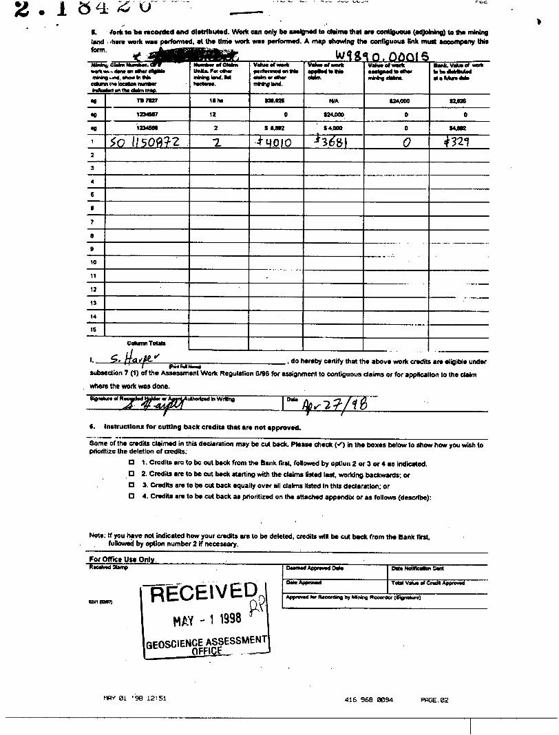
i a 4 s "o-l. fork to be recorded and distributed. Work can only be assigned to claims that are contiguous (adjoining) to tt* mining land 'here work was performed, at the time work was performed. A map showing the contiguous Bnk must accompany thisform. * •HMMWHB n——. . - -
Utah*MWtt*•nWn cohm Ma•8
•e•gi
2
3
4
E
8
7
6
9
10
11
12
13
14
IS
t, CM* Mumkw . Orftilt omt Oil OVMf 4H0BWj^md, •howlrtW*1 1A9 toCflUQfl nUffBMTtad en lh* ehkn rao.
ra 7*27
1234667
1234668
tO i /5007-2
Column Totab.
lMU.Forotwr
nBCtaVlM.
16 fv
12
2
T.
oMnvoftMr n**i01wid.
t26.62S
0
S 6492
4" q 010
.
•pptodMM* eWm.
N/A
124.000
S 4.000
•H^BI
VahMOfwMk•Mfcjmdktalhw
624,000
0
0
0
Bank. \Muiof work fcbvdbMbuUd
WOB
0
(4.682
4:321
____________,, do hereby certify that the above work credits are eligible under subsection 7 (1) of the Assessment Work Regulation 6/96 for assignment to contiguous claims or for application to the claim
where the work was done.
IM*
t. Instructions for cutting back credits that are not approved.
Some of the credits claimed in this declaration may be cut back. Please check (O in the boxes tolow to show how you wish to prioritize the deletion of credits:
G 1. Credits arc to bc out back from the Bank firs!, followed by option 2 or 3 or 4 as Indicated.O 2. Credits are to be cut back starting with the claims listed last, working backwards; orQ 3. Credits are to be cut back equally over all claims listed In this declaration; orD 4. Credits are to be cut back as prioritized on the attached appendix or as follows (describe):
Note: If you have not indicated how your credits are to be deleted, credits will be cut back from the Bank first, followed by option number 2 if necessary.
For Office Ute Only.___________._______
u*i ramRECEIVED
MAY - 1 1998 ^GEOSCIENCE ASSESSMENT
id IM* M* NoHteaton So*
ToM Vahj* of Cradk Approwd
Apprawd (or RvconUng by Mining Recorder (Signature)
MPV 01 -98 12=51 416 968 0094 PfiGE.02

Ontario Statement of Costs for Assessment Credit
Transaction Number (office use)
oool.Personal information collected on this form Is obtained under the authority of subsection 6 (1) of the Assessment Work Regulation 6/96. Under section 8 of the Mining Act, this information is a public record. This Information wffl be used to review the assessment work and correspond with the mining land holder. Questions about this collection should be directed to a Provincial Mining Recorder, Ministry of Northern Development and Mlnes^d Floor, 9gp Ranney Lake Rggd, Sudbury, Ontario, P3E 6B5.
l Mines*anl Floor, SJ3 Ranwey Lake RQQd, Sudbui
^ * l 84/86Work Type
La k CM
fio^'IW rjUI
4-"T\y ^•fvxue*
Units of workDepending on the type of work, list the number of hours/days worked, metres of drilling, kilometres of grid line, number of samples, etc.
^ftook (ii^yb]?oUysZ*Uv* @ fZW/J^V1
Associated Costs (e.g. supplies, mobilization and demobilization).
wfo /f" W/f f-'^'J V'S ̂ V ̂ (3) ' "̂ O0(o(^ V;
Transportation Costs
7V*^1 /v^k'c e^ -fe^ol)Rj^ ;^^ \kWt -fd^y
Food and Lodging Costs
/T JflP d^cl ftfiJ-
Cost Per Unit of work
fetf/cfW
i solJU i3^/Ji^
x
fiO -c, c/t v
Total Value of Assessment Work
Total Cost
M^O'^0
60O
IVO
330
C, C
510
40(0
Calculations of Filing Discounts:
1. Work filed within two years of performance is claimed at 10007o of the above Total Value of Assessment Work.2. If work is filed after two years and up to five years after performance, it can only be claimed at 5007o of the Total
Value of Assessment Work. If this situation applies to your claims, use the calculation below:
TOTAL VALUE OF ASSESSMENT WORK x 0.50 * Total S value of worked claimed.
Note:- Work older than 5 years is not eligible for credit.- A recorded holder may be required to verify expenditures claimed in this statement of costs within 45 days of a
request for verification and/or correction/clarification. If verification and/or correction/clarification is not made, the Minister may reject all or part of the assessment work submitted.
Certification verifying costs:
l,. ,, do hereby certify, thai ihe amounts shown are as accurate as may reasonablyi print full name)
be determined and the costs were incurred while conducting assessment work on the lands indicated on the accompanying
TDeclaration of Work form as l am authorized to make this certification.(recorded holder, agent, or stale company position with signing authority)
0212 (03/97) RECEIVEDX \^'^0APR 2 ** 1993 i
GEOSCIENCE ASSESSMENT
Date
OntarioMinistry of Ministere duNorthern Development Developpement du Nordand Mines et des Mines ^ . ^ _ - , ^ _,.
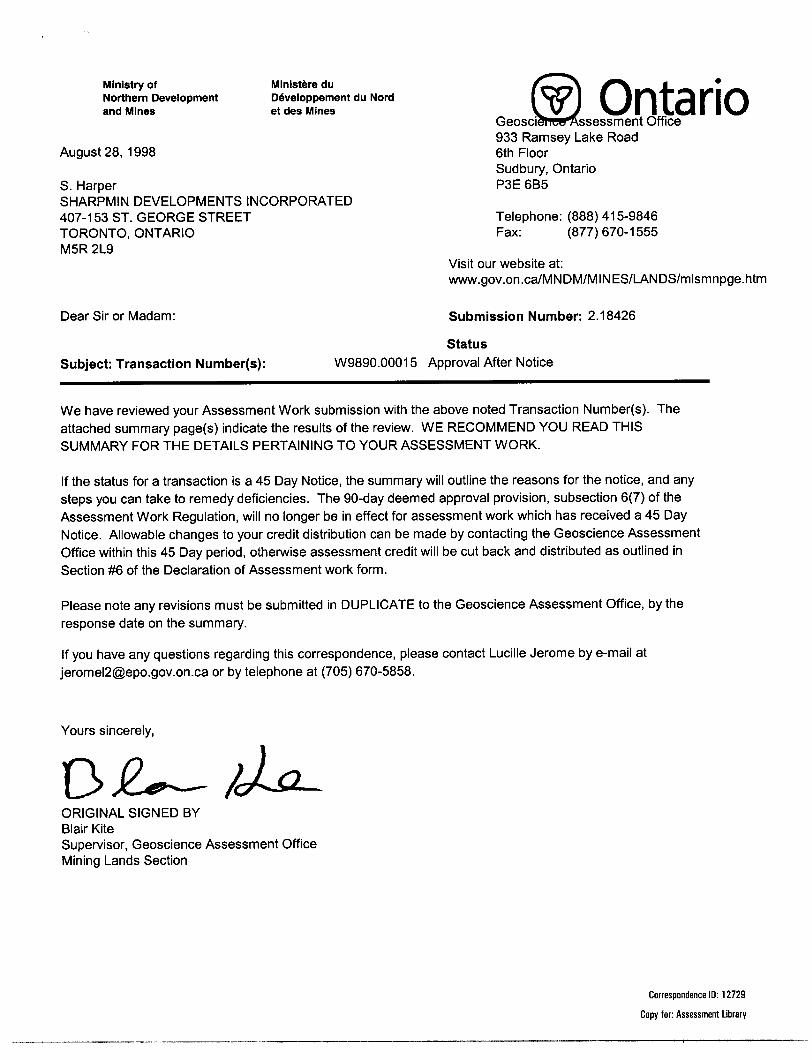
Geosci^l iCe^ssessment Office 933 Ramsey Lake Road
August 28, 1998 6th FloorSudbury, Ontario
S. Harper P3E 6B5SHARPMIN DEVELOPMENTS INCORPORATED407-153 ST. GEORGE STREET Telephone: (888) 415-9846TORONTO, ONTARIO Fax: (877)670-1555M5R 2L9
Visit our website at: www.gov.on.ca/MNDM/MINES/LANDS/mlsmnpge.htm
Dear Sir or Madam: Submission Number: 2 .18426
Status
Subject: Transaction Number(s): W9890.00015 Approval After Notice
We have reviewed your Assessment Work submission with the above noted Transaction Number(s). The attached summary page(s) indicate the results of the review. WE RECOMMEND YOU READ THIS SUMMARY FOR THE DETAILS PERTAINING TO YOUR ASSESSMENT WORK.
If the status for a transaction is a 45 Day Notice, the summary will outline the reasons for the notice, and any steps you can take to remedy deficiencies. The 90-day deemed approval provision, subsection 6(7) of the Assessment Work Regulation, will no longer be in effect for assessment work which has received a 45 Day Notice. Allowable changes to your credit distribution can be made by contacting the Geoscience Assessment Office within this 45 Day period, otherwise assessment credit will be cut back and distributed as outlined in Section #6 of the Declaration of Assessment work form.
Please note any revisions must be submitted in DUPLICATE to the Geoscience Assessment Office, by the response date on the summary.
If you have any questions regarding this correspondence, please contact Lucille Jerome by e-mail at [email protected] or by telephone at (705) 670-5858.
Yours sincerely,
ORIGINAL SIGNED BYBlair KiteSupervisor, Geoscience Assessment OfficeMining Lands Section
Correspondence ID: 12729
Copy for: Assessment Library

Work Report Assessment Results
Submission Number: 2 .18426
Date Correspondence Sent: August 28,1998______________________Assessor: Lucille Jerome^^^^^^^^^^^^^^^^^^
Transaction First ClaimNumber Number Township(s) l Area(s) Status Approval Date
W9890.00015 1150872 MONMOUTH Approval After Notice August 28, 1998
Section:10 Physical PTRNCH 10 Physical PSTRIP
The map provided serves well as a location map, however, all future physical work submissions must contain the following information on a detail map in order to receive assessment work credit:
i) the dimension of workings, trenches and stripping, ii) the nature of the rocks and mineralization exposed,
Correspondence to: Recorded Holder(s) and/or Agent(s):
Resident Geologist S. HarperTweed, ON SHARPMIN DEVELOPMENTS INCORPORATED
TORONTO, ONTARIO Assessment Files Library Sudbury, ON
Page: 1Correspondence ID: 12729
MONMOUTH TWP.
Dudley Twp.
25 26 27 28 29 30 31i, 12 13 14 15 16 17 18 19 20
STR
12 " 3 l 4 'S 16 17 18 19 20
28 29 30 3133 34 35
Anstruther Twp.
LEGENDHIGHWAY AND ROUTE No OTHER ROADS TRAILS SURVEYED LINES:
TOWNSHIPS, BA^E LINES,LOTS, MINING OLA l MS, PARfcELS, ETC.
UNSURVEYEO LINES:LOT LtNES - PARCEL BOUNDARY - MINING CLAIMS ETC -
RAILWAY AND RIGHT OF WAY -t- UTILITY LINES -t NON-PERENNIAL STREAM - FLOODING OR FLOODING RIGHTS SUBDIVISION OR COMPOSITE PLAN RESERVATIONS ORIGINAL SHORELINE MARSH OR MUSKEG MINES TRAVERSE MONUMENT
Q ..9-
DISPOSITION OF CROWN LANDS
TYPE OF DOCUMENT SYMBOLPATENT. SURFACE ft MINING RIGHTS ..—.—.— — I.. ^
.SURFACE RIGHTS ONLY- __ .—.—,........... 6'
.MINING RIGHTS ONLY —...... ___ ........... OLEASE. SURFACE S. MINING RIGHTS-.—.——..,.—. B
" .SURFACE RIGHTS ONLY. _ ̂ ........,........... B" .MINING RIGHTSONLY.., _ ..... __ ........ __ . B
LICENCE OF OCCUPATION , . __ ...........,,.........— TORDER-IN-COUNCIL ...——— ......... .. _ ............— OCRESERVATION ___ ........——— — .—————... ..™... ©CANCELLED __ .................,,— ———......... ®SAND 8. GRAVEL ___ .... ___ ......... _ ............... (J)LAND ACQUISITION--.. ------. __ ......
SCALE: 1 INCH = 40 CHAINS
O 1OOO 20OO 4OOO 6OOO 8000
O 20O MtTRE S
1OOOII KM)
3000[2 KM)
NOTESThis Map Is Not To Be Used
— FOR SURVEY PURPOSES —Original shoreline shown thus: —* FRI shoreline shown thus -~ Patents Map shoreline shown thus. -.~.
status of summer resort locations shown
Rease contact Ministry of Natural Rcsourses-
JUNE 1 2,1986 F iU 3OOO3
GRAVEL AND SAND
r /^^sz .... l~ f. v*
jUM 1 1 1998.-.o-.-iM-.!^ RECORDING
AREAS WITHDRAWN FQOM D ISPOSITION
M.R.O. - MINING RIGHTS ONLYS.R.O. - SURFACE R IGiHTSONLYM.+ S- - MINING AND SURFACE RIGHTS
Dneription Onfar No. Oat. Dnporitlon F H* SEC. iS/Sw tf-50-89/96 95/12/21 S.R.O. I95ISO
THE INFORMATION THAT APPEARS ON THIS MAP HAS BEEN COMPILED FROM VARIOUS SOURCES. AND ACCURACY IS NOT GUARANTEED. THOSE WISHING TO STAKE MIN ING CLAIMS SHOULD CON SULT WTTH THE MINING RECORDER, MINISTRY OF NORTHERN DEVELOP MENT AND MINES. FOR AD DITIONAL INFORMATION ON THE STATUS OF THE LANDS SHOWN HEREON.400- S* (RF ACE RIGHTS RESERVATION AROUND ALL THE LAKES ANDMVER9
(asEC.35/90 WSO-ai/94 27/05/94 M.RO. I95I5O
TOWNSHIP
MONMOUTHM.M.R. ADMINISTRATIVE DISTRICT
MINDENMINING DIVISION
SOUTHERN ONTARIO4
LAND TITLES/ REGISTRY DIVISION
HALIBURTON
Ministryof Ministry ofNatural Northern* Development!Resources and Mines
Ontario
Oit* FEBRUARY, 1987
G-I298
RF.S r,FD TWFFR
O1
C*OJ 00
CDi
.01o;CO
31D16KW2001 2.18426 MONMOUTH 200 M.N.R. DIST M1NDFN
i