physical characteristics of some soils from the middle east · physical characteristics of some...
TRANSCRIPT

TEC-0032
AD-A269 560
Physical Characteristicsof Some Soils from theMiddle East
Judy Ehlen DT CELC-V T
SEP 22 1993
May 1992
Approved for public release; distribution is unlimited. n
9t.§. Army Corps of Engineers 0Topographic Engineering CenterFort Belvoir, Virginia 22060-5546

Destroy this report when no longer needed.Do not return it to the originator.
The findings in this report are not to be construed as an official Department of the Armyposition unless so designated by other authorized documents.
The citation in this report of trade names of commercially available products does notconstitute official ,:-,&,rsement or approval of the use of such products.

REPOT DCUMNTATON AGEform Approved
REP RT OC MEN ATON AG OMB No. 070,-018
OWC repoonfnq bwrfrO" for (OI1fiSCA o f R8,1*tOf , Is est,-mlald tO 8tv'&94@ I .tVO p 'err .feIs€s . A tfi t,"UA 0fo fe04 7"nW* ^tfuctoft. stearchtwn ellt n data ,urcaathertng and mrneta.Ai the date Aegdtd. an'd c.€EYSrd.q and veoewenq PC COII of afonnatSond cOmmti r a rn, tht burden tsmt@ 0' any other a of the
€ o~• f mfoqauon, mncludig " ~ll vfor Mrekd iAg thtIs bUden. to Wath.s9.nq n -liq uafoert serv•$ ft, Ourecnoeate for nfoqwnatm Og•era•tn Sod Ftc Mg. 2i'S J'"teesD&Vt% sqhway. SuWte1204o &¢lrqtngt. A 22202-4302. ar1 tO he O14,(e of Mae•qe-vot and i9cdct. Pa•H•Oft ftelunSn PI© • (0704-0 Sill. washgton. O( OSOjl
i. AGENCY USE ONLY (Leave blank) 2. REPORT DATE 3. REPORT TYPE AND OATES COVERED
I- May 193 Technical Re )ort Au•y. 1984 - Dec. 199214. TITLE AND SUBTITLE S. FUNDING NUMBERS
Physical Characteristics of Some Soids from the Middle East
6. AUTHOR(S)
Judy Ehlen
"7. PERFORMING ORGANIZATION NAME(S) AND ADORESS(ES) S. PERFORMING ORGANIZATIONREPORT NUMBER
U.S. Army Topographic Engineering Center TEC-0032Fort Belvoir, VA 22060-5546
9. SPONSORING/MONITORING AGENCY NAME(S) AND ADORESS(ES) 10. SPONSORING/MONITORINGAGENCY REPORT NUMBER
11. SUPPLEMENTARY NOTES
12a. DISTRIBUTION /AVAILABILITY STATEMENT 12b. DISTRIBUTION CODE
Approved for public release; distribution is unlimited.
13. A•STRACT (Maximum 200 words)
This report presents soil moisture and soil texture data on 59 soil samples from eastern Saudi Arabia, Iraq andKuwait. Very little soil moisture data are available, and although the data reported here are probablyoverestimates, they are reported because of the apparent lack of such data. With respect to soil texture, thesoils were grouped as sandy soils or gravelly soils, and then were further subdivided using a descriptiveclassification based on particle size differences. A modified version of the U.S. Department of Agricultureclassification was used. This classification was tested using cluster analysis. Petrographic descriptions of11 samples are included as an appendix. Although limited, the data are reported because of an apparent interestin such data with respect to military operations in desert areas.
14. SUBJECT TERMS IS. NUMBER OF PAGES27
Particle size analysis, Middle East, soils 7 PRICE CODE
17. SECURITY CLASSIFICATION I1. SECURITY CLASSIFICATION 19. SECURITY CLASSIFICATION 20. LIMITATION Of ABSTRACT
OF REPORT OF THIS PAGE OF ABSTRACT
UNCLASSIFIED UNCLASSIFIED UNCLASSIFIED UNLIMITEDNSN 7S40-01-2S0-SS00 Standard Form 298 (Rev. 2-89)
te~c.b, by ANSI Std I31-tI296.102

CONTENTS
TITLE PAGE
ILLUSTRATIONS iv
PREFACE v
INTRODUCTION 1
SOIL MOISTURE 5
SOIL TEXTURE 5
Procedures 5
Sieve Analysis 6
Sandy Soils 6
Gravelly Soils 6
Classification 6
Two-Cluster Classification 11
Five-Cluster Classification 12
CONCLUSIONS 14
REFERENCES 15
APPENDIX A: PETROGRAPHIC ANALYSIS Acc-yio'-, For 16
Methodology r", r.- Is ; A . 16
Sample Descriptions ., 16
Discussion of Results By................. 20
References Di:. t ny ;o108 22
Avaii ciD5ri Ap-ciaI
i-ii

ILLUSTRATIONS
FIGURE TITLE PAGE
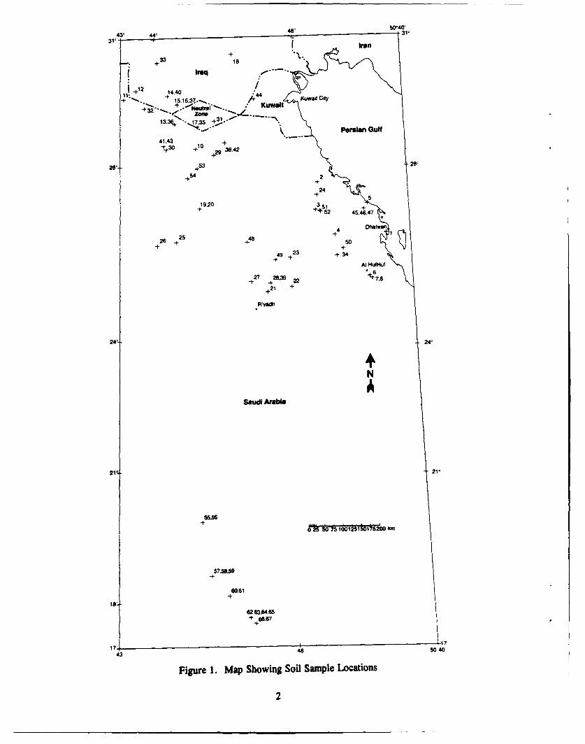
1 Map Showing Soil Sample Locations 2
2 Sieve Separate Distributions, Sandy Soils 9
3 Sieve Separate Distributions, Gravelly Soils 10
4 Typical Dendrogram. Line a-b indicates the 11optimum clustering level, the four-cluster level.
TABLE
1 Latitudes, Longitudes and Descriptions of Samples 3
2 Particle-Size Distributions, Sandy Soils 7
3 Particle-Size Distributions, Gravelly Soils 8
4 Soil Sample Distribution in the Two-Cluster 12Classification
5 Soil Sample Distribution in the Five-Cluster 13Classification
iv

PREFACE
This report reflects one of the efforts conducted by TEC in support of Desert Shield/DesertStorm between August 1990 and April 1991. It was prepared under the supervision of Dr. J.N.Rinker, Senior Research Scientist, and of Mr. John V.E. Hansen, Director, Research Institute, in partunder DA Project 4A161102B52C, Task FO, Work Unit 201, "Image Analysis Research."
Mr. Walter E. Boge was Director and COL Kenneth C. Kessler was Commander and DeputyDirector of the Topographic Engineering Center at the time of publication of this report.
v

PHYSICAL CHARACTERISTICS OF SOME SOILSFROM THE MIDDLE EAST
INTRODUCTION
In September 1990 the Research Institute of the Topographic Engineering Center (TEC)initiated a feasibility study (Project Ostrich) to evaluate the usefulness of airborne long-wavelength(penetrating) radar to detect buried mines in soils comparable to those found in the Desert Shield areaof operations in the Middle East. Work being done by TEC in conjunction with the U.S. GeologicalSurvey near Yuma, Arizona, using airborne long-wavelength radars had shown images of what werebelieved to be subsurface objects, possibly buried ordnance (G.G. Schaber, U.S. Geological Survey,personal communication). Work done previously by McCauley et al. (1982), Blom et al. (1984), andMcCauley et al. (1986), among others, indicated that one critical factor to success was the hyperaridnature of the soils where this work had been done. Hyperarid refers to soils that typically containless than 1 % soil moisture.
Project Ostrich involved building a minefield in soils comparable to those that occur in theMiddle East: a site at the Marine Corps Air Ground Combat Center at Twentynine Palms, Californiawas chosen. The major problem encountered with respect to soils was that very little information onthe soils in the Desert Shield area of operations could be obtained, and what was available was notpertinent to the purposes of Project Ostrich. Data were needed so that the soil characteristics of thetwo areas could be compared. Several unsuccessful attempts were made to locate appropriate Armyunits and to obtain samples or data. Finally, a few samples were obtained from Mr. Ron Rhodes,U.S. Army Corps of Engineers Trans-Atlantic Division, from military personnel of the 529thEngineer Detachment stationed in Saudi Arabia, and from SSGT Michael Dibble (TEC), who spentseveral weeks in Saudi Arabia on temporary duty. Although this sampling was uncontrolled, allsamples were gratefully accepted. The data on these samples is reported in Elen and Henley (1991).
Toward the end of Operation Desert Storm, samples were collected by Dr. J.N. Rinker(TEC), LTC Keith Wedge (U.S. Army Reserves), and Bob Knowles (U.S. Army Reserves and TEC).Although still not collected using a traditional sampling scheme, these samples were more usefulbecause more information was provided with most of them. They also increased the total number ofsamples more than five times.
This report thus presents data on the physical characteristics of the 59 soil samples obtainedfrom Saudi Arabia, Iraq and Kuwait in conjunction with Project Ostrich during Operations DesertShield and Desert Storm. Soil samples came from eastern Saudi Arabia, from the Empty Quarter inthe south to the northern border with Iraq and Kuwait; from the Neutral Zone between Saudi Arabiaand Iraq; from western Kuwait; and from southern Iraq (Figure 1). Table 1 lists the samples bynumber and gives the latitude and longitude (determined primarily by military GPS) of their point ofcollection. Remarks provided by the individuals who collected the samples are also included whereavailable. These remarks are somewhat cryptic, and are field descriptions. The country of origin isSaudi Arabia unless otherwise indicated. Samples 34 through 41 were too small to be evaluated bythe procedures described in this report, although their locations are plotted on Figure 1.
4W 540'43' 448.,+ 31
31' 31'n31... I Irnt
+• 16
Iraq
I -12 14,40
+ •-. 15.16.3?.-. Kuwait City+ Kuwait- z. , Nato ....
"- k Persian Gulf41.+43 +4 o .-
++.30 +10 +2 3.42
28%. +53
+5 + 2
24
19.20 2°
,52 45.46,47
26 25 4 _ý4 tDahran
25 4+ 50
49 23 + 34 ~
* *3
Al HOW~u
+ 7 28.39 22 -ý.
*21 +
24'-
N
Saudi Arabia
21 21v
21'A
02 Mg 0 7'5 10012150175200 krn
60.61
62.63.64.65~*66.67
117
1743 48 5040
Figure 1. Map Showing Soil Sample Locations
2

Table 1. Latitudes, Longitudes and Descriptions of Samples
Sample Latitude Longitude Field description/Remarks'NumberSA-1 260 14.4'N 5009.7'ESA-2 27 029'N 48027'ESA-3 26052'N 48 022'ESA-4 26016'N 48050'ESA-5 26055'59"N 49042'52"E - 140 km south of Kuwait, 500m inland
from the Gulf CoastSA-6 25 017'00"N 49 038'45"ESA-7 25 0 13'00"N 49041'15"ESA-8 25 012'30"N 49042'30"ESA-9SA-10 28 023'N 45 020'ESA-I1 29 033'N 43"28'05"E subsurface, matek a from up to 10-15
cm depthSA-12 29 044. 'N 43048'E gravel/duricrust (Iraq) \SA-13 28 058'N 44 048'E silty sand, Karma domes swaleSA-14 29"36.7'N 44 038.1'E sand (Iraq)SA-15 29 024'N 44"053'E duricrust (Iraq)SA-16 29 024'N 44 053"E silt flat (Iraq)SA-17 28 053'N 45 024'E bulk, Wadi BatinSA-18 30 031.3'N 46 023.0'E barchan dune area, interdune flat
(Iraq)SA-19 27 000.5'N 45023.0'E top of dune, Ad Dahna sandsheet, 12
km N of Um al JamajimSA-20 27 000.5'N 45"23.0'E swale, Ad Dahna sand sheet, 12 km N
of Um al JamajimSA-21 25 003'N 47 002'E duricrust escarpmentSA-22 25 008.2'N 47 039'E dune crest, Ad Dahna sandsheetSA-23 25048'N 47 039'E bulkSA-24 27 0 11.6'N 48 025.0'E sand quarrySA-25 26"15.5'N 44043.3'E dome dune, Ad Dahna sandsheetSA-26 26 0 11.7'N 44"15'E Ad Dahna sandsheetSA-27 25 0 18'N 46 038'ESA-28 25013.5'N 47 007.2'E bulk, silt flatSA-29 28013.0'N 45 048.0'E wadiSA-30 28 023.26'N 44032.57'ESA-31 2900.04'N 45 051.45'ESA-32 29 020'N 4401.6'ESA-33 30023.03'N 44023.2'E IraqSA-42 28030'N 46 006.2'E bulk, western bank, Wadi BatinSA-43 28027.9'N 44 028.7'E bulk, wadi areaSA-44 29027'N 46056'E Kuwait
Unless stated otherwise, country of origin is Saudi Arabia.
3

Table 1. (continued)
Sample Latitude Longitude Field description/Remarks 2
Number
SA-45 26049'N 49°36.5'E sahbkaSA-46 26049'N 49 036.5'E sahbka, bulk, top 5 cmSA-47 26 049'N 49 036.5'E sahbka, Ist hard layerSA-48 26012'N 46 035'E campsite, Ad Dahna sandsheetSA-49 25 046.0'N 47°17.3'ESA-50 25 056.6'N 49°01.2'ESA-51 26 049.5'N 48 028.4'ESA-52 26 049.0'N 48 028.7'ESA-53 27 055.88'N 45 020.75'ESA-54 27 043.02'N 45 005.69'ESA-55 19048.88'N 45*07.97'E Empty QuarterSA-56 19048.88'N 45 007.97'E 4" deep (Empty Quarter)SA-57 18035.26'N 45 *18.90'E Empty QuarterSA-58 18035.26'N 45018.90'E 2-4" deep (Empty Quarter)SA-59 18035.26'N 45018.90'E Empty QuarterSA-60 18007.27'N 45 043.76'E Empty QuarterSA-61 18007.27'N 45°43.76'E subsurface (Empty Quarter)SA-62 17035.49'N 460 12.77'E dune crest (Empty Quarter)SA-63 17035.49'N 46012.77'E interdune troughs (Empty Quarter)SA-64 17035.50'N 46012.77'E dune surface, windward (Empty
Quarter)SA-65 17035.50'N 46 0 12.77'E dune subsurface, windward, S side
(Empty Quarter)SA-66 17028.19'N 46 020.79'E interdunal area (Empty Quarter)SA-67 17028.19'N 46020.79'E subsurface, interdunal area (Empty
Quarter)
Very little information was provided regarding the depth from which the samples werecollected. Most descriptions are "surface," "subsurface" or "bulk" with no depths given.3 For 46samples with such descriptors, 33 are surface samples and 13 are from the subsurface. Surfacesamples were collected mainly by taking a handful of soil from the surface, probably no deeper than 4cm. Most of the subsurface, or bulk, samples were apparently collected from 5-10 cm depths; thedeepest samples extend to depths of 15 cm. Unless described as "bulk" or "subsurface" in Table 1,all samples are surface samples (i.e. 0-4 cm).
2 Unlesn stated otherwise, country of origin is Saudi Arabia.
'"Bulk' refers to a sample collected from the subsurface (J.N. Rinker, U.S. Army Topographic Engineering Center,oral communication, 1992).
4

In addition to soil texture, spectral reflectance curves for samples SA-1 through SA-8 werereported by Ehlen and h.aley (1991). Information on the thermal infrared characteristics of thesesoils as well as some rock samples from the same area can be found in Eastes (in prep). Petrographicdata on selected simples are given in Appendix A (Rubick Luttrell, 1991a and 1991b).
The data presented below are limited because (1) no controlled sampling scheme was used, (2)very few samples were collected over a very large area and (3) many samples are random grab;amples, collected by individuals with limited knowledge of soil characteristics. An attempt has beenmade, however, to group the soils statistically according to particle-size characteristics.
Soil Moisture
As stated above, soil moisture was a primary concern in choosing a test site for ProjectOstrich Hansen et al., in prep). Soil moisture was measured on soils from the test site, but only onereference to soil moisture in the area of interest (Berlin et al., 1986) was located in the literature; noother source of such data was found. Berlin et al. (1986) report soil moisture in the Al Labbah sandin northern Saudi Arabia to be 0.148-0.248% at 20-30 cm depth and 0.183-0.578% at 50 cm depth.Surface soil moisture was reported as ranging from 0.054% to 0.077%.
Soil moisture was not determined for most of the samples listed in Table 1. None of thesamples were weighed in the field and sample history after collection was not known. Soil moisturewas determined on five samples that appeared to have been collected under more controlledconditions. The results are reported here, because of the apparent lack of such information in theliterature, although they probably don't represent the actual soil moisture conditions when the sampleswere collected. These soil moisture values are about one magnitude greater than those reported byBerlin et al. (1986).
Upon receipt, the soil samples were weighed, then oven dried to constant weight at 1030 C.Drying to constant weight usually took 36-48 hours. Soil moisture was then calculated on an oven-dry weight basis.
Soil moisture was determined for samples SA-2, SA-3 and SA-4, which are surface samples(0-4 cm depth). Soil moisture for these sample was 0.58%, 13.3% and 0.38%, respectively. Soilmoisture for sample SA-3 is particularly high due to the presence of a large amount of gypsum, ahydrated mineral. Water of hydration as well as free water is driven off during heating.
Soil moisture was also determined for samples SA-10 (0-4 cm depth) and SA-I 1 (10-15 cmdepth), collected during the rainy season. Containers for these samples were sealed with tape andtheir transit time was not long. Soil moisture in these two samples was 1.8% and 3.7%, respectively.These values compare well with those for samples SA-2 and SA-4 when climatic conditions are takeninto consideration.
Soil Texture
Procedures
Particle-size analysis was performed on the 59 oven-dried samples. The samples wereweighed and then sieved. After sieving, the individual separates were weighed so that their
5

proportion of the total could be determined. A modified U.S. Department of Agricultureclassification (U.S.D.A., 1951) was used: gravel (>2 mm), very coarse sand (1-2 mm), coarse sand(0.5-1 m), medium sand (0.25-0.5 mm), fine sand (0.125-0.25 mm), very fine sand (0.075-0.125mm), and silt+clay (<0.075 mm). Sieve sizes for each of these fractions are: No. 10, No. 18, No.35, No. 60, No. 120 and No. 200, respectively. An agricultural classification was used, rather thanthe Unified Classification, because agricultural classifications contain more fractions in the sandcategory, the category of greatest interest.
Sieve Analysis
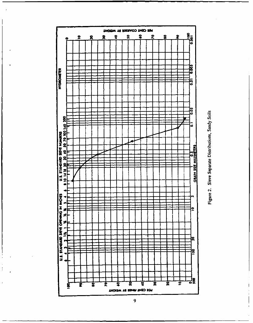
Table 2 lists soils classified as sandy, i.e. soils containing less than 20% gravel-sizedparticles. Table 3 shows soils classified as gravelly, i.e. soils containing more than 20% gravel-sizedparticles. Figures in parentheses at the bottom of columns in the tables are means for each sieveseparate. Figures 2 and 3 show graphically the distribution of the sieve separates for sandy andgravelly soils, respectively.
Sandy Soils. Thirty-six samples are classed as sandy soils. Sample SA-I is excluded fromthe calculation of means on Table 2 because the amount of the > 2 mm fraction was not determined.Of the remaining 35 sandy soils, 5 are classified as fine sands (14.3%), 14 as sands (40.0%), 11 ascoarse sands (31.4%), 3 as loamy sands (8.6%), 1 as loamy coarse sand (2.8%), and 1 as sandy loam(2.8%). Means for the separates of these samples are: 0.6% gravel, 4.6% very coarse sand, 14.5%coarse sand, 26.9% medium sand, 42.3% fine sand, 9.1% very fine sand, and 2.3% silt+clay.
Because of their appearances, textures and field descriptions, 14 samples (SA-9, 19, 22, 24,25, 27, 50, 54, 55, 56, 62, 63, 64, and 65) were considered dune sands. Means for the separates ofthese samples are: 4.6% gravel, 5.4% very coarse sand, 14.8% coarse sand, 27.5% medium sand,32.9% fine sand, 10.9% very fine sand, and 4.8% silt+clay.
Gravelly Soils. Of the 23 gravelly soils, 15 are gravelly sand (65.2%) and 8 are gravellyloamy sand (34.8%). Although classed as gravelly, sample SA-47 may be anomalous: it comes fromthe first hard layer below the surface of a sahbka. In this sample, particles > 2 mm in size consist ofcemented sand grains and are thus not true gravel particles. Means for gravelly soils are 33.0%gravel, 8.3% very coarse sand, 9.3% coarse sand, 13.6% medium sand, 17.3% fine sand, 10.5%very fine sand, and 8.1% silt+clay.
Classification
Cluster analysis was chosen to evaluate the traditional soil classification discussed above andshown in Tables 2 and 3 because it offers an objective and unbiased approach to the grouping ofsimilar objects. The clustering routine used, Ward's Method, is an hierarchical, agglomerativeclassification. Ward's Method chooses two clusters at each step, initially two data points, thecombination of which leads to the least increase in the euclidean sum of squares, a distance measurecalculated from a similarity matrix. As clustering proceeds, the number of clusters is reduced, e.g. inthis case, from 58 to 1"
4 Sample SA-I was not included in the cluster analysis because the weight of the >2 mm separate is unknown.
6

Table 2. Particle Size, Sandy Soils
Sample > 2mm 1-2mm 0.5-1 0.25- 0.125- 0.075- < 0.075 Description
Number mm 0.5mm 0.25mm 0.125mm mm
SA-22 0.0 0.0 0.0 44.4 50.6 5.0 0.0 fine sandSA-25 0.0 0.0 0.0 18.0 72.7 8.8 0.5 fine sandSA-63 0.0 0.1 0.8 21.4 70.2 6.9 0.5 fine sandSA-64 0.0 0.0 0.0 1.9 83.6 12.5 2.0 fine sandSA-65 0.0 0.0 0.0 1.7 86.7 10.7 0.8 fine sand(mean) (0.0) (0.0) (0.2) (17.5) (72.8) (8.8) (0.8)
SA-4 3.2 0.3 12.2 34.9 33.2 11.0 5.3 sandSA-5 14.0 5.0 15.9 32.0 20.5 5.9 6.7 sandSA-9 0.0 0.0 0.0 54.2 42.1 3.7 0.0 sandSA-12 1.6 0.7 16.5 31.3 33.4 12.9 3.6 sandSA-19 0.0 0.0 tr 49.3 46.8 3.7 0.3 sandSA-20 0.0 tr 5.2 45.1 45.1 4.3 0.3 sandSA-26 tr 1.9 17.0 37.3 32.1 10.4 1.3 sandSA-28 5.2 7.0 8.7 10.5 36.5 24.7 7.4 sandSA-31 17.1 4.6 10.4 32.2 20.7 10.6 4.3 sandSA-42 19.4 10.3 13.6 26.8 17.1 7.4 5.5 sandSA-46 0.9 1.3 t8.9 42.8 25.9 6.9 3.3 sandSA-48 0.0 0.5 18.5 30.2 44.1 5.2 1.5 sandSA-54 0.5 tr 9.8 38.3 39.8 8.7 2.8 sandSA-67 1.9 5.3 12.7 38.4 27.5 9.8 4.5 sand
(mean) (4.6) (2.6) (11.4) (36.0) (31.0) (8.9) (3.3)
SA-43 17.1 7.7 11.1 15.9 13.6 13.5 21.1 sandy loam
SA-I na 10.7 13.8 19.3 27.8 14.7 13.7 loamy sandSA-30 10.0 4.1 9.5 20.2 28.4 14.8 13.1 loamy sandSA-33 18.8 10.6 10.4 13.0 14.1 15.6 17.6 loamy sandSA-66 15.3 10.4 12.6 13.9 16.1 17.7 14.1 loamy sand
(mean) (14.7) (8.4) (10.8) (15.7) (19.5) (16.0) (14.9)
SA-15 10.0 10.5 15.5 22.1 20.1 10.9 10.8 loamy coarsesand
SA-2 1.3 13.4 13.3 32.8 26.7 9.0 3.4 coarse sandSA-6 4.7 19.3 16.4 21.8 19.2 11.3 7.3 coarse sandSA-17 13.2 8.6 21.5 29.5 18.5 6.0 2.6 coarse sandSA-18 0.0 0.4 29.4 17.6 46.1 6.1 0.5 coarse sandSA-24 1.0 1.5 25.4 60.2 10.9 0.5 0.4 coarse sandSA-27 0.1 4.3 22.0 20.1 31.6 18.0 4.0 coarse sandSA-45 0.6 1.7 24.8 39.4 21.7 9.6 2.3 coarse sandSA-50 0.0 tr 27.9 32.0 24.5 11.5 4.1 coarse sandSA-55 5.7 30.4 18.8 11./ 14.1 14.3 5.1 coarse sandSA-56 1.1 17.2 24.4 12.2 13.7 22.5 8.8 coarse sandSA-62 0.0 10.2 74.4 11.1 4.2 0.2 0.0 coarse sand
(mean) (2.5) (9.7) (27.1) (26.2) (21.0) (9.9) (3.5)
7

Table 3. Particle Size, Gravelly Soils
Sample >2mm 1-2mm 0.5-1 0.25- 0.125- 0.075- < 0.075 DescriptionNumber mm 0.5mm 0.25mm 0.125mm mm
SA-10 25.1 7.4 9.2 14.8 20.7 12.6 10.1 gravellyloamy sand
SA-1I 46.9 10.0 9.1 8.2 7.8 7.2 10.9 gravellyloamy sand
SA-13 24.8 8.9 9.8 14.5 15.8 10.6 15.5 gravellyloamy sand
SA-14 20.2 7.1 9.0 14.0 17.9 15.6 16.2 gravellyloamy sand
SA-16 25.9 10.6 11.1 12.5 12.5 10.4 17.0 gravellyloamy sand
SA-29 27.7 11.4 8.6 14.2 16.6 9.7 11.8 gravellyloamy sand
SA-32 22.8 10.1 10.5 14.6 20.3 11.3 10.4 gravellyloamy sand
SA-60 42.3 5.7 1.0 2.3 22.3 16.3 10.2 gravellyloamy sand
(mean) (29.5) (8.9) (8.5) (11.9) (16.7) (11.7) (12.8)
SA-3 22.0 16.0 14.7 16.7 17.8 8.0 4.7 gravelly salSA-7 31.7 6.5 8.6 15.4 18.8 13.6 5.3 gral sandSA-8 27.1 4.7 10.6 16.3 18.5 15.4 7.5 gayVly sawnSA-21 37.2 5.3 11.2 14.5 18.8 8.9 4.1 gravelly sandSA-23 20.5 12.1 13.2 14.1 18.8 13.2 8.3 gravellysandSA-44 36.5 7.9 9.8 15.3 16.6 9.5 4.4 grayly sandSA-47 52.3 2.4 5.4 19.9 13.0 6.3 0.6 veygravdly
sandSA-49 30.1 7.3 7.4 15.8 24.7 8.9 5.8 gravely sandSA-51 28.8 9.4 8.3 10.4 21.9 12.7 8.4 gravdely sdSA-52 55.4 11.8 7.2 7.7 9.6 5.1 3.3 gravelly sandSA-53 22.5 12.5 12.6 13.3 19.7 10.5 8.8 gravelly sandSA-57 36.6 6.6 7.4 15.3 20.8 9.1 4.2 gravelly sandSA-58 42.7 7.6 7.7 11.8 14.7 7.7 7.9 gravelly sandSA-59 61.0 4.7 14.6 14.2 3.7 1.1 0.7 gravelly sandSA-61 19.6 5.1 7.0 16.0 26.0 16.8 9.4 gravelly sand(mean) (34.9) (8.0) (9.7) (14.4) (17.6) (9.8) (5.6)
8
DNOOIM M VUUIWO £IQD NN
I I
~42
4-H
C, 0 40 0 a)
1002
000" l WPMMn 33
It9

IHOSIM Al USM2OAN jIU~N
o ~ ~ 0 0
U -0
Cii
47)
II
I~ F
PH0-

Each clustering routine produces a "best" classification for a given number of clusters, whichis chosen by the user. For instance, if the user wishes four clustering levels, the program willproduce the most distinct combinations for groups of four, three, two and one clusters. "Best" isdefined in terms of the clustering algorithm; if a distance measure is used as in this case, "best"would be the smallest or largest distance between members of a given cluster and the greatest or leastdistance between clusters depending on the type of coefficient used. The coefficient used in thisanalysis was a dissimilarity coefficient, so the greatest distance was calculated. The most appropriate,or best, clustering level is often determined by identifying multiple clusters with similar clusteringcoefficients (as shown on the y axis) directly from the dendrograms (see Figure 4). The line a-babove and parallel to the x axis indicates the best clustering level for this classification, the four-cluster level (four tie-lines are crossed). There is seldom an obvious "best" for any clustering routineand, consequently, two or three groups of clusters are often evaluated.
In this case, ten clustering levels were evaluated, and levels consisting of two and five clusterswere considered best. The level containing eight clusters, the number of different soil textures shownin Tables 2 and 3, was considered worst, ranking 10 out of 10.
0.857
0.767 T0.678 -0.5
Q 0.588 T0 0.499
C.%- tS0.3192 0.230 T
0 .05 1 T
to (0 OO0~ rEn M M
Sample Identification
Figure 4. Typical Dendrogram. Line a-b indicates the optimum clusteringlevel, the four-cluster level
Tho-Ouster Classification. This classification does not separate samples described as sandysoils (Table 2) from those described as gravelly soils (Table 3) as had been hoped, but it does verysuccessfully separate the finer- from the coarser-textured soils. Cluster 1, which represents thecoarse-textured soils, contains all those soils described as loamy or gravelly in addition to 63.6% ofthe coarse sands and 28.6% of the sands. There are no fine sands in this cluster. Most subsurfacesamples are in Cluster 1. Cluster 2, which represents the fine-textured soils, contains all the finesands, 71.4% of the sand soils, and 36.4% of the coarse sands. Table 4 shows the soil samples ineach cluster.
11

With respect to spatial pattern, the samples in Cluster 1 occur throughout the area in whichthe samples were collected. Those in Cluster 2, however, tend to occur primarily in the central partof the area, below latitude 280 and above latitude 250.
Table 4. Soil Sample Distribution in the Two-Cluster Classification
Cluster 1: Cluster 2:
SA-2 SA-15 SA-32 SA-55 SA-4 SA-45SA-3 SA-16 SA-33 SA-56 SA-9 SA-46SA-5 SA-17 SA-42 SA-57 SA-12 SA-48SA-6 SA-21 SA-43 SA-58 SA-18 SA-50SA-7 SA-23 SA-44 SA-59 SA-19 SA-54SA-8 SA-27 SA-47 SA-60 SA-20 SA-63SA-10 SA-28 SA-49 SA-61 SA-22 SA-64SA-1 I SA-29 SA-51 SA-62 SA-24 SA-65SA-13 SA-30 SA-52 SA-66 SA-25 SA-67SA-14 SA-31 SA-53 SA-26
Five-cluster classification. This classification predictably allows more differentiation than thetwo-cluster classification. Surface and subsurface samples are relatively evenly distributed throughoutthe five clusters. The distribution of soil samples among the clusters is shown in Table 5.
Cluster I contains 64% of the samples described as coarse sand in Table 2 as well as the oneloamy coarse sand and 29% of the sands, but only 7% of the gravelly sands; the soils is Cluster 1can be called gravelly coarse sands. Most of these samples have very large very coarse sand (1-2mm) separates compared to other members of their soil texture groups. Silt+clay separates (<0.075mm) tend to be large as well. The sand soils in this cluster also have very large gravel components(> 2 mm). Cluster 1 contains the largest proportion of subsurface samples; depth of sampling isknown for 85% of the samples in the cluster. The samples in Cluster 1 exhibit no spatial pattern,although they tend to be most common in the central area, nearer to Persian Gulf, east of longitude460, between 250 and 280 latitude.
Cluster 2 consists primarily of sand soils with coarse sand soils and one fine sand soil; thesoils in this cluster can be called sands. The coarse sand soils have very low percentages of gravel(>2 mm), very coarse sand (1-2 mm), and very fine sand (0.075-0.125 mm). This cluster includes71% of the sand soils shown in Table 2 as well as 36% of the coarse sands. In addition, it containsthe highest proportion of surface samples, but depth of sampling is known for only 75%. MostCluster 2 samples occur in an east-west band between latitudes 250 and 280.
Cluster 3 soils, which consist of gravelly sand and gravelly loamy sand, can be called gravellysands. Gravelly sands comprise 83% of Cluster 3, and 67% of the gravelly sands occur in Cluster 3.Compared to the gravelly loamy sands in other clusters, the gravelly loamy sands in Cluster 3 havevery large gravel separates (>2 mm), large very coarse sand separates (1-2 mm), very small coarseand medium sand separates (0.5-1 mm and 0.25-0.5 mm, respectively), and small silt+clay separates
12

(<0.075 mm). Twenty-five percent of -the gravelly loamy sand soils shown in Table 3 are in Cluster
3. Cluster 3 samples occur through the collecting area.
Table 5. Soil Sample Distribution in the Five-Cluster Classification
Cluster:1 2 3 4 5
SA-2 SA-4 SA-7 SA-9 SA-10SA-3 SA-12 SA-8 SA-19 SA-13SA-5 SA-18 SA-1I SA-20 SA-14SA-6 SA-26 SA-21 SA-22 SA-16SA-15 SA-45 SA-44 SA-24 SA-23SA-17 SA-46 SA-47 SA-29SA-30 SA-48 SA-49 SA-30SA-31 SA-50 SA-52 SA-32
SA-54 SA-57 SA-33SA-67 SA-58 SA-43
SA-59 SA-51SA-60 SA-53
SA-61SA-63
Cluster 4 consists primarily of loamy soils (gravelly loamy sands, loamy sands and sandyloam), but also contains some gravelly sands; the soils in this cluster can be called gravelly and loamysands. More than 70% of the loamy soils are in Cluster 4. These soil samples are low in gravel(> 2 mm), compared to other members of their soil texture groups, and contain relatively largeamounts of all separates but medium sand (0.25-0.5 mm). This cluster includes 75% of the gravellyloamy sands and 27% of the gravelly sands listed in Table 3. With respect to spatial pattern, mostsamples in Cluster 4 occur in the northwest part of the collecting area, west of longitude 46° andnorth of latitude 280.
Cluster 5 contains only fine sand soils, and can therefore be called fine sands. Eighty percentof the fine sand soils shown in Table 2 are included in the cluster. These four samples aredistinguished from the fifth fine sand (SA-22) by having smaller medium sand separates (0.25-0.5
umn), and larger fine sand and very fine sand separates (0.125-0.25 mm and 0.075-0.125 mm,respectively). In addition, these four samples contain at least small amounts of silt+ clay (<0.075
umm), whereas the remaining sample contains none. All but one of these samples are surface samples;the sampling depths are known. Three of the four samples came from the Empty Quarter in SaudiArabia.
Viewing the classification from another perspective, most of the soil types listed in Tables 2and 3 occur primarily in one cluster. Cluster 1 contains 64% of the coarse sands; 71% of the sandsare in Cluster 2; 67% of the gravelly sands are in Cluster 3; 75% of the gravelly loamy sands are inCluster 4; and Cluster 5 contains 80% of the fine sands. The loamy sand, loamy coarse sand andsandy loam soils occur in one cluster. Gravelly sands are the only soil texture group that occurs inmore than two clusters.
13
Conclusions
Over the past two years, a number of requests for these data have been received from variousgovernment agencies (e.g. Department of Energy, Department of Army, and other elements of theDefense Department), from contractors working for these agencies, and from universities. Theirinterests centered around the effects of soils of the Middle East on the operation and maintenance ofmilitary equipment and they had been unable to locate data on soils in the Middle East. Because dataon the physcial characteristics of Middle East soils is very difficult to obtain, the above data on these59 soils, although limited, will prove useful to others as well.
14

References
Berlin, G.L., Tarabzouni, M.A., Al-Naser, A.H., Sheikho, K.M. and Larson, R.W. 1986. SIR-Bsubsurface imaging of a sand-buried landscape: Al Labbah Plateau, Saudi Arabia: IEEE Transactionson Geoscience and Remote Sensing, vol. GE-24, pp 595-602.
Blom, R.G., Crippen, R.E. and Elachi, C. 1984. Detection of subsurface features in Seasat radarimages of Means Valley, Mojave Desert, California: Geology, vol. 12, pp. 346-349.
Ehlen, J. and Henley, J.P. 1991. A Comparison of Soils From Twenrynine Palms, California andSaudi Arabia: Fort Belvoir, Virginia, U.S. Army Engineer Topographic Laboratories, ETL-0583.
Eastes, J.W. Thermal Infrared Spectral Properties of Some Saudi Arabian Rocks and Soils:Implications for Remote Terrain Analysis: Fort Belvoir, Virginia, U.S. Army TopographicEngineering Center (in prep).
Hansen, J.V.E., Ehlen, J., Evans, T.D. and Hevenor, R.A. Project Ostrich: Fort Belvoir, Virginia,U.S. Army Topographic Engineering Center (in prep).
McCauley, J.F., Schaber, G.G., Breed, C.S., Grolier, M.J., Haynes, C.V., Issawi, B., Elachi, C.and Blom, R. 1982. Subsurface valleys and geoarcheology of the Eastern Sahara revealed by Shuttleradar: Science, vol. 218, pp 1004-1020.
McCauley, J.F., Breed, C.S., Schaber, G.G., McHugh, W.P., Issawi, B., Haynes, C.V., Grolier,M.J. and Kilani, A.E. 1986. Paleodrainages of the Eastern Sahara - the radar rivers revisited (SIR-A/B implications for a Mid-Tertiary Trans-African Drainage System): IEEE Transactions onGeoscience and Remote Sensing, vol. GE-24, pp. 624-648.
Rubick Luttrell, P. 199 1a. Petrologic Analysis of Sediment Samples Collected from the USGS JornadaDesert Winds Erosion Test Site and from Dhahran, Saudi Arabia: unpublished TEC contract report,pp 38-41, pp 45-46.
__. 1991b. Petrographic Analysis of Sediment Samples Collected from Field Sites in Saudi Arabiaand Twenty-Nine Palms, California: unpublished TEC contract report, 28 p.
Soil Survey Staff. 1951. Soil Survey Manual: Washington, D.C., U.S. Government Printing Office,U.S. Department of Agriculture Handbook No. 18, pp 205-213.
15

Appendix A
PETROGRAPHIC ANALYSIS
Eleven samples were sent to Patty Rubick Luttrell, a professional consulting geologist, forpetrographic analysis. Her descriptions and the results of her analyses comprise this appendix, inwhich a geologic particle-size classification was used. Particle-size ranges for the particle namesused, therefore, do not necessarily agree with those used in the body of this report. Color photomi-crographs to facilitate sample descriptions of the thin sections were included in the unpublishedcontract report, but are not reproduced here.
Methodology
Sample texture and composition were determined by thin section analysis. Thin sections weremade by mounting loose grains with epoxy. Slides were stained with sodium cobaltinitrite to facilitatethe identification of potassic feldspar and Alizarin red-S to differentiate dolomite from calcite.
Sample Descriptions
Samples examined ranged in grain size from granule (2.25-2.00 nun) to sand (1.75-0.27 rran)to silt (0.06-0.002 mm) to mud (2/3 silt, 1/3 clay) to clay (<2 jL). The samples are assigned acompositional name based on grain size and composition (Folk, 1974).
Sample SA-1:
A light buff, moderately to poorly sorted, subrounded, fine-grained (0.24 mun) sand collectedwest of Dhahran. A thin film of detrital calcite (CaCO3) cement coats the majority of grains.
The sand composition consists of quartz (30%), feldspar/plagioclase (< 1%), carbonate rockfragments (54%), gypsum rock fragments (15%), sandstone rock fragments (1%), chert (< 1%),plutonic rock fragments (< 1%), mica (< 1%) and < I% heavy minerals (magnetite, zircon). Thesample is classified as a gypsiferous quartzose carbonate lithic arenite (15% gypsum, 30% quartz, 1%sandstone rock fragments, 54% carbonate rock fragments).
The carbonate rock fragments are micritic (microcrystalline) to sparry (coarsely crystalline)and are the dominant lithic in this sample (54%). Some of the carbonate rock fragments containfossils (trilobites, echinoderms) which document the rock fragments as being marine in origin. Aftercementation, the carbonate was eroded and transported as discrete sand-sized grains.
The gypsum (CaSO,2H 20) rock fragments are the second most abundant lithic. The gypsumshows partial replacement by calcite (CaCO3) as well as detrital calcite cement along the outer rim ofthe grains.
The composition of this sand indicates a mixed parentage of sedimentary and plutonic terrain.Evidence for a sedimentary input involves quartz, reworked quartz overgrowths, carbonate rockfragments of a marine origin, gypsum, chert, sandstone rock fragments and the pervasive detritalcalcite cement coating all sand grains. It is the detrital calcite cement which demonstrates that thegrains are multicyclic in origin.
16

Mineral assemblages signifying a plutonic source terrain include quartz, feldspar (microcline,orthoclase), plagioclase (oligoclase), plutonic rock fragments, mica (muscovite, biotite), magnetite andzircon. Because these grains are coated by a detrital calcite cement, their plutonic heritage isconsidered ultimate with the proximate source interpreted as sedimentary.
Sample SA-2:
A bimodal, moderately well-sorted, subrounded, buff-colored sand collected from northeastSaudi Arabia, south of Tap Line Road. The two grain size modes consist of very coarse- (1.51 nun)and medium-sized (0.27 mm) grains.
Sample composition consists of 79% quartz, 6% potassic feldspar (microcline, orthoclase,perthite), 1% twinned plagioclase (oligoclase), 6% carbonate rock fragments, 3% plutonic rockfragments (quartz/orthoclase, plagioclase/orthoclase, microcline/plagioclase/muscovite), 5% volcanicrock fragments (rhyolite), < 1% mica (muscovite, biotite) and < 1% gypsum. This classifies thesample as a bimodal sublithic quartz arenite.
The lithic population (sedimentary, plutonic and volcanic grains) demonstrates a mixedparentage for the sand. The coarse-sized grains consist of quartz and volcanic rock fragments, whichsuggests a nearby igneous source terrain since volcanic rock fragments are considered labile andunable to survive great distances of transport intact.
The carbonate and plutonic rock fragments indicate a sedimentary and plutonic input into thebasin. The presence of a detrital micrite (carbonate mud) cement coating each grain, reworked quartzovergrowths and the subrounded shape of the grains reveals that the grains are multicyclic with themost recent (proximate) source being sedimentary.
Sample SA-4:
A moderately sorted, subrounded, buff-colored, medium-grained (0.33 nun) sand collectedfrom northeast Saudi Arabia, south of Tap Line Road. All grains are coated with a detrital micritic(carbonate mud) cement.
Sample composition consists of 79% quartz, 4% potassic feldspar (orthoclase, microcline),1 % twinned plagioclase, 7% carbonate rock fragments (micritic to microspar), 7% plutonic rockfragments (quartz/hornblende, quartz/plagioclase, quartz/muscovite, orthoclase/plagioclase), 1%volcanic rock fragments (rhyolite), 1 % metamorphic rock fragments and < 1% heavy minerals(hornblende, hematite, zircon). This classifies the sample as a sublithic quartz arenite.
The presence of a thin micrite (carbonate mud) cement coating grains, the reworked quartzovergrowths (silica cement), the subrounded shape of the grains and an abundance of quartz (79%)indicates that the sand is multicyclic in origin and was most recently sourced by a sedimentary terrain.The carbonate rock fragments also imply a sedimentary parentage. Prior to being eroded anddeposited as a sediment, the plutonic, metamorphic and volcanic rock fragments, feldspar/plagioclasepopulation, heavy minerals and quartz were sourced by a mixed igneous (plutonic & volcanic) andmetamorphic terrain.
17

Sample SA-5:
A poorly sorted, subrounded, medium-grained (0.33 mm), light buff- colored sand collectedfrom northeast Saudi Arabia, south of Tap Line Road. The poor sorting is due to a range in grainsize from clay (< 0.02 A) to coarse sand.
Sample composition consists of 60% siliciclastics (quartz with minor feldspar/plagioclase,plutonic & volcanic rock fragments) and 40% carbonate rock fragments, which classifies it as acarbonate lithic quartz arenite. The carbonate lithics include micrite (carbonate mud), concentricallylaminated o6ids (spar to detrital quartz nuclei) and fossiliferous micritic carbonates (bryozoan &unidentified plant fragments).
The 40% carbonate lithic population in this sand (80% micritic carbonate rock fragments,10% o6ids, 10% fossiliferous micritic rock fragments) is of a marine origin. Bryozoan fragments(marine invertebrate with calcareous skeleton) and o6ids are diagnostic of a marine setting. O6ids(concentrically laminated grains) form in a shallow marine setting by grains being rolled in anoscillatory fashion (wave action) with a resultant concentric buildup of micrite (carbonate mud). Theabundance of carbonate rock fragments and their labile nature (easily pulverized to clay-sized fraction)indicates a localized marine carbonate source for these lithics. The siliciclastics (60%) represent amixture of multicyclic grains with an ultimate plutonic/volcanic source terrain.
Sample SA-6:
A bimodal, moderately sorted (each mode), subrounded, buff-colored sand collected fromnortheast Saudi Arabia, south of Tap Line Road. The bimodal grain size consists of very coarse-(1.50 mm) and medium-sized (0.33 mm) grains.
Sample mineralogy consists of 61 % quartz, 5% potassic feldspar (orthoclase, microcline),< 1% twinned plagioclase, 25% carbonate rock fragments (micritic to silty micritic), < 1 %sedimentary rock fragment (fossiliferous chert/sponge spicules), 3% metamorphic rock fragments(metaquartzite, epidote/ plagioclase), 2% plutonic rock fragments (polycrystalline quartz/biotite,quartz/plagioclase), 4% volcanic rock fragments (rhyolite) and < 1% mica (biotite). This sample isclassified as a carbonate lithic quartz arenite.
The strong carbonate rock fragment population (25%) and fossiliferous chert containingsponge spicules indicates a localized sedimentary source for the grains, most likely of a marine origin.Some of the rock fragments show replacement of calcite (CaCO3) by gypsum (CaSOi2H20), acommon diagenetic process in marine sediments. The high percentage of labile sedimentary lithicssuggests a localized source for the carbonate rock fragments.
The subrounded quartz and reworked quartz overgrowths indicate that the siliciclastic grainsare multicyclic. The plutonic, metamorphic and volcanic rock fragments demonstrate an ultimatesource terrain of mixed heritage.
Sample SA-7:
A bimodal, moderately sorted (each mode), subrounded, light brown sand collected fromnortheast Saudi Arabia, south of Tap Line Road. The bimodal grain size population consists of very
18

coarse- (1.75 nmn) and medium-size (0.35 mm) grains. The composition of this sand comprises 50%quartz, 10% potassic feldspar (orthoclase), < I% twinned plagioclase (oligoclase), 30% carbonaterock fragments, 3% chertified carbonate rock fragments, < 1% metamorphic rock fragments (meta-quartzite, epidote/plagioclase), 5% plutonic rock fragments (quartz/plagioclase/biotite, quartz/biotite,quartz/orthoclase), and 2% heavy minerals (hornblende, zircon, tourmaline). This sand is classifiedas a carbonate lithic quartz arenite. The carbonate lithics consist of silty to sandy micritic (carbonateclay) rock fragments.
This sand has an ultimate source of metamorphic and plutonic terrain. Reworked quartzovergrowths, detrital calcite (micritic) cement and subrounded grains indicate more than onesedimentary cycle for this sand. A localized sandy to silty carbonate terrain undergoing erosion issuggested as the source of the sand in this sample. The very coarse-sized quartz and plutonic rockfragments indicate a proximal igneous source.
Sample SA-8:
A bimodal, moderately sorted (each mode), buff-colored sand collected from northeast SaudiArabia, south of Tap Line Road. The bimodal texture consists of very coarse- (1.10 mm) andmedium-sized (0.40 mm) grains. The sand composition of this sample consists of 50% quartz, 7%potassic feldspar (orthoclase, microcline), 1% twinned plagioclase (oligoclase), 33% calcite rockfragments, 3 % chertified silty carbonate rock fragments, < 1% metamorphic rock fragments(metaquartzite), 6% plutonic rock fragments (quartz/muscovite, untwinned plagioclase/mica,quartz/untwinned plagioclase), < 1% mica (chlorite, biotite) and < 1% hornblende, which classifiesthe sediment as a carbonate lithic quartz arenite. The carbonate lithics consist of micritic to sparry(coarsely crystalline) calcite and are the source of the clay-sized particles.
This sample displays a mixed-source parentage. Ultimate sources of the grains includeplutonic (quartz, plutonic rock fragments, feldspar/plagioclase, mica, hornblende) and metamorphic(metaquartzite) terrains. The micritic to sparry carbonate rock fragments, quartz, reworked quartzovergrowths, and detrital micrite cement coating the siliciclastic grains attest to a reworkedmulticyclic sedimentary source.
Sample SA-9:
This sample is a medium-grained (0.35 mm), well-sorted, subrounded, light orange sand. Itis a dune sand collected from near Riyadh. The sample contains 90% quartz, < 1% potassic feldspar(orthoclase), 6% micritic (carbonate mud) rock fragments, 2% sandstone rock fragments, 2% plutonicrock fragments (plagioclase/mica, quartz/hornblende) and < 1% hematitic o6ids. The sediment isclassified as a quartz arenite.
This sample is quartz rich (90%) and suggests a strong sedimentary parentage. Subroundedgrains, reworked quartz overgrowths, detrital hematitic calcite cement coating the siliciclastic grains,carbonate (micritic) rock fragments and sandstone rock fragments all point to a sedimentary sourceterrain. The minor amounts of feldspar and plutonic rock fragments suggest an ultimate igneoussource and attest to the compositional and textural maturity a sand can reach in an eolian duneenvironment.
19

Sample SA-10:
A poorly sorted, subrounded, buff-colored sandy mud (2/3 silt, 1/3 clay) collected fromnortheast Saudi Arabia, south of Tap Line Road. The composition consists of 30% siliciclastic grains(quartz, minor potassic feldspar/plagioclase) and 70% silty micritic rock fragments. This sediment isclassified as a sandy micritic mud (2/3 silt, 1/3 clay).
In situ disaggregation of the silty micritic rock fragments forms the micritic mud. Thesiliciclastic grains are coated by a similar detrital micritic cement. This sandy micritic mud is directlysourced by the silty micritic rock fragments that it contains. The micritic rock fragments are, in turn,released from a nearby sedimentary source. The clasts are easily destroyed and are capable of onlyminimal transport.
Sample SA-11:
A very coarse-grained (1.43 mm), poorly sorted, subrounded, buff- colored, clayey (1/3 silt,2/3 clay) sand collected from northeast Saudi Arabia, south of Tap Line Road. The composition con-sists of 5% quartz, 85% carbonate rock fragments (silty micritic to micritic) and 10% gypsiferouscarbonate rock fragments, which classifies it as a clayey carbonate lithic arenite. The source of theclay-sized micrite is the in situ disaggregation of the carbonate rock fragments. This clayey sand wassourced by a localized carbonate sedimentary source terrain. The labile nature of the grains suggestthat the source is proximal.
Discussion of Results
The samples range in grain size from granule (2.25-2.00 mm) to sand (1.75-0.27 nin) to silt(0.06-0.002 umn) to mud (2/3 silt, 1/3 clay) to clay (< 2 A). Grain size was dominated by thesand-sized fraction and a bimodal grain size distribution was present in 4 of the 11 samples analyzed.A bimodal distribution is believed to be attributed to the process of deflation/winnowing by the wind,which tends to concentrate the coarser grains as lag within the finer grained sediments.
Only two samples (SA-10, SA-1 1) contained appreciable amounts of mud (2/3 silt, 1/3 clay)and clay (<2 microns). In both instances, the clay-sized fraction is a carbonate mud. Petrographicexamination reveals that the source of these clays is in situ disaggregation of micritic carbonate rockfragments.
The composition of the arenites indicate a mixed parentage. A plutonic source terrain isindicated by the presence of quartz, potassic feldspar (microcline, orthoclase, perthite), twinnedplagioclase (oligoclase, labradorite), plutonic rock fragments (quartz/muscovite, quartz/orthoclase,quartz/ plagioclase, plagioclase/orthoclase, microcline/biotite/plagioclase/muscovite,quartz/hornblende, quartz/plagioclase/biotite, orthoclase/biotite, plagioclase/quartz/zircon,quartz/orthoclase/magnetite, plagioclase/myrmekite), mica (muscovite, biotite, chlorite) and heavyminerals (magnetite, zircon, tourmaline, rutile, hornblende, hematite).
Minerals indicating a metamorphic input to samples include clasts of metaquartzite,metaquartzite/epidote, plagioclase/epidote and gneiss. These rock fragments are diagnostic of low- tohigh-grade metamorphism. Volcanic input is shown by the presence of aphanitic rhyolite(phenocrysts of potassic feldspar/quartz/hematite) and basalt (phenocrysts of
20

plagioclase/clinopyroxene/hematite, plagioclase/hematite, augite/oxyhornbiende, plagioclase/magne-tite).
Sample input was primarily sedimentary. Evidence for a sedimentary parentage includesdetrital carbonate clay cement coating siliciclastic grains, reworked quartz overgrowths, carbonaterock fragments (micritic to microspar), sandstone rock fragments, chert and gypsiferous rockfragments. Carbonate clasts of marine origin include o6ids, bryozoans, plant fragments and spicularchert. Fossilized carbonate rock fragments were documented in samples SA-5 and SA-6.
The siliciclastic grains in these samples are coated with a detrital carbonate mud cement. Thisis direct evidence of recycling, with sand-sized detritus being eroded from a sedimentary source rock.So although the ultimate source for the arenites involves a mixed heritage of plutonic, metamorphicand volcanic terrain, the most recent source is interpreted as sedimentary.
In terms of generalized provenance, tht, samples denote a mixed heritage of plutonic,metamorphic, volcanic (rhyolitic to basaltic) and marine carbonate terrain. All grains except thecarbonates exhibit a multicyclic depositional history.
21

Rererences
Folk, R.L.. 1974. Petrology of Sedimentary Rocks: Austin, Texas, Hemphill Publishing Company,
184 pp.
22