pilot training manual v 1
TRANSCRIPT
7/29/2019 Pilot Training Manual v 1
http://slidepdf.com/reader/full/pilot-training-manual-v-1 1/58
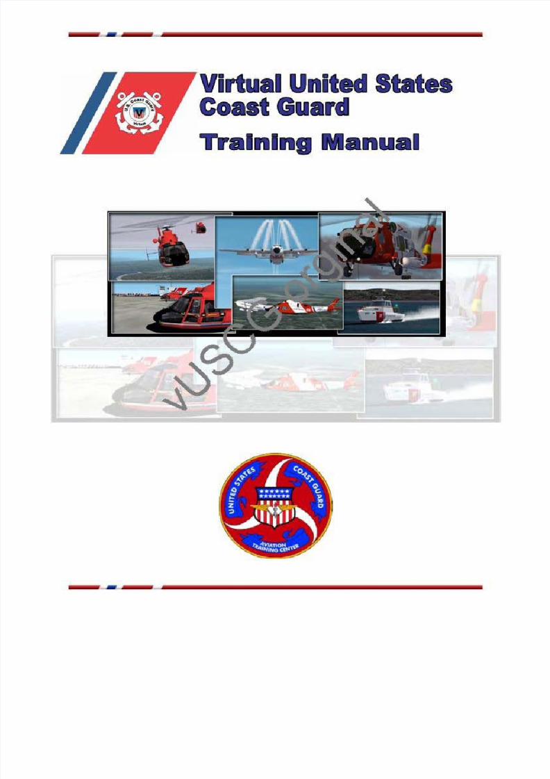
-Virtual United States
Coast GuardTraining Manual
r. ,., /'0",0i Q ••• ••• '"I:: . ~\ ~ X i ~ o
~ - « > " ' "ik-.. _
- ~ - - - - - - - - - - - -

7/29/2019 Pilot Training Manual v 1
http://slidepdf.com/reader/full/pilot-training-manual-v-1 2/58
I
Virtual United States Coast GuardvEnsign Training Manual
Disclaimer
The Virtual United States Coast Guard is in no way affiliated with the real world
United States Coast Guard nor represents that branch of the military in any way
or the ideas and missions of the United States Coast Guard.
©2000-2010 Virtual United States Coast Guard. All Rights Reserved.
~ - , ~ - - - - - - -

7/29/2019 Pilot Training Manual v 1
http://slidepdf.com/reader/full/pilot-training-manual-v-1 3/58
II
Welcome Aboard
Welcome to the Virtual US Coast Guard Aviation Training Center at Mobile Regional Airport,
Mobile, Alabama. This is where you will start your career as a vUSCG fleet airman. We desire to
have the most professional airmen in the VATSIM system while having the most fun flying our
missions together.
Your training will consist of one-on-one training with your flight instructor. You will train on
ATC & Coast Guard communications, search patterns, VFR & IFR flight, weather, airspace,
basic flight operations and more. After your training with your flight instructor, you will
undergo a checkride, to see if you can put into practice what you have learned. Upon successful
completion of your checkride, you will be award you with the rank of vLieutenant, Junior Grade
and assign you to one of the vUSCG Districts throughout the United States. You will be able to
develop more advanced Coast Guard flying skills while at your assigned station.
The speed with which you progress will depend largely on your current flying skills and how
quickly you can learn a few basic Search and Rescue (SAR) patterns. If you have any questions or concerns, please contact your instructor for more help.
~ - , ~ - -
_ . ~ - ~---

7/29/2019 Pilot Training Manual v 1
http://slidepdf.com/reader/full/pilot-training-manual-v-1 4/58
III
Table of Contents
Welcome Aboard II
About the vUSCGSynopsis pg. 2
Districts pg. 3
Chain of Command pg. 4
Reserves pg. 5
Engineering pg. 6
Getting StartedSoftware pg. 8
Downloads pg. 9
Links pg. 10
Your time at CGAS Mobile pg. 11
Preparing for your Checkride pg. 13
vUSCG Ranks & AwardsRanks pg. 17
Advancement Requirements pg. 19
Awards pg. 20
vUSCG CommunicationsRadio Guard Procedures pg. 23
TACAN ApproachWhat is TACAN pg. 27
Plan View pg. 28
Profile View pg. 29
Minimum Descent Altitude pg. 30
Airport View pg. 31
KMOB TACAN-A Practice pg. 32
SAR OperationsOverview pg. 36
Trackline pg. 37
Parallel pg. 38
Creep pg. 39
Sector pg. 40
SAR Pattern Exercises pg. 41
SAR Checklist pg. 42
~ - , ~ - -
_ . ~ - ~---

7/29/2019 Pilot Training Manual v 1
http://slidepdf.com/reader/full/pilot-training-manual-v-1 5/58
IV
Table of Contents
Software Tutorials
FS Navigator SAR Patterns pg. 44
Terminology & Abbreviations pg. 48
~ - , ~ - -
_ . ~ - ~---

7/29/2019 Pilot Training Manual v 1
http://slidepdf.com/reader/full/pilot-training-manual-v-1 6/58
~ - , ~ - - - - -

7/29/2019 Pilot Training Manual v 1
http://slidepdf.com/reader/full/pilot-training-manual-v-1 7/58
About the vUSCG Page 2
The Virtual United States Coast Guard (vUSCG) is an organization of fellow flight
simulator enthusiasts that enjoy simulating the missions and procedures of our nation's
coast guard. We have found terrific enjoyment from trying to emulate the heroic and
lifethreatening jobs that real-world USCG men and women perform as a daily routine. Out of
admiration and respect, we have tried to make this organization as realistic as our
virtual environment will allow and have made every effort to maintain a similar level of
professionalism to our real-world counterparts.
Many newcomers ask: How does it work? The answer is very simple. Individuals running
Microsoft Flight Simulator 2004 (we are currently working to upgrade files to FSX
compatibility) can connect via the VATSIM System (http://www.vatsim.net/) so that they
can see each other from their own aircraft. Using the voice communication program
Team Speak (http://www.teamspeak.com/), we are able to communicate in real time with
each other and perform synchronized procedures. These basics, combined with our owncustomized aircraft fleet and sceneries, make flying the missions and saving virtual lives
really "as real as it gets"!
~ - , ~ - -
_ . ~ - ~---
7/29/2019 Pilot Training Manual v 1
http://slidepdf.com/reader/full/pilot-training-manual-v-1 8/58
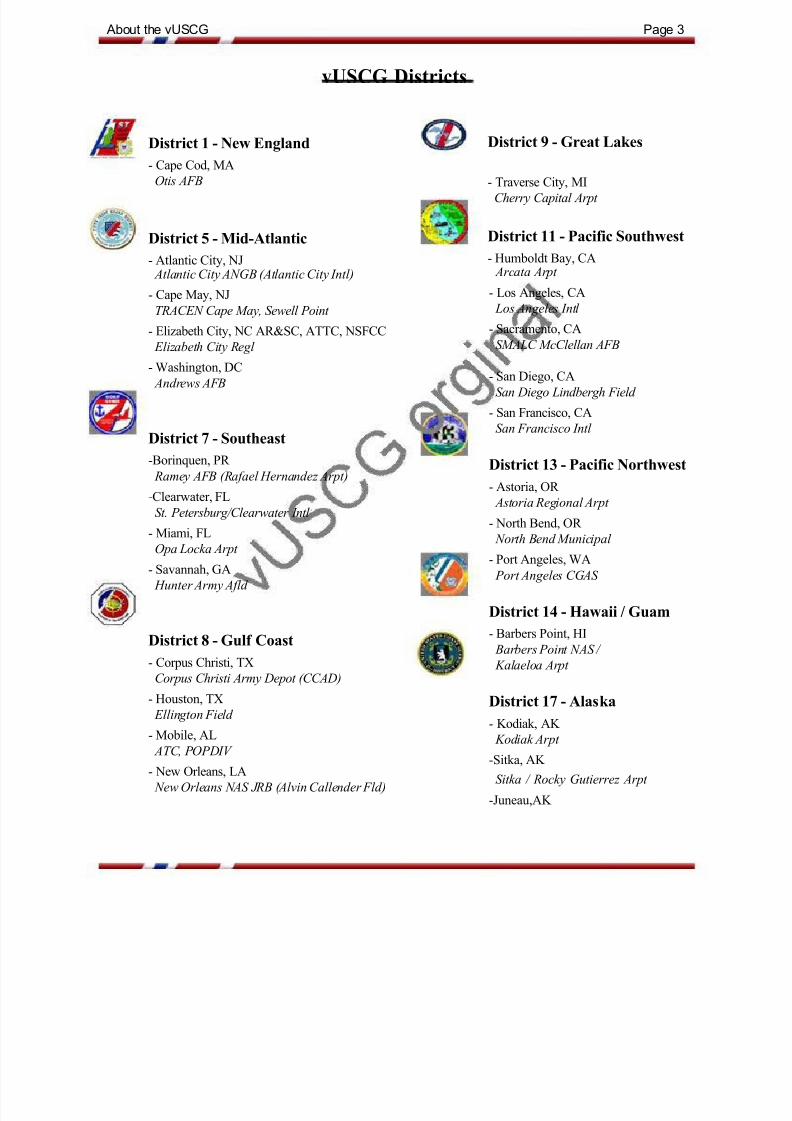
About the vUSCG Page 3
vUSCG Districts
District 1 - New England District 9 - Great Lakes
- Cape Cod, MA
Otis AFB - Traverse City, MI
Cherry Capital Arpt
District 5 - Mid-Atlantic District 11 - Pacific Southwest
- Atlantic City, NJ - Humboldt Bay, CA
Atlantic City ANGB (Atlantic City Intl)
- Cape May, NJ
TRACEN Cape May, Sewell Point
- Elizabeth City, NC AR&SC, ATTC, NSFCC
Elizabeth City Regl
- Washington, DC
Andrews AFB
District 7 - Southeast
-Borinquen, PR
Ramey AFB (Rafael Hernandez Arpt)
-Clearwater, FL
St. Petersburg/Clearwater Intl
- Miami, FLOpa Locka Arpt
- Savannah, GA
Hunter Army Afld
District 8 - Gulf Coast
- Corpus Christi, TX
Corpus Christi Army Depot (CCAD)
- Houston, TX
Ellington Field
- Mobile, AL
ATC, POPDIV
- New Orleans, LA
New Orleans NAS JRB (Alvin Callender Fld)
Arcata Arpt
- Los Angeles, CA
Los Angeles Intl
- Sacramento, CA
SMALC McClellan AFB
- San Diego, CA
San Diego Lindbergh Field
- San Francisco, CA
San Francisco Intl
District 13 - Pacific Northwest
- Astoria, OR
Astoria Regional Arpt
- North Bend, OR
North Bend Municipal
- Port Angeles, WA
Port Angeles CGAS
District 14 - Hawaii / Guam
- Barbers Point, HI
Barbers Point NAS /
Kalaeloa Arpt
District 17 - Alaska- Kodiak, AK
Kodiak Arpt
-Sitka, AK
Sitka / Rocky Gutierrez Arpt
-Juneau,AK
~ - ' ~ - - = - - -
_ . ~ -

7/29/2019 Pilot Training Manual v 1
http://slidepdf.com/reader/full/pilot-training-manual-v-1 9/58
About the vUSCG Page 4
vUSCG Chain of Command
~ - , ~ ~ - - - - - - - -
..uscG VIc. C"""""ldor"
"'..... ""........
,... , 0 . " " ,
...... , ~
.......,"""""- _u_,., , " ' , , - -
".-u__...
"" ' , , -..""""-,....,,..,-
,.,,'1n,_........-

7/29/2019 Pilot Training Manual v 1
http://slidepdf.com/reader/full/pilot-training-manual-v-1 10/58
About the vUSCG Page 5
vUSCG Reserves
Unfortunately, not all members are able to fulfill their hours requirements for full
membership with the Virtual United States Coast Guard. The intention of the vUSCG
Reserves Program is to permit members of the vUSCG who have completed their training to
remain a member of the vUSCG even if their everyday schedule would not normally
permit it.
The Virtual United States Coast Guard Reserves Program is open to any individual who has
completed their initial training at the vUSCG Training Center, located in Mobile, Alabama,
and have achieved a minimum rank of Lieutenant (JG). The Virtual United States Coast
Guard Reserves Program is not open to members who hold the rank of Ensign. Members of the Virtual United States Coast Guard Reserves will not be permitted to
advance in rank, regardless of hours completed, and will not be eligible for command or
administrative positions with the Virtual United States Coast Guard.
Members of the Virtual United States Coast Guard Reserves will be permitted to assist
with any missions or events as if they were active members of the Virtual United States
Coast Guard, but will be limited to filing at most ten (10) hours of time with the Virtual
United States Coast Guard per month. To remain in the Virtual United States Coast Guard
Reserve Program, a member must file at least two (2) hours of flight time every six (6)
months. If this condition is not met, the member will be removed from the Virtual United
States Coast Guard, and will be required to reapply for membership, and undergo all
relevant training.
To be transferred to the Virtual United States Coast Guard Reserve Program, a
prospective member must have achieved the rank of Lieutenant (JG), and submit, in
writing, a request to their District Commander that they be placed in the Reserves
Program. The vUSCG Command Staff reserves the right to allow or deny any request as they
see fit. Members of the Virtual United States Coast Guard Reserve Program who wish to return
to active status must make a request, in writing, to the Director of theVirtual United States Coast Guard Reserve Program, who will then consider the request. If
granted, a member will be placed in a District of the Virtual United States Coast Guard Chief
Of Staff‟s choosing, and may be promoted to the rank as indicated by total hours accrued, if all
advancement requirements have been met.
A member of the Virtual United States Coast Guard may only request membership with the
Virtual United States Coast Guard Reserve Program once, and if they return to full active
status, will be required to fulfill the hours required of active members, or will be removed
from the Virtual United States Coast Guard roster._ . ~ - ~---

7/29/2019 Pilot Training Manual v 1
http://slidepdf.com/reader/full/pilot-training-manual-v-1 11/58
About the vUSCG Page 6
Engineering Division
The vUSCG Engineering Division is a group of highly skilled individuals who bring
specialized real world skills to the Virtual U.S. Coast Guard and allow us to utilize
technology to create the most realistic and accurate simulation of the vUSCG. This also
allows the vUSCG to develop its own technical applications without having to rely oncurrently available technologies.
vUSCG Engineering covers all aspects of technical knowledge in both the real world and
flight simulation world. We cover a wide range of technology issues along with research and
development relating to real world flight, navigation, communications, flight
simulator, software, hardware, aircraft, scenery, and computer performance.
Our job is to provide cutting edge technology to the vUSCG. We are expected to come up
with break through technologies and solve problems with equipment, computers, software,
and aircraft as they arise.
Our “Direct Officer Commission Program “ allows people with special real world
technical skills to become vUSCG officers immediately by contributing their expertise to
our organization. If you have a background in any of the following or have real world
experience in any of these areas and are interested in joining our team, please submit a
request under the recruiting button on the main page and explain your background in the
comments field. We will contact you and let you know if you qualify for the direct officer
commission program. If you are already a vUSCG member and would like to join the
Engineering Division in addition to your normal duties, send an email with a request toyour commander and we will get back to you and let you know if you qualify.
We accept people with proven experience in one of the following areas. We are looking for
“self starters” who have the time to commit to large scale projects from concept to completion
including testing. This position carries with it the prestige of being an
Engineering Developer for the vUSCG, the premier search and rescue organization in the flight
simulation world. Our commitment is to maintain the most realistic simulation as possible
while providing a enjoyable experience for pilots of flight sim.

7/29/2019 Pilot Training Manual v 1
http://slidepdf.com/reader/full/pilot-training-manual-v-1 12/58

7/29/2019 Pilot Training Manual v 1
http://slidepdf.com/reader/full/pilot-training-manual-v-1 13/58
Getting Started Page 8
All pilots must have a VATSIM ID, and be familiar with flying on the VATSIM network.
Software
Listed below is the software that is needed for operations with the vUSCG. Some of the
software is required (AOL Instant Messenger, FS INN, Team Speak and vUSCG E-Z
Scenery) and are free to download. FSNavigator or FSCommander is the only payware, and
is not required by vUSCG, but is highly recommended.
AOL Instant Messenger: http://www.aim.com
The vUSCG uses AIM for "satellite secure" communications. Whenever
you are available for vUSCG missions, you will log in on AIM using your
vUSCG screen name (CGA01A). You can contact the Training Director on his AIM
name of vUSCGHQ02 anytime you see him logged in under this name. This is a free service
provided by AOL. We publish our screen names to each other behind the password protectedSecure Site link on the main vUSCG web site.
FS Inn: http://usa-w.vatsim.net/prc/VPTPublic/103/103h/103h.htm
Most vUSCG flights, even in training, take place within the VATSIM world,
where the pilots interface their FS system with the VATSIM system using
SquawkBox (SB) or FSInn You should be able to enter MUTIPLAYER mode in FS,
start up SB or FSInn, and connect to the servers, then create and upload a
VFR flight plan before taking off from Mobile. You will also need a Pilot ID
PID) from VATSIM. Be sure to read all the documentation that comes with these
add on software packages. In some cases they may require additional files not
included in the SB download.
TeamSpeak: http://www.teamspeak.com
All voice communications between vUSCG assets are conducted on TeamSpeak.

7/29/2019 Pilot Training Manual v 1
http://slidepdf.com/reader/full/pilot-training-manual-v-1 14/58
Getting Started Page 9
FSNavigator: http://www.fsnavigator.com/
FSCommander:
FSNav or FSCommander is highly recommended for use in setting up SAR
patterns as well as normal navigation. It has many great features, such as
multiplayer connections and holding patterns and can be downloaded
from the programmer's site.
*FSNavigator is no longer being sold or supported. If you do not already have
a copy of it, we recommend FSCommander, which is FS9 & FSX
compatable.
Downloads
Several downloads are also required for use during training, and throughout your service.
Additional aircraft and scenery will be available to you once you complete your training. On
the vUSCG.org web site on the far left, Secure Downloads>Training;
CGAS Mobile: Available On the vUSCG website.
Scenery file for CGAS Mobile (KMOB)
HH-65 B/C Dolphin: Available on the vUSCG website
FS9 - HH-65B/C for Helicopter Training at ATC Mobile.
HU-25 Guardian: Available on the vUSCG website.
FS9/FSX - HU-25B for Fixed Wing Training at ATC Mobile.
vUSCG SOP: Available on the vUSCG website.

7/29/2019 Pilot Training Manual v 1
http://slidepdf.com/reader/full/pilot-training-manual-v-1 15/58
Getting Started Page 10
Links
There are numerous links to aviation sites containing airport diagrams, approach plates,
and weather. You should always check the weather for your departure and arrival airports,
along with the weather along your route. It is also recommended that you have the
appropriate charts on board when flying.
Listed below are just a few of these sites.
Route Planning
RouteFinder: http://rfinder.asalink.net/free/
Route generator for PC flight simulation use
Airport Diagrams
FltPlan.com: http://www.fltplan.com/index.htm
General aviation site that generates flight plans and produces weather information and
forecasts. You must register, but its free.
My Airplane: http://www.myairplane.com/databases/approach/index.php
Get free printouts of approach, DP/STAR, and facility charts for most any airport in the
USA.
AirNav: http://airnav.com/
Real World Aviation Database for airports, nav aids, fixes, etc. Look up any airport or nav aid
here.
Weather
Aviation Digital Data Service (ADDS): http://adds.aviationweather.noaa.gov/
US Government site with tons of weather information including several Java apps. Use the
METAR Java Tool to locate that bad weather for IFR practice or to steer around it whenflying VFR.
NWS METAR Data Access: http://weather.noaa.gov/weather/metar.shtml
Current and recent METAR reports from around the world are available from the NWS
METAR Help: http://weather.cod.edu/notes/metar.html
A site to assist in interpreting METAR information

7/29/2019 Pilot Training Manual v 1
http://slidepdf.com/reader/full/pilot-training-manual-v-1 16/58
Getting Started Page11
Your time at GCAS Mobile
The vUSCG has a self paced training program. This means it is u to you, how fast or slow you
want to take it. This information is designed to prepare you for a Check Ride (CR), which if
you successfully pass, will see you posted to one of our Districts.
Read the section “Preparing for a Check Ride” and use that as your training guide. IF at any
time you need help email [email protected] or politely ask someone you see on the
TeamSpeak Server. WHEN you are ready for the CR, it is up to you to notify CG-07.
On TeamSpeak, the Pilot Lounge is the default room. If you are flying then you are expected to
be on the TS server. The Training Rooms are the preferred rooms for chatting whilst at the
vEnsign program. You SHOULD however try to monitor the NATCOM room prior to your CR
so you get a feel for the way we make radio calls etc.
There are four (4) SAR Training missions on the download section of the website, once you
can handle the aircraft around KMOB, and are confident then go ahead and work through
these. If you need help email [email protected] or politely ask someone on TS.
IF you do the CR in the HU-25, then you will only be given a fixed wing certification. IF you
do the CR in the HH-65, then you will receive both rotary and fixed wing cert‟.
Whilst flying online use your allocated callsign, and don‟t forget about Airspace requirements,
regarding clearances etc to depart/return.
The following pages provide additional information on the training topics, checkride
requirements and some rules and regulations for flights out of CGAS Mobile.

7/29/2019 Pilot Training Manual v 1
http://slidepdf.com/reader/full/pilot-training-manual-v-1 17/58
Getting Started Page12
When flying vEnsigns should remain in the KMOB local area (approx 60 NM radius) at all
times except the VFR Cross-Country flight, IFR training flights assigned by an Instructor.
Start Up Location for the vUSCG Ramp
Be sure to preposition yourself and your aircraft at the vUSCG ATC ramp at KMOB prior to
logging onto FS INN. Never use SLEW when connected.Voice Communications
The vUSCG uses Team Speak for all voice communications. The server address
is70.87.174.171:8813. Personnel should log in, setting their nickname as their vUSCG ID #
(i.e. CGA01A)
When the Airfield is VFR
When Mobile reports a ceiling of 1000 ft and 3 SM visibility or better, you may file
VFR. Make sure to put some brief instructions in the route section of the flight plan to let
any controller know what your intentions are while flying. DO NOT enter any Class B
airspace without specific clearance from the ATC. If you have less than 3 SM visibility but
more than 1 SM, then you may file special VFR, or SVFR, but you must remain clear of clouds. If you are taking off in controlled airspace (when HOU_CTR is on line), please
give them a call to let them know you're departing the field VFR and in what direction.
When the Airfield is IFR
When Mobile has less than a 1000 ft ceiling or the visibility is less than 1 SM, the field is IFR
and you should use only IFR flight plans to operate fixed wing aircraft. Helicopters may still
operate SVFR, with the one rule that they must not hit anything! Use all normal VATUSA
operations for IFR flight.
Special Instructions for Helicopters
As mentioned above, helicopters may still fly SVFR even when fixed are forced to fly IFR, butdon't hit anything. Helicopters also use a technique called Air Taxi and Air Hover to
move about the airport, where Air Taxi is done at less than 30 ft AGL and less than 20 kts,
and Air Hover is done at less than 100 ft AGL and at a safe airspeed. Helicopters routinely use
the local helipads to depart the airport versus using a runway. Helicopters may also
approach an airport at low level from almost any direction and fly directly to the helipad if
there is no conflicting traffic. Helicopter are to avoid the flow of fixed wing traffic when
approaching the airport.
vUSCG Squawk Codes
Most all military operations use transponder codes which begin with 4. You may use 4xxx,
where xxx is any three numbers 0-7 you wish, or just stay with 1200, which is a VFR code. If assigned a code by any VATUSA controller, use that code. Never Squawk 7700 or
7600 in the VATSIM environment without first asking the local ATC's permission
first. Additionally, understand you must then go to the VATSIM site a fill out a report on the
incident, as well as the controller. The vUSCG uses the Squawk code of 1277 for
aircraft actively involved in a SAR or Medevac missions.

7/29/2019 Pilot Training Manual v 1
http://slidepdf.com/reader/full/pilot-training-manual-v-1 18/58
Getting Started Page 13
Preparing for your checkride
There are several standard tasks that you will be required to perform during your
checkride:
Task 1 - VATSIM and FS INN Operations
• Able to log on VATSIM using FS INN and FS2000/2/9/10 multiplayer mode
• Able to file and send a VATSIM VFR flight plan on the VATSIM Flight Plan page
• Able to contact Houston Center or other appropriate ATC to advise intentions
• Able to load and voice communicate to VATSIM controllers or vUSCG operations
Task 2 - MSFS Set Up
• Able to load and use mission and CGAS scenery
• Able to load and generate vUSCG scenery using the vUSCG E-Z Scenery
• Able to load and use vUSCG aircraft
Task 3 - Weather Information
• Able to interpret METARs for wind direction and strength, cloud ceilings and
visibility
• Able to decide if ATC Mobile airspace is VFR, Marginal VFR, or IFR based on METAR
reports
• Able to look up other airport METARs for current conditions
Task 4 - Taxi and Take Off
• From CGAS ramp at Mobile, choose appropriate runway or helipad and position for take
off
• Contacts ATC and advises intentions (so they know we‟re not going to go bustingthrough their airspace)
• Contacts vUSCG NATCOM for advisory after take off

7/29/2019 Pilot Training Manual v 1
http://slidepdf.com/reader/full/pilot-training-manual-v-1 19/58
Getting Started Page 14
Task 5 - Local Flight Operations
• Ensigns should be able to locate and use any of the following for local flight
operations.
• Airspace: Mobile is a Class C airspace with overlying Class E airspace with
approach or tower in operation, and all Class E when ATC is not operating.• Able to locate other area airports, VORs and NDBs and their frequencies
- Dauphin Island
- Mobile Downtown
- Gulfport
- Keelser AFB
- Pensacola- Semmes VOR
- Brookley VOR
- Summerdale NDB- Mobile NDB
- PQ NDB
Task 6 - Basic SAR Operations
Given the following, be able to fly a basic search pattern (recommend FSNAV for this
function)
• Coordinates for the start point (Lat/Lon or VOR radial/DME)
• Track
• Space lengths
• Leg lengths
• Search Altitude
• Appropriate airspeed for aircraft type
• Major and Minor Axis
• Pattern Type
• Any communications requirements (call turns, start, stop, etc)

7/29/2019 Pilot Training Manual v 1
http://slidepdf.com/reader/full/pilot-training-manual-v-1 20/58
Getting Started Page 15
Task 7 - Landing and Taxi
• Able to contact Mobile ATC for landing instructions
• If no ATC, able to choose runway based on winds using METARS
• Able to fly any one of the following approaches
• Any TACAN at Mobile appropriate to the aircraft type
• Any NDB at Mobile appropriate to the aircraft type
• Any VFR Traffic Pattern Requested
• Able to taxi from the landing runway to the vUSCG ramp at Mobile and park
• Files PIREP to appropriate authority (use Training Page PIREP while an Ensign)
When ready, your instructor will recommend you for your checkride.
After You Pass The Check Ride
The flight instructor issuing the checkride will tell you if you passed as you taxi back to the
vUSCG ramp at KMOB. Afterwards he will send in the results of your checkride to the
Training Director. You will be notified of your new vUSCG callsign (the last three digits of
which will remain with your regardless of district; the first number denotes the current district)and instructions on how and when to report to your new district.
Your access rights will be upgraded on the site, and you will access to more links within the
vUSCG site, including additional aircraft and scenery.
You will be expected to take a commercial flight to your new district and report to the
DCO (District Commanding Officer) for a specific air station assignment. Your new DCO
will give you any additional information at that time. Also, each district maintains its own
web page, so make sure you look it over carefully prior to your arrival at your new duty
station.

7/29/2019 Pilot Training Manual v 1
http://slidepdf.com/reader/full/pilot-training-manual-v-1 21/58

7/29/2019 Pilot Training Manual v 1
http://slidepdf.com/reader/full/pilot-training-manual-v-1 22/58
Ranks & Awards Page 17
vUSCG Officer Ranks
vEnsign
Grade: vO-1Formal: vEnsign Smith, vUSCGInformal: Ensign Smith or Mr. Smith
Written: vENS SMITH
vLieutenant (Junior Grade)
Grade: vO-2
Formal: vLieutenant (Junior Grade) Smith, vUSCGInformal: Lieutenant Smith or Mr. Smith
Written: vLTJG SMITH
vLieutenant
Grade: vO-3
Formal: vLieutenant Smith, vUSCGInformal: Lieutenant Smith or Mr. SmithWritten: vLT SMITH
vLieutenant Commander
Grade: vO-4
Formal: vLieutenant Commander Smith, vUSCG
Informal: Commander Smith or Mr. Smith
Written: vLCDR SMITH
vCommander
Grade: vO-5Formal: vCommander Smith, vUSCG
Informal: Commander SmithWritten: vCMDR SMITH
vCaptain
Grade: vO-6
Formal: vCaptain Smith, vUSCG
Informal: Captain Smith
Written: vCAPT SMITH

7/29/2019 Pilot Training Manual v 1
http://slidepdf.com/reader/full/pilot-training-manual-v-1 23/58
Ranks & Awards Page 18
vUSCG Admiral Ranks
vRear Admiral (Lower Half)
Grade: vO-7
Formal: vRear Admiral (Lower Half) Smith, vUSCG
Informal: Admiral SmithWritten: vRADM(LH) SMITH
vRear Admiral
Grade: vO-8
Formal: vRear Admiral Smith, vUSCGInformal: Admiral Smith
Written: vRADM SMITH
vVice Admiral
Grade: vO-9
Formal: vVice Admiral Smith, vUSCGInformal: Admiral Smith
Written: vVADM SMITH
vAdmiral
Grade: vO-10Formal: vAdmiral Smith, vUSCG
Informal: Admiral Smith
Written: vADM SMITH

7/29/2019 Pilot Training Manual v 1
http://slidepdf.com/reader/full/pilot-training-manual-v-1 24/58
Ranks & Awards Page 19
vUSCG Advancement Requirements
vRear Admiral (Lower Half)
Advancement to vRear Admiral (Lower Half) is made by the vUSCG Commandant only. These are
the District Commanders and other Unit Commanders and are appointed on an individual basis as
needed.
vCaptain
This rank may be awarded by the Commandant, Vice Commandant, or the Area
Commanders (COMLANTAREA and COMPACAREA). All District Deputy Chiefs of Staff and
selected administrative positions will have the rank of vCaptain.
vCommander
To be eligible for a promotion to the rank of vCDR, the member must have successfully
completed the advanced SAR course, participated in a minimum of 10 SAR cases and logged a
minimum of 250 flight hours. The District Commander may recommend advancement, only
the Commandant, Vice Commandant, or Area Commander (LANTCOM, PACCOM) may
award the rank.
vLieutenant Commander
To be eligible for a promotion to the rank of vLCDR, the member will have gotten their CG01/02
certification, as well as logging a minimum of 150 flight hours. The District Commander mayrecommend the promotion.
vLieutenant
To be eligible for a promotion to the rank of vLT, the member will have successfully completed the
Oceanic Flight course and logged a minimum of 50 flight hours. The District Commander may
recommend the promotion
vLieutenant (Junior Grade)
All members that complete their training and pass the examination requirements will be given the
rank of vLieutenant (Jr. Grade).
vEnsign
Upon successful completion of a recruiting application, all new recruits will be given the rank of
vEnsign. All vEnsigns are assigned to the Training Division and are NOT affiliated with a
specific District until their training is completed.

7/29/2019 Pilot Training Manual v 1
http://slidepdf.com/reader/full/pilot-training-manual-v-1 25/58
Ranks & Awards Page 20
vUSCG Award Ribbons
Virtual Defense Distinguished Service vUSCG General Engineering
vUSCG Distinguished Service
vUSCG Founder
Virtual Defense Superior Service
Distinguished Virtual Flying Cross
vUSCG Medal
Bronze Virtual Star
Virtual Defense Meritorious Service
Virtual Meritorious Service
Virtual Air Medal
Virtual Aerial Achievement Medal
Joint Service Commendation Medal
vUSCG Commendation Medal
vUSCG Achievement Medal
vUSCG Commandant Letter of
Commendation
Virtual Combat Action Participation
Joint Meritorious Unit Award
vUSCG Unit Commendation
vUSCG Meritorious Unit Commendation
vUSCG Meritorious Team Commendation
vUSCG Gold Lifesaving Medal
vUSCG Silver Lifesaving Medal
vUSCG Instructor Pilot Medal
HITRON Tactical Course Completion
HITRON Membership
Drug Interdiction Participation
vUSCG PSU Membership
vUSCG Aircraft Interceptor Award
Advanced Search & Rescue Award
vUSCG In-flight Refueling Endorsement
vUSCG SimNASA Joint Operations
Participation
vUSCG Good Conduct Award
vUSCG Antarctica Service
vUSCG Arctic Service
vUSCG International Ice Patrol
vUNAF Expeditionary Medal
Humanitarian Service Award
vUSCG Sea Service Award
vUSCG Special Operations Service

7/29/2019 Pilot Training Manual v 1
http://slidepdf.com/reader/full/pilot-training-manual-v-1 26/58
Ranks & Awards Page 21
vUSCG Award Ribbons
Cope Thunder 2006 SAR MissionvUSCG Training Honor Graduate
vUNAF Hawaii Festival 2000
vUNAF World Tour 2000
Coast Guard One Certified Pilot
HoverSafe Advanced Graduate
HoverSafe Intermediate Graduate
HoverSafe Basic Graduate
vUNAF Houston Memorial Fly-In 2001
Operation Northern Fury Airmen's
Commendation
Operation Northern Fury SAR Award
Operation Northern Fury Participant
vUSCG Test Pilot Award
Fixed-Wing Aircraft Endorsement
Rotary Aircraft Endorsement
Surface Fleet Endorsement
vUSCG 2nd Anniversary Fly-In Participant
vUSCG 1st Anniversary Fly-In Participant
Cope Thunder 2004 Participant
Cope Thunder 2004 SAR Mission Award
Cope Thunder 2006 Participant
Award
Operation SALITRE 2006
Participant

7/29/2019 Pilot Training Manual v 1
http://slidepdf.com/reader/full/pilot-training-manual-v-1 27/58

7/29/2019 Pilot Training Manual v 1
http://slidepdf.com/reader/full/pilot-training-manual-v-1 28/58
vUSCG Communications Page 23
Communications Procedure for "Radio Guard"
Radio Guard means maintaining a scheduled radio communications link with an aircraft or
vessel in order to
1. Provide a safety watch of the aircraft or vessel asset.
2. Be able to track the position of the aircraft or vessel asset.
3. Be able to monitor mission status of the aircraft or vessel asset.
Procedure for Aircraft :
1. Once you become airborne and established in flight contact NATCOM or GROUP station on
the Team Speak NATCOM/VUSCG default channel (unless otherwise specified).
a. Use the vUSCG Team Speak server address: 70.87.174.171:8813 b. You are not required to call for radio guard when on the ground. You call once
airborne.
c. Radio Guard is NOT air traffic control. You must assume all required ATC comms
independent of Radio Guard.
d. If there is not a NATCOM station on when you go airborne, you are required to
continue to monitor the NATCOM/VUSCG default channel in case a NATCOM signs
on while you are in flight, at which time you will then check in.
e. If there continues to be no NATCOM during your flight, you must still remain on
thefreq, and can give a short general call out of your position and status "similar to a
Unicom call". This will allow vUSCG units on the freq to know each others
approximate positions.
2. NATCOM will respond to your call and ask you for the following information. You can
provide the information to NATCOM during your initial call, otherwise NATCOM will ask you
for the info on their next transmission.
a. Departure point (usually airport)
b. Destination point (usually airport)
c. aircraft type
d. number of persons on board. (use at least a default crew number for the type of
aircraft you are in)
e. mission (default is local patrol, or local trainer)
7/29/2019 Pilot Training Manual v 1
http://slidepdf.com/reader/full/pilot-training-manual-v-1 29/58
vUSCG Communications Page 24
3. Once this information is passed to NATCOM they will inform you that they are assuming
your Radio Guard at this time and will instruct you to check in on a certain scheduled
time.
Defaults are
a. Fix wing , every 30 minutes
b. Helicopters, every 15 minutesd. Vessels, every 1 Hour
4. NATCOM will request that your check in include your FLIGHT OPERATIONS, and
your position.
a. Flight Operations or flight-ops, means the condition of your flight, aircraft,
equipment, and personnel. The Default is (NORMAL).
b. Position is the current position of the aircraft or vessel. NATCOM recommends that
you send your Latitude and Longitude for a position whenever possible, however, other
methods are acceptable such as, distance from airport or Navaid.
5. Natcom will tell when you need to make your first check in.
a. usually rounded to the next 15 or 30 minute mark of the current hour.
b. NATCOM will attempt to keep all assets on the frequency on the same routine
schedule time in order to keep radio traffic under better control.
6. It is the responsibility of the asset to initiate the check in by calling NATCOM at the
scheduled time and passing the report.
a. NATCOM will initiate a call to the asset if they are not heard from approximately 3minutes past their scheduled check in time
b. NATCOM may initiate a call to the asset before the scheduled check in time if
NATCOM needs to get the report earlier than the scheduled time.
7. If the asset does not check in on schedule, NATCOM will attempt to asses the situation
and will,
a. Try to determine the reason the asset is not responding.
b. Continue to call the asset on an increased schedule (5 minutes) until the assets
respondsc. After a time period or 30 minutes for rotary, and 1 hour for fix wing, NATCOM will
initiate its LOST COMMS procedure which involves a detailed procedure and report for
determining why the asset did not respond.
This may include initiating a request for a search for the asset by other vUSCG
assets.
d. NATCOM will be attempting to contact the unit by every means available,
including TS, FS Inn chat, AIM secure, and email.

7/29/2019 Pilot Training Manual v 1
http://slidepdf.com/reader/full/pilot-training-manual-v-1 30/58
vUSCG Communications Page 25
8. Once you have reached your destination you contact NATCOM to SECURE or CLOSE
your radio guard.
a. Typically you will call NATCOM when you are completely parked on the ground at
your destination.
b. You may call NATCOM when you are very close to the destination airport and in
contact with a LIVE tower controller at that airport (Tower only, not approach or
Center). NATCOM allows your guard to be closed at this point since you are in
constant contact with the tower up until landing.
c. NATCOM will advise you that your Guard is closed.
e. If you forget to close your Guard, NATCOM will assume you to be missing and may
initiate Lost Comms on your unit. You must always close your Guard if you have
one established !
9. Special Considerations
a. An aircraft or vessel can keep the Radio Guard of another aircraft or vessel during a
mission if instructed to do so by NATCOM
b. A separate SOP (fix wing cover SOP), explains the procedure for fix wing aircraft
providing cover of helicopters on long range missions beyond 100 NM from land.
Please refer to that.
10. Special considerations in the sim. world
a. If your computer gets bumped off-line during flight and you had guard with NATCOM you need to somehow get word back to them on your situation.
b. If you can't continue for some reason, please try to at least send an AIM or an email to
NATCOM and let them know what happen and why you dropped off.
c. If your internet connection is causing COM to break up, it is acceptable to keep your
Guard with NATCOM through AIM satellite secure comms, however, this will not be
allowed as a regular practice. It will only be allowed if a unit seems to have a problem with
COMMs during a particular mission.
Procedure for vessels, cutters, boats
The procedure for vessels is the same as the one for aircraft above with the following
exceptions.
a. Vessels report "ops normal" not "flight ops normal"
b. Vessels call for Radio Guard once they leave dock or port.

7/29/2019 Pilot Training Manual v 1
http://slidepdf.com/reader/full/pilot-training-manual-v-1 31/58

7/29/2019 Pilot Training Manual v 1
http://slidepdf.com/reader/full/pilot-training-manual-v-1 32/58
TACAN Approaches Page 27
What is TACAN?
A TACtical Air Navigation (TACAN) approach is centered around a ground-based
R eceiver-Transmitter (RT) which works exactly like a VOR (VHF Omni R ange) with
DME (Distance Measuring Equipment). TACANs differ from VOR in that they transmit on the
UHF radio band vs. the VHF radio band used by VORs and civil aviation.
TACAN‟s, however, are used only by the US Military for navigation and unlike some
VOR‟s, all TACANs have the DME function. A RT location with both functions installed is
called a VORTAC on the enroute charts and has its own symbol. You can also tell if it is a
VORTAC if the information box lists a 3-digit channel number, which indicates the UHF
frequency vs. a VOR's MHz frequency. TACAN approaches are considered a Non
Precision approach, just like VOR, GPS, and NDB‟s.
Where TACANs really differ from VOR approaches is in most VORs, the pilot must use a stop
watch to time from the Final Approach Fix (FAF) to the Missed Approach Point (MAP) where the
TACAN relies solely on the DME function to locate the MAP.
If you already understand VOR approaches and know how to read an approach plate, you
may want to skip the following discussion about approach plates and go down to the specific
discussion on flying the Mobile TACAN-A approach.
Reading Instrument Approach Procedures (IAP) Charts
There are four main parts of the any approach chart, including the TACAN (VOR)approach:
PLAN
AIRPORTDIAGRAM
PROFILE
MINIMUM DESCENTALTITUDES
7/29/2019 Pilot Training Manual v 1
http://slidepdf.com/reader/full/pilot-training-manual-v-1 33/58
TACAN Approaches Page 28
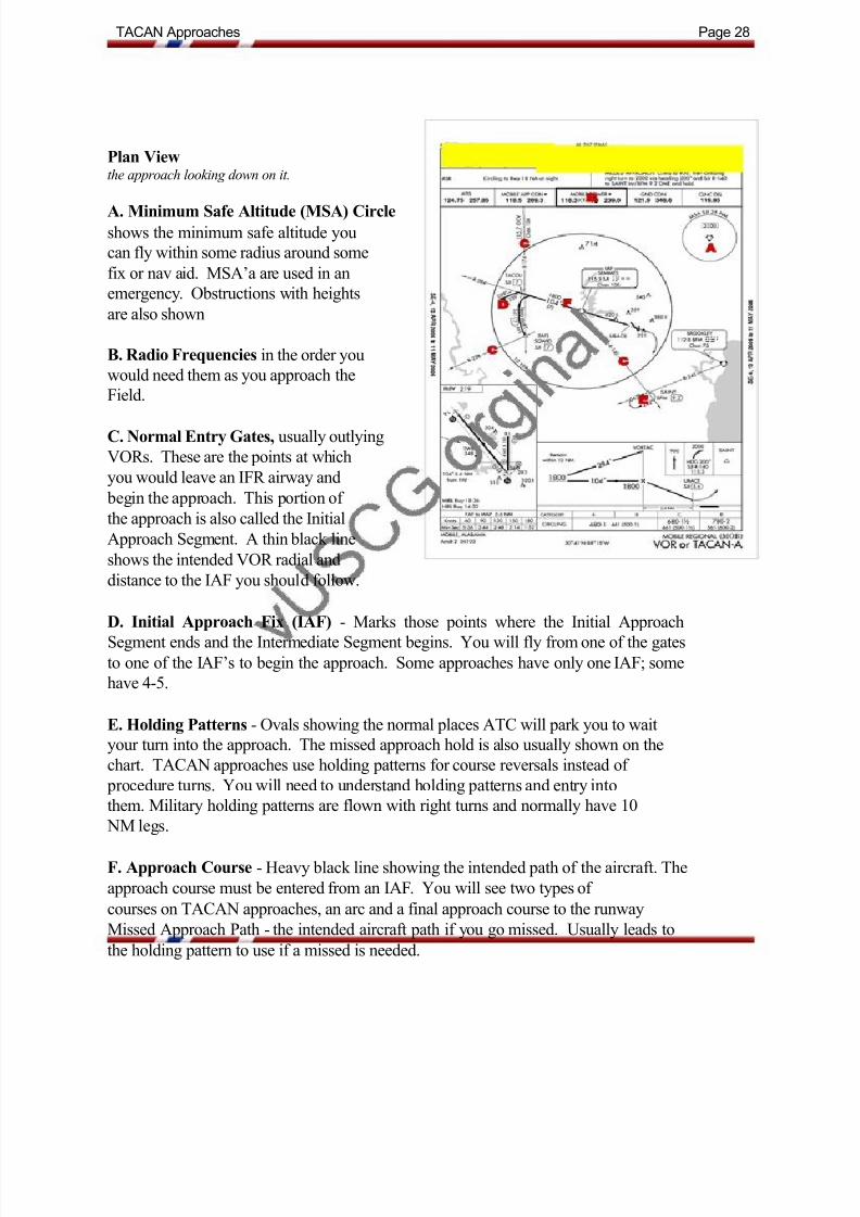
Plan Viewthe approach looking down on it.
A. Minimum Safe Altitude (MSA) Circle
shows the minimum safe altitude you
can fly within some radius around some
fix or nav aid. MSA‟a are used in an
emergency. Obstructions with heights
are also shown
B. Radio Frequencies in the order you
would need them as you approach the
Field.
C. Normal Entry Gates, usually outlying
VORs. These are the points at which
you would leave an IFR airway and
begin the approach. This portion of
the approach is also called the Initial
Approach Segment. A thin black line
shows the intended VOR radial and
distance to the IAF you should follow.
D. Initial Approach Fix (IAF) - Marks those points where the Initial Approach
Segment ends and the Intermediate Segment begins. You will fly from one of the gates
to one of the IAF‟s to begin the approach. Some approaches have only oneIAF; some
have 4-5.
E. Holding Patterns - Ovals showing the normal places ATC will park you to wait
your turn into the approach. The missed approach hold is also usually shown on the
chart. TACAN approaches use holding patterns for course reversals instead of procedure turns. You will need to understand holding patterns and entry into
them. Military holding patterns are flown with right turns and normally have 10
NM legs.
F. Approach Course - Heavy black line showing the intended path of the aircraft. The
approach course must be entered from an IAF. You will see two types of
courses on TACAN approaches, an arc and a final approach course to the runway
Missed Approach Path - the intended aircraft path if you go missed. Usually leads to
the holding pattern to use if a missed is needed.

7/29/2019 Pilot Training Manual v 1
http://slidepdf.com/reader/full/pilot-training-manual-v-1 34/58
TACAN Approaches Page 29
Profile Viewas if looking at the approach from the side.
A. Approach Course
- heavy black line indicating the final
approach course to be dialed into your
NAV1 radio. DME/Altitude Points
- points along the approach course with
DME and altitudes marked. After you
pass a DME point, you may drop to the
next altitude listed, usually at about
800-1000 fpm.
B. Final Approach Fix (FAF)
- indicated by a Maltese Cross, this is the
beginning of the Final Approach
Segment. On a VOR approach, you
would start your timing here.
C. Missed Approach Point (MAP)
- point where the heavy black line stops and
the dashed line starts. The point wherea missed approach procedure must be
started. On TACANs, this is a DME
fix whereas on VORs it is when your time expires. Also note that, unlike TACANs
where maintaining a constant ground speed isn‟t necessary, when timing a VOR
you must maintain ground speed carefully. This is generally what makes TACANs
easier than VORs.
D. Missed Approach Procedure - A textual procedure to follow if you must go
missed. A missed approach procedure is required when the visibility is such thatyou cannot see the runway, the end lights, or the approach lights upon reaching the
MAP. It is also required if you drift off course enough that the NAV1 needle pegs
full scale.

7/29/2019 Pilot Training Manual v 1
http://slidepdf.com/reader/full/pilot-training-manual-v-1 35/58
TACAN Approaches Page 30
Minimum Descent Altitudes (MDA)
A table below the Profile View that
details the minimum altitudes you
cannot go below before reaching the
MAP. They change by aircraft speed
(the letters A-D, and can e looked up in
a Terminal Procedure Book; vUSCG
fixed should reference Type C). The
lines that begin with an S indicate
Straight-in minimums while the letter
C indicates a Circling approach.
Straight ins have lower minimums, andthe airport MUST be kept in sight for a
circling approach… if you lose it in the
clouds, you must go missed. The
number following the MDA is the
visibility minimums. You can see if
you have a chance of making the
minimums using at ACARS function
in Squawkbox to check weather. This
block also contains other information,
alternate minimums, alternate departure
procures, and restrictions

7/29/2019 Pilot Training Manual v 1
http://slidepdf.com/reader/full/pilot-training-manual-v-1 36/58
TACAN Approaches Page31
Airport View
Small box on the lower right
which shows a basic airport
outline. A light black line shows
the approach course relative to
runway alignment. The other
item of interest here is the TDZE,
or Touch Down Zone Elevation,
the altitude you can expect the
wheels to touch the runway. The
runway light types can also be
seen and looked up in the USTerminal Procedures manual, but
FS scenery cannot be relied upon
to be consistent.

7/29/2019 Pilot Training Manual v 1
http://slidepdf.com/reader/full/pilot-training-manual-v-1 37/58
TACAN Approaches Page 32
KMOB TACAN-A Practice Exercises
Set Up
• NAV1 and NAV 2 set to 115.300 MHz
• Dial the NAV1 OBS to the final approach course of 105 as shown on the chart.
• Fly the approach at reasonable speeds, 220 -200 knots for Falcons, and 60-80 knots
for helicopters. See the aircraft specs for all airspeeds.
• Consult the chart for the appropriate altitude for each segment of the approach
• Be sure to let Mobile Tower, Approach, or Houston Center know what you are doing
with a quick courtesy call.
• Fully brief yourself using the approach chart well before beginning the approach so
you‟ll be ahead of the airplane the entire time.
• The following pages contain a description of the steps involved with a TACAN
approach.

7/29/2019 Pilot Training Manual v 1
http://slidepdf.com/reader/full/pilot-training-manual-v-1 38/58
TACAN Approaches Page 33
1. There are two IAF points to start this approach on this chart; one at SEMMES VORTAC,
one at SQWID. We will focus on doing the full approach, with procedure turn, using
SEMMES as our IAF.
2. Start the approach at the IAF at 1800 ft. For this practice, we will start 10NM south of theSEMMES VORTAC on 115.30 on NAV1 and the OBS turned until the needle is centered with a
TO flag as you fly direct to the VORTAC.
3. Check your altimeter setting and perform pre landing checklist.
4. Approaching from the south on a heading of 010, fly over te VORTAC, then turn left to
about heading 240, twist the NAV1 OBS to 105, and intercept the SEMMES Radial 285
outbound from the VORTAC by turning to heading 285 as the NAV1 needle centers.
FS Map View after intercepting the R285 and turning outbound to start the procedure turn.
5. After flying outbound for about 1 min (~ 5 DME), begin procedure turn by turning to
heading 240 for 1 min.
FS Map View, heading 240 procedure turn outbound for 1 min.

7/29/2019 Pilot Training Manual v 1
http://slidepdf.com/reader/full/pilot-training-manual-v-1 39/58
TACAN Approaches Page 34
6. After 1 min, turn right to heading 060 and intercept the 105 inbound approach course (the
opposite direction of the R285).
FS Map View, heading 060, intercepting the 105 inbound course to the VORTAC.
7. As you cross the VORTAC inbound, you descend to 680 ft, the MDA until the runway is in
sight and you can enter the pattern (~ 3 DME).
FS Map View, at 680 ft MSL, 3 DME on heading 105, starting turn to right base for runway 14.
8. Inbound heading 105, NAV1 needle centered, cross the VORTAC at 1800 ft MSL, then
descend to 680 ft MSL, the MDA for this approach. Start a left base turn at about 2 miles from
the end of the runway. Turn final to runway 14.
FS Map View, after left 2 NM base, turned final for runway 14.
9. If the runway is not in sight at DME 5.6, then perform the published missed approach
procedure.
10. If you go missed, you will climb to 900 ft, then climbing right turn to 2000 ft via heading200 to SAINT intersection and hold

7/29/2019 Pilot Training Manual v 1
http://slidepdf.com/reader/full/pilot-training-manual-v-1 40/58

7/29/2019 Pilot Training Manual v 1
http://slidepdf.com/reader/full/pilot-training-manual-v-1 41/58
SAR Patterns Page 36
Overview
The following discussion and practice exercises are designed to help Ensigns improve their
learning rate focused on the Search and Rescue (SAR) patterns required to graduate from the
Ensign Pilot Training Program.
All five patterns have several basic parameters:
Commence Search Point (CSP) - given as a Lat/Lon position, a Nav Aid fix such as cross
radials from two VORs or a single VOR radial with DME, or an RNAV fix. Easiest way to
identify and fly to the CSP is using a flight planner such as FS Nav where any of them can
be
entered and flown to directly.
Major/Minor Axis - basically def ines the „box‟ you will search. Each pattern uses thesesomewhat differently to define the direction of the Legs and Spaces.
Leg/Space - Defined as distances. Using FS Nav or other flight planning tools, these are
easy to program. After plotting in the CSP and heading for it, the SAR pilot can set up the
pattern while enroute. Without these tools, one is left with an E6B flight computer (circular
slide rule), a ruler, and a map to lay out the search pattern. Then you would fly it using a
stopwatch, adjusting for wind direction and speed to keep a constant ground track and speed
(whew!). Leg is also called the Search Leg, and space is sometime referred to as the creep
distance.
Altitude - Affects the visual distance you can see. Between 500 - 1000 ft for helos and
between 1000 - 2000 ft for fixed wing is normal.
Track - the general direction the search pattern should progress.
Airspeed - If the target is large, you can go faster, if it is small, you‟ll need to go slow.
Also go slow if your crew is tired. If you fly above 180 kts, the Spaces will need to be at least
5 NM.

7/29/2019 Pilot Training Manual v 1
http://slidepdf.com/reader/full/pilot-training-manual-v-1 42/58
SAR Patterns Page 37
Types of Basic SAR Patterns
Some Patterns are better for certain situations and aircraft types. Further study will make the
choices clearer; for now they will be assigned to you to fly and the parameters
provided. Click on the pattern title to see the graphical representation.
Trackline
When the path of target is known, fly the path. After reaching the CSP, fly the MAJOR
AXIS first. The multiple Trackline is used to bracket either side of the known path.

7/29/2019 Pilot Training Manual v 1
http://slidepdf.com/reader/full/pilot-training-manual-v-1 43/58
SAR Patterns Page 38
Parallel
General pattern to cover large areas. After reaching the CSP, fly the MAJOR AXIS first.
7/29/2019 Pilot Training Manual v 1
http://slidepdf.com/reader/full/pilot-training-manual-v-1 44/58
SAR Patterns Page 39
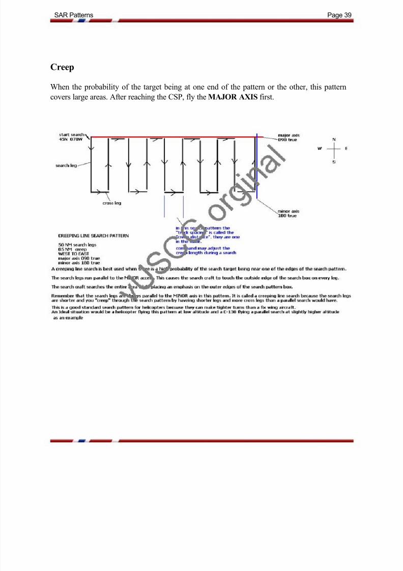
Creep
When the probability of the target being at one end of the pattern or the other, this patterncovers large areas. After reaching the CSP, fly the MAJOR AXIS first.

7/29/2019 Pilot Training Manual v 1
http://slidepdf.com/reader/full/pilot-training-manual-v-1 45/58
SAR Patterns Page 40
Sector
Usually the first pattern flown upon reaching an assigned location. This pattern may becommenced upon arrival if no other instructions have been received. The first leg should be
downwind, and default uses 10 NM legs.

7/29/2019 Pilot Training Manual v 1
http://slidepdf.com/reader/full/pilot-training-manual-v-1 46/58
SAR Patterns Page 41
SAR Pattern Training Exercises
These five scenarios use the same CSP. They only differ slightly in the area they
cover, but should help the Ensign visualize each pattern and their differences and
similarities. These patterns can be flown in either fixed of helicopter aircraft. If
you are flying a helicopter and fuel gets low, fly to Dauphin's Island Airport. There
is a helipad located there and gas is available, and is about 26 NM closer than
Mobile.
You can download the Search And R escue Training exercises in the
downloads/training downloads/basic training. The downloads include BGL
files which are E-Z Scenery targets for you to locate using the appropriate
search pattern.

7/29/2019 Pilot Training Manual v 1
http://slidepdf.com/reader/full/pilot-training-manual-v-1 47/58
SAR Patterns Page 42
SAR Checklist
1. RECEIVE ORDERS FROM vUSCG COMMAND
2. DETERMINE YOUR UNITS ABILITY TO CONDUCT THE MISSIONFuel
Pilot Endurance
aircraft or vessel capability
3. Report back to Command if able to conduct mission or not IF
CONDUCTING MISSION:
4. Generate proper flight plan and submit on VATSIM network.
(you must be logged into the VATSIM network)
5. Change your callsign to Prefix RESCUE as in CG Rescue 0002.
You do not need to change your VATSIM log in callsign to Rescue, however you can add
Rescue when talking TEXT with ATC.
6. Plot the rescue scene or CSP on FS navigator.
a. if search pattern is already given to you, try to also plot it on FS navigator before you
take off if you have time.
b. make sure you have your search pattern diagram information with you in the cockpit.
c. try to get a weather report for the area of the SAR if able before taking off.
d. determine your approximate Bingo Fuel based on what you know at the time.
e. determine a secondary location for refueling if needed.
f. perform necessary aircraft prep and aircraft check lists as required.
g. final head count of persons on board and determine that proper persons are on board, i.e.
(doctor, rescue swimmer)
7. Depart your current location per ATC or Unicom instructions via your flight plan.
a. do not depart until you have ATC clearance if you are in a controlled airspace !1. take the most direct route that ATC will allow to the scene of the
rescue.
2. observe real world weather VFR and IFR flight rules using VATSIM
real world weather in FS INN.
b. Once airborne and established in flight, Call NATCOM or other vUSCG command to
get Radio Guard during flight.
1. if no NATCOM on at the time, continue to monitor vUSCG voice
primary during entire mission incase of NATCOM arrival.
c. Attempt to gather as much information about the SAR case as possible while enroute
from the commanding vUSCG station.
d. Arrive on scene and perform the given instructions, such as search pattern, or medevac. If you arrive on scene to SAR case and do not see the target, and have not yet
received exact orders from Command, perform a Victor Sierra Vector Search of the area to
try to locate the target. Command may call at some point and give you a different
search pattern.
e. Follow through with Command instructions at the SAR scene.
f. Return to base when you are released from the scene by Command. RTB to destination
given by Command, i.e. (homeplate, hospital)
g. Contact necessary ATC if not already in contact.
h. Maintain Radio Guard with NATCOM or other vUSCG Command.
i. Once on ground cancel radio guard.
j. Aircraft shut down check list, and maintenance formsk. Fill out and file pirep with detail of the SAR case.

7/29/2019 Pilot Training Manual v 1
http://slidepdf.com/reader/full/pilot-training-manual-v-1 48/58

7/29/2019 Pilot Training Manual v 1
http://slidepdf.com/reader/full/pilot-training-manual-v-1 49/58
Software Tutorials Page 44
FSNavigator SAR patterns
This short tutorial will describe how to build a SAR pattern using FS Navigator and the
information provided by the mission tasker. First, the pattern we will create will be a parallel pattern, CSP N30 08.90 W087 44.66, major axis is 160, minor axis is 070, legs are
20 NM, space is 5 NM, creep is SW to NE.
Before we start making the pattern, notice a few important parts of FS Nav (refer to
Figure
1 below):
1. Flight Plan Area - where you will drop fixes as are dragging them from the map view.
2. Lat/Lon Display - shows lat/lon of the cursor's position on the map in decimals and
min/sec
Now we'll start by placing the cursor over the map and looking at the lat/lon display
(2). When we've found the right location, we press the left mouse button and a circle with
a line thru it will appear where the cursor was. Holding the mouse button down, drag the
lined circle to the flight plan area and release the button, and it will create Fix01 (3)
If you didn't get the first fix exactly where you wanted it, simply place the cursor over the fix
icon and wait for the text information box to appear, then you can glance down at the lower
left lat/lon readout and adjust. Alternatively, you can pick any point for Fix01 and right click on it in the flight plan window to manually edit the lat/lon data. Fix01 will automatically
adjust to this accurate position.
Remember, the N gets bigger as you go north and the W gets bigger as you move west.

7/29/2019 Pilot Training Manual v 1
http://slidepdf.com/reader/full/pilot-training-manual-v-1 50/58
Software Tutorials Page 45
Next, we want to plot the major axis, so we move the cursor down and to the right (about
160 degrees and 20 NM, just guess) of Fix01, hold the left mouse button down, and drag to
the flight plan box. Now you can adjust the exact location by placing the cursor over the fix,
waiting for the info box, then move it slightly. You will get finer adjustment as you zoom
in, so if you find yourself chasing the location, zoom in one level and try
again. This should create Fix02.
After you find the location of Fix02, we next plot the minor axis or 070, which is -90
degrees from 160, so go up and right of Fix02, select a location, drag it to the flight plan box,
creating Fix03, then come back and do the fine adjustments. Notice a small box with heading
and distance information also appears next to the course line while you are
moving each fix. Figure 2 below shows Fix02 and Fix03 added.
Now we will fly back to the NW, so we choose the point for Fix04 parallel to the first leg, up
and to the left of Fix03. Figure 3 below shows Fix04 in place.

7/29/2019 Pilot Training Manual v 1
http://slidepdf.com/reader/full/pilot-training-manual-v-1 51/58
Software Tutorials Page 46
And lastly, here is our SAR assignment plotted out with four legs.

7/29/2019 Pilot Training Manual v 1
http://slidepdf.com/reader/full/pilot-training-manual-v-1 52/58

7/29/2019 Pilot Training Manual v 1
http://slidepdf.com/reader/full/pilot-training-manual-v-1 53/58
vUSCG Terminology Page 48
AIRSTA - Air Station (airport that has a vUSCG air station)
AMVER - Automated Mutual Assistance Vessel Rescue System (computer system that
reports vessel locations)
ATC - Air Traffic Control
ALPHA - Phonetic alphabet for the letter "A"
BINGO FUEL - The time in which you will need to depart a given location in order to
refuel.
BLOCKS - Means wheel blocks in place at parking. Signifies the time that you will be
completely parked.
BOTTOM OF THE HOUR - The time of exactly 30 minutes past any given hour. i.e.
17:30
BRAVO - Phonetic alphabet for the letter "B"
CASREP - Casualty Report
CHARLIE - Copy, as in Affirmative, also "Charlie, Charlie" Phonetic alphabet for the
letter "C"
COMMS - Short for Communications
COMMSTA - Communications Station (a Roger Wilco Voice station that represents
vUSCG command), also NATCOM
COVER - The act of an aircraft visually watching another aircraft or vessel (usually for
safety purposes)
CSP - Commence Search Point (usually coordinates, that mark the location of the beginning of a search pattern)
DMB - Data Marker Buoy (dropped by AC to mark a position in the water) simulated by
marking location in FSnav
DELTA - Phonetic alphabet for the letter "d"
ELT - Emergency Locating Transmitter, similar to an EPIRB, only a low power beacon
(used more in aircraft)

7/29/2019 Pilot Training Manual v 1
http://slidepdf.com/reader/full/pilot-training-manual-v-1 54/58
vUSCG Terminology Page 49
EPIC - El Paso Intelligence Center
EPIRB - Emergency Position Indicating Radio Beacon (like an ELT, but newer technology
and indicates location)
ETA - Estimated Time of Arrival (usually in hours and/or minutes)
ECHO - Phonetic alphabet for the letter "E"
Flare - Emergency device that uses bright flame to signal aircraft or vessels. Can be
handheld or aerial
Flight Operations - Used with Radio Guard SOP, relates to the condition of the aircraft or
vessel. (default is NORMAL)
FLIR - Forward Looking Infra-Red Radar (shows targets based on heat signiture)
FRTT - Fleet Radio Teletype (EMAIL)
FOXTROT - Phonetic alphabet for the letter "F"
GANT-COM - Greater Antillies area command callsign (mainly HITRON)
GO-FAST - Speed boat (50 kts or faster over the water)
GOLF - Phonetic alphabet for the letter "G"
HITRON - Drug interdiction task force
HOIST - As in doing a hoist, lifting someone from water
HOME PLATE - Home Base (Your Home CG air station)
HOTEL FOXTROT - "HF" High Frequency/Shortwave radio comms, Sometimes calledHotel Fox, (Roger Wilco Voice)
HOTEL - Phonetic alphabet for the letter "H"
IN THE BLIND - Sending message without hearing a response
INTERROGATIVE - Prefix that signifies that a question is being asked over radio ie,
"Interogrative, what time is it?"

7/29/2019 Pilot Training Manual v 1
http://slidepdf.com/reader/full/pilot-training-manual-v-1 55/58
vUSCG Terminology Page 50
INDIA - Phonetic alphabet for the letter "I"
JULIET - Phonetic alphabet for the letter "J"
KILO - Phonetic alphabet for the letter "K"
LANDLINE - Standard Telephone
LANT-COM - vUSCG Atlantic area command callsign
LAT / LONG - Short for Latitude and Longitude (usually means pass your lat and long to
the station calling)
LIMA CHARLIE - Loud and Clear
LIMA ECHO - Law Enforcement
LOCAL TIME - The time of a given location relating to its time zone and taking into
account any daylight savings.
LIMA - Phonetic alphabet for the letter "L"
MIKES - Minutes of times used on Radio comms. 5 mikes = 5 minutes
MESSAGE BLOCK - A hand written message on paper that is placed in a specialcontainer and dropped to vessels by aircraft
MIKE - Phonetic alphabet for the letter "M"
NAS - Naval Air Station
NATCOM - vUSCG National Command callsign
NINER - The numeral "9" as pronounced on he radio.
NVG - Night Vision Goggles (switch your simulation to daytime in Flight Sim)
NOVEMBER - Phonetic alphabet for the letter "N"
ON DECK - Aircraft Landed (anywhere), airport, any ground location, or on a ship, or any
platform
OSCAR - Phonetic alphabet for the letter "O"

7/29/2019 Pilot Training Manual v 1
http://slidepdf.com/reader/full/pilot-training-manual-v-1 56/58
vUSCG Terminology Page 51
PAC-COM - vUSCG Pacific area command callsign
PARENT COMMAND - Your immediate vUSCG command unit, ie Group Miami
PAN PAN - Prefix that signifies emergency radio traffic coming up (listen and copy if its
in your area)
PFD - Personal Floatation Device
PIREP - Pilot Information Report. To vUSCG it means a record of your flight, (can also
mean weather report)
PIW - Persons in Water
POB - Persons On Board (also known as souls on board)
POSITION - Usually relates to radio guard SOP, means the position of your AC or vessel,
Lat/Long or distance from
PAPA - Phonetic alphabet for the letter "P"
QUEBEC - Phonetic alphabet for the letter "Q"
RADIO GUARD - To maintain a listening watch for safety on Radio, boats and aircraft
(vUSCG SOP)
RCC - Rescue Coordination Center (CG center that coordinates rescue activity with
NATCOM)
RDF - Radio Direction Finding (locates position based on radio transmitter location)
RESCUE #### - USCG Aircraft on SAR Case (add RESCUE to your callsign anytime you
are engaged in a RESCUE operation)
RTB - Return to Base
ROMEO - Phonetic alphabet for the letter "R"
SAR CASE - Search & Rescue Mission
SAR PACK - Emergency equipment dropped by aircraft
SARSAT - Search & Rescue Satellite (locates distress vessels and aircraft by showing
EPIRB location)

7/29/2019 Pilot Training Manual v 1
http://slidepdf.com/reader/full/pilot-training-manual-v-1 57/58
vUSCG Terminology Page 52
SATELLITE SECURE - Use of AOL instant messenger to simulate satellite data link.
(send text by typing)
SECURITY, SECURITY - prefix that signifies important radio traffic coming up (please
copy if in your area)
SCN - Systems Coordination Net (usually an AIM chat room related to a certain joint
operation)
SKAD - Survival Kit/Air Dropped (CanForces) (Canadian forces will drop this to distress
vessels)
SITREP - Situation Report (report on scene situation during a vUSCG mission)
SOB - Souls on Board, Older Term for POB (persons on board)
SOS - Save Our Ship, Mayday
SQUAWKBOX OR SB - Use of the text box in the Squawkbox program for
communications. CG primary is 123.1 on SB text.
SIERRA - Phonetic alphabet for the letter "S"
TACAN - Navaid (military version of VOR), see vUSCG SOP and documents for
information
TACTICAL COMMS - Coded speech used to hide the position of units during missions
usually on Roger Wilco voice.
TOP OF THE HOUR - The time of exactly the beginning of any given hour, ie 01:00
TANGO - Phonetic alphabet for the letter "T"
UNIFORM - Phonetic alphabet for the letter "U"
VICTOR SIERRA - Vector search pattern (default pattern to fly when arriving on scene
of SAR with no instructions)
VUNAF - Virtual United Nations Air Forces (our parent organization)
VICTOR - Phonetic alphabet for the letter "V"
WILCO - Military Term for "Will Comply"

7/29/2019 Pilot Training Manual v 1
http://slidepdf.com/reader/full/pilot-training-manual-v-1 58/58
vUSCG Terminology Page 53
WHISKEY - Phonetic alphabet for the letter "W"
XRAY - Phonetic alphabet for the letter "X"
YANKEE - Phonetic alphabet for the letter "Y"
ZULU or "Z" - Suffix used with time that signifies UTC time is being used
Phonetic alphabet for the letter "Z"