pima pineapple cactus survey: proposed rosemont … · proposed rosemont project santa rita road...
TRANSCRIPT

Q:\Jobs\1000's\1049.14\PPC\2009 Waterline PPC Survey 18 Dec 09.doc WestLand Resources, Inc. Engineering and Environmental Consultants
PIMA PINEAPPLE CACTUS SURVEY: PROPOSED ROSEMONT PROJECT SANTA RITA ROAD WATERLINE
PREPARED FOR: Rosemont Copper Company PREPARED BY: WestLand Resources, Inc. DATE: December 18, 2009 PROJECT NO. 1049.14 CCO3 342
TABLE OF CONTENTS
1. INTRODUCTION .................................................................................................................................... 2
2. SPECIES STATUS, RANGE, AND HABITAT ..................................................................................... 2
3. METHODS ............................................................................................................................................... 4
4. PROJECT AREA DESCRIPTION ........................................................................................................... 5
5. PIMA PINEAPPLE CACTUS SURVEY AREA DETERMINATION ................................................... 8
6. PIMA PINEAPPLE CACTUS SURVEY RESULTS............................................................................... 8
7. LITERATURE CITED ........................................................................................................................... 13
LIST OF FIGURES Figure 1. Vicinity Map .................................................................................................................................. 3 Figure 2. Aerial Overview Map .................................................................................................................... 6 Figure 3. Surficial and Bedrock Geology Map ............................................................................................. 7 Figure 4. Surficial Geology Map ................................................................................................................ 10
LIST OF TABLES Table 1. Locations and Notes for PPC Found During the Proposed Rosemont Santa Rita Road Waterline
Survey, Fall 2009 .............................................................................................................. 11
ATTACHMENTS A. Pima Pineapple Cactus Survey of the Proposed Rosemont Waterline Alignment B. Addendum to the Pima Pineapple Cactus Survey of the Proposed Rosemont Waterline Alignment

Pima Pineapple Cactus Survey: December 18, 2009 Proposed Rosemont Project Santa Rita Road Waterline Page 2
Q:\Jobs\1000's\1049.14\PPC\2009 Waterline PPC Survey 18 Dec 09.doc WestLand Resources, Inc. Engineering and Environmental Consultants
1. INTRODUCTION WestLand Resources, Inc. (WestLand), was retained by Rosemont Copper Company to survey for Pima pineapple cactus (Coryphantha scheeri var. robustispina; PPC) along approximately 22.4 linear miles (1,158 acres) of proposed waterline, including alternate routes, (the Project Area, Figure 1) as part of the proposed Rosemont Project. Augusta Resources has proposed development of a copper ore body in the northern Santa Rita Mountains known as the Rosemont Project. The Rosemont Project includes an open pit copper mine, waste rock and dry stack tailings, leach pad, disposal areas, and other ancillary facilities required for project operations. The waterline would extend from less than 1 mile east of the town of Sahuarita to the east side of Lopez Pass in the Santa Rita Mountains, following the north side of Santa Rita Road for approximately 7 miles in the middle section of the waterline1. The width of the Project Area ranges from 150 feet to approximately 650 feet. Previously surveyed portions of the Project Area and portions with no potential for PPC were not surveyed, as described in Section 5 of this document. Fifty-four PPC were found within the Project Area. The 54 PPC included 48 live and six dead. One of the dead PPC was found on a portion of the Project Area that was surveyed in 2008, but not in 2009. 2. SPECIES STATUS, RANGE, AND HABITAT The PPC is listed by U.S. Fish and Wildlife Service (USFWS) as endangered (58 FR 49875, 09-23-93) under the Endangered Species Act. There is no designated critical habitat or proposed critical habitat for PPC. The PPC is reported from 2,300 to 5,000 feet (702 to 1,525 meters) in elevation (AGFD 2001). Its range includes northern Sonora, Mexico and Pima and Santa Cruz counties in southern Arizona (Benson 1982; Phillips et al. 1981). The known range of PPC in Arizona is from the Baboquivari Mountains east to the Santa Rita Mountains, and from the Mexican border north to Tucson (AGFD 2001). Two populations have been documented in northern Sonora, Mexico (USFWS 1998). PPC do not occur in mountainous areas, including the Sierrita, Baboquivari, Santa Rita, Quinlan, Coyote, Atascosa, Pajarito, Cerro Colorado, San Luis, and Tumacacori Mountains, and has not been found in riparian areas such as the Santa Cruz River floodplain or the Sonoita Creek drainage in Arizona (58 FR 49875).
1 Crossing T17S, R14E, Sections 17, 20, 21, and 27-35; T18S, R14E, Sections 1, 2, and 12; T18S, R15E, Sections 1, 17, 18, and
20-24, and T18S, R16E, Sections 19 and 30, Gila and Salt River Meridian.


Pima Pineapple Cactus Survey: December 18, 2009 Proposed Rosemont Project Santa Rita Road Waterline Page 4
Q:\Jobs\1000's\1049.14\PPC\2009 Waterline PPC Survey 18 Dec 09.doc WestLand Resources, Inc. Engineering and Environmental Consultants
PPC are generally found on alluvial surfaces and ridges in Sonoran desertscrub and semidesert grassland (Mills 1991). In ridge-valley or hilly geologic formations, the species has been found mainly on relatively level crests, but rarely on slopes or in drainages. Substrates in which PPC occur have been described as rocky to sandy or silty soils in alluvial valleys or on shallow-sloped hillsides (less than 10-percent grade; Mills 1991) and White House sandy loam series (Roller 1996). They are not known to occur in very sandy or very rocky soils, in deeper soils along drainages, or in soils with high clay content (Mills 1991). Although a less than 10-percent slope has been cited as the general limit for occurrence (Mills 1991, Roller 1996), Mills (1991) reported some plants on south-facing hillsides (mid to upper slope) with slopes up to 15 percent. Mills (1991) reported that they found no plants on north-facing slopes, despite intensive surveys. However, single PPC were found on small terraces on both northern and southern slopes with approximately 25-percent grade (S. Hart, WestLand Resources, personal observation). 3. METHODS The survey followed guidelines set forth in the USFWS document entitled Pima Pineapple Cactus 3 Tier Survey Methods (Roller 1996). WestLand field technicians with PPC survey experience walked transects approximately 15 feet apart to attain 100-percent coverage of the portions of the Project Area that were surveyed. A single survey of suitable PPC habitat was completed. A majority of the survey was completed in September 2009. Waterline segments were added and surveyed in October and November 2009. The boundaries of the Project Area were entered into a Trimble GPS unit with sub-centimeter accuracy. The GPS unit was carried in the field to guide the survey. Where the Project Area straddled fencing along private property, the private property was not included in the survey and the fence became one survey boundary. The UTM coordinates of all PPC that were found were entered into the GPS unit. Live PPC were tagged with a unique number and the number of stems and general health of each plant were recorded. WestLand used slope angle and surficial geology to assess portions of the Project Area that did not warrant survey. Mills (1991), Roller (1996), and USFWS (2009) were referenced to determine slope angles and surficial units to exclude from survey. Only where those exclusion criteria were clearly met upon field inspection was an area excluded from survey. In areas where conditions provided potentially suitable habitat for PPC, surveyors walked transects approximately 15 feet apart to attain 100 percent coverage of those areas.

Pima Pineapple Cactus Survey: December 18, 2009 Proposed Rosemont Project Santa Rita Road Waterline Page 5
Q:\Jobs\1000's\1049.14\PPC\2009 Waterline PPC Survey 18 Dec 09.doc WestLand Resources, Inc. Engineering and Environmental Consultants
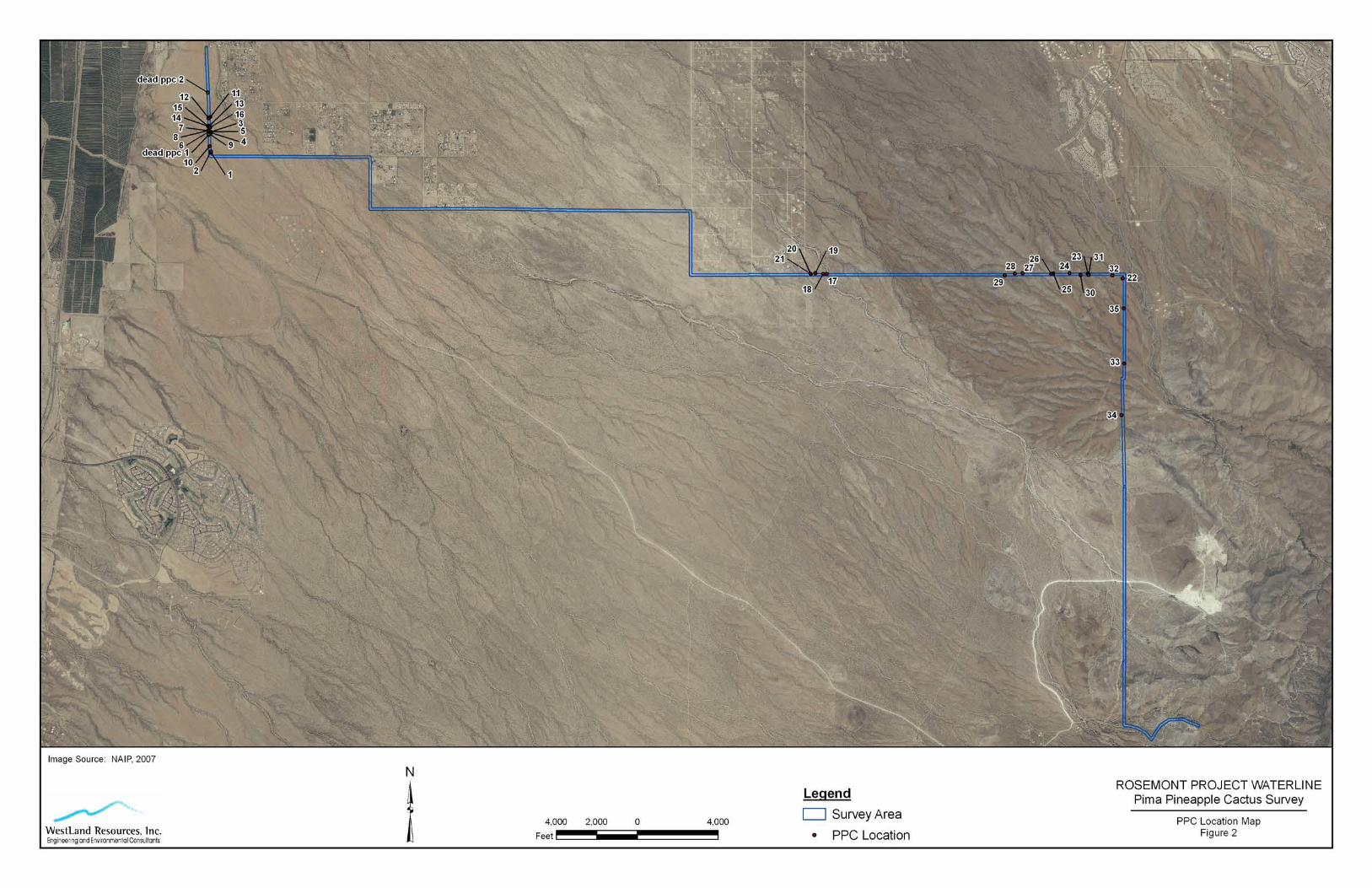
4. PROJECT AREA DESCRIPTION The Project Area consists of a main line with two spurs (Figure 2). The main line is 650-feet wide on the western mile-long length and 500 feet wide thereafter, with minor variations. One of the two spurs is only several hundred feet long, approximately 1 mile from the west end of the main line. The other spur is several hundred feet east of the first spur. It includes approximately 4.5 miles of line, 150-feet wide (80 acres), north of the main line. The west end of the Project Area is on alluvium immediately east of the Santa Cruz River floodplain. From the western terminus of the main line, the Project Area traverses east and intersects Santa Rita Road. It then follows along the north side of the road, traversing southeast on alluvial deposits until it reaches the foothills of the mountains. From the foothills, the alignment heads east over Lopez Pass and ends on the east slope of the mountains. Near the edge of the foothills, the Project Area splits into two alternate routes around a low, isolated hill. The southern of the alternate routes includes another small alternate route. The two routes around the hill join together again less than 2 miles to the east, before ascending the slopes of the mountains. The Project Area passes through a mix of privately held parcels, State Trust lands, and federally held properties. Most of the adjacent lands are undeveloped, except for short stretches with scattered residences in a rural setting (Figure 2). The Project Area includes dirt roadways and the dirt shoulder of the paved Santa Rita Road over approximately 7 miles of its length. Drewes (1971) Sahuarita Quadrangle map of geomorphological units includes all of the Project Area except approximately 0.25 mile at the east end (Figure 3). The western portion, including approximately 19 linear miles (965 acres) of the Project Area, is generally planar with a gentle but gradually increasing upward slope to the southeast. The western end in proximity to the Santa Cruz River is on alluvium of the piedmont area, with some deposits derived from the river upstream rather than the nearby mountains. Leaving the alluvium near the river, the Project Area includes approximately 18 linear miles of alluvium that cap higher terraces and pediments. At the foothills of the mountains, the Project Area enters the steep, geologically complex slopes of the Santa Rita Mountains that continue to the east end of the Project Area. On Brown’s (1994) map of biotic communities of the Southwest, the west end of the Project Area is near the boundary of semidesert grassland and the Arizona upland subdivision of the Sonoran desertscrub biotic community. The Project Area crosses east and south within semidesert grassland, and into the Madrean evergreen woodland community as it ascends the slopes of the mountains on the east end.


Pima Pineapple Cactus Survey: December 18, 2009 Proposed Rosemont Project Santa Rita Road Waterline Page 8
Q:\Jobs\1000's\1049.14\PPC\2009 Waterline PPC Survey 18 Dec 09.doc WestLand Resources, Inc. Engineering and Environmental Consultants
The Project Area crosses through various vegetation associations within the broader communities referenced. Within semidesert grassland and Arizona upland, these associations include mesquite–cactus scrub with more Sonoran desertscrub influence; creosotebush (Larrea tridentata) flats; relatively densely vegetated xeroriparian areas with velvet mesquite (Prosopis velutina), blue palo verde (Parkinsonia florida), whitethorn acacia (Acacia constricta), and other shrubs; and areas that were likely typical semidesert grassland decades ago, but now support more mesquite, soaptree yucca (Yucca elata), and many species of shrubs and sub-shrubs. Entering the foothills of the mountains, species including ocotillo (Fouquieria splendens) and Palmer agave (Agave palmeri) become locally abundant. At middle elevations ascending the slopes within the Project Area, semidesert grassland grades into Madrean evergreen woodland in a wide transition zone. Madrean evergreen woodland is characterized by open woodlands or savanna, with trees, grasses, and forbs interspersed. Emory oak (Quercus emoryi), alligator juniper (Juniperus deppeana), and Mexican pinyon (Pinus cembroides) are dominant trees. Velvet mesquite, white-thorn acacia, and skunk bush (Rhus trilobata) are common. Also present in this community are Palmer agave, a smaller number of Parry agave (Agave parryi), beargrass (Nolina microcarpa), banana yucca (Yucca baccata), several species of cacti, and a variety of grasses and forbs. 5. PIMA PINEAPPLE CACTUS SURVEY AREA DETERMINATION The PPC habitat parameters discussed in Section 2 of this report were used to determine portions of the Project Area that did not warrant survey. A biological opinion for a project in the Santa Cruz River valley southeast of Tucson was also referenced (USFWS 2009). In that document, areas excluded as potential PPC habitat included sandy wash bottoms, bedrock, and slopes of 15 percent or greater. Citing Mills (1991), Roller (1996), and USFWS (2009), WestLand excluded the bedrock and slopes with greater than 15-percent grade from survey. Based on the above criteria, the entire eastern approximately 3.2 miles (193 acres) of the Project Area was excluded from survey as having no potential for PPC occurrence. The excluded area begins in the foothills of the Santa Rita Mountains, where a combination of slopes over 15 percent and very rocky or bedrock substrates begins and continues to the east end of the Project Area. The geology throughout that portion of the Project Area is complex, but a commonality among them is the general lack of well developed soil. On the long spur at the west end of the Project Area, the northernmost approximately 0.7 miles (12 acres) of the Project Area was surveyed for PPC in 2008 for an alternate waterline route (see Attachment A for report), and was not included in the 2009 survey. The areas not surveyed in 2009 are depicted on Figure 2. 6. PIMA PINEAPPLE CACTUS SURVEY RESULTS Approximately 18.5 miles (953 acres) of the Project Area were surveyed for PPC. The survey did not include the eastern 3.2 miles (193 acres), which were determined to be unsuitable for PPC, and the northernmost 0.7 miles (12 acres), which had been surveyed in 2008. WestLand mapped, tagged, and

Pima Pineapple Cactus Survey: December 18, 2009 Proposed Rosemont Project Santa Rita Road Waterline Page 9
Q:\Jobs\1000's\1049.14\PPC\2009 Waterline PPC Survey 18 Dec 09.doc WestLand Resources, Inc. Engineering and Environmental Consultants
recorded data for the 48 live PPC that were found during the survey effort, and recorded and mapped five dead PPC (Figure 2). Another dead PPC that was found on a portion of the Project Area that was surveyed in 2008 is included on Figure 2. The UTM coordinates and notes for all live and dead PPC found during the 2009 survey are provided in Table 1. Distribution of PPC was not uniform along the Project Area (Figure 2). Fifty-two of the 54 PPC were found on the western half of the surveyed area. From the easternmost of the 52 western PPC found, it was approximately 2 miles southeast to the next single PPC; from that PPC, it was another approximately 4 miles to the next (easternmost) single PPC. Among the 51 western PPC, a cluster of 16 was found over less than a 0.5 mile length of the line along Santa Rita Road, and other, smaller clusters were found. This included five PPC found within less than 0.5-mile of the main line on the long spur. Only three PPC were found on the remaining approximately 4 miles of that spur. There was also approximately 0.75 mile with no PPC found on the main line between the spur and Santa Rita Road. Most of the Project Area surveyed for PPC was on Drewes (1971) Pleistocene-age Qgth gravel unit (Figure 3). The Qgth unit of alluvium occurs as higher terraces and pediments, capped by a moderately well developed red to brown soil or soil complex. Drewes delineated an “a” boundary with a prominent older soil of the Qgth complex west of the boundary. Seventeen of the 54 PPC were found on the surface west of the “a” boundary (Figure 2). Drewes also delineated a “b” boundary east of the “a” boundary. The area between Drewes’ Qgth “a” and “b” boundaries, a distance of less than 2 miles along the main line, had 22 PPC. Sixteen of those were within an approximately 0.5-mile length of the Project Area, three more were in a small cluster several hundred feet northwest of the first cluster, and the other three were nearly 0.75 mile west of the second cluster, near the “a” boundary and PPC found west of that boundary. Drewes described the second soil unit, between the “a” and “b” lines, as silt facies of the alluvial sheet (younger than the “a” unit of Qgth). East of the “b” (silt facies) boundary the Drewes Pleistocene-age Qgth gravel unit continues. Thirteen PPC were found east of the “b” boundary. Eleven of those were within approximately 1.5 miles of the “b” boundary, while only two PPC were found between 1.5 miles east of the “b” boundary and the east end of the survey, a distance of approximately 6.5 miles.
The only two PPC that were not found on the Qgth unit were found on the QTg unit near the west end of the main line. Drewes (1971) defines QTg as alluvium of the piedmont area.
Pearthree and Youberg (2000) mapped the alluvium on which 22 of the western PPC occur as “Qm”, the alluvium on which 28 of the PPC occur as “Qly”, and two PPC on “Qy” (Figure 4). The two easternmost PPC are east of their map. For Pearthree and Youberg, all three units are complexes of surficial units, with Qm deposited in the middle Pleistocene, Qly deposited between the late Pleistocene and the Holocene, and the youngest, Qy, deposited in the Holocene. Because of the large scale of the mapping, PPC near the edge of two units may be on either unit. One of the two easternmost PPC was found on a surface mapped by Jackson (1990) as M1 (middle Pleistocene alluvial deposits; Figure 4). The easternmost PPC is on an area not covered by the Jackson or Pearthree and Youberg maps.


Pima Pineapple Cactus Survey: December 18, 2009 Proposed Rosemont Project Santa Rita Road Waterline Page 11
Q:\Jobs\1000's\1049.14\PPC\2009 Waterline PPC Survey 18 Dec 09.doc WestLand Resources, Inc. Engineering and Environmental Consultants
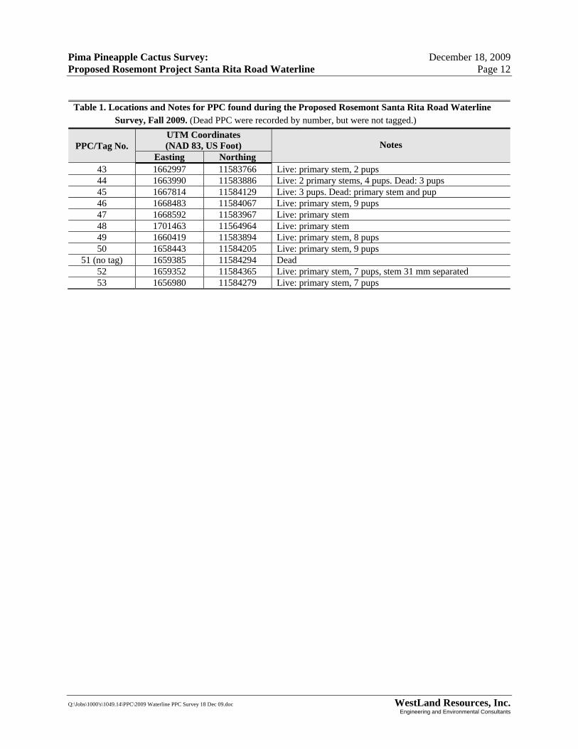
Table 1. Locations and Notes for PPC found during the Proposed Rosemont Santa Rita Road Waterline Survey, Fall 2009. (Dead PPC were recorded by number, but were not tagged.)
PPC/Tag No. UTM Coordinates (NAD 83, US Foot) Notes
Easting Northing 1 1669848 11583518 Live: 4 pups. Dead: 2 primary stems
2 (no tag) 1669884 11583504 Dead 3 1669875 11583549 Live: primary stem 4 1669926 11583413 Live: 2 large and 16 small pups. Dead: primary stem 5 1670409 11583142 Live: primary stem, 6 pups 6 1670709 11583109 Live: primary stem 7 1670685 11583049 Live: primary stem 8 1670323 11583274 Live: primary stem, 2 pups 9 1670342 11583299 Live: primary stem, 1 pup
10 1669874 11583679 Live: primary stem, 2 pups 11 1670089 11583525 Live: primary stem, 9 pups 12 1670200 11583445 Live: primary stem, 4 large and 9 small pups 13 1670350 11583362 Live: primary stem
14 (no tag) 1670848 11583079 Dead 15 (no tag) 1671096 11583188 Dead
16 1670358 11583513 Live: 2 large and 2 small pups. Dead: primary stem, pup 17 1676006 11579665 Live: primary stem 18 1676905 11579033 Live: primary stem, 6 pups
19 (no tag) 1677111 11579124 Dead 20 1674681 11580825 Live: primary stem 21 1673865 11581600 Live: 6 large and 7 small pups. Dead: primary stem 22 1673741 11581706 Live: 5 large and 4 small pups. Dead: primary stem 23 1673476 11581928 Live: 5 pups. Dead: primary stem 24 1673559 11581886 Live: primary stem and pup 25 1673238 11582220 Live: primary stem 26 1677085 11579295 Live: primary stem, 5 pups. Dead: pup 27 1673265 11582298 Live: primary stem, 7 pups 28 1683885 11572128 Live: 9 pups. Dead: primary stem 29 1662927 11589257 Live: primary stem, 9 pups 30 1662905 11591437 Live: primary stem. Dead: pup 31 1662802 11585731 Live: primary stem, 3 pups 32 1662811 11585556 Live: primary stem, 2 pups 33 1662825 11585072 Live: primary stem, 3 pups 34 1662884 11584508 Live: 2 primary stems 35 1661553 11585148 Live: primary stem 36 1661570 11584194 Live: primary stem, 7 pups. Dead: pup 37 1662920 11585621 Live: primary stem, 2 pups 38 1661700 11584031 Live: primary stem 39 1661306 11585129 Live: primary stem, pup 40 1661090 11584783 Live: primary stem, pup 41 1661178 11584687 Live: primary stem, pup 42 1661289 11584023 Live: primary stem, 2 pups
Pima Pineapple Cactus Survey: December 18, 2009 Proposed Rosemont Project Santa Rita Road Waterline Page 12
Q:\Jobs\1000's\1049.14\PPC\2009 Waterline PPC Survey 18 Dec 09.doc WestLand Resources, Inc. Engineering and Environmental Consultants
Table 1. Locations and Notes for PPC found during the Proposed Rosemont Santa Rita Road Waterline Survey, Fall 2009. (Dead PPC were recorded by number, but were not tagged.)
PPC/Tag No. UTM Coordinates (NAD 83, US Foot) Notes
Easting Northing 43 1662997 11583766 Live: primary stem, 2 pups 44 1663990 11583886 Live: 2 primary stems, 4 pups. Dead: 3 pups 45 1667814 11584129 Live: 3 pups. Dead: primary stem and pup 46 1668483 11584067 Live: primary stem, 9 pups 47 1668592 11583967 Live: primary stem 48 1701463 11564964 Live: primary stem 49 1660419 11583894 Live: primary stem, 8 pups 50 1658443 11584205 Live: primary stem, 9 pups
51 (no tag) 1659385 11584294 Dead 52 1659352 11584365 Live: primary stem, 7 pups, stem 31 mm separated 53 1656980 11584279 Live: primary stem, 7 pups

Pima Pineapple Cactus Survey: December 18, 2009 Proposed Rosemont Project Santa Rita Road Waterline Page 13
Q:\Jobs\1000's\1049.14\PPC\2009 Waterline PPC Survey 18 Dec 09.doc WestLand Resources, Inc. Engineering and Environmental Consultants
PPC were found on essentially all of Drewes’ (1971) and Pearthree and Youberg’s (2000) surficial geologic units that were surveyed in 2009. The PPC distribution of PPC within single geologic units, especially the distribution of PPC east of Drewes’ (1971) Qgth “b” line (several PPC found within 1.5 miles east of the line and only two PPC found between 1.5 and 8 miles east of the line, as the alluvial surface becomes steeper approaching the mountains), suggests either that Drewes’ map does not provide sufficient detail to analyze any correlation between geologic units and PPC occurrence, or that factors other than geologic unit have a significant influence on PPC distribution within the Project Area. The same holds true for PPC distribution on the geologic units depicted by Pearthree and Youberg (2000), where PPC were found in similar numbers on the two geologic units that comprise a majority of the surveyed area that is covered by their map. It is outside the scope of this document to provide further analysis of PPC distribution within the Project Area in relation to geologic units. However, the distribution pattern found in this survey is similar to the pattern found in the 2008 survey for the alternative waterline route (Attachment A), which is north of the 2009 Project Area but overlaps with it at the northwest end and near the east end. A discussion of the 2008 survey PPC distribution and factors that influence PPC distribution is found in Attachment B.
7. LITERATURE CITED
Arizona Game and Fish Department. 2001. Coryphantha scheeri var. robustispina. Unpublished abstract compiled and edited by the Heritage Data Management System, Arizona Game and Fish Department, Phoenix, AZ. Accessed May 12, 2008.
Benson, L. 1982. The Cacti of the United States and Canada. Stanford University Press. Stanford,
California. Brown, D.E. (ed.). 1994. Biotic Communities: Southwestern United States and Northwestern Mexico.
University of Utah Press, Salt Lake City. Drewes, H. 1971. Geologic map of the Sahuarita Quadrangle, southeast of Tucson, Pima County,
Arizona. Miscellaneous Geologic Investigations Map I-613. Department of the Interior, United States Geologic Survey.
Jackson, G. 1990. Surficial geologic maps of the northeastern, southeastern, and southwestern portions of the Tucson metropolitan area. Arizona Geological Survey, Open-File Report 89-2. Arizona Geological Survey, Tucson, AZ.
Mills, G.S. 1991. Miscellaneous notes on Coryphantha scheeri var. robustispina. Unpublished report. U.S. Fish & Wildlife Service, Arizona Ecological Services Office, Phoenix, Arizona.

Pima Pineapple Cactus Survey: December 18, 2009 Proposed Rosemont Project Santa Rita Road Waterline Page 14
Q:\Jobs\1000's\1049.14\PPC\2009 Waterline PPC Survey 18 Dec 09.doc WestLand Resources, Inc. Engineering and Environmental Consultants
Pearthree, P. A., and A. Youberg. 2000. Surficial geologic map of the Green Valley-Sahuarita Area, Pima County. Plate 1 – Twin Buttes and Sahuarita 7.5’ Quadrangles. Arizona Geological Survey Digital Geologic Map 3.
Phillips, A.M., B.G. Phillips, and N. Brian. 1981. Status report: Coryphantha scheeri var. robustispina.
Office of Endangered Species, U.S. Fish & Wildlife Service, Albuquerque, New Mexico. Unpublished report.
Roller, P.S. 1996. Pima Pineapple Cactus 3-tier Survey Methods. Unpublished report. U.S. Fish &
Wildlife Service. Phoenix, Arizona. U.S. Fish and Wildlife Service. 1998. Endangered and Threatened Species of Arizona. Ecological
Services Field Office, Phoenix. 123 pp. U.S. Fish and Wildlife Service. 2009. Biological Opinion on the Mission Peaks Residential Subdivision.
U.S. Fish and Wildlife Service File No. 22410-2008-F-0473. Available at: http://www.fws.gov/southwest/es/arizona/Biological.htm

ATTACHMENT A
PIMA PINEAPPLE CACTUS SURVEY
OF THE PROPOSED ROSEMONT
WATERLINE ALIGNMENT

Q:\Jobs\1000's\1049.10\PPC\Rosemont Waterline PPC Survey 031109.doc WestLand Resources, Inc. Engineering and Environmental Consultants
PIMA PINEAPPLE CACTUS SURVEY OF THE PROPOSED ROSEMONT PROJECT WATERLINE ALIGNMENT
PREPARED FOR: Rosemont Copper Company PREPARED BY: WestLand Resources, Inc. DATE: March 11, 2009 PROJECT NO. 1049.10 350 350
TABLE OF CONTENTS
1. INTRODUCTION .................................................................................................................................... 1 2. SPECIES STATUS .................................................................................................................................. 2 3. METHODS ............................................................................................................................................... 3 4. SURVEY AREA DESCRIPTION ............................................................................................................ 4 5. PIMA PINEAPPLE CACTUS SURVEY RESULTS............................................................................... 6 6. LITERATURE CITED ............................................................................................................................. 7
LIST OF FIGURES Figure 1. Vicinity Map .................................................................................................................................. 3 Figure 2. PPC Location Map ........................................................................................................................ 5
LIST OF TABLES Table 1. Locations and Notes for PPC found during the Rosemont Waterline Survey, October 2008 ........ 6 1. INTRODUCTION WestLand Resources, Inc. (WestLand) was retained by Rosemont Copper Company to survey for Pima pineapple cactus (PPC; Coryphantha scheeri var. robustispina) along an approximately 15.77-mile-long proposed waterline as part of the proposed Rosemont Project. A 120-ft wide area was surveyed along the

Pima Pineapple Cactus Survey March 11, 2009 of the Proposed Rosemont Project Waterline Alignment Page 2
Q:\Jobs\1000's\1049.10\PPC\Rosemont Waterline PPC Survey 031109.doc WestLand Resources, Inc. Engineering and Environmental Consultants
proposed waterline extending from just east of the Town of Sahuarita to the western base of the Santa Rita Mountains1 (the Survey Area, Figure 1). 2. SPECIES STATUS The PPC is listed by US Fish and Wildlife Service (USFWS) as endangered (58 FR 49875, 09-23-93) under the Endangered Species Act (ESA). There is no designated critical habitat or proposed critical habitat for PPC. The PPC is reported to occur from 2,300 to 4,500 feet (700 to 1,400 meters) in elevation (EES 1992) in Pima and Santa Cruz counties, southern Arizona, and northern Sonora, Mexico (Benson 1982; Phillips and Phillips 1981). The known range of PPC in Arizona is from the Baboquivari Mountains east to the Santa Rita Mountains in Santa Cruz and Pima counties. Most of the known locations are in the Altar and Avra valleys, Santa Cruz River Basin, and the alluvial fans of the Sierrita, Santa Rita, Empire, Coyote, and Pajarito mountains (AGFD 2001), and two documented populations are known in northern Sonora, Mexico (USFWS 1998). The PPC does not occur in mountainous areas including the Sierrita, Baboquivari, Santa Rita, Quinlan, Coyote, Atascosa, Pajarito, Cerro Colorado, San Luis, and Tumacacori mountains. The species has not been found in riparian areas such as the Santa Cruz River floodplain or the Sonoita Creek drainage of Arizona (58 FR 49875).
The PPC is generally found on Sonoran desertscrub alluvial fans and semidesert grassland ridges (Mills 1991). In rolling hilly habitats, the species has been found mainly on flat hilltops and rarely on slopes or in drainages separating the hilltops. Although PPC occur most commonly on flat ridgetops with little (less than 10 percent) slope, Mills (1991) reported some plants on south-facing hillsides (mid to upper slope) with slopes up to 15 percent (Mills 1991). Mills (1991) also reported that they found no plants on north-facing slopes of any significant size, despite intensive surveys. However, PPC have been found on a northern slope with approximately 25 percent grade (S. Hart, WestLand Resources, Inc., personal observation) but this is uncommon. Substrate composition is likely an important factor in determining PPC distribution, although we are not aware of any studies that conclusively identify important substrate factors. Substrates in which PPC occur are described as rocky to sandy or silty soils in alluvial valleys or on shallow-sloped (less than 10 percent grade) hillsides (Mills 1991) and White House sandy loam series (Roller 1996). They are not known to occur in very sandy or very rocky soils, in deeper soils along drainages, or in soils with high clay content (Mills 1991).
1 Crossing T17S, R14E, Sections 17, 20, 21, and borders of Sections 22/27, 23/26, and 24/25; T17S, R15E, borders of Sections 30/31, 29/32, 28/33, 27/34 and 34/35; and T18S, R15E, borders of Sections 2/3, 10/11, and 14/15, and Section 23, Gila and Salt River Meridian


Pima Pineapple Cactus Survey March 11, 2009 of the Proposed Rosemont Project Waterline Alignment Page 4
Q:\Jobs\1000's\1049.10\PPC\Rosemont Waterline PPC Survey 031109.doc WestLand Resources, Inc. Engineering and Environmental Consultants
3. METHODS The survey followed guidelines set forth in the USFWS document entitled Pima Pineapple Cactus 3 Tier Survey Methods (Roller 1996). Surveyors walked transects approximately 15 feet apart to attain 100 percent coverage of the Survey Area. A single, 100-percent coverage survey was completed between October 7 and 21, 2008, by a WestLand field crew with extensive PPC survey experience. The boundaries of the Survey Area were entered into a Trimble GPS unit with sub-centimeter accuracy. The unit was carried in the field to guide the survey. In places, the Survey Area straddled fencing along the boundary of private property. In these situations, the private property was not included in the survey but the survey width remained 120 feet, with the fence becoming one boundary. UTM coordinates (in NAD 27) of all PPC found were entered into the Trimble unit. PPC were tagged with a unique number and the number of stems and general health of each plant was recorded. 4. SURVEY AREA DESCRIPTION The Survey Area is located mainly on alluvium on the west side of the Santa Rita Mountains. The Survey Area passes through undeveloped lands, except for short stretches with residences in a rural setting on one side of the alignment (Figure 2). The Survey Area included dirt roadways over much of its length. Jackson (1989) mapped the geomorphological units that the Survey Area crosses. The western approximately 7 miles of the Survey Area are generally planar with a gentle but gradually increasing upward slope to the east. This section starts on late Pleistocene–early Holocene soils at the west end, moving east over a mosaic of middle and late Pleistocene through Holocene soils. The next 3.5 miles continue east onto a wide alluvial fan of early Pleistocene (older) origin spilling out of Sycamore Canyon in the Santa Rita Mountains. This surface is easily distinguished in aerial color photography (shown reddish in color) and typified by northwest-trending, steep-sloped ridges and an increasingly steep overall gradient as the base of the Santa Rita Mountains are approached (Figure 2). The Survey Area then turns south and continues on the same surface for close to 2 miles, then for more than 1.5 miles crosses a surface with a similar overall slope and age, but of different origin and with shallower cut ridges. The final approximately 1.75 miles of the Survey Area crosses a small, outlying hill of the mountains protruding from the alluvial material, ending in a steep drainage at the base of the mountains. The low point of the Survey Area is approximately 2,730 feet above mean sea level (amsl) near its western end, and the high point is approximately 4,500 feet amsl near its eastern end. On Brown’s (1994) map of biotic communities of the southwest, the west end of the Survey Area is near the boundary of the semidesert grassland and Arizona upland subdivision of the Sonoran desertscrub biotic communities, crossing eastward within semidesert grassland. The Survey Area crosses through

Pima Pineapple Cactus Survey March 11, 2009 of the Proposed Rosemont Project Waterline Alignment Page 6
Q:\Jobs\1000's\1049.10\PPC\Rosemont Waterline PPC Survey 031109.doc WestLand Resources, Inc. Engineering and Environmental Consultants
various vegetation communities, including mesquite–cactus scrub with more Sonoran desertscrub influence; creosotebush (Larrea tridentata) flats; relatively densely vegetated xeroriparian areas with velvet mesquite (Prosopis velutina), blue palo verde (Parkinsonia florida), whitethorn acacia (Acacia constricta), and other shrubs; and areas that were likely typical semidesert grassland decades ago, but now support more mesquite, soaptree yucca (Yucca elata), and many species of shrubs and sub-shrubs. 5. PIMA PINEAPPLE CACTUS SURVEY RESULTS The 120-ft-wide, 15.77-mile-long Survey Area covers approximately 229 acres. WestLand mapped, tagged, and recorded data on the 35 live PPC that were found during the survey effort. Distribution of the PPC was not uniform along the Survey Area. A cluster consisting of 16 live PPC and two dead PPC was found along the westernmost portion of the Survey Area (Figure 2). Soils within this westernmost portion are of late Pleistocene to early Holocene origin. Approximately 6.5 miles to the east of the first cluster, a group of 5 PPC was found on middle Pleistocene soils just east of the intersection of Camino de Aurelia and South Kolb Road (Figure 2). The other 14 PPC were found dispersed over approximately 2.5 miles of early Pleistocene soils within the Sycamore Canyon alluvial fan, where the alignment makes its final turn to the south (Figure 2). The gaps where no PPC were found are notable, including approximately 6.5 miles between the western and middle clusters, 1.5 miles from the middle cluster to the first PPC on the Sycamore Canyon fan, and the final southeastern 3.5 miles of the Survey Area (Figure 2). The UTM coordinates, in NAD 27, of all live PPC found during the survey are provided in Table 1.
Table 1. Locations and Notes for PPC found during the Rosemont Waterline Survey, October 2008
PPC Tag No. UTM Coordinates (NAD 27)
Notes Easting Northing
1 506158 3533168 No pups, healthy 2 506153 3533187 2 main stems, no pups, healthy 3 506152 3533475 4 pups, 2 fruits, healthy 4 506152 3533480 4 pups, healthy 5 506149 3533481 2 healthy main stems, 4 pups (3 dead) 6 506131 3533489 5 pups, healthy 7 506121 3533499 Dead main stem, 6 pups 8 506117 3533501 No pups, healthy 9 506140 3533444 No pups, 1 fruit, healthy
10 506133 3533261 10 pups, healthy 11 506144 3533705 2 fruits, unhealthy 12 506121 3533690 Main stem unhealthy, 4 pups 13 506128 3533570 No pups, healthy 14 506119 3533561 No pups, healthy 15 506113 3533565 1 healthy stem, 1 dead stem 16 506144 3533550 Main stem dead, 3 pups 17 515453 3531336 no pups; healthy

Pima Pineapple Cactus Survey March 11, 2009 of the Proposed Rosemont Project Waterline Alignment Page 7
Q:\Jobs\1000's\1049.10\PPC\Rosemont Waterline PPC Survey 031109.doc WestLand Resources, Inc. Engineering and Environmental Consultants
Table 1. Locations and Notes for PPC found during the Rosemont Waterline Survey, October 2008
PPC Tag No. UTM Coordinates (NAD 27)
Notes Easting Northing
18 515399 3531335 1 pup; healthy 19 515281 3531349 20 515212 3531334 no pups 21 515211 3531335 7 pups 22 519923 3531270 4 stems 1 dead 3 fruit healthy 23 519395 3531340 7 pups; fair health 24 519121 3531347 2 pups; healthy; 1 fruit 25 518874 3531346 2 pups; healthy; 2 dry fruit remnants 26 518842 3531336 8 pups; healthy 27 518412 3531347 0 pups; healthy 28 518293 3531339 main stem dead; 6 pups; healthy 29 518143 3531316 26 pups; healthy; 2 dry-partial fruit; 3 ripe fruit 30 519283 3531321 3 pups; healthy 31 519409 3531322 0 pups; healthy 32 519763 3531315 3 pups healthy 3 fruits 33 519944 3529983 4 stems 2 dead 6 pups 34 519905 3529206 3 pups; healthy 35 519938 3530817 11 pups; healthy
6. LITERATURE CITED
Arizona Game and Fish Department. 2001. Coryphantha scheeri var. robustispina. Unpublished abstract compiled and edited by the Heritage Data Management System, Arizona Game and Fish Department, Phoenix, AZ. Accessed May 12, 2008.
Benson, L. 1982. The Cacti of the United States and Canada. Stanford University Press. Stanford,
California. Brown, D.E. (ed.). 1994. Biotic Communities: Southwestern United States and Northwestern Mexico.
University of Utah Press, Salt Lake City.
Ecosphere Environmental Services (EES). 1992. A Range Study of Coryphantha scheeri var. robustispina. Final report prepared by the U.S. Bureau of Reclamation. Phoenix, Arizona.
Jackson, G. 1989. Surficial geologic maps of the northeastern, southeastern, and southwestern portions of
the Tucson metropolitan area. Arizona Geological Survey, Open-File Report 89-2. Arizona Geological Survey, Tucson, AZ.
Mills, G.S. 1991. Miscellaneous notes on Coryphantha scheeri var. robustispina. Unpublished report. U.S. Fish & Wildlife Service, Arizona Ecological Services Office, Phoenix, Arizona.

Pima Pineapple Cactus Survey March 11, 2009 of the Proposed Rosemont Project Waterline Alignment Page 8
Q:\Jobs\1000's\1049.10\PPC\Rosemont Waterline PPC Survey 031109.doc WestLand Resources, Inc. Engineering and Environmental Consultants
Phillips, A.M., B.G. Phillips, and N. Brian. 1981. Status report: Coryphantha scheeri var. robustispina.
Office of Endangered Species, U.S. Fish & Wildlife Service, Albuquerque, New Mexico. Unpublished report.
Roller, P.S. 1996. Distribution, growth and reproduction of Pima pineapple cactus (Coryphantha scheeri Kuntz var. robustispina Schott). M.S. Thesis, University of Arizona.
Roller, P.S. 1996. Pima Pineapple Cactus 3-tier Survey Methods. Unpublished report. U.S. Fish &
Wildlife Service. Phoenix, Arizona. US Fish and Wildlife Service. 1998. Endangered and Threatened Species of Arizona. Ecological Services
Field Office, Phoenix. 123 pp.

ATTACHMENT B
ADDENDUM TO THE PIMA PINEAPPLE CACTUS SURVEY
OF THE PROPOSED ROSEMONT
WATERLINE ALIGNMENT

Rosemont Copper Project
Record # 0123,15 Locator Sheet
Document Date ZIPI
Document Title: Pacionduv\A, Pivv10„PinbapOe,01.Q.,40t,
4-10, Rappne.dfr Rir-r)(9 vtitbA.4- VO.Sth Coe, PLirono&-k- Document Author Met-A-lCuAd , t A C
Document Description
Other Notes
This document is located in the following
[CIRCLE THE CATEGORY (from the list below) IN WHICH THIS ITEM IS FILED]
1. Project Management a. Mine Plan (including compilation)
a. Formal recommendations & Directions b. Supporting Documents
b. Formal meeting minutes & memos c. Detailed Designs
c. General Correspondence 6. Alternatives
d. Contracts, Agreements, & MOUs (Rosemont, a. Cumulative Effects Catalog
Udall, SWCA)
b. Connected Actions
e. Other
c. Dismissed from Detailed Analysis
2. Public Involvement
d. Analyzed in Detail
a. Announcements & Public Meetings 7. Resources
b. Mailing Lists a. Air Quality & Climate Change
c. Scoping Period Comments Biological
d. Udall Foundation Working Group c. Dark Skies
e. Scoping Reports d. Fuels & Fire Management
f. Comments after Scoping Period e. Hazardous Materials
g. DEIS Public Comments f. Heritage
3. Agency Consultation & Permits g. Land Use
a. Army Corps of Engineers (404 permit) h. Livestock Grazing
b. US Fish & Wildlife Service (Sec. 7 T&E) i. Noise & Vibration
c. State Historic Preservation Office (Sec. 106) j. Public Health & Safety
d. Tribes (Sec. 106) k. Recreation & Wilderness
e. Advisory Council on Historic Preservation (Sec. I. Riparian
106) m. Socioeconomics & Environmental Justice
f. Other n. Soils & Geology
4. Communication o. Transportation & Access
a. Congressional p. Visual
b. Cooperating Agencies q. Water
c. Organizations 8. Reclamation
d. Individuals 9. DEIS
e. FOIA 10. FEIS
f. Internal 11. Geospatial Analysis (GIS Data)
g. Proponent 12. FOIA Exempt Documents
5. Proposed Action 13. ROD (including BLM & ACOE)