pinedale anticline project area
TRANSCRIPT

1
Pinedale Anticline Project Area
Monitoring for Reclamation Success
Mo
nit
ori
ng
fo
r R
ecl
am
ati
on
Su
cce
ss
20
09
P
ine
da
le A
nti
clin
e P
roje
ct A
rea
In accordance with the Pinedale Anticline Record of Decision signed September 12, 2008, this Reclamation Monitoring Plan was developed to give standardized guidance for monitoring the reclamation success in the Pinedale Anticline Project Area. This plan contains criteria that are required to be measured and reported annually to the Bureau of Land Management and Pinedale Anticline Project Office.
Bureau of Land Management
Pinedale Field Office
Pinedale Anticline Project Office
Pinedale, Wyoming
Updated May 15, 2012

2
Pinedale Anticline Project Area Monitoring for Reclamation
Success
Bureau of Land Management Pinedale Field Office
Pinedale Anticline Project Office Pinedale, Wyoming
____________________ May 15, 2012 Shane DeForest, Field Manager Date Pinedale Field Office

3
Table of Contents
1. Introduction…………….……………………………………………………………………..5
2. Agency and Public Involvement……………………………………………………………....6
3. Responsibilities………………………………………………………………………………..7 3.1. Responsibilities of the Operators…………………………………..…………………......7
3.2. Responsibilities of the PAPO……………………………………………………………..7
3.3. Responsibilities of the BLM………………………………………………...………...….7
4. Stages of Reclamation…………………………………………………………………………8
5. Reference Areas…………..……………………………………………………………….....10
5.1. Spatial Data………………………………………………………………………..….....10
5.2. Photo Points and Qualitative Data………………………………………………………10
5.3. Quantitative Data and Monitoring Schedule….………………………………………...10
6. Well-Pads………………….………………………………………………………..………..12
6.1. Spatial Data………..….…………………………………………………………...….…12
6.2. Photo Points and Qualitative Data.……………………………………………………...12
6.3. Quantitative Data…………………………………..……………………………………12
6.3.1. Quantitative Data Monitoring Schedule…...……………………………………..13
6.3.2. Quantitative Methodologies……………...………………………………………13
7. Right-of-Ways………………………………………………………………………….........15

4
APPENDIX A Post-2008 Adopted Adaptive Management Actions…………….………16
June 4, 2010
APPENDIX B Required Monitoring Methodologies and Data Forms………...…………19
Spatial Data………………………………………………………………………20 Photo Points…………………………………………………………………...…21 Frequency……………………………...…………………………………………22
o Frequency – Plant Species Diversity Data Form………………...…...…..24 o Ecological Site/Vegetation Type Sample Size……………………...……25
Cover (Foliar and Ground)/Species Composition/Production………..…..………35
o Line-Point Intercept Data Form…………………………………..………39 Plant Species Diversity……………...…..………………………………………..40 Qualitative Monitoring……………………..………………………………….....42
APPENDIX C Recommended Seed Mixes…………..………………………………..…43 APPENDIX D September 2008 ROD Appendix C..…………………………………..…45 APPENDIX E Sample Outline Weed Management Plan……………….………………..50
GLOSSARY OF TERMS………………………………………………………………………..56 LITERATURE CITED…………………………………………………………………………..58

5
Pinedale Anticline Project Area
Monitoring for Reclamation Success
1. Introduction
This Reclamation Monitoring Plan (Plan) was developed to standardize reclamation monitoring
and reporting for the Pinedale Anticline Project Area (PAPA) according to the 2008 Record of
Decision for the Final Supplemental Environmental Impact Statement for the Pinedale Anticline
Oil and Gas Exploration and Development Project (2008 ROD). The Plan contains criteria
required to be measured and reported to the Bureau of Land Management (BLM) and Pinedale
Anticline Project Office (PAPO) per the 2008 ROD, and subsequent adaptive management actions
(Appendix A). For the purpose of this document ‘location’ refers to any area where surface
disturbance has occurred for natural gas development (e.g., well-pads, rights-of-way, etc.).
Disturbance that was reclaimed post 2008 ROD falls under the current standards. In other words, if
an area was disturbed pre-2008, but was seeded post 2008 ROD for interim or final reclamation the
location must be monitored and meet the expectations outlined in the 2008 ROD. Areas disturbed
and reclaimed pre-2008 ROD are monitored and evaluated against the standards in place at that
time. If an authorization for new disturbance is/was granted and the site was re-disturbed, the
location must be reclaimed monitored according to the 2008 ROD objectives. Site-by-site
reclamation applications and modifications may be considered on a case-by-case basis and with
the approval of the Authorized Officer (AO). If a lease is sold or changes ownership, the new
lessee is responsible for following the policies/requirements detailed in this document, the 2008
ROD, and all other state and federal regulations associated with leased lands. It is recommended
that monitoring occur early in the season when plants are growing and forbs are present.

6
2. Agency and Public Involvement
The Pinedale Anticline Working Group (PAWG) designated a Reclamation Task Group to inform
the development of the first version of this plan in 2009. The group included Pinedale Field Office
BLM and Wyoming Game and Fish employees (members of the PAPO), the Sublette County
Weed and Pest (two employees, one who represented agriculture), two gas industry
representatives, and an at-large member of the public.
The primary purpose of reviewing and updating the manual is to provide clarification and further
guidance about the implementation of methods in this plan. The PAPO has incorporated
changes/additions made to the monitoring program since the first version (e.g., PADMS, etc.). The
PAPO strives to maintain the continuity of existing decisions while trying to ensure the
reclamation objectives. The PAPO also intends to ensure vegetative criteria identified in the 2008
ROD and subsequent adaptive management actions can be monitored with the best available
information.
The PAPO initiated the review and Adaptive Management process of the plan in December of
2011.
[This section was intentionally left incomplete until the review and public comment process are
complete].

7
3. Responsibilities
3.1. Responsibilities of the Operators
The operators must provide geospatial data meeting the Pinedale Anticline Data Management
System’s (PADMS) standards (reference Appendix B, and the PADMS Operator Manual).
Operators shall provide an Annual Monitoring Report and assessment as per the FSEIS ROD
Appendix C Reclamation Plan, and the June 4, 2010 Adaptive Management memo (Appendix A).
These reports are due to the BLM and PAPO no less than three weeks before the Annual Planning
Meeting or January 31, whichever comes first. Operators shall submit data to the PAPO through
PADMS in the format provided by the PAPO. Operators shall report any reclamation issues upon
discovery (present or upcoming events that may impair success) to both the BLM and PAPO in
writing. All reclaimed locations will require seeding and presence of Wyoming big sage Artemisia
tridentata ssp. wyomingensis, unless otherwise approved by the BLM AO and PAPO (e.g.,
alkaline soils).
3.2. Responsibilities of the PAPO
The PAPO will evaluate annual monitoring reports, support or refute findings of reclamation
assessments (regarding success and rationale), and recommend adaptive management as
warranted to achieve successful reclamation. In addition, coordinate with the BLM AO to achieve
the goals set forth in the FSEIS ROD. The PAPO will randomly evaluate a minimum of 5% of
locations where reclamation has been initiated within the PAPA each year. The PAPO will
maintain the monitoring database and provide Operators with data submission protocols. The
BLM Pinedale Field Office will acquire the PAPO’s current responsibilities when the interagency
office ceases to exist.
3.3. Responsibilities of the BLM
The BLM will accept or refute PAPO recommendations, coordinate with the PAPO to achieve the
goals set forth in the FEIS ROD, and prescribe remedial actions to the operators when reclamation
success criteria are not met. Remediation in writing from the BLM AO may include one or more
actions such as soil amendments, irrigation, seeding, etc.

8
4. Stages of Reclamation
The 2008 ROD discusses criteria for site stabilization, and interim as well as final reclamation. The
ROD and subsequent adaptive management actions (Appendix A) identify reporting requirements
to the BLM and the PAPO. These requirements include a list of all well-pads with site
stabilization, interim or final reclamation, and locations identified for future development that may
be in interim reclamation (Gregory). The following are the ‘stages of reclamation’ operators are
expected to report in PADMS for all surface disturbance related to oil and gas development on the
Pinedale Anticline (ROD C-1).
a. Reclamation not initiated: areas where the surface has been disturbed, and drilling,
production or other types of activities such as laying pipe are ongoing.
b. Site stabilization: initiated when there is not active drilling on a well-pad; however, an
operator reports to the BLM they will reoccupy the location within the next two years.
Well-pads that do not have active development, construction, completion, or drilling, and
are not required for production activities should have protective cover on at least 75% of all
bare ground (ROD A-10). Protective cover can include, but is not limited to: organic
mulch; herbaceous vegetation; or other erosion-preventative materials (ROD A-10).
Reference the ROD for more detailed information about site stabilization.
c. Interim reclamation: initiated on locations where surface disturbing activities are not
anticipated for the next two plus years. This includes locations where all development is
complete for the production phase of a well-pad. Interim reclamation should include
recontouring (to match pre-construction topography), seedbed preparation, and as needed
soil amendments to restore the biological activity of the soil to predisturbance levels. This
stage of reclamation includes seeding a BLM approved seed mix with forbs, shrubs, and
grasses (see Appendix C for seed mix ideas).
d. Interim reclamation achieved: a location in stage ‘c’ of reclamation (above) has met the
2008 ROD ‘interim reclamation’ objectives, and vegetative criteria for ‘interim
reclamation’ (Appendix D).

9
e. Final reclamation initiated (Full site final reclamation): a location where the
production phase is complete, and all infrastructures has been removed. Final reclamation
should include recontouring (to match pre-construction topography), seedbed preparation,
and as needed soil amendments to restore the biological activity of the soil to
predisturbance levels. This stage of reclamation includes seeding a BLM approved seed
mix with forbs, shrubs, and grasses to restore the natural vegetative community.
f. Final reclamation achieved: a location where final reclamation has been initiated (‘f’
above), and has met the 2008 ROD ‘final reclamation’ objectives, and vegetative criteria
for ‘full site final’ reclamation (Appendix D).

10
5. Reference Areas
Operators will identify and submit permanent reference areas to the PAPO for approval. Reference
areas will be located in areas not planned for future disturbance/development and may lie outside
of the core development area (see ROD, 2008, p. 8). Reference areas will represent the ecological
characteristics of the reclaimed area before disturbance (ROD C-3, C.4). If the primary ecological
site/vegetation is the same among several surface disturbances/transects they can have the same
reference area.
5.1 Spatial Data
Reference areas are represented in PADMS with point shapefiles (Schweizer). The points are
created by entering the latitude and longitude coordinates of a reference area (Appendix B). A
reference area includes the name of the ecological site or the general vegetation composition
(which is the two most abundant plant species, for example, Wyoming big sagebrush-western
wheatgrass plant community), for instances when an ecological site is not available that the point
represents (Schweizer). The Operator Manual includes detailed information about how to create a
reference area within the database.
5.2 Photo Points and Qualitative Data
A permanent photo point will be established and marked by GPS for year-to year verification. The
required photographs are: north, east, south, and west facing, as well as a close-up photograph of
the soil surface with the frequency monitoring frame (Appendix B). Additional photographs can
be taken and submitted into the database.
Qualitative data will not be collected and reported for reference areas, because the data is not
applicable (e.g., Seeding Method; Is seed germination apparent?, etc.).
5.3 Quantitative Data and Monitoring Schedule
Quantitative data (frequency, cover [foliar and ground], species composition, production, and species diversity) will be collected three consecutive years to establish a baseline, and then at least every fifth year. The frequency, cover (foliar and ground), species composition, and production data will be collected along one, 100-meter transect.
11
- Frequency: at least the appropriate minimum sample size will be gathered based on the ecological site or general vegetation composition (see above) (Appendix B). The PAPO will continue to calculate minimum sample sizes for different ecological sites or vegetation compositions. The most up to date list of sample sizes will be available on PADMS. If a sample size is not available then the minimum sample size is 50 per transect. All data collectors must use a ½-meter by ½-meter quadrat.
Frequency protocols were adopted from the Sampling Vegetation Attributes
Interagency Technical Reference 1734-4 (Appendix B). Forb and shrub species rooted presence or absence will be recorded.
- Cover (Foliar and Ground)/Species Composition/Production: foliar and ground cover, and species composition will be collected by species at every meter, using the line-point intercept method adopted from the Monitoring Manual for Grassland,
Shrubland and Savanna Ecosystems, Volume I: Quick Start (J. E. Herrick, J. W. Van Zee and K. M. Havstad) (Appendix B). Aboveground production, by species, will be correlated to changes in percent foliar cover by species over time. Please Note: The
BLM and PAPO will assess the proposed modified line-point intercept method to
collect cover, species composition, and to estimate production during the 2012 field
season. The Operators and contractors will use the same procedures for line-point
intercept they have used in prior years for the 2012 field season.
- Plant Species Diversity: plant species diversity will be collected, by species, throughout the reference area. Search, by walking, a circular plot that is centered at the 50-meter point on the transect and extends out to the 25-meter point on the transect and out to the 75-meter point on the transect, for a circular plot of 50 meters in diameter. Walk so as to search the area of this 50-meter diameter circular plot evenly during a 15-minute period. Search for plant species and record each plant species encountered during this 15-minute period. Continue searching the plot area for plant species after the 15 minutes until new plant species are detected at intervals of 2 minutes or more. When new plant species are detected at intervals of 2 minutes or more, stop (MacKinnon, Karl and Toevs) (Appendix B). Diversity protocols were adopted from the BLM Terrestrial Indicators and Methods Technical Note 440 (i.e., Plot-level species inventory) (MacKinnon, Karl and Toevs).
12
6. Well-Pads
6.1 Spatial Data
Surface disturbance and reclamation polygons are required for well-pads. Polygons of new surface disturbance must be submitted quarterly (DeForest), and polygons for new reclamation will be submitted annually (by January 31, or 3 weeks before the February Annual Planning meeting, whichever comes first).
Surface disturbance and reclamation polygons will be submitted to the PAPO through PADMS. They can be submitted individually or as a batch upload. PADMS users can upload reclamation initiated in different years on the same location, and the database has the ability to distinguish in what year reclamation was initiated on the different ‘parts’ of a location. The PADMS Operator Manual provides in-depth details about rules for and how to submit individual as well as batch spatial uploads. See Appendix B or the PADMS Operator Manual for the required attribute (data dictionary) information.
6.2 Photo Points and Qualitative Data
A permanent photo point will be established and marked by GPS during the first growing season post seeding for year-to-year verification. The required photographs are: north, east, south, and west facing, as well as a close-up photograph of the soil surface with the frequency monitoring frame (Appendix B). Additional photographs can be taken and submitted into the database. See Appendix B for photo point rules, and the required naming convention for PADMS.
Qualitative monitoring will be occur annually on all reclamation sites starting the first growing season post seeding (Appendix B). Qualitative monitoring will continue annually until a location has met the interim reclamation criteria set forth in FEIS ROD 2008 pp. C-3, C.4.1.
An operator must notify the BLM and PAPO in writing to request a location be acknowledged in PADMS as meeting the interim reclamation objectives and vegetative criteria (Appendix D). Operators will qualitatively monitor ten-percent of locations that have met the interim reclamation criteria outlined in Appendix C of the SEIS ROD (Appendix D) annually. These locations will be monitored on a rotating schedule approved by the BLM and PAPO. This schedule should be proposed in the Operator’s Annual Monitoring Report. Qualitative monitoring will continue until final reclamation objectives and vegetative criteria have been met, and the BLM approves final abandonment.
6.3 Quantitative Data
A 1, 100-meter transect will be established and reported to the PAPO per 5 acres of well-pad in reclamation (Table 1). A transect can be established in a number of different configurations (e.g., linear, two 50-meter transects that cross in the center to form an ‘X,’ etc.) to adapt to limitations

13
such as change in the direction of the seed row. Each transect will be paired with a reference area representative of the ecological site or vegetation composition (plant community) on that five acres. A reference area can be paired with more than one location/transect if the ecological site or vegetative composition are the same.
Table 1. Acres of a well-pad in reclamation and the number of required transects. If a well-pad has greater than 20 acres in reclamation then the number of transects will increase accordingly.
Acres of Reclamation Transects Required
Less than 5 1 > 5 and up to 10 2 > 10 and up to 15 3 > 15 and up to 20 4
6.3.1 Quantitative Data Monitoring Schedule
Quantitative data will be gathered on reclaimed areas of a well-pad beginning no later than the third growing season, after seeding. The data will be collected and reported again the 5th, and 8th years post seeding. If the BLM requires remedial action for a location that is not meeting the vegetative criteria within an expected timeframe the monitoring schedule will be reset. In other words, the Operators will quantitatively monitor locations the 3rd, 5th, and 8th growing seasons post remedial action.
Similar to qualitative monitoring, an operator must notify the BLM and PAPO in writing to request a location be acknowledged in PADMS as meeting the interim reclamation objectives and vegetative criteria (Appendix D). Operators will quantitatively monitor twenty-percent of locations that have met the interim reclamation criteria outlined in Appendix C of the SEIS ROD (Appendix D) annually. These locations will be monitored on a rotating schedule approved by the BLM and PAPO. This schedule should be proposed in the Operator’s Annual Monitoring Report. Quantitative monitoring will continue until final reclamation objectives have been met, and the BLM approves final abandonment.
6.3.2 Quantitative Methodologies
- Frequency: at least the appropriate minimum sample size will be gathered based on the ecological site or general vegetation composition (see above) (Appendix B). The PAPO will continue to calculate minimum sample sizes for different ecological sites, or vegetation compositions. The most up to date list of sample sizes will be available on PADMS. If a sample size is not available then the minimum is 50 per transect. A ½-meter by ½-meter quadrat will be used by all data collectors.

14
Frequency protocols were adapted from the Sampling Vegetation Attributes
Interagency Technical Reference 1734-4 (Coulloudon, Eshelman and Gianola) (Appendix B). Forb and shrub species rooted presence or absence will be recorded.
- Cover (Foliar and Ground)/Species Composition/Production: foliar and ground cover, and species composition will be collected by species at every meter, using the line-point intercept method adopted from the Monitoring Manual for Grassland,
Shrubland and Savanna Ecosystems, Volume I: Quick Start (J. E. Herrick, J. W. Van Zee and K. M. Havstad) (Appendix B). Aboveground production by species will be correlated to changes in percent foliar cover by species over time. Please Note: The
BLM and PAPO will assess the proposed modified line-point intercept method to
collect cover, species composition, and to estimate production during the 2012 field
season. The Operators and contractors will use the same procedures for line-point
intercept they have used in prior years for the 2012 field season.
- Plant Species Diversity: plant species diversity will be collected, by species, throughout the reference area. Search, by walking, a circular plot that is centered at the 50-meter point on the transect and extends out to the 25-meter point on the transect and out to the 75-meter point on the transect, for a circular plot of 50 meters in diameter. Walk so as to search the area of this 50-meter diameter circular plot evenly during a 15-minute period. Search for plant species and record each plant species encountered during this 15-minute period. Continue searching the plot area for plant species after the 15 minutes until new plant species are detected at intervals of 2 minutes or more. When new plant species are detected at intervals of 2 minutes or more, stop (MacKinnon, Karl and Toevs) (Appendix B). Diversity protocols were adopted from the BLM Terrestrial Indicators and Methods Technical Note 440 (i.e., Plot-level species inventory) (MacKinnon, Karl and Toevs).

15
7. Right-of-Ways (ROWs)
Currently, ROWs are quantitatively monitored by running a 1, 100-meter transect diagonally
across multiple ROWs every ½-mile. The data collected along a transect might include several
different years of reclamation. For example, the first 15 meters of a transect might have been
reclaimed 10 years ago, the next 20 meters 8 years ago, etc. The PAPO acknowledges ROWs are
complex in nature due to how they are permitted, as well as redisturbance of an existing ROW is
an inherent step in the process of constructing a new ROW (specific to pipelines).
The PAPO is reviewing 2010 and 2011 data to decide whether the data are providing the
information needed to determine if interim or final reclamation objectives and vegetative
criteria have been achieved. They plan to meet with the BLM, gas companies who have
pipelines on the Anticline, and contractors in the field during the 2012 monitoring season to
further explore if data needs are being met. If not, the PAPO will facilitate further discussion of
available quantitative monitoring options to ensure monitoring for reclamation success.
The PAPO anticipates completing this section before the 2013 field season.

16
Appendix A Post-2008 Adopted Adaptive Management Actions
June 4, 2010
17
ADAPTIVE MANAGEMENT
Memo
Date: June 4, 2010
To: Pinedale Field Manager
From: Shelley Gregory
PFO Planning & Environmental Coordinator
The intent of adaptive management is to provide a process for any person or group to propose
changes to the SEIS ROD based on ongoing monitoring results in the Anticline. It is not intended
to change decisions within the ROD, but clarify decisions and/or modify monitoring methods.
State of Problem
The language in the ROD Reclamation Plan, Section C.2 and C.3 in Appendix C, is confusing in
that the report required in each section seems redundant and does not clearly state format and
recipients.
Section C.2, Reclamation Plan and Annual Reports: “Reclamation standards, objectives, and
results will be reviewed during the annual planning meetings.” “Operators will provide annual
ERRP (Erosion, Revegetation and Restoration Plan) reports indicating reclamation status of all
locations (to include extent of reclamation, vegetative composition, density or frequency, cover,
resilience, sustainability, diversity and noxious weed presence, and surface stability). Surface
disturbance reports will include “as built” GIS data in acceptable form for inclusion into the BLM
database.”
Section C.3, Monitoring and Evaluation: “The operators will monitor and evaluate reclamation
success and shall prepare an annual monitoring and evaluation report to be submitted to BLM and
the cooperating agencies a minimum of 3 weeks prior the annual meeting.” “An
interagency-review team will annually review and analyze the annual monitoring results and
methods.”
Recommendation
Section C.2, Reclamation Plan and Annual Reports, Paragraph III should be clarified as follows:
Reclamation standards, objectives, and results will be reviewed during the annual planning
meetings. Reclaimed sites should be inspected annually (until either interim or final criteria,
whichever is applicable for the location, is achieved) and evaluated the first and third growing
seasons post seeding to determine if desirable plants are establishing. Operators will provide
annual ERRP reports indicating reclamation status of all locations (to include extend of
reclamation, vegetative composition, density or frequency, cover, resilience, sustainability,

18
diversity and noxious weed presence, and surface stability). Surface disturbance reports will
include “as built” GIS data in acceptable form for inclusion into BLM database. Three weeks prior
to the Annual Planning Meeting (starting in 2011), operators will provide to the PAPO an Annual
Reclamation Monitoring Report indicating reclamation status of all locations through qualitative
and/or quantitative assessments to be conducted as per the Pinedale Anticline Project Area
Monitoring for Reclamation Success document. In addition, operators will provide the BLM-PFO
with an Annual Reclamation Monitoring Report Summary which will include: a list of pads with
site stabilization, interim or final reclamation, pads proposed for reclamation and site stabilization
in the upcoming planning year, pads identified for future development that may be in interim
reclamation, as well as trends and/or issues with reclamation or the monitoring plan. This
summary will be included as part of the collection of reports that are submitted to the BLM three
weeks prior to the Annual Planning Meeting.
Section C.3, Monitoring and Evaluation, Paragraph I should be clarified as follows:
The operators will monitor and evaluate reclamation success and shall prepare an annual
monitoring and evaluation report to be submitted to BLM and the cooperating agencies a
minimum of 3 weeks prior the annual meeting. Sites will be monitored and evaluated by
individuals skilled in rangeland or reclamation monitoring (including knowledge of local ecology
and plant identification). as per the requirements found in the Pinedale Anticline Project Area
Monitoring for Reclamation Success document issued on September 12, 2009. An interagency
review team will annually review and analyze the annual monitoring results and methods.
Discussion of Recommendation Impacts
Clarify that the ERRP report required in Section C.2 is not an ERRP report – it is the Annual
Reclamation Monitoring Report per the Pinedale Anticline Project Area Monitoring for
Reclamation Success document. ERRP’s (SEIS ROD, page A-6) are site specific and not required
everywhere; it is confusing to use the same language for the reclamation report. Secondly, this
Adaptive Management Memo seeks to clarify that reporting requirements were discussed in the
Monitoring and Evaluation section when they are more appropriately dealt with in the
Reclamation Plan and Annual Reports section. The discussion in the Reclamation Plan and Annual
Reports section about surface disturbance reports is deleted as that is handled previously in the
document (page A-6).
By clarifying this process, the mitigation team and the interagency-review team will receive
information that best suits their function and parameters. Operators will avoid report redundancy
and be able to refine their submissions to fulfill the requirements of Sections C.2 and C.3.
Conformance with Record of Decision
This conforms with the intent of the ROD as it further defines procedures already encapsulated
within.

19
Appendix B Required Monitoring Methodologies and Data Forms
Spatial Data
Photo Points
Frequency
o Frequency – Plant Species Diversity data form
o Ecological site/Vegetation type sample sizes
Cover (Foliar and Ground)/Species Composition/Production
o Line-point intercept data form
Please Note: The BLM and PAPO will assess the proposed modified line-point intercept method to
collect cover, species composition, and to estimate production during the 2012 field season. The
Operators and contractors will use the same procedures for line-point intercept they have used in
prior years for the 2012 field season.
Plant Species Diversity
Qualitative Data Form

20
SPATIAL DATA
Reference areas, surface disturbance, and areas where reclamation has been initiated have spatial
data associated with them. Reference areas are represented in PADMS with point shapefiles. The
points are created by entering the latitude and longitude coordinates of a reference area. Surface disturbance and reclamation spatial data are submitted as polygons. Polygons for new surface disturbance must be submitted quarterly (DeForest), and polygons for new reclamation will be submitted annually (by January 31, or 3 weeks before the February Annual Planning meeting, whichever comes first).
The PADMS Operator Manual provides detailed information about how to submit individual spatial files, and batch uploads. The following are a few points to keep in mind when preparing spatial data.
All spatial data uploads must include the following four files: .shp; .dbf; .shx; and .prj. An
individual file name must be identical to a corresponding feature name (pad name, road name, etc.)
that already exists in PADMS. The shapefile’s attributes (data dictionary or .dbf) must include the
following fields (additional fields can be included although PADMS will ‘remove’ the fields and
the information will not be retained in the database).
1. Name (Text 50): The unique name of the feature. The name should include the unique well pad name and number.
2. FeatType (Text 20): This is the type of feature. Allowed Entries: Well Pad, Road, Pipeline, Other.
3. CollDate (Date; Format = MM/DD/YYYY): Date the data were collected or observed NOT the upload date or the GIS processing, unless the GIS data was created by on-screen digitizing.
4. DistType (Text 20): Type of polygon. Allowed Entries: Disturbance or Reclamation.
Reference the most current version of the PADMS Operator Manual for more detailed information about spatial, quantitative, qualitative, and photo submittals into PADMS. The manual can be downloaded at: https://my.usgs.gov/papo.

21
PHOTO POINTS
A permanent photo point will be established and marked by GPS for year-to year verification for reference areas, and well-pads. The required photographs are: north, east, south, and west facing, as well as a close-up photograph of the soil surface with the frequency monitoring frame. Additional photographs can be taken and submitted into the database as ‘Other’. Data Collection Rules:
1) Photo resolution should be at least 800*600 pixels
2) Photos should be taken without zooming
PADMS Image Formats:
JPG GIF PNG
PADMS Naming Convention: When photographs are individually uploaded the database will request the following information.
Collection Date Location Direction Comment (optional, but important especially for photographs marked ‘other’)
When photographs are batch uploaded the database requires the following naming convention, which corresponds with an existing feature in PADMS. Note: Do NOT leave any spaces in the photograph name, use an underscore ‘_’ for spaces in a name. <feature name>_<direction> Example: North facing picture of SP 7-18 would be named: SP_7-18_N
Direction choices are: N = North S = South E = East W = West O = Other Close-up

22
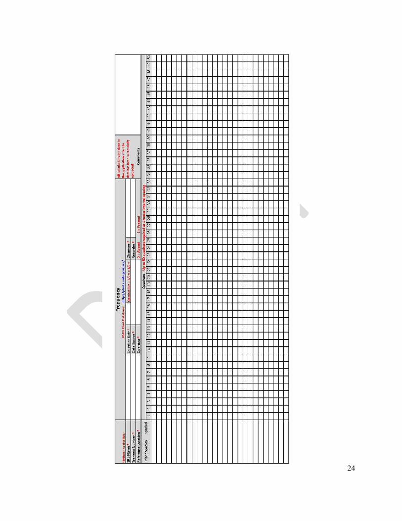
FREQUENCY
The following frequency protocols were adapted from the Sampling Vegetation Attributes
Interagency Technical Reference 1734-4 (Coulloudon, Eshelman and Gianola). Frequency is
required to be gathered and reported to monitor abundance of forbs and shrubs for interim and final
reclamation per the 2008 SEIS ROD, pages C-3 and C-4.
Forb and shrub rooted frequency data, by species, will be gathered along 1, 100-meter transect per
5 acres of each ecological site/general vegetation composition (which is the two most abundant plant species, for example Wyoming big sagebrush-western wheatgrass plant community) in
reclamation for a well-pad. A transect can be established in a number of different configurations (e.g., linear, two 50-meter transects that cross in the center to form an ‘X,’ etc.) to adapt to limitations such as change in the direction of the seed row. The sample size must be at least the
minimum based on the ecological site or general vegetation composition (see above) (pp. 33). The
most up to date list of sample sizes will be available on PADMS. If a sample size is not available
then the minimum is 50 per transect. A ½-meter by ½ -meter quadrat will be used by all data
collectors.
Equipment
Frequency – Plant Species Diversity data form (download the current form from PADMS)
Frequency frame (½-meter by ½-meter)
1, 100-meter tape measure
Compass
2 steel pins
Writing utensil
Clipboard
Data Collection Rules
1) Extend the tape 100 meters and secure each end with a steel pin
a. Ensure the tape is tight
b. The tape should be as close to the ground as possible
2) Walk on one side of the tape only, and place the quadrat on the opposite side
a. Place a corner of the quadrat at the meter mark where data will be collected with
one of the ½-meter sides running parallel with the measuring tape, and the quadrat
extending away from the monitor. The monitor should consistently place the
quadrat with or against the direction of travel along the transect.

23
Record rooted presence (1) or absence (0) data for each forb and shrub species within a quadrat
using the frequency form (pp. 24). Each species is recorded only once per quadrat regardless of the
number of times it occurs within the quadrat.
1) Forbs must be rooted in the quadrat to be counted
2) Shrubs must be rooted in the quadrat to be counted. For shrubs with multiple stems that
emerge from the soil surface, any portion of the multiple stems emerging from the soil
surface within the quadrat will be considered to be rooted in the quadrat.
3) Annual forbs are counted whether they are green or dry.
4) Unknown forbs should be recorded as annual or perennial, the life form, and for each
unknown species that is encountered record a number (e.g., 1 unknown annual forb would
be AF1, or the third unknown perennial forb encountered would be PF3).
5) Unknown shrubs should be recorded as ‘SH’ followed by a number (e.g., 1 unknown shrub
would be SH1, or the third unknown shrub encountered on a transect would be SH3).
Calculation
1) Percent Frequency by Forb Species
a. Total the number of quadrats a forb species occurred in (i.e., present – 1).
b. Divide the total from above (‘a’) by the total number of quadrats sampled along a
transect.
c. Take the calculated value from ‘b’ and multiply it by 100, and record the percent
frequency of the forbs.
2) Percent Frequency by Shrub Species
a. Total the number of quadrats a shrub species occurred in. (i.e., present – 1).
b. Divide the total from above (‘a’) by the total number of quadrats sampled along a
transect.
c. Take the calculated value from ‘b’ and multiply it by 100, and record the percent
frequency of the shrubs.
24

25
ECOLOGICAL SITE/VEGETATION TYPE SAMPLE SIZES
The PAPO worked with the BLM National Operations Center (NOC) to calculate a minimum
sample size by ecological site or vegetation type to monitor shrub and forb frequency. The
following pages explain the process used to calculate the minimum sample size to monitor shrub
and forb frequency.
The same process was implemented for other ecological sites/vegetation types where data were
sufficient. The minimum sample size for locations without a calculated sample size is 50. An
operator/contractor can have sample size greater than the minimum sample size. In other words, if
someone does not want to track which ecological site/vegetation type they are monitoring, they
can streamline the process by using the largest, minimum sample size. Currently, the largest,
minimum sample size is 50 (pp. 33).
13 May 2011
Estimating Minimum Sample Size Required for Monitoring Frequency of
Native Shrubs and Native Forbs on Mesa on Pinedale Anticline
Sources: pages 17 to 20 in Technical Reference 1734-4, Sampling Vegetation Attributes, and
pages 360-361 in Technical Reference 1730-1, Measuring and Monitoring Plant Populations
Native Shrub Frequency
To estimate minimum sample size required for monitoring native shrub frequency and native forb
frequency, pilot sampling must occur with an arbitrarily selected sample size. The pilot sampling
determines at what sample size the average and the standard deviation stabilize. The final average
and standard deviation from the pilot sampling should be used to calculate the sample size
necessary to estimate the average with a certain level of confidence and precision.
The management objectives for native shrub frequency and native forb frequency state that the
average native shrub frequency or average native forb frequency on reclaimed areas must be a
certain percentage of the native shrub frequency or native forb frequency found on reference areas,
by a certain time period. No estimate of the precision of the estimated native shrub frequency or
native forb frequency has been stated.
Below is a pilot sample for native shrub frequency on a reference area called Mesa. Forty sampling
units were collected for native shrub frequency and here is a sequential sampling or running tally
of the average and standard deviation for the 40 sampling units. N is equal to sample size. SD is
equal to standard deviation.

26
N
Native Shrub
Frequency Average SD
1 1 1.000 0.000
2 1 1.000 0.000
3 1 1.000 0.000
4 1 1.000 0.000
5 0 0.800 0.447
6 0 0.667 0.516
7 1 0.714 0.488
8 0 0.625 0.518
9 0 0.556 0.527
10 0 0.500 0.527
11 0 0.455 0.522
12 0 0.417 0.515
13 1 0.462 0.519
14 1 0.500 0.519
15 1 0.533 0.516
16 1 0.563 0.512
17 1 0.588 0.507
18 1 0.611 0.502
19 1 0.632 0.496
20 1 0.650 0.489
21 0 0.619 0.498
22 1 0.636 0.492
23 1 0.652 0.487
24 0 0.625 0.495
25 1 0.640 0.490
26 0 0.615 0.496
27 0 0.593 0.501
28 1 0.607 0.497
29 1 0.621 0.494
30 0 0.600 0.498
31 1 0.613 0.495
32 1 0.625 0.492
33 1 0.636 0.489
34 1 0.647 0.485
35 1 0.657 0.482
36 1 0.667 0.478
37 0 0.649 0.484
38 1 0.658 0.481
39 1 0.667 0.478
40 1 0.675 0.474

27
Here is a graph showing the running tally of the average and standard deviation for this sample of
40.
The graph shows that at about sample size 10, the standard deviation begins to stabilize and there is
no further appreciable decline in variation of shrub frequency with sample sizes greater than 10.
This shows that the sample size used should not be less than 10. It also shows that the pilot sample
of 40 quadrats was large enough so that the average and standard deviation stabilized.
The interim reclamation management objective is to have average frequency of shrubs on the
reclaimed area be at least 50% of the reference area within 5 years.
The sample size equation required for this situation is determining the necessary sample size for
detecting differences between 2 proportions with temporary sampling units. This can be found on
pages 360-361 in Measuring and Monitoring Plant Populations. The assumption is made here that
the quadrats that will be sampled on the reclamation area, and the quadrats on the reference area,
are temporarily rather than permanently positioned. The 2 proportions are the average native shrub
frequency on the reference area, and the average native shrub frequency on the reclamation area.
The difference between the 2 proportions is 50% for the interim reclamation management
objective.
0.000
0.200
0.400
0.600
0.800
1.000
1.200
1 3 5 7 9 11 13 15 17 19 21 23 25 27 29 31 33 35 37 39
Average (Green)
and
Standard Deviation
(Purple)
Sample Size
Native Shrub Frequency
Mesa 7-27 Reference

28
The sample size equation is:
N = (Zα + Zβ)2
X (p1q1 + p2q2)
(p2 –p1)2
Where Zα = the Z coefficient for a false-change (Type I) error rate (in this case the error we are
willing to make that the management objective is being achieved when it really has not been
achieved)
Zβ = the Z coefficient for a missed-change (Type II) error rate (in this case the error we are
willing to make that the management objective is not being achieved when it really has been
achieved)
p1 = the value of the proportion for the first sample as a decimal.
q1 = 1 – p1.
p2 = the value of the proportion for the second sample as a decimal. This is determined
based on the magnitude of change one wishes to detect.
q2 = 1 – p2.
Parties monitoring reclamation on the Pinedale Anticline are interested in detecting a difference
between the average shrub frequency on the reclamation area and the average shrub frequency on
the reference area where the reclamation area is less than the reference area. Therefore, they will
need to use 1-tailed values for Zα and Zβ. Detecting a difference where the average shrub frequency
on the reclamation area is greater than the average shrub frequency on the reference area is not an
objective of this process.
For the interim reclamation management objective, the hypotheses being tested are:
The null hypothesis is:
Ho: Average native shrub frequency on the reclaimed area is less than 50% of the average native
shrub frequency on the reference area
And the alternate hypothesis is:
Ha: Average native shrub frequency on the reclaimed area is 50% or more of the average native
shrub frequency on the reference area
In order to be 80% certain (confident) of detecting a 50% change (that the average shrub frequency
on the reclamation area is 50% of the reference area) in average shrub frequency and to accept a
20% chance that the management objective has been achieved but really has not, then the Zα value
will be 0.84 and the Zβ value will be 0.84. p1 equals the proportion (frequency) of native shrubs on
the reference area which is 0.675, q1 equals 1 – 0.675 or 0.325, p2 equals the proportion
(frequency) of native shrubs on the reclaimed area that would be 50% or more of the reference area
which would be 50% of 0.675 or 0.3375, and q2 equals 1 – 0.3375 or 0.6625. Plugging these values
into the sample size equation yields:

29
N = (0.84 + 0.84)2 X ((0.675 X 0.325) + (0.3375 X 0.6625))
(0.3375 – 0.675)2
And N will equal 10.976 quadrats, which rounds up to 11 quadrats. Eleven quadrats will be the
necessary sample size on the reclamation area, to be 80% confident that an average shrub
frequency calculated on the reclamation area really is 50% or more of the average shrub
frequency on the reference area.
Any power greater than 80% will require greater sample sizes than these.
Native Forb Frequency
Below is a pilot sample for native forb frequency on a reference area called Mesa. Forty sampling
units were collected for native forb frequency and here is a sequential sampling or running tally of
the average and standard deviation for the 40 sampling units. N is equal to sample size. SD is equal
to standard deviation.
N
Native Forb
Frequency Average SD
1 1 1.000 0.000
2 1 1.000 0.000
3 1 1.000 0.000
4 1 1.000 0.000
5 1 1.000 0.000
6 1 1.000 0.000
7 1 1.000 0.000
8 1 1.000 0.000
9 1 1.000 0.000
10 1 1.000 0.000
11 0 0.909 0.302
12 1 0.917 0.289
13 0 0.846 0.376
14 0 0.786 0.426
15 1 0.800 0.414
16 1 0.813 0.403
17 1 0.824 0.393
18 1 0.833 0.383
19 0 0.789 0.419
20 1 0.800 0.410
21 0 0.762 0.436
22 1 0.773 0.429
23 1 0.783 0.422

30
24 1 0.792 0.415
25 0 0.760 0.436
26 1 0.769 0.430
27 0 0.741 0.447
28 1 0.750 0.441
29 1 0.759 0.435
30 1 0.767 0.430
31 0 0.742 0.445
32 1 0.750 0.440
33 1 0.758 0.435
34 1 0.765 0.431
35 1 0.771 0.426
36 1 0.778 0.422
37 1 0.784 0.417
38 1 0.789 0.413
39 1 0.795 0.409
40 0 0.775 0.423

31
Here is a graph showing the running tally of the average and standard deviation for this sample of
40.
The graph shows that at about sample size 15, the average and standard deviation begin to stabilize
and there is no further appreciable decline in variation of forb frequency with sample sizes greater
than 15. This shows that the sample size used should not be less than 15. It also shows that the pilot
sample of 40 quadrats was large enough so that the average and standard deviation was able to
stabilize.
The interim reclamation management objective is to have average frequency of forbs on the
reclaimed area be at least 75% of the reference area within 5 years. For the interim reclamation
management objective, the sample size equation required for this situation is determining the
necessary sample size for detecting differences between 2 proportions with temporary sampling
units. This can be found on pages 360-361 in Measuring and Monitoring Plant Populations. The
assumption is made here that the quadrats that will be sampled on the reclamation area, and the
quadrats on the reference area, are temporarily rather than permanently positioned. The 2
proportions are the average native forb frequency on the reference area, and the average native
forb frequency on the reclamation area. The difference between the 2 proportions is 25% for the
interim reclamation management objective.
0.000
0.200
0.400
0.600
0.800
1.000
1.200
1 3 5 7 9 11 13 15 17 19 21 23 25 27 29 31 33 35 37 39
Average (Green)
and Standard
Deviation (Purple)
Sample Size
Native Forb Frequency
Mesa 7-27 Reference

32
The sample size equation is:
N = (Zα + Zβ)2
X (p1q1 + p2q2)
(p2 –p1)2
Where Zα = the Z coefficient for a false-change (Type I) error rate (in this case the error we are
willing to make that the management objective is being achieved when it really has not been
achieved)
Zβ = the Z coefficient for a missed-change (Type II) error rate (in this case the error we are
willing to make that the management objective is not being achieved when it really has been
achieved)
p1 = the value of the proportion for the first sample as a decimal.
q1 = 1 – p1.
p2 = the value of the proportion for the second sample as a decimal. This is determined
based on the magnitude of change one wishes to detect.
q2 = 1 – p2.
Those monitoring reclamation on the Pinedale Anticline are interested in detecting a difference
between the average forb frequency on the reclamation area and the average forb frequency on the
reference area where the reclamation area is less than the reference area. Therefore, they need to
use 1-tailed values for Zα and Zβ. Detecting a difference where the average forb frequency on the
reclamation area is greater than the average forb frequency on the reference area is not an objective
of this process.
For the interim reclamation management objective, the hypotheses being tested:
The null hypothesis is:
Ho: Average native forb frequency on the reclaimed area is less than 75% of the average native
forb frequency on the reference area
And the alternate hypothesis is:
Ha: Average native forb frequency on the reclaimed area is 75% or more of the average native forb
frequency on the reference area
In order to be 80% certain (confident) of detecting a 25% change (that the average forb frequency
on the reclamation area is 75% of the reference area) in average forb frequency and willing to
accept a 20% chance that the management objective has been achieved but really has not, then the
Zα value will be 0.84 and the Zβ value will be 0.84. p1 equals the proportion (frequency) of native
forbs on the reference area which is 0.775, q1 equals 1 – 0.775 or 0.225, p2 equals the proportion
(frequency) of native forbs on the reclaimed area that would be 75% or more of the reference area
which would be 75% of 0.775 or 0.58125, and q2 equals 1 – 0.58125 or 0.41875. Plugging these
values into the sample size equation yields:

33
N = (0.84 + 0.84)2 X ((0.775 X 0.225) + (0.58125 X 0.41875))
(0.58125 – 0.775)2
And N will equal 31.41 quadrats, rounding up to 32 quadrats. Thirty-two quadrats will be the
necessary sample size on the reclamation area to be 80% confident that an average forb
frequency calculated on the reclamation area really is 75% or more of the average forb
frequency on the reference area.
Any power greater than 80% will require a greater sample size than this.

34
14 June 2011 Minimum Sample Sizes Pinedale Anticline Native Shrub Frequency Native Forb Frequency Loamy 7-9
inch Green
River and
Great Divide
Basins (Big
Sagebrush/Bu
nchgrass)
Loamy 7-9 inch
Green River
and Great
Divide Basins
(Mixed
Grass/Big
Sagebrush)
Shallow
Loamy 10-14
inch Foothills
and Basins
West
Loamy
10-14 inch
Foothills
and Basins
West
Sandy 7-9
inch Green
River and
Great
Divide
Basins
Saline Upland
7-9 inch Green
River and
Great Divide
Basins
Saline
Lowland,
Drained 7-9
inch Green
River and
Great Divide
Basins
Gravelly 7-9
inch Green
River and
Great Divide
Basins
Clayey 7-9
inch Green
River and
Great Divide
Basins
Native Shrub
Frequency
Interim Reclamation
25 30 Cannot Estimate Sample Size from pilot sample because pilot sample too small. Need Larger Pilot Sample.
35 20 Cannot Estimate Sample Size from pilot sample because pilot sample too small. Need Larger Pilot Sample.
35 Cannot Estimate Sample Size from pilot sample because pilot sample too small. Need Larger Pilot Sample.
50
Native Forb
Frequency
Interim Reclamation
40 50 Cannot Estimate Sample Size from pilot sample because pilot sample too small. Need Larger Pilot Sample.
30 36 Cannot Estimate Sample Size from pilot sample because pilot sample too small. Need Larger Pilot Sample.
Cannot Estimate Sample Size from pilot sample because pilot sample too small. Need Larger Pilot Sample.
Cannot Estimate Sample Size from pilot sample because pilot sample too small. Need Larger Pilot Sample.
40
35
COVER (FOLIAR and GROUND), SPECIES COMPOSITION, and
PRODUCTION
Please Note: The BLM and PAPO will assess the proposed modified line-point intercept method to
collect cover, species composition, and to estimate production during the 2012 field season. The
Operators and contractors will use the same procedures for line-point intercept they have used in
prior years for the 2012 field season.
The protocols for collecting cover (foliar and ground) follow the line-point intercept (LPI)
methods adopted from the Monitoring Manual for Grassland, Shrubland and Savanna
Ecosystems, Volume I: Quick Start (J. E. Herrick, J. W. Van Zee and K. M. Havstad) and some
calculations are adopted from (Coulloudon, Eshelman and Gianola). Foliar cover must be gathered
and reported to monitor plant species composition, wildlife habitat, and vegetation production of
interim and/or final reclamation per the 2008 SEIS ROD, pages C-1, C-2, C-3, and C-4. Ground
cover must be gathered and reported to monitor potential for soil erosion (soil stability) of interim
and final reclamation per the 2008 SEIS ROD, pages C-1, and C-3.
The line-point intercept method is used to monitor cover including soil and vegetation (J. E.
Herrick, J. W. Van Zee and K. M. Havstad). Foliar cover has been closely related to vegetation
production (J. Herrick, J. Van Zee and Havstad, K.M.), and compared with other methods, such as
frequency, foliar cover is considered to be more directly related to vegetation production (Elzinga,
Salzer and Willoughby). For example, Poissonet et al. (1973) showed there is a direct relationship
between increasing foliar cover and increasing biomass production, or decreasing foliar cover and
decreasing biomass.
Foliar cover by species, and ground cover, will be collected at every meter along a 1, 100-meter
transect per 5 acres of each ecological site/general vegetation composition (see below) in
reclamation for a well-pad. A transect can be established in a number of different configurations (e.g., linear, two 50-meter transects that cross in the center to form an ‘X,’ etc.) to adapt to limitations such as change in the direction of the seed row or the size/shape of the area being inventoried.
Equipment
Line-point intercept data form (download the current form from PADMS)
A straight pointer – at least 75 cm long and less than 1 mm in diameter
1, 100-meter tape measure
Compass
2 steel pins
Writing utensil
Clipboard

36
Data Collection Rules
1) Extend the tape 100 meters and secure each end with a steel pin
a. Ensure the tape is tight
b. The tape should be as close to the ground as possible
2) Walk on only one side of the measuring tape
3) Begin at the ‘0’ end of the measuring tape
4) Drop the pointer from a height greater than what the vegetation is, so all vegetation has as
least some probability of being hit by the pointer as the pointer drops through the
vegetation to the soil surface.
a. The pointer should be vertical
b. Do not guide the pointer all the way to the ground
5) When the pointer is flush with the ground, record every plant species it intercepted
(touched) from the first interception in the air all the way to the soil surface.
a. Record the species of the first stem, leaf or plant base intercepted in the “Top
Layer” column using the USDA Plants database species code
(http://plants.usda.gov/java/)
b. Record all additional species intercepted by the pin, in the ‘Lower Layers’
columns. Even if the same plant species is intercepted more than 1 time, record the
plant species each time it is intercepted.
c. If no leaf, stem, or plant base is intercepted, record ‘None’ in the ‘Top Layer’
column.
d. Record herbaceous (i.e., grass, grasslike, forb) litter as ‘L,’ if present. Litter is
defined as detached dead stems and leaves that are part of a layer that comes in
contact with the ground. Record ‘WL’ for detached woody litter that is greater than
5 mm in diameter and in direct contact with the soil. If present and not embedded,
record Litter and Woody Litter in ‘Lower Layers’ columns.
e. If the genus is identifiable, but not the species, use the USDA Plants database genus
code.
f. If you cannot identify the genus, use the following codes:
i. AF#: Annual forb (includes biennials)
ii. PF#: Perennial forb
iii. AG#: Annual graminoid
iv. PG#: Perennial graminoid
v. SH#: Shrub
vi. TR#: Tree

37
g. Foliage can be alive or dead. Be sure to record all species intercepted.
6) Record whether the pointer intercepts a plant base or one of the following in the ‘Soil
Surface’ column.
a. Species code, for basal intercept
b. R: rock fragment ( > 5 mm diameter)
c. BR: bedrock
d. M: moss
e. LC: visible lichen crust on soil
f. S: soil without any other soil surface code
g. EL: embedded litter – where removal of the litter would leave an indention in the
soil surface or disturb the soil surface
h. D: duff – where there is no clear boundary between litter and soil, and litter is not
removed during typical storms (occurring annually).
i. For unidentified plant bases, use the codes listed under 5.f (above)
Calculations
1) Percent Foliar Cover by Species, Vegetative Composition, and Production:
a. Count the total number of plant intercepts, by species, in the ‘Top Layer’ column,
the ‘Lower Layers’ columns, and the ‘Soil Surface’ column.
b. Count the total number of plant intercepts in the ‘Top Layer’ column, the ‘Lower
Layers’ columns, and the ‘Soil Surface’ column.
c. Divide the total number of plant intercepts by species in ‘a’ by the total number of
plant intercepts in ‘b.’
d. Multiply the decimal (‘c’) by 100 to get percent foliar cover by species.
e. The list of percent foliar cover by species constitutes the plant species composition
f. Changes in percent foliar cover by species over time can be correlated to changes in
aboveground production by species over time.
2) Percent Bare Ground:
a. Count the total number of points along the transect that have bare ground. In other
words, points where:
i. There are no plant intercepts recorded in the ‘Top Layer’ column (None is
recorded in the ‘Top Layer’ column) or ‘Lower Layers’ column (left blank)
and,
ii. Soil (i.e., ‘S’) is recorded in the ‘Soil Surface’ column
b. Multiply the total number from ‘a’ by 1 and record the percent bare ground.

38
3) Percent Ground Cover:
a. Subtract the percent bare ground (2b – above) from 100% to get the percent ground
cover for each transect.

39
40
PLANT SPECIES DIVERSITY
The protocols for collecting plant species diversity follow the Line-Point Intercept with Plot-Level
Plant Species Inventory method adopted from the BLM Terrestrial Indicators and Methods
Technical Note 440 (MacKinnon, Karl and Toevs). Plant species diversity is required to be
gathered and reported to monitor number of plant species of interim and final reclamation per the
2008 SEIS ROD, pages C-1, C-2, and C-3.
Equipment
Frequency – Plant Species Diversity data form¹ (download the current form from PADMS)
1, 100-meter tape measure
Compass
2 steel pins
Writing utensil
Clipboard
Data Collection Rules
1) Use the same 100-meter transect (measuring tape) used to gather frequency, and cover
(foliar and ground) data. Extend the tape 100 meters and secure each end with a steel pin
2) Search, by walking, a circular plot that is centered at the 50-meter point on the transect, and extends out to the 25-meter point on the transect, and out to the 75-meter point on the transect, for a circular plot of 50 meters in diameter. Walk so as to search the area of this 50-meter diameter circular plot evenly during a 15-minute period. Search for plant species, and record each plant species encountered during this 15-minute period. Continue searching the plot area for plant species after the 15 minutes until new species are detected at intervals of 2 minutes or more. When new plant species are detected at intervals of 2 minutes or more, stop searching.
3) Record all species encountered on the ‘Frequency – Plant Species Diversity’ data form¹
(pp. 24). If the genus is identifiable, but not the species use the USDA Plants database
genus code.
4) If you cannot identify the genus, use the following codes:
i. AF#: Annual forb (includes biennials)
ii. PF#: Perennial forb
iii. AG#: Annual graminoid
iv. PG#: Perennial graminoid
v. SH#: Shrub
vi. TR#: Tree

41
Calculation
1) Plant Species Diversity
a. List, and total the number of different species recorded during the search.
b. Add to this list of plant species, all other additional plant species encountered from
the frequency, and foliar cover collected on the transect.
c. Compile a list of all the plant species that includes the plant species in ‘a’ and ‘b,’
and provide the total number of plant species.
¹Currently, if a species is encountered when collecting plant species diversity, but not in the
frequency quadrat the frequency data for that species should be recorded as absent ‘0’ when
uploading data into PADMS.

42
QUALITATIVE MONITORING SHEET
Well Name/ Number
Monitoring Date
Company
Inspector
Well Pad Access Road Pipeline Other
Topsoil Storage Stockpile (> 3ft) Stockpile (< 3ft) Direct Haul None
Length of Topsoil Storage (months)
Seeding Method Broadcast Drill Other
Date Seeded Seed Mix_________________________
Soil Amendment Date of Amendment Application
Item Monitoring Requirement Description Yes No
1 Is seed germination apparent? Seeds have germinated, seedlings are emerging.
2 Is the area free of undesirable
materials?
Trash, construction materials, etc.
3 Is the soil stable with no
indications of subsidence,
slumping and/or significant
erosion?
Rills greater than 2 inches, accelerated erosion is
obvious and soils are not being held by plants on
site, sheet flow, head cutting in drainages, slopes
occurring on or adjacent to reclaimed areas.
4 Absence of noxious weeds? Perennial pepperweed, Canada thistle, black
henbane, leafy spurge, yellow or Dalmatian
toadflax, spotted knapweed, Russian knapweed,
etc.
5 Absence of other undesirable
species?
Cheatgrass, Japanese brome, halogeton, Russian
thistle, etc.
6 Is there evidence of good
reproductive capability?
Seed production is evident.
Amount of tillers, rhizomes, flowers, and/or seed
stalks are comparable to the reference site.
To answer yes, must have for all three plant types:
grass, forb, and shrub.
7 Is there evidence of vegetative
litter decomposing into the soil?
Item 7: Year of Reclamation
Years 2 - 3 Years 4 - 5 Years 6 -7 Years 8+
If any of the items are answered “No” above, please identify the problem, attach explanation and
photographs, and contact BLM Reclamation Specialist.

43
Appendix C Recommended Seed Mixes

44
The PAPO is working to develop recommended seed mixes with species that are generally,
readily available on the market, native, and have demonstrated success in the area. The PAPO
anticipate the final, recommended seed mixes will be completed by the 2013 field season.

45
Appendix D September, 2008 Record of Decision Final Supplemental Environmental Impact Statement for the
Pinedale Anticline Oil and Gas Exploration and Development Project – Appendix C

46
Appendix C Reclamation Plan
Pinedale Anticline ROD C-1
Reclamation Plan
All operators are responsible for the satisfactory and timely reclamation of the land surface disturbed by their operations in accordance with federal regulations and the standards, guidelines, and criteria set forth below. These standards will apply to all surface disturbing activities including but not limited to pads, roads, right-of-way, and all industry associated pipelines. All surface disturbances will be reclaimed to meet Bureau of Land Management (BLM) standards as described in Surface Operating Standards and Guidelines for Oil and Gas Exploration and Development – The Gold Book, and specific criteria identified in this document. Habitat and livestock grazing reclamation will be initiated to meet criteria standards on all portions of the well pads, access roads, etc not needed for production operations when the last well on the pad is drilled and completed or when no forecasted drilling (based in existing Wyoming Oil and Gas Conservation Commission permitted spacing or depth limitations) or completion activity is expected within two years, but additional well development activity is planned on the pad. Site stabilization including seeding will occur during the first appropriate growing season. BLM will coordinate such requests for expansion and reoccupation with Wyoming Game and Fish Department and/or other appropriate agencies through the Application for Permit to Drill (APD) process. Where practical this coordination would occur through the annual meeting, but could occur on a case-by-case basis throughout the year. These specific requirements are subject to modification through the adaptive management process. C.1 Reclamation Objectives
The objective of interim reclamation is to achieve healthy, biologically active topsoil; control erosion; and restore habitat, visual, and forage function on those portions of the disturbed area not need for production operations for the life of the well or facilities or until final reclamation is initiated. Interim reclamation will be considered successful when:
• Disturbed areas not needed for long-term production operations or vehicle travel are recontoured, protected from erosion, and revegetated with a self-sustaining, vigorous, diverse, native (or otherwise approved) plant community sufficient to minimize visual impacts, provide habitat and forage, stabilize soils, and impede the invasion of noxious weeds.
The objective of final reclamation is to achieve habitat, forage, and hydrologic function the functions that existed prior to disturbance. Including restoration of the original landform or creating a landform that approximates and blends in with the surrounding landform. Final reclamation involves restoring natural vegetative community, hydrologic systems, visual resources, agricultural values and wildlife habitats. Final reclamation will be considered successful when:
• The original landform is restored for individual disturbed areas including well pads, production facility areas, roads, pipelines, and utility corridors. • A self-sustaining, vigorous, diverse, native (or otherwise approved) plant community is established on the site, with a density or frequency sufficient to control erosion and non-native plant invasion and reestablish wildlife habitat and forage production. Sites demonstrate productivity approximately equal to or better than pre-disturbance levels.

47
• Plants are resilient as evidenced by well-developed root systems, flowers, and seed heads. Sites must exhibit sustainability of desired attributes after the removal of external influences for a period of not less than one year. • Shrubs are well established and in a “young” age class at a minimum (therefore, not comprised of seedlings that may not survive until the following year). • In agricultural areas, irrigation systems and soil conditions are reestablished in such a way as to ensure successful cultivation and harvesting of crops. • Erosion control is sufficient so that water naturally infiltrates into the soil and gullying, headcutting, slumping, and deep or excessive rilling (greater than 3 inches) or excessive sheet erosion is not observed. • The site is free of federal, state and county-listed noxious weeds, oil field debris, contaminated soil, and equipment.
C.2 Reclamation Plan and Annual Reports
The operators will prepare a detailed Reclamation and Monitoring Plan within 1 year of the signing of this ROD. The Plan will include appropriate quantitative and qualitative reclamation and monitoring standards, as detailed below. Site-specific reclamation plans will continue to be included with the section 10 of the 13 point Surface Use Plan of Operations for APD-related surface disturbing activity and in the Plan of Development (POD) for right-of-way related actions. The reclamation plan for surface disturbance should reference and be consistent with the overall Reclamation Plan for the SEIS area and should reference the ecological site type when the site type is available, or will reference the general vegetation composition if ecological site type data is not available. The plan will address erosion control measures including wind erosion. Reclamation standards, objectives, and results will be reviewed during the annual planning meetings. Reclaimed sites should be inspected annually (until either interim or final criteria, whichever is applicable for the location, is achieved) and evaluated the first and third growing seasons post seeding to determine if desirable plants are establishing. Operators will provide annual ERRP reports indicating reclamation status of all locations (to include extent of reclamation, vegetative composition, density or frequency, cover, resilience, sustainability, diversity and noxious weed presence, and surface stability). Surface disturbance reports will include “as built” GIS data in acceptable form for inclusion into BLM database. C.3 Monitoring and Evaluation
The operators will monitor and evaluate reclamation success and shall prepare an annual monitoring and evaluation report to be submitted to BLM and the cooperating agencies a minimum of 3 weeks prior the annual meeting. Sites will be monitored and evaluated by individuals skilled in rangeland or reclamation monitoring (including knowledge of local ecology and plant identification). An interagency review team will annually review and analyze the annual monitoring results and methods. Annual satellite imagery or other comparable imagery may assist in monitoring and evaluation. Should the success criteria stated below not be met, the operators will be responsible for implementing additional measures as directed by BLM. Wyoming Game and Fish Department (WGFD), Wyoming Department of Environmental Quality (WDEQ) and/or other appropriate agencies may provide guidance and suggestions to BLM what the additional measures could include, such as: soil amendments, reseeding, inter-seeding, providing precipitation, fencing to isolate plantings from ungulates, and creating snow fences to increase local snow depth.

48
C.4 Interim or Final Reclamation Criteria
A sample representation of the vegetative population will be used to collect the vegetative data on the reclamation and reference site. The reference site location will represent the ecological characteristics of the well pad prior to disturbance. Successful reclamation to facilitate restoration of habitat function will be measured in stages as follows:
• Within 1 year of initiation of interim or final reclamation sites will demonstrate the establishment of a viable desirable seedling density or frequency. Desirable seedling density or frequency, compared to reference site, shall consist of a vigorous, diverse, native (or otherwise approved) plant community or ecologically comparable species as approved by BLM Authorizing Officer (AO).
C.4.1 Vegetative Criteria for Interim Reclamation
1. Native Forbs: The average density or frequency of desirable forbs must be a minimum of 75% of the reference site within 5 years. Diversity of forbs on a reclaimed site must be equal to or greater than the reference site within 5 years.
2. Native Shrubs: The average density or frequency of the shrub component must be at least 50 % of the reference site within 5 years. This includes both shrubs and half shrubs (e.g. winterfat, fringed sage, etc.). At least 15% density or frequency of the shrub component must be by the dominant species from reference site. The diversity of shrubs must be equal to or greater than the reference site.
3. Native Grasses: Reclaimed sites must have a minimum of three native perennial grass species present, two of which must be bunch grass species. These are to be planted at rates appropriate to achieve abundance and diversity characteristics similar to those found on the reference site.
4. Non-Native Weeds: Sites must be free from all species listed on the Wyoming and federal noxious weed lists. All state and federal laws regarding noxious weeds must be followed. Other highly competitive invasive species such as cheatgrass and other weedy brome will be actively treated if found in the reclaimed areas.
5. Plant Vigor: Plants must be resilient as evidenced by well-developed root systems, flowers, and seed heads. All sites must exhibit the sustainability of the above desired attributes after the removal of external influences. A minimum of one growing season without external influences (irrigation, mat pads, fences, etc.) may satisfy this requirement.
C.4.2 Full Site Final Reclamation Criteria
1. Ground Cover & Ecological Function
To ensure soil stability and nutrient cycling, ground cover must be equal to or greater than the reference site and vegetative litter must be decomposing into the soil.

49
2. Vegetative Criteria
a. Native Forbs: The average density or frequency and total diversity of forbs must be equal to or greater than the reference site within 8 years
b. Native Shrubs: The average density or frequency of the shrub component must be at least 80% of the reference site within 8 years. This includes both shrubs and half shrubs (e.g. winterfat, fringed sage, etc.). At least 25% density of frequency of the shrub component must be the dominant species from the reference site. The diversity of shrub must be equal to or greater than the reference site.
c. Native Grasses: Reclaimed sites must exhibit grass production equal to the reference site. A minimum of 3 native perennial species must be included with at least 2 bunch grass species.
d. Non-Native Weeds: Sites must be free from all species listed on the Wyoming and Federal noxious weed list. All state and federal laws regarding noxious weeds must be followed. Other highly competitive invasive species such as cheatgrass and other weedy brome grasses are also prohibited.
e. Plant Vigor: Plants must be resilient as evidenced by well-developed root systems and flowers. Shrubs will be well established and in a “young” age class at a minimum (e.g. not comprised of seedlings that may not survive until the following year.
C.4.3 Other Requirements
All seed must be native (or otherwise approved) ecologically suitable species and site-specific. Should available seed mixtures, techniques or other applications be available to enhance the productivity and diversity of the reclaimed area used by wildlife or livestock, these methods should be pursued as approved by the BLM AO. All topsoil from disturbed sites should be salvaged and stockpiled for later use in reclamation. Stockpiled topsoil will be seeded with native perennial grasses or an appropriate cover crop and soil should be reapplied to a reclaimed area while the topsoil is still viable – usually within 2-5 years. Any mulch used would be reasonably free from mold, fungi, or noxious weed seeds. Mulch may include native hay, small grain straw, wood fiber, live mulch, cotton, jute, biodegradable netting, and rock or otherwise approved media. Straw mulch should contain fibers long enough to facilitate crimping and provide the greatest cover. The grantee or lessee would be responsible for the control of all noxious weed infestations on surface disturbances.

50
Appendix E Sample Outline Weed Management Plan

51
Noxious and Invasive Weed Management Plan for Oil and
Gas Development Areas
I. Introduction Weed Management Plan
Noxious and invasive weeds can occur both directly and indirectly from energy development as
well as other development activities that cause disturbance. Weeds and weed seed can be
transported and spread with road surfacing and other construction related events including
reclamation activities. Weeds and weed seed can be attached to equipment and vehicles thus
having the potential to be spread over large areas. Physical disturbance of the soil from pipelines,
well locations, road development and other construction, as well as soil moisture and chemical
alterations from produced water discharge, and stream flow / storage will also create opportunities
for the introduction, infestation and spread of noxious and invasive weeds.
Prevention and control of noxious and invasive weeds should be incorporated into the design,
layout and construction of access roads, pipelines, and well locations as well as other facilities.
Discharge points for water including reservoirs, off-channel containment structures, drainages for
runoff, etc. can harbor weeds and other invasive plants.
Control of noxious and invasive weeds during construction, production, and reclamation using an
integrated approach is most beneficial. Consideration of landscape, soils, desirable vegetation,
open water, water table locations, and land use must be considered.
The spread of weeds to off location / adjacent areas, and other pertinent factors should be
addressed using the most effective combination of any or all of the following methods.
Cultural
a. The prompt seeding and revegetation of areas of disturbed soils with certified
weed-free seed.
b. Encourage the cleaning of equipment and vehicles prior to entering or leaving each
management area. (Pressure wash in a designated area)
c. Minimize soil disturbance, where possible.
d. Use certified weed-free mulch/straw for erosion control.

52
Physical
a. Mowing of weeds in newly revegetated areas during the first season of establishment,
prior to seed formation of the weeds in the revegetated area. Care will be taken to
encourage seed formation and growth of new native plants.
b. Hand pull and remove weedy plants in areas that BLM sensitive species are found and
newly seeded areas.
Biological
a. Use of domestic animals and approved biological agents may be utilized. *NOTE:
biological agents are species specific and can take up to five years before any results
may be detected. Biological agents also require prior approval; see “Policy 1. (c)”.
b. Use of domestic livestock include, but is not limited to, livestock species/ breed;
targeted weed species and necessary management/care of livestock that is used (i.e.
fencing, water, herding, etc.) Use of Livestock require prior approval; see “Policy 1.
(b)”.
Chemical
a. Consider weed species, the site on which the herbicide will be applied, method of
application, and desired result when selecting the herbicide for treatment and control of
noxious/ invasive weeds.
b. Ensure selected herbicides are BLM approved for weed(s) that are to be controlled, and
chemical label applications are followed.
c. ALL herbicides are required to be applied by a certified commercial applicator(s).
II. Goals
1. Prevent new infestations of noxious weeds in and around the project area(s), provide
inventory, monitoring, and control methods of existing infestations. Including the areas
that are affected off pad or (lease).
2. Implement an integrated weed management plan to eradicate/manage noxious weeds
populations, including areas that may be affected off pad. *NOTE: Weeds are to be
mapped and reported by township, range, and section; weeds that are off a pad, but located
on a lease will be treated.
3. Maintain weed inventory, herbicide, and mapping records by lease.

53
III. Policy
1. On BLM administered public lands:
a. An approved Pesticide Use Permit (PUP) is required to apply chemical herbicide.
b. Approval and proper permitting for domestic livestock is required prior to
implementing this as a weed control method.
c. An approved Biological Release Permit (BRP) is required for the release of biological
agents.
d. Upon completion of any pesticide application, a Pesticide Application Record (PAR)
will be completed within 24 hours. The PAR will be kept for 10 years.
2. ALL herbicide applications on BLM administered public lands are required to be applied
by a certified commercial applicator(s).
a. See current list of herbicide approved for application on Bureau of Land Management
administered lands. Contact the BLM, Pinedale Field Office.
b. Weed list for Wyoming and Sublette County. www.wyoweed.org, or contact the BLM,
Pinedale Field Office.
IV. BLM Wyoming Sensitive/ Threatened & Endangered Species
1. Before a chemical pest control program may be initiated, a survey of the area for
Threatened and Endangered Species/ BLM Wyoming Sensitive Species will be made
(BLM Manual sec. 6840).
a. Contact the Pinedale BLM Field Office for a list of plants that may be located in
your Management Area.
V. Incorporate Weed Prevention and Control Measures
a. Use only certified weed-free hay, straw and/or any other materials used for erosion
control and other reclamation activities.
b. Use only certified weed-free gravel and earthen materials for road surfacing and
maintenance.

54
c. Cleaning of equipment and vehicles used in the construction drilling or reclamation
activities prior to entering or leaving a management area. (Pressure washing or other
means in a designated area).
d. Reseed all areas immediately following construction, drilling or other restoration
activities.
e. Use only certified weed-free seed for the reclamation/restoration of areas disturbed by
related development activities.
VI. Initiate a Weed Education Policy
a. Develop cooperative education and awareness programs within your company in
conjunction with State, County and Federal Agencies. (i.e.: Extension Agents, County
Weed and Pest personnel and Local BLM Field Office Representative (s)).
b. Designate a Company representative, who is responsible for weed management and
will be a liaison for the company with State, County and Federal Agencies.
c. Encourage contractors and employees to report new noxious/ invasive weed
infestations to a designated company representative who is responsible for weed
management.
d. Review and make available weed education material at onsite and pre-construction
meetings and offices.
VII. Weed Management Plans Will Include
1. Prevention and Detection: The most important component to controlling noxious weeds.
Early detection and proper identification of a new weed infestation is critical to any
successful weed management plan. This management plan will include how
noxious/invasive weeds will be detected.
2. Inventory and Mapping: Maintaining accurate records aids in tracking weed infestations
over time and will aid in the overall management decisions made over time in the weed
management area. This will also include locations of any BLM Wyoming Sensitive
Species. Provide an annual map with identified weed locations and associated control
methods. This map will be included with the annual reclamation reports provided to the
BLM and PAPO January 31 of each year.

55
3. Reporting: Maintain a weed inventory, mapping (GPS) and pesticide application data for
tracking weeds on public lands and other reporting as necessary, and then reported
annually to the BLM, Pinedale Field Office. *Inclusion of an ArcGIS shape file with the
report that contains polygons of weed infestations recorded with a GPS unit is required.
4. Weed Control: After weeds have been inventoried and mapped they must be treated with
the best available weed control techniques with consideration of any BLM Wyoming
sensitive species. Contact the BLM, Pinedale Field Office for assistance.
5. Long Term Monitoring and Retreatment: Many weeds have seeds that remain viable in
the soil for many years. Thus weed management must be viewed as a long-term process
and commitment to the land in order to achieve positive management of the management
area. A long term monitoring plan will be submitted as part of a weed management plan.
6. Spread of Weeds from Pad to undisturbed BLM: Weeds can and will spread to
locations located off of well pads and other construction/development areas to other leases,
BLM lands, and other adjacent lands including private lands . A coordination plan between
all entities involved, including various operators and agencies will be included as part of
any weed monitoring program.

56
Glossary of Terms
Ecological Site: Distinctive kind of land with specific physical characteristics that differs from other kinds of land in its ability to produce a distinctive kind and amount of vegetation.
Ecological Site Description (ESD):
Natural Resources Conservation Service (NRCS) Ecological Site Description - A site description contains interpretations on the physical, climatic, soil and vegetation conditions. Interpretation of vegetation includes major plant species, production by species, composition, cover and plant community dynamics.
Final Reclamation: Achieve habitat, forage, and hydrologic function (functions that existed prior to disturbance) including restoration of the original topography or creating topography that approximates and blends in with the surrounding landform. This also involves restoring the natural vegetation community, hydrologic systems, visual resources, agricultural and wildlife habitats.
Forb: any broad-leaved herbaceous plant that is not a grass, especially one that grows in a prairie or meadow
Grass: hollow-stemmed green plant: a plant with hollow jointed stems and long narrow, usually green leaves and tiny flowers arranged in spikes.
Interim Reclamation: Achieve healthy, biologically active topsoil; control erosion; and restore habitat, and forage function on those portions of the disturbed area not needed for production operations for the life of the well or facilities or until final reclamation is initiated.
Litter: Dead plant material, leaves, sticks, etc.
Noxious Weeds: Plants designated by federal, state, or county authorities as noxious.
Operators: Oil and Gas Companies/ Lease Holders
PAPO: Pinedale Anticline Project Office

57
Reference Locations: An undisturbed location designated and reported, in detail, as a comparable site for evaluation of any surface disturbance/transect that shares similar vegetation, soils, and precipitation zone.
Sensitive Species: Those species found on public lands, designated by a State Director, which could easily become endangered or extinct in a State. The protection provided for these plants are the same as that provided for candidate species.
Shrub: woody plant with several stems: a woody plant without a trunk but with several stems growing from the base
Undesirables: trash that has been used in construction or has been discarded, such as tires, pipe, screws, cans, bottles, paper, etc.
Undesirable species: Native or non-native plant species considered a nuisance, are aggressive, and/or undesirable for any number of reasons.

58
Literature Cited
Coulloudon, Bill, et al. Sampling Vegetation Attributes Interagency Technical Reference 1734-4.
Denver: Bureau of Land Management's National Applied Resource Sciences Center, 1999.
DeForest, Shane. 9167(WYD01) Shapefile submittal from PAPA Operators. Pinedale: Bureau of
Land Management - Pinedale Field Office, 2011.
Elzinga, C.L., D.W. Salzer and J.W. Willoughby. Measuring & Monitoring Plant Populations:
Technical Reference 1730-1. National Applied Resource Sciences Center, Denver, CO:
U.S. Department of Interior, Bureau of Land Management, 1998.
Gregory, Shelly. Adaptive Management Memo. Pinedale: Bureau of Land Management Pinedale
Field Office, 2010.
Herrick, J.E., et al. Monitoring Manual for Grassland, Shrubland and Savanna EcosystemS;
Volume II: Design, supplementary methods and interpretation. Las Cruces: USDA- ARS
Jornada Experimental Range, 2009.
Herrick, Jeffrey E., et al. Monitoring Manual for Grassland, Shrubland and Savanna Ecosystems
Volume I: Quick Start. Las Cruces: USDA-ARS Jonrada Experimental Range, 2009.
MacKinnon, W.C., et al. BLM Core Terrestrial Indicators and Methods Technical Note 440.
Denver: U.S. Department of the Interior, Bureau of Land Management, National
Operations Center, 2011.
Poissonet, P.S., M.P. Poissonet and G.A. Long. "A Comparison of Sampling Methods in Dense
Herbacesous Pasture." Journal of Range Management 26: 65-67 (1973).
ROD, FSEIS. Record of Decision for the Supplemental Environmental Impact Statement Pinedale
Anticline Oil and Gas Exploration and Development Project. Pinedale: Bureau of Land
Management, 2008.
Schweizer, Haylee. "Pinedale Anticline Data Management System (PADMS) Operator Manual."
Fort Collins: USGS, October 2011.