pitted cones and domes on mars: observations in acidalia
TRANSCRIPT

Pitted cones and domes on Mars: Observations in Acidalia Planitia
and Cydonia Mensae using MOC, THEMIS, and TES data
William H. FarrandSpace Science Institute, Boulder, Colorado, USA
Lisa R. Gaddis and Laszlo KeszthelyiAstrogeology Team, U.S. Geological Survey, Flagstaff, Arizona, USA
Received 19 May 2004; revised 3 March 2005; accepted 31 March 2005; published 17 May 2005.
[1] Domes and cones with summit pits located in Acidalia Planitia and Cydonia Mensaewere studied usingMOCandTHEMIS images and aTES-derived thermal inertiamap.Northof 40.5�N latitude, the features have a dome-like morphology, and south of that latitude, themorphology is more cone-like. Layering is apparent in the summit craters of fresher lookingsouthern cones, and asymmetric aprons were observed in some instances. Some of thenorthern domes also display layering in their summit craters, but asymmetric apronswere not observed. The northern domes can also display multiple summit pits or no summitpits at all and can occur in association with higher-albedo ‘‘pancake’’ features. The northerndomes are higher in albedo but have apparent thermal inertias that are lower than thesurrounding plains. The apparent thermal inertia values of the southern cones range fromvalues comparable to the surrounding plains to slightly lower. From the TES thermal inertiamap, we infer that the thermal inertia values of the pitted cones are between those of basalticfine dust and sand, while those of the surrounding plains are closer to that of basaltic sand.While a unique interpretation of the origin of the pitted cones is not possible with theavailable data, we do not find compelling evidence to suggest an origin related to eitherbasaltic volcanism or ground-ice. Instead, an origin for these features through somecombination of mud volcanism and evaporite deposition around geysers and/or springs ismost consistent with the observations.
Citation: Farrand, W. H., L. R. Gaddis, and L. Keszthelyi (2005), Pitted cones and domes on Mars: Observations in Acidalia Planitia
and Cydonia Mensae using MOC, THEMIS, and TES data, J. Geophys. Res., 110, E05005, doi:10.1029/2004JE002297.
1. Introduction
[2] The presence of small pitted cones on the northernplains of Mars was first recognized from analysis of VikingOrbiter imagery [Allen, 1979; Frey et al., 1979]. Largely onthe basis of crater/cone diameter ratio comparisons, thesefeatures were initially thought to be analogous to terrestrialrootless cones (pseudocraters) [Frey and Jarosewich, 1982]such as those that occur in the Lake Myvatn region ofIceland [Thorarinsson, 1953]. However, there is a disparityin size between the cones observed in the Viking imagery(mean diameter of �542 m, this study) and the Icelandicrootless cones (mean diameter of �50 m [Greeley andFagents, 2001]). Smaller cones, with sizes commensuratewith terrestrial rootless cones, have since been observed inMars Orbital Camera (MOC) images of volcanic plains inElysium Planitia and Amazonis Planitia [Lanagan et al.,2001; Greeley and Fagents, 2001]. The larger pitted conesthat occur in the northern plains of Acidalia Planitia andCydonia Mensae are distinct from the smaller cones both interms of geologic setting, size, and, in some cases, mor-
phology. Within the Acidalia and Cydonia areas studiedhere, there appear to be at least two classes of cones. Freyand Jarosewich [1982] also recognized differences in conemorphology, and McGill [2002] noted that more than oneprocess could be involved in the formation of these features.[3] Uncertainty over the nature of the pitted cones is
mirrored by the ongoing debate over the nature and geo-logic history of the Martian northern plains themselves.Recent research has provided very different views of howthe northern plains might have formed. Theories of theformation of the northern plains include their having beensubmerged beneath a long standing ocean [Parker et al.,1989, 1993; Baker et al., 1991; Head et al., 1999] to theirbeing formed by in situ alteration processes followingemplacement of CO2-charged debris flows [Tanaka et al.,2001]. By examining the morphology and occurrence of thepitted cones, further insights might be gained into the rolethat water and other volatiles might have played in shapingthe northern plains as a whole. Data collected by the MarsGlobal Surveyor’s (MGS) MOC narrow-angle (NA) cameraand Thermal Emission Spectrometer (TES) were comparedwith data from the Thermal Infrared Imaging System(THEMIS) on board the Mars Odyssey orbiter to studythe pitted cones in the northern plains of Mars. The
JOURNAL OF GEOPHYSICAL RESEARCH, VOL. 110, E05005, doi:10.1029/2004JE002297, 2005
Copyright 2005 by the American Geophysical Union.0148-0227/05/2004JE002297$09.00
E05005 1 of 14

geomorphology, mineralogy, and thermophysical propertiesof the cones, as well as their relation to the surroundingplains were examined using these data. These observationswere then used to constrain the most likely formationprocesses for these pitted cones. In the following, we placethe cones and domes in their geologic setting, detail the datasets used, describe the new observations made, and thensystematically investigate a wide range of plausible forma-tion mechanisms to reach our final conclusions.
2. Geologic Setting
[4] We focus our attention on the greater Acidalia Planitia(centered approximately at 44�N, 21�W) region of the vastnorthern plains of Mars. We include part of the Cydoniaregion (centered approximately at 34�N, 9�W) immediatelyto the east of Acialia. This study area has abundantoccurrences of pitted cones. Acidalia is a classical darkregion in the northern lowlands of Mars. Recently, on thebasis of the analysis of TES data, it was designated as thetype locale for the ‘‘surface type 2’’ spectral class which hasbeen interpreted as andesitic in composition while the‘‘surface type 1’’ spectral class is interpreted as basaltic[Bandfield et al., 2000]. Several outflow channels, includingAres, Tiu and Kasei Valles, emptied into the Acidalia basin.If the hypothesized northern ocean existed, much of Acid-alia would have been submerged. For example, Figure 1shows that the �3760 m elevation contour, which closelyapproximates the ‘‘Contact 2’’ [Parker et al., 1989] or
‘‘Deuteronilus’’ [Clifford and Parker, 2001] putative shore-line, encompasses most of Acidalia and Cydonia. Theportion of Cydonia examined in this study extends fromAcidalia on the west to 0� longitude and from approximately30�N to 40�N in latitude. While parts of Cydonia rise abovethe �3760 m contour, all of the pitted cones and domesexamined in this study occurred below the �3760 contour(see Figure 1).[5] Much of northern Acidalia has been mapped as being
covered by the Vastitas Borealis Formation (VBF) (the outerboundary of which is denoted by the red line in Figure 1).There are competing hypotheses for the origin of the VBFand the shaping of the northern plains. The mottled andknobby members of the VBF were originally interpreted asbeing volcanic in origin [Scott and Tanaka, 1986]. Morerecent discussions of the nature of the VBF dispute the roleof volcanism in its formation. The VBF surface has beendescribed variously as the former ocean floor of a standingnorthern ocean [Parker et al., 1989, 1993; Baker et al.,1991], as a clastic sedimentary unit dropped from suspen-sion from a short-lived ocean produced by the outflowchannels to the south [Kreslavsky and Head, 2002], andas the product of in situ reworking/alteration of preexistingmaterials by permafrost-related processes [Tanaka et al.,2003]. A sedimentary origin had previously been posited forthe polygonally fractured terrain within the VBF by McGilland Hills [1992] and a ‘‘mud ocean’’ covering the northernplains was posited by Jons [1985, 1986]. While there arenumerous pitted cones within the VBF, they also occur
Figure 1. Context image of Acidalia Planitia region using a MOC wide-angle mosaic as background.The green boundary follows the MOLA-determined �3760 m elevation contour, which approximates the‘‘Contact 2’’ or Deuteronilus putative shoreline [Parker et al., 1989]. The red line outlines the outerboundary of the Hvm, Hvr, and Hvg units of the Vastitas Borealis Formation as it occurs in this region[Scott and Tanaka, 1986]. Occurrences of northern domes examined in this study are plotted as yellowcircles, and southern cones are plotted as magenta triangles.
E05005 FARRAND ET AL.: PITTED CONES AND DOMES ON MARS
2 of 14
E05005

beyond its boundaries. This study addresses pitted coneswithin both the VBF and parts of Cydonia Mensae that lieoutside of the mapped boundaries of the VBF. Dependingon how boundaries are drawn, the western portion ofCydonia includes the AHvh unit, or the hummocky memberof the VBF, of Tanaka et al. [2003]; Hb2, the Hesperianboundary plains unit of Tanaka et al. [2003]; and Hnuundivided Noachian and Hesperian aged material.[6] This evolution in thinking about the nature of the
VBF and the northern plains ofMars leads to a correspondingrange in plausible hypotheses for the formation of thepitted cones and domes, including purely volcanic cindercones, phreatomagmatic constructs, mud volcanoes, andpingos formed by the freezing of mobile groundwater.These various origin hypotheses have implications for thenature of the northern plains in general and that of theVBF in particular. Pitted cone origin hypotheses thatrequire the action of water would also suggest that watercould also have played a major role in the formation ofthe VBF. If we can eliminate some of the origin hypoth-eses from the large list of possible processes that couldhave formed the pitted cones, we may be able to placeadditional constraints on the nature and origin of thenorthern plains.
3. Data and Data Analysis
[7] Data from several Mars Global Surveyor (MGS) andMars Odyssey (MO) instruments were used in this study.Detailed morphologic assessments and size measurementsof the cones were made using MOC NA camera andTHEMIS Visible (Vis) camera images ingested into theUSGS ISIS software [Eliason, 1997; Gaddis et al., 1997;Torson and Becker, 1997]. The MOC images have spatialresolutions ranging from 1.5 to 6 m/pixel. The nominalspatial resolution of THEMIS Vis imagery is 19 m/pixel.These high-resolution images, along with 100-m-pixel, dayand night, single-band THEMIS Mid-Wave Infrared(MWIR) images, were geometrically registered to a com-mon areocentric coordinate system using the ISIS softwareand were overlain on several different image basemapsusing Geographic Information System (GIS) software.USGS scripts [Hare and Tanaka, 2004] were used to aidin taking the data from the ISIS processing environment tothe GIS. The images were overlaid on multiple coregistereddata sets, including the 128 pixels per degree griddedtopography from the Mars Orbiting Laser Altimeter(MOLA), a MOC wide-angle camera mosaic, a 20 pixel perdegree thermal inertia map derived from the ThermalEmission Spectrometer (TES) [Mellon et al., 2002], and4 pixel per degree mineral abundance maps derived fromTES [Bandfield, 2003]. The THEMIS day/night imagepairs were used in conjunction with the TES thermalinertia map [Mellon et al., 2002] to extract informationon thermophysical properties.[8] The THEMIS data were obtained from the Planetary
Data System (PDS) in the form of calibrated at-sensorradiance. The individual channels are not inherentlycoregistered. To achieve coregistration, ISIS software wasused to register the bands to each other and to georegisterthem so that they could be coregistered with, and comparedwith, the other GIS image bases.
[9] Qualitative examination of multispectral propertieswas conducted using both the THEMIS Vis and MWIRcameras [Christensen et al., 2004]. THEMIS has 10 MWIRbands; 9 of these bands are useful for surface studies. Theseare bands 1–9, centered at 6.78, 6.78, 7.93, 8.56, 9.35, 10.21,11.04, 11.79, and 12.57 mm, respectively. For theGISmosaicsassembled for this study, we used band 8 (11.79 mm) for thedaytime scenes and band 9 (12.57 mm) for the nighttimescenes. To look for relative color differences in the THEMISMWIR data, a smaller number of component scenes fromthese mosaics were examined using the nine THEMIS bandsfor surface analysis. Several standard multispectral process-ing approaches, including band ratios, principal componentsanalysis, and decorrelation stretches [Gillespie et al., 1986]were applied to these scenes. The THEMIS Vis camerahas 5 bands in the visible to near infrared (VNIR) (bandcenters at 0.42, 0.54, 0.65, 0.75, and 0.86 mm). In allTHEMIS Vis images examined, the fifth band wasunusable due to an unacceptably low SNR.[10] The THEMIS MWIR data provide important in-
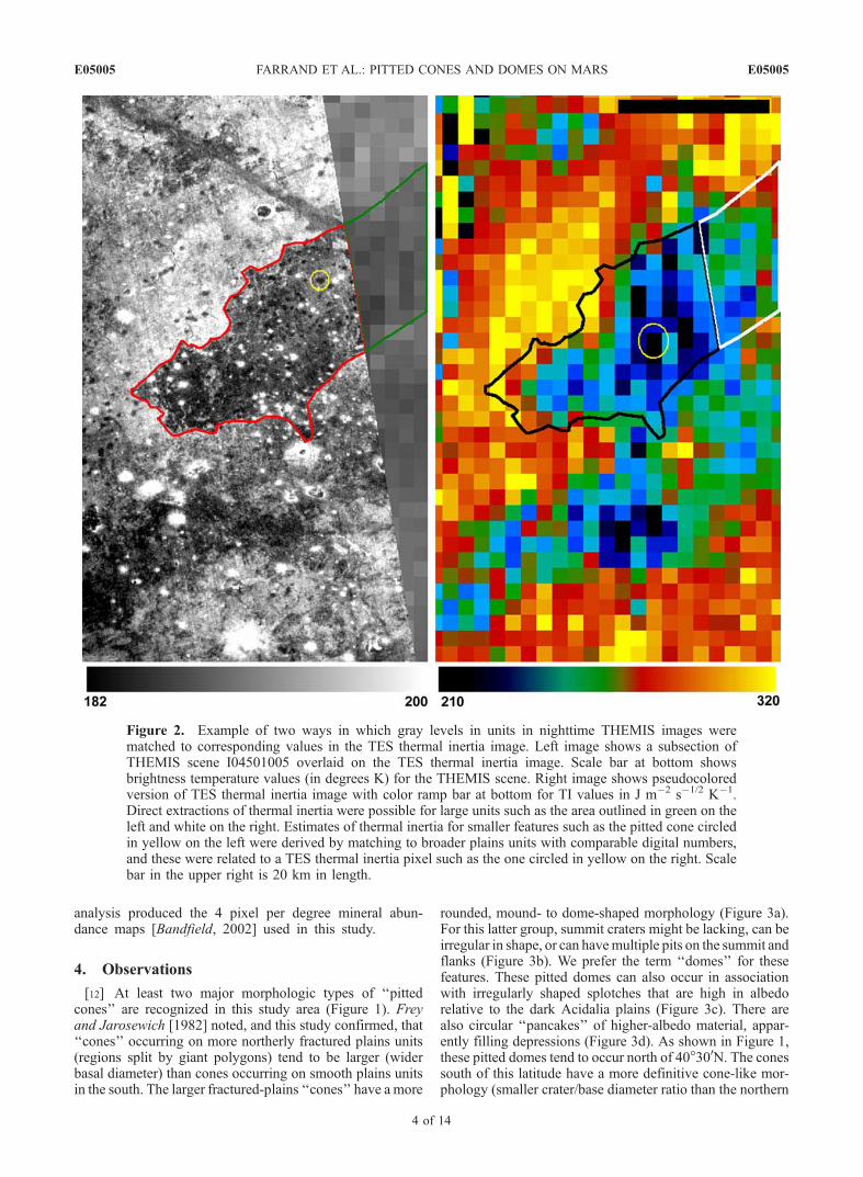
formation on thermophysical properties of the surfacesimaged and work is ongoing to derive calibrated THEMISthermal inertia data [Fergason and Christensen, 2003]. How-ever, given the current absence of a standardized method ofdetermining thermal inertia from THEMIS data, we impro-vised an approach for deriving thermal inertia from nighttimeTHEMIS data. This involved a process of overlaying thenight 100-m-pixel THEMIS data on a 3-km-pixel map ofthermal inertia derived from TES [Mellon et al., 2002]. Bymatching the relative gray level of homogenous plainsregions in the night THEMIS images to the underlyingthermal inertia image, estimates were derived for the thermalinertia of the background plains. This approach is illus-trated in Figure 2. For the cones, a range of approximatevalues were derived by noting a region where theTHEMIS radiance values were the same as a broaderpatch of plains material that then could be matched to thelower spatial resolution TES thermal inertia map. Thermalinertia values derived via this methodology are noted inTable 2.[11] TES data were used in this study in the form of
the aforementioned thermal inertia map derived from TESdata [Mellon et al., 2002] and in the form of 4 pixel perdegree mineral abundance maps derived by Bandfield[2002]. As was noted earlier, Bandfield et al. [2000]referenced Acidalia as being the type region for thesecond major dark region surface type. The first surfacetype has an emittance spectrum similar to a terrestrialflood basalt and is typified by spectra of Syrtis Major.The ‘‘surface type 2’’ material, typified by the Acidaliadark region, has an emittance spectrum that is wellmodeled by a more andestic composition [Bandfield etal., 2000] although weathered basalt has been suggestedas a viable alternative interpretation [e.g., Wyatt andMcSween, 2002]. The analysis of Bandfield et al.[2000] was performed using atmospherically correctedemittance spectra binned into one pixel per degree maps.Mineral maps were obtained through application of alinear deconvolution analysis that modeled TES emittancespectra as linear combinations of laboratory measuredemittance of mineral samples after the approach ofRamsey and Christensen [1998]. A later version of this
E05005 FARRAND ET AL.: PITTED CONES AND DOMES ON MARS
3 of 14
E05005
analysis produced the 4 pixel per degree mineral abun-dance maps [Bandfield, 2002] used in this study.
4. Observations
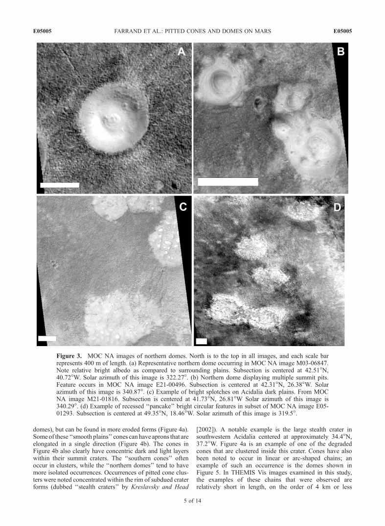
[12] At least two major morphologic types of ‘‘pittedcones’’ are recognized in this study area (Figure 1). Freyand Jarosewich [1982] noted, and this study confirmed, that‘‘cones’’ occurring on more northerly fractured plains units(regions split by giant polygons) tend to be larger (widerbasal diameter) than cones occurring on smooth plains unitsin the south. The larger fractured-plains ‘‘cones’’ have a more
rounded, mound- to dome-shaped morphology (Figure 3a).For this latter group, summit craters might be lacking, can beirregular in shape, or can havemultiple pits on the summit andflanks (Figure 3b). We prefer the term ‘‘domes’’ for thesefeatures. These pitted domes can also occur in associationwith irregularly shaped splotches that are high in albedorelative to the dark Acidalia plains (Figure 3c). There arealso circular ‘‘pancakes’’ of higher-albedo material, appar-ently filling depressions (Figure 3d). As shown in Figure 1,these pitted domes tend to occur north of 40�300N. The conessouth of this latitude have a more definitive cone-like mor-phology (smaller crater/base diameter ratio than the northern
Figure 2. Example of two ways in which gray levels in units in nighttime THEMIS images werematched to corresponding values in the TES thermal inertia image. Left image shows a subsection ofTHEMIS scene I04501005 overlaid on the TES thermal inertia image. Scale bar at bottom showsbrightness temperature values (in degrees K) for the THEMIS scene. Right image shows pseudocoloredversion of TES thermal inertia image with color ramp bar at bottom for TI values in J m�2 s�1/2 K�1.Direct extractions of thermal inertia were possible for large units such as the area outlined in green on theleft and white on the right. Estimates of thermal inertia for smaller features such as the pitted cone circledin yellow on the left were derived by matching to broader plains units with comparable digital numbers,and these were related to a TES thermal inertia pixel such as the one circled in yellow on the right. Scalebar in the upper right is 20 km in length.
E05005 FARRAND ET AL.: PITTED CONES AND DOMES ON MARS
4 of 14
E05005
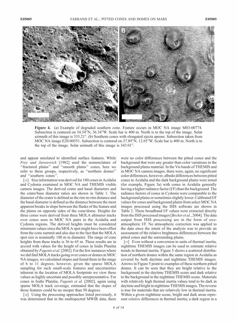
domes), but can be found in more eroded forms (Figure 4a).Some of these ‘‘smooth plains’’ cones can have aprons that areelongated in a single direction (Figure 4b). The cones inFigure 4b also clearly have concentric dark and light layerswithin their summit craters. The ‘‘southern cones’’ oftenoccur in clusters, while the ‘‘northern domes’’ tend to havemore isolated occurrences. Occurrences of pitted cone clus-ters were noted concentrated within the rim of subdued craterforms (dubbed ‘‘stealth craters’’ by Kreslavsky and Head
[2002]). A notable example is the large stealth crater insouthwestern Acidalia centered at approximately 34.4�N,37.2�W. Figure 4a is an example of one of the degradedcones that are clustered inside this crater. Cones have alsobeen noted to occur in linear or arc-shaped chains; anexample of such an occurrence is the domes shown inFigure 5. In THEMIS Vis images examined in this study,the examples of these chains that were observed arerelatively short in length, on the order of 4 km or less
Figure 3. MOC NA images of northern domes. North is to the top in all images, and each scale barrepresents 400 m of length. (a) Representative northern dome occurring in MOC NA image M03-06847.Note relative bright albedo as compared to surrounding plains. Subsection is centered at 42.51�N,40.72�W. Solar azimuth of this image is 322.27�. (b) Northern dome displaying multiple summit pits.Feature occurs in MOC NA image E21-00496. Subsection is centered at 42.31�N, 26.38�W. Solarazimuth of this image is 340.87�. (c) Example of bright splotches on Acidalia dark plains. From MOCNA image M21-01816. Subsection is centered at 41.73�N, 26.81�W Solar azimuth of this image is340.29�. (d) Example of recessed ‘‘pancake’’ bright circular features in subset of MOC NA image E05-01293. Subsection is centered at 49.35�N, 18.46�W. Solar azimuth of this image is 319.5�.
E05005 FARRAND ET AL.: PITTED CONES AND DOMES ON MARS
5 of 14
E05005
and appear unrelated to identified surface features. WhileFrey and Jarosewich [1982] used the nomenclature of‘‘fractured plains’’ and ‘‘smooth plains’’ cones, here werefer to these groups, respectively, as ‘‘northern domes’’and ‘‘southern cones’’.[13] Size informationwas derived for 180 cones inAcidalia
and Cydonia examined in MOC NA and THEMIS visiblecamera images. The derived crater and basal diameters andthe crater/base diameter ratios are shown in Table 1. Thediameter of the crater is defined as the rim-to-rim distance andthe basal diameter is defined as the distance between the mostapparent breaks in slope between the flanks of the feature andthe plains on opposite sides of the cone/dome. Heights forthree cones were derived from three MOLA altimeter tracksover cones seen in MOC NA pairs in the Acidalia andCydonia regions. The derived heights must be consideredminimumvalues since theMOLAspotmight have been offsetfrom the cone summit and also due to the fact that the MOLAspot size is nominally 180 m in diameter. The range of coneheights from these tracks is 36 to 65 m. These results are inaccord with values for the height of cones in Isidis Planitiaobtained byFagents et al. [2002]. For the few instanceswherewe did findMOLA tracks going over cones or domes inMOCNA images, we calculated slopes and found them in the rangeof 6 to 11 degrees; however, given the sparse MOLAsampling for such small-scale features and uncertaintiesinherent in the location of MOLA footprints we view thesevalues as highly uncertain and possibly unrepresentative. Forcones in Isidis Planitia, Fagents et al. [2002], again usingsparse MOLA track coverage, estimated that the slopes ofthose features could be no steeper than 50 degrees.[14] Using the processing approaches listed previously, it
was determined that in the multispectral MWIR data, there
were no color differences between the pitted cones and thebackground that were any greater than color variations in thebackground plains material. In the Vis bands of THEMIS andin MOCNA camera images, there were, again, no significantcolor differences; however, albedo differences between pittedcones in Acidalia and the dark background plains were noted(for example, Figure 3a) with cones in Acidalia generallyhaving a higher radiance factor (I/F) than the background. Theradiance factors of cones in Cydonia were comparable to thebackground plains or sometimes slightly lower. Calibrated I/Fvalues for cones and background plains from selectMOCNAimages processed using the ISIS software are shown inTable 2. These broadband I/F values were extracted directlyfrom the ISIS processed images [Beckeret al., 2004]. The dataoutput from ISIS processing are in the form of exo-atmospheric I/F. No atmospheric correction was applied tothe data since the intent of the analysis was to provide anassessment of the relative brightness differences between thepitted cones and the surrounding plains.[15] Even without a conversion to units of thermal inertia,
nighttime THEMIS images can be used to estimate relativetrends in thermal inertia. Figure 5 shows a scattered distribu-tion of northern domes within the same region in Acidalia ascovered by both daytime and nighttime THEMIS images.Arrows in Figure 5 point to examples of these northern pitteddomes. It can be seen that they are bright relative to thebackground in the daytime THEMIS scene and dark relativeto the background in the nighttime THEMIS scene. Materialswith relatively high thermal inertia values tend to be dark indaytime and bright in nighttimeTHEMIS images. The reverseis true for materials that are relatively low in thermal inertia.Within a given nighttime scene, bright and dark areas repre-sent relative differences in thermal inertia; a dark region in a
Figure 4. (a) Example of degraded southern cone. Feature occurs in MOC NA image M03-00774.Subsection is centered on 34.54�N, 36.34�W. Scale bar is 400 m. North is to the top of the image. Solarazimuth of this image is 333.21�. (b) Southern cones with elongated ejecta aprons. Subsection taken fromMOC NA image E20-00551. Subsection is centered on 37.89�N, 12.65�W. Scale bar is 400 m. North is tothe top of the image. Solar azimuth of this image is 343.01�.
E05005 FARRAND ET AL.: PITTED CONES AND DOMES ON MARS
6 of 14
E05005

high thermal inertia plains unit in a nighttime THEMIS scenecan still have a comparatively high value of thermal inertia.[16] In contrast to the relative difficulty in extracting
thermal inertia from THEMIS data, the THEMIS radiancedata can be readily converted to brightness temperature.Brightness temperatures of the pitted cones and backgroundmaterials were directly extracted from THEMIS brightnesstemperature images provided to the PDS (actual brightnesstemperature values were determined using scaling factorsprovided in the PDS headers). Average brightness temper-atures for southern cones in Acidalia and in Cydonia (overthe solar longitude (Ls) range 142� to 148�) and northerndomes in Acidalia (over the Ls range 110� to 124�) areshown in Table 2. Not all occurrences of pitted cones arethermally distinct from their background. Some occurrencesof southern cones in Acidalia were indistinguishable tonearly indistinguishable from the background in the night-time THEMIS images (Figure 6). In all of the examinedimagery, the northern domes were distinct from the back-ground. Also, the relatively flat ‘‘pancake’’ features notedabove and visible-wavelength bright splotches are coldrelative to the background in the nighttime THEMIS imag-ery (Figure 7).[17] The estimated thermal inertia of the northern domes
is in the range of 210 to 240 J m�2 s�1/2 K�1 and that of the
southern cones is in the range of 190 to 210 J m�2 s�1/2
K�1. These values are between the thermal inertia ofbasaltic fine to coarse sand (155 and 374 J m�2 s�1/2�K�1)[Mellon, 2001]. The thermal inertias of the fractured plainsare closer to the basaltic sand value and that of the smoothplains are in the same approximate range as that of the pittedcones. These values explain why the southern cones some-time blend in with the background in the nighttime THEMISimages.[18] The TES-derived 4 pixel per degree mineral abun-
dance maps of Bandfield [2003] indicated only that thecomposition of the study area is consistent with the ‘‘surfacetype 2’’ spectral class. Analysis of these maps did not revealany variations in composition that could be associatedspecifically with the pitted cones. Earlier work by bothFarrand andGaddis [2003a] and Bandfield [2002] indicated
Table 1. Sizes of Southern Cones and Northern Domes
Features
Basal Diameter,m
Crater Diameter,m Crater/Base
Mean Std. Dev. Mean Std. Dev. Mean Std. Dev.
Southern cones 455 166 232 80 0.513 0.072Northern domes 774 197 415 98 0.544 0.092
Figure 5. (left) Daytime (I03271002) and (right) nighttime (I04638003) THEMIS MWIR images over aportion of Acidalia Planitia. Solar illumination is from the lower left in the daytime image. White arrowpoints to a pair of fresh craters that are dark in the daytime and bright in the nighttime THEMIS data.Black arrows point to representative examples of northern domes which are bright to neutral in thedaytime THEMIS image but dark in the nighttime THEMIS image. Note that some of these cones arealigned in chains. The black scale bar is 10 km long. North is to the top in both images.
E05005 FARRAND ET AL.: PITTED CONES AND DOMES ON MARS
7 of 14
E05005

a high fraction of basaltic glass in Acidalia. This observa-tion could have significance since basaltic glass is oftenassociated with ash from explosive volcanic activity andthus could support volcanic origins for the pitted cones. Wenote, however, that linear deconvolution [Ramsey andChristensen, 1998] of thermal infrared data is nonunique.For example, while the ‘‘surface type 2’’ spectral unit wasinitially interpreted as being andesitic in composition, it hasbeen reinterpreted as an altered basalt [Wyatt and McSween,2002] with clays accounting for the spectral features thatwere attributed to glass in the Bandfield et al. [2000]interpretation.
5. Discussion
[19] A variety of origins have been suggested for thecones and domes in Acidalia and Cydonia, includingthose related to volcanic, ground-ice, and sedimentaryprocesses. Suggested terrestrial analogs for the northernplains cones and domes have included cinder cones[Wood, 1979], rootless cones [Frey and Jarosewich,1982], pingos [Lucchitta, 1981; Farrand and Gaddis,
Table 2. Broadband I/F, Brightness Temperature, and Relative
Thermal Inertia of Pitted Cones and Background Plainsa
Region
Cones/Domes Plains
Mean Std. Dev. Mean Std. Dev.
MOC NA I/FSouthern cones 0.109 0.0018 0.109 0.0027Northern domes 0.110 0.0034 0.098 0.0029
Brightness Temperature, KSouthern cones 178.5 5.7 184.85 10.7Northern domes 189.1 2.1 196.08 3.2
Thermal Inertia, J m�2 s�1/2 K�1
Southern cones 210 ± 13 to 240 ± 14 235.5 7.5Northern domes 190 ± 11 to 210 ± 13 298.0 9.9
aStandard deviations of I/F and brightness temperature values arestandard deviations of the mean for the pixels averaged together to obtainthose values and do not include uncertainties inherent in the calibration to I/For brightness temperature. Standard deviations of thermal inertia of plains arestandard deviations of the mean for the pixels averaged together to obtainthose values. A range of values is provided for thermal inertias of pitted conesand domes given that the values were obtained by indirect comparisons. Aplus/minus value is given for the lower and upper bounds based on theapproximately 6% uncertainty in the TES thermal inertia map (M. T. Mellon,personal communication).
Figure 6. (a) MOC NA images (left) E15-01186 and (right) E20-00551 overlaid on daytime THEMISscenes I01798002 and I01436005 (exposed in lower right). Solar illumination is from the southwest inthe daytime THEMIS scenes and from the west-northwest in the MOC scenes. Note that dark plains unitin upper portion of E20-00551 is bright in daytime THEMIS scene, indicating lower thermal inertiarelative to the surrounding plains. Note also that southward (Sun-facing) slopes of pitted cones are brightrelative to the background. The cones are of sufficient size and contrast to be distinguished. These imagesare located near 37.9�N, 12.9�W. Scale bar is 8 km long. North is to the top of the image. (b) Approximatelythe same region as in Figure 6a with the twoMOC scenes overlaid on nighttime THEMIS scene I05437014.While the spatial resolution of this THEMIS scene is comparable to the daytime scene in Figure 6a, thecontrast of the pitted cones against the background is very low, indicating comparable thermal inertias. Theexception is in the relatively low thermal inertia plains unit in the upper right-hand portion of the image,where the cones are darker than the background (i.e., relatively low in thermal inertia relative to the plains).Scale bar is 8 km long. North is to the top of the image.
E05005 FARRAND ET AL.: PITTED CONES AND DOMES ON MARS
8 of 14
E05005

2003b], and mud volcanoes [Tanaka, 1997; Tanaka et al.,2003]. Crumpler [2003] notes that spring deposits canform features similar in morphology to the pitted cones ofthis study.[20] We note that there is no reason a single formation
mechanism is required to explain all the cones and domes.The two groups of pitted cones are distinct not only in termsof morphology and size, but also in terms of their geo-graphic distribution. The northern domes occur predomi-nantly north of 40.5�N latitude and southern cones occurpredominantly south of that latitude. The difference inmorphology of the northern domes from the southern conesrequires some associated change in formative process. Sucha change could indicate either two different formationprocesses for the northern and southern cones or a singleprocess with a change in some parameter (for example,amount of water included during a hydrovolcanic or mudvolcano eruption). We now examine each of the proposedorigins for the cones and domes of the northern plains inturn.
5.1. Cinder Cones
[21] Cinder cones are formed by (typically basaltic) lavafountaining from a point source in the ground. While thegeneral size and shape of many of the southern pitted conesare similar to those of terrestrial cinder cones, there areseveral reasons to reject this hypothesis. First, cinder coneson Mars are expected to have a lower aspect ratio because,in Mars’ lower gravity and thinner atmosphere, ash andcinders are expected to travel further from the vent on Marsthan they do on Earth [Wilson and Head, 1983]. Second,fields of cinder cones are usually associated with lava flows.
There are no obvious lava flows around the cones anddomes in the Acidalia region. Third, cinder cone materi-als would be expected to have optical and thermalproperties broadly similar to basaltic sand [Zimbelman,1986; Keszthelyi, 1994]. While the thermal properties arecompatible with cinder, the cones and domes we observedare distinctly brighter than the basaltic sands in Acidalia.Moreover, the southern cones and northern domes havemean I/F values of 0.109 and 0.110 respectively, whilebasaltic ash, in the MOC NA images, should have aradiance factor of approximately 0.075 (value measuredby Geissler et al. [1990] for exo-atmospheric I/F ofputative basaltic ash in Valles Marineris). Finally, whilehaving similarities to the southern cones, cinder cones area poor morphologic analog to the northern domes.
5.2. Rootless Cones
[22] Rootless cones (also called pseudocraters) areformed by explosions that result from a lava flow advancingover a wet substrate. Rootless cones on Earth are typicallytens of meters in diameter, but, on Mars, could havediameters similar to the cones and domes we have observed[Greeley and Fagents, 2001; Fagents et al., 2002]. Rootlesscones can form in chains [Bruno et al., 2004], although thelength and number of such chains observed for the conesand domes of Cydonia and Acidalia appears smaller thanwas observed in the terrestrial examples presented by Brunoet al. [2004]. There are two reasons why we do not favor arootless cone origin for these features. First, they do notobviously sit on lava flows. In other locations on Mars, theinterpretation of cones as rootless cones has depended ontheir superposition on recognizable lava surfaces [Lanagan
Figure 7. (a) Relatively flat ‘‘pancake’’ features filling apparent depressions in the northern plains.Arrows point to lower two ‘‘pancakes’’ of a set of four. Subsection of THEMIS Vis scene V04632009.Scale bar in upper left is 10 km long. The scene is centered at 48.4�N, 19.4�W. (b) Subsection ofnighttime THEMIS scene I05562016 covering same area as the Vis THEMIS scene in Figure 7a. Arrowspoint to the same two ‘‘pancake’’ features, which can be seen to be dark relative to the background. Scalebar in upper left is 10 km long.
E05005 FARRAND ET AL.: PITTED CONES AND DOMES ON MARS
9 of 14
E05005
et al., 2001; Greeley and Fagents, 2001]. Second, thespatter and other pyroclasts associated with rootless conesare generally quite dense. This is because the lava that isthrown out of a rootless cone has been largely degassedduring flow on the surface [Morrissey and Thordarson,1991]. However, the thermal inertias we observe for thecones and domes on Mars are much lower than expected fordense spatter. Morrissey and Thordarson [1991] note thatwhile sediments are incorporated into Icelandic rootlesscones, they are generally incorporated during the earlystages of cone formation (e.g., they would be found closerto the core of the cone than to the exterior) thus it seemsunlikely that there could be fine-grained sediments, associ-ated with the eruption, that blanket the cones and reduce theapparent thermal inertia of these features. Thus, primarilyon the basis of the lack of apparent lava flow features andthe evidence provided by the apparent thermal inertia ofthese features, we conclude that rootless cones are anunlikely explanation for the cones and domes observed inAcidalia and Cydonia.
5.3. Phreatomagmatic Tuff Cones
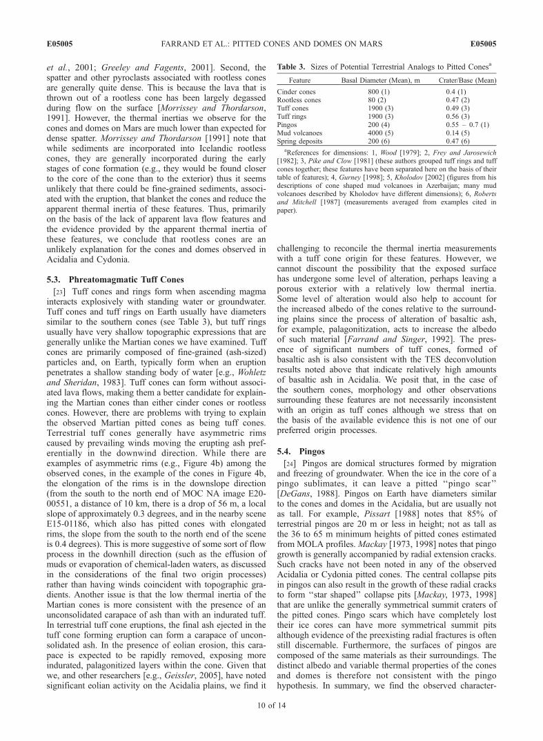
[23] Tuff cones and rings form when ascending magmainteracts explosively with standing water or groundwater.Tuff cones and tuff rings on Earth usually have diameterssimilar to the southern cones (see Table 3), but tuff ringsusually have very shallow topographic expressions that aregenerally unlike the Martian cones we have examined. Tuffcones are primarily composed of fine-grained (ash-sized)particles and, on Earth, typically form when an eruptionpenetrates a shallow standing body of water [e.g., Wohletzand Sheridan, 1983]. Tuff cones can form without associ-ated lava flows, making them a better candidate for explain-ing the Martian cones than either cinder cones or rootlesscones. However, there are problems with trying to explainthe observed Martian pitted cones as being tuff cones.Terrestrial tuff cones generally have asymmetric rimscaused by prevailing winds moving the erupting ash pref-erentially in the downwind direction. While there areexamples of asymmetric rims (e.g., Figure 4b) among theobserved cones, in the example of the cones in Figure 4b,the elongation of the rims is in the downslope direction(from the south to the north end of MOC NA image E20-00551, a distance of 10 km, there is a drop of 56 m, a localslope of approximately 0.3 degrees, and in the nearby sceneE15-01186, which also has pitted cones with elongatedrims, the slope from the south to the north end of the sceneis 0.4 degrees). This is more suggestive of some sort of flowprocess in the downhill direction (such as the effusion ofmuds or evaporation of chemical-laden waters, as discussedin the considerations of the final two origin processes)rather than having winds coincident with topographic gra-dients. Another issue is that the low thermal inertia of theMartian cones is more consistent with the presence of anunconsolidated carapace of ash than with an indurated tuff.In terrestrial tuff cone eruptions, the final ash ejected in thetuff cone forming eruption can form a carapace of uncon-solidated ash. In the presence of eolian erosion, this cara-pace is expected to be rapidly removed, exposing moreindurated, palagonitized layers within the cone. Given thatwe, and other researchers [e.g., Geissler, 2005], have notedsignificant eolian activity on the Acidalia plains, we find it
challenging to reconcile the thermal inertia measurementswith a tuff cone origin for these features. However, wecannot discount the possibility that the exposed surfacehas undergone some level of alteration, perhaps leaving aporous exterior with a relatively low thermal inertia.Some level of alteration would also help to account forthe increased albedo of the cones relative to the surround-ing plains since the process of alteration of basaltic ash,for example, palagonitization, acts to increase the albedoof such material [Farrand and Singer, 1992]. The pres-ence of significant numbers of tuff cones, formed ofbasaltic ash is also consistent with the TES deconvolutionresults noted above that indicate relatively high amountsof basaltic ash in Acidalia. We posit that, in the case ofthe southern cones, morphology and other observationssurrounding these features are not necessarily inconsistentwith an origin as tuff cones although we stress that onthe basis of the available evidence this is not one of ourpreferred origin processes.
5.4. Pingos
[24] Pingos are domical structures formed by migrationand freezing of groundwater. When the ice in the core of apingo sublimates, it can leave a pitted ‘‘pingo scar’’[DeGans, 1988]. Pingos on Earth have diameters similarto the cones and domes in the Acidalia, but are usually notas tall. For example, Pissart [1988] notes that 85% ofterrestrial pingos are 20 m or less in height; not as tall asthe 36 to 65 m minimum heights of pitted cones estimatedfrom MOLA profiles. Mackay [1973, 1998] notes that pingogrowth is generally accompanied by radial extension cracks.Such cracks have not been noted in any of the observedAcidalia or Cydonia pitted cones. The central collapse pitsin pingos can also result in the growth of these radial cracksto form ‘‘star shaped’’ collapse pits [Mackay, 1973, 1998]that are unlike the generally symmetrical summit craters ofthe pitted cones. Pingo scars which have completely losttheir ice cores can have more symmetrical summit pitsalthough evidence of the preexisting radial fractures is oftenstill discernable. Furthermore, the surfaces of pingos arecomposed of the same materials as their surroundings. Thedistinct albedo and variable thermal properties of the conesand domes is therefore not consistent with the pingohypothesis. In summary, we find the observed character-
Table 3. Sizes of Potential Terrestrial Analogs to Pitted Conesa
Feature Basal Diameter (Mean), m Crater/Base (Mean)
Cinder cones 800 (1) 0.4 (1)Rootless cones 80 (2) 0.47 (2)Tuff cones 1900 (3) 0.49 (3)Tuff rings 1900 (3) 0.56 (3)Pingos 200 (4) 0.55 – 0.7 (1)Mud volcanoes 4000 (5) 0.14 (5)Spring deposits 200 (6) 0.47 (6)
aReferences for dimensions: 1, Wood [1979]; 2, Frey and Jarosewich[1982]; 3, Pike and Clow [1981] (these authors grouped tuff rings and tuffcones together; these features have been separated here on the basis of theirtable of features); 4, Gurney [1998]; 5, Kholodov [2002] (figures from hisdescriptions of cone shaped mud volcanoes in Azerbaijan; many mudvolcanoes described by Kholodov have different dimensions); 6, Robertsand Mitchell [1987] (measurements averaged from examples cited inpaper).
E05005 FARRAND ET AL.: PITTED CONES AND DOMES ON MARS
10 of 14
E05005
istics of the cones and domes to be inconsistent with anorigin as pingos.
5.5. Mud Volcanoes
[25] On Earth, the term ‘‘mud volcano’’ covers a widerange of different features from meter sized cones todomical structures hundreds of meters in size [Kholodov,2002]. However, terrestrial mud volcanoes are all the resultof gas discharge, often accompanied by the explosiveeruption, or less violent effusion of soft (i.e., wet) sedi-ments. Terrestrial mud volcanoes also occur within sedi-mentary basins and the roots of the mud volcanoes arebelieved to extend to the lowest levels of the sedimentarystack in these basins [Grigor’yants, 2001]. In larger terres-trial mud volcanoes, the active volatile agent is most oftenmethane; however, there are rare occurrences of mudvolcanoes that emit CO2 or nitrogen [Dimitrov, 2002]. OnMars, the driving gas could plausibly be CO2, H2O, ormethane, but CO2 released from decomposing water-CO2 orwater-CH4 clathrates might be the most likely [Kargel et al.,2000; Hoffman, 2000]. In the following discussion, somecharacteristics of subaerial and submarine terrestrial mudvolcanoes are described.[26] The larger terrestrial examples are similar in lateral
and vertical dimension to the Martian domes and cones ofthe Acidalia region. They can have summit depressions ofvariable size and appear to be most comparable to the coneshaped mud volcanoes described by Kholodov [2002].Submarine mud volcanoes described from the Gulf of Cadizhave symmetric cone shaped morphologies without summitcraters [Somoza et al., 2003]. These features have diametersthat range from 0.8 to 2 km and are associated with steeperflanked cones and with rounded craters. While the bulk ofthe life of a mud volcano involves relatively passiveeffusion of fluid mud, they also can explode violently ifthe gas release becomes constricted. There can be secondaryand satellite surface vents for a single mud volcano [Dimitrov,2002], providing an explanation for the multiple pits seen inFigure 3b. The dried, loosely cemented, mud deposits wouldbe a good match to both the albedo and thermal inertiameasurements from the Martian domes and cones. Terrestrialmud volcanoes are also found concentrated along subsurfacefractures that focus the flow of gas andmud. This matches theobservation that the domes and cones in the Acidalia regioncan be concentrated along possible buried impact cratermargins and are sometimes found in chains. Repeated out-flow of mud could explain the coarse layering seen in thesummit pits of the cones. Effusive mudflows flowing down-slope could account for the asymmetric cones shown inFigure 4b.[27] The difference in morphology in the Acidalia and
Cydonia cones and domes could be related to changes in thenature of the sediments and blocks making up the con-structs. Cifci and Ergun [2004], in describing the morphol-ogy of submarine mud volcanoes, note that when thick mudbreccias are erupted, the resulting construct is in the form ofa cone with steep flanks, but when the mud breccia isthinned with water, the volcano is low in height with aflatter morphology. This description closely matches thechange in morphology from the southern cones to thenorthern domes. We posit that the change in morphologycould be due to a greater abundance of subsurface water
during the mud eruptions that produced the northern domes.Given that the northern domes occur at lower elevations,this hypothesis comports well with a downslope concentra-tion of water.[28] The volatilization of near surface pockets of clath-
rates could also produce depressions and a limited effusionof volatiles and sediment leading to the ‘‘pancake’’ featuresin Figures 3d and 7. Given that ices can be stable atshallower depths further to the north, the bright patchesassociated with the northern domes might be caused byspontaneous vaporization of very shallowly buried clath-rates. Craters on the terrestrial seafloor have been similarlyattributed to the explosive decompression of clathrate-hydrates [Solheim and Elverhoi, 1993]. As has been ob-served with both Mars Exploration Rovers at two verydifferent sites on Mars, the surface layer can be very thinwith the result that a minor disturbance (such as poundingor scraping by the airbag landing system) can produce amarked albedo difference [Bell et al., 2004a]. In thisinstance, the vaporization of shallowly buried clathrates(perhaps at times of low orbital obliquity [Mellon andJakosky, 1995]) would have displaced the shallow surfaceveneer of dark sediments with lighter sediments lyingbeneath. A similar mechanism with a limited (not enoughsubsurface material removed to form a crater) eruption ofsubsurface sediments could account for the bright splotchesof Figure 3c.[29] To summarize, there are a number of similarities
between terrestrial mud volcanoes and the cones and domesdiscussed in this paper. The loosely cemented mud mantlesof mud volcanoes could account for the observed thermalinertia character of the cones and dome. Repeated eruptionscould account for layering seen in craters of some of theMartian cones and dome. Flow of mud downslope couldaccount for the asymmetric aprons in the cones in Figure 4b.Finally, formation processes for mud volcanoes accord wellwith trends seen in the Acidalia cones and domes. Mudvolcanoes occur in sedimentary basins and Acidalia is abasin which, is widely believed to be filled with sedimentsbrought in from the outflow channels. Also, the occurrenceof some cones and domes in chains or in concentrationsaround buried crater margins accords well with the obser-vation that terrestrial mud volcanoes are often concentratedalong subsurface fractures.
5.6. Springs and Geysers
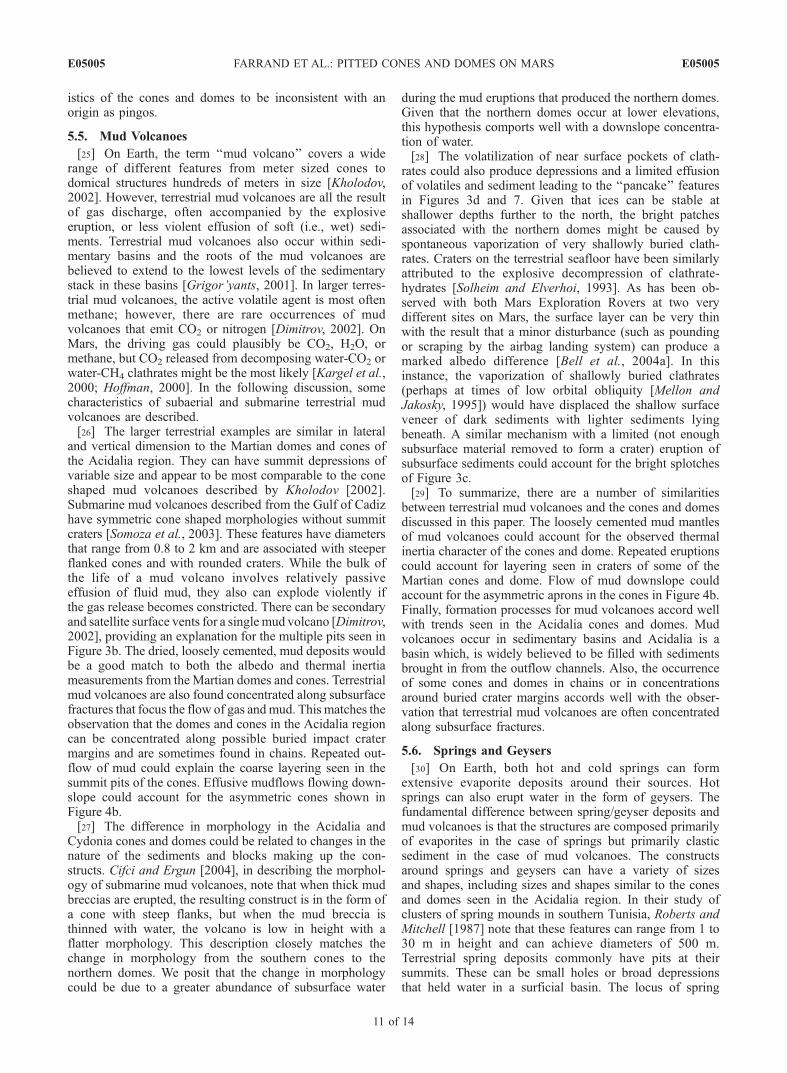
[30] On Earth, both hot and cold springs can formextensive evaporite deposits around their sources. Hotsprings can also erupt water in the form of geysers. Thefundamental difference between spring/geyser deposits andmud volcanoes is that the structures are composed primarilyof evaporites in the case of springs but primarily clasticsediment in the case of mud volcanoes. The constructsaround springs and geysers can have a variety of sizesand shapes, including sizes and shapes similar to the conesand domes seen in the Acidalia region. In their study ofclusters of spring mounds in southern Tunisia, Roberts andMitchell [1987] note that these features can range from 1 to30 m in height and can achieve diameters of 500 m.Terrestrial spring deposits commonly have pits at theirsummits. These can be small holes or broad depressionsthat held water in a surficial basin. The locus of spring
E05005 FARRAND ET AL.: PITTED CONES AND DOMES ON MARS
11 of 14
E05005

activity can shift with time, producing multiple pits in asingle mound. The spring mounds described by Roberts andMitchell [1987] from southern Tunisia are a good morpho-logic analog to the domes and cones we have observed;albeit with heights at the low end of the range observed forthe Acidalia pitted cones. Some of the Tunisian mounds aredescribed as consisting of cemented gypsiferous sand,organic fragments, eolian sand lenses, and ‘‘gypsiferousrubble’’. Others have a larger component of travertine.Some of the Tunisian mounds have stratigraphy visible intheir inner rims (just as some of the pitted cones, such asthose in Figures 3b and 4b, have layering visible). Somesignificant differences can be expected between terrestrialand Martian spring/geyser deposits. On Earth, the dominantmineral is often travertine, a form of calcium carbonate. OnMars, there is little evidence for carbonate deposits, butthere is ample evidence for sulfate evaporites [Squyres etal., 2004; Gendrin et al., 2004]. Thus the Martian springdeposits are likely to have a different mineralogy thanterrestrial ones. However, either mineralogy would producean albedo higher than the surrounding basaltic plains.Albedos of the basaltic plains and (presumed) evaporiticoutcrops examined by the Opportunity rover at MeridianiPlanum are 0.14 ± 0.01 and 0.25 ± 0.06 [Bell et al., 2004b].Thus the albedos of the evaporites observed at Meridiani arebrighter than the observed albedos of the southern conesand northern domes (Table 2). Terrestrial spring moundscontain clastic sediments so it is likely that analogousMartian spring mounds could incorporate low-albedo ba-saltic clasts that would result in a lower albedo for thespring mounds than for the areally extensive Meridianievaporites. Some terrestrial spring deposits are describedin the literature as ‘‘porous’’ [e.g., Guidry and Chafetz,2003]. Martian spring deposits might be even more porous.The thinner atmosphere on Mars should have a significanteffect on surface evaporation. Not only will liquid waterevaporate quickly, the uppermost layer can boil vigorously.This could lead to relatively porous deposits on Mars ascompared to the Earth. Such porosity could help explain thethermal properties of the cones and domes on Mars. Theerosion, through eolian activity, of an outer, highly porouslayer could explain the more eroded appearance and seem-ingly higher thermal inertia of some of the southern conescompared to the northern domes.
5.7. Relevance of Pitted Cone Origin Modes forModels of the Northern Plains
[31] The set of possible origins addressed in the precedingdiscussion have implications for the history of the AcidaliaPlanitia region, and for the VBF which covers much ofnorthern Acidalia. The interpretation of the pitted cones asmud volcanoes accords well with the interpretation of theVBF as sedimentary residue from the outflow channels tothe south. In effect, Acidalia is a sedimentary basin underthis interpretation. On Earth, mud volcanoes are associatedwith sedimentary basins; thus the presence of mud volca-noes accords well with this interpretation. It is unknownwhat the primary gas associated with this putative mudvolcanism was. On Earth, methane is the primary gasassociated with mud volcanism. On Mars, the primary gascould have been CO2, although recent observations ofmethane in the Martian atmosphere [Formisano et al.,
2004; Krasnopolsky et al., 2004] allow for the possibilitythat methane might also have played a role in the formationof the pitted cones discussed in this paper.[32] The other preferred interpretation, that the pitted
cones might be dome to cone shaped spring deposits, wouldbe evidence of a formerly active subsurface hydrologicalsystem in Acidalia. It would also require periods after thedeposition of the VBF (post early Amazonian) for theclimate to have been warm enough to allow water (likelybrine-saturated water) to flow to the surface and evaporateaway to leave the evaporitic spring deposits.
6. Summary and Conclusions
[33] Pitted cones in Acidalia Planitia and Cydonia Men-sae were studied using MOC NA imagery, THEMIS MWIRand VNIR data, and a TES-derived map of thermal inertia[Mellon et al., 2002]. The pitted cones observed in Acidaliaand Cydonia can be separated into two major groups: thosethat lie predominantly south of 40.5�N latitude tend to havea more cone-like morphology; those that occur predomi-nantly north of that latitude tend to have a more dome-likemorphology. The northern domes are higher in albedo thanthe surrounding plains and also have lower apparent thermalinertias than the surrounding plains. The southern coneshave albedos and thermal inertias that are commensuratewith the surrounding plains. The thermal inertia values ofthe pitted cones and domes are between those of basalticfine dust and sand while that of the surrounding plains arecloser to that of basaltic sand.[34] After examining various possible formation processes
for the cones and domes of the northern plains, we havereached several general conclusions. Largely on the basis ofthe absence of associated volcanic flow features, we con-sider a cinder cone or rootless cone origin for the pittedcones to be unlikely. While we cannot completely eliminatea phreatomagmatic origin, neither can we find any compel-ling evidence for such an origin. Similarly, the observationsappear to be generally inconsistent with an origin as pingos.Instead, we find the visible and thermal observations aremost consistent with these cones and domes having formedvia mud volcanism, geysers, and/or springs. It is possiblethat some combination of these processes acted to form theobserved cones and domes. The process of mud volcanism,by itself, could potentially account for the observed differ-ences in the morphology of the cones in the southern andnorthern portion of the study area. When copious amountsof water are included in a mud volcano eruption, the eruptedsediments are thinned by the water and the flanks of theresulting structure are not as steep. In a dryer mud volcanoeruption, the erupted mud breccia is thicker and can form acone with steep flanks [Cifci and Ergun, 2004]. The changein morphology from south to north could thus indicate thatmore water was available at the time and locations of theeruptive processes that formed the northern domes. Thus anorigin of the northern plains cones and domes involvingsome form of mud volcanism is compelling.[35] The prospect that some of the pitted cones might be
the Martian equivalent of terrestrial spring mounds is alsointriguing. Morphologically, they seem to be a good matchto spring mounds that occur in southern Tunisia [Robertsand Mitchell, 1987]. Assuming that the evaporitic materials
E05005 FARRAND ET AL.: PITTED CONES AND DOMES ON MARS
12 of 14
E05005

are porous, as is often the case with terrestrial springdeposits, these materials could also account for the observedalbedo and thermal characteristics. Spring deposits can forma variety of landforms and some combination of changes intemperature related to differences in latitude, changes inatmospheric pressure related to differences in elevation, andchanges in the nature of the near surface geology couldaccount for the differences in morphology between thenorthern domes and the southern cones.[36] Origin by mud volcanism, eruption of geysers and/or
springs, or some combination of these processes couldaccount for the observed occurrences of northern domesand southern cones. While we cannot distinguish betweenor among these processes with the data available currently,we conclude that the formation of both cones and domesmost likely involved the presence of water, but the exactrole of liquid water is still not clear. Either the mudvolcanism or spring processes are supportive of the ideathat large amounts of water were once present across muchof the northern plains of Mars. However, we cannot placeany strong constraints on whether this water was in the formof groundwater (either mobile or immobile), intermittentseas, or a long-lived ocean. Analyses of new, high spatial-resolution imaging in conjunction with hyperspectral obser-vations, such as will be available from the HiRISE [McEwenet al., 2002] and CRISM [Murchie et al., 2002] instru-ments on the upcoming Mars Reconnaissance Orbiter,will be essential for distinguishing between the differentremaining hypotheses for the formation of these intriguingfeatures. In particular, the CRISM data could be used toreadily prove or disprove the spring deposit hypothesissince such features are formed from evaporite minerals(on Earth, largely travertine, but on Mars perhaps pri-marily sulfate minerals such as gypsum and kieserite)with distinctive spectral signatures.
[37] Acknowledgments. This research was funded under the NASAOffice of Space Science Mars Data Analysis Program grant number NAG5-10577. We thank Catherine Weitz of the Planetary Science Institute andreviewers Sarah Fagents, Peter Lanagan and an anonymous reviewer forhelpful reviews.
ReferencesAllen, C. C. (1979), Volcano/ice interactions on Mars, J. Geophys. Res., 84,8048–8059.
Baker, V. R., R. G. Strom, V. C. Gulick, J. S. Kargel, G. Komatsu, and V. S.Kale (1991), Ancient oceans, ice sheets, and the hydrological cycle onMars, Nature, 352, 589–594.
Bandfield, J. L. (2002), Global mineral distribution on Mars, J. Geophys.Res., 107(E6), 5042, doi:10.1029/2001JE001510.
Bandfield, J. L. (2003), Martian global surface mineralogy from the Ther-mal Emission Spectrometer: Surface emissivity, mineral map, and spec-tral endmember data products, in Sixth International Conference on Mars[CD-ROM], abstract 3052, Lunar and Planet. Inst., Houston, Tex.
Bandfield, J. L., V. E. Hamilton, and P. R. Christensen (2000), A globalview of Martian surface compositions from MGS-TES, Science, 287,1626–1630.
Becker, T., E. Eliason, K. Becker, and USGS Astrogeology Team (2004),ISIS Workshop: Processing for MGS/MOC imaging, U.S. Geol. Surv.,Flagstaff, Ariz. (Available at http://isis.astrogeology.usgs.gov/Isis2/gifs/mgs_moc.pdf)
Bell, J. F., III, et al. (2004a), Pancam multispectral imaging results from theSpirit rover at Gusev Crater, Science, 305, 800–806.
Bell, J. F., III, et al. (2004b), Pancam multispectral imaging results from theOpportunity rover at Meridiani Planum, Science, 306, 1703–1709.
Bruno, B. C., S. A. Fagents, T. Thordarson, S. M. Baloga, and E. Pilger(2004), Clustering within rootless cone groups on Iceland and Mars:Effect of nonrandom processes, J. Geophys. Res., 109, E07009,doi:10.1029/2004JE002273.
Christensen, P. R., et al. (2004), The Thermal Emission Imaging System(THEMIS) for the Mars 2001 Odyssey Mission, Space Sci. Rev., 110,85–130.
Cifci, G., and M. Ergun (2004), Image characteristics of the MediterraneanSea and the Black Seamud volcanoes and sea bed features, paper presentedat Second Balkan Geophysical Congress and Exhibition, Balkan Geophys.Soc., Bucharest, Romania. (Available at http://www.balkangeophysoc.org/menu/congresses/oral/12-13-O4-1-gunay-cifci.PDF)
Clifford, S. M., and T. J. Parker (2001), The evolution of the Martianhydrosphere: Implications for the fate of a primordial ocean and thecurrent state of the northern plains, Icarus, 154, 40–79.
Crumpler, L. S. (2003), Physical characteristics, geologic setting, and pos-sible formation processes of spring deposits on Mars based on terrestrialanalogs, in Sixth International Conference on Mars [CD-ROM], abstract3228, Lunar and Planet. Inst., Houston, Tex.
DeGans, W. (1988), Pingo scars and their identification, in Advances inPeriglacial Geomorphology, edited by M. J. Clark, pp. 299–322, JohnWiley, Hoboken, N. J.
Dimitrov, L. I. (2002), Mud volcanoes—The most important pathway fordegassing deeply buried sediments, Earth Sci. Rev., 59, 49–76.
Eliason, E. (1997), Production of digital image models (DIMs) using ISIS,Lunar Planet. Sci., XVIII, abstract 331.
Fagents, S. A., P. Lanagan, and R. Greeley (2002), Rootless cones on Mars:A consequence of lava-ground ice interaction, in Volcano-Ice Interactionon Earth and Mars, edited by J. L. Smellie and M. G. Chapman, Geol.Soc. Spec. Publ., 202, 295–317.
Farrand, W. H., and L. R. Gaddis (2003a), Analysis of MGS TES data overAcidalia Planitia and Cydonia Mensae: Compositional evidence for hy-drovolcanic activity, Lunar Planet. Sci., XXXIV, abstract 1601.
Farrand, W. H., and L. R. Gaddis (2003b), THEMIS Observations of pittedcones in Acidalia Planitia and Cydonia Mensae, in Sixth InternationalConference on Mars, abstract 3094, Lunar and Planet. Inst., Houston, Tex.
Farrand, W. H., and R. B. Singer (1992), Alteration of hydrovolcanic basalticash: Observations with visible and near-infrared spectrometry, J. Geophys.Res., 97, 17,393–17,408.
Fergason, R. L., and P. R. Christensen (2003), Thermal inertia usingTHEMIS infrared data, Lunar Planet. Sci., XXXIV, abstract 1785.
Formisano, V., S. Atreya, T. Encrenaz, N. Ignatiev, and M. Giuranna(2004), Detection of methane in the atmosphere of Mars, Science, 306,1758–1761.
Frey, H. M., and M. Jarosewich (1982), Subkilometer Martian volcanoes:Properties and possible terrestrial analogs, J. Geophys. Res., 87, 9867–9879.
Frey, H. M., B. L. Lowry, and S. A. Chase (1979), Pseudocraters on Mars,J. Geophys. Res., 84, 8075–8086.
Gaddis, L., et al. (1997), An overview of the Integrated Software for Ima-ging Spectrometers (ISIS), Lunar Planet. Sci., XVIII, abstract 387.
Geissler, P. E. (2005), Three decades of Martian surface changes, J. Geo-phys. Res., 110, E02001, doi:10.1029/2004JE002345.
Geissler, P. E., R. B. Singer, and B. K. Lucchitta (1990), Dark materials inValles Marineris: Indications of the style of volcanism and magmatism onMars, J. Geophys. Res., 95, 14,399–14,413.
Gendrin, A., J.-P. Bibring, B. Gondet, Y. Langevin, N. Mangold, J. F.Mustard, F. Poulet, and C. Quantin (2004), Identification of sulfate de-posits on Mars by OMEGA/Mars Express, paper presented at SecondConference on Early Mars, Lunar and Planet. Inst., Jackson Hole, Wyo.
Gillespie, A. R., A. B. Kahle, and R. E. Walker (1986), Color enhancementof highly correlated images: I. Decorrelation and HSI contrast stretches,Remote Sens. Environ., 20, 209–235.
Greeley, R., and S. A. Fagents (2001), Icelandic pseudocraters as analogs tosome volcanic cones on Mars, J. Geophys. Res., 106, 20,527–20,546.
Grigor’yants, B. V. (2001), Mud volcanism as a source of geological in-formation, Geotectonics, 35, 207–216.
Guidry, S. A., and H. S. Chafetz (2003), Depositional facies and diageneticalteration in a relict siliceous hot-spring accumulation: Examples fromYellowstone National Park, U.S.A., J. Sediment. Res., 73, 806–823.
Gurney, S. D. (1998), Aspects of the genesis and geomorphology of pingos:Perennial permafrost mounds, Progr. Phys. Geogr., 22, 307–324.
Hare, T. M., and K. L. Tanaka (2004), Expansion in geographic informationservices for PIGWAD, Lunar Planet. Sci., XXXV, abstract 1765.
Head, J. W., H. Hiesinger, M. A. Ivanov, M. A. Kreslavsky, S. Pratt, and B. J.Thomson (1999), Possible ancient oceans on Mars: Evidence from MarsOrbiter Laser Altimeter data, Science, 286, 2137–2143.
Hoffman, N. (2000), White Mars: A new model for Mars’ surface andatmosphere based on CO2, Icarus, 146, 326–342.
Jons, H.-P. (1985), Late sedimentation and late sediments in the northernlowlands of Mars, Lunar Planet. Sci., XVI, 414–415.
Jons, H.-P. (1986), Arcuate ground undulations, gelifluxion-like featuresand ‘‘front tori’’ in the northern lowlands on Mars—What do theyindicate?, Lunar Planet. Sci., XVII, 404–405.
E05005 FARRAND ET AL.: PITTED CONES AND DOMES ON MARS
13 of 14
E05005

Kargel, J. S., K. L. Tanaka, V. R. Baker, G. Komatsu, and D. R. MacAyeal(2000), Formation and dissociation of clathrate hydrates on Mars: Polarcaps, northern plains, and highlands, Lunar Planet. Sci., XXXI, abstract1891.
Keszthelyi, L. (1994), Calculated effect of vesicles on the thermal proper-ties of cooling basaltic lava flows, J. Volcanol. Geotherm. Res., 63, 257–266.
Kholodov, V. N. (2002), Mud volcanoes, their distribution, regularities, andgenesis: Communication 1. Mud volcanic provinces and morphology ofmud volcanoes, Lithol. Miner. Resour., 27, 197–209.
Krasnopolsky, V. A., J. P. Maillard, and T. C. Owen (2004), Detection ofmethane in the Martian atmosphere: Evidence for life?, Icarus, 172,537–547.
Kreslavsky, M. A., and J. W. Head (2002), Fate of outflow channel efflu-ents in the northern lowlands of Mars: The Vastitas Borealis Formation asa sublimation residue from frozen ponded bodies of water, J. Geophys.Res., 107(E12), 5121, doi:10.1029/2001JE001831.
Lanagan, P. D., A. S. McEwen, L. P. Keszthelyi, and T. Thordarson (2001),Rootless cones on Mars indicating the presence of shallow equatorialground ice in recent times, Geophys. Res. Lett., 28, 2365–2367.
Lucchitta, B. K. (1981), Mars and Earth: Comparison of cold-climate fea-tures, Icarus, 45, 264–303.
Mackay, J. R. (1973), The growth of pingos, western Arctic coast, Canada,Can. J. Earth Sci., 10, 979–1004.
MacKay, J. R. (1998), Pingo growth and collapse, Tuktoyaktuk Peninsulaarea, western arctic coast, Canada: A long-term field study, Geogr. Phys.Quat., 52, 1–53.
McEwen, A. S., et al. (2002), HiRISE: The High Resolution ImagingScience Experiment for the Mars Reconnaissance Orbiter, Lunar Planet.Sci., XXXIII, abstract 1163.
McGill, G. E. (2002), The small domes and pits of Cydonia Mensae andadjacent Acidalia Planitia, Mars: Implications for the role of near surfacewater or ice, Lunar Planet. Sci., XXXIII, abstract 1126.
McGill, G. E., and L. S. Hills (1992), Origin of giant Martian polygons,J. Geophys. Res., 97, 2633–2647.
Mellon, M. T. (2001), Thermal inertia and rock abundance, paper presentedat Thermal Emission Spectrometer workshop, Ariz. State. Univ., Tempe,Ariz.
Mellon, M. T., and B. M. Jakosky (1995), The distribution and behavior ofMartian ground ice during past and present epochs, J. Geophys. Res.,100, 11,781–11,799.
Mellon, M. T., K. A. Kretke, M. D. Smith, and S. M. Pelkey (2002), Aglobal map of thermal inertia from Mars Global Surveyor mapping-mis-sion, Lunar Planet. Sci., XXXIII, abstract 1416.
Morrissey, M. M., and T. Thordarson (1991), Origins and occurrences ofpseudocrater fields in S. Iceland, Eos Trans. AGU, 72, 556.
Murchie, S., et al. (2002), CRISM: Compact Reconnaissance ImagingSpectrometer for Mars on the Mars Reconnaissance Orbiter, Lunar Planet.Sci., XXXIII, abstract 1697.
Parker, T. J., R. S. Saunders, and D. M. Schneeberger (1989), Transitionalmorphology in West Deuteronilus Mensae, Mars: Implications for mod-ification of the Lowland/Upland boundary, Icarus, 82, 111–145.
Parker, T. J., D. S. Gorsline, R. S. Saunders, D. C. Pieri, and D. M.Schneeberger (1993), Coastal geomorphology of the Martian northernplains, J. Geophys. Res., 98, 11,061–11,078.
Pike, R. J., and G. D. Clow (1981), Revised classification of terrestrialvolcanoes and catalog of topographic dimensions, with new results onedifice volume, U.S. Geol. Surv. Open File Rep., 81-1038, 40 pp.
Pissart, A. (1988), Pingos: An overview of the present state of knowl-edge, in Advances in Periglacial Geomorphology, edited by M. J.Clark, pp. 279–297, John Wiley, Hoboken, N. J.
Ramsey, M. S., and P. R. Christensen (1998), Mineral abundance determi-nation: Quantitative deconvolution of thermal emission spectra, J. Geo-phys. Res., 103, 577–596.
Roberts, C. R., and C. W. Mitchell (1987), Spring mounds in southernTunisia, in Desert Sediments: Ancient and Modern, edited by L. Frostickand I. Reid, Geol. Soc. Spec. Publ., 35, 321–334.
Scott, D. H., and K. L. Tanaka (1986), Geologic map of the western equa-torial region of Mars, U.S. Geol. Surv. Geol. Invest. Ser., Map I-1802A.
Solheim, A., and A. Elverhoi (1993), Gas-related sea floor craters in theBarents Sea, Geo Mar. Lett., 13, 235–243.
Somoza, L., et al. (2003), Seabed morphology and hydrocarbon seepage inthe Gulf of Cadiz mud volcano area: Acoustic imagery, multibeam andultra-high resolution seismic data, Mar. Geol., 195, 153–176.
Squyres, S. W., et al. (2004), In-situ evidence for an ancient aqueous en-vironment on Mars, Science, 306, 1709–1714.
Tanaka, K. L. (1997), Sedimentary history and mass flow structures ofChryse and Acidalia Planitiae, Mars, J. Geophys. Res., 102, 4131–4150.
Tanaka, K. L., W. B. Banerdt, J. S. Kargel, and N. Hoffman (2001), Huge,CO2-charged debris-flow deposit and tectonic sagging in the northernplains of Mars, Geology, 29, 427–430.
Tanaka, K. L., J. A. Skinner Jr., T. M. Hare, T. Joyal, and A. Wenker(2003), Resurfacing history of the northern plains of Mars based ongeologic mapping of Mars Global Surveyor data, J. Geophys. Res.,108(E4), 8043, doi:10.1029/2002JE001908.
Thorarinsson, S. (1953), The crater groups in Iceland, Bull. Volcanol., 14,3–44.
Torson, J. M., and K. J. Becker (1997), ISIS—A software architecture forprocessing planetary images, Lunar Planet. Sci., XXVIII, abstract 1443.
Wilson, L., and J. W. Head (1983), A comparison of volcanic eruptionprocesses on Earth, Moon, Mars, Io, and Venus, Nature, 302, 663–669.
Wohletz, K. M., and M. F. Sheridan (1983), Hydrovolcanic explosionsII. Evolution of basaltic tuff rings and tuff cones, Am. J. Sci., 283,385–413.
Wood, C. A. (1979), Monogenetic volcanoes of the terrestrial planets, Proc.Lunar Planet. Sci. Conf. 10th, 2815–2840.
Wyatt, M. B., and H. Y. McSween (2002), Spectral evidence for weatheredbasalt as an alternative to andesite in the northern lowlands of Mars,Nature, 417, 263–266.
Zimbelman, J. R. (1986), The role of porosity in thermal inertia variationson basaltic lava, Icarus, 68, 366–369.
�����������������������W. H. Farrand, Space Science Institute, 4750 Walnut Street, Suite 205,
Boulder, CO 80301, USA. ([email protected])L. R. Gaddis and L. Keszthelyi, Astrogeology Team, U.S. Geological
Survey, 2255 North Gemini Drive, Flagstaff, AZ 86001, USA.
E05005 FARRAND ET AL.: PITTED CONES AND DOMES ON MARS
14 of 14
E05005