plan of management - queanbeyan-palerang · areas has been further acknowledged by the development...
TRANSCRIPT
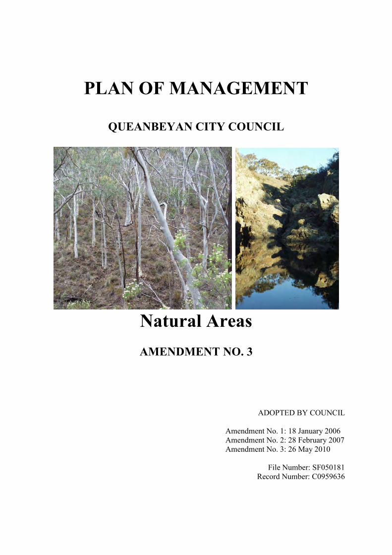
PLAN OF MANAGEMENT
QUEANBEYAN CITY COUNCIL
Natural Areas
AMENDMENT NO. 3
ADOPTED BY COUNCIL
Amendment No. 1: 18 January 2006 Amendment No. 2: 28 February 2007 Amendment No. 3: 26 May 2010
File Number: SF050181
Record Number: C0959636

2
3
CONTENTS
PART A – COMMON TO ALL PLANS OF MANAGEMENT .......................................... 5 1. Introduction ................................................................................................................ 5 2. Land covered by this plan of management ................................................................ 6 3. Category and objectives for management of land. ................................................... 10 4. Owner of the land..................................................................................................... 11 5. Management of the land........................................................................................... 11 6. Approvals for activities on the land ......................................................................... 17
PART B – SPECIFIC PLAN OF MANAGEMENT FOR MOUNT JERRABOMBERRA ... 18 1. Use of the land and structures at the date of adoption of the plan ........................... 22 2. Threatened species legislation ................................................................................. 22 3. Future use of the land. .................................................................................................. 22 4. Scale and intensity ................................................................................................... 22 5. Leases, licences, and other estates. .......................................................................... 22
PART C – SPECIFIC PLAN OF MANAGEMENT FOR QUEANBEYAN RIVER CORRIDOR ......................................................................................................................... 24
1. Use of the land and structures at the date of adoption of the plan. .......................... 27 2. Threatened species laws ........................................................................................... 27 3. Future use of the land. .................................................................................................. 27 4. Scale and intensity ................................................................................................... 27 5. Leases, licences and other estates. ............................................................................... 27
PART D – SPECIFIC PLAN OF MANAGEMENT FOR JERRABOMBERRA PARK ... 25 1. Use of the land and structures at the date of adoption of the plan. .......................... 32 2. Threatened species laws ........................................................................................... 32 3. Future use of the land. .............................................................................................. 32 4. Scale and intensity ................................................................................................... 32 5. Leases, licences and other estates. ........................................................................... 32
PART E – SPECIFIC PLAN OF MANAGEMENT FOR STRINGYBARK HILL ........... 34 1. Use of the land and structures at the date of adoption of the plan. .......................... 39 2. Threatened Species Laws ......................................................................................... 39 3. Future use of the land. .............................................................................................. 39 4. Scale and Intensity ................................................................................................... 39 5. Leases, licences and other estates. ........................................................................... 39
PART F – SPECIFIC PLANS OF MANAGEMENT FOR ESCARPMENT AREAS ....... 40 1. Use of the land and structures at the date of adoption of the plan. ........................... 44 2. Threatened Species Legislation ............................................................................... 44 3. Future use of the land. .............................................................................................. 44 4. Scale and Intensity ................................................................................................... 44 5. Leases, licences and other estates. ........................................................................... 44
Appendix 1 ........................................................................................................................... 46 Table 1: Identified species based on Southern Tablelands Grassy Woodland
vegetation community ................................................................................... 46 Table 2: Threatened species based on Southern Tablelands Dry Sclerophyll Forest
vegetation community ................................................................................... 47 References ............................................................................................................................ 48

4
5
PART A – COMMON TO ALL PLANS OF MANAGEMENT
1. Introduction Natural Areas Natural areas are public reserves consisting of natural features such as vegetation, landforms, and drainage patterns that dominate the landscape. The diversity of bushland qualities through much of the city remains high with small Public Reserves retaining a range of bushland qualities with the larger areas found outside of the developed areas of the City containing native vegetation having partially or completely regenerated over time, possessing important qualities as habitat for surviving flora and fauna (Barrer: 1993). The larger areas adjoin other portions of National Park land and are considered to be regionally important as they assist in maintaining the wildlife corridor throughout the area. There are three types of community land that are considered Natural Areas within the Queanbeyan City area and these are further categorised under the Local Government Act 1993 as ‘bushland’, ‘watercourse’ and ‘escarpment’:
a) Urban Bush Reserves (Bushland) – Generally situated on higher grounds where development is restricted by scenic protection and urban servicing allowing the protection of significant vegetation. These areas are generally large in area averaging more than 5000m². Under the Local Government Act 1993 t hese are categorised as ‘bushland’.
b) Queanbeyan River Corridor (Watercourse) – The Queanbeyan River is a water
course constituting a significant natural feature and recreation base within the City of Queanbeyan. It provides the community with a range of aquatic based recreational opportunities, and has significance in terms of wildlife habitat. The river corridor presents the community with an unequalled opportunity to combine urban amenity, active and passive recreation with a naturally occurring aquatic wildlife corridor.
c) Escarpment – Located to the North-east of the city the naturally forested
escarpment which is considered as an important scenic feature of the City with its native vegetation and wildlife adding to the bush character of the City.
These natural areas contribute significantly to the city’s overall urban setting and constitute an important part of Queanbeyan’s informal open space system. T he importance of these areas has been further acknowledged by the development of several operational Plans of Management which apply to specific areas. T hese documents are detailed as follows and should be referred to when considering works or actions in these areas.
1. The Queanbeyan River Corridor Plan of Management (1999) 2. The Mount Jerrabomberra Plan of Management (2004) 3. The Jerrabomberra Creek Plan of Management (2006)
6
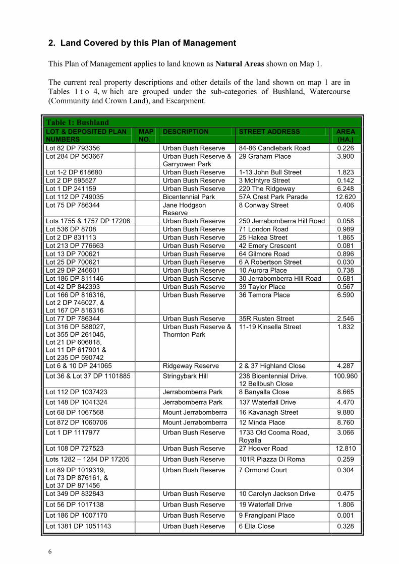
2. Land Covered by this Plan of Management This Plan of Management applies to land known as Natural Areas shown on Map 1. The current real property descriptions and other details of the land shown on map 1 are in Tables 1 t o 4, w hich are grouped under the sub-categories of Bushland, Watercourse (Community and Crown Land), and Escarpment.
Table 1: Bushland LOT & DEPOSITED PLAN NUMBERS
MAP NO.
DESCRIPTION STREET ADDRESS AREA (HA.)
Lot 82 DP 793356 Urban Bush Reserve 84-86 Candlebark Road 0.226 Lot 284 DP 563667 Urban Bush Reserve &
Garryowen Park 29 Graham Place 3.900
Lot 1-2 DP 618680 Urban Bush Reserve 1-13 John Bull Street 1.823 Lot 2 DP 595527 Urban Bush Reserve 3 McIntyre Street 0.142 Lot 1 DP 241159 Urban Bush Reserve 220 The Ridgeway 6.248 Lot 112 DP 749035 Bicentennial Park 57A Crest Park Parade 12.620 Lot 75 DP 786344 Jane Hodgson
Reserve 8 Conway Street 0.406
Lots 1755 & 1757 DP 17206 Urban Bush Reserve 250 Jerrabomberra Hill Road 0.058 Lot 536 DP 8708 Urban Bush Reserve 71 London Road 0.989 Lot 2 DP 831113 Urban Bush Reserve 25 Hakea Street 1.865 Lot 213 DP 776663 Urban Bush Reserve 42 Emery Crescent 0.081 Lot 13 DP 700621 Urban Bush Reserve 64 Gilmore Road 0.896 Lot 25 DP 700621 Urban Bush Reserve 6 A Robertson Street 0.030 Lot 29 DP 246601 Urban Bush Reserve 10 Aurora Place 0.738 Lot 186 DP 811146 Urban Bush Reserve 30 Jerrabomberra Hill Road 0.681 Lot 42 DP 842393 Urban Bush Reserve 39 Taylor Place 0.567 Lot 166 DP 816316, Lot 2 DP 746027, & Lot 167 DP 816316
Urban Bush Reserve 36 Temora Place 6.590
Lot 77 DP 786344 Urban Bush Reserve 35R Rusten Street 2.546 Lot 316 DP 588027, Lot 355 DP 261045, Lot 21 DP 606818, Lot 11 DP 617901 & Lot 235 DP 590742
Urban Bush Reserve & Thornton Park
11-19 Kinsella Street 1.832
Lot 6 & 10 DP 241065 Ridgeway Reserve 2 & 37 Highland Close 4.287 Lot 36 & Lot 37 DP 1101885
Stringybark Hill 238 Bicentennial Drive, 12 Bellbush Close
100.960
Lot 112 DP 1037423 Jerrabomberra Park 8 Banyalla Close 8.665 Lot 148 DP 1041324 Jerrabomberra Park 137 Waterfall Drive 4.470 Lot 68 DP 1067568 Mount Jerrabomberra 16 Kavanagh Street 9.880 Lot 872 DP 1060706 Mount Jerrabomberra 12 Minda Place 8.760 Lot 1 DP 1117977 Urban Bush Reserve 1733 Old Cooma Road,
Royalla 3.066
Lot 108 DP 727523 Urban Bush Reserve 27 Hoover Road 12.810 Lots 1282 – 1284 DP 17205 Urban Bush Reserve 101R Piazza Di Roma 0.259 Lot 89 DP 1019319, Lot 73 DP 876161, & Lot 37 DP 871456
Urban Bush Reserve 7 Ormond Court 0.304
Lot 349 DP 832843 Urban Bush Reserve 10 Carolyn Jackson Drive 0.475 Lot 56 DP 1017138 Urban Bush Reserve 19 Waterfall Drive 1.806 Lot 186 DP 1007170 Urban Bush Reserve 9 Frangipani Place 0.001 Lot 1381 DP 1051143 Urban Bush Reserve 6 Ella Close 0.328
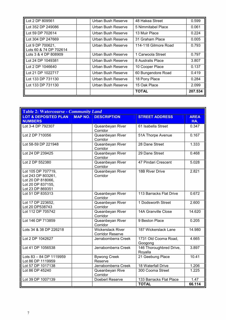
7
Lot 2 DP 809561 Urban Bush Reserve 48 Hakea Street 0.599 Lot 352 DP 249086 Urban Bush Reserve 5 Nimmitabel Place 0.061 Lot 59 DP 702614 Urban Bush Reserve 13 Muir Place 0.224 Lot 304 DP 247669 Urban Bush Reserve 31 Graham Place 0.005 Lot 9 DP 700621, Lots 60 & 74 DP 702614
Urban Bush Reserve 114-118 Gilmore Road 0.793
Lots 3 & 4 DP 808909 Urban Bush Reserve 1 Carwoola Street 0.797 Lot 24 DP 1049381 Urban Bush Reserve 8 Australis Place 3.807 Lot 2 DP 1046640 Urban Bush Reserve 10 Cooper Place 0.137 Lot 21 DP 1022717 Urban Bush Reserve 60 Bungendore Road 0.419 Lot 133 DP 731130 Urban Bush Reserve 18 Pony Place 0.284 Lot 133 DP 731130 Urban Bush Reserve 15 Oak Place 2.099 TOTAL 207.534
Table 2: Watercourse - Community Land LOT & DEPOSITED PLAN NUMBERS
MAP NO. DESCRIPTION STREET ADDRESS AREA HA.
Lot 3-4 DP 792307 Queanbeyan River Corridor
61 Isabella Street 0.347
Lot 2 DP 710056 Queanbeyan River Corridor
51A Thorpe Avenue 0.167
Lot 58-59 DP 221948 Queanbeyan River Corridor
28 Dane Street 1.333
Lot 24 DP 239425 Queanbeyan River Corridor
29 Dane Street 0.468
Lot 2 DP 552380 Queanbeyan River Corridor
47 Pindari Crescent 5.028
Lot 105 DP 707719, Lot 243 DP 803261, Lot 20 DP 818066, Lot 20 DP 837155, Lot 23 DP 869351
Queanbeyan River Corridor
18B River Drive 2.821
Lot 51 DP 835313 Queanbeyan River Corridor
113 Barracks Flat Drive 0.672
Lot 17 DP 223652, Lot 20 DP538743
Queanbeyan River Corridor
1 Dodsworth Street 2.600
Lot 112 DP 705742 Queanbeyan River Corridor
14A Granville Close 14.620
Lot 146 DP 713859 Queanbeyan River Corridor
9 Beston Place 0.205
Lots 34 & 38 DP 226218 Wickerslack River Corridor Reserve
187 Wickerslack Lane 14.980
Lot 2 DP 1042627 Jerrabomberra Creek 1731 Old Cooma Road, Googong
4.665
Lot 41 DP 1056538 Jerrabomberra Creek 146 Thoroughbred Drive, Royalla
3.897
Lots 83 – 84 DP 1119959 Lot 86 DP 1119959
Bywong Creek Reserve
21 Geebung Place 10.41
Lot 57 DP 1017138 Jerrabomberra Creek 18 Waterfall Drive 1.206 Lot 86 DP 45240 Queanbeyan Rive
Corridor 300 Cooma Street 1.225
Lot 39 DP 1007139 Doeberl Reserve 133 Barracks Flat Place 1.47 TOTAL 66.114

8
Table 3: Watercourse - Crown Land LOT & DEPOSITED PLAN NUMBERS
MAP NO. DESCRIPTION STREET ADDRESS AREA (HA.)
Lot 7300 DP 1146331 River Corridor 38 A Carinya Street 1.247 Lot 113-115 DP 821709 River Corridor 53 Carinya Street 1.691 Part Lot 1 Sec 33 DP 758862 River Corridor 58 Carinya Street 0.809 Lot 116 DP 821709 River Corridor 63 Carinya Street 2.846 No Lot number Buttles Creek 12 High Street 1.046 Lot 1 & Part Lots 2-5 Sec 34 DP 758862
River Corridor 61 High Street 0.478
No Lot number River Corridor 100 Morisset Street 1.385 No Lot number River Corridor 11 Waniassa Street 1.187 Lot 4 DP 45210 River Corridor 6 Jineroo Street 0.136 Lot 3 DP 45210 River Corridor 7 Jineroo Street 0.196 No Lot number River Corridor 1 Trinculo Place 0.981 No Lot number River Corridor 51 Trinculo Place 0.607 No Lot number River Corridor 2 Collett Street 0.619 No Lot number River Corridor 30 Collett Street 0.182 TOTAL 13.410
Table 4: Escarpment - Community Land Only LOT & DEPOSITED PLAN NUMBERS
MAP NO. DESCRIPTION STREET ADDRESS AREA (HA.)
Lot 17 DP 826557 Escarpment 230 Bungendore Road 0.837 TOTAL 0.837
Part A covers all land within the category of Natural Areas, including those covered in Parts B to F Parts B to F contain specific plans for the land nominated in each part.

9
Map 1: Location of Natural Areas within Queanbeyan City Council LGA

10
3. Category and Objectives for Management of Land The land to which this plan applies is categorised as Natural Area under section 36E of the Local Government Act 1993. The core objectives of the Local Government Act 1993 for management of community land categorised as Natural Area are:
a. To conserve biodiversity and maintain ecosystem function in respect of the land, or the features habitat in respect of which the land is categorized as a natural area, and
b. To maintain the land, or that feature or habitat, in its natural state and setting, and
c. To provide for the restoration and regeneration of the land, and d. To provide for community use and access to the land in such manner as will
minimize and mitigate any disturbance caused by human intrusion, and e. To assist in and facilitate the implementation of any provisions restricting the
use and management of the land that are set out in a recovery plan or threat abatement plan prepared under the Threatened Species Conservation Act 1995 or the Fisheries Management Act 1994.
The subject land that is categorised as a natural area is further categorised as:
• bushland, • escarpment, and • watercourse
Under section 36(5) of the Local Government Act 1993. Each of these categories also has core objectives for management of community land. Bushland The core objectives for management of community land categorised as bushland are:
a) To ensure the ongoing ecological viability of the land by protecting the ecological biodiversity and habitat values of the land, the flora and fauna (including invertebrates, fungi and micro-organisms) of the land and other ecological values of the land, and
b) To protect the aesthetic, heritage, recreational, educational and scientific values of the land, and
c) To promote the management of the land in a manner that protects and enhances the values and quality of the land and facilitates public enjoyment of the land, and to implement measures directed to minimising or mitigating any disturbance caused by human intrusion, and
d) To restore degraded bushland, and e) To protect existing landforms such as natural drainage lines, watercourses and
foreshores, and f) To retain bushland in parcels of a size and configuring that will enable the existing
plant and animal communities to survive in the long term, and g) To protect bushland as a natural stabiliser of the soil surface.
Escarpment The core objectives for management of community land categorised as an escarpment are:
a) To protect any important geological, geomorphological or scenic features of the escarpment, and

11
b) To facilitate safe community use and enjoyment of the escarpment. Watercourse The core objectives for management of community land categorised as a watercourse are:
a) To managed watercourses so as to protect the biodiversity and ecological values of the instream environment, particularly in relation to water quality and water flows, and
b) To manage watercourses so as to protect the riparian environment, particularly in relation to riparian vegetation and habitats and bank stability, and
c) To restore degraded watercourses, and d) To promote community education, and community access to and use of the
watercourse, without comprising the other core objectives of the category.
4. Owner of the Land These lands are owned by Queanbeyan City Council and the Crown
5. Management of the Land BACKGROUND TO THE MANAGEMENT OF THIS LAND This plan of management seeks to:
• Comply with the core objectives for this type of community land and all other statutory provisions,
• Set up a management and maintenance regime in order to maintain the facilities on the lands covered by this plan in good order so as to reduce public liability risk and to protect public investment as well as their users,
• Authorise leases for specific sites; and • Identify landscape development plans for specific sites.
The management of these sites involve Engineering & Recreation, Governance and Environmental Services sections of Council. The action priorities for Natural Areas are shown in the following tables which have been arranged according to the following management issues and specific plans: Generic Section of the Plan:
• Compliance with the Core Objectives for Natural Areas and the core objectives of the further categories of bushland, escarpment, and watercourse (applicable to this type of community land) (5.1)
• Maintenance (5.2) • Community Consultation (5.3) • Public Access to the Sites (5.4)
Specific Plans are included in Parts B to F of this Plan and cover:
• Mount Jerrabomberra (Including Landscape Development Plan for 120 Southbar Road, also known as The Scar)
•

12
• Queanbeyan River Corridor • Jerrabomberra Park (Including Landscape Development Plan) • Stringybark Hill • Escarpment Areas
13
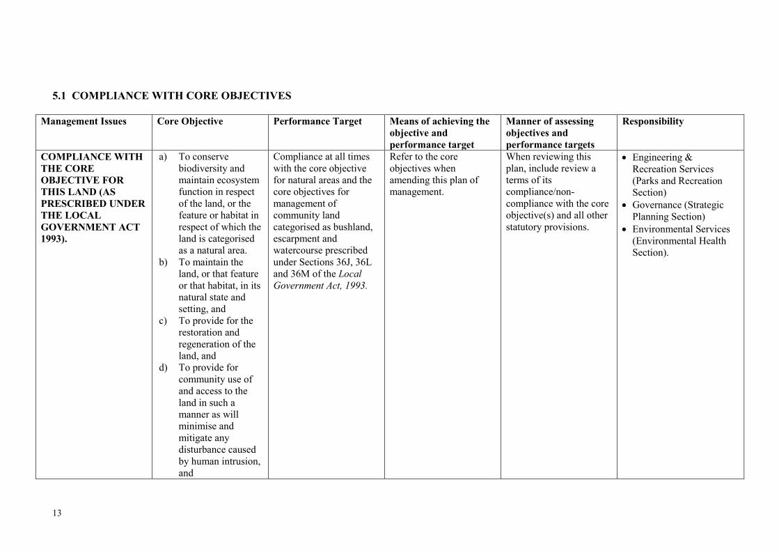
5.1 COMPLIANCE WITH CORE OBJECTIVES
Management Issues Core Objective Performance Target Means of achieving the objective and performance target
Manner of assessing objectives and performance targets
Responsibility
COMPLIANCE WITH THE CORE OBJECTIVE FOR THIS LAND (AS PRESCRIBED UNDER THE LOCAL GOVERNMENT ACT 1993).
a) To conserve biodiversity and maintain ecosystem function in respect of the land, or the feature or habitat in respect of which the land is categorised as a natural area.
b) To maintain the land, or that feature or that habitat, in its natural state and setting, and
c) To provide for the restoration and regeneration of the land, and
d) To provide for community use of and access to the land in such a manner as will minimise and mitigate any disturbance caused by human intrusion, and
Compliance at all times with the core objective for natural areas and the core objectives for management of community land categorised as bushland, escarpment and watercourse prescribed under Sections 36J, 36L and 36M of the Local Government Act, 1993.
Refer to the core objectives when amending this plan of management.
When reviewing this plan, include review a terms of its compliance/non-compliance with the core objective(s) and all other statutory provisions.
• Engineering & Recreation Services (Parks and Recreation Section)
• Governance (Strategic Planning Section)
• Environmental Services (Environmental Health Section).

14
Management Issues (Continued)
Core Objective (Continued)
Performance Target Means of achieving the objective and performance target (Continued)
Manner of assessing objectives and performance targets (Continued)
Responsibility (Continued)
As above e) To assist in and facilitate the implementation of any provisions restricting the use and management of the land that are set out in a recovery plan or threat abatement plan prepared under the Threatened Species Conservation Act 1995 or the Fisheries Management Act 1994.
As above As above As above As above

15
5.2 MAINTENANCE
Management Issues Objective Performance Target Means of achieving the objective
Manner of assessing performance
Responsibility
GENERAL SITE MAINTENANCE
GENERAL SITE MAINTENANCE
To minimise public risk and to ensure the proper management of the site.
• Continue to finance and to provide administrative support for the maintenance of each site.
• Continue to report all damage to Environmental Health Section for restoration.
• Continue to maintain the areas in accordance with the natural areas maintenance programme.
• Continue to monitor the areas with regard to their usefulness/appropriateness, risk, condition, long term maintenance, and compliance with the relevant Standards.
• Annual risk assessment of the sites.
• Whether or not funds for the maintenance are included in the annual management plan.
• Visual inspection to determine general maintenance standard of the areas.
• Assessment of whether or not the areas comply with the relevant Standards or are at high risk.
• Whether or not annual risk assessment is undertaken.
• Whether or not appropriate remedial action is taken to ensure that areas are in good order and/or comply with the relevant Standards or are high risk.
•
• Engineering & Recreation Services (Parks and Recreation Section)
• Environmental Services (Environmental Health Section)
16
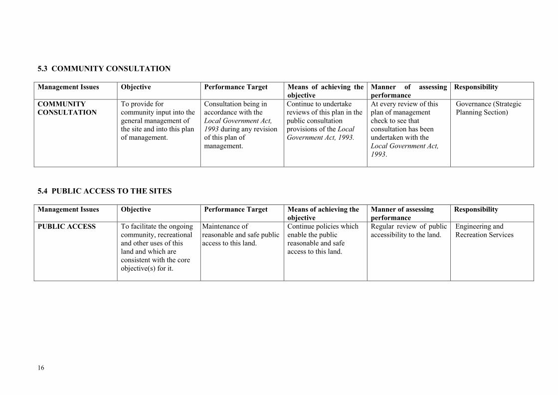
5.3 COMMUNITY CONSULTATION Management Issues Objective Performance Target Means of achieving the
objective Manner of assessing performance
Responsibility
COMMUNITY CONSULTATION
To provide for community input into the general management of the site and into this plan of management.
Consultation being in accordance with the Local Government Act, 1993 during any revision of this plan of management.
Continue to undertake reviews of this plan in the public consultation provisions of the Local Government Act, 1993.
At every review of this plan of management check to see that consultation has been undertaken with the Local Government Act, 1993.
Governance (Strategic Planning Section)
5.4 PUBLIC ACCESS TO THE SITES Management Issues Objective Performance Target Means of achieving the
objective Manner of assessing performance
Responsibility
PUBLIC ACCESS
To facilitate the ongoing community, recreational and other uses of this land and which are consistent with the core objective(s) for it.
Maintenance of reasonable and safe public access to this land.
Continue policies which enable the public reasonable and safe access to this land.
Regular review of public accessibility to the land.
Engineering and Recreation Services
17
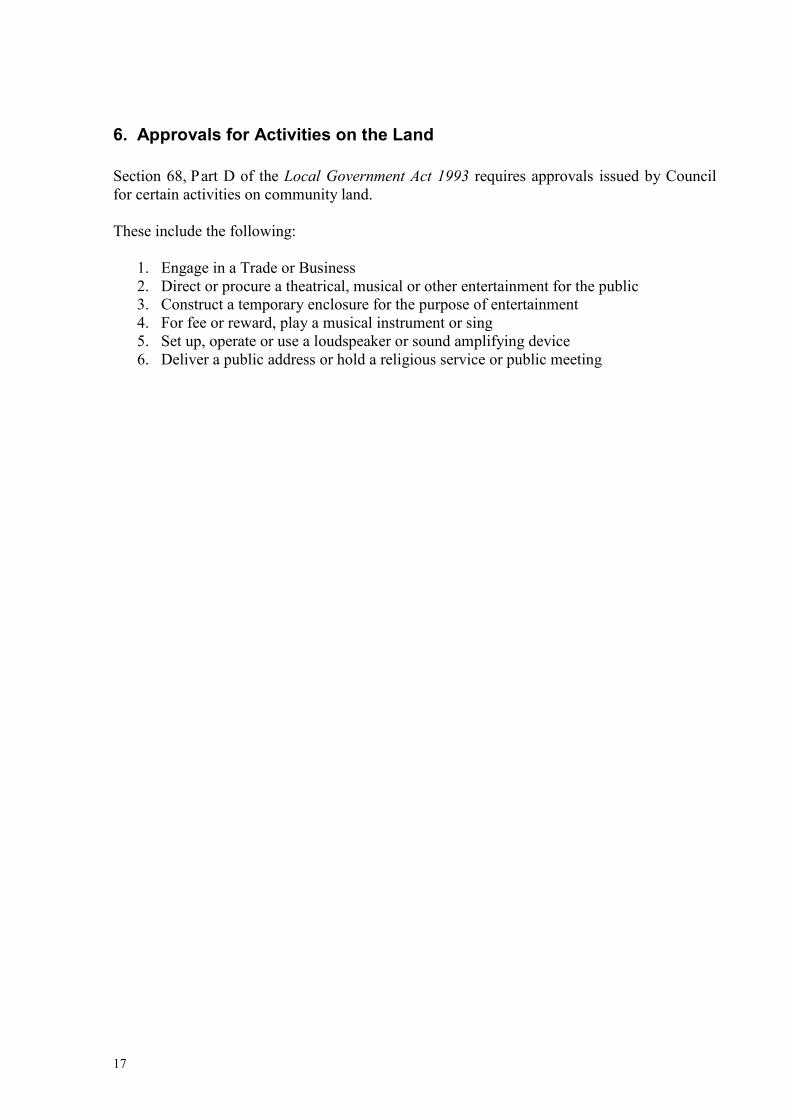
6. Approvals for Activities on the Land Section 68, Part D of the Local Government Act 1993 requires approvals issued by Council for certain activities on community land. These include the following:
1. Engage in a Trade or Business 2. Direct or procure a theatrical, musical or other entertainment for the public 3. Construct a temporary enclosure for the purpose of entertainment 4. For fee or reward, play a musical instrument or sing 5. Set up, operate or use a loudspeaker or sound amplifying device 6. Deliver a public address or hold a religious service or public meeting

18

19
Part B:
Site Specific Plan of Management for Mount
Jerrabomberra

20
21
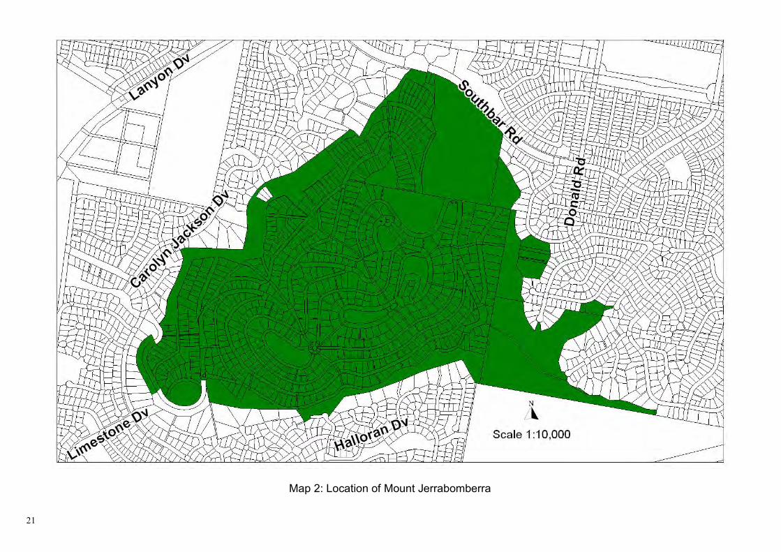
Map 2: Location of Mount Jerrabomberra

22
CONDITION OF THE LAND AND STRUCTURES ON ADOPTION OF THE PLAN FOR MOUNT JERRABOMBERRA. FEATURE DESCRIPTION/CONDITION LOCATION Jerrabomberra Hill Road AREA 142.64 Hectares LANDFORM AND SURROUNDING LAND USE
A three peaked mountain sloping away to the south-west and north-west
VEGETATION Tablelands dry shrub tussock grass forest. IMPROVEMENTS Public roads, communication infrastructure, walking tracks and
dog exercise area.
URBAN SERVICES The following services are provided to the site: electricity. SUMMARY Please refer to the Mount Jerrabomberra Plan of Management
adopted by Council on April 7, 2004 for more detail on the headings below and for the Specific maintenance schedule.
1. Use of the Land and Structures at the Date of Adoption of the Plan Telecommunications towers, trig station, urban water tanks, dog exercise area.
2. Threatened Species Legislation Land covered by this Plan is affected by the Threatened Species Conservation Act 1995. Mount Jerrabomberra contains significant flora and fauna communities some of which contain species listed under the Threatened Species Conservation Act 1995 see Appendix 1, Tables 1 and 2.
3. Future Use of the Land. The proposed changes for the use of 120 Southbar Road (also known as The Scar), which is included in the Mount Jerrabomberra Plan is indicated on the Landscape Development Plan on page 23 of this document.
4. Scale and Intensity Minor
5. Leases, Licences, and Other Estates. Leases and licences and the granting of other estates are primarily governed by sections 44-47 of the Local Government Act 1993. This plan of management authorises the lease, licence, or grant of any other estate over Mount Jerrabomberra which is consistent with the core objective of this plan and which is permissible under Queanbeyan Local Environmental Plan 1998.

23

24
Part C:
Site Specific Plan of Management for Queanbeyan River Corridor

25
26
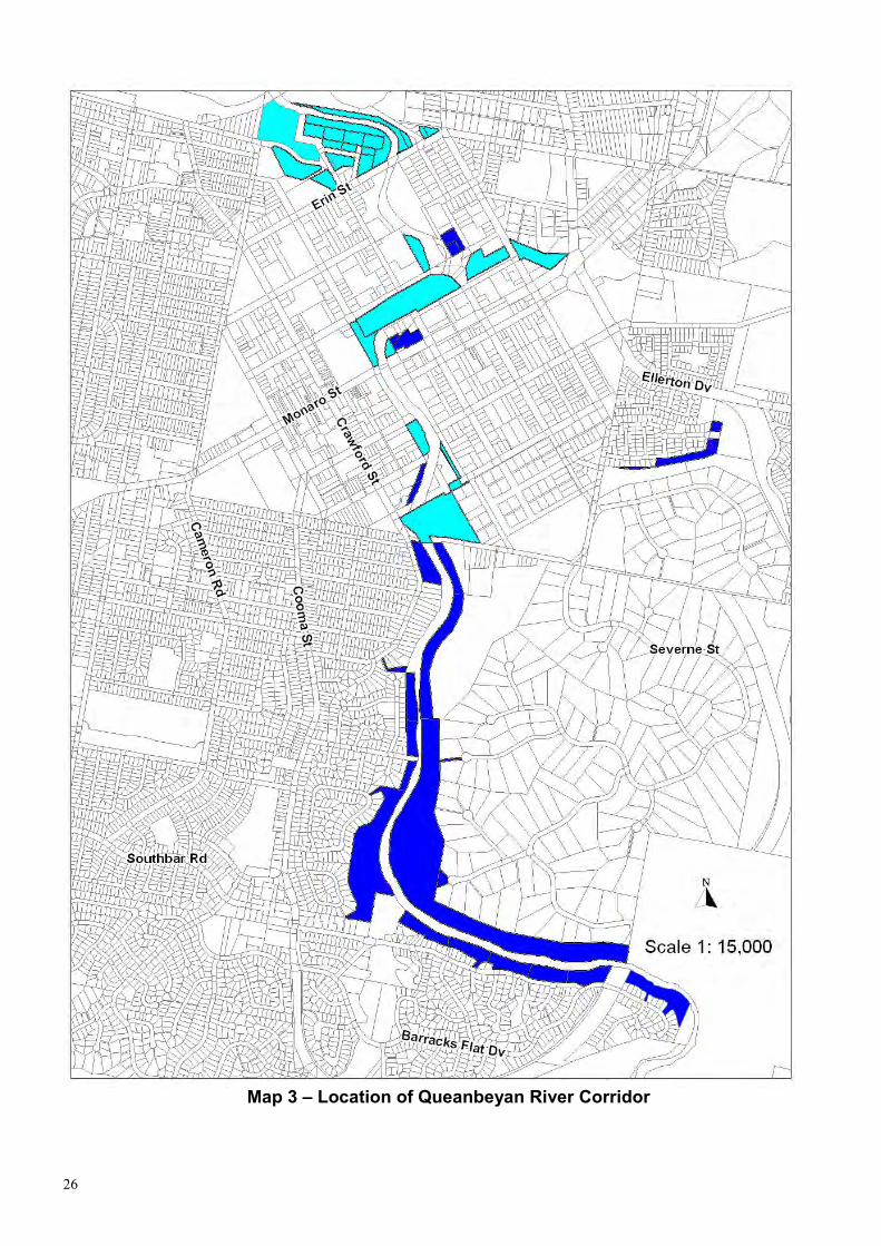
Map 3 – Location of Queanbeyan River Corridor

27
CONDITION OF THE LAND AND STRUCTURES ON ADOPTION OF THE PLAN FOR THE QUEANBEYAN RIVER CORRIDOR. FEATURE DESCRIPTION/CONDITION LOCATION Queanbeyan River Corridor AREA
LANDFORM AND SURROUNDING LAND USE
River runs through the middle of the city with the corridor surrounded by commercial, residential, and recreational uses.
VEGETATION Native grasses, wattle, eucalypts, and tea tree shrubs. IMPROVEMENTS
URBAN SERVICES The following services are provided at particular points along the corridor: electricity, gas, stormwater, and sewerage.
SUMMARY Please refer to the Queanbeyan River Corridor Plan of Management adopted by Council on July 21, 1999 for more detail on the headings below and for the Specific maintenance schedule.
1. Use of the Land and Structures at the Date of Adoption of the Plan. The site is used for general recreational opportunities supporting native flora and fauna and heritage items.
2. Threatened species Laws Land covered by this Plan is not affected by the Threatened Species Conservation Act 1995.
3. Future use of the land. All proposed changes to the river corridor are listed in the action chapter of the River Corridor Plan of Management.
4. Scale and intensity Minor
5. Leases, licences and other estates. Leases and licences and the granting of other estates are primarily governed by sections 44-47 of the Local Government Act 1993. This plan of management authorises the lease, licence, or grant of any other estate over the Queanbeyan River Corridor which is consistent with the core objective of this plan and which is permissible under Queanbeyan Local Environmental Plan 1998.

28
Part D:
Site Specific Plan of Management for Jerrabomberra Park

29
30
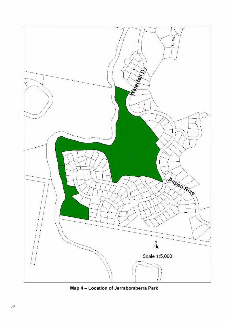
Map 4 – Location of Jerrabomberra Park

31
MAP 5 LANDSCAPE DEVELOPMENT PLAN

32
CONDITION OF THE LAND AND STRUCTURES ON ADOPTION OF THE PLAN FOR JERRABOMBERRA PARK.
FEATURE DESCRIPTION/CONDITION LOCATION Lot 112 DP 1037423, 8 Banyalla Close & Lot 148 DP 1041324, 137
Waterfall Drive, Jerrabomberra AREA 7.45 Ha LANDFORM AND SURROUNDING LAND USE
Bush land located along Jerrabomberra Creek. A waterfall is located within this area and surrounded by Residential development
VEGETATION Native grasses, eucalypts, wattle, and tea tree shrubs IMPROVEMENTS Formalised walking tracks, signage, parking areas and
observation deck URBAN SERVICES There are no services provided to the abovementioned sites SUMMARY Please refer to the Jerrabomberra Creek Plan of Management
adopted 7 June 2006 for more detail on the headings below and for the Specific maintenance schedule
1. Use of the land and structures at the date of adoption of the plan.
The site is used for general recreation opportunities supporting native flora and fauna and other natural features.
2. Threatened species laws
Land covered by this Plan is not affected by the Threatened Species Conservation Act 1995.
3. Future use of the land.
The proposed changes include formalised walking tracks, signage, parking areas and an observation deck as the landscape development plan.
4. Scale and intensity Minor
5. Leases, licences and other estates.
Leases and licences and the granting of other estates are primarily governed by sections 44-47 of the Local Government Act 1993. This plan of management authorises the lease, licence or grant of any other estate over Lot 112 DP 1037423, 8 Banyalla Close & Lot 148 DP 1041324, 137 Waterfall Drive Jerrabomberra which is consistent with the core objective of this plan and which is permissible under Queanbeyan Local Environmental Plan 1998.

33

34
Part E:
Site Specific Plan of Management for Stringybark Hill

35

36
Map 6: Location of Stringybark Hill

37
Management Issues Objective Performance Target Means of achieving the objective
Manner of assessing performance
Responsibility
GENERAL SITE MAINTENANCE
GENERAL SITE MAINTENANCE
To minimise public risk and to ensure the proper management of the site.
• Continue to finance and to provide administrative support for the maintenance of each site.
• Continue to report all damage to Environmental Health Section for restoration.
• Continue to maintain the areas in accordance with the natural areas maintenance programme.
• Compilation and implementation of a Bushfire Management Strategy in conjunction with the Rural Fire Service.
• Whether or not funds for the maintenance are included in the annual management plan.
• Visual inspection to determine general maintenance standard of the areas.
• Assessment of whether or not the areas comply with the relevant Standards or are at high risk.
• Engineering & Recreation Services (Parks and Recreation Section)
• Environmental Services (Environmental Health Section)

38
SPECIFIC SITE MAINTENANCE Management Issues Objective Performance
Target Means of achieving the objective
Manner of assessing performance
Responsibility
Fencing Weed Control General Clean Up Access & Entry Points Asset Protection Zone Signage Further Studies
To ensure that the Stringybark Reserve is maintained as an Urban Bushland Reserve and wildlife corridor, enabling it to sustain the current variety of flora and fauna whilst being accessible by the public.
To maintain the site as an urban bushland reserve and wildlife corridor whilst providing access to the public for passive recreation.
• Fencing off the reserve to define the boundaries of the site.
• Eliminating and controlling weed infestation.
• Cleaning up and disposing of litter left onsite (e.g. Builders rubble & car bodies).
• Controlling and minimising the number of access points to the site.
• Provision of an Asset Protection Zone where required in consultation with the Rural Fire Service.
• Provision of signage to indicate that the land is owned by Council and is urban bush reserve.
• Further studies if required to assess the impacts on existing flora and fauna populations.
• Allocation of funds within Councils Management Plan.
• Regular visual inspections of the site to determine the maintenance required.
• Identifying key types and locations of access points to the site to restrict unauthorised vehicle access preventing illegal collection of firewood and motorbikes.
• Engineering & Recreation Services (Parks and Recreation Section)
• Environmental Services (Environmental Health Section)
39
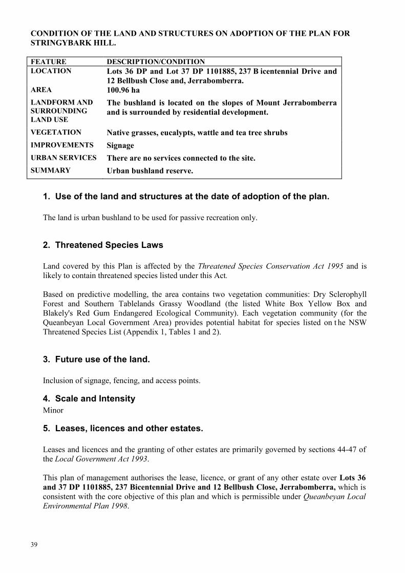
CONDITION OF THE LAND AND STRUCTURES ON ADOPTION OF THE PLAN FOR STRINGYBARK HILL. FEATURE DESCRIPTION/CONDITION LOCATION Lots 36 DP and Lot 37 DP 1101885, 237 B icentennial Drive and
12 Bellbush Close and, Jerrabomberra. AREA 100.96 ha LANDFORM AND SURROUNDING LAND USE
The bushland is located on the slopes of Mount Jerrabomberra and is surrounded by residential development.
VEGETATION Native grasses, eucalypts, wattle and tea tree shrubs IMPROVEMENTS Signage URBAN SERVICES There are no services connected to the site. SUMMARY Urban bushland reserve.
1. Use of the land and structures at the date of adoption of the plan.
The land is urban bushland to be used for passive recreation only.
2. Threatened Species Laws
Land covered by this Plan is affected by the Threatened Species Conservation Act 1995 and is likely to contain threatened species listed under this Act. Based on predictive modelling, the area contains two vegetation communities: Dry Sclerophyll Forest and Southern Tablelands Grassy Woodland (the listed White Box Yellow Box and Blakely's Red Gum Endangered Ecological Community). Each vegetation community (for the Queanbeyan Local Government Area) provides potential habitat for species listed on t he NSW Threatened Species List (Appendix 1, Tables 1 and 2).
3. Future use of the land.
Inclusion of signage, fencing, and access points.
4. Scale and Intensity Minor
5. Leases, licences and other estates.
Leases and licences and the granting of other estates are primarily governed by sections 44-47 of the Local Government Act 1993. This plan of management authorises the lease, licence, or grant of any other estate over Lots 36 and 37 DP 1101885, 237 Bicentennial Drive and 12 Bellbush Close, Jerrabomberra, which is consistent with the core objective of this plan and which is permissible under Queanbeyan Local Environmental Plan 1998.

40
Part F:
Site Specific Plan of Management for Escarpment Areas

41

42
Map 7: Location of Escarpment Areas
43
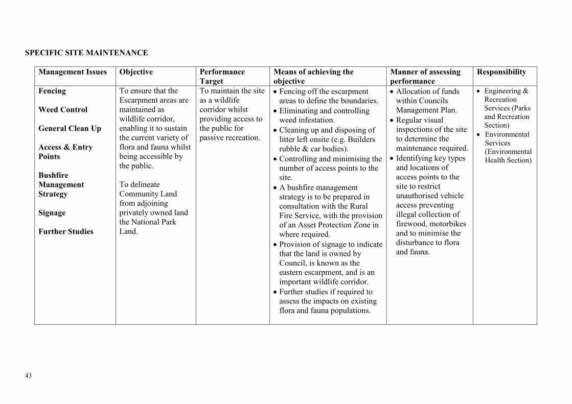
SPECIFIC SITE MAINTENANCE
Management Issues Objective Performance Target
Means of achieving the objective
Manner of assessing performance
Responsibility
Fencing Weed Control General Clean Up Access & Entry Points Bushfire Management Strategy Signage Further Studies
To ensure that the Escarpment areas are maintained as wildlife corridor, enabling it to sustain the current variety of flora and fauna whilst being accessible by the public. To delineate Community Land from adjoining privately owned land the National Park Land.
To maintain the site as a wildlife corridor whilst providing access to the public for passive recreation.
• Fencing off the escarpment areas to define the boundaries.
• Eliminating and controlling weed infestation.
• Cleaning up and disposing of litter left onsite (e.g. Builders rubble & car bodies).
• Controlling and minimising the number of access points to the site.
• A bushfire management strategy is to be prepared in consultation with the Rural Fire Service, with the provision of an Asset Protection Zone in where required.
• Provision of signage to indicate that the land is owned by Council, is known as the eastern escarpment, and is an important wildlife corridor.
• Further studies if required to assess the impacts on existing flora and fauna populations.
• Allocation of funds within Councils Management Plan.
• Regular visual inspections of the site to determine the maintenance required.
• Identifying key types and locations of access points to the site to restrict unauthorised vehicle access preventing illegal collection of firewood, motorbikes and to minimise the disturbance to flora and fauna.
• Engineering & Recreation Services (Parks and Recreation Section)
• Environmental Services (Environmental Health Section)

44
CONDITION OF THE LAND AND STRUCTURES ON ADOPTION OF THE PLAN FOR THE ESCARPMENT AREAS.
FEATURE DESCRIPTION/CONDITIONLOCATION Lot 17 DP 86557, 230 Bungendore Road. AREA 0.837haLANDFORM AND SURROUNDING LAND USE
Naturally forested escarpment areas containing native flora andfauna
VEGETATION Eucalypts, wattles, tea tree shrubs, and native grassesIMPROVEMENTS No improvements proposedURBAN SERVICES There are no services provided to the siteSUMMARY Eastern Escarpment
1. Use of the land and structures at the date of adoption of the plan.
The area is escarpment and is to be used for passive recreational use.
2. Threatened Species Legislation
Land covered by this Plan is affected by the Threatened Species Conservation Act 1995.The land contains a lot of native flora and fauna and is considered to be an important wildlife corridor.
3. Future use of the land.
Inclusion of fencing, signage, and access points.
4. Scale and IntensityMinor
5. Leases, licences and other estates.
Leases and licences and the granting of other estates are primarily governed by sections 44-47 of the Local Government Act 1993.

45
46
Appendix 1
Table A: Identified species based on Southern Tablelands Grassy Woodland vegetation community
Queanbeyan Local Government Area – Threatened Species ListSouthern Tablelands Grassy Woodland
Scientific Name Common Name Species Type Threatened Category
Aprasia parapulchella
Pink-tailed Worm lizard
Animal > Reptiles Vulnerable
Calyptorhynchus lathami
Glossy Black-Cockatoo
Animal > Birds Vulnerable
Climacteris picumnus victoriae
Brown Treecreeper (eastern subspecies)
Animal > Birds Vulnerable
Lophoictinia isura Square-tailed Kite Animal > Birds VulnerableMelanodryas cucullata cucullata
Hooded Robin (south-eastern form)
Animal > Birds Vulnerable
Miniopterus schreibersii oceanensis
Eastern Bentwing-bat
Animal > Bats Vulnerable
Petroica rodinogaster Pink Robin Animal > Birds VulnerablePomaderris pallida Pale Pomoderris Plant > Shrubs VulnerablePyrrholaemus saqittatus
Speckled Warbler Animal > Birds Vulnerable
Rutidosis leptorrhynchoides
Button Wrinklewort Plant > Herbs and Forbs
Endangered
Stagonopleura guttata
Diamond Firetail Animal > Birds Vulnerable
Suta flagellum Little Whip Snake Animal > Reptiles VulnerableSwainsona recta Small Purple-pea Plant > Herbs and
ForbsEndangered
Swainsona sericea Silky Swainson-pea Plant > Herbs and Forbs
Vulnerable
Synemon plana Golden Sun Moth Animal > Invertebrates
Endangered
Thesium australe Austral Toadflax Plant > Herbs and Forbs
Vulnerable
Varanus rosenbergi Rosenberg’s Goanna Animal > Reptiles VulnerableWhite Box Yellow Box Blakely’s Red Gum
Box-Gum Woodland Community > Threatened Ecological
Endangered Ecological Community
Information provided by Department of Environment and Conservation based on threatened species website http://www.threatenedspecies.environment.nsw.gov.au; August 2006

47
Table B: Threatened species based on Southern Tablelands Dry Sclerophyll Forest vegetation community
Queanbeyan Local Government Area – Threatened Species ListSouthern Tablelands Dry Sclerophyll Forests
Scientific Name Common Name Species Type Threatened Category
Aprasia parapulchella
Pink-tailed Worm-lizard
Animal > Reptiles Vulnerable
Calyptorhynchus lathami
Glossy Black-Cockatoo
Animal > Birds Vulnerable
Climacteris picumnus victoriae
Brown Treecreeper (eastern subspecies)
Animal > Birds Vulnerable
Falsistrellus tasmaniensis
Easter False Pipistrelle
Animal > Bats
Lophoictinia isura Square-tailed Kite Animal > Birds VulnerableMelanodryas cucullata cucullata
Hooded Robin (south-eastern form)
Animal > Birds Vulnerable
Miniopterus schreibersii oceanensis
Eastern Bentwing-bat
Animal > Bats Vulnerable
Petroica rodinogaster Pink Robin Animal > Birds VulnerablePomaderris pallida Pale Pomoderris Plant > Shrubs VulnerablePyrrholaemus saqittatus
Speckled Warbler Animal > Birds Vulnerable
Stagonopleura quttata
Diamond Firetail Animal > Birds Vulnerable
Suta flagellum Little Whip Snake Animal > Reptiles VulnerableSwainsona recta Small Purple-pea Plant > Herbs and
ForbsVulnerable
Swainsona sericea Silky Swainson-pea Plant > Herbs and Forbs
Vulnerable
Thesium australe Austral Toadflax Plant > Herbs and Forbs
Vulnerable
Varanus rosenbergi Rosenberg’s Goanna Animal > Reptiles VulnerableInformation provided by Department of Environment and Conservation based on threatened
species website http://www.threatenedspecies.environment.nsw.gov.au; August 2006
48
References
Barrer, P. 1993: Bushlands, Grasslands and t he Ecological Resources of the City of Queanbeyan, NSW – a report to the Trees for Queanbeyan Committee, the Queanbeyan Branch of the Monaro Conservation Society, The Queanbeyan City Council and the Save the Bush Grants Scheme, pg 10.
Queanbeyan City Council. 1999: Queanbeyan River Corridor Plan of Management – prepared by Connell Wagner Pty Ltd (Adopted by Council on 21st July 1999).
Queanbeyan City Council. 2004: Mount Jerrabomberra Plan of Management – prepared by Planning for People, Alistair Grinbergs Heritage Solutions and Scenic Landscape Architecture (Adopted by Council on 7th April 2004).
Queanbeyan City Council. 2005: Draft Jerrabomberra Creek Plan of Management – prepared by Maunsell AECOM (Not adopted by Council at time of printing).
Department of Environment and Conservation (NSW): August 2006http://www.threatenedspecies.environment.nsw.gov.au