planning a trip to tombstone territorial park · planning a trip to tombstone territorial park 3...
TRANSCRIPT

2017
Planning a Trip to Tombstone Territorial Park
Ddhäl Ch’èl Cha Nän “Ragged mountain land”

Planning a Trip to Tombstone Territorial Park 2
Contents Park Overview _____________________________________________________________________________________ 3 How to get to there _________________________________________________________________________________ 3 Harvesting Activities ________________________________________________________________________________ 4 Seasonal Activities __________________________________________________________________________________ 4 Map _____________________________________________________________________________________________ 5
Frontcountry Facilities ________________________________________________________________________ 6 Roadside Facilities __________________________________________________________________________________ 6 Tombstone Interpretive Centre _______________________________________________________________________ 7 Frontcountry Camping _______________________________________________________________________________ 7
Visitor Safety and Emergency Services ___________________________________________________________ 8 Visitor Safety ______________________________________________________________________________________ 8 Emergency Medical Services (EMS) ____________________________________________________________________ 8 Emergency Phone Numbers __________________________________________________________________________ 8 Bear Safety ________________________________________________________________________________________ 9 Bearproof Food Canisters ___________________________________________________________________________ 10
Park Guidelines _____________________________________________________________________________ 11 Campfires ________________________________________________________________________________________ 11 Traveling with Dogs ________________________________________________________________________________ 11 Historical and Cultural Resources _____________________________________________________________________ 11 Off‐Road Vehicles _________________________________________________________________________________ 11 Wildlife Sightings __________________________________________________________________________________ 11 Backcountry Travel ________________________________________________________________________________ 11 Leave No Trace ___________________________________________________________________________________ 12
Permits & Licenses __________________________________________________________________________ 13 Camping Permits __________________________________________________________________________________ 13 Park Use Permits __________________________________________________________________________________ 13 Wilderness Tourism License _________________________________________________________________________ 14 Other Permits ____________________________________________________________________________________ 14 Helicopter Use and Flight Guidelines __________________________________________________________________ 15
Day Hiking Opportunities _____________________________________________________________________ 16 1. Beaver Pond Interpretive Trail _____________________________________________________________________ 16 2. Grizzly Trail to Mt. Monolith Lookout ________________________________________________________________ 17 3. North Klondike Trail _____________________________________________________________________________ 18 4. Goldensides Trail ________________________________________________________________________________ 18 5. Hart River Winter Road __________________________________________________________________________ 19
Backcountry Travel __________________________________________________________________________ 20 What to Expect in the Backcountry ____________________________________________________________________ 20 Rules & Regulations ________________________________________________________________________________ 21 Tips for a Successful Hike ___________________________________________________________________________ 21 Travel Guidelines in Non‐Facility Areas _________________________________________________________________ 22
Backcountry Hiking Routes and Facilities ________________________________________________________ 23 Backcountry Campground Facilities ___________________________________________________________________ 23 Online Reservations ________________________________________________________________________________ 23 Grizzly, Divide and Talus Lake Route Description _________________________________________________________ 24 1. Km 58.5 to Grizzly Lake ___________________________________________________________________________ 25 2. Grizzly Lake to Twin Lakes _________________________________________________________________________ 26 3. Grizzly Lake to Divide Lake ________________________________________________________________________ 26 4. Divide Lake to Talus Lake __________________________________________________________________________ 27 5. North Klondike Valley ____________________________________________________________________________ 27
Sample Trip Plan and Checklist ________________________________________________________________ 29 What to Bring: Suggested checklist for backcountry travel (mid‐June to Mid Sept) ______________________________ 30
Winter Activities in Tombstone Territorial Park ___________________________________________________ 31 Further Resources __________________________________________________________________________ 32

Planning a Trip to Tombstone Territorial Park 3
Section 1 – Introduction 2017
Park Overview Where else in the world can you drive to where boreal forest meets both alpine and arctic tundra? Tombstone Territorial Park protects 2,200 km2 of unique wilderness at this continental zone of transition. Rugged peaks, permafrost landforms and a diverse host of flora and fauna, are reflected in a rich First Nations culture. The Dempster Highway traverses the park south to north and provides an unequalled opportunity to view stunning arctic tundra landscapes and wildlife, and to access hiking areas. The park is a legacy of Tr'ondëk Hwëch'in First Nation’s Land Claim Agreement and lies entirely within their Traditional Territory. The Tr’ondëk Hwëch’in have used the area for over 8,000 years. The availability of raw materials for tools and the abundance of subsistence resources including caribou, moose, fish and furbearers gives it immense value. The area also was, and still is, used by the Tukudh Gwich’in and Teetl’it Gwich’in. Today’s indigenous people continue this ancient use of the land. Tombstone Park is a remote area. Allow flexibility for delays. There are no coffee shops, food services, banking, Wi‐Fi, RV dump stations, telephones or cell service. Come prepared! Bring extra fuel, at least one spare tire, and emergency equipment.
How to get to there Tombstone Territorial is located 585 km north of Whitehorse, Yukon, Canada on the Dempster Highway. The Dempster Highway is a gravel road that starts 40 km from Dawson City, and is the only road in Canada that crosses the Arctic Circle. The Park boundaries are between km 50 and km 120 on this highway. The Dempster Highway crosses the Arctic Circle (km 406) and ends in Inuvik, NWT (km 733). Road conditions can change drastically, ranging from very muddy and slippery to dry and dusty. Be prepared to pull over for approaching trucks, and use highway pull‐outs to safely stop and admire the view. On the lower Dempster, fuel is only available at Km 0 and 371. If you have any questions about travelling on to the Northwest Territories via the Dempster Highway, you can visit the NWT Visitor Information Centre in Dawson City. You can also give them a call at 867‐993‐6167 (May to September). The highway to Inuvik is open year round although may have closures during periods of high winds, snowfall and seasonally at river crossings farther north. More information: Park information, events, backcountry registration: www.env.gov.yk.ca/tombstone Highway conditions: www.511yukon.ca Air travel, buses and vehicle rentals: www.travelyukon.com/Plan/Getting‐Here
All photos Yukon Government unless otherwise noted.

Planning a Trip to Tombstone Territorial Park 4
Section 1 – Introduction 2017
Harvesting Activities
Visitors may encounter First Nation subsistance hunters or licenced resident hunters within Park boundaries, usually in the fall. When you see our friends or families hunting moose or caribou, you are witnessing an important part of northern culture.
Traditional Harvesting Activities such as subsistence hunting, fishing, trapping, berry picking and collection of medicinal plants are examples of harvesting activities that may occur year round throughout the park. The park has sustained the Tr’ondëk Hwëch’in First Nation for many generations, and Elders teach children traditional practices and stewardship through camps on the land. Please respect traditional activities and avoid disturbing or interfering with the rightful use of these resources.
For more information about First Nations history and culture please visit www.trondekheritage.com, the Tombstone Interpretive Centre or the Dänoja Zho Cultural Centre in Dawson City.
Seasonal Activities Spring
– Frontcountry campground services open mid‐May – Interpretive Centre opens May Long Weekend – Wildlife viewing, excellent birding – Limited hiking, some trails may still be closed due to wet, snowy conditions – Backcountry is closed
Summer – Front and backcountry trails and campgrounds are open – Alpine flowers at their peak near summer solstice – Weekly interpretive programming and special events – Camping, fishing, wildlife viewing
Fall – Hunting season starts August 1st for licensed resident hunters; year‐round for
area First Nations. Information: www.env.gov.yk.ca/hunting – Fall colors start mid‐August – Weekly interpretive programming and special events – Hiking, camping, fishing, wildlife viewing – Interpretive Centre closes, campground un‐serviced after mid‐September
Winter – Frontcountry and backcountry facilities un‐serviced – Snowshoeing, cross country skiing, dog sledding – Use of snow machines in designated areas. – Winter road conditions: www.511yukon.ca – More information, including weather and park avalanche terrain guide:
www.env.gov.yk.ca/camping‐parks/WinterRecreationinTombstone.php
Photo courtesy ‘Tr’ondëk Hwëch’in Heritage
Planning a Trip to Tombstone Territorial Park 5
Section 1 – Introduction 2017
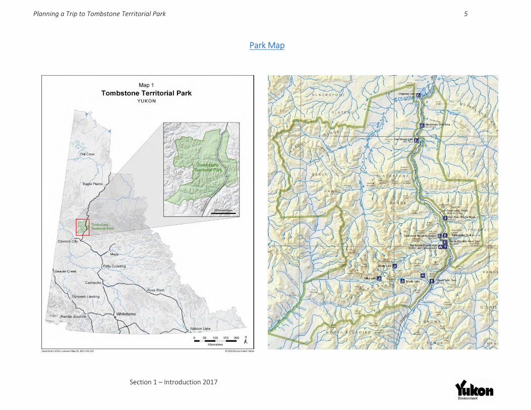
Park Map

Planning a Trip to Tombstone Territorial Park 6
Section 2 – Frontcountry Services 2017
Frontcountry Facilities Roadside Facilities Park Portal Sign (km 50)
• Pullout
Grizzly Lake Trailhead (km 58.5) • Outhouse, bear‐proof garbage bins, message board, parking, no camping
Tombstone Interpretive Centre (km 71.5) • Interpretive displays, presentations and visitor services • Backcountry camping permits, fishing permits & bear‐proof food canister rentals • Trailhead for Beaver Pond Interpretive Trail and trail to campground
Tombstone Mountain Campground (km 72) • 12 walk‐in, 33 pull‐in, 1 pull through, and 3 group use sites, outhouses, recycling and garbage
bins, bear‐proof food lockers, hanging food cache, picnic shelter, non‐potable creek water • North Klondike trailhead and ‘Edge of the Arctic’ interpretive trails
Tombstone Mountain Viewpoint (km 74) • Parking, interpretive signage, bear ‐proof garbage bins
Goldensides Mountain Trailhead (km 74.4) • Bear‐proof garbage bin, message board, parking
Hart River Winter Road (km 78.2) parking on west side of highway
Two Moose Lake Wildlife Viewing Site (km 102) • Viewing platform, interpretive panels, bear‐proof garbage bins
Blackstone River Rest Area (km 107.5) • Outhouses, interpretive panels, bear‐proof garbage bins • Chapman Lake Interpretive Site (km 116) • Interpretive signs, park portal sign, bear‐proof garbage bins
Coffeehouse Music Event at Tombstone Interpretive Centre

Planning a Trip to Tombstone Territorial Park 7
Section 2 – Frontcountry Services 2017
Tombstone Interpretive Centre The Tombstone Interpretive Centre is at km 71.5 on the Dempster Highway. It opens mid‐May to May 31st for weekends only from 9:00 a.m. to 5:00 p.m. The Centre opens daily June 1st to mid‐September. The centre is a great base to orient yourself and get the most out of your stay. Interpretive displays and daily interpretive programs are offered during the operating season.
Drop in for a cup of wild mountain tea and browse our library of fascinating books about the area. Park interpreters are here to help you understand, appreciate and take care of the park. This is where you will receive your backcountry orientation and purchase permits, guide books, maps, fishing licenses and other souvenirs. The centre is CASH ONLY!
Services include parking, toilets and interpretive trails. There is no phone service or Wi‐Fi here. This is a remote area – leave your cell phone behind and truly immerse yourself in the park!
Visit www.env.gov.yk.ca/camping‐parks/Tombstone‐Events.php for daily schedule and special events.
Frontcountry Camping Tombstone Mountain Campground is the only highway accessible campground in Tombstone. It is located at km 72 on the Dempster Highway. There are 12 walk‐in tent sites, 33 pull‐in sites, 1 pull through site, and 3 group use sites. Facilities include one covered picnic shelter, a campfire presentation circle, non‐potable water (boil before use), outhouses, picnic tables and firewood. Payment and self‐registration is located at the registration kiosk in the campground. Cash is required for on‐site payment. Tombstone Mountain campground is popular and fills up daily. Be sure to arrive early to secure a spot.
Camping Fees Individual & Commercial Campground Permit Fee
• $12.00 (including GST) per day, per accommodation unit (tent, RV, camper, trailer, automobile or other form of temporary moveable accommodation). CASH ONLY or prepaid permits.
Yukon Residents – Annual Permit • Yukon residents can obtain a $50.00 Annual Permit at https://env.eservices.gov.yk.ca, any Yukon Visitor Information Center, the Tombstone Interpretive Centre or from a licensed vendor
• Annual permit is free for Yukon Resident seniors aged 65 years or over • If requested, annual permit holders must show a piece of government‐issued ID to prove Yukon residency or eligibility for senior fee waiver
• Everyone must register each stay • Annual permits do not cover backcountry campgrounds
Fees for Non‐Profit Groups • Fees may be waived only with written pre‐approval from the Director of Yukon Parks
* Campsites cannot be reserved in advance and stays must be limited to 14 nights in any 30‐day period per campground. See additional rules at www.env.gov.yk.ca/camping. * Camping at YG roadside campgrounds is free for Yukon Residents Oct. 1 – May 31. Register each stay.

Planning a Trip to Tombstone Territorial Park 8
Section 3 – Visitor Safety 2017
Visitor Safety and Emergency Services Visitor Safety Tombstone Park is remote area without food, gas or phone service. You must be completely self‐sufficient and bring all required food supplies, survival, safety and emergency equipment with you. Leave a trip plan with a friend or family, and be aware spot and satellite phone connection is not always reliable due to the large mountain ranges. More info: www.hss.gov.yk.ca/travelsmart. www.env.gov.yk.ca/camping
Emergency Medical Services (EMS) Tombstone is a remote area and is serviced my medical services based 585km away in
Whitehorse. These Medevac crews (based in Whitehorse) consist of Critical Care Nurses, Critical Care Paramedics and Advanced Care Paramedics.
Emergency Phone Numbers Medical Emergencies 1‐867‐667‐3333 Police / Search and Rescue 1‐867‐993‐5555 North Region Park Rangers 1‐867‐993‐5651, 1‐867‐ 993‐7899 1‐867‐993‐3877 (after hours) Conservation Officers Toll free (in Yukon, NWT & Nunavut only): 1‐800‐661‐0408 (ext. 8005) 1‐867‐993‐5492 (local) TIPP Line 1‐800‐661‐0525 (in Yukon, NWT & Nunavut only) Forest Fires 1888‐798‐3473 Yukon Parks Office Dawson City 1‐867‐993‐7714 or 1‐867‐993‐6850 Yukon Parks Office Whitehorse 1‐867‐667‐5648 Toll free (in Yukon m NWT & Nunavut only): 1‐800‐661‐0408 (ext. 5648)

Planning a Trip to Tombstone Territorial Park 9
Section 3 – Visitor Safety 2017
Bear Safety BE BEAR AWARE
Be on the lookout for fresh bear tracks and signs, such as scat or rub trees.
Avoid areas with circling ravens as this can indicate the presence of a carcass.
If a bear is present, use extra caution. Stay alert and don’t camp in the area!
REDUCE ODOURS IN CAMP (this includes items like tooth paste, creams etc.)
DON’T SURPRISE A BEAR Scan the area before you begin walking. Carry bear bells, shout or sing in forested areas or beside noisy streams. Stay alert and look all around you. Keep your pets on a leash at all times!
CARRY PEPPER SPRAY Keep it easily accessible and know how to use it. Do not spray your tent or body with it. It is designed to be sprayed directly into the bear’s face from less than 5 metres away.
DON’T APPROACH A BEAR If you see a bear, don’t approach for a better photo. Take a different route or leave the area.
LEARN MORE Learn about bear behaviour and what to do before your trip. Check the wildlife sightings and bear information board at the Interpretive Centre. For more information read How you can stay safe in bear country (also in German / French) and view Staying Safe in Bear Country: A Behavioural‐Based Approach to Reducing Risk at any Yukon Visitor Information Centre, public library, Tombstone Interpretive Centre, or purchase your own copy at www.bearsmart.com. Visit www.env.gov.yk.ca/environment‐you/bearsafety.php for more information.
NEVER EAT OR STORE FOOD IN YOUR TENT!
In the backcountry, keep items with odour in air‐tight containers, such as Zip‐Lock bags, and store in a Park‐ approved hard shelled bear‐proof canister. Store the canister 100 m downwind from camp.
In campgrounds, never leave food, garbage or other attractants in your campsite unattended, even for a few minutes. Store these in bear‐proof food lockers, food hangers, or in your vehicle. Do not bring food or attractants into your tent. A cooler or action packer is NOT bear proof!

Planning a Trip to Tombstone Territorial Park 10
Section 3 – Visitor Safety 2017
Bearproof Food Canisters Bearproof food canisters are MANDATORY for all backcountry travel to protect wildlife and your food supply. These canisters are available to rent for a fully‐refundable $60.00 deposit (CASH ONLY) at the Tombstone Interpretive Center (Km 71 of the Dempster Highway). This not only benefits you, but also helps keep bears and other animals from becoming conditioned toward backpackers as a food supply. Bears who learn backpackers carry easily‐accessible food can become increasingly aggressive in raiding backpackers’ equipment. Tombstone Park has a policy to relocate or destroy food‐conditioned bears due to the high risk of danger associated with such bears. With the addition of only 2.7 lbs. you can do your part to save the bears. These canisters are also useful for protecting your food from gnawing rodents and other furry creatures that would rather chew through your backpack than dig up a tuber, and can be used as a backcountry chair. How it works: The lid is secured by two latches that can be twisted open/closed with a coin, key, or thumbnail. Leave the closed container away from your sleeping area. If a bear finds it, do not risk provoking the bear by attempting to take the container away from the bear. These containers easily withstand a bear’s pawing, chewing and kicking. The bear will eventually lose interest in it and leave it alone.
• THIS CANISTER IS NOT SMELL PROOF OR WATERPROOF. KEEP FOOD IN ZIPLOCK BAGS WITHIN THE CONTAINER TO REDUCE ODOURS AND KEEP FOOD DRY
• Weight: 2.7 pounds
• Dimensions: 8.8” diameter x 12” long; walls 3/16” thick.
• Capacity: This canister holds approximately 6 person‐days of food (i.e., 3 people for 2 days; or 2 people for 3 days; or 1 person for 6 days; etc.)
• Transportation: It is designed to fit into a backpack or can be attached to the outside of a pack.
www.backpackerscache.com

Planning a Trip to Tombstone Territorial Park 11
Section 4 – Park Guidelines 2017
Park Guidelines Tombstone Territorial Park is a pristine and fragile environment and any impact on it lasts a very long time. Therefore, we have set out guidelines for its protection and to ensure visitor satisfaction.
Campfires Campfires are only permitted in Tombstone Mountain Campground in designated fire pits from May 1 – October 1. Keep fires small and only after 4.00 pm. Respect fire bans and never leave fires unattended. Campfires are not permitted elsewhere in Tombstone Territorial Park. There are no trees in the tundra! In wilderness areas, use lightweight stoves for cooking.
Traveling with Dogs Due to the sensitive habitats and relatively short summer season, it is very important to reduce disturbances by dogs to wildlife.
Dogs must be on a leash and under control at all times. Doggie bags are available at most trail heads. Please put dog feces in garbage bins. If traveling with dogs in the backcountry, pack out all dog feces or deposit in backcountry outhouses. Dogs carry diseases and parasites that can endanger wildlife and humans.
Dogs MUST be leashed at all times to reduce impacts to plants, animals and other hikers. Animals have a very short season to prepare for winter. It is important wildlife conserve and use their energy gathering food and raising young rather than spending the afternoon running away from our amused pets.
Historical and Cultural Resources There are many historical and cultural resources in the Park. It is illegal to damage or remove any of them. Please treat all sites with the respect they deserve and leave them as is.
Off‐Road Vehicles No off‐road vehicles are allowed in the park except along the Hart River Winter Road. Visit Snowmobile use on page 31 of this document or www.env.gov.yk.ca/camping‐parks/WinterRecreationinTombstone.php.
Wildlife Sightings Keep your distance from ALL wildlife. Do not feed wildlife and do not let your pets harass them. Use binoculars and spotting scopes for closer study. This is to protect you and to protect their wildness. If you find bones or antlers please leave these in place. We invite you to share all your wildlife sightings with interpretive staff. Information you provide is valuable for data purposes. Visit www.env.gov.yk.ca/viewing for more information on wildlife viewing tips and etiquette.
Backcountry Travel Visit the Tombstone Interpretive Centre to register your trip and receive updated information on weather, wildlife, leave no trace etiquette and area closures. See page 20, Backcountry Travel, for more information.

Planning a Trip to Tombstone Territorial Park 12
Section 4 – Park Guidelines 2017
Leave No Trace What is Leave No Trace? It means exactly what you might think! To enjoy your wilderness or outdoor camping adventure to the fullest, and afterwards leave no sign that you were ever there.
Why is it important? Wilderness travel is becoming increasingly popular. More visitors result in more impact. Using Leave No Trace practices will protect the unique features and wilderness of the Yukon. If you are doing a wilderness trip you must practice Leave No Trace. Alpine, subalpine and areas of permafrost are among the most fragile ecosystems due to severe weather conditions, soil instability and short growing seasons. What may seem like a harmless activity can cause long term damage.
For Yukon‐specific tips on how to leave no trace, read Into the Yukon Wilderness: what you need to know to travel safely and gently in Yukon wilderness (also in German, French and Japanese) and visit www.yukonparks.ca. Additional resources are www.leavenotrace.ca, www.wildwise.ca, and www.tc.gov.yk.ca/heritage_guidelines.html.
Keep it Wild:
1. Plan ahead and prepare to Leave No Trace.
2. Travel and camp on durable surfaces. Use existing trails and campsites. In pristine areas, spread out on durable ground. Avoid walking or camping in fragile, wet meadow areas.
3. Dispose of waste properly. Pack it in, pack it out. When outhouses are not available, cover human waste in a small "cat" hole at least 60 m from water, camp and trails.
4. Leave what you find. Leave natural, historical and cultural artifacts and sites undisturbed.
5. Minimize campfire impacts. Use stoves or designated fire rings in Tombstone Mountain Campground. Outside of Tombstone Campground use lightweight camp stoves. Fires should only be used for emergency situations.
6. Respect wildlife. Observe from a distance using binoculars or scopes. Never feed them. Keep pets on a leash and under control at all times.
7. Be considerate of other visitors and residents. Many folks come for solitude & tranquility.

Planning a Trip to Tombstone Territorial Park 13
Section 5 – Permits and Licenses 2017
Permits & Licenses Camping Permits Tombstone Territorial Park has only one highway accessible campground, the Tombstone Mountain Campground (km 71 Dempster Highway), and three hike‐in‐ backcountry campgrounds at Grizzly, Divide and Talus Lakes. Camping permits and registration are required for all campgrounds. See page 7, Frontcountry Camping Fees, or Page 23, Backcountry Camping Fees for more information. Fees are $ 12.00 / sleeping unit.
Park Use Permits What is a Park Permit? A Permit use Permit authorizes an individual, group, or organization to carry out a specific activity, development or use of a park or campground under the Parks and Land Certainty Act (PLCA) and outlines the specific conditions and regulations under which the activity may occur. These Permits are necessary to reduce user conflicts, ensure quality visitor experiences and to safeguard the natural, cultural, and ecological integrity of Yukon territorial parks.
Do I need a Park Permit? If you are uncertain as to whether you require a Park Permit for an activity, or for general inquiries about park permits, please contact Yukon Parks. Refer to the four Permit descriptions below:
1. Commercial Recreation Park Permit This permit applies to, but is not limited to, commercial guided wilderness tourism activities such as hiking, horseback riding, dog mushing, canoeing, kayaking, sport fishing, mountain biking, skiing, snowmobiling, wildlife viewing, and photography, including aircraft landings within park boundaries. The permit also authorizes sporting events, festivals and large private events.
2. Research and Educational Activities Park Permit This permit applies to all research and monitoring activities, including but not limited to, collection of specimens, establishment of research plots, monitoring, surveying, inventory and other research. This permit also applies to educational activities and events associated with schools, colleges, universities or non‐profit organizations, including field trips, field courses, workshops and public education events.
3. Land Use or Industrial Development Park Permit This permit applies to all other commercial, industrial and/or existing residential purposes.
4. Commercial Filming and Photography Park Permit This permit applies to all commercial film productions or commercial photography shoots including filming/photography for motion pictures, documentaries, advertisements, or other commercial products (e.g., calendars, books, postcards, etc).
How much does it cost? This permit is FREE!
How do I apply for a Park Permit? Download the application form from www.env.gov.yk.ca/camping‐parks/ParkPermits.php or contact Yukon Parks at 1‐ 867‐667‐5648, [email protected].

Planning a Trip to Tombstone Territorial Park 14
Section 5 – Permits and Licenses 2017
Wilderness Tourism License Who requires a Wilderness Tourism License?
• Anyone who takes clients into the Yukon Wilderness in return for a fee or reward. • Yukon Wilderness is identified as stepping outside the highway right‐of‐way. As a result, highway
van tours, or campground visits do not require a license.
Requirements to Acquire a License • Registered business in Yukon Territory • Workers Compensation coverage • Public Liability Insurance • Guides must have standard first aid and level “C” CPR • $100 annual licensing fee
Requirements to Maintain License • Practice leave‐no‐trace travel including proper waste disposal • Submit trip and rental reports
How long is this license valid? • May 1st – April 30th of the following year
Visit http://wtay.com/ and www.env.gov.yk.ca/camping‐parks/tourism_operators.php for more information.
Other Permits
Additional permits may be required under other legislation or regulations, and it is the responsibility of the applicant to ensure all relevant permits have been acquired before beginning any activity (e.g., Scientist and Explorers License, Dempster Highway Development Area Permit, Wildlife Act Permit, etc.). When these permits or licenses are needed, copies will be required to support Park Permit approval.
For more information on required Permits and Licenses, please contact: Yukon Parks, Environment Yukon Tel.: 867‐667‐5648, Toll free in Yukon 1(800) 661‐0408, ext. 5648 Fax: 867‐393‐6223 Email: [email protected] Website: www.yukonparks.ca

Planning a Trip to Tombstone Territorial Park 15
Section 5 – Permits and Licenses 2017
Helicopter Use and Flight Guidelines Helicopters require a permit to land within Park boundaries, and must abide by Federal Standards (500 ft. above the ground, unless during an emergency). Environment Canada has strict guidelines on flying in known caribou and sheep habitat. For information, visit http://www.env.gov.yk.ca/publicationsmaps/documents/flying_caribou_country.pdf and http://www.env.gov.yk.ca/publicationsmaps/documents/flying_in_sheep_country.pdf.
Designated Landing Sites All aircraft require a Park Use Permit to land in Tombstone Territorial Park, and can only use designated landing sites south of 64 34’ Parallel). There are no designated landing sites north of 64”34, outside the Dempster Highway corridor. Inquire with Yukon Parks about Park Use Permit requirements.
Landing Site Location Notes
Syenite Lake 64° 28’ 09.58”N 138° 43’ 37.51”W
Located at the headwaters of the West Blackstone
Tombstone Valley
64° 25’ 20.97”N 138° 34’ 09.70”W
1 km NW of Talus Lake (Landing near campground is not permitted)
Azure Lake 64° 25’ 20.97”N 138° 35’ 28.55”W
Access unpredictable due to high mountain weather. Site is located above tree line in a steep north facing valley. Camping is NOT permitted
Little 12 Mile Powerhouse
64° 22’ 39.29”N 138° 59’ 28.74 W
Tall bushes may necessitate landing up to 2 km away from the Powerhouse
Gravel pit @ Km 67.5 Dempster Highway
64° 27’ 56.85” N 138° 12’ 19.81” W
This is an active gravel site, with limited parking and possible access closures.
64 34’

Planning a Trip to Tombstone Territorial Park 16
Section 6 – Day Hiking Opportunities 2017
Day Hiking Opportunities There are 5 established day hiking trails in Tombstone Territorial Park. Please stay on the trails to minimize impacts to the sensitive alpine tundra. Trail use comment forms are located at all established trails. Please help us determine visitor use which will aid us in future Park planning and management. Day Hikes Summary
1. Beaver Pond Interpretive Trail
Distance: 900 m (one‐way) Time: 30 minutes to 1 hour (one‐way) Difficulty: Easy Start point: Tombstone Interpretive Centre (km 71.5)
Description:
This trail is located within walking distance of the Tombstone Mountain Campground and Tombstone Interpretive Centre and leads to a series of wetland ponds created by the efforts of local beavers. The trail is hardened with gravel and is fairly wide and flat, making it possible for rugged outdoor wheelchairs. Sections of boardwalk cover wetter areas.
Natural artists have been busy along this trail, so keep your eyes open! Ten interpretive panels along the trail depict the wildlife, geology and cultural history of the area. Several park benches offer places to rest or to just sit and listen to the sounds of nature. A viewing platform and natural play structure is found at the end of the trail where you can stop to look for wildlife. Continuing on the old gravel roadbed for 100 m and on to the highway will take you to the beaver pond and lodges where your chances of seeing the master builders at work are good.
Even though this trail is very near the Tombstone Interpretive Centre and staff accommodation, bears and other wildlife frequently travel through the area. ALWAYS remember to sing, whistle, shout or make some other sort of loud noise to alert wildlife of your presence and avoid conflict.
Trail Name Start point on Dempster Highway
Hiking Time (one‐way)
Distance (one‐way)
Level
1. Beaver Pond Km 71.4 0.5 – 1 hour
1.8 Km Easy
2. Grizzly Trail to Monolith viewpoint
Km 58.5 3‐4 hours 6 Km Moderate to Difficult
3. North Klondike Km 71.5 1‐2 hours 3.4 Easy to Moderate 4. Goldensides Km 74.5 1‐2 hours 3.4 Moderate 5. Hart River Winter
Road Km 78 2‐4 hours 9.5 Km to Park
boundary Easy to Moderate

Planning a Trip to Tombstone Territorial Park 17
Section 6 – Day Hiking Opportunities 2017
2. Grizzly Trail to Mt. Monolith Lookout
Distance to Lookout: 3 km (one‐way) Time: 1 ½ hours – 2 hours (one way) Difficulty: Moderate to Difficult Start point: Km 58.5 Dempster Highway
Description:
Many people are surprised at the level of difficulty on this trail! It is well defined and flat in the beginning through mature boreal forest. There are a few sections of boardwalk and stairs in wet areas. On September 4th, 2013 an extreme wind event caused a widespread blow down of trees over 200 years old. Some wood has been cut and removed by park staff to reduce chances of wildlife‐human conflict, but much of it remains. This example of a natural forest disturbance is a great opportunity to view the early stages of forest succession.
Many roots, rocks and slippery sections make for slow going in the first section of the trail. After about 1.5 km, there is a widened area by Cairnes Creek. This is the last water source for 4.5 km, so fill up your water bottles! Remember to treat your water. After this point, the trail starts gaining substantial elevation and the vegetation changes from towering forest to dense willow and dwarf birch. The trail is strenuous and continuously climbing, but don’t lose hope – the view is worth the effort!
Upon reaching the lookout, you are rewarded with breathtaking views of Mt. Monolith and the surrounding panorama. Views of both Grizzly Valley to the south and Cairnes Valley to the north are possible. At this point you can have a snack and return the way you came, or continue up the ridge to the trail’s summit for another challenging 1.5 km. There are great vantage points along the ridge offering stunning mountain views. It is not advisable to push on all the way to Grizzly Lake if you are on a day hike, more than 8.5 km further (see backcountry trail section for description, distances and times).
Please note:
• You will NOT be able to see Tombstone Mountain from this vantage point.
• You may encounter furry marmots and ground squirrels who will be mesmerized by your snack bag and terrified of your dog – please resist the temptation to feed them. You may even see the collared pika, a small alpine denizen related to rabbits and hares.
• Dogs MUST be on a leash at all times. Sing, yodel, tell knock‐knock jokes or otherwise make noise to avoid bear encounters, especially while in thick willows where visibility is limited, or when close to noisy creeks.

Planning a Trip to Tombstone Territorial Park 18
Section 6 – Day Hiking Opportunities 2017
3. North Klondike Trail Distance: 1.6 km (one‐way) Time: ½ hour – 1 hour (one‐way) Difficulty: Easy to Moderate Start point: Tombstone Mountain Campground
Description: This is a great trail for those looking for an authentic Tombstone Territorial Park experience right outside their tent or motorhome. Whether you are seeking an early morning walk, afternoon hike, or evening stroll, this relatively easy trail provides beautiful views of the area. The trail begins in the Tombstone Mountain Campground, between Sites 18 and 19. The first 500 metres of the trail is level and graveled as it passes through poplar forest by the North Klondike River. This section can be very wet at times.
The trail rises into dwarf birch offering views of the valley bottom and surrounding mountains, and is used by many wildlife, so establish your presence by making noise to avoid surprising bears and moose. The final 500 metres of the trail descends into willow and continues to the braided section of the North Klondike River. This portion of the trail has sections of boardwalk and seasonal snow patches. The braided section of the North Klondike River is the end of the trail. It may still be covered in aufeis (overflow ice) well into July, making it a great place to come and cool off!
A short Interpretive Loop Trail near the beginning is an opportunity to learn more about the transition from the boreal forest to the sub‐arctic on the ‘Edge of the Arctic’ self‐guided interpretive trail. The North Klondike River is often used as a ‘highway’ by wildlife. Making some form of noise (clapping, practicing different accents, debating, singing etc.) is recommended to prevent any surprise encounters.
4. Goldensides Trail Distance: 1.5 km (one‐way) Time: ½ ‐1 hour (one way) Difficulty: Moderate Start point: Km 74.5 Dempster Highway
Description: Turn right off the Dempster Highway at Km 74.5, just north of the Tombstone Mountain viewpoint. Follow the road up to the radio tower to the trailhead. Parking is limited. The trail begins as a leisurely stroll through low‐lying dwarf birch gradually getting steeper. The trail leads to the top of a shoulder of the mountain. Stay on the trail and avoid walking on delicate meadow areas. The trail is hardened with gravel and boardwalk in moist areas.
Along the trail hikers have spectacular views of the surrounding landscape, including the North Klondike Valley, Mt. Chester Henderson, Fold Mountain and the Blackstone Uplands. This is also an excellent vantage point to spot wildlife on the ridges and valleys below. There’s generally always a good stiff breeze blowing which helps to keep the bugs at bay.
Please note: Marmots, ground squirrels and ptarmigan are often encountered on the trail which provides a great viewing opportunity. Having your dog on a leash ensures that both you and the wildlife can go about each other’s day undisturbed. This trail does NOT lead to the summit of Goldensides Mountain.

Planning a Trip to Tombstone Territorial Park 19
Section 6 – Day Hiking Opportunities 2017
5. Hart River Winter Road
Distance: 9.5 km to Park boundary Time: up to 3 hours (one way) Difficulty: Easy to Moderate Start point: Km 78 Dempster Highway
Description:
The Hart River Winter Road begins near the summit of North Fork Pass and heads 100 km east to a mineral exploration site abandoned in the late 1960s. To access this trail, there is a parking area located on the west side of the highway at km 78 on the Dempster Highway. There is no trailhead signage here but the trail begins almost directly across the highway ‐ you can’t miss it. The road is an ambling dirt track that follows the valley bottom and maintains a fairly level grade. Aside from the Dempster Highway, this is the only place in the park suitable for mountain biking or ATV‐ing. ATVs, motorbikes and bicycles must remain on the road surface.
As you continue, you are bordered by dense clusters of willow and dwarf birch. Views of the surrounding mountains are excellent including Trapper Mountain to the north (important Dall sheep habitat) and Blackcap and Goldensides Mountains to the south.
The road can be VERY muddy in spring and early summer. It is also widely used by animals making it an ideal place to spot animal tracks of moose, caribou, bear, wolf, fox and ptarmigan. The highest point of the Hart road is located about 5 km in. This is a great place to stop and scan for wildlife with binoculars or a spotting scope. The Park boundary is located about 9.5 km from the start of the road. The road descends from a pass into the West Hart Valley and is usually much wetter and rougher, often impassable, from this point on.
In the fall, the Hart River Winter Road becomes a popular transportation route used by resident and First Nation hunters. The Tr’ondëk Hwëch’in and other local First Nations have hunted caribou and other animals in the area for thousands of years and the hunt is an integral part of their culture. Wildlife harvested within park boundaries continue to feed both indigenous and other local families today and allow the Tr’ondëk Hwëch’in to practice their timeless traditions.
Please note:
• The road is very rough and muddy. Do NOT attempt to drive it with a 2 or 4‐wheel drive vehicle. • Hunting season begins August 1st of each year. The Hart Road is a commonly used access route for
hunters. Please stay alert for hunting activity, including gut piles which may attract bears. Watch for circling ravens as this often indicates carcasses nearby.

Planning a Trip to Tombstone Territorial Park 20
Section 7 – Backcountry Travel 2017
Backcountry Travel What to Expect in the Backcountry Backcountry travel in Tombstone is no walk in the park! When you travel into the park’s wilderness you are on your own and you must be self‐sufficient. Prepare for rough terrain, drastic weather changes, and wildlife encounters. Many people come back from the backcountry reporting that nothing prepared them for the level of difficulty they encountered in the backcountry. If you are not prepared, don’t go. Terrain In mountainous areas, expect steep elevation changes, sharp, slippery, unstable rocks, and side‐hilling. This terrain involves travel over tundra tussocks, rock glaciers, talus slopes and rock slide areas. Some travel will require the use of your hands, and many visitors suffer from blisters. Wear worn‐ in, comfortable hiking boots. Don’t try breaking in new boots in Tombstone Park! Route‐finding Tombstone Territorial Park is a remote park with only one backcountry route accessing Grizzly, Divide and Talus Lake Backcountry Campgrounds. Route finding and mapping skills are essential.
Visitor Safety Mountain travel is dangerous, and hazards do exist. Spotting hazards and assessing their risk is your responsibility. Yukon Park staff are not responsibility for initiating search and rescue. Leave a trip plan with a reliable friend or family before you depart. Include your planned routes, expected return date and when authorities should be notified if you don't arrive home as scheduled. There is no cell service and satellite service is unreliable. If you have an emergency, it is unlikely you will receive immediate medical attention.
Weather & Seasonal Conditions
Season Time of year Trail status Weather & Terrain Backcountry Campground status
Spring May to June/early July
May be closed due to weather or wildlife
Snow conditions
Closed
Summer July to early August
Open Possible snowfall and freezing temperatures
Open
Fall mid‐August to September
May be closed due to weather or wildlife
Possible snowfall and freezing temperatures
May be closed due to weather or wildlife
Winter mid‐September to May
Closed Snow cover and freezing temperatures
Closed
Hiking Grizzly Trail – July 2015

Planning a Trip to Tombstone Territorial Park 21
Section 7 – Backcountry Travel 2017
Rules & Regulations The following rules are in place for ALL backcountry areas in the Park • Register ALL backcountry travel in Tombstone Park • Acquire all required permits for backcountry travel throughout the Park • Bearproof food canisters are MANDATORY and available from Tombstone Interpretive Centre for a
refundable $60 deposit. • Dogs must be kept on a leash at all times • Fires are not permitted. There is no firewood in the tundra. Use a camp stove to reduce impacts. • Stay on designated trails and flagged routes where available. When no obvious route is available,
choose durable ground and spread out to prevent creation of new trails • Do NOT cook on tent pads or near tent • Pack out all garbage, and carry out extra food
In addition to the above rules, the following are in place for Grizzly, Divide and Talus Lakes areas: • Camping is only permitted on designated tent pads • Each permit allows the use of one tent per tent pad • Maximum of three people per tent • Camping is limited to three consecutive nights at any one of the three campgrounds • Grey water disposal: Dispose dish water, cooking water, and toothpaste in the grey water barrel to
reduce impact on water bodies and avoid attracting wildlife. Always ensure lid is replace after each use. Open barrels can fill with rainwater very quickly and must be removed via helicopter when full.
Tips for a Successful Hike • This area is covered by 1:50,000 topographic maps 116B/7, 116B/8, 116B/9 & 116B/10 and the
Tombstone Hiking Map. The hiking map can be purchased at Mac’s Fireweed Bookstore in Whitehorse, online at www.yukonbooks.com or at the Interpretive Centre.
• Keep your pack as light as possible while ensuring you have the essentials to stay warm and comfortable. Choose lightweight gear and food and limit the number of ‘luxury’ items. Remove packaging. Use the following suggested packing list to help ensure a safe and comfortable journey.
• For detailed information about travelling safely and gently through Yukon, read Into the Yukon Wilderness (also in French, German, Japanese) www.env.gov.yk.ca/wilderness and download a Yukon Travel Smart Plan at www.hss.gov.yk.ca/travelsmart. Printed copies of each are also available at any Yukon Visitor Information Centre.

Planning a Trip to Tombstone Territorial Park 22
Section 7 – Backcountry Travel 2017
Travel Guidelines in Non‐Facility Areas There are many backcountry opportunities in Tombstone for those who are experienced, well prepared and self‐reliant.
Register your trip Visit the Tombstone Interpretive Centre to register your trip and receive updated information on weather, wildlife, leave no trace etiquette and area closures
Mandatory bear‐proof food canister use Bearproof food canisters are MANDATORY for all backcountry travel to protect wildlife and your food supply. Canisters are available to rent for a fully‐refundable deposit at the Tombstone Interpretive Center (Km 71 of the Dempster Highway).
Reduce your Impacts – Practice Leave No Trace Travel on hardened surfaces like dwarf birch rather than delicate meadow areas. Spread your impact! If there is more than one person in your group take different footsteps to avoid the cumulative impact of many footsteps. Learn more at www.env.gov.yk.ca/wilderness.
Avoid Wildlife Encounters Travel in areas with high visibility such as dwarf birch or alpine tundra. Avoid dense willow. When visibility is reduced, make noise by talking, singing, or simply shouting "Hey bear! Do not camp or hike where visibility is low or along wildlife travel routes, such as near lakeshores, streams or trails. Learn more at www.env.gov.yk.ca/bears.
PLEASE NOTE: • Mandatory registration for all backcountry travel in Tombstone Park
• Register at the Tombstone Interpretive Centre prior to your trip and receive up‐to‐date information trail conditions, closures and wildlife activity.
• Registration is used for park management purposes and does not initiate search and rescue.

Planning a Trip to Tombstone Territorial Park 23
Section 7 – Backcountry Travel 2017
Backcountry Hiking Routes and Facilities Overnight camping reservations and permits are required to camp at Grizzly, Divide and Talus Lake backcountry campgrounds. Opening and closing dates for these campgrounds vary from year to year depending on weather and snowpack. Advanced reservations are required to ensure availability.
Backcountry Campground Facilities
Site Name Tent Pads Outhouse(s) Shared Cooking Platform(s) Grey Water Disposal Grizzly Lake 10 2 2 yes Divide Lake 10 1 1 yes Talus Lake 10 1 1 yes
Online Reservations Reservations for Grizzly, Divide and Talus lakes backcountry campsites can be made online at www.env.gov.yk.ca/tombstone, by calling Yukon Parks, North Region at: 1‐867‐993‐7714 (April‐October) or Whitehorse at 1‐867‐667‐5648 (toll free in Yukon 1‐800‐661‐0408 ext. 5648). Reservations cannot be made at the Tombstone Interpretive Centre. Cancellations mean that spots may become available on a first come first serve basis.
Reservation and Cancellation Policy • Online reservations must be booked at least 3 days in advance. • Cancellations can be made up to 21 days (3 weeks) prior to your booking date for a 75% refund.
If you cancel your reservation after this window there will be no refund and your space will become available for other campers.
No‐Show Policy • It’s important to arrive early on the day of your departure on the trail. Your spot will be held until
1:00 p.m. on the day you are scheduled to depart. After 1:00 p.m. your booking will be forfeited and your spot(s) will become available for walk‐ons.
Permits and Backcountry Orientation • Permit pick‐up and mandatory orientations for all overnight backcountry camping in Tombstone
Territorial Park are at 9:00 am, 11:00 am, 1:00 pm and 4:00 pm daily, during the operating season at the Tombstone Interpretive Centre.
• Bring your reservation with you. This is your confirmation of your booking.
Backcountry Camping Fee • $12 per night per tent. Yukon Annual Camping Permits DO NOT cover this fee • Annual camping permits cannot be used to pay for backcountry campgrounds. • Due to the remoteness of the park it is often difficult to get in touch with staff on‐site. If you
anticipate missing a deadline, be sure to email [email protected] to make arrangements at least a day before your departure date.

Planning a Trip to Tombstone Territorial Park 24
Section 7 – Backcountry Travel 2017
Grizzly, Divide and Talus Lake Route Description The route from the Grizzly Trailhead to Talus Lake Campground via Grizzly Lake, Glissade Pass and Divide Lake is 24 km one‐way, and 48 km return. A minimum of 3 ‐ 4 days is recommended for this trip. Map ‐ Grizzly, Divide and Talus Lakes Area
Route Summary
Backcountry Route Section Hiking Time (one‐way)
Distance (one‐way)
Level
1. Grizzly Lake Trailhead to Grizzly Lake 7‐10 hours 11.5 Km Difficult
2. Grizzly Lake to Divide Lake 3‐4 hours 6 Km Difficult to Extreme
3. Divide Lake to Talus Lake 1‐2 hours 6 Km Easy to Moderate

Planning a Trip to Tombstone Territorial Park 25
Section 7 – Backcountry Travel 2017
1. Km 58.5 to Grizzly Lake Total Distance: 11.5 km (one way) Time: 6‐10 hours Difficulty: Difficult Start point: Km 58.5
Description:
Many people are not prepared for the level of difficulty they encounter on this trail. The first 3 km to Mt. Monolith Lookout is a popular day hike. The trail is well defined and flat for the first km but be prepared for uneven ground, with roots, rocks and potential muddy sections. Km 1.5 is a resting spot where you can fill your bottle for the last time before the trail starts to climb. From here it’s a steady and relentless climb through willow and dwarf birch and then finally through rocky terrain to the Mount Monolith Lookout. Be on the lookout for pikas and ground squirrels among the rock boulders. At Km 3, you are rewarded with magnificent views up the valley to Mount Monolith. After the Lookout, the trail continues along the ridge. Be careful at this point as many guide books incorrectly advise hikers to stay on the left side of the mountain which leads into thick willows in the valley bottom. Instead, follow the trail UP the steep rocky slope onto the ridge. The trail is marked with green flagging or rock cairns, just make sure you stop and look for the trail if you can’t spot it right away. The trail summit is at approximately km 4.5. Views of the entire Grizzly Valley and Grizzly Lake are possible. This is a good destination for longer day hikes. The only water source is at km 6.1 (halfway point). You will encounter a large grassy saddle. At the far side of the saddle there is a creek which flows under the rocks. You may have to walk about 50 m downhill from the trail to access open water. After the saddle you will cross a large talus slope. Take care when the rocks are wet. After the talus slope you will see Marmot Meadows (2.7 km long). This section of the trail is relatively easy walking. This is prime marmot, ground squirrel and pika habitat which makes it critical that all dogs remain on a leash. After marmot meadows, the trail gradually descends to the lake. Side hilling will be required. Be cautious on the scree slopes, boulder fields and short willowy sections encountered before you reach the lake. Take care when crossing Grizzly Creek, particularly when water levels are high. It usually takes around 6‐10 hours to hike all the way to the lake. Some people have done it in 4 hours and some in 12 hours depending on your pace, physical condition, ability, weather and trail conditions.
Facilities: Two outhouses, 10 tent pads, cooking platform, grey water disposal
Please note: • Camping at Divide Lake requires backcountry camping permits ($12/night/tent) • The trail does NOT follow the valley bottom – it follows the ridge then descends near the lake • Do NOT attempt to go along the valley bottom – it is extremely brushy with a high risk of wildlife encounters. The valley route can take 12+ hours (vs. 6‐10 hrs ridge route).
• There is limited water along the trail – km 1.5 and 6.1 only • Dogs must be kept on a leash at all times to prevent harassment of wildlife.

Planning a Trip to Tombstone Territorial Park 26
Section 7 – Backcountry Travel 2017
Day trips from Grizzly Lake Hiking in any direction from Grizzly Lake requires good route finding skills. There are no formal trails or routes, and the terrain is rough and slow going, over unstable or slippery rocks, especially when wet.
2. Grizzly Lake to Twin Lakes Distance: 6 km round trip Time: 6 hours Difficulty: moderate to difficult Start point: south side of the lake
Description: Go to the south end of Grizzly Lake and ascend Grizzly Pass. The route up the pass is on the right (west) side of the creek. Trails on the left side are game trails and are on unstable scree slopes. You will come to a small alpine pond. From this point start ascending the ridge to the Twin Lakes Viewpoint. Once at the top, side‐hill the ridge to the right (southwest) of the pass until you have a nice view of the whole valley and you can choose where to descend from this point. Follow the ridge down until you have a good view of the gully to the immediate right. It is a steep descent on shale so take precautions when going down. It is best to return by the same route as the ridge is VERY rocky and covered with large loose boulders making climbing up (or down) very difficult and unsafe. Camping is not permitted.
3. Grizzly Lake to Divide Lake Distance: 6 km one way (from Grizzly Lake) Time: 3‐5 hours Difficulty: Difficult/Extreme Start point: North side of Grizzly Lake
Description: Ascend Glissade Pass on the north side of Grizzly Lake ‐ when you are in the campground, backtrack past the creek and you will come to a boulder field. Stay on the right side of this field and continue up to the pass. Glissade Pass is a grassy patch at the top visible from the campground, and is a 1‐2 hour strenuous climb. The Northside of Glissade Pass is extremely steep with unstable shale and loose rock. Stay together as a group to avoid the danger of dislodged rocks that gain speed as they tumble. Large unstable snow patches linger until mid‐July causing seasonal closures.
Once at the bottom of the pass, stay to the left of the creek and waterfalls and look for rock cairns and green flagging to Divide Lake. Stay below the inviting bench (on your left) and above Axeman Creek (on your right) and the trail will soon be obvious.
On the return trip, climbing Glissade Pass can be daunting, very steep and loose. Choose solid ground or larger boulders which tend to be more stable.
Facilities: 1 outhouse, 10 tent pads, cooking platform, grey water disposal
Please note: • Camping at Divide Lake requires backcountry camping permits ($12/night/tent) • Dogs must be kept on a leash at all times to prevent harassment of wildlife.

Planning a Trip to Tombstone Territorial Park 27
Section 7 – Backcountry Travel 2017
4. Divide Lake to Talus Lake Distance: 6 km one way (from Divide Lake) Time: 1.5 ‐ 3 hours Difficulty: Easy to moderate Start point: West side of Divide Lake
Description: The trail between Divide Lake and Talus Lake starts at the south end of the Divide Lake camping area. Follow the path west through the willows towards Tombstone Pass. Tombstone Pass is located in the bottom of the Valley. Look for a small path, green flagging and rock cairns, which will take you up out of the willows to the top of the pass. Once on top of Tombstone Pass, you will encounter open tussock tundra with some small tarns or ponds. It can be quite moist around the ponds, so aim your route towards the bottom of the scree slope to the south of the ponds. Continue west across the Pass. The route may be hard to find from here on so look for green flagging and rock cairns to find the way. Facilities: 1 outhouse, 10 tent pads, cooking platform, grey water disposal
Day trips from Talus Lake: There are many possibilities for day trips from Talus Lake. Explore the base of Mount Monolith, the valleys toward Mt. Frank Rae, or follow the valley to the base of Tombstone Mountain (6km one‐way).
5. North Klondike Valley Distance: 16‐18 km Time: 8‐12 hours (one‐way) Difficulty: Extreme Start point: Divide Lake or Tombstone Campground
Description: This route is extremely difficult, dangerous and is not recommended. You will encounter thick brush, lots of mud, several creek crossings and marshes. The Valley is an important wildlife corridor with high risk of human‐wildlife conflicts due to poor visibility and travel along noisy creeks.
Please note: • Camping at Divide Lake requires backcountry camping permits ($12/night/tent) • Dogs must be kept on a leash at all times to prevent harassment of wildlife.
Please note: • We strongly recommend getting to/from Divide Lake via the Grizzly Creek/Glissade Pass route • This valley has NO DESIGNATED TRAIL • Camping in this valley is not recommended

Planning a Trip to Tombstone Territorial Park 28
Section 7 – Backcountry Travel 2017
Backcountry Trail Elevations to Grizzly, Divide and Talus Lakes
Average 2 – 3 hours one-way. Route is in the bottom of the valley, and crosses the Continental Divide / Tombstone Pass.
DIVIDE LAKE TO TALUS LAKE:
Divide Lake
Talus Lake
GRIZZLY TRAIL PARKING LOT TO GRIZZLY LAKE
2 km to Grizzly Lake
Average 7 – 10 hours (one-way). Strenuous with steep, unstable terrain (boulder fields, side-hilling, talus slopes), elevation changes, minimal water, exposed to weather.
- H20 Grizzly Trailhead
GRIZZLY LAKE TO DIVIDE LAKE:
Glissade Pass
Steep talus slope
Average 3 - 5 hours (one- way). Strenuous with unstable terrain (extremely steep talus slopes on Divide side of Glissade Pass).
Divide Lake
Grizzly Lake

Planning a Trip to Tombstone Territorial Park 29
Section 7 – Backcountry Travel 2017
Sample Trip Plan and Checklist Use this checklist to plan your trip and leave it with a responsible friend. Trip details: Start ……………………..day……………month………………time……………. Intended return………….day…………….month………………time……………… Notify RCMP if not back by………………day……………….month………………time………….. Purpose of trip……………………………………………………………………………………………….………… Intended route (include return route as well) …………………………………………………………………………………………………….…………………………… ……………………………………………………………………………………………………………………………….... ………………………………….……………………………………………………………………………………………... Contact Info for Leader…………………………………………………………………………………………….. …………………………………………………………………………………………………………………………………. …………………………………………………………………………………………………………………………………. Maps used (numbers) …………………………………………………………………………………………..…. Satellite Phone number ‐‐‐‐‐‐‐‐‐‐‐‐‐‐‐‐‐‐‐‐‐‐‐‐‐‐‐‐‐‐‐‐‐‐‐‐‐‐‐‐‐‐‐‐‐‐‐‐‐‐‐‐‐‐‐‐‐‐‐‐‐‐‐‐‐‐‐‐‐‐‐‐‐‐‐‐‐ …………………………………………………………………………………………………………………………………. Vehicle(s) Make Colour License Plate Location …………………………………………………………………………………………………………………………………… ....................................................................................................................................... …………………………………………………………………………………………………………………………………… Brief Description of Equipment (Colour of tents, jackets, and packs) …………………………………………………………………………………………………………………………………… ....................................................................................................................................... …………………………………………………………………………………………………………………………………… Person 1 Person 2 Person 3 Person 4 Last name First name Age Height Weight Hair and skin colour
Medical conditions
Physician Hat colour Coat colour Shirt/sweater Pant colour Footwear type Language

Planning a Trip to Tombstone Territorial Park 30
Section 7 – Backcountry Travel 2017
What to Bring: Suggested checklist for backcountry travel (mid‐June to Mid Sept) Rain/wind gear/gaiters Maps Compass/GPS/Personal Locator Beacon (e.g., SPOT), extra batteries Matches/lighter (in a waterproof container) Water bottle Water filter or treatment tablets Pocket knife or multi‐tool Toiletry kit (incl. personal medications) First aid kit Flashlight or headlamp with spare batteries Sunscreen, insect repellent Fire starter (for emergency only) Bear spray and bear bangers Hat, balaclava/scarf, gloves (even in summer we can have near‐freezing temps and snow) Thermal underwear Quick dry pants & shirts – try to stay away from cotton which is cold when wet! Change of clothes (at least 3 complete sets) Extra socks (NO COTTON!) Light shoes (for camp and creek crossings) Sturdy waterproof hiking boots Bearproof food canister Cook stove & fuel Dense high calorie food (try to stay away from strong smelling food like cheese/sausage) Cookware (incl. sieve or spatula to strain food particles from grey water) Large waterproof bags to keeping things dry inside your pack Extra Zip Lock bags (for packing out garbage, incl. toilet paper and feminine products) Tent with a rain proof fly Small tarp Extra pegs Spare rope/line Sleeping bag Sleeping mat Survival kit with whistle
Planning a Trip to Tombstone Territorial Park 31
Section 8 – Winter Activities 2017
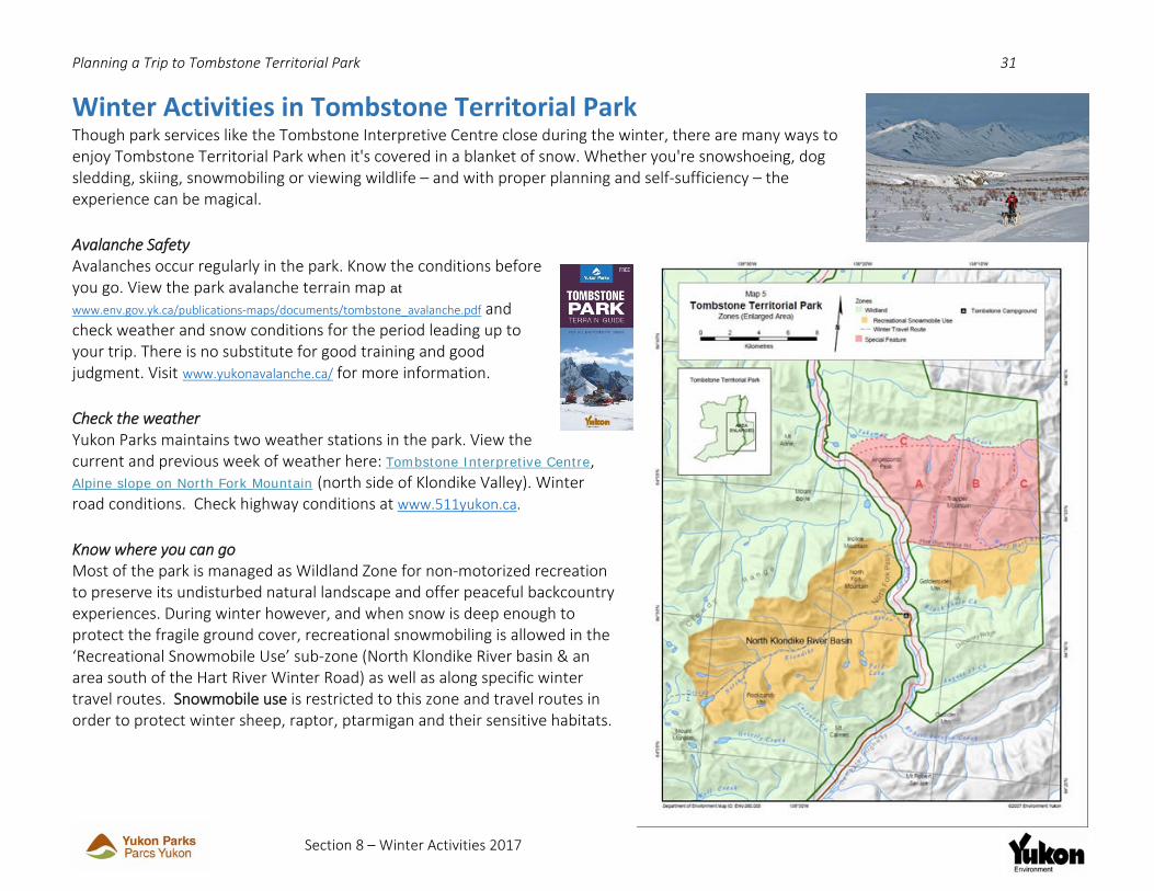
Winter Activities in Tombstone Territorial Park Though park services like the Tombstone Interpretive Centre close during the winter, there are many ways to enjoy Tombstone Territorial Park when it's covered in a blanket of snow. Whether you're snowshoeing, dog sledding, skiing, snowmobiling or viewing wildlife – and with proper planning and self‐sufficiency – the experience can be magical. Avalanche Safety Avalanches occur regularly in the park. Know the conditions before you go. View the park avalanche terrain map at www.env.gov.yk.ca/publications‐maps/documents/tombstone_avalanche.pdf and check weather and snow conditions for the period leading up to your trip. There is no substitute for good training and good judgment. Visit www.yukonavalanche.ca/ for more information. Check the weather Yukon Parks maintains two weather stations in the park. View the current and previous week of weather here: Tombstone Interpretive Centre, Alpine slope on North Fork Mountain (north side of Klondike Valley). Winter road conditions. Check highway conditions at www.511yukon.ca. Know where you can go Most of the park is managed as Wildland Zone for non‐motorized recreation to preserve its undisturbed natural landscape and offer peaceful backcountry experiences. During winter however, and when snow is deep enough to protect the fragile ground cover, recreational snowmobiling is allowed in the ‘Recreational Snowmobile Use’ sub‐zone (North Klondike River basin & an area south of the Hart River Winter Road) as well as along specific winter travel routes. Snowmobile use is restricted to this zone and travel routes in order to protect winter sheep, raptor, ptarmigan and their sensitive habitats.

Planning a Trip to Tombstone Territorial Park 32
Section 9 – Further Resources 2017
Further Resources To help you with Leave No Trace principle #1 – Plan Ahead and Prepare – we recommend the following books, brochures, maps and websites:
Brochures Available at Yukon visitor centres, the Tombstone Interpretive Centre or www.yukonparks.ca.
• A Visitor’s Guide to Tombstone Territorial Park • The Dempster Highway Travelogue • Yukon Fishing Regulations Summary (Aussi disponible en Français.) • Birds of Tombstone Territorial Park • How you can stay safe in bear country (Français. Deutsch.) • Into the Yukon Wilderness: traveling safely and respectfully (English. Français. Deutsch. Japanese.) • Tombstone Park (avalanche) Terrain Guide (for winter travel) • Yukon Wildlife Viewing Guide (English. Français. Deutsch.) • Yukon Wild booklets: flowers, birds, bats, butterflies, bears, amphibians, fishes, ungulates • Visit www.env.gov.yk.ca/brochures for a full list of Government brochures
DVDs • Staying Safe in Bear Country: A Behavioural‐Based Approach to Reducing Risk. We strongly
suggest you view this informative video at any Yukon Visitor Information Centre, public library, Tombstone Interpretive Centre, or purchase at www.bearsmart.com
Books • Along the Dempster: An Outdoor Guide to Canada’s Northernmost Highway, Walter Lanz • Birds by the Dempster Highway, Bob Frisch • Yukon’s Tombstone Range and Blackstone Uplands: A Traveler’s Guide, Canadian Parks and
Wilderness Society • Hiking in the Yukon, Curtis Vos • Hammerstones: a history of the Tr'ondëk Hwëch'in, Helen Dobrowolsky
Maps The following 1:50,000 scale maps for backcountry hiking are available for purchase at the Tombstone Interpretive Centre, Mac’s Fireweed in Whitehorse or online at yukonbooks.com.
• A Hiking Map of Tombstone Territorial Park, Yukon Parks, or • Tombstone River (sheet 116B/7); Upper Klondike River (sheet 116B/8); North Fork Pass (sheet
116B/9); Seela Pass (sheet 116B/10) Use the Tombstone Park brochure or Dawson 1:250,000 scale map (sheet 116B) for Park overview.
Websites: Yukon Parks: www.yukonparks.ca, Tr'ondëk Hwëch'in: www.trondek.ca, Yukon Hiking www.yukonhiking.ca, Yukon Travel Smart: www.hss.gov.yk.ca/travelsmart, Yukon Road Conditions: www.511yukon.ca, Yukon Tourism; http://travelyukon.com, Dempster weather: http://weather.gc.ca/city/pages/yt‐4_metric_e.html;