planning committee 12 september 2017 county matter … recommendation 040917.pdf · allow for a...
TRANSCRIPT
Planning Committee Agenda Item No. 4 12 September 2017 County Matter Mineral Application Amendment of condition no. 2 of planning permission WSCC/052/12/WC to allow for a further 12 months of continued operations to enable the completion of phase 3 testing and phase 4 restoration or retention Woodbarn Farm, Adversane Lane, Broadford Bridge, Billingshurst, West Sussex, RH14 9ED Application No: WSCC/029/17/WC Report by Head of Planning Services Local Member: Pat Arculus District: Horsham Executive Summary This report concerns a proposal for an extension of time for a period of 12 months to allow the completion of the testing and evaluation of oil and the restoration or retention of the site at Wood Barn Farm, Broadford Bridge, near Billingshurst. The site already benefits from planning permission for the exploration, testing and evaluation of hydrocarbons until 15 September 2017. The application proposes that the site will be restored if no viable hydrocarbon resource is found or, if a viable resource is found, to suspend the well and retain the site while a planning application for production is prepared. The report provides a generalised description of the site and a detailed account of the proposed development, and appraises it against the relevant policy framework from national to local level. The main policies of relevance to this application are policies 1, 14, 26, 27, 53, 58, 60 of the West Sussex Minerals Local Plan; policies 1, 10, 24, 25, 26, 32 and 33 of the Horsham District Planning Framework (2015); and policies M7a, M12, M15, M16, M17, M18, M19, M20, M22 and M24 of the emerging West Sussex Joint Minerals Local Plan. No objections were raised by statutory consultees, although West Chiltington Parish Council and Billingshurst Parish Council raised matters for concerns. Five hundred and forty-nine representations were received from members of the public and public bodies; 374 objected to the development and 168 were in support. The remaining seven representations either raised concerns, had no comment to make, or were anonymous. Consideration of Key Issues The main material planning considerations are whether:
• there is a need for the development;
• the development is acceptable in terms of highway capacity and road safety;
• the development is acceptable in terms of impact on local residents; and
• the development is acceptable in terms of impact on the environment. Need for the Development The NPPF gives ‘great weight’ to the benefits of mineral extraction, including to the economy and highlights that minerals can only be worked where they are found. Planning Policy Guidance on Minerals notes that oil and gas will continue to form part of the national energy supply, and gives a clear steer from Government that there is a continuing need for indigenous oil and gas. The West Sussex Minerals Local Plan (2003) notes that planning permission for oil and gas exploration will normally be granted, subject to environmental considerations and the development being the ‘best option’ in the area of search. The present proposal would make use of an existing well on a site with established infrastructure to determine whether oil and gas resources are exploitable and so is considered to represent the ‘best option’. It is, therefore, concluded that there is an identified need for local oil and gas production, and that there is an identified need for development on this site to establish whether there are any viable hydrocarbons that could be exploited. Highway Safety The continued use of the site to allow the completion of the testing and appraisal phase and the restoration/retention phase would result in a low number of traffic movements. The development would not result in significant impacts on the highway network or road safety. It is, therefore, considered that the impact on highway capacity and road safety is acceptable. Impact on Local Residents It is considered that the proposal would not result in unacceptable impacts on local residents. Vehicular movements associated with the development are low; noise emissions have been shown to be within an acceptable range and the noise management plan would ensure the operator complies with identified noise limits. The impact of the flare on air quality can be adequately considered and controlled by the Environmental Permit and lighting is considered to have a negligible impact. Given the temporary nature of the development, the development is considered acceptable with regards to its impact upon local residents. Impact on the Environment Although the proposed development would be of an industrial nature within a rural setting, it is well-screened from public views, negating any visible impacts and, therefore, it is considered that the proposal is acceptable in landscape terms. The development does not pose a risk to the water environment, either at the surface or groundwater. The potential impact of the development on habitats and species would be minimal, subject to controls on lighting, emissions to air and the water environment which would contain the operation within the site. Overall, given the temporary nature of the development and subject to the imposition of the suitable conditions and approved documents, the impact of the development on the immediate environment and the surrounding landscape is considered to be minimal.
Conclusion The 12 month extension to allow for testing and appraisal and for the retention/restoration phases of the hydrocarbon exploration at the Broadford Bridge site has the potential to result in impacts on the highway, local residents, and the environment, issues that have been raised in the large number of objections to the application. However, no statutory objections have been received, although the local parish councils have raised matters to be reviewed. It is concluded that the number of vehicles required to carry out the remainder of the development is not significant enough to raise concerns regarding highway capacity or road safety. The site set-up during the remaining phases would have limited visibility, and would be during a limited time period and so would not have an adverse impact on the character of the area. The impacts of the development would be controlled through the planning regime as well as through the environmental permitting and health and safety regimes to ensure that water quality would not be compromised and that emissions to air would be acceptable. Overall, the extension of time to conclude the final phases of hydrocarbon exploration is considered to have minimal impacts, and the development would help to meet an identified need for local hydrocarbon exploration and appraisal. The development accords with the development plan and other material considerations, including the National Planning Policy Framework. Therefore, it is considered that the proposal is acceptable subject to the imposition of appropriate conditions to control the potential impacts as it progresses through the various stages of development. Recommendation That planning permission be granted subject to the conditions and informatives set out in Appendix 1 of this report.
1. Introduction 1.1 This report concerns a proposal for an extension of time for a period of 12
months to allow the completion of the testing and evaluation of oil and the restoration or retention of the site at Wood Barn Farm, Broadford Bridge, near Billingshurst. The site already benefits from planning permission (WSCC/052/12/WC) for the exploration, testing and evaluation of hydrocarbons until 15 September 2017.
1.2 Although construction of the site began on 16 September 2014, drilling did not commence until 24 May 2017 after a long period of inactivity (due to a change in operator). The site has been set up (identified as ‘Phase 1’ in the original application) and drilled (phase 2), and testing (phase 3) began in July 2017 but has not been completed.
1.3 The present application seeks additional time to complete the testing for oil and gas and to restore the site if no viable hydrocarbon resource is found or, if a viable resource is found, to suspend the well and retain the site while a planning application for production is prepared. The possible submission of a future planning application for production is not material to the consideration of this application.
2. Site and Description 2.1 The proposed application site is located in the countryside in the parish of West
Chiltington, in Horsham District, approximately 7km to the south east of Horsham and 3km to the south of Billingshurst.
2.2 The drilling pad and main operational area is set back some 430m from the
western side of Adversane Lane (the B2133), accessed via a purpose-built crushed stone track. The site is surrounded in all directions by woodland and arable fields, typically enclosed with hedgerows. The most significant areas of woodland consist of Pocock’s Wood to the north-west and Prince’s Wood approximately 150m to the east, the latter designated as Ancient Woodland (see Appendix 2 –Site Location Plan)
2.3 The local area is generally characterised by gently undulating farmland enclosed by mature hedgerows and scattered woodland blocks. The settlement pattern comprises a network of farmsteads and associated agricultural workings alongside smaller villages, groups of residential properties and individual cottages and homes, some of which are Listed Buildings (the closest of which being Broadford Bridge Farmhouse some 500m to the south-east). The closest area of development lies approximately 300m to the south east and consists of a number of poultry houses at Homefield Farm. Further to the east of the poultry houses is the main farmhouse and other detached properties associated with the hamlet of Broadford Bridge. The most significant area of development is the village of Billingshurst which lies approximately 3km to the north of the site, while Pulborough is some 4km to the south-west.
2.4 There is a network of public footpaths and bridleways in the locality. The
closest public right of way passes approximately 320m to the north-west between Wood Barn Farm and Gay Street Farm.
3. Relevant Planning History 3.1 Following approval by the Planning Committee, a temporary, three-year
planning permission was granted in February 2013 for “the siting and development of a temporary borehole, well site compound and access road including all ancillary infrastructure and equipment, on land at Wood Barn Farm, Broadford Bridge, for the exploration, testing and evaluation of hydrocarbons in the Willow Prospect.” (ref. WSCC/052/12/WC). No hydraulic fracturing was proposed or approved.
3.2 The timescales set out in the Environmental Statement that accompanied the application (as set out in the Planning Committee Report for that application) are summarised below: Phase Best Case Scenario Worst Case Scenario
Phase 1 Construction 6 weeks 6 weeks
Phase 2 Mobilisation and
Drilling
6 weeks 10 weeks (includes a 4 week contingency)
Phase 3a Testing (gas) 1 week (includes mobilisation, 1 week test
2 weeks (includes mobilisation, 2 weeks
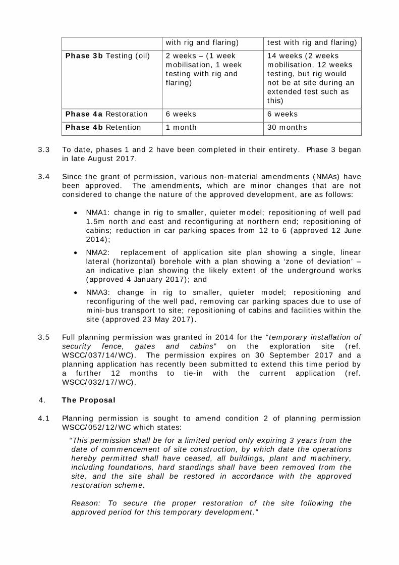
with rig and flaring) test with rig and flaring)
Phase 3b Testing (oil) 2 weeks – (1 week mobilisation, 1 week testing with rig and flaring)
14 weeks (2 weeks mobilisation, 12 weeks testing, but rig would not be at site during an extended test such as this)
Phase 4a Restoration 6 weeks 6 weeks
Phase 4b Retention 1 month 30 months
3.3 To date, phases 1 and 2 have been completed in their entirety. Phase 3 began
in late August 2017.
3.4 Since the grant of permission, various non-material amendments (NMAs) have been approved. The amendments, which are minor changes that are not considered to change the nature of the approved development, are as follows:
• NMA1: change in rig to smaller, quieter model; repositioning of well pad 1.5m north and east and reconfiguring at northern end; repositioning of cabins; reduction in car parking spaces from 12 to 6 (approved 12 June 2014);
• NMA2: replacement of application site plan showing a single, linear lateral (horizontal) borehole with a plan showing a ‘zone of deviation’ – an indicative plan showing the likely extent of the underground works (approved 4 January 2017); and
• NMA3: change in rig to smaller, quieter model; repositioning and reconfiguring of the well pad, removing car parking spaces due to use of mini-bus transport to site; repositioning of cabins and facilities within the site (approved 23 May 2017).
3.5 Full planning permission was granted in 2014 for the “temporary installation of
security fence, gates and cabins” on the exploration site (ref. WSCC/037/14/WC). The permission expires on 30 September 2017 and a planning application has recently been submitted to extend this time period by a further 12 months to tie-in with the current application (ref. WSCC/032/17/WC).
4. The Proposal 4.1 Planning permission is sought to amend condition 2 of planning permission
WSCC/052/12/WC which states:
“This permission shall be for a limited period only expiring 3 years from the date of commencement of site construction, by which date the operations hereby permitted shall have ceased, all buildings, plant and machinery, including foundations, hard standings shall have been removed from the site, and the site shall be restored in accordance with the approved restoration scheme.
Reason: To secure the proper restoration of the site following the approved period for this temporary development.”
4.2 Site construction commenced on 16 September 2014, meaning the permission expires on 16 September 2017. The applicant is seeking to amend the condition to extend the permission by a further 12 months.
4.3 The permission was implemented in September 2014 when the site roads and drilling pad were constructed and enclosed with a fence (identified in the initial application as ‘Phase 1 – Construction’). Operations then ceased. In August 2016, the original operator Celtique Energie was acquired by the current operator UKOG. In May 2017, UKOG commenced Phase 2 – Mobilisation and drilling, i.e. bringing the drilling rig and associated infrastructure to site followed by the drilling of the borehole. Initial testing (‘Phase 3 – Short Term Testing and Evaluation’) commenced soon after.
4.4 Permission is now sought to extend the temporary permission by twelve months to allow for the completion of the testing phase (see Appendix 3 – Well Test Layout Plan), after which either restoration or retention (‘Phase 4’) would be undertaken.
4.5 The remaining works would involve Phases 3 and 4, namely up 14 weeks of testing (Phase 3) followed by either restoration of the site (Phase 4a) or ‘retention’ of the site (Phase 4b), while a further planning application is prepared for production (see Appendix 4 – Restoration Plan and Appendix 5 – Retention Plan).
4.6 Testing and evaluation involves cleaning the well before carrying out flow tests and ‘shut-ins’ (i.e. sealing the well to carry out pressure testing) to understand the pressure and temperature characteristics of the geology and hydrocarbon resource. The applicant has noted that although the original application indicated that testing for oil and gas may be required, it is now anticipated that only oil testing will be needed.
4.7 Fluid and gas would be pumped into a separator where oil and water would be diverted into separate tanks, and gas would be diverted to a flare. The ultimate aim of the process is to understand whether the hydrocarbons can be economically exploited. The testing/evaluation process takes up to 14 weeks, and so is expected to be complete by November 2017.
4.8 If the tests show that there is not a viable hydrocarbon resource, the well would be ‘abandoned’ by plugging the borehole and the site restored (Phase 4a of the original application). This involves cutting the steel tubing inside the well approximately five metres below the surface, and capping the borehole with a steel plate before and decommissioning of the rig, a process which would take approximately three days. All structures including welfare and support buildings, the rig, storage tanks, the well cellar and ditch lining would be removed, and any remaining drilling mud, cuttings and waste would be removed from the site. The land would be returned to its former use, using the native soils from the stored sub and top soil bunds. The site surface would be re-formed using the stored soils and allowed to regenerate naturally.
4.9 If the tests show that hydrocarbon production is viable and producible quantities of oil are available, the site would be put into ‘retention’ (Phase 4b of the original application). This would involve the capping (sealing) of the well, and the removal of all buildings, tanks, structures and materials except for the crushed stone well pad and underlying impermeable membrane, drainage
ditches, fences and the borehole cellar chamber. A shipping container would be installed over the wellhead. The applicant’s intention is that this would remain in place pending the submission of a planning application for production within this 12 month period of extension.
4.10 The applicant has also submitted a slightly revised site layout plan to reflect the existing arrangement of facilities on site. The approved layout showed various single storey, portable cabins, stores and tanks around the site. The amended layout shows a reconfiguration of these. It is considered that the revisions to the layout are minor considering the development already approved.
5. Environmental Impact Assessment (EIA) 5.1 The proposal does not comprise Schedule 1 development, as defined in the
Town and Country Planning (Environmental Impact Assessment) Regulations 2017)(‘the EIA Regulations’).
5.2 The application submitted in respect of the currently approved development proposals (WSCC/052/12/WC) was voluntarily accompanied by an EIA as proposals which may fall within Schedule 2, Part 2 (e) ‘Surface industrial installations for the extraction of coal, petroleum, natural gas and ores, as well as bituminous shale’. The Screening threshold set out in column 2 to Schedule 2 for such development is where ‘The area of the development exceeds 0.5 hectare.
5.3 The development proposals are considered to fall within Schedule 2 to the EIA Regulations, namely Part 13(b) as relating to a ‘change to or extension of development of a description listed in paragraphs 1 to 12 of Column 1 of this table (Schedule 2), where that development is already authorised, executed or in the process of being executed.’
5.4 The site is not located within a ‘sensitive area’ as defined in regulation 2(1) of the EIA Regulations, however, the site measures 2.12 hectares exceeding the 0.5 hectare threshold set out in column 2 to Schedule 2.
5.5 As a result of the above, with reference to Schedule 3 to the EIA Regulations, consideration needs to be given as to whether the proposed variations amendments to the approved development, along with the existing, approved development has the potential to result in ‘significant environmental effects’ which require an EIA.
5.6 The Annex to PPG: Environmental Impact Assessment (6 March 2014) sets out indicative thresholds when considering whether EIA is necessary. For part 2(e) the indicative thresholds refer to a development site of 10 hectares or more, or where production is expected to be more than 100,000 tonnes of petroleum per year. The present proposal would not fall within either of these criteria.
5.7 The key issues to consider are noted in this annex as the scale of development, emissions to air, discharges to water, risk of accidents and arrangements for transporting the fuel.
5.8 The scale of the present development and emissions associated with it are not considered to be significant, particularly as the use would be temporary. The risk of accidents is not considered to be significant, and significant amounts of
fuel would not require transportation. No potentially significant impacts have been identified when considering the key issues.
5.9 Taking into account the EIA Regulations, it was considered that the proposals would not have the potential for significant effects on the environment within the meaning of the EIA Regulations. Therefore, EIA was not considered necessary.
6. Policy Statutory Development Plan
6.1 Section 38(6) of the Planning and Compulsory Purchase Act 2004 requires that
applications are determined in accordance with the statutory development plan unless material considerations indicate otherwise (as confirmed in paragraph 2 of the National Planning Policy Framework (‘the NPPF’)). For the purposes of the application, the following approved or adopted planning policy documents form the statutory development plan: the West Sussex Minerals Local Plan (2003) (‘MLP’) and the Horsham District Planning Framework (2015) (‘HDPF’).
6.2 The key policies in the development plan that are material to the determination of the application are summarised below, and their conformity or otherwise with the NPPF considered. In addition, reference is made to relevant national planning policy guidance, emerging planning policies and other policies that guide the decision-making process and which are material to the determination of the application.
West Sussex Minerals Local Plan (2003)
6.3 Given the age of the MLP, and the emergence of the replacement Plan, only the policies which are consistent with the NPPF should be given full weight. The main policies from the MLP which are in accordance with the NPPF and of relevance to the present application are:
• Policy 1 – Principles of Sustainable Development
• Policy 14 – Seeks appropriate restoration, protecting the physical characteristics of the land
• Policy 26 – Relates to oil/gas exploration and requires that the proposal is the best option in comparison with alternative sites and is acceptable in relation the surrounding area.
• Policy 27 – Notes that permission will normally be granted for hydrocarbon exploration subject to compliance with Policy 26, “having regard to the limited duration and area of activity.”
• Policy 53 – Seeks the incorporation of satisfactory means for the retention, protection and maintenance of existing trees.
• Policy 58 – Requires appropriate stripping, handling and storage of soils
• Policy 60 – Seeks appropriate protection from noise.
Horsham District Planning Framework (2015) 6.4 The HDPF was adopted in November 2015 and forms part of the ‘Development
Plan’. The relevant policies are:
• Policy 1 - Sustainable Development;
• Policy 10 – Rural Economic Development
• Policy 24 - Environmental Protection;
• Policy 25 - Natural Environment and Landscape Character;
• Policy 26 - Countryside Protection;
• Policy 32 - Quality of New Development;
• Policy 33 - Development Principles; and West Sussex Joint Minerals Local Plan: Proposed submission Draft (Regulation 19)(January 2017)(‘the Emerging MLP’)
6.5 The Emerging Minerals Local Plan has been subject to two rounds of public consultation and will be subject to Examination in Public in September 2017. In accordance with paragraph 216 of the NPPF, given its advanced stage of preparation it can be given significant weight, though the relevant policies may be given less weight where there are unresolved objections. The following sets out the relevant considerations and the weight accorded to them in the determination of this application.
6.6 Policy M7a of the Emerging MLP is of greatest relevance to the present application as it relates to ‘hydrocarbon development not involving hydraulic fracturing’. This policy is subject to significant challenge and so should be afforded little weight at this stage.
6.7 Clause (a) of the policy notes that extensions to existing oil/gas sites, including extensions of time, will be permitted provided that, in summary:
i. They are located outside South Downs National Park and Areas of Outstanding Natural Beauty;
ii. The site is the least sensitive, deliverable location from which the target reservoir can be reached;
iii. Any unacceptable impacts can be minimised and/or mitigated;
iv. Restoration/aftercare would be to a high quality standard; and
v. No unacceptable impacts would arise from the on-site storage or treatment of hazardous substances or contaminated fluids above or below ground.
6.8 The more generic ‘development management’ policies of relevance to the
proposal are as follows:
• Policy M12: Character – supports development which would not have an unacceptable impact on the separate identity of towns and villages and reinforce the main attributes of the wider character areas; [policy subject to minor objection and so can be given substantial weight]
• Policy M15: Air and Soil – supports development which would not have unacceptable impacts on the intrinsic quality of air and soil or their management; [policy not subject to objection and so can be given significant weight]
• Policy M16: Water Resources – supports development which would not cause unacceptable risk to water quality or quantity; [policy subject to some relatively minor challenge and so can be given significant weight]
• Policy M17: Biodiversity and Geodiversity – supports development which avoids/mitigates/remedies significant harm to wildlife species and habitats; [policy subject to significant challenge and so little weight should be afforded]
• Policy M18: Public Health and Amenity – supports development which would not result in an unacceptable impact on public health and amenity through on site operations or vehicle movements; and which safeguards public right of way routes; [policy subject to some challenge and so less weight afforded].
• Policy M19: Flood Risk Management – supports development which would not result in increased flood risk on site or elsewhere; [not challenged and so should be afforded significant weight]
• Policy M20: Transport – supports development with adequate transport links; maximises the use of the Lorry Route Network rather than local roads; does not have an unacceptable impact on highway capacity; provides safe access to the highway; provides vehicle turning on site; and minimises vehicle movements; [not challenged and so should be afforded significant weight]
• Policy M22: Cumulative Impact – supports development provided an unreasonable level of disturbance does not result from cumulative impact; [policy subject to challenge and so little weight should be afforded].
• Policy M24: Restoration and Aftercare – supports development with restoration schemes which ensure that land is restored at its earliest opportunity to a high quality. [not challenged and so should be afforded significant weight].
National Planning Policy Framework (2012)
6.9 The NPPF sets out the Government’s planning policies for England and outlines how these are expected to be applied. The Framework is a material consideration in determining planning applications. At the heart of the NPPF is a presumption in favour of sustainable development.
6.10 Paragraph 142 sets out the importance of minerals to support sustainable economic growth, highlighting that minerals can only be worked where they are found, and the importance of making best use of them to secure their long-term conservation.
6.11 Paragraph 144 sets out matters to consider in determining applications for
minerals development including (in summary): giving great weight to the benefits of mineral extraction including to the economy; ensuring that there are no unacceptable adverse impacts on the natural and historic environment, human health, or aviation safety, and taking into account cumulative impacts; ensure that unavoidable noise, dust and vibrations are mitigated; and providing for restoration at the earliest opportunity to the highest standard.
6.12 The other paragraphs in the NPPF of relevance to the application are:
Paragraph 7 (three dimensions of sustainable development); paragraph 14 (presumption in favour of sustainable development, and approving development that accords with the development plan); 17 (core planning principles); 109 (protection and enhancement of the natural and local environment); 110 (minimising pollution and other adverse effects); 120 (ensuring new development appropriate for location taking into account impact of pollution on health and the environment); 123 (impact of noise health and quality of life); 186 (positive decision making); 196 (determining applications in accordance with the development plan); 197 (presumption in favour of sustainable development); and 203-206 (use of planning conditions).
Planning Practice Guidance (PPG)
6.13 Planning Practice Guides (PPGs) were first published in March 2014 to
accompany the NPPF. As with the NPPF, these are a material consideration in considering planning applications. PPG: Minerals
6.14 PPG: Minerals (October 2014) sets out the Government’s approach to planning for mineral extraction in both plan-making and the planning application process.
6.15 Paragraph 12 sets out the relationship between planning and other regulatory regimes noting that “the planning system controls development and the use of land in the public interest” including ensuring development is appropriate for its location and an acceptable use of land.
6.16 It notes that “the focus of the planning system should be on whether the development itself is an acceptable use of the land and the impacts of those uses, rather than any control processes, health and safety issues or emissions themselves where these are subject to approval under regimes. Mineral planning authorities should assume that these non-planning regimes will operate effectively.”
6.17 Paragraph 13 sets out the environmental issues minerals planning authorities should address including noise, air quality, lighting, visual impact, traffic, risk of contamination to land, geological structure, flood risk, impacts on protected landscapes, surface and in some cases ground water issues, and water abstraction.
6.18 Paragraph 14 sets out issues which are for other regulatory regimes to address. For hydrocarbon extraction this links to paragraphs 110 to 112 which sets out the key regulators in addition to the Mineral Planning Authority, namely:
• Department of Energy and Climate Change (DECC)[now the Oil and Gas Authority]: issues petroleum licences, gives consent to drill, responsibility for assessing risk of and monitoring seismic activity, grant consent for flaring or venting;
• Environment Agency: protect water resources (including groundwater aquifers), ensure appropriate treatment of mining waste, emissions to air, and suitable treatment/management of naturally occurring radioactive materials (NORMs). Assess chemical content of fluids used in operations.
• Health and Safety Executive: regulates safety aspects of all phases of extraction, particularly ensuring the appropriate design and construction of a well casing for any borehole.
6.19 Paragraph 17 notes that the cumulative impact of mineral development can be
a material consideration in determining planning applications.
6.20 Paragraphs 91 to 128 relate specifically to hydrocarbon extraction.
6.21 Paragraph 93 notes that planning permission is required for each phase of hydrocarbon extraction, while paragraph 94 notes that applications can cover more than one phase and paragraph 118 notes that both vertical and horizontal drilling can be included in one application.
6.22 Paragraph 95 explains that the exploratory phase of hydrocarbon extraction: “seeks to acquire geological data to establish whether hydrocarbons are present. It may involve seismic surveys, exploratory drilling and, in the case of shale gas, hydraulic fracturing.”
6.23 Paragraph 100 explains that the appraisal phase
“…can take several forms including additional seismic work, longer-term flow tests, or the drilling of further wells. This may involve additional drilling at another site away from the exploration site or additional wells at the original exploration site…Much will depend on the size and complexity of the hydrocarbon reservoir involved.
6.24 Paragraph 124 states that Mineral Planning Authorities should take account of
Government energy policy which makes it clear that energy supplies should come from a variety of sources’ including onshore oil and gas. It also refers (and electronically links) to the Annual Energy Statement 2013 which notes, among other things, that the UK needs to make the transition to low carbon in order to meet legally-binding carbon emission reduction targets (paragraph 1.2) and that levels of production from the UK continental shelf are declining so the UK will become increasingly reliant on imported energy (paragraph 1.3). The three stated priorities in delivering the UK’s energy policies in the near term are:
• “helping households and businesses take control of their energy bills and keep their costs down;
• unlocking investment in the UK’s energy infrastructure that will support economic growth; and
• playing a leading role in efforts to secure international action to reduce greenhouse gas emissions and tackle climate change.” (paragraph 1.6).
6.25 Paragraph 3.69 states:
“With oil and gas remaining key elements of the energy system for years to come (especially for transport and heating), the Government is committed to maximising indigenous resources, onshore and offshore, where it is cost-effective and in line with safety and environmental regulations to help ensure security of supply.”
Other PPGs
6.26 PPG: Air Quality notes that when deciding whether air quality is relevant to a planning application, considerations could include whether the development would (in summary): significantly affect traffic (through congestion, volumes, speed, or traffic composition on local roads); introducing new point sources of air pollution; give rise to potentially unacceptable impact (such as dust) during construction; or affect biodiversity (paragraph 5).
6.27 PPG: Noise notes that noise can override other planning concerns (paragraph 2), and that the acoustic environment should be taken account of in making decisions, including consideration of (in summary) whether a significant adverse effect is likely to occur; whether an adverse effect is likely to occur; and whether a good standard of amenity can be achieved (paragraph 3).
6.28 PPG: Climate Change notes that addressing climate change is one of the core land use planning principles the NPPF expects to underpin decision taking.
7. Consultations 7.1 Horsham District Council - Planning: No objection. The District Council
would have concerns with the long term retention of this development as it would be detrimental to the landscape character of this countryside location. Given permission has already been granted, no objection is raised to allowing an additional 12 months for continued operations for testing. The District Council would ask that the applicants confirm that testing will stop on site after this period.
7.2 Horsham District Council - Environmental Health: No objection provided
the drilling operations continue with no significant changes to the machinery and equipment being used.
7.3 West Chiltington Parish Council: Seek six rather than twelve month extension due to impacts on ecology and highway; seek speed reduction to 30/40 mph; seek operations in daylight only to minimise risk of collision with tankers; consider submission lacks up-to-date information, particularly relating to ecology and timings of works which were expected to be October to February rather than July to October; contrary to submission site abuts ecologically-sensitive ancient woodland and is within 10km of SSSIs and RAMSAR site; unclear what chemicals to be used and how stored; flaring emissions unclear.
7.4 Pulborough Parish Council: No objection.
7.5 Billingshurst Parish Council: Neither objects or supports application but
resubmits comments made on 2012 application noting foliage at B2133 junctions should be maintained to ensure signage not obscured; junction improvements should be considered via S278; and reduction in speed limit to 40mph on B2133 should be considered.
7.6 Environment Agency: No objection. Notes that the applicant has the
necessary Environmental Permits in place to prevent pollution to the environment and that the time extension does not change any of the
requirements within the permits as the technical procedures and pollution control measures are sufficient.
7.7 Natural England: No comments to make.
7.8 Southern Water: No comments to make.
7.9 Police: Further crime prevention advice not required. 7.10 WSCC Tree Officer: No objection; no further impact to existing trees on or
adjacent to the site. Notes that the approved landscaping should have established more successfully.
7.11 WSCC Ecology: No objection. There is no reasonable expectation of harm to local biodiversity, thus requesting repeat-ecological surveys at this stage would not be proportionate to the risk of harm.
7.12 WSCC Highways: No objection. The amendment to the condition would not
have a material impact on the traffic generated by the development site.
7.13 WSCC Councillor Patricia Arculus: No comments received. 8. Representations 8.1 The application was publicised in accordance with The Town and Country
Planning (Development Management Procedure)(England) Order 2015. This involved the erection of eight site notices located around the application site, and advertisement in the local newspaper, and 40 neighbour notification letters and emails. Notification of the application was also sent to 59 addresses who wrote to the Council prior to the application being formally submitted.
8.2 In total, 549 representations were received from local residents and interested
parties, including the Broadford Bridge Action Group (BBAG) and other organisations. Of these, 374 objected to the development and 168 were in support. The remaining seven representations either raised concerns, had no comment to make, or were anonymous.
8.3 The main issues raised through objections, including that of BBAG, were, in summary:
• New application required changes too extensive to consider through an amendment to the original permission, including targeting a different rock strata;
• Risk of use of toxic chemicals without adequate assessment being done;
• Storage of hydrochloric acid contrary to condition 23 which prevents hazardous material being stored on site;
• Justification for extension of time by 12 months unclear and would go beyond expiry of Petroleum Exploration and Development Licence. Company knew expiry date, should have completed works;
• Lack of adequate, independent monitoring;
• Impact of HGVs on condition of road, and amenity;
• Noise impact during drilling;
• Industrialisation of rural area;
• Impact on ecology, including adjacent ancient woodland. Extension of time would go through bird nesting season;
• Oppose fracking: operation now appears to involve and/or require hydraulic fracturing (fracking), including through acidisation;
• Lack of emergency plans or bond, and no information on insurance in case of accident;
• Potential pollution of local aquifers;
• Waste of water resources;
• Impact of fossil fuel extraction on climate change;
• Lack of information regarding emissions from flare;
• Increased impact when site goes into production;
• Health impacts;
• Content and management of ‘flowback’ water, and lack of facilities in southern England to deal with it;
• Public consultation every 5 years inadequate;
• Few economic benefits for local residents;
• Risks of transportation of hazardous material;
• Operator has not shown that site is most appropriate location, including for testing Kimmeridge Clay Formation;
• Continuing visual impact;
• Heritage ‘decimated’ by use;
• Greater investment in ‘green’ solutions needed;
• Costs of use do not outweigh benefits;
• Site restoration should be guaranteed;
• Disruption, loss of amenity and cost of policing due to protesters;
• Horizontal extent of drilling under houses unknown;
• Site on fault line – risk of earthquakes, sinkholes, liquefaction and transmission of fluids to aquifers and public water supply.
Several representations were received from other organisations:
• Friends of the Earth: Objects. In granting the original permission the impact was presumably only considered acceptable for the temporary period allowed, with restoration to be secured as soon as possible. Not in the public interest to extend the timescale; would increase duration of impacts on people and environment. Impact of change in ownership of site not a material consideration.
• Sussex Wildlife Trust: concerned that no new ecological information has been provided; storage of hydrochloric acid now proposed without being previously considered.
• Campaign to Protect Rural England Sussex Countryside Trust: Objects. Assessments of impact on ecology out of date and inadequate, including considering operations in a different season (winter rather than summer);
misleading information regarding protected species near site; lack of detail about impact of chemicals used/stored and flaring;
8.4 Of those in support of the development, the following issues were raised:
• Operator should be allowed adequate time to test for commerciality of oil that has been found;
• Application is not for fracking so no justification for refusal;
• Important to make use of on-shore resources for national security and given dwindling North Sea supply.
• Given reduced availability of off-shore supplies from the North Sea, imperative on-shore sources are exploited;
• Oil fields can be developed without detrimental impact on the environment, particularly with modern methods, and restoration can be beneficial;
• Beneficial to economy and jobs, locally and nationally. 9. Consideration of Key Issues 9.1 The main material planning considerations in relation to this application are
whether:
• there is a need for the development;
• the development is acceptable in terms of highway capacity and road safety;
• the development is acceptable in terms of impact on local residents; and
• the development is acceptable in terms of impact on the environment.
Need for the Development 9.2 In considering the need for oil/gas exploration, the NPPF notes that “Minerals
are essential to support sustainable economic growth and our quality of life” and that “…minerals are a finite natural resource, and can only be worked where they are found…” (NPPF paragraph 142). Paragraph 144 requires that in determining planning applications local planning authorities “give great weight to the benefits of mineral extraction, including to the economy”, though this must be balanced against the weight given to environmental impacts of a development.
9.3 Paragraph 124 of PPG: Minerals provides a clear steer that nationally, energy, including oil and gas, should come from a variety of sources, giving the following response to the hypothetical question:
“Do mineral planning authorities need to assess demand for, or consider alternatives to oil and gas resources when determining planning applications?
Mineral planning authorities should take account of Government energy policy, which makes it clear that energy supplies should come from a variety of sources. This includes onshore oil and gas, as set out in the Government’s Annual Energy Statement published in October 2013.”
9.4 The Annual Energy Statement referred to in this paragraph notes that energy policy is underpinned by two key factors: the need to reduce carbon emissions and to ensure energy security (paragraph 1.1). It makes it clear that while renewable energy must form an increasing part of the national energy picture, oil and gas remain key elements of the energy system for years to come (paragraph 3.69).
9.5 One of the three key priorities outlined in the Annual Energy Statement is ‘unlocking investment in the UK’s energy infrastructure that will support economic growth’ (paragraph 1.6). Paragraph 3.69 of the Statement notes the Government is committed to maximising indigenous resources, subject to safety and environmental considerations.
9.6 Taking this into account, the present proposal is considered to accord with the approach set in national guidance by investing in energy infrastructure to establish whether indigenous oil and/or gas reserves are available and worth exploiting at Broadford Bridge.
9.7 At the local level, Policy 27 of the West Sussex Minerals Local Plan (2003) states that permission for hydrocarbon exploration “will normally be granted subject to compliance with the issues addressed in Policy 26, having regard to the limited duration and area of the activity”. This policy indicates a presumption in favour of allowing temporary hydrocarbon exploration, subject to environmental matters which are considered in detail in the separate sections below. The preamble to this policy expands on this presumption in favour, noting that exploration can normally be undertaken quickly and relatively unobtrusively, and that allowing it would not give any commitment for further appraisal, development or actual working of the reserve (paragraph 5.9, MLP).
9.8 Policy 26 of the West Sussex Minerals Local Plan (2003) states that “Proposals for oil and gas will be permitted where it is demonstrated to the satisfaction of the Planning Authority that it demonstrates the best option in comparison with other alternative sites within the area of search…”. This feeds into consideration of whether there is a need for this development on this site in particular.
9.9 As noted in paragraph 6.7, emerging Policy M7a supports proposals for oil and gas exploration and appraisal not involving hydraulic fracturing subject to certain criteria, including that the site is outside the national park and areas of outstanding natural beauty; and that the site is the least sensitive, deliverable location from which the target reservoir can be reached. The remainder of the criteria are considered in the following sections.
9.10 The site is not within the national park or an area of outstanding natural beauty and so meets this requirement.
9.11 In terms of consideration of whether the site is the ‘least sensitive, deliverable location from which the target reservoir can be reached’, paragraph 147 of the NPPF states that minerals planning authorities should “when planning for on-shore oil and gas development…address constraints on production and processing within areas that are licensed for oil and gas exploration or production”. This makes it clear that any consideration of constraints should be limited to sites that are covered by a Petroleum Exploration and Development
Licence (PEDL). As hydrocarbons can only be exploited within a given PEDL area, it is considered reasonable to limit consideration of alternative sites to a single PEDL area.
9.12 The application site is within PEDL 234, a reverse-L shaped area of some 300 square kilometres. The area covered by the PEDL is generally rural with scattered, small settlements and, therefore, any oil/gas site tapping into this reserve is likely to be within the West Sussex countryside. PEDL 234 is therefore the ‘search area’ for the purposes of this application.
9.13 By using the existing site, the operator can make use of existing geological data, and utilise the existing borehole only recently drilled and the associated infrastructure on site including the well pad and access road. It is considered that making use of an existing site and data is the best option for establishing whether the reserves are viable to exploit. An alternative site selection process was undertaken in relation to the previous application confirming that the site is the least sensitive, deliverable location.
9.14 Taking the above into account, it is concluded that there is a need for continued exploration and appraisal at the site to establish whether there are hydrocarbon resources present that can be utilised. It is also concluded that the site represents the best option within the search area (i.e. the PEDL boundary).
9.15 Some objectors have stated that a new planning application is required because the current operator is targeting a different rock stratum to the one that was the original target when planning permission was granted in 2013. However, it is considered that this is a commercial decision by the operator (based on the likelihood of identifying a viable resource) and that it does not change the nature of the development permitted under WSCC/052/12/WC. Therefore, a new planning application is not required.
9.16 For the avoidance of doubt, hydraulic fracturing (‘fracking’) was not permitted under WSCC/052/12/WC and it is not proposed under the current application. ‘Acidisation’ is a very common industrial process used in creating and maintaining boreholes (whether for oil or water) to increase yield/performance or to rehabilitate a borehole (i.e. to remove blockages). Therefore, the proposed use of acidisation by the operator does not mean that fracking is proposed at the site. Furthermore, hydraulic fracturing cannot be carried out at the site without further permissions and authorisations being secured.
9.17 The NPPF gives ‘great weight’ to the benefits of mineral extraction, including to the economy and highlights that minerals can only be worked where they are found. Planning Policy Guidance on Minerals notes that oil and gas will continue to form part of the national energy supply, and gives a clear steer from Government that there is a continuing need for indigenous oil and gas. The West Sussex Minerals Local Plan (2003) notes that planning permission for oil and gas exploration will normally be granted, subject to environmental considerations and the development being the ‘best option’ in the area of search. The present proposal would make use of an existing well on a site with established infrastructure to determine whether oil and gas resources are exploitable and so is considered to represent the ‘best option’. It is, therefore, concluded that there is an identified need for local oil and gas production, and that there is an identified need for development on this site to establish whether there are any viable hydrocarbons that could be exploited.

Highway Capacity and Road Safety
9.18 One of the key issues raised in objections to the application is the impact of HGV movements on the road network.
9.19 The original application in 2012 assessed the traffic and transport attributed to the development. It was broken down into the four phases, anticipating that the second phase (Mobilisation of the Drill Rig and Drilling Operations) would have the greatest impact during peak hours, with this phase generating approximately 15 peak hour (8am–9am) movements. This phase has been completed. During the testing phase (Phase 3), it is expected that the development would result in two HGV movements/day (one HGV travelling to/from the site). During restoration (Phase 4a), there would be up to 22 HGV movements/day (11 HGVs travelling to/from the site).
9.20 In response to the 2012 application, WSCC Highways confirmed that the
vehicles generated by the development would have an imperceptible impact on the highway network, and that a full junction capacity assessment would not be required.
9.21 In response to this application, WSCC Highways stated;
“The proposed amendment to the condition would not have a material impact on the traffic generated by the development site. No alterations are proposed to site operations as part of the application that would impact upon vehicular generation beyond traffic impacts previously considered. No objection is raised to the proposed amendment.”
9.22 As already noted, the application requests an extension of time to complete the
testing and restoration/retention phases. These phases involve limited vehicle movements. The extension of time would not increase the movements that have already been considered as acceptable. Further, the impact on the highway network would not be prolonged because of the delay to the commencement of the development.
9.23 The continued use of the site to allow the completion of the testing and
appraisal phase and the restoration/retention phase would result in a low number of traffic movements. The development would not result in significant impacts on the highway network or road safety. It is, therefore, considered that the impact on highway capacity and road safety is acceptable. Impact on Local Residents
9.24 The main potential impacts of the proposed extension of time are considered to
result from vehicular movements, noise, air pollution and lighting. The nearest dwelling to the site is Gatewick Farm, some 400 metres south of the development site, with Adversane Road (B2133) being the nearest roadway.
9.25 Given the relatively low levels of vehicle movements associated with the
development, it is not considered that there is a potential for these to result in unacceptable impacts on the amenity of local residents.
9.26 The construction and drilling phase of the exploration has been completed, meaning that 24 hour operations at the site have also finished. The remaining phases for the testing/appraisal and the retention/restoration of the site would be undertaken during the day (from 07.00 to 19.00 Monday to Friday, and 08.00 to 13.00 on Saturdays), which would help to minimise the risk of disturbance, particularly that resulting from noise.
9.27 Horsham District Councils’ Environmental Health Officer has raised no objection
to the extension of the development for a further 12 months.
9.28 Notwithstanding the Environmental Health Officer’s response, a Noise Management Plan (NMP) was required and discharged under Condition 8 of the original application. The NMP requires the monitoring of the development to ensure that noise from the site does not exceed the noise limits used in the assessments for the original Environmental Statement. Should the application be approved, the NMP would still form part of the approved documents to which the operator would be required to adhere. It is considered that exploration operations at the site would not result in unacceptable impacts on local residents.
9.29 Under these circumstances and given the controls that the conditions would provide, it is not considered that the proposal would result in adverse noise impacts on residential amenity.
9.30 Concern has been raised in third party objections about the potential impact of the flare, in particular on air quality and human health.
9.31 A shrouded flare would be on site to dispose of natural gas, which is a by-product of oil exploration. PPG: Minerals (paragraph 112) is clear that the flaring or venting of gas is subject to DECC (now the Oil & Gas Authority) controls and regulated by the Environment Agency, with Minerals Planning Authorities needing to consider only “how issues of noise and visual impact will be addressed”. It is clear, therefore, that the potential impact of the flaring of gas on air quality is not a matter for the County Council.
9.32 However, in leaving this issue to other regimes, PPG: Minerals also makes it clear that the Minerals Planning Authority must be satisfied that the issues can or will be addressed by taking advice from the relevant regulatory body (paragraph 112). The Environment Agency has commented on this application and has raised no objection. In addition, the Environment Agency has granted an Environmental Permit that addresses the flaring of waste gas resulting from the proposed operations, and concludes that it can be undertaken without risk to people or the environment.
9.33 The development also has the potential to result in impacts on air quality through increased traffic on the road to and from the site. However, the levels of vehicles associated are not considered to be significant enough to reduce air quality, particularly given the short-term nature of the project and the small increase over existing HGV numbers already on the local highway network.
9.34 Taking the above into account, it is concluded that the potential impact of the development on air quality is satisfactory, particularly given the controls in place through the Environmental Permitting regime.
9.35 With the rig off-site and no further 24 hour working, the site lighting required for the final phases would be substantially less than was required during the drilling phase of the development. The potential for visual impact, including from lighting, is reduced through the heavy tree and hedgerow cover enclosing the site to the north, west and south, and soil bunding to approximately two metres in height to the east. Additional infill hedgerow planting was also requested along the access track.
9.36 Taking into account these factors, the temporary nature of the proposal, and the separation distances involved, it is considered that the impact on neighbouring residents, is likely to be minimal.
9.37 It is considered that the proposal would not result in unacceptable impacts on
local residents. Vehicular movements associated with the development are low; noise emissions have been shown to be within an acceptable range and the noise management plan would ensure the operator complies with identified noise limits. The impact of the flare on air quality can be adequately considered and controlled by the Environmental Permit and lighting is considered to have a negligible impact. Given the temporary nature of the development, the development is considered acceptable with regards to its impact upon local residents.
Impact on the Environment
Landscape/character 9.38 The application site is located adjacent to agricultural land within a rural area
characterised by open fields and woodlands. The key visible elements of the testing and appraisal phase would comprise plant, machinery and equipment required for the testing operations. Single storey portacabins and containers would also be on-site housing site offices and workshops. Access to the site for the final phases of the development would utilise the existing site access, which itself was an existing field access prior to the permitted development.
9.39 Although the development is industrial in nature, the site is enclosed to the north, west and south with mature woodland, with a bund to the east. The distance and screening from Adversane Lane by mature trees and hedgerows is significant meaning that there are limited public views into the site. Furthermore, any such views are likely to be transient, primarily as people travel in vehicles along Adversane Lane.
9.40 Upon completion of the proposed operations, depending upon the results of the testing and appraisal, the site would either be restored to agricultural use or retained in a safe state pending the preparation of a planning application for production. Whether the applicant opts for restoration or retention of the site, by 16th September 2018, proposed condition 1 would require the site be restored. Therefore, there would be no long-term impact on the landscape as a result of the current proposal.
9.41 WSCC’s Trees and Woodland Officer raises no objection to the extension of the
time period, stating that the site already exists and provided that there are no modifications “there should be no further impact to existing trees on or adjacent to the site”. Although the site has been modified in terms of plant and machinery positioning, with equipment being used subject to operational
requirement, no changes are proposed to the well-pad itself and access road that would affect surrounding trees and hedgerows.
9.42 Given the relatively short duration of the development and the location of the site within a heavily wooded area, the impact on the visual amenity and landscape is considered to be minimal. The site would be restored or retained to a standard that would blend in with its surroundings, as has been previously agreed, and so any visual impacts would be temporary.
Water Environment
9.43 One of the concerns raised in objections to the proposal is the potential impact on the water environment. PPG: Minerals notes that “surface, and in some cases ground water issues” should be addressed by minerals planning authorities as well as flood risk and water (paragraph 13). The impact on the water environment is, therefore, a material planning consideration.
9.44 The site is not within an area considered to be at increased risk of flooding, nor is it within a groundwater source protection zone.
9.45 In considering the potential impacts on the water environment, it is important
to note that the County Council must assume that other, non-planning regimes operate effectively (PPG: Minerals, paragraph 112). In relation to water, this means assuming that the construction, design and operation of the borehole have been undertaken appropriately, in accordance with Health and Safety Executive (HSE) requirements. It also means assuming that the Environment Agency will ensure that surface equipment operates satisfactorily, and that mining waste and naturally occurring radioactive materials (NORMs) are appropriately managed.
9.46 Nonetheless, as already noted, paragraph 112 of PPG: Minerals notes that before granting permission the County Council will need to be satisfied that the issues dealt with under other regimes can be adequately addressed ‘by taking advice from the relevant regulatory body’. Furthermore, this application is only seeking an extension of time for the testing and appraisal phase and the retention/restoration phase.
9.47 The main risks to surface water are due to run-off from the surface of the site. For any development, it is important to ensure that fluids, particularly where they are potentially polluting, are managed within the site. For this development, impacts on water quality would be mitigated by ensuring potentially-polluting activities are undertaken on an impermeable surface with sealed drainage system. Details of site drainage have been agreed through the discharge of Condition 22 of the original application. Should the application be approved, the details would still form part of the approved documents to which the operator would still need to adhere. In addition, the Environment Agency has not raised any objection to the extension of the time period for 12 months.
9.48 The main risks to groundwater are through failure of the well casing, leaking of chemicals and hydrocarbons, and through migration of liquid from the borehole. All of these matters are addressed through regulation by the Environment Agency and HSE.
9.49 Specific concerns have been raised regarding the storage on site of and the use of hydrochloric acid and the process of ‘acidisation’. The use of dilute hydrochloric acid is a standard procedure used for cleaning of boreholes not just for oil and gas development but also more generally for many drinking water boreholes.
9.50 The Environment Agency has considered this process in granting its Environmental Permits and has raised no concerns. The decision document relating to the Environmental Permit for this operation notes that “Acidisation has been carried out historically within oil wells and water wells therefore we are satisfied that there is no likelihood of environmental risk from this process”.
9.51 It has been suggested by objectors that a bond or financial guarantee should be sought to cover remediation in the event that contamination occurs or that the operator finds itself in financial trouble. However, for minerals projects, typically quarries and similar, financial guarantees are only justified in ‘exceptional cases’ involving very long-term projects, novel approaches, or reliable evidence of the likelihood of financial or technical failure (PPG: Minerals, paragraph 48). For oil and gas projects, the operator is explicitly liable for any damage or pollution caused by their operations, with DECC (the Oil & Gas Authority) checking that operators have appropriate insurance against these liabilities in granting a PEDL Licence.
9.52 Taking the above into account, it is considered that the development does not
pose a risk to the water environment. Ecology
9.53 The application site abuts woodland to the north, west and south, with ancient woodland some 125m to the east. It is otherwise relatively distant from any ecological designations, none being within 1km of the site. The nearest Site of Special Scientific Interest (SSSI) is some 2.8 kilometres north of the site; the Coneyhurst Cutting.
9.54 It is considered that by controlling impacts on surface and groundwater, and emissions to air, any adverse impacts on ecology would also be minimised. Monitoring of both water and air quality (as required by the Environmental Permit) would ensure that any emissions are identified and controlled appropriately. The potential for adverse impacts through water and air emissions is therefore considered to be minimal.
9.55 Of concern in relation to this application is the potential impact on bats and birds as the site is surrounded by trees, with the potential to house both.
9.56 WSCC’s Ecology Officers have raised no objection to the proposal, noting that “The proposed testing phase will occur outside of the bird breeding season and would be, in any case, unlikely to have an impact during the breeding season. Similarly for bats, the existing permission allows the activities to occur to this point and the new permission represents a reduction in potential impacts i.e. arising from lighting”.
9.57 The ecologist also noted that it would not be proportionate to require repeat ecological surveys. In reaching this conclusion, he has taken into account
concerns raised by Sussex Wildlife Trust and other representations that question the adequacy of the submitted ecological information.
9.58 Taking the above into account, it is considered that the impacts of the proposed development can be contained within the site to ensure that habitats and species are not adversely affected.
9.59 Although the proposed development would be of an industrial nature within a rural setting, it is well-screened from public views, negating any visible impacts and, therefore, it is considered that the proposal is acceptable in landscape terms. The development does not pose a risk to the water environment, either at the surface or groundwater. The potential impact of the development on habitats and species would be minimal, subject to controls on lighting, emissions to air and the water environment which would contain the operation within the site. Overall, given the temporary nature of the development and subject to the imposition of the suitable conditions and approved documents, the impact of the development on the immediate environment and the surrounding landscape is considered to be minimal.
10. Overall Conclusion and Recommendation
10.1 The 12 month extension to allow for testing and appraisal and for the retention/restoration phases of the hydrocarbon exploration at the Broadford Bridge site has the potential to result in impacts on the highway, local residents, and the environment, issues that have been raised in the large number of objections to the application. However, no statutory objections have been received, although the local parish councils have raised matters to be reviewed.
10.2 It is concluded that the number of vehicles required to carry out the remainder
of the development is not significant enough to raise concerns regarding highway capacity or road safety. The site set-up during the remaining phases would have limited visibility, and would be during a limited time period and so would not have an adverse impact on the character of the area. The impacts of the development would be controlled through the planning regime as well as through the environmental permitting and health and safety regimes to ensure that water quality would not be compromised and that emissions to air would be acceptable.
10.3 Overall, the extension of time to conclude the final phases of hydrocarbon
exploration is considered to have minimal impacts, and the development would help to meet an identified need for local hydrocarbon exploration and appraisal. The development accords with the development plan and other material considerations, including the National Planning Policy Framework. Therefore, it is considered that the proposal is acceptable subject to the imposition of appropriate conditions to control the potential impacts as it progresses through the various stages of development.
10.4 It is recommended, therefore, that planning permission be granted subject to
the conditions and informatives set out at Appendix 1. 10.5 The conditions have been carried over from the original planning permission,
unless they have been formally discharged and are no longer required (for example, where they relate to Phases 1 and 2). Where appropriate, some
conditions have been updated, for example, to refer to new controls (such as the Noise Management Plan) that have been put in place following the discharge of original conditions. The non-material amendments identified in Section 3 have also been incorporated.
11. Resource Implications and Value for Money 11.1 This is not a material planning consideration and cannot, therefore, be
considered in determining this application. There will be no requirement for additional resources unless the decision is challenged and there is a requirement to defend the County Council’s position at any subsequent appeal.
12. Equality Duty 12.1 The County Council has a duty to have regard to the impact of any proposal on
those people with characteristics protected by the Equality Act 2010. Officers considered the information provided by the applicant, together with the responses from consultees and other parties, and determined that the proposal would have no material impact on individuals or identifiable groups with protected characteristics. Accordingly, no changes to the proposal were required to make it acceptable in this regard.
13. Risk Management Implications 13.1 Section 38(6) of the Planning and Compulsory Purchase Act 2004 provides that
the determination of planning applications must be made in accordance with the policies of the development plan unless material considerations indicate otherwise. If this is not done, any decision could be susceptible to an application for Judicial Review.
14. Crime and Disorder Act Implications 14.1 This decision has no implications in relation to crime and disorder. 15. Human Rights Act Implications 15.1 The Human Rights Act requires the County Council to take into account the
rights of the public under the European Convention on Human Rights and prevents the Council from acting in a manner which is incompatible with those rights. Article 8 of the Convention provides that there shall be respect for an individual’s private life and home save for that interference which is in accordance with the law and necessary in a democratic society in the interests of (inter alia) public safety and the economic wellbeing of the country. Article 1 of protocol 1 provides that an individual’s peaceful enjoyment of their property shall not be interfered with save as is necessary in the public interest.
15.2 For an interference with these rights to be justifiable the interference (and the
means employed) needs to be proportionate to the aims sought to be realised. The main body of this report identifies the extent to which there is any identifiable interference with these rights. The Planning Considerations identified are also relevant in deciding whether any interference is proportionate. Case law has been decided which indicates that certain development does interfere with an individual’s rights under Human Rights
legislation. This application has been considered in the light of statute and case law and the interference is not considered to be disproportionate.
15.3 The Committee should also be aware of Article 6, the focus of which (for the
purpose of this committee) is the determination of an individual’s civil rights and obligations. Article 6 provides that in the determination of these rights, an individual is entitled to a fair and public hearing within a reasonable time by an independent and impartial tribunal. Article 6 has been subject to a great deal of case law. It has been decided that for planning matters the decision making process as a whole, which includes the right of review by the High Court, complied with Article 6.
Michael Elkington Head of Planning Services Contact: Chris Bartlett (phone 0330 222 6946).
Background Papers As set out in Section 6 List of Appendices Appendix 1 – Conditions and Informatives Appendix 2 - Site Location Plan Appendix 3 – Well Test Layout Plan Appendix 4 – Restoration Plan Appendix 5 - Retention Plan
Appendix 1: Conditions and Informatives CONDITIONS TIME LIMITS 1. This permission shall be for a limited period only expiring on 15th September
2018, by which date the operations hereby permitted shall have ceased, all buildings, plant and machinery, including foundations, hard standings shall have been removed from the site, and the site shall be restored in accordance with the approved restoration scheme (ref. Proposed Site – Restoration Plan 3261/BB/18).
Reason: To secure the proper restoration of the site following the approved period for this temporary development.
APPROVED OPERATIONS PROGRAMME
2. Only Phase 3 – Testing and Phase 4 – Restoration/retention is permitted under this approval. Phase 1 – Construction and Phase 2 – Mobilisation and Drilling shall not be carried out or revised in the lifetime of this approval. For the avoidance of doubt, hydraulic fracturing (‘fracking’) is not permitted under this permission.
Reason: To ensure the development is carried out as proposed
3. The development hereby approved shall not take place other than in
accordance with the approved drawings:
• Site Location Plan – 26059 P1 • Access Track 1 – Proposed Layout 3261/BB/07 Revision B; • Access Track 2 – Proposed Layout 3261/BB/08 Revision B; • Proposed Site Entrance 3261/BB/15 Revision A; • Well Test Layout Plan – UKOG-BB-PA-WT-01; • Well test Parking Layout Plan – UKOG-BB-PA-WT-02; • Site Sections – Retention 3261/BB/17 Revision C; and • Proposed Site – Restoration Plan 3261/BB/18, except as modified by condition hereafter.
Reason: To ensure the development is carried out as proposed
4. Prior written notification of the date of commencement of Phase 3 - Testing
and Phase 4 - Restoration/retention hereby approved shall be sent to the County Planning Authority not less than seven days before commencement of each Phase.
Reason: To inform the County Planning Authority of potential disruptive periods in the interests of amenity.
5. A copy of this decision notice together with the approved plans and any
schemes and/or details subsequently approved pursuant to this permission shall be kept at the site office at all times and the terms and contents thereof shall be made known to supervising staff on the site.
Reason: To ensure the site operatives are conversant with the terms of the planning permission.
HOURS OF WORKING 6. Work at the site, including HGVs entering and leaving the site, shall only be
undertaken between the hours of 0700 and 1900 Mondays to Fridays and 0800 to 1300 on Saturdays. No work shall occur on Sundays, Bank Holidays and Public Holidays.
Reason: To protect the amenities of occupiers of nearby residential properties
NOISE 7. No plant or equipment shall be used on the site unless fitted and operated at
all times with silencing measures to a standard not less than the manufacturer's UK standard specification for that equipment.
Reason: In the interests of the amenities of occupiers of nearby residential properties
8. The approved Noise Management Plan (project number 9Y0893-105-100 and
dated 21 August 2014) shall be adhered to and retained throughout the duration of the permission. Should monitoring of noise indicate that the limits (which are specified within Chapter 9 of the Environmental Statement) are being exceeded, details of further mitigation and a timetable for implementation will be submitted to the County Planning Authority for approval.
Reason: In the interests of the amenities of the residents of the locality; to ensure that noise from the site does not exceed the noise limits set out in the Environmental Statement.
LANDSCAPING AND ACCESS TRACK RESTORATION 9. The approved plans and documents relating to landscaping matters and
restoration methodology, namely: • Landscape Proposals (drawing number 1377-3001 Revision 01); • Tree Protection Plans (Sheets 1 – 3); • Access Track Construction in Vicinity of Trees at Entrance (drawing number
3261/BB/21 Revision B); • ‘Methodology for the removal and reinstatement of the access track and
no-gig surfacing at the access off Adversane Lane’ document; and the • ‘Tree Protection Plan’ methodology, shall be adhered to and where relevant form part of the overall restoration of the site which shall be completed in full.
Reason: To ensure the landscape and ecology of the area is protected after the development has been completed.
10. A scheme of aftercare specifying the steps to be taken to manage restored
land shall be submitted for the written approval of the County Planning
Authority prior to the commencement of restoration. Thereafter the approved strategy shall be implemented in full.
Reason: To ensure effective restoration and afteruse of the land to protect the landscape and ecology of the area.
ACCESS / HIGHWAYS 11. The vehicular access and visibility splays, shown on drawing 3261/BB/15
Revision A, shall be retained and maintained throughout the duration of the permission.
Reason: In the interests of highway safety
12. The discharged Construction Traffic Management Plan document (project
number 9Y0895 and dated 14 August 2014) shall be adhered to and retained throughout the duration of the permission.
Reason: In the interests of highway safety and the amenities of the area.
FIRE FIGHTING 13. Within 7 days of the date of this decision, a fire fighting plan shall be
submitted to the County Planning Authority for approval showing the on-site fire water tanks relocated near the main entrance to the well site compound. Once approved in writing by the County Planning Authority, the tanks shall be relocated to the position indicated and shall remain on site, in the approved position and available for immediate use throughout the development.
Reason: In the interests of fire safety
GROUNDWATER PROTECTION/DRAINAGE 14. The approved groundwater protection/drainage scheme to dispose of foul and
surface water and accompanying drawings ‘Plan of Surface Water Distribution at Site Entrance – 3261/BB/20 Revision A’ and ‘Site Ditch Construction Details – 3261/BB/C/10 Revision A’ shall be adhered to and retained throughout the duration of the permission.
Reason: To protect water quality and ensure compliance with the NPPF
15. The approved Construction Method Statement and accompanying drawings
‘Cellar Detail – 3261/BB/C/09 Revision C’ and ‘Site Ditch Construction Details – 3261/BB/C/10 Revision A’ shall be adhered to and retained throughout the duration of the permission.
Reason: To protect water quality and ensure compliance with the NPPF
INFORMATIVES
A. In accordance with paragraphs 186 and 187 of the National Planning Policy Framework, the County Planning Authority has approached the determination of this application in a positive way, and has worked proactively with the applicant by:

• Providing pre-application advice; • Discussing issues of concern as early as possible, including those raised
by consultees and third parties; • Giving them the opportunity to provide further information/changes to
overcome material impacts; and • Working with consultees.
As a result, the County Planning Authority has been able to recommend the grant planning permission for an acceptable proposal, in accordance with the presumption in favour of sustainable development. •