planning concepts and development …shodhganga.inflibnet.ac.in/bitstream/10603/100706/12/12_chapter...
TRANSCRIPT

50
PLANNING CONCEPTS AND DEVELOPMENT
CONTROLS IN INDIA
Introduction
India’s strong historical past of more than 2000 years, in the form of
civilizations and associated systems, of which town planning was a characteristic
feature has been well researched by historians. Planning for cities in India dates back to
the Vedic times with most of the cities like Patliputra, Varanasi, Nalanda etc were built
on the basis of well conceived plans (Nallathinga, 2009). These were the concerted
efforts of specific kingdoms or empires prevalent at various points of time in history
rather than an outcome of documented and institutionalized procedures. Therefore, it is
difficult to compare the ancient planning systems with the modern planning systems.
This present chapter focuses on various planning concepts and development controls
that have evolved along with the present day concept of master plan and in-built
development controls in the post independence era.
Planning Concepts in Ancient India
Town Planning was developed and practiced as an art by our ancestors way back
in 8000 BC when the small settlements evolved into about 100 large Indus Valley
settlements following a hierarchy of cities, villages and outposts. Some of the legendary
ancient cities along the Indus were Dholavira, Kalibangan, Rupar, Rakhigarhi and
Lothal - presently located in states of Gujarat, Haryana, Punjab and Rajasthan in India.
The two largest and most studied cities of Indus Valley civilization are
Mohenjodaro and Harappa. Each of these cities was about 1 sq. kms in size with an
estimated population between 23000 and 40000, with a density of about 90 to 160
people per acre, which is desirable even by today’s sustainability standards. These cities
provided the first known examples of town planning, civil engineering, building design
and construction in India. The focus was more on the spatial arrangement of houses for
various classes residing within the city. The strategically safe areas were reserved for
ruling or higher classes while the weaker sections resided in the outskirts. While setting
the residential areas for the higher classes, attention was paid to the most frequent

51
prevailing wind direction. City Streets had a north south orientation, with a central
market place and a small wall surrounded the city. A fortified citadel lay to the west and
a larger ‘lower city’ to the east. The citadel included a massive brick platform, possibly
to protect from flooding and housed granaries with loading bays, baths and an assembly
hall. The lower city was laid in a grid pattern of streets having controlled widths, with
shops and workshops lining the streets. Every house was linked to a main drain, with
regular inspection holes for maintenance. Houses up to two storeys were built on plinths
with brick stairs leading to upper floors or the roof. The typical residential unit was built
around an open to sky court with entrance from side lanes, without any windows
opening on to main streets. Houses were varied in sizes, but included cooking and
bathing spaces partitioned within them. Larger houses had courtyards and private wells
also (Ramanathan, 2011).
The planning of the ancient cities clearly demonstrated appropriate planning
approach. Further the building controls ensured that the buildings in the cities followed
a uniform approach and provided enough room for light and ventilation. It was ensured
that all the houses followed a similar layout resulting in organized development. The
controls provided structured development of the cities with commercial and residential
areas separated from each other.
Thousand years after the deterioration of Indus settlements, the period between
1750BC and 750BC, ushered in the second most lasting urban settlements in the
Gangetic Plains. New trade routes emerged and knowledge guilds were established and
new coastal cities were developed during this period. Kingdoms were fortified and
planning of the towns was mainly confined around the fort that formed the nucleus with
subgroups based on occupation and caste organised around it (Ramanathan, 2011).
Thooyavan (2005) explained in his book on ‘Human Settlements’ that the settlements
built during this period were within the framework of strict rules and regulations laid
down in Hindu Shastras and Puranas. Among these, the most important were the Silpa
Sasthras and Kautilya’s Arthasasthra. These ancient treatises on town administration
and architecture indicate how scientifically the art of town planning in the earlier ages
was studied and practiced. Based on the predominant features and functions, the towns
were classified as Nagara (District headquarters), Rajdhani (Royal Capital), Pathare

52
(Commercial town), Druga (Fortified, or small industrial town), Kheta (Town grown by
local industries), Kharveta (Big industrial town), Sivira (Military encampment),
Senamukha (Suburban military township), Skandavara (Military towns with imperial
quarters), Sthaneya (Frontier Headquarters, fortified town), Dronamukha (Market
town), Kotamakoraka (Hill / Forest site settlement). The cities were well planned and
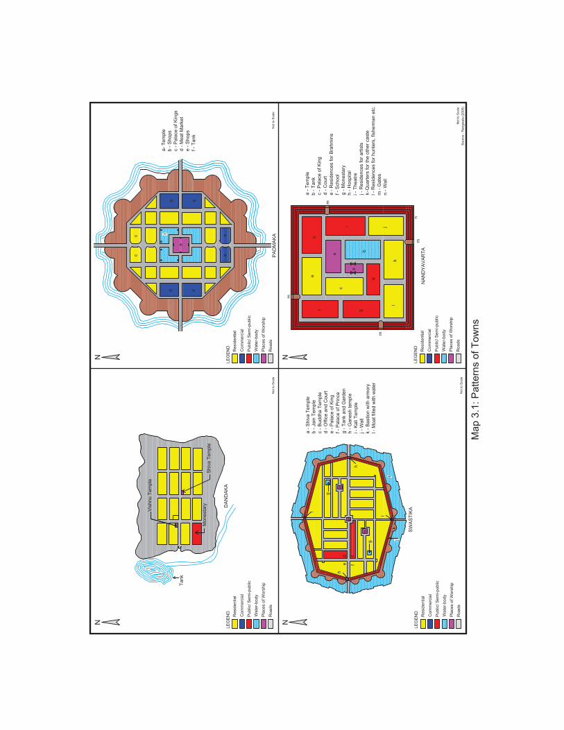
laid according to numerous patterns like Dandaka, Swastika, Padmaka, Nanyavartha,
Chatmukha, Pratara, Karmuka, Sarvothobhadra etc as shown in Map 3.1 and 3.2. Each
of these types differs from the other in their shape, method of street planning and
location of activities based on size and principal purpose of settlement. The whole area
of the city was divided into zones, based on the political and religious hierarchy, thus
determining the exact sites for the Royal Palaces, the council hall, market places, streets
and lanes, gardens, temples, wells (1: 10 houses), reservoirs and above all the blocks of
houses and wards for different communities and professions. The division of areas or
zones was based on the system of “Padavinyasa” i.e. division of town into a number of
blocks (or pada) set apart for a particular caste/ profession. But they had one thing in
common and that was considerations they displayed towards the pedestrian. A person
could conveniently transverse the whole width of the settlement.
Researchers like Kangle (1965), Rangarajan (1992) who studied and explored
Kautiliya’s ‘Arthasasthra’ in the light of town planning mentioned that it was
mandatory to have the width of main thoroughfares be adequately wide up to 4 dandas
i.e. 24 feet in width and lined with trees for aesthetic and comfort values. A number of
bye-laws and regulations regarding construction of buildings in the towns were also
highlighted in their studies. Although many of them were very conceptual giving
directions related to the planning of a town and house. Some of them worth mentioning
are given below.
1) Basic controls like minimum plot size or land required for houses and height of the
buildings were fixed based on the status of a particular class in the society i.e. low
class population had smaller plots and low height houses and high class had larger
plots and multistoried houses.

53
2) Ground coverage of plot was not supposed to be more than 50% of site with open
front yard as wide as 1/3rd
of the plot.
3) No deviation from the fixed measurements of lengths, breadths and heights of the
respective buildings of different classes of people was permitted.
4) Houses were provided with verandahs and flight of steps from the ground level lead
to the high plinth of verandahs. One ‘vedika’ (raised seat) was constructed on each
side of the door. Outside the house and touching it, a footpath (‘Vithika’) risen on
both sides of the street was provided.
5) All the houses faced the royal roads and at their rear narrow lanes for services were
provided.
6) Drains of sufficient slope and length were constructed from each house to the main
drain.
The classification of towns based on their functions and existence of distinct
areas for shrine, citadel, markets and gardens clearly indicates the concept of land use
zoning being adopted while planning of settlements even in those days. The above listed
rules shows how sensibly the ancient building controls were devised keeping in mind
the light, ventilation, massing, aesthetics as well as health and privacy of the
inhabitants. There are many examples which are still surviving based on these
principles. Ancient core of Srirangam (Tamilnadu) on Nandavartha pattern and core city
of Jaipur based on Sarvothobhadra pattern are the few worth mentioning examples.
Under the Mauryan and Gupta Dynasties between 750 BC and 700 AD, major
growth of states and kingdoms took place. The two main centers of urbanisation during
this period were Patliputra and Taxila. Patliputra, the capital of Mauryan Empire was a
garden city surrounded by parks and ponds, with wooden structures dressed in stone. It
had 570 towers, a wooden wall with 64 gates and a moat all around the city for defense.
Drainage and fire protection systems were carefully planned. Taxila was the centre of
religion, art and culture and centre of exchange between the East and West.
Architecture had both the Gandhara and Greek influences, with narrow streets laid
haphazardly in the city (Ramanathan, 2011).
Vis
hnu T
em
ple
Monesta
ryS
hiv
a T
em
ple
Tank
DA
ND
AK
A
a
c
g
h
ed
fd
gb
h
i
lk
j
SW
AS
TIK
A
a -
Shiv
a T
em
ple
b -
Jain
Tem
ple
c -
Buddha T
em
ple
d -
Off
ice a
nd C
ourt
e -
Pala
ce o
f K
ing
f -
Pala
ce o
f P
rince
g -
Tank a
nd G
ard
en
h -
Ganesh t
em
ple
i -
Kali
Tem
ple
j -
Wall
k -
Bastion w
ith a
rmory
l -
Moat
fille
d w
ith w
ate
r
i
a
db
cc
ee
db
f
PA
DM
AK
A
a-
Tem
ple
b -
Shops
c -
Pala
ce o
f K
ings
d -
Meat
Mark
et
e -
Shops
f -
Tank
a
b
c
d
a
i
he
f g
lk
j
m
n
m
m
m
NA
ND
YA
VA
RT
A
a -
Tem
ple
b -
Tank
c -
Pala
ce o
f K
ing
d -
Court
e -
Resid
ences f
or
Bra
hm
ins
f -
School
g -
Monesta
ry
h -
Hospital
i -
Theatr
e
j -
Resid
ences f
or
art
ists
k-Q
uart
ers
for
the o
ther
caste
l -
Resid
ences f
or
hunte
rs,
fisherm
an e
tc.
m -
Gate
s
n -
Wall
Map 3
.1:
Patt
ern
s o
f T
ow
ns
Not
to S
cale
Not
to S
ca
le
Not
to S
cale
Not
to S
cale
Resid
ential
Com
merc
ial
Public
/ S
em
i-public
Wate
r-body
Pla
ces o
f W
ors
hip
Roads
Resid
ential
Com
merc
ial
Public
/ S
em
i-public
Wate
r-body
Pla
ces o
f W
ors
hip
Roads
Resid
ential
Com
merc
ial
Public
/ S
em
i-public
Wate
r-body
Pla
ces o
f W
ors
hip
Roads
Resid
ential
Com
merc
ial
Public
/ S
em
i-public
Wate
r-body
Pla
ces o
f W
ors
hip
Roads
Sourc
e :
Rangw
ala
(2005)
LE
GE
ND
LE
GE
ND
LE
GE
ND
LE
GE
ND
NN N
N

a
bb
bb b
bb
b
c
c
c
c
d
CH
AT
MU
KH
A
a-
Tem
ple
b -
Blo
cks
c -
Gate
s
d -
Wall
a
b
c
d
i
j
f
eg
i i ii
ii
iii
iii
ii
iii
ii i
ii
i
hhhh
hh h h h
hhh
h hh
gg g
g gg
g
k
jj
j
f
f
a -
Tem
ple
b -
Tank
c -
Monesta
ry
d -
Colle
ge
e -
Hospital
f -
Resid
ences f
or
very
ric
h
g -
Resid
ences f
or
rich
h -
Resid
ences f
or
mid
dle
cla
ss
i -
Resid
ences f
or
poor
cla
ss
j -
Gate
s
k -
Wall
PR
AS
TA
RA
a
b
d
c
e
g
f
g
e
e
e
ee
ee
ee
ee
e
e
e
e
a -
Shiv
a T
em
ple
b -
Colle
ge
c -
Hospital
d -
Monasta
ry a
nd T
ank
e -
Bastion w
ith a
rmory
f -
Wall
g -
Moat
fille
d w
ith w
ate
r
KA
RM
UK
A
Not
to S
cale
Resid
ential
Com
merc
ial
Public
/ S
em
i-public
Wate
r-body
Pla
ces o
f W
ors
hip
Roads
Sourc
e :
Rangw
ala
(2005)
Not
to S
cale
Resid
ential
Com
merc
ial
Public
/ S
em
i-public
Wate
r-body
Pla
ces o
f W
ors
hip
Roads
Not
to S
cale
Resid
ential
Com
merc
ial
Public
/ S
em
i-public
Wate
r-body
Pla
ces o
f W
ors
hip
Roads
Map 3
.2:
Patt
ern
s o
f T
ow
ns
LE
GE
ND
LE
GE
ND
LE
GE
ND
NN
N

54
The period after the Mauryan and Gupta empires till the time of Mughals (16th
Century A.D.) was the period of successive invasions and endless strife among various
rulers. The kingdoms established by Harsha, Kanishka, Mohammed Gazni and
Mohammed Ghori were followed by a series of Muslim rulers in North India. During
these times, planning was mainly confined to the establishment of well-fortified capital
cities. These fortresses of these cities were impregnable, securing the safety of rulers
and their accumulated wealth. Each of these fortress towns had a citadel where the
well guarded residence of ruler, administrative offices, treasury and arsenal were
located. The residents lived partly inside the fortress or just outside and were protected
by the rulers. The splendor, art and culture of that period were reflected in the palaces,
temples and other public buildings (Thooyavan, 2005). The closely packed buildings
and network of narrow streets effectively provided shelter from sun and hot dust laden
winds and also acted as protection from enemy. The fort and city walls dominated the
skyline of towns as from miles away the forts and its battlements appeared on the
horizon as symbols of impregnable cities. Jaisalmer in Rajasthan and Golconda in the
Deccan are good examples of such fortress towns.
Planning Concepts in Mughal Period
The Mughal Period, starting from 16th
century and lasting over 300 years,
brought a comparatively settled period when city planning covered not only capitals but
also defense outposts, trading establishments, ports and military cantonments
(Thooyavan, 2005) Ramanathan (2011) categorized the towns of this period into four
categories i.e. Administrative (Delhi, Lahore), Religious (Varanasi, Mathura), Military/
Strategic (Attock, Asirgarh) and Trade (Patna, Ahmedabad). A separate department
existed for the construction and development work during the reign of Akbar and
Shahjahan (Rangwala, 2005). The emperor himself headed the department and it
included eminent architects, engineers and ministers as its members. It brought a new
sensibility and symmetry to planning by introducing gardens, courtyards and water
channels into the planning of public and private spaces. Subsequently, all the other
Muslim rulers also maintained a separate section and pushed ahead the process of town
planning according to their own ideas to fulfil the requirements of public spaces. While
the mughals stamped their religious and cultural identity on the built form in India, city

55
planning was mainly done in accordance with the principles of Shilpa Shastras. Security
considerations also impacted the design and construction of houses. One of the chief
features of these towns was the peculiar construction of houses which was arranged so
as to make the locality safe against internal penetration (Ramanathan, 2011).
Shahjahanabad (Delhi) built by Shahjahan in 1648 and Jaipur established by Raja Sawai
Jai Singh II in 1728 are good examples of cities developed during this period.
Planning Concept in British Period
The continuity of town planning broke with the decline of Mughal Empire in
India and the pattern of planning took an entirely different course under British colonial
rule. The implementation of European concept of planning and controls had a great
influence on town development in India (Nallathinga, 2009). Britishers during their rule
over India have estimated the need for evolving the cities to serve the economic needs
of their mother land. During the process, they had laid principles for organization of
settlements, lying of infrastructure, legislation for legal validity of planning proposals.
The system was mainly designed to serve the economic interests of the Britishers first
and the social interests of Indians later. Therefore, it had several undesirable features
associated with it. A clear division of areas was visible between Victorian grandiose of
the ‘rulers’ within the city and contrasting poor neighbourhoods resided by the ‘ruled’
i.e. the general public. (Mehrotra, et.al., 1995).
Thooyavan (2005) in his book categorized the British towns in three categories
i.e. Cantonments, Provincial capitals and Hill stations. Cantonments were established
along the main routes and at strategic places in all parts of the country. Some of the
important cantonment towns were Bangalore, Dehradun, Kasauli, Firozpur etc. These
were permanent army camps with small civil population serving them. The areas were
planned with wide roads in a grid pattern disconnected from their surroundings, with
low density housing laid out strictly according to ranks, along with parade grounds and
other facilities for the use of army personnel. The provincial capitals were
administrative and commercial centers which subsequently developed into industrial
centres such as Chennai (Madras), Mumbai (Bombay), Kolkatta (Calcutta), Allahabad,
Lahore and Nagpur. In these towns, the residential area of the Britishers were clearly

56
separated from those of the native population and areas reserved for the white
population were distinctly better with regard to the layout and amenities. Hill stations
were developed both in the North and South India (Simla, Dalhousie, Nainital,
Darjeeling, Kodaikanal etc) as places where governors of provincial capitals and other
British officials spend their summer months away from the hot plains. These
picturesque hill stations were laid out with spacious bungalows, gardens and wide roads
and avenues. The residential areas for the native population were at the lower levels
with very little amount of planning and infrastructural services.
The Britishers had been able to introduce dual character to cities, where their
residential areas were separated from those of the native population in the congested
core. In the areas developed by Britishers, streets were no longer an integrated element
of neighbourhood, but were used as the dominant elements that fragment spaces. While
traditional houses were set against the streets with an internal private courtyard and
built in close proximity to each other, the colonial houses had setbacks on all sides
leaving no room for internal courtyards. Houses for the British were far flung and built
on larger plots, lined along road networks (Ramanathan, 2011).
The first effort in the direction of urban development and planning regulations
made by the Britishers was through the appointment of Sanitary Commission in 1864
for the three provincial capitals (Madras, Bengal and Bombay). Under the Bombay
Municipal Corporation Act of 1888, building regulations were first introduced and in
1898, the first Unitary Improvement Trust (UIT) of India was established in Bombay
for planning the city (Ramanathan, 2011). The Punjab Municipalities Act 1911
provided the provisions for preparation of town planning schemes by the Urban Local
Bodies (ULB) in both private and municipal lands for providing housing with secured
sanitary conditions in Punjab region. Another town planning legislation, Bombay Town
Planning Act, 1915 enabled the preparation of land use plan within city limits.
Subsequently, the governments of princely state of Hyderabad in 1916, United
Provinces in 1919, Madras in 1920 and Punjab in 1922 have enacted town planning
legislations for their respective states, thus paving the way for introducing Town
Planning Schemes for future expansion. The main focus of these schemes was to
develop residential, commercial, industrial land uses in different areas. However, it

57
emerged later that these schemes did not ensure comprehensive development of cities as
expected (Thooyavan, 2005).
Planning Concepts in Post Independence Period
After Independence, India adopted the British Town Planning System by
adapting it as per the requirements of the Indian cities. According to TCPO (1996), the
2nd
five year Plan (1956-61) largely placed the responsibility of planning on the state
governments. It was emphasized that if planned urban development is to be undertaken,
then each state should have a phased program for the survey and preparation of Master
Plans for all important towns. It was also identified that in order to get the task of
preparation of Master Plan accomplished, town and country planning legislation and
necessary mechanism for its implementation need to be enacted in all states. Since most
of the Town Improvement Acts in various states did not had provisions for preparation
of master plans, therefore a need was felt to have a comprehensive Town and Country
Planning Act on the lines of the British Town and Country Planning Act 1947. As a
result, a Model Town and Regional Planning and Development Act in 1960 was
formulated by TCPO to deal with the subject of planning (regional, urban and rural) and
development policies. The major provisions of the Model Act include provisions for
preparation of comprehensive Master Plan for urban areas; constitution of board by the
local planning authorities in state to advise and coordinate in the matter of planning and
provisions for implementation and enforcement of Master Plans in the state. However
momentum to prepare Master Plans was generated during the 3rd
five year plan (1961-
1966) when central government provided 100% financial assistance to state
governments to set up town planning departments. This was done for the preparation of
Master Plan for all cities and towns under the legislative framework based on the Model
Law formulated by the TCPO in 1960 (TCPO, 1996). Presently, most of the states have
their own legislations based on this model such as State Town and Country Planning
Acts, Urban/ Metropolitan Development Authorities Acts besides the Municipal Acts
which enable preparation of Master Plans/ Development Plans, Regional Plans, Zonal
Plans, Town Planning Schemes, Urban Development Projects, implementation of
Central and State sponsored schemes, framing of rules and regulations by state
governments and local bodies with necessary variations to suit their local, regional and

58
state practices. These acts have mandated the preparation of Master Plans for the
proposed development of cities for the next 20-25 years and undertaking development
in the areas that have been declared as development areas.
Master Plan involves estimation of future population, social economic
conditions and infrastructural needs along with land use plan (present and proposed)
and development control restrictions for ensuring that the necessary facilities are in
place when the development takes place. Master plan is a statutory document that is
approved, enforced and implemented for controlling, directing and promoting sound
and rational development or redevelopment of an urban area with a view to achieving
maximum economic, social and aesthetic benefits (Nallathinga, 2006). The scope of
master plan as defined by TCPO (1996) is confined to broad proposals and allocation of
land for various purposes such as residential, industrial, commercial, recreational,
public and semi public for guiding and regulating development in urbanisable area over
a period of time. Dis-aggregation of Master Plan proposals is done through zonal
development plans and in-built development controls. Zoning and Sub division
regulations are a part of Development Control Regulations (DCR) under Master Plan.
They stipulate the densities of the development in various pockets of urbanisable land
through Floor Area Ratio (FAR) or Floor Space Index (FSI), maximum ground
coverage, maximum height permissible etc. Building Byelaws is a separate document
governed by the regulations given in Master Plan that guides and controls the setting,
design and construction of the buildings with due recognition for ventilation, light and
built envelope requirements from health and sanitation perspectives.
As per Census of India 2011, the total number of towns and cities are 7935, out
of which 4041 are statutory towns. TCPO (2011) reports that the number of approved
master plans available in the country is 1233 and about 657 master plans are under
various stages of preparation. This means that although the concept of Master Plan is in
practise for the last five decades, only 24% of cities and towns have master plan and
more than ¾ of the urban settlements are growing without any spatial plan and planned
interventions. It is important to note that only 47% of statutory towns have approved
Master Plans, based on the assumption that the 657 Master plans under preparation get

59
approved shortly (Kshirsagar, et al., 2012). But the extent to which these plans have
influenced in shaping urban form and structure of our towns is a matter of debate.
According to Philip (2007), inspite of the fact that Master Plans and Detailed
Zonal plans have been notified for urban areas, cities are characterized by chaos,
congestion, narrow roads, dilapidated buildings and lack of parking spaces. It is to be
noted here that the development authorities and municipalities are not the only agencies
working for planning and development of urban areas. For providing the much needed
infrastructure, different nodal service providing agencies like Water Supply and
Sanitary Boards, Housing Boards, Slum Clearance Boards, Industrial Area
Development Boards, Electricity Board co-exist. A coordinated and structured
collaboration with these agencies is essential. Lack of coordination among these
agencies is responsible for violations of development controls, thus putting impact on
housing and traffic which further leads to unauthorized developments and congestion
(Swamy, et al., 2008).
It is evident from the review of the urban development and planning regulations
and experiences that over the past decades, the conventional forms of urban
development and planning regulations have failed to provide orderly and sustainable
urban development (Sengupta, et al., 2012). Despite the various planning legislations
that have been put in place, urban development has been haphazard and disjointed. As a
result, violation of development controls, squatter settlements and informal sectoral
activity have continued to mushroom due to inadequate and incompetent development
control mechanisms.
As identified by Government of India (1996), inspite of deficiencies in the
Master Plan approach listed below, there is no alternative to land use plan.
Rigid, static and regulatory nature of plans
Long term plan period - projections for longer duration (20-25years)
Long time taken for plan preparation
Weak Database and non- availability of Base Maps
High norms and standards

60
Time consuming process
Lack of co-ordination among service providing agencies
Ineffective Public Participation
Lack of monitoring mechanism
Rigid process of modification/ removal
Lopsided plan implementation
Mismatch of growth projections and sectoral needs
Neglect of development of urban fringe
Lack of cooperation and coordination among implementing agencies
Apart from the short coming listed above, research over the one and half decade
(Jain, 1997; Jain, 2010; Philip, 2007) indicates that Development Controls that forms a
part of Master Plan are restrictive in nature and do not take considerations of prevailing
socio economic realities of people. These are too static, inflexible and hardly
accommodate the urban poor or adapt itself to increasing pressure on land, soaring land
value and advancing technology. Development Controls are also viewed as an
unnecessary interference in private property rights as it interferes with the individual
freedom to build according to their choice. Rigid rules coupled with laxity in
enforcement create havoc in the system. In addition, where regulations have been
enforced, they are seen as distortions into land and housing markets, which result in
higher costs. It has been argued that traditional land use planning has justifiably been
discredited and must take a share of the blame for illegal developments and inadequate
service provisions.
Risbud (2011) while conducting state level case studies for cost reduction by
regulations and guidelines in India highlighted that many regulations in India are old
and framed without any affordability considerations. Almost 95% of the regulations are
focused on new greenfield developments rather than redevelopment. It has been
highlighted that the enforcement of regulations has been weak and eroded by massive
growth of illegal land subdivisions in all cities which resulted in high standards for

61
minimum plot sizes. In the context of high land prices, housing became unaffordable for
middle and low income groups and resulted in unauthorised colonisation and illegal
commercialisation. This is accompanied by state’s policy of regularizing illegal and
unauthorised development either through Act or through administrative policy thus
making the planning exercise whole planning exercise irrelevant and futile.
Bertaud (2002) explained that the combined effect of multiple layers of poorly
conceived regulations has contributed to an artificial urban land shortage. In addition,
some regulations have negative impact on the spatial structure of cities. By
unreasonably reducing the amount of floor space i.e. prescribing the low FAR that can
be built in centrally located areas and by making land recycling difficult, some
regulations tend to push urban development toward the periphery. As a result,
commuting trips becomes longer, operation of public transport becomes difficult and
urban infrastructure needs to be extended further.
As evident from the studies of Risbud, 2011; Sridhar, 2007, the Floor Area
Ratio (FAR) values in India are very low as compared to major cities around the world.
Typically, even in centrally located areas FAR in India are seldom above 2.0 compared
to values ranging from 5 to 15 in the CBD of other cities of Asia. This tends to increase
the consumption of land as more land is required to build the given area of floor space.
This affects low and middle income households more than others and in the non
residential sectors contributes to a loss of productivity. According to the TCPO (1999),
in Indian cities the FAR determines the total built up space that a plot is allowed to
hold, subject to the land availability and requirements, household densities and dwelling
sizes and availability of parking. In most large cities of the world, as technology and
infrastructure improves, the FAR in the city tends to increase. One could argue that
existing infrastructure in developing countries is insufficient and so higher densities
(presumably brought about by higher FAR) cannot be absorbed, which appears to be the
basis of TCPO’s stated guidelines. But it is to be noted that whether density would
increase or decrease following an increase in FAR depends on the FAR-elasticity of
demand for built area. If there is a more than proportionate increase in built area in
response to an increase in the FAR, then population and/ or employment density
increases. The infrastructure will then have to be redesigned and rebuilt in the areas

62
where a large FAR increase is projected. Bertaud (2002) explained that the progressive
increase in FAR serves two purpose, firstly it allows households and firms to consume
more floor space as their incomes increase without moving to new areas or in the
suburbs and secondly increase in FAR contributes to decrease in the city spatial
expansion (suburbanisation) and commuting costs. The same views has been expressed
by Sridhar (2007) in reference to land use regulations that population gets attracted to
the areas where relaxation of FAR norms exists. This means that in order to make better
use of existing infrastructure (water supply, sewerage, roads etc.) in Indian cities, state
and local governments must consider increasing the FAR with time so that more floor
space can be accommodated in the already developed or newly developed areas. This
way excessive city growth and urban sprawl can be contained, commuting can be
reduced and housing along with other facilities can be made more affordable.
In addition, the general principles that justify specific value for the FAR at
specific locations should be revised. For this guidelines shall be provided to urban
planners to help them regulate FAR in a manner that is consistent with an efficient and
market driven urban spatial structure. As suggested by Bansal (2012) especially with
reference to Indian cities, the concept of additional FAR Factor shall be based on
‘creativity’ and ‘context’. In such cases, the creativity is defined as design parameters
including urban form, parking provision, pedestrian safety and impact of design on
services and environment. The context is defined as local attributes like location with
respect to land use as given in Master Plan, accessibility, level of congestion on the
approach road etc. Normally maximum permissible FARs (with additional 5% as
compoundable) are specified for various use premises in the Master Plan which is
generally revised upwards over a period of time as part of extensive modification to the
Master Plan. The same can also be applied to land subdivision regulations where the
quantitative parameters like minimum plot size, streets right of ways etc should be
carefully audited, taking into account their impact on development costs, land
affordability and environment.
In India, Building Byelaws provide a uniform building code for construction of
buildings by getting the legal support under the respective Municipalities Act or
Authority Act as the case may be. Building code is a document containing standardized

63
requirements for the design & construction of almost all type of buildings, with an
objective to protect the health, safety & welfare of the occupant. Building byelaws
expresses all aspects of construction including structural integrity, fire resistance, safe
exits, lighting, electrical, energy conservation, plumbing, sanitary facilities, ventilation,
seismic design and correct use of construction materials. They also provide broad
planning norms such as size of rooms, building height, setbacks, coverage, floor area
ratio for different sizes of plots in different use zones, the requirement of light and
ventilation, thickness of walls, floor, provisions regarding stairways, passages, lifts,
elevators, etc for various types of buildings. Currently Building Bye-Laws are based on
the National Building Code which was first published in 1997 and revised in 2005 (Das,
2007).
Government of India (2011) under JNNURM Rapid Training Programme
highlighted that although modern building bye laws are framed to ensure greater
compliance with the planning/ zoning and structural requirements, there are several
pitfalls associated with their design, practice and implementation at local level. Such
pitfalls like rapidly changing technology, excessive control and rigid specifications;
ambiguity and discretion; coordination hurdles; lack of transparency; corruption which
in turn have led to the creation of an inefficient system.
While examining the degree of compliance with the required regulations, the
extent to which people are aware of the existence of these regulations is important
because it partly determines the extent to which people will comply with these
regulations. The lack of awareness is one of the main causes of building violations as
people carry out the construction without being aware that their activity would result in
violation of building bye-laws. Public participation in plan preparation process is
emphasized time and again by researchers over the years (Boake, 2006; Chotani, 2012;
Dewal, 2006; Jain, 1997; Jain, 2010; Nallathiga, 2009; Rakodi, 2001; Thomas, 2001)
in a way that it should not be confined only to inviting the public objections and
suggestions after Draft Plan Preparation. In fact, the requirement of greater public
participation/ stakeholder consultation at every level and stage of the urban planning
process starting from notification of the intention of plan preparation to plan
implementation, enforcement and review has been highlighted. Such practices are being

64
followed in Singapore and Malaysia as they are helpful in preparing the plan as people’s
product (World Bank, 1989).
A number of factors that contribute to non−compliance of the development
control regulations in India as enlisted by researchers in their studies (Chandira, 2007;
Gupta, 1992; Gupta, 2002; Jain, 1997; Jain, 2002; Poulose, 2007) are as follows–
Failure of planning process to take account of ground realities and reset the
planning guidelines, thus resulting in supply side shortages in terms of
legitimate spaces for various land uses.
Weak enforcement machinery is responsible for the non-implementation of
building laws and regulations. Implementation of development policies has been
characterised by delays and poor execution of projects and programmes by
nodal service providing agencies, lack of institutional and inter-sectoral
coordination framework for development planning and the inadequate
participation by the beneficiary population.
Unrealistic and cumbersome regulations including complex development control
norms and building byelaws along with long drawn approval.
Absence of proper standing of institutional mechanism for seeking justifiable
modifications/ relaxations vis-a-viz the existing building code and land use
regulations. In recent years, there has been considerable debate and criticism
levelled at the management of local government and legal system as it does not
provide for quick and apt resolutions of building violation issues, which result in
delays and misuse of the system.
There are ways as suggested by Farvacque, et al., 1992; Jain, 2010; Rakodi,
2001 that can improve the enforcement of development regulations and are listed
below:
Simplification of development control requirements by simplifying procedures
and introducing appropriate policies/ zoning regulations while safeguarding the
health and environment and not damaging the economic base of the activities
concerned.

65
Revisiting the principles on which development control is based. As in case of
zoning systems, certainty for developers is achieved at the cost of inflexibility
for unforeseen demands and needs; while in discretionary systems flexibility to
accommodate rapid and unforeseen changes comes at the cost of uncertainty and
greater opportunities for corruption. It has been recommended that a system
needs to be evolved to achieve a workable compromise between these
principles.
Strengthening the enforcement capacity to monitor and take action on illegal
developments and violations of development controls. In order to improve the
efficiency and effectiveness of development controls, it is important that rather
than devoting resources to improving the quality of urban spatial plans and
development regulations, urban managers should concentrate on governance. It
is necessary to make the whole system of plan formulation and implementation
more dynamic and responsive to changes. For this, the planning legislation will
have to be modified, updated and made more citizens friendly.
Conclusion
Urban planning does not end with the preparation of a Master Plan. It is a
continuous process and not an event of making a plan and getting it sanctioned and
implementing it with in a time frame. There is a fundamental difference between the
developed and developing countries regarding the potential effectiveness of the whole
Master Plan approach, as a primary step towards urban improvement. In most of the
developed cities, a set of basic assumptions – the social and civic standards are usually
quite well understood and therefore widely accepted. It is implicit in their master plans
that certain minimum physical standards of housing and services which are both
desirable and feasible. The growth trends could readily be projected and the established
economic base of the city continues to provide increased employment and adequate tax
resources, with little public intervention beyond zoning and services. Whereas in
developing countries, the fundamental economic, social and demographic assumptions
are hardly beginning to be clarified, in terms of viable urban standards. The answers to
questions like what would be the affordable overhead investment per capita, how to

66
spend that amount to provide reasonable urban living conditions, what should be the
urban pattern from social conditions viewpoint etc, are still not being made available to
the planning team at the time of preparation of Master Plan.
In India, where planning is completely a government responsibility, a school of
thought have emerged that the government or the planners should only be responsible
for the maintenance of public spaces and should not interfere in the functioning of
private residential areas or even privately owned commercial spaces. The residents of
an area understand their needs and should be left free to decide their plans of
construction and management and disposal of their properties. It is the market forces of
demand and supply that should be allowed to determine what is the most appropriate
use of land.
In a rapidly evolving urban environment, it is very difficult to maintain the
master plan and in-built development controls in the best of times. Therefore a research
is going on to have a flexible system and stress on comprehensive development plans
for sustainable development. Master Plan as a tool for urban development planning
cannot be done away with; rather the need is to make it more dynamic, realistic and
effective. This is possible only with greater involvement of people and improvement in
urban governance. The studies over the years have analyzed the impact of land use
regulations recommended that the needs and conditions of development in developing
countries require a more flexible set of standards than what has been introduced based
on European experience. These standards must consider the rapid changes in the urban
fabric, relate more to local conditions and be easier to implement. It is important to
identify simple design paradigms that encapsulate the overall strategy and implement
them through strategic interventions that have multiplier effects. In the end it is
important to note that with all this discussion, all the three research hypotheses framed
during the initial stage of the study has been strengthened i.e. Development controls are
important and necessary so as to promote public health, safety, moral and social welfare
of the community by securing the right use of land and buildings in a regulated way;
weak enforcement mechanisms leading to increasing violations and limited need based
flexibility in development controls is important. The chapter has been able to provide

67
the necessary direction and has laid the path for better understanding of the situation for
discussing the development controls with respect to Delhi in the following chapter.
References
Bertaud, A. (2002). The economic Impact of land and urban planning regulations in
India. Unpublished memorandum. <http://ebookbrowse.com/the-economic-
impact-of-land-and-urban-planning-regulations-in-india-doc-d71313215>.
Accessed on 2010 August, 10.
Baoke, T.M. (2006). Regulatory Determinants: The Impact of Development of
Planning and Zoning. <http://www.architecture.uwaterloo.ca/ faculty_projects
/terri/ images/ course_pdf/172-ch2.pdf>. Accessed on 2010 March, 8.
Census of India. (2011). Provisional Population Totals - 2011. Government of India,
New Delhi.
Chandira, S.M. (2007). Development Control Rules and Byelaws in Tamil Nadu.
Journal of Institute of Town Planners of India (ITPI). 4(1): 37-43.
Chotani, M.L. (2012). Urban Development Planning Regulatory Framework: A
perspective, Proceedings of 60th
National Town & Country Planners Congress.
Institute of Town Planners of India (ITPI). New Delhi: 141-149.
Das, A. K. (2007). Urban Planning in India. pp 106-119. Rawat Publications, Jaipur.
Dewal, S. (2006). Master Plan for Delhi: 2021 - A Critical Analysis. CCS Working
Paper no. 160. Summer Research Internship Programme. Centre for Civil
Society. New Delhi: 1-40.
Farvacque, C. and McAuslan, P. (1992). Reforming urban land policies and institutions
in developing countries. Urban Management Programme Policy Paper 5. World
Bank. Washington, DC.
Government of India. (1996). Urban Development Plan Formulation and
Implementation Guidelines (UDPFI Guidelines), Ministry of Urban Affairs and
Employment, New Delhi.

68
Government of India. (2011). Revision of building byelaws to streamline the approval
process – Optional reforms. JNNURM Rapid Training Programme. Ministry of
Urban Development. <http://jnnurm.nic.in/about-rtp.html>. Accessed on visited
on 2012 April, 12.
Gupta, S.C. (1992). Unauthorized Development in Delhi: Zoning regulations and
Building Byelaws violations. Journal of Institute of Town Planners of India
(ITPI). New Delhi. 10(4): 71-75.
Gupta, J.K. (2002). Issues related to Plan Enforcement. Spatio Economic Development
Record. 9(2): 21-24.
Jain, A.K. (1997). A new approach to building byelaws to facilitate development, Case
Study – Delhi. Spatio Economic Development Record. 4(3): 41-48.
Jain, A.K. (2010). Innovative Concepts of Planning Building and Development
Controls, <http://www.ashahabitat.com/knowledgebase/pdf/ planning4.pdf>.
Accessed on 2009 August, 30.
Jain, R.K. (2002). Massive Urbanisation and Urban Governance. Spatio-Economic
Development Record. 9(2): 25-27Jain, 2002;
Kangle, R.P. (1965). The Kautilya Arthashastra, Part III. M.B. Publishers, Delhi.
Kshirsagar, J.B. and Srinivas, R. (2012). Planning and Development 2025: Professional
and Academic Challenges. Proceedings of 60th
National Town and Country
Planning Congress. Institute of Town Planners of India (ITPI). New Delhi: 8-20.
Mehrotra, R. and Dwivedi, S. (1995). Bombay: The Cities Within. Oxford University
Press, New Delhi.
Nallathinga, R. (2006). Development Planning or Development Control – The changing
focus of Master Plan of Mumbai. Journal of Institute of Town Planners of India
(ITPI). 3(4): 28-35.
Nallathiga, R. (2009). From Master Plan to Vision Plan: The changing role of Plans and
Plan Making in City Development (With Reference to Mumbai). Theoretical
and Empirical Researches in Urban Management. 4(13): 141-157.

69
Philip, E. (2007). Urban Planning and Development Control Regulations: Case Study –
Kerela. Journal of Institute of Town Planners of India (ITPI). 4(1): 13-16
Poulose, T.K. (2007). Inadequacies and Infirmities in Development Control
Regulations. Proceeding of 55th
National Town and Country Planning Congress.
Institute of Town Planners of India (ITPI). New Delhi: 150-156
Rakodi, C. (2001). Forget planning, put politics first? Priorities for urban management
in developing countries. International Journal of Applied Earth Observation and
Geoinformation (JAG). 3(3): 209-223.
Ramanathan, S. (2011). Shaping Vibrant Cities. Business Standard India. 155-179.
Rangarajan, L.N. (1992). Kautilya, The Arthashastra. Penguin Classics, New Delhi
Rangwala, S.C. (2005). Town Planning, 19th
edition. Charotar Publishing House,
Anand
Risbud, N. (2011). State level case studies, Cost reduction by regulation and guidelines.
Paper presented at National Workshop on Town Planning Parameters for
Housing the Urban Poor. Ministry of Housing & Urban Poverty Alleviation.
School of Planning & Architecture, New Delhi
Sengupta, B.K. and Banerji, H. (2012). Issue for Future Urban Development and
Reform Agenda in Planning and Regulatory Framework. Proceedings of 60th
National Town and Country Planning Congress. Institute of Town Planners of
India (ITPI). New Delhi: 150-158
Sridhar, K.S. (2007). Impact of land use regulations on Suburbanisation: Evidence from
Indian Cities. Working Paper 185. Institute for Social and Economic Change,
Bangalore. <www.isec.ac.in/WP%20-%20185.pdf>. Accessed on 2009 October,
26.
Swamy, M.C.K., Bhaskara, R.B. and Hegde, V.M. (2008). Urban Planning and
Development at crossroads – Crisis in Urban Development and Governance.
Seminar Theme Paper. Books for Change Publisher, Bangalore. 1-80.

70
Town and Country Planning Organisation (TCPO). (1996) Master Plan Approach in
India and Other Countries. Government of India. pp 23-56. New Delhi.
Town and Country Planning Organisation (TCPO). (1999). A study of Planning Norms,
Building Byelaws, Tariff Structure, Land Assembly and Resource Mobilization
(of Nine Metropolitan Cities). Ministry of Urban Development and Poverty
Alleviation. Government of India. New Delhi.
Town and Country Planning Organisation (TCPO). (2011). Status of Town and Country
Planning Department and Acts in different States and UTs in India as on 2011.
Spatio-Economic Development Record. 18(5): 138-139.
Thomas, D. (2001). The Importance of Development Plans/ Land Use Policy for
Development Control, Prepared for the USAID/OAS Post-Georges Disaster
Mitigation Project, Workshop for Building Inspectors. <http://www.oas.org/
pgdm/document/BITC/papers/dthomas.htm>. Accessed on 2009 October, 26.
Thooyavan, K. R. (2005). Human Settlements: A Planning Guide to Beginners. MA
Publications, Chennai.
World Bank. (1989). Malaysia - The housing Sector: Getting the Incentives Right.
World Bank, Washington, DC. Available online at <http://documents.
worldbank.org/curated/en/1989/04/738854/malaysia-housing-sector-getting-
incentives-right>. Accessed 2010 August, 20.