planning for suds - making it happen...case study 4.1 celeste morgan, aecom figures 4.11 and 4.12...
TRANSCRIPT

Planning for SuDS –making it happen
Stephen Dickie MWH
Gaye McKay MWH
Lindsey Ions Environment Agency
Paul Shaffer CIRIA
CIRIA C687
London, 2010

ii
Planning for SuDS – making it happen
Dickie, S, McKay, G, Ions, L, Shaffer, P
CIRIA C687 RP784
© CIRIA 2010 ISBN: 978-0-86017-687-9
British Library Cataloguing in Publication Data
A catalogue record is available for this book from the British Library
Published by:
CIRIA
Classic House, 174–180 Old Street, London, EC1V 9BP
CIRIA C687
Keywords
Sustainable water management, flood risk management and surface water drainage, regeneration and contaminatedland, sustainability and the built environment
Reader interest
Spatial planners, urban designers, landscape architects,drainage engineers, highway engineers, developers,sewerage undertakers, contractors and otherorganisations involved in the provision
Classification
AVAILABILITY Unrestricted
CONTENT Technical guidance
STATUS Committee-guided
USER Spatial planers, urban designers,engineers, regulators
This publication is designed to provide accurate and authoritative information on the subject matter covered. It is sold and/or distributed with theunderstanding that neither the authors nor the publisher is thereby engaged in rendering a specific legal or any other professional service. Whileevery effort has been made to ensure the accuracy and completeness of the publication, no warranty or fitness is provided or implied, and theauthors and publisher shall have neither liability nor responsibility to any person or entity with respect to any loss or damage arising from its use.
All rights reserved. No part of this publication may be reproduced or transmitted in any form or by any means, including photocopying andrecording, without the written permission of the copyright-holder, application for which should be addressed to the publisher. Such writtenpermission must also be obtained before any part of this publication is stored in a retrieval system of any nature.
If you would like to reproduce any of the figures, text or technical information from this or any other CIRIA publication for use in other documents orpublications, please contact the Publishing Department for more details on copyright terms and charges at: [email protected] or tel: 020 7549 3300.
For further information about CIRIA publications go to: <www.ciria.org>

iii
Acknowledgements
Research contractor
This publication is the outcome of CIRIA Research Project784. The publication was prepared by MWH with supportfrom CIRIA.
Authors
Stephen Dickie BEng, MSc, IEng, AMICE
Steve is a principal environmental engineer at MWH. Hehas more than 25 years experience in drainage design andover 10 years in SuDS design, surface water management,flood risk management and flood mitigation. Hisexperience has been gained in local government andconsultancy.
Gaye McKay MA (Hons), MSc, MCIWEM
Gaye is a senior environmental scientist at MWH. Sheformerly worked for the Environment Agency indevelopment control and the Scottish EnvironmentProtection Agency where she was the co-ordinator of theSuDS monitoring project in Scotland.
Lindsey Ions BSc, MSc
Lindsey is a principal flood risk officer at the EnvironmentAgency, working in the Thames Gateway and Olympicssustainable development team. She has over six yearsexperience in surface water drainage, flood riskmanagement and flood risk policy, with experience ofworking in both the private and public sector.
Paul Shaffer BSc
Paul is an associate at CIRIA and for nearly 15 years hasencouraged the sustainable use and management ofwater. He has been responsible for several projects andinitiatives to help overcome barriers to sustainabledrainage.
Steering group
Following CIRIA’s usual practice, the research project wasguided by a steering group consisting:
Chair
Martin Osborne Mouchel
Members
John Blanksby University of Sheffield
Martin Bolton SEEDA
Simon Boots Campbell Reith
Bob Bray Robert Bray Associates
Meyrick Brentnall Gloucestershire Council
Phil Chatfield Environment Agency
Ray Farrow Home Builders Federation
George Fordyce NHBC
Phil Gelder Severn Trent Water
Chris Glass Banks Developments
George Gray Wavin
Celeste Guisti Camden Council
Jonathan Hunter Environment Agency
David Hutchinson Greater London Authority
Jessica Johns Micro Drainage
Chris Mead WSP
Celeste Morgan Aecom
Owen Peat Homes and Communities Agency
Jonathan Reed Peter Brett Associates
Dave Schofield Arup
Alex Stephenson Hydro International
Laurence Tricker Kent Thameside
Mark Welsh Lincolnshire County Council
Corresponding members
Steve Ball Homes and Communities Agency
Robert Barker BACA Architects
Dennis Cooper Ipswich Council
Elliot Gill Halcrow
Alex House TCPA
Richard Kellagher HR Wallingford
Roger Nowell Sheffield City Council
Mark Trajan Swindon Borough Council
Mark Vigor Cambridge County Council
Mike Vout Borough of Telford and Wrekin
Planning for SuDS – making it happen

iv
CIRIA managers
The project was managed by Paul Shaffer and RobinFarrington with support from Louise Clarke.
Project funders
Campbell Reith
Environment Agency
Greater London Authority
Hepworth Drainage
Homes and Communities Agency
Hydro International
Micro Drainage
NHBC
SEEDA
Wavin
WSP
Contributors
CIRIA wishes to acknowledge the following individual whoprovided substantial additional information and input:
Bob Bray Robert Bray Associates
Celeste Morgan Aecom
Mike Vout Borough of Telford and Wrekin
Martin Osborne Mouchel
Illustrations
The illustrations were developed by Ailsa Gunson, CelesteMorgan and Kelly Guest from Aecom.
CIRIA C687
Figure 1.4 Simon Bunn, Cambridge City CouncilFigure 1.6 Environmental Services, City of Portland,
OregonCase Study 1.2 Bob Bray, Robert Bray AssociatesFigure 1.7 Paul Hargreaves, HalcrowChapter 2 cover Celeste Morgan, Aecom(green roof and swales)Chapter 4 cover Dusty Gedge, Livingroofs.orgFigure 4.1 Celeste Morgan, AecomFigure 4.2 Graham FairhurstFigure 4.4 Celeste Morgan, AecomFigure 4.9 Celeste Morgan, AecomCase Study 4.1 Celeste Morgan, AecomFigures 4.11 and 4.12 Bob Bray, Robert Bray AssociatesCase Study 4.3 Bristol City Council & SUSTRANSChapter cover 5 Mathew Frith, London Wildlife TrustCase Study 5.1 Lambeth CouncilCase Study 6.1 Alex Stephenson, Hydro InternationalCase Study 6.2 Bob Bray, Robert Bray AssociatesChapter cover 7 Graham FairhurstFigure 7.1 Roger Nowell, Sheffield City Council

ContentsAcknowledgements ...........................................................................................................................................................................iii
List of figures ........................................................................................................................................................................................vi
List of tables.........................................................................................................................................................................................vi
List iof case studies ............................................................................................................................................................................vii
Introduction .........................................................................................................................................................................................1
1 Why sustainable drainage systems?...................................................................................................................................3
2 What are sustainable drainage systems ..........................................................................................................................21
3 How to work with the planning and development process......................................................................................33
4 How to make sustainable drainage happen..................................................................................................................47
5 How to specify sustainable drainage .............................................................................................................................69
6 What SuDS maintenance is required...............................................................................................................................79
7 Frequently asked questions..............................................................................................................................................87
8 Glossary...............................................................................................................................................................................95
9 Abbreviations...................................................................................................................................................................101
List of figuresFigure 1.1 Effects of urbanisation on the water cycle ................................................................................................................................................6
Figure 1.2 Benefits of using SuDS...................................................................................................................................................................................7
Figure 1.3 Runoff flowing into a swale as part of public open space, Ipswich, England.....................................................................................8
Figure 1.4 Wildlife benefit of SuDS................................................................................................................................................................................9
Figure 1.5 Stormwater wetland area, Malmo, Sweden .............................................................................................................................................9
Figure 1.6 Rain garden constructed on a school playground, Portland, USA......................................................................................................10
Figure 1.7 Camborne Pool and Redruth SWMP and drainage implementation strategy .....................................................................................13
Figure 1.8 The SuDS triangle.........................................................................................................................................................................................14
Figure 1.9 Integration into a development.................................................................................................................................................................16
Figure 2.1 SuDS scheme providing amenity and biodiversity.................................................................................................................................23
Figure 2.2 Wetlands providing habitat, biodiversity and green corridors, Elvetham Heath, England................................................................24
Figure 2.3 Wetland managing pollution by controlling discharge into the watercourse.....................................................................................24
Figure 2.4 Regional pond providing biodiversity, Elvetham Heath, England.........................................................................................................24
Figure 2.5 Source control: rain garden and green roof, Malmo, Sweden............................................................................................................25
Figure 2.6 Play areas incorporating attenuation, Malmo, Sweden..........................................................................................................................26
Figure 2.7 The SuDS management train ......................................................................................................................................................................30
Figure 3.1 Detention basin integrated into roundabout, Leicester, England.........................................................................................................35
Figure 3.2 Wetland, Caw Burn, Scotland....................................................................................................................................................................37
Figure 3.3 SuDS and the planning process................................................................................................................................................................38
Figure 3.4 The flood risk management hierarchy ......................................................................................................................................................41
Figure 4.1 Swale in development, Upton, England..................................................................................................................................................49
Figure 4.2 Detention basin integrated in public open space, Ipswich, England .................................................................................................51
Figure 4.3 The masterplanning process......................................................................................................................................................................52
Figure 4.4 SuDS component combined with street furniture, San Francisco, America ......................................................................................55
Figure 4.5 Linear wetland, Edinburgh, Scotland........................................................................................................................................................55
Figure 4.6 SuDS in a high density development setting...........................................................................................................................................57
Figure 4.7 SuDS in a medium density development setting....................................................................................................................................58
v
Planning for SuDS – making it happen

Figure 4.8 SuDS in a low density development setting ...........................................................................................................................................59
Figure 4.9 Swale in Upton, England ............................................................................................................................................................................60
Figure 4.10 Conveyance feature within a housing development, Gloucestershire, England ...............................................................................62
Figure 4.11 SuDS in a high density development, Stamford, England.....................................................................................................................63
Figure 4.12 Securing SuDS at a strategic level .............................................................................................................................................................65
Figure 4.13 Securing SuDS at a site specific level .......................................................................................................................................................66
Figure 7.1 A canal in a high density housing development, Stamford, England ..................................................................................................90
Figure 7.2 SuDS interpretation board, Cambridgeshire, England ...........................................................................................................................92
Figure 7.3 SuDS rill at a school, Exeter, England........................................................................................................................................................92
Figure7.4 The Dings before and after, Bristol, England............................................................................................................................................93
Figure 7.5 Retrofitting SuDS, Malmo, Sweden ...........................................................................................................................................................93
List of tables
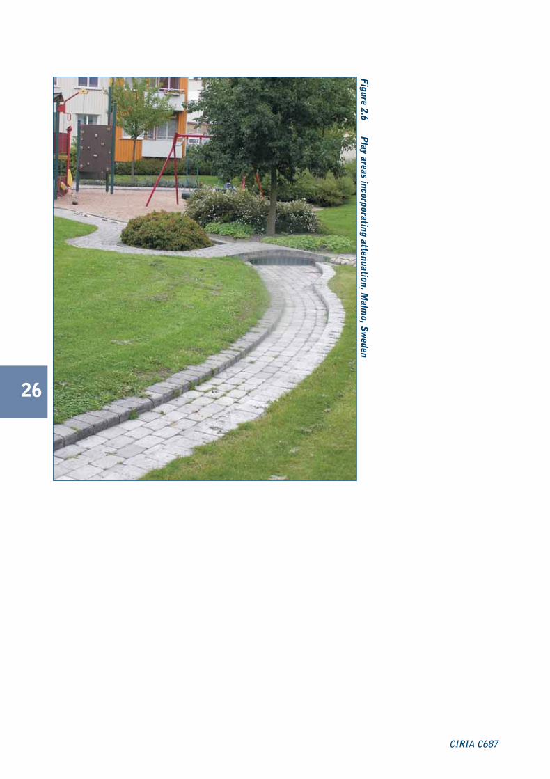
Table 2.1 SuDS components ......................................................................................................................................................................................27
Table 2.2 SuDS treatment requirements....................................................................................................................................................................32
Table 3.1 Planning policy statements in England......................................................................................................................................................36
Table 3.2 Planning policy statements in Wales..........................................................................................................................................................37
Table 3.3 Stakeholders involved in the planning process ......................................................................................................................................43
Table 4.1 Main SuDS components to consider for different development settings..........................................................................................56
Table 5.1 Design criteria for sustainable drainage....................................................................................................................................................71
Table 5.2 Stages in the design process ....................................................................................................................................................................74
Table 6.1 Typical inspection and maintenance activities ........................................................................................................................................82
List of case studiesvi
CIRIA C687
What is specifically demonstrated in the case study?
Cas
e st
udy
ref
Pag
e re
f
Location Development
Del
iver
y of
SuD
Sm
anag
emen
t tr
ain
Man
agin
g lo
cal f
lood
ing
Wat
er q
ualit
y be
nefi
t
Bio
dive
rsit
y an
d ha
bita
tbe
nefi
t
Com
mun
ity
invo
lvem
ent
Edu
cati
onal
ben
efit
s
Mul
tifu
ncti
onal
ben
efit
s
Ado
ptio
n an
d m
aint
enan
ceis
sues
res
olve
d
Ear
ly a
nd e
ffec
tive
stak
ehol
der
enga
gem
ent
Ada
ptab
ility
and
retr
ofit
ting
SuD
S
Symbols identifying specific benefits:
1.1 7 North Hamilton, Leicester Residential � � � � �
1.2 11 Exwick Heights, Exeter School � � � �
1.3 12 Elvetham Heath, Hampshire Residential � � �
2.1 31 Hopwood M42 MSA, Oxford Commercial � �
4.1 61 Upton, Northamptonshire Residential � � � � �
4.2 64 Waterlooville, Hampshire Mixed � � �
4.3 67 The Dings, Bristol Residential � � �
5.1 76 Elthelred, Lambeth Residential � � � �
6.1 83 Eden Park, Littlehampton Residential � � �
6.2 84 Springhill, Stroud Residential � � � � � �
C687 Prelims:C687 Prelims 23/11/2010 15:39 Page vi

1
Planning for SuDS – making it happen
Introduction
What is the guidanceabout?Water is an essential part of our natural and builtenvironment. The way we live, work and play to varyingdegrees are influenced by the availability and quality ofwater.
Increasingly we need to embrace water management asan opportunity, rather than a challenge. Successfullydelivered sustainable drainage provides communities andwider society with benefits set within the context ofadapting to climate change, development and improvingour natural environment.
Sustainable drainage systems or SuDS are a more naturalapproach to managing rainfall where it falls for any site.There are many different SuDS components to suit theopportunities and constraints of a site.
SuDS are an important part of delivering sustainablecommunities and development, and should beconsidered together with established requirements forpublic open space, parking, transport etc. Also, efficientlydelivered SuDS will unlock other sustainability benefitswithin the development, and contribute to ecosystemsservices.
Have you wondered what SuDS are, discussed theirbenefits with clients, planners or consultants? Have youwondered what the interactions are with the planningprocess, and how a good SuDS scheme can bedelivered? Have you also wondered how to develop avision for draining a development more sustainably? If the
answer to any of these questions is yes, then this guidancemay be of interest to you. It provides information on theplanning, design and delivery of attractive and high qualitySuDS schemes.
What is the scope of theguidance?The guidance is primarily intended for use by thosepeople involved in the planning and developmentprocess requiring independent and digestible informationon the delivery of SuDS. It gives information for thosefamiliar with sustainable drainage about the planning,master planning and development process and how theycan be effectively used to deliver a more sustainableapproach to drainage. These disciplines include:
� spatial planners
� architects and urban designers
� developers
� drainage engineers
� highway engineers
� landscape architects.
Why use the guidance?Sustainable drainage offers an opportunity to delivermultiple benefits within a development, contributing tolocal quality of life and green infrastructure. This guidanceseeks to support the delivery of high quality SuDSintegrated within developments.
C687 Planning for SuDS:C687 SuDS guide 04/11/2010 10:26 Page 1

How to use the guidanceThere are symbols throughout the guide to identifyspecific benefits in case studies and in some of thefigures. These are:
2
The guidance provides an easy to use reference for thosenot overly familiar with SuDS, the planning anddevelopment process or a mixture of both. It should beviewed within the wider context of surface watermanagement.
The Flood and Water Management Act 2010 proposes aregulatory framework that places local authorities,particularly county, unitary or metropolitan authorities atthe heart of SuDS delivery. They will be responsible for
the approval and eventual adoption of SuDS in-line withthe forthcoming National Standards for SustainableDrainage. The guidance within this publication is based ongood practice and is complementary to the NationalStandards that are likely to be introduced in 2011. TheNational Standards will help with the approval, design andconstruction of SuDS and should simplify the process –the design process will ultimately remain the same.
CIRIA C687
Delivery of SuDS management train
Local flood risk management benefit
Water quality benefit
Biodiversity and habitat benefit
Community involvement
Educational benefit
Multifunctional benefit
Adoption and maintenance issuesresolved
Early and effective stakeholderengagement
Adaptability of retrofitting SuDS
C687 Planning for SuDS:C687 SuDS guide 04/11/2010 10:26 Page 2
3
Planning for SuDS – making it happen
Whysustainabledrainagesystems?
Whysustainabledrainagesystems?
1
C687 Planning for SuDS:C687 SuDS guide 04/11/2010 10:27 Page 3

4
CIRIA C687
This chapter will…
� explain why we should use sustainabledrainage
� outline the benefits of sustainabledrainage
� explain sustainable drainage
� refer to the drivers for sustainabledrainage.
C687 Planning for SuDS:C687 SuDS guide 04/11/2010 10:27 Page 4

Why sustainable drainagesystems?
1.1 Why change?When imaginatively and innovatively integrated into thebuilt environment water creates attractive places forpeople to live, play and work. The management of surfacewater runoff is an important part of this vision and thewater cycle. However, traditional drainage systems weredesigned to collect surface water as quickly as possibleand dispose of it from the built environment throughunderground pipes (drains and sewers).
Figure 1.1 demonstrates the changes that urbanisation cancause in terms of increasing surface water runoff. This canreduce opportunities for water to be managed naturallywith the potential for pollution and localised floodingwhen the piped systems cannot cope with rainfall.
In many of our towns and cities we have ageing drainagesystems that are struggling to cope with existing rainfall and
runoff. They are unlikely to cope with further urbanisationand greater extremes in rainfall because of climate change.
There is a growing acceptance that we need to have amore sustainable approach to managing surface water.Sustainable drainage systems (SuDS) mimic naturaldrainage processes to reduce the effect on the qualityand quantity of runoff from developments and provideamenity and biodiversity benefits.
Planning for SuDS – making it happen guides youthrough a relatively new approach to managing rainfall inour towns and cities, encouraging an integrated multi-disciplinary approach towards managing runoff. Thisguidance can help those involved in the planning systemunderstand their involvement in sustainable drainage, howSuDS should be incorporated into the planning processand the importance of early decision making.
1.2 Benefits ofsustainable drainage
A good SuDS scheme will be compatible with thelandscape and can be seamlessly integrated with otherurban design features within a development. Dependingon the design criteria (� Section 5.1) often they providemultiple benefits, eg drainage, public open spaces, and carparking. Figure 1.2 provides an overview of some of thebenefits, which can be associated with ecosystem services.
When specifying SuDS, early consideration of potentialbenefits and opportunities will help deliver the bestschemes.
5
Planning for SuDS – making it happen
1
Useful information
SuDS mimic natural drainage patterns by:
� storing runoff and releasing it slowly (attenuation)
� allowing water to soak into the ground(infiltration)
� filtering out pollutants
� allowing sediments to settle out by controlling theflow of the water
� creating attractive environments for people andwildlife.
i
C687 Planning for SuDS:C687 SuDS guide 04/11/2010 10:27 Page 5

6
CIRIA C687
Figure 1.1 Effects of urbanisation on the water cycle
Natural catchmentSlow surface water runoff,infiltration into the ground
Evapotranspiration fromvegetation and surface water
Groundwaterrecharge
Rapid surface water runoff,limited infiltration into the ground
Reduced evapotranspiration fromvegetation and surface water
Reducedgroundwaterrecharge
Urban catchment
C687 Planning for SuDS:C687 SuDS guide 04/11/2010 10:27 Page 6

This residential development is located on formeragricultural grassland. The aim of the scheme was tomimic natural drainage patterns, removing the needto connect to traditional sewers, which would reducecost. The main focus for the use of SuDS wasexisting flooding problems in the nearby MeltonBrook.
The SuDS components are an integral part of thesite, which have been designed as water features.
The scheme does not include many source controlcomponents but it does include retention ponds andswales, which have been used to improve the visuallandscape and local biodiversity value.
The retention ponds include open water, marginalvegetation and reedbeds within the swales that allimprove the biodiversity value of the facilities.Wildlife that has been attracted to the area includesthe Gadwall duck, which is a rare species.
The ponds with nearby grassland now meet thecriteria for designation as a local wildlife site.
Local people take more pride in their localenvironment, and maintenance is undertaken by aprivate maintenance company
Figure 1.2
Benefits of using SuDS
Flood riskmanagement
Water qualitymanagement
Amenity andbiodiversity
Waterresources
Community
Recreational
Educational
Enabledevelopment
SuDS
7
Planning for SuDS – making it happen
Residential developm
ent, North H
amilton, L
eicester
North Hamilton, Leicester (� Case study 1.1)shows how delivering SuDS has introducedseveral benefits to the site, such as creation ofponds with good biodiversity and open space,which has given local residents pride in theirsurroundings.
Location North Hamilton, Leicester
Type of development Residential
SuDS used Swales and retention ponds
Background
Case study 1.1
C687 Planning for SuDS:C687 SuDS guide 04/11/2010 10:27 Page 7

8
CIRIA C687
Flood risk management benefits
Development often alters natural drainage by replacingfree draining ground with impermeable surfaces, gulleys,pipes, sewers and channels. Also, it can removevegetation and compact the ground. These changesincrease the total volume and flow of runoff and maymake areas more susceptible to flooding locally but alsoexacerbate river flooding.
Our climate is changing, and recent research suggests that:
� winters may become milder and wetter with moreintense rainfall events
� summers may be hotter and drier across the UK
� extreme weather events may become more frequent,eg heat waves, cold snaps and heavy rainfall.
We need to have drainage systems that can adapt to andmange the extreme events including flooding and periodsof drought, while reducing our carbon emissions.
SuDS schemes can be designed to slow water down(attenuate) before it enters the watercourse, provideareas for water storage in natural contours, and can beused to allow water to soak (infiltrate) into the ground (�Section 2.1) or evaporated from surface water andtranspired from vegetation (known as evapotranspiration).These benefits of SuDS have been highlighted in Defra(2008) and the Flood and Water Management Act 2010.SuDS are already the preferred approach for surfacewater management for most planning authorities.
Water quality managementbenefits
Our activities lead to numerous pollutants (such as oil,sediments, fertilisers, pesticides, animal waste and litter)that can cause diffuse pollution and adversely affect theenvironment, which is not managed by traditional pipeddrainage. Pollutants or contaminants can be washed intosewers and eventually watercourses through surfacewater runoff making it difficult to comply with waterquality legislation.
Some SuDS components provide water qualityimprovements by reducing sediment and contaminantsfrom runoff either through settlement or biologicalbreakdown of pollutants.
The Water Framework Directive (WFD) (Directive2000/60/EC) established a framework for the protection,improvement and sustainable use of all water bodiesacross Europe, ie all rivers, lakes, canals, estuaries, coastalwaters, wetlands and groundwater.
Amenity and biodiversitybenefits
There is increasing pressure on planners and developersto deliver green infrastructure. SuDS can help meet thischallenge and improve a development by creatinghabitats that encourage biodiversity and simultaneouslyprovide open space.
SuDS provide an array of amenity, recreational andbiodiversity benefits (� Case studies 1.1 and 5.1),particularly from components like ponds and stormwaterwetlands. However, they will only fulfil their ecologicalpotential, if their design criteria consider ecology, floodrisk and water quality management together (� Section5.1).
SuDS provide opportunities to create visually attractivegreen (vegetated and landscaped) and blue (water)corridors in developments connecting people to water.This encourages opportunities for returning modifiedwatercourses (culverts, engineered channels etc) to theirmore natural, visually and environmentally appealing state.
Figure 1.3 Runoff flowing into a swale as part ofpublic open space, Ipswich, England
C687 Planning for SuDS:C687 SuDS guide 04/11/2010 10:27 Page 8

9
Planning for SuDS – making it happen
Water resource benefits
As we adapt to climate change it is important that weconsider how we can connect the water cycle. In areasthat require water cycle studies, where the effects ofdevelopment on the water cycle have to be managed,often SuDS are required.
Some SuDS components that soak water into the groundcan recharge underground aquifers (where there is no riskof polluting the aquifer). More specifically SuDS cancapture, or harvest rainwater that can be used forfunctions that do not require treated water from the mains(flushing toilets, irrigation etc). This may contribute to waterefficiency and, depending on the scale of the system, cancontribute to localised flood risk management. Also, this isa good approach to scoring highly in the Code forSustainable Homes (CLG, 2006).
Community benefits
National and regional planning policies encourage thedesign of attractive public open space and thedevelopment of social cohesion to improve the quality oflife and create better communities. Well designed SuDScan incorporate many of these aspects that create betterplaces to live, work and play.
SuDS deliver value and benefits for the community often inhighly urbanised areas improving local quality of life andour interaction with water. How? By:
� using green space to store runoff
� creating habitat for wildlife
� creating attractive areas for social and recreationalactivities
� using rain gardens in highways to collect and infiltraterunoff, and calm traffic.
By introducing water to the urban environment theplanning process provides the opportunity to bring SuDSinto the public arena, addressing the aspirations of thepublic for a better, cleaner and greener urbanenvironment. Wetlands can become wildlife parks withstepping stones, boardwalks and islands. Similarly, pondswith the inclusion of footpaths, benches, picnic tables etccan be exciting social and recreational areas. Ponds andwetlands will be assets to the community, enhancing thequality of life, by providing attractive and tranquil greenspace within the built environment.
For guidance on maximising the ecologicalvalue of SuDS ponds see Ponds, pools andlochans (Biggs et al 2000)
Figure 1.4 Wildlife benefit of SuDS
Figure 1.5
Storm
water w
etland area, Malm
o, Sw
eden
C687 Planning for SuDS:C687 SuDS guide 04/11/2010 10:27 Page 9

10
Recreational benefits
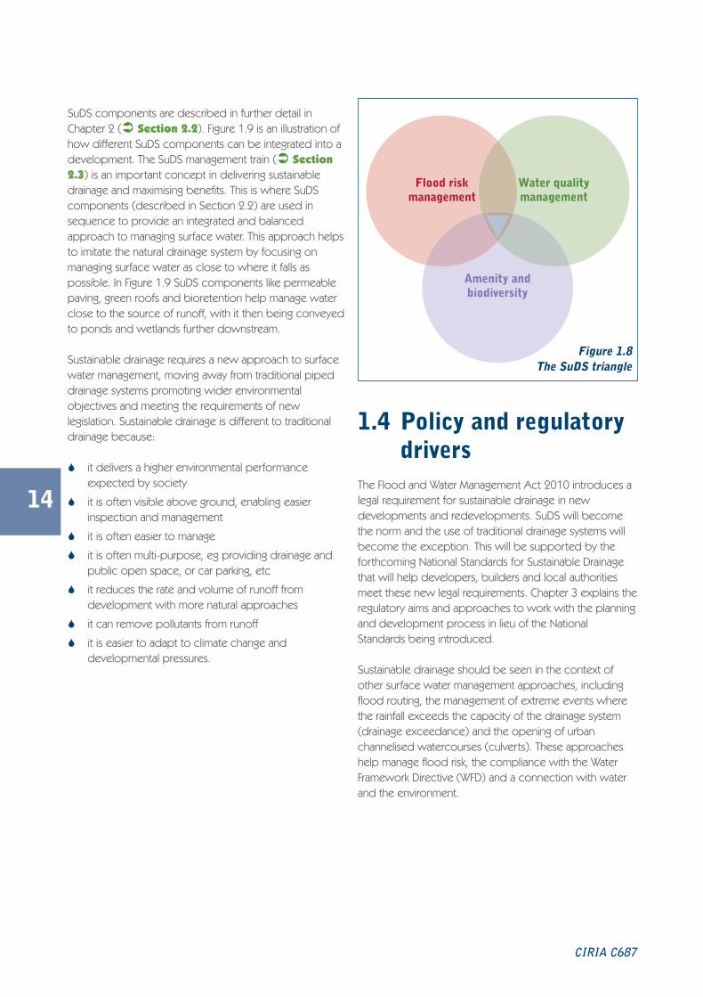
SuDS can deliver recreational benefits through the dualuse of components and facilities such as using attenuationand storage areas and overland conveyance routes forplay and/or sports areas (� Figure 2.6). Also,multifunctional use of SuDS components can have otherbenefits such as the incorporation of recreational openspace into a development that otherwise may bedeemed impracticable by a developer.
Educational benefits
In addition to improvements to the visual appearance of adevelopment, many SuDS components have been usedfor recreational and educational purposes with schemeslocated in school grounds. Exwick Heights School, Exeter(� Case study 1.2) includes SuDS to manage surfacewater that also provides an invaluable learning resourceabout water. Within the school green roofs providestorage for dealing with runoff on site, to help mitigatesurface water storage and disposal costs, as well asincreasing noise and heat insulation. The scheme uses apermeable pavement, under-drained swales and featureponds at the end of the system and further down thereceiving watercourse. Rainwater is harvested by apermeable play space that collects water from roofs andother hard surfaces to be used for toilet flushing.
In the city of Portland, USA many of the playgrounds aredesigned to educate pupils in surface water management.Mt Tabor Middle School is a good example of thisapproach. Previously, the area had experienced sewerflooding. A rain garden was retrofitted into a playgroundand a car park to capture runoff from impermeablesurfaces on the roof and asphalt. This reduces runoffentering the sewer system and encourages infiltration.Fencing and barrier planting of shrubs controls access tothe garden, with viewing areas provided to allow the areato be observed.
Benefits for developers
Delivery of SuDS can enable the granting of planningpermission as sustainable drainage is encouraged throughnational planning policy. The Environment Agency expectsSuDS to be incorporated into new developments.
SuDS can provide savings on the overall construction andmaintenance of drainage schemes. The SuDS scheme atLamb Drove, Cambourne and Cambridgeshire gave a 10%saving on design and capital costs to traditional drainage.This saving could have increased with effective pre-application discussions.
The use of SuDS and resultant improvements in visualattractiveness of a development has been proven toincrease house values by 10% to 20% (� Case study1.3).
Also, sustainable drainage can be integrated into strategiesfor public open space and green infrastructure withindevelopments. This will link urban areas through thedevelopment of blue/green corridors, such as theproposals set out in the Camborne Pool Redruth surfacewater management plan (SWMP) and drainageimplementation strategy (DIS) (� Figure 1.7).
CIRIA C687
Figure 1.6 Rain garden constructed on a schoolplayground, Portland, USA
C687 Planning for SuDS:C687 SuDS guide 04/11/2010 10:28 Page 10

11
Planning for SuDS – making it happen
The Exwick Heights Secondary School is located on a steeply sloping site. The access road, schoolbuilding and play spaces are positioned at the top of the site on two terraces with a multi-use gamesarea (MUGA) and sports pitch mid-way.
The car park is drained using permeable pavement with runoff passing through concrete blocks intovoided stone to provide full storage and release of water at greenfield rate of runoff to adjacent grassbasins that collect road runoff.
Runoff from the entrance road and paths flows directly to a detention basin or roadside swale withstorage of first flush runoff to allow silt and spillage management but allowing large storm events tobypass to wetland attenuation lower down the site.
Runoff from the access road and play surface behind the school is stored within the road constructionbeneath the impermeable tarmac road surface flowing via a control chamber to low flow grass channels.By removing the requirement for silt traps, storage structures and deep excavation, flows are atgreenfield rate of runoff. Where flows cross the contour, they drop down in stone filled baskets toprevent erosion before entering the biodiversity pond at the bottom of the site. Runoff from the schoolroof is attenuated and cleaned by a green roof.
The upper terrace and school entrance drivegenerally drain to the roadside swale. Therunoff from the lower terrace is collected inthe filter drain and stored in the play area.This then discharges directly to a low flowchannel beyond the gabion wall to thewetland and pond feature lower down thesite.
The MUGA hard play has a permeableasphalt surface over voided stoneconstruction and acts as a collector for boththe play surface and nearby hard areas.
Location Exwick Heights, Exeter
Type of development School
SuDS usedSwales, permeable paving, rainwater harvesting, green roofs,filter drains, detention basins and stormwater wetlands
Background
Case study 1.2
SuD
S at E
xwick H
eights secondary school, Exw
ick Heights, E
xeter
C687 Planning for SuDS:C687 SuDS guide 04/11/2010 10:28 Page 11

12
CIRIA C687
Elvetham Heath is a residential development in Hampshire that integrated SuDS. The main reason forusing SuDS was because the development was close to a site of special scientific interest (SSSI)immediately downstream.
The drainage strategy was to use soakaways to drain areas of high ground, swales for conveyance in theflattest areas and shallow detention basins for attenuation and to encourage infiltration to reduce theamount of runoff. A retention pond is used as a regional control immediately upstream of the naturereserve, and it also incorporates several proprietary SuDS engineering components.
Thames Water adopted the drainage system but Hart District Council carries out operation andmaintenance of all landscaped SuDS schemes as well as other public area landscaping, based on acommuted sum paid by the developers.
Research into the residents responses at the site suggest that the local community has high regard forthe scheme, which is reflected in the positive values of properties close to open water.
Location Elvetham Heath, Hampshire
Type of development Residential
SuDS used Soakaways, detention basins, a pond and swales
Background
Case study 1.3
SuD
S integrated at a residential developm
ent, Elvetham
Heath, F
leet, Ham
pshire
C687 Planning for SuDS:C687 SuDS guide 04/11/2010 10:28 Page 12

13
Planning for SuDS – making it happen
1.3 Sustainable drainageexplained
SuDS are becoming the preferred approach for managingsurface water runoff. This more natural approach tomanaging water as close to its source (where it falls) helpsmanage flood risk, water pollution as well as contributingamenity and biodiversity. The SuDS triangle (Figure 1.8)presents the primary benefits of sustainable drainage. The
extent to which these benefits can be realised willdepend on the opportunities and constraints of the site.
Sustainable drainage uses both landscaped features andharder engineering. Landscape features include greenroofs, and more natural features such as ponds, wetlandsand shallow vegetated channels called swales. Harderengineered SuDS components, such as permeablepaving, and soakaways can be used and often areincorporated into high density developments.
Figure 1.7 Camborne Pool and Redruth SWMP and drainage implementation strategy
C687 Planning for SuDS:C687 SuDS guide 04/11/2010 10:28 Page 13
SuDS components are described in further detail inChapter 2 (� Section 2.2). Figure 1.9 is an illustration ofhow different SuDS components can be integrated into adevelopment. The SuDS management train (� Section2.3) is an important concept in delivering sustainabledrainage and maximising benefits. This is where SuDScomponents (described in Section 2.2) are used insequence to provide an integrated and balancedapproach to managing surface water. This approach helpsto imitate the natural drainage system by focusing onmanaging surface water as close to where it falls aspossible. In Figure 1.9 SuDS components like permeablepaving, green roofs and bioretention help manage waterclose to the source of runoff, with it then being conveyedto ponds and wetlands further downstream.
Sustainable drainage requires a new approach to surfacewater management, moving away from traditional pipeddrainage systems promoting wider environmentalobjectives and meeting the requirements of newlegislation. Sustainable drainage is different to traditionaldrainage because:
� it delivers a higher environmental performanceexpected by society
� it is often visible above ground, enabling easierinspection and management
� it is often easier to manage
� it is often multi-purpose, eg providing drainage andpublic open space, or car parking, etc
� it reduces the rate and volume of runoff fromdevelopment with more natural approaches
� it can remove pollutants from runoff
� it is easier to adapt to climate change anddevelopmental pressures.
1.4 Policy and regulatorydrivers
The Flood and Water Management Act 2010 introduces alegal requirement for sustainable drainage in newdevelopments and redevelopments. SuDS will becomethe norm and the use of traditional drainage systems willbecome the exception. This will be supported by theforthcoming National Standards for Sustainable Drainagethat will help developers, builders and local authoritiesmeet these new legal requirements. Chapter 3 explains theregulatory aims and approaches to work with the planningand development process in lieu of the NationalStandards being introduced.
Sustainable drainage should be seen in the context ofother surface water management approaches, includingflood routing, the management of extreme events wherethe rainfall exceeds the capacity of the drainage system(drainage exceedance) and the opening of urbanchannelised watercourses (culverts). These approacheshelp manage flood risk, the compliance with the WaterFramework Directive (WFD) and a connection with waterand the environment.
14
CIRIA C687
Figure 1.8The SuDS triangle
Flood riskmanagement
Water qualitymanagement
Amenity andbiodiversity
C687 Planning for SuDS:C687 SuDS guide 04/11/2010 10:28 Page 14

15
Planning for SuDS – making it happen
C687 Planning for SuDS:C687 SuDS guide 04/11/2010 10:28 Page 15

16
CIRIA C687
C687 Planning for SuDS:C687 SuDS guide 04/11/2010 10:28 Page 16

1 Urban square with permeable paving
2 Retention pond with integrated seating
3 Rill within pedestrianised shopping street
4 Brown roofs within town centre
5 Planted road-side bioretention strips
6 Detention basin/infiltration trench
7 Green roofs
8 Segmented micro-wetland within courtyard
9 Filter strip and retention pond within residentialsquare
10 Permeable paving within residential street/ mews
11 Road-side bioretention tree pits
12 Large, naturalised swale within green space
13 Wetland areas
14 Natural waterway
15 Rainwater butt
Figure 1.9 Integration of SuDS into a development
Project2:Layout 2 20/10/2010 08:15 Page 1

18
1.5 Key learning points
What are the benefits of using SuDS?
Managing flood risk
� less surface water entering sewers (freeing capacityand reducing flood risk)
� flow control and dealing with surface water at acatchment level helps manage flood risk
� allows adaptation to a changing climate
� making space for SuDS allows overland flow routingand management of flooding from extreme events(drainage exceedance).
Managing water quality
� water quality will be managed to reduce the amountof pollution in runoff
� assists with compliance with the Water FrameworkDirective.
Amenity and biodiversity
� the use of SuDS can contribute to the quality of theplace
� provides opportunities for multifunctional areas (playareas in detention basins)
� provides wildlife habitat and ecological benefit.
Water resources
� some components can recharge undergroundaquifers
� harvested rainwater can be used for toilet flushing,garden irrigation etc.
Community and recreation
� SuDS can improve local quality of life
� promotes attractive surroundings to socialise andundertake recreation.
Education
� enables children to improve their understanding ofthe water and natural environment
� provides attractive environments for education.
Developers
� reduced construction costs
� reduced maintenance costs compared to manytraditional drainage methods when carried withlandscape maintenance
� increased property values.
CIRIA C687
C687 Planning for SuDS:C687 SuDS guide 04/11/2010 10:28 Page 18

19
1.6 References and further readingBIGGS, J, WILLIAMS, P, WHITFIELD, M, FOX, G and NICOLET, P (2000) Ponds, pools and lochans. Guidance on goodpractice in the management and creation of small waterbodies in Scotland. Pond Task Group, Scottish EnvironmentProtection Agency (SEPA), Stirling, Scotland. Go to:<http://www.sepa.org.uk/water/water_regulation/regimes/engineering/habitat_enhancement/best_practice_guidance.aspx#Ponds>
CLG (2006) Code for Sustainable Homes. A step-change in sustainable home building practice. Code 06 BD 04224,Department for Communities and Local Government, Crown Copyright, London. Go to:<http://www.planningportal.gov.uk/uploads/code_for_sust_homes.pdf>
DEFRA (2008) Future Water, The Government’s water strategy for England. Department for Environment, Food and RuralAffairs, HMSO, London
DUGGIN, J and REED, J (2006) Sustainable water management in schools. W012, CIRIA, London. Available to downloadfrom <www.ciria.org>
EUROPEAN COMMISSION (EUROPA) (2000) Water Framework Directive (WFD) 2000. Directive 2000/60/EC of theEuropean Parliament and of the Council establishing a framework for the Community action in the field of water policy
NEWTON, J, GEDGE, G, EARLY, P and WILSON, S (2007) Building Greener. Guidance on the use of green roofs, greenwalls and complementary features on buildings. C644, CIRIA, London (ISBN: 978-0-86017-644-2)
WOODS-BALLARD, B, KELLAGHER, R, MARTIN, P, JEFFRIES, C, BRAY, R and SHAFFER, P (2007a) The SUDS Manual. C697,CIRIA, London (ISBN: 978-0-86017-697-8)
Statutes
Flood and Water Management Act 2010
Planning for SuDS – making it happen
C687 Planning for SuDS:C687 SuDS guide 04/11/2010 10:28 Page 19

20
CIRIA C687
C687 Planning for SuDS:C687 SuDS guide 04/11/2010 10:28 Page 20

21
Planning for SuDS – making it happen
What aresustainabledrainagesystems?
What aresustainabledrainagesystems?
2
C687 Planning for SuDS:C687 SuDS guide 04/11/2010 10:29 Page 21

22
CIRIA C687
This chapter will…
� describe the SuDS approach
� introduce the SuDS components
� describe the SuDS management train
� explain the importance of themanagement train
� discuss where SuDS can be used.
C687 Planning for SuDS:C687 SuDS guide 04/11/2010 10:29 Page 22

2.1 Sustainable drainageapproaches
SuDS include a wide range of different components thatcan be designed to cope with flows from a variety ofdevelopments and sites. SuDS components work inseveral ways: they can infiltrate (soak) into the ground,convey (flow) into a watercourse (or if necessary asewer), they can also provide storage on site andattenuate (slow down) the flows of water. Often SuDSschemes use a combination of these processes. Moredetailed information on the design and technicalspecification of sustainable drainage can be found in TheSUDS Manual (Woods-Ballard et al, 2007a). The design ofthe scheme will depend on the site and the design criteriaused (� Section 5.1).
Generally, water is an attractive feature that people enjoy.SuDS improves water in the landscape and provides afocal point for developments.
Section 1.2 discuses the benefits of SuDS in detail. Somesimple components can be incorporated into schemes topromote their ecological value, such as providing nativeplanting or a series of shallow pools. Maximising theecological value of SuDS gives an important contributionto urban areas. Also, good ecology is linked to high qualityattractive environments that have a wide public appeal.
23
Planning for SuDS – making it happen
Figure 2.1 SuDS scheme providing amenity andbiodiversity
What are sustainabledrainage systems?2
Useful information
The SuDS approach
� mimic natural drainage – the collection of rainfallin components or features that slow, store or filterwater at the surface
� control water at its source – manage rainfall asclose to is source as possible
� use the SuDS management train – uses a sequenceof SuDS components to help manage the flow andvolume of water. It also provides incrementalimprovements in water quality.
i
C687 Planning for SuDS:C687 SuDS guide 04/11/2010 10:29 Page 23

2.2 SuDS componentsA diverse range of SuDS components are available, eachsuited to different site opportunities and constraints. Inmost cases, a combination of components is required toprovide the best results. With this in mind, and with carefulconsideration and selection, sustainable drainage can beused on most, if not all sites.
SuDS are not just traditional soakaways, ponds orwetlands, but are a suite of measures working in differentways that can be used to drain a variety of sites. Table 2.1provides an overview of different SuDS components andtheir suitability. The level of operation and maintenancewill vary depending on the type of SuDS component andscheme, and site considerations. Further information canbe found in The SUDS Manual (Woods-Ballard et al,2007a).
Dealing with water when and where it falls (sourcecontrol) may be the preferred, cheaper and easier optionfor many developments. Source control is moreappropriate in urbanised areas where space may be at apremium and less readily available (� Case study 4.3).By dealing with runoff at the source the volume of waterand the potential amount of contamination is less, whichrequires smaller SuDS components further downstream.Often source control components are within the curtilageof properties and maintained by the property owner ormanager and can include green roofs, permeablesurfaces, rainwater harvesting etc.
24
CIRIA C687
Well designed SuDS schemes can drain:
� permeable and impermeable sites
� sites with clay soil
� steep and flat sites
� large open spaces
� small constrained sites
� high density developments
� sites with contamination. �
Figure 2.3 Wetland managing pollution bycontrolling discharge into thewatercourse
Figure 2.4 Regional pond providing biodiversity,Elvetham Heath, England
Figure 2.2 Wetlands providing habitat,biodiversity and green corridors,Elvetham Heath, England
C687 Planning for SuDS:C687 SuDS guide 04/11/2010 10:29 Page 24

25
Runoff is then conveyed to site or regional controls. Sitecontrol is runoff and is managed from several localsources. Typically it includes, swales, detention basins etc.
Regional control components manage runoff from sourceslocally and across the site and often include, basins,ponds, wetlands.
Usually, site and regional controls require more space todeal with bigger volumes of water and contamination.However, they have greater potential to provide habitat,amenity and flood risk management opportunities, bydealing with larger volumes from multiple sources. Also,they are found in the public realm and early considerationof adoption or long-term management is required.
The SuDS management train requires the use ofcomponents in sequence that work together to manage theflows, volumes and pollution. Prevention initiates thesequence where runoff and/or pollution is reduced and thisfollows on to source control, then site and regional controlsproviding benefits further downstream (� Figure 2.7).
Integrated planning unlocks multiple benefits from SuDScomponents when innovatively designed into openspace, and can help deliver the SuDS management train.Figure 2.6 shows a play area in public open space,overlooked by residential properties in Malmo, Sweden.This attractive design uses the available space and createsa sustainable drainage feature in the development, furtherimproving the urban form.
Planning for SuDS – making it happen
Figure 2.5
Source control: rain garden andgreen roof, Malmo, Sweden
C687 Planning for SuDS:C687 SuDS guide 04/11/2010 10:29 Page 25
26
CIRIA C687
Figure 2.6
Play areas incorporating attenuation, M
almo, S
weden
C687 Planning for SuDS:C687 SuDS guide 04/11/2010 10:29 Page 26
Key
Good contribution ���
Medium contribution ��
Low contribution �
27
Planning for SuDS – making it happen
Table 2.1 SuDS components
What Why Where
Flo
od r
isk
man
agem
ent
bene
fits
Wat
er q
ualit
ym
anag
emen
tbe
nefi
ts
Am
enit
y an
dbi
odiv
ersi
tybe
nefi
ts
Gre
en r
oofs
The roof of abuilding that ispartially orcompletely coveredwith vegetation oranother growingmedium.
To control runoff asclose to source.Store water andfilter out pollutants.Can provide otherbenefits.
Private in curtilage(source control). ��� �� ���
Soa
kaw
ays
Excavation ortrench that can befilled with filtermaterial. Can bemade of pre-castconcrete orpolyethylene rings/perforated storagestructures that arethen backfilled withgranular material.Allows water tosoak away into theground.
To store runoff,filter out pollutantsand rechargegroundwater.
Private in curtilage(source control).Also next to roads.Can be easilyretrofitted.
��� ��� �
Rai
nwat
er h
arve
stin
g
System to collectwater fromimpermeablesurfaces for use innon-potable watersituations.
Reduce the amountof potable water use.
Private in curtilage(source control). ��� �� �
Per
mea
ble
pave
men
ts Surfaces that allowwater to soak intothe ground or agravel-filled base.Porous surfacereplaces traditionalhard (impermeable)surfaces.
Water is stored inthe base andreleased gradually.Also, it can treatrunoff and removepollutants. Can beused in permeableand impermeableground conditions (itincorporates someform of outflow andoverflowcomponent).
Private in curtilage(source control),car parks and someroads.
��� ��� �
Geo
cellu
lar
/mod
ular
sys
tem
s Modular plasticsystems that can beused to createbelow groundinfiltration orstorage.
Can both store andallow infiltration ofwater. Flexiblesystems that can beused on most sites.
Driveways, carparks, next toroads.
��� � �
C687 Planning for SuDS:C687 SuDS guide 04/11/2010 10:30 Page 27

28
CIRIA C687
What Why Where
Flo
od r
isk
man
agem
ent
bene
fits
Wat
er q
ualit
ym
anag
emen
tbe
nefi
ts
Am
enit
y an
dbi
odiv
ersi
tybe
nefi
ts
Cha
nnel
s an
d ri
lls Open landscapedchannels which can bevegetated, used toconvey water fromone SuDS componentto another.
Used to conveywater and canprovide somestorage.
In curtilage, inopen space. �� ��� ���
Bio
rete
ntio
n
Depressions backfilledwith a sand/soilmixture and plantedwith vegetation.Water enters througha vegetated surfaceand then trickles via afilter layer entering aperforated pipe at thebottom before beingcarefully transporteddownstream.
To store water andrelease itgradually. Somewater qualityimprovement isprovided by a filterlayer.
Private in curtilageSuDS (sourcecontrol), in openspace, next to roadsand car parking.
��� ��� ���
Infi
ltra
tion
tren
ch
Stone-filled trenchesthat allow water tosoak into the ground,as close to where therain lands as possible.
To control theamount of runoffand providestorage. Needspermeable groundconditions.
Open space next toroads (if precededby filter strip) andcar parks.
��� �� ���
Filt
er s
trip
s
A vegetated area ofgently sloping grounddesigned to drainwater evenly offimpermeable areasand filter out silt andother material.
To filter outpollutants,especiallysediment, beforerunoff enteringanother SuDScomponent orwatercourse.
Open space, next toroads and carparks.
�� ��� ��
Rai
n ga
rden
Vegetated area intowhich runoff isdrained, attenuatedand stored. Waterinfiltrates into theground or is taken upby plants.
To store runoff,filter outpollutants andrechargegroundwater.
Next to roads, inresidentialdevelopments andthroughout urbanareas.
��� ��� ���
Table 2.1 SuDS components (continued)
C687 Planning for SuDS:C687 SuDS guide 04/11/2010 10:30 Page 28

29
Planning for SuDS – making it happen
What Why Where
Flo
od r
isk
man
agem
ent
bene
fits
Wat
er q
ualit
ym
anag
emen
tbe
nefi
ts
Am
enit
y an
dbi
odiv
ersi
tybe
nefi
ts
Filt
er d
rain They are gravel filled
trenches with a pipewith small holes installedin the bottom.
The gravel slows theflow by storing waterand releasing itgradually. Can be used inpermeable orimpermeable conditions.May need periodicmaintenance to preventsiltation.
In openspace, nextto roads andcar parks.
��� �� �
Sw
ales
Shallow vegetatedswales that can runparallel to hard surfaces,allowing runoff to trickledown the side slopes andinto the base of thecomponent. Water isthen transported in acontrolled manner toanother SuDScomponent or to astream or riverdownstream.
To treat and attenuaterunoff. Can be used inpermeable orimpermeable groundconditions (if under-drained).
In openspace, nextto roads andcar parks.
��� ��� ��
Tre
nch
trou
ghs Open landscaped
channels which can bevegetated, over filtermedium and under-drained. Used to convey,attenuate and improvewater quality.
Used to convey water.Will provide somestorage and attenuation.
In openspace. ��� ��� ���
Det
enti
onba
sin
Shallow vegetateddepressions to controlthe amount and rate ofrunoff and some waterquality improvement.
To store water duringlarge storms, and releaseit gradually.
In openspace. �� ��� ��
Wet
land
Retention ponds withmore emergent aquaticvegetation and a smalleropen water area.
The wetlands storewater and release itslowly. Sedimentremoval also takes placethrough settlement andbiological treatmentoccurs due to thevegetation.
In openspace, nextto roads andcar parks.
��� ��� ���
Ret
enti
on p
onds
Artificial ponds with anopen water area andmarginal wetland aroundthe edge. Also, shouldincorporate astilling/settlement areaat the inlet to allow forsome treatment andcalming of storm flowsto prevent shock loadingof the main water body.
Ponds store water andrelease it slowly,allowing sediment tosettle in the pond in adesignated basin at theinlet, while thevegetation providesbiological treatment.Can be hard engineered.
In openspace. ��� ��� ���
Table 2.1 SuDS components (continued)
C687 Planning for SuDS:C687 SuDS guide 04/11/2010 10:30 Page 29

2.3 The SuDSmanagement train
For SuDS to best mimic natural drainage, a managementtrain approach should be adopted. This is fundamental inachieving a successful SuDS scheme, as it uses drainagecomponents in sequence to incrementally managepollution, flow rates and volumes. Figure 2.7 shows theSuDS management train.
30
CIRIA C687
Figure 2.7
The SuDS management train
1 Prevention
Good housekeeping and site design toreduce and manage runoff andpollution, eg land-use planning,reduction of paved surfaces
2 Source control
Runoff managed as close tothe source as possible, egusing green roofs, rainwaterharvesting, permeable paving,filter strips
3 Site control
Runoff managed in a networkacross a site or local area, egusing swales, detention basins,public realm SuDS componentsfor attenuation and treatment.Also, flow should be slowedusing overland conveyed routes
4 Regional control
Downstream management ofrunoff for a whole site/catchment,eg retention ponds, wetlands
Useful information
Good planning of a site involves consideration ofsurface water from the start. Delivery of SuDS iseasier if they are planned and designed to be fullyintegrated into the urban environment.
i
C687 Planning for SuDS:C687 SuDS guide 04/11/2010 10:30 Page 30
31
Planning for SuDS – making it happen
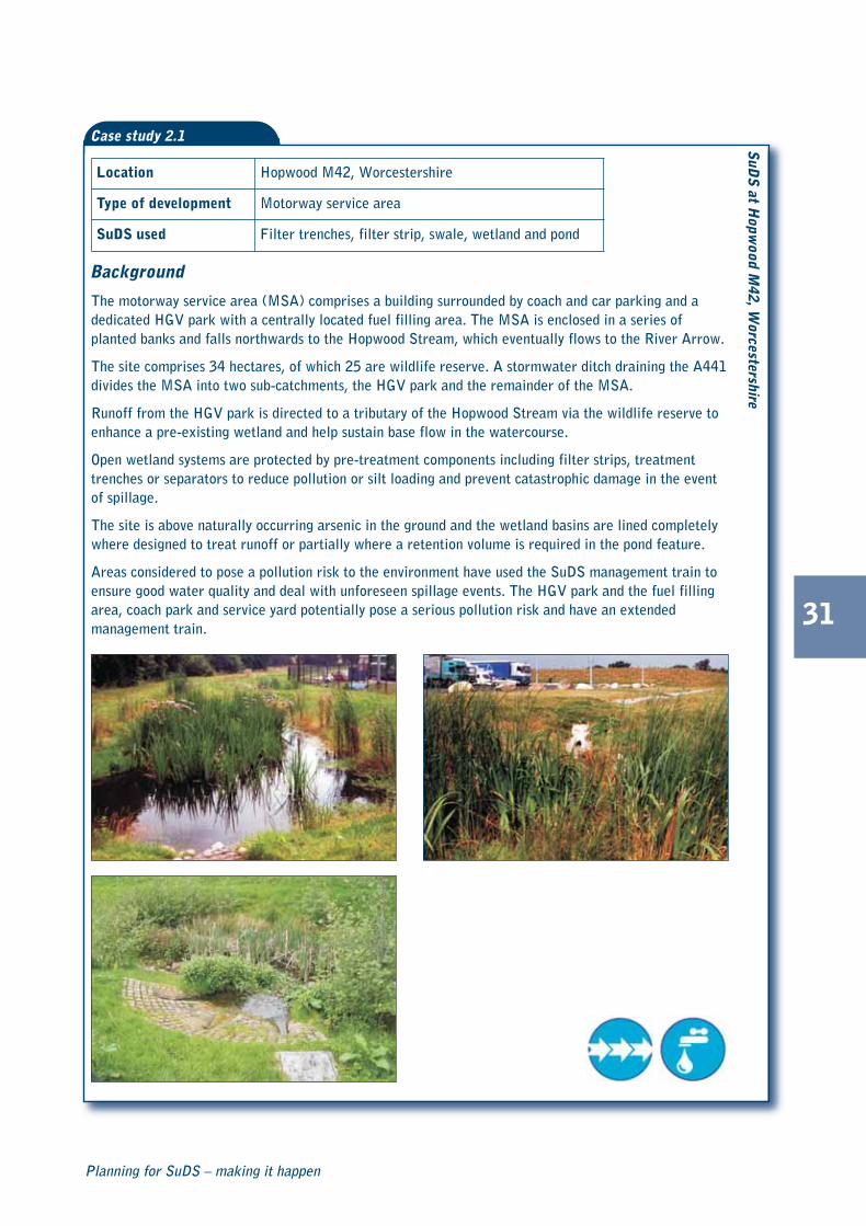
The motorway service area (MSA) comprises a building surrounded by coach and car parking and adedicated HGV park with a centrally located fuel filling area. The MSA is enclosed in a series ofplanted banks and falls northwards to the Hopwood Stream, which eventually flows to the River Arrow.
The site comprises 34 hectares, of which 25 are wildlife reserve. A stormwater ditch draining the A441divides the MSA into two sub-catchments, the HGV park and the remainder of the MSA.
Runoff from the HGV park is directed to a tributary of the Hopwood Stream via the wildlife reserve toenhance a pre-existing wetland and help sustain base flow in the watercourse.
Open wetland systems are protected by pre-treatment components including filter strips, treatmenttrenches or separators to reduce pollution or silt loading and prevent catastrophic damage in the eventof spillage.
The site is above naturally occurring arsenic in the ground and the wetland basins are lined completelywhere designed to treat runoff or partially where a retention volume is required in the pond feature.
Areas considered to pose a pollution risk to the environment have used the SuDS management train toensure good water quality and deal with unforeseen spillage events. The HGV park and the fuel fillingarea, coach park and service yard potentially pose a serious pollution risk and have an extendedmanagement train.
SuD
S at H
opwood M
42, Worcestershire
Location Hopwood M42, Worcestershire
Type of development Motorway service area
SuDS used Filter trenches, filter strip, swale, wetland and pond
Background
Case study 2.1
C687 Planning for SuDS:C687 SuDS guide 04/11/2010 10:31 Page 31

The SuDS management train encourages the control ofsurface water as close to the source as possible on siteand close to the development rather than beingtransferred and managed in larger componentsdownstream. This improves pollution management,contributes to the overall development, and can helpreduce the land take of water in the whole catchment.
Table 2.2 suggests the number of treatment stages orcomponents required to remove pollution from runoff,it is important that silt and pollution is removed before itreaches components like ponds or wetlands and risks ofcontamination is considered. The SUDS Manual (Woods-Ballard et al, 2007) provides further detail about watertreatment. The National Standards will include aframework for managing water quality, and the approachto managing water quality may change once theStandards are introduced. Urban designers, landscapearchitects, highway engineers and other stakeholdersworking together are important for translating suchaspirations into reality, and ensuring sustainabledevelopment is delivered.
Hopwood Motorway Services (� Case study 2.1) is anexample of how the SuDS management train approachcan be applied in practice. The main reason for using thisapproach was to ensure good water quality. Sourcecontrol components trap most of the contaminants fromthe site, protecting the downstream components. Whenan unforeseen spill occurs, the pollutants can be easilycontained, limiting the amount of remedial work requiredon the whole system and ensuring contaminants do notenter any nearby watercourses.
Table 2.2 SuDS treatment requirements
2.4 Key learning points� there are a variety of SuDS components that are flexible and can be adapted to any site
� managing surface water at source using the SuDS management train approach is important to realising multiplebenefits
� planning land-use to provide surface water overland conveyance routes and storage
� urban designers, landscape architects, highway engineers and other stakeholders play an important role indelivering this approach and ensuring benefits are realised.
32
CIRIA C687
2.5 References and further readingWOODS-BALLARD, B, KELLAGHER, R, MARTIN, P, JEFFRIES, C, BRAY, R and SHAFFER, P (2007a) The SUDS Manual. C697,CIRIA, London (ISBN: 978-0-86017-697-8)
Runoffpollutioncontent
Catchmentcharacteristics
Number oftreatment stages orSuDS components
Low Roofs 1
Medium Roads, parking areas,commercial zones 2
HighRefuse collection andindustrial areas, loadingbays, lorry parks
3
C687 Planning for SuDS:C687 SuDS guide 04/11/2010 10:31 Page 32

3
33
Planning for SuDS – making it happen
How to workwith theplanning anddevelopmentprocess
How to workwith theplanning anddevelopmentprocess
C687 Planning for SuDS:C687 SuDS guide 04/11/2010 10:34 Page 33

34
CIRIA C687
This chapter will…
� describe how to deliver SuDS throughstrategic and regional planning
� describe SuDS and local developmentplanning
� provide advice on supplementaryplanning documents
� outline interactions with othermanagement plans
� describe who should be involved in theplanning and development process forSuDS.
C687 Planning for SuDS:C687 SuDS guide 04/11/2010 10:34 Page 34

3.1 How to deliver SuDSthrough strategicplanning
Planning policy provides guidance to local authorities onwhat can be built and where. National policy states whatshould be included in strategic and local policies. Theseprovide policies and provisions which are the startingpoint for all development control decisions, includingappeals. Having appropriate SuDS policies at strategic
level will assist in achieving multiple benefits at local level.This allows local authorities to influence the pattern ofdevelopment through a plan led system. The stronger thepolicy at strategic level, the more likely the multiplebenefits of SuDS will be achieved.
At a local level the inclusion of policies on sustainabledrainage in local authority’s unitary development plans andlocal development frameworks provides an opportunityto encourage sustainable drainage making necessarylinkages with surface water management plan and thewider local flood risk management strategy.
35
Planning for SuDS – making it happen
Figure 3.1 Detention basin integrated into roundabout, Leicester, England
How to work with theplanning and developmentprocess
3
C687 Planning for SuDS:C687 SuDS guide 04/11/2010 10:34 Page 35

Sustainable drainage and theplanning process in England
Planning Policy Statement 25 (PPS25) states that priorityshould be given to sustainable drainage and discusses theimpact of new development on flood risk (DCLG, 2006).PPS25 recognises the contribution that SuDS can make toquality of place, wildlife and the delivery of multiplebenefits. The variety of planning policy statements inEngland related to SuDS is presented in Table 3.1.
Sustainable drainage and theplanning process in Wales
Wales has a different local government structure toEngland. Planning Policy Wales (PPW) sets out the land-useplanning policies of the Welsh Assembly Government andis supplemented by a series of technical advice notes(TAN) (� Case study 3.1).
The spatial plan by the National Assembly for Wales(2008) serves a similar role to regional spatial strategies inEngland, but also sets out a wider ranging spatial visionand strategy. The plan has statutory status, to which alllower tier plans must have regard.
Table 3.1 Planning policy statements in England
36
CIRIA C687
Policy statement Aim
PPS1 Delivering sustainable development� regional and local planning bodies should promote sustainable drainage
� policies should improve the environment as part of developments.
PPS3 Housing � opportunities should be taken to green residential developments and provideappropriate high density development.
PPS9 Biodiversity and geological conservation � development may provide opportunities to conserve nature and provide biodiversity.
PPS23 Planning and pollution control � encourages the management of diffuse pollution.
PPS25 Development and flood risk� encourages the use of sustainable drainage
� encourages source control and drainage exceedance.
Key points �
Planning policy in England
� National planning policies are set out in planning policy statements and supporting policy guidance notes
� Planning policy statements explain statutory provisions and provide guidance on planning policy and theoperation of the planning system. Local planning authorities must take their content into account whenpreparing development plans and decisions on planning applications
� PPS25 is the main planning policy statement in England promoting sustainable drainage
� regional spatial strategies are prepared by each region and sets out their requirements to meet the futureneeds of the population in the area, such as setting out how many new homes should be built. Thesestrategies are drafted by the regional planning body
� local development documents are prepared by local planning authorities and set out the future vision for adistrict, objectives in pursuit of that vision and a strategy for approaching them. These include localdevelopment frameworks and are supported by action plans
� action plans can take various forms such as area masterplans, site development briefs, design statementsand neighbourhood plans.
C687 Planning for SuDS:C687 SuDS guide 04/11/2010 10:34 Page 36

Under the Planning and Compulsory Purchase Act 2004,each unitary authority in Wales is required to produce alocal development plan for its area. Unlike the localdevelopment framework (LDF) approach in England, this isa single document that sets out the strategy as well as sitespecific and development control policies. Thedevelopment plans provide:
� strategic location guidance for development
� detailed site specific policies, including specific SuDSpolicies
� identification of proposals for development.
The Welsh Assembly Government has a duty underSection 121 of the Government of Wales Act, to promotesustainable development in the delivery of its functions.Technical Advice Note (TAN) 15 (National Assembly forWales, 2004) provides the technical guidance thatsupplements the policy set out by the Welsh AssemblyGovernment (2010) in relation to development andflooding. It advises on development and flood risk as thisrelates to sustainability principles and provides aframework for assessing risks.
PPS25 and TAN15 are similar in content and purpose. Theyboth promote sustainable drainage by endorsing theconcept at all stages of the planning process. Bothdocuments require developers to use SuDS whereverpossible and if they are not used to provide justification asto why they have not been included.
To gain planning permission, all new development in Waleshas to be tested against TAN15 for flood risk. The aim is todirect new development away from high risk areas or tojustify development in high risk areas.
TAN15 highlights the importance of managing surfacewater runoff by SuDS to mitigate flood risk. A newdevelopment should not create further runoff whencompared to the undeveloped situation and runoffshould be reduced by retrofitting where possible.
37
Planning for SuDS – making it happen
Table 3.2 Policy planning statements in Wales
Policy statement Aim
TAN15 Development andflood risk
� encourages the use of sustainabledrainage to manage surface water
� development should not createadditional runoff when comparedwith the predevelopment situation.
TAN5 Natureconservation andplanning
� encourages policies that enhance orpreserve biodiversity.
Figure 3.2 Wetland, Caw Burn, Scotland
Key points �
Planning policy in Wales
� National planning policy is set out by the WelshAssembly (2010)
� Technical advice note (TAN) 15 providesguidance on flood risk management andencourages the delivery of SuDS
� Wales spatial plan sets out a strategic frameworkto guide future development and policyinterventions
� local development plans provide strategiclocation based guidance for development andflood risk.
C687 Planning for SuDS:C687 SuDS guide 04/11/2010 10:34 Page 37

Key
Figure 3.3 SuDS and the planning process
38
CIRIA C687
RPB Regional planning body
SFRA Strategic flood risk assessment
LPA Local planning authority
LFRM Local flood risk management strategy
SWMP Surface water management plan
LDD Local development document
RSS Regional spatial strategy
Planningconsent granted
Regional spatialstrategy
Localdevelopmentframework
Pre planningapplicationsubmission
Submission
Decision making
Planningapplicationapproval
Nationalplanning policy
National planning policies requireRPBs and LPAs to promote SuDS
RSS should include specific policies topromote SuDS
Surface water drainage is a material planning consideration
WHO?
Forward plannersusing evidence base
from SFRAs/SWMPs to include
robust SuDSpolicies
LDDs should include local policies onSuDS. Policies informed by site specificguidance in SFRA, SWMP and LFRMs
Consultation with stakeholders is key to ensuring issues with
design, adoption and maintenance and community acceptance
Once consent has been granted, it is important that SuDS are built as designed
WHO?
Inspection bybuilding control/
approved inspector
WHO and WHAT?
Environment Agency,Highways Authority, water utilities, localcommunities, local
authorities, buildingcontrol, conservationorganisations, internal
drainage boards
C687 Planning for SuDS:C687 SuDS guide 04/11/2010 10:34 Page 38

3.2 SuDS and theplanning process
SuDS should be considered at all stages of the planningprocess. Figure 3.3 describes different tiers of the planningprocess in England, what stage SuDS should be specifiedand who should be involved where.
SuDS and regional planning
Regional planning bodies should include specific SuDSpolicies in their regional spatial strategies. Regional floodrisk appraisals should include a high level consideration ofsurface water management issues.
SuDS and local developmentplanning
Local planning authorities should include specific policiesrelating to SuDS in their local development documents,particularly the core strategy. Also, strategic flood riskassessments should (for allocated sites) makerecommendations on the type of SuDS componentsappropriate for the site, and an indication of the amountof land required.
Supplementary planningdocuments
Supplementary planning documents (SPDs) within thelocal development document (LDD) can support thedelivery of specific policy aspects, and may beappropriate to encourage sustainable drainage. They canbe used by the local planning authority to highlight themain features of SuDS and provide guidance on how thecomponents should be incorporated into developmentschemes.
Guidance produced by Cambridge City Council (Wilson etal, 2010) and the London Borough of Islington (Bray,2010) are good examples of documents produced bylocal authorities to support the delivery of SuDS. Theseoutline the Council’s requirements and the local context.
39
Planning for SuDS – making it happen
The Flood and Water Management Act 2010
National Standards for the design and construction of sustainable drainage for new and redeveloped sitesare being developed by Defra and the Welsh Assembly Government. The Flood and Water Management Act2010 states that:
� drainage schemes will be subject to an approvals process in accordance with the National Standards
� new connection to the public sewer will be in accordance with the National Standards
� planning authorities should be required to take the National Standards into account with planningconsiderations.
Useful information
Supplementary planning documents
Local planning authorise (LPAs) can developsupplementary planning documents that set out theprinciples of surface water management and SuDS andprovide guidance on how they would expect to seesustainable drainage accommodated in a development,particularly in high flood risk and/or high growth areas.
i
�
C687 Planning for SuDS:C687 SuDS guide 04/11/2010 10:34 Page 39

Regional flood risk appraisals(RFRA)
National planning policy in England states that RFRAsshould include a broad scale consideration of surfacewater management, focusing on regionally specific issues.
Area action plans
Area action plans form part of a LDF aimed at establishingproposals and policies for an area and may be used toestablish improved surface water management andsustainable drainage.
Town and Country Planning ActSection 106 Agreements
Section 106 of the Town and Country Planning Act (1990)enables a planning obligation from a local authority to belegally binding, which can be used to deliver SuDS andother benefits for developments such as public openspace. This is a useful mechanism in securing developmentaspects and particularly the maintenance of SuDS, as thereis currently no legally binding obligation relating to themaintenance of SuDS as opposed to conventionalsystems. Section 106 agreements assist in improving thequality, or reducing the adverse effect of development,and are potentially wide ranging.
The local planning authority can use a Section 106agreement together with a commuted sum to develop aSuDS maintenance framework with a developer (theCommunity Infrastructure Levy is likely to replace Section106 Agreements as these are phased out).
3.3 SuDS and flood riskassessments
PPS25 and the associated practice guide sets out whatshould be included in flood risk assessments, from theregional through to specific site level.
40
CIRIA C687
Strategic flood risk assessments(SFRA)
Guidance that supports national planning policy statesSFRAs should identify surface water drainage issues andthe types of measure (in a surface water managementplan if needed) that may be appropriate to manage them.This takes into account location, site opportunities,constraints and geology. LPAs should encouragesustainable drainage practices in their LDDs.
C687 Planning for SuDS:C687 SuDS guide 04/11/2010 10:35 Page 40

41
Planning for SuDS – making it happen
Site specific flood riskassessments (FRA)
Guidance that supports national planning policy alsostates that site FRAs should consider flood risk to andfrom the site.
3.4 Planning policy andsustainable drainage
It is important that sustainable drainage is considered at allstages in the planning process. This section will discuss, inmore detail, the role of planning policy in SuDS delivery.There are many planning policy statements that mentionSuDS, which are listed in Section 3.1. This section focuseson the impact of PPS25 and TAN15, as they are mostrelevant in drainage terms. The PPS25 practice guidesuggests that surface water should be considered in allsteps of the flood management hierarchy (� Figure 3.4).
3.5 Sustainable drainageand interactions withother relevant plans
The concept of sustainable drainage interacts with severalother management plans including local flood riskmanagement strategies, surface water management plans,catchment flood management plans and river basinmanagement plans. Figure 3.4 The flood risk management hierarchy
C687 Planning for SuDS:C687 SuDS guide 04/11/2010 10:35 Page 41
42
CIRIA C687
Surface water management plans (SWMPs) provide a frameworkwhere the main partners with responsibility for surface waterdrainage work together to understand local constraints on growthor flood risks. The outputs of these plans include the identificationof preferred options to reduce the risk of flooding, which is likelyto include the use of sustainable drainage.
Catchment flood management plans help understand the factorsthat contribute to the flood risk in a catchment and to recommendthe best ways to manage the risk. They are an important planningtool and take a strategic and active approach to flooding now andin the future, helping spatial planners assess flood risks associatedwith land allocations and determining the sustainability ofproposals. Sustainable drainage is an important tool in deliveringeffective surface water management on a catchment wide basis.
Biodiversity action plans (BAPs) areinternationally recognisedprogramme addressing threatenedspecies and habitats. They aredesigned to protect and restorebiological systems. The careful useof SuDS can help to improve theopportunities for habitat restorationand creation. Also, SuDS mayprovide opportunities to createecosystems that will be beneficial towildlife, such as wetlands andbioretention. SuDS can help toprotect habitat from future urbandevelopment. Biodiversity actionplans (BAPs) are internationallyrecognised programme addressingthreatened species and habitats.They are designed to protect andrestore biological systems. Thecareful use of SuDS can help toimprove the opportunities for habitatrestoration and creation. Also, SuDSmay provide opportunities to createecosystems that will be beneficial towildlife, such as wetlands andbioretention. SuDS can help toprotect habitat from future urbandevelopment.
River basin management plans are required by the WFD. Theyestablish a strategic plan for the long-term management of riverbasin districts and set out objectives for waterbodies (includingrivers, streams, lakes and the land that drains into them) focusingon water quality to protect and improve the water environment.
The use of SuDS can help improve the status of a waterbody bytreating some of the diffuse pollution (pollutants associated withrunoff). The concept of sustainable drainage has the added benefitof controlling water in relatively small quantities and maintainingthe existing flow conditions in a waterbody.
3.6 Stakeholders involvedin the planning anddevelopment process
There are numerous organisations involved in the planningprocess. Their level of engagement and participationvaries and it is important to include the public andcommunities planning decisions for best results.
All consultees should be contacted at the earliestavailable opportunity, to ensure developers are aware ofrequirements at a site specific level, particularly withregard to flood risk, pollution control and creating betterplaces to live. Many SuDS proposals are not submitteduntil the planning application stage. In such cases, oftenpre-application discussions are omitted, which can result
in delays in getting a planning application processed.However, when pre-application discussions take place, allcalculations and designs are agreed from the start of theprocess smoothing the way for approval.
The Code for Sustainable Homes is the national standardfor the sustainable design and construction of newhomes and it has targeted a reduction in carbonemissions by creating homes that are more sustainable(CLG, 2006). For example, by rain and greywater recyclingthat may reduce potable water consumption for useswhere lower quality water may be sufficient, eg toiletflushing.
Table 3.3 provides a list of the roles and aims of some ofthe key stakeholders. Regional variations in the approachand interpretations of regulations exist – another goodreason for early consultation.
C687 Planning for SuDS:C687 SuDS guide 04/11/2010 10:35 Page 42

43
Table 3.3 Stakeholders involved in the planning process
Planning for SuDS – making it happen
Stakeholders Role Desired outcomes
Public and communitiesThey have a vital role in the vibrancy of adevelopment and the acceptance ofsustainable drainage.
� to live, work and play in attractive surroundings
� to be involved in the development and how theSuDS scheme works
� to be certain that the design is adequate, and theoperation and maintenance of SuDS schemes willbe taken into account.
Local authority – planners
Upper tier – SuDS approval body
Lower tier – planning
They control planning applications and canadvise on the effect of regional/local policies.They will consult stakeholders to understandthe opportunities, constraints and issues of anapplication.
� to promote development policy
� to approve new development
� to encourage the inclusion of sustainable drainage.
Local authority – highwayengineers
They construct and manage highways andprovide standards to developers for theconstruction and adoption of roads. Managingthe quantity and quality of runoff fromhighways.
� to ensure highways drain to sustainable drainage
� to be satisfied SuDS components used meet theirrequirements
� to be satisfied that SuDS can be adopted.
Building control or approvedinspectors
Before construction building control officersneed to be satisfied development complieswith the Building Regulations and will notaffect the integrity of any buildings.
� to know location of drainage system in relation tobuildings
� to ensure it is compliant with BuildingRegulations.
Environment Agency
They are statutory consultees in the planningprocess on flood matters covering regionalspatial strategies and strategic flood riskassessments.
� to holistically manage runoff rates and volumes
� to ensure that sustainable drainage principles havebeen incorporated
� to see the SuDS management train delivered.
Conservation organisations
Natural England and the Countryside Councilfor Wales are the statutory advisors onconserving and enhancing the naturalenvironment at a regional and national level.
� high quality, sustainable developments
� protect sites of special scientific interest, specialprotected areas or special areas of conservation.
Sewerage undertakersThey have a duty to provide a public sewerconnection and are responsible for surfacewater drainage from developments.
� normally to ensure surface water managementsystems adhere to Sewers for Adoption
� some sewerage undertakers may also adopt SuDS
� consider capacity of existing drainage systems andwhere possible use sustainable drainage.
Developers
They are ultimately responsible for the typeof surface water management system used.To achieve successful SuDS involve themwith other important stakeholders early inthe planning process.
� to meet planning requirements
� to comply with the requirements of the Code forSustainable Homes and National Standards (onceintroduced)
� to provide a cost effective, attractivedevelopment, which will be easily sold.
Internal drainage boards
They are an operating authority in parts ofEngland and Wales that have permissivepowers to manage surface water and waterlevels within their district.
� to be consulted on development of strategic floodrisk assessments
� to be consulted on development within their area.
C687 Planning for SuDS:C687 SuDS guide 04/11/2010 10:35 Page 43

44
CIRIA C687
3.7 Key learning points� sustainable drainage needs to be considered as early as possible in the planning process and can save money,
by reducing the need for retrofit solutions
� sustainable drainage is difficult to deliver successfully if a development layout has been decided withoutappropriate consideration of drainage
� numerous organisations and stakeholders are involved in both drainage and the planning process so earlyconsultation and discussion about SuDS is vital
� National planning policy statements set out clear requirements for the use of SuDS, particularly PPS25 in Englandand TAN15 in Wales.
3.8 References and further readingBRAY, R (2010) Promoting sustainable drainage systems: design guidance for Islington. London Borough Of Islington,London. Go to: <http://www.islington.gov.uk/DownloadableDocuments/Environment/Pdf/Sustainability/islington_suds_gd_web_small.pdf>
CLG (2006) Code for sustainable homes. A step-change in sustainable home building practice. Code 06 BD 04224,Department for Communities and Local Government, Crown Copyright, London. Go to:<http://www.planningportal.gov.uk/uploads/code_for_sust_homes.pdf>
CLG (2004) Planning Policy Statement (PPS) 23: Planning and pollution control. Department for Communities and LocalGovernment, HMSO, London
CLG (2006) Planning Policy Guidance (PPS) 3: Housing. Department for Communities and Local Government, HMSO,London
CLG (2006) Planning Policy Guidance (PPS) 9: Biodiversity and Geological conservation - final regulatory impactassessment. Department for Communities and Local Government, HMSO, London
CLG (2006) Planning Policy Statement 1: Delivering sustainable development. Department for Communities and LocalGovernment, HMSO, London
CLG (2006) Planning Policy Statement (PPS) 25: Development and flood risk. Department for Communities and LocalGovernment, HMSO, London
CLG (2008) Planning Policy Statement 25: Development and flood risk – practice guide. Department for Communitiesand Local Government, HMSO, London
NATIONAL ASSEMBLY FOR WALES (2004) Technical Advice Note (Wales) (TAN) 15 Development and flood risk.National Assembly for Wales, Cardiff
NATIONAL ASSEMBLY FOR WALES (2008) People, places, futures – the Wales spatial plan update 2008. Ref: CMK-22-05-043, D0080809 National Assembly for Wales, Cardiff (ISBN: 978-0-75044-845-1). Go to:<http://wales.gov.uk/location/strategy/spatial/documents/wsp2008update/?lang=en>
C687 Planning for SuDS:C687 SuDS guide 04/11/2010 10:35 Page 44

45
Planning for SuDS – making it happen
WELSH ASSEMBLY GOVERNMENT (2010) Planning Policy Wales. Edition 3, Welsh Assembly Government, Cardiff, Wales.Go to: <http://wales.gov.uk/topics/planning/policy/ppw2010/?lang=en>
WILSON, S, BRAY, B, NEESAM, S, BUNN, S, FLANAGAN, E (2010) Sustainable drainage design and adoption guide.Environment and Planning, Cambridge City Council, Cambridge. Go to:<http://www.cambridge.gov.uk/public/docs/SUDS-Design-and-Adoption-Guide.pdf>
WRC (2006) Sewers for Adoption. WRC Publications, Swindon, Wiltshire, (ISBN: 978-1898920571). Go to:<http://sfa.wrcplc.co.uk/index.php>
Statutes
Government of Wales Act 1998 and 2006
Planning and Compulsory Purchase Act 2004
Town and Country Planning Act 1990
C687 Planning for SuDS:C687 SuDS guide 04/11/2010 10:35 Page 45

46
CIRIA C687
C687 Planning for SuDS:C687 SuDS guide 04/11/2010 10:35 Page 46

47
Planning for SuDS – making it happen
How to makesustainabledrainagehappen
How to makesustainabledrainagehappen
4
C687 Planning for SuDS:C687 SuDS guide 04/11/2010 10:36 Page 47

48
CIRIA C687
This chapter will…
� explain how to integrate SuDS with theplanning and design of development
� explain how to work with the site
� describe the master planning process
� explain the urban design process andhow to use design codes
� provide guidance on how to requestSuDS.
C687 Planning for SuDS:C687 SuDS guide 04/11/2010 10:36 Page 48

4.1 Integrating SuDS withplanning and designof developments
There is no “one size fits all” solution to delivering SuDS indevelopments, so good design is crucial. The designprocess involves both a range of expertise and theunderstanding of several specific factors. Planners play animportant role in involving the right expertise at the righttime, and ensure SuDS are seamlessly integrated with thewider design and planning process of developments.
Design is an issue at all levels of the planning process withdifferent information and levels of detail neededdepending on the planning stage. The following sectionsdiscuss the main design and planning considerationsalongside various stages of the development planningprocess. The drafting of SuDS policy requirements andguidance is discussed in Section 4.3.
Working with the site anddeveloper ambitions
Good SuDS design begins with an understanding of bothsite conditions and the ambition for the development.Sustainable drainage should be considered at the start ofthe project, preferably at the master planning stage. Onsites where planning has already progressed to a moredetailed stage, possibilities may be limited, but it is stillimportant to understand the opportunities. At thebeginning of a site planning process, planner anddesigners should seek to understand the followingaspects to inform SuDS design:
1 What is the developer seeking from the site in terms ofquantity of development, eg the density ofdevelopment and mix of uses?
2 What is the developer seeking in terms of the typeand quality of development, eg its general characterand style?
3 Likely mix of impermeable and permeable surfaces?
4 What is the local planning authority seeking from thesite, ie what are the policy requirements and bestpractice ambitions on site?
49
Planning for SuDS – making it happen
Figure 4.1 Swale in development, Upton,England
How to make sustainabledrainage happen4
C687 Planning for SuDS:C687 SuDS guide 04/11/2010 10:36 Page 49

50
5 How can the design of the architecture and buildingsassist, improve and be part of addressing water in asustainable way, eg green roofs?
6 How can SuDS shape the development and how canthe design of the landscape, and external areasintegrate water in a sustainable way, eg public openspace used as detention basins?
7 How could SuDS enhance biodiversity on site?
8 How will land-use on site create pollution of runoffand influence treatment requirements for SuDS?
9 How will long-term maintenance and management ofSuDS be ensured?
10 Are overland flow routes, eg swales and linear openspace, incorporated into the master plan?
Answering these questions requires input from a range ofdisciplines including engineers, urban designers,architects, landscape architects and ecologists. The designteam needs to include the right expertise at the beginningof the project and then at appropriate moments duringthe planning process to ensure these questions areanswered and brought together in the design solution.
Master planning and outlineplanning applications
The inclusion of SuDS at the master planning ordevelopment site planning stage has a significant effect onthe viability and cost-effectiveness of SuDS integration andthe ability of SuDS to deliver multiple planning benefits.Master planning provides a strategic approach to considerthe (sometimes competing) requirements for adevelopment. It is an inclusive urban design approach thatbrings together stakeholders, to regenerate or developareas that create better places to live, work and play. Amaster plan will typically set out the relationship betweenbuildings, infrastructure and public open spaces. Also, itenables a shared understanding of how a developmentintegrates with the surrounding urban context and naturalenvironment.
Good master planning will include the management ofrunoff, respond to natural topography and begin to locateSuDS and identify possible SuDS components. Thisprocess requires sustainable drainage expertise integratedwithin the master planning team. By developing asustainable drainage approach at the master planningstage, the team can integrate SuDS design with other largescale planning initiatives that are considered at the masterplanning stage including connections with:
� the type of architecture, what it is and how it isplaced, where it is placed on a site and how much ofthe site is occupied by it
� open space, public realm, green infrastructureplanning and opportunities for blue/green corridorlinks
� testing of land-use and density arrangements, ie theeffect on water treatment and storage requirements
� ecological connectivity and biodiversity strategies.
CIRIA C687
C687 Planning for SuDS:C687 SuDS guide 04/11/2010 10:36 Page 50

51
Planning for SuDS – making it happen
Figure 4.2 Detention basin integrated in public open space, Ipswich, England
Good master planning is also about looking at a site withinits context and designing holistically - where each element,ie buildings and site, are designed as one and workingtogether. The process is explained in Figure 4.3.
Many organisations have expanded the master planningprocess to include a full consultative, participatory andcollaborative design process. This typically engagesstakeholders, including the community to assess andreview a complex range of design requirements for thedevelopment site. SuDS are an important part of thisconsultation process to identify local issues andopportunities. This was undertaken at Upton,Northampton (� Case study 4.1).
Area action plans delivered by local authorities are anexample of where this should happen. However, a SuDSapproach and integration with spatial design are importantaspects to include within the requirements of a designand access (D&A) statement in support of an outlineplanning application. D&A statements explain theconsiderations behind a planning application and theaspirations and ambition for a development. Whenreviewing a master plan at outline planning stage, theplanner should ensure that the spatial layout bothminimises runoff, and incorporates SuDS components.
C687 Planning for SuDS:C687 SuDS guide 04/11/2010 10:37 Page 51

52
CIRIA C687
Examine sitetypography and geology
Aim to mimic the naturaldrainage systems andprocesses as far as possible.Identify key natural flowpaths, existing water bodiesand potential infiltration areasto understand opportunitiesand constraints.
Create a spatialframework for SuDS
Minimise runoff byrationalising large paved areasand maximising permeablesurfaces. Consider likely spaceneeds for site control SuDSbased on character ofdevelopment and the proposeddegree of source control. Useflow paths and possibleinfiltration or storage areas toinform development layout.
Figure 4.3
The master planning process
C687 Planning for SuDS:C687 SuDS guide 04/11/2010 10:37 Page 52

53
Planning for SuDS – making it happen
Look formultifunctional spaces
Consider how SuDS featurescould be co-located with openspace and public realm areasto create multifunctionalspaces. SuDS can be designedto be valuable amenity andecological features.
Integrate the streetnetwork with SuDS
Structure the street networkto complement and manageflow pathways. IntegrateSuDS features into streetcross-sections, ensuring streetwidths are adequate. SuDSshould be used to improve thestreetscape providing amenityand multifunctionality byintegrating with other streetfeatures including treeplanting, traffic calming,parking bays, verges andcentral reservations.
Figure 4.3
The master planning process(continued)
C687 Planning for SuDS:C687 SuDS guide 04/11/2010 10:37 Page 53

Key
54
CIRIA C687
Cluster land uses tomanage pollution
The number, size and type ofSuDS will be affected by landuses and the correspondingpollution risk. Potentialpolluters, eg industrialdevelopments, should havetheir own isolated SuDSnetwork. Integrate a series ofSuDS features that willprovide water treatmentthroughout the networks,responding to the level ofpollution risk. Clusteringshould be considered alongsideother mixed use ambitions.
Site boundary
Contours
Natural flow path
SuDS network
Attenuation feature(soft landscape)
Public green space
Streets
Attenuation feature(hard landscape)
Local flood risk management
Multifunctional benefit
Biodiversity and habitat benefit
SuDS treatment feature
Residential/mixed uses
Industrial uses
Figure 4.3
The master planning process(continued)
C687 Planning for SuDS:C687 SuDS guide 04/11/2010 10:37 Page 54

55
Urban design integration
Good urban design is only possible where the design andmanagement of water in a scheme is integrated as animportant part of the whole concept.
SuDS can be designed without urban design input, butthis leads to the creation of water management featuresthat are disconnected with the character and aesthetic ofthe place. Making SuDS attractive and integrating theirdesign with other urban features (ie roads and publicopen space) is vital to their acceptance, performance andlongevity. Communities and stakeholders are more likely toapprove, operate and maintain SuDS when they aredelivered using good urban design principles. Figure 4.5demonstrates how a wetland can be integrated with thetransport network.
Some of the following principles of urban design (basedon the Urban design compendium, Llewelyn-Davies et al,2000) provide a framework for integrating SuDS, make apositive contribution to a scheme and add value to adevelopment.
Table 4.1 and Figures 4.6 to 4.8 demonstrate SuDScomponents for different development settings.
Planning for SuDS – making it happen
Figure 4.5 Linear wetland, Edinburgh, Scotland
Figure 4.4 SuDS component combined with streetfurniture, San Francisco, America
C687 Planning for SuDS:C687 SuDS guide 04/11/2010 10:38 Page 55

Table 4.1 Main SuDS components to consider for different development settings
56
CIRIA C687
Places for people
SuDS should be safe, varied and attractive. Ifcreatively designed and integrated SuDS can addcharacter and develop a sense of place, as wellproviding the opportunity for education, play andrecreation.
Enrich the existing
Applying SuDS as a positive design tool can enrichthe design and the quality of the existing urbanplaces. Design and selection of SuDS shouldrespond to the scale and setting of development.
Work with the landscape
To give the greatest value, SuDS design should usethe site’s intrinsic resources – climate, landform,landscape and ecology. SuDS should respond tolocal topography and landscape character andincorporate local biodiversity needs. As in thedesign of a landscape or in public, shade and sunexposure should be considered in the placement ofSuDS and the effect on plant species and materialselection.
Manage the investment
For places to be successful they must beeconomically viable, well managed and maintained.Designing SuDS to be attractive and integratedwith other urban infrastructure will ensure thatSuDS and long-term maintenance is given moreattention. To ensure SuDS are economically viable,design integration is vital from the start.
Design for change
SuDS should be flexible enough to respond tofuture changes in climate, urban character andland-use. It is important to consider future uses ofsurrounding areas in SuDS design, and to accountfor the affects of climate change. Vegetated andpermeable SuDS will assist in the mitigation of theurban heat island effect.
Development settings
High density Medium density Low density
Mos
t su
itab
le S
uDS
com
pone
nts
Integrated buildings � green roofs
� rainwater harvesting.
� green roofs
� rainwater harvesting.
� green roofs
� rainwater harvesting.
Streetscapes
� permeable paving
� road-side bioretentioncomponents.
� road-side swales
� permeable paving
� road-side bioretentioncomponents
� filter strips.
� road-side swales
� permeable paving
� road-side bioretention.
Public realm andopen space
� permeable paving andunderground storage
� rills and channels
� hardscape pools
� micro-wetlands orbioretention components insquares, courtyards or hardpaved spaces.
� micro-wetlands orbioretention components insquares, courtyards or hardpaved spaces
� open space integrated pondsand wetlands.
� ponds and wetlands
� swales.
C687 Planning for SuDS:C687 SuDS guide 04/11/2010 10:38 Page 56
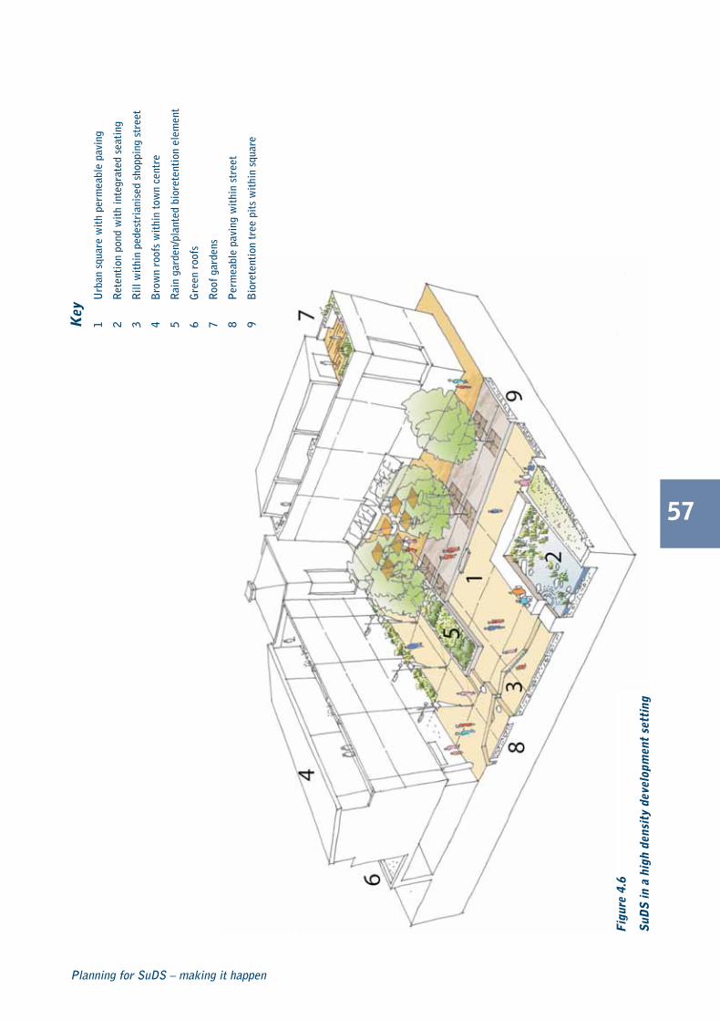
57
Planning for SuDS – making it happen
Fig
ure
4.6
SuD
S in
a h
igh
dens
ity
deve
lopm
ent
sett
ing
Key
1U
rban
squ
are
wit
h pe
rmea
ble
pavi
ng
2R
eten
tion
pon
d w
ith
inte
grat
ed s
eati
ng
3R
ill w
ithi
n pe
dest
rian
ised
sho
ppin
g st
reet
4B
row
n ro
ofs
wit
hin
tow
n ce
ntre
5R
ain
gard
en/p
lant
ed b
iore
tent
ion
elem
ent
6G
reen
roo
fs
7R
oof g
arde
ns
8P
erm
eabl
e pa
ving
wit
hin
stre
et
9B
iore
tent
ion
tree
pit
s w
ithi
n sq
uare
C687 Planning for SuDS:C687 SuDS guide 04/11/2010 10:38 Page 57

58
CIRIA C687
Fig
ure
4.7
SuD
S in
a m
ediu
m d
ensi
ty d
evel
opm
ent
sett
ing
Key
1F
ilter
str
ip a
nd r
eten
tion
pon
d w
ithi
nre
side
ntia
l squ
are
2P
erm
eabl
e pa
ving
wit
hin
resi
dent
ial
stre
et/m
ews
3R
oads
ide
bior
eten
tion
tree
pit
s
4G
rave
l/per
mea
ble
surf
aces
wit
hin
resi
dent
ial s
quar
e
5G
reen
roo
fs
6R
oof g
arde
ns
7R
ainw
ater
col
lect
ion
from
roo
fs in
fron
tra
in g
arde
ns/ w
ater
but
ts
C687 Planning for SuDS:C687 SuDS guide 04/11/2010 10:38 Page 58

59
Planning for SuDS – making it happen
Fig
ure
4.8
SuD
S in
a lo
w d
ensi
ty d
evel
opm
ent
sett
ing
Key
1W
etla
nd a
reas
wit
hin
larg
e op
en s
pace
2P
erm
eabl
e pa
ving
wit
hin
resi
dent
ial
stre
et/ m
ews
3N
atur
al w
ater
way
4G
reen
roo
fs
5R
ainw
ater
col
lect
ion
from
roo
fs in
fron
tra
in g
arde
ns/w
ater
but
ts
6R
ainw
ater
har
vest
ing
7R
oads
ide
swal
e
C687 Planning for SuDS:C687 SuDS guide 04/11/2010 10:39 Page 59

Using design codes
Design codes are a tool to help direct the design of adevelopment. They are rules and instructions aboutspecific design features and how those featuresinterrelate. Design codes inform the master plan shapingthe layout and location of components and describestheir quality and aesthetics. The urban design priorities forSuDS can be communicated and enforced through theuse of a design code (or for smaller sites designstatements).
Design codes can be very prescriptive, but this is notdesirable as it can prevent the potential to developcreative design solutions. It is more important that a designcode provides a framework of key design rules in whichmore detailed design decisions can take place. The levelof prescription is determined by an understanding of thesite, how the site will be developed and by whom. Theycan include as little or as much information as is deemednecessary to control and achieve a scheme withintegrated and effective SuDS including standards relatingto restrictions on the flow and volume of runoff or anyother performance target. A design code should outlinethe desired character and possible suitable types of SuDS
to be included in the development along with keyconsiderations for different urban settings (egstreetscapes, urban centre, suburban neighbourhood).
Upton, Northamptonshire (� Case study 4.1) showshow using design codes and involving stakeholders earlyin the process can deliver a sustainable drainage schemethat improves the local environment, deals with surfacewater runoff effectively and provides better places forpeople to live. The main reason for using this approachwas to ensure control surface water runoff followingflooding in the catchment in 1998.
PPS25 suggests that strategic flood risk assessmentsidentify land requirements to accommodate SuDS onlarger allocated sites. Developers are made aware of theland required for SuDS from the start of the developmentprocess, providing a greater opportunity for amanagement train approach to be adopted.
60
CIRIA C687
Figure 4.9 Swale in Upton, England
It is vital that SuDS site layout and open spacerequirements are considered at the same time as theSuDS design. Space for SuDS should be allocated atan early stage.
C687 Planning for SuDS:C687 SuDS guide 04/11/2010 10:39 Page 60

61
Planning for SuDS – making it happen
Managing surface water effectively was a priority for the urban extension at Upton. Many SuDSelements were incorporated into the design, including water butts, green roofs, permeable surfaces,swales and storage ponds. This has allowed surface water to be limited and controlled.
Sustainability was embedded in both the Upton design code and urban framework plan for SuDS byensuring:
� stakeholders were involved at an early stage
� surface drainage should be managed by SuDS
� the drainage of the site from extreme events and effect on downstream systems should be explicitlymitigated.
Using the codes helped delivery of SuDS and reduced the time for planning approval. The codes provideclear design guidance and instruction for all parties.
The drainage schemes have enhanced the high quality open green spaces with the swale and pondnetwork, providing ‘green fingers’ extending from the country park into the public realm, enhancinglocal biodiversity.
By carefully identifying the paths for exceedance flood routes through the development, the damagingeffects of flooding have been managed. In this case, the conveyance of the large resulting flood volumesis more effective than local storage. However, discharging these flows into the receiving water wouldhave proved unacceptable due to the potentially damaging effects of flooding downstream. The provisionof local surface storage as a dual use area has helped to mitigate these effects. The scheme could havebeen improved further with the inclusion of more source control components to attenuate flows andmore attention on the detailing of some of the components.
SuD
S integrated at a residential developm
ent at Upton, N
orthamptonshire
Location Upton, Northamptonshire
Type of development Residential
SuDS usedWater butts, green roofs, permeable paving, swalesand ponds
Background
Case study 4.1
C687 Planning for SuDS:C687 SuDS guide 04/11/2010 10:39 Page 61

Design codes and large sites
When outline planning permission has been granted for alarge site, but the landowner sells parcels of land to otherparties for development, is another common challenge.Although SFRAs requires that a certain amount of land isset aside for SuDS, these frequently take the form of largeend of pipe systems that may not contribute much interms of amenity. Also, it is important that source and sitecontrols are considered and design codes can set arequirement for these to be included in eachdevelopment parcel or subcatchment. The ideal solutionis to introduce restrictions on the flow rate and volume ofrunoff leaving each parcel, before water discharges intoregional control components downstream. Also, thedesign codes should incorporate some form of designstandards to ensure effective SuDS design over a largearea and ensure optimum benefits are realised. SuDSshould be designed in-line with the guidance in CIRIAC697 The SUDS Manual (Woods-Ballard et al, 2007),
When SuDS are considered at an early stage, there isgreater chance that they can be integrated into the masterplan as features of the development and that adequateland can be set aside to accommodate these structures. Itshould be noted that a site specific flood risk assessmentwill be required for all sites larger than 1 hectare in areas oflow flood risk and all sites situated in medium or high riskareas.
4.2 Overcomingchallenges during thedesign processChallenges faced during the design of SuDS schemesshould be overcome with early discussion with thestakeholders. Typical challenges and questions likely to beraised are discussed in Section 7.1. Further guidance canbe found in The SUDS Manual (Woods-Ballard et al, 2007).
Site specific applications have their own challenges,especially those that are not allocated in the localdevelopment documents. It is unlikely that the local SFRAwill address SuDS requirements at such sites. Usually it isup to the individual planning officer to apply their localauthority’s SuDS policy and determine whether theapplication meets the requirements of PPS25 (this is likelyto be formalised with the introduction of the NationalStandards).
Contaminated land
A common misconception is that SuDS cannot be used ina site with contaminated land that is proposed forredevelopment. Certain SuDS components such assoakaways and infiltration trenches may need to beavoided in parts of the site that might be contaminated.However, other components that do not infiltrate into theunderlying ground and attenuate and store runoff on thesurface can be used. The design of the system will be sitespecific and dependent on the contaminants found at thesite and a risk assessment should be undertaken.
Land take
Often, the land taken to accommodate SuDS (land take) isquoted as an issue, particularly in constrained high densitysites. Planning Policy Statement (PPS) 3 promotes the useof high density development for new sites andencourages a large number of units to be located in asmaller area. This can cause some tension with thespecifications of PPS25, as there may be requirements touse space for SuDS. However, numerous types of SuDSare ideal for use in high density areas. The use of sourcecontrol components will also minimise the amount of landneeded for site and regional controls (� Section 2.3).
62
CIRIA C687
Figure 4.10 Conveyance feature within a housingdevelopment, Gloucestershire, England
C687 Planning for SuDS:C687 SuDS guide 04/11/2010 10:39 Page 62

63
Planning for SuDS – making it happen
The introduction of green roofs allows rainwater to becontrolled as close to source as possible. Permeablepaving can be used to minimise the amount ofimpermeable area and the amount of runoff generated bya development. Permeable paving is frequently employedin low trafficked areas such as driveways, car parks andminor shared access roads and do not require anyadditional land take. Also, they provide an attractive visuallandscape in highly urbanised areas.
In some cases, depending on ground conditions,infiltration components provide a good solution to SuDSin high density areas. Bioretention facilities offer theopportunity not only for water quality improvements andstorage, but also for biodiversity and amenity. Thesecomponents provide pockets of green areas in oftenhighly urbanised areas. Examples include areas used asislands in car parks and areas where green space wouldbe required anyway.
Securing adoption of SuDS
Historically Section 106 of the Town and Country PlanningAct 1990 allowed a planning obligation to a localauthority to be legally binding. This is a useful mechanismin securing the maintenance of SuDS (� Section 6.2),but these are now being phased out. The CommunityInfrastructure Levy (Planning Act 2008) was introduced toprovide a flexible local levy that local authorities in Englandand Wales can choose to levy on development withintheir area to fund infrastructures (drainage, roads etc).
The Flood and Water Management Act 2010 and theassociated National Standards should simplify the adoptionproces. In advance of their introduction the Waterloovilleproject (� Case study 4.2) demonstrates the importanceof consultation and how it can help overcome the challengeof allocation long-term responsibility for SuDS maintenance.
4.3 Securing sustainabledrainage
This section provides guidance on how to ask for asustainable drainage approach to surface watermanagement. Figures 4.12 and 4.13 presents anapproach to specifying SuDS for both new and existingdevelopments. In addition to the step by step guidanceChapter 3 provides more information on how to workwith the planning and development process, andChapter 5 provides more detailed guidance on settingthe design criteria for SuDS.
Securing SuDS at a strategic level
Sustainable drainage is an integral part of national planningpolicy in England and Wales. Local authorities shouldencourage their use at all stages of the planning process.Figure 4.13 describes at what stages in the planningprocess SuDS should be considered.
Securing SuDS at a site specificlevel
The use of a sustainable drainage approach to controlsurface water has national policy backing, so whendevelopers say that they cannot use SuDS then they needto show no other viable option. Figure 4.13 describeshow and when to ask for SuDS at a site specific level (�Section 5.3).
Figure 4.11 SuDS in a high density development,Stamford, England
C687 Planning for SuDS:C687 SuDS guide 04/11/2010 10:40 Page 63

64
CIRIA C687
A steering group addressed SuDS maintenance and adoption challenges, and ensured that these did notbecome a barrier to the delivery of SuDS on this site.
The adoption meetings were attended by representatives from the two local authorities, HighwaysAgency, Southern Water, the developers, consultants for the developers, and representatives from theEnvironment Agency.
Both local authorities were supportive of SuDS in principle but were reluctant to commit to adoption.Through a steering group approach, the local authorities were persuaded that by designing systemsappropriately, such as incorporating gentle side slopes on swales, they would have the experience andthe machinery available to carry out the maintenance required.
The Waterlooville steering group provided a framework delivering SuDS into a major developmentarea. The success of the project demonstrated that a partnership approach enabled barriers to beovercome through discussion and negotiation.
Agreement was reached on maintenance rates for systems including swales, wetlands, and detentionbasins. Ponds would be examined individually. The exercise demonstrated that the cost for the localauthorities to carry out routine works for public open spaces was similar to that identified for SuDSmaintenance. A commuted sum was agreed between the developers and the local authority, and SuDSmaintenance costs were then written into a draft Section 106 agreement of the Town and CountryPlanning Act 1990.
In this case, the Environment Agency helped to facilitate the SuDS adoption processes by organisingsteering group meetings and working closely with all interested parties to ensure that contentiousissues with adoption and maintenance of SuDS were tackled and solved at the pre development stage.The scheme is to be monitored to support and promote the future use of SuDS through creating abetter understanding of how these systems operate. The project will endeavour to demonstrate thatthe development will not increase flood risk, worsen water quality or affect the ecology of localwatercourses, which is consistent with the objectives of sustainable development.
Mixed S
uDS
at Waterlooville, H
ampshire
Location Waterlooville, Hampshire
Type of development Mixed
SuDS usedPermeable paving, detention basins, swales, retentionponds
Background
Case study 4.2
C687 Planning for SuDS:C687 SuDS guide 04/11/2010 10:40 Page 64

PPS1 and PPS25 require regional and localplanning authorities to encourage the use of SuDS. National planning policies encourage the use of SuDS.
STEP 1 National planning policy
STEP 2 Regional spatial strategy
STEP 3 Local development framework
65
Planning for SuDS – making it happen
Figure 4.12 Securing SuDS at a strategic level
Must include specific policies to promote SuDS, inaccordance with PPS25.
Need to provide robust policies at strategic level thatencourage the use of SuDS.
Must include specific policies to promote SuDS, inaccordance with PPS25.
Local authorities need to provide robust policies thatencourage the use of SuDS at a local level.
C687 Planning for SuDS:C687 SuDS guide 04/11/2010 10:40 Page 65

Figure 4.13 Securing SuDS at a site specific level
66
CIRIA C687
The developer should meet with the local authorityand other consultees (particularly the EnvironmentAgency) as early as possible to agree the SuDSprinciples and design criteria. The SFRA should bechecked to confirm potential developmentrestrictions.
Once the National Standards for SustainableDrainage have been introduced, this process shouldbe formalised.
Discuss issues of design, integration and adoption ofSuDS. The local authority should encouragemultifunctional benefits of SuDS at this stage inaccordance with planning policies.
STEP 1 Pre-application discussions
STEP 2 Review of proposals
STEP 3 Submission of FRA
The developer should provide an indication of theSuDS scheme (integration, components etc) andsome initial calculations demonstrating that runoffcan be appropriately controlled.
The local authority and Environment Agency shouldreview whether sustainable drainage has beenadequately provided and whether the proposals willincrease flood risk and adversely affect waterquality.
The developer should submit a draft FRA forcomment and then a finalised FRA to support theplanning application (and D&A statement) to thelocal authority, which is then sent to consultees toprovide advice.
The local authority should send the draft and finalflood risk assessment to consultees for review andobtain advice on suitability of proposals. The designapproach and maintenance plan are agreed at thisstage.
Local authority grants planning permission (subjectto conditions) or refuses planning permission.
Conditions should only be used if the local authorityis satisfied that the proposals will not affect theaquatic environment, but insufficient design detailhas been provided to support the application.Building control/approved inspectors may check thedesign before approval.
STEP 4 Decision making
STEP 5 Construction phase
STEP 6 Post implementation phase
If successful then construction phase begins.
Building control/approved inspectors check thedesign and construction of SuDS is in accordancewith planning permission. This is likely to be afunction of the SAB.
Maintenance and post construction monitoring.
C687 Planning for SuDS:C687 SuDS guide 04/11/2010 10:40 Page 66

67
Planning for SuDS – making it happen
The Dings home zone is situated in central Bristol in an area of social deprivation. It is a mixeddevelopment with a severe parking and traffic problem that motivated residents and the council to lookfor an innovative solution, so a home zone was proposed.
A shared surface (block) paving was created in many areas to stop the traditional distinction betweenpedestrian and car space, encouraging interaction between all users to bring vehicle speeds to a walkingpace.
Using SuDS was encouraged as the existing combined sewer system in the area was already working atcapacity and the drainage authority did not want to increase flow into these sewers.
Permeable paving allows rain to infiltrate through a permeable concrete block paved surface into astone sub-base where it is cleaned by natural processes, before being released in a controlled mannerinto sewers or watercourses, or infiltrated directly into the sub-grade.
Permeable paving was used in some of the streets, removing the need for traditional drainage channels,which can form a barrier to mobility-impaired people and also delineates between car and pedestrianspace. The Dings home zone was the first area of SuDS permeable paving to be laid as adopted highwayin Bristol and is one of the largest areas in Britain.
SuDS were championed by the design team to convince the Highway Authority Maintenance (HAM) toadopt a new concept for Bristol’s roads. This was aided by HAM’s suggestion to bring in a specialistconsultant to provide advice on the suitability proposal and educate on the use of SuDS.
Residential S
uDS
, The D
ings, Bristol
Location The Dings, Bristol
Type of development Residential
SuDS used Permeable paving
Background
Case study 4.3
C687 Planning for SuDS:C687 SuDS guide 04/11/2010 10:40 Page 67

68
CIRIA C687
4.4 Key learning points� SuDS should be considered as early as possible in the planning process
� master planning has a significant effect on the viability and cost effectiveness of SuDS integration
� integrating SuDS with an urban design process can help community acceptance of schemes
� design codes help to direct the design of a development.
4.5 References and further readingCABE (2006) Design and access statements: How to write, read and use them. Commission for Architecture and theBuilt Environment, London. Go to: <http://www.cabe.org.uk/files/design-and-access-statements.pdf>
CABE (2008) Creating successful masterplans: A guide for clients. Commission for Architecture and the BuiltEnvironment, London. Go to: <http://www.cabe.org.uk/files/creating-successful-masterplans.pdf>
DCLG (2010) Planning Policy Statement (PPS) 3: Housing. Department for Communities and Local Government, HMSO,London
KELLAGHER, R (2005) Use of SuDS in high density developments. SR666. HR Wallingford Oxfordshire, UK
LLEWELYN-DAVIES AND ALAN BAXTER & ASSOCIATES (2000) Urban design compendium. English Partnerships and TheHousing Corporation, London. Go to: <http://www.urbandesigncompendium.co.uk>
NWDA, (2007) Economic value of urban design. Final report. North West Development Agency/Renew Northwest,Warrington
WOODS-BALLARD, B, KELLAGHER, R, MARTIN, P, JEFFRIES, C, BRAY, R and SHAFFER, P (2007a) The SUDS Manual. C697,CIRIA, London (ISBN: 978-0-86017-697-8)
Statutes
Community Infrastructure Levy (Planning Act) 2008
Flood and Water Management Act 2010
Town and Country Planning Act 1990

69
Planning for SuDS – making it happen
How tospecifysustainabledrainage
How tospecifysustainabledrainage
5
C687 Planning for SuDS:C687 SuDS guide 04/11/2010 10:41 Page 69
70
CIRIA C687
This chapter will…
� explain how to specify SuDS
� explain how to set design criteria
� describe the design process
� explain how schemes should bereviewed
C687 Planning for SuDS:C687 SuDS guide 04/11/2010 10:41 Page 70

5.1 Setting the designcriteria
Setting the design criteria at the start of the project andestablishing a clear SuDS vision ensures that the drainagecomponents are not secondary to other requirements forthe site. Sustainable drainage should be integrated into theurban form, whether using hard engineering or softlandscaping features. Failure to allocate areas for SuDS atthe start will result in poorly designed components thatdo not meet the design criteria or fully delivermultifunctional benefits.
Design criteria provide a useful framework for delivering ascheme that meets objectives agreed by the client anddesign team. These will ideally relate to flood risk
management, water quality management, and theprovision of biodiversity and amenity. It may not bepossible to maximise opportunities for all three objectivesand the extent that this happens should be discussed withthe relevant stakeholders. When introduced the NationalStandards should provide a framework for theseobjectives to be agreed and delivered. The design criteriaapproach is flexible enough to respond to clientaspirations as well as site opportunities and constraints.
The design criteria are given in Table 5.1 and more specificguidance can be found in The SUDS Manual (Woods-Ballard et al, 2007a).
71
Planning for SuDS – making it happen
Design criteria Key principles
Water quantity(hydraulics, flooding, runoff etc)
People and property must be protected from all flooding sources, including watercourses, thedrainage system and overland flows.
Development should not exacerbate flood risk within the wider catchment.
The flow rate and volume of runoff should be managed to agreed levels.
Water quality
(pollution control, management etc)
Potential pollution risks should be mitigated by the use of the SuDS management train.
Adequate retention time should be provided to enable pollutants to be treated.
Amenity and biodiversity
SuDS can positively influence urban design and landscape value through provision of green space,vegetation integrating water into the built environment, providing opportunities for biodiversity. Thisis essential if sustainable drainage is to be included in public open spaces and contribute to greeninfrastructure.
Health and safety concerns should be addressed and designed out. SuDS components should haveshallow side slopes, and ponds should have shallow shelving edges, and make good use of vegetationto prevent access.
How to specifysustainable drainage5
Table 5.1 Design criteria for sustainable drainage
C687 Planning for SuDS:C687 SuDS guide 04/11/2010 10:41 Page 71

5.2 How to specifysustainable drainage
Sustainable drainage is designed using similar principles asconventional drainage systems, but applied in a differentway. Alongside the more technical issues are those ofamenity and improving the environment. Opportunities tocreate interesting and attractive developments improvingthe quality and reducing the flow and volume of waterleaving a development should be exploited by designingSuDS that are imaginatively integrated into the urban form.The planning system is fundamental to specifying sustainable.
Specifying SuDS in strategicplans
Regional spatial strategies (RSS) and local developmentframeworks (LDF) should refer to sustainable drainageopportunities (� Chapter 3) to reduce the effect ofdevelopment. Strategic flood risk assessments (SFRA)should refer to SuDS on new developments and should:
� identify site opportunities for SuDS, taking intoconsideration location, constraints and geology
� identify suitable SuDS components
� require SuDS to reduce and treat runoff
� identify retrofit opportunities.
Specifying SuDS in surfacewater management plans
Surface water management plans (SWMPs, and local floodrisk management strategies) make it possible to connectsite specific FRAs across developable catchments, andcan help to master plan sustainable drainage requirementsin a co-ordinated manner.
A SWMP can contribute to the requirements for surfacewater drainage within new developments and urbanextensions, as identified in the RSS and LDDs, so that itdoes not cause flooding, and does not exacerbate floodrisk elsewhere in the catchment. Any proposed drainageshould be designed to be future proof against furtherdevelopment and climate change. SWMPs can promoteand support the use of SuDS within urban areas.
Specifying SuDS in flood riskassessments
Site specific flood risk assessments (FRA) should also referto SuDS options for minimising the effect of newdevelopment by applying the management trainphilosophy. The design of sustainable drainage will becarried out when submitting a full planning application.When selecting SuDS it is important to consider the designcriteria, although these will have to reflect the sitecharacteristics, opportunities and constraints. SuDS shouldbe viewed as an opportunity to incorporate features intothe urban landscape that can be visually appealing,provide opportunities for habitat creation and amenityvalue while carrying out functional drainage requirements.
5.3 Design process andSuDS
It is useful to structure the design process around thedelivery of the SuDS management train. It should start byconsidering what can be done to reduce impermeablesurfaces (prevention) and then consider source control.Often these are excluded from the management train dueto limitations with space and SuDS can become tokenfeatures. Runoff is transported via conventional drainagenetworks to off-site storage and the benefits of SuDS arelost.
The design process and their purpose are highlighted inTable 5.2. It is likely that throughout the process the localplanning authority will act as co-ordinator and maintaincontact with the Environment Agency, sewerageundertaker and other local authority functions. With theintroduction of the Flood and Water Management Act2010 the SuDS approval body will co-ordinate thisprocess and the stages outlined in Table 5.2 may change.
72
CIRIA C687
Useful information
The intention is to make “sustainable urban surfacewater management decisions that are evidence based,risk based, while taking climate change intoconsideration, and are inclusive of stakeholder viewsand preferences” Defra, 2010.
i
C687 Planning for SuDS:C687 SuDS guide 04/11/2010 10:41 Page 72

A successful scheme will require the design team to workwith other stakeholders involved in the planning anddevelopment process (� Section 3.6).
Selection of SuDS components
Once the design criteria have been set and an assessmentof the site’s constraints has been made, drainagecomponents can be selected based upon the following:
� the overall vision for the site and management ofsurface water
� delivering the surface water management train
� suitability in-line with site opportunities andconstraints. For example, if a site is contaminated thenit may not be possible to use a component thatinvolves letting water soak into the ground (infiltration)
� performance of SuDS component – relating to howwell a particular component can, for example,improve water quality. Table 2.1 provides some initialindication of SuDS performance against water quality,water quantity (flood risk) and biodiversity/amenityconsiderations.
The site should be split into subcatchments for themanagement of surface water runoff. The use ofdevelopment compartments can also be helpful inmanaging the rate and volume of runoff in discrete areasof a development helping to reduce the size and scale ofSuDS components.
73
Planning for SuDS – making it happen
For detailed design guidance see CIRIAC697 The SUDS Manual (Woods-Ballardet al, 2007a)
Useful information
SuDS should be the primary method of conveying,attenuating and storing surface water. Developersshould demonstrate that there is no practicablealternative to control runoff. The design team shouldconsider SuDS at the feasibility stage of developmentand integral stages during the SuDS.
i

Table 5.2 Stages in the design process
74
CIRIA C687
Stage Purpose and outcomes
Pre-application stakeholderdiscussions
Developer initiates contact with the local planning authority as early as possible to:
� make sure everyone is aware of the proposed development
� ensure effective lines of communication are clear
� identify the design criteria and opportunities/constraints for the site
� ensure SuDS are integrated with the rest of the development
� understand the approaches for the adoption of SuDS in the public realm.
Outline planning applicationand outline drainage proposal
Develop outline drainage proposals via initial discussions that will define the approaches to integrate theSuDS scheme into the landscape. This could be incorporated into a design and access statement. Specificrequirements will include:
� demonstrating that sustainable drainage principles have been applied and system operation has beenaccounted for in the overall design parameters
� information on approximate sizing of drainage components
� using SuDS management train principles
� initial calculations of the flow rate from the site
� initial estimates on the amount of runoff that needs to be controlled for a storm with 1% probability(1 in 100 year event)
� an outline of the SuDS scheme with flood routes mapped
� demonstrating that initial scheme design considers climate change
� agreement on adoption maintenance and operation of the systems
� identifying space for storage areas and conveying exceptional overland/exceedance flows (for extremeevents)
� compliance with the Code for Sustainable Homes.
Full planning application anddetailed drainage assessment,design and consultation
Prepare a detailed drainage design for submission with full planning application. The scope of thedrainage assessment is likely to include:
� adequate land set aside for SuDS
� SuDS designs that are integrated into the overall site concept and layout
� calculations showing peak runoff flow rates before and after development
� an indication of overland flow routes and that drainage exceedance has been considered
� an indication that opportunities to deliver SuDS have been maximised
� calculations showing that runoff flow and volumes can be appropriately controlled and managed
� need for investigation and further remediation of contaminated land
� a method statement on how surface water will be controlled during construction
� agreement on adoption maintenance and operation of the systems
� the need for long-term monitoring.
C687 Planning for SuDS:C687 SuDS guide 04/11/2010 10:41 Page 74

75
5.4 Evaluating sustainabledrainage plans
Regulators and more increasingly local authorities willevaluate designs to ensure that they are delivering whatwas expected in-line with national and local policy as wellas the agreed design criteria. Evaluation should beundertaken in consultation with a drainage practitioner,probably within the local authority, but also theEnvironment Agency may have a role. With theintroduction of the National Standards this process shouldbe formalised with the SuDS approving body (SAB)reviewing designs and checking that schemes have beenconstructed in accordance with the Standards.
The constructed SuDS scheme should reflect what waspresented during the planning and design stages and thatany alternatives should be rigorously evaluated.
Designers should demonstrate an awareness of the localsite conditions and that they have been considered in theSuDS design, eg contamination from previous site uses,and water table and topography to demonstrate that theproposals are the most appropriate for the site.
Plans should indicate the amount of surface water runofffrom the impermeable areas and the effect of theproposed SuDS on the volume. Also, there should be aclear indication as to the pollutants removed. Amaintenance plan developed by the designer should beconsidered (� Section 3.6.1).
Planning for SuDS – making it happen
� does it deliver the agreed design criteria:
� management of flood risk
� management of water quality
� provision of biodiversity/amenity
� has the SuDS management train been delivered
� does it provide source control
� where possible is water managed on the surface
� have all the opportunities of the site beenexploited (location, site topography, views)
� has existing flood routes and drainageexceedance been considered
� has health and safety been considered(gradients, inlets, outlets control structures)
� has maintenance and access been considered
� is there a maintenance plan
� has adoption been resolved. �
Designers should demonstrate that they have followed current best practice and procedures containedin the following CIRIA guidance:
The SUDS Manual (C697) (Woods-Ballard et al, 2007a)
Site handbook for the construction of SUDS (C698) (Woods-Ballard B, et al (2007b)
Designing for exceedance in urban drainage: good practice (C635) (Digman, C, Balmforth, D,Kellagher, R and Butler, D 2006)
Building Greener. Guidance on the use of green roofs, green walls and complementary features onbuildings (C644) (Newton, J, Gedge, D, Early, P and Wilson, S 2007)
Evaluation checklist
Useful information
SuDS should be evaluated according to the designcriteria and objectives set at the beginning of thedesign process.
i
C687 Planning for SuDS:C687 SuDS guide 04/11/2010 10:42 Page 75
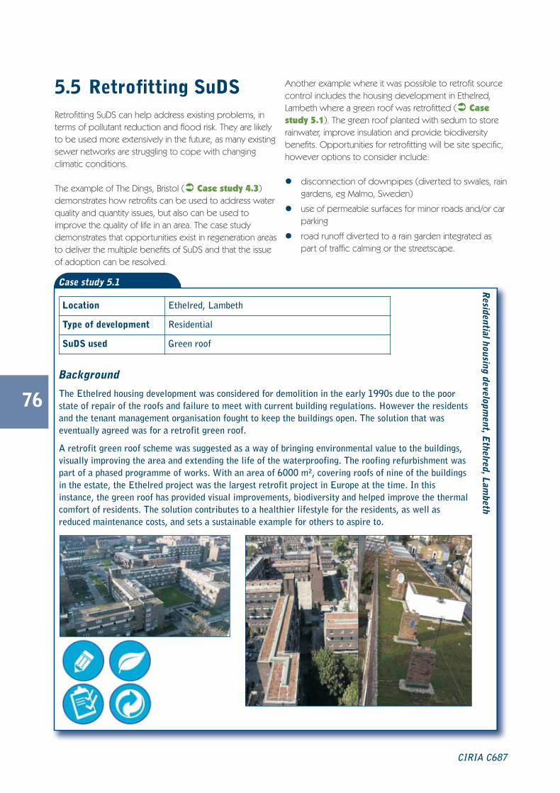
76
5.5 Retrofitting SuDSRetrofitting SuDS can help address existing problems, interms of pollutant reduction and flood risk. They are likelyto be used more extensively in the future, as many existingsewer networks are struggling to cope with changingclimatic conditions.
The example of The Dings, Bristol (� Case study 4.3)demonstrates how retrofits can be used to address waterquality and quantity issues, but also can be used toimprove the quality of life in an area. The case studydemonstrates that opportunities exist in regeneration areasto deliver the multiple benefits of SuDS and that the issueof adoption can be resolved.
Another example where it was possible to retrofit sourcecontrol includes the housing development in Ethelred,Lambeth where a green roof was retrofitted (� Casestudy 5.1). The green roof planted with sedum to storerainwater, improve insulation and provide biodiversitybenefits. Opportunities for retrofitting will be site specific,however options to consider include:
� disconnection of downpipes (diverted to swales, raingardens, eg Malmo, Sweden)
� use of permeable surfaces for minor roads and/or carparking
� road runoff diverted to a rain garden integrated aspart of traffic calming or the streetscape.
CIRIA C687
The Ethelred housing development was considered for demolition in the early 1990s due to the poorstate of repair of the roofs and failure to meet with current building regulations. However the residentsand the tenant management organisation fought to keep the buildings open. The solution that waseventually agreed was for a retrofit green roof.
A retrofit green roof scheme was suggested as a way of bringing environmental value to the buildings,visually improving the area and extending the life of the waterproofing. The roofing refurbishment waspart of a phased programme of works. With an area of 6000 m², covering roofs of nine of the buildingsin the estate, the Ethelred project was the largest retrofit project in Europe at the time. In thisinstance, the green roof has provided visual improvements, biodiversity and helped improve the thermalcomfort of residents. The solution contributes to a healthier lifestyle for the residents, as well asreduced maintenance costs, and sets a sustainable example for others to aspire to.
Location Ethelred, Lambeth
Type of development Residential
SuDS used Green roof
Background
Case study 5.1
Residential housing developm
ent, Ethelred, L
ambeth
C687 Planning for SuDS:C687 SuDS guide 23/11/2010 15:38 Page 76

77
Planning for SuDS – making it happen
5.6 Some Do’s and Don’tsAs well as considering Table 5.2 when detailing the designprocess, specifiers and evaluators of sustainable drainagemight benefit from some simple Do’s and Don’ts:
Do’s
� encourage early dialogue between interestedparties
� ensure SuDS are integrated with the rest of thedevelopment as early as possible
� ensure that the SuDS vision and desiredoutcomes are set out at the early stages of design
� ensure an appropriate maintenance regime isagreed early on
� agree designs with the local authority andEnvironment Agency through pre-applicationdiscussions
� design inlets/outlets that are sympathetic to theirsurroundings, eg using locally based stone ratherthan concrete structures
� use locally sourced plants, to prevent invasivespecies taking over
� ensure that health and safety of the scheme isconsidered with a risk assessment
� provide barrier planting where required, so thataccess to open water can be appropriatelycontrolled. Consider providing access points suchas boardwalks and beaches
� provide irregularity along the banks of ponds, suchas scrapings and small basins as wildlife habitats
� ensure ponds and wetlands have sedimentforebays, where sediment settles out in acontrolled manner, reducing the amount ofmaintenance required
� create islands in ponds and wetlands, providingwildlife with a sanctuary, where they won’t bedisturbed
� provide walkways around the SuDS, makingthem a water feature rather than hiding them
� provide check dams for swales if the site issteeply sloping. This will slow down the runoffand prevent erosion of the slopes
� locate filter strips upstream of infiltrationdevices to prevent them clogging.
Don’ts
� leave discussions with the consultees in theplanning process too late
� get the levels wrong so water cannot flow intothe facility through gravity
� avoid discharging water to a single point in aswale. This can lead to erosion and much of thesediment accumulating in one place rather thanbeing spread across a wide area. For this reasonavoid end of pipe swales
� avoid designing ponds and basins with the inletsand outlets located too close together, limitingthe amount of time water stays in the component
� use infiltration devices for impermeable soils
� allow construction runoff from building sites toenter SuDS components unless you are preparedto carry out remedial work, as there is likely tobe significant sediment accumulation
� design ponds or basins with steep sided slopes,they can be dangerous and provide little wildlifevalue. Also, deep ponds may suffer from waveaction that re-suspends sediment
� use garden centre plants as they can becontaminated by invasive species.
�
C687 Planning for SuDS:C687 SuDS guide 04/11/2010 10:42 Page 77

78
CIRIA C687
5.7 Key learning points� the specification process should include early stakeholder involvement
� consideration of SuDS early in the design process
� a good SuDS design meets the local requirements for water quantity and quality, but also will seek to provideamenity and habitat opportunities
� designs should be simple to understand and maintain
� designs should comply with existing guidance.
5.8 References and further readingBALMFORTH, D, DIGMAN, C, KELLAGHER, R and BUTLER, D (2006). Designing for exceedance in urban drainage systems– good practice. C635, CIRIA, London (ISBN: 978-0-86017-635-0)
DEFRA (2009) Surface water management plan technical guidance. Living draft version 1, Department for Environment,Food and Rural Affairs, HMSO, London
NEWTON, J, GEDGE, G, EARLY, P and WILSON, S (2007) Building Greener. Guidance on the use of green roofs, greenwalls and complementary features on buildings. C644, CIRIA, London (ISBN: 978-0-86017-644-2)
WOODS-BALLARD, B, KELLAGHER, R, MARTIN, P, JEFFRIES, C, BRAY, R and SHAFFER, P (2007a) The SUDS Manual. C697,CIRIA, London (ISBN: 978-0-86017-697-8)
WOODS-BALLARD, B, KELLAGHER, R, MARTIN, P, JEFFRIES, C, BRAY, R and SHAFFER, P (2007) Site handbook for theconstruction of SUDS. C698, CIRIA, London (ISBN: 978-0-86017-698-5)
Statutes
Flood and Water Management Act 2010
C687 Planning for SuDS:C687 SuDS guide 04/11/2010 10:42 Page 78

79
Planning for SuDS – making it happen
What SuDSmaintenanceis required?
What SuDSmaintenanceis required?
6
C687 Planning for SuDS:C687 SuDS guide 04/11/2010 10:43 Page 79

80
CIRIA C687
This chapter will…
� explain the types of maintenancerequired
� describe who adopts SuDS at themoment
� provide an example of where adoptionissues have been overcome.
C687 Planning for SuDS:C687 SuDS guide 04/11/2010 10:43 Page 80

81
6.1 Maintenancerequirements
Like all drainage systems, SuDS components should beinspected and maintained. This ensures efficient operationand prevents failure. Usually, SuDS components are on ornear the surface and most can be managed using landscapemaintenance techniques. For below-ground SuDS such aspermeable paving and modular geocellular storage themanufacturer or designer should provide maintenanceadvice (� Case study 6.1). This should include routine andlong-term actions that can be incorporated into amaintenance plan. Also, the design process (� Section5.3) should consider the maintenance of the componentsincluding any corrective maintenance to repair defects orimprove performance. A SuDS management plan for themaintenance of SuDS should be prepared. This shouldinclude an overview of the design concepts (� Chapter 5)and a maintenance schedule for the scheme to ensure that itcontinues to function as intended.
Funding for maintenance may need to be resolved at thestart of the process to ensure that either the localauthority, a maintenance company, local residents or thewater company have sufficient resources to maintain thesystem in the long-term (� Case study 6.2).
Maintenance can be categorised into three main groups(� Table 6.1):
� regular
� occasional
� remedial.
The level of inspection and maintenance will varydepending on the type of SuDS component and scheme,the land use, types of plants as well as biodiversity andamenity requirements. Further information on maintenancecan be found in The SUDS Manual (Woods-Ballard et al,2007a).
The SuDS scheme is unlikely to be handed over formaintenance until all parties are confident that the schemeis constructed and performs as designed. An interimmaintenance plan can be incorporated on larger schemes.
Operation and use
The design and maintenance of SuDS schemes need to beundertaken in accordance with the Construction andDesign Management (CDM) Regulations 2007 to helpcover health and safety concerns. Unlike traditionaldrainage, SuDS components may be located aboveground and can fill with water during operation. Careshould be taken in the design to ensure that maintenancecan be carried out safely and that safe access/egress ispossible at all times.
The community should be involved in the developmentand use of the SuDS scheme. Community engagement canhelp local residents understand how the SuDS schemeworks, allay fears about safety and reduce the chances ofresidents altering schemes. Many SuDS schemes haveinterpretation boards and include paths and picnic seatingto enable people and particularly young families to makethe best use of the areas.
Planning for SuDS – making it happen
What SuDS maintenanceis required?6
C687 Planning for SuDS:C687 SuDS guide 04/11/2010 10:43 Page 81

82
Table 6.1 Typical inspection and maintenanceactivities
CIRIA C687
6.2 AdoptionSome important differences between adoption andmaintenance are demonstrated in Waterlooville,Hampshire (� Case study 4.2) and Springhill, Stroud (�Case study 6.2). Adoption is related to someone or anorganisation taking responsibility for management.Maintenance includes the activities undertaken.
Adoption and source controlcomponents
Source control SuDS components within private propertyis the responsibility of the landowner or propertymanager. There should be information on how thesecomponents function and to reduce the risk ofunintentional damage.
Adoption of site control andregional control SuDScomponents
The Flood and Water Management Act 2010 formalisesthe approval and delivery of sustainable drainage andsuggests that a SuDS approval body (SAB) should haveresponsibility for their approval and adoption. The SABwill be responsible for the adoption of SuDS components
within the public realm, which is likely to include site andregional control SuDS components.
Some local authorities like Cambridge City and the LondonBorough of Islington have already begun to provideguidance to developers on the delivery of SuDS to meettheir specific local requirements and aspirations.
Activity Indicative frequency Typical tasks
Routine/regular maintenanceMonthly
(for normal care of SuDS)
� litter picking
� grass cutting
� inspection of inlets, outlets and control structures.
Occasional maintenanceAnnually
(dependent on the design)
� silt control around components
� vegetation management around components
� suction sweeping of permeable paving
� silt removal from catchpits, soakaways and cellular storage.
Remedial maintenanceAs required
(tasks to repair problems due todamage or vandalism)
� inlet/outlet repairs
� erosion repairs
� reinstatement of edgings
� reinstatement following pollution
� removal of silt build up.
For examples of local authority guidanceon SuDS please see
Sustainable drainage – Cambridge designand adoption guide (Wilson, S, Bray, B,Neesam, S, Bunn, S and Flanagan, E,2010)
Promoting Sustainable drainage systems –design guidance for Islington (Robert BrayAssociates and Islington Council, 2010)
Adoption should not be seen as a barrier to SuDSdelivery and should be discussed early in the process.There are examples where local authorities, water utilities,private companies and other organisations have adoptedSuDS. Potential mechanisms include the use oflegal/model agreements together with commuted sums(� Case study 4.3). Some of the approaches include:
� using a model agreement and commuted sum,Section 106 agreements from the Town and CountryPlanning Act, 1990
C687 Planning for SuDS:C687 SuDS guide 04/11/2010 10:43 Page 82

� using a model agreement and commuted sum,Section 38 from the Highways Act 1980
� using private management companies that are fundedthrough a commuted sum or service charge and payan assurance bond.
The example of Springhill, Stroud (� Case study 6.2)demonstrates that the issue of adoption does notnecessarily need to be an insurmountable barrier.
83
Planning for SuDS – making it happen
Residential housing developm
ent, Eden P
ark, Littleham
pton
Location Eden Park, Littlehampton
Type of development Residential
SuDS used Infiltration basins, wetland and geocellular storage
Background
Case study 6.1
Three separate house builders were involved in the development to provide 400 new homes on the siteof a former nursery. As there were no public surface water sewers or watercourses near to the site, aconventional solution would have involved expensive civil engineering works including a surface waterpumping station and significant off-site surface water sewers. The alternative solution using acombination of infiltration, wetlands and geocellular storage delivered a reduced cost solution, andenabled low maintenance and easy access to the infiltration system once installed.
The above-ground SuDS components were designed into open spaces, incorporating play areas andlandscaping that, following funding by the developers, the local authority adopted. This ensured that thelocal authority was able to obtain and control funds for future maintenance of the SuDS, to ensure thelong-term viability and quality of management and maintenance for the public open spaces and playareas on the Eden Park Estate. Also, it made certain that adequate maintenance would be carried outon the SuDS to allow it to function to its design capabilities.
The geocellular storage provides effective silt andsediment separation. Maintenance is limited to sumpemptying of silt and sediment following major stormevents.
Useful information
Early discussions about adoption should overcome any issues.
i
C687 Planning for SuDS:C687 SuDS guide 04/11/2010 10:43 Page 83

84
CIRIA C687
Housing density is 50 units/hectare, which exceeds PPS 3 recommendations. Vehicle access to the siteis from the top and leads to a level parking area designed to adoptable standards but managed by thecommunity. The parking comprises lined permeable block paving with a shallow geocellular modulartank to store runoff ensuring clean water enters the storage structure with all silt and debris left in thesurface. The car park receives additional flows from nearby roofs and hard surfaces before passingthrough a control structure to a tile hung cascade on the retaining crib wall. Also, some roof water flowsto the T-piece cascade creating a visual spectacle when it rains.
The upper sub-catchment flows to a gabion erosion control and garden swale before entering a featurepool in front of the community building. Roofs contribute extra water to this small visual andbiodiversity pond.
Runoff from the lower pedestrian street flows to a rill channel in front of the lower terrace of housing.This collection mechanism was discussed and agreed with prospective residents during the designprocess. Once the rill is full, excess volumesflow through a silt trap into geocellular boxesbelow the pavement. These provide 1 in 2year storage with additional volumes directedto a detention basin that is also an informalplay space. Eventually water flows to thespring fed stream at the bottom of thedevelopment. It enters the stream at“greenfield rate” of runoff. Maintenance ofthe site is undertaken by residents.
Residential developm
ent, Springhill, S
troud
Location Springhill, Stroud
Type of development Residential
SuDS used Permeable paving, swales, rills, ponds
Background
Case study 6.2
C687 Planning for SuDS:C687 SuDS guide 04/11/2010 10:44 Page 84

6.4 References and further readingNSWG, (2004) The interim code of practice for SUDS. National SUDS Working Group, London (ISBN: 978-0-86017-904-7). Go to: <http://www.ciria.org.uk/suds/pdf/nswg_icop_for_suds_0704.pdf>
SHAFFER, P, ELLIOTT, C, REED, J, HOLMES, J, WARD, M (2004) Model agreements for SuDS. C625, CIRIA, London (ISBN:978-0-86017-625-1)
WOODS-BALLARD, B, KELLAGHER, R, MARTIN, P, JEFFRIES, C, BRAY, R and SHAFFER, P (2007a) The SUDS Manual. C697,CIRIA, London (ISBN: 978-0-86017-697-8)
WILSON, S, BRAY, B, NEESAM, S, BUNN, S and FLANAGAN, E (2010) Sustainable drainage – Cambridge design andadoption guide, Environment and Planning, Cambridge City Council, Cambridge. Go to:<http://www.cambridge.gov.uk/public/docs/SUDS-Design-and-Adoption-Guide.pdf>
ROBERT BRAY ASSOCIATES and ISLINGTON COUNCIL (2010) Promoting sustainable drainage systems – design guidancefor Islington, Islington Council. Go to: <http://www.islington.gov.uk/DownloadableDocuments/Environment/Pdf/Sustainability/islington_suds_gd_web_small.pdf>
Statutes
Construction and Design Management (CDM) Regulations 2007
Flood and Water Management Act 2010
Highways Act 1980
Land Drainage Act 1991
Town and Country Planning Act 1990
85
Planning for SuDS – making it happen
6.3 Key learning points� inspection and maintenance ensures efficient operation and prevents failure
� inspection and maintenance can be broken down into three important tasks:
� routine
� occasional
S remedial
� information should be provided to property owners and managers on how source control SuDS componentswork and should be maintained
� until SABs become operational the adoption of SuDS in the public realm is something of a grey area, but thereare ways to overcome these issues
� the Interim Code of Practice for SUDS (NSWG, 2004) provides useful advice on how to overcome adoptionissues
� with appropriate vision the issue of adoption can be overcome
� early discussions during the planning process can ensure that SuDS are readily adopted and maintained.
C687 Planning for SuDS:C687 SuDS guide 04/11/2010 10:44 Page 85

86
CIRIA C687
C687 Planning for SuDS:C687 SuDS guide 04/11/2010 10:44 Page 86

87
Planning for SuDS – making it happen
Frequentlyasked questionsFrequentlyasked questions 7
C687 Planning for SuDS:C687 SuDS guide 04/11/2010 10:45 Page 87

88
CIRIA C687
This chapter will…
� answer questions on commonchallenges about SuDS delivery
� dispel some common myths associatedwith SuDS.
C687 Planning for SuDS:C687 SuDS guide 04/11/2010 10:45 Page 88

7.1 What are the potentialchallenges?
Sustainable drainage is the preferred approach tomanaging surface water, due to the multiple benefits itprovides compared to conventional drainage.Traditionally drainage of urban areas has been inunderground piped systems. However as urbandevelopment has continued drainage systems can nolonger cope in many areas and, coupled with climatechange predictions, this can only get worse with time.Over time practitioners’ attitudes toward sustainabledrainage have become more positive. Their reluctanceto deliver sustainable drainage might have originallybeen due to:
� lack of available guidance
� venturing into the unknown
� complicated regulatory framework
� uncertainty about capital and operational costs
� difficulties in getting SuDS adopted.
Now there are many organisations supporting thedelivery of sustainable drainage. Over the last few yearsseveral guidance documents have been producedproviding practitioners with information on planning,designing, constructing and managing SuDS. Also, thedevelopment of guidance has been supported by manyconferences and training courses. With this level ofsupport available practitioners now have greaterconfidence to deliver SuDS.
7.2 Are SuDS moreexpensive thantraditional drainage?
Limited public information on the cost of SuDS exists.However there is strong evidence suggesting that theconstruction and operational costs of SuDS, particularlymultifunctional landscaped components, are lessexpensive than traditional drainage. This is because SuDSdo not involve deep excavation or expensive materials.
As sustainable drainage approaches are relatively new andneed to be tailored to the site it is thought that the designprocess may be slightly more expensive. However thisshould be evaluated against the delivery of the wideropportunities over and above the provision of traditionaldrainage. For example SuDS can be used wherelandscaping is provided and can be used as a feature ona site such as ponds or wetlands, and hard landscapingsuch as channels and rills. Also, it can provide amenityfeatures within a development that reduces the overallcost of providing landscaping and drainage separately.
Lamb Drove, Cambridge had a 10% saving on design andcapital costs compared to traditional drainage systems, asaving that may have been higher if consultation had takenplace before the layout of the development was decided.
89
Planning for SuDS – making it happen
Frequently askedquestions7
For information on whole-life costing forSuDS see: Performance and whole lifecosts of best management practices andSuDS (UKWIR 2009)
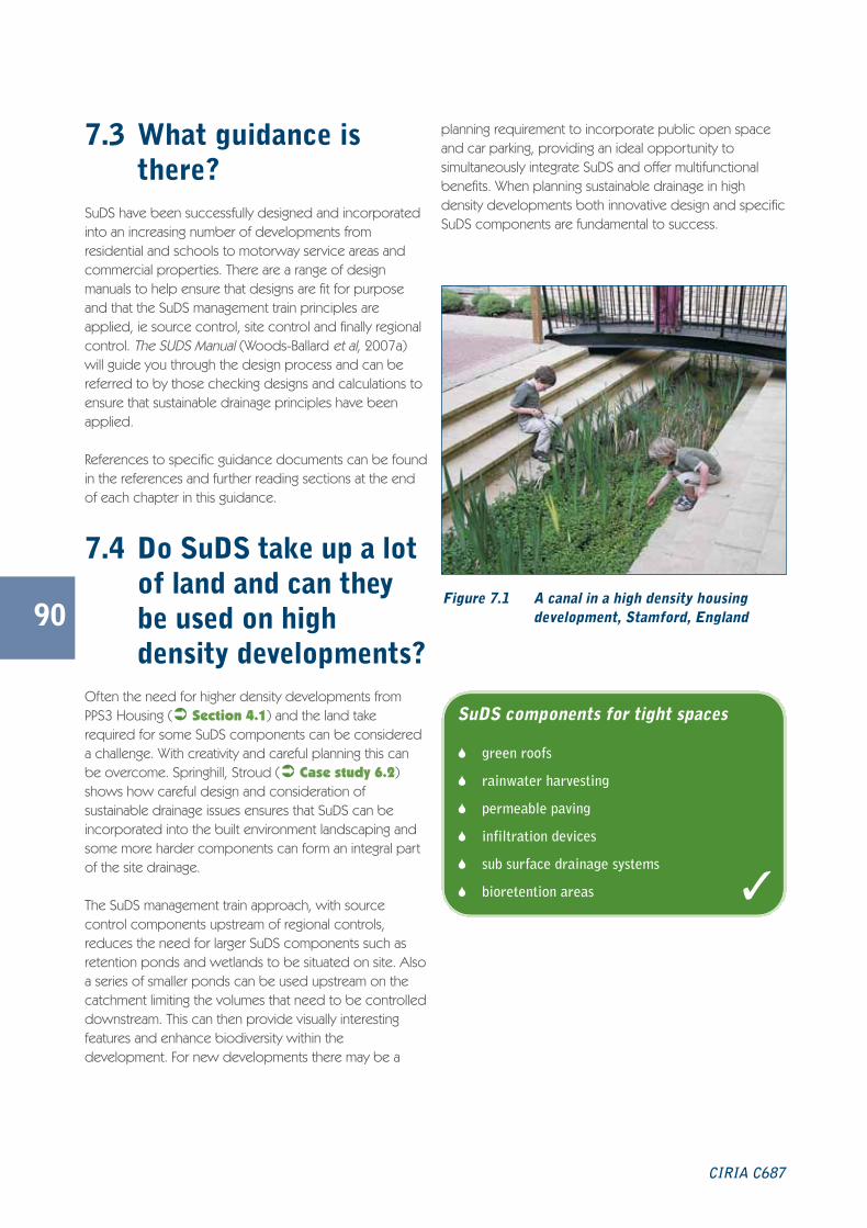
7.3 What guidance isthere?
SuDS have been successfully designed and incorporatedinto an increasing number of developments fromresidential and schools to motorway service areas andcommercial properties. There are a range of designmanuals to help ensure that designs are fit for purposeand that the SuDS management train principles areapplied, ie source control, site control and finally regionalcontrol. The SUDS Manual (Woods-Ballard et al, 2007a)will guide you through the design process and can bereferred to by those checking designs and calculations toensure that sustainable drainage principles have beenapplied.
References to specific guidance documents can be foundin the references and further reading sections at the endof each chapter in this guidance.
7.4 Do SuDS take up a lotof land and can theybe used on highdensity developments?
Often the need for higher density developments fromPPS3 Housing (� Section 4.1) and the land takerequired for some SuDS components can be considereda challenge. With creativity and careful planning this canbe overcome. Springhill, Stroud (� Case study 6.2)shows how careful design and consideration ofsustainable drainage issues ensures that SuDS can beincorporated into the built environment landscaping andsome more harder components can form an integral partof the site drainage.
The SuDS management train approach, with sourcecontrol components upstream of regional controls,reduces the need for larger SuDS components such asretention ponds and wetlands to be situated on site. Alsoa series of smaller ponds can be used upstream on thecatchment limiting the volumes that need to be controlleddownstream. This can then provide visually interestingfeatures and enhance biodiversity within thedevelopment. For new developments there may be a
planning requirement to incorporate public open spaceand car parking, providing an ideal opportunity tosimultaneously integrate SuDS and offer multifunctionalbenefits. When planning sustainable drainage in highdensity developments both innovative design and specificSuDS components are fundamental to success.
90
CIRIA C687
Figure 7.1 A canal in a high density housingdevelopment, Stamford, England
SuDS components for tight spaces
� green roofs
� rainwater harvesting
� permeable paving
� infiltration devices
� sub surface drainage systems
� bioretention areas �
C687 Planning for SuDS:C687 SuDS guide 04/11/2010 10:45 Page 90

may re-mobilise pollutants in the ground. However,components that store or convey water on the surfaceare likely to be more suitable. Ground investigationinformation will indicate that components are applicableto the local conditions, and it might be that certain partsof the development can use infiltration if there is no risk ofpollution.
Using liners to prevent infiltration into the underlyingground will enable the use of swales, wetlands, pondsand permeable paving on sites. As SuDS tend to beshallow there will be less disruption to any contaminatedground as can happen when installing traditional pipeddrainage, eg where a contaminated site has been capped,trenches for piped systems can break through this layer,potentially re-mobilising contaminants. Also, traditionalsystems can provide a pathway for contaminants via thepipe surround. SuDS may provide a pathway, but above-ground systems will quickly show if this is occurring andSuDS may offer some water quality improvements ifpolluted. Traditional drainage systems will not.
SuDS can reduce the effect on watercourses, which mayhave been historically polluted, by improving the qualityand reducing the rate and volume of runoff. SuDS canprovide biodiversity and habitat opportunities oncontaminated sites through careful and consideratedesign.
SuDS can be used during construction to trap andremove contaminants from development. For example,when a site has been cleared runoff can be rapid andmay contain high levels of silts, sediments and pollutedmaterial.
Components that have permanent open water can beplanted to restrict access, but other features such asdetention basins and swales may have occasional waterabove ground and may need signage to advise the publicof their primary use. Often the permanent waterbodieswill be used as public amenity and so safety fears may beallayed. Effective communication will be vital for mitigatinghealth and safety risks, and this should be established at anearly stage of the planning and design process.
91
Planning for SuDS – making it happen
By careful consideration, and sometimes using innovativesolutions, runoff from urban areas can be removed atsource, while providing supplementary benefits. Similarly,roof runoff can be intercepted and diverted into raingardens or rainwater harvesting systems for reuse.
7.5 Can SuDS be used oncontaminated land?
A common misconception is that SuDS cannot be usedat a contaminated land site that is proposed forredevelopment. When considering sustainable drainagesome components may not be appropriate forcontaminated sites, such as those using infiltration, which
Green roofs (� Table 2.1) allow rainwater to becontrolled as close to source as possible, and researchhas suggested that green roofs reduce annual runoff fromroofs by about 50% (Newton et al, 2007).
Permeable paving or other permeable surfaces canreplace standard impermeable tarmac to reduce theamount of runoff generated by a development.
In some cases, depending on ground conditions,infiltration components (or facilities that allow water tosoak into the ground) (� Table 2.1) can help provideSuDS in high density areas. Bioretention facilities(underdrained landscaped areas) (� Table 2.1) offergood opportunities for water quality improvements,storage, and for amenity. For example in bioretention areasthat would be used as landscaped features in car parks,and in areas where green space would be requiredanyway.
Traffic calming can incorporate SuDS (� Case study4.3), eg using rain gardens to remove road gulleys, andrunoff into the sewerage system, by intercepting highwaysrunoff at source and controlling discharge into theunderlying ground. Examples of this system have beensuccessfully included in Portland, Oregon, whereroadside rain gardens are planted with native species toreduce the width of the road (and the speed of vehicles)and removing runoff from the drainage network.
For guidance on delivering SuDS in smallareas see: Use of SuDS in high densitydevelopments – guidance manual (SR666)(HR Wallingford, 2005)
For guidance on delivering SuDS oncontaminated land see: SuDS Advice note– brownfield sites (SEPA, 2003)
C687 Planning for SuDS:C687 SuDS guide 04/11/2010 10:45 Page 91

92
CIRIA C687
7.6 Are SuDS safe?There are many ways to reduce the chances of accidentsin and around sustainable drainage schemes. Withappropriate design these risks can be minimisedparticularly if components are visible and successfullyintegrated into the public. It is recommended that openwater components incorporate barrier planting (usuallydensely planted marginal vegetation and/or thorny plantsto restrict access) and gently inclined side slopes.Options include the design of banks for ponds andswales with a maximum of a 1 in 4 slope and the depthsof ponds and wetlands should be kept to a minimum,with the maximum depth of water being located awayfrom the edges. Often, information signs are useddemonstrating the benefits of sustainable drainage.Educating the public how the SuDS scheme works andthe risks is a vital part of involving the community.
7.7 How can the issue ofadoption be solved?
Adoption is still considered one of the main barriers toSuDS even though most SuDS are simple to look after,often using standard landscape gardening techniques. It isimportant that early discussions take place betweenstakeholders to resolve this issue as early as possible. Theapproval process with the National Standards will enablethis to happen and provide a framework for adoptingSuDS.
As discussed in Section 6.2 there are examples andmechanisms where adoption has been resolved.
Figure 7.2 SuDS interpretation board,Cambridgeshire, England
Figure 7.3 SuDS rill at a school, Exeter, England
C687 Planning for SuDS:C687 SuDS guide 04/11/2010 10:45 Page 92

93
7.8 Can SuDS beretrofitted?
Retrofitting SuDS can help address existing capacity anddrainage problems, in terms of pollutant reduction andflow control. They are likely to be used more extensively inthe future, as existing sewers continue to struggle withdevelopment and changing climatic conditions.
The example of The Dings, Bristol (� Case study 4.3)demonstrates how retrofit projects can be used toaddress water quality and quantity issues, but can be usedto improve the quality of life in an area. The case studydemonstrates that opportunities exist in regeneration areas
to deliver the multiple benefits of SuDS and that the issueof adoption can be resolved (� Case study 7.4).
Careful consideration to retrofitting SuDS may be neededto ensure that they are incorporated into the existingurban form, this has been successfully achieved in Malmo,Sweden (� Figures 1.5, 2.5, 2.6 and 7.5). There areexamples of SuDS retrofits into highways to form trafficcalming, by reducing the road width and removing existinggulleys (for example in Portland, USA and Auckland, NewZealand). Permeable paving can be installed in car parksand low trafficked areas and runoff from individualbuildings can be removed from the public seweragesystem by disconnecting downspouts from pipeddrainage systems and diverting runoff into rain gardens orsoakaways.
Planning for SuDS – making it happen
Figure 7.4
The Dings before andafter, Bristol, England
Figure 7.5
Retrofitting SuDS,Malmo, Sweden
C687 Planning for SuDS:C687 SuDS guide 04/11/2010 10:45 Page 93

7.9 References and further readingUK WATER INDUSTRY RESEARCH LTD (UKWIR) (2009) Performance and whole life costs of best management practicesand SuDS. UKWIR, London
KELLAGHER, R (2005) Use of SuDS in high density developments. Science Report SR666, HR Wallingford, Oxfordshire
NEWTON, J, GEDGE, G, EARLY, P and WILSON, S (2007) Building Greener. Guidance on the use of green roofs, greenwalls and complementary features on buildings. C644, CIRIA, London (ISBN: 978-0-86017-644-2)
SUSTAINABLE URBAN DRAINAGE SCOTTISH WORKING PARTY (SuDSWP) (2003) SuDS advice note – brownfield sites.SEPA, Stirling, Scotland
94
CIRIA C687
C687 Planning for SuDS:C687 SuDS guide 04/11/2010 10:45 Page 94

Glossary8
95
Amenity The quality of place being pleasant or attractive, ie agreeableness. A feature thatincreases attractiveness or value, especially of a piece of real estate or a geographiclocation.
Attenuation Reduction of peak flow and increased duration of a flow event.
Basin A ground depression acting as a flow control or water treatment structure that isnormally dry and has a proper outfall, but is designed to detain stormwatertemporarily.
Biodiversity The diversity of plant and animal life in a particular habitat.
Bioretention area A depressed landscaping area that is allowed to collect runoff so it percolatesthrough the soil below the area into an underdrain promoting pollutant removal.
Brownfield site A site that has been previously developed.
Catchment The area contributing surface water flow to a point on a drainage or river system.Can be divided into sub-catchments.
Combined sewer A sewer designed to carry foul sewage and surface runoff in the same pipe.
Contaminated ground Ground that has the presence of such substances that, when present in sufficientquantities or concentrations, is likely to have detrimental effects on potential targets.
Conventional drainage The traditional method of draining surface water using subsurface pipes and storagetanks.
Conveyance Movement of water from one location to another.
Construction (Design and Emphasise the importance of addressing construction health and safety issues at thedesign Management) (CDM) phase of a construction project.Regulations 2007
Culvert A closed channel carrying a watercourse beneath an obstruction such as a road,railway or canal.
Curtilage An area of land around a building or group of buildings for the private use of theoccupants of the buildings.
Design and access statement Formal documents explaining the design philosophy behind a planning application.
Design codes These are defined as detailed design guidance, which is stricter and more exactthan other guidance.
Design criteria A set of standards agreed by the developer, planners, and regulators that theproposed system should satisfy.
Design statement In the context of a planning application, a written statement to a local authorityprepared by an applicant setting out the design principles adopted in relation to aproposed design for a site and its wider context.
Planning for SuDS – making it happen
C687 Planning for SuDS:C687 SuDS guide 04/11/2010 10:45 Page 95

96
Designing for exceedance An approach that aims to manage exceedance flows during rainfall events, eg usingcar parks during extreme events.
Detention basin A vegetated depression that is normally dry except following storm events.Constructed to store water temporarily to attenuate flows, and may allow infiltrationof water to the ground.
Detention pond/tank A pond or tank that has a lower outflow than inflow. Often used to preventflooding.
Diffuse pollution Pollution arising from land-use activities (urban and rural) that are dispersed across acatchment, or sub-catchment, and do not arise as a process effluent, municipalsewage effluent, or an effluent discharge from farm buildings.
Ecology All living things, such as trees, flowering plants, insects, birds and mammals, andtheir habitats.
Ecosystem A biological community of interacting organisms, and their physical environment.
Ecosystem services Services provided by the natural environment that benefit people.
Environment Both the natural environment (air, land, water resources, plant, and animal life) andhabitats.
Environmental regulators These include the Environment Agency in England and Wales, the ScottishEnvironment Protection Agency in Scotland.
Erosion The group of natural processes, including weathering, dissolution, abrasion,corrosion, and transportation, by which material is worn away from the Earth’ssurface.
Evapotranspiration The process that the Earth’s surface or soil loses moisture by evaporation of waterand by use of and transpiration from plants.
Filter drain A linear drain consisting of a trench filled with a permeable material, often with aperforated pipe in the base of the trench to assist drainage.
Filter strip A vegetated area of gently sloping ground designed to drain water evenly offimpermeable areas and to filter out silt and other particulates.
Filtration Removing sediment or other particles from a fluid by passing it through a filter.
Flood routing Design and consideration of above-ground areas that act as pathways permittingwater to run safely over land to minimise the adverse effect of flooding. This isrequired when the design capacity of the drainage system has been exceeded.
Flood and Water Legislation to clarify the framework for managing flood risk (particularly surface waterManagement Act 2010 management) in England and Wales.
Flora The plants found in a particular physical environment.
Forebay A small basin or pond upstream of the main drainage component with the functionof trapping sediment.
Geocellular structure A plastic box structure used in the ground, often to attenuate runoff.
Green infrastructure A strategically planned and delivered network of high quality green spaces andother environmental features (often including water features).
Green roof A roof with plants growing on its surface, which contributes to local biodiversity.The vegetated surface provides a degree of retention, attenuation and treatment ofrainwater, and promotes evapotranspiration. Sometimes referred to as an alternativeroof.
CIRIA C687
C687 Planning for SuDS:C687 SuDS guide 04/11/2010 10:45 Page 96

97
Groundwater Water that is below the surface of ground in the saturation zone.
Habitat The area or environment where an organism or ecological community normally livesor occurs.
Highways Agency The government agency responsible for strategic highways in England, ie motorwaysand trunk roads.
Highways authority A local authority with responsibility for the maintenance and drainage of highwaysmaintainable at public expense.
Impermeable Will not allow water to pass through it.
Impermeable surface An artificial non-porous surface that generates a surface water runoff after rainfall.
Infiltration (to the ground) The passage of surface water into the ground.
Infiltration basin A dry basin designed to promote infiltration of surface water to the ground.
Infiltration trench A trench, usually filled with permeable granular material, designed to promoteinfiltration of surface water to the ground.
Local development A non-statutory term used to describe a folder of documents that includes all theframework (LDF) local planning authority’s local development documents (LDDs). The LDF will
comprise the statement of community involvement, the local development schemeand the annual monitoring report.
Master plan A master plan includes both the process by which organisations undertake analysisand prepare strategies, and the proposals that are needed to plan for major changein a defined physical area.
National Standards for Referred to as the National Standards. A regulatory document providing standardsSustainable Drainage and guidance on the design, construction and maintenance of SuDS for approval
and adoption by the SuDS approval body.
Non-wholesome water Water not suitable for drinking and has the same meaning as in Part G of Schedule 1to the Building Regulations 2000 (SI 2531) (as amended).
Pathway The route by which potential contaminants may reach targets.
Pavement The road or car park surface and underlying structure, usually asphalt, concrete, orblock paving. Note that the path next to the road for pedestrians is known as thefootway.
Permeability A measure of the ease that a fluid can flow through a porous medium. It dependson the physical properties of the medium, for example, grain size, porosity, andpore shape.
Permeable pavement A permeable surface that is paved and drains through voids between solid parts ofthe pavement.
Permeable surface A surface that is formed of material that is itself impervious to water but, by virtue ofvoids formed through the surface, allows infiltration of water to the sub-basethrough the pattern of voids, for example concrete block paving.
Pollution A change in the physical, chemical, radiological, or biological quality of a resource(air, water or land) caused by human/human activities that is injurious to existing,intended, or potential uses of the resource.
Pond Permanently wet depression designed to retain stormwater above the permanentpool and permit settlement of suspended solids and biological removal ofpollutants.
Planning for SuDS – making it happen
C687 Planning for SuDS:C687 SuDS guide 04/11/2010 10:45 Page 97

98
Porous paving A permeable surface that drains through voids that are integral to the pavement.
Potable/mains water Water company/utility/authority drinking water supply.
Prevention Site design and management to stop or reduce the occurrence of pollution ofimpermeable surfaces and to reduce the volume of runoff by reducingimpermeable areas.
Public realm Public space between private buildings including pavements, streets, squares, parks
Public sewer Has the same meaning as given by paragraph 219(1) of the Water Industry Act1991. A sewer that is vested and maintained by the sewerage undertaker.
Rainwater butt Small scale garden water storage device that collects rainwater from the roof via thedrainpipe.
Rainwater harvesting or A system that collects rainwater from where it falls rather than allowing it to drainrainwater use system away. It includes water that is collected within the boundaries of a property, from
roofs and surrounding surfaces.
Recharge The addition of water to the groundwater system by natural or artificial processes.
Regional control Management of runoff from a site or several sites, typically in a balancing pond orwetland.
Retention pond A pond where runoff is detained for a sufficient time to allow settlement andbiological treatment of some pollutants.
Risk The chance of an adverse event. The combination of the probability of thatpotential hazard being realised, the severity of the outcome if it is, and the numbersof people exposed to the hazard.
Risk assessment “A carefully considered judgement” requiring an evaluation of the consequencesthat may arise from the hazards identified, combining the various factorscontributing to the risk and then evaluating their significance.
Rill Open surface water channels with hard edges.
Runoff Water flow over the ground surface to the drainage system. This occurs if theground is impermeable, is saturated or rainfall is particularly intense.
Section 38 An agreement entered into pursuant to Section 38 Highways Act 1980 where away that has been constructed or that is to be constructed becomes a highwaymaintainable at the public expense. A publicly maintainable highway may includeprovision for drainage of the highway (drainage of highways is defined in Section100 (9) of the Highways Act 1980).
Section 106 Town and A section of the Act that allows a planning obligation to a local planning authority toCountry Planning Act 1990 be legally binding.
Sewerage undertaker This is a collective term relating to the statutory undertaking of water companies thatare responsible for sewerage and sewage disposal including surface water fromroofs and yards of premises.
Site control Management of water in a local area or site, eg routing water from building roofsand car parks to a large soakaway, infiltration or detention basin.
Soakaway A sub-surface structure into which surface water is conveyed, and designed topromote infiltration.
Source control The control of runoff at or near its source (normally within the cartilage of aproperty).
CIRIA C687
C687 Planning for SuDS:C687 SuDS guide 04/11/2010 10:45 Page 98
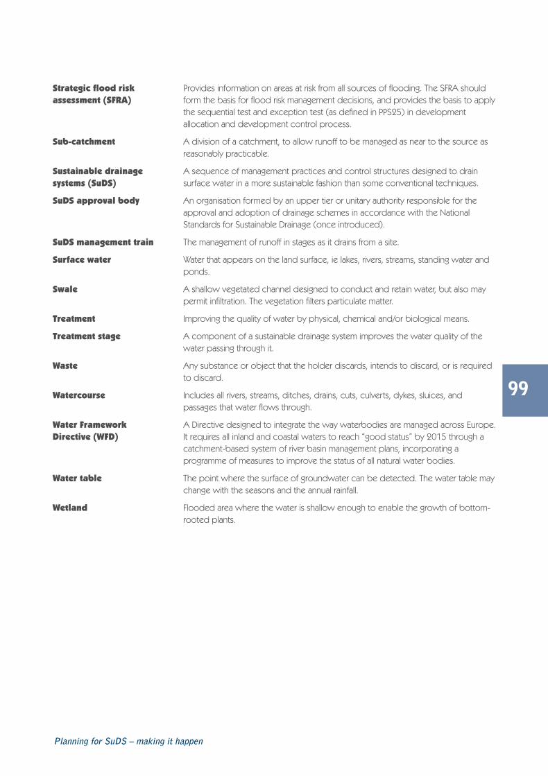
99
Strategic flood risk Provides information on areas at risk from all sources of flooding. The SFRA shouldassessment (SFRA) form the basis for flood risk management decisions, and provides the basis to apply
the sequential test and exception test (as defined in PPS25) in developmentallocation and development control process.
Sub-catchment A division of a catchment, to allow runoff to be managed as near to the source asreasonably practicable.
Sustainable drainage A sequence of management practices and control structures designed to drainsystems (SuDS) surface water in a more sustainable fashion than some conventional techniques.
SuDS approval body An organisation formed by an upper tier or unitary authority responsible for theapproval and adoption of drainage schemes in accordance with the NationalStandards for Sustainable Drainage (once introduced).
SuDS management train The management of runoff in stages as it drains from a site.
Surface water Water that appears on the land surface, ie lakes, rivers, streams, standing water andponds.
Swale A shallow vegetated channel designed to conduct and retain water, but also maypermit infiltration. The vegetation filters particulate matter.
Treatment Improving the quality of water by physical, chemical and/or biological means.
Treatment stage A component of a sustainable drainage system improves the water quality of thewater passing through it.
Waste Any substance or object that the holder discards, intends to discard, or is requiredto discard.
Watercourse Includes all rivers, streams, ditches, drains, cuts, culverts, dykes, sluices, andpassages that water flows through.
Water Framework A Directive designed to integrate the way waterbodies are managed across Europe.Directive (WFD) It requires all inland and coastal waters to reach “good status” by 2015 through a
catchment-based system of river basin management plans, incorporating aprogramme of measures to improve the status of all natural water bodies.
Water table The point where the surface of groundwater can be detected. The water table maychange with the seasons and the annual rainfall.
Wetland Flooded area where the water is shallow enough to enable the growth of bottom-rooted plants.
Planning for SuDS – making it happen
C687 Planning for SuDS:C687 SuDS guide 04/11/2010 10:45 Page 99

100
CIRIA C687
C687 Planning for SuDS:C687 SuDS guide 04/11/2010 10:45 Page 100
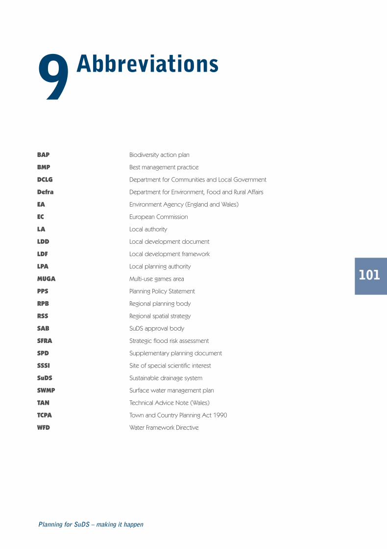
Abbreviations9
101
BAP Biodiversity action plan
BMP Best management practice
DCLG Department for Communities and Local Government
Defra Department for Environment, Food and Rural Affairs
EA Environment Agency (England and Wales)
EC European Commission
LA Local authority
LDD Local development document
LDF Local development framework
LPA Local planning authority
MUGA Multi-use games area
PPS Planning Policy Statement
RPB Regional planning body
RSS Regional spatial strategy
SAB SuDS approval body
SFRA Strategic flood risk assessment
SPD Supplementary planning document
SSSI Site of special scientific interest
SuDS Sustainable drainage system
SWMP Surface water management plan
TAN Technical Advice Note (Wales)
TCPA Town and Country Planning Act 1990
WFD Water Framework Directive
Planning for SuDS – making it happen
C687 Planning for SuDS:C687 SuDS guide 04/11/2010 10:45 Page 101

102
CIRIA C687
C687 Planning for SuDS:C687 SuDS guide 04/11/2010 10:45 Page 102