planning proposal local government area: name of planning proposal… · 2020-03-11 · planning...
TRANSCRIPT
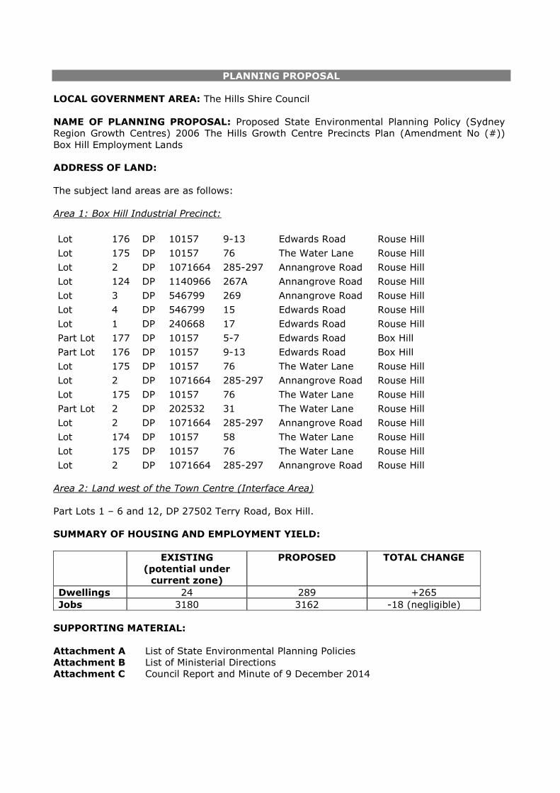
PLANNING PROPOSAL
LOCAL GOVERNMENT AREA: The Hills Shire Council
NAME OF PLANNING PROPOSAL: Proposed State Environmental Planning Policy (Sydney
Region Growth Centres) 2006 The Hills Growth Centre Precincts Plan (Amendment No (#))
Box Hill Employment Lands
ADDRESS OF LAND:
The subject land areas are as follows:
Area 1: Box Hill Industrial Precinct:
Lot 176 DP 10157 9-13 Edwards Road Rouse Hill
Lot 175 DP 10157 76 The Water Lane Rouse Hill
Lot 2 DP 1071664 285-297 Annangrove Road Rouse Hill
Lot 124 DP 1140966 267A Annangrove Road Rouse Hill
Lot 3 DP 546799 269 Annangrove Road Rouse Hill
Lot 4 DP 546799 15 Edwards Road Rouse Hill
Lot 1 DP 240668 17 Edwards Road Rouse Hill
Part Lot 177 DP 10157 5-7 Edwards Road Box Hill
Part Lot 176 DP 10157 9-13 Edwards Road Box Hill
Lot 175 DP 10157 76 The Water Lane Rouse Hill
Lot 2 DP 1071664 285-297 Annangrove Road Rouse Hill
Lot 175 DP 10157 76 The Water Lane Rouse Hill
Part Lot 2 DP 202532 31 The Water Lane Rouse Hill
Lot 2 DP 1071664 285-297 Annangrove Road Rouse Hill
Lot 174 DP 10157 58 The Water Lane Rouse Hill
Lot 175 DP 10157 76 The Water Lane Rouse Hill
Lot 2 DP 1071664 285-297 Annangrove Road Rouse Hill
Area 2: Land west of the Town Centre (Interface Area)
Part Lots 1 – 6 and 12, DP 27502 Terry Road, Box Hill.
SUMMARY OF HOUSING AND EMPLOYMENT YIELD:
EXISTING
(potential under
current zone)
PROPOSED TOTAL CHANGE
Dwellings 24 289 +265
Jobs 3180 3162 -18 (negligible)
SUPPORTING MATERIAL:
Attachment A List of State Environmental Planning Policies
Attachment B List of Ministerial Directions
Attachment C
Council Report and Minute of 9 December 2014

THE SITE:
The land which is the subject to the amendment is the existing Box Hill Industrial Precinct
(Area 1) which is generally located along the south-eastern boundary of the Precinct adjoining
Annangrove Road. The proposed amendment also applies to land to the west of Box Hill town
centre, along Terry Road (Area 2) which is currently zoned B6 Enterprise Corridor.
Figure 1: Site Areas
BACKGROUND:
Box Hill and Box Hill Industrial Precincts were rezoned for urban development on 5 April 2013
under State Environmental Planning Policy (Sydney Region Growth Centres) 2006 Amendment
(The Hills Growth Centres Precincts). The final precinct plan (Figure 2) zoned 133ha of
Employment lands including approximately 53ha of Light Industrial Land along Annangrove
Road, extending to Box Road to the west and Edwards Road to the North.
Area 1
Area 2

Figure 2: Box Hill and Box Hill Industrial Precincts Indicative Layout Plan (December 2012)
Since the notification of the release area a review of planning framework for the Box Hill
Industrial Precinct has been undertaken by The Hills Shire Council.
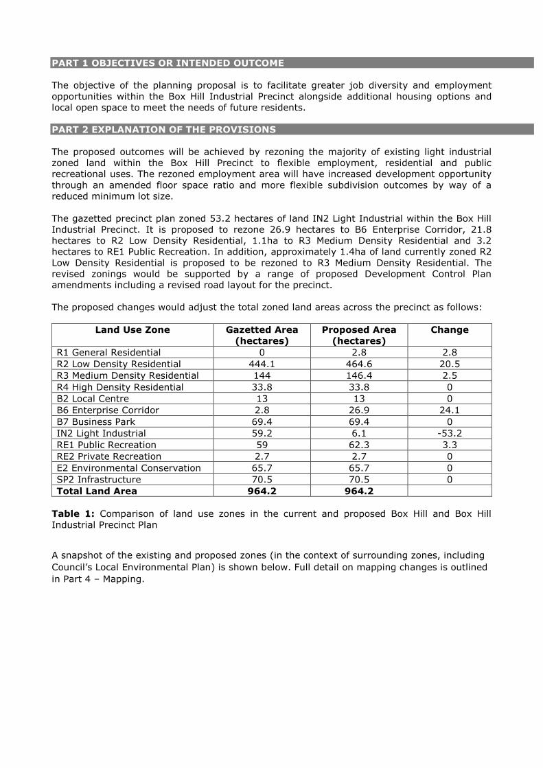
PART 1 OBJECTIVES OR INTENDED OUTCOME
The objective of the planning proposal is to facilitate greater job diversity and employment
opportunities within the Box Hill Industrial Precinct alongside additional housing options and
local open space to meet the needs of future residents.
PART 2 EXPLANATION OF THE PROVISIONS
The proposed outcomes will be achieved by rezoning the majority of existing light industrial
zoned land within the Box Hill Precinct to flexible employment, residential and public
recreational uses. The rezoned employment area will have increased development opportunity
through an amended floor space ratio and more flexible subdivision outcomes by way of a
reduced minimum lot size.
The gazetted precinct plan zoned 53.2 hectares of land IN2 Light Industrial within the Box Hill
Industrial Precinct. It is proposed to rezone 26.9 hectares to B6 Enterprise Corridor, 21.8
hectares to R2 Low Density Residential, 1.1ha to R3 Medium Density Residential and 3.2
hectares to RE1 Public Recreation. In addition, approximately 1.4ha of land currently zoned R2
Low Density Residential is proposed to be rezoned to R3 Medium Density Residential. The
revised zonings would be supported by a range of proposed Development Control Plan
amendments including a revised road layout for the precinct.
The proposed changes would adjust the total zoned land areas across the precinct as follows:
Land Use Zone Gazetted Area
(hectares)
Proposed Area
(hectares)
Change
R1 General Residential 0 2.8 2.8
R2 Low Density Residential 444.1 464.6 20.5
R3 Medium Density Residential 144 146.4 2.5
R4 High Density Residential 33.8 33.8 0
B2 Local Centre 13 13 0
B6 Enterprise Corridor 2.8 26.9 24.1
B7 Business Park 69.4 69.4 0
IN2 Light Industrial 59.2 6.1 -53.2
RE1 Public Recreation 59 62.3 3.3
RE2 Private Recreation 2.7 2.7 0
E2 Environmental Conservation 65.7 65.7 0
SP2 Infrastructure 70.5 70.5 0
Total Land Area 964.2 964.2
Table 1: Comparison of land use zones in the current and proposed Box Hill and Box Hill
Industrial Precinct Plan
A snapshot of the existing and proposed zones (in the context of surrounding zones, including
Council’s Local Environmental Plan) is shown below. Full detail on mapping changes is outlined
in Part 4 – Mapping.

Figure 3: Existing Land Zoning Map – Area 1 – Box Hill Industrial
Figure 4: Proposed Land Zoning Map – Area 1 – Box Hill Industrial

Figure 5: Existing Land Zoning Map – Area 2 – Box Hill Town Centre
Figure 6: Proposed Land Zoning Map – Area 2 – Box Hill Town Centre

To support the proposed zones a revised road layout for Area 1 is proposed. This would be
progressed as part of revised development controls for the precinct.
Figure 7: Area 1 – Box Hill Industrial proposed revised road layout
Employment Provisions Explanation
The planning proposal seeks to rezone 26.9 hectares of land currently zoned IN2 Light
Industrial to B6 Enterprise Corridor. The purpose of the rezoning is to ensure the future
resilience and versatility of the precinct as an employment area and to enable it to better
adapt to the changing nature of industry.
The proposed B6 Enterprise Corridor Zone will retain future opportunities for light industrial
and urban support functions within the precinct whilst providing additional development
opportunities through business and office floor space. It is also proposed to reduce the
minimum subdivision lot size from 8,000m2 to 4,000m2 and apply an increased floor space
ratio of 1:1.
The approach being pursued through the planning proposal will open the precinct to a wider
segment of the industrial market by amending the zone and development standards which
currently apply to the precinct. This will result in a different type of industrial product and
subdivision pattern from what has traditionally been offered within the Shire’s other industrial
areas and will facilitate smaller developments that suit niche industries who do not have access
to capital to develop large multi-unit complexes and who require less restrictive strata by-laws
to operate their business.
Whilst the extent of the employment land will reduce as a result of the rezoning, the
employment capacity of the Precinct will be maintained given there will be an increase in the
maximum floor space ratio potential and higher job densities associated with the increased
commercial and business land uses available under the B6 Enterprise Corridor Zone (reduced

from 80m2 per employee to 50m2 per employee). Given the foregoing the employment
capacity is expected to be similar to existing projections. The additional opportunity provided
by the B6 Enterprise Corridor zone will however ensure development in the precinct is viable
and future jobs that are more aligned with the employment needs of incoming residents. Given
light industrial land uses will remain permissible in the proposed zone, the precinct will
continue to support these uses. It is also noted that 6.1 hectares of land zoned IN2 Light
Industrial will remain at the western edge of the Box Hill Precinct, adjacent to Windsor and
Boundary Roads.
As the B6 Enterprise Corridor zone is intended to be used to facilitate employment outcomes
along the employment corridor it is also proposed to delete ‘Shop top housing’ as a permitted
land use within the zone.
Residential Provisions Explanation
As future employment outcomes can be accommodated within a reduced land area it is
appropriate to consider other uses which may meet wider objectives within the Precinct. Given
the strategic importance to provide for increased housing delivery and diversity, a range of
residential outcomes are proposed. It is therefore proposed that 2.18 hectares of land
currently zoned IN2 Light Industrial is rezoned to R2 Low Density Residential. In addition it is
proposed to rezone 1.4 hectares of land currently zoned R2 Low Density Residential to R3
Medium Density Residential.
The proposed residential zones would result in approximately 289 dwellings or 965 additional
people which would increase the projected population within the Box Hill Precinct from 27,998
to 28,963 people.
The proposed zoning scheme has been established to minimise the potential impact on
adjoining land uses and to facilitate logical zone boundaries within this portion of the Precinct.
Land zoned R3 Medium Density Residential has been restricted to the areas adjoining the open
spaces to improve the opportunities for passive surveillance. The remaining residential land is
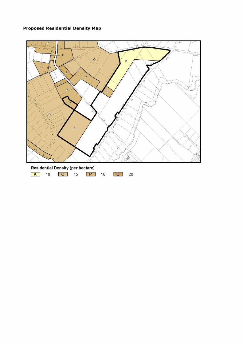
proposed to be zoned R2 Low Density Residential with a minimum dwelling density of 15
dwellings/ha for land south of The Water Lane.
In order to provide for appropriate transition across densities within the precinct and to ensure
a diverse range of housing outcomes can be provided, a 700m2 minimum subdivision lot size
and 10 dwellings/ha dwelling density is proposed for the R2 Low Density Residential land north
of The Water Lane. For dual occupancies in this location it is proposed to amend the written
instrument of the SEPP (Clause 4.1A (4)) to specify a 700m2 minimum land size.
Given a primarily detached, low density outcome is sought in this area it is proposed to amend
the written instrument of the SEPP to specify a prohibitive minimum land size of 2,000m2 for a
semi-attached dwelling for land with a 10 dwellings/ha dwelling density under clause 4.1A (5).
It is also proposed to insert an additional clause under 4.1AA (relating to Approval Pathway A2
Subdivision with Building Envelope Plans) outing the clause does not apply to land if the
dwelling density (per hectare) in relation to the land is 10.
For building heights it is proposed to amend the Height of Buildings Map to apply a 14 metre
height limit to the land zoned R3 Medium Density Residential and an 8.5 metre height limit to
the land zoned R2 Low Density Residential, consistent with the standards of adjoining R2 and
R3 zoned land.
Town Centre Interface Area Provisions Explanation
Given the intention to apply the B6 Enterprise Corridor to employment land within the Box Hill
Industrial Precinct, it is proposed to rezone the existing strip of land which is currently zoned
B6 Enterprise Corridor, adjoining the Box Hill Town Centre to R1 General Residential. The R1
General Residential zone is used elsewhere in the Shire for land adjacent to town centres that
have an ancillary business/higher density residential character, such as on the fringe of
Baulkham Hills and Castle Hill town centres. The B6 zone is generally not considered
appropriate in this context as it contains mandated land uses that have the potential to impact

on residential amenity such as light industries, landscaping material supplies, passenger
transport facilities, and warehouse and distribution centres. In this regard, the R1 General
Residential zone is considered to be more appropriate to facilitate the future desired outcomes
and character for land west of the future Box Hill Town Centre.
The objectives and permissibility of land uses within the R1 zone are proposed to be consistent
with Council’s Local Environmental Plan 2012. As the B6 Enterprise Corridor zone is intended
to be used to facilitate employment outcomes along the employment corridor it is also
proposed to delete ‘Shop top housing’ as a permitted land use within the B6 Enterprise
Corridor Zone.
Recreational Infrastructure Provision (Active and Passive Open Space) Provisions Explanation
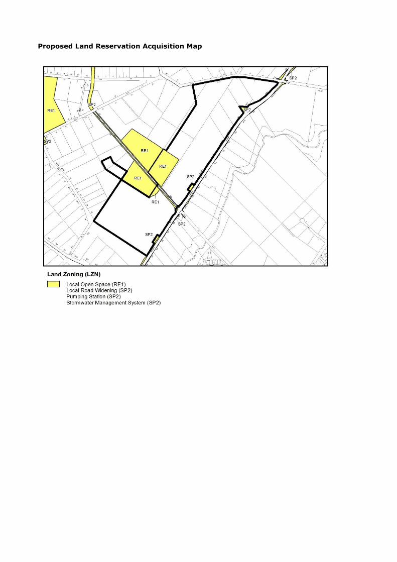
Given the increased residential yield it is necessary to ensure appropriate level of open space
to support the recreational needs of the population. Accordingly, as part of this proposal it is
proposed to rezone an additional 3.2 hectares of land for open space comprising of 3 ha for
one (1) additional playing field and 2,000 m2 for passive open space. For this land it is
proposed to apply the RE1 Public Recreation zone with a Local Open Space Classification and
identify Council as the relevant acquisition authority.
The figure overleaf shows the zoning and road layout for the precinct inclusive of the proposed
amendments:

Figure 8: Box Hill and Box Hill Industrial Precincts - proposed zones and road layout
Should a Gateway Determination be issued for the proposal it is recommended the Indicative
Layout Plan for the precinct be updated as a draft to reflect the proposed revised zonings,
recreation provision and road layout.
SECTION A - NEED FOR THE PLANNING PROPOSAL
1. Is the planning proposal a result of any strategic study or report?
The planning proposal is the outcome of a strategic review of The Box Hill Industrial Precinct,
undertaken by the Hills Shire Council since the notification of the release area. The outcomes
of the review were reported to Council on 9 December 2014.
2. Is the planning proposal the best means of achieving the objectives or intended outcomes,
or is there a better way?
Yes, the planning proposal is considered to be the best way to achieve the intended outcomes
for the subject land.
Within The Hills Shire there is an increasing need to provide versatile employment lands that
reflect the nature trends within the workforce. Additional flexibility provided by the B6
Enterprise Corridor zone will provide wider opportunity for emerging industries and innovative
local businesses as well as traditional urban support functions.
The proposed changes will improve the employment capacity of the area and result in a more
efficient land use planning response to the delivery of new job growth. As light industrial land
uses will remain permitted in the zone the proposal would not reduce opportunities for the
development of land for such purposes. The proposed prohibition of ‘shop top housing’ will
remove potential for land use conflict and ensure future development is focused on
employment delivery.
As future employment outcomes can be accommodated within a reduced land area, it is
appropriate to consider other uses which may meet wider objectives within the Precinct. Given
the strategic importance to provide for increased housing delivery and diversity, a range of
residential outcomes are proposed. These include low to medium density residential options to
ensure housing choice and affordability outcomes.
The rezoning of the town centre interface area to R1 General Residential will better meet the
land use and character objectives for this area by removing land uses which have the potential
to impact on residential amenity in the context of higher densities.
The proposed residential zoning scheme has been established to minimise the potential impact
on adjoining land uses and to facilitate logical zone boundaries within this portion of the
Precinct. Land zoned R3 Medium Density Residential has been restricted to the areas adjoining
the open spaces to improve the opportunities for passive surveillance. The remaining
residential land is proposed to be zoned R2 Low Density Residential with a minimum dwelling
density of 15 dwellings/ha for land south of The Water Lane and 10 dwellings/ha with a
minimum lot subdivision lot size of 700m2 for land north of The Water Lane.
The increase in dwelling yield requires adjustment of the amount open space to meet the
needs the new community. It is noted that there is already an under provision of open space
within the Box Hill Precinct under the current contributions plan with a rate of provision of only
2.12 hectares per 1,000 persons (below the standard benchmark of 2.83 hectares per 1,000
persons as contained within the Growth Centres Development Code). As such, the additional
residential population will not only increase demand for open space infrastructure but also
potentially exacerbate the existing shortfall within the precinct. Accordingly, as part of this
proposal it is proposed to rezone an additional 3.2 hectares of land for open space comprising
of 3 ha for one (1) additional playing field and 2,000 m2 for passive open space. These
additional open space facilities will increase the rate of provision of open space from 2.12
hectares per 1,000 persons to 2.16 hectares per 1,000 persons and the associated land
acquisition and embellishment costs should be included within the contributions plan. It is
anticipated that the additional residential population will largely offset the additional costs to
be included within the contributions plan and the contribution rate is unlikely to change
substantially as a result.
SECTION B - RELATIONSHIP TO STRATEGIC PLANNING FRAMEWORK
3. Is the planning proposal consistent with the objectives and actions contained within the
applicable regional or sub-regional strategy (including the Sydney Metropolitan Strategy
and exhibited draft strategies)?
Yes, a discussion of consistency is provided below.
A Plan for Growing Sydney
A Plan for Growing Sydney replaces the Metropolitan Plan for Sydney 2036 and seeks to make
Sydney ‘a strong global city, a great place to live’. The planning proposal is consistent with
and will contribute to achieving the following ‘Goals’ outlined in the growth plan for Sydney:
Goal 1: A Competitive economy with world-class services and transport
Goal 2: A city of housing choice, with homes that meet our needs and lifestyles
Goal 3: A great place to live with communities that are strong, healthy and well
connected
Goal 4: A sustainable and resilient city that protects the natural environment and has a
balanced approach to the use of land and resources.
The planning proposal will diversify employment opportunities and provide greater capacity for
emerging industries without reducing the employment capacity of the precinct. This will help
to ensure the ongoing viability of the precinct in the face of economic trends and ensure jobs
are tailored to the needs of the local and regional workforce. Additionally, the proposal will
provide greater housing supply and choice with an additional 289 dwellings in a range of low
and medium densities. The additional employment and housing capacity afforded by the
proposal will help to achieve a key aim of the plan to provide more jobs closer to homes.
Action 1.9.2 – Support key industrial precincts with appropriate planning controls says the
Industrial Lands Strategic Assessment Checklist will guide the assessment of proposed
rezonings of industrial lands. It will pose questions regarding whether an industrial site is near
or within direct access to key economic infrastructure, how it contributes to a significant
industry cluster, and how the proposed rezoning would impact on industrial land stocks and
employment objectives in each subregion.
The proposed employment area is considered to be well situated being within close proximity
to the Rouse Hill Major Centre, the proposed North West Rail Link, the North Kellyville Precinct
to the south-east, and the Annangrove Road Industrial Area (including the Edwards Road
Precinct which is also zoned B6 Enterprise Corridor). The precinct will significantly benefit from
the delivery of key economic infrastructure such as the North West Rail Link and the District
and Regional bus routes proposed as part of the planning for the North West Growth Centre.
These transport links will ensure that the precinct is well connected to the surrounding
residential areas and strategic centres.
As part of the planning for the Box Hill and Box Hill Industrial Precinct, the Department of
Planning and Environment engaged Hill PDA to prepare a retail and employment to forecast the
demand and supply of employment land within the Precinct. One of the key findings of the
Assessment was that by 2036 there would be demand for 492.6 hectares of industrial land and
112.3 hectares of business land within the Statistical Areas of Hawkesbury, Baulkham Hills
(North) and Blacktown (North). Following a comparison of the forecast demand and the
existing/proposed supply of industrial and business zoned land, it was identified that there was
an oversupply of both forms of employment land. A map extract of the Statistical Areas used
by Hill PDA in the assessment of the needs of business and industrial land is included below.
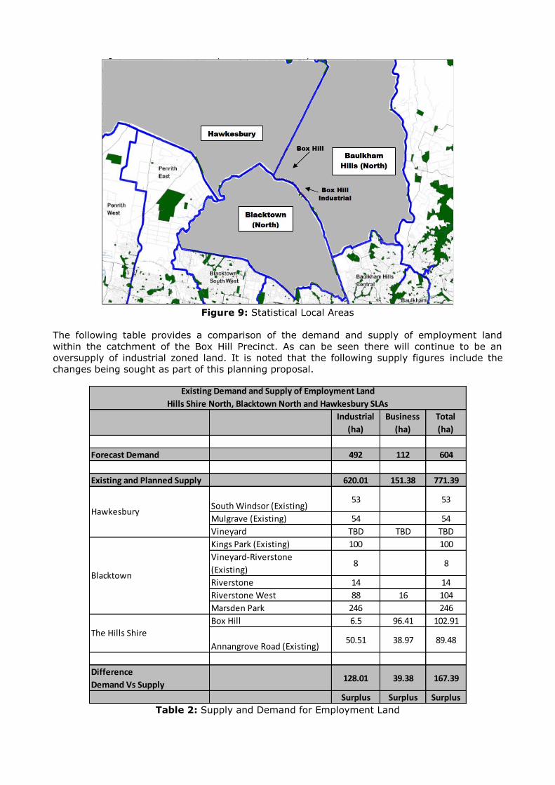
Figure 9: Statistical Local Areas
The following table provides a comparison of the demand and supply of employment land
within the catchment of the Box Hill Precinct. As can be seen there will continue to be an
oversupply of industrial zoned land. It is noted that the following supply figures include the
changes being sought as part of this planning proposal.
Table 2: Supply and Demand for Employment Land
Industrial
(ha)
Business
(ha)
Total
(ha)
Forecast Demand 492 112 604
Existing and Planned Supply 620.01 151.38 771.39
South Windsor (Existing)53 53
Mulgrave (Existing) 54 54
Vineyard TBD TBD TBD
Kings Park (Existing) 100 100
Vineyard-Riverstone
(Existing)8 8
Riverstone 14 14
Riverstone West 88 16 104
Marsden Park 246 246
Box Hill 6.5 96.41 102.91
Annangrove Road (Existing)50.51 38.97 89.48
Difference
Demand Vs Supply128.01 39.38 167.39
Surplus Surplus Surplus
Blacktown
The Hills Shire
Existing Demand and Supply of Employment Land
Hills Shire North, Blacktown North and Hawkesbury SLAs
Hawkesbury

As can be seen from the above table, there is considered to be significant supply of land within
the North West Growth Centre to cater the future regional demand for more traditional
industrial land. Notwithstanding this, light industrial uses will continue to be permitted
through the B6 Enterprise Corridor zone. The planning proposal will make the employment
area more flexible by permitting a wider range of employment uses.
The Department of Planning and Environment has noted within its Employment Lands
Development Program Update Report 2014 that there has recently been a strong tendency for
the rezoning of industrial land to business zones as a measure to make these areas more
versatile for future employment uses.
Whilst the extent of the employment land will reduce as a result of the rezoning, the
employment capacity of the Precinct will be maintained given there will be an increase in the
maximum floor space ratio potential and higher job densities associated with the increased
commercial and business land uses available under the B6 Enterprise Corridor Zone (reduced
from 80m2 per employee to 50m2 per employee). In recognition of the flexibility of the B6
Enterprise Corridor zone, the projected job creation within the employment area is expected to
be similar to the current job growth.
Draft North West Subregional Strategy
The draft North West Subregional Strategy was prepared by the NSW Government to
implement the Metropolitan Plan and the State Plan. The draft strategy plans to accommodate
some 130,000 jobs and 140,000 dwellings within the North West Subregion by 2031. Of
these, 47,000 jobs (36%) and 36,000 dwellings (26%) are to be accommodated within The
Hills Shire. An overarching theme of the strategy is for dwelling and employment growth to be
concentrated within centres and near to public transport hubs.
Employment areas currently employ around a quarter of the region’s workforce and for this
reason the planning of these areas is essential in ensuring that the Sydney Metropolitan
economy remains efficient and competitive. In this regarding the rezoning of part of the IN2
Light Industrial zone to B6 Enterprise Corridor will be consistent with the Strategy as the
employment capacity of the precinct will be maintained.
With respect to the provision of housing, the proposal will facilitate the delivery of 289
additional dwellings within a 30 minute commute of major centres such as Norwest, Rouse Hill,
Castle Hill and the future Box Hill Business Park. These new dwellings will contribute to the
dwelling targets of The Hills Shire and the broader Region.
North West Growth Centre Structure Plan
The proposal will further meet the wider vision and objectives for the development of the Box
Hill Precinct and the North West Growth Centre generally. The proposal will better provide for
economically viable development within the precinct alongside the delivery of a wider range of
employment opportunities to meet both local and regional demand. Additionally the proposal
will create additional opportunities for the development of a variety of housing types, and new
open spaces to meet the recreation needs of the future population.
4. Is the planning proposal consistent with the local council’s Community Strategic Plan, or
other local strategic plan?
Yes, a discussion of consistency is provided below.
The Hills Future Community Strategic Plan
The Hills Future Community Strategic Direction articulates The Hills Shire community’s and
Council’s shared vision, values, aspirations and priorities with reference to other local
government plans, information and resourcing capabilities. It is a direction that creates a
picture of where the Hills would like to be in the future. The direction is based on community
aspirations gathered throughout months of community engagement and consultation with
members of the community. The planning proposal is considered to be consistent with the
following key outcomes:

Balanced Urban Growth – (7) Responsible planning facilitates a desirable living
environment and meets growth targets;
Modern Local Economy - (10) Our Shire is the vibrant key business centre in the region.
Draft Local Strategy
In 2008 Council adopted its Local Strategy to provide the basis for the future direction of land
use planning in the Shire and within this context implement the key themes and outcomes of
the ‘Hills 2026 Looking Toward the Future’. The Residential, Integrated Transport, Centres and
Employment Lands Directions are the relevant components of the Local Strategy to be
considered in assessing this application.
Residential Direction
Council’s Residential Direction was adopted on 10 June 2008 and aims to provide an additional
36,000 dwellings by 2031 for the Shire. The Direction also seeks to provide for a diversity of
housing choice, well located housing close to services and infrastructure, a built environment
that reflects the “garden shire‟ image and the development of communities that offer a sense
of place and community connection. The ultimate goal is to create housing options that
promote sustainable economic, environmental and social outcomes for the residents of the
Shire. The subject planning proposal seeks to rezone land that will provide an additional 289
residential dwellings which would be consistent with the following key directions:
R1 Accommodate population growth;
R2 Respond to changing housing needs; and
R4 Facilitate quality housing outcomes.
Integrated Transport Direction
Council’s Integrated Transport Direction commenced in May 2010 and provides an overall
strategic context for the planning and management of transport within the Shire. The Direction
provides a package of solutions to provide greater connectivity between key destinations and
to ensure that residents and workers can get where they need to go with a range of integrated
travel options. The Direction is underpinned by five key directions which are to:
Plan and manage the Shire's transport network to meet community needs;
Facilitate delivery of a cohesive transport network;
Promote and enhance sustainable travel choices;
Plan for an integrated transport network for new areas; and
Encourage quality transport outcomes.
Future development will have access to District bus Route 3 and the Regional route along the
Water Lane and District Bus Route 1 along Edwards Road. These transport links will ensure
that future development within this portion of the precinct is well serviced by public transport
services which will provide links to the surrounding residential areas and strategic centres.
Centres Direction
During the planning for the Box Hill and Box Hill Industrial Precinct, particular concern was
raised by Council in relation to the proposed B6 Enterprise Corridor zone adjoining the
proposed centre along Terry Road. Whilst the zone provides for a range of employment and
residential uses, land uses which are mandated as permitted with consent could have the
potential to impact on residential amenity including light industries, landscaping material
supplies, passenger transport facilities, and warehouse and distribution centres. Such uses are
not considered to provide an appropriate transition to higher density residential areas.
The objectives of the R1 General Residential zone are:
• To provide for the housing needs of the community.
• To provide for a variety of housing types and densities.
• To enable other land uses that provide facilities or services to meet the day to day
needs of residents.

• To enable other land uses that support the adjoining or nearby commercial centres
and protect the amenity of the adjoining or nearby residential areas.
The approach being pursued is consistent with Action 5.1.1 of the Centres Direction which
requires Council to have an active role in the planning and implementation of centres in
Growth Centre Precincts. Additionally, Action 3.2.1 of the Centres Direction seeks to improve
the permeability and legibility of centres. By applying the R1 General Residential zone to the
land adjoining the proposed centre along Terry Road, will facilitate development which will
provide a more appropriate commercial transition between the retail centre and adjacent
residential uses.
Employment Lands Direction
The North West Subregional Strategy establishes an employment capacity target for the Shire
from 2001 to 2031 of 47,000 jobs. The Employment Lands Direction demonstrates that there
is capacity to meet this target with capacity for 55,574 additional jobs to 2031. In addition to
the contribution towards anticipated employment targets, the Direction seeks to provide
employment close to home, services and transport infrastructure.
By pursuing a B6 Enterprise Corridor zone at this location, it will improve the versatility of this
employment area and will increase employment opportunities by catering for a wider variety of
employment land uses. By doing so the planning proposal will assist in achieving the following
key objectives within the Employment Lands Direction:
E1 - Ensure that planning and future development provides for employment generation
opportunities.
E2 - Promote the Shire’s competitive strengths to attract new business.
5. Is the planning proposal consistent with applicable State Environmental Planning Policies?
Yes. An assessment of the planning proposal against applicable State Environmental Planning
Policies is provided in Attachment A. A discussion on the consistency of the proposal with the
relevant Policies is provided below.
State Environmental Planning Policy No 55 Remediation of Land
This Policy aims to promote the remediation of contaminated land for the purpose of reducing
the risk of harm to human health or any other aspect of the environment by:
(a) specifying when consent is required, and when it is not required, for a remediation
work;
(b) specifying certain considerations that are relevant in rezoning land and in determining
development applications in general and development applications for consent to carry
out a remediation work in particular; and
(c) requiring that remediation work meet certain standards and notification requirements.
The Policy requires a planning authority to consider the possibility that a previous land use has
caused contamination of the site as well as the potential risk to health or the environment from
that contamination.
As part of the planning for the broader Box Hill and Box Hill Industrial Precincts, a Land
Capability, Salinity and Contamination Assessment was undertaken by WSP Environment and
Energy. With respect to contamination the Assessment provided the following:
‘The likelihood of contamination is linked to the previous and existing use of the land.
However, the limited sampling undertaken across the Precincts did not result in any
definitive link between current and known past land uses and evidence of contamination.
Whilst contamination is not necessarily in existence for all land uses the information below
provides an indication of the potential contamination for different land uses:

Potential contamination from residential houses on rural allotments may exist
relating to asbestos containing materials from buildings, lead from paint,
hydrocarbons and other organic chemicals from storage of chemicals and petrol
onsite and vehicle maintenance, and potential contamination around farm dams.
Soil contamination was identified with elevated concentrations of total petroleum
hydrocarbons associated with fuel storage and vehicle maintenance and elevated
concentrations of lead associated with residential buildings.
Rural commercial and rural industry areas may have potential contamination in the
form of contaminated material, scrap metal and other building materials, drums and
chemical storages, underground and above ground storage tanks.
The key potential contaminants on rural residential lots relate to asbestos in soils,
oils storage associated with maintenance sheds and potential for contaminated fill
around farm dams and drainage and creek lines. Market garden activities may have
left residual chemicals in the soils and areas of cultivation may have pesticide and
heavy metal contamination’.
In accordance with the findings and recommendations of the assessment, development
controls relating to contamination were included within the Development Control Plan. The
controls require that for all proposed development, a Stage 1 – Preliminary Site Contamination
Investigation is required with a Stage 2 assessment required where a Stage 1 report identifies
that a site could potentially be contaminated. The Development Control Plan also required an
assessment for asbestos on all properties prior to residential development.
For the reasons outlined above the proposal is considered to satisfactorily address the
requirements of SEPP 55 Remediation of Land for the current phase of the proposal’s
assessment.
State Environmental Planning Policy (Sydney Region Growth Centres) 2006
The SEPP provides for the coordinated release of land for residential, employment and other
urban development in the North West and South West growth centres of the Sydney Region (in
conjunction with Environmental Planning and Assessment Regulation relating to precinct
planning). The Box Hill and Box Hill Industrial Precinct is zoned under the SEPP and forms part
of the North West Growth Centre. The aims of the SEPP are as follows:
(a) To co-ordinate the release of land for residential, employment and other urban
development in the North West and South West growth centres of the Sydney
Region;
(b) To enable the Minister from time to time to designate land in those growth centres as
ready for release for development;
(c) To provide for comprehensive planning for those growth centres;
(d) To enable the establishment of vibrant, sustainable and liveable neighbourhoods that
provide for community well-being and high quality local amenity;
(e) To provide controls for the sustainability of land in those growth centres that has
conservation value;
(f) To provide for the orderly and economic provision of infrastructure in and to those
growth centres;
(g) To provide development controls in order to protect the health of the waterways in
those growth centres;
(h) To protect and enhance land with natural and cultural heritage value; and
(i) To provide land use and development controls that will contribute to the conservation
of biodiversity.
The proposal will further meet the wider vision and objectives for the development of the Box
Hill Precinct and the North West Growth Centre generally. The proposal will better provide for
economically viable development within the precinct alongside the delivery of a wider range of
employment opportunities to meet both local and regional demand. Additionally the proposal
will create additional opportunities for the development of a variety of housing types, and new
open spaces to meet the recreation needs of the future population. Accordingly, it is

considered that the planning proposal, along with the amendments to the Development Control
Plan and Contributions Plan, will assist in achieving the aims of the SEPP.
State Environmental Planning Policy (Infrastructure) 2007
The key objective of the Policy is to assist in facilitating the delivery of infrastructure by
introducing consistent planning regime which provides greater certainty regarding the planning
provisions applying to infrastructure projects across NSW. The planning proposal does not
contradict or repeat any provision within the Policy. Any future development within the precinct
will need to be in accordance with the provisions of the Policy.
SREP No 20 Hawkesbury-Nepean River
The aim of SREP No 20 (No. 2 − 1997) is to protect the environment of the Hawkesbury −
Nepean River system by ensuring that the impacts of future land uses are considered in a
regional context. This requires consideration of the impacts of the development on the
environment, the feasibility of alternatives and consideration of specific matters such as
environmentally sensitive areas, water quality, water quantity, flora and fauna, riverine scenic
quality, agriculture, and metropolitan strategy.
Appropriate controls apply to ensure that future development does not adversely impact the
riverine environment. Accordingly, it is considered that the planning proposal achieves
satisfactory compliance with the provisions of SREP No 20 (No. 2 − 1997).
6. Is the planning proposal consistent with applicable Ministerial Directions (s.117 directions)?
Yes. The consistency of the planning proposal with the s.117 Ministerial Directions is detailed
within Attachment B. A discussion on the consistency of the proposal with each relevant
Direction is provided below.
Direction 1.1 Business and Industrial Zones
The objective of this direction is to encourage employment growth, protect employment lands
and support the viability of strategic centres.
A key objective of the planning proposal is to ensure the viable development of the
employment lands within the Box Hill Industrial Precinct. The planning proposal seeks to
ensure that the future resilience and versatility of the precinct as an employment area. The
proposal is therefore consistent with the underpinning objectives of the Direction.
Whilst the extent of the employment land will reduce as a result of the rezoning, the
employment capacity of the Precinct will be maintained given there will be an increase in the
maximum floor space ratio potential and higher job densities associated with the increased
commercial and business land uses available under the B6 Enterprise Corridor Zone (reduced
from 80m2 per employee to 50m2 per employee). Therefore, in recognition of the flexibility of
the B6 Enterprise Corridor zone, the projected job creation within the employment area is
expected to be similar to the current job growth.
Given the foregoing, any possible inconsistency with the Direction is considered justified.
Direction 2.3 Heritage Conservation
The Direction aims to conserve items, areas, objects and places of environmental heritage
significance and indigenous heritage significance. The Direction sets out that a planning
proposal must contain provisions that facilitate the conservation of environmental heritage.
Adjacent to the subject area, No.58 The Water Lane contains a heritage item known as The
Hunting Lodge which is listed as an item of State Significance in Schedule 5 of the SEPP. The
Hunting Lodge has both architectural and historic significance. It is State significant for its
associations with early farms at Rouse Hill, Box Hill and Copenhagen Farm and for its possible
association with S.H.Terry. It is also significant for its rarity as a 19th century hunting lodge
and its associated elements including gothic/baronial design follies and the remains of a
surrounding moat.

Figure 10: View of the Hunting Lodge north from the Water Lane
Figure 11: State Heritage Listing curtilage
Special area controls for the Hunting Lodge are contained within The Box Hill Development
Control Plan. The objectives of the controls are:
a) To conserve and protect the heritage significance of The Hunting Lodge
b) To protect and enhance the heritage curtilage of The Hunting Lodge
c) To ensure that the development around The Hunting Lodge respects the heritage value
of the building
d) To encourage the maintenance of the Hunting Lodge through an appropriate use
The DCP contains a Precinct Plan Control area for the Hunting Lodge which identifies curtilages
and controls for surrounding development.
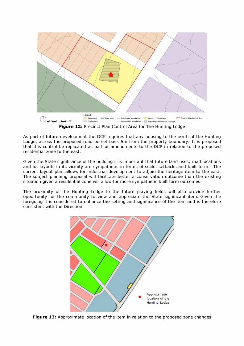
Figure 12: Precinct Plan Control Area for The Hunting Lodge
As part of future development the DCP requires that any housing to the north of the Hunting
Lodge, across the proposed road be set back 5m from the property boundary. It is proposed
that this control be replicated as part of amendments to the DCP in relation to the proposed
residential zone to the east.
Given the State significance of the building it is important that future land uses, road locations
and lot layouts in its vicinity are sympathetic in terms of scale, setbacks and built form. The
current layout plan allows for industrial development to adjoin the heritage item to the east.
The subject planning proposal will facilitate better a conservation outcome than the existing
situation given a residential zone will allow for more sympathetic built form outcomes.
The proximity of the Hunting Lodge to the future playing fields will also provide further
opportunity for the community to view and appreciate the State significant item. Given the
foregoing it is considered to enhance the setting and significance of the item and is therefore
consistent with the Direction.
Figure 13: Approximate location of the item in relation to the proposed zone changes
Direction 3.1 Residential Zones
The planning proposal provides for an approximately 289 residential dwellings within the Box
Hill Precinct and will assist in the meeting of State Government dwelling targets. The proposed
zoning and density standards will facilitate a mix of housing options including low to medium
density lots. The majority of the land will have the opportunity of utilising recent changes to
the planning framework for the growth centres in relation to smaller lots and approval
pathways.
In order to provide a variety of lot sizes and housing choice it is however proposed that the
revised zonings also provide for a portion of new allotments with a larger minimum lot size of
700m2. The proposed framework therefore encourages variety and choice in housing types for
future residents of the Precinct and is consistent with the Direction.
Direction 3.4 Integrated Land Use Transport
The subject areas considered to be well situated being within close proximity to the Rouse Hill
Major Centre and future release areas in the Blacktown LGA. The precinct will benefit from the
delivery of the North West Rail Link (with good access to both Rouse Hill and Cudgegong Road
Stations) and the District and Regional bus routes proposed as part of the planning for the
North West Growth Centre.
An expansion of business uses in the south of the precinct will ensure a greater range of
employment opportunities for local residents and will also provide additional urban services to
meet the needs of residents and workers in these areas.
Additional residential capacity in the north of the precinct will be suitably located adjacent to a
future local centre and open space land. This will reduce required travel distances to access
these vital services encouraging walking and cycling as key transport modes for the Box Hill
Precinct. This residential land will also be located in close proximity to the planned business
park thereby increasing residential densities close to employment.
Given the above, the proposed amendments will assist the precinct to achieve a high level of
public transport use, cycling and walking and is therefore consistent with the Direction.
Direction 4.4 Planning for Bushfire Protection
The Direction requires that planning proposals have regard to Planning for Bushfire Protection
Guideline 2006, introduce controls that avoid placing inappropriate developments in hazardous
areas, and ensure that bushfire hazard reduction is not prohibited within the Asset Protection
Zone.
A small portion of the land to be zoned B6 Enterprise Corridor is classified as bushfire prone
land (Category 1) – Buffer Zone as shown below. Accordingly, any future development of this
land may require the establishment of the Asset Protection Zones (APZs) and the preparation
of a bushfire report.

Figure 14: Bushfire Prone Land Map
The Direction also requires that Council undertake consultation with the Commissioner of the
NSW Rural Fire Service following receipt of a Gateway Determination under section 56 of the
Environmental Planning and Assessment Act 1979 (EP&A Act), and prior to undertaking
community consultation in satisfaction of section 57 of the EP&A Act. Council will need to take
into consideration any comments received as part of this consultation.
Direction 6.1 - Approval and Referral Requirements
The planning proposal is consistent with this direction since it does not include provisions
requiring the concurrence or referral of future applications to a Minister or public authority.
Direction 6.2 – Reserving Land for a Public Purpose
The planning proposal intends to reserve 3.3ha of land for local open space purposes. The Hills
Shire Council is the intended acquisition authority. The proposal is consistent with the
objectives of the Direction subject to the approval of the Director General of the Department.
Direction 6.3 Site Specific Requirements
The proposal does not contain any unnecessarily restrictive site specific planning controls and
is therefore consistent with the Direction.
Direction 7.1 Implementation of the Metropolitan Plan for Sydney 2036
The strategic plan prepared by the NSW Government titled the Metropolitan Plan for Sydney
2036 aims to integrate land use and transport planning to provide a framework for the growth
and development of the Sydney region to 2036. The planning proposal is consistent with the
strategic directions and key policy settings of the strategy since it will contribute to improved
local employment outcomes and provide housing choice and recreational opportunities for the
future population.

SECTION C - ENVIRONMENTAL, SOCIAL AND ECONOMIC IMPACT
7. Is there any likelihood that critical habitat or threatened species, populations or ecological
communities, or their habitats, will be adversely affected as a result of the proposal?
Biodiversity Certification of the Growth Centres SEPP was granted in December 2007, under
section 126G of the Threatened Species Conservation Act 1995 (TSC Act). Biodiversity
Certification removes the need for further threatened species assessments before developing
land in the ‘Certified Areas’. However, Biodiversity Certification is not an automatic approval
to clear native vegetation, it simply means that in Certified Areas threatened species
assessments are no longer required as part of the submission of a development application, or
when undertaking local and regional infrastructure works.
A patch of Cumberland Plain Woodland within certified lands exists to the east of Box Road.
This patch of vegetation is Biodiversity Certified and no assessment requirements under the
TSC Act would be required as part of any future development application for future
redevelopment of the land.
8. Are there any other likely environmental effects as a result of the planning proposal and
how are they proposed to be managed?
The potential impact of future development on existing heritage items is discussed under
Questions 6 relating to consistency with Direction 2.3 Heritage Conservation. The planning
proposal will not result in any other environmental effects.
9. How has the planning proposal adequately addressed any social and economic effects?
The planning proposal supports the economic and residential growth and future direction
envisaged by the State Government and Council with respect to the urbanisation of the Box
Hill and Box Hill Industrial Precinct.
An analysis of the jobs held by the resident population in The Hills Shire, based on 2011
Census data, shows the three most popular occupations were:
Professionals (24,539 people or 28.1%);
Clerical and Administrative Workers (15,162 people or 17.4%); and
Managers (15,126 people or 17.3%).
The above occupations accounted for 54,827 of people in total or 62.8% of the employed
resident population. As a comparison, the Greater Sydney Region employed 25.5% in
Professionals, 16.2% in Clerical and Administrative Workers and 13.3% in Managers. The
trend in occupations within The Hills Shire between 2006 and 2011 is included in the following
graph.

Figure 15: Change in occupation of Employment – 2006 to 2011 (profile.id by .id)
Within The Hills Shire there will be greater need to provide versatile employment lands that
reflect the nature trends within the workforce. Additional flexibility will provide wider
opportunity for emerging industries and innovative local businesses as well as traditional urban
support functions. In this context it is important to ensure there is a supply of land that
provides for flexible land uses and can facilitate an appropriate diversity of economic
outcomes.
Whilst the extent of the employment land will reduce as a result of the rezoning, the
employment capacity of the Precinct will be maintained given there will be an increase in the
maximum floor space ratio potential and higher job densities associated with the increased
commercial and business land uses available under the B6 Enterprise Corridor Zone (reduced
from 80m2 per employee to 50m2 per employee). In recognition of the flexibility of the B6
Enterprise Corridor zone, the projected job creation within the employment area is expected to
be similar to the current job growth.
Additionally, as mentioned previously, there is considered to be significant supply within the
North West Growth Centre and West Central Subregion to cater the future regional demand for
more traditional industrial land. Notwithstanding this, light industrial uses will continue to be
permitted through the B6 Enterprise Corridor zone. The planning proposal will make the
employment area more flexible by permitting a wider range of employment uses and will
improve the employment area’s versatility.
SECTION D - STATE AND COMMONWEALTH INTERESTS
10. Is there adequate public infrastructure for the planning proposal?
Potable and Recycled Water
Sydney Water is the sole servicing authority for potable water and recycled water supply to the
Box Hill Precincts. Future development will have access to existing and proposed Trunk
infrastructure proposed as part of the servicing plan for the Box Hill Precinct. Delivery of this
infrastructure will occur in-line with the timeframes proposed by Sydney Water. Consultation
will be required with Sydney Water as part of the exhibition of the planning proposal.
Wastewater
Sydney Water is the sole servicing authority for waste water supply to the Box Hill Precincts.
Future development will have access to existing and proposed Trunk infrastructure proposed as
part of the servicing plan for the Box Hill Precinct. Delivery of this infrastructure will occur in-
line with the timeframes proposed by Sydney Water. Consultation will be required with Sydney
Water as part of the exhibition of the planning proposal.
Natural Gas
There is no existing natural gas reticulation within the Box Hill Precinct. However, the precinct
will benefit from the natural gas infrastructure proposed as part of the broader North West
Growth Centre. Reinforcement of the infrastructure within the area is required to provide
natural gas to the entire 65,000 dwellings and commercial enterprises within the North West
Growth Centre. This will consist of a high pressure feeder pipeline from the Jemena Trunk
Receiving Station located in Industry Road, Vineyard, to the current high pressure network in
Sunnyholt Road. Consultation will be required with Jemena as part of the exhibition of the
planning proposal.
Electricity
As part of the precinct planning process for the Box Hill and Box Hill Industrial Precinct, it was
determined that the supply of electricity can be provided from Mungerie Park for the first three
to five years of development, equating to a maximum of 1,600 residential lots. Endeavour
Energy aims to provide the Box Hill zone substation when development has reached a stage
that cannot be supplied by the existing network. Electricity infrastructure will be delivered in
accordance with Endeavour Energy’s design requirements including 132kV feeders and the
proposed zone substation will be funded by Endeavour Energy. The 22Kv distribution network
and other required infrastructure, including padmount substation, will be funded by developers
including any temporary works. Consultation will be required with Endeavour Energy as part of
the exhibition of the planning proposal.
Local Infrastructure
Contributions Plan 15 – Box Hill Precinct applies to the Box Hill and Box Hill Industrial Precincts
and facilitates the collection of monetary contributions from residential, commercial and
industrial development in order to fund the provision of local infrastructure (water
management, transport management and open space) required to support the urban
development of the precinct.
The proposal will impact on both the underlying assumptions (residential and employment
yield projections) and infrastructure requirements under the Contributions Plan. In particular,
it is noted that the proposed road layout will require an additional roundabout to facilitate safe
and efficient movement of traffic and the additional residential population will generate
demand for additional open space facilities.
With respect to the provision of open space, it is noted that there is already an under provision
of open space under the current contributions plan with a rate of provision of only 2.12
hectares per 1,000 persons (below the standard benchmark of 2.83 hectares per 1,000
persons as contained within the Growth Centres Development Code). As such, the additional
residential population will not only increase demand for open space infrastructure but also
potentially exacerbate the existing shortfall within the precinct. Accordingly, as part of this
proposal it is proposed to rezone an additional 3.2 hectares of land for open space comprising
of 3 ha for one (1) additional playing field and 2,000 m2 for passive open space. These
additional open space facilities will increase the rate of provision of open space from 2.12
hectares per 1,000 persons to 2.16 hectares per 1,000 persons and the associated land
acquisition and embellishment costs should be included within the contributions plan. It is
anticipated that the additional residential population will largely offset the additional costs to
be included within the contributions plan and the contribution rate is unlikely to change
substantially as a result.
The following amendments are proposed to the Contributions Plan in conjunction with the
planning proposal to reflect the proposed increase in the planned future residential population
of the Box Hill Precinct and in order to ensure that an adequate level of service of
infrastructure is provided within the precinct:
Update residential and employment yield projections to reflect the impacts of the planning
proposal (including an increase in residential yield by 965 persons);
Include one (1) additional roundabout required to facilitate safe and efficient movement of
traffic within the proposed new residential area and road network; and
Include land acquisition and embellishment costs for additional open space within the Box
Hill Precinct with a total area of 3.2 hectares. This would facilitate the delivery of one (1)
additional playing field and approximately 2,000 m2 of passive open space.
The above amendments to the contributions plan will be exhibited concurrently with the
planning proposal. Following exhibition, any submissions which are received will be considered
in a further report to Council. The draft Contributions Plan must then be submitted to IPART
for endorsement after which time the Contributions Plan would again be reported to Council for
adoption.
11. What are the views of State and Commonwealth Public Authorities consulted in accordance
with the gateway determination, and have they resulted in any variations to the planning
proposal? (Note: The views of State and Commonwealth Public Authorities will not be
known until after the initial gateway determination. This section of the planning proposal is
completed following consultation with those public authorities identified in the gateway
determination.)
Following the Gateway determination, all relevant agencies will be consulted. A preliminary list
of agencies to be consulted is included below:
Sydney Water Corporation;
TransGrid;
Endeavour Energy;
Office of Environment and Heritage;
Department of Planning and Environment – Office of Strategic Lands;
Roads and Maritime Services;
Transport for NSW;
NSW Rural Fire Services;
Telstra
Jemena; and
Hawkesbury Nepean Catchment Management Authority.

PART 4 MAPPING
The planning proposal seeks to amend the zoning, floor space ratio, minimum subdivision lot
size, height of buildings, residential density and land reservation acquisition maps of State
Environmental Planning Policy (Sydney Region Growth Centres) 2006 in relation to the Hills
Growth Centre Precincts (Box Hill and Box Hill Industrial Precincts).

Existing Zone Map – Area 1- Box Hill Industrial
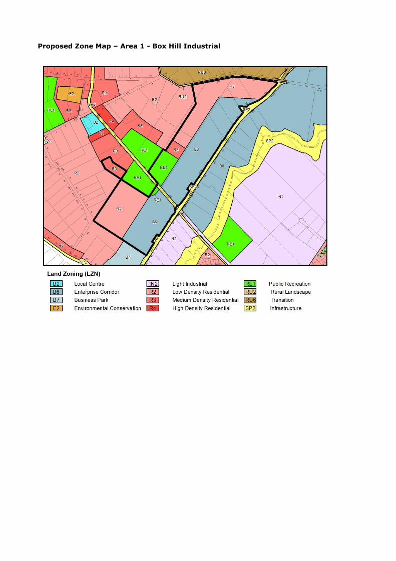
Proposed Zone Map – Area 1 - Box Hill Industrial

Existing Zone Map – Area 2 - Box Hill Town Centre

Proposed Zone Map – Area 2 - Box Hill Town Centre

Existing Floor Space Ratio Map

Proposed Floor Space Ratio Map

Existing Minimum Lot Size Map
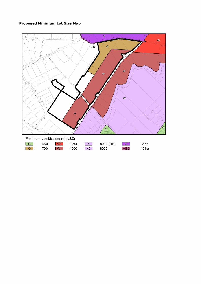
Proposed Minimum Lot Size Map

Existing Height of Buildings Map
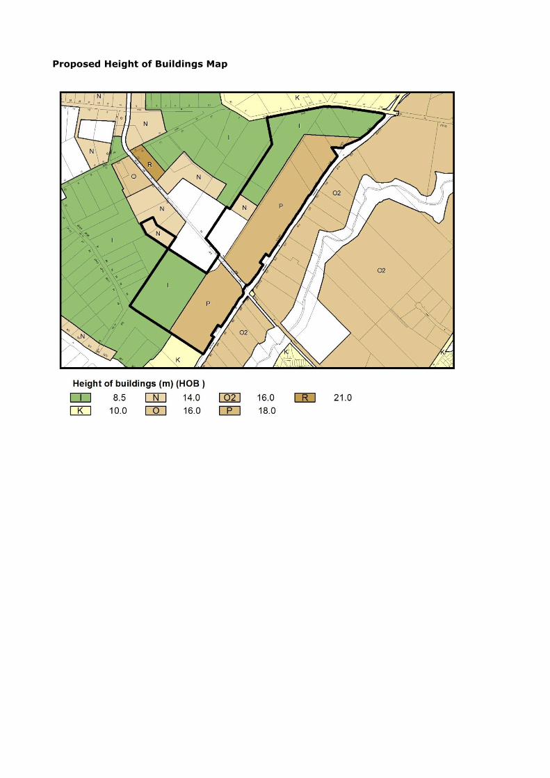
Proposed Height of Buildings Map

Existing Residential Density Map
Proposed Residential Density Map

Existing Land Reservation Acquisition Map
Proposed Land Reservation Acquisition Map
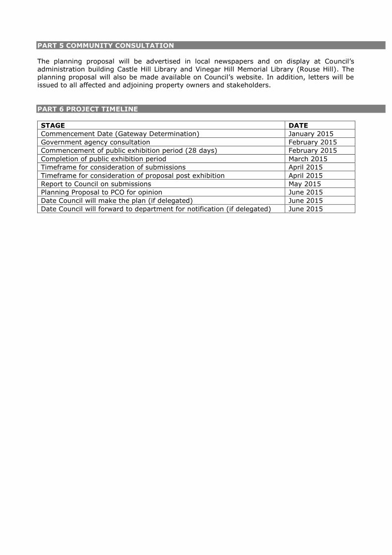
PART 5 COMMUNITY CONSULTATION
The planning proposal will be advertised in local newspapers and on display at Council’s administration building Castle Hill Library and Vinegar Hill Memorial Library (Rouse Hill). The planning proposal will also be made available on Council’s website. In addition, letters will be issued to all affected and adjoining property owners and stakeholders.
PART 6 PROJECT TIMELINE
STAGE DATE
Commencement Date (Gateway Determination) January 2015
Government agency consultation February 2015
Commencement of public exhibition period (28 days) February 2015
Completion of public exhibition period March 2015
Timeframe for consideration of submissions April 2015
Timeframe for consideration of proposal post exhibition April 2015
Report to Council on submissions May 2015
Planning Proposal to PCO for opinion June 2015
Date Council will make the plan (if delegated) June 2015
Date Council will forward to department for notification (if delegated) June 2015
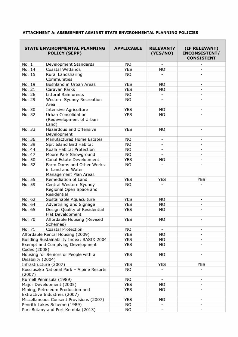
ATTACHMENT A: ASSESSMENT AGAINST STATE ENVIRONMENTAL PLANNING POLICIES
STATE ENVIRONMENTAL PLANNING
POLICY (SEPP)
APPLICABLE RELEVANT?
(YES/NO)
(IF RELEVANT)
INCONSISTENT/
CONSISTENT
No. 1 Development Standards NO - -
No. 14 Coastal Wetlands YES NO -
No. 15 Rural Landsharing
Communities
NO - -
No. 19 Bushland in Urban Areas YES NO -
No. 21 Caravan Parks YES NO -
No. 26 Littoral Rainforests NO - -
No. 29 Western Sydney Recreation
Area
NO - -
No. 30 Intensive Agriculture YES NO -
No. 32 Urban Consolidation
(Redevelopment of Urban
Land)
YES NO -
No. 33 Hazardous and Offensive
Development
YES NO -
No. 36 Manufactured Home Estates NO - -
No. 39 Spit Island Bird Habitat NO - -
No. 44 Koala Habitat Protection NO - -
No. 47 Moore Park Showground NO - -
No. 50 Canal Estate Development YES NO -
No. 52 Farm Dams and Other Works
in Land and Water
Management Plan Areas
NO - -
No. 55 Remediation of Land YES YES YES
No. 59 Central Western Sydney
Regional Open Space and
Residential
NO - -
No. 62 Sustainable Aquaculture YES NO -
No. 64 Advertising and Signage YES NO -
No. 65 Design Quality of Residential
Flat Development
YES NO -
No. 70 Affordable Housing (Revised
Schemes)
YES NO -
No. 71 Coastal Protection NO - -
Affordable Rental Housing (2009) YES NO -
Building Sustainability Index: BASIX 2004 YES NO -
Exempt and Complying Development
Codes (2008)
YES NO -
Housing for Seniors or People with a
Disability (2004)
YES NO -
Infrastructure (2007) YES YES YES
Kosciuszko National Park – Alpine Resorts
(2007)
NO - -
Kurnell Peninsula (1989) NO - -
Major Development (2005) YES NO -
Mining, Petroleum Production and
Extractive Industries (2007)
YES NO -
Miscellaneous Consent Provisions (2007) YES NO -
Penrith Lakes Scheme (1989) NO - -
Port Botany and Port Kembla (2013) NO - -

STATE ENVIRONMENTAL PLANNING
POLICY (SEPP)
APPLICABLE RELEVANT?
(YES/NO)
(IF RELEVANT)
INCONSISTENT/
CONSISTENT
Rural Lands (2008) NO - -
SEPP 53 Transitional Provisions (2011) NO - -
State and Regional Development (2011) YES NO -
Sydney Drinking Water Catchment (2011) NO - -
Sydney Region Growth Centres (2006) YES YES YES
Three Ports (2013) NO - -
Urban Renewal (2010) NO - -
Western Sydney Employment Area (2009) NO - -
Deemed SEPPs
SREP No. 8 (Central Coast Plateau Areas) NO - -
SREP No. 9 – Extractive Industry (No. 2 –
1995)
YES NO -
SREP No. 16 – Walsh Bay NO - -
SREP No. 18 – Public Transport Corridors NO - -
SREP No. 19 – Rouse Hill Development
Area
NO - -
SREP No. 20 – Hawkesbury – Nepean
River (No 2 – 1997)
YES YES YES
SREP No. 24 – Homebush Bay Area NO - -
SREP No. 25 – Orchard Hills NO - -
SREP No. 26 – City West NO - -
SREP No. 30 – St Marys NO - -
SREP No. 33 – Cooks Cove NO - -
SREP (Sydney Harbour Catchment) 2005 NO - -

ATTACHMENT B: ASSESSMENT AGAINST SECTION 117 MINISTERIAL DIRECTIONS
DIRECTION APPLICABLE RELEVANT?
(YES/NO)
(IF RELEVANT)
INCONSISTENT/
CONSISTENT
1. Employment and Resources
1.1 Business and Industrial Zones YES YES CONSISTENT
1.2 Rural Zones NO - -
1.3 Mining, Petroleum Production and
Extractive Industries
NO - -
1.4 Oyster Aquaculture NO - -
1.5 Rural Lands NO - -
2. Environment and Heritage
2.1 Environment Protection Zone NO - -
2.2 Coastal Protection NO - -
2.3 Heritage Conservation YES YES YES
2.4 Recreation Vehicle Area NO - -
3. Housing, Infrastructure and Urban Development
3.1 Residential Zones YES YES CONSISTENT
3.2 Caravan Parks and Manufactured
Home Estates
NO - -
3.3 Home Occupations NO - -
3.4 Integrating Land Use and
Transport
YES
YES
CONSISTENT
3.5 Development Near Licensed
Aerodomes
NO
- -
3.6 Shooting Ranges NO - -
4. Hazard and Risk
4.1 Acid Sulfate Soils NO - -
4.2 Mine Subsidence and Unstable
Land
NO - -
4.3 Flood Prone Land NO - -
4.4 Planning for Bushfire Protection YES YES YES
5. Regional Planning
5.1 Implementation of Regional
Strategies
NO - -
5.2 Sydney Drinking Water Catchment NO - -
5.3 Farmland of State and Regional
Significance on the NSW Far North
Coast
NO - -
5.4 Commercial and Retail
Development along the Pacific
Highway, North Coast
NO - -
5.8 Second Sydney Airport: Badgerys
Creek
NO - -
5.9 North West Rail Link Corridor NO - -

DIRECTION APPLICABLE RELEVANT?
(YES/NO)
(IF RELEVANT)
INCONSISTENT/
CONSISTENT
Strategy
6. Local Plan Making
6.1 Approval and Referral
Requirements
YES YES YES
6.2 Reserving Land for Public Purposes YES YES YES
6.3 Site Specific Provisions YES YES YES
7. Metropolitan Planning
7.1 Implementation of the
Metropolitan Plan for Sydney 2036
YES YES YES
MINUTES of the duly convened Ordinary Meeting of The Hills Shire Council held
in the Council Chambers on 9 December 2014
This is Page 16 of the Minutes of the Ordinary Meeting of The Hills Shire Council
held on 9 December 2014
4. Following the adoption of the Draft Voluntary Planning Agreement, the planning
proposal be progressed to finalisation to amend Local Environmental Plan 2012 in
the following manner:
a. Increase maximum permitted building height from RL 116 metres to RL
143.20 metres;
b. Increase the maximum permitted floor space ratio from 1.49:1 to 2.42:1;
c. Provide for commercial premises, residential flat buildings, building
identification signs and business identifications signs, as additional
permitted uses on that part of the site that is zoned SP2 Infrastructure
(Drainage); and
d. Add a local clause to specify a minimum of 6,000m2 of commercial floor
space to be provided as part of any redevelopment of the land.
5. Amendments to The Hills Development Control Plan 2012 Part B Section 6 –
Business, including post-exhibition amendments, be adopted and come into force
following the notification of the planning proposal.
Being a Planning Matter, the Mayor called for a Division to record the votes on this
matter.
VOTING FOR THE MOTION
Clr A C Jefferies
Clr Dr M R Byrne Adjunct Professor
Clr R K Harty OAM
Clr R A Preston
Clr R M Tracey
VOTING AGAINST THE MOTION
Clr P J Gangemi
Clr A N Haselden
Clr M G Thomas
ABSENT FROM THE ROOM
Clr Y D Keane
Clr M O Taylor
ITEM-3 PLANNING PROPOSAL - BOX HILL PRECINCT
EMPLOYMENT LANDS (6/2014/PLP)
A MOTION WAS MOVED BY COUNCILLOR PRESTON AND SECONDED BY COUNCILLOR DR
BYRNE ADJUNCT PROFESSOR THAT the Recommendation contained in the report be
adopted.
THE MOTION WAS PUT AND CARRIED UNANIMOUSLY.
754 RESOLUTION
1. A planning proposal be forwarded to the Department of Planning and
Environment for a Gateway Determination to rezone land within Box Hill

MINUTES of the duly convened Ordinary Meeting of The Hills Shire Council held
in the Council Chambers on 9 December 2014
This is Page 17 of the Minutes of the Ordinary Meeting of The Hills Shire Council
held on 9 December 2014
Industrial Precinct from IN2 Light Industrial to part B6 Enterprise Corridor, part
R3 Medium Density Residential, part R2 Low Density Residential and part RE1
Public Recreation. The planning proposal would also rezone existing land
adjacent to the future Box Hill Town Centre from B6 Enterprise Corridor to R1
General Residential and remove ‘shop top housing’ as a permitted land use within
the B6 zone
2. Draft amendments to the Box Hill and Box Hill Industrial Development Control
Plan to facilitate the proposal be prepared in relation to road layouts, setbacks
and site coverage. Draft amendments to the Development Control Plan be placed
on public exhibition concurrently with the planning proposal.
3. Draft amendments to Contributions Plan 15 – Box Hill Precinct be prepared to
reflect the future residential population and employment yield of the precinct
resulting from the proposal, increase the planned provision of open space and
include one (1) new roundabout within the proposed new residential area road
network. Draft amendments to the Contributions Plan be placed on public
exhibition concurrently with the planning proposal.
Being a Planning Matter, the Mayor called for a Division to record the votes on this
matter.
VOTING FOR THE MOTION
Clr A C Jefferies
Clr Dr M R Byrne Adjunct Professor
Clr P J Gangemi
Clr R K Harty OAM
Clr A N Haselden
Clr Y D Keane
Clr R A Preston
Clr M G Thomas
Clr R M Tracey
VOTING AGAINST THE MOTION
None
ABSENT FROM THE ROOM
Clr M O Taylor
Councillor Keane, having previously declared a conflict of interest, left the meeting at
8.02pm and took no part in the debate or voting on the following matter – Item 4.
ITEM-4 PLANNING PROPOSAL 2-4 BURBANK PLACE
BAULKHAM HILLS (8/2015/PLP)
A MOTION WAS MOVED BY COUNCILLOR HASELDEN AND SECONDED BY COUNCILLOR
HARTY OAM THAT the Recommendation contained in the report be adopted.
THE MOTION WAS PUT AND CARRIED.

ORDINARY MEETING OF COUNCIL 09 DECEMBER, 2014
PAGE 146
ITEM-3 PLANNING PROPOSAL - BOX HILL PRECINCT EMPLOYMENT LANDS (6/2014/PLP)
THEME: Balanced Urban Growth
OUTCOME: 7 Responsible planning facilitates a desirable living environment and meets growth targets.
STRATEGY: 7.2 Manage new and existing development with a robust framework of policies, plans and processes that is in accordance with community needs and expectations.
GROUP: STRATEGIC PLANNING
AUTHOR: FORWARD PLANNING COORDINATOR
ANNE BANYAI
RESPONSIBLE OFFICER: MANAGER FORWARD PLANNING
STEWART SEALE
EXECUTIVE SUMMARY The planning proposal seeks to rezone approximately 50 hectares of land within the Box Hill Industrial Precinct from IN2 Light Industrial to part B6 Enterprise Corridor, part R3 Medium Density Residential, part R2 Low Density Residential and part RE1 Public Recreation. It is also proposed to rezone existing land adjacent to the future Box Hill Town Centre from B6 Enterprise Corridor to R1 General Residential and remove ‘shop top housing’ as a permitted land use within the B6 zone. The proposal primarily seeks to amend the planning framework for the Box Hill Industrial Precinct to facilitate greater job diversity and employment opportunities to meet the needs of future residents. This would be facilitated by the application of the B6 Enterprise Corridor zone, a minimum lot size of 4,000m2 and a maximum floor space ratio of 1:1 to a reduced employment precinct of approximately 24 hectares focused on the Annangrove Road corridor. The report recommends that a planning proposal to rezone various employment lands within the Box Hill Release Area to higher order employment, residential and public recreation uses be forwarded to the Department of Planning and Environment for Gateway Determination. The planning proposal would amend State Environmental Planning Policy (Sydney Region Growth Centres) 2006 (‘Growth Centres SEPP’), not Local Environmental Plan 2012. APPLICANT Council Initiated STATE ENVIRONMENTAL PLANNING POLICY (SYDNEY REGION GROWTH CENTRES) 2006 AMENDMENT (THE HILLS GROWTH CENTRES PRECINCTS) Zones: IN2 Light Industrial R2 Low Density Residential Minimum Lot Size: 8,000m2 - Maximum Height: 18m 8.5m Maximum Floor Space Ratio: 0.7:1 - Minimum Residential Density 15 dwg per hectare

ORDINARY MEETING OF COUNCIL 09 DECEMBER, 2014
PAGE 147
BACKGROUND Box Hill and Box Hill Industrial Precincts were rezoned for urban development on 5 April 2013 under the State Environmental Planning Policy (Sydney Region Growth Centres) 2006 Amendment (The Hills Growth Centres Precincts). The final precinct plan (Figure 1) zoned 133ha of Employment lands including approximately 53ha of Light Industrial Land along Annangrove Road, extending to Box Road to the west and Edwards Road to the North. During the precinct planning process Council raised concern regarding the excessive amount of industrial land proposed given existing local and regional supply, limited demand and its appropriateness in meeting the employment needs of future residents. The Industrial Area is identified as Area 1 on Figure 1. Similarly, concerns were also raised with regard to the zoning of land to the west of Box Hill Town Centre to B6 Enterprise Corridor given the range of permitted land uses would be incompatible with its function in providing an interface between the town centre and higher density residential uses. The B6 Enterprise Corridor zoned land is identified as Area 2 on Figure 1.
Figure 1
Box Hill and Box Hill Industrial Precinct – Indicative Layout Plan

ORDINARY MEETING OF COUNCIL 09 DECEMBER, 2014
PAGE 148
Notwithstanding the concerns raised by Council, the SEPP was gazetted with the Department suggesting a proposal to amend the SEPP could be prepared to address the specific issues. Since that time, further investigation and review of the scale and extent of industrial land within the precinct has been undertaken. REPORT The purpose of the report is to outline proposed amendments to the planning framework for the Box Hill and Box Hill Industrial Precincts. THE SITE The land which is the subject to the amendment is the existing Box Hill Industrial Precinct (Area 1) which is generally located along the south-eastern boundary of the Precinct adjoining Annangrove Road. The proposed amendment also applies to land to the west of Box Hill town centre (Area 2) which is currently zoned B6 Enterprise Corridor. PLANNING PROPOSAL The planning proposal aims to amend State Environmental Planning Policy (Sydney Region Growth Centres) 2006 (SEPP) to facilitate greater job diversity and employment opportunities to meet the needs of future residents. The Box Hill Industrial Area is currently zoned IN2 Light Industrial and has an area of approximately 53ha. It is proposed that this land be rezoned to part B6 Enterprise Corridor (26.9ha), part RE1 Public Recreation (3.2ha), part R2 Low Density Residential (21.8ha) and part R3 Medium Density Residential (1.1ha). Approximately 1.4ha of land currently zoned R2 Low Density Residential is proposed to be rezoned to R3 Medium Density Residential. It is also proposed that the existing strip of land which is currently zoned B6 Enterprise Corridor, adjoining the Box Hill Town Centre, be rezoned to R1 General Residential. Snapshots of the existing and proposed zoning including annotations to outline the proposed amendment are included below.
Figure 2
Existing Land Zoning Map – Area 1 – Box Hill Industrial
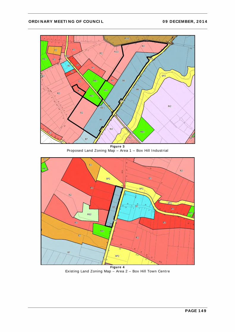
ORDINARY MEETING OF COUNCIL 09 DECEMBER, 2014
PAGE 149
Figure 3
Proposed Land Zoning Map – Area 1 – Box Hill Industrial
Figure 4
Existing Land Zoning Map – Area 2 – Box Hill Town Centre

ORDINARY MEETING OF COUNCIL 09 DECEMBER, 2014
PAGE 150
Figure 5
Proposed Land Zoning Map – Area 2 – Box Hill Town Centre A number of other additional amendments are also required to the development standard maps and written instrument of the SEPP to facilitate the proposed rezoning. These additional amendments are detailed below.
• Amend the Floor Space Ratio Map to apply a floor space ratio of 1:1 to the land zoned B6 Enterprise Corridor;
• Amend the Lot Size Map to apply a minimum lot size of 4,000m2 to the land zoned B6 Enterprise Corridor;
• Amend the Height of Buildings Map to apply a 14 metre height limit to the land zoned R3 Medium Density Residential and an 8.5 metre height limit to the land zoned R2 Low Density Residential, consistent with the standards of adjoining R2 and R3 zoned land;
• Amend the Land Reservation Map to identify the land zoned RE1 Public Recreation. This land will have a Local Open Space (RE1) Classification with Council identified as the relevant acquisition authority;
• Amend the Residential Density Map to apply a residential density of 18 dwellings/ha to the land zoned R3 Medium Density Residential, a residential density of 15 dwellings/ha to the land zoned R2 Low Density Residential (south of The Water Lane) and a residential density of 10 dwellings/ha to the land zoned R2 Low Density Residential (north of The Water Lane);
• Amend the land use table within the SEPP to delete ‘Shop top housing’ as a permitted land use within the B6 Enterprise Corridor Zone and to insert the R1 General Residential Zone. The objectives and permissibility of land uses within the R1 zone is proposed to be consistent with Council’s Local Environmental Plan 2012.
STRATEGIC CONTEXT The planning proposal is consistent within the Sydney Metropolitan Strategy 2031 and the North West Sub-regional Plan as it will facilitate the viable redevelopment within the Box Hill Industrial Precinct by improving the flexibility of the employment land to cater

ORDINARY MEETING OF COUNCIL 09 DECEMBER, 2014
PAGE 151
for a wider range of employment uses. The planning proposal will also facilitate increased dwelling yield to assist Council and the Region in achieving its dwelling targets. ISSUES 1. Employment Land Supply and Demand A modern local economy and the delivery of jobs close to home are key components of Council’s strategic planning framework. The success and viability of employment generating land uses are impacted by a number of local, regional and global trends. An analysis of the jobs held by the resident population in The Hills Shire, based on 2011 Census data, shows the three most popular occupations were:
• Professionals (24,539 people or 28.1%); • Clerical and Administrative Workers (15,162 people or 17.4%); and • Managers (15,126 people or 17.3%).
The above occupations accounted for 54,827 of people in total or 62.8% of the employed resident population. As a comparison, the Greater Sydney Region employed 25.5% in Professionals, 16.2% in Clerical and Administrative Workers and 13.3% in Managers. The trend in occupations within The Hills Shire between 2006 and 2011 is included in the following graph.
Figure 6
Change in occupation of Employment – 2006 to 2011 (profile.id by .id) Within The Hills Shire there will be greater need to provide versatile employment lands that reflect the nature trends within the workforce. Additional flexibility will provide wider opportunity for emerging industries and innovative local businesses as well as traditional urban support functions. In this context it is important to ensure there is a supply of land that provides for flexible land uses and can facilitate an appropriate diversity of economic outcomes. Whilst the extent of the employment land will reduce as a result of the rezoning, the employment capacity of the Precinct will be maintained given there will be an increase in the maximum floor space ratio potential and higher job densities associated with the increased commercial and business land uses available under the B6 Enterprise Corridor Zone (reduced from 80m2 per employee to 50m2 per employee). In recognition of the flexibility of the B6 Enterprise Corridor zone, the projected job creation within the employment area is expected to be similar to the current job growth.

ORDINARY MEETING OF COUNCIL 09 DECEMBER, 2014
PAGE 152
It is considered that there is significant supply within the North West Growth Centre and West Central Subregion to cater the future regional demand for more traditional industrial land. Notwithstanding this, light industrial uses will continue to be permitted through the B6 Enterprise Corridor zone. The planning proposal will make the employment area more flexible by permitting a wider range of employment uses. The Department of Planning and Environment has noted within its Employment Lands Development Program Update Report 2014 that there has recently been a strong tendency for the rezoning of industrial land to business zones as a measure to make these areas more versatile for future employment uses. 2. Increased Residential Densities The proposed amendment to the SEPP would facilitate the delivery of approximately 289 additional dwellings, comprising 265 dwellings within the R2 Low Density Residential zone and 24 additional dwellings within R3 Medium Density Residential zone. This yield equates to approximately 965 additional people which would increase the projected population within the Box Hill Precinct from 27,998 to 28,963 people. The proposed zoning scheme has been established to minimise the potential impact on adjoining land uses and to facilitate logical zone boundaries within this portion of the Precinct. Land zoned R3 Medium Density Residential has been restricted to the areas adjoining the open spaces to improve the opportunities for passive surveillance. The remaining residential land is proposed to be zoned R2 Low Density Residential with a minimum dwelling density of 15 dwellings/ha for land south of The Water Lane and 10 dwellings/ha for land north of The Water Lane. 3. Infrastructure and Contributions Planning Contributions Plan 15 – Box Hill Precinct applies to the Box Hill and Box Hill Industrial Precincts and facilitates the collection of monetary contributions from residential, commercial and industrial development in order to fund the provision of local infrastructure (water management, transport management and open space) required to support the urban development of the precinct. The proposal will impact on both the underlying assumptions (residential and employment yield projections) and infrastructure requirements under the Contributions Plan. In particular, it is noted that the proposed road layout will require an additional roundabout to facilitate safe and efficient movement of traffic and the additional residential population will generate demand for additional open space facilities. With respect to the provision of open space, it is noted that there is already an under provision of open space under the current contributions plan with a rate of provision of only 2.12 hectares per 1,000 persons (below the standard benchmark of 2.83 hectares per 1,000 persons as contained within the Growth Centres Development Code). As such, the additional residential population will not only increase demand for open space infrastructure but also potentially exacerbate the existing shortfall within the precinct. Accordingly, as part of this proposal it is proposed to rezone an additional 3.2 hectares of land for open space comprising of 3 ha for one (1) additional playing field and 2,000 m2 for passive open space. These additional open space facilities will increase the rate of provision of open space from 2.12 hectares per 1,000 persons to 2.16 hectares per 1,000 persons and the associated land acquisition and embellishment costs should be included within the contributions plan. It is anticipated that the additional residential population will largely offset the additional costs to be included within the contributions plan and the contribution rate is unlikely to change substantially as a result. It is recommended that the following amendments are made to the Contributions Plan in conjunction with the planning proposal to reflect the proposed increase in the planned

ORDINARY MEETING OF COUNCIL 09 DECEMBER, 2014
PAGE 153
future residential population of the Box Hill Precinct and in order to ensure that an adequate level of service of infrastructure is provided within the precinct: • Update residential and employment yield projections to reflect the impacts of the
planning proposal (including an increase in residential yield by 965 persons); • Include one (1) additional roundabout required to facilitate safe and efficient
movement of traffic within the proposed new residential area and road network; and • Include land acquisition and embellishment costs for additional open space within the
Box Hill Precinct with a total area of 3.2 hectares. This would facilitate the delivery of one (1) additional playing field and approximately 2,000 m2 of passive open space.
Should a Gateway Determination be issued for the planning proposal, it is recommended that the above amendments to the contributions plan be exhibited concurrently with the planning proposal. Following exhibition, any submissions which are received will be considered in a further report to Council. The draft Contributions Plan must then be submitted to IPART for endorsement after which time the Contributions Plan would again be reported to Council for adoption. 4. Existing Native Vegetation Biodiversity Certification of the Growth Centres SEPP was granted in December 2007, under section 126G of the Threatened Species Conservation Act 1995 (TSC Act). Biodiversity Certification removes the need for further threatened species assessments before developing land in the ‘Certified Areas’. However, Biodiversity Certification is not an automatic approval to clear native vegetation, it simply means that in Certified Areas threatened species assessments are no longer required as part of the submission of a development application, or when undertaking local and regional infrastructure works. A patch of Cumberland Plain Woodland within certified lands exists to the east of Box Road. This patch of vegetation is Biodiversity Certified and no assessment requirements under the TSC Act would be required as part of any future development application for future redevelopment of the land. 5. Heritage No.58 The Water Lane contains a heritage item known as The Hunting Lodge which is listed as an item of State Significance in Schedule 5 of the SEPP. The Hunting lodge has both architectural and historic significance. It is State significant for its associations with early farms at Rouse Hill, Box Hill and Copenhagen Farm and for its possible association with S.H.Terry. It is also significant for its rarity as a 19th century hunting lodge and its associated elements including gothic/baronial design follies and the remains of a surrounding moat. Given the State significance of the building it is important that future land uses, road locations and lot layouts in its vicinity are sympathetic in terms of scale, setbacks and built form. The current layout plan (under the SEPP) allows for industrial development to adjoin the heritage item to the east. The subject planning proposal will improve the curtilage of the item and will provide greater design flexibility in terms of building height, colours, finishes and landscaping for future development. The proximity of the hunting lodge to the future playing fields will also provide an opportunity for the community to view and appreciate the State significant item. 6. Existing Land Zoned B6 – Enterprise Corridor Adjoining Box Hill Town Centre The proposed use of the B6 Enterprise Corridor zone to deliver more appropriate employment outcomes within the Box Hill Industrial Precinct has necessitated review of the application of this zone elsewhere in the release area where it is adjacent to the future Box Hill town centre, on the western side of Terry Road.
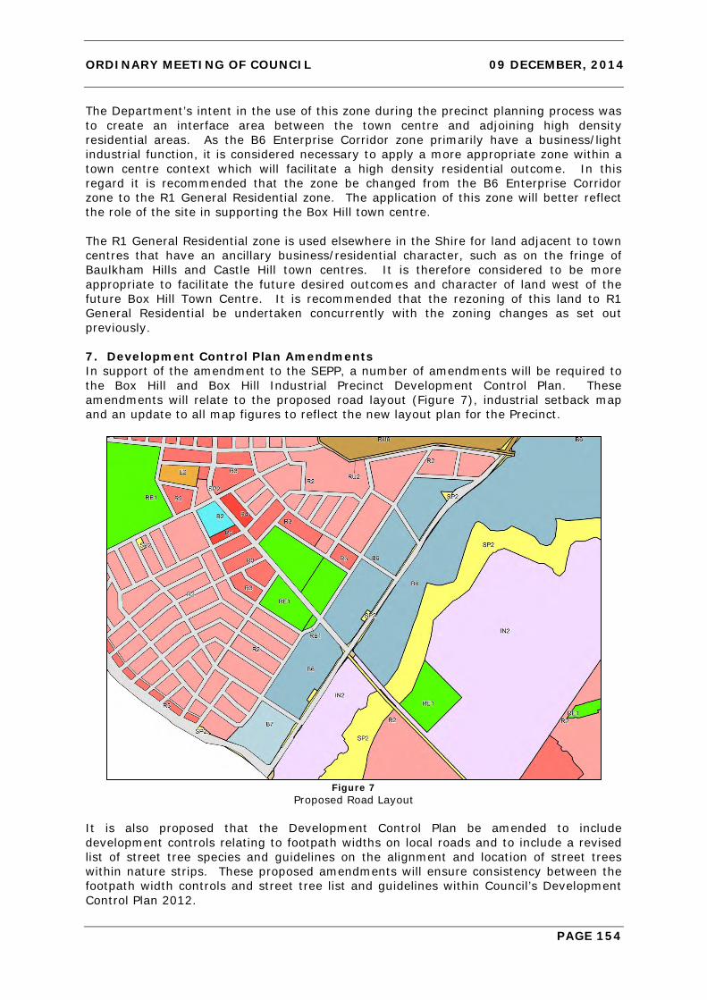
ORDINARY MEETING OF COUNCIL 09 DECEMBER, 2014
PAGE 154
The Department’s intent in the use of this zone during the precinct planning process was to create an interface area between the town centre and adjoining high density residential areas. As the B6 Enterprise Corridor zone primarily have a business/light industrial function, it is considered necessary to apply a more appropriate zone within a town centre context which will facilitate a high density residential outcome. In this regard it is recommended that the zone be changed from the B6 Enterprise Corridor zone to the R1 General Residential zone. The application of this zone will better reflect the role of the site in supporting the Box Hill town centre. The R1 General Residential zone is used elsewhere in the Shire for land adjacent to town centres that have an ancillary business/residential character, such as on the fringe of Baulkham Hills and Castle Hill town centres. It is therefore considered to be more appropriate to facilitate the future desired outcomes and character of land west of the future Box Hill Town Centre. It is recommended that the rezoning of this land to R1 General Residential be undertaken concurrently with the zoning changes as set out previously. 7. Development Control Plan Amendments In support of the amendment to the SEPP, a number of amendments will be required to the Box Hill and Box Hill Industrial Precinct Development Control Plan. These amendments will relate to the proposed road layout (Figure 7), industrial setback map and an update to all map figures to reflect the new layout plan for the Precinct.
Figure 7
Proposed Road Layout It is also proposed that the Development Control Plan be amended to include development controls relating to footpath widths on local roads and to include a revised list of street tree species and guidelines on the alignment and location of street trees within nature strips. These proposed amendments will ensure consistency between the footpath width controls and street tree list and guidelines within Council’s Development Control Plan 2012.
ORDINARY MEETING OF COUNCIL 09 DECEMBER, 2014
PAGE 155
CONCLUSION The proposal will facilitate an improved planning outcome for the Box Hill and Box Hill Industrial Precincts providing greater versatility to employment lands and increasing the residential capacity of the precinct. To facilitate the planning proposal, amendments will also be required to the associated Development Control Plan (including road layout and setback controls) and Contributions Plan (including population and employment projections and inclusion of additional open space and traffic facilities). IMPACTS Financial Future amendments will be required to Contributions Plan 15 to reflect the proposed increase in the planned future residential population of the Box Hill Precinct and in order to ensure that an adequate level of service of infrastructure is provided within the Precinct. These amendments will include the additional land acquisition and embellishment costs for the additional open space areas and a proposed roundabout. The Hills Future - Community Strategic Plan The planning proposal will also facilitate increased dwelling yield to assist Council and the Region in achieving its dwelling targets. This approach is consistent with Council’s Community Strategic Plan vision of balanced urban growth. RECOMMENDATION
1. A planning proposal be forwarded to the Department of Planning and Environment for a Gateway Determination to rezone land within Box Hill Industrial Precinct from IN2 Light Industrial to part B6 Enterprise Corridor, part R3 Medium Density Residential, part R2 Low Density Residential and part RE1 Public Recreation. The planning proposal would also rezone existing land adjacent to the future Box Hill Town Centre from B6 Enterprise Corridor to R1 General Residential and remove ‘shop top housing’ as a permitted land use within the B6 zone
2. Draft amendments to the Box Hill and Box Hill Industrial Development Control
Plan to facilitate the proposal be prepared in relation to road layouts, setbacks and site coverage. Draft amendments to the Development Control Plan be placed on public exhibition concurrently with the planning proposal.
3. Draft amendments to Contributions Plan 15 – Box Hill Precinct be prepared to
reflect the future residential population and employment yield of the precinct resulting from the proposal, increase the planned provision of open space and include one (1) new roundabout within the proposed new residential area road network. Draft amendments to the Contributions Plan be placed on public exhibition concurrently with the planning proposal.
ATTACHMENTS Nil