planning services public meeting report - clarington · municipality of clarington psd-086-17 page...
TRANSCRIPT

Planning Services Public Meeting Report
If this information is required in an alternate accessible format, please contact the Accessibility Coordinator at 905-623-3379 ext. 2131.
Report To: Special Planning and Development Committee
Date of Meeting: December 4, 2017
Report Number: PSD-086-17 Resolution:
File Number: PLN 41.1 By-law Number:
Report Subject: Wilmot Creek Secondary Plan Study – Terms of Reference
Recommendations:
1. That Report PSD-086-17 be received;
2. That Planning Services staff be authorized to commence the preparation of the WilmotCreek Secondary Plan;
3. That staff be authorized to finalize the Draft Terms of Reference and issue a Requestfor Proposal to retain the necessary consultants for the preparation of the SecondaryPlan;
4. That the Director of Planning be authorized to execute the necessary cost-recoveryagreements with Landowners Group for the preparation of the Secondary Plan; and
5. That all interested parties and the Region of Durham Planning Department be notified ofCouncil’s Decision.
#PD-216-17
Municipality of Clarington PSD-086-17 Page 2
Report Overview The purpose of this report is to inform the land owners within the Wilmot Creek Secondary Plan area of the request by Rice Development Group for Council to initiate the preparation of a Secondary Plan for these lands. This report seeks Council authorization for staff to commence the preparation of the Secondary Plan generally in accordance with the draft Terms of Reference.
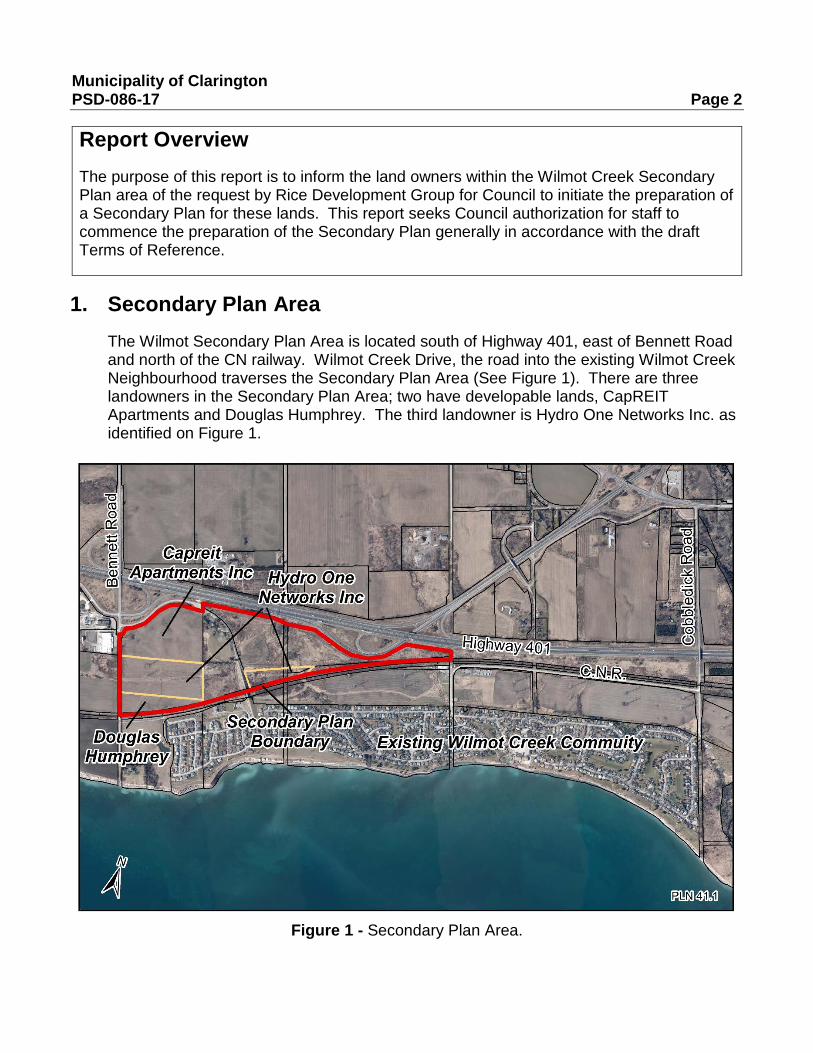
1. Secondary Plan Area The Wilmot Secondary Plan Area is located south of Highway 401, east of Bennett Road and north of the CN railway. Wilmot Creek Drive, the road into the existing Wilmot Creek Neighbourhood traverses the Secondary Plan Area (See Figure 1). There are three landowners in the Secondary Plan Area; two have developable lands, CapREIT Apartments and Douglas Humphrey. The third landowner is Hydro One Networks Inc. as identified on Figure 1.
Figure 1 - Secondary Plan Area.

Municipality of Clarington PSD-086-17 Page 3
2. Background 2.1 Original Application (2003)
In 2002, a Durham Regional Official Plan Amendment application was submitted to incorporate the subject lands into the Newcastle Village Urban Area in order to develop the next phase of the Wilmot Creek Lifestyle Community.
In October 2003, a corresponding application was submitted to amend the Clarington Official Plan to incorporate the subject lands into the Newcastle Village Urban Area. Since a local (Clarington) Official Plan Amendment cannot proceed ahead of an upper-tier (Region of Durham) Official Plan Amendment, the Clarington application was put on hold.
Further consideration of the Regional Official Plan Amendment application was put on hold following the introduction of the Provincial Growth Plan in 2005, and the beginning of the Region of Durham’s Official Plan Review.
In June of 2009, Regional Official Plan Amendment 128 adopted changes to the Durham Regional Official Plan which incorporated the subject lands into the Newcastle Village Urban Area. Amendment 128 was subsequently approved by the Ontario Municipal Board in January of 2013.
2.2 Application Restart (2014)
In 2014, Rice Development Group restarted their 2003 Official Plan Amendment application for the expansion of the Newcastle Village Urban Boundary. By January 2015, an application, including numerous supporting studies, was submitted. A statutory public meeting was held in March 2015. This was followed by numerous meetings between Staff, the developer (Rice Development Group), owner/operator of Wilmot Creek Lifestyle Community (CapREIT), the Wilmot Creek Homeowners Association and Wilmot Creek residents. The Wilmot Creek Homeowners Association made a submission to the Official Plan Amendment application outlining their concerns with the development proposal.
In June 2016, Rice Development Group appealed the Official Plan Amendment application to the Ontario Municipal Board in respect to Clarington Council’s failure to make a decision on the application. A settlement was reached regarding the Official Plan Amendment which was approved by the Ontario Municipal Board in 2017. Of particular note is that both parties agreed to advance the Secondary Planning process as set out in Official Plan Amendment 107 once the amendment was approved by the Region of Durham.

Municipality of Clarington PSD-086-17 Page 4
3. Secondary Planning Process 3.1 General Process
The Clarington Official Plan provides policy direction for the preparation of a privately initiated Secondary Plan. In summary the process is as follows:
1) Consultation with municipal staff and the establishment of the landowners group.
2) Receipt of a Request to Initiate a Secondary Plan and receipt of a proposed Terms of Reference.
3) Public Meeting and a Decision of Council to initiate the preparation of the Secondary Plan.
4) If Council decides to proceed with the Secondary Plan process, the Municipality will retain the necessary consultants.
5) All costs associated with the process, planning staff time, consultants and project and administration of the Secondary Plan are to be covered 100% by the landowners group.
6) Work will only be initiated once a funding agreement is in place between the trustee for the landowners group and the Municipality.
3.2 Wilmot Creek Secondary Plan Process
The Rice Development Group and staff have met on a number of occasions to discuss the Secondary Plan process. Rice Development Group will be representing the two landowners throughout this Secondary Plan process, CapREIT and Douglas Humphrey. Rice Development Group has a contractual agreement with CapREIT to develop their lands and it is anticipated that Mr. Humphrey will develop his own lands.
Rice Development Group has submitted a letter to request the Municipality to commence the preparation of the Secondary Plan and Zoning By-law (Attachment 1). On numerous occasions as well as noted in this letter, Rice Development Group has committed to funding 100% this process.

Municipality of Clarington PSD-086-17 Page 5
3.3 Summary of the Draft Terms of Reference
The Terms of Reference provided in Attachment 2 is unique to the Wilmot Creek Secondary Plan area as compared to other secondary plans. The Terms of Reference recognize that there is one primary developer for a smaller development area rounding out an existing community. Further consideration was given to the OMB decision and the different reports and public comments received through the application process to date.
When Rice Development Group reactivated their Official Plan Amendment application, many technical studies had been prepared for their lands. Staff agreed that any studies that have already been submitted/undertaken as part of the restart of their application, may be updated by the original consulting firm. These studies will need to be updated to include all of the Secondary Plan Area and to be responsive to the Secondary Plan and public participation process.
Should Council decide to proceed with the Secondary Plan, staff will issue a Request for Proposal to engage a team of consultants to complete the new studies and coordinate and finalize the update of existing studies.
Due to the advanced nature of a number of studies, a number of the proponent’s consultants would be engaged as sub-consultants to the Municipal consulting team. The team of consultants will prepare the draft Secondary Plan and Zoning By-law Amendment.
In the recently adopted Clarington Official Plan, Council adopted a sustainable green lens approach to development. All studies, to be updated and new, for any secondary plan will be required to include details as to how the development meets Council policies, in particular the commitment to reach net zero communities and the techniques that will be employed to reduce greenhouse gas emissions.
Another key component of the process is ample public participation. Staff and the applicant have already agreed to retain a facilitator to manage the community consultation process. All costs associated with the consultants and facilitator including related project management and administration costs are to be recovered from the applicants.
4. Conclusion Staff believe the Draft Terms of Reference describes a transparent process that balances the efforts of the Rice Development Group to date, issues raised by the Wilmot Creek Homeowners Association, the policies in the Clarington Official Plan and the OMB Minutes of Settlement. They will be finalized in consultation with Engineering Services the Region and CLOCA. It is respectfully recommended that Council authorize staff to undertake the preparation of the Wilmot Creek Secondary Plan.

Municipality of Clarington PSD-086-17 Page 6
5. Strategic Plan Application Not applicable.
Submitted by: Reviewed by: David J. Crome Andrew C. Allison, B. Comm, LL.B Director of Planning Services CAO
Staff Contact: Carlos Salazar, Manager of Community Planning at extension 2409 or [email protected] or Lisa Backus, Principal Planner at extension 2413 or [email protected]
Attachments:
Attachment 1 – Letter from Rice Development Group Attachment 2 – Terms of Reference
LB/COS/tg I:\^Department\LDO NEW FILING SYSTEM\PLN Planning Files\PLN 41 Secondary Plans\PLN 41.1 - Wilmot Creek (Electronically Only)\Staff Reports\PSD-086-17_Final.Docx

Attachment 1 to Report PSD-086-17

Attachment 2 to Report PSD-086-17
Draft Terms of Reference Wilmot Creek Secondary Plan
-i-
Table of Contents 1. General .............................................................................................................. 1
2. Study Area ......................................................................................................... 1
3. Overview ............................................................................................................ 1
4. Roles and Responsibilities ................................................................................. 2
4.1 Municipal Staff ........................................................................................... 3
4.2 Steering Committee ................................................................................... 3
4.3 Landowners ............................................................................................... 4
5. Detailed Work Program ...................................................................................... 4
6. Public Consultation ............................................................................................ 6
7. Process Schedule .............................................................................................. 7
8. Funding .............................................................................................................. 8
Appendix A – Summaries of Studies to be Updated ................................................... 9
Appendix B – Summaries of New Studies to be Undertaken.................................... 11 Appendix C - Priority Green Clarington Development Framework…………………...14 Appendix D - Proposed Process ………………………………………………………...15

Draft Terms of Reference Wilmot Creek Secondary
-1-
1. General The Wilmot Creek Secondary Plan and Zoning By-law project will commence following Council approval of these Terms of Reference. The project will be managed by the Clarington Planning Services Department and fully funded by the Rice Development Group.
This Secondary plan process, based on the foregoing, is unique to this Secondary Plan because of this long history and OMB decision. (See Appendix D for an overview of the process)
2. Study Area The lands within the proposed Secondary plan are owned by CapREIT Apartments, Hydro One Networks and Douglas Humphrey and are located within Special Policy Area B2 as identified in the Clarington Official Plan. Figure 1 shows the limits of Special Policy Area B2. The surrounding land uses are also provided for context.
3. Overview The work program will consist of three phases as follows:
3.1 Phase 1
Analysis of Background Information and the Preliminary Development Proposal.
• Public Consultation - Community Open House and Presentation of Work to date. • Deliverables - Phase I preliminary technical report.
3.2 Phase 2
Proposed Development Concept
• Deliverables - Preferred concept, draft Secondary Plan and Zoning By-law. Final Technical Reports.
• Public Consultation – Preferred development concept and draft documents presented.
3.3 Phase 3 Proposed Secondary Plan and Zoning By-law for Statutory Public Meeting and Approval
• Public Participation – Statutory Public Meeting.
• Deliverable – Approved Secondary Plan, Urban Design and Green Development Guidelines and Zoning By-law.

Draft Terms of Reference Wilmot Creek Secondary
-2-

Draft Terms of Reference Wilmot Creek Secondary
-3-
4. Roles and Responsibilities
4.1 Municipal Staff
Staff will:
• Retain and direct the Lead Consultant to complete the required technical background studies throughout the process.
• Retain and direct a Facilitator to conduct the public information sessions/workshops.
• Be responsible for the overall coordination of the Secondary Plan.
4.2 Steering Committee
The Steering Committee will be composed of:
• Municipal Staff representing key departments.
• Staff of key commenting agencies such as the Region of Durham and the Central Lake Ontario Conservation Authority.
• A representative from the Wilmot Creek Homeowner’s Association.
• A landowner representative.

Draft Terms of Reference Wilmot Creek Secondary
-4-
• The Lead Consultant. The Steering Committee will advise the Municipality by:
• Conducting general oversight of the technical requirements of the study.
• Reviewing study products and recommendations.
4.3 Landowners
The Landowners will:
• Provide detailed comments on the different reports to the Municipality in a timely manner.
• Participate in the preparation of the Secondary Plan as provided for in the terms of reference.
• Fund 100% of all the background studies, public participation, and any project management and administration costs as directed by the Clarington Official Plan Policies.
• Fund 100% of any Ontario Municipal Board related costs related to Council approval of the Secondary Plan and related implementing Zoning By-law and guidelines.
• Fund the Consultant’s work program as determined through the accepted proposal by the Municipality.
• Fund 100% of the Facilitator’s work program as determined through the accepted proposal by the Municipality.
• Provide any additional technical information if, and when, gaps are identified, in a timely manner.
• Attend and actively participate in Steering Committee meetings.
5. Detailed Work Program 5.1 Phase 1 – Analysis of Background Information and Preliminary Development
Proposal
1. Phase 1 will start with a Community Open House and Presentation to be conducted following a short presentation of the work to date summarized by the facilitator.
2. The Development proposal and related studies submitted as part of the application COPA 2003-0012 process will be considered as the initial starting point for the process and will be validated and/or revised during the preparation of the technical background studies and public participation.
3. The Municipality through its lead consultant will manage the update of the following studies previously submitted. The lead consultant will include, as
Draft Terms of Reference Wilmot Creek Secondary
-5-
part of its team, the consultants that have already prepared those reports submitted as part of application COPA 2003-0012. The scope of work from these firms are attached as Appendix A. :
• Environmental Impact Study including geomorphic (GEO Morhpix) and hazard land assessment of Rickard Creek (Savanta)
• Air Quality Assessment due to nearby Employment Uses (RWDI)
• Archaeological Assessment (Archeoworks)
• Geotechnical Investigation (Terraprobe)
• Traffic Impact Assessment, Parking Needs (GHD)
• Noise and Vibration Study (HGC)
• Financial Impact Analysis (Hemson)
4. The lead consultant will retain additional consultants for the following required studies (a Summary of the scope of work for each of these studies is contained in Appendix B), some of these studies may combined :
• Active Transportation Analysis
• Water and Wastewater Servicing Plan
• Flood Plain Analysis and Stormwater Management Plan
• Landscape Analysis
• Green Development Guidelines including a Neighbourhood Energy Plan
• Urban Design Analysis
• Hydrogeological Investigation and Water Balance
5. Preliminary reports to be circulated to the landowners, agencies for review and comment.
6. This phase will conclude with a Phase 1 report. The Municipality through its consultants will consolidate and summarize the findings of the different technical reports and from the public input (Facilitators report). This Phase 1 report will be the basis for the refinement/validation of the design concept presented as part of application COPA 2003-0012 during Phase 2.
5.2 Phase 2 Proposed Development Concept
1. Based upon the results of Phase 1 the consulting team will prepare/refine a development concept with a demonstration plan. The landowners may

Draft Terms of Reference Wilmot Creek Secondary
-6-
provide any further technical information required to analyze the development plan and to fill gaps in such information as identified in Phase 1.
2. The Steering Committee will review the development concept and demonstration plan and may circulate to all agencies and its consultants for review and comments. It will also work collaboratively with the Landowners and the Steering Committee to refine and finalize the development concept
3. All technical reports to be finalized.
4. The Consultant will prepare:
• a Draft Secondary Plan and Draft Urban Design Plan;
• draft Zoning By-law based; and
• a draft Green Development Implementation Guidelines based upon the preferred development proposal
5. Phase 2 will conclude with a Public information Centre on the draft documents.
6. The Municipality will re-engage Hemson Consulting Limited to update the 2008 Financial Impact Analysis, which originally assessed the impacts of this development on Municipal Finances.
5.3 Phase 3 -Proposed Secondary Plan and Zoning By-law Amendment for Statutory Public Meeting and Approval
1. Based upon the input received and input from the Steering Committee, the consultant will finalize the draft documents
2. The above documents will be released as part of a final report for Council’s consideration at Planning and Development Committee. This report will summarize the process and public input received to date and at the time of the statutory public meeting.
3. If required by Committee, a final recommendation report would be prepared by the Municipality.
6. Public Consultation There will be a public information session near the beginning of Phase 1 and near the completion of Phase 2 of the study process. The third opportunity for the public to provide input will be the statutory public meeting.

Draft Terms of Reference Wilmot Creek Secondary
-7-
Community Open House
The study will commence with a Community Open House and Presentation to be conducted following a short presentation of the work completed to date. This Session will be hosted by the facilitator. Input will be received. This will occur very early in the process.
Public Information Centre
Session two will be hosted following the completion of Phase 2. A Public Information Centre will include a presentation of the preferred development concept, the Draft Secondary Plan (including UD guidelines) and the draft Zoning By-law. Input will be received.
Statutory Open House and Public Meetings
A statutory Open House will be scheduled at least two weeks prior to the Statutory Public Meeting to be held by Council’s Planning and Development Committee. At his public meeting, The Committee will consider approval of the final Secondary plan and related implementation tools like the Urban Design plan, Green Development Guidelines, and Zoning By-law.
Online Engagement Tools
A variety of different stakeholders will need to be engaged through the preparation of the Secondary Plan and Zoning By-law. To complement the Community Open House and statutory meetings, the Municipality will provide the online engagement tools available through Bang the Table platform (http://www.bangthetable.com/engagementhq/engagement-tools/). In consultation with the Steering Committee, the lead consultant will select the appropriate tools from the “Bang the Table” toolkit.
7. Process Schedule 7.1 Phase 1 Technical Background
• 4-6 months.
• Community Open House – beginning and midway.
7.2 Phase 2 Development Concept • 4-6 months.
• Public Information Centre – midway or later.
7.3 Phase 3 Secondary Plan and Zoning Bylaw Public Meeting and Approval • Statutory Public Meeting - Planning Act.
• Adoption of Secondary Plan and Zoning By-law.
Draft Terms of Reference Wilmot Creek Secondary
-8-
8. Funding Rice Development Corporation acknowledge and agree that in addition to the Owners’ Share of the actual Costs, they are responsible for 100% of project management or administrative costs associated with the completion of any aspect of the preparation, adoption or approval of the Secondary Plan, including but not limited to all technical and background studies, facilitation etc., in accordance with the policies of the Municipality’s Official Plan.
Rice Development Corporation will be solely responsible for collecting the proportionate share of the above costs from Douglas Humphrey through a private cost-sharing agreement.

Draft Terms of Reference Wilmot Creek Secondary
-9-
Appendix A – Summaries of Studies to be Updated
1. Environmental Impact Study (EIS)
The EIS will address for the lands in the study area:
1) Wildlife habitat assessment
2) Botanical, bird and wildlife surveys
3) Potential for impact on habitat of species at risk
4) Fluvial geomorphologic assessment as input into the determination of the hazard limit of Rickard Creek
5) Identification of wetlands
The EIS will determine development limits in keeping with Official Plan policies and determine whether restoration or enhancement strategies for natural heritage system features may be appropriate to achieve an overall ecological net gain. The EIS should consider the protection and enhancement of the Municipality’s tree canopy cover and urban forest, providing for a range of habitat types to support biodiversity, and recommend a tree replacement program.
2. Air Quality Assessment due to nearby Employment Uses This study will be undertaken in accordance of MOECC guideline D6 regarding land use compatibility. It will recommend required set-backs and/or mitigation measures between employment uses on the west side of Bennett Road and future sensitive land uses within the Secondary Plan area.
3. Archaeological Assessment The archaeological assessment for the purposes of the Secondary Plan shall consist of Stage 1 and Stage 2 for any potentially developable land. Any further archaeological assessments (Stage 3 and Stage 4) will be the responsibility of individual landowners to be undertaken before development takes place.
4. Geotechnical Investigation An appropriate number of boreholes will be drilled covering the lands within the study area with potential for development. The report will include recommendations relevant to design and construction including foundation design, seismic site classification, basement drainage, excavation, shoring, site servicing and backfill, short term dewatering and other constructability recommendations.
5. Traffic Impact Assessment and Parking Needs The Traffic Impact Assessment component will project the additional traffic from the Secondary Plan area that will use Bennett Road. It will recommend any required road improvements at: i) The new intersections proposed with Bennett Road ii) Bennett Road and the South Service Road/401 East On-Ramp

Draft Terms of Reference Wilmot Creek Secondary
-10-
iii) Bennett Road and 401 West On-Ramp iv) Bennett Road and Highway No. 2 The parking needs assessment will project the parking demand for the proposed uses including the proposed Community Centre within Wilmot Creek Phase 8 and recommend an appropriate parking standard for this use. The parking needs assessment should consider means to reduce the overall parking footprint in order to conserve land, reduce impermeable surface area, and promote the use of transit and active transportation, and provide recommendations, as appropriate.
6. Noise and Vibration Study The noise portion of the study will investigate the impact of noise on the proposed development lands from: i) Highway 401 ii) Bennett Road iii) Canadian National Railway (CNR) The predicted noise levels will be compared to the guidelines of MOECC, the railway and the Municipality. If excesses of the noise guidelines are found, recommendations for conceptual control features will be provided. The vibration component, ground-borne vibration measurements will be made for all potential development lands adjacent or near to the CN railway. If exceedances of vibration guidelines are found, appropriate mitigation measures will be recommended.
7. Financial Impact Analysis The financial impact analysis update will determine the proposed developments financial impact on the municipality’s operating and long term capital budgets. The study will consider the costs of the development in all municipal services and infrastructure at both the municipal and if required, regional levels.

Draft Terms of Reference Wilmot Creek Secondary
-11-
Appendix B – Summaries of New Studies to be Undertaken
1. Active Transportation Analysis & Plan
This component will explore the requirements for a walkable community for the making for safe and easy pedestrian and cycling use and requirements for golf-cart use.
It will also examine the connectivity between the existing and new neighborhoods including:
1) An estimate of the existing and proposed volume of pedestrian and vehicles of all types including golf cart traffic over the existing Wilmot Creek railway bridge.
2) Conduct a sight line analysis for the existing bridge.
3) Investigate and make recommendations to accommodate all users across the CN rail corridor.
4) Investigate and make recommendations regarding access to the interim and final location of the waterfront trail and the future Technology Park trail and the future Wilmot Creek trail.
2. Water and Waste Water Servicing Plan
This study shall include the following:
a) Identify and assess the future availability of the provision of water and sanitary sewer services and constraints to the Study Area. This review shall include the identification of the geographic limits to servicing and the costs, staging and financing which will be required to facilitate urban development in this area. These matters shall be prepared in close consultation with the Municipality’s Engineering and Building Services Department and the Region of Durham.
b) A general servicing base plan will be prepared based on the analysis and review of any requirements of the Municipality, the Region of Durham and Provincial Ministries and/or agencies. The servicing plan shall illustrate, among other matters, in graphic and textural form, the general provision of water services and sanitary sewer services and associated facilities for the Study Area.
3. Floodplain Analysis and Stormwater Management Plan
This study will, using appropriate floodplain modelling techniques, delineate the limits of the floodplain of the Rickard Creek within the Study Area. Potential for cut and fill to modify the limit of development will be reviewed as necessary. A stormwater concept plan will be developed for the Secondary Plan study area that will provide quality control for a normal level of treatment as per downstream constraints. Appropriate locations for and sizes of blocks for future storm water management facilities, where needed, will be provided. Opportunities for and an analysis of low impact development stormwater management approaches and an

Draft Terms of Reference Wilmot Creek Secondary
-12-
integrated treatment train approach to minimize stormwater runoff and maximize infiltration will be identified.
4. Landscape Analysis
This component shall include the following:
a) Describe and assess the existing context of the lands within the Study area.
b) Identify the Study Area’s topography and grading; existing built form; and natural features.
c) Prepare a summary of the Study Area in terms of parcel, topography, and built environment as foundation for the area’s development.
5. Sustainability Plan and Green Development Guidelines
The consultant shall identify and assess sustainable development principles and practices that are appropriate for implementation in this neighbourhood to create a net zero community. An integrated approach will be addressing green development, recognizing the inter-relationships between studies and examining the combined impacts of green development alternatives. This Plan and Guidelines will consolidate the opportunities for addressing the green development objectives and Secondary Plan policies of the Official Plan and based on the Priority Green Clarington Development Framework (see Appendix C). The Sustainability Plan and Standards should include measureable targets to move towards a net zero community.
In addition, the consultant shall prepare a set of guiding principles and green development standards for sustainable development (including servicing, roads, parks, open space, residential, commercial, institutional, land and buildings and development), which support, but are not limited to, the following:
a) An approach to development that respects the vital function of Green Infrastructure;
b) Use of renewable energy, low carbon energy and opportunities for energy products for the development site;
c) A development pattern that encourages and supports transit usage;
d) A development pattern that is adaptable over time for future generations;
e) A land use and development pattern which establishes good connectivity and mobility;
f) A mix of housing and other uses which help create a complete community and contribute to the health and vibrancy of the existing and future community; and
g) Green development standards that includes resilient infrastructure and reduced greenhouse gas emissions in support of the move towards a net zero community.

Draft Terms of Reference Wilmot Creek Secondary
-13-
h) A Neighbourhood Energy Plan will include consideration of:
• Energy use early in the land-use and infrastructure planning process and identify opportunities to integrate local energy solutions at the building or neighbourhood scale. It should identify development and infrastructure toMinimize the use of electricity, natural gas and gasoline consumption;
• Address energy-efficient building orientation, design and construction; and
• Identify opportunities and targets for on-site energy generation, district heatingand renewable energy options including opportunities for changing stations.
6. Urban Design Analysis This report will illustrate and demonstrate how the Urban Design Principles contained in the Clarington Official Plan that apply to this Secondary Plan will be implemented by the land use designations and policies of the proposed Secondary Plan. Specifically, the Report will:
o describe the vision or design intent, physical form, layout and design of the proposed development;
o evaluate the proposal to ensure that the development blends with the neighbourhood, or advances the emerging character of a new development within the existing context;
o illustrate the building massing, and articulation to establish the relationship between the building and the street, pedestrian and transit linkages, landscape and outdoor amenity areas, and lighting.
o demonstrate how the impacts on adjacent sites are mitigated including protecting significant views and vistas, limiting shadow impacts on existing sunlight sensitive uses and maintaining the privacy of those properties. It may also involve an appropriate conceptualization of the future development of lands in the vicinity of the subject site, as well as show existing conditions and/or other concurrent proposals in the broader surrounding area.
7. Hydrogeological Investigation and Water Balance Study This study will include the installation of an appropriate number of monitoring wells on the lands with potential for development. Ground water levels will be taken over four seasons. In addition, the hydraulic properties of the soil will be assessed. A detailed hydrogeological report including a water balance calculation will be prepared.

Draft Terms of Reference Wilmot Creek Secondary
-14-
Appendix C - Priority Green Clarington Development Framework
The Sustainability Plan and Green Development Standards will demonstration how, at a minimum, the criteria for Secondary Plans established in the Priority Green Clarington Development Framework and Implementation Plan are addressed, and how the Secondary Plan can support moving towards net zero communities that are resilient to the potential impacts of climate change. The four themes that represent the core elements of a sustainable community and are addressed by the Priority Green Clarington – Green Development Framework and Implementation Plan are:
Built Environment The built environment is the constructed physical environment in which we live, work and play each day. It considers the design and layout of a neighbourhood, including land use mix and diversity, and the interaction of the buildings, road systems and other infrastructure that we encounter.
Mobility Mobility is about reducing vehicle dependency and offering choices for residents to travel in to, out of and through neighbourhoods each day. It speaks to facilitating active transportation in order to reduce pressure on Clarington’s transportation network and reduce emissions from entering the environment, while contributing to human health and well-being.
Natural Environment & Open Space This theme seeks to protect and enhance ecologically significant components of Clarington’s natural heritage system, to encourage design that works with natural conditions and gains benefit from the environmental, economic and social benefits of the natural landscape, and promotes linkages to a diverse range of open spaces, parks and recreation facilities.
Infrastructure & Buildings Green neighbourhoods strive to use resources more efficiently, leading to potential cost savings. This theme identifies means to maximize energy and water conservation, minimize the consumption of resources, and contribute to climate change mitigation and adaptation.

Phase ITechnical Background
Update Studies
Environmental Impact Study -geomorphic (GEO Morhpix) hazard land assessment of Rickard Creek
(Savanta) Air Quality Assessment due to nearby
Employment Uses (RWDI) Archaeological Assessment
(Archeoworks) Geotechnical Investigation
(Terraprobe) Traffic Impact Assessment, Parking
Needs (GHD)Noise and Vibration Study (HGC)Fiscal Impact Analysis (Hemson)
Phase I Technical Background
New Studies
Active TransportationWater and Wastewater
Servicing PlanFlood Plain Analysis and
Stormwater Management PlanLandscape AnalysisGreen Development
Guidelines & Energy PlanUrban Design Analysis
PUBLIC INPUT –
FacilitatorCommunity Open
House
Phase IIDevelopment
Concept
Development ConceptDrafts: Secondary Plan
Urban Design PlanGreen Development
Implementation Guidelines
Zoning By-law
PUBLIC INPUT -All Reports Public
- Online Engagement Tools
-Public Information Centre
Phase IIIFinal Secondary
Plan
Final Secondary Plan with
Urban Design and Green Development
Guidelines Final Zoning By-law
PUBLIC INPUT - Statutory Open
House -Statutory Public
Meeting
2017-11-27 PLANNING SERVICES DEPARTMENT
APPENDIX D - WILMOT CREEK SECONDARY PLAN – TERMS OF REFERENCE PROPOSED PROCESS – 12 months after retaining consultants