plantation management plan - cranbrook.wa.gov.au
TRANSCRIPT

This document is protected by copyright. No part of this document may be reproduced, adapted, transmitted, or stored in any form by any process (electronic or otherwise) without the specific written consent of Woodside. All rights are reserved.
Plantation Management Plan
Woodside Native Reforestation Project
Sukey Hill, 94 Barytes Rd, Cranbrook, WA
Woodside Energy Ltd
January 2020
Version Date Author Approved by
Rev0 – Issued for Use
17/1/2020 Nick Kennedy / Gareth Parry / Greening Australia
Jayne Baird
Plantation Management Plan – Woodside Native Reforestation Project
DRIMS#1401383720 Page 2 of 15 [Insert Date]
TABLE OF CONTENTS
1. INTRODUCTION ....................................................................................................... 3
2. LAND INFORMATION .............................................................................................. 4
Area .................................................................................................................................... 4
Locality map and access roads ........................................................................................... 4
Natural features ................................................................................................................... 5
Improvements ..................................................................................................................... 5
2.4.1 Buildings ................................................................................................................ 5
2.4.2 Roads and tracks ................................................................................................... 5
2.4.3 Sensitive areas ...................................................................................................... 5
2.4.4 Fences, gates, powerlines, Telstra cables.............................................................. 6
3. ENVIRONMENTAL PLANTINGS ESTABLISHMENT PLAN ................................... 7
Species to be planted and source of stock .......................................................................... 7
Areas to be planted ............................................................................................................. 7
Access roads and firebreaks ............................................................................................... 7
Site preparation and planting technique .............................................................................. 7
Direction of planting lines in relation to contours and natural drainage ................................ 8
Description of weed control methods and buffer zones........................................................ 8
Control of vermin and declared weeds ................................................................................ 8
Clearing of woody vegetation .............................................................................................. 8
4. TENDING PLAN ....................................................................................................... 9
Fertilising schedule .............................................................................................................. 9
Weed management ............................................................................................................. 9
Monitoring and contingencies for disease and pests ........................................................... 9
Road and firebreak maintenance ......................................................................................... 9
Grazing strategy .................................................................................................................. 9
Firebreak pruning ................................................................................................................ 9
Pruning and thinning schedule ............................................................................................ 9
5. HARVESTING PLAN .............................................................................................. 10
6. REFERENCES........................................................................................................ 10
7. AUTHORISATION .................................................................................................. 10
APPENDIX A: PROPERTY MAP - 94 BARYTES RD, CRANBROOK ............................. 11
APPENDIX B: PROPERTY MAP - REMNANT VEGETATION ......................................... 12
APPENDIX C: PROPERTY MAP - PROJECT AREA AND LAND USE ........................... 13
APPENDIX D: PROPERTY MAP - TOPOGRAPHIC MAP ............................................... 14

Plantation Management Plan – Woodside Native Reforestation Project
DRIMS#1401383720 Page 3 of 15 [Insert Date]
1. Introduction
Woodside Energy Ltd is the Landholder of Sukey Hill, 94 Barytes Rd, Cranbrook, WA. The property covers 399.3 ha and is located approximately 5km to the east of the Cranbrook townsite.
Woodside is currently assessing the feasibility of using the property to generate Australian Carbon Credit Units (ACCUs) under the Federal Government’s Emissions Reduction Fund (ERF)1.
This project establishes permanent plantings of a mix of native tree species on land that has been used predominantly for agricultural activities. The tree species will be selected to be representative of the remnant vegetation in the local area. It will provide biodiversity and ecological benefits including restored landscape linkages, habitat creation and protection of fauna species. Social benefits will be realised, including employment opportunities.
The methodology used to generate ACCUs is “Reforestation by Environmental or Mallee Plantings – FullCAM”. The trees will be established using a mix of direct seeding and planting nursery grown seedlings.
The project feasibility study is being undertaken by Greening Australia, with a final investment decision (FID) due early in 2020.
This document outlines the following in relation to the project:
1. Introduction
2. Land Information
3. Environmental Plantings Establishment Plan
4. Tending Plan
1 Established under the Carbon Credits (Carbon Farming Initiative) Act 2011

Plantation Management Plan – Woodside Native Reforestation Project
DRIMS#1401383720 Page 4 of 15 [Insert Date]
2. Land Information
Area
The Sukey Hill property consists of two parcels of land bisected by Barytes Rd - Lots 2078 and 4537. The total area of the property is 399.3 ha and it is located approximately 5 km east of Great Southern Hwy and is adjacent to the Sukey Hill Lookout and telecommunications tower.
GPS Location (gate on Barytes Road, dms): 34°17'59.7"S 117°36'52.9"E
Location Deposited Plan
Lot 2078 DP 136003
Lot 4537 DP 149299
Sukey Hill comprises of approximately 298.7 ha of plantable area and 97.5 ha of remnant vegetation.
Land Type Area (ha)
Dam 3.1
Remnant Vegetation 97.5
Plantable Area 298.7
Total Area 399.3
The property is undulating with some steep sections near the top of Sukey Hill grading to flatter areas towards the northern, southern and eastern boundaries. The pastures are rocky with evidence of rock-picking by previous owners manifested in significant numbers of rock piles across the property.
The previous owners have used the property for mixed grazing for the last ten years. There were no permanent residents on the property at time of purchase.
The property is located on the eastern edge of the Gordon-franklin River catchment and, has a long-term average rainfall of 500mm (Cranbrook BoM station). Rainfall in 2018 was 402mm.
The land included in Lots 2078 and 4537 is zoned “rural’ under the Shire of Cranbrook Planning Scheme.
A search of the area on the Public Drinking Water Source Area (PDWSA) mapping tool, part of the Department of Water and Environmental Regulation indicates that the property does not fall within a priority area.
https://dow.maps.arcgis.com/apps/webappviewer/index.html?id=63ddb4ec2a6e463f84028aa3977bab2b
Locality map and access roads
The property has a primary and secondary ingress-egress points off Barytes Rd, an unsealed road off Salt River Rd. Tracks on the property are limited and generally follow the firebreaks and fence lines around the perimeter. There is good access to all areas of the property.

Plantation Management Plan – Woodside Native Reforestation Project
DRIMS#1401383720 Page 5 of 15 [Insert Date]
During the planting and establishment phase there will be a requirement for light trucks and direct seeding equipment to access the property. This equipment will fall within the general classification of agricultural equipment (e.g. tractors, single and dual line direct seeders, sprayers, fuel trucks).
As the trees will not be harvested there is no ongoing requirement for haulage by road trains or large vehicles.
Natural features
The property includes a portion of the eastern flank of Sukey Hill and drops away to flatter ground to the north and south and moves into undulating ground to the east.
There are bands of remnant vegetation on rocky soils that appeared to have escaped past clearing. There are rocky outcrops on a general northwest to southeast trend and are interspersed with primarily Wandoo (Eucalyptus wandoo) and Jarrah/Mallee heath systems, which have important conservation value and have been identified as part of Stirling Range Outliers in the Forest-Stirlings Conservation Action Plan.
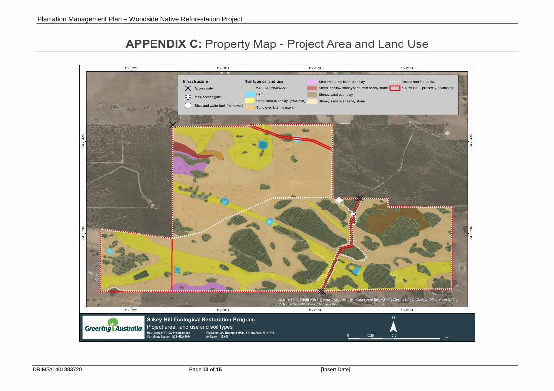
Soils are estimated as 90% medium and 10% light, described as “mainly medium duplex loams, some lighter sandy loams”, with original vegetation as Wandoo, Yate and Mallee. The soil type variations across the property are outlined in Appendix C.
No Registered Aboriginal Sites were found in a search of the area on the Aboriginal Heritage Inquiry System, part of the Department of Planning, Lands and Heritage, WA State Government https://maps.daa.wa.gov.au/AHIS/
There are seven dams on the property, no more than 70m in width. Six of these are on the area west of Barytes Rd, with a single dam on the area to the east. No major waterways run through the property.
Improvements
2.4.1 Buildings
There is limited infrastructure on the property consisting of fencing, a steel framed general purpose shed (15 x 10m) and a 5000 L rainwater tank. At time of purchase there was no residence and no full-time residents on the property, with farming activities being supported from the previous owners’ operational base in Kojonup.
2.4.2 Roads and tracks
It is not anticipated that significant changes will be made to access tracks on the property prior to or after establishment of the planting. Minor changes may be made to the access track that runs E-W through the middle of the property during establishment of the planting. This may include adding tracks along the borders of restoration planting areas – however whether this is required is yet to be decided.
2.4.3 Sensitive areas
The Department of Water and Environmental Regulation datasets have revealed that there are no declared Environmentally Sensitive Areas (ESA) within the property.
https://www.der.wa.gov.au/your-environment/environmentally-sensitive-areas
The Landgate Cadastre GIS dataset indicates that two parcels of Crown land adjoin the property to the East and to the West. These properties are primarily composed of remnant vegetation. The environmental plantings will have a positive impact on these land parcels, as it will re-establish landscape connectivity, ecological function and biodiversity into an otherwise fragmented landscape.
The property is not adjacent to any Department of Biodiversity, Conservation and Attractions (DBCA) land. The closest DBCA reserve is an outlier parcel of the Stirling Range

Plantation Management Plan – Woodside Native Reforestation Project
DRIMS#1401383720 Page 6 of 15 [Insert Date]
National Park (R14792), which is approximately 4.5km from the Eastern boundary of the property. The proposed environmental plantings will not impact on this land.
2.4.4 Fences, gates, powerlines, Telstra cables
A boundary fence surrounds the property. An double fence laneway runs through the centre of the property in an E-W direction. Boundary fences will be maintained in cooperation with neighbouring landowners. There are two wire gates off Barytes Rd which provide vehicle access to the property.
Grid power is not connected to the property and there are no overhead power or telephone lines. There are no known underground cables at the property.
Plantation Management Plan – Woodside Native Reforestation Project
DRIMS#1401383720 Page 7 of 15 [Insert Date]
3. Environmental Plantings Establishment Plan
Species to be planted and source of stock
Planting will include a mixture of species that are representative of the native remnant
vegetation in the area, as per information provided by botanical consultants from on-
ground flora surveys conducted by Greening Australia and experience botanical
consultant Nathan McQuoid (Sandiford, 2012). Species mixes will be matched as far as
possible with soil types on which different native vegetation systems grow.
The planting species mix will comprise of approximately 20-30 species, at a density to
achieve > 600 stems per hectare. The following key species will be included, amongst
others:
• Eucalyptus wandoo,
• Eucalyptus marginata,
• Eucalyptus pachyloma,
• Eucalyptus preissiana,
• Eucalyptus decipiens,
• Agonis theiformis,
• Kunzea montana,
• Melaleuca thymoides
• Leptopspermum erubescens.
Seed for the environmental plantings may be sourced from the remnant vegetation on the
site. However, some species will need to be sourced from alternate locations, due to the
likelihood of there being insufficient quantities on the property.
Areas to be planted
The map in Appendix A outlines the area of the property that is considered plantable. This is estimated at 298.7 ha and does not include areas of remnant vegetation or dams.
Access roads and firebreaks
Primary access to the property is through Barytes road, which is composed of gravel. All existing firebreaks and laneways are considered safe and are free of debris.
The current access roads and firebreaks on the property are outlined on the map in Appendix C.
Further establishment of internal firebreaks to separate planting compartments and provide access to water points will occur during project execution. Further details of these firebreaks are outlined in the Bushfire Management Plan.
Site preparation and planting technique
Prior to planting activities, site preparation will consist of a knockdown spray of the entire
plantable area. This will primarily be undertaken by a self-propelled sprayer – however
some smaller areas may need to be sprayed using a smaller boom-spray vehicle.
Remnant vegetation on the property will not be cleared or negatively impacted during site
preparation activities.
Plantation Management Plan – Woodside Native Reforestation Project
DRIMS#1401383720 Page 8 of 15 [Insert Date]
The environmental plantings will be conducted using two direct seeding Commercial
Native Vegetation Seeder (CommVeg). The CommVeg will scalp the plantable area for
water harvesting and weed control, while some shallow ripping will also occur. The
CommVeg will be towed around the property by a standard farming vehicle (eg. ute or
small/ medium tractor).
One pass of the direct seeder will include one or two seed rows at 1.5m spacing, with
each run 4.5m apart (resulting in alternating 3m and 1.5m row spacings). A small
proportion of infill planting will be conducted with seedlings that have been germinated off-
site.
Diesel 4x4 vehicles will be used to deliver seed to the CommVegs for direct seeding, and
diesel 4x4 vehicles with seedling trailers will be used to deliver seedlings to the planting
sites for infill planting.
Once mixed and bulked with bulking agent, the seed mix will be stored in the back of the
Diesel 4x4 vehicles ready to be tipped into the CommVegs.
The planting species mix will comprise of approximately 20-30 species, at a seed mix
density capable of achieving > 600 stems per hectare.
Direction of planting lines in relation to contours and natural drainage
The CommVeg direct seeding runs will broadly follow contour lines throughout the property, particularly in areas of steep gradients.
Description of weed control methods and buffer zones
Weed control will be undertaken by qualified and licensed spraying contractors using approved pesticides. The method of application will primarily be by a large self-propelled sprayer – however some smaller areas may need to be sprayed using a small vehicle with a boom.
Control of vermin and declared weeds
The site has been assessed for the presence of vermin, and it is anticipated that there will only be a minor impact from rabbits, kangaroos and emus. Some rabbit control may be required by rabbit baiting stations and poison oats, as damage can be done to plantings during the establishment phase. The site will be periodically assessed for vermin as part of regular maintenance.
Clearing of woody vegetation
The property contains patches of remnant vegetation, which accounts for approximately 97.5 ha. These patches are primarily Wandoo (Eucalyptus wandoo) and Jarrah/Mallee heath systems, as outlined in Appendix A. The remnant vegetation on the property will not be cleared.

Plantation Management Plan – Woodside Native Reforestation Project
DRIMS#1401383720 Page 9 of 15 [Insert Date]
4. Tending Plan
Fertilising schedule
There are no plans to apply fertiliser in the project area.
Weed management
There are currently no major concerns with weeds at the site. A site-wide knockdown spray will occur prior to planting with a follow-up treatment post-planting. Broadleaf selective herbicide and insecticide will also be used post-planting, with a selective spray conducted the following year if required.
Weed status will be monitored on a regular basis throughout the first year after establishment and on an annual basis after that.
Monitoring and contingencies for disease and pests
Monitoring for disease and pests will be conducted regularly during establishment, and annually during routine maintenance.
Rabbit control will likely be required through baiting stations, and kangaroo control will potentially be required. Insect control will be completed using residual insecticides if required. Any insecticide spraying will be completed by licensed professional sprayers under contract.
Road and firebreak maintenance
Spraying of firebreaks with herbicide will be done annually between August and September, with further maintenance using earthmoving equipment conducted as necessary.
Roads will be subject to annual inspections with maintenance programs developed to address any serious issues.
Grazing strategy
There are currently no plans to undertake grazing activities in the project area. However, some managed grazing of 2-3 week time periods could be used after establishment to help control grasses.
Firebreak pruning
Edges of the plantations will be maintained to ensure fire breaks have sufficient fire vehicle access.
Pruning and thinning schedule
With the planned species mix, it is unlikely that any pruning or thinning will be required.

Plantation Management Plan – Woodside Native Reforestation Project
DRIMS#1401383720 Page 10 of 15 [Insert Date]
5. Harvesting plan
The environmental plantings at this location will not be harvested.
Under the Emissions Reduction Fund scheme, the plantings from this project will be subject to a 100-year permanence period. During this time, an obligation remains to maintain carbon stores in the project area.
6. References
Sandiford, E.M. 2012. Proteaceous rich vegetation in the Forest to Stirlings section of Gondwana Link.
7. Authorisation
Approved by Jayne Baird (Vice President Carbon – Woodside Energy Ltd)

Plantation Management Plan – Woodside Native Reforestation Project
DRIMS#1401383720 Page 11 of 15 [Insert Date]
APPENDIX A: Property Map - 94 Barytes Rd, Cranbrook

Plantation Management Plan – Woodside Native Reforestation Project
DRIMS#1401383720 Page 12 of 15 [Insert Date]
APPENDIX B: Property Map - Remnant Vegetation
Plantation Management Plan – Woodside Native Reforestation Project
DRIMS#1401383720 Page 13 of 15 [Insert Date]
APPENDIX C: Property Map - Project Area and Land Use

Plantation Management Plan – Woodside Native Reforestation Project
DRIMS#1401383720 Page 14 of 15 [Insert Date]
APPENDIX D: Property Map - Topographic Map

woodside.com.au
Plantation Management Plan
Woodside Native Reforestation Project
Sukey Hill, 94 Barytes Rd, Cranbrook, WA
Head Office
Mia Yellagonga
11 Mount Street
Perth WA
Postal address:
GPO Box D188
Perth WA 6840
Australia
T: +61 8 9348 4000
F: +61 8 9214 2777