plts gis data reviewer 4 - esri support...
TRANSCRIPT

PLTS GIS Data ReViewer 4.2
An ESRI ® White Paper • April 2003
ESRI 380 New York St., Redlands, CA 92373-8100, USA • TEL 909-793-2853 • FAX 909-793-5953 • E-MAIL [email protected] • WEB www.esri.com

Copyright © 2003 ESRI All rights reserved. Printed in the United States of America. The information contained in this document is the exclusive property of ESRI. This work is protected under United States copyright law and other international copyright treaties and conventions. No part of this work may be reproduced or transmitted in any form or by any means, electronic or mechanical, including photocopying and recording, or by any information storage or retrieval system, except as expressly permitted in writing by ESRI. All requests should be sent to Attention: Contracts Manager, ESRI, 380 New York Street, Redlands, CA 92373-8100, USA. The information contained in this document is subject to change without notice.
U.S. GOVERNMENT RESTRICTED/LIMITED RIGHTS Any software, documentation, and/or data delivered hereunder is subject to the terms of the License Agreement. In no event shall the U.S. Government acquire greater than RESTRICTED/LIMITED RIGHTS. At a minimum, use, duplication, or disclosure by the U.S. Government is subject to restrictions as set forth in FAR §52.227-14 Alternates I, II, and III (JUN 1987); FAR §52.227-19 (JUN 1987) and/or FAR §12.211/12.212 (Commercial Technical Data/Computer Software); and DFARS §252.227-7015 (NOV 1995) (Technical Data) and/or DFARS §227.7202 (Computer Software), as applicable. Contractor/Manufacturer is ESRI, 380 New York Street, Redlands, CA 92373-8100, USA. ESRI, the ESRI globe logo, www.esri.com, @esri.com, ArcMap, ArcGIS, ArcView, ArcEditor, ArcInfo, and ArcSDE are trademarks, registered trademarks, or service marks of ESRI in the United States, the European Community, or certain other jurisdictions. Other companies and products mentioned herein are trademarks or registered trademarks of their respective trademark owners.

J-9052
PLTS GIS Data ReViewer 4.2
An ESRI White Paper Contents Page Introduction ........................................................................................... 1
GIS Data ReViewer 4.2......................................................................... 1 Assessing Data ................................................................................ 1 GIS Data ReViewer......................................................................... 2
Error Table ................................................................................ 3 Logging Errors Into the Error Table ......................................... 4 Automated Checks .................................................................... 5
Batch Validation for Attribution Rules ............................... 5 Topology Checks................................................................. 6 Spatial Analysis Checks ...................................................... 6
Visual Quality Control .............................................................. 7 Random Sample Generation................................................ 7
Results Analysis ........................................................................ 8 Error Table Work Flow and History ............................................... 8
Review Data .............................................................................. 8 Correct Data .............................................................................. 8 Verify Corrections..................................................................... 8
Summary ............................................................................................... 9
ESRI White Paper i

J-9052
PLTS GIS Data ReViewer 4.2
Introduction Large and small, data acquisition, manipulation, and creation projects have a vital need to review, validate, and maintain data quality throughout the project. Being able to monitor and carry out these efforts in a way that does not encumber the production process and that is tightly integrated with the software has traditionally been the challenge to data quality control. GIS Data ReViewer is a custom product developed for the ESRI® ArcMap™ application by ESRI's Production Line Tool Sets (PLTS) Group to support visual review and batch validation of data. ArcMap is an application within the ArcGIS™ Desktop products (ArcView®, ArcEditor™, and ArcInfo™). GIS Data ReViewer is composed of a series of buttons, tools, and context menus used to identify where corrections, additions, and deletions must be made to the spatial data and its attributes. Errors are logged into a table that stores all the necessary information for historical tracking. GIS Data ReViewer is a data quality control (QC) management application that provides an integration framework for ArcGIS multiuser geodatabase environments. It simplifies many aspects of automated and visual spatial data QC tasks, resulting in error information consolidation and eliminating the paper trail associated with error files by storing data error information in an electronic file. The GIS Data ReViewer improves and organizes the data review effort. GIS Data ReViewer provides tools for selecting and editing, performing spatial analysis, creating QC Grids, finding overlapping features, creating error tables, capturing and digitizing missing features, and making topology checks as well as many other QC processes. After each data integrity check, errors can be logged automatically to the error table. This information can be supplemented with comments and notes to provide even richer error log documentation. You can use GIS Data ReViewer integration points within the ArcMap application to leverage existing commercial off-the-shelf solutions or to embed GIS Data ReViewer functionality in new applications. This paper introduces the key features and discusses the intricacies and the framework of GIS Data ReViewer. It also explores the key integration points with ArcMap and topics of configuration and customization. For a complete discussion of how to configure and use GIS Data ReViewer, refer to the documentation and help system provided with GIS Data ReViewer.
GIS Data ReViewer 4.2
Assessing Data Assessing the quality of spatial data is critical whether the data is being produced or
acquired. Data that does not meet requirements will affect how the data is used and the information it provides. To ensure high-quality data, a quality assurance (QA) program must be established. QA is the sum of all quality control steps in the data production process. Spatial data QC tasks include a series of automated and visual checks.
ESRI White Paper

PLTS GIS Data ReViewer 4.2
J-9052
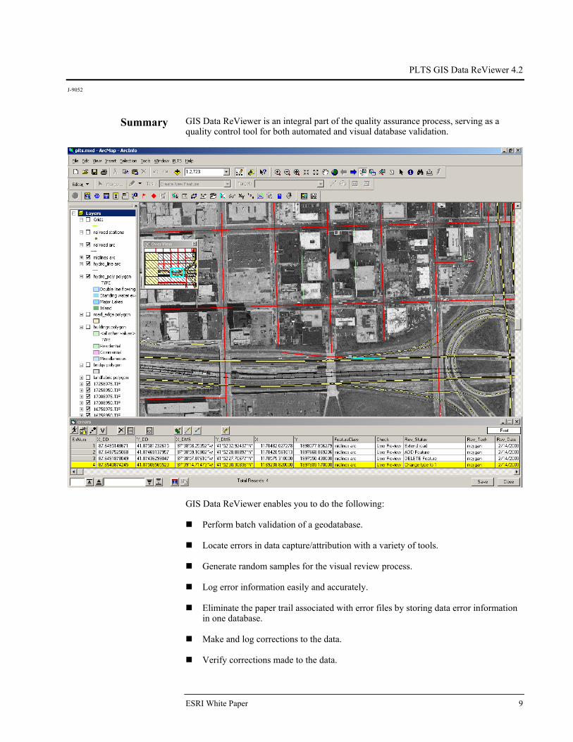
GIS Data ReViewer GIS Data ReViewer supports the QC effort by facilitating the automated and visual checking of data. Errors are logged into a database table that stores the x,y position of each error, the feature class name, a description of the error, correction status of the error, technician's name, and the date the error was corrected. The results of the QC review can be provided in an efficient and timely manner. Four toolbars—PLTS Visual Review Tools, PLTS GIS Data ReViewer, PLTS Table of Contents (TOC) Manager, and PLTS Map Gallery—are added to the ArcMap environment, and online help is available. You can create or open an existing map document (.mxd), then begin a GIS Data ReViewer session. A personal geodatabase stores error table information and feature classes that are created within the session. A series of buttons, tools, and context menus is used to identify where corrections, additions, and deletions must be made to the spatial data and its attributes.
PLTS Visual Review Tools
PLTS GIS Data ReViewer
The PLTS TOC Manager provides easy and simple methods for sorting and grouping the layers in ArcMap software's table of contents view.
PLTS Table of Contents Manager
The PLTS Map Gallery is a virtual map store in which map properties, such as layer symbology and labeling attributes, can be stored and reapplied anytime. The PLTS Map Gallery tool is composed of three elements: a map store, a map gallery, and a map draft.
PLTS Map Gallery
GIS Data ReViewer can be used to review data that is in either a personal or an ArcSDE® geodatabase. Coverages or shapefile data can be reviewed using the visual review functionality of GIS Data ReViewer.
April 2003 2

PLTS GIS Data ReViewer 4.2
J-9052
Error Table Errors identified either by the automated or visual QC process are stored in the GIS Data ReViewer error table. GIS Data ReViewer records error information associated with each erroneous feature. Click on a record in the error table, and the display zooms to the feature in question. The error table includes the following information.
Error Table Field Description
ErrNum Sequential error number FeatureID Feature ID of record that contains the error Y_DD Y-coordinate in decimal degrees X_DD X-coordinate in decimal degrees Y_DMS Y-coordinate in degrees, minutes, and seconds X_DMS X-coordinate in degrees, minutes, and seconds X Y-coordinate in native coordinate system
ESRI White Paper 3

PLTS GIS Data ReViewer 4.2
J-9052
Error Table Field Description
Y X-coordinate in native coordinate system Location Location of the data on the system Feature Class Feature class name that contains the error FCode Feature code of the record Check Name of the tool that created the error entry Rev_status Error description Rev_tech Reviewer's name or initials Rev_date Date the error was entered into the table Cor_status Correction status for the error Cor_tech Correction technician's name or initials Cor_date Date the error was corrected Ver_status Verification status for the error Ver_tech Verification of technician's name or initials Ver_date Date the correction was verified
A GIS Data ReViewer session can have more than one error table to allow for flexibility in storing results. A backup copy of the error table is automatically generated. If multiple technicians are reviewing the data, errors can be consolidated into one database using the import functionality available in GIS Data ReViewer. Errors in the error table can be visited by simply clicking the error record.
Logging Errors Into the Error Table
Errors can be added to the error table through a variety of ways. Information about the data record that has the error is added into the error table. Automated checks log error information automatically into the error table while visual checks require user input of error information. By selecting the feature and clicking the Commit Error button, you can choose an
error message from the error description table or enter your own error description. You can also add customized project-specific error description messages to the Error Description table.
April 2003 4

PLTS GIS Data ReViewer 4.2
J-9052
Missing features can be added to the error table by using the Flag Missing Feature
button. You can duplicate error calls by clicking the Duplicate Error button, then clicking
in the data to view the location where the error exists. Multiple features can be added as errors to the error table using the User Review
button.
Automated Checks Automated QC checks can reduce the amount of labor required in evaluating data. Automated QC checks are consistent tests run against the data to ensure conformance to specifications. GIS Data ReViewer provides automated checks for feature attribution, topology, and spatial analysis.
Batch Validation for Attribution Rules
Using GIS Data ReViewer, data attributes can be checked against coded value and range domains, connectivity rules, and relationships defined in the geodatabase and against the PLTS knowledge base. The PLTS knowledge base is a database of additional rules to which the data must adhere. The rules can be configured through valid value tables (VVTs) or condition tables (CNTs). VVTs extend the capabilities of domains because they are lists of multiple attributes specifying valid code combinations for features. CNTs check attributes that are SQL queries. One VVT and one CNT are configured for each feature class. Once the PLTS knowledge base is configured, VVTs and CNTs are stored in the geodatabase where the data resides. The batch validation can check a selected set of features or all features that are loaded in the ArcMap table of contents. The user has flexibility in running checks against the core geodatabase rules and the PLTS knowledge base. Errors in the data that are identified by the batch validation can automatically be logged into the error table.
ESRI White Paper 5

PLTS GIS Data ReViewer 4.2
J-9052
Topology Checks In the process of digitizing features, geometric anomalies that compromise the topological fabric of a feature class may be introduced into the data. GIS Data ReViewer has topological checks to validate simple geometry. Topological checks include overlapping polygons within the same feature class, overlapping lines within the same feature class, duplicate polygon vertices, duplicate line vertices, self-crossing nonintersecting lines, nonintersecting lines within a feature class, and minimum length lines and area polygons. The topology checks can be run against a selected set of features or all features that are loaded in the ArcMap table of contents. Errors in the data that are identified by the topology validation are automatically logged into the error table.
Spatial Analysis Checks
Spatial analysis checks available in GIS Data ReViewer include Minimum area checks to identify polygons smaller than a specified size criteria
Duplicate point checks to identify points within the same feature class or between
two feature classes that are located within a specified tolerance of one another Point on Poly checks to identify point features that fall within polygon features
Poly on Poly checks to identify overlapping polygons
To input the appropriate feature classes and tolerances for the spatial analysis checks, you must know the database specifications. Any records that meet the criteria for the spatial checks can either be automatically logged into the error table or visited and logged
April 2003 6
PLTS GIS Data ReViewer 4.2
J-9052
manually. Spatial checks can be run on a selected set of records within a feature class or the entire feature class(es).
Visual Quality Control
Visual QC refers to manually reviewing the data for anomalies. This process can be used to evaluate data for Completeness (no missing features) Positional accuracy to source data Correct attribution Annotation placement, rotation, and spelling Edgematching between map sheets/units
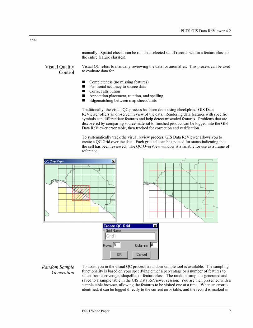
Traditionally, the visual QC process has been done using checkplots. GIS Data ReViewer offers an on-screen review of the data. Rendering data features with specific symbols can differentiate features and help detect miscoded features. Problems that are discovered by comparing source material to finished product can be logged into the GIS Data ReViewer error table, then tracked for correction and verification. To systematically track the visual review process, GIS Data ReViewer allows you to create a QC Grid over the data. Each grid cell can be updated for status indicating that the cell has been reviewed. The QC OverView window is available for use as a frame of reference.
Random Sample Generation
To assist you in the visual QC process, a random sample tool is available. The sampling functionality is based on your specifying either a percentage or a number of features to select from a coverage, shapefile, or feature class. The random sample is generated and saved to a sample table in the GIS Data ReViewer session. You are then presented with a sample table browser, allowing the features to be visited one at a time. When an error is identified, it can be logged directly to the current error table, and the record is marked in
ESRI White Paper 7

PLTS GIS Data ReViewer 4.2
J-9052
the sample table. This feature allows you to have a permanent record of the sample taken and provides you with an efficient method to review the sampled features.
Results Analysis Basic reporting capabilities in GIS Data ReViewer include Feature counts summarizing the number of records for each feature class loaded in
the ArcMap table of contents A point feature class that can be generated from the errors logged into the error table,
providing visual reference for the analysis of error location or concentration A summary that reports the number of errors for each feature class sorted by the type
of check and the revision status Summarization of a particular attribute field for a data delivery is a useful indicator
of possible data issues. The frequency tool in GIS Data ReViewer provides the ability to create a summary of values for an attribute in the data.
Error Table Work Flow and History
Tracking historical information in the review and correction process is an important element offered by GIS Data ReViewer. Whether the scenario of data review is your internal QC, a review between you and your customer, or a review between you and your subcontractors, the GIS Data ReViewer work flow can be applied. The detection, correction, and verification of errors are recorded in the GIS Data ReViewer error table, thereby facilitating communication between users.
Review Data The data is inspected using the GIS Data ReViewer automated and visual functionality. The revision status (Rev_Status), the QC technician's name (Rev_Tech), and the review date (Rev_Date) are logged into the error table. If multiple people are reviewing the data, error information can be consolidated into one database using the import functionality. The error information is provided to the person or organization responsible for making corrections to the data.
Correct Data The error information is imported into a GIS Data ReViewer session for corrections. You can step through each record in the error table and make the appropriate correction. The correction status (Cor_Status) is updated indicating the corrective action taken. The correction technician's name (Cor_Tech) and date of the correction (Cor_Date) are automatically stored in the error table.
Verify Corrections Corrected data and the updated error table are returned to the group or individual who conducted the original review. Each error call can be revisited to verify that the appropriate corrective actions were applied. The verification status (Ver_Status) can be updated to reflect this information. Again, the name of the technician (Ver_Tech) and date of verification (Ver_Date) are automatically populated.
April 2003 8
PLTS GIS Data ReViewer 4.2
J-9052
ESRI White Paper 9
Summary GIS Data ReViewer is an integral part of the quality assurance process, serving as a quality control tool for both automated and visual database validation.
GIS Data ReViewer enables you to do the following: Perform batch validation of a geodatabase.
Locate errors in data capture/attribution with a variety of tools.
Generate random samples for the visual review process.
Log error information easily and accurately.
Eliminate the paper trail associated with error files by storing data error information
in one database. Make and log corrections to the data.
Verify corrections made to the data.
No. GS-35F-5086H
Printed in USA
Place ESRI business partner or distributor address here.
For more than 30 years ESRI has been helping people manage and analyze geographic information. ESRI offers a framework for implementing GIS technology in any organization with a seamless link from personal GIS on the desktop
to enterprisewide GIS client/server and data management systems. ESRI GIS solutions are flexible and can be customized to meet the needs of our users. ESRI is a full-service GIS company, ready to help you begin, grow, and build success with GIS.
International Offices
Regional Offices
ESRI
380 New York Street
Redlands, California
92373-8100, USA
Telephone: 909-793-2853
Fax: 909-793-5953
For more information
on ESRI, call
1-800-447-9778(1-800-GIS-XPRT)
or contact an ESRI reseller near you.
Send e-mail inquiries to
Visit ESRI’s Web page at
www.esri.com
Corporate
Outside the United States,
contact your local ESRI distributor.
For the number of your distributor,
call ESRI at 909-793-2853,
ext. 1235,
or visit our Web site at
www.esri.com/international
Australia613-9867-0447
Belgium/Luxembourg32-2-460-7480
Bulgaria359-2-964-0850
Canada416-441-6035
China852-2730-6883
France33-1-46-23-6060
Germany/Switzerland49-8166-677-041-1-360-2460
Hungary361-428-8040
India91-11-2620-3800
Indonesia/Malaysia62-21-570-7685603-7874-9930
Italy39-06-406-96-1
Japan81-3-3794-6681
Korea82-2-571-3161
Netherlands31-10-217-0700
Poland 48-22-326-7300
Portugal351-2-1-781-6640
Romania40-21-231-13-81
Singapore65-742-8622
Spain34-91-559-4375
Sweden46-23-755-400
Thailand66-2-678-0707
United Kingdom44-1296-745-500
Venezuela58-212-285-9394
ESRI–Minneapolis 651-454-0600ESRI–Olympia
360-754-4727ESRI–Boston 978-777-4543
ESRI–California909-793-2853 ext. 1-1906
ESRI–Denver 303-449-7779
ESRI–San Antonio 210-499-1044
ESRI–Charlotte704-541-9810
ESRI–Washington, D.C.703-506-9515
ESRI–St. Louis 636-949-6620 ESRI–Philadelphia
610-337-8380
ESRI–New York City212-349-3700