point arena mountain beaver survey - united … hcp...bioconsultant point arena mountain beaver...
TRANSCRIPT

Bioconsultant Point Arena Mountain Beaver Surveys Fisher AP #27-211-02 April 23, 2003 1
Point Arena Mountain Beaver Survey___________________ Fisher/Jordan Property 1. SUMMARY OF FINDINGS This report presents the habitat assessment and survey results for Point Arena mountain beaver at AP #27-211-02. The habitat assessment identified large areas of the project site as potentially suitable PAMB habitat. The suitable habitat quality varied, ranging from poor to good, depending upon the topography and specific site characteristics. Within the project site boundaries, the survey effort located five separate areas containing active PAMB sign. 2. INTRODUCTION At the request of prospective buyers, Denise and Andy Fisher, BioConsultant agreed to conduct a presence and absence survey for Point Arena mountain beaver (Aplodontia rufa nigra) (PAMB) at AP #27-211-02. Previous biological surveys have documented PAMB to be present within or in the immediate area of the referenced parcel. On December 12, 1991, the US. Fish and Wildlife Service (USFWS) formally listed this species as Endangered (50 FR 64716), and under the Endangered Species Act of 1973 is fully protected. The results of this survey will be used to assist the buyers and the USFWS in the possible development of a Habitat Conservation Plan, and for the application of a coastal development permit. The California Coastal Commission (CCC) is charged with the regulation of the development of environmentally sensitive habitat areas in the California's coastal zone, as stipulated in the California Coastal Act. Many cities, Point Arena included, have their own Local Coastal Program (LCP) that has been certified by the CCC. The LCP is the lead agency responsible for protecting the coastal zone and is the center of review for local development permits. Given that Point Arena mountain beaver have been identified in the vicinity of the above proposed building site, the City of Point Arena’s LCP requires surveys for PAMB to insure the proposed project will not negatively impact the protected mountain beaver.
BioConsultant conducted the PAMB surveys following the survey and reporting protocol presented in Draft Guidelines for Project-Related Habitat Assessments and Surveys for Point Arena Mountain Beaver (Aplodontia rufa nigra) (October 2002). The guidelines and setback distances of the Draft Point Arena Mountain Beaver Standard Protection Measures for No-Take Determinations (November 2002) were used to develop recommendations and guidelines to minimize potential impacts to PAMB.

Bioconsultant Point Arena Mountain Beaver Surveys Fisher AP #27-211-02 April 23, 2003 2
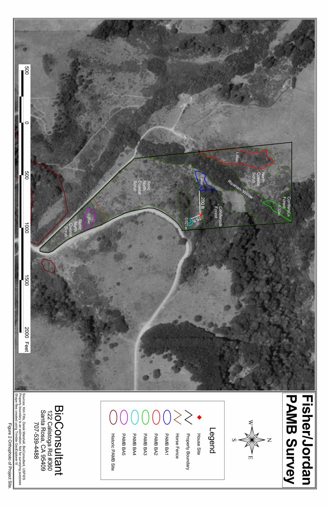
Project Location The subject parcel is located in the NW ¼ of Section 7, T12N R16W, MDB&M Point Arena, Mendocino County, California (Figure 1). The parcel is situated 3000 feet north of Riverside Drive. Description of Proposed Action (written by prospective buyer; Denise Fisher) The primary goal of the proposed project is the construction of a two bedroom, one bath single family dwelling with an estimated size of 1,000 square feet. The future home site is approximated on Figure 2 and shown in Figure 3. Following are descriptions of the components that support the completion of this project.
Foundation Since the property is still in escrow, the design and engineering work for the building site has not yet begun. However, consultation with the buyers’ architect indicates that the foundation may be constructed in one of two ways: 1) drilled piers with grade beams, or 2) spread footing with a stem wall. The drilled piers would have a maximum depth of 10 feet and a maximum width of 16 inches. A backhoe would be required for either option, with an auger attachment for the drilling. Ground disturbance would be substantially less with pier construction. Ground vibration would be similar in either case.
Driveway The driveway to the house will be graded 10 feet wide along the knoll top accessing from Hathaway Crossing and following the natural terrain down to the homesite for a distance of approximately 200 feet. Driveway surface will be crushed gravel roadbase. A backhoe or skiploader will be required for driveway construction. No additional compaction equipment is expected to be necessary.
Septic System and Leach Field The project will utilize a septic system and leach field sufficient to support a two bedroom, one bath home. The dimensions of the leach field will depend on the outcome of the perc test, which is scheduled for June, 2003. The septic tank and leach field will be located to the west of the homesite. The septic tank will be setback at least five feet from the house and 50 feet from the well and the leach field will be setback at least eight feet from the house and 100 feet from the well.
Utilities The home will use solar power (possibly tied to the utility grid) and propane. Solar panels will be installed on the roof of the house. The propane tank will be accessible from the driveway near the house. A telephone line will also serve the residence.
Water The home will be served by a domestic well. The location of the well has not yet been determined; however potential drilling sites have been identified. Primary drilling sites will be on the knoll top near the driveway. If an alternate drilling location is needed, it will be along an adjacent knoll top to the south of the homesite. The well will be installed by Fisch Bros. Drilling using a truck-mounted 2001 Ingersoll-Rand TH 60. When asked to compare the ground vibration of the TH60 to that of the directional boring

Bioconsultant Point Arena Mountain Beaver Surveys Fisher AP #27-211-02 April 23, 2003 3
55 equipment used for the AT&T Western Territory Lightguide Project (Stephenson Associates 1992) John Fisch explained that the rigs may be different but the bits would be the same – and that the level of vibration is determined by the bit size (all other factors being equal). In his opinion, ground vibration from drilling the proposed well would essentially be the same as that of the AT&T directional boring.
Barn and Fencing An old barn remains on the property as a remnant of the prior sheep ranch. It is situated near the creek about 370 feet from the homesite. Although structurally sound, the barn will require a new roof. Proposed uses for the barn will be to provide shelter for one horse, hay storage, and workshop space. A small horse paddock connected to the barn is proposed to control the single horse’s movement. Temporary electric fencing will be used to monitor grazing on other areas of the parcel. A permanent perimeter fence is proposed for the southern portion of the property (Figure 2) as a future project and funds permit. An old dirt road off Creekside Spur was used historically to access the barn. The road is no longer accessible due to encroachment by riparian vegetation. This road is proposed for relocation to a higher contour. It will be crushed gravel roadbase, 10 feet wide by approximately 550 feet long. In addition to the existing barn, there used to be several other structures in close proximity. These have disintegrated and lie on the ground in piles of debris. This debris is proposed for removal or salvage. Most of the removal work may be done by hand. Some larger pieces may require the use of a small piece of equipment like a backhoe or skid steer. The construction start date is dependent upon issuance of a building permit from the County of Mendocino. Once the property is purchased, the new owners intend to submit plans to the County shortly after, by mid-July, 2003. The County tells applicants to expect 4 to 6 months for the planning/permit process. Construction on this project could begin by mid-November, 2003. Project Site Description The parcel configuration and boundaries are shown in Figure 2. The varied topography of the 24.25 acres of the project site creates a rich mosaic of habitat types and plant associations which overlap and intergrade into one another (Figure 4). Northern coastal scrub covers much the site’s moderate slopes; this type grades into areas of grasses, conifers/hardwoods and riparian habitats. A willow dominated riparian corridor borders the north fork of Hathaway Creek as it travels along the valley floor. The coastal scrub on the south-facing slope is an open scrub field dotted with seeps, while the east and lower west-facing slopes host a tall, mostly closed overstory. The primary plant communities occurring in the project site are northern coastal scrub, seep areas, riparian, and conifers/hardwood forest.
Bioconsultant Point Arena Mountain Beaver Surveys Fisher AP #27-211-02 April 23, 2003 4
Point Arena Mountain Beaver Currently, the potential range of the PAMB is considered by USFWS to be that area of coastal Mendocino County located south of a point two miles north of Bridgeport Landing, north of a point five miles south of the town of Point Arena, and to a distance of five miles inland from the Pacific Ocean (USFWS 2002).
Point Arena mountain beaver occupy a wide range of habitat types (Fitts et al. 2002, USFWS 2002), which can overlap and integrate with one another. The USFWS recommends surveying for PAMB in all areas that contain brushy and herbaceous plant cover within the potential range of PAMB.
The subject parcel is inside the known PAMB distribution range and PAMB have been documented along the north fork of Hathaway Creek and in the Rolling Hills subdivision (USFWS 1986 and 2002). These sites are also documented in the California Department of Fish and Game’s Natural Diversity Data Base (CNDDB) as occurrence No. 18, 19 and 36.
3. POINT ARENA MOUNTAIN BEAVER SURVEYS Kim Fitts, wildlife biologist, conducted the habitat assessments. Kim, along with Derek Marshall performed the PAMB surveys. Per the referenced survey protocol, both are USFWS-approved PAMB surveyors. The assessments and surveys were performed only on the referenced parcel; adjacent private properties were not surveyed. Habitat Assessments for PAMB Suitability All areas and plant communities within the project site (Figure 2) were assessed for their potential to support PAMB on March 19, 2003. The assessments were conducted as Ms. Fitts walked through the project site; many areas were assessed simultaneously while conducting surveys for PAMB sign. The duration of the habitat assessments equaled approximately 2 to 3 hours. The majority of the parcel was assessed as suitable potential habitat with varying degrees of quality. Unsuitable areas, such as those with a dense coniferous or willow overstory, or only annual grasses, were present within an overall matrix of suitable habitat types. The habitat types identified as suitable are generally described below and mapped on the aerial photo (Figure 2). Northern Coastal Scrub Coastal scrub is the predominate habitat type in the project site and, depending upon its location and exposure, the quality ranges from good to unsuitable (Figures 4 and 5). Of the habitat types present, the coastal scrub has the greatest predicative value to support PAMB. Coyote brush (Baccharis pilularis) dominates the shrub layer which depending upon its location and site characteristics forms an open or closed overstory about three to seven feet tall. Other important overstory shrubs are poison oak (Toxicodendron diversilobum), western hazelnut (Corylus cornuta var. californica), thimbleberry (Rubus
Bioconsultant Point Arena Mountain Beaver Surveys Fisher AP #27-211-02 April 23, 2003 5
parviflorus), and coffeberry (Rhamnus californica). The understory varies from a dense, tangled interwoven thicket of ferns and herbaceous perennials to a more open one. Sword fern (Polystichum munitum) and cow parsnip (Heracleum lanatum) are important in the more mesic areas, while California blackberry (Rubus ursinus), bracken fern (Pteridium aquilinum var. pubescens), and salal (Gaulthera shallon) become more important in the more open and drier areas. The majority of the southern slope (Figure 4) is an open scrub field dotted with seeps; areas dominated with plants characteristic of wet areas, such as pacific reed grass (Calamagrostis nutkaensis), sedges (Carex spp.) and rushes (Juncus spp.) A large portion of the slope was determined to be unsuitable after closer examination of the vegetation (Figure 6) during the survey for PAMB sign. Only the more mesic coastal scrub in the narrow section of the parcel (between the roads) was assessed as suitable habitat (Figures 2 and 13). Riparian The riparian corridor of Hathaway Creek is dominated by several willows (Salix spp.) which characteristically create a dense overstory mostly devoid of a rich herbaceous understory. Only the edges and the interspersed open areas of this habitat type are suitable habitat for PAMB. Sword fern and stinging nettle (Urtica dioica) are the dominant herbaceous species in these edge/patch openings. In the northern section of this corridor, alders replace the willows in dominance, and a rose species and Californian blackberry form a tangled shrub layer (Figure 7). Principal forbs include hedge nettle and Solomon’s seal (smilacina racemosa), cow parsnip and stinging nettles. Dense thickets of pure poison oak are present in this inclusive habitat type. Artificial Habitat The collapsed barn near the riparian corridor has created suitable habitat for PAMB. The wooden debris has created “artificial suitable habitat” by providing cover and open areas where forage plants have grown (Figure 8). Surveys for PAMB Sign On March 19 and 20, 2003, the entire project site, except those areas deemed unsuitable, was surveyed for PAMB sign using a wandering transect technique. The spacing between the transect lines was determined by the vegetation type and structure. Using this technique, the ground surface and vegetation was examined for PAMB sign (burrows and runways). The duration of the two-person survey effort was 11.5 hours. The survey effort found five distinct burrow areas within the property boundaries (Figure 2); these are described below. Active burrows were noted in all of the areas with PAMB sign. In general, the soil was moist and friable, and the sporadic presence of other fossorial sign was determined to be pocket gopher (Thomomys bottae). Site characteristic of Burrow Area #1 This burrow area (BA) occupies approximately 0.24 acre, which includes a portion of the base of the west-facing slope and valley floor (Figure 2). One hundred plus burrows are scattered throughout the debris of the collapsed wooden structure (Figure 8) and the adjacent coastal scrub. The site includes both active and inactive burrows. The burrows
Bioconsultant Point Arena Mountain Beaver Surveys Fisher AP #27-211-02 April 23, 2003 6
located along the edge of the debris pile appear to be less active than those in the coastal scrub, and may be used seasonally; however, burrows in the interior of the debris were not examined because of undue risk of impact. The portion of the BA on the valley floor extends from the edge of the willow corridor to the coastal scrub, and is riparian in nature. Riparian plant species have grown in between the wooden debris and several burrows can be observed leading into the artificially created habitat (Figure 9). Stinging nettles, California bee plant, rushes, cow parsnip and California blackberry are associated with this part of the BA. Sword fern, Solomon’s seal, poison oak, coyote brush, coffeeberry, Douglas Iris, and various grasses (Figure 10) are typical of the coastal scrub species in this site. Due to the significantly different topography and species composition between the flat valley floor and the scrub covered slope, we used the more “typical” coastal scrub habitat type and recorded the terrain variables (slope and aspect) at the closest burrow system to the house site. The west-facing slope was 280 and the slope was 55 degrees. (UTM 10S 441,002.56mE; 4,308,316.72mN) Site Characteristic of Burrow Area #2 Approximately 500 to 750 burrows occupy 1.46 acres (Figure 2) of good quality coastal scrub and riparian habitats. The burrow area begins on average 30 ft. upslope from the creek and extends north and upward to nearly the top of the slope. The majority of the burrows are within the coastal scrub. The site is well established, including old and inactive burrows as well as active ones. As typical in a riparian habitat, the burrows are located along the edges and more open areas of the willow corridor. The understory species include stinging nettle and cow parsnip. The coastal scrub is dominated by coyote brush which combined with scattered coffeeberry and hazelnut form a dense shrub overstory (Figures 5 and 11). Herbaceous understory species include sword fern, cow parsnip, poison oak, Solomon’s seal, Douglas Iris, hedge nettle and California blackberry. On average, the slope is 50 degrees with an east-facing aspect of 90. (UTM 10S 440,939.62mE; 4,308,417.41mN). Site Characteristic of Burrow Area #3 Along the northern property line and the edge of a Douglas fir/madrone overstory, a system with 100 to 200 burrows covers approximately 0.32 acre of riparian habitat (Figure 2). Approximately half of the burrows were classified as active and the burrow area most likely continues over the north/east property line. White alder (Alnus rhombifolia) form a lattice-like overstory that has allowed a rather dense understory of rose (Rosa spp.), thimbleberry, sword fern, and California blackberry to develop (Figure 7). Closer to the creek, stinging nettles, cow parsnip, Solomon’s seal and hedge nettle mix into the well developed understory. The slope averaged 30 degrees and the aspect was 120. (UTM 10S 441,078.08mE; 4,308,521.54mN).

Bioconsultant Point Arena Mountain Beaver Surveys Fisher AP #27-211-02 April 23, 2003 7
Site Characteristic of Burrow Area #4 A small burrow area, occupying 0.027 acre of fair quality riparian scrub, was found at the base of a steep ravine (Figure 12). The ravine starts at the road edge of Hathaway Crossing, parallels the proposed house site, and then flattens in the valley floor near the standing barn. An estimated 10 to 15 burrows are within a dense impenetrable thicket of poison oak; three burrows are in an adjacent patch of sword fern that is too fragile to survey without severely impacting the burrows present. The burrows were assessed as active, but recent sign of activity was not noted. As per the referenced survey protocol, we delineated the area adjacent to the burrows that we could not penetrate to survey. The slope at the base of the steep slope was 20 degrees and the aspect was 260. (UTM 10S 441,113.55mE; 4,308,289.26mN). Site Characteristic of Burrow Area #5 At this site, approximately 0.28 acre of mesic coastal scrub contains an estimated 100 to 200 burrows at the south end of the project site (Figure 2). The system includes both active and inactive burrows. Although the terrain variables are not characteristic of preferred PAMB habitat, the plant composition does create some of the best quality habitat in the project site. Coyote brush, both live and dead, dominate the shrub layer; scattered coffeeberry is also present. A lush understory is dominated by cow parsnip and various sedges. Also included are stinging and hedge nettle, California bee plant, California blackberry and sword fern. Figure 13 shows the typical species associated with the burrows in this BA. The average slope is 30 degrees and the aspect is 230. (UTM 10S 441,099.82mE; 4,308,026.08mN).
Bioconsultant Point Arena Mountain Beaver Surveys Fisher AP #27-211-02 April 23, 2003 8
4. CONCLUSIONS AND RECOMMENDATIONS Based on the habitat and PAMB burrow location information provided in this report, the following guidelines and protective measures can reduce the potential for adverse impacts caused from the proposed actions.
• The proposed construction activities will constitute “Ground Vibration Disturbance” and per the No-Take guidelines should maintain a buffer of at least 100 ft. from the occupied habitat during the breeding season (Dec 15 to June 30) and 50ft. during the rest of the year.
• The ground vibration disturbance caused from drilling the well should be
equivalent to that of directional boring, and per the No-Take guidelines should follow the above setback distances.
• Grazing, even light grazing, by horses has the potential to cause significant direct
and indirect effects to the individual PAMB, its food source and burrows. The burrow openings and shallow tunnels are easily crushed, and because mountain beaver will continue to use these caved in tunnels, the risk of predation increases greatly. Also, grazing removes the vegetation and modifies the structure which mountain beaver rely on for food, nesting materials, and cover. It is BioConsultant’s recommendation that grazing should not occur in any areas with PAMB sign. Specifically, in the area of BA #5, the surrounding suitable habitat is evaluated as good quality habitat and important for burrow expansion and the continued existence of the system. The proposed installation of the permanent perimeter fence is recommended.
• All activities associated with the removal of the wooden debris (artificial habitat)
should be conducted outside the breeding season. The following information is of importance when determining potential project impacts.
• No suitable habitat will be removed in the development of the house site or access driveway; both footprints will be completely contained within either unsuitable xeric coastal scrub habitat or conifer/hardwood forest.
• The construction footprint will not produce severe ground vibration as described
in the referenced No-Take guidelines. No soil compaction equipment will be required for the house site or for the access driveway.
As recommended in the referenced survey protocol, complete assessment and surveys within 500 ft. of impact areas will be considered valid for a period of 2 years. If the construction activities will be delayed until after 2005, surveys in the identified suitable habitats should be repeated.

Bioconsultant Point Arena Mountain Beaver Surveys Fisher AP #27-211-02 April 23, 2003 9
REFERENCES Fitts, K.M., R. Meentemeyer, D. Marshall, R. Jackson, P.T. Northen and S. Flowers.
2002. Habitat Protection and Restoration Plan for Manchester State Park. Technical Report for California Dept. of Parks and Recreation. 46 pp. plus App.
Stephenson, G. Ross Associates. 1992. AT&T Western Territory Lightguide Project Point Arena to San Francisco.
U.S. Fish and Wildlife Service (USFWS). 1998. Recovery Plan for the Point Arena Mountain Beaver Aplodontia rufa nigra (Rafinesque). Portland, Oregon.
_____. 2001. Draft Point Arena Mountain Beaver Standard Protection Measures for No-take Determinations. Unpublished document on file at the Arcata Fish and Wildlife Office, Arcata, California
_____. 2002. Draft Guidelines for Project-Related Habitat Assessments and Surveys for Point Arena Mountain Beaver (Aplodontia rufa nigra). Unpublished document on file at the Arcata Fish and Wildlife Office, Arcata, California.
_____. 2002. Point Arena Mountain Beaver Locations. Point Arena 7.5-Minute Quadrangle. September 9, 2002.
�
������
�����
����
�� �
�����
������
�����
����������������������
�������������������������������
����� !�"����#
�� �������$�����
���������������
�� �������$�����
����
�������
��������
$���
�
��
�
�������%�&�'�$����(�)���*�������(�+���� ���� �(�,�$"�
-������.���� /�.���� �����'��� !������������0�.� 1��������������������������/���� 1�2��'����3��45�������666
+���� ���� �����������1��/�7� �� �����(��8�9��9
���!��9!��
����������� ���� ������
$�1������:�������������-��;���������
<���������
�
-������.�+�� /�.
<�����$� ��
-8�+�+8�
-8�+�+8�
-8�+�+8�
-8�+�+8
-8�+�+8�
<��������-8�+�����
=�1� /

Photographs to Support PAMB Survey Results March 19, 2003
Figure 3. The proposed house site is the triangle of coastal scrub just beneath the conifer stand.
Figure 5. A view of the good quality coastal scrub habitat on east-facing slope that supports BA#2.
Figure 4. The view is looking north at the project site; Note the riparian corridor and coastal scrub areas interrupted by stands of conifers/hardwoods.
Figure 6. A view of the unsuitable south-facing slope and the plant associations.

Photographs to Support PAMB Survey Results March 19, 2003
Figure 7. This view shows the north end of the riparian corridor with an Alder overstory, approximately the center of BA #3. Orange flagging marks the locations of burrows.
Figure 9. Examples of burrows leading into the artificial habitat created by the wooden debris.
Figure 8. The fallen barn has created suitable habitat in an area that otherwise not be suitable. This view shows a large portion of BA #1; the riparian habitat of the valley floor and the adjoining coastal scrub.
Figure 10. An example of the typical coastal scrub plant assemblage in BA #1. The flagging marks the location of several active burrows.

Photographs to Support PAMB Survey Results March 19, 2003
Figure 11. Another view of the coastal scrub of BA#2. Note the height and denseness of the shrub overstory, and the assemblage of understory plants.
Figure 13. A view of the good quality mesic coastal scrub of BA #5. The yellow flagging marks burrow locations.
Figure 12. BA #4 lies at the base of this ravine. The photo was taken from the road and the view is looking west toward the standing barn.