port augusta – port wakefield road stuart highway …
TRANSCRIPT

PORT AUGUSTA ROAD MANAGEMENT PLAN
(DRAFT)
PORT AUGUSTA – PORT WAKEFIELD ROAD STUART HIGHWAY
EYRE HIGHWAY YORKEY CROSSING ROAD
MARCH 2012

Date Revisions Amended by
March 2012 Draft report issued for Internal Review P&D

Table of Contents 1 Overview .............................................................................................................. 1
2 Existing Conditions .............................................................................................. 3
2.1 General Description .................................................................................... 3
2.2 Traffic volumes ........................................................................................... 3
2.3 Freight routes .............................................................................................. 5
2.4 Crash history ............................................................................................... 6
2.5 Asset Sustainment ....................................................................................... 9
2.5.1 Road Pavements .............................................................................. 9 2.5.2 Structures ......................................................................................... 9 2.5.3 Road Lighting ................................................................................ 10 2.5.4 Traffic Signals ............................................................................... 10 2.5.5 Routine Maintenance ..................................................................... 11
2.6 Control of Access ...................................................................................... 11
3 Expansion of the mining industry ....................................................................... 12
4 Issues identification ............................................................................................ 13
5 Improvement Strategy Investigations ................................................................. 15
5.1 Revision of the Port Augusta Structure Plan Work .................................. 15
5.2 RMP - develop approach to stakeholder engagement ............................... 16
5.3 Eyre Hwy / Burgoyne St / Caroona Rd intersection upgrade ................... 16
5.4 Port Augusta bridge barrier investigation ................................................. 17
5.5 Hazardous materials freight risk assessment ............................................ 18
5.5.1 Freight route risk ........................................................................... 18 5.5.2 Pollution risk into Spencer Gulf .................................................... 19
5.6 Traffic Signal optimisation ....................................................................... 20
5.7 Yorkey Crossing alignment options .......................................................... 22
5.8 Yorkey Crossing upgrade - Existing alignment ........................................ 23
5.9 Yorkey Crossing upgrade - Realign south-eastern end (6.5km) and seal
existing alignment ..................................................................................... 23
5.10 Duplicate existing Port Augusta bridge over Spencer Gulf ................... 24
5.11 New Northern Port Augusta bypass ....................................................... 25
5.12 Victoria Parade turn protection (Carlton Pde to Rail Overpass) ............ 27
5.13 Road Lighting Assessment .................................................................... 28
6 Appraisal Summary (including Costs & Priority) .............................................. 29
7 Conclusion .......................................................................................................... 30

Figures
Figure 1 AADT Estimates (24 hour two-way flows) as at 18 April 2010 3 Figure 2 Road Train Gazetted routes 4 Figure 3 B-double Gazetted routes 4 Figure 4 Oversize / Over mass routes 4 Figure 5 Road crash history (2005-2010) 5 Figure 6 Control of Access Maps 10 Figure 7 Design for Caroona Rd / Burgoyne St / Eyre Hwy intersection 14 Figure 8 Typical Cross section for new Port Augusta Bridge Barrier 16 Figure 9 Port Augusta Bridge Stormwater Concept Plan 19 Figure 10 Yorkey Crossing Alignment improvement & alternative options 21 Figure 11 Potential Bridge Duplication Alignment 23 Figure 12 Right turn protection - Solid median option 26 Figure 13 Right turn protection - Painted median option 27
Tables
Table 1 Pt Augusta Infrastructure Plan - Summary of Future Road Networks requirements 12
Table 2 Summary of heavy vehicle progress thru signalised intersections (Nov 2008) 19
Table 3 Appraisal Summary table 28
Tables
Appendix A Stakeholder Engagement Schedule for Road Management Plan Appendix B SA Road Traffic (Misc) Regulations 1999, Part 4, Section 20), and
SafeWork SA Technical Note 16 – Special Conditions – 2, Approved routes.
Appendix C Environmental Impacts Preliminary Assessment report Appendix D – Economic Appraisal Yorkey Crossing Options and Pt Augusta Bridge
Duplication Appendix E Economic Analysis for Yorkey Crossing

DRAFT ROAD MANAGEMENT PLAN
GLOSSARY AADT Average Annual Daily Traffic – The number of axle pairs
crossing at a specific site per year and dividing this number by 365
DA Development Assessment DDA Disability Discrimination Act 1992 DPA Development Plan Assessment DPLG Department for Planning & Local Government DPTI Department for Planning, Transport and Infrastructure Intersection Place where two or more roads cross Junction Level of Service
Place where two or more roads meet A qualitative measure describing operational conditions within a traffic stream, and their perception by motorists and/or passengers. Generally 6 levels of service, designated A to F, with a level of service A representing the best operating condition (i.e. free flow)
Pedestrian Refuge An island in a carriageway set aside for the exclusive use of pedestrians
PDO Property damage only (relating to the severity of a vehicle crash) Right Angle Crash: A crash involving two vehicles travelling on different roads
colliding at right angles Right Turn Crash A crash involving two vehicles travelling on the same road but in
opposite directions. One vehicle is travelling straight ahead and the other executes a right turn or U turn across its path
RMP Road Management Plan RN Road Number PAC Pedestrian Activated Crossing

DRAFT ROAD MANAGEMENT PLAN
1
1 Overview On 25 February 2010, the Premier of South Australia committed to develop a Road Management Plan (RMP) for Port Augusta. This document is focussed on an overall review of the operational and safety issues on the arterial road network in Port Augusta. It identifies potential short to medium term (5-10 year) road improvements for safety and traffic operations along the existing roads. The arterial road network in Port Augusta considered as part of this RMP is:
RN3500 Port Augusta – Port Wakefield Road (locally known as Highway One or Victoria Parade), between RN3006 Range View Rd (Stirling North) intersection to RN2000 Eyre Highway (Burgoyne St / Caroona Rd) intersection
RN1000 Stuart Highway, between RN2000 Eyre Highway intersection and RN15060 Yorkey Crossing Rd intersection
RN2000 Eyre Highway, between RN3500 Port Augusta – Port Wakefield Road (Highway One) intersection to near Port Augusta airport
The over-dimension vehicle by pass route of Pt Augusta, RN15060 Yorkey Crossing Road is also considered, taking into account projected increases in use of this route determined from the Resources and Energy Sector Infrastructure Council’s (RESIC) infrastructure demand study completed in 2011. Longer term major road improvements required to support future residential growth are being determined by council and the developers as part of DPA and DA processes. The first stage of the RMP was the development of the Scoping Paper for Port Augusta (November 2010)1 The Scoping Paper summarised all known issues and investigations derived from the strategic plans, previous studies and direct consultation with selected key stakeholders. The key strategic recommendations identified for further investigation being: Short to Medium Term
Work with DPLG to integrate transport infrastructure planning with the revision of the Port Augusta Structure Plan
Establish an approach to stakeholder engagement into the development of the RMP
Proceed with design work for the upgrade of the Eyre Highway / Burgoyne St / Caroona Road intersection
Structural investigations to upgrade bridge barriers on existing Port Augusta bridge
Commission a risk assessment to determine what freight, carrying hazardous waste, may need to detour on risk grounds
1 Port Augusta RMP - Scoping Paper (November 2010), authored by Intermethod.
DRAFT ROAD MANAGEMENT PLAN
2
Carry out optimisation of traffic signals along Highway 1 to prevent unnecessary delays
Commence an engineering assessment into Yorkey Crossing to determine localised improvements for increased level of service
Medium to Long Term
Establish future traffic volume scenarios Establish a unified vision for how transport infrastructure will support urban
growth needs and freight movements on the basis of future traffic volume scenarios
Work with private parties to establish the likelihood for Spencer Junction relocation and a new intermodal facility in Port Augusta
Establish the preferred long- term option for freight routes through town, considering Yorkey Crossing upgrade and bridge upgrade in conjunction with rail facilities upgrade options.
This RMP reviews the Short to Medium Term strategic recommendations and will form the basis for discussion with the Port Augusta City Council and the wider community. This will enable the further development of concepts leading to business case development if appropriate. The RMP considered a number of options for the Yorkey Crossing route, but in view of the low projected demand for additional traffic coming from the RESIC study, none can be justified currently. The study did identify a possible alternative corridor for a shorter northern bypass of Pt Augusta in the longer term. In addition, for RN 3500, the RMP recommends; A new rigid traffic barrier be designed and installed on Pt Augusta Bridge Investigation into stormwater capture system for Pt Augusta Bridge Implementation and monitoring of “flexi-link” signal coordination in Port Augusta Installation of CCTV at Eyre Highway / Caroona Rd / Burgoyne St be included as part of the intersection upgrade and assess the benefits of installation of CCTV at other sites. Installation of a right turn protection scheme Investigate the justification for a road lighting upgrade It should be noted, that whilst the RMP proposes a number of recommended treatments for consideration, the proposals are presently not funded. Funding for any improvements will need to be considered against other State-wide priorities in future financial years. This approach ensures that the funds available each year are allocated to the projects where the greatest benefit can be provided to the community as a whole.
DRAFT ROAD MANAGEMENT PLAN
3
2 Existing Conditions
2.1 General Description The key route passing through Port Augusta is RN3500 - Port Augusta to Port Wakefield, known locally as Highway 1 and Victoria Parade. This road has duplicated carriageways (2 lanes each direction) from Range View Road (Quorn turnoff) to Port Augusta Bridge, except across the rail overpass near the Port Augusta Secondary School and across the Port Augusta Bridge over the Spencer Gulf where it narrows to a 2 lane - 2 way road. The Port Augusta Bridge has restrictions for Over-dimensional vehicles greater than 4.0m wide and 5.8m high. These vehicles must detour via Yorkey Crossing road. Other key roads are Stuart Highway (RN 1000) that leads to / from the Northern Territory border, and Eyre Highway (RN 2000) that leads to / from the Western Australian border. Both these roads are 2 lane-two way roads. All three roads form part of the National Land Transport Network (ie Federally funded) and are Strategic routes, Principle freight routes and Key tourist routes. Yorkey Crossing road (RN15060) is a Rural Local road maintained by Port Augusta Council which forms a northern bypass route around the top of the gulf. It is primarily an unsealed road which is also used for over dimensional vehicles. The southern end of the bypass route is an anti-directional route through residential / industrial areas of Port Augusta. Approximately 4.5km of this road is outside of the Port Augusta City Council boundary, with DPTI providing some funding for maintenance.
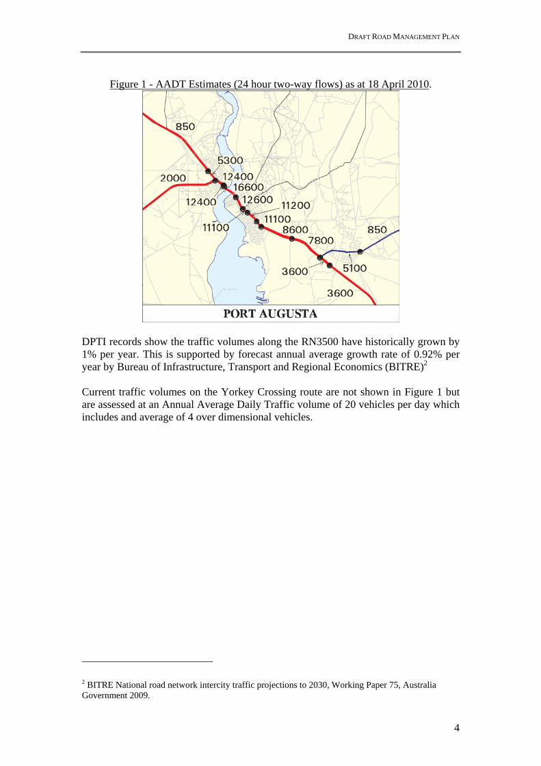
2.2 Traffic volumes Traffic volume records for Port Augusta are shown in Figure 1. These values represent the Annual Average Daily Traffic Estimates – 24 hour two-way flows as at 18 April 2010. Traffic volumes increase within Port Augusta due to local movements within the CBD district.
DRAFT ROAD MANAGEMENT PLAN
4
Figure 1 - AADT Estimates (24 hour two-way flows) as at 18 April 2010.
DPTI records show the traffic volumes along the RN3500 have historically grown by 1% per year. This is supported by forecast annual average growth rate of 0.92% per year by Bureau of Infrastructure, Transport and Regional Economics (BITRE)2 Current traffic volumes on the Yorkey Crossing route are not shown in Figure 1 but are assessed at an Annual Average Daily Traffic volume of 20 vehicles per day which includes and average of 4 over dimensional vehicles.
2 BITRE National road network intercity traffic projections to 2030, Working Paper 75, Australia Government 2009.
DRAFT ROAD MANAGEMENT PLAN
5
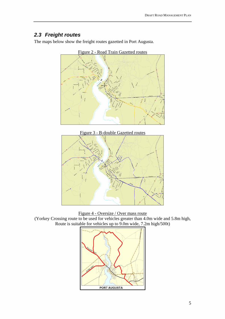
2.3 Freight routes The maps below show the freight routes gazetted in Port Augusta.
Figure 2 - Road Train Gazetted routes
Figure 3 - B-double Gazetted routes
Figure 4 - Oversize / Over mass route (Yorkey Crossing route to be used for vehicles greater than 4.0m wide and 5.8m high,
Route is suitable for vehicles up to 9.0m wide, 7.2m high/500t)

DRAFT ROAD MANAGEMENT PLAN
6
2.4 Crash history The Scoping Paper produced a Road Crash plan (2005-2010) that identified most crashes in Port Augusta as primarily occurring at intersections (see Figure 5). These crashes have been further investigated to identify trends.
Figure 5 – Road crash history (2005-2010)
Signalised intersections a) Eyre Highway (RN2000)/ Victoria Pde (RN3500)/ Caroona Rd / Burgoyne St
The predominant crash type at this intersection is rear end (6 crashes), with most reports being on the southern approach in the thru lanes. Hit fixed object crashes both involved vehicles towing trailers colliding with a traffic signal pole on the Caroona Road / Eyre Highway corner.
Intersection Crash Type PDO $ 3000+
Injury Total
Caroona Road / Eyre Hwy Rear End 6 - 6 Right Turn 3 - 3 Hit Fixed Object 2 - 2 Right Angle 2 - 2 Side Swipe 1 - 1
Total 14 - 14

DRAFT ROAD MANAGEMENT PLAN
7
b) Victoria Parade / Flinders Tce Intersection Crash Type PDO
$ 3000+ Injury Total
Victoria Pde / Flinders Tce Rear End 8 3 11 Right Turn 5 4 9 Roll Over - 1 1 Right Angle 1 4 5 Side Swipe - 1 1
Total 14 13 27 The predominant crash type at this intersection is rear end (11 crashes) with two common trends identified. The first involves motorists wanting to turn left onto Flinders Terrace from Eyre Highway (3 crashes) and the other involves motorists wanting to turn left from Flinders Terrace onto Eyre Highway (3 crashes). Other crashes did not reveal any other observable trends. There appears to be a higher than normal incidence of Injury (Treated or Admitted) crashes. c) Victoria Parade / Carlton Parade
Intersection Crash Type PDO $ 3000+
Injury Total
Victoria Pde / Carlton Pde Rear End - 1 1 Right Turn 2 1 3 Right Angle 1 - 1
Total 3 2 5 There have been no crashes at this intersection since 2005. A red light camera was installed in 2007. Unsignalised intersections d) Victoria Road / Tottenham Road
Intersection Crash Type PDO $ 3000+
Injury Total
Tottenham Road & Eyre Hwy Rear End 3 3 6 Right Turn 2 1 3 Side Swipe 1 1 2
Total 6 5 11 The predominant crash type at this intersection is rear end (6 crashes) with three of these caused by vehicles crashing into motorists conducting a U-turn from a northerly to southerly direction. Similarly, all three right turn crashes were influenced by vehicles conducting U-turns from north to south which obscured the view of motorists wanting to turn right onto Tottenham Road. There is no sheltered turn lane at this intersection.

DRAFT ROAD MANAGEMENT PLAN
8
e) Eyre Highway / Bond Street Intersection Crash Type PDO
$ 3000+ Injury Total
Eyre Hwy / Bond Street Right Angle 4 1 5 Right Turn 1 - 1
Total 5 1 6 The predominant crash type is vehicles exiting Bond Street failing to give way to north bound traffic on Eyre highway. The sight distance from Bond Street, past the pedestrian activated crossing, may be restricted due to road geometry and further restricted by parked vehicles. f) Victoria Parade / Howard Street
Intersection Crash Type PDO $ 3000+
Injury Total
Victoria Pde / Howard St Rear End 2 - 2 Right Turn 1 - 1 Right Angle 1 1 2 Side Swipe 1 - 2
Total 6 1 7 This intersection provides access to McDonalds and a Petrol Station. Three out of the seven crashes involved vehicles making a U-turn from a southerly to a northerly direction at the Howard Street intersection. There is a sheltered right turn lane from the south, but no sheltered turn lane (or U-turn lane) from the north. g) Highway One / Edinburgh Terrace Intersection Crash Type PDO
$ 3000+ Injury Total
Highway One / Edinburgh Terrace Rear End 2 1 3 Right Angle 1 1 2 Hit Fixed Object 1 1 2
Total 4 3 7 There is no predominant crash type at this intersection. Two vehicles hit the pipeline within the median strip, and rear end crashes occurred when vehicles collided into the rear of vehicles turning left from Edinburgh Terrace onto Eyre Highway.

DRAFT ROAD MANAGEMENT PLAN
9
2.5 Asset Sustainment
2.5.1 Road Pavements
DPTI maintains a history of pavement age and road surface condition. The records show that the last roughness and rutting assessment in June & July 2009 rated the pavements in good condition. The last cracking assessment was in 2005. Road Roughness
(NAASRA Count)
Rutting (Percent <=10mm
Cracking (Percent Total)
Seal Age
RN3500 (RRD 0 -5)
Avg = 60 (Good)
97% (Good) 9.5% (Acceptable)
Intersections = 2003 Rest of hwy = 1987
RN1000 (RRD 922 – 927)
Avg = 51 (Excellent)
75% (Needs investigation)
3.7% (Excellent)
3.7km = 1998 0.9km = 1994 1.0 km = 1987
RN2000 (RRD 944 – 949)
Avg = 47 (Excellent)
97% (Good) 2.6% (Excellent)
Intersection =2008 Rest of Hwy = 1996
There are no proposed plans to undertake major pavement rehabilitation works on these roads in the next 3 years, however the N&W Region re-assess these roads on a yearly basis to determine the list of potential candidate projects to receive funding in future financial years.
2.5.2 Structures
DPTI maintains a State-wide register of bridges and structures on DPTI roads. These bridges and structures are routinely inspected for condition and repair. A summary of the bridges and structures within Port Augusta is below. Location (Road Number & Road Running Distance)
Structure Overall Condition rating
RN3500 RRD 7.96 Culverts (2 x 1.8m dia) Good RN3500 RRD 7.12 Bridge over railway line to power station (35m x
6.3m) Very Good
RN3500 RRD 3.15 Bridge over railway line southern end of Port Augusta (35m x 12m)
Very Good
RN3500 RRD 2.02 High school pedestrian underpass (25m x 4m) Very Good RN3500 RRD 1.78 Jervois St pedestrian underpass (25m x 4m) Good RN3500 RRD 1.71 Bridge over railway line northern end of Port Augusta
(38m x 23m) Good
RN3500 RRD 1.25 Pt Augusta Bridge over Spencer Gulf (545m x 11m) Good RN1000 RRD 924.6 Armco Culvert over railway line north of Port
Augusta (38m x 10m) Good
RN1000 RRD 923.53 Culvert over Woomera pipeline (58m x 1.8m) Good All DPTI owned bridges and structures are considered to be in good or very good condition.

DRAFT ROAD MANAGEMENT PLAN
10
The old Great Western Bridge crosses the Spencer Gulf parallel to the Port Augusta Bridge. This bridge is the responsibility of Port Augusta Council since October 1978. It appears to be in a poor condition and is used for pedestrian and cycling activities. This bridge is closed to traffic, but reportedly can still be used by emergency vehicles.
2.5.3 Road Lighting
A desktop survey identified that there are approx 95 DPTI poles for the extent of the analysis. Most poles are 15-20 year vintage but are still quite serviceable. The majority of road lighting on Victoria Parade (RN3500) is High Pressure Sodium 100W luminaires which do not meet the desired V3 road lighting standards. This is due to the national standards having been reviewed and amended over time, while the asset itself has not been upgraded to reflect these new standards. It should be noted that the street lighting mounted on ETSA stobie poles is owned by ETSA Utilities, with DPTI and Council paying a tariff to ensure the lighting is maintained. If luminaires were to be upgraded to High Pressure Sodium 150W (or even 250W) then in the majority of cases it is believed that the existing poles would comply. Some of the electrical infrastructure may also need to be upgraded to support a Luminaire upgrade, but this would need to be checked on a full design. At present, DPTI has reviewed road lighting based on project specific sites in Port Augusta (ie Eyre Hwy / Caroona Rd intersection upgrade). This has again led to a mixture of Low Pressure ‘monochromatic’ lamps and upgrades High Pressure Sodium lamps. The desktop study identified a poor area for road lighting where there are ETSA stobie poles just north west of the Burgoyne St upgrade to Bond St. These are mainly Low Pressure 90W Monochromatic Luminaires which create a weak point for road lighting. To improve road lighting would require a project that evaluates the condition of lighting based on the quality of the lighting (measurement) , night time crash rates and traffic volumes. This evaluation would determine costs and priority ranking for upgrade compared to other locations across the network If found to be a priority, DPTI would need to work with ETSA to negotiate the program of works for the upgrade of the existing lighting to the latest standards.
2.5.4 Traffic Signals
Traffic signals and Pedestrian Actuated Crossing are installed at the following locations:
Traffic Signals Pedestrian Actuated Crossings Eyre Highway / Burgoyne St / Caroona Rd (TS382) Near Bond St (PC125) Victoria Parade / Flinders Terrace (TS388) Victoria Parade / Carlton Parade (TS387) These sites are linked to DPTI’s Metropolitan Region who monitors performance and faults. These assets are subject to a routine maintenance program.

DRAFT ROAD MANAGEMENT PLAN
11
2.5.5 Routine Maintenance
Routine Maintenance activities on this road section are typically carried out by DPTI or an external contractor in accordance with the department’s specifications for maintenance.
2.6 Control of Access The Commissioner of Highways has declared Control of Access along the following road sections within Port Augusta.
Eyre Highway 220m west of Kittel St to Stokes Tce Eyre Hwy Mildred St to Caroona Rd Caroona Rd Eyre Hwy to Loudon Rd (north side only) Victoria Parade - Tassie St to Flinders Tce Highway One (Princes Hwy) - Russell Ave to 1100m south of McConnal Rd
junction Range View Road - Highway One to Bowman Rd
Further details and maps are at http://maps.dpti.sa.gov.au/ArcIMS/CAR/index.asp)
Figure 6 – Control of Access Maps
DRAFT ROAD MANAGEMENT PLAN
12
3 Expansion of the mining industry A concern to the Port Augusta City Council is the potential for increased heavy traffic from mining developments, in particular the Olympic Dam Expansion, using the Pt Augusta Bridge and the Yorkey Crossing route. During 2011, the Resources and Energy Sector Infrastructure Council (RESIC) undertook an infrastructure demand study. From a survey of resource and infrastructure companies, data was collected on the current and future demands on infrastructure from proposed resources sector projects in SA. Data was collected for three provinces, Eyre Peninsula, Yorke and Braemar, and Upper North. Freight from Adelaide to projects in the Eyre Peninsula region and some of the projects in the Upper North region (those west of Port Augusta) is likely to pass through Pt Augusta. The RESIC study does not identify the origin of road freight to service these proposed developments, but does indicate that the total inbound road freight for projects in these two regions averages 580,000 tonnes per year, peaking in the period 2017-2021. The companies that responded to the survey indicated that the majority for road freight would be carried on B-Double and A-Double road trains. This demand equates to an annual average of around 60 heavy vehicle trips per day. Demand through Pt Augusta is likely to be less than this, perhaps 40 heavy vehicles per day, taking into account freight for projects in the east of the Upper North Region which will not pass through Pt Augusta. Survey information provided by companies indicates a very small amount of over dimension (escort) freight is projected be generated by these projects, of the order of 220 tons per year. This equates to about 10 trips per year on the Yorkey Crossing route. The most significant increase in traffic and freight volumes is expected to come from BHPB’s Olympic Dam expansion project. Data on the freight demand from this project is contained in the 2009 Draft EIS and 2011 Supplementary EIS. BHPB indicates that heavy vehicle movements through Pt Augusta are likely to peak at 65 heavy vehicles per day 4 years after commencement of the expansion project reducing to just 2 heavy vehicle trips 3 years later. (page 645 ODX Supp EIS). BHPB indicates that it expects very few over dimension loads to use the Yorkey Crossing route. It estimates a peak of 4 per day for over dimension loads between 3.5m and 5.5m. Only loads greater than 4m wide are required to use Yorkey crossing and this is estimated to be less than 2 trips per day. The projected peak demands in heavy vehicles from the RESIC study and BHPB EIS collectively result in a 8% increase of commercial vehicles crossing the Pt Augusta bridge. It is considered unlikely the peak demands from the Olympic Dam expansion and other projects identified in the RESIC study will coincide.

DRAFT ROAD MANAGEMENT PLAN
13
4 Issues identification The first stage of the Road management Plan was the development of the Scoping Paper3 which summarised all known issues and investigations derived from the strategic plans, previous studies & direct consultation with selected key stakeholders. During this process Port Augusta City Council provided the Port Augusta Infrastructure Plan4 which has been developed to provide a blue print for future development in Port Augusta. This document underpins the Port Augusta Structure Plan5. The Infrastructure Plan contains a Traffic Impact Assessment including SIDRA intersection analysis conducted by Traffic engineering consultants – MFY. The Infrastructure Plan sets out a framework for supporting the predicted growth scenarios for Port Augusta for years 2026, 2036 and 2041. Against these scenarios it sets out suggested infrastructure development needs for: development areas, water supply, wastewater, stormwater, electricity, telecommunications, Olympic Dam Expansion and supporting road infrastructure proposals. An overview of recommendations is provided in Table 1 following:
Table 1 - Summary of Future Road Networks proposals from Pt Augusta Infrastructure Plan
(Source: Port Augusta Infrastructure Plan (2009) – Table 16, Pg 58, Authored by Connor Holmes)
3 Port Augusta Road Management Plan - Scoping Paper (November 2010), authored by Intermethod. 4 Port Augusta Infrastructure Plan (September 2009), authored by Connor Holmes for Port Augusta City Council 5 Port Augusta Structure Plan. Department for Planning and Local Government. January 2011. Available at http://www.planning.sa.gov.au/index.cfm?objectid=48588231-F203-0D46-A3B5C051BF3F4EDE

DRAFT ROAD MANAGEMENT PLAN
14
Generally, these growth scenarios are beyond the time scope of this RMP that aims to address the potential short to medium term (5-10 year) road improvement needs for improved safety and traffic operations. The key strategic recommendations from both the Scoping Paper and Port Augusta Infrastructure Plan for the short to medium term (5-10 years) are listed below. These form the basis of the projects for further investigation for the Road Management Plan and development of an Improvement Strategy. Short to Medium Term
Work with DPLG to integrate transport infrastructure planning with the revision of the Port Augusta Structure Plan
Establish an approach to stakeholder engagement into the development of the RMP
Proceed with design work for the upgrade of the Eyre Highway / Burgoyne St / Caroona Road intersection
Structural investigations to upgrade bridge barriers on existing Port Augusta bridge
Commission a risk assessment to determine what freight, carrying hazardous waste, may need to detour on risk grounds
Carry out optimisation of traffic signals along Highway 1 to prevent unnecessary delays
Commence an engineering assessment into Yorkey Crossing to determine localised improvements for increased level of service
Provide sheltered right turn lanes for unsignalised intersections, particularly between Carlton Parade and rail overpass. This is to minimise the impact of right turning vehicles on through traffic and improve the safety and efficiency at these locations.
Upgrade the Caroona Road / Burgoyne St / Eyre Highway intersection to address capacity issues that lead to excessive queue lengths

DRAFT ROAD MANAGEMENT PLAN
15
5 Improvement Strategy Investigations The key strategic recommendations from both the Scoping Paper and Port Augusta Infrastructure Plan for the short to medium term (5-10 years) are further investigated in the following sections. These investigations aim to identify the key issues, constraints and benefits for each project. Where applicable, a rapid economic appraisal is undertaken to determine whether a project is justified in the short to medium term based on benefit costs assessment.
5.1 Revision of the Port Augusta Structure Plan Work A new release of the Port Augusta Structure Plan occurred on 21 January by Hon Paul Holloway MP. This new plan incorporates reference to the Transport Network and Infrastructure Planning (Extracts from Plan below).
Transport network Port Augusta forms the interstate crossroads for the nation’s east–west and north–south National Land Transport Network and National Rail Network corridors. All goods arriving or departing Australia from Fremantle and Darwin and originating from or destined for Sydney, Melbourne or Adelaide transit through Port Augusta either by road or rail. More than 15 million tonnes are estimated to move along these corridors every year, and this will rise substantially as mining and defence activities expand. Complementing these national corridors is a well developed grid of local roads. The Port Augusta Structure Plan ensures development will support the ongoing operation of these transport networks. Comprehensive traffic impact assessments need to be undertaken for each area proposed for rezoning to determine the eventual transport system improvements needed to cater for expected traffic (for example, junction improvements). These assessments should occur as a part of all Structure Plans and Development Plan Amendments to enable transport infrastructure providers (commonwealth, state and local government) to properly consider the implications and merits of the proposed changes. Any improvements required to the transport system as a result of proposed changes shall be funded by the developer. Access structures need to be developed to ensure effective performance (efficiency and safety) is maintained on the National Land Transport Network corridors. Infrastructure planning Port Augusta City Council has prepared an Infrastructure Plan (2009), as recommended in the council’s Strategic Plan, which provides a crucial stepping-stone between the Port Augusta Structure Plan and any subsequent amendments to the Development Plan. Specifically, the Infrastructure Plan provides the foundations for detailed, area specific planning prior to the rezoning of land identified in this Structure Plan.
Recommendation: As outlined in the plan comprehensive traffic impact assessments
will need to be undertaken for each area proposed for rezoning in order to ensure the travel demand created by the developments can be catered for by the transport infrastructure within Port Augusta. Exploration of a scale of urban development within Port Augusta that results in feasible transport infrastructure requirements is required in order to ensure a sustainable expansion of the city.
DRAFT ROAD MANAGEMENT PLAN
16
5.2 RMP - develop approach to stakeholder engagement Intermethod was engaged to develop a preliminary Stakeholder Engagement Schedule for reference. This document is included in Appendix A
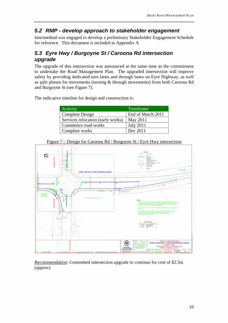
5.3 Eyre Hwy / Burgoyne St / Caroona Rd intersection upgrade The upgrade of this intersection was announced at the same time as the commitment to undertake the Road Management Plan. The upgraded intersection will improve safety by providing dedicated turn lanes and through lanes on Eyre Highway, as well as split phases for movements (turning & through movements) from both Caroona Rd and Burgoyne St (see Figure 7). The indicative timeline for design and construction is:
Activity Timeframe Complete Design End of March 2011 Services relocation (early works) May 2011 Commence road works July 2011 Complete works Dec 2011
Figure 7 – Design for Caroona Rd / Burgoyne St / Eyre Hwy intersection
Recommendation: Committed intersection upgrade to continue for cost of $2.5m (approx)

DRAFT ROAD MANAGEMENT PLAN
17
5.4 Port Augusta bridge barrier investigation The community identified their concerns about the perceived risk of a vehicle leaving the Port Augusta Bridge and falling into the Spencer Gulf. The existing bridge barrier, installed as part of the original construction, is a pedestrian type fence. Concerns have been raised that this fence may not stop a heavy vehicle leaving the bridge in an instance that the vehicle mounts the concrete kerb during a crash. DPTI has prepared a preliminary design for a rigid bridge barrier. The new barrier is designed to be placed above the existing concrete kerb on either side of bridge (ie. in front of existing pedestrian barrier on the north side and on the road side edge of the pedestrian footpath). This barrier is designed in consideration of the crashes, as well as ensuring that over-dimensional vehicles (low height and wide loads), still have sufficient clearance for their loads across the bridge. See Figure 8. Preliminary investigation identified that there are seven 100 mm diameter conduits + a single 50 conduit located within the footpath for electrical cables (road lighting) and communications cables (Telstra). The conduit located closest to the kerb in the footpath will be impacted by the new barrier design. This conduit is empty and Telstra have been contacted and confirmed that they are supportive of its permanent loss. Recommendation: Complete the detailed design and install new rigid traffic barrier for an estimated cost of $2.5M. (Registered Estimate)
Figure 8 – Typical Cross section for new Port Augusta Bridge Barrier

DRAFT ROAD MANAGEMENT PLAN
18
5.5 Hazardous materials freight risk assessment The Mayor’s Taskforce “Key freight issues report6” recommended the conduct of a risk assessment of hazardous materials for road freight movements over the Port Augusta Bridge to assess the need to detour some freight along Yorkey Crossing due to environmental risk.
5.5.1 Freight route risk DPTI places restrictions on road routes for dangerous goods cartage (other than explosives & Security Sensitive Ammonium Nitrate) for environmental reasons. A list of prohibited routes is gazetted under the Road Traffic Act, but this does not include any roads within Port Augusta (see Appendix B, SA Road Traffic (Miscellaneous) Regulations 1999, Part 4, Section 20). The gazette prescribes the quantity and form of dangerous good that the prohibited routes apply to. SafeWork SA (SWSA) restricts carriage of explosives (Class 1) and ammonium nitrate blasting intermediates of Class 5 greater than 1000kg. Only approved routes may be used for explosives greater than 1000kg. Approved routes have been assessed considering population density, number of dwellings and protected places along the route, critical infrastructures along the route, waterways or bodies, tunnels and bridges, traffic density on the route is factored, the frequency and volume of explosives being proposed to be transported along the route. A consequence risk assessment is also performed The proposed route is also driven by the explosives inspector to look at the road conditions, number of suitable rest stops available en-route and viability of emergency response access on route. Similar assessment and approval is required for cartage of Security Sensitive Ammonium Nitrate (SSAN) goods. This extends to routing for rail transport routes as well as road transport. A list of the approved routes is given in the SafeWork SA Technical Note 16 – Special Conditions – 2; Approved routes (see Appendix B). Port Augusta is on several SWSA approved routes (ie NSW to WA) with the Technical Note 16 advising “Where a practicable by-pass road exists as any centre of population, it shall be used.” The use of Yorkey Crossing would therefore apply for Port Augusta. Recommendation: Maintain status quo
6 Port Augusta City Council - The Mayor’s Taskforce “Key freight issues report” (7 August 2008), authored by SCM Advisory.

DRAFT ROAD MANAGEMENT PLAN
19
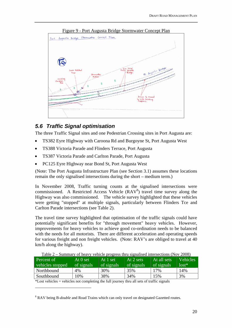
5.5.2 Pollution risk into Spencer Gulf The existing Port Augusta Bridge directs water flow along the kerb either side of the road carriageway. Stormwater leaves the carriageway via a series of scuppers7 spaced longitudinally on either side of the road that directly discharge flows unrestricted into the Spencer Gulf. In cases of accidental spills these pollutants also discharge straight to the waterways. In recognition of the potential pollution risk, and in light of public concern following the recent accidental acid spillage, DPTI commissioned a preliminary investigative design to assess the practicality of a “Spill and stormwater catchment system” on the bridge. The investigation found that it would be very difficult and uneconomic to capture the full extent of a major spill event (ie semi trailer =35,000 litres to Road train = 70,000 litres). Enquiries with SafeWork SA identified the design specifications for tanker vehicles have an industry practice of double tanks (ie. a tank within a tank). The investigation therefore focussed on capturing the stormwater events and minor spills. Drainage calculations recommend the use of 375mm diameter pipes along either side of the bridge deck to sufficiently cater for stormwater and accidental spillages on the bridge deck. The drains will need to be fireproof, hence made of steel or concrete, and could be fitted through the existing service voids under the bridge and through the abutments. The pipes will need to be suspended from the bridge deck with stainless steel fittings. It is likely that new scuppers will need to be directly connected to the suspended pipes to direct flows into the new pipe system. Within the approach ramp earthworks embankment the eastern and western side pipe systems will need to join together. The new bridge pipe network can potentially connect in with the existing stormwater network junction box located on the eastern side of the northern embankment (see Figure 9). The existing road stormwater network on the eastern side of the highway collects stormwater from Caroona Road intersection and discharges it into the gulf. A gross pollutant trap can be incorporated into the system near the outlet to remove oil and grit before stormwater is discharged to the gulf. In the event of a rapid response situation, the stormwater network could potentially be used to capture (or restrict) spills by blockage of the outlet or junction boxes. To be effective this system would require regular maintenance. Recommendation: Ongoing investigation into the practicality and cost of the stormwater capture network. Preliminary cost estimate is $2.1M (Registered Estimate)
7 Scupper – drainage hole cast through the bridge deck
DRAFT ROAD MANAGEMENT PLAN
20
Figure 9 - Port Augusta Bridge Stormwater Concept Plan
5.6 Traffic Signal optimisation The three Traffic Signal sites and one Pedestrian Crossing sites in Port Augusta are:
TS382 Eyre Highway with Caroona Rd and Burgoyne St, Port Augusta West
TS388 Victoria Parade and Flinders Terrace, Port Augusta
TS387 Victoria Parade and Carlton Parade, Port Augusta
PC125 Eyre Highway near Bond St, Port Augusta West
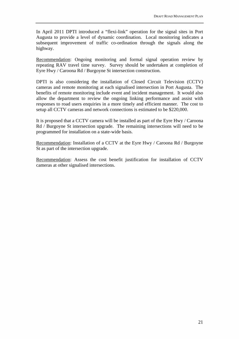
(Note: The Port Augusta Infrastructure Plan (see Section 3.1) assumes these locations remain the only signalised intersections during the short – medium term.) In November 2008, Traffic turning counts at the signalised intersections were commissioned. A Restricted Access Vehicle (RAV8) travel time survey along the Highway was also commissioned. The vehicle survey highlighted that these vehicles were getting "stopped" at multiple signals, particularly between Flinders Tce and Carlton Parade intersections (see Table 2). The travel time survey highlighted that optimisation of the traffic signals could have potentially significant benefits for "through movement" heavy vehicles. However, improvements for heavy vehicles to achieve good co-ordination needs to be balanced with the needs for all motorists. There are different acceleration and operating speeds for various freight and non freight vehicles. (Note: RAV’s are obliged to travel at 40 km/h along the highway).
Table 2 – Summary of heavy vehicle progress thru signalised intersections (Nov 2008) Percent of vehicles stopped
At 0 set of signals
At 1 set of signals
At 2 sets of signals
At all sets of signals
Vehicles lost*
Northbound 4% 30% 35% 17% 14% Southbound 10% 38% 34% 15% 3%
*Lost vehicles = vehicles not completing the full journey thru all sets of traffic signals
8 RAV being B-double and Road Trains which can only travel on designated Gazetted routes.
DRAFT ROAD MANAGEMENT PLAN
21
In April 2011 DPTI introduced a “flexi-link” operation for the signal sites in Port Augusta to provide a level of dynamic coordination. Local monitoring indicates a subsequent improvement of traffic co-ordination through the signals along the highway. Recommendation: Ongoing monitoring and formal signal operation review by repeating RAV travel time survey. Survey should be undertaken at completion of Eyre Hwy / Caroona Rd / Burgoyne St intersection construction. DPTI is also considering the installation of Closed Circuit Television (CCTV) cameras and remote monitoring at each signalised intersection in Port Augusta. The benefits of remote monitoring include event and incident management. It would also allow the department to review the ongoing linking performance and assist with responses to road users enquiries in a more timely and efficient manner. The cost to setup all CCTV cameras and network connections is estimated to be $220,000. It is proposed that a CCTV camera will be installed as part of the Eyre Hwy / Caroona Rd / Burgoyne St intersection upgrade. The remaining intersections will need to be programmed for installation on a state-wide basis. Recommendation: Installation of a CCTV at the Eyre Hwy / Caroona Rd / Burgoyne St as part of the intersection upgrade. Recommendation: Assess the cost benefit justification for installation of CCTV cameras at other signalised intersections.

DRAFT ROAD MANAGEMENT PLAN
22
5.7 Yorkey Crossing alignment options The Scoping Paper identifies the long standing community request and Strategic document recommendations to upgrade Yorkey Crossing to an all-weather road for use by heavy freight vehicles. Currently it is mandatory for over-dimensional vehicles to use this route, unless they are granted a permit in instances such as road closure due to wet weather. A number of options for the upgrade of Yorkey Crossing existing alignment and Alternative Alignments have been investigated. Figure 10 shows the options considered. Further details for Economic Analysis are provided in Appendix D and Economic Appraisal in Appendix E.
Figure 10 - Yorkey Crossing Alignment improvement & alternative options

DRAFT ROAD MANAGEMENT PLAN
23
5.8 Yorkey Crossing upgrade - Existing alignment The existing Yorkey Crossing is 27.5 kilometres in length inclusive of 20.1 kilometre section of unsealed pavement. There are 4.5 kilometres of the unsealed section that is ‘Out of Districts’ and is the responsibility of DPTI, with the remaining 23 kilometres being the responsibility of the Port Augusta City Council. The Project Proposal scope includes the sealing of the existing unsealed portion of Yorkey Crossing to provide an all weather access for over dimensional vehicles. The project involves the installation of active control at the existing railway crossing (National Line), allowance for new drainage lines and extensions to existing drainage lines, plus minor realignment to road geometry and minor intersection upgrades. This upgrade is targeted at reducing industry ‘down time’ associated with rain forced closures. It assumes the maintenance of the existing traffic volumes on Yorkey Crossing rather than encouraging additional vehicles. The route will continue on its existing alignment through the residential/industrial zoned areas at its south eastern end. A preliminary Cost Estimate (Strategic level only) and Rapid Economic Appraisal have been undertaken showing Costs = $45M (2011 costs) achieving Benefits = $3.3M (approx) and B/C of 0.10. This option is therefore not justified in the short to medium term based on benefit costs assessment. Recommendation: Not economically justified.
5.9 Yorkey Crossing upgrade - Realign south-eastern end (6.5km) and seal existing alignment The south-eastern end of the existing Yorkey Crossing follows a circuitous route passing through residential/industrial zoned areas. An option to bypass this road section with a new alignment passing northeast of Davenport Community, then matching back to Yorkey Crossing will require the construction of 6.5km of new road. The upgrade of the remainder of the unsealed portion of Yorkey Crossing is as per the previous option (Section 4.8). The total route length is 24.5km (3km short than the existing route) and will include sealing of 17km of Yorkey Crossing. The total route will provide an all weather sealed route for over dimensional vehicles. This upgrade is targeted at reducing industry ‘down time’ associated with rain forced closures. It assumes the maintenance of the existing traffic volumes on Yorkey Crossing rather than encouraging additional vehicles. A preliminary Cost Estimate (Strategic level only) and Rapid Economic Appraisal have been undertaken showing Costs = $60M (2011 costs) achieving Benefits = $3.4M (approx) and B/C of 0.08. This option is therefore not justified in the short to medium term based on benefit costs assessment. Recommendation: Not economically justified.
DRAFT ROAD MANAGEMENT PLAN
24
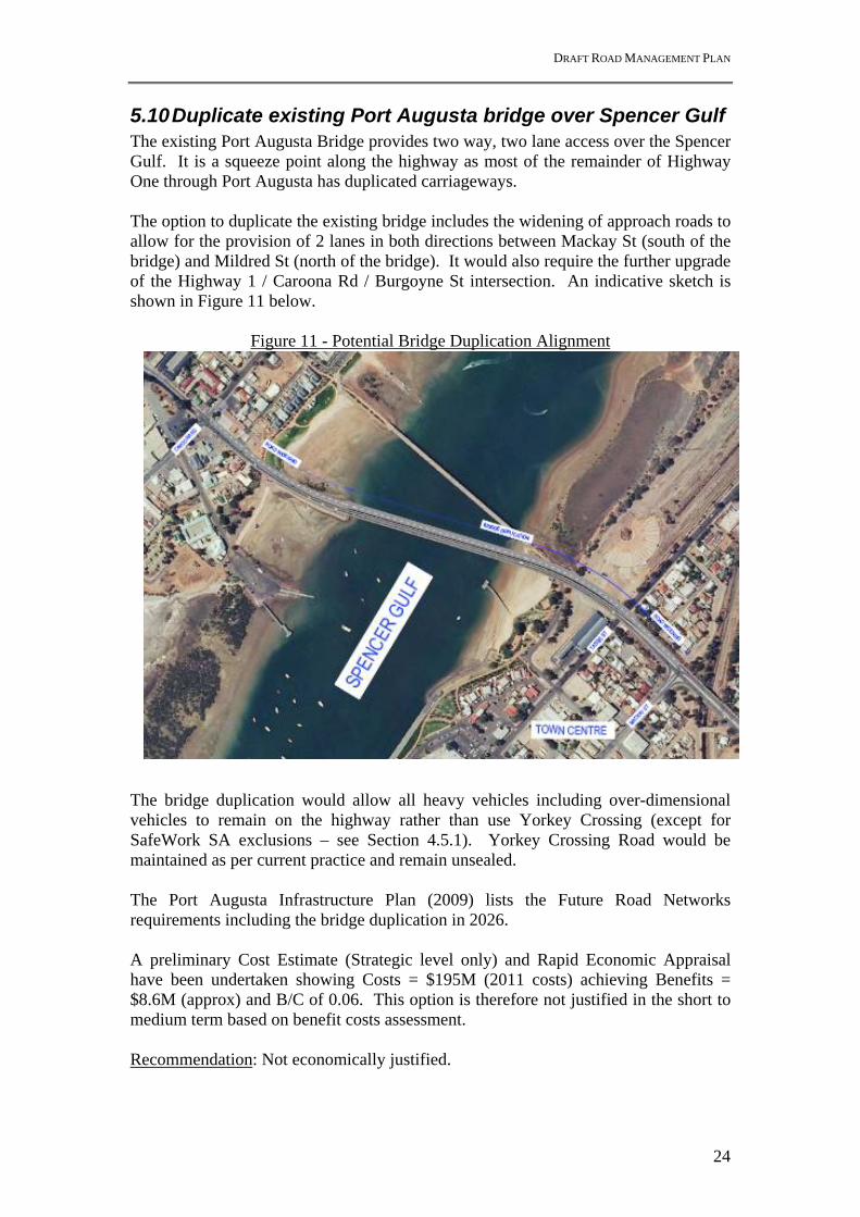
5.10 Duplicate existing Port Augusta bridge over Spencer Gulf The existing Port Augusta Bridge provides two way, two lane access over the Spencer Gulf. It is a squeeze point along the highway as most of the remainder of Highway One through Port Augusta has duplicated carriageways. The option to duplicate the existing bridge includes the widening of approach roads to allow for the provision of 2 lanes in both directions between Mackay St (south of the bridge) and Mildred St (north of the bridge). It would also require the further upgrade of the Highway 1 / Caroona Rd / Burgoyne St intersection. An indicative sketch is shown in Figure 11 below.
Figure 11 - Potential Bridge Duplication Alignment The bridge duplication would allow all heavy vehicles including over-dimensional vehicles to remain on the highway rather than use Yorkey Crossing (except for SafeWork SA exclusions – see Section 4.5.1). Yorkey Crossing Road would be maintained as per current practice and remain unsealed. The Port Augusta Infrastructure Plan (2009) lists the Future Road Networks requirements including the bridge duplication in 2026. A preliminary Cost Estimate (Strategic level only) and Rapid Economic Appraisal have been undertaken showing Costs = $195M (2011 costs) achieving Benefits = $8.6M (approx) and B/C of 0.06. This option is therefore not justified in the short to medium term based on benefit costs assessment. Recommendation: Not economically justified.
DRAFT ROAD MANAGEMENT PLAN
25
5.11 New Northern Port Augusta bypass A disadvantage of Yorkey Crossing in attracting more commercial vehicle traffic is the large additional distance to be travelled. The direct route through Port Augusta is 10.5km, whereas the existing Yorkey Crossing route is 27 km. N&W Region have assisted to identify a “Greenfields” route for a possible new northern bypass of Port Augusta between Stuart Highway and Highway One (near Footner Road). A possible alignment for a new sealed road to provide an all weather access for general traffic & over dimensional vehicles (13.5 km) is shown in Figure 10. This route is 14km shorter than the existing Yorkey Crossing route. The new alignment bypasses the Davenport community, and Port Augusta residential / industrial areas. This route will be an alternative alignment to Yorkey Crossing which would remain unsealed. The new alignment would involve the installation a new active controlled crossing at the existing railway crossing (National Line), and a new bridge crossing over the Spencer Gulf adjacent to the existing rail bridge crossing. It would require new drainage lines and extensions to existing drainage lines, plus minor and major intersection upgrades at the interfaces with the existing road network. Grade separation of the rail crossings (x2) along the bypass route has been excluded. These would add significant complications and additional cost. The route will require land acquisition to create the “green fields” alignment. The western end of the route from Stuart highway to the Alice Springs Railway track passes through land owned by “The Minister for Environment.” The “Minister for Transport” owns the land to Depot Creek road.. The remainder of the route is over privately owned land including the outer extremes of the Davenport Community. The route from Carlton Parade to Highway One will predominantly follow the existing road reserves requiring only minor land acquisition. A desktop Environmental Impacts Preliminary Assessment identified that this route will require extensive environmental assessment. Various Registers have identified Aboriginal archaeological, cultural and historic sites. There are extensive patches of mature native vegetation providing a moderate level of habitat value (particularly for birds and small animals) and good screening / visual amenity value. The route also passes through a signed Conservation Zone, directly west of the gulf and north of the Whyalla rail line, which forms part of the Australian Arid Land Botanical Garden Site. The Environmental Impacts Preliminary Assessment report is given in Appendix C. There are also a few vulnerable flora and fauna species, and a high potential of encountering acid sulphate soils during construction particularly for works close to the estuary. This upgrade is targeted at reducing industry ‘down time’ associated with rain forced closures. It assumes the attraction of additional heavy vehicles to this route as it has a similar length the existing route with reduced stops and would allow higher speeds. It is assumed that the bypass route would be attractive to commercial vehicles travelling through Pt Augusta with destinations North of Pt Augusta on the Stuart Highway. The
DRAFT ROAD MANAGEMENT PLAN
26
route may also be attractive to some light vehicle through traffic. However it is noted that the majority of traffic currently using Pt Augusta Bridge is local traffic. A preliminary Cost Estimate (Strategic level only) and Rapid Economic Appraisal have been undertaken showing Costs = $170M (2011 costs) achieving Benefits = $15.5M (approx) and B/C of 0.18. This option is therefore not justified in the short to medium term based on benefit costs assessment. Recommendation: Not economically justified. Port Augusta City Council may wish to investigate further & consider reserving a road corridor.
DRAFT ROAD MANAGEMENT PLAN
27
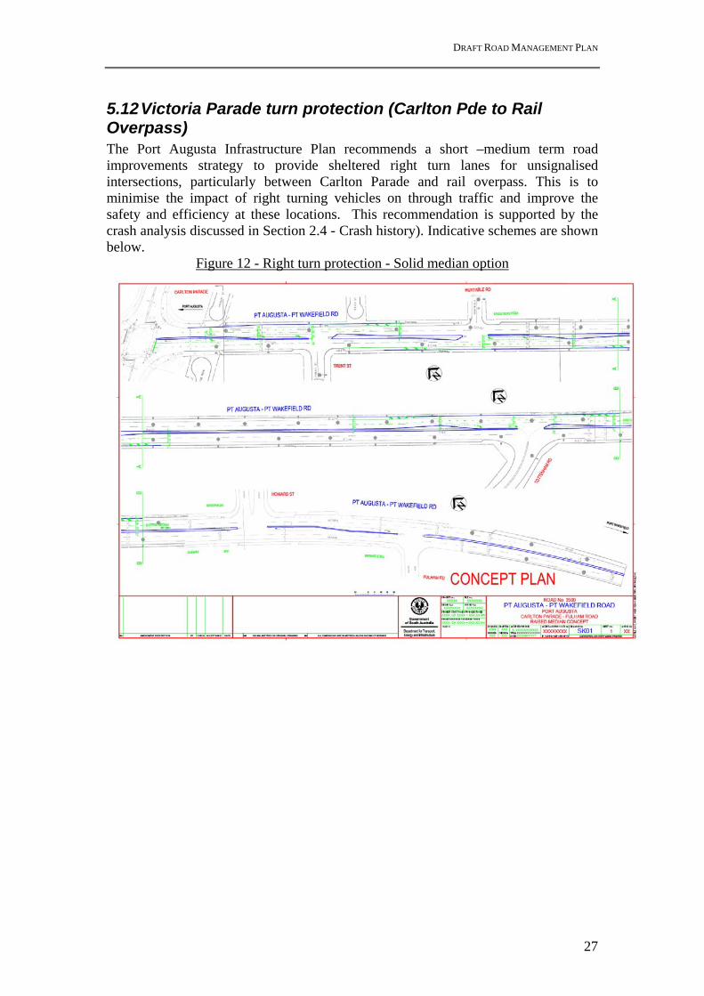
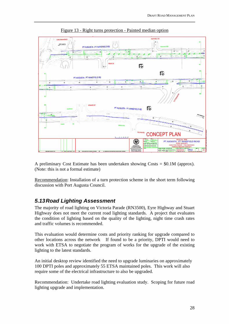
5.12 Victoria Parade turn protection (Carlton Pde to Rail Overpass) The Port Augusta Infrastructure Plan recommends a short –medium term road improvements strategy to provide sheltered right turn lanes for unsignalised intersections, particularly between Carlton Parade and rail overpass. This is to minimise the impact of right turning vehicles on through traffic and improve the safety and efficiency at these locations. This recommendation is supported by the crash analysis discussed in Section 2.4 - Crash history). Indicative schemes are shown below.
Figure 12 - Right turn protection - Solid median option
DRAFT ROAD MANAGEMENT PLAN
28
Figure 13 - Right turns protection - Painted median option
A preliminary Cost Estimate has been undertaken showing Costs = $0.1M (approx). (Note: this is not a formal estimate) Recommendation: Installation of a turn protection scheme in the short term following discussion with Port Augusta Council.
5.13 Road Lighting Assessment The majority of road lighting on Victoria Parade (RN3500), Eyre Highway and Stuart Highway does not meet the current road lighting standards. A project that evaluates the condition of lighting based on the quality of the lighting, night time crash rates and traffic volumes is recommended. This evaluation would determine costs and priority ranking for upgrade compared to other locations across the network If found to be a priority, DPTI would need to work with ETSA to negotiate the program of works for the upgrade of the existing lighting to the latest standards. An initial desktop review identified the need to upgrade luminaries on approximately 100 DPTI poles and approximately 55 ETSA maintained poles. This work will also require some of the electrical infrastructure to also be upgraded. Recommendation: Undertake road lighting evaluation study. Scoping for future road lighting upgrade and implementation.

DRAFT ROAD MANAGEMENT PLAN
29
6 Appraisal Summary (including Costs & Priority) The Road Management Plan investigations have reviewed the Short to Medium Term recommendations from both the Port Augusta Infrastructure Plan and Scoping Paper documents. Cost estimates for each Project recommendation are given in Table 3 below and correspond to Level 1-3 “Preliminary Cost Estimates” in DPTI’s Transport System Management Framework.
Table 3 Appraisal Summary Table
Option Estimated Cost (Sept 2011)
BCR Priority
Eyre Hwy / Caroona Rd / Burgoyne St intersection upgrade (Section 4.3)
$2.5M N/A Completed
Design and install new rigid traffic barrier on Port Augusta Bridge (Section 4.4)
$2.6M NC High
Stormwater / pollution capture system on Port Augusta Bridge (Section 4.5.2)
$2.1M NC Medium
Traffic signal optimisation (Section 4.6)
N/A N/A Completed
Traffic signal CCTV at Eyre Hwy / Caroona Rd / Burgoyne St intersection (Section 4.6)
N/A N/A Low
Traffic Signal CCTV at other signalised intersections (Section 4.6)
$0.22M NC Low
Yorkey Crossing Upgrade existing alignment (Section 4.8)
$45M 0.10 Not economically
justified
Yorkey Crossing Upgrade existing alignment + 6.5 km realignment of South-eastern end. (Section 4.9)
$65M 0.08 Not economically
justified
Port Augusta Bridge duplication (Section 4.10) $195M 0.06
Not economically justified
New northern Port Augusta bypass alignment (Section 4.11)
$170M 0.18 Not economically
justified
Victoria Parade turn protection (Section 4.12)
$0.1M* NC High
Road lighting evaluation study (Section 4.13) $0.05M* NA High
Road lighting upgrade design & implementation (Section 4.13)
$0.5-1.0M* NC Medium
N/A = not applicable (committed funding), NC = Not calculated, * Indicative cost only
DRAFT ROAD MANAGEMENT PLAN
30
7 Conclusion This Road Management Plan has made a number of recommendations to address the short to medium term operational and safety issues that have been identified from both the Port Augusta Infrastructure Plan and Scoping Paper documents. The proposed recommendations are conceptual only, unless otherwise identified. Concepts require further development and consultation with Port Augusta City Council and the community.
DRAFT ROAD MANAGEMENT PLAN
Appendix A - Stakeholder Engagement Schedule for Road Management Plan
DRAFT ROAD MANAGEMENT PLAN

DRAFT ROAD MANAGEMENT PLAN
DRAFT ROAD MANAGEMENT PLAN

DRAFT ROAD MANAGEMENT PLAN

DRAFT ROAD MANAGEMENT PLAN
Appendix B - SA Road Traffic (Misc) Regulations 1999, Part 4, Section 20).
- SafeWork SA Technical Note 16 – Special Conditions – 2, Approved routes.
DRAFT ROAD MANAGEMENT PLAN

DRAFT ROAD MANAGEMENT PLAN

DRAFT ROAD MANAGEMENT PLAN

DRAFT ROAD MANAGEMENT PLAN

DRAFT ROAD MANAGEMENT PLAN

DRAFT ROAD MANAGEMENT PLAN
DRAFT ROAD MANAGEMENT PLAN
Appendix C – Environmental Impacts Preliminary Assessment report
(Yorkey Crossing Rd and New Northern Bypass alignments)

DRAFT ROAD MANAGEMENT PLAN
Refer to File No.: 2011/03115/01 Prepared by: Shannen Stone
Preliminary Environmental Impact Assessment
Port Augusta Road Management Plan – Yorkey Crossing Alternatives 24th March 2011
SUMMARY
Issue Action Indicative Estimated Cost
Timing
Sustainability Undertake a Sustainability Management Plan (if a Cabinet Submission or Public Works Submission is required for the project).
N/A N/A
Aboriginal heritage
Undertake an Aboriginal heritage survey once the final alignment has been chosen
N/A N/A
Native Title Undertake an assessment of native title for any land that is to be acquired.
N/A N/A
Non-Aboriginal heritage
If any work impact on a local or state listed heritage item or area consult with State or Federal DEH to determine mitigation measures and planning/approval requirements.
N/A N/A
Vegetation Undertake a vegetation survey once the preferred road alignment is selected
N/A N/A
Develop a landscape/vegetation management plan to offset any vegetation removals
N/A N/A
Seek approval from DAC and Council for removal of any Significant Tree.
N/A N/A
Landscaping construction N/A N/A
Landscaping maintenance N/A N/A
Fauna Minimise disturbance to vegetation and implement an appropriate landscape/vegetation management plan.
N/A N/A
Acid sulphate soils
On completion of Geotechnical Reports check if Acid Sulphate Soils are to be impacted by this project.
N/A N/A
Water Quality Undertake a water quality risk assessment for the project and determine the need for a Water Affecting Activity Permit
N/A N/A
Investigate and design appropriate water quality treatment measures including the use of swale drains for stormwater treatment over the use of piping and kerbing.
N/A N/A
Contaminated land
Undertake Site History investigations for all land to be acquired N/A N/A
Undertake Site Remediation N/A N/A Air quality If required, undertake air quality modelling. N/A N/A
Noise Undertake noise modelling and monitoring to verify preliminary results
N/A N/A
Investigate and design appropriate noise mitigation N/A N/A
Social/ Community
Undertake appropriate community and stakeholder consultation and develop and implement a community consultation plan.
N/A N/A
Energy/Waste Investigate options for using recycled or recyclable materials, Investigate options for re-using road materials i.e. asphalt, Investigate options for using energy efficient products i.e. solar
powered lighting
N/A N/A
Environmental management
Undertake an EIAR N/A N/A
Develop an EMP for construction (including dust control measures) Undertake Environmental Audit/s during construction
N/A N/A

DRAFT ROAD MANAGEMENT PLAN
INTRODUCTION This report provides a broad overview of the key environmental issues and impacts for the proposed Yorkey Crossing Road Alternatives, Port Augusta. There are two alternatives covered within this report, resealing the current Yorkey Crossing Road or constructing a brand new Yorkey Crossing Road. This report has been produced for the project’s feasibility study. It has been produced under the following preliminary assumptions: Existing Alignment The upgrading of Yorkey Crossing Road by resealing. Only the current road reserve of Yorkey Crossing Road will be used. New Alignment The new alignment of Yorkey Crossing Road as per the plans is being used. Land acquisition will be required for this alignment. The issues identified in this report are based on desk-top information obtained. The undertaking of the actions identified below may result in additional recommendations to be undertaken at various stages of the project and may incur additional costs. A more detailed assessment of the environmental issues associated with the preferred option for this project will be required in the Environmental Impact Assessment Report (EIAR). Black – Current Alignment Blue – Proposed Alignment ISSUES 1. ABORIGINAL HERITAGE Objective: Preservation and conservation of cultural heritage – where possible avoid
loss or damage to areas of cultural heritage significance The Aboriginal Affairs and Reconciliation Division (AARD) of the Department of Premier and Cabinet were contacted to determine if there were any previous Aboriginal Heritage surveys had been undertaken or sites identified within the project area. ARRD has indicated that there are entries on their Register of Aboriginal Sites and Objects within the proposed work locations. The Aboriginal sites are described as eleven archaeological, six cultural and three historic sites.

DRAFT ROAD MANAGEMENT PLAN
A search of DPTI’s Aboriginal Heritage Surveys Database and Roadside Significant Sites Database indicated no surveys have previously been undertaken nor any recorded Aboriginal heritage sites identified along Yorkey Crossing Road. There have been a few surveys conducted in Port Augusta – Port Wakefield Road. The closest survey goes into the Port Augusta Township for a road upgrade. Besides that there are no other surveys for the proposed work area. The Yorkey Road Upgrade both the existing track and the new track will have an impact on Aboriginal heritage, an Aboriginal heritage survey will be required when the final alignment has been determined. A survey will need to be undertaken by a qualified archaeologist/anthropologist in consultation with the appropriate Aboriginal communities. This shall be in accordance with DPTI’s Cultural Heritage Guidelines (1999) and DPTI’s Guidelines for Conducting Aboriginal Heritage Surveys (2002). In addition to preserving cultural heritage a survey may reduce (but not remove) the likelihood of finding a site and avoiding lengthy delays during construction. If a site is found within the project area during the Aboriginal heritage survey and work still is to be undertaken, Section 23 under the Aboriginal Heritage Act 1988 will need to be applied for. This process can take around 6 months to complete. In accordance with the Aboriginal Heritage Act 1998, during construction the discovery of any Aboriginal sites or objects will require works to be stopped until ARRD has been notified. (AARD, 2011, Port Augusta Aboriginal Sites) Action Indicative
Estimated Cost Engage a qualified archaeologist/anthropologist to undertake and
Aboriginal heritage survey once the final alignment has been chosen. N/A
2. NATIVE TITLE

DRAFT ROAD MANAGEMENT PLAN
Objective: Preservation and conservation of cultural heritage. A search on the National Native Title Register showed that there is an active title claim by the Nukunu Aboriginals within the study area, but this would be extinguished in some areas. Further investigation will be required. The existence of native title is dependent upon land tenure and land use history. To determine whether native title rights exist on any properties that are proposed for acquisition, advice will need to be obtained from the Crown Solicitor’s Office, Native Title Section. NB: Native title has been extinguished within road reserve and over freehold titles or titles held in fee simple. Action Indicative Estimated Cost If any land is to be acquired an assessment of
native title will be required. N/A
3. NON-ABORIGINAL HERITAGE Objective: Preservation and conservation of cultural heritage - where possible avoid loss
or damage to areas of cultural heritage significance. A search has been carried out to identify non-Aboriginal heritage sites within the proposed project area. Both the Register of the National Estate and the Australian Heritage Places Inventory were searched for national and state heritage items. Port Augusta Council Development Plan (consolidated 24 February 2011) was also checked for local heritage items. No listed world, commonwealth, national, state or local heritage items were found along or immediately adjacent to Yorkey Crossing. It should be noted that there is a site located off Yorkey Crossing Road which is currently listed on the Register of National Estate. A former Ostrich Farm which consists of a worker’s cottage but it is quite a distance and would not be damaged by any work. If any work impacts on or is to occur on the Ostrich Farm consultation will need to undertaken with the Federal Department for Environment and Heritage to determine if any mitigation measures are required. Action Indicative
Estimated Cost If any work impact on a local or state listed heritage item or area consult
with State or Federal DEH to determine mitigation measures and planning/approval requirements.
N/A
4. VEGETATION Objective: Preservation and conservation of native vegetation and significant trees -
where possible avoid loss or damage to native vegetation and significant trees.
Protection and conservation of biodiversity and Objective 3 (SA Strategic Plan) Attaining Sustainability (Native Vegetation), lose no species
A desktop study regarding the area and the vegetation was conducted along the current and new Yorkey Crossing Road to determine the landscape and/or ecological significance of vegetation present.
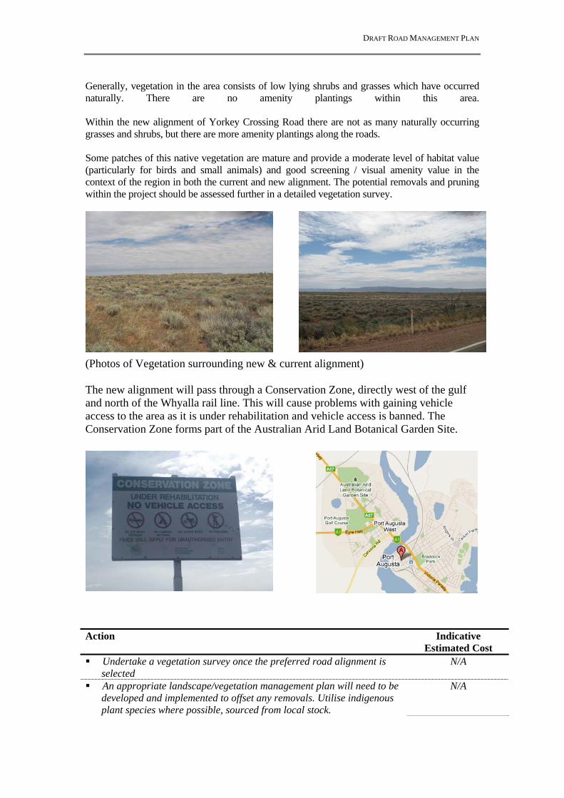
DRAFT ROAD MANAGEMENT PLAN
Generally, vegetation in the area consists of low lying shrubs and grasses which have occurred naturally. There are no amenity plantings within this area. Within the new alignment of Yorkey Crossing Road there are not as many naturally occurring grasses and shrubs, but there are more amenity plantings along the roads. Some patches of this native vegetation are mature and provide a moderate level of habitat value (particularly for birds and small animals) and good screening / visual amenity value in the context of the region in both the current and new alignment. The potential removals and pruning within the project should be assessed further in a detailed vegetation survey.
(Photos of Vegetation surrounding new & current alignment) The new alignment will pass through a Conservation Zone, directly west of the gulf and north of the Whyalla rail line. This will cause problems with gaining vehicle access to the area as it is under rehabilitation and vehicle access is banned. The Conservation Zone forms part of the Australian Arid Land Botanical Garden Site.
Action Indicative
Estimated Cost Undertake a vegetation survey once the preferred road alignment is
selected N/A
An appropriate landscape/vegetation management plan will need to be developed and implemented to offset any removals. Utilise indigenous plant species where possible, sourced from local stock.
N/A

DRAFT ROAD MANAGEMENT PLAN
Approval from DAC and Council will be required for any Significant Tree removals.
N/A
Landscaping during construction Estimated cost: Depending on the landscape plan and the area to be landscaped, allow: $2/m2 grassing; $18/m2for tube stock planting (at 3 plants/m2); $300 for the supply and installation for each semi-advanced street tree.
N/A
5. FAUNA Objective: Protection and conservation of biodiversity and Objective 3 (SA Strategic Plan) Attaining Sustainability (Native Vegetation) - lose no species. The majority of the native vegetation within the project would provide some habitat value for local birds and small animals. It is likely that reptile species would also utilise this habitat. The removal of vegetation from the road reserve will significantly decrease available habitat to local fauna. An initial search of the EPBC Act Protected Matters Report has been undertaken and shows there are a number of EPBC Species and this will require further investigations and potentially an EPBC application. A search on EnvMaps also came up with numerous flora and fauna surveys that have been done within the study area. There are also a few vulnerable flora and fauna species located along the existing Yorkey Crossing Road & near the new alignment of the Yorkey Crossing Road. Further Investigations will be required & some permits may need to be submitted depending on species. Action Indicative
Estimated Cost Minimise disturbance to vegetation and implement an appropriate
landscape plan. N/A
6. PHYTOPHTHORA Objective: Appropriate management of Phytophthora. The study site is located in a nil/very low risk area for Phytophthora cinnimomi, a parasitic fungi that lives in the soil and attacks the roots and basal stems of plants. This fungi causes extensive damage to native vegetation by killing or injuring native plants. No control procedures will be needed as this site is a low risk area for Phytophthora. Action Indicative
Estimated Cost Implementation of hygiene controls during construction - 7. ACID SULPHATE SOILS Objective: Appropriate management of Acid Sulphate Soils.

DRAFT ROAD MANAGEMENT PLAN
Acid Sulphate Soil research was conducted on the Australian Soil Research Information System and concluded that there were various levels of Acid Sulphate Soils located around Port Augusta. There is a high probability of Acid Sulphate Soils occurring along the estuary, but further inland there is an extremely low probability the Acid Sulphate Soil to occur. The new alignment of Yorkey Crossing Road would have a high potential of encountering acid sulphate soils during construction as we would be working close to the estuary. The existing Yorkey Crossing Road should have no issues regarding Acid Sulphate Soils as it is not located close to the estuary. Action Indicative
Estimated Cost Acid Sulphate Soils are likely to be impacted by this project. Undertake a
check of Geotechnical Reports once complete. N/A
8. WATER QUALITY Objective: Protection of water quality and minimisation of water consumption during construction and maintenance. As the current alignment of Yorkey Crossing Road is unsealed the ground is already pervious to rainfall. It is a low lying are not covered by many water courses so there would be no real risk regarding water run off flowing into water ways. Stormwater is also not a big issue due to the area. If the current Yorkey Crossing Road was to be sealed there would need to be proper drainage from the road so that no pooling of water occurred on the road or close to the side of the road. The sealing of Yorkey Crossing Road will increase the impermeable surface area. The new alignment of Yorkey Crossing Road would include a bridge over the estuary which could have a large impact on the environment during large rainfalls. In the event of a large rainfall the build up of pollution on the bridge would be washed into the estuary causing pollution problems. The bridge would need to have proper drainage that would not let any of the rain water into the estuary. Drains located around the new alignment would also need stabilising as it is an already built up area and high rainfall events would put more pressure on current drains. A water quality risk assessment will need to be undertaken in line with DPTI’s Protecting Waterways Manual. The manual also provides guidance on water quality treatment measures that may be applied during construction and operation. The risk assessment will also identify the project’s need for a Water Affecting Activity permit. A permit may be required from the Dept. Water Land & Biodiversity Conservation (DWLBC) for discharging runoff either directly or indirectly into a watercourse. During construction there is a legislative requirement under the Environment Protection Act 1993 that sediment and other pollutants are prevented from entering waterways, including creeks and drainage lines. The construction Contractor will be required to develop and implement a Soil Erosion and Drainage Management Plan (SEDMP), which will detail how water quality issues will be managed on-site. Construction activities should comply with EPA Stormwater Codes of Practice. Action Indicative

DRAFT ROAD MANAGEMENT PLAN
Estimated Cost Investigate and design appropriate water quality treatment measures
including the use of swale drains for stormwater treatment over the use of piping and kerbing.
N/A
Undertake a water quality risk assessment for the project and determine the need for a Water Affecting Activity Permit
N/A
9. CONTAMINATED LAND Objective: Appropriate management of site contamination Land use throughout Port Augusta is predominately residential, but there is a large section of industrial areas throughout the town. The new alternative route would have a very high probability of encountering some industrial areas. There are numerous rail crossings and shunting yards that are located along both tracks. These rail crossings and yards have the potential for pollution issues. A contamination report would be needed across the new alignment to check for potential contamination hot spots associated with the rail crossings and shunting yards. Besides the rail crossings and shunting yards the current Yorkey Crossing Road should have no other issues with contaminated land as it is already being used as a road, and there will be no land acquisition. As there is potential for land contamination, for any land to be acquired for the project, site histories (Phase 1 Environmental Site Assessment) will need to be undertaken to determine the potential for site contamination issues and identify if there is any site to be acquired that will result in any liability to DPTI. A site history investigation will determine any potentially contaminating activities that may have occurred on each site and determine if any further testing and remediation is required. Action Indicative
Estimated Cost Undertake Site History investigations for all land to be acquired. N/A 10. AIR QUALITY Objective: Reduce the impact of air quality (pollution) on the local community to help
achieve Objective 3 of SA’s Strategic Plan, Attaining Sustainability (Greenhouse Emissions) - achieve the Kyoto target during the first commitment period (2008-12).
The impact of air quality on the local community depends on local meteorology, traffic volumes, traffic composition, vehicle emission rates and the closeness of the sensitive receptor (e.g. residential property). Air pollution due to transportation is expected to reduce with time due to improved stringent controls on vehicle emissions and fuel quality. This together with the expected minimal increases in traffic volumes to 2021 should mean that the impact on local air quality and the community from the upgrade of Yorkey Crossing road should not substantially increase from current levels. Air quality modelling may be required to determine if any concentrations of contaminants are above National Environment Protection Measure (NEPM) levels.

DRAFT ROAD MANAGEMENT PLAN
Generally, the highest concentrations of air quality pollutants occur on the roadway with levels reducing with the distance from the road and therefore the best way to manage pollutants emitted from vehicles is to create a buffer between residential properties and traffic. Therefore, locating additional lanes as far away from residential properties is preferable to reduce any impacts of pollutants on the local community. The current Yorkey Crossing Road is not located close to many residents so there shouldn’t be a large problem regarding air quality. As Port Augusta is quite dry there is a potential for dust problems, which will need to be monitored throughout construction. This will occur with the existing and new roads. Action Indicative
Estimated Cost If required, undertake air quality modelling. Implement dust control
measures during construction. N/A
11. NOISE Objective: Reduction in Traffic Noise Impacts – No increase in the impact of noise on
sensitive receptors along the alignment, Upgraded road meets ‘desirable range’ noise criteria.
The impact of noise pollution on the local community depends on local topography, traffic volumes, traffic composition, proximity of the sensitive receptors (e.g. residential property) and existing effective noise barriers. Those properties close to the new Yorkey Crossing Road alignment would require some form of noise treatment. This could be a fence that provides an adequate air seal and interrupts line of sight between the receiver and the source. Quieter pavement would also reduce the levels to within the guidelines. The preliminary modelling assumed dense graded asphalt. The use of stone mastic asphalt would reduce the levels by approximately 2 dB and the use of a stone chip seal would increase the noise by a similar order. No assessment has been undertaken as to whether there is already effective noise mitigation in place, or whether the layout of the property would require no treatment. More detailed modelling is required once a ground survey has been undertaken as the level of detail currently available is limited in achieving an accurate noise model. This is important, as the vertical (topographical) levels have not been accurately taken into account and, when considered, could increase the noise levels further. If night works are required a night works management plan must be implanted. Local residents will also need to be warned. As the majority of Yorkey Crossing Road is not a residential area this is not a large issue, the start of Yorkey Crossing Road does have a few residents which should be warned about any night works being undertaken. The new Yorkey Crossing Road is located closer to the Port Augusta Township and the local residents would need to be warned of any night works. Action Indicative
Estimated Cost Further detailed noise monitoring and modelling will be required once
a preferred location for widening has been determined. Mitigation of traffic noise is likely for only a small number of properties, for those
N/A

DRAFT ROAD MANAGEMENT PLAN
receivers who do not have existing treatment, possibly in the form of fences to act as noise barriers, and in certain situations quieter pavement may suffice
12. SOCIAL ENVIRONMENT Objective: Minimisation of social impacts and establishment of relationships with the
community, stakeholders, customers and suppliers to achieve environmental goals and objectives.
The current alignment of Yorkey Crossing Road has little social impacts as it is not located close to any residential or commercial areas. It would also have only a small visual impact as there is already an unsealed road and there would not need many large vegetation removals depending on the width of the road. The new alignment of Yorkey Crossing Road has a large impact on the social environment as it is in the centre of Port Augusta and there are many residents and commercial properties that will be affected. Discussions should be held involving key stakeholders early on in the planning process. As is will be necessary to acquire land under the Highways Act, 1926, this has the potential to cause community anguish and should be dealt with early in the planning phase of the project. Concerns may also arise at the potential removal of large native remnant trees and avenues of streetscape plantings. An appropriate landscaping scheme will help to alleviate these concerns and improve the amenity of the area. Action Indicative
Estimated Cost Undertake appropriate community and stakeholder consultation and
develop and implement a community consultation plan N/A
13. SUSTAINABILITY – ENERGY, WASTE Objective: Minimisation of energy consumption over the life of the project and use of
recycled and recyclable materials to help achieve OBJECTIVE 3 (SA Strategic Plan): Attaining Sustainability (Zero Waste) - Reduce waste to landfill by 25% within 10 years.
A holistic, life cycle approach to energy management will be required for the project. Energy required for construction and operation of the project will need to be assessed, investigating alternative or renewable energy sources. Sources of material and opportunities for reuse and recycling of materials during construction will need to be investigated, including potential sources of fill, pavement materials and water. Action Indicative
Estimated Cost Investigate options for using recycled or recyclable materials, N/A Investigate options for re-using road materials i.e. asphalt, N/A
Investigate options for using energy efficient products i.e. solar powered lighting
N/A

DRAFT ROAD MANAGEMENT PLAN
14. ENVIRONMENTAL MANAGEMENT Objective: Assess all environmental effects associated with the project and minimise the
impact of construction on the local environment Further assessment of environmental impacts need to be undertaken to assist in determining a suitable alignment. Once the most suitable alignment is determined an Environmental Impact Assessment Report (EIAR) will be required for the proposed Yorkey Crossing Road upgrade. An Environmental Management Plan (EMP) will also be required for the construction phase. These reports are required for environmental clearance to be provided by the Senior Environmental Management Officer, Environmental Systems Unit. In addition, any outstanding issues identified in this document will need to be addressed before construction commences. Action Indicative
Estimated Cost Undertake an EIAR N/A Develop an EMP for construction N/A
_________________ Prepared by: (Environmental Officer) / / _________________ Reviewed: (Coordinator Environmental Planning) / /

DRAFT ROAD MANAGEMENT PLAN
Appendix D – Economic Appraisal Yorkey Crossing Options and Pt Augusta Bridge Duplication
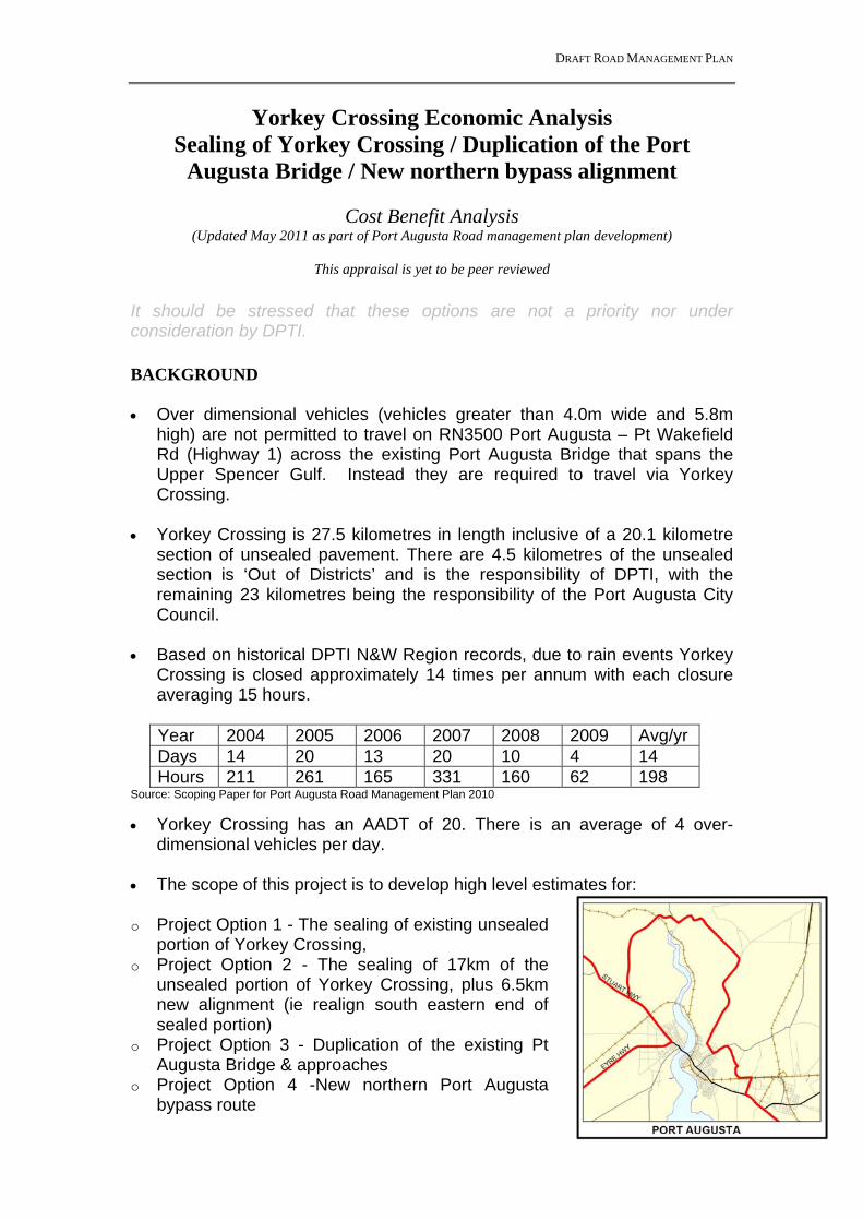
DRAFT ROAD MANAGEMENT PLAN
Yorkey Crossing Economic Analysis Sealing of Yorkey Crossing / Duplication of the Port
Augusta Bridge / New northern bypass alignment
Cost Benefit Analysis (Updated May 2011 as part of Port Augusta Road management plan development)
This appraisal is yet to be peer reviewed
It should be stressed that these options are not a priority nor under consideration by DPTI. BACKGROUND Over dimensional vehicles (vehicles greater than 4.0m wide and 5.8m
high) are not permitted to travel on RN3500 Port Augusta – Pt Wakefield Rd (Highway 1) across the existing Port Augusta Bridge that spans the Upper Spencer Gulf. Instead they are required to travel via Yorkey Crossing.
Yorkey Crossing is 27.5 kilometres in length inclusive of a 20.1 kilometre
section of unsealed pavement. There are 4.5 kilometres of the unsealed section is ‘Out of Districts’ and is the responsibility of DPTI, with the remaining 23 kilometres being the responsibility of the Port Augusta City Council.
Based on historical DPTI N&W Region records, due to rain events Yorkey
Crossing is closed approximately 14 times per annum with each closure averaging 15 hours.
Year 2004 2005 2006 2007 2008 2009 Avg/yr Days 14 20 13 20 10 4 14 Hours 211 261 165 331 160 62 198
Source: Scoping Paper for Port Augusta Road Management Plan 2010
Yorkey Crossing has an AADT of 20. There is an average of 4 over-dimensional vehicles per day.
The scope of this project is to develop high level estimates for: o Project Option 1 - The sealing of existing unsealed
portion of Yorkey Crossing, o Project Option 2 - The sealing of 17km of the
unsealed portion of Yorkey Crossing, plus 6.5km new alignment (ie realign south eastern end of sealed portion)
o Project Option 3 - Duplication of the existing Pt Augusta Bridge & approaches
o Project Option 4 -New northern Port Augusta bypass route

DRAFT ROAD MANAGEMENT PLAN
PROPOSED ALIGNMENT AND SCENARIOS A rapid economic assessment of the following project cases and scenarios. Proposal Comment Project Case 1
Sealing the existing alignment (21kms) of Yorkey Crossing to provide an all weather surface. Total length of route is 27.5 km
Will reduce industry ‘down time’ (rain forced closures) and political pressure.
Project Case 2.
Sealing 17kms of existing Yorkey Crossing and the construction of 6.5km of new alignment (South East end) to provide an all weather surface. Total length of route is 24.5 km
Will reduce industry ‘down time’ (rain forced closures) and political pressure. Will bypass large vehicles around the residential/industrial zoned areas.
Project Case 3.
Duplication of the Port Augusta Bridge and augmentation of associated pavement and intersections to accommodate over-dimensional vehicles.
Will reduce industry ‘down time’ (rain forced closures) and political pressure. Will remove the only remaining section of non duplicated road through Pt Augusta and consequently improve capacity.
Project Case 4
New alternative alignment for a northern Port Augusta bypass incorporating new bridge across Spencer gulf.
Will reduce industry ‘down time’ (rain forced closures) and political pressure. Will bypass large and general vehicles around the residential/industrial zoned areas
Scenario 1
Government decree that all restricted access vehicles (i.e. B-doubles, Road Trains, over mass/over dimensional), bypass Pt Augusta via a dedicated heavy vehicle detour (Yorkey Crossing).
This scenario forces industry to travel an additional 17km (approx) as they travel via the 27.5 km Yorkey Crossing (the approximate distance currently travelled on NH1 is 10.4km). A significant economic cost is expected.
Scenario 2
The existing Pt Augusta bridge is closed for 2 days, 3 times a year for the next 30 years. (assumed, road crash, bridge maintenance, etc)
Both local and non-local traffic will be forced to use Yorkey Crossing when the bridge is closed. A significant economic cost is expected.
Alignments are shown in Figure 2 on the following page
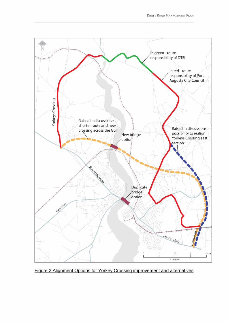
DRAFT ROAD MANAGEMENT PLAN
Figure 2 Alignment Options for Yorkey Crossing improvement and alternatives
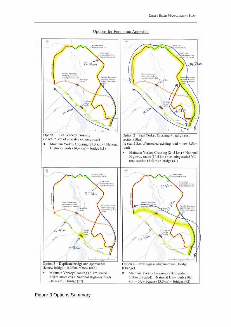
DRAFT ROAD MANAGEMENT PLAN
Figure 3 Options Summary

DRAFT ROAD MANAGEMENT PLAN
DISCUSSION
The BASE CASE for this project is to:
retain the existing single lane bridge over the Upper Spencer Gulf in Port Augusta (which is not suitable for over dimensional vehicles due to width restrictions), &
Retain the existing unsealed Yorkey Crossing over-dimensional route.
The approximate distance travelled via the National Highway is 10.4km between RN3500 / Footner Rd intersection and RN3500 / RN 1000 Stuart Hwy intersection. The approximate distance travelled via the Yorkey Crossing bypass route is 27.5km. Due to inclement weather Yorkey Crossing is closed approximately 14 times per annum with each closure averaging 15 hours. During these events over-dimensional vehicles are not able to pass Port Augusta. PROJECT CASE 1 (Sealing of the existing Yorkey Crossing) Scope The project scope includes the sealing of Yorkey Crossing (21kms) to provide an all weather access for over dimensional vehicles. The project involves the installation of active control at the existing railway crossing (National Line), allowance for new drainage lines and extensions to existing drainage lines, plus minor realignment and intersection upgrades. The proposed route would remain at 27.5km. Analysis The rapid economic assessment identified the following. Net Present Benefits (NPB) $3.2m Costs incurred due to inclement
weather are avoided (i.e. closure of Yorkey Crossing)
Improved travel time (Vehicle speeds have been assumed higher on a sealed pavement).
Net Present Costs (NPC) $34.1m Identified via a strategic level estimate of the proposed scope of works.
Benefit Cost Ratio (BCR) 0.10 Note that for the purpose of this analysis: the ‘most likely’ estimated expenditure amounts are used, an estimators contingency of 30% is inclusive in the Estimate Summary
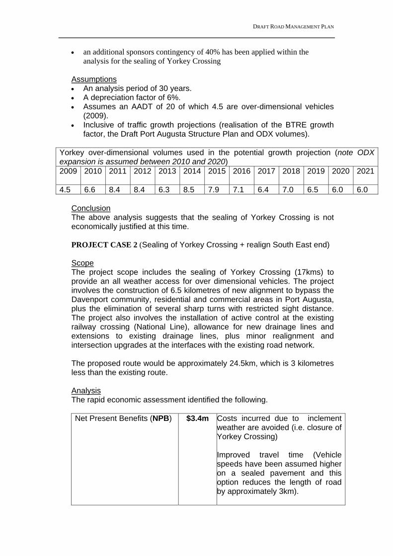
DRAFT ROAD MANAGEMENT PLAN
an additional sponsors contingency of 40% has been applied within the analysis for the sealing of Yorkey Crossing
Assumptions An analysis period of 30 years. A depreciation factor of 6%. Assumes an AADT of 20 of which 4.5 are over-dimensional vehicles
(2009). Inclusive of traffic growth projections (realisation of the BTRE growth
factor, the Draft Port Augusta Structure Plan and ODX volumes). Yorkey over-dimensional volumes used in the potential growth projection (note ODX expansion is assumed between 2010 and 2020) 2009 2010 2011 2012 2013 2014 2015 2016 2017 2018 2019 2020 2021
4.5 6.6 8.4 8.4 6.3 8.5 7.9 7.1 6.4 7.0 6.5 6.0 6.0
Conclusion The above analysis suggests that the sealing of Yorkey Crossing is not economically justified at this time. PROJECT CASE 2 (Sealing of Yorkey Crossing + realign South East end)
Scope The project scope includes the sealing of Yorkey Crossing (17kms) to provide an all weather access for over dimensional vehicles. The project involves the construction of 6.5 kilometres of new alignment to bypass the Davenport community, residential and commercial areas in Port Augusta, plus the elimination of several sharp turns with restricted sight distance. The project also involves the installation of active control at the existing railway crossing (National Line), allowance for new drainage lines and extensions to existing drainage lines, plus minor realignment and intersection upgrades at the interfaces with the existing road network. The proposed route would be approximately 24.5km, which is 3 kilometres less than the existing route. Analysis The rapid economic assessment identified the following. Net Present Benefits (NPB) $3.4m Costs incurred due to inclement
weather are avoided (i.e. closure of Yorkey Crossing)
Improved travel time (Vehicle speeds have been assumed higher on a sealed pavement and this option reduces the length of road by approximately 3km).

DRAFT ROAD MANAGEMENT PLAN
Net Present Costs (NPC) $45.6m Identified via a strategic level estimate of the proposed scope of works.
A Benefit Cost Ratio (BCR) 0.08
Note that for the purpose of this analysis: the ‘most likely’ estimated expenditure amounts are used, an estimators contingency of 30% is inclusive in the attached estimate
summary’s an additional sponsors contingency of 40% has been applied within the
analysis for the sealing of Yorkey Crossing
Assumptions An analysis period of 30 years. A depreciation factor of 6%. Assumes an AADT of 20 of which 4.5 are over-dimensional (2009). Inclusive of traffic growth projections (realisation of the BTRE growth
factor, the Draft Port Augusta Structure Plan and ODX volumes). Conclusion The above analysis suggests that this proposal is not economically justified at this time. PROJECT CASE 3 (Duplication of the Port Augusta Bridge) Scope The project scope includes the duplication of the existing bridge (some 545m), widening of approach roads to allow for the provision of 2 lanes in both directions between Mackay St (south of the bridge) and Mildred St (north of the bridge) & augmentation of the intersection at National Highway 1 and Caroona Rd to improve capacity. Analysis The rapid economic assessment identified the following. Net Present Benefits (NPB) $8.7m Costs incurred due to inclement
weather are avoided (i.e. closure of Yorkey Crossing) Travel time for past users of Yorkey Crossing is improved through a reduction in travel distance (by 17kms) and increased travel speed. A reduction in vehicle crash costs is assumed for previous users of the Yorkey Crossing as they switch to the National Highway 1.
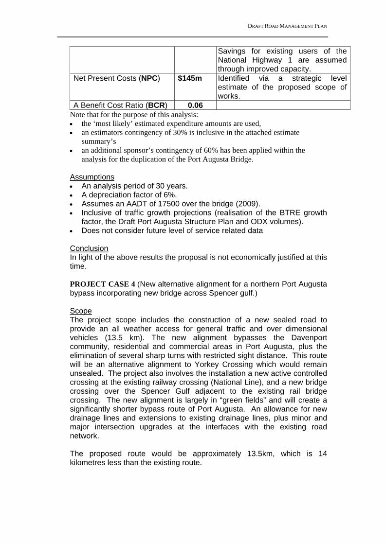
DRAFT ROAD MANAGEMENT PLAN
Savings for existing users of the National Highway 1 are assumed through improved capacity.
Net Present Costs (NPC) $145m Identified via a strategic level estimate of the proposed scope of works.
A Benefit Cost Ratio (BCR) 0.06 Note that for the purpose of this analysis: the ‘most likely’ estimated expenditure amounts are used, an estimators contingency of 30% is inclusive in the attached estimate
summary’s an additional sponsor’s contingency of 60% has been applied within the
analysis for the duplication of the Port Augusta Bridge. Assumptions An analysis period of 30 years. A depreciation factor of 6%. Assumes an AADT of 17500 over the bridge (2009). Inclusive of traffic growth projections (realisation of the BTRE growth
factor, the Draft Port Augusta Structure Plan and ODX volumes). Does not consider future level of service related data Conclusion In light of the above results the proposal is not economically justified at this time. PROJECT CASE 4 (New alternative alignment for a northern Port Augusta bypass incorporating new bridge across Spencer gulf.)
Scope The project scope includes the construction of a new sealed road to provide an all weather access for general traffic and over dimensional vehicles (13.5 km). The new alignment bypasses the Davenport community, residential and commercial areas in Port Augusta, plus the elimination of several sharp turns with restricted sight distance. This route will be an alternative alignment to Yorkey Crossing which would remain unsealed. The project also involves the installation a new active controlled crossing at the existing railway crossing (National Line), and a new bridge crossing over the Spencer Gulf adjacent to the existing rail bridge crossing. The new alignment is largely in “green fields” and will create a significantly shorter bypass route of Port Augusta. An allowance for new drainage lines and extensions to existing drainage lines, plus minor and major intersection upgrades at the interfaces with the existing road network. The proposed route would be approximately 13.5km, which is 14 kilometres less than the existing route.

DRAFT ROAD MANAGEMENT PLAN
Grade separation of the rail crossings (x2) along the bypass route has been excluded. These would add significant complications and additional costs. Analysis The rapid economic assessment identified the following. Net Present Benefits (NPB) $15.5m Costs incurred due to inclement
weather are avoided (i.e. closure of Yorkey Crossing)
Improved travel time (Vehicle speeds have been assumed higher on the bypass (80 km/h). This option reduces the length of road by approximately 12.5km & eliminates most stops along the route.
This route would likely attract additional freight & light vehicles from Stuart Hwy, but not Eyre Hwy.
Net Present Costs (NPC) $87.6m Identified via a strategic level estimate of the proposed scope of works.
A Benefit Cost Ratio (BCR) 0.18 Note that for the purpose of this analysis: the ‘most likely’ estimated expenditure amounts are used, an estimators contingency of 30% is inclusive in the attached estimate
summary’s an additional sponsors contingency of 35% has been applied within the
analysis for the sealing of the new bypass route
Assumptions An analysis period of 30 years. A depreciation factor of 6%. Assumes an AADT of 20 of which 4.5 are over-dimensional (2009). Inclusive of traffic growth projections (realisation of the BTRE growth
factor, the Draft Port Augusta Structure Plan and ODX volumes). New Bypass route attracts 50% of commercial traffic currently on
Stuart Highway (ie 50% of 210 (2011 vols) and 25% of other vehicles on Stuart Hwy (ie 25% of 640 (2011 vols). No vehicles are attracted from Eyre Hwy.
Number of stops along existing National Link is 1.5 per vehicles based on Travel survey Nov 2008.
Conclusion In light of the above results the proposal is not economically justified at this time. Port Augusta City Council may wish to investigate further & consider reserving a road corridor.

DRAFT ROAD MANAGEMENT PLAN
Appendix E – Yorkey Crossing Economic Analysis

DRAFT ROAD MANAGEMENT PLAN
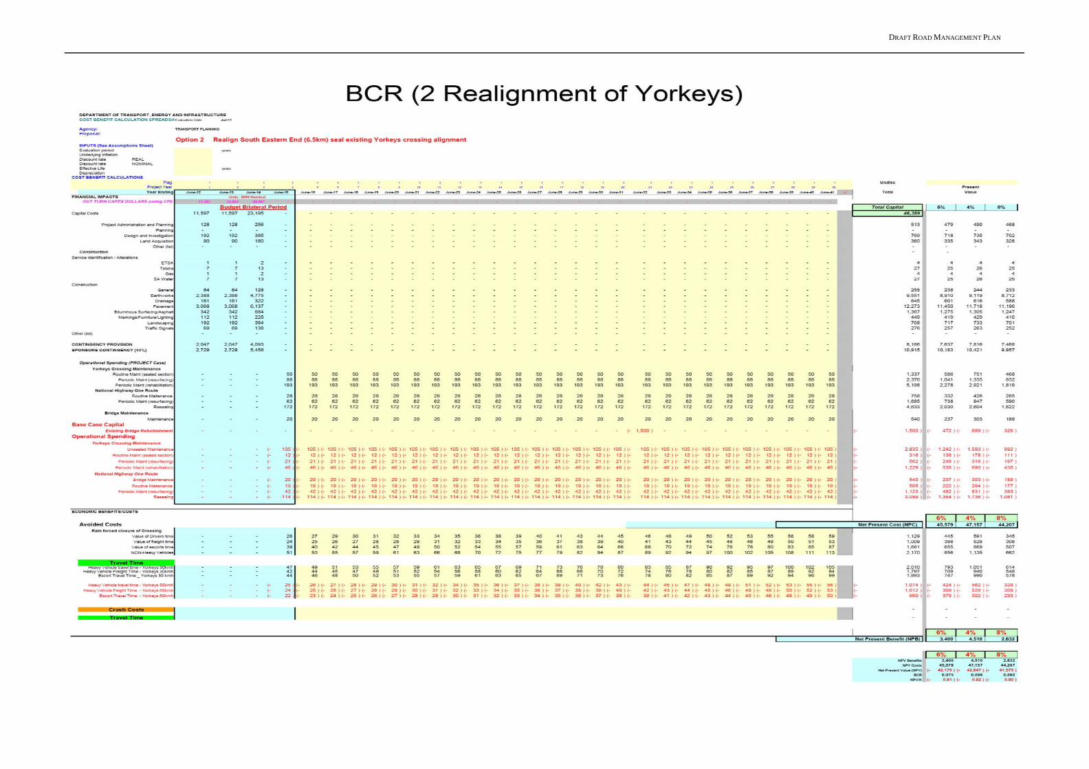
DRAFT ROAD MANAGEMENT PLAN
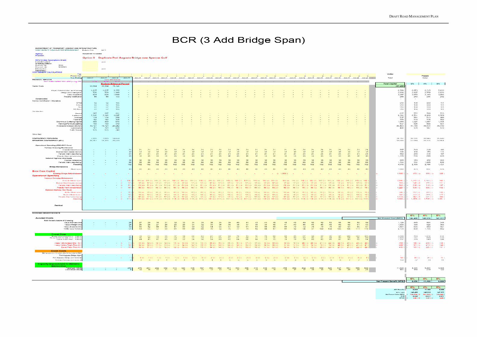
DRAFT ROAD MANAGEMENT PLAN
DRAFT ROAD MANAGEMENT PLAN