port douglas waterfront master plan …...port douglas waterfront master plan landscape design guide...
TRANSCRIPT
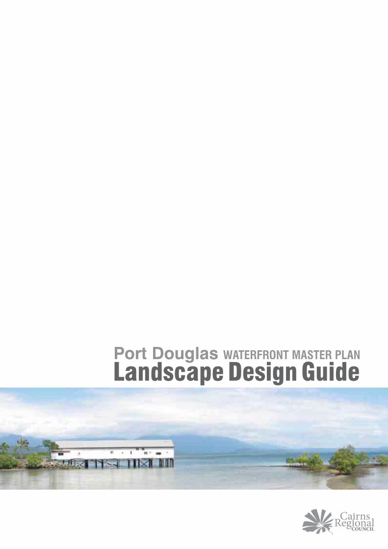
Port Douglas WATERFRONT MASTER PLAN
Landscape Design Guide


Port Douglas Waterfront Master PlanLandscape Design Guide
April 2012 - Cairns Regional Council119-145 Spence Street - PO Box 359 - Cairns, QLD, 4870Ph: (07) 4044 3044 – F (07) 4044 3022 – E: [email protected]
This document is available on the Cairns Regional Council website:
www.cairns.qld.gov.au
3

4

Acknowledgements
The Port Douglas Landscape Design Guide would not have been possible without the collaborative efforts of a number of people and organisations. Cairns Regional Council would like to thank all contributors for their involvement, passion and valuable contributions to the Port Douglas Landscape Design Guide.
ReferencesPort Douglas Waterfront Master Plan Indigenous Cultural Heritage Assessment - 2009 (Australian Museum Business Services)
Port Douglas Waterfront Master Plan Non-indigenous Cultural Heritage Study - 2008 (Maunsell/Aecom)
Port Douglas Waterfront Master Plan - 2009 (Urbis)
The Project Team includes the following Council officers:
Council’s Representative (Project Manager)Sandra Burke Project Manager
Project Team MembersStephen Tyter Manager, Infrastructure ManagementLiz Collyer Regional Manager Port DouglasJez Clark Landscape ArchitectClaire Burton Graphic Designer
5
ACKNOWLEDGEMENTS

6

CCONTENTS
1.0 INTRODUCTION ....................................................... 101.1 What is the Port Douglas Landscape Design Guide? ............................... 101.2 What is the purpose of the Port Douglas Landscape Design Guide? ...... 101.3 What area does the Landscape Design Guide cover? ............................. 111.4 Who will use this document?..................................................................... 121.5 How to use this document......................................................................... 121.6 Glossary ..................................................................................................... 14
2.0 DESIGN GUIDELINES .............................................. 182.1 Philosophy of Change ............................................................................... 182.2 Key Design Principles ................................................................................ 182.3 Design Elements ........................................................................................ 20
3.0 PRECINCTS.............................................................. 423.1 Village Centre ............................................................................................ 44
3.1.1 Mowbray Street ............................................................................... 463.1.2 Warner Street .................................................................................. 483.1.3 Macrossan Street ............................................................................. 503.1.4 Wharf Street .................................................................................... 523.1.5 Grant Street .................................................................................... 543.1.6 Davidson Street ............................................................................... 56
3.2 Waterfront Parkland ................................................................................... 583.2.1 Rex Smeal Park ................................................................................ 603.2.2 Anzac Park ....................................................................................... 623.2.3 St Mary’s by the Sea ........................................................................ 643.2.4 Sugar Wharf ..................................................................................... 663.2.5 Waterfront ........................................................................................ 683.2.6 Island Point ...................................................................................... 70
3.3 The Four Mile Beach Esplanade ............................................................... 723.3.1 The Esplanade ................................................................................ 72
3.4 Sporting and Recreation Precinct ............................................................. 743.4.1 Wharf Street (between Mowbray and Port Street) ........................... 75
3.5 Town Gateway Precinct ............................................................................. 76
4.0 APPENDIX ................................................................ 804.1 List of special projects .............................................................................. 804.2 List of suitable Plant Species ..................................................................... 82
7

8

1INTRODUCTION
9

1.1 What is the Port Douglas Landscape Design Guide?
The Landscape Design Guide has been prepared in response to and as a result of the Port Douglas Master Plan.
The Landscape Design Guide describes in words, pictures, diagrams and illustrations the ‘relaxed tropical style’ that is the desired design direction for Port Douglas. The character of Port Douglas is defined by its tropical latitude, waterside location, and mix of tourism and marine activity. These elements have been a defining feature of Port Douglas’ success and have combined together to create the unique character which underpins the town’s appeal. The Landscape Design Guide is a tool that has been developed as a result of the Port Douglas Waterfront Master Plan to limit and control future change. The attributes that comprise the character of the town are strongly reflected within the Landscape Design Guide and the guidelines set out within this document reflect the aspirations of Port Douglas to retain its’ “unique identity”.
1.0 INTRODUCTION1.2 What is the purpose
of the Port Douglas Landscape Design Guide?
The purpose of the Port Douglas Landscape Design Guide is to ensure that future changes to Port Douglas are consistent with the Port Douglas Waterfront Master Plan and that these changes enhance the existing character of Port Douglas. The Landscape Design Guide will ensure that landscape design strengthens the experience of residents and visitors in Port Douglas and adds “authenticity” to the tropical village character. The document promotes the continuation of the “Port Douglas” style and establishes a comprehensive framework that identifies the design of, and how to carry out landscape and streetscape works;
“The attributes that comprise the character of the town are strongly reflected within the Landscape Design Guide and the guidelines set out within this document reflect the aspirations of Port Douglas to retain its’ unique identity”
10

“Landscape design enhances the experience of residents and visitors in Port Douglas and adds authenticity to the tropical village character”.
1.3 What area does the Landscape Design Guide cover?
The Landscape Design Guide covers the area of Port Douglas as shown in the adjacent illustration.
11
INTRODUCTION

1.4 Who will use this document?
The Landscape Design Guide is intended for use by:
Cairns Regional Council
Development Proponents and Design Professionals
The General Public
1.5 How to use this document
The Landscape Design Guide is divided into two key sections which will allow the user to find information relevant to the design element or particular precinct within the project area.
The two key sections are:
Section 2.0 Design GuidelinesSection 3.0 Precincts
The Design Guidelines section examines the key principles which will govern future design and deals with the general elements which make up the town streetscapes and open spaces

Each element is discussed in terms of their relevance to the delivery of the Port Douglas Waterfront Master Plan, detailing “WHY” the element is important and “WHAT” guiding principles lay behind the use of each element. This is followed by a further discussion of “COMMON ISSUES” which answers some of the more common questions on the application of these design elements.
Images depicting desirable design outcomes or good examples of what has been discussed are included. In some instances, a poor outcome may be included to clearly demonstrate what is considered inconsistent with the character of Port Douglas.
The Precinct Guidelines section examines specific areas within the project area, which have a unique distinguishable character (previously established by the Port Douglas Waterfront Master Plan 2009).
The Precincts are divided in to five main sections;
1. Village Centre » Mowbray Street » Macrossan Street » Grant Street » Warner Street » Wharf Street » Davidson Street
2. Waterfront Parkland » Rex Smeal Park » Anzac Park » St Mary’s by the sea » Sugar Wharf » Waterfront » Island Point
3. Esplanade » Between Macrossan Street
and Mowbray Street
4. Sporting and Recreation Precinct » Sports grounds » Wharf Street
5. Town Gateway » Davidson Street
Precincts within the village centre are defined by street name while those within the existing waterfront have been selected based upon historic usage and are already familiar to the residents of Port Douglas.
INTRODUCTION
1.6 Glossary
Port Douglas Planning Scheme The planning scheme applies to particular land uses, such as residential, tourism, industrial and commercial developments and subdivisions. It identifies where different land uses such as shops, houses, units or industrial activities can occur in the Shire, and what performance criteria and specific outcomes are required to be satisfied.There are 11 different policies included in the planning scheme. These relate to a variety of subject matters such as building design & architectural elements, water supply & sewerage headworks, landscaping, open space contributions and cultural and heritage values.
http://www.cairns.qld.gov.au/building-planning-and-infrastructure/planning-schemes
CPTED(Crime Prevention through Environmental Design)
The fundamental concept of Crime Prevention through Environmental Design is that it is possible to use knowledge and creativity to design our built environments in ways that lessen or prevent the incidence of crime.For more detailed information on CPTED issues please refer to the latest Queensland Government CPTED Guidelines for Queensland at the following address:http://www.police.qld.gov.au/programs/cscp/safetyPublic/default.htm
WSUD(Water Sensitive Urban Design)
WSUD offers an alternative to the traditional conveyance approach to stormwater management. WSUD is a philosophy which aims to mitigate environmental impacts particularly on water quantity, water quality and receiving waterways, conventionally associated with urbanisation.http://www.brisbane.qld.gov.au/planning-building/planning-guidelines-and-tools/subdivision-development-guidelines/water-sensitive-urban-design/index.htm
FNQROC(Far North Queensland Regional Organisation of Councils)
The Far North Queensland Regional Organisation of Councils is made up of a membership of councils from Ingham to Cooktown and offers comprehensive and practical guidelines to assist development across the region. http://www.fnqroc.qld.gov.au
14

Cairns Regional Council Carbon Emissions Reduction Policy
Corporate Sustainability PolicyProtection of the Natural Environment Policy Carbon Emissions Reduction PolicyCRC Climate Change Strategy 2010 - 2015Douglas Shire Council Sustainability CodeCRC Climate Change Adaptation Action Plan
Landscape Design Landscape Design is the art of arranging or modifying the features of a landscape, an urban area, etc., for aesthetic or practical purposes and is usually divided into hardscape design and softscape design. This will include planting and paving, signage and furniture as well as place making.
Precinct A distinct area with generally definable boundaries
Streetscape The visual appearance of a road, including the rhythm of the built form elements such as roads, street furniture, vegetation and open space that combine to form the streets character.
Hardscape The hard elements such as paving, decking and other usually trafficable areas
Softscape The planted elements within a design such as trees, shrubs and flowering plants, grasses and turf.
Sightlines The clear line of sight from one vehicle to another, generally at intersections, roundabouts and driveways. Sightlines protect both vehicles and pedestrians and need to make allowance for small children.
Viewsheds/View Corridor Viewsheds and view corridors are areas of particular scenic or historic value that are deemed worthy of preservation against development or other change. These are often spaces that are readily visible from public areas such as from public roadways or public parks. The preservation of clear lines of sight to features of significance within these areas is a vital component of the landscape design process.
Street Hierarchy and Road Hierarchy
The hierarchy of streets and roads is an urban design and traffic management technique for separating vehicular through-traffic from local streets.
15
INTRODUCTION

16

2DESIGN
GUIDELINES
17

2.0 DESIGN GUIDELINES2.1 Philosophy of ChangeThe existing character of Port Douglas underpins its attraction to both residents and visitors. Change will be limited, or controlled to ensure that the town retains its iconic charm and appeal.
The Landscape Design Guide Vision
The aim is to ensure that future change remains true to the relaxed village feel of the town, an incremental change that appears both natural and in harmony with the current surroundings. Subtle transformations are sought which will blend with and flow from the unique character of Port Douglas.
2.2 Key Design PrinciplesLandscape Design is guided by the following set of principles:
Landscape is designed and maintained to create a safe and accessible environment with a strong pedestrian focus.The style and form of landscape and built elements and selection of plant species and materials are consistent with the tropical character of Port Douglas.The selection and placement of plants creates a shady, park-like atmosphere which features and showcases native species.All landscape works embody principles of sustainability, including: » Reduced consumption of
water » Conservation of ecological
and biodiversity values » Maintainability and longevity » Local employment

“…landscape design enhances the experience of residents and visitors alike in Port Douglas and adds authenticity to the tropical village character”
Landscape design honours the many layers of cultural heritage in Port Douglas through art, design, interpretation and story-telling.The unique qualities of individual precincts are clearly distinguishable within the overall village character.Landscape projects deliver a choice of recreational options and experiences, from the main street to nature-based activities.
19
DESIGN GUIDELINES

2.3 Design Elements
Streets
Why this is important Port Douglas is not a car dominated town. Movement corridors are to be characterised by shady trees, soft edges, water sensitive urban design elements, natural finishes and mixed materials. Green infrastructure will continue to be used as a foil to the urban fabric of the town centre and plays a leading role in the character of the tropical streetscape.
Streets need to be safe and accessible for all users, including people with impairments. The level of passive surveillance of a street, traffic speed and parking behaviour affects the actual and perceived safety of pedestrians. The current mixture of activities along the northern end of Macrossan Street serves as an example of this principle. Traffic speeds are controlled by the number and movement of pedestrians and by the function of on street parking. This is a model to be used across local streets.
Streets that feel safe are more likely to foster social encounters and activity. The key aim is to create streets where people have opportunities for walking and cycling, and this requires streets to be designed primarily for pedestrians and cyclists not just for cars.
streetsDesign principles
Design local streets to reduce traffic speeds so that pedestrians, cyclists and vehicles can mix safely. On-street parking can help slow traffic speeds and shared spaces foster respect and caution from drivers.Provide clear routes for pedestrians and bicycles as well as for vehicles. If separate cycle paths are provided indicate them with street markings or by discrete but clearly displayed and well-designed signage.Ensure pedestrian and bicycle routes are direct, continuous and well lit, and that appropriate street crossings are provided.Reduce road signage to a minimum.Streets need to accommodate the Carnivale Parade.Shade trees and tropical plantings are a key feature of the tropical streetscape.Maintain village atmosphere and avoid the tendency to urbanise.Maintain idiosyncrasies of the streetscape with an ‘if it isn’t broke don’t fix it’ attitude across the town.Create a series of linked public spaces that provide a unified identity for the public realm whilst respecting the ad-hoc nature of the current streetscapes.
“streets to be designed primarily for pedestrians and cyclists”
20

Response to common issues
How will we create a legible hierarchy of tropical streets?The quality and scale of landscape design will be used to define streets within the hierarchy of the established road network. The main streets will be defined through the use of large scale trees and open street edges. Local streets can be smaller in scale with a more enclosed character to help reduce traffic speeds and create a more pedestrian friendly and intimate environment.
Refer to Section 3.0 Precincts for further details of individual streets.
DESIGN GUIDELINES

intersectionsIntersections
Why this is important Intersections are the points at which all users of the street converge. They must be designed for the safe and convenient passage of all users. Intersections that prioritise pedestrians generally cause drivers to slow down. Traffic signals and excessive road signage are not features of Port Douglas and should not form part of future traffic solutions within the town centre.
Local streets are for pedestrians and cyclists as well as for vehicles. Our aim is to create walkable neighbourhoods and active communities, therefore, streets must be pedestrian-friendly. On local streets, well-designed intersections provide an improved pedestrian environment. They allow pedestrians to cross safely and directly without diverting from their chosen route.
Design principles
Design intersections to reflect the road hierarchy. Control vehicle speeds on minor streets by: » Extending verges to narrow
the carriageway at the intersection (creating ‘pinch-points’).
» Using differently textured materials on the carriageway across the throat of the intersection to identify a change of road structure and to alert drivers to pedestrians and cyclists.
» Ensuring the design indicates the presence of the intersection on all approaches.
» Use planting to delineate road geometry.
» Ensure planting complies with current CPTED principles while maintaining the tropical relaxed feel.
» Splitter islands are not generally recommended because when they are used, larger splays (kerb radii) are required to enable trucks, buses and other large vehicles to turn, which compromises pedestrian amenity and safety and widens intersections.
Pedestrian priority

Response to common issues
Intersections and the street hierarchy
Different treatments can be used to indicate the priority of connecting streets. The image above has used a different approach by widening the verges and using planter beds close to the street edge to visually and physically narrow the street throat - further indicating that it is the lower order street.
Materials palette:Interlocking unit pavers
“walkable neighbourhoods”
23
DESIGN GUIDELINES

pathways
24

Pathways through open space areas
Pathways within main town centre
Pathways outside main town centre
25
DESIGN GUIDELINES

pathways through open space areasWhy this is importantThe role of pathways across the open spaces which comprise the Waterfront of Port Douglas is to provide a legible and permeable environment which can be easily traversed by pedestrians and cyclists. Pathways will link these open spaces with the wider townscape and provide for logical and desirable movement across the site.
Design principlesPaths are to be visually unobtrusive and pedestrian in nature.Use natural materials, and create soft edges which blend with natural landscape features.Signage and cultural interpretation can be laid on horizontal plain and incorporated within the path network.Use of a mixed palette of natural materials for the path treatments to lessen the impact of the path network on natural or predominantly landscaped areas.Sustainable materials and products will be sought for all landscape treatments.Paths must be usable by all members of the public including those people with disabilities.Paths are to be organic and curvilinear in appearance rather than angular and geometric, reflecting the relaxed unhurried feel of Port Douglas reflecting the open parkland experience.
pathways

Materials Palette:
(coloured in natural palette)
How large do these pathways need to be?Pathways need to respond to local levels of foot traffic and allow for a variety of uses:
Pathways may vary from 2 metres to 4 metres depending on location. For specific path requirements refer to Section 3.0 Precincts.
How will we manage service roads and vehicular access within the Waterfront Park?Access for vehicles is limited in use and is not considered sufficient to require a network of dedicated sealed service roads which are undesirable within the proposed parkland. Vehicles will need to share paths with pedestrians and drive at speeds appropriate to such a mixed use.
The main path system will link the following:
This simple path network will be treated with a mix of materials which will emphasise their pedestrian function while remaining usable to the various vehicles which may share them.
The path network is further designed to accommodate the necessary maintenance for the parkland and its various facilities:
Allowing for easy access will increase maintenance efficiency and prevent scouring and damage of the parkland by maintenance vehicles.
How large do these shared paths need to be?With nearly one million visitors each year, shared paths will need to be a minimum of four metres wide to accommodate pedestrians and the following users:
Service vehicles (this includes council vehicles, and delivery vehicles - which will need to access St Mary’s Church and Sugar Wharf)
DESIGN GUIDELINES
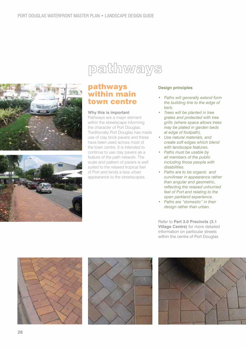
pathwayspathways within main town centreWhy this is important Pathways are a major element within the streetscape informing the character of Port Douglas. Traditionally Port Douglas has made use of clay brick pavers and these have been used across most of the town centre. It is intended to continue to use clay pavers as a feature of the path network. The scale and pattern of pavers is well suited to the relaxed tropical feel of Port and lends a less urban appearance to the streetscapes.
Design principles
Paths will generally extend form the building line to the edge of kerb.Trees will be planted in tree grates and protected with tree grills (where space allows trees may be plated in garden beds at edge of footpath).Use natural materials, and create soft edges which blend with landscape features.Paths must be usable by all members of the public including those people with disabilities.Paths are to be organic and curvilinear in appearance rather than angular and geometric, reflecting the relaxed unhurried feel of Port and relating to the open parkland experience.Paths are “domestic” in their design rather than urban.
Refer to Part 3.0 Precincts (3.1 Village Centre) for more detailed information on particular streets within the centre of Port Douglas
28

Materials Palette:
(Boral Summerset Opal 113x228x40mm or equivalent)
Clay Pavers should have the following characteristics:
Paver Patterns:
pathways outside main town centreWhy this is importantPathways provide a safe walking environment for pedestrians and the system of pathways helps to articulate the pedestrian network. Pathways within these dominantly residential areas should be consistent with the FNQROC Development Manual and will generally measure between 1.4 and 2 metres in width, depending on local demand and site conditions. Pathways are generally to be located 600mm from the property boundary and allow for a grassed verge or nature strip within which shade trees can be planted.
29
DESIGN GUIDELINES

interpretationand signageInterpretation and SignageWhy this is importantInterpretation and signage play a vital role in the legibility, permeability and accessibility between the waterfront, the town centre and surrounding areas. Way-finding assists on a practical level helping visitors to navigate the townscape and waterfront while locating key features and places of interest. Interpretive material tells the stories which are particular to Port Douglas and should be presented in forms which are readily accessible to the wider public. Both ensure that visitors and residents gain a full appreciation of Port Douglas and all that it has to offer; and that they are engaged in the broader historical and cultural influences that have shaped the township.
Both the Indigenous and non-Indigenous heritage of the waterfront should be recognised, enhanced and protected. All interpretation and signage recognising Port Douglas’ Indigenous history and the connection of the Kuku Yalanji, Irikanji and Jabugai peoples to the area should be developed in close consultation and negotiation with representatives of the local Indigenous communities.
The waterfront of Port Douglas has a wealth of history some predating early white settlement as well as covering the growth of the town from its founding in 1877. While much of the early waterfront has been lost there remain several features which still give testimony to the towns past and its’ importance as an administrative and maritime centre.“visually
interesting presentation of material”
“simple forms and clear text”
Sandblasted concrete
Sandblasted patterned concrete

The intent is to develop the amenity of the waterfront as a major component of the tourism experience. The understanding and interpretation of the areas rich history is integral to this and should be expressed not just through conventional interpretive boards but also by recognising aspects of the original working waterfront which was so instrumental in the development of the township, integrating historic references within the landscape design. Heritage interpretation is discussed in more detail in 3.0 Precincts (3.2 Waterfront Parkland).
Design principles Interpretation and signage are to be visually unobtrusive (signage must not obscure views or create unnecessary visual clutter which detracts from the natural parkland feel).Signage can be located within the ground plane or at low level incorporated within the path network, furniture and art work.Landscape design should express and honour the many layers of cultural heritage through the selection of materials and forms which echo both indigenous and non-Indigenous historic land uses and activities .Signage will include maps which locate key areas of interest and landmarks which are top be located at key points across the town.Maps are to be augmented with discreet but legible navigational signs which can be integrated within the path network.Signage should be easy to read and accessible to a wide range of users including those for whom English is not the first language (the use of pictorial and diagrammatic maps is preferred).Emphasis on natural finishes in materials which acknowledge the cultural heritage values of the site.
Materials Palette:
Response to common issue
Way-finding signs will just be more visual pollutionWay-finding signage will be discreet and carefully situated to not intrude on the townscape while being accessible to all users. It can make use of existing signage, which already exists within the town and be located near or close to facilities where there is already infrastructure. Signage within the park will be minimised by the introduction of a simple and legible pedestrian network which will clearly articulate movement across the site. Signage will make use of the ground plane and area below waist height to avoid obscuring views and cluttering the broader landscape.
“Interpretive material tells the stories which are particular to Port Douglas”

furnitureFurniture
Why this is important Furniture has an obvious function within the landscape but also serves to emphasise areas of interest and can be grouped to create informal meeting places, which allow people to gather and creates a sense of community and vibrancy. Within the waterfront furniture should be located to provide rest under shade and to maximise key views of the inlet and those special buildings of interest, a topic discussed in more detail in 3.0 Precincts (3.2 Waterfront Parkland).
It is important to see furniture in the broader context of the story of Port Douglas, its community and shared histories. The sugar industry, wharf structures, trams and cargo ships can all inform the design of and manufacture of furniture and can help to tell this story and make visual links to the towns past. Design should avoid the “Disney Approach” to such elements and rely on simple authentic forms and materials to suggest rather than replicate historic artefacts; new and introduced elements should readily articulate their contemporaneity and not cloud the authenticity of historic features.Within the town there is no current pattern to street furniture; it varies in style and form and offers a broad range of types from post war cast iron seats to in-built slatted timber benches. The variety of furniture types is not to be seen as a negative; the variety belies the evolution of the townscape and adds to the “authenticity” of the experience of visitors. A rigid palette of standardised urban furniture should be resisted in favour of a more relaxed approach, which tolerates the differences in form and style and has a “don’t’ fix it if it isn’t broke” approach to the current settings. Overtly urbanised forms should be avoided in favour of simple contemporary styles in natural materials.
“...located to maximise key views”
“The sugar industry, wharf structures, trams and cargo ships can all inform the design of and manufacture of furniture...”

Design principles Furniture is to be organic in nature and respect the heritage values of the waterfront.Raw simple shapes are preferred over standard urban forms.Unique and bespoke hand made pieces are preferred over commercial furniture types with the possibility to make use of local craftsmen and manufacturers.Furniture should not intrude on the parkland and can be integrated with interpretation and signage to minimise infrastructure.Replace all concrete picnic settings with a suitable contemporary setting.Where existing furniture is affected by site alterations ensure that where possible it is recycled and relocated within the project area.Sustainable options should be sought for all furniture selections.
Materials Palette:
“unique and bespoke hand made pieces”
“locally crafted and organic forms”
Response to common issue
Do we need a palette of furniture?The answer is that we do not. The variety of furniture relieves the sense of sameness which can result from such standardisation across project sites. The ad-hoc charm of a more random approach suggests a more natural growth and evolution, one in step with the towns’ development over the last decades. While certain furniture such as the concrete picnic settings are not a positive feature and should be replaced; in general furniture need only adhere to the guidelines set out above to create a harmonious approach across the project site.
DESIGN GUIDELINES

Planting Design
Why this is important Port Douglas is well known as a tropical oasis; a place to refresh, restore and revitalise, either in the aquamarine reef waters of the Coral Sea, the crystal creeks of Mossman Gorge, or the palm fringed golden sands of Four Mile Beach. Plants play a vital role in establishing the relaxed tropical character of Port Douglas which makes it such an appealing place to live and visit. Streets lined with tropical trees, bordered by swathes of lush tropical foliage are a key feature of the township and help to distinguish Port Douglas from other destinations within Australia.
Port Douglas is unique in being the only place on Earth where two World Heritage listed sites can be found together; the Great Barrier Reef and the Daintree Rainforest. While development of the town has significantly altered the natural plant communities which once fringed its coastline, there still remain stands of mangroves, paperbarks, Beach Calophyllum and giant Fig trees.
Planting design helps to articulate these plant communities and integrate new features in to the
planting designbroader landscape. This guide recognises the value of exotic planting and the role it has played in establishing the resort character of Port Douglas; while acknowledging the importance of the regions natural plant communities. Mixed plantings incorporating both native and exotic plant species are supported across most of the townscape but should be restricted around the foreshore where a more natural approach is preferred, and where native species will enhance remnant stands of vegetation and the natural appearance of the coastline of the town.
Quality landscape design is imperative for good streetscapes. Street trees, when mature, tend to be the most prominent landscape elements. They can contain vistas and help to define boundaries, reduce traffic speeds by narrowing the perceived travel-way, and provide shade and habitat for fauna. Green streetscapes help to create a sense of place and are an attractive feature of port Douglas.
Refer to 3.0 Precincts for specific view corridors.
“The overall landscape character of Port Douglas is of shady trees set within a parkland”
34

Design principles The overall landscape character of Port Douglas is of shady trees set within a parkland. A number of iconic species, mostly endemic, are to be used strategically throughout town, whilst exotic feature planting adds localised colour and texture to key areas or landmarks.Landscaping should compliment the existing tropical coastal “resort town” character of Port Douglas and create dominantly tropically vegetated streetscapes.Ensure that existing vegetation on Site is retained, protected during works and integrated with the built environment. Ensure that landscaping screens buildings to reduce their bulk and to enhance the landscape character of the village.Mature vegetation on site is retained wherever possible to provide shade and maintain diversity in tree maturity across the site.Maximise landscaping in all streets with an emphasis on shade trees.Ideally, space trees so that the canopies touch when mature.
Ensure there are no potential conflicts with other street elements, such as streetlights being blocked by the tree canopy, or car doors being opened onto tree trunks.Where appropriate integrate landscape design with water sensitive urban design systems. Use best practice tree planting technologies to assist in the preparation of tree pits.Incorporates new plants which encourage biodiversity; and maintains and strengthens the tropical and native landscape character of Port Douglas through high quality landscape works: » Native species are
incorporated into landscaping, as a means of providing continuity between developed and undeveloped areas.
» 60% of the total proposed species are endemic or native species.
» Native and endemic plant species characteristic of the area are to be included in the landscape design.
» Plant species are selected in accordance with the Plant Species Schedule in Port Douglas Planning Scheme Policy No 7 – Landscaping (please see Part 4.0 Appendix for a full Plant Species Schedule).
“acknowledging the importance of the regions natural plant communities”

Iconic Native Tree/Palm Species:
Botanic Name Common Name
Deplanchea tetraphylla
Livistonia muellerii
Dillenia alata
Melaleuca leucadendra
Melaleuca dealbata
Melaleuca viridiflora
Melaleuca quinquenervia
Terminalia ssp.
Callophyllum ssp.
Barringtonia ssp.
Alstonia scholaris
Peltophorum pterocarpum
Ficus ssp.
Iconic Exotic Tree/Palm Species
Delonix regia
Plumeria ssp.
Elaeis guineensis
Pterocarpus indicus
For a more detailed list of suitable plants for the Port Douglas area refer to Appendix 4.2.
planting design

Response to common issues
How can we ensure the health and success of our street trees?Tree pits must be designed to accommodate the specified tree at maturity. Roots cells and similar technologies can be utilised within street tree pit design to ensure root growth and avoid damage to localised infrastructure by the appropriate use of root barriers. Specialist advise on these technologies is to be sought prior to all street tree installation works proceeding.
How should exotic planting be used within future parkland design?Exotic planting is not seen as a major feature of future landscape treatments within the waterfront parkland; and is only to be used in association with native and endemic species to create feature planting for key elements within the landscape design:
St Mary’s by the SeaThe CourthouseWater play or lagoon facilities and children’s play area (suitable coastal plants)
Wherever possible, existing native vegetation is to be retained, incorporated into the site design and protected during works. Mature vegetation is to be retained wherever possible as this provides shade and screening, often has cultural significance, and reduces the impact of redevelopment, providing a more natural mix of trees of varied maturity.
60% of the total proposed species are endemic or native species.
Lush tropical plantings do not conform to CPTED principles!A balance is needed between CPTED requirements and lush plantings, which typify the visitor experience of Port Douglas as a relaxed resort town. Planting helps to reduce the harshness and urbanity of the streetscape and contributes to the over all “barefoot” character of the town - which is designed around pedestrian use.
37
water sensitiveWater sensitive urban design (WSUD)
Why this is important Streets account for a significant percentage of the impervious area of our built environments, causing increased stormwater flows. They are also the source of a number of water borne pollutants such as sediments, metals and hydrocarbons that adversely affect the health of receiving waters. To preserve the health and vitality of our waterways and the Great Barrier Reef it is essential that we reduce the dispersal of these pollutants and protect our seas. WSUD elements can be integrated into open space and streetscapes to collect and treat runoff prior to discharge and can become interesting landscape features which integrate well with local vegetation communities.
Design principles Use stormwater treatment elements in the urban landscape to maximise the visual and recreational amenity of future works.Size WSUD elements relative to the contributing impervious area (approximately 2-3% of its catchment depending on the geographical location).Generally, WSUD is most effective on slopes of 1 – 4%. Where slopes exceed 4% either bioretention street planters or additional flow control features (such as check dams with swales and bioretention systems) can be used.Use WSUD elements such as bioretention swales on the high-side verge reserve if there is one. Where the street runs perpendicular to contours use either verge for bioretention systems. Ensure street or driveway crossovers of bioretention swales are either at grade or incorporate a culvert crossing. If this is not possible, use discrete WSUD elements separated by driveway crossovers.
“preserve the health and vitality of our waterways and the Great Barrier Reef”
38

urban designNative and endemic plant species can be utilised within the WSUD systems to absorb unwanted nutrients prior to discharge. These species can enhance local natural vegetation protecting local ecologies.WSUD treatments must be adapted for use Port which is in a high rainfall area.This street has a swale within its central median as part of the WSUD strategy. The unique kerb treatment and timber walkway also create an interesting streetscape. Swales can also be simple grass depressions on the street edge or within an open space area.
Response to common issues
Bioretention systems present a health risk?Badly performing WSUD treatments can present a health risk by promoting the presence of mosquito larvae in slow draining water retention systems. It is essential that WSUD features are designed to prevent the risk of insect breeding.
Should all streets have WSUD elements? It is not necessary or appropriate to provide WSUD elements on all streets. Stormwater however can be directed to a series of site-wide systems which utilise the natural topography of Port Douglas to concentrate stormwater to the area within the sports fields to the west of the town.
How should WSUD elements be integrated with travel-ways and parking areas? Parking areas can be located adjacent to WSUD elements but should be designed to prevent vehicles damaging these systems. Bollards or kerbs with regular breaks are required to allow distributed flow to the WSUD element.
Parking areas may be interspersed between WSUD elements, such as parking bays between rain gardens.
Do WSUD elements require much maintenance? In the first two years it is important to remove weeds. Only limited maintenance is required after this.
“WSUD elements can be integrated into open space and streetscapes”
39

40
3PRECINCTS
41

3.0 PRECINCTSWhat are the main precincts within Port Douglas?
For the purposes of this document Port Douglas has been divided in to five distinct precincts. These in turn are divided into sub-precincts which have been identified as possessing their own distinct character.
Sub-precincts within the village centre are defined by street name while those within the existing waterfront have been selected based upon historic usage, which is already familiar to the residents of Port Douglas. The Four Mile Beach Esplanade is a stand alone precinct at the eastern end of the study area.
Village Centre Precinct
Waterfront Parkland Precinct
Four Mile Beach Esplanade Precinct
Sporting and Recreation Precinct
Town Centre Gateway Precinct

Village Centre Precinct
Sporting and Recreation
Precinct
Town Centre GatewayPrecinct
Waterfront Parkland Precinct
Four Mile Beach
Esplanade Precinct
2
3
4
5
1
Sugar Wharf / Dixie St.
St Mary’s by the Sea
Combined Club
Dixies Shed
Mobility Hub
1
2
3
4
5
43
PRECINCTS

3.1 Village CentreGeneral description of design objectives for the village centre precinctWith the exception of wider circulation initiatives minimal changes to areas outside of the waterfront are anticipated. Over all design will ensure that each street maintains its’ unique character, and derives this character from existing values, exhibiting a gentle approach to change and a respect for existing conditions.
A clear framework for access and circulation will include improvements to the intersection of Davidson and Mowbray Streets as the key gateway to the town, with the utilisation of Mowbray Street as the first node of arrival. This will highlight the importance of the proposed Community and Cultural Precinct and positions the waterfront as the key experience for those arriving in Port Douglas. The creation of the Mowbray Street Gateway sets the scene for the creation of a ‘mobility hub’ at the eastern end of Mowbray Street. The mobility hub is intended to consolidate visitor car parking, coach drop off and pick up facilities, cycle storage and hire car offices. This initiative will not remove
the need for on street parking or other existing parking resources but, rather, will lessen demand on parking in the police reserve and mitigate the future removal of parking within the proposed waterfront park.
The realignment of the Davidson Street and Mowbray Street intersection will promote a clockwise vehicular circulation pattern by encouraging vehicles to use Wharf and Macrossan Streets as a ‘loop’. Macrossan Street is envisioned as a “Green Spine” with the impacts of vehicle infrastructure being reduced by the introduction of additional tree planting, increasing green space amenity while connecting this highly successful retail strip to the overall open space system. This will form a lineal link from the Waterfront Park to Four Mile Beach and consolidate the east west axis that will connect these two key attractors and the town of Port Douglas.
“each street maintains its’ unique character”
“Macrossan Street is envisioned as a Green Spine”
44

Port Douglas is not seen as a car dominated environment and as a result a key objective is to better promote walking and cycling throughout the town and to improve conditions for foot traffic. Improved street lighting for footpaths and improving the environmental quality and amenity of certain streets through tree planting are ways to ameliorate pedestrian environments. Streets should be kept to a human scale, which is both intimate and “non-urban” in style. The charm and appeal of Port Douglas lies in its rather ad-hoc, relaxed, “barefoot” feel where the mingling of lush tropical vegetation, footpath dining and small boutiques blend together in a way which encourages exploration and lends an unhurried tropical air to the centre of town. Design should encourage such pedestrian movement and assist in activating other less used areas of the town by encouraging access across the town as a whole.
“gentle approach to change”
“Port Douglas is not seen as a car dominated environment”
PRECINCTS

3.1.1 Mowbray Street
DescriptionIn order to rationalise vehicularmovement into and around the township, and in the interests of making the waterfront a definingaspect of the arrival experience, Mowbray Street will become thenew Gateway to Port Douglas with traffic directed via a new entry feature located at Davidson Street. The scale of the road will express its status within the hierarchy andclearly articulate it as the major approach to the town centre and waterfront.
A waterfront plaza located within the proposed new Marina redevelopment will serve a numberof functions within the broadernetwork of public open spaces.It will provide a waterfront arrival node and a dramatic terminationto the Cultural Precinct, offering opportunities for cultural events and activities within a more formalised space that will help transitionbetween the marina development and the broader parkland to thenorth.
Land topography together with the location and nature of landwithin the sporting precinct allowsopportunities for stormwatercollection and treatment prior todischarge into the wider waternetwork. The redirection ofstormwater through treatment lines
north-west and south-east of the sports precinct will allow opportunity for improved purification and create multiple discharge points in to the Dickson Inlet, improving the quality of water along the waterfront
Mowbray Street will also function as the key access to the Cultural Precinct through which visitors will pass. It is envisioned as an inviting streetscape with a welcoming community focus, placing the community and its’ values at the heart of the precinct.
This becomes the civic heart of Port Douglas and will express the community’s values through the following features:

Design guidelines/featuresArrival landscaping and new entry statement at intersection with Davidson Street.Pedestrian friendly intersection treatment at Wharf Street to connect Waterfront Plaza and Mobility Hub.Integrate WSUD treatment to side of street no kerb.Meandering 2m wide concrete shared path along western side, passing through the WSUD treatment incorporating boardwalk and possible interpretive area to express commitment to sustainability.Shared path links to the existing cycle network and provides clear access to the waterfront (ensure safe crossing points across Wharf Street).
“the waterfront a defining aspect of the arrival experience”
Ensure community gardens do not interfere with areas suited to future WSUD features and are located close to the Community Centre to allow ease of access to facilities and provide greater passive surveillance.Create and articulate clear linkage to the waterfront for pedestrians and cyclists.The intersection at Davidson Street will be re-aligned to promote left turning vehicles.
47
PRECINCTS

3.1.2 Warner Street
DescriptionThe section of Warner Street between Grant and Owen Streetshas become something of an iconicstreetscape for Port Douglas. Its avenue of Indian Padauk treesprovides a shady and attractiveenvironment, but this theme needsto be extended to the full length ofWarner Street to Wharf Street. This will provide much needed shadeand help to reduce the impact ofthe larger scale buildings in this section, of the street and helpreconnect this part of the town tothe waterfront.
At present the dominance of the Coles building, its’ loading and parking facilities and the proximity of other rather industrial scale buildings creates an uneasy feel more suited to town fringe than town centre. The planting of large scale tropical trees will lessen these impacts and improve the general streetscape. Landscaping will also frame the view corridor to Dixie Street, which is in fact in direct alignment with Warner Street and forms a strong axis to the Sugar Wharf and St Mary’s by the Sea.
“reconnect this part of the town to the waterfront”
“frame the view corridor to Dixie Street”
48

Design guidelines/featuresBetween Owen Street and Grant Street
Incorporate a planted WSUD to the road side.No kerb and channel rather use a concrete edge restraint.Use a recycled decking system to relieve pressure on tree root systems and to allow for a pedestrian footpath.Decked crossovers for driveways.Develop a maintenance strategy to manage the existing trees and to ensure their long term health.Install one way system to reduce trafficable area (from Owen - Grant Streets only).
Between Grant Street and Wharf Street
Indian Padauk trees planted in large islands within the road shoulder.Maintain the view corridor to Dixie Street, Sugar Wharf and St Mary’s by the Sea.
49

3.1.3 Macrossan StreetDescriptionMacrossan Street is the main shopping area of Port Douglas, and is a lively bustling thoroughfare typified by large shade trees and tropical plantings with small shops and outdoor dining. Vehicles are currently controlled by the dominance of pedestrians and by the movement associated with on street parking. This mix of activities slows traffic speeds and helps to foster a more relaxed and less urban atmosphere where pedestrians can move more freely and drivers give greater consideration to other road users.
With Mowbray Street becoming the main approach to Port Douglas it is anticipated that traffic along Macrossan Street will be further reduced. The extension of the current centre planting and parking along the northern end
of Macrossan to Davidson Street will see the consolidation of the “Green Spine” that will connect the waterfront parkland to Four Mile Beach.
The creation of the Green Spine would see the rationalisation of loading bays and on street parking along the Southern Side of the street to create a continuous shaded green spine that links the street to the waterfront parklands. This will require detailed traffic modelling to ensure its feasibility but in principle would deliver an enhancement in the overall amenity of street.
“...relaxed and less urban atmosphere...”
“...’green spine’ that will connect the waterfront parkland to four mile beach”
“...typified by large shade trees and tropical plantings...”

Design guidelines/featuresExtend median planting and centre parking along the remainder of Macrossan Street between Owen Street and Davidson Street.Minimise the impact of the large intersections with surface treatments.Streetscape improvements must make provision for the Carnivale Parade.Maintain the ad hoc nature of the streetscape by allowing for non-uniform approach to street furniture.Maintain and enhance the current mix of tropical shade trees allowing for flowering species to add colour and interest.Improvements to the current intersection with Davidson Street to improve pedestrian movement and reinforce the axis with the Esplanade Four Mile beach.Maintain current pathway treatments (Refer to Part 2.0 Design Guidelines - Pathways Across Town).
PRECINCTS

3.1.4 Wharf Street DescriptionOnce Mowbray Street is activated as the major approach to the town Wharf Street will play a key role within this new arrival experience. In general Wharf Street provides valuable views to the waterfront and the sea and mountains beyond.
Main View corridors:
Wharf Street is to be designed as a slow vehicle environment to allow for the safe movement of pedestrians to the waterfront parkland. Landscaping will provide a transition from the current edge of the town to the open parkland setting of the proposed waterfront.
Design guidelines/featuresSlow vehicle environment.Pedestrian friendly.Transition from town edge to parkland (eastern and western sides of Wharf Street).Parkland edge treatment to park informal (avoid rigid plantings of Poinciana trees avenue planting styles).Facilitate pedestrian/cyclist movement between new marina and the parkland via clearly defined public access along the Wharf Street frontage of the plaza.No additional kerbing to the waterfront park edge and use bollards or similar to restrict vehicular access.Park edge open to allow free access and clear views of the waterfront park.Maintain view corridors (refer to illustration opposite).
“Wharf Street provides valuable views to the waterfront and the sea and mountains beyond”
52

“ transition from the current edge of the town to the open parkland”
53
PRECINCTS

3.1.5 Grant Street DescriptionThe extension of Mowbray Street to Wharf Street to create a new approach road to town will result in the closure of Grant Street between Mowbray Street and Wharf Street. The construction of the Mobility Hub will, however, help activate this corner of Grant Street. There is a lively café scene with shaded outdoor dining at the Macrossan Street end of Grant Street and will improve circulation to and from this area of the town.
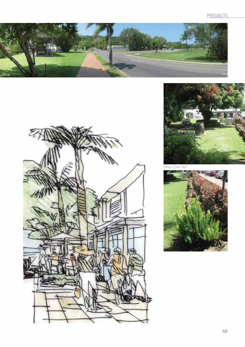
The southern end of Grant Street adjacent to Macrossan Street along its eastern side has a lively café scene with shaded outdoor dining facing the Rotary Club Park. This western side of the street requires tree planting to enhance the streetscape with large shade trees.
Design guidelines/featuresGeneral Streetscape improvements in line with recent development.Continue theme of Copper Pods to Mowbray Street.Trees in grates at 8m centres along existing footpath to provide more shade.
“tree planting to enhance the streetscape with large shade trees”
lively café scene with shaded outdoor dining
54
55
PRECINCTS

3.1.6 Davidson Street (between Macrossan Street and Mowbray Street)
DescriptionIn order to rationalise vehicular movement into and around the township, and in the interests of making the waterfront a defining aspect of the arrival experience, Mowbray Street will become the new Gateway to Port Douglas with traffic directed via a new entry feature located at Davidson Street. The scale of the road will express its status within the hierarchy and clearly articulate it as the major approach to the town centre and waterfront.
Design guidelines/featuresThe provision of a roundabout offers the greatest opportunity for a landscaped arrival feature.Possible entry sign to welcome visitors and enhance the sense of arrival.Roundabout layout designed to emphasise the Mowbray Street turn off and promote Mowbray Street as the approach to the Town via the waterfront.Incorporate Calophyllum ssp. to link existing themes on Mowbray Street.Incorporate “iconic” plant species such as licuala and cabbage palms as well as white flowering plants that compliment prevailing street themes.Signage should be clear and simple in design and in materials which associate to Port Douglas’ maritime history - use of stainless steel and hardwood timber.
“welcome visitors and enhance the sense of arrival”
“...Gateway to Port Douglas...”

PRECINCTS

3.2 Waterfront ParklandGeneral description of design objectives for the waterfront parkland precinct The Master Plan recognised the role of the waterfront as a principle feature of Port Douglas. A key focus of the master planning process was the creation of a “walkable waterfront” allowing unrestrained public access to the waters edge from the Combined Club through to Rex Smeal Park. The implementation of a new gateway via Mowbray Street will ensure the waterfront will become a defining experience for visitors to Port Douglas as they approach the village centre.
Key to the consolidation of the new walkable waterfront is the removal of private buildings and parking between the Combined Club and the Sugar Wharf. The reclamation of this area for public open space will offer many key design opportunities:
“...the waterfront will become a defining experience for visitors...”

Future design of this area should seek to transition the waterfront parkland from the marina at its southern end, where there is a concentration of built form, to a more natural, undeveloped character at the far northern end of Rex Smeal Park.
Activity is concentrated around the Sugar Wharf. Sugar Wharf, the Combined Club and St Mary’s by the Sea represent a vital reminder of Port Douglas’ historic past.
Rex Smeal Park will remain relatively untouched and serve as an area of passive recreation, a quiet zone, which will continue to serve as a function area for special events.
Pathways form an essential component of the redevelopment of the waterfront parkland as they articulate the space and assist with way-finding reducing the need for signage. Solutions to providing pathways, access ways and supporting market activities need to be as unintrusive as possible.
The current lack of appropriate maintenance access across the site has led to it being worn by vehicle tracks which have eroded the grass and created a scarred appearance with dust and exposed earth dominating the parkland. This issue is to be addressed by the inclusion of appropriate access paths which can be combined with pedestrian paths to minimise impacts on the parkland. While paths are acknowledged as a key component of the parkland they are not to be a dominant feature of the landscape A sealed path will provide access throughout the precinct to all users, including maintenance vehicles.
This simple path network will assist in the maintenance of the park and allow for more controlled vehicular access, directing pedestrian movement through and across the site, incorporating the historic features.
The waterfront has a vibrant cultural past representing both the early settlers and the traditional owners alike and there is extensive opportunity for interpretive signage, which can help to articulate the towns’ historic context and link the modern waterfront to the past.
The waterfront parkland is divided in to the following sub-precincts:
Further north there would be fewer built structures (although some picnic facilities) and more natural landscape. Opportunities to provide limited parking under the existing trees should be investigated to improve accessibility for a range of users.
The design seeks to remove the large areas of car parking and improve the general park amenity of this area. Also to resolve the impact of the markets on the environment with the possibility to relocate the markets to the northern end of the park thereby providing waterfront access.
“walkable waterfront”
PRECINCTS

3.2.1 Rex Smeal ParkDescriptionRex Smeal Park is located on a site of enduring historic significance to the Port Douglas community. The park is built within the confines of the former sea pool constructed in Port Douglas in 1972 to provide a safe swimming environment for the town’s residents. The pool was constructed using quarried rocks, partly built on top of the remains of the original nineteenth century stone jetty. This jetty was the first to be built in the town to service the loading and unloading of cargo. It was located at the end of Wharf Street, which soon became the most important thoroughfare in the burgeoning town. Although the sea pool initially proved popular and successful, it eventually became unusable and was filled in during 1976, at which point the new park was named in honour of Rex Smeal, a former Douglas Shire Council overseer.
This park enjoys patronage by residents and visitors alike for its amenity and unimpeded views of the Coral Sea and mountainous backdrop.
The Port Douglas Court House Museum and the Police ReserveThe Port Douglas Court House was constructed on its current site in 1879 as the first court house in the town and is one of the earliest surviving timber constructed court houses in Queensland. The building now operates as a local history museum and has been run by the Port Douglas Historical Society since 1997. The Court House is the only survivor of the original government buildings that
were constructed along Wharf Street during the latter part of the nineteenth century. The Court House is currently listed in the Queensland Heritage Register, the former Douglas Shire Policy for Cultural Heritage and Valuable Sites and under the National Trust of Queensland.
As early as 1878, a large area of the current police reserve was marked as “Reserved for Police use”. As Port Douglas grew in importance the town became the headquarters for the police in the area and it served in this capacity for a number of years. The original barracks and site office are no longer, having been moved to Einsliegh. The current buildings date from the 1960s to the present day, but provide an historical link to the sites past and to the early establishment of an administrative quarter.
Kuku YalanjiPort Douglas is located in the tribal lands of the Kuku Yalanji people. It is believed that there were originally three or five groups within the tribe. Their territory included rainforest, range, riverine and coastal environments. The communities lived on a wide and varied range of natural resources. For the Kuku Yalanji, the environment was a humanised landscape, one described in human terms where seasonal changes were interpreted as changes in the human or social world. It was interacted with, spoken to and acted upon and in return provided materials and resources.
The discovery of gold in the Hodgkinson River and the opening up of the Christie Palmerston Road
Annual Port Douglas food and wine festival
Special Event
60

to the coast in 1877, brought with it an incredible and inconceivable change for the Kuku Yalanji tribe. Early contact was often violent with fatalities occurring on both sides.
The area now known as Rex Smeal Park was an important meeting place and campsite for the Kuku Yalanji people before white settlement encroached on their traditional grounds. The Kuku Yalanji would meet here with members of the neighbouring peoples from the Irikanji and the Jabugai. The mango tree plantings, which persist to this day, were particular to these meeting areas, and still have a high social value to the local indigenous community due to their connection to the community Elders.
The beach near the court house and adjacent to Rex Smeal Park was historically used by the women of the Kuku Yalanji during oyster fishing.
Design guidelines/featuresPreserve and incorporate the existing rock wall in to any future changes to the site.To protect existing trees, large scale parking is to be restricted and a semi-formalised shared path/parking and set down area provided within the footprint of existing access tracks to service special events.Informal permeable surface to Rex Smeal access path.Access approach to Rex Smeal (toilet block) to incorporate an enhanced planted swale as part of a WSUD treatment.Replace the tired BBQs with more appropriate lightweight structures.Create link to coastal Trail with appropriate signage.Remove and replace the existing signs with more appropriate signage.Replace damaged steps to the beach adjacent to Rex Smeal Park with low key access steps in natural form.Retain existing character and features and enhance setting as a quiet area for passive recreation.Renovate the toilet block and screen facilities with suitable planting.
Explore the indigenous and non-Indigenous cultural heritage values of the area by incorporating interpretive displays and art work based on these themes.Incorporate an appropriate Kuku Yalanji name on the theme of the meeting place to compliment the later 1970s naming of the park.Natural transition to the coastal vegetation zone.Informal path network, which clearly articulates both the coastal path and the island point road lookout.Replace existing BBQs with more suitable light weight structures (Refer to 2.0 Design Guidelines - Furniture).Maintain views to and from the Court House across the park.Maintain views from end of Anzac Park to ocean.Relocate toilet and BBQ facilities to maintain key views.Replace existing play area with new nature based adventure playground incorporating imaginative play elements around the existing fig trees.Provide permanent performance platform with demountable stage structure adjacent to police reserve.
“...important meeting place and campsite for the Kuku Yalanji people...”
Annual Port Douglas food and wine festival
Historic rock wall
PRECINCTS

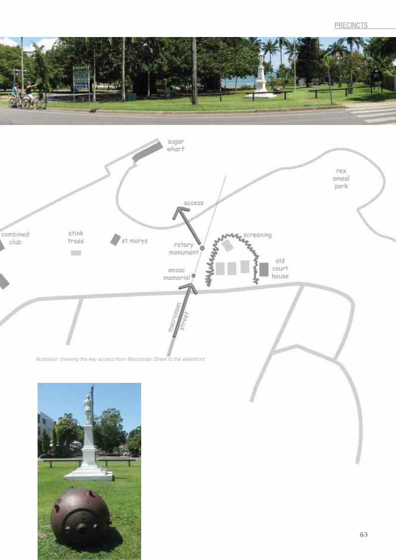
3.2.2 Anzac ParkDescriptionAnzac Park was originally part of the government precinct that included a host of official buildings which had sprung up along Wharf Street during the early part of the nineteenth century. The Park itself originally formed part of Macrossan Street and only recently became into a local government reserve allowing for the creation of a war memorial. The contemporary Park features a commemorative Anzac statue erected in 1923, a disarmed sea mine from World War II, discovered on Four Mile Beach, and a number of commemorative plaques marking the celebration of Australia’s Centenary of Federation, erected by the Rotary Club of Port Douglas in 2001.
Design guidelines/featuresScreen police station with suitable native plants incorporated with WSUD treatment. Rationalise recent tree planting with species of an appropriate size (minimum 100 litre specimens).Landscaping should emphasise the key axis with Macrossan Street.Re-establish and enhance views to the waterfront.Open up views to Sugar Wharf from waterfront edge of Anzac Park.Establish appropriate beach access to cove.Repair and update damaged rotary club displays.
PRECINCTS

3.2.3 St Mary’s by the Sea
DescriptionSt Mary’s by the Sea is one of the oldest buildings in Port Douglas and was reconstructed in about 1911 from the remains of the original Port Douglas Catholic Church, which had been destroyed during a cyclone in March of that year.
In 1987, the Catholic Church gave St Mary’s Church (now in a state of deterioration) to the local community who rallied to have it relocated to its current location in November 1988. Once relocated, St Mary’s Church was restored and renamed “St Mary’s by the Sea”. It is used as an ecumenical community church for weddings, carol services and other special services and events. The building is now listed in the Queensland Heritage Register, the former Douglas Shire Policy for Cultural Heritage and Valuable Sites and under the National Trust of Queensland.
“The Stink Trees”Locally known as “The Stink Trees”, these specimens of Ocotea usambarensis were rumoured to have been planted by a visiting sailor during the later years of the nineteenth century. The species is native to Africa and it was valued at the time by cabinet makers in southern Africa. These trees are indicative of the town’s historic status as a major trading port in North Queensland and bear testimony to its maritime history.
During its flowering season the Ocotea trees emit a unique and rather unpleasant, sweet odour; hence its colloquial name “stink trees”. This odour and the historical connotations that are inherent in this introduced species have seen it become a locally significant feature of the Port Douglas Waterfront and highly valued by the local community.

Design guidelines/featuresVehicle set down area close to the church to be incorporated in to the main pedestrian network.Key node on footpath network and a perfect area for a meeting place.Opportunity for public art feature as part of the above based on local heritage or environmental values.Opportunities for additional heritage interpretation of historic uses within the area.Enhance the scenic charm of the church and provide a suitably relaxed tropical setting for photo opportunities for both wedding parties and tourists.Opportunity to enhance and enlarge the existing relaxed and informal tropical garden theme around the church with an emphasis on scented flowers.
Maintain view corridor from Wharf Street.Secondary view corridor from Warner Street (relocate the existing electrical box at end of Warner Street to open views to church).Remove the existing play areas and bollards adjacent to the church.
Toilet BlockScreen existing toilet block to reduce visual impact.Connect to main footpath network.Highlight “The Stink Trees” with appropriate interpretive signage.
“...one of the earliest Catholic Churches in North Queensland”

3.2.4 Sugar WharfPort Douglas was established in 1877 as a port to service the newly opened Hodgkinson Goldfield. Between 1877 and 1893, Port Douglas functioned primarily as a port for the mining hinterland and secondarily as an administrative and service centre for the surrounding developing agricultural districts. Following the decision in 1885 to construct a railway terminus at Cairns trade with Port Douglas soon dwindled and the town survived principally as a sugar port, with the last sugar shipment being made in 1958.
There were a number of associated buildings with the early wharfage. This included two storage sheds which were erected on the Divisional Board Wharf in 1896. These sheds projected into the channel so as to load lighters that would ferry bagged sugar to larger
vessels anchored out to sea. The completion of the Mossman to Port Douglas tramway in 1900 meant that the sheds were used simply for the storage of the sugar as it awaited transportation to larger vessels.
The Port Douglas and District Combined ClubIn 1973 The Port Douglas and District Combined Club took over the use of the one remaining shed, the other having been demolished in the 1960s. The original wharf structure and jetty were lost during subsequent land reclamation during 1977. The timber framed original structure has been substantially altered over time including a new roof and frontage. In spite of these alterations the current building is listed in the Queensland Heritage Register, the former Douglas Shire Policy for Cultural Heritage and Valuable Sites and under the National Trust of Queensland.

The Sugar WharfThe Sugar Wharf building we see today was constructed in 1904 for the Douglas Shire Council and was designed to handle general cargo as well as sugar. The new wharfage benefited form the construction of the tramway network linking the sugar mills of Mossman to the township of Port Douglas. The original nineteenth century approach to the wharf consisted of a stone pitched wall, a precision placed stone ramp some fifty metres long, was extended by the addition of a timber jetty during the 1904 upgrade. At this same time the original storage shed was extended and relocated over the new jetty, sliding the structure back from the wharfs’ outer face.
The space between the original stone-pitched jetty and the storage building was reclaimed in 1977 and
the timber framed jetty removed and the stone pitched jetty replaced by the rock wall which remains to this day, however parts of the original stone pitched jetty are still in evidence at the side of the new earth filled access to the building. Dixie Street is built on the alignment of this old jetty, and the original stone pitched approach is enclosed beneath the tarmac. The Sugar Wharf building and the Combined Club are all that remains of the complex of buildings which made up the historic working waterfront of Port Douglas. Tramway buildings including a station, customs office, bond store, workshop and goods shed have all been lost. The Sugar Wharf is listed in both the Queensland Heritage Register, the former Douglas Shire Policy for Cultural Heritage and Valuable Sites and under the National Trust of Queensland.
Design guidelines/featuresEnhance the landscape setting to the Sugar Wharf with historically sensitive treatments which recognise and acknowledge the historic character of the wharfage.Opportunity to expose the historic stone pitched causeway currently hidden beneath Dixie Street and enhance the historic axis with Warner Street.Link Dixie Street to the gardens adjacent to St Mary’s by the Sea.Opportunity to restore part of the original quay line to the limit of the original stone causeway and reinstate a timber jetty in imitation of the 1904 original with adaptation to suit the modern requirements of the Sugar Wharf and it’s possible future uses.All restoration work must consider and respond to the effects of coastal influences and ensure that any changes to the current waterfront do not adversely impact on the broader coastal zone.Sugar Wharf is seen as an iconic feature of the Port Douglas Waterfront.
67
PRECINCTS
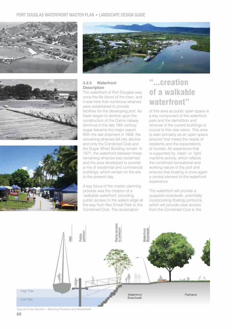
3.2.5 Waterfront DescriptionThe waterfront of Port Douglas was once the life blood of the town; and it was here that numerous wharves were established to provide facilities for the developing port. As trade began to decline upon the construction of the Cairns railway terminus in the late 19th century, sugar became the major export. With the last shipment in 1958, the remaining wharves fell into decline and only the Combined Club and the Sugar Wharf Building remain. In 1977, the waterfront between these remaining wharves was reclaimed and the area developed to provide a mix of residential and commercial buildings, which remain on the site to the present day.
A key focus of the master planning process was the creation of a ‘walkable waterfront’ providing public access to the waters edge all the way from Rex Smeal Park to the Combined Club. The reclamation
of this area as public open space is a key component of the waterfront park and the demolition and removal of the current buildings is crucial to this new vision. This area is seen primarily as an open space precinct that meets the needs of residents and the expectations of tourists. An experience that is supported by ‘clean’ or ‘light’ maritime activity, which reflects the combined recreational and working nature of the port and ensures that boating is once again a central element to the waterfront experience.
The waterfront will provide a quayside boardwalk, potentially incorporating floating pontoons, which will provide clear access from the Combined Club to the
“...creation of a walkable waterfront”
68

Sugar Wharf and St Mary’s by the Sea. The boardwalk will take full advantage of the stunning views and allow opportunities to extend the current Sunday Markets to the waters edge. The amenity of the area will be enhanced by the construction of BBQ pavilions which will encourage and facilitate social gatherings and make best use of the magnificent ocean views.
Design guidelines/featuresThe removal of several buildings associated with the existing waterfront leases. To allow unrestrained public access to the waterfront from the Combined Club and the Sugar Wharf and St Mary’s by the Sea.To develop the amenity of the waterfront and surrounding areas as a major component of the tourism experience.Improve the visual relationship between the town and waterfront by enhancing ocean views.
Create a park land with pedestrian boardwalk, community facilities, short-term public boat mooring and visually sympathetic low scale pavilions.The boardwalk should respect the heritage values of the waterfront.Boardwalk structures should not impede views to inlet (low edge barriers are preferred over balustrades where these are practicable and provide adequate safety).Boardwalk structures should reflect the simple working nature of the historic wharves; simple, raw forms are preferred over more sophisticated urban design solutions.To provide a suitable waterside extension to the existing Sunday Markets.BBQ pavilions located to maximise views and local breezes, light structures which minimise the visual impact on the park land and possible views.
Pavilions to be enhanced by shade trees (tree canopies can camouflage roof structures).Boardwalk should provide ample opportunity to sit and admire the magnificent views and furniture can be integrated in to the boardwalk structure (edge barriers).Lighting should not interfere with the natural appearance of the shoreline or create excessive light pollution and spoil night-time views by excessive glare.Low level lighting to boardwalk (concealed within barrier structures).
69
3.2.6 Island PointDescriptionFlagstaff Hill, originally known as ‘Billy Goat Hill’ is closely associated with the development of Port Douglas both as a functioning maritime port and later as a popular tourist destination. Flagstaff Hill was established as the location where the town’s Harbour Master would raise the flag to alert Port Douglas to the approach of a vessel; and later as a cyclone warning. In the following years a scenic lookout at the end of Island Point Road was developed and this spot became an attraction to tourists for the vistas it allows to the Pacific Ocean and Four Mile Beach. A Global Direction Plaque was erected by the Rotary Club for the people of Port Douglas after its formation in 1988; and the plaque demonstrates the strong sense of community that evolved in the town through the actions of such groups.
As this area was essential to Queensland’s shipping trade, the dangers of outlying reefs were originally marked by buoys and a small red light located at Island Point. As this proved insufficient, a small lighthouse was constructed in 1879, which was later replaced following damage caused during the 1911 cyclone.
Flagstaff Lookout, the former Shipping Flagstaff, the Global Direction Plaque and the Island Point Lighthouse are all listed under the Douglas Shire Council Policy No 4: Cultural Heritage and Valuable Sites, the National Trust of Queensland List of Cultural Heritage and Valuable Sites. Flagstaff Hill is now located within a conservation area and is within the Flagstaff Hill Special Management Area.
Example of timber boardwalk
“scenic lookout”

Design guidelines/featuresProvide a discovery walk from Rex Smeal Park to Four Mile Beach via Island Point Road.Provide a sensitively designed lookout located at the axis of Grant Street on Island Point Road.Lookout to offer views across the townscape and currently unseen ocean views to the north.Improve the visitor experience with suitable interpretive signage.Combination of asphalt shared paths and dedicated concrete footpaths with recycled decking to lookout.The natural values of the site should be protected and enhanced.Infrastructure should be simple and unobtrusive in character and compliment the natural setting.
Create a pedestrian connection between the island point lookout and Macrossan Street as a pedestrian only extension of Grant Street.Island Point is a continuation of the natural parkland experience offered at the northern end of Rex Smeal Park.Island Point offers nature based recreation in combination with heritage and scenic trail.The Island Point Road corridor will be dominated by the natural landscape that surrounds it. Platforms and stairs associated with the lookout structures will be light weight to reduce the impact on the natural soil structure and reflect the secluded qualities of the hill top.
71

3.3 The Four Mile Beach Esplanade
General description of design objectives for the waterfront parkland precinct
Design of the Four Mile Beach Esplanade will reorganise the road to provide a more pedestrian friendly environment including calmed traffic and streetscape treatments to improve the visitor experience and provide a more fitting naturalistic gateway to the beach front.
3.3.1 The Esplanade DescriptionThe Esplanade at Four Mile Beach is a popular destination for locals and visitors alike. Situated at the eastern end of Macrossan Street and, only a short walk from the centre of town, it serves as a Gateway to the famous Four Mile Beach, considered to be the best in the Far North Queensland.
The Esplanade runs parallel to the beach and adjoins a small area of beachfront parkland. This currently offers picnic and BBQ facilities, outdoor showers, drinking fountains and cycle parking as well as access to the beach itself.
“naturalistic gateway to the beachfront”
72
Design guidelines/featuresActive and passive recreation opportunities and high quality vegetation and landscaping.Use of grasscrete to parking areas to minimise extents of bitumen and reduce perceived road widths.Create an improved sense of arrival at the beach front with informal native and endemic gateway planting.Improve pedestrian safety and enhance the existing “shared zone” approach to the roadway.Maintain two-way traffic and on road cycling but limit line marking and traffic speeds.Limit change and maintain relaxed feel of the esplanade.Re-alignment of roadway to remove the parallel parking to the park frontage to open up beach front park.Incorporate WSUD treatments within the drainage design. Improve and formalise visitor car parking and inhibit vehicular access to the parkland.
Incorporate pedestrian friendly intersection treatments at Mowbray and Macrossan Streets.Landscape treatments to incorporate WSUD elements and to reflect the local dunal vegetation communities.Enhance and open the view corridor to the sea at the end of Macrossan Street and create an informal grassed “plaza”.Offer equal access to the beach via the life savers hut and improve disabled parking and access to facilities.Minimise kerb and channel and use WSUD friendly edge treatments to parkland.Minimise use of barrier kerbs and maintenance strips and use edge restraints to separate landscape areas.Informal tree planting using a mix of endemic species.
73

3.4 Sporting and Recreation Precinct
DescriptionLand topography together with the location and nature of land within the sporting area allows an opportunity for stormwater collection and treatment prior to discharge into the wider water network. The redirection of stormwater through treatment lines north-west and south-east of the sports precinct will allow opportunity for improved purification and create multiple discharge points in to the Dickson Inlet, improving the quality of water along the waterfront.
Design guidelines/featuresInfrastructure to be balanced by the addition of native plantings and shade trees which harmonise with the surrounding natural vegetation.Open up views through to Wharf Street and the Marina to visually connect the sports precinct to the waterfront.Improve pedestrian access to the site from Wharf Street, the Marina and Mowbray StreetCapture stormwater run-off and filter through natural drainage lines.Provide a natural backdrop to the Marina and the Wharf Street scenic rail and cycle network.Protect and enhance the natural plant communities that currently occur in this precinct.Landscaping should respect the current natural landscape values through the use of native and endemic species.Create a network of pedestrian footpaths which will provide access and improve circulation through and across the precinct.Incorporate WSUD treatments as part of overall landscape strategy and make physical links to the proposed WSUD features along Mowbray Street.
“...improving the quality of water along the waterfront”

3.4.1 Wharf Street (between Mowbray and Port Street)
DescriptionThis section Wharf Street is relatively under used at present. It serves mainly as a local access road for the sports grounds and the yacht club, and is used mainly by locals.
Bally Hooley is the name given to the historic little steam train that operates from the Marina Mirage station in Port Douglas every Sunday and follows the tracks along Wharf Street to St Crispins Station located at the 12th tee of the Mirage Golf Course. The two coal-fired locomotives (Speedy and Bundy) that haul the trains are both over 55 years old, and are the last steam engines used by the Mossman Sugar Mill. The track on which these trains run has been in existence for over a century, and the whole little set-up is much loved by locals and visitors alike. The railway is operated by a dedicated small group of passionate volunteers.
Design guidelines/featuresWharf Street will remain the key access to the yacht club and sports grounds.Maintain and enhance the scenic values of the train operations.Protect and enhance the remnant natural vegetation.Incorporate WSUD treatments. Principle cycle route to the Waterfront Park and Marina (connecting to the existing cycle path network).Dedicated and fully separated cycle path.Concrete pedestrian footpath with boardwalks as required.Opportunities for interpretive signage on heritage values, WSUD treatments in adjacent sports grounds and the local ecology.Improve pedestrian access to and from the sports grounds.
“a natural backdrop to the Marina and the Wharf Street scenic rail and cycle network”
PRECINCTS

3.5 Town Gateway PrecinctDescriptionThis precinct is dominated by Davidson Street which is the main approach road in to the centre of Port Douglas. The precinct is enhanced by a series of resort-style hotels and apartments which fringe the road and contribute to the tropical character of this key gateway.
Design guidelines/features Incorporate WSUD treatments where possible.Gateway treatment at the intersection of Port Street emphasising the main cycle route along Wharf Street.Maintain the current mix of landscape solutions, incorporating resort style plantings with more natural parkland features with large shade trees and avenues of palms.
“Landscaped avenue suitable as key gateway to Port Douglas”


78

4APPENDIX
79
80
4.0 APPENDIX4.1 List of special projects Item no
PDWMP Priority Deliv. PROJECT TITLE BRIEF PROJECT DESCRIPTION COM Dependency
$
1 Grant Street Street Tree Planting between Macrossan Street and Mowbray StreetIncludes:
specimen trees 100 litrepossible specialist root cell technology for hard pave tree planting in accordance with best practicetree grates and grills (in accordance with the workshop outcomes)
2 Mowbray Street Plant Street trees in Avenue along Mowbray Street
continue existing theme of Callophyllum ssp. along community centre side of streetfind suitable species for planting along CLINK side of street100 litre specimens with tree stakes
3 4B/5J/10A Mowbray Street Extension
Potential to punch through the connection to Wharf Street
need to relocate the “Faugh-a-Ballagh” locomotiveapprox. 90 metres of new road surfacelocal drainage issues possible vegetation impacts
4 Warner Street Initiate street tree management programme for existing street trees between Grant Street and Owen Street
staged pruning/removals to enhance existing health of trees and assist in providing required streetscape infrastructure (parking/driveways/access)
5 5C/5I Rex Smeal Park Improvements to the existing access/service road at end of Wharf Street
Requires further investigation to ensure works will not interfere planned developmentincorporation of WSUD treatmentsdesign of more pedestrian friendly/shred zone approach to access/service road
6 Anzac park Enhance Anzac park with appropriate species
replace existing new plantings and tree grills with appropriate speciesopen/enhance view corridor to inlet from Macrossan Streetreplace existing bollards with appropriate treatments in accordance with the workshop outcomes
7 9A Intersection
improvementsLimited to surface treatments with possibility of using permeable pavements/water storage.
Wharf Street and Macrossan StreetWharf Street and Warner StreetMacrossan Street and Grant StreetMacrossan Street and Warner StreetMacrossan Street and Owen StreetMacrossan Street and Davidson StreetWarner Street and Grant Street
8 9B/10B Mowbray/Davidson Intersection
Provide arrival node at this locationinvestigate options (roundabout)implementplanting in accordance with workshop outcomes

81
APPENDIX
Item no
PDWMP Priority Deliv. PROJECT TITLE BRIEF PROJECT DESCRIPTION COM Dependency
$
9 5K Esplanade (Four Mile Beach)
Complete detail design with consideration to workshop outcomes
landscape treatments and the use of native speciesparkland edge (palette of native trees – not in avenues)refer to iconic tree species list (port Douglas Landscape Plan Engagement Workshop Outcomes)use of different surface treatments to reduce impacts and soften footpathsuse of permeable pavements and WSUD edge treatments to soften road edge and on street parking
10 Screen Planting to Police Residencies
Install native screen planting to existing police residencies
liaise with police and establish cooperation agreementdefine future boundaries in light of proposed future land uses
11 WSUD Treatments along Mowbray Street
Construct bioretention areas along Mowbray Street on Sports Precinct side of road.
ensure that Community Garden does not limit/obstruct potential for future water treatment in areaincorporate WSUD as key feature of Cultural Precinctincorporate future footpaths in design of WSUD featureswetland experience with seating and shelterinterpretive areas
12 Mowbray Street footpath relocation
Re align the existing footpath to allow greater incorporation with potential water treatment areas
path to meander among trees soft edgeincorporate boardwalk and interpretive signage at WSUD areas
13 Community Gardens Construct the community gardens in an appropriate location which will not interfere/impede future water treatment along Mowbray Street
incorporate community gardens with existing and proposed infrastructureensure gardens are linked to existing and future footpaths
14 10C Macrossan Street streetscape improvements
Continuation of median treatments along Macrossan Street between Grant Street and Davidson Street
installation of median parking and tree islands100 litre minimum specimen treesnew line marking to shoulder parking (angle to parallel)
15 Davidson Street streetscape improvements
Continuation of median treatments along Davidson Street between Macrossan Street and Mowbray Street
installation of median parking and tree islands100 litre minimum specimen trees

82
4.2 List of suitable Plant Species
Botanical Name Common Name Height at MaturitySuitable as a Street Tree
Suitable Under a Powerline
Abelmoschus moschatus subsp. tuberosus
Ground Cover No Yes
Abutilon auritum 1-1½m No Yes
Acacia falciformis 2-3m No Yes
Acacia hylonoma 8m Yes No
Acacia leptocarpa Swamp Wattle 6m Yes No
Acacia leptoloba 3-5m No No
Acacia leptostachya 3m No Yes
Acacia pubirhachis 3-5m Yes No
Acacia racospermoides White-barked Wattle 3-5m Yes No
Acacia simsii 2-3m No Yes
Acalypha lyonsii 1-3m No Yes
Acanthus ilicifolius Holly-leaf Mangrove 1m No Yes
Acmena hemilampra Blush Satinash 6-10m Yes No
Acmena smithii Lillipilli 2-6m Yes No
Acmena sp. Mt. Misery 5-8m No No
Acrostichum aureum 1-3m No Yes
Acrostichum speciosum Mangrove Fern 1-2m No Yes
Adenanthera pavonina False Red Sandalwood 6-10m Yes No
Adenia heterophylla Large Vine No No
Adiantum atroviride Maidenhair Fern Ground Cover No Yes
Adiantum hispidulum Maidenhair Fern Ground Cover No Yes
Aglaia elaeagnoidea Coastal Aglaia 6-8m Yes No
Aidia racemosa Wild Randa 6-8m Yes No
Aidia sp. Gap Creek 6-8m Yes No
Alchornea ilicifolia 1-3m No Yes
Alchornea thozetiana 2-5m No No
Alectryon connatus Alectryon 6-8m Yes No
Alectryon tomentosus Woolly Rambutan 6-8m Yes No
Allocasuarina littoralis Black She Oak 3-8m No No
Alocasia brisbanensis 1m No Yes
Alpinia arctiflora Native Ginger 1-2m No Yes
Alpinia caerulea Common Ginger 1-2m No Yes
Alpinia hylandii Native Ginger 1m No Yes
Alpinia modesta Native Ginger 1m No Yes
Alyxia ruscifolia 1-1½m No Yes
Amomum dallachyi 2m No Yes
Amorphallus galbra 1m No Yes
Amphineuron terminans 1m No Yes
Antidesma bunius Herbert River Cherry 6-8m Yes No
Antidesma erostre Native Currant 6-8m Yes No
Antidesma parvifolium 2-3m No Yes
Aphananthe philippinensis Native Elm 2-5m No No
Archidendron grandiflorum Laceflower Tree 3-6m Yes No
Archidendron hendersonii White Laceflower 3-5m No No
Archidendron lucyi Scarlet Bean 5-8m Yes No
Archirhodomyrtus beckleri Rose Myrtle 2-3m No Yes

83
APPENDIX
Botanical Name Common Name Height at MaturitySuitable as a Street Tree
Suitable Under a Powerline
Archontophoenix alexandrae Alexandra Palm 6-8m Yes No
Arenga australasica Arenga 6-8m No No
Argophyllum lejourdanii 2-3m No Yes
Argophyllum sp. Koolmoon Creek 2m No Yes
Argophyllum verae 2m No Yes
Argusia argentea 2-3m No Yes
Aryterya divaricata Rose Tamarind 5-6m Yes No
Aryterya paucifolia Pink Tamarind 2-3m No Yes
Asplenium australasicum Bird’s Nest Fern 1m No Yes
Asplenium nidus Bird’s Nest Fern 1m No Yes
Asteromyrtus angustifolia 3-5m No No
Asteromyrtus brassii 3-5m No No
Asteromyrtus symphyocarpa 3-5m No No
Atractocarpus fitzalanii Brown Gardenia 5-8m Yes No
Babingtonia tozerensis 1m No Yes
Baeckea frutescens 2-4m Yes Yes
Bambusa forbesii Native Bamboo 3-5m No No
Barringtonia calyptrata Mango Pine 20-30m Yes No
Banksia aquilonia Northern Banksia 4-5m Yes No
Banksia dentata 4-5m Yes No
Banksia plagiocarpa 3-4m Yes No
Banksia robur 1-2m No Yes
Banksia spinulosa 1m No Yes
Barringtonia acutangula Freshwater Mangrove 3-5m Yes No
Barringtonia asiatica Beach Barringtonia 20-30m Yes No
Blechnum orientale 1m No Yes
Blechnum indicum 1m No Yes
Bombax ceiba Bombax 8-12m No No
Brachychiton acerifolius Flame Tree 5-10m No No
Buchanania arborescens Jallara 10-15m Yes No
Buckinghamia celsissima Ivory Curi Tree 5-10m Yes No
Calophyllum bicolor 5-8m Yes No
Calophyllum inophyllum Beach Calophyllum 15-20m Yes No
Callipteris prolifera 1m No Yes
Cananga odorata Perfume Tree 10-20m No No
Caralia brachiata Corkwood 5-10m Yes No
Castanospermum australe Black Bean 10-15m Yes No
Casuarina equisetifolia Beach She Oak 10-15m No No
Cleistanthus hylandii Bernie.s Cleistanthus 2-4m No Yes
Cochlospermum gillivraei Kapok Tree 6m No No
Cordia subcordata Sea Trumpet 10m Yes No
Cordyline cannifolia Native Cordyline 1-2m No Yes
Crinum pendunculatum Swamp Lily 1-3m No Yes
Cupaniopsis anacardioides Tuckeroo 10m Yes No
Cupaniopsis flagelliformis 2-4m No Yes
Curcuma australasica Less than 1m No Yes
Cyathea cooperi Tree Fern 5m No No

84
Botanical Name Common Name Height at MaturitySuitable as a Street Tree
Suitable Under a Powerline
Darlingia darlingiana Brown Silky Oak 8-15m Yes No
Davidsonia pruriens Davidson.s Plum 4-6m No No
Deplanchea tetraphylla Golden Bouquet Tree 15m Yes No
Dianella caerulea Flax Lily 1m No Yes
Dillenia alata Red Beech 6-10m Yes No
Dimorphocalyx australiensis Shiptons Glory 2-4m No Yes
Diospyros compacta Sea Ebony 3-6m Yes No
Diplogottis diphyllostegia Northern Tamarind 5-10m Yes No
Diplogottis smithii Smiths Tamarind 4-8m No No
Eucalyptus torelliana Cadagi 15-20m Yes No
Eugenia reinwardtiana Beach Cherry 3m No Yes
Eupomatia laurina Bolwarra 6m No No
Euroschinus falcata Pink Poplar 15-20m Yes No
Eustrephus latifolius Wombat Berry Vine No Yes
Fagraea cambagei Cape Jitta 6m No No
Ficus benjamina Weeping Fig 8-15m Yes No
Flindersia bourjotiana Silver Ash 15-20m No No
Flindersia braleyana Queensland Maple 15-20m No No
Ganophyllum falcatum Daintree Hickory 15-20m Yes No
Garcinia warrenii Native Mangosteen 6-10m No No
Gardenia ovularis Native Gardenia 4-8m No No
Gardenia psidioides Native Gardenia 1-2m No Yes
Gardenia rupicola Native Gardenia 1-2m No Yes
Gardenia scabrella Native Gardenia 2-3m No Yes
Glycosmis trifoliata Pink Lime 3-4m No Yes
Gmelina dalrympleana Grey Teak 6-10m Yes No
Graptophyllum excelsum Scarlet Fuschia 1-2m No Yes
Grevillea baileyana White Oak 10-15m Yes No
Grevillea glauca Bushmans Clothespegs 3-6m No No
Guettarda speciosa 3-6m No No
Guioa lasioneura Silky Tamarind 6-8m No No
Harpullia arborea Cooktown Tulipwood 4-8m No No
Harpullia frutescens 1-2m No Yes
Harpullia pendula Tulipwood 8-10m Yes No
Hibbertia banksii 1-2m No Yes
Helichrysum rupicola Native Daisy Less than 1m No Yes
Homalium circumpinnatum Brown Boxwood 8-10m Yes No
Hoya australis Native Hoya Vine No No
Hoya pottsii Native Hoya Vine No No
Hydriastele wendlandiana Water Palm 5-8m No No
Hymenosporum flavum Native Frangipani 5-8m No No
Intsia bijuga Kwila 15-20m Yes No
Jagera pseudorus Foam Bark 5-8m Yes No
Leea indica Bandicoot Berry 3-5m No Yes
Lepidozamia hopei Zamia Palm 5-10m No No
Leptospermum madidum Weeping Tea Tree 3-5m Yes No
Leptospermum polygalifolium Tea Tree 1-2m No Yes
Licuala ramsayi Fan Palm 20m No No

85
APPENDIX
Botanical Name Common Name Height at MaturitySuitable as a Street Tree
Suitable Under a Powerline
Lithomyrtus obtusa Pink Myrtle 1-1½m No Yes
Livistona muelleri Fan Palm 12m No No
Lomandra longifolia Mat Rush 1m No Yes
Lophostemon suaveolens Swamp Mahogany 15-20m Yes No
Maniltoa lenticellata Cascading Bean 8-10m Yes No
Melaleuca dealbata Red Tea Tree 15-20m Yes No
Melaleuca leucadendra Tea Tree 20-25m Yes No
Melaleuca viridiflora Broad Leaf Tea Tree 5-10m Yes No
Melastoma affine Native Lassandra 1-1½m No Yes
Melia azedarach White Cedar 15-20m No No
Melicope elleryana Corkwood 15-20m Yes No
Melicope rubra Little Euodia 6-8m Yes No
Micromelum minutum Lime Berry 3-5m No No
Miliusa brahei Raspberry Jelly Tree 5-8m Yes No
Millettia pinnata Pongamia 10-15m Yes No
Mimusops elengi Red Coondoo 10-15m No No
Morinda citrifolia Cheese Fruit 3-10m No No
Nauclea orientalis Leichhardt Tree 10-15m Yes No
Neofabricia myrtifolia 3-5m Yes Yes
Nypa fruticans Nypa Palm 4-6m No No
Palaquium galactoxylum Cairns Pencil Cedar 10-15m No No
Pandanus brookei Screw Pine 4-6m No No
Pandanus cookii Screw Palm 4-6m No No
Pandanus tectorius Screw Palm 4-6m No No
Pandorea jasminoides Vine No Yes
Pandorea pandorana Wonga Vine Vine No Yes
Pararchidendron pruinosum Snow Wood 8-10m Yes No
Paraserianthes toona Acacia Cedar 10-15m Yes No
Passiflora aurantia Native Passionfruit Vine No Yes
Pavetta australiensis Snow Cloud 2-3m No No
Phaius tancarvilleae 1-1½m No Yes
Phaleria clerodendron Scented Daphne 3-5m No No
Phaleria octandra Cape Daphne 1-1½m No Yes
Phyllanthus cuscutiflorus 3-4m No No
Pittosporum ferrugineum Rusty Pittosperum 5-8m No No
Pittosporum rubiginosum Red Pittosporum 2-3m No Yes
Planchonia careya Corky Apple 4-6m No No
Pleiogynium timorense Burdekin Plum 15-20m Yes No
Pleomele angustifolia Native Dracena 3-4m No Yes
Podocarpus grayae Brown Pine 8-10m No No
Polyalthia nitidissima Canary Beech 5-8m Yes No
Polyscias elegans Celerywood 10m No No
Pouteria castanosperma Saffron Boxwood 5-8m Yes No
Pouteria obovata Yellow Boxwood 5-8m Yes No
Pouteria sericea 2-3m No Yes
Premna serratifolia Coastal Premna 4m No No
Proiphys amboinensis Cardwell Lily 1m No Yes
Ptychosperma elegans Solitaire Palm 5-8m Yes No

86
Botanical Name Common Name Height at MaturitySuitable as a Street Tree
Suitable Under a Powerline
Rhodamnia spongiosa Northern Malletwood 3m No No
Scaevola taccada Sea Lettuce 2m No Yes
Scolopia braunii Brown Birch 5-8m No No
Shefflera actinophylla Umbrella Tree 10m No No
Sophora tomentosa Silver Bush 2-3m No Yes
Stenocarpus sinuatus Wheel of Fire 15m Yes No
Sterculia quadrifida Peanut Tree 10m Yes No
Syzygium australe Lillipilli 3-5m Yes No
Syzygium fibrosum Fibrous Satinash 5-8m Yes No
Syzygium forte Flakybark Satinash 10-15m Yes No
Syzygium luehmannii Cherry Satinash 8-15m No No
Syzygium suborbiculare Red Lady Apple 5-10m Yes No
Syzygium tierneyanum Creek Satinash 8-10m Yes No
Syzygium wilsonii ssp. wilsonii Powderpuff Lilipilli 1-3m No Yes
Syzygium xerampelinum Mulgrave Satinash 5-8m Yes No
Tabernaemontana orientalis Gondola Bush 3-4m No No
Tarenna dallachiana Tree Ixora 5-8m No No
Thespesia populnea Pacific Rosewood 10m Yes No
Toechima daemelianum Cape Tamarind 5-8m Yes No
Toechima pterocarpum Glossy Tamarind 5-8m No No
Tristaniopsis exiliflora Kanuka Box 5-8m No No
Xanthostemon chrysanthus Golden Penda 6-10m Yes No
Xanthostemon youngii Red Penda 3-5m No No
Xanthostemon verticillatus Poland’s Penda 3-5m Yes No

87
APPENDIX

April 2012 - Cairns Regional Council119-145 Spence Street - PO Box 359 - Cairns - QLD 4870
Ph: (07)4044 3044 - F: (07)4044 3022 - E: [email protected]
This document is available on the Cairns Regional Council website:www.cairns.qld.gov.au