port of geelong port development strategy 2018
TRANSCRIPT
i
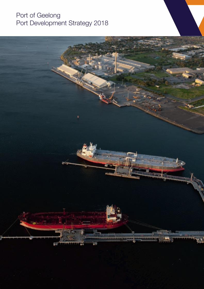
Port of GeelongPort Development Strategy 2018

Front and back cover images: katrianalawrence.com
1
1. EXECUTIVE SUMMARY
Since 1836 the Port of Geelong has played a fundamental role in the growth and development of Geelong, the surrounding region and Victoria.
In 2018, the challenge in light of Geelong’s manufacturing evolution is to have a clear and purposeful port development strategy that supports a dynamic and changing port and city.
The 2018 Port Development Strategy is under-pinned by capacity planning for trade throughput at the port. It addresses the requirements of the Port Management Act 1995 and associated Ministerial Guidelines including current and projected trade, land use, port infrastructure and transport infrastructure.
Geelong’s port will continue to be Victoria’s premier dry bulk and bulk liquid hub, with trade volumes increasing significantly over the next 30 years.
The port is in a unique position to capture this growth, given the inherent operating flexibility of its landside assets and its capacity to handle a significant increase in shipping traffic, without creating congestion issues.
The Port of Geelong has the capacity to grow and projections see growth in trade volume in both, inbound and outbound
shipping.
Continued development of all aspects of port operations, from shipping, loading/unloading to landside port access is considered to be of utmost significance to the positive economic development of the State of Victoria.
The port is well positioned for the next five years before the next port development strategy to accommodate potential trade growth. The Port Development Strategy has identified actions within that period to continue the development potential of the port.
These include a number of constraints that need to be unlocked to enable this growth to develop in an efficient and economically sustainable manner.
Prime considerations are:
• Delivering a road network that incentivises higher productivity vehicles on a smaller number of better connected routes
• Ensuring shipping channels are of sufficient depth to meet the needs of major port users
• Promoting use of rail through enhancing and expanding the local rail network
• Securing land for expanding port trade
• Protecting port activities from land use encroachment in and around port environs
In order to create and sustain the most efficient and economically effective end-to-end supply chains required to support economic growth and prosperity both regionally and for the State of Victoria, the continued development of the Port of Geelong is critical.
2
Department of Transport is forecasting a threefold increase in freight traffic over the next three decades.
Whilst not all of this traffic will start or end at a port, 90 per cent of the material
Victoria and Australia requires to sustain our growing population is transported
through a port.
Clearly, strategic and considered planning to ensure that ports including the Port of Geelong are efficient and able to grow to meet demand is critical to economic prosperity. To enhance transport connections the Port Development Strategy has identified the need to enhance integrated transport planning.
Cities grow around ports, as is the case in Geelong where it is vitally important that the city does not inhibit port growth and development. The port also needs to work to preserve the amenity of Geelong’s community.
The Port of Geelong is well positioned to service the growing needs of all Victorians and this will happen if there is recognition of the vital role the port plays across all levels of the community, from local families and businesses to municipal, state and federal Governments.
VRCA believes the 2018 Port Development Strategy identifies these many challenging issues and provides the framework for enhancing the port’s role in moving Victoria’s bulk freight.
3
Contents
1. EXECUTIVE SUMMARY 1
2. WHAT IS THE PDS AND HOW WAS IT DEVELOPED? 52.1 Why 5
2.2 How 5
2.3 Consultation 6
3. THE PORT TODAY 83.1 Economic impact 11
3.2 Assets and management 11
3.3 The Port Environs, piers and wharves 11
3.4 The existing transport network 16
3.5 Changes since 2013 20
4. THE PORT IN THE FUTURE 214.1 Trade possibilities identified for the port of Geelong 21
5. LAND AND PORT INFRASTRUCTURE 255.1 Refinery precinct land footprint and berths 26
5.2 Lascelles precinct land footprint and berths 28
5.3 Corio Quay precinct land footprint and berth 30
5.4 Bulk Grain precinct land footprint and berth 33
5.5 Point Henry precinct revival 35
6. TRANSPORT 366.1 Integrated transport planning 36
6.2 Road network 36
6.3 Rail network 39
6.4 Shipping channels 41
7. PORT ENVIRONS (INCLUDING INFRASTRUCTURE) 437.1 Land planning 43
7.2 Port footprint 45
8. FUTURE DEVELOPMENT 49
9. RECOMMENDATIONS 51
10. APPENDIX 1- PORT MANAGEMENT ACT REQUIREMENTS 5210.1 Port Management Act requirements 52
10.2 Purpose of Port Development Strategies 52

4
5
2. WHAT IS THE PDS AND HOW WAS IT DEVELOPED?
The 2018 Port Development Strategy (PDS) identifies the infrastructure and land use needs of the port to meet potential trade demands. Its purpose, as set out in Ministerial Guidelines, is that a port development strategy is largely concerned with capacity planning for trade throughput at the port.
Forecast trade opportunities drive the requirement for asset improvement and development.
It commences by looking at the current state of the port, identifying its advantages and where constraints impact on productivity and development potential.
The port’s potential is considered through projected trade demands over a 30 year horizon. These trades are focused on the port’s core trade in bulk commodities. Also examined is the freight task within the immediate area which strengthens the port as a freight hub.
Projected trade demand then provides the basis for identification of future port infrastructure, land requirements and transport connections. These result in actions and recommendations that provide a base for enabling growth in the port’s capacity.
2.1 Why
The port of Geelong plays a vital role in the life of Geelong and the region. A bulk port, it is a competitive maritime hub, which connects users and suppliers of dry, liquid and break bulk cargoes with national and international markets.
Port operators and users agree that this focus for the Port of Geelong is not expected to change dramatically, existing uses will grow and evolve and be supplemented by new trades. In order to support the
sustainable future growth of the port, we need to periodically review the port’s needs and adapt accordingly.
The port cannot, does not, and should not operate in isolation from its stakeholders and local community.
2.2 How
The PDS has been undertaken to create an effective and agile roadmap for the future development of the Port, taking into consideration its many stakeholders and maintaining a keen focus on appropriate economic growth. Updating the PDS every five years provides an opportunity to test the development path and adapt it to a changing world.
This provides the port with the necessary resilience to work with changing transport needs, social and environmental expectations, and climate and technology changes.
The strategy is focused on the potential for port development, its transport links, land requirements, port infrastructure and associated trade. While due and appropriate consideration is given to community and social impacts, the key focus of the PDS is port development.
The port of Geelong’s ownership structure comprises three port managers. Victorian Regional Channels Authority (VRCA) as the manager of port waters, GeelongPort and GrainCorp as the managers of their respective landside assets.
There are also a number of significant port users who own large parcels of land abutting the port. The PDS focuses on the infrastructure and land needs of the port as a whole, to enable investment to occur and meet potential trade demand.

6
Port development strategies address the requirements of the Port Management Act 1995 and associated Ministerial Guidelines. Key requirements include current and projected trade, land use, port infrastructure and transport infrastructure.
Development options are based around understanding the current trade and what future trade could develop, if the operating environment and transport network provide the right connections.
Accomplishing this required reviewing existing operations at the port, what commodities trade now, in what quantities, berth usage, the present freight flows to and from the port by ship, rail and roads and identifying trade possibilities.
Berth, channel, road and rail assets that currently define the operational capacity of the port were examined and reviewed, with consideration of trade possibilities and what change may be needed.
This information was gathered through direct stakeholder engagement and desktop literature review.
A particular focus was applied to understanding how port precinct tenants work with each other and the effects of freight flows in and out of the port environs into the broader transport network.
Through understanding the potential trade demand, how do these translate to the port’s land footprint requirements and what infrastructure connects the water and the broader transport network?
Land requirements were considered with reference to the availability of land for port activity and how planning schemes ensure port expansion needs are met. Parcels of land are identified where port activity is the potential highest and best use.
Port freight operators and tenants were interviewed to understand truck sizes currently accessing the port and what size vehicles may be required in future years. There was also a review of rail access restrictions, future rail terminals and the arrangements for third parties obtaining effective access to the essential infrastructure of the port, such as the Corio Grain Loop on land to the south of Corio Quay.
The assessment of infrastructure vital to the growth of the Port of Geelong has also taken account of current and planned road and rail infrastructure further afield. Particular attention is given to the grain growing areas of northern Victoria, southern NSW, mineral product supply from western NSW and other product supply from Gippsland.
2.3 Consultation
Geelong’s port community does not operate in isolation, a continuing dialogue occurs between it and a range of stakeholders with interests in the port and its environs. This continually shapes the direction and inputs for the port’s development and has underpinned the consideration of consultation utilised by this PDS.
VRCA regularly conducts ongoing engagement through facilitating the Port-City Coordination Group, regular engagement with City of Greater Geelong, the G21 – Transport and Economic Pillar and participation in, and with, local member-based organisations such as the Committee for Geelong, the Geelong Chamber of Commerce and the Geelong Manufacturing Council.
7
In commencing the preparation of the PDS, VRCA invited broad community engagement. With limited response VRCA changed its focus to undertaking targeted stakeholder engagement through VRCA and external consultants, including interviews with key port stakeholders, tenants, owners and port users. This has been used to refine the direction put forward within the Port Development Strategy.
To inform port trade forecasts and infrastructure needs, VRCA’s consultants engaged with 30 different stakeholders through 21 face to face meetings, 6 teleconference discussions and 3 email communications. This included current and future tenants, port users, owners, service providers, agencies and authorities. These consultations aimed to understand each business and its varying demands on operations, perspectives on trade outlook, as well as supply chain and maritime shipping needs.
8
3. THE PORT TODAY
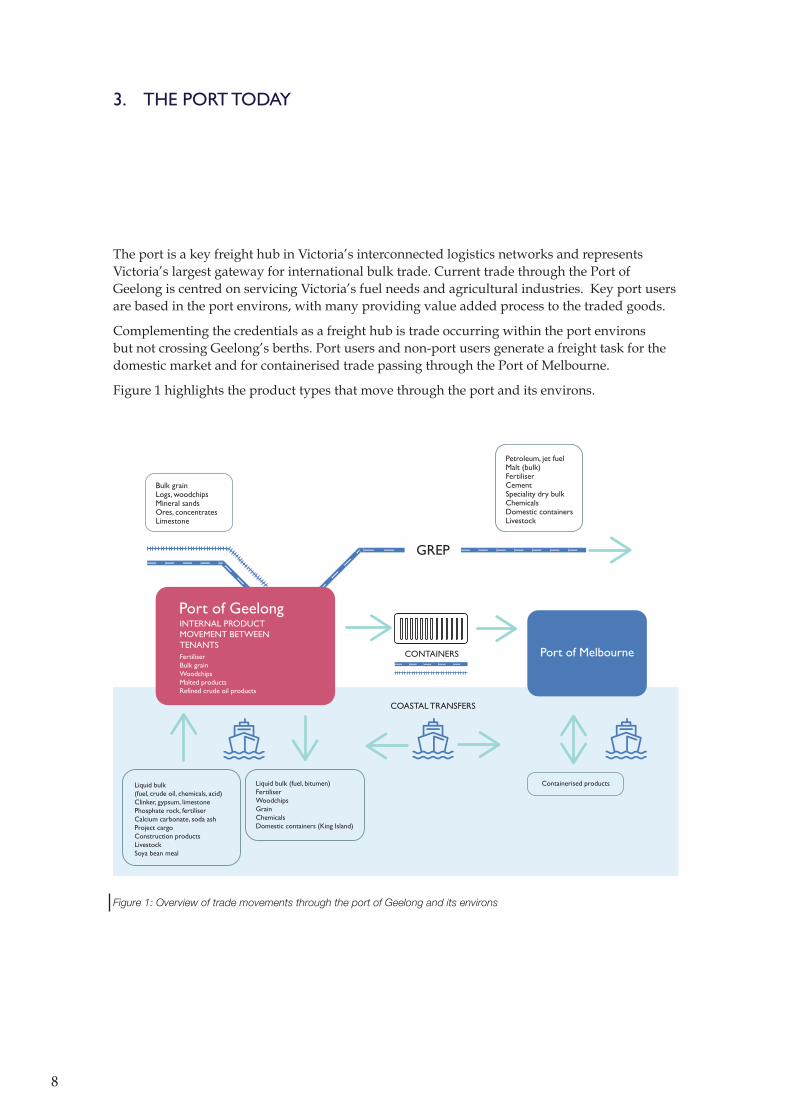
The port is a key freight hub in Victoria’s interconnected logistics networks and represents Victoria’s largest gateway for international bulk trade. Current trade through the Port of Geelong is centred on servicing Victoria’s fuel needs and agricultural industries. Key port users are based in the port environs, with many providing value added process to the traded goods.
Complementing the credentials as a freight hub is trade occurring within the port environs but not crossing Geelong’s berths. Port users and non-port users generate a freight task for the domestic market and for containerised trade passing through the Port of Melbourne.
Figure 1 highlights the product types that move through the port and its environs.
Bulk grainLogs, woodchipsMineral sandsOres, concentratesLimestone
GREP
COASTAL TRANSFERS
CONTAINERS
Liquid bulk (fuel, crude oil, chemicals, acid)Clinker, gypsum, limestonePhosphate rock, fertiliserCalcium carbonate, soda ashProject cargoConstruction productsLivestockSoya bean meal
Liquid bulk (fuel, bitumen)FertiliserWoodchipsGrainChemicalsDomestic containers (King Island)
INTERNAL PRODUCT MOVEMENT BETWEEN TENANTSFertiliserBulk grainWoodchipsMalted productsRefined crude oil products
Containerised products
Petroleum, jet fuelMalt (bulk)FertiliserCementSpeciality dry bulkChemicalsDomestic containersLivestock
Port of Geelong
Port of Melbourne
Figure 1: Overview of trade movements through the port of Geelong and its environs
9
0
20
40
60
80
100
Other
Petroleum Products
Woodchips
Grains% of exports
Figure 2: Port of Geelong Trade 2017-18
Exports: 5,295,700 tonnes
Chemicals
Break Bulk
General Cargoes
Cement Products
Petroleum Products
Fertiliser
Crude Oil
% of imports
0
20
40
60
80
100 Imports: 8,852,500 tonnes
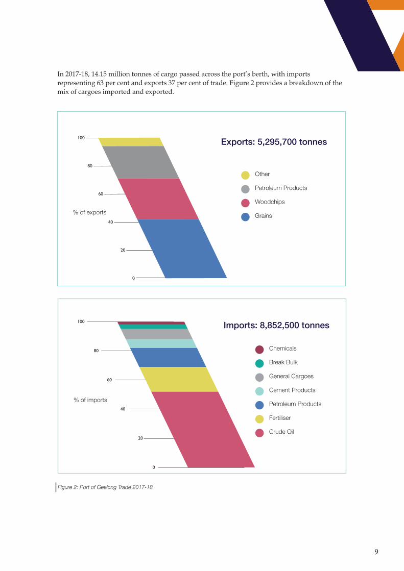
In 2017-18, 14.15 million tonnes of cargo passed across the port’s berth, with imports representing 63 per cent and exports 37 per cent of trade. Figure 2 provides a breakdown of the mix of cargoes imported and exported.
10
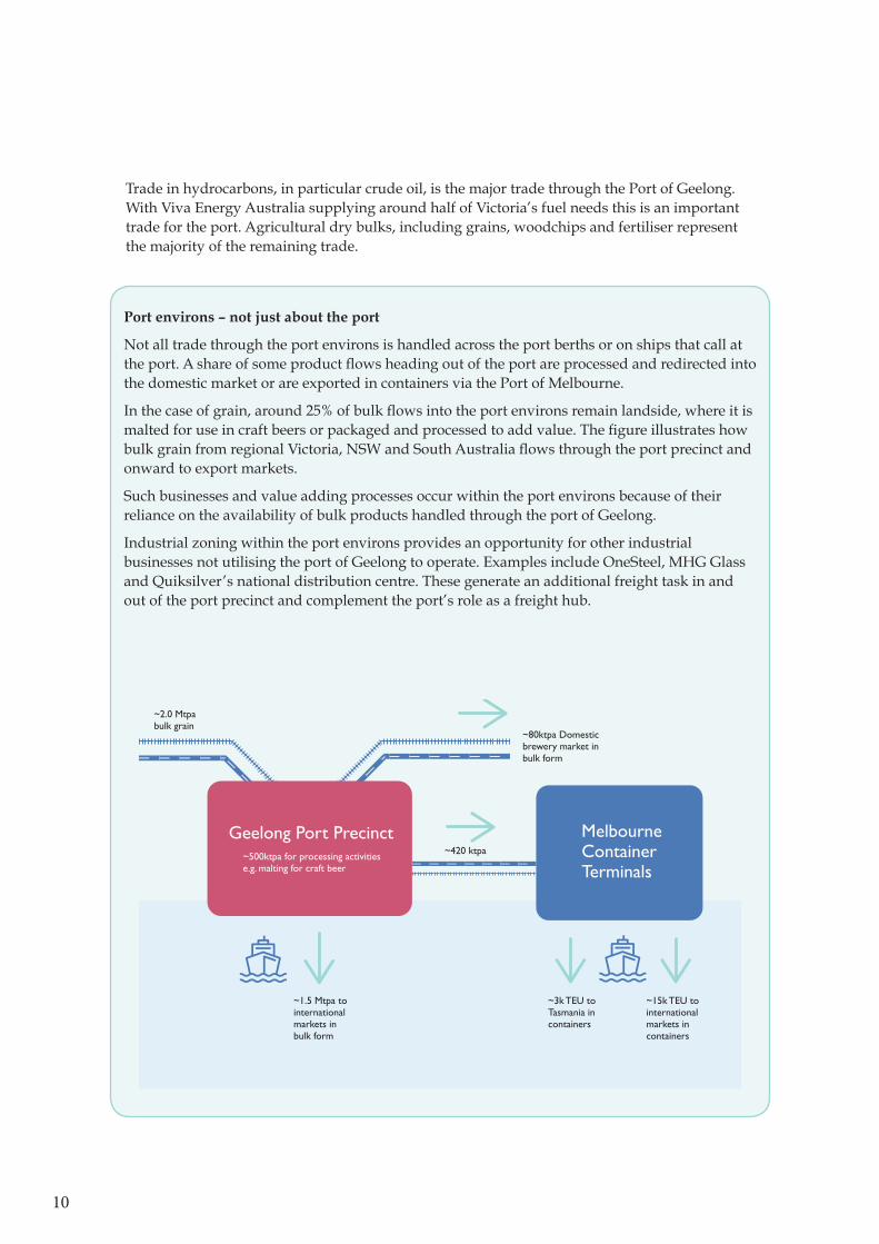
Port environs – not just about the port
Not all trade through the port environs is handled across the port berths or on ships that call at the port. A share of some product flows heading out of the port are processed and redirected into the domestic market or are exported in containers via the Port of Melbourne.
In the case of grain, around 25% of bulk flows into the port environs remain landside, where it is malted for use in craft beers or packaged and processed to add value. The figure illustrates how bulk grain from regional Victoria, NSW and South Australia flows through the port precinct and onward to export markets.
Such businesses and value adding processes occur within the port environs because of their reliance on the availability of bulk products handled through the port of Geelong.
Industrial zoning within the port environs provides an opportunity for other industrial businesses not utilising the port of Geelong to operate. Examples include OneSteel, MHG Glass and Quiksilver’s national distribution centre. These generate an additional freight task in and out of the port precinct and complement the port’s role as a freight hub.
~3k TEU to Tasmania in containers
~15k TEU to international markets in containers
~1.5 Mtpa to international markets in bulk form
~420 ktpa~500ktpa for processing activities e.g. malting for craft beer
~2.0 Mtpa bulk grain
~80ktpa Domestic brewery market in bulk form
Geelong Port Precinct Melbourne Container Terminals
Trade in hydrocarbons, in particular crude oil, is the major trade through the Port of Geelong. With Viva Energy Australia supplying around half of Victoria’s fuel needs this is an important trade for the port. Agricultural dry bulks, including grains, woodchips and fertiliser represent the majority of the remaining trade.
11
3.1 Economic impact
The most recent assessment of economic impact was undertaken in 2016-17. The cargo traded in this year had an estimated value of approximately $7.8 billion.
This trade resulted in the port generating $367 million worth of economic activity for the Barwon region (direct and flow-on effects) with 2016-17 having a throughput of around 13.5 million tonnes.
Direct employment (full-time equivalents) was estimated to be 988 in the region, and corresponding household income was $74 million.
3.2 Assets and management
Ownership of Port of Geelong’s commercial assets and land is unique in that there are two private Port Managers (GeelongPort and GrainCorp) who have land assets and a number of significant port users freehold land. This can be contrasted to the Port of Portland and Port of Melbourne where a single entity owns the berth structures and the majority of the abutting land. Port of Hastings more closely represents the Geelong situation where VRCA manages the water and Port of Hastings Development Authority manages the majority of the landside assets.
3.3 The Port Environs, piers and wharves
The port environs embrace a substantial area of Geelong, an area greater than the suburbs of Norlane or Newtown. Extending from School Road in the north to Osborne House in the south, the port encompasses much of Corio Bay’s western shoreline and has a long boundary with the communities in northern Geelong.
The port environs can be categorised into four main precincts based on the wharf and berth assets, Refinery Pier, Lascelles Wharf, Corio Quay and Bulk Grain Pier as shown in figure 3.
The Point Henry Pier and channel are commercial assets separated from the port environs. Also located remotely from other port assets is the Department of Defence’s Point Wilson Pier.
GeelongPort, GrainCorp, Viva Energy Australia, Incitec Pivot Ltd and Midway Ltd, non-port industrial entities including OneSteel, MaltEurop, MHG glass and Ford occupy substantial parcels of land. Ford is in the process of selling its holdings.
The North Shore residential area is located centrally within the port environs, resulting in a break in port-utilised land along the coastline. Residential land abuts the nominated port environs in a number of areas, requiring consideration in planning industrial and residential land use. This break also represents where public access provides a link to the water for the community.

12
Re�nery Pier Precinct
Lascelles Wharf Precinct
Corio Quay Precinct
Bulk Grain Precinct
Port of Geelong Environs Boundary (approximate)
Figure 3: Port of Geelong environs and precincts
13
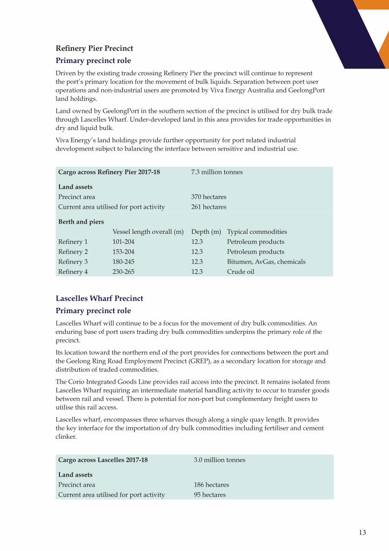
Refinery Pier Precinct
Primary precinct role
Driven by the existing trade crossing Refinery Pier the precinct will continue to represent the port’s primary location for the movement of bulk liquids. Separation between port user operations and non-industrial users are promoted by Viva Energy Australia and GeelongPort land holdings.
Land owned by GeelongPort in the southern section of the precinct is utilised for dry bulk trade through Lascelles Wharf. Under-developed land in this area provides for trade opportunities in dry and liquid bulk.
Viva Energy’s land holdings provide further opportunity for port related industrial development subject to balancing the interface between sensitive and industrial use.
Cargo across Refinery Pier 2017-18 7.3 million tonnes
Land assets
Precinct area 370 hectaresCurrent area utilised for port activity 261 hectares
Berth and piers
Vessel length overall (m) Depth (m) Typical commoditiesRefinery 1 101-204 12.3 Petroleum productsRefinery 2 153-204 12.3 Petroleum productsRefinery 3 180-245 12.3 Bitumen, AvGas, chemicalsRefinery 4 230-265 12.3 Crude oil
Lascelles Wharf Precinct
Primary precinct role
Lascelles Wharf will continue to be a focus for the movement of dry bulk commodities. An enduring base of port users trading dry bulk commodities underpins the primary role of the precinct.
Its location toward the northern end of the port provides for connections between the port and the Geelong Ring Road Employment Precinct (GREP), as a secondary location for storage and distribution of traded commodities.
The Corio Integrated Goods Line provides rail access into the precinct. It remains isolated from Lascelles Wharf requiring an intermediate material handling activity to occur to transfer goods between rail and vessel. There is potential for non-port but complementary freight users to utilise this rail access.
Lascelles wharf, encompasses three wharves though along a single quay length. It provides the key interface for the importation of dry bulk commodities including fertiliser and cement clinker.
Cargo across Lascelles 2017-18 3.0 million tonnes
Land assets
Precinct area 186 hectaresCurrent area utilised for port activity 95 hectares

14
Berth and piers
Vessel length overall (m) Depth CommoditiesLascelles 1 185 12.3 Cement clinker and sulphuric acid.Lascelles 2 163 12.3 Dry bulk products, fertiliserLascelles 3 273 12.3 Dry bulk products and project
Corio Quay Precinct
Primary precinct role
Corio Quay provides for a mix of trade across break bulk and dry bulk, as is reflected in the assets at the Quay.
Corio Quay provides for a mix of use, from a dry bulk loader utilised by Midway for the export of woodchips, to break-bulk and export of grain through portable ship loaders.
Cargo across Corio Quay 2017-18 1.5 million tonnes
Land assets
Precinct area 144 hectaresCurrent area utilised for port activity 42 hectares
Berth and piers
Vessel length overall (m) Depth CommoditiesCQS1 200 11 Break bulk CQN1/2 355 11 Break bulk and dry bulkCQN3 60 11 Small vesselCQN4 194-229 12.3 Woodchips
Bulk Grain Precinct
Primary precinct role
The bulk grain precinct can continue to develop with a focus on dry-bulk commodities. It will continue as a key export site for grain. The precinct provides a focal point for the movement of grain with malting plants co-located to take advantage of the freight movements to the port.
GrainCorp owns Bulk Grain Pier 3, whilst GeelongPort owns the former bulk grain pier berths . Bulk Grain Pier 3’s ship loader is utilised for grain and woodchip exports and the former grain pier as a tug and layup berth.
Cargo across Bulk Grain Pier 2017-18 2.3 million tonnes
Land assets
Precinct area 74 hectaresCurrent area utilised for port activity 35 hectares
Berth and piersVessel length overall (m) Depth Commodities
Bulk Grain Pier 3 225 12.3 Grain, Woodchips Bulk Grain Pier 1 and 2 201 12.3 Tug berth
15
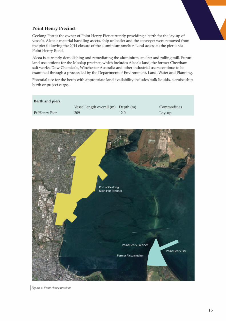
Point Henry Precinct
Geelong Port is the owner of Point Henry Pier currently providing a berth for the lay-up of vessels. Alcoa’s material handling assets, ship unloader and the conveyer were removed from the pier following the 2014 closure of the aluminium smelter. Land access to the pier is via Point Henry Road.
Alcoa is currently demolishing and remediating the aluminium smelter and rolling mill. Future land use options for the Moolap precinct, which includes Alcoa’s land, the former Cheetham salt works, Dow Chemicals, Winchester Australia and other industrial users continue to be examined through a process led by the Department of Environment, Land, Water and Planning.
Potential use for the berth with appropriate land availability includes bulk liquids, a cruise ship berth or project cargo.
Berth and piers
Vessel length overall (m) Depth (m) CommoditiesPt Henry Pier 209 12.0 Lay-up
Port of Geelong Main Port Precinct
Former Alcoa smelter
Point Henry Precinct
Point Henry Pier
Figure 4: Point Henry precinct
16
Other port related areas
While most of the focus on port-related land use is in the port environs, other areas in Geelong provide complementary sites for port related activity.
Geelong Ring Road Employment Precinct (GREP)
The Geelong Ring Road Employment Precinct (GREP) is located to the north of Geelong adjacent to the Geelong Ring Road. It provides a key alternate locality for users of the port, with several fertiliser businesses importing through Lascelles Wharf having storage and distribution facilities located within GREP.
Point Wilson Explosives Area
Department of Defence is planning to remediate the Point Wilson Pier to service the Point Wilson Explosive Area. While not part of the main commercial port, it is accessed by VRCA’s shipping channels. Port Wilson Explosive Area is the only Defence owned importation facility capable of large scale movements of explosive ordinance.
3.4 The existing transport network
The transport of dry bulk and break bulk commodities to and from the port is typically by road, except for bulk grain, for which around 50% of volumes arriving at the port arrive by rail through the Corio Grain Loop.
Liquid bulk products such as refined petroleum are processed at the refinery located at the port and are transported into Victoria using pipelines and trucks.
Existing shipping channels and anchorages
Geelong’s shipping channels stretch 18 nautical miles through Corio Bay from Point Richards through to Refinery Pier. The channels are man-made having been deepened and widened through periodic dredging for larder vessels to support port trade development At 12.3 metres deep Geelong’s channels are shallower than those serving Port of Melbourne at 15.5 metres accommodating vessels up to a draught of 14.7 metres. Key port users have
identified channel depth as critical to drive future trade development and economies of scale. The effective and safe management of channels and vessel navigation falls under the responsibility of VRCA.
Corio Bay’s location within Port Phillip provides a protected bay, with negligible currents and limited wave height.
The volume of cargo carried by larger vessels transiting Geelong’s channels is limited due to the channel depth. VRCA utilises the Dynamic Under Keel Clearance (DUKC®) system to optimise the draught of vessels to ensure safe transit through the channels. Vessels of up to 12.0m sailing draught can access the port with appropriate tides which represents the limit to which DUKC® can maximise available sailing draughts.
VRCA provides an anchoring service allowing vessels to anchor at the eastern end of the channel or to a limited extent within Corio Bay for shallow draught vessels. Port users in Geelong have long sought to expand Geelong’s port waters to create an eastern anchorage for deeper draught vessels. This will facilitate trade as it avoids the need to anchor at the Melbourne anchorages with its associated costs.
Road network
Geelong is well connected to Victoria’s road network. State route M1 Princes Freeway provides connection to Melbourne and the states north and to Colac and South Australia in the west.
Primary arterial roads connect Geelong to Hamilton, Ballarat and key agricultural areas in the state’s north west.
Secondary arterial roads in the Geelong region in a general grid pattern support vehicle movements on the primary route.

17
Corio BayWILSON SPIT CHANNEL
HOPETOUN CHANNELPO
INT RICHARDS C
HANNEL
Wedge Point
BeaconPoint
Kirk Point
Point Lillias
Limeburners BayCorio
North Shore
Corio Quay
Rippleside
Cunningham Pier
Limeburners Point
Point Henry
Geelong
Point Wilson
Explosives Pier
Point Richards
Portarlington
Spoil Ground
Explosives Anchorage
WesternEastern
Southern
Figure 5: Port of Geelong Waters
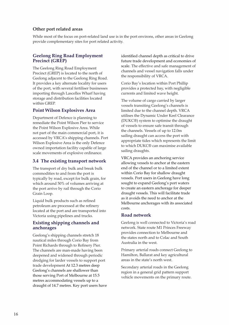
The road network within the port precinct also caters for bicycles, buses and pedestrians. Local government strategies around higher levels of service for these transport mode can conflict with heavy vehicle movements. The Northern Strategic Cycling Corridor includes road sections that are significant routes for heavy vehicles accessing the port. Consultation with stakeholders have identified the key corridors to provide a higher level of service for bicycles, pedestrians and buses. In the port precinct area, the Northern Strategic Cycle Corridor is an existing alignment along Corio Quay Road and Shell Parade, connecting Geelong to Lara.
18
The gazetted Higher Productivity Freight Vehicle (HPFV) routes around Geelong Region are limited to Princes Freeway for the state connection and Shell Parade for Port of Geelong connection.
DRAFT
2
2
2
2
2
2
2
Refinery Pier(Berths 1 to 4)
Lascelles Wharf(Berths 1 to 3)
Corio Quay
Point HenryPier
Bulk Grain Pier No.3(GrainCorp)
Bulk Grain Pier Nos. 1 and 2
Cunningham Pier
Broad and standardgauge mainline rail
Princes Freeway
MO
OR
ABO
OL
RIV
ER
ELCHO DRAIN
DEVIATIONCHANNEL
COWIES CREEK ROLLERAMA DRAIN
HOVELLS CREEK
BARW
ON
RIVER
NORTH SHORE
CORIO
LARA
FYANSFORD
GEELONG
GEELONG-BALLAN
RO
AD
RYRIE STREET
SEPARATION STREET
ST GEORGES ROAD
HAMILTO
N HIGHWAY
PRINCES FREEWAY
SHAN
NO
N A
VEN
UE
ABERDEEN STREET
CHURCH STREET
ANAKIE ROAD
LOW
ES
T RE
ET
DO
UR
O S
TRE
ET
HAYS ROAD
MINYIP ROAD
WEST FYANS STREETFYANS STREET
STAT
ION
STR
EET
OBRIENS ROAD
THO
MPS
ON
RO
AD
MCCLELLAND AVENUE
DANDOS ROAD
HEALES ROAD
LOVELY BANKS ROAD
GEELONG-PORTARLINGTON ROAD
BALLARATRO
AD
MCKILLOP STREET
PRIN
CES
HIG
HW
AY
COX ROADFO
REST
RO
AD
LATR
OBE
TER
RA
CE
SCEN
IC ROAD
BRO
DER
ICK
RO
AD AVAL
ON
RO
AD
SHEL
L PA
RAD
E
BACC
HU
S MA
RSH
RO
AD
GE
ELO
NG
RIN
GR
OAD
POIN
TH
EN
RY
ROAD
\\ghdnet\ghd\AU\Melbourne\Projects\91\10767\GIS\Maps\Working\9110767_001_BaseMap_A3P_RevC.mxd
0 10.5
Kilometres
Map Projection: Transverse MercatorHorizontal Datum: GDA 1994Grid: GDA 1994 MGA Zone 55 o
© 2018. Whilst every care has been taken to prepare this map, GHD (and DATA CUSTODIAN) make no representations or warranties about its accuracy, reliability, completeness or suitability for any particular purpose and cannot accept liability and responsibility of any kind (whether in contract, tort or otherwise) for any expenses, losses, damages and/or costs (including indirect or consequential damage) which are or may be incurred by any party as a result of the map being inaccurate, incomplete or unsuitable in any way and for any reason.
Victorian Regional Channels AuthorityGeelong Port Master Plan - Update
Figure 1
Job NumberRevision C
91-10767
02 Nov 2018
Geelong Transport Network
Date
Data source: Data Custodian, Data Set Name/Title, Version/Date. Created by:sacevedo
180 Lonsdale Street Melbourne VIC 3000 Australia T 61 3 8687 8000 F 61 3 8687 8111 E [email protected] W www.ghd.com
Paper Size A3
VicRoads DeclaredRoads
Freeway
ArterialLocal GovernmentRoads
HPFV A DoubleNetworkB Double Network
Strategic CyclingCorridorRailway
Figure 6 - Land Based Transport
19
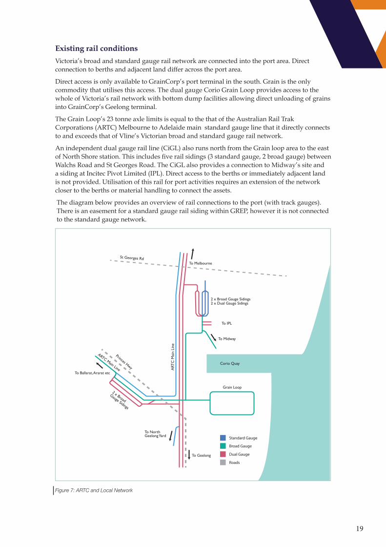
Existing rail conditions
Victoria’s broad and standard gauge rail network are connected into the port area. Direct connection to berths and adjacent land differ across the port area.
Direct access is only available to GrainCorp’s port terminal in the south. Grain is the only commodity that utilises this access. The dual gauge Corio Grain Loop provides access to the whole of Victoria’s rail network with bottom dump facilities allowing direct unloading of grains into GrainCorp’s Geelong terminal.
The Grain Loop’s 23 tonne axle limits is equal to the that of the Australian Rail Trak Corporations (ARTC) Melbourne to Adelaide main standard gauge line that it directly connects to and exceeds that of Vline’s Victorian broad and standard gauge rail network.
An independent dual gauge rail line (CiGL) also runs north from the Grain loop area to the east of North Shore station. This includes five rail sidings (3 standard gauge, 2 broad gauge) between Walchs Road and St Georges Road. The CiGL also provides a connection to Midway’s site and a siding at Incitec Pivot Limited (IPL). Direct access to the berths or immediately adjacent land is not provided. Utilisation of this rail for port activities requires an extension of the network closer to the berths or material handling to connect the assets.
The diagram below provides an overview of rail connections to the port (with track gauges). There is an easement for a standard gauge rail siding within GREP, however it is not connected to the standard gauge network.
2 x Broad Gauge Sidings2 x Dual Gauge Sidings
To IPL
To Midway
To Ballarat, Ararat etc
Corio Quay
Grain Loop
To Geelong
To Melbourne
St Georges Rd
Princes Hwy
To North Geelong Yard
2 x Broad
Gauge Sidings
ARTC Main Line ART
C M
ain
Line
Standard Gauge
Broad Gauge
Dual Gauge
Roads
Figure 7: ARTC and Local Network
20
Pipelines
Viva Energy Australia utilises pipelines to transfer much of its output to its Newport Terminal for distribution by road. Further pipelines provide connection to Tullamarine airport for jet fuel. The refinery is also connected to the Westernport, Altona and Geelong pipeline, which links the refinery to the Bass Strait oil and gas fields.
3.5 Changes since 2013
A number of substantial changes have occurred at the port and its operating environment since the 2013 Port Development Strategy was released.
New entrants have entered the port, such as Riordan Grains and others have consolidated the use of the port such as Boral who committed in 2018 to constructing a grinding plant adjacent to Lascelles Wharf. Trade has also been lost such as the closure of Alcoa’s Point Henry refinery in August 2014 resulting in a loss to port trade of around 450,000 tonnes per annum.
Channel capacity has been improved through the introduction of the DUKC® system allowing safe transit of deeper draught vessels. The software has allowed maximum draughts to be increased from 11.7 metres with tide to 12.0 metres.
Government infrastructure investment and regulatory change have provided productivity improvements for the supply chains. There is improved access for Higher Productivity Freight Vehicles (HPFV) to the port and across the road network. Completed elements of the Murray Basin Rail Project have expanded Victoria’s standard gauge rail network.
Changes to planning policy and planning controls introduced include:
• introducing a new Port Zone, emphasising the gateway role of trading ports. The Port Zone was initially applied to GeelongPort’s land but a rezoning in 2018 has seen GrainCorp’s port terminal included in the zone.
• a Ministerial Direction to ensure that changes to planning schemes avoid sensitive land uses establishing in locations impacted by ports
• applying the Environmental Significance Overlay to selected precincts around ports, requiring impacts on the port to be assessed for permit applications
• revised state planning policy to acknowledge the significance of ports and clarify land use policy in the port environs
• a Planning Practice Note to provide guidance on land use planning around ports.
21
4. THE PORT IN THE FUTURE
Port of Geelong’s focus will be to continue to provide a competitive maritime hub in the bulk commodity value chain. The port’s future is dependent on developing a strategic plan that keeps the options open for the port’s development and stimulates investment by port owners and users.
4.1 Trade possibilities identified for the port of Geelong
Consideration of the port’s development has focused on the emerging trade possibilities across three categories:
1. Growth in existing products and trades handled through the port and its environs in response to increasing international and domestic demand and other influencing market factors
2. Prospective trade and products identified and/or have indicated that they may choose to use the Port of Geelong and the local region for their operations in the future
3. Relocated bulk and break-bulk trade from the Port of Melbourne as it focusses on the enhancement of its container handling capacity.
Growth in existing trades and products handled at the Port of Geelong
Projected volumes identified by the existing port user base indicate a growth scenario for development planning. The magnitude of trade growth will be dependent on a multitude of different variables and for some trades there are known uncertainties including the:
• Woodchip volumes are reliant on investment to maintain or expand plantation agro-forestry
• Documented uncertainty around Australia’s refining viability, which can alter the mix of crude oil compared to refined product being imported.
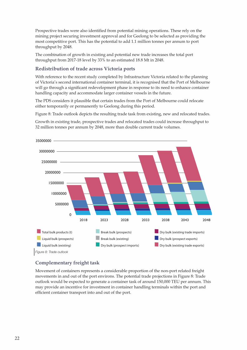
Figure 8: Trade outlook summarises the 30 year forecast trade task, showing total growth from existing trade, new trade and relocated trade. If growth in existing trade is considered in isolation the projected growth represents a 25% increase in from 2017-18 trades to 17.7M tonnes in 2048
Prospective trades through the Port of Geelong
Prospective trade options were explored through consultation with port users and identifying other trade opportunities within the port’s catchment.
The likelihood of each trade occurring differs but the amalgamated trade volumes provide a test of the ports ability to accommodate growing trade.
The more certain trade and in some cases trades where these trends have commenced in the shorter term include project cargoes associated with wind energy projects and Bass Strait island trade. These trades are still in the process of developing and are not included in the baseline scenarios utilised in the development scenario. New trades in niche dry bulk were identified where operators are expecting to relocate trade to utilise the port.
22
Prospective trades were also identified from potential mining operations. These rely on the mining project securing investment approval and for Geelong to be selected as providing the most competitive port. This has the potential to add 1.1 million tonnes per annum to port throughput by 2048.
The combination of growth in existing and potential new trade increases the total port throughput from 2017-18 level by 33% to an estimated 18.8 Mt in 2048.
Redistribution of trade across Victoria ports
With reference to the recent study completed by Infrastructure Victoria related to the planning of Victoria’s second international container terminal, it is recognised that the Port of Melbourne will go through a significant redevelopment phase in response to its need to enhance container handling capacity and accommodate larger container vessels in the future.
The PDS considers it plausible that certain trades from the Port of Melbourne could relocate either temporarily or permanently to Geelong during this period.
Figure 8: Trade outlook depicts the resulting trade task from existing, new and relocated trades.
Growth in existing trade, prospective trades and relocated trades could increase throughput to 32 million tonnes per annum by 2048, more than double current trade volumes.
0
5000000
2018 2023 2028 2033 2038 2043 2048
10000000
15000000
20000000
25000000
30000000
35000000
Total bulk products (t) Break bulk (prospects) Dry bulk (existing trade imports)
Liquid bulk (prospects) Break bulk (existing) Dry bulk (prospect exports)
Liquid bulk (existing) Dry bulk (prospect imports) Dry bulk (existing trade exports)
Figure 8: Trade outlook
Complementary freight task
Movement of containers represents a considerable proportion of the non-port related freight movements in and out of the port environs. The potential trade projections in Figure 8: Trade outlook would be expected to generate a container task of around 150,000 TEU per annum. This may provide an incentive for investment in container handling terminals within the port and efficient container transport into and out of the port.
23
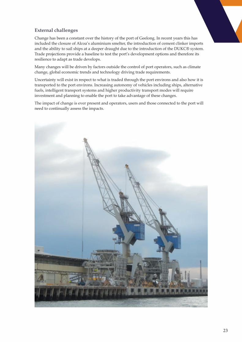
External challenges
Change has been a constant over the history of the port of Geelong. In recent years this has included the closure of Alcoa’s aluminium smelter, the introduction of cement clinker imports and the ability to sail ships at a deeper draught due to the introduction of the DUKC® system. Trade projections provide a baseline to test the port’s development options and therefore its resilience to adapt as trade develops.
Many changes will be driven by factors outside the control of port operators, such as climate change, global economic trends and technology driving trade requirements.
Uncertainty will exist in respect to what is traded through the port environs and also how it is transported to the port environs. Increasing autonomy of vehicles including ships, alternative fuels, intelligent transport systems and higher productivity transport modes will require investment and planning to enable the port to take advantage of these changes.
The impact of change is ever present and operators, users and those connected to the port will need to continually assess the impacts.
24
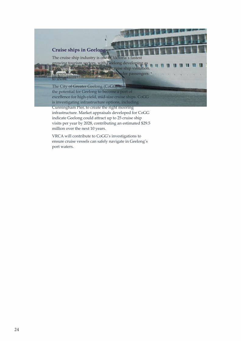
Cruise ships in Geelong
The cruise ship industry is one of Victoria’s fastest growing tourism sectors, with Geelong developing as a popular destination in terms of cruise ship visitation. At present, cruise ships anchor and tender passengers to shore.
The City of Greater Geelong (CoGG) has identified the potential for Geelong to become a port of excellence for high-yield, mid-size cruise ships. CoGG is investigating infrastructure options, including Cunningham Pier, to create the right mooring infrastructure. Market appraisals developed for CoGG indicate Geelong could attract up to 25 cruise ship visits per year by 2028, contributing an estimated $29.5 million over the next 10 years.
VRCA will contribute to CoGG’s investigations to ensure cruise vessels can safely navigate in Geelong’s port waters.

25
5. LAND AND PORT INFRASTRUCTURE
Port infrastructure and the land needs for port development have been considered across three periods, the short term within the next 5 years, a medium term 5-15 year period and a longer term 15-30 year period.
The capability of the current land and infrastructure to meet projected trade outlooks has been assessed and categorised.
Colour CommentPresent capabilities expected to cater for demand
Options need to be assessed for future demand
Expected that capabilities will not meet demand
Land and infrastructure capability have been split into three categories in considering the capability of the land and port assets. These are:
Land requirements – Is there sufficient land available for trade growth?
An assessment if the available land within the precinct is capable of accommodating growth in existing trade, prospective trade and relocated trade.
Port Infrastructure requirement – Is berth capacity sufficient for trade growth?
This assesses if the number and configuration of existing berths can accommodate growth in the trade projections.
Port Infrastructure - Are the berths suitable for expected vessel sizes?
Considers if the berths can handle the preferred vessel sizes to meet future trade needs.
From these capability assessments actions have been identified to support port development.
26
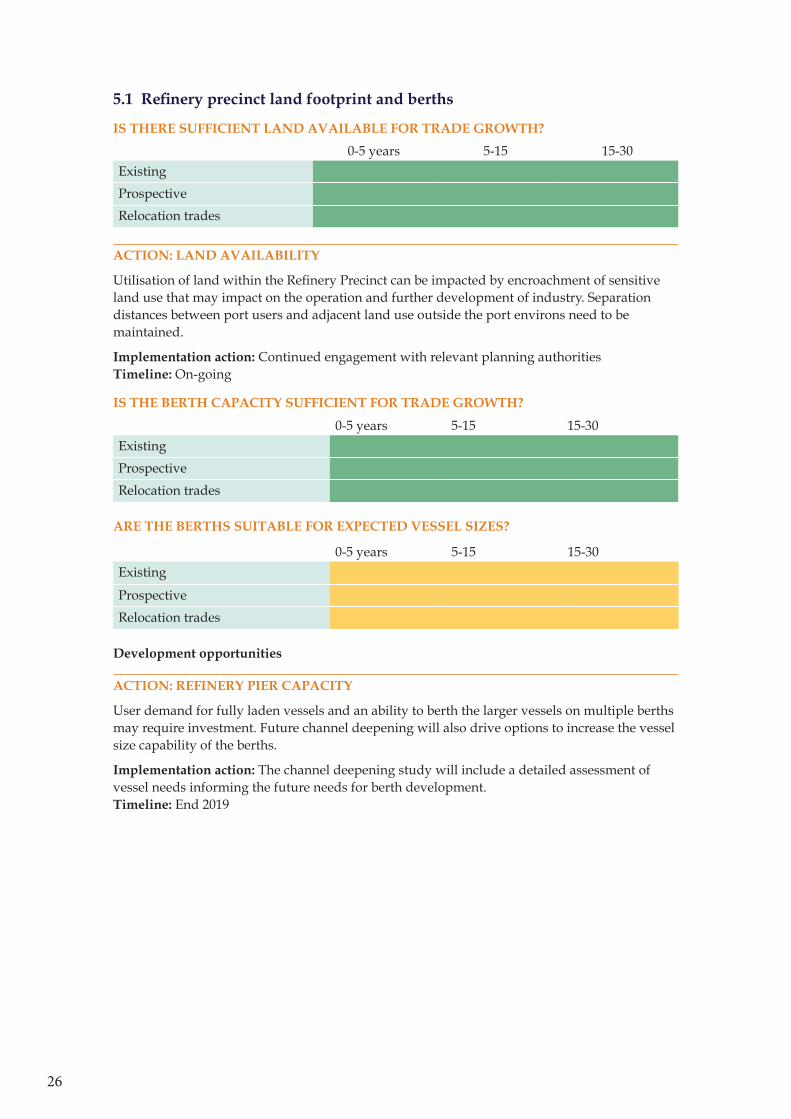
5.1 Refinery precinct land footprint and berths
IS THERE SUFFICIENT LAND AVAILABLE FOR TRADE GROWTH?
0-5 years 5-15 15-30Existing
Prospective
Relocation trades
ACTION: LAND AVAILABILITY
Utilisation of land within the Refinery Precinct can be impacted by encroachment of sensitive land use that may impact on the operation and further development of industry. Separation distances between port users and adjacent land use outside the port environs need to be maintained.
Implementation action: Continued engagement with relevant planning authorities Timeline: On-going
IS THE BERTH CAPACITY SUFFICIENT FOR TRADE GROWTH?
0-5 years 5-15 15-30Existing
Prospective
Relocation trades
ARE THE BERTHS SUITABLE FOR EXPECTED VESSEL SIZES?
0-5 years 5-15 15-30Existing
Prospective
Relocation trades
Development opportunities
ACTION: REFINERY PIER CAPACITY
User demand for fully laden vessels and an ability to berth the larger vessels on multiple berths may require investment. Future channel deepening will also drive options to increase the vessel size capability of the berths.
Implementation action: The channel deepening study will include a detailed assessment of vessel needs informing the future needs for berth development. Timeline: End 2019
27
Boundary Precinct
Viva and Barwon Water
Recycled Water Plant (Viva)
GeelongPort
Incitec Pivot
Dry Bulk Materials (Natrio)
Port Environs Boundary
Non Port related
Terminals Group
Railway
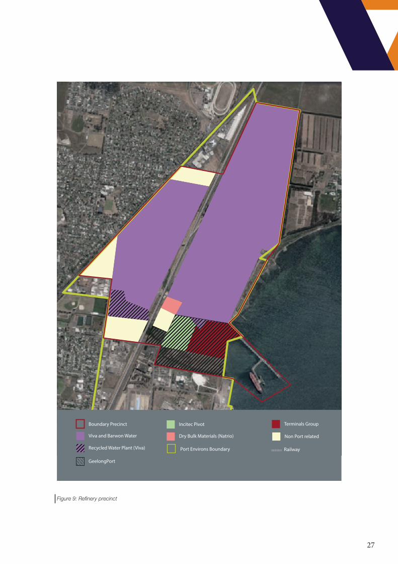
Figure 9: Refinery precinct
28
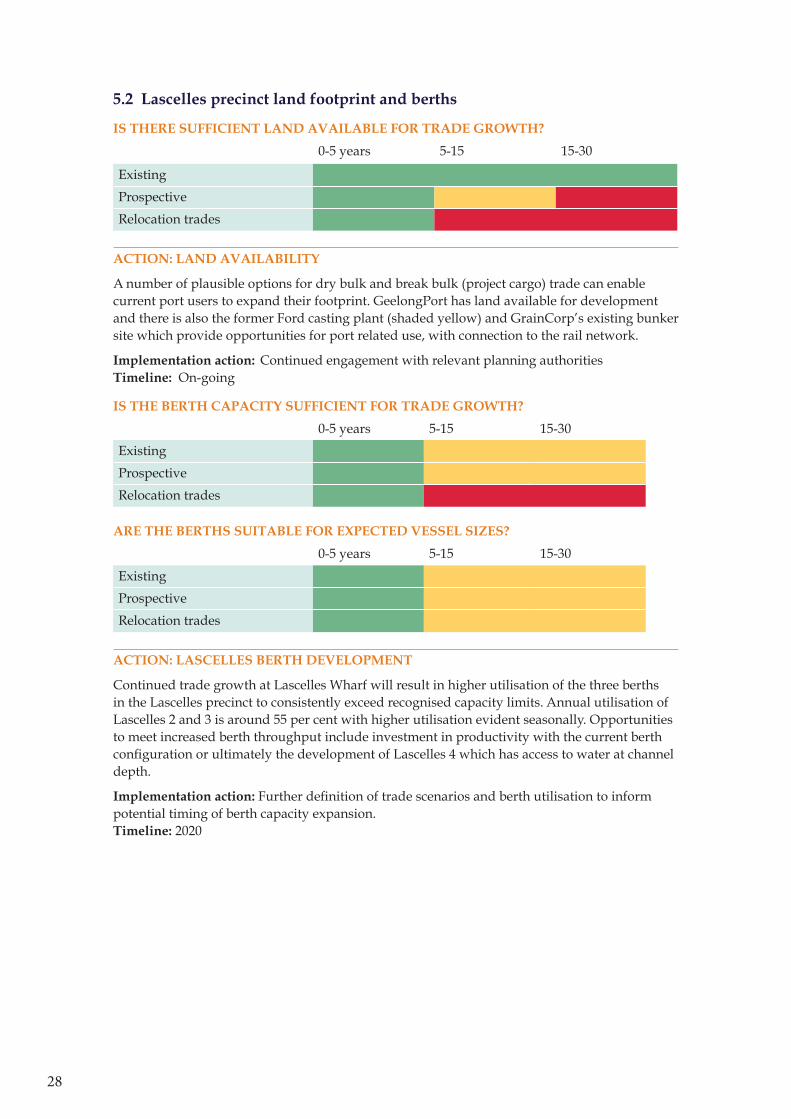
5.2 Lascelles precinct land footprint and berths
IS THERE SUFFICIENT LAND AVAILABLE FOR TRADE GROWTH?
0-5 years 5-15 15-30
Existing
Prospective
Relocation trades
ACTION: LAND AVAILABILITY
A number of plausible options for dry bulk and break bulk (project cargo) trade can enable current port users to expand their footprint. GeelongPort has land available for development and there is also the former Ford casting plant (shaded yellow) and GrainCorp’s existing bunker site which provide opportunities for port related use, with connection to the rail network.
Implementation action: Continued engagement with relevant planning authorities Timeline: On-going
IS THE BERTH CAPACITY SUFFICIENT FOR TRADE GROWTH?
0-5 years 5-15 15-30
Existing
Prospective
Relocation trades
ARE THE BERTHS SUITABLE FOR EXPECTED VESSEL SIZES?
0-5 years 5-15 15-30
Existing
Prospective
Relocation trades
ACTION: LASCELLES BERTH DEVELOPMENT
Continued trade growth at Lascelles Wharf will result in higher utilisation of the three berths in the Lascelles precinct to consistently exceed recognised capacity limits. Annual utilisation of Lascelles 2 and 3 is around 55 per cent with higher utilisation evident seasonally. Opportunities to meet increased berth throughput include investment in productivity with the current berth configuration or ultimately the development of Lascelles 4 which has access to water at channel depth.
Implementation action: Further definition of trade scenarios and berth utilisation to inform potential timing of berth capacity expansion. Timeline: 2020
29
Lascelles Precinct
GeelongPort
Boral
Wettenhalls (Transport)
Grain Corp
Incitec Pivot
Omya Port Environs Boundary
Potential Port use (non port user owned)
Non Port related
Residential
Railway
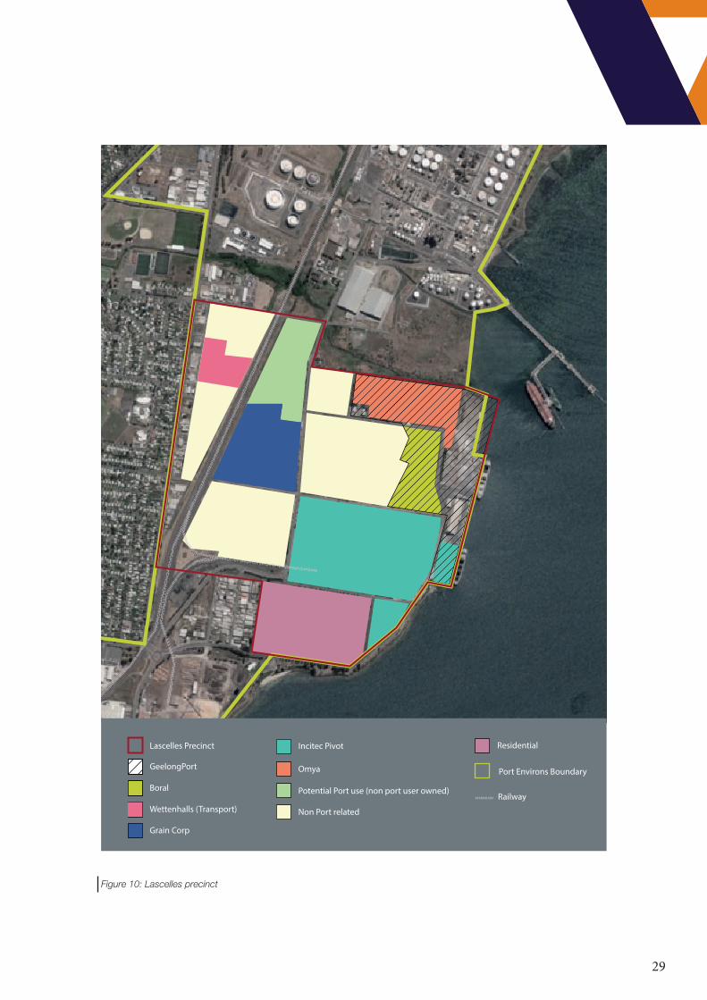
Figure 10: Lascelles precinct

30
5.3 Corio Quay precinct land footprint and berth
IS THERE SUFFICIENT LAND AVAILABLE FOR TRADE GROWTH?
0-5 years 5-15 15-30
Existing
Prospective
Relocation trades
ACTION: LAND AVAILABILITY FOR RELOCATED TRADE
Relocation of a significant Port of Melbourne trade in roll-on/roll-off or break-bulk will require an expansion of the current port footprint. .
The former Ford stamping plant site provides the largest potential land holding that might be suitable for trade expansion
Implementation action: Include as consideration in Victoria’s Port Strategy development Timeline: 2019
IS THE BERTH CAPACITY SUFFICIENT FOR TRADE GROWTH?
0-5 years 5-15 15-30
Existing
Prospective
Relocation trades
ARE THE BERTHS SUITABLE FOR EXPECTED VESSEL SIZES?
0-5 years 5-15 15-30
Existing
Prospective
Relocation trades
ACTION: BERTH CAPACITY - DEPTH
Demand for deeper draught vessels will drive investment by VRCA to increase channel depth and associated investment by GeelongPort in wharf integrity.
Implementation action: Utilise VRCA’s channel deepening study to further define trade scenarios and berth utilisation to inform potential timing of berth capacity expansion. Timeline: Mid 2020
ACTION: CORIO QUAY EXPANSION
The configuration of Corio Quay provides for multiple berth extension options to accommodate trade growth.
Implementation action: Utilise VRCA’s channel deepening study to further define trade scenarios and berth utilisation to inform potential timing of berth capacity expansion. Timeline: Mid 2020
31
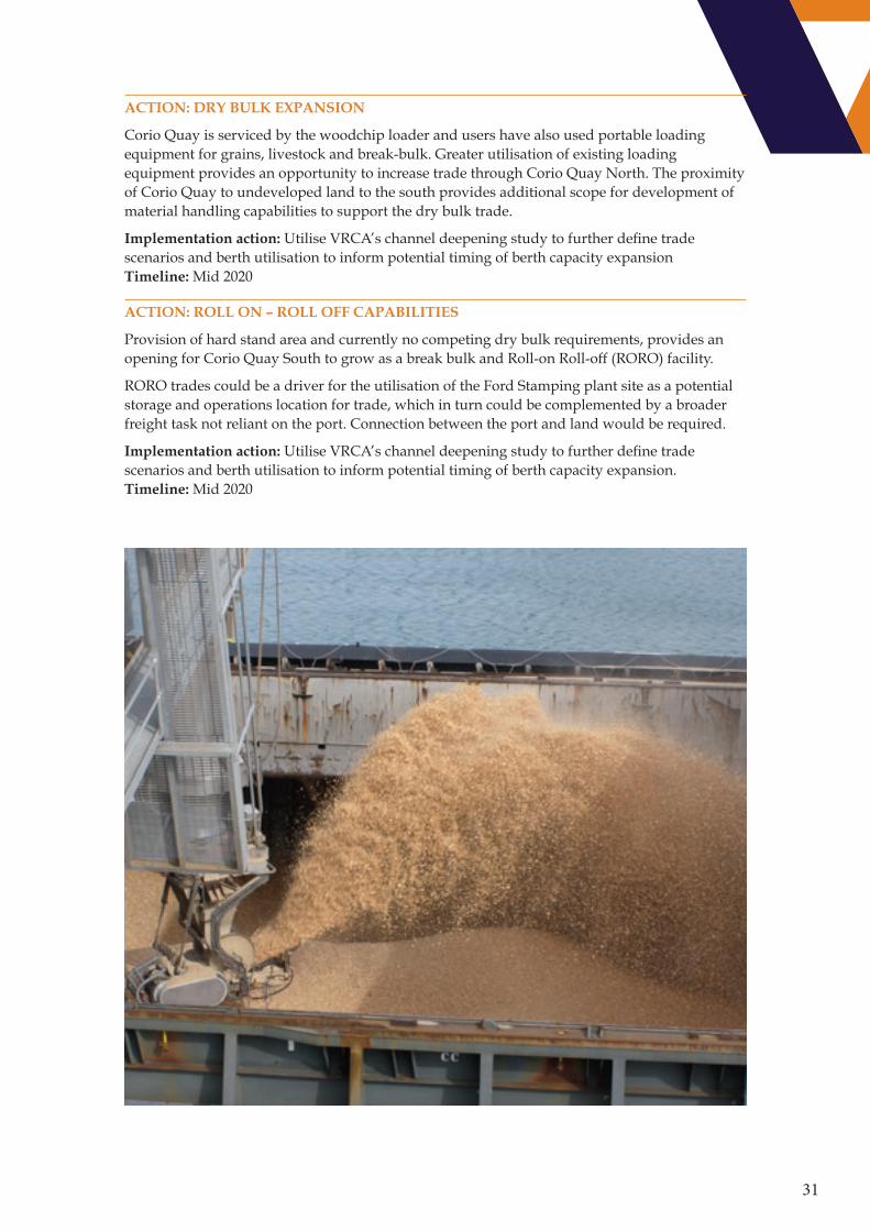
ACTION: DRY BULK EXPANSION
Corio Quay is serviced by the woodchip loader and users have also used portable loading equipment for grains, livestock and break-bulk. Greater utilisation of existing loading equipment provides an opportunity to increase trade through Corio Quay North. The proximity of Corio Quay to undeveloped land to the south provides additional scope for development of material handling capabilities to support the dry bulk trade.
Implementation action: Utilise VRCA’s channel deepening study to further define trade scenarios and berth utilisation to inform potential timing of berth capacity expansion Timeline: Mid 2020
ACTION: ROLL ON – ROLL OFF CAPABILITIES
Provision of hard stand area and currently no competing dry bulk requirements, provides an opening for Corio Quay South to grow as a break bulk and Roll-on Roll-off (RORO) facility.
RORO trades could be a driver for the utilisation of the Ford Stamping plant site as a potential storage and operations location for trade, which in turn could be complemented by a broader freight task not reliant on the port. Connection between the port and land would be required.
Implementation action: Utilise VRCA’s channel deepening study to further define trade scenarios and berth utilisation to inform potential timing of berth capacity expansion. Timeline: Mid 2020
32
Corio Precinct
Geelong Port Potential Port Use (Non Port User Owned)
Port Environs Boundary
Midway
Non Port related
Local Government Roads
Railway
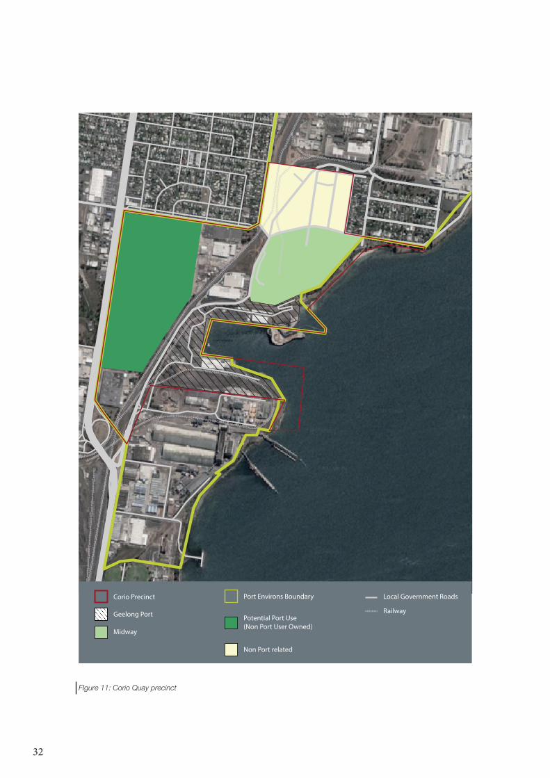
FIgure 11: Corio Quay precinct
33
5.4 Bulk Grain precinct land footprint and berth
IS THERE SUFFICIENT LAND AVAILABLE FOR TRADE GROWTH?
0-5 years 5-15 15-30
Existing
Prospective
Relocation trades
ACTION: NON-INDUSTRIAL LAND USE
Land use not in accordance with the primary zoning of the area reduces potential development of port use or services that complement port use. The Bulk Grain Precinct has limited options for growth outside the current port footprint. Un-developed properties in close proximity to GrainCorp’s terminal provide the only potential area for port use outside the existing footprint.
The Federal Mills development has resulted in the encroachment of commercial land into the industrial zoned port environs. Development of non-industrial use can bring amenity expectations that are in conflict with the industrial zoning of the area.
Implementation action: Land use is in accordance with the primary purpose of the planning zone Timeline: On-going
IS THE BERTH CAPACITY SUFFICIENT FOR TRADE GROWTH?
0-5 years 5-15 15-30
Existing
Prospective
Relocation trades
ARE THE BERTHS SUITABLE FOR EXPECTED VESSEL SIZES?
0-5 years 5-15 15-30
Existing
Prospective
Relocation trades
ACTION: BULK GRAIN PIER CAPACITY
Increased throughput or larger vessels may require the capacity of the Bulk Grain Pier to be expanded by lengthening the pier
Implementation action: Utilise VRCA’s channel deepening study to further define trade scenarios and berth utilisation to inform potential timing of berth capacity expansion. Timeline: Mid 2020

34
Bulk Grain Precinct
Koch Fertiliser (storage)
Softwood Plantation Exporters
Grain Corp
Barrett Burston
Malteurop
Port Environs Boundary
Potential Port use (non port user owned)
Non Port related
Local Government Roads
Railway
Figure 12: Bulk Grain precinct

35
5.5 Point Henry precinct revival
The vacant Alcoa land adjacent to the Point Henry pier is considered highly suitable for the storage of liquid bulk materials, hazardous cargoes and/or industries that may benefit from the availability of large separation distances to residential areas.
Point Henry can provide a temporary location for berthing cruise ships.
ACTION: POINT HENRY PORT USE
Protect Point Henry as a future option for port use by ensuring land availability.
Implementation action: Substantiate the benefits of port use at Point Henry and advocate the need to maintain it as a port asset. Timeline: Mid 2019.
36
6. TRANSPORT
Future efficient transport connections to and from the port are a vital component to unlock future development of the port. The port is fortunate in that it is situated close to key road and rail assets providing for a strong basis to enhance the productivity of the supply chain.
6.1 Integrated transport planning
The port is only one element in the transport network. The benefits from improved transport networks feeding the Port of Geelong will only be realised if planning is integrated across the whole transport network
The Victorian Freight Plan’s action to review the principal freight network will assist in ensuring that the port’s freight task is integrated into the overall development of Victoria’s freight network. It provides an opportunity to balance the incentives and mix of different transport modes to provide the port with a transport network that will meet its development needs.
Important to the port is incorporating the needs of the non-port related freight task occurring within the port environs and GREP. This includes the movement of containers to and from the Port of Melbourne.
With rail shuttles seen as a potential method to remove heavy vehicle movements through the Melbourne metropolitan area, the right investment climate could result in the viability of Geelong to Melbourne shuttles. Under prospective trade forecasts a freight task of around 150,000 TEU could develop for the shuttles not only to the Port of Melbourne but also for the movement of products such as cement.
6.2 Road network
The port requires a defined efficient road network that allows freight to be moved by the most productivity vehicle. A focus on port development needs to be defined and planning higher productivity corridors to service the port.
Constraints and issues
Road freight to/from the port will use the most time efficient route for that vehicle through Geelong’s arterial road network. The spread of arterial roads connecting the port, the Geelong Ring Road and the Princes Highway include a mixture of industrial, commercial and residential areas. For many of the roads, port traffic will only represent a small component of heavy vehicle and total vehicle movement. A major constraint is the lack of an efficient connection between the port and the Geelong Ring Road.
Balancing the mix of different traffic users will result in inefficiencies for some of these users. With port freight spread across the arterial road network it means that planning is part of the broader transport operations. This also occurs for road funding with port freight needs spread across the broader road network resulting in a lack of focus as to how the largest benefits can be achieved.

37
Impacts on local community though safety, amenity, environment and economic are better managed when transport needs are planned across the long term, rather than simply be allowed to ‘happen’. This is a key element of the Port-City concept, where the broader benefits of the port are balanced with consideration of the local community which has the most physical interaction with the port and its network.
Road network development opportunities
The priorities to enhance the port’s road linkages are highlighted in Figure 7. These aim to improve the connectivity of the port for higher productivity and over-dimension vehicles by focusing investment on key links. Current road alignments and access constrain the range of HPFV’s able to access the port.
They also identify the key areas where other road users including cyclists, need to be considered and the provision of suitable rest and clean up areas to support transport operators.
Other road users
West link options
Rest areas
Port link
Last mile
Lara
Figure 13: Road elements to be considered in network planning
38
ACTION: PORT LINK
The north-south route connecting the Princes Highway in the north to Mackey Street in the south will be targeted as the primary backbone for freight vehicles entering the port, with a focus on HPFV’s and over-dimension vehicles.
Implementation action: VRCA, port operators and users, council and transport agencies to establish a network plan and investment case. Inform Freight Victoria’s review of the Principal Freight Network and Port Strategy. Timeline: End 2019
ACTION: WESTERN LINK PLANNING
A western link that provides critical access between the port, GREP and western Victoria provides scope for substantial productivity and community benefits. Potential westbound connections are to be prioritised and key land connections identified that should be protected to allow future development to occur.
Planning for a western link will need to incorporate consideration of the future transport requirements arising from the Northern Geelong Growth Area. Connections to Victoria’s west will support the potential freight task for over-dimension vehicles resulting from investment in renewable energy projects.
Implementation action: VRCA, port operators and users, council and transport agencies to establish a network plan and investment case. Inform Freight Victoria’s review of the Principal Freight Network and Port Strategy Timeline: End 2019
ACTION: PORT LINK - LAST MILE ACCESS
Enhance connections between the Principal Freight Network and local roads
Implementation action: VRCA, port operators and users, council and transport agencies to establish a network plan and investment case. Inform Freight Victoria’s review of the Principal Freight Network and Port Strategy Timeline: End 2019
ACTION: PROVISION OF CLEAN UP AND REST AREAS
Engagement with port operators and transport companies identified a lack of ancillary services to support road transport through the port. These services include vehicle facilities to allow truck operators to clean and refuel trucks and have access to general weigh bridges and facilities for truck drivers for refreshment and safe resting sites.
Implementation action: VRCA, port operators and users, council and transport agencies to establish a network plan which establishes optimal locations Timeline: End 2019
39
Other road users
ACTION: PASSENGER, PEDESTRIAN AND CYCLING INITIATIVES
The North Shore residential area and the port’s location within Geelong generates non-commercial road movements. Road planning across the port environs needs to effectively manage the interaction between commercial heavy vehicles, passenger vehicles, cyclists and pedestrians. Segregation of heavy vehicles and other transport modes can be the most effective method to enhance road safety in the port areas.
The main focus for port operations will be to ensure that network planning is focused on ensuring that non-commercial vehicles are able to transit through the port environs safely. This includes connections between segments of Geelong’s cycling network and access for North Shore residents and those wishing to access the waterfront
Implementation action: VRCA, port operators and users, council and transport agencies to establish a network plan and investment case. Timeline: End 2019
ACTION: PORT LINK - HEAVY FREIGHT ZONE
A designated Heavy Freight Zone with associated planning and investment could allow operators to increase axle loads on heavy vehicles, remove the requirement for lashing of loads for intra-port precent movement, allow the introduction of different trailer combinations and manage interactions with vulnerable road users. This zone would improve operator efficiencies and road safety in the area.
Implementation action: Following a network plan, bring consideration to how a heavy freight zone could be developed. Timeline: End 2021
6.3 Rail network
Rail remains an important but under utilised transport mode for freight access to the port of Geelong. Investment is required to increase the utilisation of rail into the port of Geelong. This is required to increase volumes of grain moved by rail and to enable access for other port trade that has a desire to utilise rail.
Constraints and issues
The Grain Loop provides direct dual gauge access for bulk grain into GrainCorp’s port terminal. However, local rail signalling through ‘C’ Box limits the capacity of the Grain Loop to one train at a time and results in other trains being held back on the network to provide access.
The Corio Independent Goods Line (CIGL) provides the opportunity for access into a greater area of the port. Direct access is currently provided into the Midway site utilising a dual gauge spur. However this spur has not been utilised for a number of years as trucks have been the preferred method for transport of logs to the site.
CIGL sidings within the Lascelles precinct are 500 metres away from the wharf. While Lascelles provides and efficient option for movement of bulk materials, utilising rail requires a material handling solution between the rail and wharf. Previous port development strategies have considered a rail loop connecting the CIGL with Lascelles Wharf.

40
Rail network development opportunities
Rail opportunities are focused on how the local rail network can be modified to expand options. This includes efficiency improvements through signalling and which sections of the network are most suited to investment as identified in Figure 14: Rail options.
Figure 14: Rail options
ACTION: SIGNAL AUTOMATION PROGRESSION
Further automation of ‘C’ Box signalling and required infrastructure to enable two trains to operate within the Grain Loop area increasing capacity and flexibility of operations.
Implementation action: Develop the evidence base to inform Freight Victoria’s review of the Principal Freight Network and Port Strategy. Timeline: End 2019
ACTION: GRAIN LOOP UTILISATION
Development of sidings south of the current Graincorp unloading area for bulk commodities such as mineral sands and the northern side of the Grain Loop to containerise grain for export via Port of Melbourne.
Implementation action: Develop the evidence base to inform Freight Victoria’s review of the Principal Freight Network and Port Strategy. Timeline: End 2019
ACTION: CORIO INDEPENDENT GOODS LINE - SIDING
There are proposals to develop the western side of the GrainCorp bunker site at North Shore as an intermodal terminal for bulk products.
Implementation action: Develop the evidence base to inform Freight Victoria’s review of the Principal Freight Network and Port Strategy. Timeline: End 2019
Potential for up to 800m siding development
Potential to add sidings to Grain Loop

41
ACTION: INCREASED STANDARD GAUGE
The Murray Basin Rail Project is in the process of converting all of the North West grain lines to standard gauge (SG). This will result in 80% of the grain arriving at Geelong on SG instead of 20% currently, but there will need to be more SG sidings at Geelong to stable trains. Conversion of some of the current broad guage sidings to SG is being considered
Implementation action: Develop the evidence base to inform Freight Victoria’s review of the Principal Freight Network and Port Strategy. Timeline: End 2019
6.4 Shipping channels
The shipping channels are key to the competiveness of trade through the port of Geelong, through efficiencies in current shipping movements and the ability to access markets that require larger per trip volumes. The shipping channels need to be deep enough to optimise shipping efficiency.
Constraints and issues
Geelong’s shipping channels have a declared depth of 12.3 metres. To access the Port of Geelong vessels transit Port Phillip Heads with a depth of up to 15.5 metres. This differential represents a constraint on the potential development for the port of Geelong for trades where the optimum vessel draught is greater than the current maximum 12.0 metres.
Figure 14 illustrates the number of vessels that visit Geelong of difference size categories. Vessels of AFRAmax, Panamax and larger Handymax size categories cannot be fully loaded when they transit Geelong’s channels. These larger vessels reflect the majority of trade volume through the port and where efficiencies are to be found.
Figure 15: Vessels visits and sizes
Dry Bulk
Panamax 65 – 100,000 dwt
Handymax 40 – 65,000 dwt
Handysize 10 – 40,000 dwt
Tankers
Aframax/LR2 85 – 125,000 dwt
Panamax/LR1 55 – 85,000 dwt
MR and smaller <40,000 dwt
0 50 100 150 200 250
Dry bulk vessel visits per size category
Tanker visits per size category

42
The limited anchorage area within Geelong’s port waters requires vessels to utilise the Melbourne anchorages, with associated fees. A greater anchorage area at Geelong provides a channel and anchorage service for the port the vessels are visiting.
Channel development opportunities need to be considered in partnership with wharf and berth investments to ensure the channel and berth engineering designs are compatible. All of Geelong’s existing channels have been dredged, which provides an opportunity in that further development occurs in an already disturbed environment.
Shipping channel development opportunities
ACTION: CHANNEL DEPTH
VRCA is evaluating options to consider the future depth of Geelong’s shipping channels. This work will provide an evaluation of the future configuration of the channels and inform future port development strategies. These studies will necessarily include how Geelong channel development can benefit Victoria’s ports overall ability to meet the future freight task.
Channel development will focus on vessels categorised as AFRAMax crude oil tankers, LR2 product tankers and Panamax bulk carriers. Each category encompasses a range of vessel dimensions and capacities. Consideration of deepening to 13.5, 14.5 and 15.5 metres will be undertaken.
Channel development needs to be aligned with wharf and berth investments to ensure the channel and berth engineering designs are compatible.
All of Geelong’s existing channels have been dredged, which provides an opportunity in that further development occurs in an already disturbed environment.
Implementation action: VRCA to conduct geotechnical assessment to inform dredging options Timeline: Mid 2019
Implementation action: VRCA will define the optimal physical channel configuration to inform economic and environmental studies. Timeline: End 2019
ACTION: OUTER ANCHORAGE
An opportunity to extend Geelong’s port waters to the east can create an outer anchorage. This anchorage is in water sufficiently deep to service vessels utilising the Port of Geelong and will be sized to accommodate growth in vessel numbers.
Implementation action: Commissioning VRCA’s enhanced port monitoring system Timeline: Mid 2019
Implementation action: Application for gazetting or defined anchorage from VPC(M) to VRCA. Timeline: End 2019
43
7. PORT ENVIRONS (INCLUDING INFRASTRUCTURE)
7.1 Land planning
The port of Geelong environs represent a significant freight place in Victoria’s Principal Freight Network (PFN). It forms an important link in its connected supply chains and restrictions on its capacity and efficiency can be felt across a broad sector.
Ensuring appropriate land is available to cater for future growth for port related activities and the associated freight task is important across the whole logistics chain. It is also important that planning for land use restricts the encroachment of non-compatible use and that the port’s land use is sympathetic to sensitive land use that may be impacted on by the port.
Freight plan - Principal Freight Network (PFN)
Figure 16
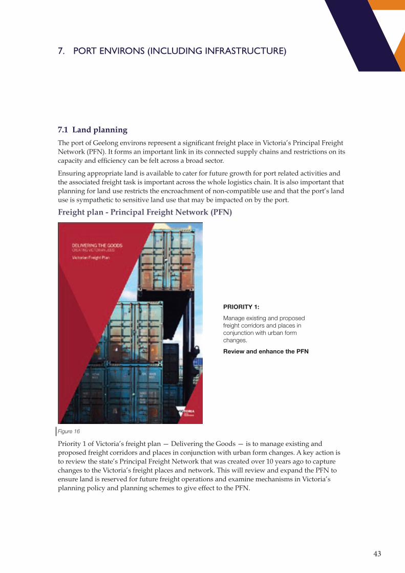
Priority 1 of Victoria’s freight plan — Delivering the Goods — is to manage existing and proposed freight corridors and places in conjunction with urban form changes. A key action is to review the state’s Principal Freight Network that was created over 10 years ago to capture changes to the Victoria’s freight places and network. This will review and expand the PFN to ensure land is reserved for future freight operations and examine mechanisms in Victoria’s planning policy and planning schemes to give effect to the PFN.
PRIORITY 1:
Manage existing and proposed freight corridors and places in conjunction with urban form changes.
Review and enhance the PFN
44
The 2018 Port Development Strategy provides a reference document outlining the opportunities for the Geelong port environs to contribute the state’s effective management of the growing freight task. It also provides insight into the interactions between port and freight users and the broader community. These should assist the review of the PFN and associated planning provisions.
Ports and land use
Ports are significant long term assets that cannot readily be relocated. To extract the greatest benefit to Victoria’s prosperity, sufficient land to enable growth over the longer term needs to be reserved. This includes land available for port related activity and land that provides separation between the port and land uses that may have sensitivities to port operation.
The significance of the Port of Geelong is given standing in the planning scheme by Plan Melbourne 2017-50, G21 Regional Growth Plan and State Planning Policy Framework of the Greater Geelong Planning scheme at clause 18.03 (Ports) and 18.03-1 (Planning for Ports). Clause 21.12 (Geelong Port) of the Greater Geelong Planning Scheme’s Local Planning Policy Framework advances a series of objectives aimed which emphasis the effective planning and efficient operation of the port.
The range of policy and strategy significance given to the port reinforces the need to protect the port from encroachment and ensure that land remains available for port growth. Strategic policy documents need to consistently contain this message.
Current port land use
Ministerial Direction 14 – Port Environs, essentially identifies the port environs (Figure 3). Within the port environs land use generally is in accordance with the intentions of the zones, an industrial zone has industrial use. There are some properties that due to heritage overlays have use outside the intention of the zone, such as 33 Mackey Street or currently unused, such as the previous Ford sites and 11 Mackey Street.
Strategic planning documents, such as Port Development Strategies, give additional weight to the intentions of the zones but there remains some ambiguity around what land uses should and should not occur within the industrial zones utilised by the port and surrounding lands. This is evidenced by commercial developments being proposed on industrial land. The continued refinement of planning policy will assist in better emphasising the strategic importance of the port.
The core port land use areas and significant non-port related freight sites are shown in Figure 17. This figure also identifies the land with potential for port related use that would be required to enable all the potential trade growth.
45
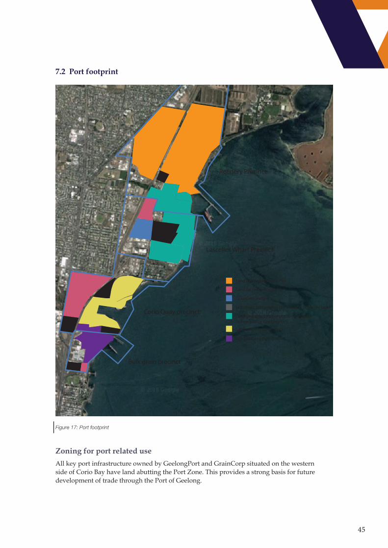
7.2 Port footprint
Land utulising Lscelles or not developed but owned by GeelongPort
Land utilising Re�nery Pier
Land for redevelopment
GrainCorp bunker
Not direct port related but a source of freight task
Land utilising Corio Quay
Land utilising Bulk Grain
Re�nery Precinct
Lascelles Wharf Precinct
Corio Quay precinct
Bulk grain precinct
Figure 17: Port footprint
Zoning for port related use
All key port infrastructure owned by GeelongPort and GrainCorp situated on the western side of Corio Bay have land abutting the Port Zone. This provides a strong basis for future development of trade through the Port of Geelong.

46
A number of properties not owned by the port asset managers (GrainCorp and GeelongPort) but whose use is directly connected to port operations have industrial zoning. The use of these sites meets the intentions of the Port Zone and could represent an opportunity to expand the land that is specifically identified for port activity.
GeelongPort’s Point Henry pier is a commercial port asset without abutting port zoned land.
Uncertainty around future land use at Point Henry exists. If a continuation of the industrial zoning land adjacent to the pier provides an opportunity for port related development, the potential exists to cement the potential for port use through rezoning part of the land as Port Zone. Point Henry is an opportunity to reserve land with large separation distances to sensitive use, existing industrial use within its locality and a connection to established shipping channels.
Heritage
The rich industrial history of the port and its environs, has resulted in a number of buildings within the port environs being nominated as heritage places. The planning scheme provides provision for
• Former Federal Woollen Mill (HO1648)
• Former Corio Distillery (HO1728)
• Some buildings associated with the former Ford stamping plant (HO1717)
• Former Pilkington site (HO1722)
The Heritage Overlay for some of these places includes provision to consider uses prohibited by the zoning if they will demonstrably assist with the conservation of the significance of the heritage place.
Any development of these sites outside the intentions of the zoning should ensure that any use will not result in a reverse-amenity impacts on port or industrial users. This includes employment based uses, such as office space, that introduce ‘sensitives’ into the port environs due to their amenity expectations being different to the intentions of the zoning.
The buildings located at former Ford stamping plant can provide a potential transitional use between industrial zoning and sensitive land use.
Major hazard facilities
Ministerial Direction 20 – Major hazard facilities was introduced in October 2018. The purpose of this Direction is to require planning authorities to seek and have regard to the views of WorkSafe Victoria and the Minister for Industry and Employment when preparing a planning scheme amendment which rezones land for, or is within the threshold distance of, a major hazard facility.
Viva Energy’s refinery and the Lyondell Bassell co-located plant are licensed Major Hazard facilities. Within the threshold distances in port environs, both Ministerial Direction 14 and 20 overlap, providing which would require a planning decision to consider both the port and the major hazard facilities if a planning scheme amendment was considered. The Major Hazard facility direction extends the consideration outside the port environs, where land falls within the threshold distance.

47
Interaction with sensitive land use
The port of Geelong exists with the broader Geelong community and is cognisant of the amenity interactions between the port and potentially sensitive land use within the port environs and in the surrounding areas. Within the port environs the North Shore residential area sits between the Corio Quay and Lascelles area.
Planning controls, including design and development overlays, major hazard facility and separation distances provide direction for port and industrial development proposals.
The Environmental Significance Overlay 5, which is placed on the North Shore residential zones recognises the impact inappropriate development in North Shore could have on the port.
48
Actions and implementation
Referencing the 2018 PDS
Amend the VPPs to make the 2018 PDS a reference document under clause 18.03 of the Greater Geelong Planning Scheme
Principal freight network
Priority one of the Victorian freight plan is to manage existing and proposed freight corridors and places in conjunction with urban form changes. The Port Development Strategy provides a base to link the Port of Geelong with the review of the principal freight network.
VRCA will work with port stakeholders and the Victorian Government in its review of the Principal Freight Network. Key elements emerging from the Port Development Strategy which will be taken forward including:
• That the Port of Geelong environs are categorised as a freight place within the freight network
• That planning controls around Environmental Significance Overlays and heritage places are considered.
• The appropriateness of utilising the Port Zone across a larger area of the Port of Geelong to ensure that sufficient land is made available to the Port of Geelong so that future Victorian supply chains are productive and efficient.
• From an assessment of the freight links into the port of Geelong work identify any key freight link that may require land use protection.
• The provision of port zoned land at Point Henry to provide opportunities for utilisation of the Point Henry Pier.
Strategic planning
Put forward a case for the opportunity to amend the Planning Policy Framework of the Greater Geelong Planning Scheme to provide for a review of local policies addressing the Port of Geelong. This should include inclusion of a plan that references Ministerial Direction No 14 which includes a definition of the port environs.
Point Henry
Point Henry is a unique land resource in Victoria, with current Industrial Zoning, substantial separation distances and a pier providing access to port waters. These characteristics provide opportunities not available within the main area of the port of Geelong and at other Victorian commercial ports.
The retention of the site as for future freight and port needs should be included in the review of the Principal Freight Network and the development of a port strategy for Victoria.

49
8. FUTURE DEVELOPMENT
The 2018 PDS is another iteration in the planning for the development for the port of Geelong. Considering the development of the port does not cease at the release of each PDS, it is a continuing process. As such discussions are ongoing about what the future of the port holds.
Discussions around the ports future cannot be conducted in isolation from discussions around the future of Geelong and Victoria and the broader hinterland.
An ongoing dialogue
Since 2013 VRCA has facilitated the Port-City Coordination Group, bringing together port users, state and local government representatives and business/development groups. Continuing this group provides a sound basis to identify and discuss the development of the port of Geelong. Port managers and users are members of various groups (such as G21) that provide a link between the port and the broader Geelong, state governments and broader community.
Organisations with a connection to the port maintain their own dialogue with the community, their customers, suppliers and government. This provides for a number of insights for the port community of the broader
There is also a broader dialogue around the place of the port in Victoria’s community. This encompasses issues around the port and environment, culture, consideration of traditional owners, technological change and economic development. Broader strategies such as the Port Philip Coastal Plan, Environmental Protection Authority policies and climate change response are all of relevance to the ports development and the port needs to be cognisant and involved in their development.
Enhancing appreciation of the port
The port’s ongoing social licence to operate is made clearer if the community has an appreciation of the ports importance within the supply chains and the broad benefit it brings to Geelong and the state. The 2018 Port Development Strategy wants to identify this an important element in the development planning for the port.
This is not just relevant for the port directly but has a broader scope of understanding of supply chains, the movement of freight and the importance they have on the prosperity of all of the community.
50
Implementation
ACTION: ANNUAL PORT DEVELOPMENT UPDATE
Prepare an annual review of port development and operations for dissemination across the community to provide guidance on where the port is in its ongoing development.
Implementation action: Development update Timeline: End calendar year
Action: Port knowledge
Continue to engage with the community, business and government to educate about the role that the port environs and its associated supply chains have.
Implementation action: Port managers and users engage with the community around port activity. Timeline: On-going
ACTION: COMMUNITY EXPECTATIONS
Continue to engage with the community to understand the changing social environment that the port operates in and inform development options
Implementation action: Port managers and users engage with the community around port activity. Timeline: On-going
ACTION: TRANSITIONING ECONOMY – SERVICE/EDUCATION
Undertake additional studies into understanding the transitioning economy of Geelong and how the port can play a role in Geelong’s development.
It is proposed that the current port-city coordination meetings continue on a regular basis in order that port, port user and operator, investor and all levels of government can share their views and requirements openly.
This structure will offer the city and its port and port users a single body with which to discuss the port’s development objectives with state and federal governments and other potential infrastructure investors.
Implementation action: Port-City Coordination structure Timeline: On-going
51
9. RECOMMENDATIONS
The aim of the PDS is to define the likely future of the port of Geelong, identify future trade opportunities, highlight the challenges faced by the port and detail what is required to unlock the potential. The PDS confirms that the port of Geelong will continue to be Victoria’s dry bulk and liquid bulk hub and will continue to grow in importance as Port of Melbourne focuses on maximising container trade.
Channel access is constrained by draught and options for channel deepening will continue to be considered. VRCA is committed to completing preliminary studies in the near term in order to inform economic and environmental assessments.
The port has an adequate land base to support limited growth and consideration of future land requirements to accommodate and facilitate trade growth is a priority consideration. Transport assets require investment to provide higher productivity access routes for cargo inbound and outbound from port operations.
The Port Development Strategies recommends the formation of an integrated transport planning group comprising port managers, port users and infrastructure asset managers to enable a whole of port approach to transport planning and investment. Access to reliable and efficient infrastructure is the key enabler of both productivity and growth. A coordinated approach is firmly in the best interests of both port users and the broader community as it will ensure consideration and incorporation of key issues.
VRCA recommends that Freight Victoria plays a central role in facilitating this integrated planning and infrastructure delivery as part of its work into the broader Principal Freight Network for the whole of Victoria.
52
10. APPENDIX 1- PORT MANAGEMENT ACT REQUIREMENTS
10.1 Port Management Act requirements
The relevant port authority must at intervals of 5 years prepare a Port Development Strategy.
A Port Development Strategy must include:
a) projections of trade through the commercial trading port,b) current and projected land use requirements, including transitional land uses designed
to protect the port from constraints on efficient operations and mitigate adverse impacts of port operations on adjacent uses,
c) current and projected infrastructure requirements for land and water in the commercial trading port,
d) current and projected transport infrastructure requirements for land and water in the commercial trading port,
e) any other matters specified in any guidelines.
10.2 Purpose of Port Development Strategies
Section 91K of the Port Management Act 1995 (PMA) sets out the requirement for port authorities to prepare a port development strategy.
It also provides the legislative standing for the Ministerial Guidelines for Port Development Strategies and that such strategies are to be prepared at regular intervals.
• A port development strategy (PDS) is largely concerned with capacity planning for trade throughput at the port. The purpose of preparing a port development strategy includes:
• Articulating a medium and long term ‘port development vision’ to the port’s stakeholders; –
• Creating economic value through supporting industry understanding, confidence and investment; –
• Maximising economic outcomes through supporting efficient allocation of critical port land and infrastructure; –
• Assisting in overall supply chain efficiency through the provision of transparency in the broader transport network task and infrastructure requirements; –
• Providing strategic information to support an understanding of significant environmental and social issues, which have the potential to impact port operations and development; and
• Supporting engagement with stakeholders and clients, and building local goodwill.

53

54