port redesign and planned beach renourishment in a high
TRANSCRIPT

Port redesign and planned beach renourishment in a high wave
energy sandy-muddy coastal environment,
Port Gisborne, New Zealand
Terry Healy a,*, Scott Stephens a, Kerry Black a, Richard Gorman b,Russell Cole b, Brett Beamsley a
aCoastal Marine Group, Department of Earth Sciences, The University of Waikato, Hamilton, New ZealandbNational Institute of Water and Atmospheric Research Ltd, Private Bag 3105, Hamilton, New Zealand
Received 15 September 1999; received in revised form 30 November 1999; accepted 24 January 2002
Abstract
Redesign of Port Gisborne for the 21st century has encompassed a broad interdisciplinary approach. This procedure has
taken into account the operational requirements of the port, effects of dredging and construction upon the benthic fauna, and
wave activity within the port confines after the proposed development. Added amenity value of the development to the local
community is an important ancillary redesign consideration. Initially, a major research project into the environmental impacts of
the developments has been undertaken.The project, which commenced in 1996 and is still continuing, involves an iterative
approach integrating the initial design and development options with the operational feasibility, construction constraints,
environmental constraints, social acceptability, and economic practicality of the port; all of these require in-depth assessment to
obtain the necessary planning and development approvals. This requires close liaison between the professional environmental
research scientists, port management, port operation staff (pilots), construction engineers, planners, and the community interest
groups.Numerical modelling of the hydrodynamics of Poverty Bay, simulating waves and current effects on the various initial
designs options, and calibrated against data from a substantial field program, has been a fundamental tool. It was applied
experimentally to determine the best option for the port layout, as well as to assess sedimentation impacts. Modelling results
indicated a significant increase in maintenance dredging expected as a result of deepening the navigation approach channel.
Because this may have an impact on the nearby sandy beach by inducing erosion, the best option for disposal of the sandy
dredged material was determined to be disposal in the surf zone for subtidal beach profile renourishment. Textural analysis of
the sediments trapped in the navigation channel demonstrated that they were suitable for this purpose.
D 2002 Elsevier Science B.V. All rights reserved.
Keywords: Port redesign; Environmental impact; Subtidal beach profile renourishment
1. Introduction
Port Gisborne is enclosed within a harbour and
breakwater system in the north of Poverty Bay, New
Zealand (Figs. 1 and 2). Since historical development
in the 1880s, it has experienced ongoing coastal
0169-555X/02/$ - see front matter D 2002 Elsevier Science B.V. All rights reserved.
PII: S0169 -555X(02 )00180 -0
* Corresponding author. Fax: +64-7-838-4061.
E-mail address: [email protected] (T. Healy).
www.elsevier.com/locate/geomorph
Geomorphology 48 (2002) 163–177

engineering problems relating to wave exposure, silta-
tion within the port, extensive dredging requirements,
as well as seiching within the confines of the present
harbour (Whyte, 1984).
Following port reform in New Zealand (1989–
1990), Port Gisborne has seen a growth in trade,
especially for export of forestry products. Economic
projections for Port Gisborne (Port Gisborne, 1998)
indicate a sustained growth in the export of wood
product well into the 21st century. This required
reassessment of the existing port facilities and infra-
structure, which are becoming inadequate to support
an expanded efficient forestry product export opera-
tion. Objectives of the port redesign include: develop-
ment of three overseas shipping berths to accommo-
date large vessels; reclamation of approximately 40 ha
for log storage and port operations; design configu-
ration to mitigate seiching within the port; minimisa-
tion of future maintenance dredging; and considera-
tion of developing public amenities (Selsky and
Memon, 1997), such as fishing and small boat loading
ramps, opportunities for aquaculture, and an artificial
surfing reef for use by the general public. An impor-
tant consideration is to mitigate potential adjacent
beach erosion arising from the development. This is
accomplished by using the maintenance-dredged
Fig. 1. Poverty Bay, New Zealand, showing location of Port Gisborne, the historical spoil ground, and proposed future disposal sites for
predominantly sandy sediments off Waikanae Beach, and muddy sediments in the centre of Poverty Bay (Stephens et al., 1997b).
T. Healy et al. / Geomorphology 48 (2002) 163–177164
material to re-nourish the nearshore subtidal beach
profile.
As a first step toward obtaining territorial local
authority approval, a field and numerical modelling
environmental study was undertaken in 1996–1997
(Stephens et al., 1997a; Healy et al., 1998) to provide
information for the Assessment of Environmental
Effects (AEE). In addition, a pilot study was con-
ducted to determine the effect on ship handling of
deepening the navigation approach channel and a new
port configuration. The modelling included simulation
of waves, fresh water input from rivers, current
circulation patterns, and sediment transport within
Poverty Bay and around the port (Black et al.,
1997,1999).
This paper outlines the broad scope of the AEE
study and initial design considerations for the poten-
tial developments and port layout redesign at Port
Gisborne. It provides an example of AEE require-
ments for port redevelopment in high wave energy,
active multi-input sedimentation environment. The
main sedimentation effects expected to arise from
phase one of the project—the deepening of the ship-
ping approach channel—are assessed, and proposed
mitigation measures presented. The paper further
serves as a modern example of Integrated Coastal
Zone Management (French, 1997; Kay and Alder,
1999).
2. Historical development and problems of the port
The port was initially sited close to the landing spot
of Lt. James Cook—the first European to set foot on
New Zealand in 1769—at the mouth of the Turanga-
nui River. In the 19th century, and indeed until the
1960s, the small port of Gisborne was serviced by
lighters to ships anchored offshore. By the 1880s,
construction commenced on an extended groin/break-
water to provide shelter for vessels from south-east-
erly waves, and during the 1950–1960s, deeper
draught wharves, a vessel turning basin, and protec-
tive vertical sea walls were constructed in an attempt
to minimise swell wave activity. The need to dredge
the port entrance has been a problem since the first
breakwater was constructed, and in the 1910s the port
invested in a steam powered bucket dredge. During
the 1930s, a boat harbour and shipping channel was
excavated from the soft ‘‘papa’’ siltstone bedrock that
comprises the shore platform. By the 1960s, the port
and channel had been deepened to 9 m and required
constant maintenance dredging (Whyte, 1984). More-
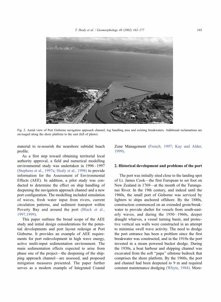
Fig. 2. Aerial view of Port Gisborne navigation approach channel, log handling area and existing breakwaters. Additional reclamations are
envisaged along the shore platform to the east (left of photo).
T. Healy et al. / Geomorphology 48 (2002) 163–177 165

over, the port structures likely caused some erosion on
the adjacent northern Waikanae beach, as the beach
readjusted its equilibrium planform.
The construction of an enclosed harbour with the
shipping channel facing toward the southeast allows
wave energy to be ‘‘pumped’’ into the port, while the
vertical walls within the harbour allow wave energy
reflections to set up a resonating long wave condition
(seiching) within the port. This undesirable feature is
common to a number of ports (Abecasis, 1964; Muir
Wood, 1969; Le Mehaute and San-Hwang, 1970;
Okihiro and Guza, 1997). For Port Gisborne, this is
especially noticeable on occasions of long period
waves of Tz14 s and may be very damaging to
vessels and the quayside. Thus, one aim of the rede-
sign of port layout is to attempt to avoid such a
resonating condition.
3. The physical background
Port Gisborne is situated in a difficult environ-
ment from a number of physical perspectives. Firstly,
it is located in an open embayment subject to large
episodic storm waves from the east and southeast.
On occasion, storm waves of significant height,
Hs>5–6 m can pound the port entrance. The port
itself is located in one of the more sheltered sectors
of the bay (Fig. 2), except for waves approaching
directly from the southeast. This location enhances
potential for sediment deposition because it is a
meeting point for littoral drift from both the east
and the southwest (Miller, 1981). In addition, the
adjacent Turanganui River system, which drains a
catchment of soft erodible Tertiary ‘‘papa’’ siltstones,
delivers high concentrations of fine suspended load
to the sea adjacent to the port during high flow
events or ‘‘freshes’’ (Healy and Nelson, 1981). Thus,
there is potential for high rates of sediment deposi-
tion near the port from several sources: wave gen-
erated littoral drift along the adjacent Waikanae
Beach from the southwest; alongshore drift from
Kaiti Beach to the east; diabathic (cross shore) sedi-
ment transport in storms; and high suspended load
muddy input from the adjacent Turanganui River
(Healy et al., 1980).
4. Preliminary scoping for redesign
Over the past decades, large areas of the unstable
catchments surrounding Poverty Bay have been con-
Fig. 3. Port outlay and present area of log storage. For redesign the reclamation is planned to extend along the shore platform, and the right
breakwater will need to be removed.
T. Healy et al. / Geomorphology 48 (2002) 163–177166

verted from pastoral farming into plantation forestry.
During this time, Port Gisborne has experienced a
rapidly growing export trade of bulk logs and timber
products, including wood chips. The length-over-all
(LOA) of modern logging and wood chip carrying
vessels is on the order of 230 m with draughts
approaching 10 m. Efficient (cost-effective) export
of logs requires about 10 ha of adjacent flat land to
service each berth. Flat land is severely restricted in
the present port service area (Figs. 2 and 3), and a
redesign of port layout and facilities to obtain the
required extra berths and service area is necessary.
The only real option to obtain such an area is to
undertake reclamation along the adjacent shore plat-
form (Fig. 3).
While in earlier decades port development was
focussed primarily upon economic and national stra-
tegic issues (Quinn, 1961), in modern times environ-
mental and social issues are an integral part of the
planning and development procedures (Butlin, 1976;
Bruun, 1989; Harlow, 1989; Svendsen, 1989).
Clearly, the development of a port is a multidiscipli-
nary problem requiring consideration of economic
and social planning issues, port operations, as well as
the environmental, scientific, and coastal engineering
problems. Early in the project, a multidisciplinary
‘‘brainstorming’’ scoping meeting was held to review
the issues and identify initial potential solutions.
These considerations then influenced the direction
of the research investigations and subsequent out-
comes of the study. Subsequent review meetings
were guided by the constraints indicated by the
research investigations, and so on. This is an ongoing
process.
5. AEE study objectives
In preparation for the potential future redevelop-
ment of the port, a major environmental impact study
was initiated in 1996. This comprised a number of
components, including:
� options for approach channel alignment;� selection of a new dredged material disposal
ground;� effects of the dredging on the marine flora and
fauna;
� geotechnical properties of the material to be
dredged;� field data measurements;� modelling of wave actions;� modelling of currents, density stratification and
sediment transport;� port redesign considerations.
5.1. Options for approach channel alignment
Consideration was given to dredging a new shorter,
curved approach channel, which would significantly
reduce the initial capital dredging required. However,
the curved approach channel is considered impractical
from a piloting perspective (Herbich, 1992). Thus,
Stage 1 of the development, completed in 2000,
encompassed deepening the existing approach chan-
nel to 10 m to take deeper draught vessels.
5.2. Selection of a new disposal site for capital
dredged sediment
Capital dredging involved removal of some
300,000 m3 of relatively soft ‘‘papa’’ siltstone rock
and silty sand from the existing approach channel.
The Department of Conservation (DoC) had ex-
pressed continued concern over the proximity of the
historical dredge spoil dump ground to an area of the
Temoana reef rocks of potentially high ecological
value (Fig. 1; see also Fig. 7), Therefore, it was
decided to investigate an alternative site for the
disposal of muddy and rock dredged material. Options
included disposal on land, in reclamation adjoining
existing port land, and at two new marine dumpsites.
A perusal of the sea floor sediment patterns
presented in Miller (1981) and Kensington (1990),
and several side scan sonar surveys conducted over
the past two decades (Healy et al., 1997) suggested
that an area seaward from the Waipaoa River in the
southwestern sector of the bay was a likely disposal
site (Fig. 1). This site is located away from any
known reefs, avoids the navigation leads, and pos-
sesses a muddy sea floor which is frequently sub-
jected to inundation of muddy water outflows from
the Waipaoa River. It has the disadvantage of being
located at a greater distance from the dredging site,
and would therefore increase dredging costs for the
port.
T. Healy et al. / Geomorphology 48 (2002) 163–177 167

5.3. Effects of the dredging on marine flora and fauna
Assessments of the impacts of a capital dredging
project on the ecology adjacent to the channel, and of
subsequent maintenance dredging and disposal pro-
grams were undertaken (Cole et al., 1997). The rocky
reefs adjacent to the shipping approach channel possess
a limited fauna of encrusting organisms, and they are
adjusted to episodic high turbidity events which occur
when the muddy sediments are stirred up by large
waves and when storm discharges from the Waipaoa
River eject large amounts of suspended sediment (mud)
into Poverty Bay. Ecological data on recolonisation
rates of the dredged channels and dumping ground
were available from Wood (1994) and Merrett (1997).
A description of the generalized benthic infauna around
the existing disposal site was also presented in Wood
(1994). Because phase one of the redevelopment ini-
tially involves capital dredging of the shipping channel,
chemical contamination of the dredged material is not
an issue (Saunder, 1993). Ecological surveys were
undertaken on the rocky reefs adjacent to the port
where an abundant ecology of molluscs and algae
occur, and which that would be destroyed should
reclamation of the shore platform proceed.
The site selected for deposition of muddy main-
tenance dredged material on the southern side of the
bay was found to be covered in soft sediments com-
prising mainly (>80%) muds (>4f). More detailed
infaunal surveys over this area found a moderately
diverse infauna comprising polychaets, bivalves, crus-
taceans, and other taxa (Cole et al., 1997). Most of the
taxa were found in abundances similar to those
reported in surveys of the existing dumpground and
elsewhere in Poverty Bay. The area was, therefore,
assessed as suitable from an ecological perspective for
the dumping of muddy dredge spoil (Cole et al.,
1997).
5.4. Effects of breakwater realignment on wave
dissipation
Plans for reclamation and construction of new
berths for larger ships involved consideration of a
Fig. 4. Numerical model output of wave refraction from WBEND for the current port configuration. Light shading indicates wave crests (Black
et al., 1997).
T. Healy et al. / Geomorphology 48 (2002) 163–177168

new port layout. Such a scheme (not officially
approved at time of writing) envisages replacement
and realignment of breakwaters (Black et al., 1997).
The effect of the breakwater and reclamation realign-
ment on wave processes both within and adjacent to
the port itself, and its impact upon the wave environ-
ment at the adjacent beach, are issues needing careful
assessment (Gorman and Black, 1997).
Several options for a new port layout, as well as the
existing port structure, were subjected to numerical
waves modelling to assess their interaction with the
local environment. Modelling of wave processes
around the port was performed over a nested 10 m
grid using a wave refraction model, WBEND (Black,
1997). Example model outputs are shown in Figs. 4
and 5 for the existing of port design and a proposed
option. The needs of the port in terms of berth and log
storage space are met far better in the second design,
and the modelling indicates that long wave energy,
and therefore the likelihood of seiching, within the
port is reduced.
5.5. Effects of the deepened channel on sediment
movement
The port and dredged navigation channels are
located at the confluence of several sedimentary path-
ways. These include littoral drift northwards along
Waikanae Beach, westwards along Kaiti Beach; wave
induced onshore (diabathic) drift, and fluvial sedi-
mentary input from the adjacent Turanganui river
system. Thus, the extent to which the deepened
channel acts as a sediment trap is a major issue. It is
evident that the deeper dredged channel will enhance
sediment trapping and will necessitate increased main-
tenance dredging. This initial assessment is derived
from information provided in the theses on sediments
and currents by Miller (1981) and Kensington (1990),
and experience elsewhere (Healy et al., 1996; Mathew
et al., 1997). To address this problem, the AEE
investigations included additional deployment of
wave and current meter instrumentation (Gorman et
al., 1997), and side-scan sonar surveys to map the
Fig. 5. Numerical model output of wave refraction from WBEND for a potential redesign of the port, which minimises long wave energy in the
harbour (Black et al., 1997).
T. Healy et al. / Geomorphology 48 (2002) 163–177 169

sediments either side of the channel (Healy et al.,
1997).
An assessment of the extent to which the deepened
channel acts as a sediment trap requires both wave and
sediment transport numerical modelling. Such tools
are becoming standard applications for designing
ports (e.g., Sawaragi, 1995). The model applied in
this study was a coupled three-dimensional hydro-
dynamic and advection/diffusion numerical model
POL3DD (Black, 1983, 1995; Black et al., 1999).
POL3DD contains five coupled models in a single
computer code, i.e. two- and three-dimensional circu-
lation, advection/dispersion of salinity and/or temper-
ature, surface gravity waves in shallow water and
ocean/atmosphere heat transfers.
A substantial field program to obtain calibration
data across a wide set of physical processes is required
to obtain good confidence in the modelling output for
a project such as this (Healy et al., 1987; McComb et
al., 2000). We aimed to obtain concurrent field data
measurements (Gorman et al., 1997) of water levels
(tide gauges), vector-averaging wave and current
meters (S4DWs), sediment transport monitoring devi-
ces, and detailed side-scan sonar survey. Temperature
and salinity data were collected using a combination
of fixed sensors and periodic conductivity, temper-
ature, and depth (CTD) surveys, while meteorological
and river discharge data were available from Gisborne
Airport weather station and Gisborne District Council,
respectively. Detailed analysis of sediment samples
collected adjacent to the channel were performed
through settling and resuspension calculations to
obtain friction factors applied in the numerical model,
and as a modern baseline against which to monitor
future change.
The modelling results have shed new light on the
oceanography of Poverty Bay including the complex-
ity of circulation patterns. Although not the focus of
this paper, circulation in the shallow bay has been
found to depend on freshwater intrusion, density gra-
dients, and temperature variation in the presence of
slow local tidal currents (Stephens et al., 1997a,1999,in
press). With high fresh water inputs, temperatures in
the surface layers are often cooler than at the bed which
is contrary to initial expectations, while solar inputs
cause differential heating as a function of depth and
drive an associated up/down-welling circulation. Ther-
mohaline mixing is dominated by water-body over-
turning associated with the baroclinic pressure gra-
dients, and by waves.
Fig. 6. Schematic concept of nearshore disposal of maintenance dredged sandy sediment within closure depth to re-nourish the beach (Port
Gisborne, 1998).
T. Healy et al. / Geomorphology 48 (2002) 163–177170

Prior to the recent capital dredging, maintenance
dredging of the navigation approach channel had been
about 50,000 m3/year. Sediment transport modelling
(Black et al., 1997) shows that, in the future, the
maintenance dredging requirements of the deepened
navigation channel are expected to be about 100,000
m3/year under average conditions and 250,000 m3/
year under stormy conditions. However, under
extreme episodic cyclone conditions dredging require-
ments could reach about 730,000 m3/year, and the
channel could fill quickly under these conditions. This
wide range and uncertainty of the dredging estimates
for future maintenance dredging capacity require-
ments is a perplexing problem for the port.
5.6. Disposal of future muddy-sand maintenance
dredging
The most appropriate site for the future dumping of
muddy dredge spoil is at the disposal site towards the
southern end of the bay, exposed to the dominant
waves from the southeast (Fig. 1). Under the present
current regime at this site, mud resuspended by wave
action in this area migrates offshore with time (Ste-
phens et al., 1997b). A side-scan sonar survey of the
proposed spoil ground in the center of Poverty Bay
shows the area to be devoid of any rocky reefs, while
a geotechnical investigation (Beamsley et al., 1998)
showed sediment from this site to comprise >80%
mud, higher than surrounding areas of the Poverty
Bay sea floor. As noted, ecologically this area is
considered to be a suitable site for future muddy
dredge spoil disposal.
6. The potential need and suitability of
maintenance dredging for beach renourishment
The sediment transport modelling results (Black et
al., 1997) suggested that the planned capital dredging
Fig. 7. Contour map of sand percentages for Poverty Bay surficial sediments. Sand percentages in the shipping approach channel area are greater
than 80% (Black et al., 1997).
T. Healy et al. / Geomorphology 48 (2002) 163–177 171

and deepening of the shipping channel may induce
significant erosion on the adjacent Waikanae Beach.
This would likely be as a result of storm-induced
diabathic offshore sediment transport of beach sedi-
ments. These sediments would become trapped in the
deepened channel. The neat solution appears to be:
recycle the sands trapped in the shipping channel
back to the active subtidal beach, ensuring that the
sediments are returned to the beach profile well inside
the diabathic ‘‘closure depth’’ (Bruun, 1988; McLel-
lan, 1990; Hands and Allison, 1991; Komar, 1998)
(Fig. 6). This technique was successfully undertaken
and monitored off Mt. Maunganui Beach, New Zea-
land, using dredged medium to coarse sandy sediment
which was laid in a berm at f8-m water depth
(Foster et al., 1994;1996). Hoekstra et al. (1996)
report a similarly successful large-scale beach profile
renourishment where sand was deposited between 5
and 7 m offshore of the Dutch barrier island, Tersch-
elling.
For the situation at Poverty Bay, we selected a
nearshore site for disposal of the sandy material
maintenance dredged from outside the port in the
shipping approach channel (Fig. 1). The proposal
allows for sandy dredged material to be deposited in
a shallow berm at about 5 m water depth located just
seaward of the daily breaking wave zone, but within
the storm wave breaking zone, so that the nourishment
sand remains part of the active beach profile surface
sediment agitation layer (Fig. 6; Smith and Jackson,
1990; Hands and Allison, 1991). This design is very
analogous to both the Dutch barrier island (Tershel-
ling) large-scale sand emplacement at 5–7 m water
depth (Hoekstra et al., 1996), and the dispersive
disposal mound emplaced between 5 and 8 m water
depth off San Diego (Andrassy, 1991). The emplace-
Fig. 8. Sites of surficial sediment samples collected as part of an assessment of maintenance dredged sediment for nearshore disposal (Beamsley
et al., 1998).
T. Healy et al. / Geomorphology 48 (2002) 163–177172

ment of sand with a significant mud content, as we get
at Poverty Bay, is also gaining acceptance in the USA
(McNair and Hales, 2000). The aim of the nearshore
beach profile is not specifically to renourish and
widen the subaerial beach (Bruun, 1988), but rather
to provide an erosional buffer against sand lost from
the littoral system.
Prior to obtaining approval by local authorities for
sandy sediment disposal in the nearshore zone, it was
necessary to ensure compatibility of the dumped
sediment with the beach sediment. Beach renourish-
ment is most effective when the renourishing sedi-
ment is coarser than the naturally occurring sediment
on the beach (Dean, 1992; National Research Council,
1995). Sediment textural assessment was based upon
the extensive data collected by Miller (1981) and
Kensington (1990), as well as on additional samples
collected in this study (Beamsley et al., 1998). Grain
size analysis of the beach sediment was undertaken
from five sample sites collected at the low-tide swash
zone (Figs. 7 and 8). These data were compared with
surficial sediments collected in and adjacent to the
shipping channel. The comparison of the grain size
distributions of sediments collected at the shipping
channel, the beach and between 5- and 10-m depth
contour (Fig. 9) confirms the suitability of shipping
channel sediment for achieving the aims of nearshore
disposal. The proportion of sediment in the very fine
sand (3–4f) range size is very similar in the shipping
channel and at the 5–10 m depth contour. This
indicates that there should be no deleterious effects
from renourishment sediment dispersal in the littoral
zone. The dredged material is likely to contain about
15% silt, so that one might expect some plumes to be
visible during the disposal activity. Natural water
discoloration is not expected to be unduly increased
Fig. 9. Grain size distribution histograms for sediment on Waikanae Beach, the shipping channel, and between 5- and 10-m depths, from
Beamsley et al. (1998). Error bars are 95% confidence intervals.
T. Healy et al. / Geomorphology 48 (2002) 163–177 173

Fig. 10. A potential design proposal for Port Gisborne, incorporating a proposed marina and an artificial surfing reef planned along the outer
breakwater curve (Port Gisborne, 1998).
T. Healy et al. / Geomorphology 48 (2002) 163–177174

by the disposal operation because, except during
abnormally calm weather, the nearshore Poverty Bay
waters typically possess low visual clarity due to
wave-induced fine sediment suspension of river
inputs. An ecological survey by Cole et al. (1997)
concluded that dumping of sandy sediment in the
nearshore zone would have little impact on the fauna
of that area, providing the texture is similar. Disposal
of the sandy material just off the beaches will allow
the coarser component of the sands (2–3f) to move
back onto the beach through natural diabathic onshore
sediment transport, as has been reported elsewhere
(Andrassy, 1991; Foster et al., 1994,1996; National
Research Council, 1995; Hoekstra, 1998). This land-
ward migration of sediment will help to maintain the
nearby sandy beach and dune shoreline.
7. Amenity value to the community
Amenities and facilities that might be incorporated
into the design to enhance public accessibility, uti-
lisation, and enjoyment of the coastal marine environ-
ment were evaluated along with port operational
requirements and environmental considerations
(French, 1997; Kay and Alder, 1999). An artificial
surfing reef (Black, 1999) is one such amenity. For
this to be effective, the alignment and shape of the
breakwater needs to be at an angle to the incident
waves which allows creation of the ideal wave break-
ing form for surfing (Hutt et al., 1999; Mead and
Black, 1999; Sayce et al., 1999). To achieve the
desired condition, sand filled geotextile bags will be
used to shape the breakwater (Black, 1999). A marina
has also been incorporated into the design (Fig. 10)
along with increased access for the public using the
breakwater for recreational purposes such as fishing,
exercise, or nature study.
8. Conclusions
Redesign of Port Gisborne for the 21st century has
encompassed a careful Integrated Coastal Zone Man-
agement process, which involves a major research
program into the environmental impacts of the devel-
opment. An integral philosophy of modern redesign
procedures is the iterative process of professional
interdisciplinary interaction and collaboration leading
to consideration of initial options. These then require
research assessments, followed by interdisciplinary
reassessment, followed by refinement of the options,
and so on. This process takes into account constraints
imposed by the economic and operational require-
ments of the port, the environmental effects upon the
benthic fauna, sedimentation and dredging impacts,
post-construction long wave seiching within the port,
engineering design and construction cost constraints,
and added amenity values for, and impacts on, the
local community. An important aspect of the process
is community consultation and feedback to the design
team.
Research into sediment transport patterns has been
an essential component of the study because the
siltation history of the area suggests that the problem
will be magnified due to the substantial capital dredg-
ing planned for the future and to the increased main-
tenance dredging that can be expected. Numerical
modelling of waves and the general hydrodynamics
of Poverty Bay have been completed while research
into sediment transport processes linked with the
hydrodynamics is ongoing. Assessment of the near-
shore sediment textures indicates that material trapped
in the shipping channel is suitable for nourishment of
the subtidal profile of the adjacent beaches, which are
expected to suffer sediment depletion due to the port
redevelopment. This sediment, to be disposed as a
shore-parallel berm at about 5 m water depth, is
expected to migrate onshore and help maintain the
subaerial beaches in a healthy condition.
Acknowledgements
The authors thank Mr. Ben Tahata and Port
Gisborne for financial support and generous assis-
tance with field work. The contribution of Bevan
Turnpenny of Turnpenny Associates is also gratefully
acknowledged.
References
Abecasis, F.M., 1964. Resonance conditions in No 1 dock of Luan-
da Harbour. Proceedings of the 9th Conference on Coastal En-
gineers American Society of Civil Engineering, New York, pp.
800–831.
T. Healy et al. / Geomorphology 48 (2002) 163–177 175

Andrassy, C.J., 1991. Monitoring of a nearshore disposal mound at
Silver Strand State Park. Coastal Sediments ’91, American So-
ciety of Civil Engineers, New York, pp. 1970–1984.
Beamsley, B., Healy, T., Black, K., 1998. Proposed Inshore Sand
Spoil Ground Sedimentological Investigation. A report on be-
half of Port Gisborne Centre of Excellence in Coastal Oceano-
graphy and Marine Geology, incorporating the Coastal Marine
Group, Department of Earth Sciences, The University of Wai-
kato, and the National Institute of Water and Atmospheric Re-
search, Hamilton, New Zealand, 50 p.
Black, K.P., 1983. Sediment transport and tidal inlet hydraulics.
PhD thesis, University of Waikato, New Zealand, 331 p.
Black, K.P., 1995. The hydrodynamic model 3DD and support soft-
ware. Occasional Report No. 19 Department of Earth Sciences,
University of Waikato, New Zealand, 53 p.
Black, K.P., 1997. Wave refraction model WBEND. Joint Centre of
Excellence in Coastal Oceanography and Marine Geology,
Department of Earth Sciences, University of Waikato and the
National Institute of Water and Atmospheric Research. New
Zealand.
Black, K.P., 1999. Designing the shape of the Gold Coast reef: field
investigations. Coasts and Ports ’99 Challenges and Predictions
for the New Century, vol. 1. National Committee on Coastal and
Ocean Engineering, Institution of Engineers Australia, Perth, pp.
58–63.
Black, K.P., Gorman, R.G., Stephens, S.A., Beamsley, B.J., Healy,
T.R., Bell, R.G., Oldman, J.W., 1997. Numerical mod-
elling for the Port Gisborne Expansion. A report on behalf of
Port Gisborne Centre of Excellence in Coastal Oceanography
and Marine Geology, incorporating the Coastal Marine Group,
Department of Earth Sciences, The University of Waikato, and
the National Institute of Water and Atmospheric Research, Ham-
ilton, New Zealand, 303 p.
Black, K., Green, M., Healy, T., Bell, R., Oldman, J., Hume, T.,
1999. Lagrangian modelling techniques simulating wave and
sediment dynamics determining sand-body equilibria. In: Harff,
J., Lemke, W., Stattegger, K. (Eds.), Computerized Modeling of
Sedimentary Systems. Springer, Berlin, pp. 3–22.
Bruun, P., 1988. Profile nourishment: its background and economic
advantages. Journal of Coastal Research 4 (2), 219–228.
Bruun, P., 1989. Port Engineering, vol. 1. Gulf Publishing, Houston,
1459 p.
Butlin, N.G. (Ed.), 1976. The Impact of Port Botany Australian
National Univ. Press, Canberra, 103 p.
Cole, R.C., Dobbie, N.J., Healy, T.R., Hull, P.J., Purdue, S.R., Ste-
phens, S.A., 1997. Assessment of Impacts on Fauna and Flora
of Areas Affected by the Expansion of Port Gisborne. A Report
for Port of Gisborne, National Institute of Water and Atmos-
pheric Research, and Coastal Marine Group, Department of
Earth Sciences, University of Waikato, New Zealand, 110 p.
Dean, R.G., 1992. Beach nourishment: design principles. Design
and Reliability of Coastal Structures, Proceedings of a Short
Course, ICCE, Venice, pp. 301–350.
Foster, G., Healy, T., de Lange, W., 1994. Sediment budget and
equilibrium for a moderate swell regime, ebb-tidal delta adjacent
beach, Mt Maunganui, New Zealand. Journal of Coastal Re-
search 10 (3), 564–575.
Foster, G., Healy, T., de Lange, W., 1996. Presaging beach renour-
ishment from a nearshore dredge spoil dump, Mt Maunganui
Beach, New Zealand. Journal of Coastal Research 12, 395–405.
French, P.W., 1997. Coastal and Estuarine Management Routledge,
New York, 251 p.
Gorman, R., Black, K.P., 1997. Harbour wave studies with a hybrid
explicit-implicit hydrodynamic model. Pacific Coasts and Ports
’97. 13th Australasian Coastal and Ocean Engineering Confer-
ence, Christchurch, pp. 631–636.
Gorman, R., Stephens, S., Beamsley, B., Black, K., Bryan, K.,
Healy, T., 1997. Field Data Collection Programme for the Port
Gisborne Expansion. A report on behalf of Port Gisborne Centre
of Excellence in Coastal Oceanography and Marine Geology,
incorporating the Coastal Marine Group, Department of Earth
Sciences, The University of Waikato, and the National Institute
of Water and Atmospheric Research, Hamilton, New Zealand,
143 pp.
Hands, E., Allison, M.C., 1991. Mound migration in deeper water
and methods of categorizing active and stable depths. Coastal
Sediments ’91. American Society of Civil Engineers, New York,
pp. 1985–1999.
Harlow, E.H., 1989. Harbor planning and design. In: Herbich, J.B.
(Ed.), Handbook of Coastal and Ocean Engineering, vol. 3. Gulf
Publishing, Houston, pp. 1–24.
Healy, T.R., Nelson, C.S., 1981. Review of the Surficial Sediments
and Sediment Transport in Poverty Bay. Final Report to the
Gisborne Harbour Board on the Project: Sedimentation in Pov-
erty Bay, 25 p.
Healy, T., Parkes, A.D., McLennan, N., Miller, K., Kamp, P., Nel-
son, C., 1980. A volumetric analysis of channel dredging at the
entrance to the Port of Gisborne. A report to the Gisborne Har-
bour Board, 15 p.
Healy, T., Black, K., de Lange, W., 1987. Field investigations re-
quired for numerical model studies of port developments in
large tidal inlet harbours. In: Gardiner, V. (Ed.), International
Geomorphology 1986. Wiley, London, pp. 1099–1112.
Healy, T., Mathew, J., de Lange, W., Black, K.P., 1996. Adjustments
toward equilibrium of a large flood-tidal delta after a major dredg-
ing program, Tauranga Harbour, New Zealand. Proceedings of
the 25th International Conference on Coastal Engineering. Amer-
ican Society of Civil Engineers, New York, pp. 3284–3294.
Healy, T., Stephens, S., Immenga, D., Mathew, J., Beamsley, B.,
1997. Side-scan sonar investigation of sedimentation relating to
the Port Gisborne expansion. A report on behalf of Port Gis-
borne Centre of Excellence in Coastal Oceanography and Ma-
rine Geology, incorporating the Coastal Marine Group, Depart-
ment of Earth Sciences, The University of Waikato, and the
National Institute of Water and Atmospheric Research, Hamil-
ton, New Zealand, 34 pp.
Healy, T., Stephens, S., Black, K., Gorman, R., Beamsley, B., 1998.
Numerical and physical process studies for Port of Gisborne
redesign for the 21st century. Journal of Coastal Research Spe-
cial Issue 26, 304–311.
Herbich, J., 1992. Dredged navigation channels. Handbook of
Coastal and Ocean Engineering, vol. 3. Gulf Publishing, Hous-
ton, pp. 49–178.
Hoekstra, P., 1998. Modelling the medium to long term behaviour
T. Healy et al. / Geomorphology 48 (2002) 163–177176

of a morphological perturbation: the Terschelling shoreface
nourishment. In: Kroon, A., Ruessink, G. (Eds.), Geographical
Developments in Coastal Morphodynamics. Universiteit
Utrecht, Utrecht, pp. 121–140.
Hoekstra, P., Houwman, K.T., Kroon, A., Ruessink, B.G., Roelvink,
J.A., Spanhoff, R., 1996. Morphological development of the
Terschelling shoreface in response to hydrodynamic and sedi-
ment transport processes. Proceedings of the 25th Coastal En-
gineering Conference. American Society of Civil Engineers,
New York, pp. 2897–2910.
Hutt, J., Black, K., Jackson, A., Mc Grath, J., 1999. Designing the
shape of the Gold Coast reef: field investigations. Coasts and
Ports ’99 Challenges and Predictions for the New Century, vol.
1. National Committee on Coastal and Ocean Engineering, In-
stitution of Engineers Australia, Perth, pp. 299–304.
Kay, R., Alder, J., 1999. Coastal Planning and Management E &
FN SPON, New York, 375 p.
Kensington, G.L., 1990. Port developments and dredge spoil dis-
persion in northern Poverty Bay. MSc thesis, Department of
Earth Sciences, University of Waikato, New Zealand, 235 pp.
Komar, P., 1998. Beach Processes and Sedimentation, 2nd edn.
Prentice-Hall, New Jersey. 544 p.
Le Mehaute, B., San-Hwang, L., 1970. Harbor design: scale model
or computer? Topics in Ocean Engineering, vol. 2. Gulf Publish-
ing, Houston, pp. 3–24.
McComb, P.J., Black, K.P., Healy, T.R., Atkinson, P.N., 2000.
Coastal sediment dynamics at Port Taranaki, New Zealand: a
large multi-faceted, field experiment. Coastal Structures ’99.
Balkema, Rotterdam, pp. 823–832.
McLellan, T.N., 1990. Nearshore mound construction using dredged
material. Journal of Coastal Research Special Issue 7, 99–107.
McNair, C., Hales, L., 2000. The USACE dredging operations and
environmental research (DOER) program. Chapter 15. In: Her-
bich, J. (Ed.), Handbook of Coastal Engineering McGraw-Hill,
New York, pp. 15-1–15-55.
Mathew, J., Healy, T.R., de Lange, W.P., Immenga, D., 1997. Ebb-
tidal delta response to shipping channel dredging, Tauranga,
New Zealand. Pacific Coasts and Ports ’97, 13th Australasian
Coastal and Ocean Engineering Conference, Christchurch, New
Zealand, pp. 823–828.
Mead, S., Black, K., 1999. Configuration of large-scale reef com-
ponents at a world-class surfing break: Bingin Reef, Bali, In-
donesia. Coasts and Ports ’99 Challenges and Predictions for the
New Century, vol. 2. National Committee on Coastal and Ocean
Engineering and Institution of Engineers Australia, Perth, pp.
438–443.
Miller, K.R., 1981. Surficial sediments and sediment transport in
Poverty Bay. MSc thesis, Department of Earth Sciences, Uni-
versity of Waikato, New Zealand, 179 p.
Merrett, N.G., 1997. An ecological survey on the effect of the dump
ground on benthos in Poverty Bay. MSc thesis, Department of
Earth Sciences, University of Waikato, New Zealand, 129 pp.
Muir Wood, A.M., 1969. Coastal Hydraulics. Macmillan, London,
187 p.
National Research Council, 1995. Beach Nourishment and Protec-
tion National Academy Press, Washington, 334 p.
Okihiro, M., Guza, R.T., 1997. Seiche observations and predictions
in three Pacific Ocean harbours. Pacific Coasts and Ports ’97.
13th Australasian Coastal and Ocean Engineering Conference,
Christchurch, New Zealand, pp. 835–840.
Port Gisborne, 1998. Proposed Capital and Maintenance Dredging.
Description and Assessment of Effects, 220 p.
Quinn, A.F., 1961. Design and Construction of Ports and Marine
Structures. McGraw-Hill, New York, 531 p.
Saunder, R.M., 1993. Chemical investigation into the effects of
dredge spoil dumping in Poverty Bay. MSc thesis, Department
of Earth Sciences, University of Waikato, New Zealand, 191 pp.
Sawaragi, T., 1995. Coastal Engineering—Waves, Beaches. Wave–
Structure Interactions, Elsevier, Amsterdam, 479 p.
Sayce, A., Black, K., Gorman, R., 1999. Breaking wave shapes on
surfing reefs. Coasts and Ports ’99 Challenges and Predictions
for the New Century, vol. 2. National Committee on Coastal and
Ocean Engineering, Institution of Engineers Australia, Perth, pp.
596–603.
Selsky, J.W., Memon, P.A., 1997. Partnerships in port management:
involving stakeholders in decision making. Pacific Coasts and
Ports ’97, 13th Australasian Coastal and Ocean Engineering
Conference, Christchurch, New Zealand, pp. 711–716.
Smith, A.W.S., Jackson, L.A., 1990. The siting of beach nourish-
ment placements. Shore and Beach 58, 17–24.
Stephens, S.A., Black, K.P., Gorman, R.M., Healy, T.R., 1997a.
Circulation patterns in Poverty Bay, New Zealand, measured
by boat-mounted Global Positioning System interfaced, Acous-
tic Doppler Current Profiler. Pacific Coasts and Ports ’97, 13th
Australasian Coastal and Ocean Engineering Conference, Christ-
church, New Zealand, pp. 675–679.
Stephens, S.A., Healy, T.R., Black, K.P., Beamsley, B.J., Gorman,
R.M., 1997. Overview Summary for the Port Gisborne Expan-
sion. A Report for the Port of Gisborne, National Institute of
Water and Atmospheric Research, and Coastal Marine group,
Department of Earth Sciences, University of Waikato, New Zea-
land, 29 p.
Stephens, S.A., Black, K.P., Healy, T.R., Tahata, B., 1999. Circu-
lation in Poverty Bay, New Zealand: a verification of numerical
modelling predictions. Coasts and Ports ’99 Challenges and
Predictions for the New Century, vol. 2. National Committee
on Coastal and Ocean Engineering, Institution of Engineers
Australia, Perth, pp. 639–643.
Stephens, S.A., Bell, R.G., Black, K.P., in press. Complex circula-
tion in a coastal embayment: shelf current, wind and density-
driven circulation in Poverty Bay, NewZealand. Journal of Coast-
al Research.
Svendsen, A.S., 1989. Ports and shipping technology and econom-
ics. In: Bruun, P. (Ed.), Port Engineering, vol. 1. Gulf Publish-
ing, Houston, pp. 29–80.
Whyte, P., 1984. Gisborne’s Battle for a Harbour. Gisborne Harbour
Board, Gisborne, 152 p.
Wood, M.L., 1994. The effects of dredge spoil dispersal on the
benthic fauna of Poverty Bay: a baseline survey. MSc thesis,
Department of Earth Sciences, University of Waikato, New Zea-
land, 223 p.
T. Healy et al. / Geomorphology 48 (2002) 163–177 177