portslade old village character statement - brighton · design & conservation, environment,...
TRANSCRIPT
Design & Conservation, Environment, Brighton & Hove City Council, Rm 414 , Town Hall, Norton Road,Hove, E.Sussex, BN3 3BQ Tel: 01273 292271 Email : [email protected]
IntroductionLocation and Setting
Portslade Old Village lies 6km to the west of Brighton and Hove city centre, and 1.5km inland from thesea. It comprises the remaining nucleus of a historic downland village, which now forms the heart ofthe Portslade and Mileoak suburb. The conservation area is bounded by Easthill Park to the southeast,Drove Road to the north, and Valley Road, High Street, South Street and Locks Hill to the southwest.
The village nestles in a hollow of a north-south aligned valley. The topography of the area is reflected inthe placename, with 'slade' probably derived from 'slaed', meaning 'shallow valley' or 'low marshyground'. This provides a sheltered location.
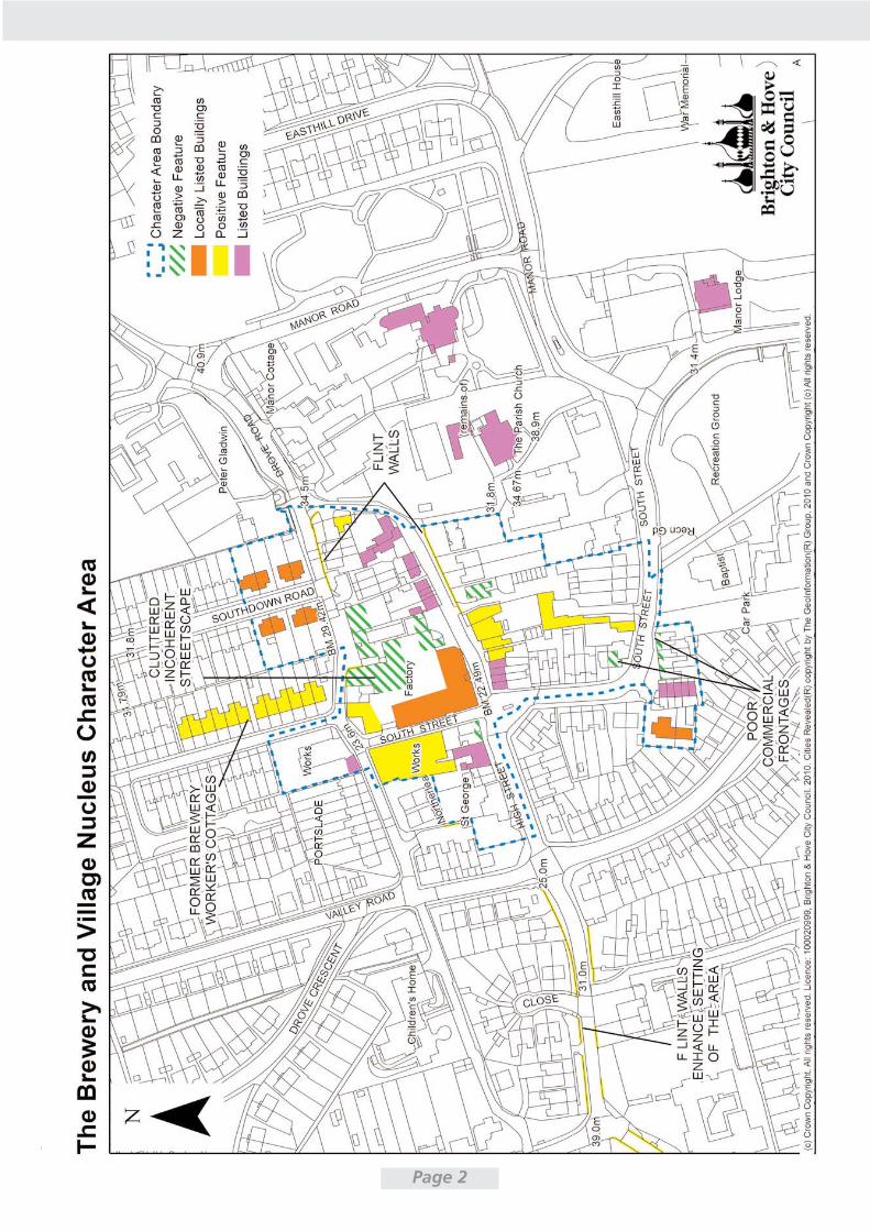
Amongst its heritage assets, the area contains 28 listed buildings, 7 locally listed buildings, a scheduledancient monument and an archaeologically sensitive area (see graphic on next page). It was designatedas a conservation area in 1974, at which point an appraisal was produced. A brief character statementwas produced in 1997.
A conservation area is defined as 'an area of special architectural or historic interest the character orappearance of which it is desirable to preserve or enhance'. This document seeks to define and assessthe 'special interest' of Portslade Old Village Conservation Area, and make recommendations for itsfuture management.
Assessment of Special Interest
General Character and Landscape Setting
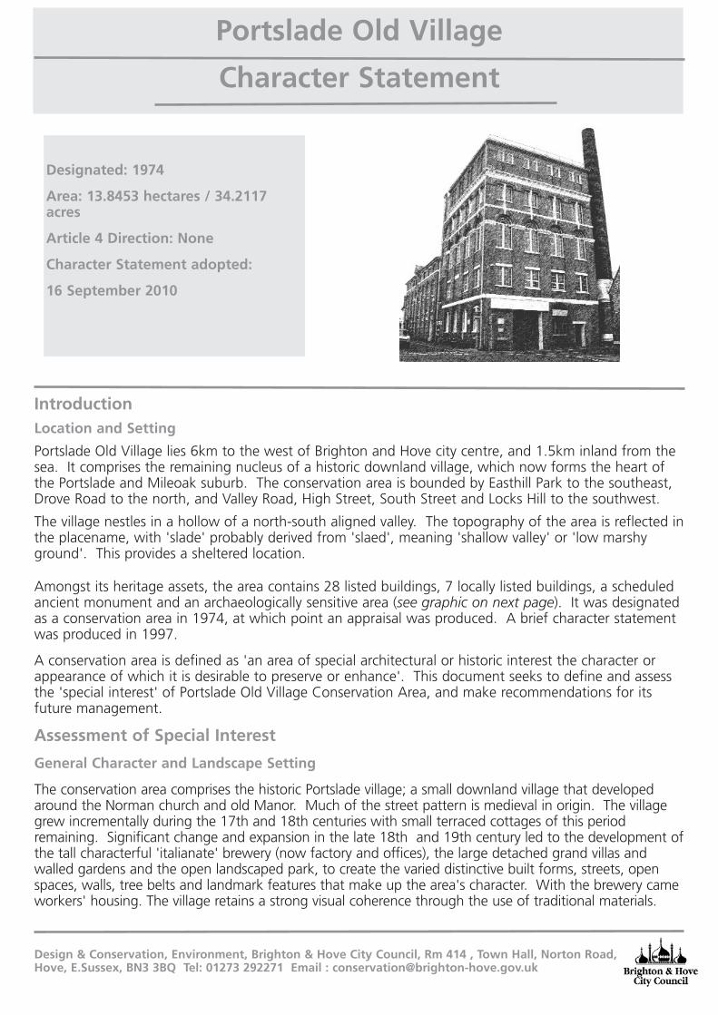
The conservation area comprises the historic Portslade village; a small downland village that developedaround the Norman church and old Manor. Much of the street pattern is medieval in origin. The villagegrew incrementally during the 17th and 18th centuries with small terraced cottages of this periodremaining. Significant change and expansion in the late 18th and 19th century led to the development ofthe tall characterful 'italianate' brewery (now factory and offices), the large detached grand villas andwalled gardens and the open landscaped park, to create the varied distinctive built forms, streets, openspaces, walls, tree belts and landmark features that make up the area's character. With the brewery cameworkers' housing. The village retains a strong visual coherence through the use of traditional materials.
Character Statement
Designated: 1974
Area: 13.8453 hectares / 34.2117acres
Article 4 Direction: None
Character Statement adopted:
16 September 2010
Portslade Old Village
Page 2
Historic Background and ArchaeologyThe origins and historic development of the area
The first documentary evidence for Portslade is the Domesday Book, where it is recorded as'Porteslamhe'. St Nicolas' Church was founded in around 1170, consisting at this time of a nave andsouth aisle. The tower was added in around 1250, and its crenellated top added in the late 14thcentury. Portslade Old Manor was built in the Norman period to the immediate north of the Church,with a further wing added in the early 17th century.
In 1312, John de Warenne, Lord of the Manor, was granted a charter by King Edward II to hold anannual Fair at Portslade on the 6th December. The village developed around the Church and ManorHouse throughout the medieval period and 16th century. Its economy was based on traditionaldownland sheep-corn husbandry.
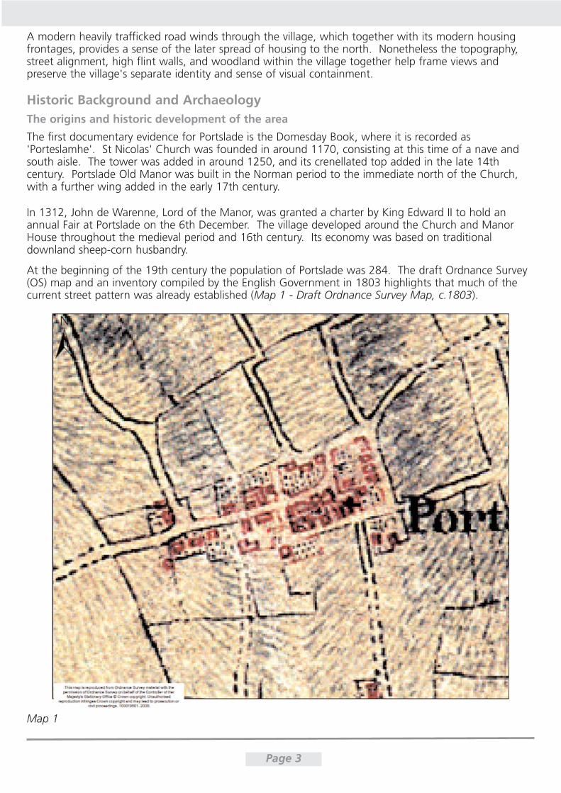
At the beginning of the 19th century the population of Portslade was 284. The draft Ordnance Survey(OS) map and an inventory compiled by the English Government in 1803 highlights that much of thecurrent street pattern was already established (Map 1 - Draft Ordnance Survey Map, c.1803).
Page 3
Map 1
A modern heavily trafficked road winds through the village, which together with its modern housingfrontages, provides a sense of the later spread of housing to the north. Nonetheless the topography,street alignment, high flint walls, and woodland within the village together help frame views andpreserve the village's separate identity and sense of visual containment.
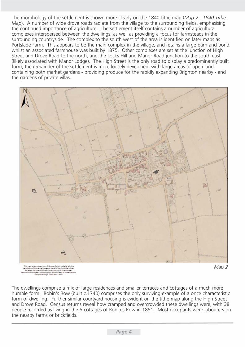
The morphology of the settlement is shown more clearly on the 1840 tithe map (Map 2 - 1840 TitheMap). A number of wide drove roads radiate from the village to the surrounding fields, emphasisingthe continued importance of agriculture. The settlement itself contains a number of agriculturalcomplexes interspersed between the dwellings, as well as providing a focus for farmsteads in thesurrounding countryside. The complex to the south west of the area is identified on later maps asPortslade Farm. This appears to be the main complex in the village, and retains a large barn and pond,whilst an associated farmhouse was built by 1875. Other complexes are set at the junction of HighStreet and Drove Road to the north, and the Locks Hill and Manor Road junction to the south east(likely associated with Manor Lodge). The High Street is the only road to display a predominantly builtform; the remainder of the settlement is more loosely developed, with large areas of open landcontaining both market gardens - providing produce for the rapidly expanding Brighton nearby - andthe gardens of private villas.
Page 4
The dwellings comprise a mix of large residences and smaller terraces and cottages of a much morehumble form. Robin's Row (built c.1740) comprises the only surviving example of a once characteristicform of dwelling. Further similar courtyard housing is evident on the tithe map along the High Streetand Drove Road. Census returns reveal how cramped and overcrowded these dwellings were, with 38people recorded as living in the 5 cottages of Robin's Row in 1851. Most occupants were labourers onthe nearby farms or brickfields.
Map 2
The large residences were built mostly in the late 18th and 19th centuries, alongside the farmhousesand labourers cottages. They suggest that the village became an increasingly desirable place to live atthis time. These included:
Portslade Lodge (1785), which is now known as Manor Lodge and has been converted to flats
Portslade House, which was built in 1790 for Nathanial Hall, located beyond the conservation area to the west, and is now demolished. Its grounds were located to both the north and south of theHigh Street, with a suspension bridge providing access between the two. This, and the surviving flintwalls along the High Street, formed a characterful feature in the area.
A new Portslade Manor (1807 for the Borrer family), which replaced the Norman Old Manor.
Easthill House (1848 for Edward Blaker), which comprised the enlargement of an older building.
15 South Street and 21a Windlesham Close, which are first evident on the 1st edition OrdnanceSurvey map (c.1875) and comprise the farmhouse to Portslade Farm. The building was later used briefly as a school.
Whychote (1895), which was built for Herbert Mews on the site of an earlier building. It waspurchased by Andrew Melville, owner of Brighton's Grand Theatre, in 1928.
Loxdale, which lies beyond the conservation area to the south, was built in 1899 for Walter Mews,by local architect Samuel Denman.
In c.1850, John Dudney established a brewery in the village. This was situated at the corner of DroveRoad and South Street, on land formerly comprising a house and yards. Following the repeal of theMalt Tax in 1880, Dudney set about building an expansive new purpose-built brewery. This causedmajor change to the character of the village, with a striking new classical building constructed at itsheart. The brewery replaced a stable, barn and cottage, with a spring also identified on this land on the1840 tithe map. The existence of a spring is probably a key reason for siting the brewery in thislocation. By 1882 the brewery was producing 1000 barrels of Southdown Ale per week. Dudney soldthe brewery to brothers Walter and Herbert Mews in 1884, who were probably responsible for theconstruction of workers housing on the present North Road and Southdown Road soon after. Thisgroup of buildings represents the first significant housing development outside the historic village coreand is of interest both to the history of the brewery and the development of the village as a whole. By1890, brewery production had increased to 1500 barrels of Southdown Ale per week. In 1919 thebuilding was sold to Kemp Town Brewery, who sold it on to Smithers & Sons Ltd of Brighton. Smithersextended the building by a further storey, allowing them to close their North Street Brewery in Brighton,move all production to Portslade and enable redevelopment of the Brighton brewery site. In the mid tolate 20th century, expansion of the site to the east required the demolition of cottages fronting the HighStreet. The brewery had been converted to manufacturing by the start of World War II, and theengineering company Le Carbone took over the premises in 1947.
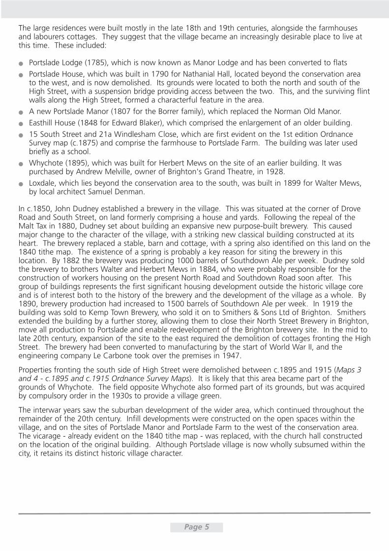
Properties fronting the south side of High Street were demolished between c.1895 and 1915 (Maps 3and 4 - c.1895 and c.1915 Ordnance Survey Maps). It is likely that this area became part of thegrounds of Whychote. The field opposite Whychote also formed part of its grounds, but was acquiredby compulsory order in the 1930s to provide a village green.
The interwar years saw the suburban development of the wider area, which continued throughout theremainder of the 20th century. Infill developments were constructed on the open spaces within thevillage, and on the sites of Portslade Manor and Portslade Farm to the west of the conservation area.The vicarage - already evident on the 1840 tithe map - was replaced, with the church hall constructedon the location of the original building. Although Portslade village is now wholly subsumed within thecity, it retains its distinct historic village character.
Page 5
Page 6
Map 3
Map 4
Archaeological significance
Portslade is located on the prehistoric thoroughfare which passes through the downs at Saddlescombeto the coast at Southwick via Hangleton. In Portslade, the route follows Drove Road, where it forms ahollow way; evident as steep banks to either side of the road.
The ruins of the Old Manor house are designated as a Scheduled Ancient Monument, with anarchaeologically sensitive area (ASA) covering the surrounding area. The original Norman Manor housewould have been formed of two wings, of which only one survives above ground. Evidence for afurther cross-wing or detached chamber is likely to survive below ground to the east of the extantremains. A wall was excavated within the Emmaus grounds in 2006, to the north of the Old Manor. Itis likely to be contemporary with the ruins, as it follows the same alignment.
Page 7
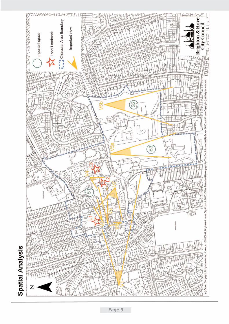
Spatial Analysis (see graphic on page 9)
The area retains clearly defined plot boundaries through high walls, mature vegetation lining roads, andcottages fronting directly on to the street. The curvature and narrow width of many roads foreshortensviews. These factors combine to create a strong sense of enclosure and place throughout the area, andrestrict permeation to certain key routes.
The area provides large areas of public and private green space. The private space comprises gardens tothe large residences with dense mature vegetation, which contribute to the green character of the area.Significant public green spaces exist (including The Green, Easthill Park, the churchyard and the greenbanks along Drove Road and at key junctions). Their open aspect contrasts with the clear overarchingsense of enclosure throughout the remaining area.
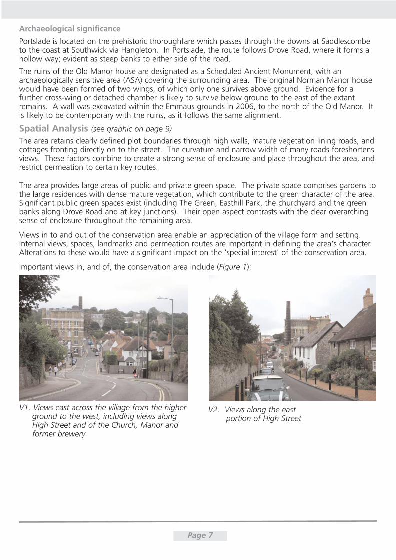
Views in to and out of the conservation area enable an appreciation of the village form and setting.Internal views, spaces, landmarks and permeation routes are important in defining the area's character.Alterations to these would have a significant impact on the 'special interest' of the conservation area.
Important views in, and of, the conservation area include (Figure 1):
V1. Views east across the village from the higherground to the west, including views along High Street and of the Church, Manor and former brewery
V2. Views along the eastportion of High Street
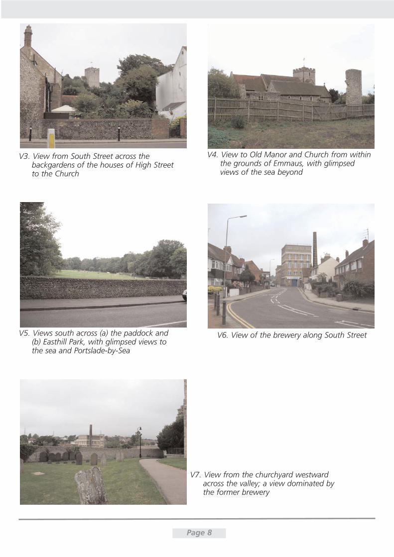
Page 8
V3. View from South Street across the backgardens of the houses of High Street to the Church
V4. View to Old Manor and Church from withinthe grounds of Emmaus, with glimpsedviews of the sea beyond
V5. Views south across (a) the paddock and(b) Easthill Park, with glimpsed views to the sea and Portslade-by-Sea
V6. View of the brewery along South Street
V7. View from the churchyard westwardacross the valley; a view dominated by the former brewery
Page 9
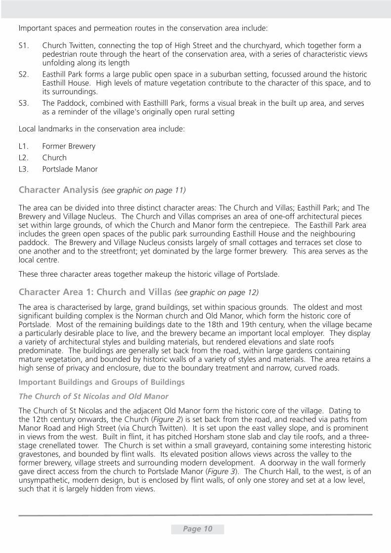
Important spaces and permeation routes in the conservation area include:
S1. Church Twitten, connecting the top of High Street and the churchyard, which together form apedestrian route through the heart of the conservation area, with a series of characteristic viewsunfolding along its length
S2. Easthill Park forms a large public open space in a suburban setting, focussed around the historicEasthill House. High levels of mature vegetation contribute to the character of this space, and toits surroundings.
S3. The Paddock, combined with Easthilll Park, forms a visual break in the built up area, and servesas a reminder of the village's originally open rural setting
Local landmarks in the conservation area include:
L1. Former Brewery
L2. Church
L3. Portslade Manor
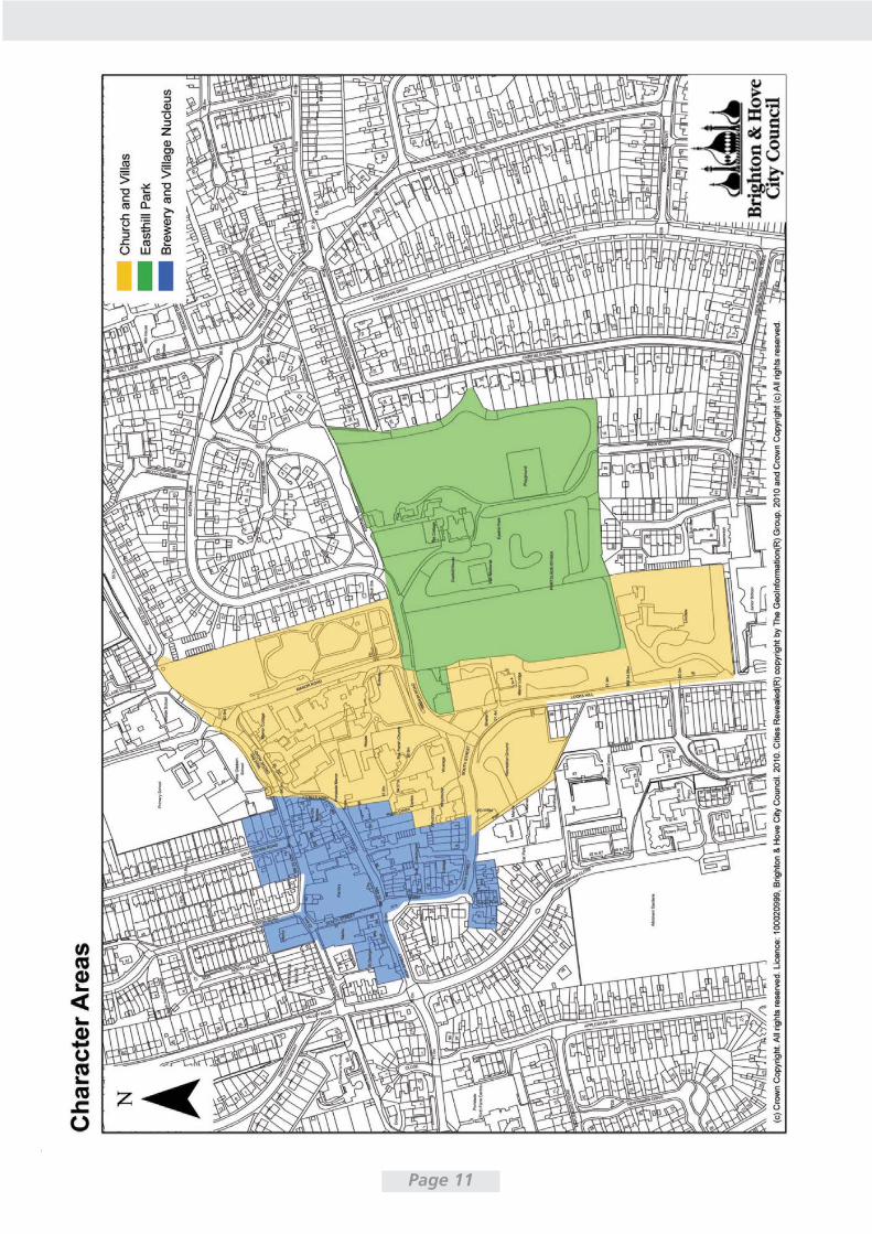
Character Analysis (see graphic on page 11)
The area can be divided into three distinct character areas: The Church and Villas; Easthill Park; and TheBrewery and Village Nucleus. The Church and Villas comprises an area of one-off architectural piecesset within large grounds, of which the Church and Manor form the centrepiece. The Easthill Park areaincludes the green open spaces of the public park surrounding Easthill House and the neighbouringpaddock. The Brewery and Village Nucleus consists largely of small cottages and terraces set close toone another and to the streetfront; yet dominated by the large former brewery. This area serves as thelocal centre.
These three character areas together makeup the historic village of Portslade.
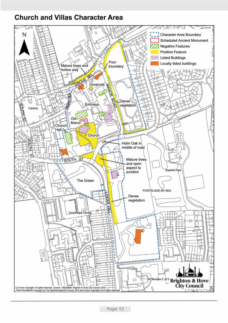
Character Area 1: Church and Villas (see graphic on page 12)
The area is characterised by large, grand buildings, set within spacious grounds. The oldest and mostsignificant building complex is the Norman church and Old Manor, which form the historic core ofPortslade. Most of the remaining buildings date to the 18th and 19th century, when the village becamea particularly desirable place to live, and the brewery became an important local employer. They displaya variety of architectural styles and building materials, but rendered elevations and slate roofspredominate. The buildings are generally set back from the road, within large gardens containingmature vegetation, and bounded by historic walls of a variety of styles and materials. The area retains ahigh sense of privacy and enclosure, due to the boundary treatment and narrow, curved roads.
Important Buildings and Groups of Buildings
The Church of St Nicolas and Old Manor
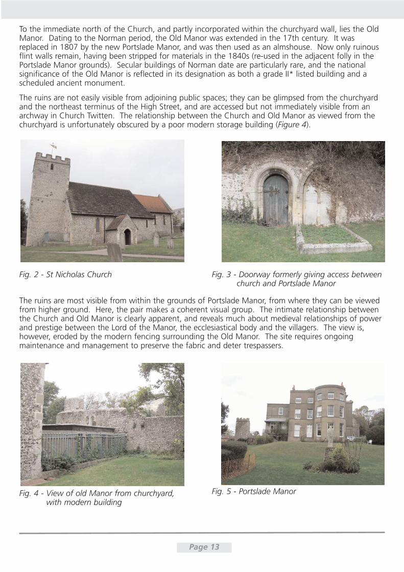
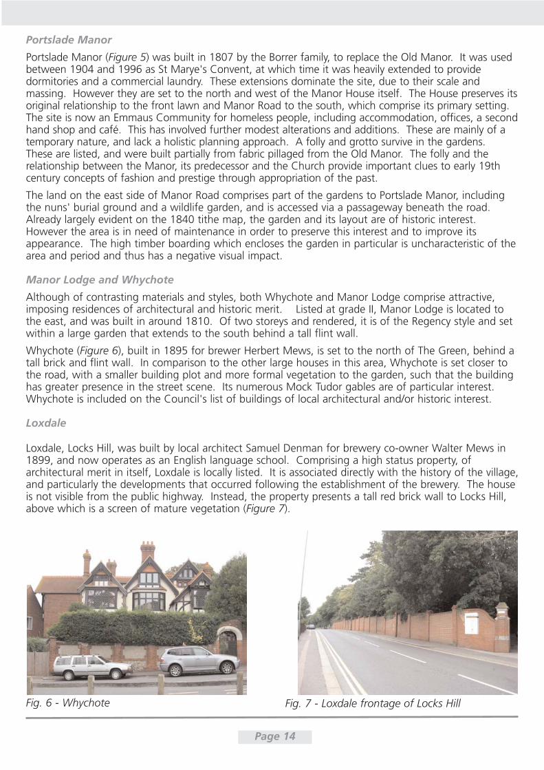
The Church of St Nicolas and the adjacent Old Manor form the historic core of the village. Dating tothe 12th century onwards, the Church (Figure 2) is set back from the road, and reached via paths fromManor Road and High Street (via Church Twitten). It is set upon the east valley slope, and is prominentin views from the west. Built in flint, it has pitched Horsham stone slab and clay tile roofs, and a three-stage crenellated tower. The Church is set within a small graveyard, containing some interesting historicgravestones, and bounded by flint walls. Its elevated position allows views across the valley to theformer brewery, village streets and surrounding modern development. A doorway in the wall formerlygave direct access from the church to Portslade Manor (Figure 3). The Church Hall, to the west, is of anunsympathetic, modern design, but is enclosed by flint walls, of only one storey and set at a low level,such that it is largely hidden from views.
Page 10
Page 11
Page 12
To the immediate north of the Church, and partly incorporated within the churchyard wall, lies the OldManor. Dating to the Norman period, the Old Manor was extended in the 17th century. It wasreplaced in 1807 by the new Portslade Manor, and was then used as an almshouse. Now only ruinousflint walls remain, having been stripped for materials in the 1840s (re-used in the adjacent folly in thePortslade Manor grounds). Secular buildings of Norman date are particularly rare, and the nationalsignificance of the Old Manor is reflected in its designation as both a grade II* listed building and ascheduled ancient monument.
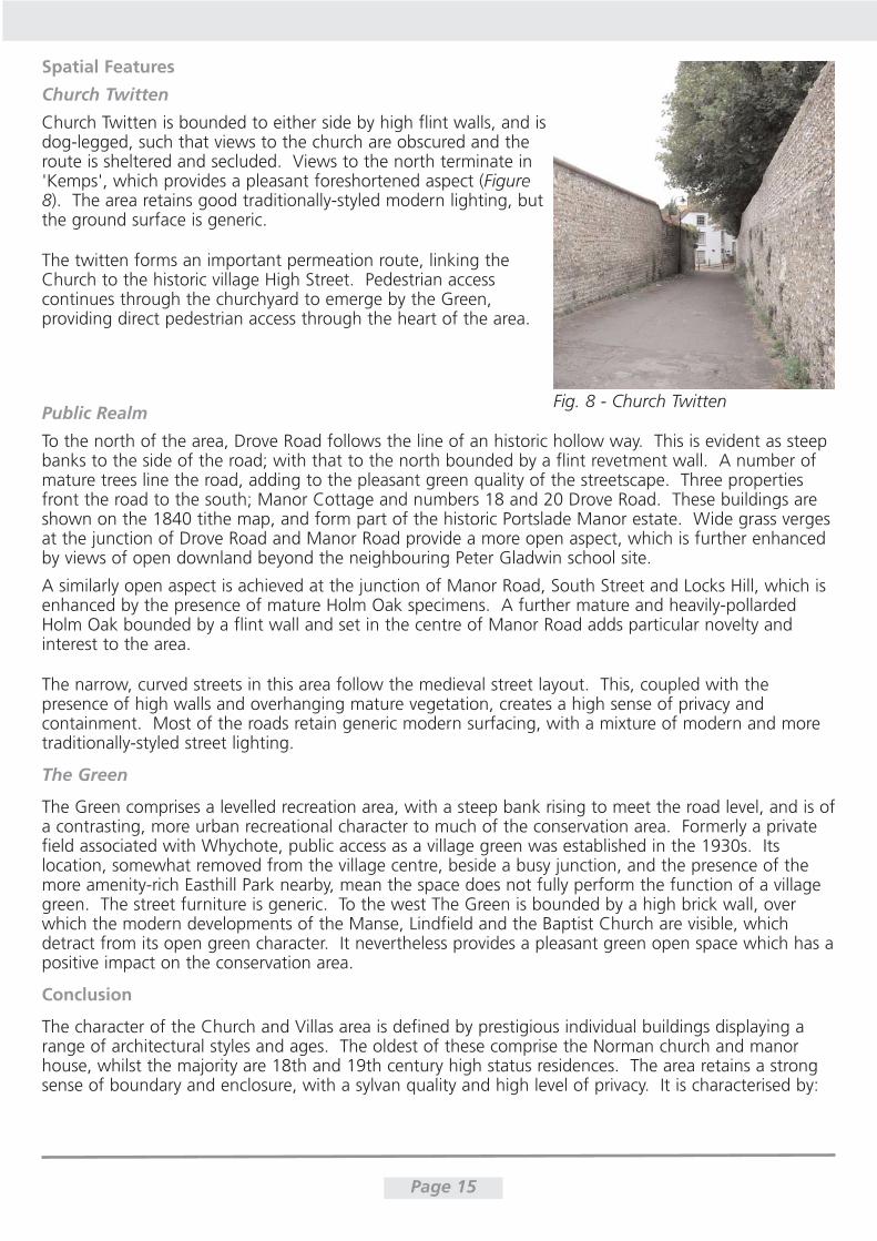
The ruins are not easily visible from adjoining public spaces; they can be glimpsed from the churchyardand the northeast terminus of the High Street, and are accessed but not immediately visible from anarchway in Church Twitten. The relationship between the Church and Old Manor as viewed from thechurchyard is unfortunately obscured by a poor modern storage building (Figure 4).
Page 13
Fig. 2 - St Nicholas Church Fig. 3 - Doorway formerly giving access betweenchurch and Portslade Manor
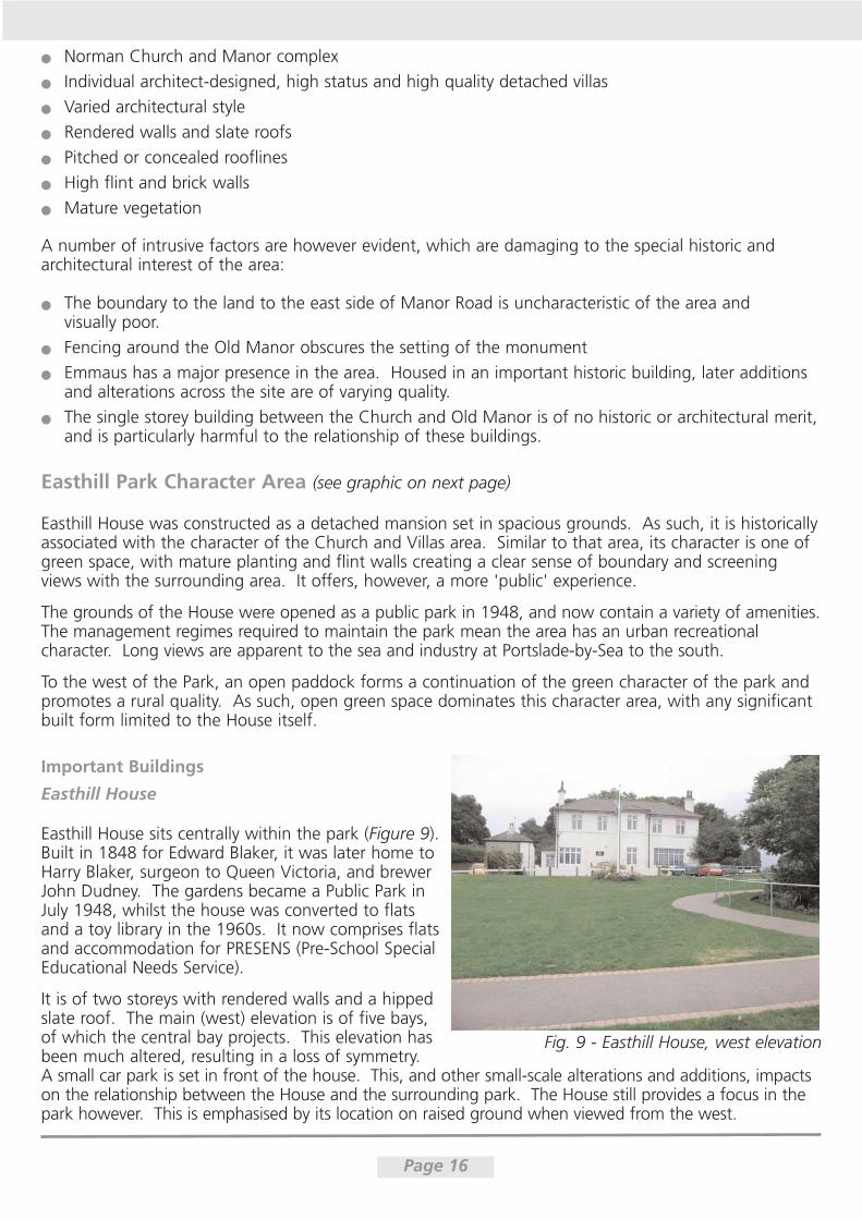
Fig. 5 - Portslade Manor
The ruins are most visible from within the grounds of Portslade Manor, from where they can be viewedfrom higher ground. Here, the pair makes a coherent visual group. The intimate relationship betweenthe Church and Old Manor is clearly apparent, and reveals much about medieval relationships of powerand prestige between the Lord of the Manor, the ecclesiastical body and the villagers. The view is,however, eroded by the modern fencing surrounding the Old Manor. The site requires ongoingmaintenance and management to preserve the fabric and deter trespassers.
Fig. 4 - View of old Manor from churchyard, with modern building
Page 14
Portslade Manor
Portslade Manor (Figure 5) was built in 1807 by the Borrer family, to replace the Old Manor. It was usedbetween 1904 and 1996 as St Marye's Convent, at which time it was heavily extended to providedormitories and a commercial laundry. These extensions dominate the site, due to their scale andmassing. However they are set to the north and west of the Manor House itself. The House preserves itsoriginal relationship to the front lawn and Manor Road to the south, which comprise its primary setting.The site is now an Emmaus Community for homeless people, including accommodation, offices, a secondhand shop and café. This has involved further modest alterations and additions. These are mainly of atemporary nature, and lack a holistic planning approach. A folly and grotto survive in the gardens.These are listed, and were built partially from fabric pillaged from the Old Manor. The folly and therelationship between the Manor, its predecessor and the Church provide important clues to early 19thcentury concepts of fashion and prestige through appropriation of the past.
The land on the east side of Manor Road comprises part of the gardens to Portslade Manor, includingthe nuns' burial ground and a wildlife garden, and is accessed via a passageway beneath the road.Already largely evident on the 1840 tithe map, the garden and its layout are of historic interest.However the area is in need of maintenance in order to preserve this interest and to improve itsappearance. The high timber boarding which encloses the garden in particular is uncharacteristic of thearea and period and thus has a negative visual impact.
Manor Lodge and Whychote
Although of contrasting materials and styles, both Whychote and Manor Lodge comprise attractive,imposing residences of architectural and historic merit. Listed at grade II, Manor Lodge is located tothe east, and was built in around 1810. Of two storeys and rendered, it is of the Regency style and setwithin a large garden that extends to the south behind a tall flint wall.
Whychote (Figure 6), built in 1895 for brewer Herbert Mews, is set to the north of The Green, behind atall brick and flint wall. In comparison to the other large houses in this area, Whychote is set closer tothe road, with a smaller building plot and more formal vegetation to the garden, such that the buildinghas greater presence in the street scene. Its numerous Mock Tudor gables are of particular interest.Whychote is included on the Council's list of buildings of local architectural and/or historic interest.
Loxdale
Loxdale, Locks Hill, was built by local architect Samuel Denman for brewery co-owner Walter Mews in1899, and now operates as an English language school. Comprising a high status property, ofarchitectural merit in itself, Loxdale is locally listed. It is associated directly with the history of the village,and particularly the developments that occurred following the establishment of the brewery. The houseis not visible from the public highway. Instead, the property presents a tall red brick wall to Locks Hill,above which is a screen of mature vegetation (Figure 7).
Fig. 7 - Loxdale frontage of Locks HillFig. 6 - Whychote
Spatial Features
Church Twitten
Church Twitten is bounded to either side by high flint walls, and isdog-legged, such that views to the church are obscured and theroute is sheltered and secluded. Views to the north terminate in'Kemps', which provides a pleasant foreshortened aspect (Figure8). The area retains good traditionally-styled modern lighting, butthe ground surface is generic.
The twitten forms an important permeation route, linking theChurch to the historic village High Street. Pedestrian accesscontinues through the churchyard to emerge by the Green,providing direct pedestrian access through the heart of the area.
Public Realm
To the north of the area, Drove Road follows the line of an historic hollow way. This is evident as steepbanks to the side of the road; with that to the north bounded by a flint revetment wall. A number ofmature trees line the road, adding to the pleasant green quality of the streetscape. Three propertiesfront the road to the south; Manor Cottage and numbers 18 and 20 Drove Road. These buildings areshown on the 1840 tithe map, and form part of the historic Portslade Manor estate. Wide grass vergesat the junction of Drove Road and Manor Road provide a more open aspect, which is further enhancedby views of open downland beyond the neighbouring Peter Gladwin school site.
A similarly open aspect is achieved at the junction of Manor Road, South Street and Locks Hill, which isenhanced by the presence of mature Holm Oak specimens. A further mature and heavily-pollardedHolm Oak bounded by a flint wall and set in the centre of Manor Road adds particular novelty andinterest to the area.
The narrow, curved streets in this area follow the medieval street layout. This, coupled with thepresence of high walls and overhanging mature vegetation, creates a high sense of privacy andcontainment. Most of the roads retain generic modern surfacing, with a mixture of modern and moretraditionally-styled street lighting.
The Green
The Green comprises a levelled recreation area, with a steep bank rising to meet the road level, and is ofa contrasting, more urban recreational character to much of the conservation area. Formerly a privatefield associated with Whychote, public access as a village green was established in the 1930s. Itslocation, somewhat removed from the village centre, beside a busy junction, and the presence of themore amenity-rich Easthill Park nearby, mean the space does not fully perform the function of a villagegreen. The street furniture is generic. To the west The Green is bounded by a high brick wall, overwhich the modern developments of the Manse, Lindfield and the Baptist Church are visible, whichdetract from its open green character. It nevertheless provides a pleasant green open space which has apositive impact on the conservation area.
Conclusion
The character of the Church and Villas area is defined by prestigious individual buildings displaying arange of architectural styles and ages. The oldest of these comprise the Norman church and manorhouse, whilst the majority are 18th and 19th century high status residences. The area retains a strongsense of boundary and enclosure, with a sylvan quality and high level of privacy. It is characterised by:
Page 15
Fig. 8 - Church Twitten
Norman Church and Manor complex
Individual architect-designed, high status and high quality detached villas
Varied architectural style
Rendered walls and slate roofs
Pitched or concealed rooflines
High flint and brick walls
Mature vegetation
A number of intrusive factors are however evident, which are damaging to the special historic andarchitectural interest of the area:
The boundary to the land to the east side of Manor Road is uncharacteristic of the area and visually poor.
Fencing around the Old Manor obscures the setting of the monument
Emmaus has a major presence in the area. Housed in an important historic building, later additionsand alterations across the site are of varying quality.
The single storey building between the Church and Old Manor is of no historic or architectural merit,and is particularly harmful to the relationship of these buildings.
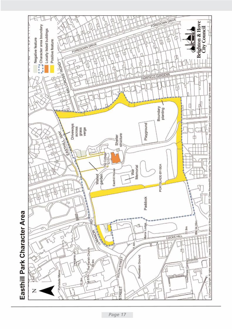
Easthill Park Character Area (see graphic on next page)
Easthill House was constructed as a detached mansion set in spacious grounds. As such, it is historicallyassociated with the character of the Church and Villas area. Similar to that area, its character is one ofgreen space, with mature planting and flint walls creating a clear sense of boundary and screeningviews with the surrounding area. It offers, however, a more 'public' experience.
The grounds of the House were opened as a public park in 1948, and now contain a variety of amenities.The management regimes required to maintain the park mean the area has an urban recreationalcharacter. Long views are apparent to the sea and industry at Portslade-by-Sea to the south.
To the west of the Park, an open paddock forms a continuation of the green character of the park andpromotes a rural quality. As such, open green space dominates this character area, with any significantbuilt form limited to the House itself.
Important Buildings
Easthill House
Easthill House sits centrally within the park (Figure 9).Built in 1848 for Edward Blaker, it was later home toHarry Blaker, surgeon to Queen Victoria, and brewerJohn Dudney. The gardens became a Public Park inJuly 1948, whilst the house was converted to flatsand a toy library in the 1960s. It now comprises flatsand accommodation for PRESENS (Pre-School SpecialEducational Needs Service).
It is of two storeys with rendered walls and a hippedslate roof. The main (west) elevation is of five bays,of which the central bay projects. This elevation hasbeen much altered, resulting in a loss of symmetry. A small car park is set in front of the house. This, and other small-scale alterations and additions, impactson the relationship between the House and the surrounding park. The House still provides a focus in thepark however. This is emphasised by its location on raised ground when viewed from the west.
Page 16
Fig. 9 - Easthill House, west elevation
Page 17
Page 18
A number of associated buildings are set to the north and east,including a flint-walled building with decorative bargeboards and asmall shelter probably associated with the football pitch, which areof mixed age and quality. The buildings are lower in height thanEasthill House, and barely visible from the park.
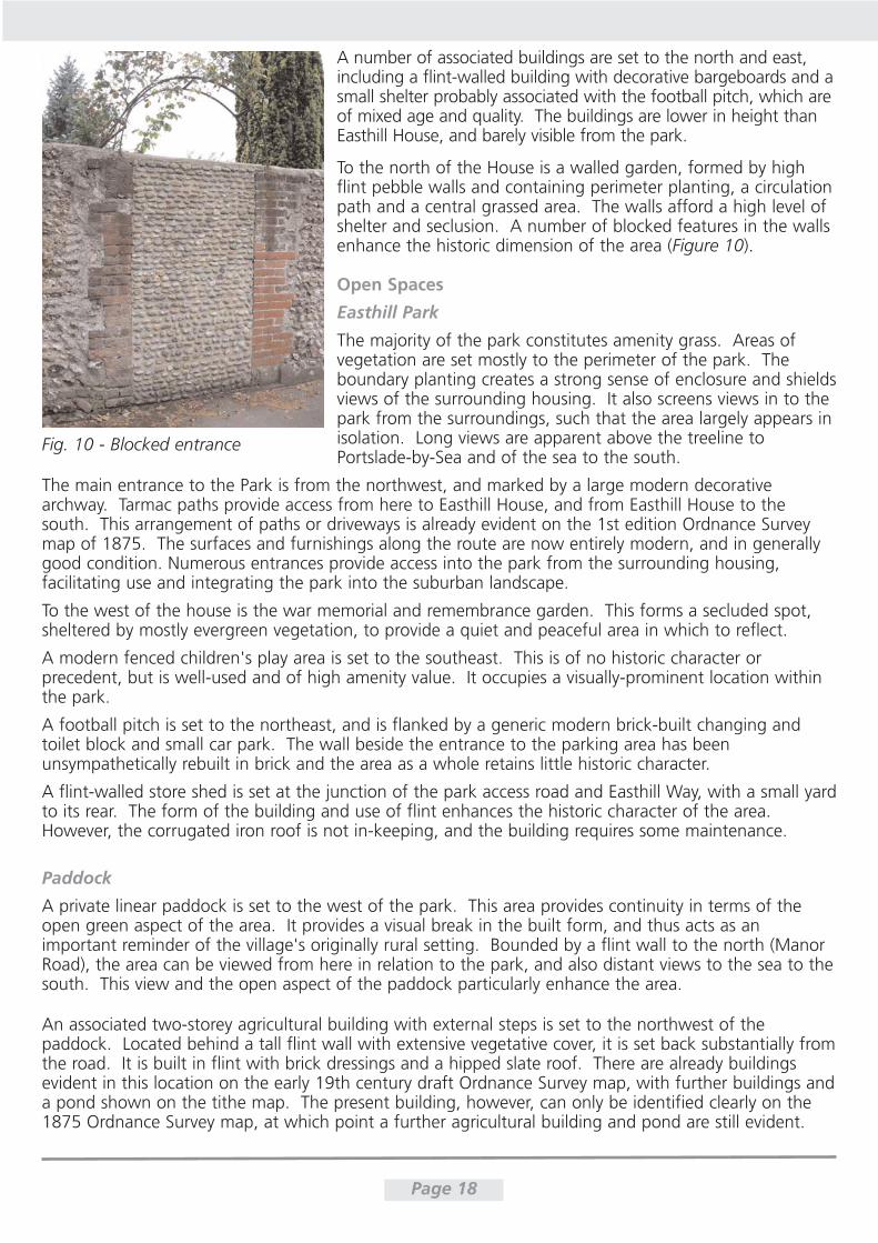
To the north of the House is a walled garden, formed by highflint pebble walls and containing perimeter planting, a circulationpath and a central grassed area. The walls afford a high level ofshelter and seclusion. A number of blocked features in the wallsenhance the historic dimension of the area (Figure 10).
Open Spaces
Easthill Park
The majority of the park constitutes amenity grass. Areas ofvegetation are set mostly to the perimeter of the park. Theboundary planting creates a strong sense of enclosure and shieldsviews of the surrounding housing. It also screens views in to thepark from the surroundings, such that the area largely appears inisolation. Long views are apparent above the treeline toPortslade-by-Sea and of the sea to the south.
The main entrance to the Park is from the northwest, and marked by a large modern decorativearchway. Tarmac paths provide access from here to Easthill House, and from Easthill House to thesouth. This arrangement of paths or driveways is already evident on the 1st edition Ordnance Surveymap of 1875. The surfaces and furnishings along the route are now entirely modern, and in generallygood condition. Numerous entrances provide access into the park from the surrounding housing,facilitating use and integrating the park into the suburban landscape.
To the west of the house is the war memorial and remembrance garden. This forms a secluded spot,sheltered by mostly evergreen vegetation, to provide a quiet and peaceful area in which to reflect.
A modern fenced children's play area is set to the southeast. This is of no historic character orprecedent, but is well-used and of high amenity value. It occupies a visually-prominent location withinthe park.
A football pitch is set to the northeast, and is flanked by a generic modern brick-built changing andtoilet block and small car park. The wall beside the entrance to the parking area has beenunsympathetically rebuilt in brick and the area as a whole retains little historic character.
A flint-walled store shed is set at the junction of the park access road and Easthill Way, with a small yardto its rear. The form of the building and use of flint enhances the historic character of the area.However, the corrugated iron roof is not in-keeping, and the building requires some maintenance.
Paddock
A private linear paddock is set to the west of the park. This area provides continuity in terms of theopen green aspect of the area. It provides a visual break in the built form, and thus acts as animportant reminder of the village's originally rural setting. Bounded by a flint wall to the north (ManorRoad), the area can be viewed from here in relation to the park, and also distant views to the sea to thesouth. This view and the open aspect of the paddock particularly enhance the area.
An associated two-storey agricultural building with external steps is set to the northwest of thepaddock. Located behind a tall flint wall with extensive vegetative cover, it is set back substantially fromthe road. It is built in flint with brick dressings and a hipped slate roof. There are already buildingsevident in this location on the early 19th century draft Ordnance Survey map, with further buildings anda pond shown on the tithe map. The present building, however, can only be identified clearly on the1875 Ordnance Survey map, at which point a further agricultural building and pond are still evident.
Fig. 10 - Blocked entrance
It is now one of very few agricultural buildings to survive in the conservation area; which were once acommon sight and central to the village's economic base. The building and particularly its settingrequires some maintenance.
Conclusion
The Easthill Park area presents an urban recreational parkland character. The historic Easthill House isprominent from the entrance to the park and the west especially. Boundary treatment, includingmature vegetation, visually dislocates the area from its surroundings, creating a sense of seclusion. Thearea is characterised by:
Open green space and mature vegetation
High number of amenities
Flint boundary walls
Easthill House as an isolated and elevated landmark building
Sense of self-containment
Long views to Portslade-by-Sea and the sea to the south
Paddock acts as reminder of the village's originally rural setting
These contribute to the special historic interest of the area; however, a number of intrusive elements aredamaging to its character and appearance:
The boundary walls are of mixed quality. The more prominent walls are of flint, other parts are ofpoor quality materials and/or design
Structures and the area associated with the football pitch do not preserve the historic landscape character of the area.
The Brewery and Village Nucleus Character Area (see graphic on next page)
In contrast to the other character areas, the Brewery and Village Nucleus displays a much finer anddenser urban grain, with varied semi-detached and terraced houses set close to one another. Thecharacter of the area derives from the contrast between the large industrial scale of the brewerybuilding, and the surrounding small-scale cottages and shops. This juxtaposition reflects the radicalchange in character that the construction of the brewery would have brought to the village in the late19th century - physically, visually, and also in terms of the secondaryimpacts on the village's economy and subsequent development.The steep east portion of the High Street preserves the image of aquintessential rural village street. The area retains a mixture ofresidential, commercial and light industrial property.
Streetscapes
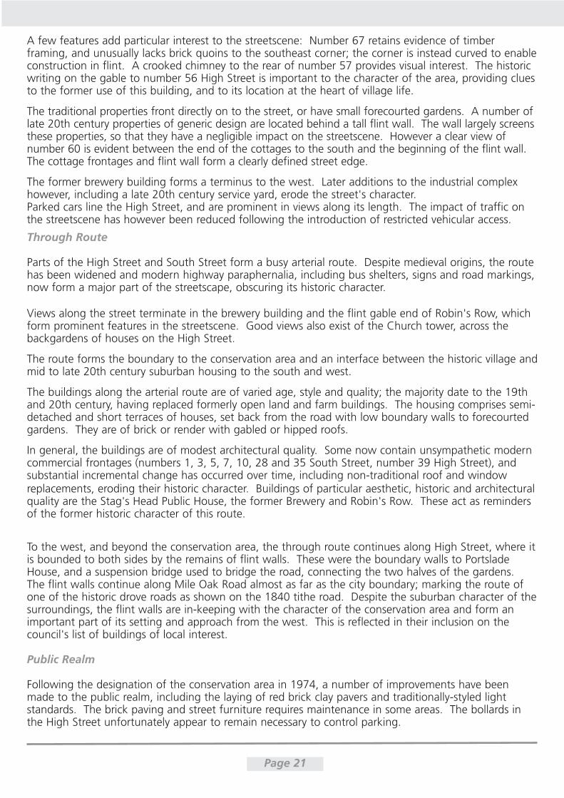
High Street
The steep and narrow east part of the High Street is particularlycharacterful; lined with small vernacular cottages, and with pleasantunfolding views along its length (Figure 11). The street preservesthe intimate character of the medieval street layout. The cottagesdisplay a variety of architectural styles, but are primarily of twostoreys with pitched clay-tile roofs.
The earlier buildings are generally either faced in flint or rendered. Therendered buildings along the south side of the High Street, oppositethe former brewery, are more altered and variable in architecturalquality, yet still contribute to the character of the streetscape.
Page 19
fig. 11 - View along High Street

Page 20
A few features add particular interest to the streetscene: Number 67 retains evidence of timberframing, and unusually lacks brick quoins to the southeast corner; the corner is instead curved to enableconstruction in flint. A crooked chimney to the rear of number 57 provides visual interest. The historicwriting on the gable to number 56 High Street is important to the character of the area, providing cluesto the former use of this building, and to its location at the heart of village life.
The traditional properties front directly on to the street, or have small forecourted gardens. A number oflate 20th century properties of generic design are located behind a tall flint wall. The wall largely screensthese properties, so that they have a negligible impact on the streetscene. However a clear view ofnumber 60 is evident between the end of the cottages to the south and the beginning of the flint wall.The cottage frontages and flint wall form a clearly defined street edge.
The former brewery building forms a terminus to the west. Later additions to the industrial complexhowever, including a late 20th century service yard, erode the street's character. Parked cars line the High Street, and are prominent in views along its length. The impact of traffic onthe streetscene has however been reduced following the introduction of restricted vehicular access.
Page 21
Through Route
Parts of the High Street and South Street form a busy arterial route. Despite medieval origins, the routehas been widened and modern highway paraphernalia, including bus shelters, signs and road markings,now form a major part of the streetscape, obscuring its historic character.
Views along the street terminate in the brewery building and the flint gable end of Robin's Row, whichform prominent features in the streetscene. Good views also exist of the Church tower, across thebackgardens of houses on the High Street.
The route forms the boundary to the conservation area and an interface between the historic village andmid to late 20th century suburban housing to the south and west.
The buildings along the arterial route are of varied age, style and quality; the majority date to the 19thand 20th century, having replaced formerly open land and farm buildings. The housing comprises semi-detached and short terraces of houses, set back from the road with low boundary walls to forecourtedgardens. They are of brick or render with gabled or hipped roofs.
In general, the buildings are of modest architectural quality. Some now contain unsympathetic moderncommercial frontages (numbers 1, 3, 5, 7, 10, 28 and 35 South Street, number 39 High Street), andsubstantial incremental change has occurred over time, including non-traditional roof and windowreplacements, eroding their historic character. Buildings of particular aesthetic, historic and architecturalquality are the Stag's Head Public House, the former Brewery and Robin's Row. These act as remindersof the former historic character of this route.
To the west, and beyond the conservation area, the through route continues along High Street, where itis bounded to both sides by the remains of flint walls. These were the boundary walls to PortsladeHouse, and a suspension bridge used to bridge the road, connecting the two halves of the gardens.The flint walls continue along Mile Oak Road almost as far as the city boundary; marking the route ofone of the historic drove roads as shown on the 1840 tithe road. Despite the suburban character of thesurroundings, the flint walls are in-keeping with the character of the conservation area and form animportant part of its setting and approach from the west. This is reflected in their inclusion on thecouncil's list of buildings of local interest.
Public Realm
Following the designation of the conservation area in 1974, a number of improvements have beenmade to the public realm, including the laying of red brick clay pavers and traditionally-styled lightstandards. The brick paving and street furniture requires maintenance in some areas. The bollards inthe High Street unfortunately appear to remain necessary to control parking.
Buildings and Groups of Buildings
Brewery and Malthouse
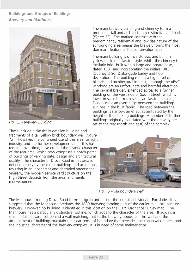
The main brewery building and chimney form aprominent tall and architecturally distinctive landmark(Figure 12). The marked contrast with thepredominantly residential and low rise nature of thesurrounding area means the brewery forms the mostdominant feature of the conservation area.
The main building is of five storeys, and built inyellow brick in a classical style, whilst the chimney issimilarly brick-built with a large and ornate base,dated 1881 and incorporating the initials 'D&S'(Dudney & Sons) alongside barley and hopdecoration. The building retains a high level ofhistoric and architectural interest, although the uPVCwindows are an unfortunate and harmful alteration.The original brewery extended across to a furtherbuilding on the west side of South Street, which islower in scale but retains similar classical detailing.Evidence for an overbridge between the buildingssurvives in the built fabric. The road between thebuildings is narrow; an effect accentuated by theheight of the flanking buildings. A number of furtherbuildings originally associated with the brewery areset to the rear (north and east) of the complex.
These include a classically-detailed building andfragments of a tall yellow brick boundary wall (Figure13). However, the continued use of this area for lightindustry, and the further developments that this hasrequired over time, have eroded the historic characterof the rear area, which now comprises a hotch-potchof buildings of varying date, design and architecturalquality. The character of Drove Road in this area isdefined largely by these rear buildings and accretions,resulting in an incoherent and degraded streetscape.Similarly, the modern service yard structure on theHigh Street detracts from the area, and meritsredevelopment.
The Malthouse fronting Drove Road forms a significant part of the industrial history of Portslade. It issuggested that the Malthouse predates the 1880 brewery; forming part of the earlier mid 19th centurybrewery. However, no building is identified in this location on the 1875 Ordnance Survey map. TheMalthouse has a particularly distinctive roofline, which adds to the character of the area. It adjoins asmall industrial yard, set behind a wall matching that to the brewery opposite. This wall and thearrangement of buildings maintain the clear sense of boundary that pervades the conservation area, andthe industrial character of the brewery complex. It is in need of some maintenance.
Page 22
Fig 12. - Brewery Building
Fig. 13 - Tall boundary wall
Page 23
1 to 8 Southdown Road
Numbers 1 to 8 (consecutive) Southdown Road and numbers 1 to 23 (odd) North Road comprise late19th and early 20th century housing, constructed for brewery workers. They represent the firstdevelopment outside the medieval village core, and are of historic importance due to their associationwith the brewery and historic development of the village. The housing on North Road comprises twoterraces forming 23 houses in total, whilst that on Southdown Road comprises four semi-detachedproperties. All the properties are of two storeys with pitched roofs, and set back from the road behinda front boundary wall. Original features common to all properties include brown brick elevations withred brick detailing, clay tile roofs, hung sash windows and decorative chimney pots.
The properties on Southdown Road are designated as locally listed buildings, and are larger and moreprestigious in design than those on North Road. They remain largely unaltered, and are of sufficientarchitectural and historic interest to merit inclusion in the area. The housing on North Road, however, hasbeen subject to a higher level of alteration such that they retain little architectural interest. They aretherefore not included within the conservation area, but form an important part of its historic development.
Robin's Row, South Street
Built in the 1740s, Robin's Row represents the last surviving example in the area of a formerlycharacteristic arrangement of dwellings. Set perpendicularly to the road, the terrace of five houses isbuilt in coursed field flint with a steeply-pitched gabled roof. The properties are well maintained andenhance the streetscape.
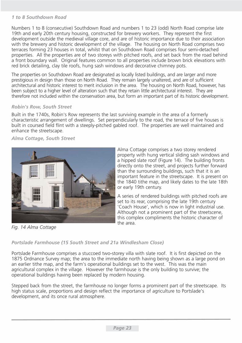
Alma Cottage, South Street
Alma Cottage comprises a two storey renderedproperty with hung vertical sliding sash windows anda hipped slate roof (Figure 14). The building frontsdirectly onto the street, and projects further forwardthan the surrounding buildings, such that it is animportant feature in the streetscape. It is present onthe 1840 tithe map, and likely dates to the late 18thor early 19th century.
A series of rendered buildings with pitched roofs areset to its rear, comprising the late 19th century'Coach House', which is now in light industrial use.Although not a prominent part of the streetscene,this complex compliments the historic character ofthe area.
Portslade Farmhouse (15 South Street and 21a Windlesham Close)
Portslade Farmhouse comprises a stuccoed two-storey villa with slate roof. It is first depicted on the1875 Ordnance Survey map; the area to the immediate north having being shown as a large pond onan earlier tithe map, and the farm's operational buildings set to the west. This was the mainagricultural complex in the village. However the farmhouse is the only building to survive; theoperational buildings having been replaced by modern housing.
Stepped back from the street, the farmhouse no longer forms a prominent part of the streetscape. Itshigh status scale, proportions and design reflect the importance of agriculture to Portslade'sdevelopment, and its once rural atmosphere.
Fig. 14 Alma Cottage
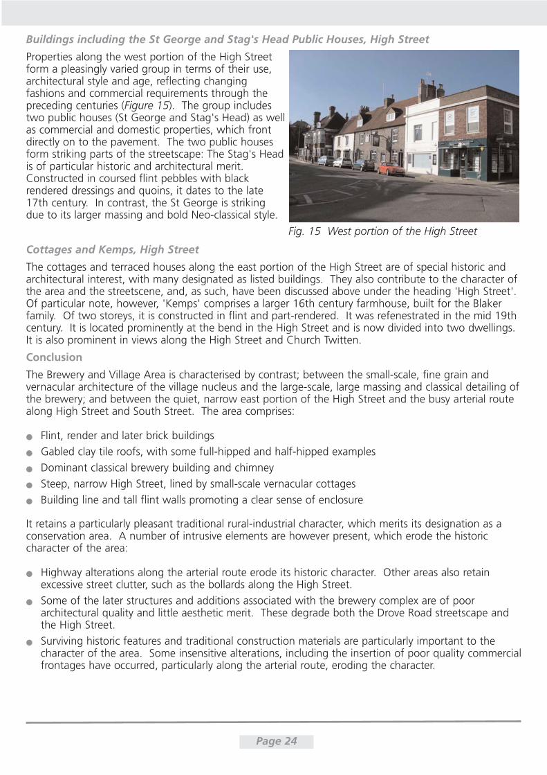
Buildings including the St George and Stag's Head Public Houses, High Street
Properties along the west portion of the High Streetform a pleasingly varied group in terms of their use,architectural style and age, reflecting changingfashions and commercial requirements through thepreceding centuries (Figure 15). The group includestwo public houses (St George and Stag's Head) as wellas commercial and domestic properties, which frontdirectly on to the pavement. The two public housesform striking parts of the streetscape: The Stag's Headis of particular historic and architectural merit.Constructed in coursed flint pebbles with blackrendered dressings and quoins, it dates to the late17th century. In contrast, the St George is strikingdue to its larger massing and bold Neo-classical style.
Cottages and Kemps, High Street
The cottages and terraced houses along the east portion of the High Street are of special historic andarchitectural interest, with many designated as listed buildings. They also contribute to the character ofthe area and the streetscene, and, as such, have been discussed above under the heading 'High Street'.Of particular note, however, 'Kemps' comprises a larger 16th century farmhouse, built for the Blakerfamily. Of two storeys, it is constructed in flint and part-rendered. It was refenestrated in the mid 19thcentury. It is located prominently at the bend in the High Street and is now divided into two dwellings.It is also prominent in views along the High Street and Church Twitten.
Conclusion
The Brewery and Village Area is characterised by contrast; between the small-scale, fine grain andvernacular architecture of the village nucleus and the large-scale, large massing and classical detailing ofthe brewery; and between the quiet, narrow east portion of the High Street and the busy arterial routealong High Street and South Street. The area comprises:
Flint, render and later brick buildings
Gabled clay tile roofs, with some full-hipped and half-hipped examples
Dominant classical brewery building and chimney
Steep, narrow High Street, lined by small-scale vernacular cottages
Building line and tall flint walls promoting a clear sense of enclosure
It retains a particularly pleasant traditional rural-industrial character, which merits its designation as aconservation area. A number of intrusive elements are however present, which erode the historiccharacter of the area:
Highway alterations along the arterial route erode its historic character. Other areas also retainexcessive street clutter, such as the bollards along the High Street.
Some of the later structures and additions associated with the brewery complex are of poorarchitectural quality and little aesthetic merit. These degrade both the Drove Road streetscape andthe High Street.
Surviving historic features and traditional construction materials are particularly important to thecharacter of the area. Some insensitive alterations, including the insertion of poor quality commercialfrontages have occurred, particularly along the arterial route, eroding the character.
Page 24
Fig. 15 West portion of the High Street
Special Interest of Portslade Old Village Conservation Area
Portslade Old Village comprises a traditional rural agricultural village, whose character was majorlyaltered in the 19th century by the construction of a brewery and a number of large, prestigiousresidences. At its centre lie the Church of St Nicolas and adjacent Old Manor, which date to the 12thcentury, and comprise the historic core of the village. The close relationship between the Church, OldManor and replacement Portslade Manor is particularly important, and reveals much about historicrelations of power and prestige.
The medieval street layout survives, and distinguishes the old village from the more orderly surroundingsuburban estate morphology. The varied building stock reflects the area's incremental development, butis unified by the use of traditional materials (flint, brick and render) to elevations and boundary walls,and steep gabled or hipped clay-tiled roofs to the cottages. The more prestigious villas have mainlyslate roofs. Tall flint walls and dense vegetation promote a clear sense of boundary and privacy.Similarly along the High Street the buildings and a tall wall define a hard edge to the road. ChurchTwitten allows pedestrian permeation through the heart of the area, and forms a significant spatialfeature. Public open space is provided in Easthill Park, which is visually self-contained. The paddockforms a visual break in the built form which acts as a reminder of the village's originally rural setting,and sets it apart from the surrounding suburban development.
The Brewery, Church and Portslade Manor form major landmarks in the area; of these the Brewery isespecially prominent. The village's location in a shallow valley provides good views across the area tothe brewery, church and High Street from the west, but limits views out to the suburban landscape,such that the area appears distinct from its surroundings.
Overall, Portslade Old Village Conservation Area retains a traditional rural-industrial village character.
Policy and Proposals
An Article 4(1) Direction under the Town and Country Planning (General Permitted Development) Order1995 is recommended to remove permitted development rights for unlisted single dwelling houses inthe area. This will help to prevent incremental change and the degradation of the special interest of thearea as a whole. Reinstatement of historic features should be encouraged when opportunities arise.
The proposed direction would affect the following properties in the conservation area:
Drove Road; Manor Cottage, 18, 20, 30-34 (even), 1-3 The Old Riding Stables
Southdown Road; 1-8 (if extension of the area is approved)
High Street; 31-33 (odd) 52-66 (even), 75
South Street; 2-8, 12-26 (even), 9 and 15 (odd), Alma Cottage, Whychote, Vicarage
Windlesham Close; 21a
Flint walls make a major contribution to the special character of the conservation area and merit aprogramme of maintenance, repair and reinstatement, in accordance with best 'traditional' practice.The wall round the Portslade Manor gardens, to the east of Manor Road in particular meritsreinstatement. Figure 16 shows some of the different types of flintwork visible in the conservation area.This subtle variety is important to the character of the area, and should be carefully matched in repairs.Possibilities for introducing a grant scheme for historic building repair work including or exclusively forflint wall repair should be explored.
A review of the Old Manor's condition and management strategy is recommended to enhance itssetting and to facilitate greater public access and interpretation.
Page 25
Page 26
Le Carbone and Emmaus form major centres in the area. Both are housed in prominent historicbuildings of architectural interest; but later additions and alterations are of varying quality. An holisticconservation management approach is recommended for each site in order to preserve and enhancetheir character whilst facilitating and managing change.
Traditional paving materials should be preserved, with repairs carefully matched to the original. Signsand other modern paraphernalia should be minimised and a consistent approach adopted. An audit ofthese features and a programme of improvements are recommended.
Existing tree cover contributes positively to the character of the area. A number of pollarded Holm Oaks- such as those at the junction of Manor Road and Locks Hill - are particularly important features in thearea. A review of tree preservation orders is recommended, including the grassed area on Easthill Way,to ensure adequate control. Further vegetation could be planted along the perimeter of The Green, inorder to lessen the visual impact of the adjacent modern development.
Future changes to Easthill Park - particularly the area around the House and the football pitch - shouldbe sympathetic to the area and look to use traditional materials. Methods of minimising the impact ofthe play area on the historic landscape would be beneficial.
The building between the Church and Old Manor is particularly harmful to the relationship of thesebuildings. Opportunities to enhance the setting of the Church and its relationship to the Old Manor, inparticular the removal of this building, should be encouraged.
Large houses set within spacious grounds are a major characteristic of the conservation area. Therelative size of plots is important in understanding the status of the dwellings and to maintaining thegreen and spacious character. In order to maintain this, there should be a presumption againstsubdividing garden plots in the conservation area.
Bibliography
Brighton and Hove City Council (2009) Brighton and Hove Urban Characterisation Study pp71-74
Brighton and Hove City Council (2007) Portslade Neighbourhood Action Plan 2007-2010
Brighton and Hove City Council (1997) Portslade Old Village Conservation Area Character Statement
Green, C. (1994) Portslade: A Pictorial History. Phillimore and Co. Ltd.
Mawer, A. and Stenton, F. M. (1930) The Place-Names of Sussex. English Place-Name Society. Vol VII (II).Cambridge University Press pp289-290
Middleton, J. (2003) Portslade Village. SB Publications
Middleton, J. (2002) Encyclopaedia of Hove and Portslade
Middleton, J. (1997) Britain in Old Photographs: Portslade. Sutton Publishing Ltd
Nairn, I. and Pevsner, N. (1965) The Buildings of England: Sussex. Penguin p459
Ray, M. (1975) Portslade Conservation Area.
Salzman, L. F. (1940) Victoria County History of the Counties of England: Sussex. Vol. 7. pp282-246
Thorne, A. (2006) An Archaeological Recording Brief on Land at Emmaus, Drove Road, Portslade, EastSussex. Archaeology South-East. Report no. 2525
Design & Conservation, Environment, Brighton & Hove City Council, Rm 414, Town Hall, Norton Road,Hove, E.Sussex, BN3 3BQ Tel: 01273 292271 Email : [email protected]