post opening project evaluation - highways...
TRANSCRIPT

Safe roads, reliable journeys, informed travellers
An executive agency of the Department for Transport
Post Opening Project Evaluation A66 Temple Sowerby Bypass & Improvements at Winderwath Five Years After Study February 2014
Notice
This document and its contents have been prepared and are intended solely for the Highways Agency’s information and use in relation to the Post Opening Project Evaluation of Major Schemes.
Atkins assumes no responsibility to any other party in respect of or arising out of or in connection with this document and/or its contents.
Post Opening Project Evaluation A66 Temple Sowerby Bypass and Improvements at Winderwath Five Years After Opening Study
2
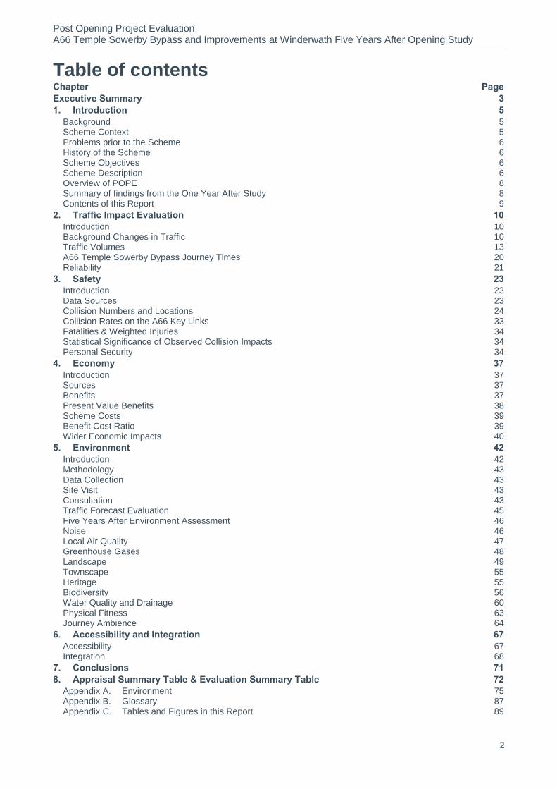
Table of contents Chapter Page
Executive Summary 3 1. Introduction 5
Background 5 Scheme Context 5 Problems prior to the Scheme 6 History of the Scheme 6 Scheme Objectives 6 Scheme Description 6 Overview of POPE 8 Summary of findings from the One Year After Study 8 Contents of this Report 9
2. Traffic Impact Evaluation 10 Introduction 10 Background Changes in Traffic 10 Traffic Volumes 13 A66 Temple Sowerby Bypass Journey Times 20 Reliability 21
3. Safety 23 Introduction 23 Data Sources 23 Collision Numbers and Locations 24 Collision Rates on the A66 Key Links 33 Fatalities & Weighted Injuries 34 Statistical Significance of Observed Collision Impacts 34 Personal Security 34
4. Economy 37 Introduction 37 Sources 37 Benefits 37 Present Value Benefits 38 Scheme Costs 39 Benefit Cost Ratio 39 Wider Economic Impacts 40
5. Environment 42 Introduction 42 Methodology 43 Data Collection 43 Site Visit 43 Consultation 43 Traffic Forecast Evaluation 45 Five Years After Environment Assessment 46 Noise 46 Local Air Quality 47 Greenhouse Gases 48 Landscape 49 Townscape 55 Heritage 55 Biodiversity 56 Water Quality and Drainage 60 Physical Fitness 63 Journey Ambience 64
6. Accessibility and Integration 67 Accessibility 67 Integration 68
7. Conclusions 71 8. Appraisal Summary Table & Evaluation Summary Table 72
Appendix A. Environment 75 Appendix B. Glossary 87 Appendix C. Tables and Figures in this Report 89

Post Opening Project Evaluation A66 Temple Sowerby Bypass and Improvements at Winderwath Five Years After Opening Study
3
Executive Summary
Scheme Description The A66 Temple Sowerby Bypass and Improvements at Winderwath scheme was a major Highways Agency project which opened on 18
th October 2007. The purpose of the scheme was to provide 3
miles (4.9km) of dual carriageway bypassing the village of Temple Sowerby and Winderwath Farm in Cumbria.
This document summarises the findings of the five years after post opening evaluation study completed in 2014.
Scheme Objectives
Objectives (Road Review, 1998) Objective Achieved?
Provide a dual carriageway bypass to cater for future predicted traffic growth
To remove through traffic from the village
To reduce noise
To reduce severance
Enhance safety for all road users Partial
Key Findings The scheme has removed 90% of the traffic previously travelling through Temple Sowerby
village.
Journey times for A66 through traffic are now around two minutes quicker than the pre-scheme situation.
Collisions have reduced on the Bypass compared to the old road through Temple Sowerby, However, there has been an increase in collisions on the A66 immediately to the east and west of the scheme extents.
Environmental impacts are generally as expected.
Monetary benefits are lower than forecast due to the lower than expected safety benefits.
Summary of Scheme Impacts
Traffic On average 16,800 vehicles use the bypass every weekday, with a 90% reduction in traffic noted
on the bypassed route through Temple Sowerby village.
Average journey times for A66 users have reduced significantly in both directions and across all time periods.
Journey time reliability has improved as a result of the scheme opening.
Safety Analysis of collision data has shown an annual average increase of 0.5 collisions a year in the
modelled area between the pre scheme and five years after opening periods. This is an increase of 12%. However, for the scheme’s key links (principally the old A66 and the new bypass) there has been an annual average collision decrease of 1.4, a reduction of 36%.
The collision severity index has decreased slightly from 15% to 13% post opening. The change in casualty severity post opening has been skewed by a coach collision.
The change in collision numbers across the modelled area is statistically insignificant and has not been included in the economic benefits of the scheme.
Post Opening Project Evaluation A66 Temple Sowerby Bypass and Improvements at Winderwath Five Years After Opening Study
4
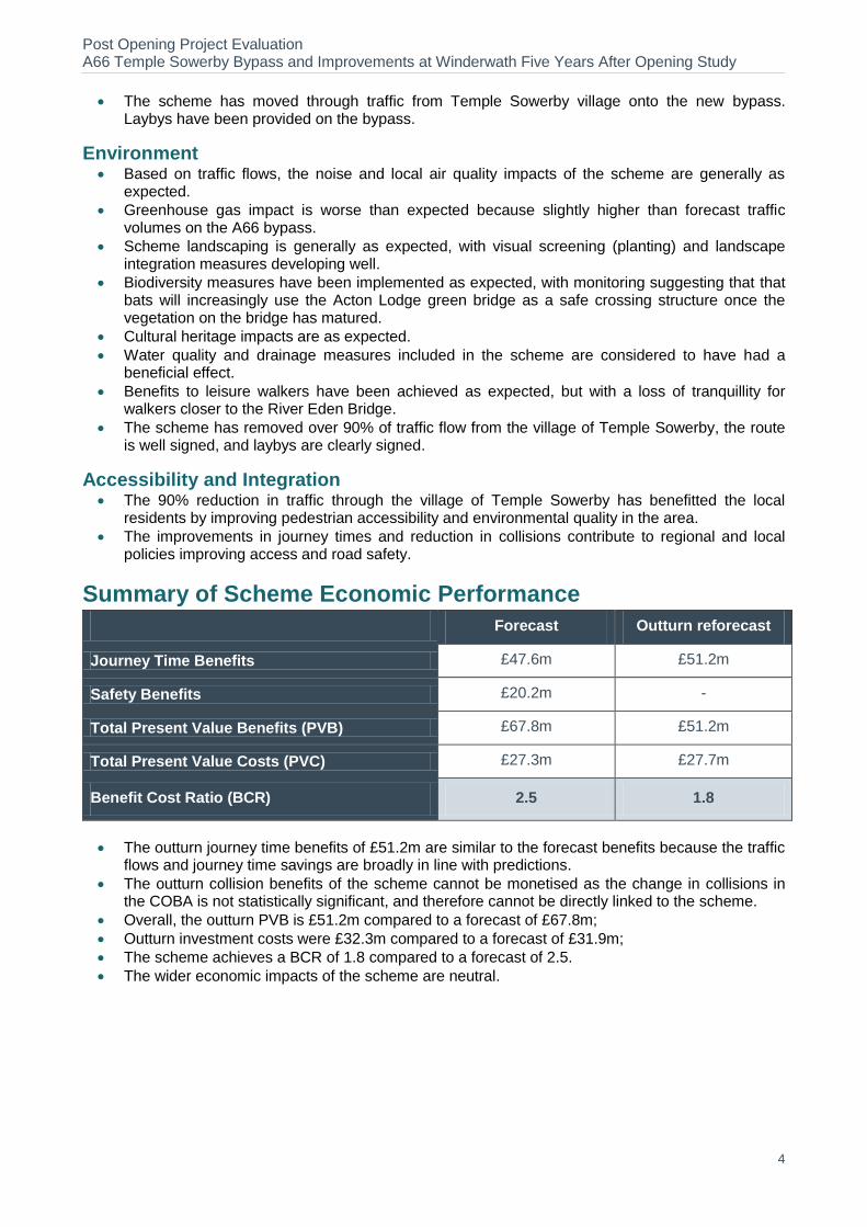
The scheme has moved through traffic from Temple Sowerby village onto the new bypass. Laybys have been provided on the bypass.
Environment Based on traffic flows, the noise and local air quality impacts of the scheme are generally as
expected.
Greenhouse gas impact is worse than expected because slightly higher than forecast traffic volumes on the A66 bypass.
Scheme landscaping is generally as expected, with visual screening (planting) and landscape integration measures developing well.
Biodiversity measures have been implemented as expected, with monitoring suggesting that that bats will increasingly use the Acton Lodge green bridge as a safe crossing structure once the vegetation on the bridge has matured.
Cultural heritage impacts are as expected.
Water quality and drainage measures included in the scheme are considered to have had a beneficial effect.
Benefits to leisure walkers have been achieved as expected, but with a loss of tranquillity for walkers closer to the River Eden Bridge.
The scheme has removed over 90% of traffic flow from the village of Temple Sowerby, the route is well signed, and laybys are clearly signed.
Accessibility and Integration The 90% reduction in traffic through the village of Temple Sowerby has benefitted the local
residents by improving pedestrian accessibility and environmental quality in the area.
The improvements in journey times and reduction in collisions contribute to regional and local policies improving access and road safety.
Summary of Scheme Economic Performance Forecast Outturn reforecast
Journey Time Benefits £47.6m £51.2m
Safety Benefits £20.2m -
Total Present Value Benefits (PVB) £67.8m £51.2m
Total Present Value Costs (PVC) £27.3m £27.7m
Benefit Cost Ratio (BCR) 2.5 1.8
The outturn journey time benefits of £51.2m are similar to the forecast benefits because the traffic flows and journey time savings are broadly in line with predictions.
The outturn collision benefits of the scheme cannot be monetised as the change in collisions in the COBA is not statistically significant, and therefore cannot be directly linked to the scheme.
Overall, the outturn PVB is £51.2m compared to a forecast of £67.8m;
Outturn investment costs were £32.3m compared to a forecast of £31.9m;
The scheme achieves a BCR of 1.8 compared to a forecast of 2.5.
The wider economic impacts of the scheme are neutral.

Post Opening Project Evaluation A66 Temple Sowerby Bypass and Improvements at Winderwath Five Years After Opening Study
5
1. Introduction
Background 1.1. This report presents a Five Years After (FYA) opening evaluation of the A66 Temple
Sowerby Bypass and Improvement at Winderwath (hereafter known as the Temple Sowerby Bypass) which opened on 18
th October 2007. The evaluation has been prepared as part of
the Highways Agency (HA) Post Opening Project Evaluation (POPE) programme and builds upon the findings of the One Year After (OYA) study published in 2009.
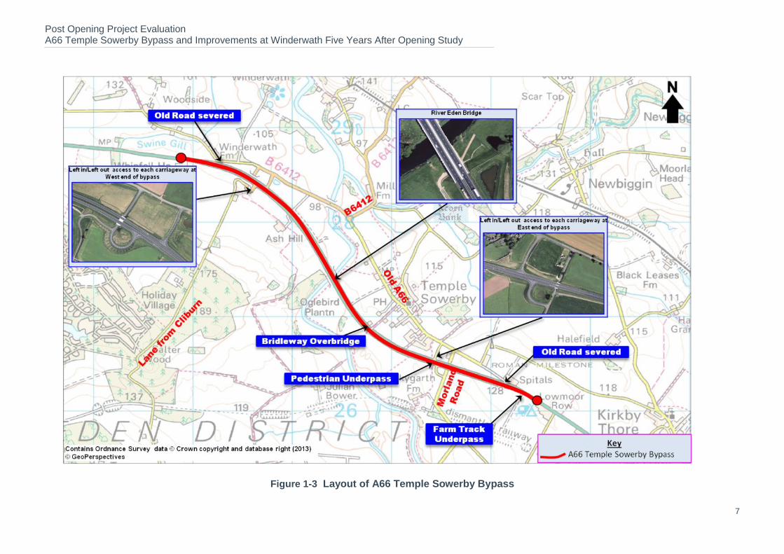
1.2. The A66 Temple Sowerby Bypass and Improvement at Winderwath scheme is a major Highways Agency (HA) scheme providing 3 miles (4.9km) of dual carriageway bypassing the village of Temple Sowerby and Winderwath Farm in Cumbria. Figure 1-1 illustrates the geographical location of the scheme.
Figure 1-1 Location of A66 Temple Sowerby Bypass
Scheme Context 1.3. The A66 is a key east west route, running between Middlesbrough in Teesside and
Workington on the Cumbria coast. Between Brough and Penrith, it is largely single carriageway, apart from the existing Appleby bypass, and the new Temple Sowerby bypass which are dual carriageway. The A66 is one of the few major roads crossing the Pennines in northern England and links two important north-south routes; the A1 in the east and the M6 in the west. The location of the A66 Temple Sowerby Bypass scheme is illustrated in Figure 1-1.
1.4. The scheme falls entirely within the County of Cumbria and is covered by Highways Agency Area 13.
Post Opening Project Evaluation A66 Temple Sowerby Bypass and Improvements at Winderwath Five Years After Opening Study
6
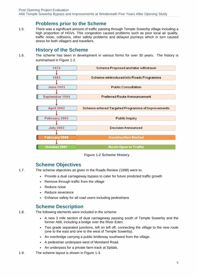
Problems prior to the Scheme 1.5. There was a significant amount of traffic passing through Temple Sowerby village including a
high proportion of HGVs. This congestion caused problems such as poor local air quality, traffic noise, collisions, other safety problems and delayed journeys which in turn caused stress for both villagers and travellers.
History of the Scheme 1.6. The scheme has been in development in various forms for over 30 years. The history is
summarised in Figure 1-2.
Figure 1-2 Scheme History
Scheme Objectives 1.7. The scheme objectives as given in the Roads Review (1998) were to:
Provide a dual carriageway bypass to cater for future predicted traffic growth
Remove through traffic from the village
Reduce noise
Reduce severance
Enhance safety for all road users including pedestrians
Scheme Description 1.8. The following elements were included in the scheme:
A new 3 mile section of dual carriageway passing south of Temple Sowerby and the former A66, including a bridge over the River Eden.
Two grade separated junctions, left on left off, connecting the village to the new route (one to the east and one to the west of Temple Sowerby).
An overbridge carrying a public bridleway southwest from the village.
A pedestrian underpass west of Moreland Road.
An underpass for a private farm track at Spitals.
1.9. The scheme layout is shown in Figure 1-3.
Post Opening Project Evaluation A66 Temple Sowerby Bypass and Improvements at Winderwath Five Years After Opening Study
7
Figure 1-3 Layout of A66 Temple Sowerby Bypass
Post Opening Project Evaluation A66 Temple Sowerby Bypass and Improvements at Winderwath Five Years After Opening Study
8
Overview of POPE 1.10. At each key decision stage through the planning process, schemes are subject to a rigorous
appraisal process to provide a justification for the project’s continued development. An Appraisal Summary Table (AST) is produced which records the degree to which the five Central Government NATA
1 objectives for Transport (Environment, Safety, Economy,
Accessibility and Integration) have been achieved. The AST for this scheme is presented in Table 8-1 of this report on page 73.
1.11. POPE studies are carried out for all Major Schemes to evaluate the strengths and weaknesses in the techniques used for appraising schemes. This is vital so that improvements can be made in the future. For POPE, this is achieved by comparing information collected before and after the opening of the scheme to traffic, against predictions made during the planning process. The outturn impacts of a scheme are summarised in an Evaluation Summary Table (EST) which summarises the extent to which the objectives of a scheme have been achieved. The EST for this scheme is presented in Table 8-2 on page 74 of this report.
1.12. POPE of Major Schemes goes beyond monitoring progress against targets set beforehand. Instead, it provides the opportunity to study which aspects of the intervention and appraisal tools used to assess it are performing better or worse than expected, and how they can be made more effective. More specifically the objectives of POPE evaluation reports are to:
Provide a quantitative and qualitative analysis of scheme impacts consistent with national transport appraisal guidance (WebTAG) and scheme specific objectives.
Identification and description of discrepancies between forecast and outturn impacts.
Explanations of reasons for differences between forecast and outturn impacts.
Identification of key issues relating to appraisal methods that will assist the HA in ongoing improvement of appraisal approaches and tools used for major schemes.
Summary of findings from the One Year After Study 1.13. The purpose of the FYA study is to verify and examine in more detail the emerging trends
and conclusions presented in the OYA study. The main conclusions from the A66 Temple Sowerby Bypass and Improvements at Winderwath OYA evaluation published in August 2009 included:
The traffic forecasting was generally successful, as would be expected, given the simple nature of the network, and the short time interval between forecast and scheme construction.
There were some discrepancies between forecast and actual flows on minor roads in the area, but this was not considered surprising in view of the low flows and the difficulty of fine model calibration.
As well as the increase in vehicle speed for traffic on the bypass, there was evidence from journey time data, that the scheme had slightly increased speeds on the unimproved A66 either side of the bypass.
There were no collisions on the scheme itself or the bypassed road, since opening, but more than before on adjacent sections of the A66.
The environmental impacts were generally as expected.
Additional maintenance of the green bridge was required to maximise its effectiveness.
Traffic management on the old road through Temple Sowerby had contributed to safety and environmental improvements.
1.14. This FYA report will reconsider the relevance of these findings and provide further clarity on the longer term effects of the improvements on the immediate area affected by the scheme.
1 As of August 2011, this approach has been revised. However, POPE is concerned with evaluation against the appraisal and as such
follows the objectives used at that time.
Post Opening Project Evaluation A66 Temple Sowerby Bypass and Improvements at Winderwath Five Years After Opening Study
9
Contents of this Report 1.15. The remainder of this report is divided into further sections as follows:
Chapter 2 – Traffic Impact Evaluation. This section looks at how the scheme had impacted on traffic volumes and journey times on the A66 and in the vicinity of the scheme and compares the results with forecasts.
Chapter 3 – Safety Evaluation. This section compares the pre and post opening collision numbers and looks at collision causations.
Chapter 4 – Economy Evaluation. This section compares the monetary value of any changes in journey times and collisions and compares these benefits with the cost.
Chapter 5 – Environment Evaluation. This section looks at the environmental impacts of the scheme and the success of any mitigation.
Chapter 6 – Accessibility and Integration Evaluation. This section contains a review of how the scheme had affected accessibility for pedestrians and cyclists. It also examines the impact of the scheme on local land use and Government policies.
Chapter 7 – Conclusions. This section summarises the main conclusions of this study.
Chapter 8 – Appraisal Summary Table (AST) and Evaluation Summary Table (EST). This section contains an overview of the actual scheme impacts compared to those predicted in the original AST.
1.16. There are also a number of appendices listed below as follows:
Appendix A – Environmental Photographic Views.
Appendix B – Glossary of Terms.
Appendix C – List of Tables and Figures presented in this Report.

Post Opening Project Evaluation A66 Temple Sowerby Bypass and Improvements at Winderwath Five Years After Opening Study
10
2. Traffic Impact Evaluation
Introduction 2.1. This section considers traffic data from a number of sources to provide a before and after
opening comparison of traffic flows and journey times on key routes affected by the scheme. The remainder of this section sets out a:
Description of national and local background traffic trends in the vicinity of the scheme.
Detailed comparison of before and after traffic flows and journey times on key routes in the study area likely to be affected by the scheme.
Explanation of key differences between forecast and outturn impacts of the scheme on traffic flows and journey times in the vicinity of the scheme.
Background Changes in Traffic 2.2. Historically in POPE scheme evaluations, the ‘before’ counts have often been factored to
take account of background traffic growth so that they are directly comparable with the ‘after’ counts. This usually involves the use of National Road Traffic Forecasts (NRTF) with local adjustments made using National Transport Model (NTM) Local Growth Factors.
2.3. However, due to the recent economic climate which has seen widespread reductions in motor vehicle travel in the UK as a whole (since 2008), it is no longer deemed appropriate to use this method of factoring ‘before’ counts to reflect background changes in traffic. Rather, a more considered approach is required in order to assess changes in the vicinity of the scheme, within the context of national, regional and locally observed background changes in traffic.
2.4. In order to better understand the effects of the recent economic downturn, it is useful to look at the long term trends in traffic nationally, regionally and in the local area of the scheme.
National Trends
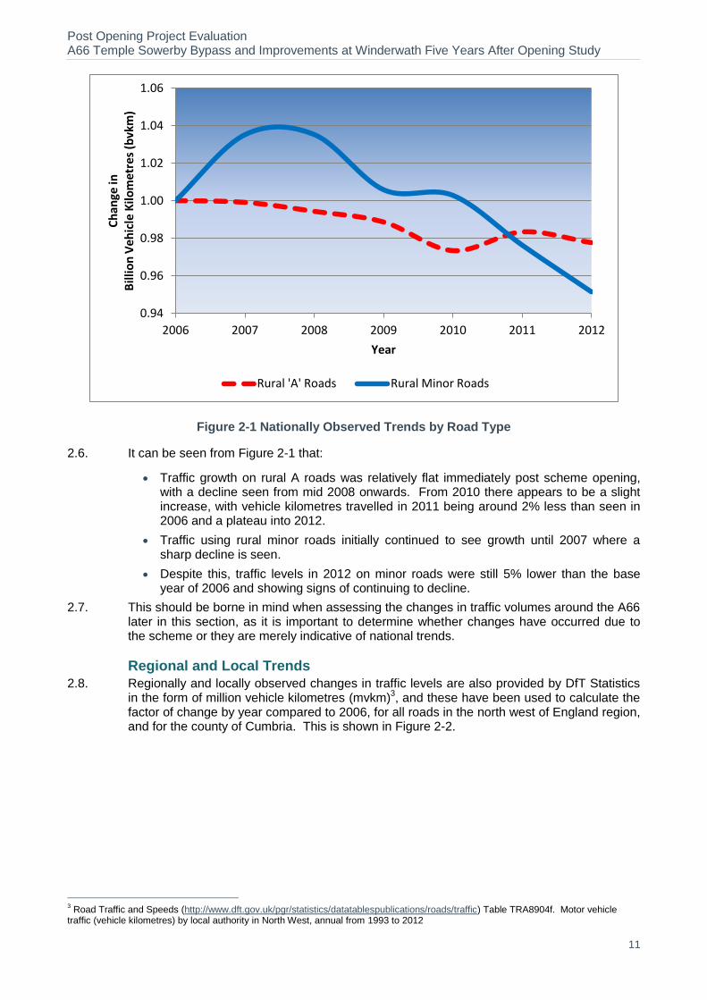
2.5. The Department for Transport (DfT) produces observed annual statistics for all motor vehicles in billion vehicle kilometres (bvkm) by road type
2. This data between 2006
(construction) and 2012 (latest available) has been used to calculate the factor of change compared to a base year of 2006 on a yearly basis, and is shown in Figure 2-1 for all rural ‘A’ roads and all rural minor roads in Great Britain.
2 Road Traffic and Speeds (http://www.dft.gov.uk/pgr/statistics/datatablespublications/roads/traffic). Table TRA0202b. Motor vehicle
traffic (vehicle kilometres) by road class in Great Britain, annual from 1993 to 2011.
Post Opening Project Evaluation A66 Temple Sowerby Bypass and Improvements at Winderwath Five Years After Opening Study
11
Figure 2-1 Nationally Observed Trends by Road Type
2.6. It can be seen from Figure 2-1 that:
Traffic growth on rural A roads was relatively flat immediately post scheme opening, with a decline seen from mid 2008 onwards. From 2010 there appears to be a slight increase, with vehicle kilometres travelled in 2011 being around 2% less than seen in 2006 and a plateau into 2012.
Traffic using rural minor roads initially continued to see growth until 2007 where a sharp decline is seen.
Despite this, traffic levels in 2012 on minor roads were still 5% lower than the base year of 2006 and showing signs of continuing to decline.
2.7. This should be borne in mind when assessing the changes in traffic volumes around the A66 later in this section, as it is important to determine whether changes have occurred due to the scheme or they are merely indicative of national trends.
Regional and Local Trends
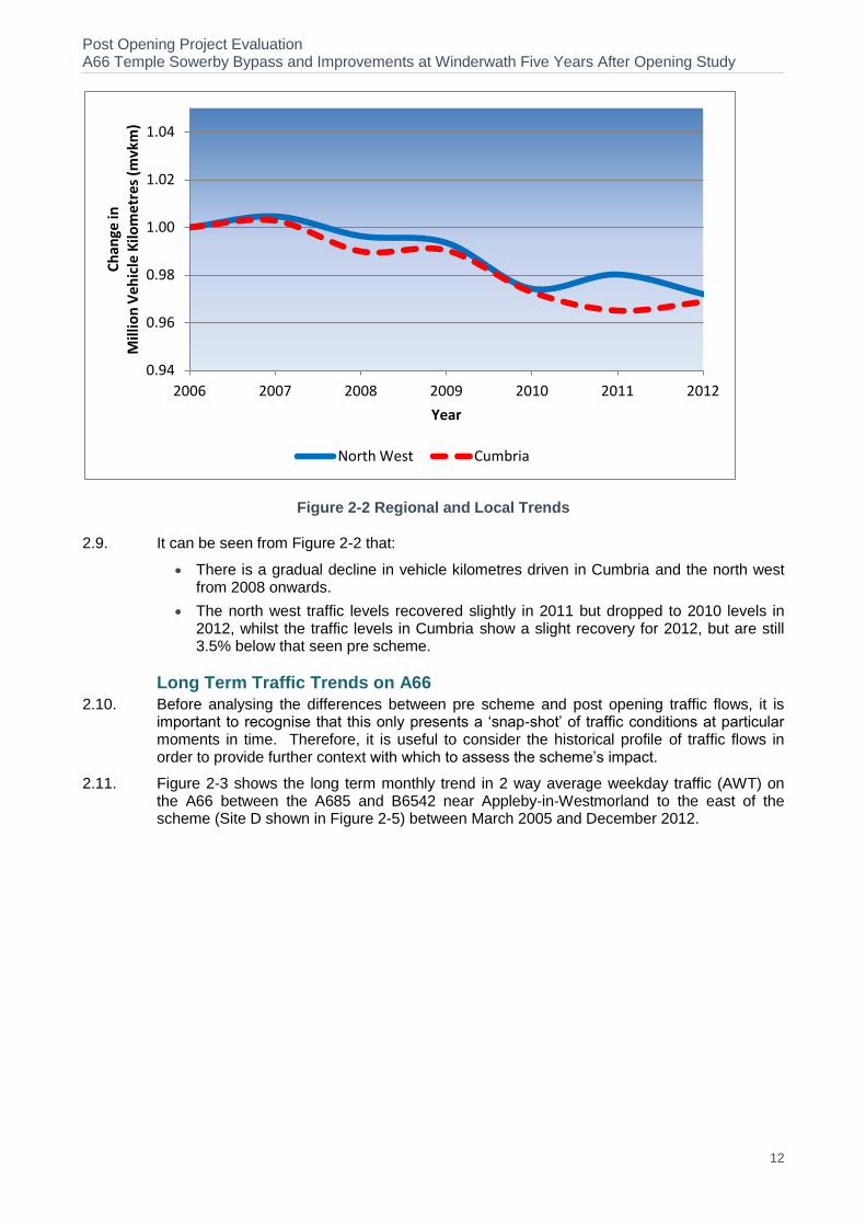
2.8. Regionally and locally observed changes in traffic levels are also provided by DfT Statistics in the form of million vehicle kilometres (mvkm)
3, and these have been used to calculate the
factor of change by year compared to 2006, for all roads in the north west of England region, and for the county of Cumbria. This is shown in Figure 2-2.
3 Road Traffic and Speeds (http://www.dft.gov.uk/pgr/statistics/datatablespublications/roads/traffic) Table TRA8904f. Motor vehicle
traffic (vehicle kilometres) by local authority in North West, annual from 1993 to 2012
0.94
0.96
0.98
1.00
1.02
1.04
1.06
2006 2007 2008 2009 2010 2011 2012
Ch
ange
in
Bill
ion
Veh
icle
Kilo
me
tres
(b
vkm
)
Year
Rural 'A' Roads Rural Minor Roads
Post Opening Project Evaluation A66 Temple Sowerby Bypass and Improvements at Winderwath Five Years After Opening Study
12
Figure 2-2 Regional and Local Trends
2.9. It can be seen from Figure 2-2 that:
There is a gradual decline in vehicle kilometres driven in Cumbria and the north west from 2008 onwards.
The north west traffic levels recovered slightly in 2011 but dropped to 2010 levels in 2012, whilst the traffic levels in Cumbria show a slight recovery for 2012, but are still 3.5% below that seen pre scheme.
Long Term Traffic Trends on A66
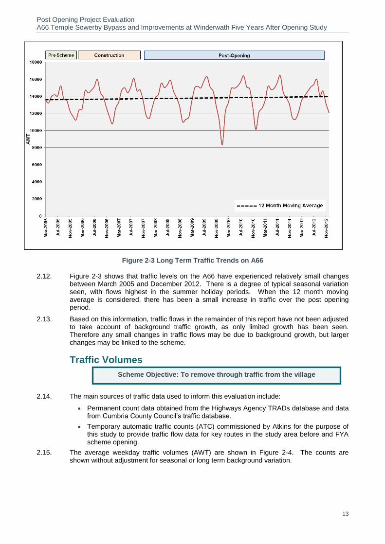
2.10. Before analysing the differences between pre scheme and post opening traffic flows, it is important to recognise that this only presents a ‘snap-shot’ of traffic conditions at particular moments in time. Therefore, it is useful to consider the historical profile of traffic flows in order to provide further context with which to assess the scheme’s impact.
2.11. Figure 2-3 shows the long term monthly trend in 2 way average weekday traffic (AWT) on the A66 between the A685 and B6542 near Appleby-in-Westmorland to the east of the scheme (Site D shown in Figure 2-5) between March 2005 and December 2012.
0.94
0.96
0.98
1.00
1.02
1.04
2006 2007 2008 2009 2010 2011 2012
Ch
ange
in
Mill
ion
Veh
icle
Kilo
me
tres
(m
vkm
)
Year
North West Cumbria
Post Opening Project Evaluation A66 Temple Sowerby Bypass and Improvements at Winderwath Five Years After Opening Study
13
Figure 2-3 Long Term Traffic Trends on A66
2.12. Figure 2-3 shows that traffic levels on the A66 have experienced relatively small changes between March 2005 and December 2012. There is a degree of typical seasonal variation seen, with flows highest in the summer holiday periods. When the 12 month moving average is considered, there has been a small increase in traffic over the post opening period.
2.13. Based on this information, traffic flows in the remainder of this report have not been adjusted to take account of background traffic growth, as only limited growth has been seen. Therefore any small changes in traffic flows may be due to background growth, but larger changes may be linked to the scheme.
Traffic Volumes
2.14. The main sources of traffic data used to inform this evaluation include:
Permanent count data obtained from the Highways Agency TRADs database and data from Cumbria County Council’s traffic database.
Temporary automatic traffic counts (ATC) commissioned by Atkins for the purpose of this study to provide traffic flow data for key routes in the study area before and FYA scheme opening.
2.15. The average weekday traffic volumes (AWT) are shown in Figure 2-4. The counts are shown without adjustment for seasonal or long term background variation.
Scheme Objective: To remove through traffic from the village

Post Opening Project Evaluation A66 Temple Sowerby Bypass and Improvements at Winderwath Five Years After Opening Study
14
Figure 2-4 Before and After Traffic Volumes (AWT)
Post Opening Project Evaluation A66 Temple Sowerby Bypass and Improvements at Winderwath Five Years After Opening Study
15
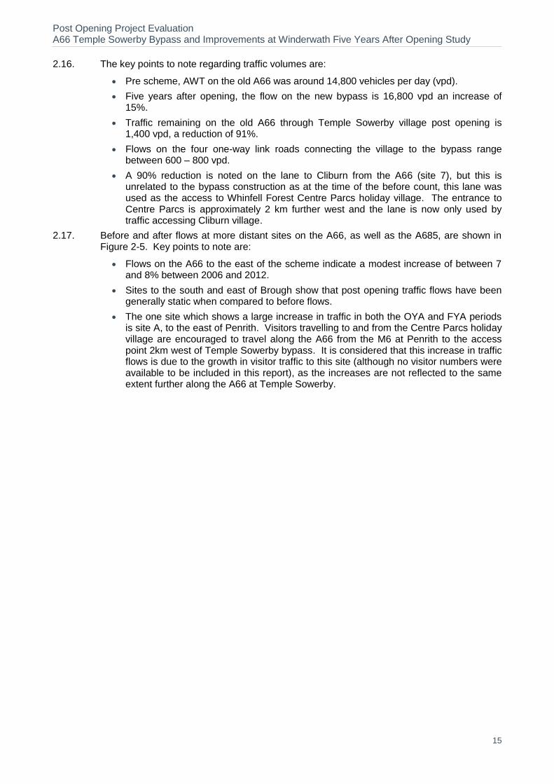
2.16. The key points to note regarding traffic volumes are:
Pre scheme, AWT on the old A66 was around 14,800 vehicles per day (vpd).
Five years after opening, the flow on the new bypass is 16,800 vpd an increase of 15%.
Traffic remaining on the old A66 through Temple Sowerby village post opening is 1,400 vpd, a reduction of 91%.
Flows on the four one-way link roads connecting the village to the bypass range between 600 – 800 vpd.
A 90% reduction is noted on the lane to Cliburn from the A66 (site 7), but this is unrelated to the bypass construction as at the time of the before count, this lane was used as the access to Whinfell Forest Centre Parcs holiday village. The entrance to Centre Parcs is approximately 2 km further west and the lane is now only used by traffic accessing Cliburn village.
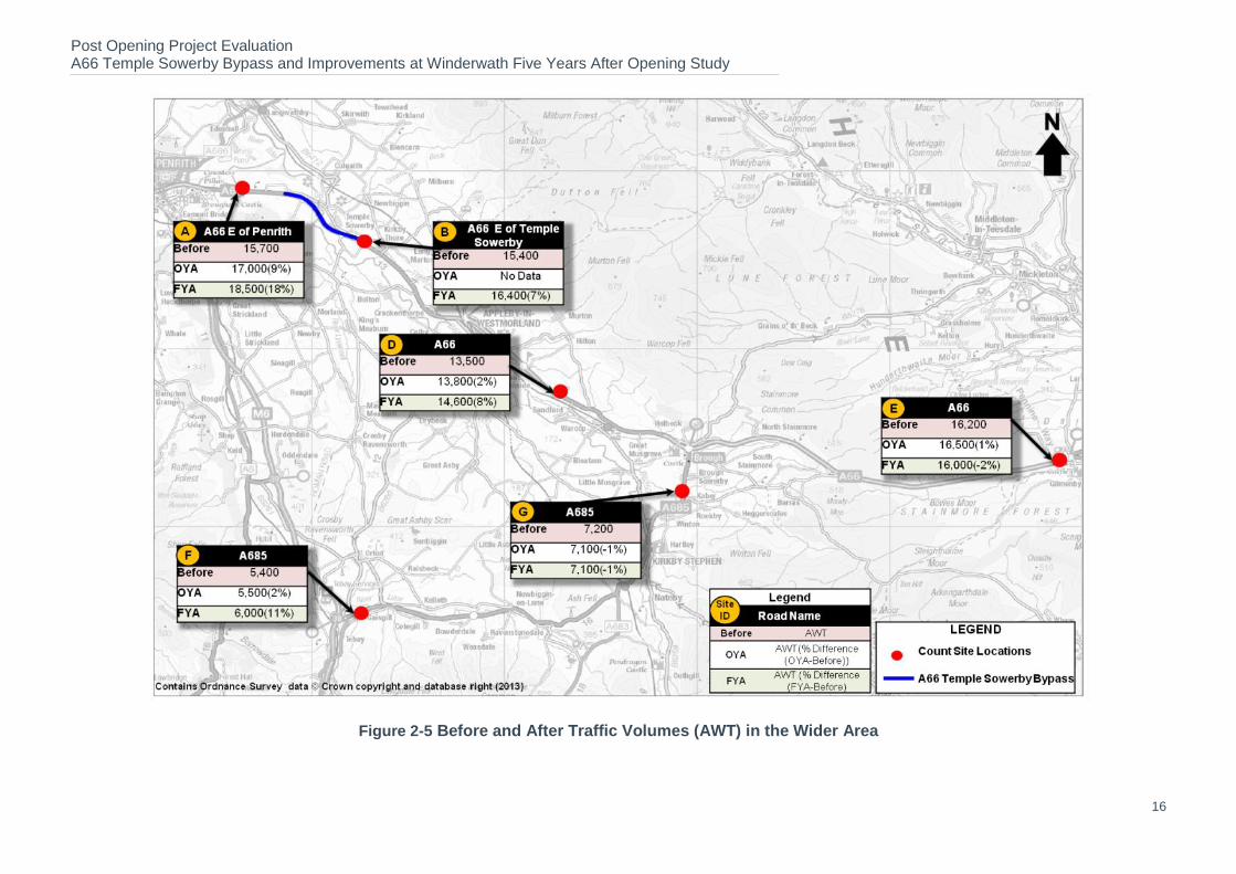
2.17. Before and after flows at more distant sites on the A66, as well as the A685, are shown in Figure 2-5. Key points to note are:
Flows on the A66 to the east of the scheme indicate a modest increase of between 7 and 8% between 2006 and 2012.
Sites to the south and east of Brough show that post opening traffic flows have been generally static when compared to before flows.
The one site which shows a large increase in traffic in both the OYA and FYA periods is site A, to the east of Penrith. Visitors travelling to and from the Centre Parcs holiday village are encouraged to travel along the A66 from the M6 at Penrith to the access point 2km west of Temple Sowerby bypass. It is considered that this increase in traffic flows is due to the growth in visitor traffic to this site (although no visitor numbers were available to be included in this report), as the increases are not reflected to the same extent further along the A66 at Temple Sowerby.
Post Opening Project Evaluation A66 Temple Sowerby Bypass and Improvements at Winderwath Five Years After Opening Study
16
Figure 2-5 Before and After Traffic Volumes (AWT) in the Wider Area
Post Opening Project Evaluation A66 Temple Sowerby Bypass and Improvements at Winderwath Five Years After Opening Study
17
Heavy Goods Vehicles (HGV’s)
2.18. Information on heavy vehicles flow is available from automatic counts where classification is based on vehicle length and the comparison of before and after heavy vehicle flows on A66 is presented in Table 2-1.
Table 2-1 HGV’s using A66
Year Average number of
HGV’s % HGV of total flow
Pre Scheme (A66 through Temple Sowerby)
5,570 36%
Post Scheme (A66 Temple Sowerby Bypass)
5,640 34%
2.19. Prior to the bypass, there was an average of 5,570 (AWT) HGVs travelling through the village of Temple Sowerby, representing 36% of the total flow.
2.20. FYA opening, the average heavy vehicle flow on the bypass is 5,640, representing 34% of the total vehicle flow. The number of HGVs using the old A66 through the village post opening is negligible, at less than 2% of the total traffic.
Forecast vs. Observed Traffic Flows
This section compares the predicted flows and observed pre scheme and post scheme flows on links around Temple Sowerby. The actual do minimum (DM) represents the before traffic flows for the year 2005. The predicted flows for do something (DS) is the central (average) case from the COBA high and low growth scenarios, adjusted to 2012 using growth factors from COBA. No HGV forecasts were available for use in this report.
Do Minimum Forecasts vs. Observed Pre-Scheme Traffic flows
2.21. Table 2-2 presents the observed (2005) 24-hr average daily traffic (ADT) on various links around Temple Sowerby with the forecast (2005) DM annual average daily traffic (AADT) flows.
Table 2-2 Forecast DM AADT Flows vs. Observed Pre-Scheme 24-hr ADT Flows
Location Forecast
(2005) Observed
(2005) Difference (%)
A66 E of Temple Sowerby 14,200 13,400 -6%
A66 W of Temple Sowerby 14,500 13,300 -8%
2.22. Comparison of the pre scheme forecasts and observed flows shows that:
The base traffic forecasts for the A66 east and west of Temple Sowerby were slightly above the pre scheme observed traffic flows.
Observed pre scheme traffic east of the village was 13,400 vehicles whereas forecast traffic was 14,200 vehicles, a difference of 6%.
Observed traffic west of the village was 13,300 vehicles whereas forecast traffic was predicted to be around 14,500 vehicles, a difference of 8%.
2.23. Based on these observations, it appears that the DM forecasts slightly over estimated the actual pre scheme traffic volume on the A66, although the difference between forecast and observed traffic is within 10%.
Scheme Objective: Provide a dual carriageway Bypass to cater for future predicted traffic growth.
Post Opening Project Evaluation A66 Temple Sowerby Bypass and Improvements at Winderwath Five Years After Opening Study
18
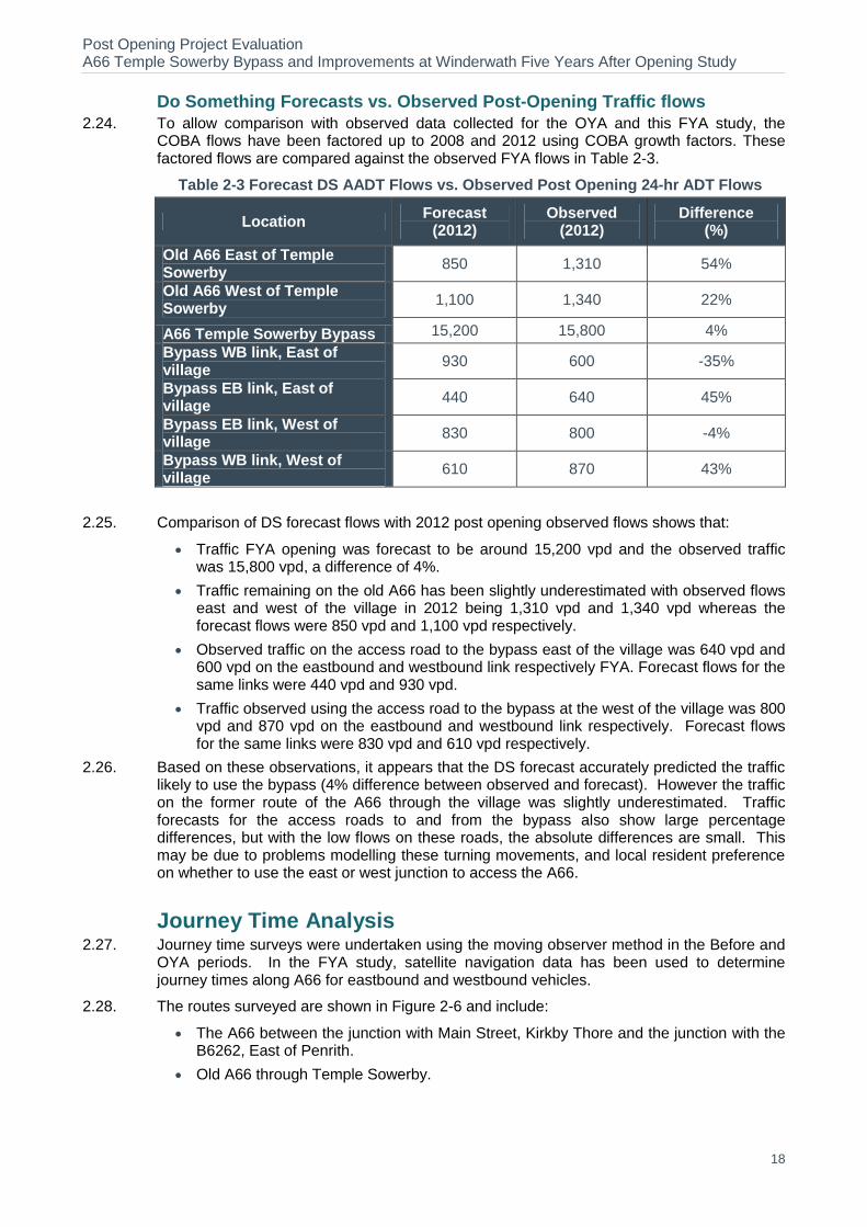
Do Something Forecasts vs. Observed Post-Opening Traffic flows
2.24. To allow comparison with observed data collected for the OYA and this FYA study, the COBA flows have been factored up to 2008 and 2012 using COBA growth factors. These factored flows are compared against the observed FYA flows in Table 2-3.
Table 2-3 Forecast DS AADT Flows vs. Observed Post Opening 24-hr ADT Flows
Location Forecast
(2012) Observed
(2012) Difference
(%)
Old A66 East of Temple Sowerby
850 1,310 54%
Old A66 West of Temple Sowerby
1,100 1,340 22%
A66 Temple Sowerby Bypass 15,200 15,800 4%
Bypass WB link, East of village
930 600 -35%
Bypass EB link, East of village
440 640 45%
Bypass EB link, West of village
830 800 -4%
Bypass WB link, West of village
610 870 43%
2.25. Comparison of DS forecast flows with 2012 post opening observed flows shows that:
Traffic FYA opening was forecast to be around 15,200 vpd and the observed traffic was 15,800 vpd, a difference of 4%.
Traffic remaining on the old A66 has been slightly underestimated with observed flows east and west of the village in 2012 being 1,310 vpd and 1,340 vpd whereas the forecast flows were 850 vpd and 1,100 vpd respectively.
Observed traffic on the access road to the bypass east of the village was 640 vpd and 600 vpd on the eastbound and westbound link respectively FYA. Forecast flows for the same links were 440 vpd and 930 vpd.
Traffic observed using the access road to the bypass at the west of the village was 800 vpd and 870 vpd on the eastbound and westbound link respectively. Forecast flows for the same links were 830 vpd and 610 vpd respectively.
2.26. Based on these observations, it appears that the DS forecast accurately predicted the traffic likely to use the bypass (4% difference between observed and forecast). However the traffic on the former route of the A66 through the village was slightly underestimated. Traffic forecasts for the access roads to and from the bypass also show large percentage differences, but with the low flows on these roads, the absolute differences are small. This may be due to problems modelling these turning movements, and local resident preference on whether to use the east or west junction to access the A66.
Journey Time Analysis 2.27. Journey time surveys were undertaken using the moving observer method in the Before and
OYA periods. In the FYA study, satellite navigation data has been used to determine journey times along A66 for eastbound and westbound vehicles.
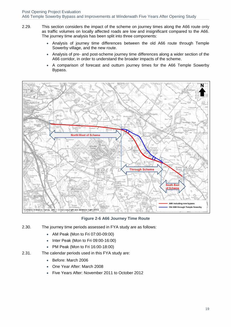
2.28. The routes surveyed are shown in Figure 2-6 and include:
The A66 between the junction with Main Street, Kirkby Thore and the junction with the B6262, East of Penrith.
Old A66 through Temple Sowerby.
Post Opening Project Evaluation A66 Temple Sowerby Bypass and Improvements at Winderwath Five Years After Opening Study
19
2.29. This section considers the impact of the scheme on journey times along the A66 route only as traffic volumes on locally affected roads are low and insignificant compared to the A66. The journey time analysis has been split into three components:
Analysis of journey time differences between the old A66 route through Temple Sowerby village, and the new route.
Analysis of pre- and post-scheme journey time differences along a wider section of the A66 corridor, in order to understand the broader impacts of the scheme.
A comparison of forecast and outturn journey times for the A66 Temple Sowerby Bypass.
Figure 2-6 A66 Journey Time Route
2.30. The journey time periods assessed in FYA study are as follows:
AM Peak (Mon to Fri 07:00-09:00)
Inter Peak (Mon to Fri 09:00-16:00)
PM Peak (Mon to Fri 16:00-18:00)
2.31. The calendar periods used in this FYA study are:
Before: March 2006
One Year After: March 2008
Five Years After: November 2011 to October 2012

Post Opening Project Evaluation A66 Temple Sowerby Bypass and Improvements at Winderwath Five Years After Opening Study
20
A66 Temple Sowerby Bypass Journey Times 2.32. The journey time results for a wider area along the A66 between Main Street and B6262- i.e.
red route in Figure 2-6, is presented in Table 2-4.
Table 2-4 Journey Time Comparison for whole section
Direction Period
A66 Journey Time Savings(mm:ss)
Old A66
Before
A66 Bypass
OYA
A66 Bypass
FYA
OYA Savings
FYA Savings
Eastbound
AM 10:00 07:06 07:07 02:54 02:53
IP 09:40 07:04 07:31 02:36 02:09
PM 10:04 07:27 07:23 02:37 02:41
Westbound
AM 10:05 07:25 07:19 02:40 02:46
IP 09:57 06:50 07:26 03:07 02:31
PM 10:09 07:17 07:23 02:52 02:46
2.33. A breakdown of the journey times along the A66, comparing the old route alignment with the new A66 Temple Sowerby Bypass and also southeast of the scheme and northwest of the scheme has been analysed and the results are presented in Table 2-5.
Table 2-5 Journey Time Comparison by Section
Direction Section
Average Journey Time (mm:ss)
Period Old A66 Before
A66 Bypass OYA
A66 Bypass FYA
OYA Savings
FYA Savings
Eastbound
West of scheme
AM 03:51 03:17 03:26 00:34 00:25
IP 03:49 03:25 03:36 00:24 00:13
PM 03:58 03:36 03:34 00:22 00:24
Through Scheme
AM 04:39 02:34 02:23 02:05 02:16
IP 04:33 02:17 02:28 02:16 02:05
PM 04:43 02:19 02:26 02:24 02:17
East of scheme
AM 01:30 01:15 01:18 00:15 00:12
IP 01:18 01:22 01:27 -00:04 -00:09
PM 01:22 01:32 01:23 -00:10 -00:01
Westbound
West of scheme
AM 01:24 01:18 01:13 00:06 00:11
IP 01:24 01:15 01:14 00:09 00:10
PM 01:28 01:14 01:14 00:14 00:14
Through Scheme
AM 04:41 02:25 02:30 02:16 02:11
IP 04:37 02:19 02:30 02:18 02:07
PM 04:40 02:23 02:30 02:17 02:10
East of scheme
AM 04:00 03:41 03:36 00:19 00:24
IP 03:57 03:16 03:42 00:41 00:15
PM 04:01 03:40 03:39 00:21 00:22
2.34. Table 2-4 and Table 2-5 show:
Average journey times for the wider area along the A66 between Main Street, Kirkby Thore to the east of the scheme and the B6262 junction to the west of the scheme
Post Opening Project Evaluation A66 Temple Sowerby Bypass and Improvements at Winderwath Five Years After Opening Study
21
before scheme construction was just over 10 minutes in the peak period. Post opening the FYA journey time along the same corridor is approximately 7 minutes 23 seconds in the peak period resulting in a saving of 2 minutes 37 seconds.
Comparison of journey time for each section for Before, OYA and FYA shows that the majority of the wider area saving is achieved through the scheme section (2 minutes and 9 seconds in the westbound direction and 2 minutes and 13 seconds in the eastbound direction).
Northwest of the scheme section (between B6262 and Northwest end of the bypass), there is a slight improvement in journey time of 20 seconds and there is no significant saving southeast of the scheme section (between the end of the bypass and Main street Kirkby Thore).
The former route of the A66 through the village is only linked to the new bypass via the new access roads. The speed limit of the old road was reduced from 40mph to 30mph as part of the detrunking process. Overall these changes make the bypass a considerably more attractive route than the former A66.
Forecast vs. Observed Journey Times
2.35. A comparison of the forecast and actual time savings on the A66 along the length of the COBA network is shown in Table 2-6. (Note: the figures are different to those presented in Table 2-5 as the
length of the route used in the comparison is different).
Table 2-6 – Forecast and Actual Journey Time Savings on A66
Forecast Actual
Peak Interpeak Peak Interpeak
Before 07:21 06:42 06:55 06:44
Five Years After 04:54 04:48 04:33 04:39
Saving 02:27 01:54 02:22 02:05
2.36. Table 2-6 shows forecast time savings closely match the actual time saving. This is to be expected for such a simple, short route.
Reliability
Appraisal
2.37. The appraisal of this scheme predates these developments, and a stress based approach was used to forecast the scheme’s impact on reliability. The AST for the scheme stated that ‘reliability would be improved due to new dual carriageway’ The overall assessment score for reliability was ‘Moderate beneficial’.
Evaluation
2.38. A stress based approach has been used to assess the reliability impacts of this scheme OYA and FYA after its opening in order to make a comparison with the forecast.
2.39. The Stress Factor for a particular link is defined as the ratio of the Annual Average Daily Traffic (AADT) flow to the Congestion Reference Flow (CRF). The CRF is expressed as an AADT flow estimate at which a road is likely to be congested in the peak periods on an average day. DfT Guidance states that only values between 75% and 125% should be considered and anything outside this range should be adjusted up or down to 75% or 125%. As a result, the adjusted stress figures are included in brackets.
2.40. The route stress calculation using observed traffic data is shown in Table 2-7.
Post Opening Project Evaluation A66 Temple Sowerby Bypass and Improvements at Winderwath Five Years After Opening Study
22
Table 2-7 – Observed Changes in Route Stress
Forecast (AST) Observed
Before Opening After Opening Before (2006) FYA (2012)
A66 scheme section
72% (75%) 21% (75%) 65% (75%) 20% (75%)
2.41. Based on this assessment, the scheme’s impact on Reliability at the FYA stage, is ‘Neutral’, as expected.
Key Points
Traffic Flow Impacts
The average weekday flow on the old A66, before the bypass, was 14,800 vpd – which was predominantly through traffic and 1,400 vehicles remain on the old road post opening, a fall of about 90%.
Post opening at the FYA stage, 16,800 vehicles are recorded on the bypass.
Flows on the four one-way link roads connecting the old A66 with the bypass range from 600 – 800 vpd.
Traffic Forecasting
DM forecasts slightly over estimated the actual traffic volume on A66, although the difference between forecast and observed traffic is within 10.
For the DS scenario, forecasts accurately predicted the traffic likely to use the bypass (4% difference between observed and forecast).
The traffic on the former route of the A66 through the village was slightly underestimated, and the traffic forecast to use the access roads to the bypass were also inaccurate, although this may be due to difficulties in modelling local turning movements.
Journey Times
Journey time savings for through traffic using the bypass in the peak times are up to 2 minutes 53 seconds, although significant savings are recorded in all time periods and in both directions.
Small journey time savings are seen to the southeast and north west of the scheme, however the majority of time savings are seen over the scheme section.
Journey time variation between peaks and interpeaks has improved, suggesting improved reliability of the route.
Journey Time Forecasting
The journey time saving for A66 through traffic is approximately two minutes which is in line with the forecasts.
Post Opening Project Evaluation A66 Temple Sowerby Bypass and Improvements at Winderwath Five Years After Opening Study
23
3. Safety
Introduction 3.1. This section of the report examines how successful the scheme has been in addressing the
safety sub-objectives of reducing collision numbers and improving security. This is assessed by analysing the changes in Personal Injury Collisions (PIC’s) occurring in the five years before construction and FYA opening. Evaluation of the scheme’s impact on personal security has also been undertaken through use of observations made during a site visit.
3.2. The Safety objective consists of two sub-objectives:
To reduce collisions
To improve security
3.3. The remainder of this section is structured as follows:
Data Sources
Collision and casualty numbers (frequency/severity/location) for the COBA area and the scheme key links
Forecast vs. observed collision numbers
Collision rates on the A66
Statistical significance of observed collision impacts
Security
Data Sources
Forecasts
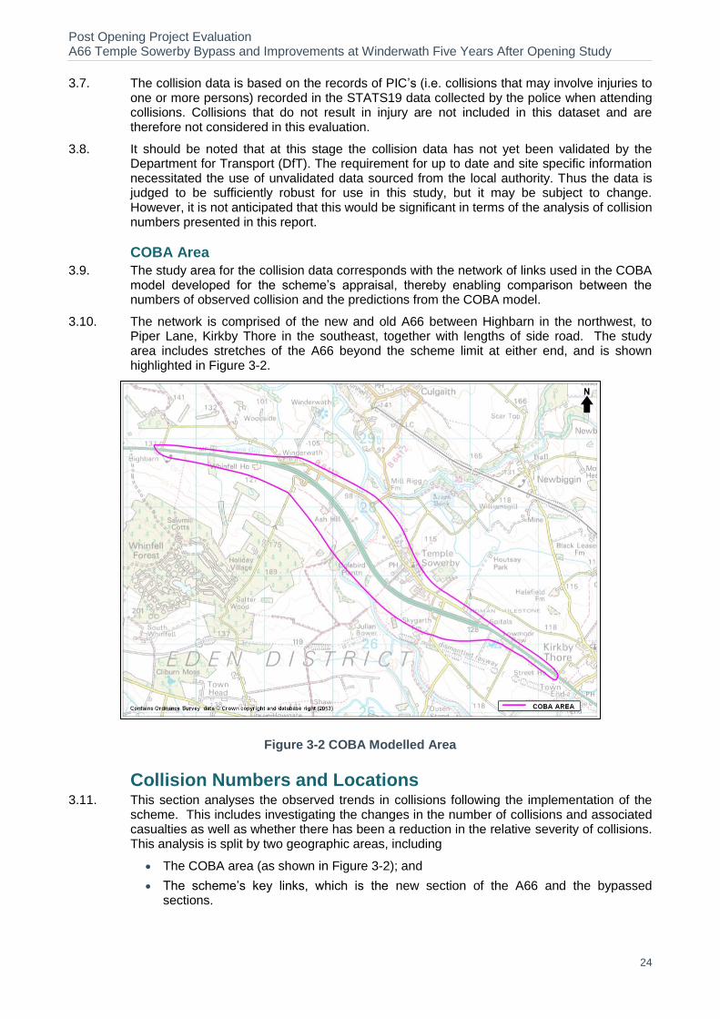
3.4. The forecast benefits for the scheme have been derived from the COBA model, which gives predicted personal injury collision (PIC) savings for the opening year and over the 30 year appraisal period. In order to ensure a like-for-like comparison between the predicted and observed collision changes, the geographical area of analysis used for this study is the same area covered by the COBA model and is shown in Figure 3-2. This covers the main routes in the immediate and wider vicinity of the scheme where changes in traffic, and hence collisions may occur.
3.5. For purposes of assessing the collision impacts of the scheme, forecasts were produced of the numbers of collisions the scheme is expected to save, together with the associated number of casualties and the monetary benefit of the savings. This section of the study concerns collision numbers; the forecast of the economic or monetary impact of the change in collisions is evaluated later in the Economy section of this report.
Observed Data
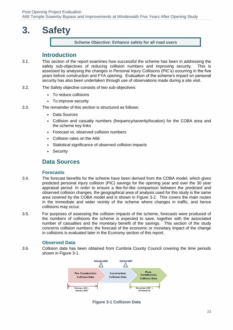
3.6. Collision data has been obtained from Cumbria County Council covering the time periods shown in Figure 3-1.
Figure 3-1 Collision Data
Scheme Objective: Enhance safety for all road users
Post Opening Project Evaluation A66 Temple Sowerby Bypass and Improvements at Winderwath Five Years After Opening Study
24
3.7. The collision data is based on the records of PIC’s (i.e. collisions that may involve injuries to one or more persons) recorded in the STATS19 data collected by the police when attending collisions. Collisions that do not result in injury are not included in this dataset and are therefore not considered in this evaluation.
3.8. It should be noted that at this stage the collision data has not yet been validated by the Department for Transport (DfT). The requirement for up to date and site specific information necessitated the use of unvalidated data sourced from the local authority. Thus the data is judged to be sufficiently robust for use in this study, but it may be subject to change. However, it is not anticipated that this would be significant in terms of the analysis of collision numbers presented in this report.
COBA Area
3.9. The study area for the collision data corresponds with the network of links used in the COBA model developed for the scheme’s appraisal, thereby enabling comparison between the numbers of observed collision and the predictions from the COBA model.
3.10. The network is comprised of the new and old A66 between Highbarn in the northwest, to Piper Lane, Kirkby Thore in the southeast, together with lengths of side road. The study area includes stretches of the A66 beyond the scheme limit at either end, and is shown highlighted in Figure 3-2.
Figure 3-2 COBA Modelled Area
Collision Numbers and Locations 3.11. This section analyses the observed trends in collisions following the implementation of the
scheme. This includes investigating the changes in the number of collisions and associated casualties as well as whether there has been a reduction in the relative severity of collisions. This analysis is split by two geographic areas, including
The COBA area (as shown in Figure 3-2); and
The scheme’s key links, which is the new section of the A66 and the bypassed sections.

Post Opening Project Evaluation A66 Temple Sowerby Bypass and Improvements at Winderwath Five Years After Opening Study
25
Background Changes in Collision Reduction
3.12. It is widely recognised that for over a decade there has been a year-on-year reduction in the numbers of personal injury collisions on the roads nationally, even against a trend of increasing traffic volumes during much of that period. The reasons for the reduction are considered to be multi-factorial and include improved safety measures in vehicles and reduced numbers of younger drivers. We need to consider this background trend when considering the changes in collision numbers within the study area. If the scheme had not been built, collision numbers in the area may still be influenced by wider trends and reduced.
3.13. When we compare the numbers of collisions in this area before and after the scheme was built and associate the net change with the scheme, we need to take this background reduction into account. The best way to do this is to assume that, if the scheme had not been built, the number of collisions on the roads in the COBA area here would have dropped at the same rate as they did nationally during the same period. This gives us what is known as the counterfactual ‘without scheme’ scenario on a like for like basis with the observed post opening data which is the ‘with scheme’ scenario.
3.14. The comparison needed is between the middle year in the after period (2009) and the middle of the pre-construction period (2003), however due to lack of necessary data prior to 2004, 2004 have been used for the pre-construction period. The approach is to use national data for the changes in the numbers of collisions in this period
4. Figure 3-3 illustrates the changes
in collision numbers by road type between 2004 and 2012.
3.15. The difference between the numbers of collisions in these two scenarios can then be attributed to the scheme rather than the wider national trends. This result will inform the calculation of monetised safety benefits achieved by the scheme as discussed in the economy chapter of this report.
Figure 3-3 Trends in Injury Collisions Numbers5
Collision Numbers and Severity – COBA Area
3.16. Collision data collected across the whole of the COBA study area has been analysed as this will enable a direct comparison with forecast collision savings derived from COBA. An evaluation of the before and after opening collisions by year for the whole of the COBA modelled area is shown in Table 3-1 and Figure 3-4. Additionally presented in Table 3-1 is the pre-scheme counterfactual number of collisions which is an alteration, based on the counterfactual scenario in which it is assumed that without the scheme in place, the collision
4 The index of change on rural A roads between 2004 and 2009 is 0.78; the index of change on all road
types in the same period is 0.79. 5 Department for Transport statistics: RAS10002
(https://www.gov.uk/government/uploads/system/uploads/attachment_data/file/239702/ras10002.xls)
0.5
0.6
0.7
0.8
0.9
1
Ind
ex c
om
pat
ed s
ince
20
04
All roads
Rural A roads

Post Opening Project Evaluation A66 Temple Sowerby Bypass and Improvements at Winderwath Five Years After Opening Study
26
numbers here would have reduced in line with the regional trend. The severity of a collision is defined by the most serious injury incurred.
Table 3-1 Number of Collisions by Severity in the COBA area
Period Date
Number of Collisions by
Severity Total
Annual
Average
Collisions From To Fatal Serious Slight
Pre Scheme
Feb-2001 Jan-2002 0 0 3 3
5.2
Feb-2002 Jan-2003 2 1 4 7
Feb-2003 Jan-2004 0 1 3 4
Feb-2004 Jan-2005 0 0 6 6
Feb-2005 Jan-2006 0 0 6 6
Pre Scheme Counterfactual 4.1
Construction Feb-2006 Dec-2006 0 1 6 7
8.6 Jan-2007 Oct-2007 0 1 7 8
Post Opening
Nov-2007 Oct-2008 0 2 3 5
4.6
Nov-2008 Oct-2009 0 0 3 3
Nov-2009 Oct-2010 0 0 6 6
Nov-2010 Oct-2011 0 0 2 2
Nov-2011 Oct-2012 0 1 6 7
Figure 3-4 Number of Collisions on Year-by-Year Basis for COBA Modelled Area
3.17. Table 3-1 and Figure 3-4 shows:
There were 26 PIC’s in the study area during the five years before scheme construction. This represents an average of 5.2 collisions per year;
For comparison, there were 23 collisions during the five year after scheme opening period and an annual average of 4.6 collisions, giving a reduction of 0.6 collisions per year;

Post Opening Project Evaluation A66 Temple Sowerby Bypass and Improvements at Winderwath Five Years After Opening Study
27
The pre-scheme counterfactual collision rate (accounting for the background reduction in collisions over time) is calculated as 4.1 collisions per annum. Compared with the post-opening collision rate, this represents an annual collision increase of 0.5 collisions; and
Furthermore, no fatal collisions have taken place in the study area during the post opening period, although total number of collisions in the pre construction and post opening period are almost the same.
Casualty Numbers and Severity - COBA Area
3.18. In addition to analysing the number of observed collisions, it is also useful to investigate trends in the number of casualties associated with these collisions. The numbers of individual people injured (casualties) in the collisions listed in Table 3-1 are considered in this section.
3.19. Reduction in number of people killed or seriously injured (KSI) in road collisions is also of interest. Casualty figures are presented in Table 3-2 and Figure 3-5.
3.20. It should be noted that no pre-scheme counterfactual value (accounting for background reduction in associated collisions) has been calculated for casualty numbers as this does not inform calculations regarding the scheme’s value for money and is not available as a national rate.
Table 3-2 Evaluation of Casualty Numbers in the COBA Area
Period Time Period
Number of Casualties by
Severity Total
Annual
Average
Casualty From To Fatal Serious Slight
Pre-Scheme
Feb-2001 Jan-2002 0 0 5 5
8.6
Feb-2002 Jan-2003 2 1 10 13
Feb-2003 Jan-2004 0 1 6 7
Feb-2004 Jan-2005 0 0 7 7
Feb-2005 Jan-2006 0 0 11 11
Construction Feb-2006 Dec-2006 0 1 10 11
14.9 Jan-2007 Oct-2007 0 1 14 15
Post-
Opening
Nov-2007 Oct-2008 0 6 14 20
9.6
Nov-2008 Oct-2009 0 0 6 6
Nov-2009 Oct-2010 0 0 10 10
Nov-2010 Oct-2011 0 0 2 2
Nov-2011 Oct-2012 0 1 9 10

Post Opening Project Evaluation A66 Temple Sowerby Bypass and Improvements at Winderwath Five Years After Opening Study
28
Figure 3-5 Number of Casualties on Year-by-Year Basis for Scheme Cordon Area
3.21. Table 3-2 and Figure 3-5 show that there were 8.6 casualties per annum prior to the scheme and the corresponding figure for FYA opening is 9.6. It should however be noted that one of the collisions in the after period on the single carriageway section west of the bypass involved a head-on collision between a car and a bus, in which there were 15 casualties. If this collision is removed, then the average annual casualties in the after period would be 6.6, representing an annual saving of 2 casualties a year.
Collision Numbers and Severity - Key Links
3.22. An evaluation of collisions occurring on the scheme’s key links has also been undertaken. The key links area for this scheme comprises:
The old A66 between Lowmoor Road in the east and Whinfell House in the west;
The new A66 Temple Sowerby bypass;
A small number of minor roads that were affected by the scheme; and
All associated junctions are also included in the analysis.
3.23. A summary of before and after opening collision numbers by year for the whole of the key links area is shown in Table 3-3. Additionally presented is the pre-scheme counterfactual number of collisions, which is an alteration based on the counterfactual scenario in which it is assumed that without the scheme in place, the collision numbers here would have reduced in line with the national trend.
Table 3-3 Number of Collisions by Severity for the Key Links
Period Date
Number of Collisions by
Severity Total
Annual
Average
Collisions From To Fatal Serious Slight
Pre Scheme
Feb-2001 Jan-2002 0 0 3 3
4.8
Feb-2002 Jan-2003 2 1 4 7
Feb-2003 Jan-2004 0 1 2 3
Feb-2004 Jan-2005 0 0 5 5
Feb-2005 Jan-2006 0 0 6 6
Post Opening Project Evaluation A66 Temple Sowerby Bypass and Improvements at Winderwath Five Years After Opening Study
29
Pre Scheme Counterfactual 3.8
Construction Feb-2006 Dec-2006 0 1 4 5
6.1 Jan-2007 Oct-2007 0 1 5 6
Post Opening
Nov-2007 Oct-2008 0 1 1 2
2.4
Nov-2008 Oct-2009 0 0 2 2
Nov-2009 Oct-2010 0 0 5 5
Nov-2010 Oct-2011 0 0 2 2
Nov-2011 Oct-2012 0 0 1 1
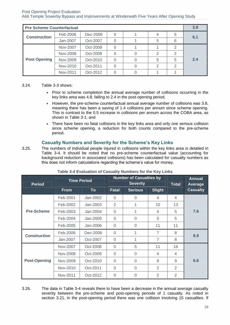
3.24. Table 3-3 shows:
Prior to scheme completion the annual average number of collisions occurring in the key links area was 4.8, falling to 2.4 in the post-opening period;
However, the pre-scheme counterfactual annual average number of collisions was 3.8, meaning there has been a saving of 1.4 collisions per annum since scheme opening. This is contrast to the 0.5 increase in collisions per annum across the COBA area, as shown in Table 3-1; and
There have been no fatal collisions in the key links area and only one serious collision since scheme opening, a reduction for both counts compared to the pre-scheme period.
Casualty Numbers and Severity for the Scheme’s Key Links
3.25. The numbers of individual people injured in collisions within the key links area is detailed in Table 3-4. It should be noted that no pre-scheme counterfactual value (accounting for background reduction in associated collisions) has been calculated for casualty numbers as this does not inform calculations regarding the scheme’s value for money.
Table 3-4 Evaluation of Casualty Numbers for the Key Links
Period Time Period
Number of Casualties by
Severity Total
Annual
Average
Casualty From To Fatal Serious Slight
Pre-Scheme
Feb-2001 Jan-2002 0 0 4 4
7.6
Feb-2002 Jan-2003 2 1 10 13
Feb-2003 Jan-2004 0 1 4 5
Feb-2004 Jan-2005 0 0 5 5
Feb-2005 Jan-2006 0 0 11 11
Construction Feb-2006 Dec-2006 0 1 7 8
8.9 Jan-2007 Oct-2007 0 1 7 8
Post-Opening
Nov-2007 Oct-2008 0 5 11 16
6.6
Nov-2008 Oct-2009 0 0 4 4
Nov-2009 Oct-2010 0 0 9 9
Nov-2010 Oct-2011 0 0 2 2
Nov-2011 Oct-2012 0 0 2 2
3.26. The data in Table 3-4 reveals there to have been a decrease in the annual average casualty severity between the pre-scheme and post-opening periods of 1 casualty. As noted in section 3.21, in the post-opening period there was one collision involving 15 casualties. If
Post Opening Project Evaluation A66 Temple Sowerby Bypass and Improvements at Winderwath Five Years After Opening Study
30
this collision is removed the post-scheme average annual casualty number falls to 3.6, a saving of 4 casualties per year.
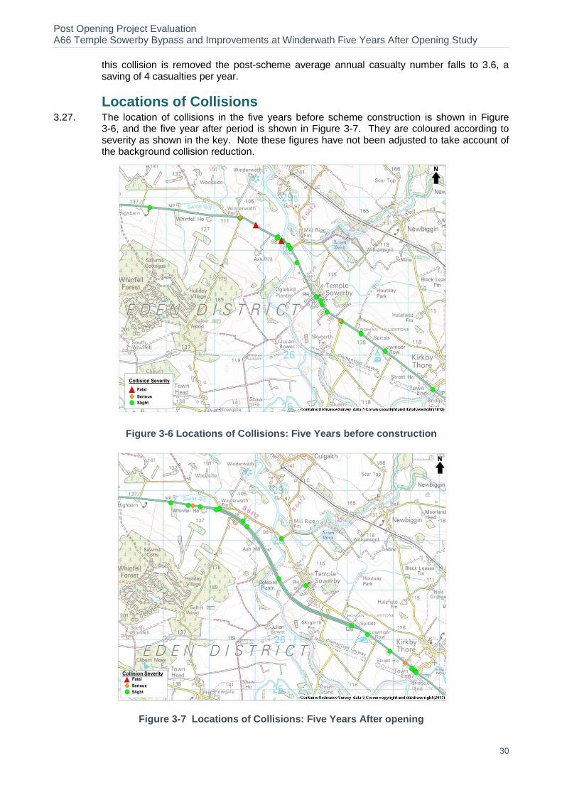
Locations of Collisions 3.27. The location of collisions in the five years before scheme construction is shown in Figure
3-6, and the five year after period is shown in Figure 3-7. They are coloured according to severity as shown in the key. Note these figures have not been adjusted to take account of the background collision reduction.
Figure 3-6 Locations of Collisions: Five Years before construction
Figure 3-7 Locations of Collisions: Five Years After opening

Post Opening Project Evaluation A66 Temple Sowerby Bypass and Improvements at Winderwath Five Years After Opening Study
31
3.28. Figure 3-6 and Figure 3-7 show:
Pre scheme:
There was a concentration of collisions on the A66 north of the village, between the River Eden bridge and the B6412.
There were also several collisions in the centre of Temple Sowerby, and at junctions with minor roads.
There were 2 fatal collisions (one near on approach to Eden bridge and other near Winderwath bend).
All but 3 of the collisions in the study area in the five years prior to opening occurred within the length of the A66 that is now bypassed by this scheme.
Post Opening:
Collisions have reduced considerably on the old A66 through the village with only 2 collisions reported during the FYA period.
A total of 6 collisions have been reported on the bypass, all of which were categorised as slight.
Of the total of 23 collisions in the study area during the five years after opening period, only seven collisions happened on the bypass and old A66 bypassed by the scheme. Remaining collisions (16 in total) in the study area occurred beyond the actual limits of the scheme.
There has been an increase in collisions during the post opening stage in the vicinity of the scheme, i.e. east and west of the bypass. This is considered in more detail later in this section.
Evaluation of Collisions east and west of the Bypass
3.29. A closer examination of collisions occurring immediately to the east and west of the Bypass (on the single carriageway sections) reveals an increase in the number of collisions occurring. These figures are presented in Table 3-5.
Table 3-5 Collisions East and West of the Scheme
Year East of A66 Temple Sowerby Bypass West of A66 Temple Sowerby Bypass
Fatal Serious Slight Total Fatal Serious Slight Total
Pre Scheme 0 0 2 2.0 0 0 1 1.0
Pre-Scheme Counterfactual
- - - 1.6 - - - 0.8
Post Scheme 0 2 9 11.0 0 1 3 4.0
3.30. Most of these are rear end collisions where vehicles waiting to turn at junctions or into private driveways are hit by vehicles from behind on A66. No collisions have been noted to the west of the bypass since 2011, however almost half of the collisions recorded post opening to the east of the bypass have occurred in 2011-2012 suggesting that this is an ongoing issue.
3.31. These sections of the A66 were not changed as part of the A66 Temple Sowerby Bypass scheme, so the reasons for the increase in collisions are unclear. It is noted that some of these collisions may be partly due to traffic not adequately changing their behaviour when transitioning from the dual carriageway bypass to the single carriageway either side, although there has also been an increase in collisions for vehicles travelling towards the bypass.
3.32. It is also possible that the delays seen pre scheme at Temple Sowerby created natural breaks in traffic travelling eastbound through Kirkby Thore. Post opening traffic flow patterns are more consistent perhaps resulting in less gaps, therefore westbound traffic waiting to

Post Opening Project Evaluation A66 Temple Sowerby Bypass and Improvements at Winderwath Five Years After Opening Study
32
turn right off the A66 remains stationary for longer waiting for a suitable gap in traffic, increasing the risk of being hit from behind/take more risks in turning across traffic.
3.33. Kirkby Thore Parish Council commented that:
‘A commonly held view is that the Bypass is successful in most aspects and widely appreciated. However, the Bypass has introduced extra problems on adjacent sections of the A66 which have potentially led to collisions and general driver stress.’
3.34. In summary, there are a number of issues which appear to contribute to the increase in collisions directly to the east and west of the bypassed section. These include:
Changes in road standard (from dual carriageway to single carriageway) with traffic behaviour not being adjusted appropriately.
Fewer gaps in traffic flow for right turning vehicles, resulting in additional risks being taken/a longer time spent stationary in the active traffic lane.
More traffic than forecast on the bypass (4%, 800 vpd) see Chapter 2 for details.
Forecast vs. Observed Collision Savings 3.35. This section compares the number of observed collisions with that forecast to occur. In order
to ensure a valid comparison, it is necessary to compare the observed savings with that forecast over the same modelled area. For the observed collisions, the Do Minimum figures are based on the annual average of five years data before scheme construction, whilst the Do Something figures are based on the annual average data five years after scheme opening. A comparison of the COBA forecast and observed collisions is presented in Table 3-6.
Table 3-6 Collision Forecasts vs. Observed COBA Area
COBA Area Forecast
(Central Growth
Opening Year Results)
Do-Minimum (without scheme) 6.8
Do-Something (with scheme) 4.0
Saving 2.8
% Change -41%
COBA Area Observed
Do-Minimum (without scheme) 5.2
Counterfactual Do-Minimum (without
scheme) 4.1
Do-Something (with scheme) 4.6
Saving -0.5
% Change +10%
3.36. From Table 3-6 it can be seen that a saving of 2.8 collisions per annum was forecast. However, there has been an observed increased in collisions in the post-scheme period of 0.5 when compared to the pre-scheme counterfactual, an increase of 10%. This can potentially be attributed to observed flows being slightly higher than forecast, as discussed in section 2.24.
3.37. The change in collisions to the east and west of the bypassed section was forecast to be negligible on the single carriageway sections over the 60 year appraisal period. It is however noted that a number of side roads accessing the A66 to the east and west of the bypass have not been included in the model, whilst the mainline carriageway at these locations has been modelled. This may mean that the number of turning movements has not been accounted for.

Post Opening Project Evaluation A66 Temple Sowerby Bypass and Improvements at Winderwath Five Years After Opening Study
33
Collision Rates on the A66 Key Links 3.38. By looking at the rates for the key links we see the impact on the roads of most interest
whilst ignoring the impact of the change in traffic volumes. The key links used in this study are:
The old A66 between Lowmoor Road in the east and Whinfell House in the west;
The new A66 Temple Sowerby bypass;
A small number of minor roads that were affected by the scheme; and
All associated junctions are also included in the analysis.
3.39. These rates are compared with those forecast for the same links and junctions. The forecast collision impact in COBA has a built in prediction of collision reduction over time. To make a comparison, we have extracted details of the traffic flows, route lengths, and collision numbers from the COBA model output for these selected links and junctions to calculate an overall rate. This is then compared with the rate calculated from the observed data for the same links and is shown in This is then compared with the rate calculated from the observed data for the same links as shown in Table 3-7.
Table 3-7 Collision Rate on the Scheme Key Links
Time Period
Collision Rate (PIC/mvkm)
Forecast
Do-Minimum (without scheme) 0.155
Do- Something (with scheme) 0.083
Forecast Saving 0.072 (46%)
Observed
Before 0.207
Before Opening Counterfactual Rate 0.162
After 0.071
Observed Saving 0.090 (56%)
3.40. Table 3-7 shows that the post-scheme collision rate (PIC/mvkm) on the key links has fallen to 0.071, from a pre-scheme counterfactual rate of 0.162, a reduction of 56% which is slightly higher than forecast.
Evaluation of Collision and Casualty Severity Indexes 3.41. The collision severity index is the ratio of the number of collisions classed as serious or fatal
compared to the total number of collisions. This is shown in Table 3-8 for the before and after collisions in the COBA study area.
Table 3-8 Severity of Collisions and Casualties COBA Area
Period
Collision Severity Index Casualty Severity Index
Annual Average Annual Average
Pre-Scheme 0.15 0.09
Post-Opening 0.13 0.15
3.42. The collision severity index was 0.15 in the before period, based on collisions in the study area over five years. It has decreased slightly to 0.13 in the FYA period. Casualty severity
Post Opening Project Evaluation A66 Temple Sowerby Bypass and Improvements at Winderwath Five Years After Opening Study
34
index has gone up from 0.09 in the before period to 0.15 at the FYA stage, but as previously noted, the bus collision was classified as a serious collision with a high number of casualties.
Fatalities & Weighted Injuries 3.43. The collision rate discussed in section 3.38 and shown in Figure 3-1 does not take into
account the severity of collisions. To analyse this we now present the Fatalities and Weighted Injuries metric which is a combined measure of casualties based on the numbers of fatal, serious and slight casualties. The FWI for the five years before and the five years after period are shown in Table 3.9. To take into account the increased traffic on the A66 and for comparison with other schemes, we also present the FWI rate per billion vehicle kilometres (bvkm).
Table 3.9– FWI on the A66
Period FWI/collision FWI/year FWI/bvkm
Before 0.110 0.51 24.1
After 0.022 0.02 0.8
3.44. Table 3.9 shows that the seriousness of collisions has reduced considerably five years post opening of scheme.
Statistical Significance of Observed Collision Impacts 3.45. In order to determine whether the changes in collision numbers observed before and after
the scheme opened are statistically significant, Chi-Square tests have been undertaken. This test uses the before and after numbers of collisions and traffic flows to establish whether the changes are significant or likely to have occurred by chance. Two Chi-Squared tests have been undertaken, one on the collisions occurring within the key links areas, and one on the whole COBA area (shown previously in Figure 3-2).
3.46. The results of these tests show that the collision changes seen on the scheme’s key links is statistically significant and as such the reduction in collisions can be attributed to the scheme. However the collision changes in the wider COBA area are not statistically insignificant suggesting that the scheme has had little impact on collisions beyond the scheme section as would be expected.
3.47. The monetisation of collision benefits is based on the wider COBA area and, given that the change in collisions has been found to not be statistically significant over this area, a monetised impact of collision changes will not be calculated in this study.
Personal Security 3.48. The aim of this sub-objective is to reflect both changes in security and the likely number of
users affected. In terms of roads, security includes the perception of risk from personal
injury, damage to or theft of vehicles, and theft of property for individuals or from vehicles.
3.49. For highway schemes, security issues may arise from the following:
On the road itself (e.g. being attacked whilst broken down)
In service areas, car parks, and so on (e.g. vehicle damage while parked at a service station, being attacked while walking to a parked car)
At junctions (e.g. smash and grab incidents while queuing at lights)
3.50. The primary indicators for roads include surveillance, landscaping, lighting and visibility, emergency call facilities and pedestrian and cyclist facilities.
Post Opening Project Evaluation A66 Temple Sowerby Bypass and Improvements at Winderwath Five Years After Opening Study
35
Forecast
3.51. The scheme appraisal states that in terms of security, ‘no change to the existing situation’. As such, the scheme was forecast to have a ‘neutral’ impact on security.
Observed
3.52. The scheme has moved through traffic from Temple Sowerby village onto the new Bypass. Laybys have been provided on the Bypass but there are no emergency telephones. Overall it can be considered that the impact on personal security is as expected.
Figure 3-8–Layby on A66 Temple Sowerby Bypass

Post Opening Project Evaluation A66 Temple Sowerby Bypass and Improvements at Winderwath Five Years After Opening Study
36
Key Points
Collisions The collision rate on the key links has dropped since the scheme opened.
Analysis of collision data has revealed an annual collision increase of 0.5 collisions per year for the COBA modelled area when compared to the pre-scheme counterfactual.
The number of casualties per annum in the before period and for FYA opening is 8.6 and 9.6 respectively. It should however be noted that one of the collisions in the after period on the single carriageway section involved a head-on collision between a car and a bus, in which there were 15 casualties, without this, an annual saving of 2 casualties a year would have been seen.
Collision severity index has slightly decreased from 0.15 in before period to 0.13 post opening;
For the key links area, there is a reduction in collisions of 1.4 per year when compared to the pre-scheme counterfactual, with a reduction in the number of casualties of 5 per year; and
The change in collisions in the COBA area is statistically insignificant and so cannot be attributed to the scheme.
Locations of Collisions
In the before period, 23 collisions occurred on the section of A66 that would be bypassed, which has reduced to 7 collisions post opening over the new and old roads.
No fatal or serious collisions were reported along the scheme section FYA, highlighting the safety improvements of the new road.
Forecast vs. Outturn Collisions
There has been a 10% increase in the number of collisions in the key links area compared to a forecast reduction of 41%.
Security
The scheme has moved through traffic from Temple Sowerby village onto the new Bypass. Laybys have been provided on the Bypass but there are no emergency telephones. The overall impact is as expected.
Post Opening Project Evaluation A66 Temple Sowerby Bypass and Improvements at Winderwath Five Years After Opening Study
37
4. Economy
Introduction 4.1. This section presents an evaluation of how the scheme is performing against the economy
objective. The five sub-objectives are to:
Get good value for money in relation to impacts on public accounts
Improve transport economic efficiency for business users and transport providers
Improve transport economic efficiency for consumer users
Improve reliability
Provide beneficial wider economic impacts
4.2. When a scheme is appraised, an economic assessment is used to determine the scheme’s value for money. This assessment is based on an estimation of costs and benefits from different sources:
Transport Economic Efficiency (TEE) benefits (travel times and vehicle operating costs)
Collision costs (changes in the number and severity level of collisions)
Costs to users due to construction and maintenance
4.3. This section provides a comparison between the forecast and outturn costs and benefits, wider economic impacts and journey time reliability.
Sources 4.4. The original appraisal of the scheme included a forecast of the economic impacts of the
scheme over 30 years using a COBA model. The area covered by the COBA model is shown in Figure 3-2 in the Safety section of this report.
4.5. This is detailed in the A66 Temple Sowerby and Improvements at Winderwath Scheme Assessment Report (April 2002) and the figures from this assessment were used in the AST. However, the most recently forecast benefits are contained in the A66 Temple Sowerby Bypass Technical Note 1 Rev 1 – Update of Economic Assessment (2005). This included the following updates in line with revised guidance:
A new COBA 11.6 run with the appraisal period extended to 60 years
Price base updated to 2002
Discount rate revised to 3.5% for the first years and 3% thereafter
Substantially increased predictions for construction and land costs, including optimism bias
4.6. It is this most recent update that has been used as the basis for evaluation in this chapter. The revised COBA model and supporting information used to produce the forecast economic benefits for the 2005 update could not be obtained.
Benefits 4.7. This section uses observed traffic flow, journey times and collision data to recalculate the
main economic impacts of the scheme.
Journey Time Benefits
Forecast Journey Time Benefits
4.8. The forecast journey time benefits are primarily derived from A66 through trips which can now travel along the Bypass in free flow conditions instead of experiencing stop-start conditions and speed limits on the former A66 through the village of Temple Sowerby.
Post Opening Project Evaluation A66 Temple Sowerby Bypass and Improvements at Winderwath Five Years After Opening Study
38
Evaluation of Journey Time Benefits
4.9. The journey time benefits for this scheme have been evaluated using a PAR6 approach,
typically adopted by the HA for the appraisal of smaller schemes. This approach has been used because the COBA model used to prepare the 2005 update is not available. However, this approach is considered robust in this instance because the evaluation includes journey time savings on both the A66 bypass and old road and it is anticipated that the vast majority of the benefits will occur on these routes.
4.10. Observed vehicle hour savings have been calculated for 2008 (opening year was at the end of 2007) and 2012 (five years after). The savings for 2009-2011 are interpolated between the 2008 and 2012 figures. In the PAR method, the value of time changes by year, so these have also been used to total the figure for the first five years. For the remainder of the appraisal period, the benefits are based on the saving in 2012 capitalised over 55 years. This is summarised in Table 4-1.
Table 4-1 - Journey Time saving and Monetary Benefit (2002 market prices discounted to 2002)
PAR method for Journey Time benefits Vehicle hours
saved Monetary benefit based on value
of time saved
2008 (using one year after opening data) 116,230 £1.197m
2009-2011 (interpolated) 345,514 £3.420m
2012 (using five year after opening data) 113,599 £0.985m
Future traffic growth
0% traffic growth
(Low Growth)
NRTF traffic growth
(High Growth)
2012 vehicle hour benefit capitalised over 55 years £36.3m £45.5m
Total 60 year appraisal period benefit (5 + 55 years) £41.9m £51.2m
4.11. Table 4-1 shows that the re-evaluated 60 year journey time benefit in market prices, based on observed traffic conditions five years after opening is between £41.9m and £51.2 million compared to a forecast of £47.6m. This is because traffic flows and journey time savings are broadly in line with predictions. The £51.2m figure will be taken forward to the BCR calculation later in this chapter because it is clear that traffic growth has occurred in this area.
Safety Benefits
4.12. In scheme appraisals, the economic impact of changes in safety are calculated by assigning monetary benefits to the predicted reduction in the number and severity of PIA’s over the appraisal period.
4.13. The forecast safety benefits of the scheme were derived from a COBA model, which gives predicted collision savings over the 60 year appraisal period. The forecast savings across the COBA area totalled £20.2m.
4.14. As discussed in section 3.47, the observed changes in collisions across the COBA area since scheme opening have been found to not be statistically significant. As such, the change in collisions cannot be included within the scheme’s economic benefits.
Present Value Benefits 4.15. A comparison of all forecast and outturn benefits is presented in Table 4.2. The outturn
figures presented are for a ‘central growth’ case which takes a 50:50 ratio from the low:high growth figures presented in Table 4-1 (journey times).
6 Project Appraisal Report Guidance Notes Version 5.0.

Post Opening Project Evaluation A66 Temple Sowerby Bypass and Improvements at Winderwath Five Years After Opening Study
39
Table 4.2 – Summary of Scheme Present Value Benefits
2002 prices discounted to 2002 Forecast
Re-Forecast based on FYA Outturn Impacts
Journey Time Benefits £47.6m £51.2m
Collision Benefits £20.2m -
Total PVB £67.8m £51.2m
4.16. The results presented in Table 4.2 show that the reforecast PVB for the scheme is £51.2m, 25% less than the £67.8m forecast at the appraisal stage. This difference is due to the lack of monetised collision savings.
Scheme Costs
Investment Costs
4.17. This section compares the forecast cost of the scheme with the outturn cost. Scheme costs include the cost to the Highways Agency of constructing the scheme and purchasing the land. The forecast cost has been obtained from the A66 Temple Sowerby Bypass Technical Note 1 Rev 1 – Update of Economic Assessment (2005). The figures were presented in 2005 prices and have been converted to 2002 prices to maintain consistency with the other figures presented in this report.
4.18. Outturn investment costs have been obtained from the HA Regional Finance Manager (supplied in April 2013) and are presented along with the forecast costs in Table 4.3.
Table 4.3 – Forecast vs. Outturn Investment Costs
2002 prices Forecast Cost
(£m) Outturn
(£m)
Total Investment Cost 31.9 32.3
4.19. Table 4.3 shows that the total outturn investment costs for the scheme is £32.3m, which is 2% higher than the £31.9m forecast investment cost.
Present Value Costs
4.20. The Present Value Cost (PVC) is calculated to allow for a valid comparison with benefits. Values in differing years are converted to a standard base year through the process of discounting, as defined by the Treasury Green Book. A comparison of all forecast and outturn costs is presented in Table 4.4. Scheme costs are discounted to 2002 values using the rate of 3.5% to obtain the PVC for use in calculating the BCR.
Table 4.4 – Forecast vs. Outturn PVC
2002 prices discounted to 2002 Forecast Cost
(£m) Outturn
(£m)
Total PVC 27.3 27.7
Benefit Cost Ratio 4.21. The Benefit Cost Ratio (BCR) is used as an indicator of the overall value for money of the
scheme. It is the comparison of the benefits (PVB) and costs (PVC) expressed in terms of present value.
4.22. Table 4.5 compares the predicted and outturn costs and benefits together with the associated BCR.
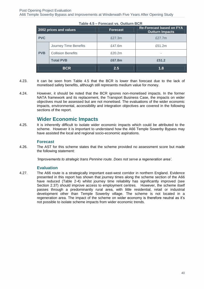
Post Opening Project Evaluation A66 Temple Sowerby Bypass and Improvements at Winderwath Five Years After Opening Study
40
Table 4.5 – Forecast vs. Outturn BCR
2002 prices and values Forecast Re-Forecast based on FYA
Outturn Impacts
PVC £27.3m £27.7m
PVB
Journey Time Benefits £47.6m £51.2m
Collision Benefits £20.2m -
Total PVB £67.8m £51.2
BCR 2.5 1.8
4.23. It can be seen from Table 4.5 that the BCR is lower than forecast due to the lack of monetised safety benefits, although still represents medium value for money.
4.24. However, it should be noted that the BCR ignores non-monetised impacts. In the former NATA framework and its replacement, the Transport Business Case, the impacts on wider objectives must be assessed but are not monetised. The evaluations of the wider economic impacts, environmental, accessibility and integration objectives are covered in the following sections of the report.
Wider Economic Impacts 4.25. It is inherently difficult to isolate wider economic impacts which could be attributed to the
scheme. However it is important to understand how the A66 Temple Sowerby Bypass may have assisted the local and regional socio-economic aspirations.
Forecast
4.26. The AST for this scheme states that the scheme provided no assessment score but made the following statement:
‘Improvements to strategic trans Pennine route. Does not serve a regeneration area’.
Evaluation
4.27. The A66 route is a strategically important east-west corridor in northern England. Evidence presented in this report has shown that journey times along the scheme section of the A66 have reduced (Table 2-4) whilst journey time reliability has significantly improved (see Section 2.37) should improve access to employment centres. However, the scheme itself passes through a predominantly rural area, with little residential, retail or industrial development other than Temple Sowerby village. The scheme is not located in a regeneration area. The impact of the scheme on wider economy is therefore neutral as it’s not possible to isolate scheme impacts from wider economic trends.
Post Opening Project Evaluation A66 Temple Sowerby Bypass and Improvements at Winderwath Five Years After Opening Study
41
Key Points
Present Value Benefits The outturn journey time benefits of £51.2m are similar to the forecast benefits because the
traffic flows and journey time savings are broadly in line with predictions.
The forecast collision benefits totalled £20.2m. Due to the change in collision numbers being statistically insignificant, the change in collisions does not count towards the economic benefit of the scheme.
Overall, the outturn PVB is £51.2m compared to a forecast of £67.8m.
Costs Outturn investment costs were £32.3m compared to a forecast of £31.9m.
BCR The scheme achieves a BCR of 1.8 compared to a forecast of 2.5.
Wider Economic Impacts The wider economic impacts of the scheme are neutral.
Present Value Costs
TBC
Benefit Cost ratio
TBC
Wider Economic Impacts
Due to the inherent difficulty in isolating the wider economic impacts of the scheme, it has not been possible to conclude whether the scheme has had a direct impact on stimulating local economic activity.
Post Opening Project Evaluation A66 Temple Sowerby Bypass and Improvements at Winderwath Five Years After Opening Study
42
5. Environment
Introduction 5.1. This section documents the evaluation of the environmental sub-objectives, focussing on
those aspects not fully evaluated at the One Year After (OYA) stage or where suggestions were made for further study.
5.2. The Environmental Statement (ES) noted that the scheme’s environmental objectives were:
To improve amenity in the village of Temple Sowerby by reducing noise from through traffic and improving air quality.
To take full account of the sensitive location within the River Eden Valley.
5.3. The following environmental sub-objectives were appraised in the ES and in the Appraisal Assessment Table (AST) according to NATA guidance at that time (2002):
Noise
Local Air Quality
Greenhouse Gases
Heritage
Landscape
Biodiversity
Water Environment
Physical fitness
Journey Ambience
Summary of OYA Evaluation Recommendations
The OYA evaluation identified a number of areas where further analysis was required at the Five Year After (FYA) stage to confirm the longer term impacts of the scheme on the surrounding environment, these are summarised as follows:
Local Air Quality –Eden District Council commented that the scheme would be included in an Air Quality Updating, Screening and Assessment to be undertaken in 2009, the results of which should be included in the FYA report.
Landscape – A copy of the Handover Environmental Management Plan (HEMP) to be issued towards the end of the three year aftercare period should be made available for the FYA report, and the ongoing establishment of the planting would be reviewed as part of the FYA evaluation.
Heritage – The published Archaeology report had not been provided to the County Archaeologist at the time of the OYA consultation and it was expected that a copy of the published report should made available for the FYA report.
Biodiversity – The OYA report stated that very little information had been made available on which to fully evaluate the impacts of the scheme on biodiversity and the effectiveness of the mitigation measures, and that these aspects should be considered in more detail at the FYA stage. Ongoing badger and bat monitoring was expected to be carried out during the three year after care period (2008 -2010), the results of which should be made available for the FYA report, and that consultation at the FYA stage should be extended to include the local wildlife trust.
Post Opening Project Evaluation A66 Temple Sowerby Bypass and Improvements at Winderwath Five Years After Opening Study
43
5.4. For each of these environmental sub-objectives, the evaluation in this Section assesses the environmental impacts predicted in the scheme’s AST and ES against those observed five years after opening.
5.5. In the context of the findings from the OYA evaluation and using new evidence collected FYA opening, this section presents:
An evaluation of the ongoing effectiveness of the mitigation measures implemented as part of the scheme.
An updated summary of key impacts against all of the nine environment WebTAG sub objectives, with particular focus on assessment of sub-objectives where it was too early to conclude at the OYA evaluation stage.
Additional analysis relevant to close out issues/ areas for further study as identified at the OYA stage for consideration at the FYA stage.
Methodology 5.6. This section focuses on those aspects not fully evaluated at OYA, or where at OYA,
suggestions were made for further study and also any issues that have arisen since the OYA evaluation. The detail of the OYA study is not repeated here, and reference is made to the OYA report where required, although key points are incorporated into this FYA report where appropriate to provide contextual understanding.
5.7. No new modelling or survey work has been undertaken for this FYA environmental evaluation.
Data Collection 5.8. The following documents have been used for the FYA:
Appraisal Summary Table
A66 Temple Sowerby Bypass and Improvements at Winderwath Environmental Statement, June 2002: Volume 1 (Scheme Information and Summary of Assessment) and Volume 2 (Detailed Assessment)
Post Opening Project Evaluation: A66 Temple Sowerby Bypass and Improvements at Winderwath - One Year After Study (August 2009)
Archaeological Investigation on the A66 at Temple Sowerby, (2006-7, 2008)
A66 Temple Sowerby Bypass and Improvements at Winderwath: Ecological Update Report (December 2007)
As-Built drawings
A66 Temple Sowerby Bypass Handover Environmental Management Plan (May 2011).
5.9. A full list of the background information requested and received to help with the compilation of this report is included in Appendix A1.
Site Visit 5.10. As part of the FYA evaluation, a site visit was undertaken in late May 2013. This included the
taking of photographs to provide comparison views with selected ES photomontages and OYA photographs. These are shown in Appendix A2.
Consultation 5.11. Three statutory environmental organisations (Natural England, English Heritage and the
Environment Agency), Cumbria County Council, Eden District Council, Parish Councils (Brougham/ Temple Sowerby/ Kirkby Thorpe/ Culgaith), the British Horse Society, and Cumbria Wildlife Trust were contacted as part of the FYA evaluation regarding their views on the impacts they perceive the road has had on the environment as shown in Table 5-1.
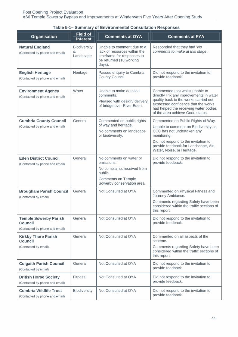
Post Opening Project Evaluation A66 Temple Sowerby Bypass and Improvements at Winderwath Five Years After Opening Study
44
Table 5-1– Summary of Environmental Consultation Responses
Organisation Field of Interest
Comments at OYA Comments at FYA
Natural England
(Contacted by phone and email)
Biodiversity & Landscape
Unable to comment due to a lack of resources within the timeframe for responses to be returned (18 working days).
Responded that they had ‘No comments to make at this stage’.
English Heritage
(Contacted by phone and email)
Heritage Passed enquiry to Cumbria County Council.
Did not respond to the invitation to provide feedback.
Environment Agency
(Contacted by phone and email)
Water Unable to make detailed comments.
Pleased with design/ delivery of bridge over River Eden.
Commented that whilst unable to directly link any improvements in water quality back to the works carried out, expressed confidence that the works had helped the receiving water bodies of the area achieve Good status.
Cumbria County Council
(Contacted by phone and email)
General Commented on public rights of way and heritage.
No comments on landscape or biodiversity.
Commented on Public Rights of Way.
Unable to comment on Biodiversity as CCC has not undertaken any monitoring.
Did not respond to the invitation to provide feedback for Landscape, Air, Water, Noise, or Heritage.
Eden District Council
(Contacted by phone and email)
General No comments on water or emissions.
No complaints received from public.
Comments on Temple Sowerby conservation area.
Did not respond to the invitation to provide feedback.
Brougham Parish Council
(Contacted by email)
General Not Consulted at OYA Commented on Physical Fitness and Journey Ambiance.
Comments regarding Safety have been considered within the traffic sections of this report.
Temple Sowerby Parish Council
(Contacted by phone and email)
General Not Consulted at OYA Did not respond to the invitation to provide feedback.
Kirkby Thore Parish Council
(Contacted by email)
General Not Consulted at OYA Commented on all aspects of the scheme.
Comments regarding Safety have been considered within the traffic sections of this report.
Culgaith Parish Council
(Contacted by email)
General Not Consulted at OYA Did not respond to the invitation to provide feedback.
British Horse Society
(Contacted by phone and email)
Fitness Not Consulted at OYA Did not respond to the invitation to provide feedback.
Cumbria Wildlife Trust
(Contacted by phone and email)
Biodiversity Not Consulted at OYA Did not respond to the invitation to provide feedback.

Post Opening Project Evaluation A66 Temple Sowerby Bypass and Improvements at Winderwath Five Years After Opening Study
45
5.12. The Highways Agency Part 1 Team has been contacted regarding Part 1 claims, but no information has been forthcoming.
5.13. The Area 13 Managing Agent Contractor (MAC) has also been consulted with regard to animal mortality figures which have been made available for the A66 Temple Sowerby Bypass for the six year period between 2008 and 2013 inclusive. These figures are discussed in the biodiversity chapter.
Traffic Forecast Evaluation 5.14. Three of the environmental sub-objectives (noise, local air quality and greenhouse gases)
are directly related to traffic flows. No new noise or air quality surveys are undertaken for Post Opening Project Evaluation (POPE) and an assumption is made that the level of traffic and the level of traffic noise and local air quality are related.
5.15. The ES outlines the need for the scheme and includes data on the Annual Average Daily Totals (AADT) for traffic flows. In order to provide a context for the following review and evaluation of environmental topics, the key findings given in the ES are summarised as follows:
The AADT two-way flow in the ‘base year 2000’ on the A66 at Temple Sowerby was 13,011 vehicles to the east of the Temple Sowerby and 13,212 to the west.
The route carried approximately 34% of heavy goods vehicles (HGV’s).
Traffic was expected to reduce within the village by about 93%.
5.16. The ES compared the future year traffic forecasts with and without the scheme. Observed after opening traffic flows on the new and old A66 flows in the opening year were within 10% of predictions. There were greater percentage differences on the four link roads, although the absolute values were small.
Table 5-2 – Comparison of Predicted and Observed AADT for Traffic Flows at OYA and FYA
Location ES Base
year (2000)
ES Forecast Post-
Construction (2005)
Observed Flows OYA
(2008)
Mean Forecast
FYA (2012)
Observed Flows FYA
(2012)
% Difference (2012 Mean Forecast vs. Observed)
Old A66 East of Temple Sowerby
LG
13,011
738
820
810
1,310 +35.2% Mean 756 849
HG 773 888
Old A66 West of Temple Sowerby
LG
13,212
953
800
1,047
1,337 +17.9% Mean 976 1,097
HG 999 1,147
New Bypass
LG
-
13,170
14,800
14,464
15,836 +4.3% Mean 13,485 15,154
HG 13,799 15,844
Post Opening Project Evaluation A66 Temple Sowerby Bypass and Improvements at Winderwath Five Years After Opening Study
46
Five Years After Environment Assessment 5.17. Included in this section is a brief summary of statements from the AST, ES and OYA
evaluations (including close out/ key issues identified for further reporting at the FYA stage) which have been included to provide the context for the FYA evaluation.
Noise
5.18. The AST predicted there would be about a 90% reduction in traffic in the village centre, which would result in a significant reduction in traffic noise in the village. The AST quantified that the number of people likely to be annoyed by traffic noise from the scheme in the long term (2020) would be 47, compared to 91 people if the scheme were not implemented.
5.19. The ES stated that operation of the Scheme would likely result in a reduction of 44 people likely to be bothered by noise long term, and the greatest reduction would be in the number of people exposed to the highest noise levels. Noise levels in the centre of Temple Sowerby at properties facing the existing A66 were predicted to experience a halving of the perceived noise levels existing before construction. A number of properties on the southern edge of the village and isolated properties along the route of the Scheme were expected to experience an increase in noise levels, although the location of the Scheme in a cutting and the use of earth mounding were expected to minimise noise impacts at the majority of these properties. The operation of the Scheme was expected to have little impact on noise levels at a number of residential properties at and beyond each end of the Scheme.
5.20. The OYA report stated that earth mounding and cuttings had generally been constructed in accordance with the ES, and that traffic through the village had significantly reduced and as such, it was considered that the local noise climate would have improved as expected. The report also noted that as a result of an objection at the Public Inquiry, a noise barrier had been erected adjacent to the eastbound carriageway above the PROW 368006 underpass.
Consultation
5.21. Kirkby Thore Parish Council has commented that:
‘The bypass is at the western edge of the Parish of Kirkby Thore and only has a
direct impact on a few properties and residents in the Parish. However, road
improvements had to be made to a section of the A66 immediately east of the
bypass to repair a section of road surface that was causing excessive noise to
residents at Low Moor.’
Evaluation
5.22. It is unclear if the section of road referred to by Kirkby Thore Parish Council in relation to the noise climate at Low Moor was damaged as a result of the new bypass, but the section referred to is not a part of the bypass and as such, is outside the scope of this report.
5.23. As can be seen in by Table 5-2, the data indicates that the observed traffic flow is very similar to that forecasted by the ES: traffic on the new A66 bypass is 4.3% greater than predicted.
5.24. Observed traffic flow on the old A66 to the east of Temple Sowerby has reduced significantly (by 90%, as predicted by the ES), and although traffic flows are higher than expected, the overall number of vehicles is less than 2000 AADT and as such, is considered to be low.
5.25. Based on the information presented in this evaluation, it is concluded that the effects of the scheme is large beneficial, as expected in terms of noise. This conclusion is based on:
The assumption made by POPE methodology that noise levels will be as expected if observed traffic flows are within 25% more or 20% less than predicted flows.
Although traffic flow on the old A66 to the east of Temple Sowerby is outside of the tolerances assumed by POPE, the overall number of vehicles is low.
Scheme Objective: To reduce noise

Post Opening Project Evaluation A66 Temple Sowerby Bypass and Improvements at Winderwath Five Years After Opening Study
47
Table 5-3 – Evaluation Summary: Noise
Sub-Objective FYA Score Evaluation
Noise Large Beneficial As expected
Local Air Quality 5.26. The AST predicted that Nitrogen dioxide (NO2) and Particulate matter (PM10)
concentrations would be well below national objectives at all properties. Properties adversely affected would be at either end of the scheme where it rejoined the existing A66, but annual mean NO2 and PM10 concentrations at properties directly facing onto the A66 would be significantly reduced. Overall, the AST concluded that 165 properties would experience an increase in air quality, and 20 properties would experience a decrease in air quality.
5.27. The ES stated that the operation of the Scheme would result in improvement or no change in air quality at 165 properties and a reduction of air quality at 20 properties, although the decrease in air quality at all 20 properties was stated as being very minor. Significant reductions in pollution concentrations were expected to occur at properties within Temple Sowerby, in particular properties which faced directly onto the road. The predicted pollutant concentrations at all residential properties were considered to be well below the UK Air Quality Strategy objectives.
5.28. The OYA report stated that it was likely that local air quality impacts were as expected, and noted that Eden District Council had commented that the scheme would be included in an Air Quality Updating, Screening and Assessment to be undertaken in 2009, the results of which should be included in the FYA report.
Consultation
5.29. Kirkby Thore Parish Council commented that the impact of the Scheme on Local Air Quality was as expected.
Evaluation
5.30. The Air Quality Updating and Assessment, noted at OYA as due to be undertaken by Eden District Council (EDC) in 2009, concluded that air quality was currently meeting the national objectives and that it was not necessary to undertake any Detailed Assessments or to declare any Air Quality Management Areas (AQMAs). An Air Quality progress Report produced by EDC in 2010 reached similar conclusions.
5.31. An Air Quality progress report produced by EDC in 2011 concluded that results from monitoring NO2 levels during 2010 at 5 new locations (one of which was on the A66 at Kirkby Thore) identified that there may be a risk of the annual mean NO2 level being exceeded. The report stated that a Detailed Assessment would be undertaken at these locations and this would be undertaken in 2012, but the results were not available at FYA.
5.32. Eden District Council has been contacted regarding results of their local air quality management review and assessment; however, there was no relevant monitoring data to the scheme that could be evaluated.
5.33. As can be seen in by Table 5-2, the data indicates that the observed traffic flow is very similar to that forecasted by the ES, traffic on the new A66 bypass being 4.3% greater than predicted.
5.34. Although observed traffic flows on the old A66 to the east and the west of Temple Sowerby appear to be significantly greater than predicted, the overall number of vehicles is less than 2000 AADT and as such, is considered to be low.
5.35. Based on the information presented in this evaluation, it is concluded that the effects of the scheme are as expected in terms of local air quality. This conclusion is based on:
The assumption made by POPE methodology that air quality will be as expected if observed traffic flows are within 10% more or 10% less than predicted flows.

Post Opening Project Evaluation A66 Temple Sowerby Bypass and Improvements at Winderwath Five Years After Opening Study
48
Although traffic flows on the old A66 to the east and west of Temple Sowerby are outside of the tolerances assumed by POPE, the number of vehicles is low and overall traffic flows have reduced significantly as a result of the bypass.
Table 5-4– Evaluation Summary: Local Air Quality
Sub-Objective FYA Score Evaluation
Local Air Quality Large Beneficial As expected
Greenhouse Gases 5.36. The assessment of the impacts of transport schemes on emissions of greenhouse gases is
one of the environment sub-objectives. WebTAG notes that carbon dioxide (CO2) is considered the most important greenhouse gas which is therefore used as the key indicator for the purposes of assessing the impacts of transport options on climate change. Changes in CO2 levels are considered in terms of equivalent tonnes of carbon released as a result of the scheme. Carbon emissions are therefore estimated for the DS and DM scenarios using forecast and observed FYA data.
Forecast Greenhouse Gases
5.37. The AST predicted that a slight increase in carbon emissions was expected due to the predicted increase in speeds and slight increase in distance on the dual carriageway. In 2005 there was a forecast increase of 314 tonnes of carbon rising to an increase of 455 tonnes of carbon in 2020.
Evaluation of Greenhouse Gases
5.38. The forecast greenhouse gas emissions contained were calculated for the whole COBA area. For this study it is not possible to analyse carbon emissions for this area as journey time and traffic flow data is not available for all links. Rather, an analysis of emissions from vehicles using the A66 and old road has been undertaken. In order to undertake this analysis, current Design Manual for Roads and Bridges (DMRB) guidance has been used to re-forecast carbon emissions for the DM and DS scenarios using forecast flows and speeds. Observed carbon emissions were calculated using the same methodology for the DM and DS scenarios, using flow and speed data collected for this study. As the same geographic area has been modelled for the forecast and observed scenarios, a clear comparison can be made between the data outputs. Table 5.5 presents the results of this exercise.
Table 5.5 – Re-Forecast and Outturn Change in Carbon Emissions
Carbon Emissions (carbon tonnes/year)
Re-Forecast Observed
Do Minimum 2,575 3,436
Do Something 2,796 4,032
Net Increase 221 596
9% 17%
5.39. Table 5.5 shows that observed carbon emissions increased by 17% between the DM and DS scenarios, equivalent to 596 tonnes of carbon. However, the re-forecast data predicted a 9% increase in carbon emissions between the DM and DS scenarios, equivalent to 221 carbon tonnes. The reason for the increase being higher than forecast is because the actual DM flows were slightly lower than forecast on the A66, whilst the post opening flows on the Bypass are slightly higher than forecast. The proportion of observed HGV’s is also higher than those forecast. Small changes in the HGV proportions have a big impact on the carbon emissions.
Post Opening Project Evaluation A66 Temple Sowerby Bypass and Improvements at Winderwath Five Years After Opening Study
49
5.40. Therefore it can be concluded that the scheme has resulted in higher carbon emissions, worse than expected.
Table 5.6 – Evaluation Summary: Greenhouse Gases
Sub-Objective FYA Score Evaluation
Greenhouse Gases Minor negative Worse than expected
Landscape 5.41. The AST stated that the new route would cut across rolling farmland behind the village, in
cutting and on embankment. An adverse effect at the bridge crossing of the scenic River Eden was predicted, and it was further noted that additional balancing ponds would not alter the assessment. A moderate adverse effect was predicted overall.
5.42. The ES stated in summary that the overall assessment of the visual effects of the Scheme was Moderate Adverse, primarily due to the availability of open views in the area that would be interrupted by the presence of the Bypass or blocked/ significantly shortened/ enclosed by the introduction of wooded embankments and false cuttings. Visual amenity in the vicinity of the River Eden would also be significantly affected.
5.43. The ES also stated that all planting undertaken as part of the landscape mitigation measures would be well established 15 years after opening, with shrub planting likely to have reached its mature size and as part of woodland or in association with scattered trees, would likely be providing its maximum screening effect. Tree planting would be expected to have reached its earliest mature state and was expected to be 5 – 7 m in height (dependent on species and precise location).
5.44. The OYA report noted that the landscape mitigation measures appeared to have been implemented in accordance with the ES design and although some minor changes had been necessary, these changes had not adversely affected the landscape or visual effect.
5.45. The OYA report also recorded that the landscape mitigation measures were generally establishing very well, with trees protected by plastic tubes, all upright and in good condition. Grass within planted plots was recorded as being under a maintenance regime, and that apart from a small infestation of noxious weeds in the hedgerow along Cliburn Road, weed control was generally good.
5.46. The OYA report recommended that a copy of the Handover Environmental Management Plan (HEMP) that was due to be issued towards the end of the three year aftercare period should be made available for the FYA report, and that it would be appropriate that the ongoing establishment of the planting be reviewed as part of the FYA evaluation.
Consultation
5.47. Natural England has no comments to make regarding landscape at this stage.
5.48. Kirkby Thore Parish Council has commented that the impact of the scheme is as expected.
Evaluation
5.49. Comparison views with selected ES photomontages and OYA photographs are shown in Appendix A.
5.50. The scheme was adopted following consideration of a number of options for alternative routes and alignments, and the detailed development of the scheme involved the following measures to limit landscape and visual effects:
The alignment of the route at Ash Hill follows the existing landscape structure and is generally placed in cutting.
The location of the proposed river crossing takes advantage of the local landform of the river terraces to minimise visual intrusion; The road is placed in cutting to the south west of the village (in the vicinity of Acton Lodge); false cuttings are incorporated into the scheme to the south of the village (in the vicinity of Croft Place.

Post Opening Project Evaluation A66 Temple Sowerby Bypass and Improvements at Winderwath Five Years After Opening Study
50
Open views are maintained at the south east of the scheme (in the vicinity of Spitals Farm.
5.51. The report found that landscape mitigation measures incorporated into the scheme had been implemented as expected and, as also stated in the ES, the site survey of 2013 confirmed that as expected:
The cutting and embankments from the Cliburn Road junction to the river crossing have been rounded out to blend with local landform and have returned to agricultural use.
The bypass crosses the river terrace at an oblique angle and is situated such that it is in scale with the river terrace and remains partially screened from Temple Sowerby village.
5.52. Other landscape integration measures included the retention of mature trees at selected locations (see Figure 5-1 below) and new planting, also designed perform a visual screening function.
Figure 5-1–Retained Mature Trees Reducing the Scale of the New Overbridge at Morland Road
5.53. The HEMP (May 2011) stated that the target percentage cover by year 3 should be 80% for Woodland/ Linear Belts of Trees & Shrubs, 85% for Woodland Edge, and 90% for Shrubs with Intermittent Trees.
5.54. In terms of management operations, the HEMP stated that in years 1-5:
Outside of planting plot areas and within the immediate vicinity of individual trees, no cutting regime for General Grassland was proposed for the majority of the site, although weeds/ scrub/ pioneer trees would be removed.
Hedgerows were to be under-planted where gaps occurred due to failures, and plant shelters were to be removed at the end of the year five.
Plant guards and shelters used to protect all other planting stock should be removed between years 4-6 of the establishment period.
Individual plants that failed to thrive or establish were generally acceptable in the general plot areas where establishment was good and where failure provided natural thinning. Plant failure was less acceptable within hedge lines, screen planting and for tree failures, where full replacement of planting stock for the first 2 years of the Management Plan would be of a size larger than the original landscape specification.
Wetland areas would be allowed to colonise naturally, but excessive encroachment into wetland areas would be prevented. 50% of the surface area would remain as open water, and overhanging trees and shrubs would be removed to ensure that shading did not exceed 20%.
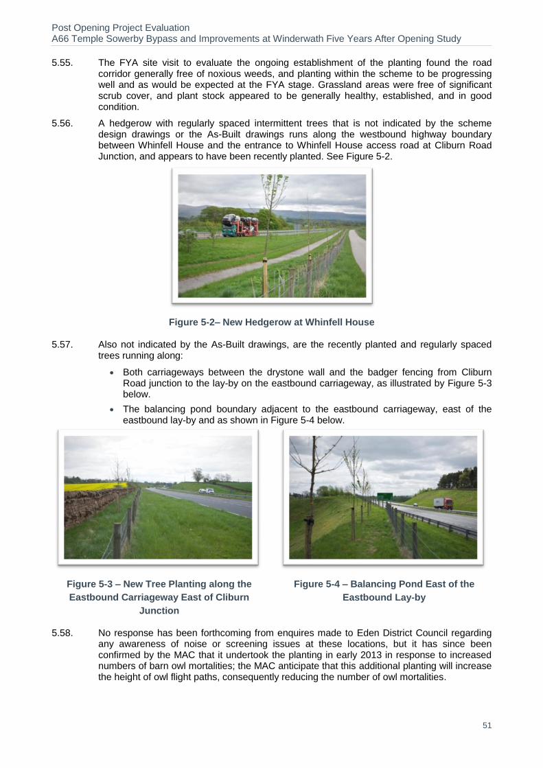
Post Opening Project Evaluation A66 Temple Sowerby Bypass and Improvements at Winderwath Five Years After Opening Study
51
5.55. The FYA site visit to evaluate the ongoing establishment of the planting found the road corridor generally free of noxious weeds, and planting within the scheme to be progressing well and as would be expected at the FYA stage. Grassland areas were free of significant scrub cover, and plant stock appeared to be generally healthy, established, and in good condition.
5.56. A hedgerow with regularly spaced intermittent trees that is not indicated by the scheme design drawings or the As-Built drawings runs along the westbound highway boundary between Whinfell House and the entrance to Whinfell House access road at Cliburn Road Junction, and appears to have been recently planted. See Figure 5-2.
Figure 5-2– New Hedgerow at Whinfell House
5.57. Also not indicated by the As-Built drawings, are the recently planted and regularly spaced trees running along:
Both carriageways between the drystone wall and the badger fencing from Cliburn Road junction to the lay-by on the eastbound carriageway, as illustrated by Figure 5-3 below.
The balancing pond boundary adjacent to the eastbound carriageway, east of the eastbound lay-by and as shown in Figure 5-4 below.
Figure 5-3 – New Tree Planting along the
Eastbound Carriageway East of Cliburn
Junction
Figure 5-4 – Balancing Pond East of the
Eastbound Lay-by
5.58. No response has been forthcoming from enquires made to Eden District Council regarding any awareness of noise or screening issues at these locations, but it has since been confirmed by the MAC that it undertook the planting in early 2013 in response to increased numbers of barn owl mortalities; the MAC anticipate that this additional planting will increase the height of owl flight paths, consequently reducing the number of owl mortalities.
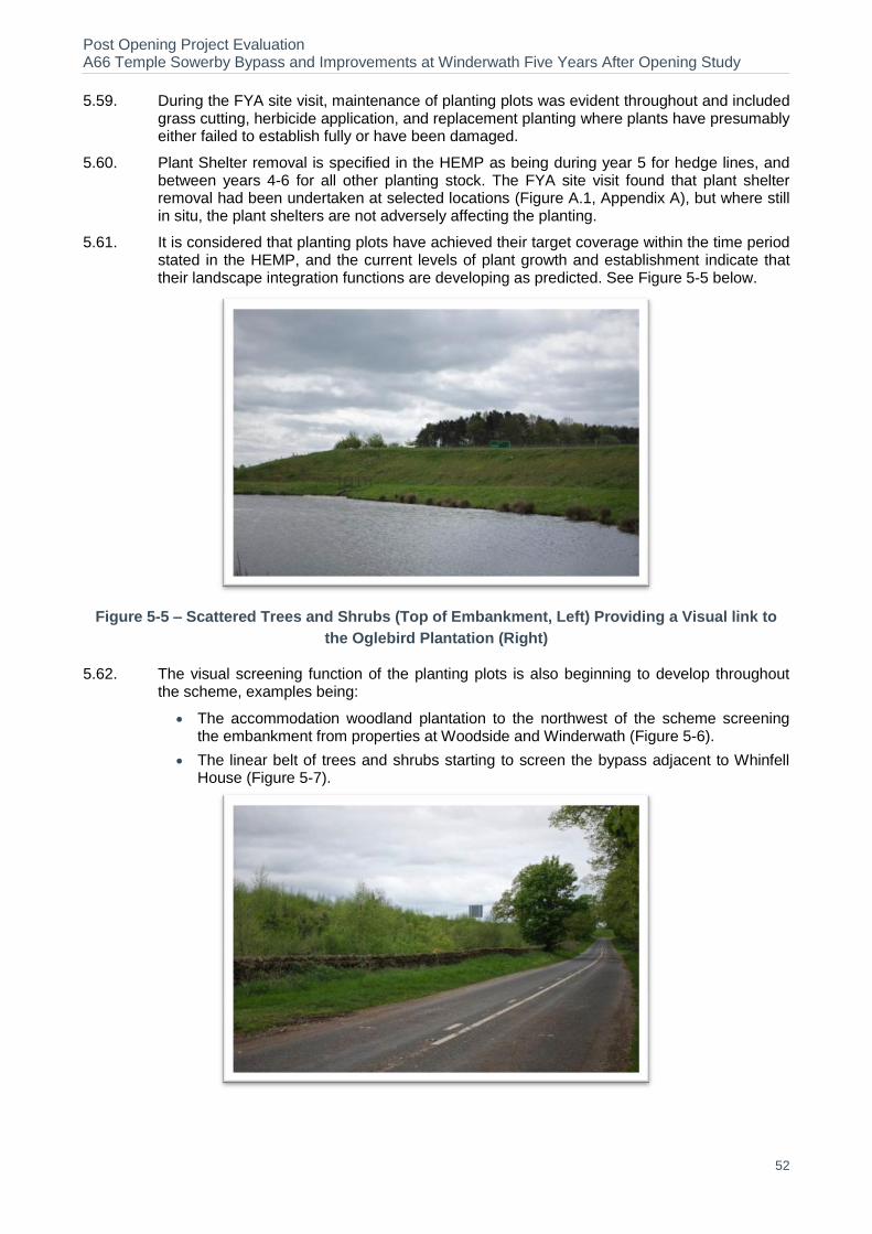
Post Opening Project Evaluation A66 Temple Sowerby Bypass and Improvements at Winderwath Five Years After Opening Study
52
5.59. During the FYA site visit, maintenance of planting plots was evident throughout and included grass cutting, herbicide application, and replacement planting where plants have presumably either failed to establish fully or have been damaged.
5.60. Plant Shelter removal is specified in the HEMP as being during year 5 for hedge lines, and between years 4-6 for all other planting stock. The FYA site visit found that plant shelter removal had been undertaken at selected locations (Figure A.1, Appendix A), but where still in situ, the plant shelters are not adversely affecting the planting.
5.61. It is considered that planting plots have achieved their target coverage within the time period stated in the HEMP, and the current levels of plant growth and establishment indicate that their landscape integration functions are developing as predicted. See Figure 5-5 below.
Figure 5-5 – Scattered Trees and Shrubs (Top of Embankment, Left) Providing a Visual link to
the Oglebird Plantation (Right)
5.62. The visual screening function of the planting plots is also beginning to develop throughout the scheme, examples being:
The accommodation woodland plantation to the northwest of the scheme screening the embankment from properties at Woodside and Winderwath (Figure 5-6).
The linear belt of trees and shrubs starting to screen the bypass adjacent to Whinfell House (Figure 5-7).

Post Opening Project Evaluation A66 Temple Sowerby Bypass and Improvements at Winderwath Five Years After Opening Study
53
Figure 5-6 – Accommodation Woodland Planting Reducing the Scale of Impact of the Bypass
and Embankment, Adjacent to Winderwath Farm and Cliburn Road Junction
Figure 5-7– Linear Belt of Trees and Shrubs Developing Screening Function at Whinfell House
5.63. The new woodland feature at the entrance to Temple Sowerby is also establishing well, as is
the new woodland planting adjacent to the Oglebird plantation that is now beginning to be
seen as part of the Oglebird plantation (See Figure 5-8 and Figure 5-9).
Figure 5-8– Establishing Woodland Feature at the Eastbound Exit to Temple Sowerby

Post Opening Project Evaluation A66 Temple Sowerby Bypass and Improvements at Winderwath Five Years After Opening Study
54
Figure 5-9– New Woodland on the Embankment Adjacent to the Oglebird Plantation
5.64. The OYA report noted that the shrub planting on Acton Lodge Green Bridge was intended to
aid bat and badger activity, but that the planting was not performing well. This is discussed
further in the biodiversity section but at the time of the FYA site visit, planting appeared to
have established and be in reasonable condition, although could not be considered thriving.
See Figure 5-10, and Figure 5-12 in the biodiversity section.
Figure 5-10– Acton Lodge Green Bridge
5.65. Overall, the current coverage, establishment, and condition of the plant stock indicates that
the visual screening and landscape integration functions of the mitigation measures are
developing well, and there is no reason to suggest that the intended functions will not be
realised by the Design Year subject to on-going maintenance and management.
5.66. It is therefore concluded that the effects of the scheme on the landscape are moderate
adverse, as expected.
Table 5-7 – Evaluation Summary: Landscape
Sub-Objective FYA Score Evaluation
Landscape Moderate Adverse As expected
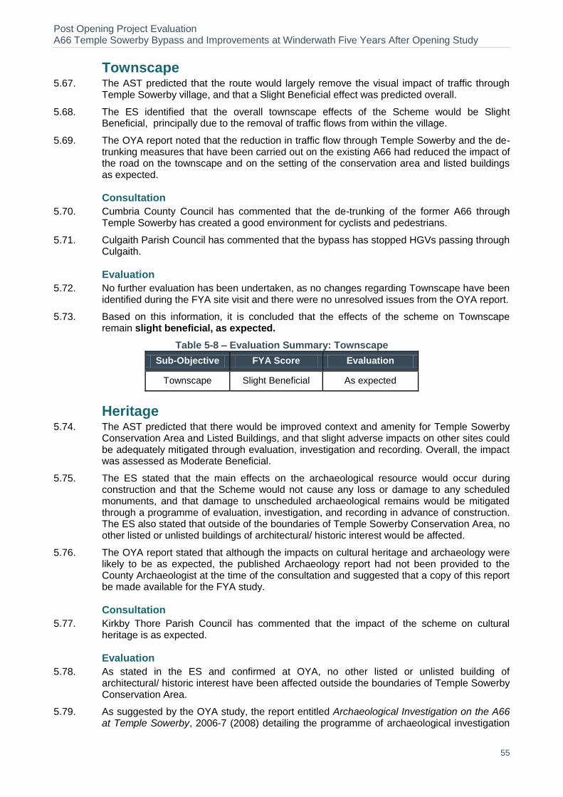
Post Opening Project Evaluation A66 Temple Sowerby Bypass and Improvements at Winderwath Five Years After Opening Study
55
Townscape 5.67. The AST predicted that the route would largely remove the visual impact of traffic through
Temple Sowerby village, and that a Slight Beneficial effect was predicted overall.
5.68. The ES identified that the overall townscape effects of the Scheme would be Slight Beneficial, principally due to the removal of traffic flows from within the village.
5.69. The OYA report noted that the reduction in traffic flow through Temple Sowerby and the de-trunking measures that have been carried out on the existing A66 had reduced the impact of the road on the townscape and on the setting of the conservation area and listed buildings as expected.
Consultation
5.70. Cumbria County Council has commented that the de-trunking of the former A66 through Temple Sowerby has created a good environment for cyclists and pedestrians.
5.71. Culgaith Parish Council has commented that the bypass has stopped HGVs passing through Culgaith.
Evaluation
5.72. No further evaluation has been undertaken, as no changes regarding Townscape have been identified during the FYA site visit and there were no unresolved issues from the OYA report.
5.73. Based on this information, it is concluded that the effects of the scheme on Townscape remain slight beneficial, as expected.
Table 5-8 – Evaluation Summary: Townscape
Sub-Objective FYA Score Evaluation
Townscape Slight Beneficial As expected
Heritage 5.74. The AST predicted that there would be improved context and amenity for Temple Sowerby
Conservation Area and Listed Buildings, and that slight adverse impacts on other sites could be adequately mitigated through evaluation, investigation and recording. Overall, the impact was assessed as Moderate Beneficial.
5.75. The ES stated that the main effects on the archaeological resource would occur during construction and that the Scheme would not cause any loss or damage to any scheduled monuments, and that damage to unscheduled archaeological remains would be mitigated through a programme of evaluation, investigation, and recording in advance of construction. The ES also stated that outside of the boundaries of Temple Sowerby Conservation Area, no other listed or unlisted buildings of architectural/ historic interest would be affected.
5.76. The OYA report stated that although the impacts on cultural heritage and archaeology were likely to be as expected, the published Archaeology report had not been provided to the County Archaeologist at the time of the consultation and suggested that a copy of this report be made available for the FYA study.
Consultation
5.77. Kirkby Thore Parish Council has commented that the impact of the scheme on cultural heritage is as expected.
Evaluation
5.78. As stated in the ES and confirmed at OYA, no other listed or unlisted building of architectural/ historic interest have been affected outside the boundaries of Temple Sowerby Conservation Area.
5.79. As suggested by the OYA study, the report entitled Archaeological Investigation on the A66 at Temple Sowerby, 2006-7 (2008) detailing the programme of archaeological investigation
Post Opening Project Evaluation A66 Temple Sowerby Bypass and Improvements at Winderwath Five Years After Opening Study
56
undertaken by Oxford Archaeology North (OAN) in 2006 and 2007 in advance of the A66 modifications was made available for the FYA study.
5.80. In summary, the archaeological report states that:
Several prehistoric sites were identified and investigated, including a group of pits that contained shards of Bronze Age pottery.
The A66 follows the route of the Stainmore Roman road and, during works to the east of Temple Sowerby, a well preserved section of this was identified. Dating evidence was sparse, but a coin minted in AD71 was recovered from the topsoil immediately above the road make-up.
Remains of post-medieval and enclosure-period agricultural landscapes were encountered.
5.81. The archaeological report also states that full details of all the data (and presumably finds, although this is not stated) recovered from the site were recorded in the project archive which was deposited with the Penrith Museum, and that copies of the archaeological report had been submitted to the Cumbria Historic Environment Record (HER) in Kendal.
5.82. On enquiry, Penrith Museum responded that the project archive does not appear to have been deposited with the museum, and further enquiries made to OAN have ascertained that agreements for the transfer of ownership of the finds from the landowner are to be agreed in the near future, after which arrangements will be made to submit the archive to the museum.
5.83. Confirmation has been received that that copies of the archaeological report have been submitted to the Cumbria HER.
5.84. No further evaluation has been undertaken at the FYA stage as there were no other outstanding issues highlighted at OYA.
5.85. POPE methodology assumes that by the FYA evaluation, all archaeological reports should have been published and deposited with the archaeological finds in the agreed archive for future reference.
5.86. Although the project archive does not appear to have been deposited with the Penrith Museum as stated in the archaeological report, archaeology is only a single aspect of cultural heritage and the effects of the scheme on built heritage are moderate beneficial as expected.
5.87. It is therefore concluded that the effects of the scheme on the heritage resource are generally as expected, but the deposition of the project archive with the Penrith Museum appears to be outstanding.
Table 5-9 – Evaluation Summary: Heritage
Sub-Objective FYA Score Evaluation
Heritage Moderate Beneficial As expected
Biodiversity 5.88. The AST stated that there would be severance impacts on bats, badgers hedgerows and
some loss of mature trees minimised by landscaping, and that there was a low risk of construction impact on the River Eden (SSSI, SAC) and species. A minor or neutral impact on other ecological receptors was predicted. The overall effect was assessed as Minor Adverse.
5.89. The ES stated that the majority of the ecological receptors identified and studied would only be slightly affected, and that the River Eden and associated protected/ relatively high value species of nature conservation interest were at most at risk during construction. The loss of individual trees with potential for bat roosts and the loss and severance of hedgerows were identified as adverse impacts with the potential to affect community routes for bats and badgers, but the bridges included in the Scheme design were expected to mitigate partly (if not fully) the effects of faunal severance. The ES also predicted that the new habitats would develop along the route and would help to compensate for habitat losses. Overall, the

Post Opening Project Evaluation A66 Temple Sowerby Bypass and Improvements at Winderwath Five Years After Opening Study
57
impacts of the Scheme in terms of nature conservation were considered by the ES to be of low significance.
5.90. The OYA report stated that very little information had been made available on which to fully evaluate the impacts of the scheme on biodiversity and the effectiveness of the mitigation measures, and that these aspects should be considered in more detail at the FYA stage.
5.91. The OYA report noted that ongoing badger and bat monitoring was expected to be carried out during the three year after care period (2008 -2010), the results of which should be made available for the FYA report. The OYA report also suggested that consultation at the FYA stage be extended to include the local wildlife trust.
Consultation
5.92. Natural England has no comments to make regarding Biodiversity at this stage
5.93. Cumbria County Council has not undertaken any monitoring of the effects of the bypass on biodiversity and is therefore unable to comment.
5.94. Kirkby Thore Parish Council has commented that the impact of the scheme on Biodiversity is as expected.
5.95. Cumbria Wildlife Trust has been contacted and invited to comment on the ecological impacts of the scheme, but no response has been forthcoming.
Evaluation
5.96. The HEMP (2011) outlines the results from the ecological monitoring of badgers and bats carried out during the three year Aftercare period (2008 -2010), and these results are now discussed with reference to the FYA site visit.
5.97. Badger resistant fencing has been provided along the whole length of the new road, and two mammal crossing points have been provided as shown on the As-Built drawings. The HEMP notes that two artificial badger setts constructed as part of the ecological mitigation measures were observed to be in intermittent use throughout the monitoring period, although signs of badger activity were prevalent in the wider area, badger footprints being regularly recorded east of the River Eden.
5.98. The FYA site visit ascertained that the badger fencing is intact and in good condition throughout the length of the scheme, and the badger/ wildlife crossing points have received maintenance and are in good condition, see Figure 5-11 below. However, no evidence of paths at the tunnel entrances/ exits that would indicate that the crossing points are being used by badgers/ other wildlife at the crossing point entrances was noted during the FYA site visit.
Figure 5-11– Badger/ wildlife crossing point
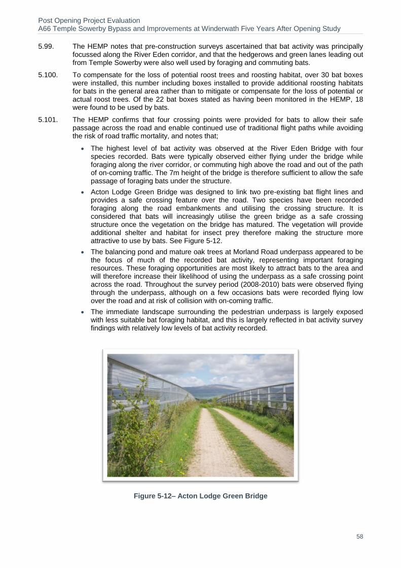
Post Opening Project Evaluation A66 Temple Sowerby Bypass and Improvements at Winderwath Five Years After Opening Study
58
5.99. The HEMP notes that pre-construction surveys ascertained that bat activity was principally focussed along the River Eden corridor, and that the hedgerows and green lanes leading out from Temple Sowerby were also well used by foraging and commuting bats.
5.100. To compensate for the loss of potential roost trees and roosting habitat, over 30 bat boxes were installed, this number including boxes installed to provide additional roosting habitats for bats in the general area rather than to mitigate or compensate for the loss of potential or actual roost trees. Of the 22 bat boxes stated as having been monitored in the HEMP, 18 were found to be used by bats.
5.101. The HEMP confirms that four crossing points were provided for bats to allow their safe passage across the road and enable continued use of traditional flight paths while avoiding the risk of road traffic mortality, and notes that;
The highest level of bat activity was observed at the River Eden Bridge with four species recorded. Bats were typically observed either flying under the bridge while foraging along the river corridor, or commuting high above the road and out of the path of on-coming traffic. The 7m height of the bridge is therefore sufficient to allow the safe passage of foraging bats under the structure.
Acton Lodge Green Bridge was designed to link two pre-existing bat flight lines and provides a safe crossing feature over the road. Two species have been recorded foraging along the road embankments and utilising the crossing structure. It is considered that bats will increasingly utilise the green bridge as a safe crossing structure once the vegetation on the bridge has matured. The vegetation will provide additional shelter and habitat for insect prey therefore making the structure more attractive to use by bats. See Figure 5-12.
The balancing pond and mature oak trees at Morland Road underpass appeared to be the focus of much of the recorded bat activity, representing important foraging resources. These foraging opportunities are most likely to attract bats to the area and will therefore increase their likelihood of using the underpass as a safe crossing point across the road. Throughout the survey period (2008-2010) bats were observed flying through the underpass, although on a few occasions bats were recorded flying low over the road and at risk of collision with on-coming traffic.
The immediate landscape surrounding the pedestrian underpass is largely exposed with less suitable bat foraging habitat, and this is largely reflected in bat activity survey findings with relatively low levels of bat activity recorded.
Figure 5-12– Acton Lodge Green Bridge
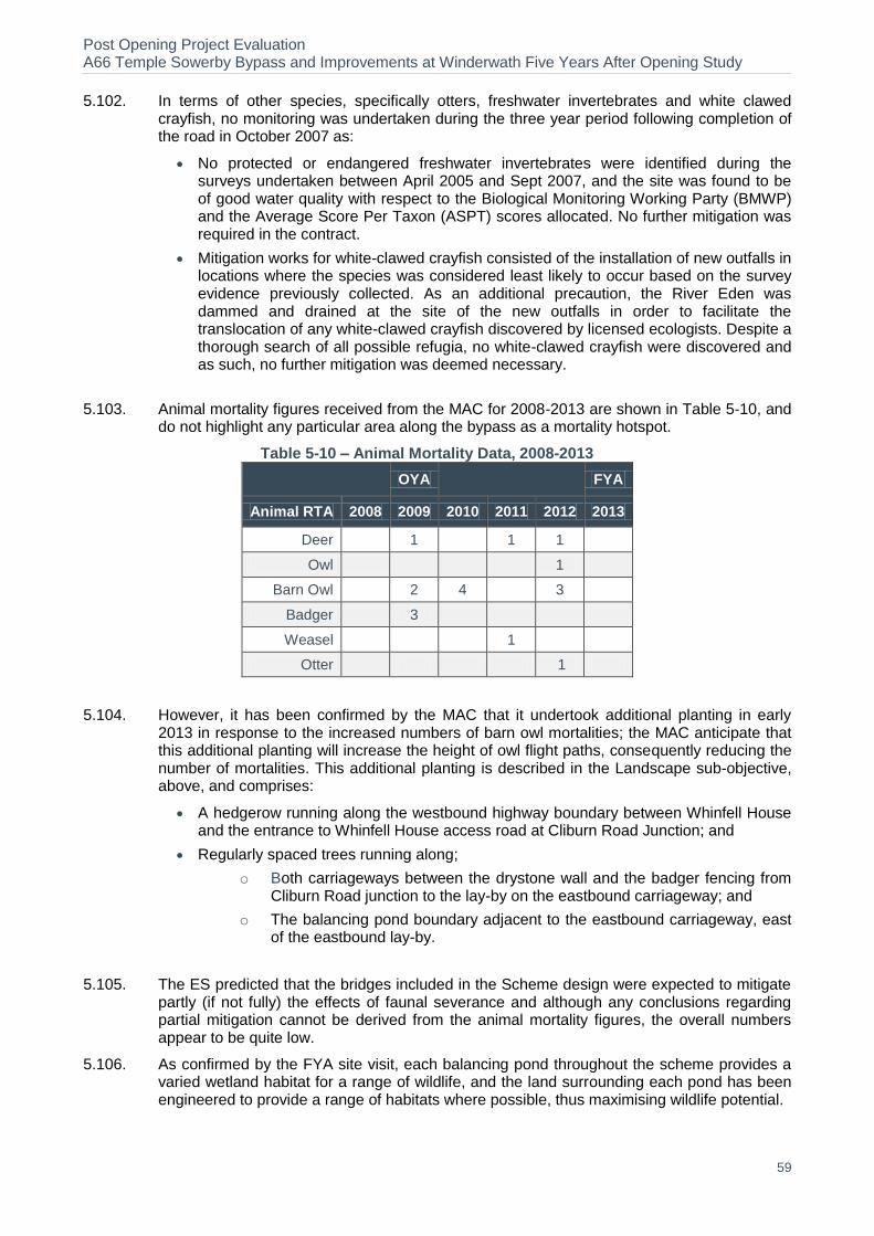
Post Opening Project Evaluation A66 Temple Sowerby Bypass and Improvements at Winderwath Five Years After Opening Study
59
5.102. In terms of other species, specifically otters, freshwater invertebrates and white clawed crayfish, no monitoring was undertaken during the three year period following completion of the road in October 2007 as:
No protected or endangered freshwater invertebrates were identified during the surveys undertaken between April 2005 and Sept 2007, and the site was found to be of good water quality with respect to the Biological Monitoring Working Party (BMWP) and the Average Score Per Taxon (ASPT) scores allocated. No further mitigation was required in the contract.
Mitigation works for white-clawed crayfish consisted of the installation of new outfalls in locations where the species was considered least likely to occur based on the survey evidence previously collected. As an additional precaution, the River Eden was dammed and drained at the site of the new outfalls in order to facilitate the translocation of any white-clawed crayfish discovered by licensed ecologists. Despite a thorough search of all possible refugia, no white-clawed crayfish were discovered and as such, no further mitigation was deemed necessary.
5.103. Animal mortality figures received from the MAC for 2008-2013 are shown in Table 5-10, and do not highlight any particular area along the bypass as a mortality hotspot.
Table 5-10 – Animal Mortality Data, 2008-2013
OYA
FYA
Animal RTA 2008 2009 2010 2011 2012 2013
Deer 1
1 1
Owl
1
Barn Owl 2 4
3
Badger
3
Weasel
1
Otter
1
5.104. However, it has been confirmed by the MAC that it undertook additional planting in early 2013 in response to the increased numbers of barn owl mortalities; the MAC anticipate that this additional planting will increase the height of owl flight paths, consequently reducing the number of mortalities. This additional planting is described in the Landscape sub-objective, above, and comprises:
A hedgerow running along the westbound highway boundary between Whinfell House and the entrance to Whinfell House access road at Cliburn Road Junction; and
Regularly spaced trees running along;
o Both carriageways between the drystone wall and the badger fencing from Cliburn Road junction to the lay-by on the eastbound carriageway; and
o The balancing pond boundary adjacent to the eastbound carriageway, east of the eastbound lay-by.
5.105. The ES predicted that the bridges included in the Scheme design were expected to mitigate partly (if not fully) the effects of faunal severance and although any conclusions regarding partial mitigation cannot be derived from the animal mortality figures, the overall numbers appear to be quite low.
5.106. As confirmed by the FYA site visit, each balancing pond throughout the scheme provides a varied wetland habitat for a range of wildlife, and the land surrounding each pond has been engineered to provide a range of habitats where possible, thus maximising wildlife potential.
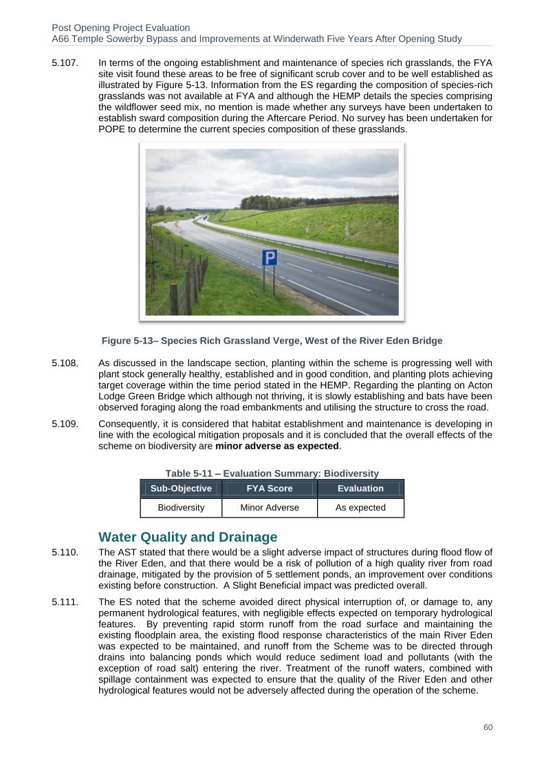
Post Opening Project Evaluation A66 Temple Sowerby Bypass and Improvements at Winderwath Five Years After Opening Study
60
5.107. In terms of the ongoing establishment and maintenance of species rich grasslands, the FYA site visit found these areas to be free of significant scrub cover and to be well established as illustrated by Figure 5-13. Information from the ES regarding the composition of species-rich grasslands was not available at FYA and although the HEMP details the species comprising the wildflower seed mix, no mention is made whether any surveys have been undertaken to establish sward composition during the Aftercare Period. No survey has been undertaken for POPE to determine the current species composition of these grasslands.
Figure 5-13– Species Rich Grassland Verge, West of the River Eden Bridge
5.108. As discussed in the landscape section, planting within the scheme is progressing well with plant stock generally healthy, established and in good condition, and planting plots achieving target coverage within the time period stated in the HEMP. Regarding the planting on Acton Lodge Green Bridge which although not thriving, it is slowly establishing and bats have been observed foraging along the road embankments and utilising the structure to cross the road.
5.109. Consequently, it is considered that habitat establishment and maintenance is developing in line with the ecological mitigation proposals and it is concluded that the overall effects of the scheme on biodiversity are minor adverse as expected.
Table 5-11 – Evaluation Summary: Biodiversity
Sub-Objective FYA Score Evaluation
Biodiversity Minor Adverse As expected
Water Quality and Drainage 5.110. The AST stated that there would be a slight adverse impact of structures during flood flow of
the River Eden, and that there would be a risk of pollution of a high quality river from road drainage, mitigated by the provision of 5 settlement ponds, an improvement over conditions existing before construction. A Slight Beneficial impact was predicted overall.
5.111. The ES noted that the scheme avoided direct physical interruption of, or damage to, any permanent hydrological features, with negligible effects expected on temporary hydrological features. By preventing rapid storm runoff from the road surface and maintaining the existing floodplain area, the existing flood response characteristics of the main River Eden was expected to be maintained, and runoff from the Scheme was to be directed through drains into balancing ponds which would reduce sediment load and pollutants (with the exception of road salt) entering the river. Treatment of the runoff waters, combined with spillage containment was expected to ensure that the quality of the River Eden and other hydrological features would not be adversely affected during the operation of the scheme.
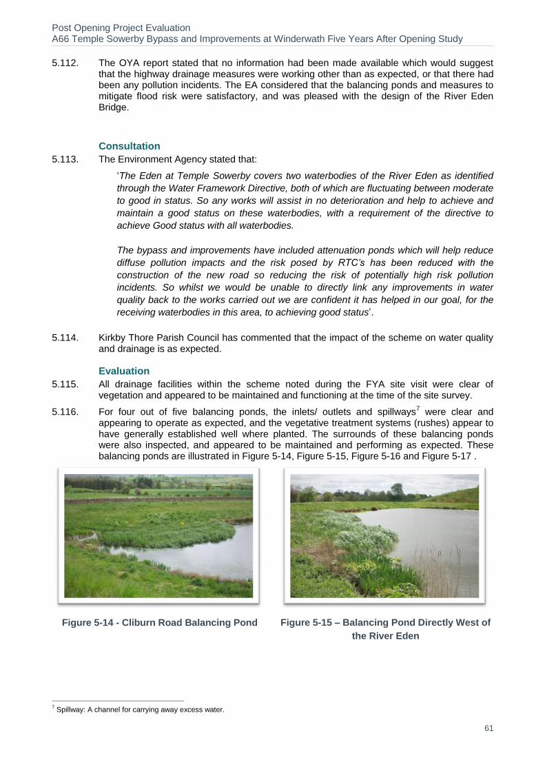
Post Opening Project Evaluation A66 Temple Sowerby Bypass and Improvements at Winderwath Five Years After Opening Study
61
5.112. The OYA report stated that no information had been made available which would suggest that the highway drainage measures were working other than as expected, or that there had been any pollution incidents. The EA considered that the balancing ponds and measures to mitigate flood risk were satisfactory, and was pleased with the design of the River Eden Bridge.
Consultation
5.113. The Environment Agency stated that:
‘The Eden at Temple Sowerby covers two waterbodies of the River Eden as identified
through the Water Framework Directive, both of which are fluctuating between moderate
to good in status. So any works will assist in no deterioration and help to achieve and
maintain a good status on these waterbodies, with a requirement of the directive to
achieve Good status with all waterbodies.
The bypass and improvements have included attenuation ponds which will help reduce
diffuse pollution impacts and the risk posed by RTC’s has been reduced with the
construction of the new road so reducing the risk of potentially high risk pollution
incidents. So whilst we would be unable to directly link any improvements in water
quality back to the works carried out we are confident it has helped in our goal, for the
receiving waterbodies in this area, to achieving good status’.
5.114. Kirkby Thore Parish Council has commented that the impact of the scheme on water quality and drainage is as expected.
Evaluation
5.115. All drainage facilities within the scheme noted during the FYA site visit were clear of vegetation and appeared to be maintained and functioning at the time of the site survey.
5.116. For four out of five balancing ponds, the inlets/ outlets and spillways7 were clear and
appearing to operate as expected, and the vegetative treatment systems (rushes) appear to have generally established well where planted. The surrounds of these balancing ponds were also inspected, and appeared to be maintained and performing as expected. These balancing ponds are illustrated in Figure 5-14, Figure 5-15, Figure 5-16 and Figure 5-17 .
Figure 5-14 - Cliburn Road Balancing Pond Figure 5-15 – Balancing Pond Directly West of
the River Eden
7 Spillway: A channel for carrying away excess water.
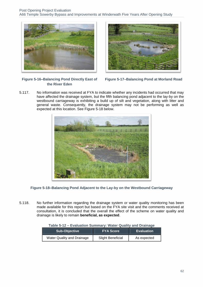
Post Opening Project Evaluation A66 Temple Sowerby Bypass and Improvements at Winderwath Five Years After Opening Study
62
Figure 5-16–Balancing Pond Directly East of
the River Eden
Figure 5-17–Balancing Pond at Morland Road
5.117. No information was received at FYA to indicate whether any incidents had occurred that may have affected the drainage system, but the fifth balancing pond adjacent to the lay-by on the westbound carriageway is exhibiting a build up of silt and vegetation, along with litter and general waste. Consequently, the drainage system may not be performing as well as expected at this location. See Figure 5-18 below.
Figure 5-18–Balancing Pond Adjacent to the Lay-by on the Westbound Carriageway
5.118. No further information regarding the drainage system or water quality monitoring has been made available for this report but based on the FYA site visit and the comments received at consultation, it is concluded that the overall the effect of the scheme on water quality and drainage is likely to remain beneficial, as expected.
Table 5-12 – Evaluation Summary: Water Quality and Drainage
Sub-Objective FYA Score Evaluation
Water Quality and Drainage Slight Beneficial As expected
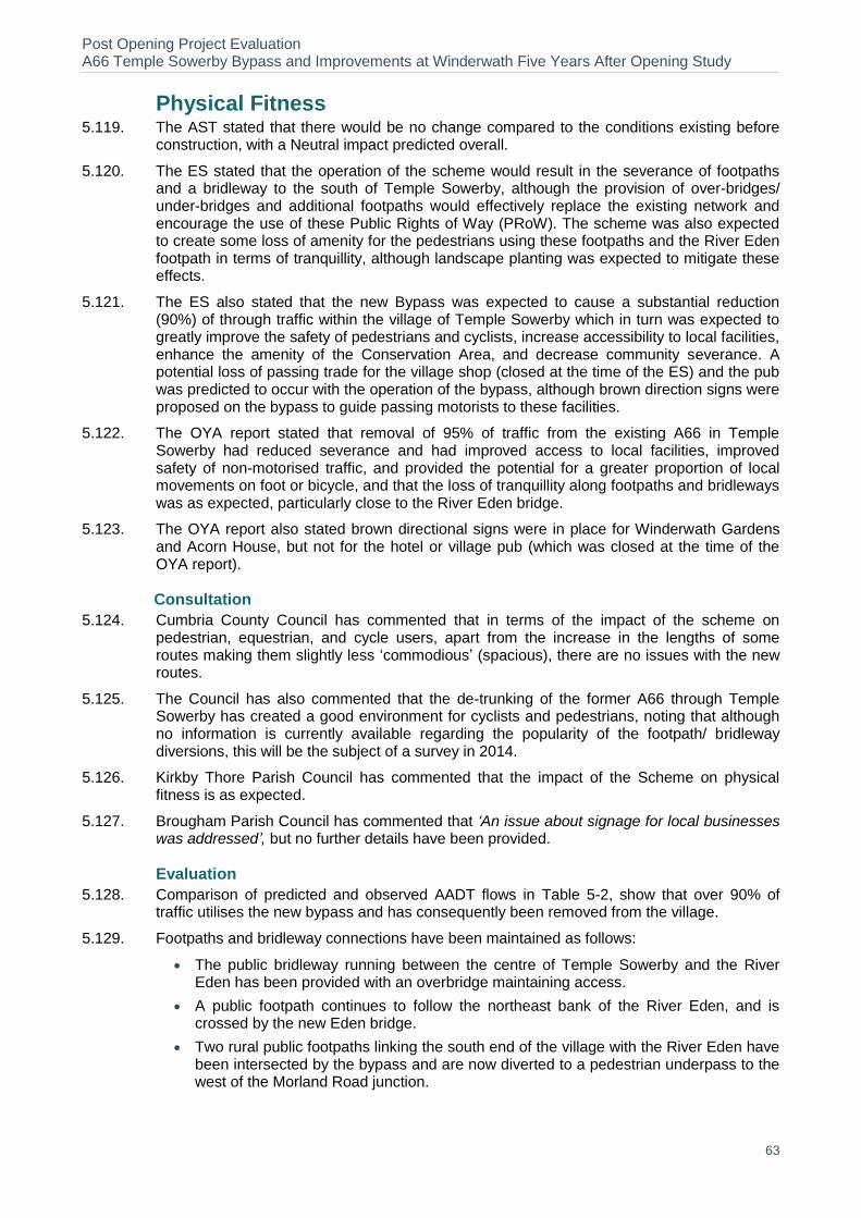
Post Opening Project Evaluation A66 Temple Sowerby Bypass and Improvements at Winderwath Five Years After Opening Study
63
Physical Fitness 5.119. The AST stated that there would be no change compared to the conditions existing before
construction, with a Neutral impact predicted overall.
5.120. The ES stated that the operation of the scheme would result in the severance of footpaths and a bridleway to the south of Temple Sowerby, although the provision of over-bridges/ under-bridges and additional footpaths would effectively replace the existing network and encourage the use of these Public Rights of Way (PRoW). The scheme was also expected to create some loss of amenity for the pedestrians using these footpaths and the River Eden footpath in terms of tranquillity, although landscape planting was expected to mitigate these effects.
5.121. The ES also stated that the new Bypass was expected to cause a substantial reduction (90%) of through traffic within the village of Temple Sowerby which in turn was expected to greatly improve the safety of pedestrians and cyclists, increase accessibility to local facilities, enhance the amenity of the Conservation Area, and decrease community severance. A potential loss of passing trade for the village shop (closed at the time of the ES) and the pub was predicted to occur with the operation of the bypass, although brown direction signs were proposed on the bypass to guide passing motorists to these facilities.
5.122. The OYA report stated that removal of 95% of traffic from the existing A66 in Temple Sowerby had reduced severance and had improved access to local facilities, improved safety of non-motorised traffic, and provided the potential for a greater proportion of local movements on foot or bicycle, and that the loss of tranquillity along footpaths and bridleways was as expected, particularly close to the River Eden bridge.
5.123. The OYA report also stated brown directional signs were in place for Winderwath Gardens and Acorn House, but not for the hotel or village pub (which was closed at the time of the OYA report).
Consultation
5.124. Cumbria County Council has commented that in terms of the impact of the scheme on pedestrian, equestrian, and cycle users, apart from the increase in the lengths of some routes making them slightly less ‘commodious’ (spacious), there are no issues with the new routes.
5.125. The Council has also commented that the de-trunking of the former A66 through Temple Sowerby has created a good environment for cyclists and pedestrians, noting that although no information is currently available regarding the popularity of the footpath/ bridleway diversions, this will be the subject of a survey in 2014.
5.126. Kirkby Thore Parish Council has commented that the impact of the Scheme on physical fitness is as expected.
5.127. Brougham Parish Council has commented that ‘An issue about signage for local businesses was addressed’, but no further details have been provided.
Evaluation
5.128. Comparison of predicted and observed AADT flows in Table 5-2, show that over 90% of traffic utilises the new bypass and has consequently been removed from the village.
5.129. Footpaths and bridleway connections have been maintained as follows:
The public bridleway running between the centre of Temple Sowerby and the River Eden has been provided with an overbridge maintaining access.
A public footpath continues to follow the northeast bank of the River Eden, and is crossed by the new Eden bridge.
Two rural public footpaths linking the south end of the village with the River Eden have been intersected by the bypass and are now diverted to a pedestrian underpass to the west of the Morland Road junction.
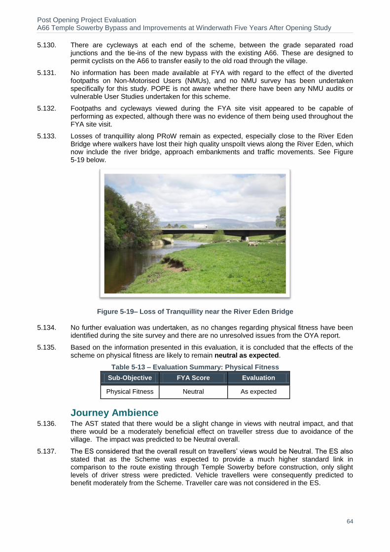
Post Opening Project Evaluation A66 Temple Sowerby Bypass and Improvements at Winderwath Five Years After Opening Study
64
5.130. There are cycleways at each end of the scheme, between the grade separated road junctions and the tie-ins of the new bypass with the existing A66. These are designed to permit cyclists on the A66 to transfer easily to the old road through the village.
5.131. No information has been made available at FYA with regard to the effect of the diverted footpaths on Non-Motorised Users (NMUs), and no NMU survey has been undertaken specifically for this study. POPE is not aware whether there have been any NMU audits or vulnerable User Studies undertaken for this scheme.
5.132. Footpaths and cycleways viewed during the FYA site visit appeared to be capable of performing as expected, although there was no evidence of them being used throughout the FYA site visit.
5.133. Losses of tranquillity along PRoW remain as expected, especially close to the River Eden Bridge where walkers have lost their high quality unspoilt views along the River Eden, which now include the river bridge, approach embankments and traffic movements. See Figure 5-19 below.
Figure 5-19– Loss of Tranquillity near the River Eden Bridge
5.134. No further evaluation was undertaken, as no changes regarding physical fitness have been identified during the site survey and there are no unresolved issues from the OYA report.
5.135. Based on the information presented in this evaluation, it is concluded that the effects of the scheme on physical fitness are likely to remain neutral as expected.
Table 5-13 – Evaluation Summary: Physical Fitness
Sub-Objective FYA Score Evaluation
Physical Fitness Neutral As expected
Journey Ambience 5.136. The AST stated that there would be a slight change in views with neutral impact, and that
there would be a moderately beneficial effect on traveller stress due to avoidance of the village. The impact was predicted to be Neutral overall.
5.137. The ES considered that the overall result on travellers’ views would be Neutral. The ES also stated that as the Scheme was expected to provide a much higher standard link in comparison to the route existing through Temple Sowerby before construction, only slight levels of driver stress were predicted. Vehicle travellers were consequently predicted to benefit moderately from the Scheme. Traveller care was not considered in the ES.
Post Opening Project Evaluation A66 Temple Sowerby Bypass and Improvements at Winderwath Five Years After Opening Study
65
5.138. The OYA considered that the impact of the scheme on journey ambience was generally as was expected for driver views and driver stress, and the reduction in traffic on the old A66 had improved the experience for drivers.
Consultation
5.139. Culgaith Parish Council has commented that access onto the A66 is easier.
5.140. Brougham Parish Council has expressed a concern that:
‘...since the by-pass opened there have been some serious accidents below Phoenix
Barn at the western end where the dual carriageway reverts to single. This raises the
question of the adequacy of signage and road marking’
5.141. Kirkby Thore Parish Council has commented that;
‘A commonly held local view is that the bypass is successful in most aspects and widely
appreciated, however the bypass has introduced extra problems on adjacent sections of
the A66 which have potentially led to accidents and general driver stress.’
‘Extra care is required due to lane and speed restrictions when approaching the single
carriageway sections at the eastern and western ends of the bypass.’
Evaluation
5.142. Regarding the comments received from consultation, these relate to the safety aspects of the scheme and have been considered within the Safety section of this report .
5.143. At the time of the FYA site visit, the lay-bys provided along the bypass were found to be clearly signed, well used, and generally tidy and litter free. However, the HEMP did note that litter was a particularly noticeable and persistent problem along the fence lines at the lay-by areas during the Aftercare period.
5.144. The screening and landscape integration functions of the planting surrounding the lay-bys is developing well.
5.145. No further evaluation was undertaken, as no changes regarding journey ambience were identified during the FYA site visit and there were no unresolved issues from the OYA report.
5.146. Based on the information presented in this evaluation, it is concluded that the effects of the Scheme on Journey Ambiance remain, as expected, Neutral.
5.147. Table 5-14 summarises the evaluation of the scheme’s impact on journey ambience.
Table 5-14 – Evaluation Summary: Journey Ambience
Traveller Factor
FYA Score FYA evaluation
Views Neutral The alignment of the route, generally in cutting and following the existing landscape structure at Ash Hill and in cutting to the south west and south of Temple Sowerby, has resulted in a slight change of view.
Open views have been retained to the south east of the scheme in the vicinity of Spitals Farm.
Stress Beneficial The increased the capacity of the new bypass has removed over 90% of through traffic from the village of Temple Sowerby, relieving congestion and facilitating free-flowing traffic by providing opportunities for the safe overtaking of slower vehicles.
The route is well signed and the junctions provide safe access and egress points to and from the A66.
Please see the traffic Sections of this report for Journey Time and Collision data, a reduction in both of which is likely to have had a beneficial effect on driver stress.
Care Neutral Lay-bys are clearly signed and although well used, generally tidy and litter free.
Accesses to facilities in Temple Sowerby are available from the clearly signed Morland Road and Cliburn Road junctions.
Summary As Expected
Post Opening Project Evaluation A66 Temple Sowerby Bypass and Improvements at Winderwath Five Years After Opening Study
66
Key Points
Noise and Air Quality
The observed traffic flow on the new A66 bypass is very similar to that forecasted by the ES, with traffic 4.3% greater than predicted.
Observed traffic flow on the old A66 either side and through the village has reduced significantly (by 90%, as predicted by the ES), and although traffic flows are higher than expected, the overall number of vehicles is low.
The impacts of the scheme for noise and local air quality are therefore considered to be as expected.
Greenhouse Gases The reason for the increase being higher than forecast is because the actual DM flows were
slightly lower than forecast on the A66, whilst the post opening flows on the Bypass are slightly higher than forecast.
Landscape The road corridor generally remains free of noxious weeds, and planting within the scheme is
progressing well. Grassland areas are free of significant scrub cover, and plant stock is generally healthy, established, and in good condition.
Planting plots have generally achieved their target coverage within the time period stated in the HEMP, and the current levels of plant growth and establishment indicate that their visual screening and landscape integration functions are developing as expected at FYA.
Biodiversity Although the planting on Acton Lodge Green Bridge is not thriving, it is slowly establishing and
results of scheme monitoring indicate that bats have been observed foraging along the road embankments and utilising the structure to cross the road.
Overall, habitat establishment and maintenance is developing in line with the ecological mitigation proposals as stated in the ES.
Cultural Heritage Although confirmation has been received that that copies of the archaeological report have been
submitted to the Cumbria HER (Historic Environment Record), the project archive does not appear to have been deposited with the Penrith Museum as stated in the archaeological report.
The effects of the scheme on built heritage are as expected.
Water No information has been made available to POPE which would indicate that the scheme
drainage measures are performing other than as intended. Based on the FYA site visit, the Landscape As-Built drawings, and consultation comments received, it is likely that the overall effect of the scheme on water quality and drainage remains beneficial.
Physical Fitness POPE is not aware whether there have been any NMU audits or Vulnerable User Studies
undertaken for this scheme, but footpaths and cycleways viewed during the FYA site visit appeared to be capable of performing as expected.
Losses of tranquillity along PRoWs remain as expected, especially close to the River Eden Bridge where walkers have lost their high quality unspoilt views along the River Eden, which now include the river bridge, approach embankments and traffic movements.
Journey Ambience
The alignment of the route, generally in cutting and following the existing landscape structure at Ash Hill and in cutting to the south west and south of Temple Sowerby, has resulted in a slight change of view. Open views have been retained to the south east of the scheme in the vicinity of Spitals Farm.
The increased capacity of the new bypass has removed over 90% of through traffic from the village of Temple Sowerby, relieving congestion and facilitating free-flowing traffic by providing opportunities for the safe overtaking of slower vehicles. The route is well signed and the junctions provide safe access and egress points to and from the A66.
Lay-bys are clearly signed and although well used, generally tidy and litter free. Accesses to facilities in Temple Sowerby are available from the clearly signed Morland Road and Cliburn Road junctions.
Post Opening Project Evaluation A66 Temple Sowerby Bypass and Improvements at Winderwath Five Years After Opening Study
67
6. Accessibility and Integration
6.1. This chapter evaluates the impact of the scheme in terms of the accessibility and integration objectives; comparing qualitative forecast assessments from the scheme AST (as shown in Section 7, see page 73) with post-opening findings and analysis of policy objectives.
Accessibility 6.2. The accessibility objective is concerned with how the scheme has affected the ability of
people in different locations to reach different types of facility, using any mode of transport.
6.3. The accessibility objective consists of three sub-objectives. These are:
Option Values
Access to the Transport System
Severance
Option Values 6.4. Option values, as defined in webTAG, relate to the availability of different transport modes
within the study area, even if they are not used. For example, a car user may value a bus service along their route even if they never used it because they have the option of another mode should their car become unavailable.
Forecast
6.5. The AST stated that the scheme would bring no change to existing conditions provided that bus operators continue to route through the village.
Evaluation
6.6. There have been no alterations to the bus service through Temple Sowerby since the bypass opened. Route 563 runs along the A66 between Appleby and Penrith seven times a day (Monday to Saturday), stopping in Temple Sowerby village. The service is operated by Grand Prix Coaches Ltd. It was noted at the OYA stage that routing the service through Temple Sowerby village added time to the journey due to the access to/from the bypass, but that the operator was able to accommodate it. No further consultation has been undertaken at the FYA stage.
6.7. There are no long-distance buses or coach services using the A66 bypass which might have benefited from the savings in journey times for through traffic resulting from the scheme. The bus service is the only public transport alternative to the car in Temple Sowerby.
6.8. As there is no evidence to suggest that the A66 Temple Sowerby Bypass has led to any changes in option values at the FYA stage, the assessment score is Neutral, as predicted.
Access to the Transport System 6.9. Access to the transport system is influenced by access to a private car and proximity to a
public transport service.
Forecast
6.10. For the access to the transport system objective, the AST forecast impact states:
‘No change in existing conditions subject to bus operators continuing to route through the village ’.
Evaluation
6.11. As detailed in the previous section, there were no measures included in this scheme to improve accessibility for users. Bus routing has been maintained, therefore it is felt that the predicted assessment of Neutral is accurate.
Post Opening Project Evaluation A66 Temple Sowerby Bypass and Improvements at Winderwath Five Years After Opening Study
68
Severance
6.12. The aim of this sub-objective is to reflect both changes in severance and the likely number of users affected. In terms of roads, severance includes the length and ease of pedestrian movements. The primary indicators for roads include footpaths, diversions of rights of way, and crossing facilities.
Forecast
6.13. The AST stated that:
‘Removal of existing severance issues in and around Temple Sowerby village, local footpath and road network and severance of farm units.’
6.14. Given the level of provision made, the AST forecast a score of Slight Beneficial for this objective.
Evaluation
6.15. No post opening non motorised user (NMU) surveys were available for this scheme, therefore the evaluation of this objective will focus on the qualitative impacts.
6.16. The removal of over 90% of traffic from the old A66 in Temple Sowerby has reduced severance and improved access to community facilities. As noted in the OYA report, speed and capacity reduction measures were put in place on the old A66 in Temple Sowerby. These include local narrowing of the carriageway, introduction of a 30 mph speed limit, and re-painting road markings .
6.17. It is considered that severance for non-motorised travellers in Temple Sowerby has improved. This is however offset in some cases by a reduction in amenity for users of footpaths affected by the bypass and consequently have a less desirable route. The forecast of slight beneficial is upheld.
Integration 6.18. The integration objective consists of two main elements:
Interchange with other transport modes: how the scheme assists different modes of transport in working together and the ease of people moving between them to choose sustainable transport choices.
Land Use Policy and Other Government Policies: how the scheme integrates with current local land use and wider government objectives.
Transport Interchange
Forecast
6.19. The AST stated that the scheme would have no impact on Transport Interchange.
Evaluation
6.20. It was not the intention of the scheme to directly improve public transport and freight interchanges. Facilities for public transport users have remained the same, therefore the overall assessment of Neutral is considered to be correct.
Land Use Policy
Forecast
6.21. The AST states that:
Scheme Objective: Reduce severance
Post Opening Project Evaluation A66 Temple Sowerby Bypass and Improvements at Winderwath Five Years After Opening Study
69
‘Scheme is consistent with County Structure Plan, Eden Local Plan and Regional Guidance’.
Evaluation
6.22. The relevant policies have been considered, and a summary evaluation is presented in Table 6-1 on page 70.
Key Points
Accessibility Impacts The provision of pedestrian and equestrian crossing points over the bypass reduces the
severance impact of a high speed road dissecting routes.
The scheme has had no discernible impacts on option values or access to the transport system.
Integration Impacts
The scheme has no discernible impacts on transport interchange.
The scheme aligns with local, regional and national policies related to land use and development. The scheme also aligns with those policies supporting an improvement in road safety.
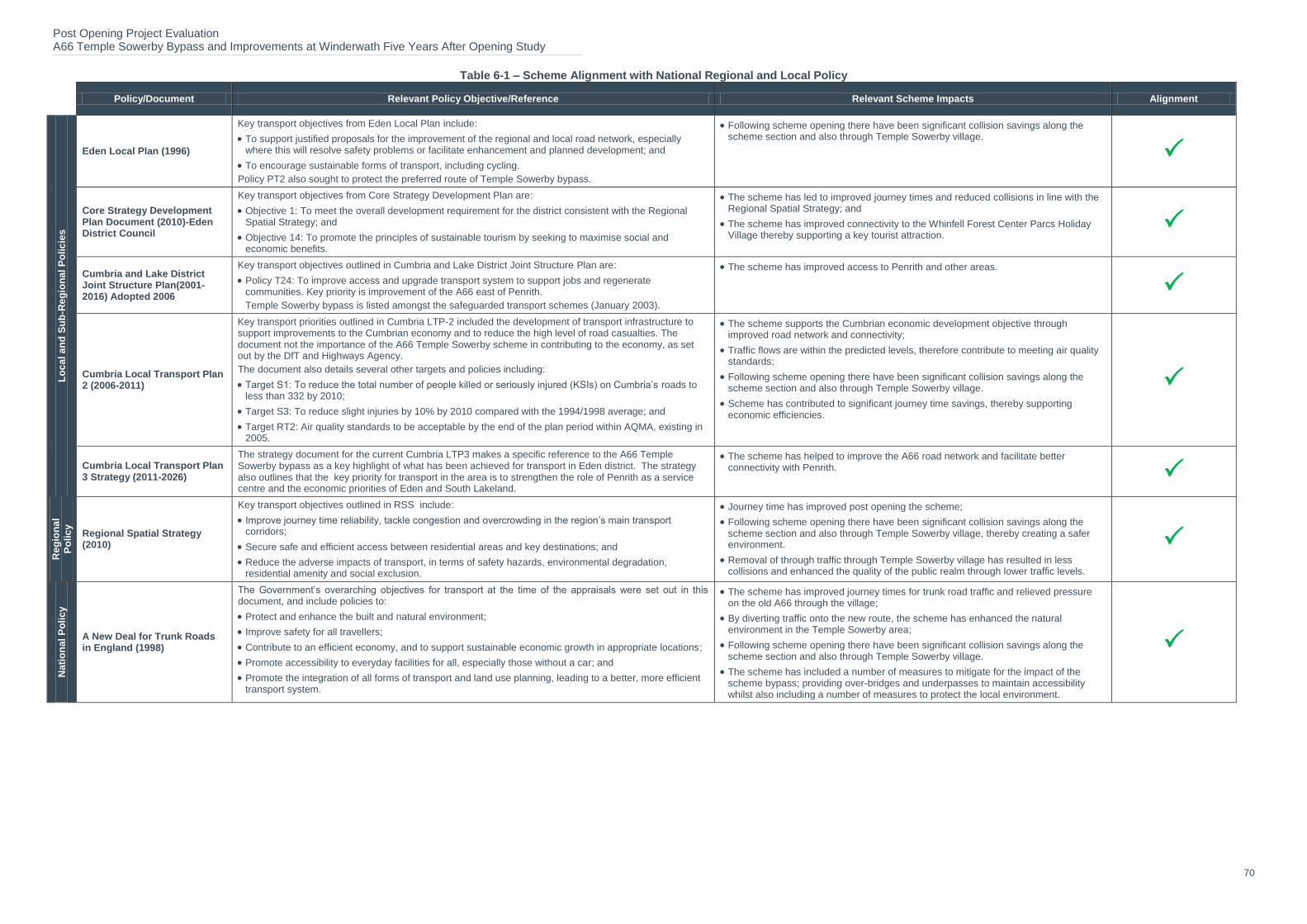
Post Opening Project Evaluation A66 Temple Sowerby Bypass and Improvements at Winderwath Five Years After Opening Study
70
Table 6-1 – Scheme Alignment with National Regional and Local Policy
Policy/Document Relevant Policy Objective/Reference Relevant Scheme Impacts Alignment
Lo
ca
l a
nd
Su
b-R
eg
ion
al
Po
lic
ies
Eden Local Plan (1996)
Key transport objectives from Eden Local Plan include:
To support justified proposals for the improvement of the regional and local road network, especially where this will resolve safety problems or facilitate enhancement and planned development; and
To encourage sustainable forms of transport, including cycling.
Policy PT2 also sought to protect the preferred route of Temple Sowerby bypass.
Following scheme opening there have been significant collision savings along the scheme section and also through Temple Sowerby village.
Core Strategy Development Plan Document (2010)-Eden District Council
Key transport objectives from Core Strategy Development Plan are:
Objective 1: To meet the overall development requirement for the district consistent with the Regional Spatial Strategy; and
Objective 14: To promote the principles of sustainable tourism by seeking to maximise social and economic benefits.
The scheme has led to improved journey times and reduced collisions in line with the Regional Spatial Strategy; and
The scheme has improved connectivity to the Whinfell Forest Center Parcs Holiday Village thereby supporting a key tourist attraction.
Cumbria and Lake District Joint Structure Plan(2001-2016) Adopted 2006
Key transport objectives outlined in Cumbria and Lake District Joint Structure Plan are:
Policy T24: To improve access and upgrade transport system to support jobs and regenerate communities. Key priority is improvement of the A66 east of Penrith. Temple Sowerby bypass is listed amongst the safeguarded transport schemes (January 2003).
The scheme has improved access to Penrith and other areas.
Cumbria Local Transport Plan 2 (2006-2011)
Key transport priorities outlined in Cumbria LTP-2 included the development of transport infrastructure to support improvements to the Cumbrian economy and to reduce the high level of road casualties. The document not the importance of the A66 Temple Sowerby scheme in contributing to the economy, as set out by the DfT and Highways Agency.
The document also details several other targets and policies including:
Target S1: To reduce the total number of people killed or seriously injured (KSIs) on Cumbria’s roads to less than 332 by 2010;
Target S3: To reduce slight injuries by 10% by 2010 compared with the 1994/1998 average; and
Target RT2: Air quality standards to be acceptable by the end of the plan period within AQMA, existing in 2005.
The scheme supports the Cumbrian economic development objective through improved road network and connectivity;
Traffic flows are within the predicted levels, therefore contribute to meeting air quality standards;
Following scheme opening there have been significant collision savings along the scheme section and also through Temple Sowerby village.
Scheme has contributed to significant journey time savings, thereby supporting economic efficiencies.
Cumbria Local Transport Plan 3 Strategy (2011-2026)
The strategy document for the current Cumbria LTP3 makes a specific reference to the A66 Temple Sowerby bypass as a key highlight of what has been achieved for transport in Eden district. The strategy also outlines that the key priority for transport in the area is to strengthen the role of Penrith as a service centre and the economic priorities of Eden and South Lakeland.
The scheme has helped to improve the A66 road network and facilitate better connectivity with Penrith.
Reg
ion
al
Po
lic
y
Regional Spatial Strategy (2010)
Key transport objectives outlined in RSS include:
Improve journey time reliability, tackle congestion and overcrowding in the region’s main transport corridors;
Secure safe and efficient access between residential areas and key destinations; and
Reduce the adverse impacts of transport, in terms of safety hazards, environmental degradation, residential amenity and social exclusion.
Journey time has improved post opening the scheme;
Following scheme opening there have been significant collision savings along the scheme section and also through Temple Sowerby village, thereby creating a safer environment.
Removal of through traffic through Temple Sowerby village has resulted in less collisions and enhanced the quality of the public realm through lower traffic levels.
Nati
on
al
Po
lic
y
A New Deal for Trunk Roads in England (1998)
The Government’s overarching objectives for transport at the time of the appraisals were set out in this document, and include policies to:
Protect and enhance the built and natural environment;
Improve safety for all travellers;
Contribute to an efficient economy, and to support sustainable economic growth in appropriate locations;
Promote accessibility to everyday facilities for all, especially those without a car; and
Promote the integration of all forms of transport and land use planning, leading to a better, more efficient transport system.
The scheme has improved journey times for trunk road traffic and relieved pressure on the old A66 through the village;
By diverting traffic onto the new route, the scheme has enhanced the natural environment in the Temple Sowerby area;
Following scheme opening there have been significant collision savings along the scheme section and also through Temple Sowerby village.
The scheme has included a number of measures to mitigate for the impact of the scheme bypass; providing over-bridges and underpasses to maintain accessibility whilst also including a number of measures to protect the local environment.
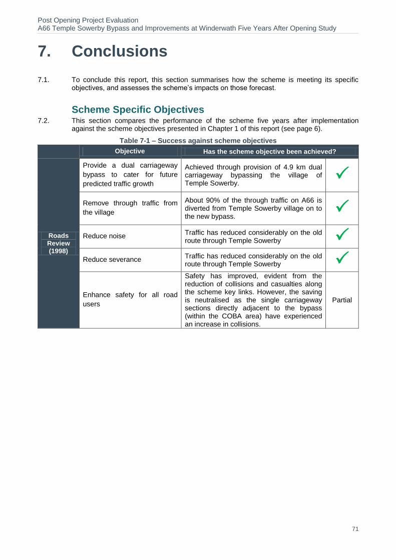
Post Opening Project Evaluation A66 Temple Sowerby Bypass and Improvements at Winderwath Five Years After Opening Study
71
7. Conclusions
7.1. To conclude this report, this section summarises how the scheme is meeting its specific objectives, and assesses the scheme’s impacts on those forecast.
Scheme Specific Objectives 7.2. This section compares the performance of the scheme five years after implementation
against the scheme objectives presented in Chapter 1 of this report (see page 6).
Table 7-1 – Success against scheme objectives
Objective Has the scheme objective been achieved?
Roads Review (1998)
Provide a dual carriageway
bypass to cater for future
predicted traffic growth
Achieved through provision of 4.9 km dual carriageway bypassing the village of Temple Sowerby.
Remove through traffic from
the village
About 90% of the through traffic on A66 is diverted from Temple Sowerby village on to the new bypass.
Reduce noise Traffic has reduced considerably on the old route through Temple Sowerby
Reduce severance Traffic has reduced considerably on the old route through Temple Sowerby
Enhance safety for all road
users
Safety has improved, evident from the reduction of collisions and casualties along the scheme key links. However, the saving is neutralised as the single carriageway sections directly adjacent to the bypass (within the COBA area) have experienced an increase in collisions.
Partial
Post Opening Project Evaluation A66 Temple Sowerby Bypass and Improvements at Winderwath Five Years After Opening Study
72
8. Appraisal Summary Table & Evaluation Summary Table
Appraisal Summary Table
8.1. The AST is a brief summary of the main economic, safety, environmental and social impacts of a highway scheme. Table 8-1 presents the AST for the A66 Temple Sowerby Bypass scheme.
8.2. The AST presents a brief description of the scheme, a statement detailing the problems that the scheme planned to address, and makes an assessment of the scheme’s predicted qualitative and quantitative impacts against the following core NATA objectives:
Environment – an estimate of the impact of the scheme on factors such as noise, local air quality, landscape, biodiversity, and water
Safety – measured reduction in the number and severity of collisions and qualitative assessment of impacts on security
Economy – Estimated impact of the scheme upon journey times, vehicle operating costs, scheme costs, journey time reliability and wider economic impact
Accessibility – A review of scheme impact upon access to the public transport network, community severance, and non-motorised user impact
Integration – A description of how a scheme is integrated with wider local planning, regional and national policy objectives
Evaluation Summary Table
8.3. The EST was devised for the POPE process to record a summary of the outturn impacts against the NATA objectives, compared to the predictions in the AST.
8.4. Drawing on the results presented in this report, Table 8-2 presents the EST for the scheme. An assessment of each of the objectives at the FYA stage is given. Where possible, the format of the EST mirrors the appearance and process of the AST to enable direct comparison between the two.
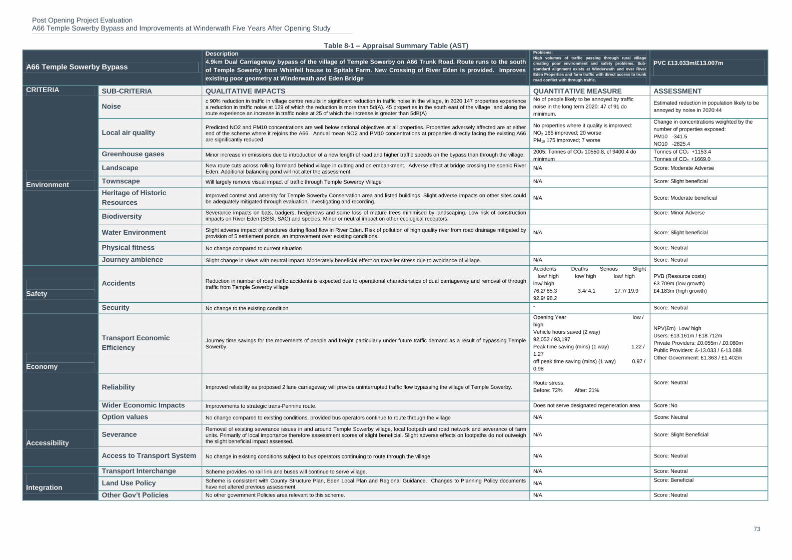
Post Opening Project Evaluation A66 Temple Sowerby Bypass and Improvements at Winderwath Five Years After Opening Study
73
Table 8-1 – Appraisal Summary Table (AST)
A66 Temple Sowerby Bypass
Description
4.9km Dual Carriageway bypass of the village of Temple Sowerby on A66 Trunk Road. Route runs to the south
of Temple Sowerby from Whinfell house to Spitals Farm. New Crossing of River Eden is provided. Improves
existing poor geometry at Winderwath and Eden Bridge
Problems:
High volumes of traffic passing through rural village
creating poor environment and safety problems. Sub-
standard alignment exists at Winderwath and over River
Eden Properties and farm traffic with direct access to trunk
road conflict with through traffic.
PVC £13.033m/£13.007m
CRITERIA SUB-CRITERIA QUALITATIVE IMPACTS QUANTITATIVE MEASURE ASSESSMENT
Environment
Noise c 90% reduction in traffic in village centre results in significant reduction in traffic noise in the village, in 2020 147 properties experience a reduction in traffic noise at 129 of which the reduction is more than 5d(A). 45 properties in the south east of the village and along the route experience an increase in traffic noise at 25 of which the increase is greater than 5dB(A)
No of people likely to be annoyed by traffic
noise in the long term 2020: 47 cf 91 do
minimum.
Estimated reduction in population likely to be
annoyed by noise in 2020:44
Local air quality Predicted NO2 and PM10 concentrations are well below national objectives at all properties. Properties adversely affected are at either end of the scheme where it rejoins the A66. Annual mean NO2 and PM10 concentrations at properties directly facing the existing A66 are significantly reduced
No properties where it quality is improved:
NO2 165 improved; 20 worse
PM10 175 improved; 7 worse
Change in concentrations weighted by the
number of properties exposed:
PM10 -341.5
NO10 -2825.4
Greenhouse gases Minor increase in emissions due to introduction of a new length of road and higher traffic speeds on the bypass than through the village. 2005: Tonnes of CO2 10550.8, cf 9400.4 do
minimum
2020: Tonnes of CO2 14158.8, cf 12489.8 do
minimum
Tonnes of CO2 +1153.4
Tonnes of CO2 +1669.0
Landscape New route cuts across rolling farmland behind village in cutting and on embankment. Adverse effect at bridge crossing the scenic River Eden. Additional balancing pond will not alter the assessment.
N/A Score: Moderate Adverse
Townscape Will largely remove visual impact of traffic through Temple Sowerby Village N/A Score: Slight beneficial
Heritage of Historic
Resources Improved context and amenity for Temple Sowerby Conservation area and listed buildings. Slight adverse impacts on other sites could be adequately mitigated through evaluation, investigating and recording.
N/A Score: Moderate beneficial
Biodiversity Severance impacts on bats, badgers, hedgerows and some loss of mature trees minimised by landscaping. Low risk of construction impacts on River Eden (SSSI, SAC) and species. Minor or neutral impact on other ecological receptors.
Score: Minor Adverse
Water Environment Slight adverse impact of structures during flood flow in River Eden. Risk of pollution of high quality river from road drainage mitigated by provision of 5 settlement ponds, an improvement over existing conditions.
N/A Score: Slight beneficial
Physical fitness No change compared to current situation
Score: Neutral
Journey ambience Slight change in views with neutral impact. Moderately beneficial effect on traveller stress due to avoidance of village. N/A Score: Neutral
Safety
Accidents Reduction in number of road traffic accidents is expected due to operational characteristics of dual carriageway and removal of through traffic from Temple Sowerby village
Accidents Deaths Serious Slight
low/ high low/ high low/ high
low/ high
76.2/ 85.3 3.4/ 4.1 17.7/ 19.9
92.9/ 98.2
PVB (Resource costs)
£3.709m (low growth)
£4.183m (high growth)
Security No change to the existing condition - Score: Neutral
Economy
Transport Economic
Efficiency
Journey time savings for the movements of people and freight particularly under future traffic demand as a result of bypassing Temple Sowerby.
Opening Year low /
high
Vehicle hours saved (2 way)
92,052 / 93,197
Peak time saving (mins) (1 way) 1.22 /
1.27
off peak time saving (mins) (1 way) 0.97 /
0.98
NPV(£m) Low/ high
Users: £13.161m / £18.712m
Private Providers: £0.055m / £0.080m
Public Providers: £-13.033 / £-13.088
Other Government: £1.363 / £1.402m
Reliability Improved reliability as proposed 2 lane carriageway will provide uninterrupted traffic flow bypassing the village of Temple Sowerby. Route stress:
Before: 72% After: 21%
Score: Neutral
Wider Economic Impacts Improvements to strategic trans-Pennine route. Does not serve designated regeneration area Score :No
Accessibility
Option values No change compared to existing conditions, provided bus operators continue to route through the village N/A Sc Score: Neutral
Severance Removal of existing severance issues in and around Temple Sowerby village, local footpath and road network and severance of farm units. Primarily of local importance therefore assessment scores of slight beneficial. Slight adverse effects on footpaths do not outweigh the slight beneficial impact assessed.
N/A Score: Slight Beneficial
Access to Transport System No change in existing conditions subject to bus operators continuing to route through the village N/A Score: Neutral
Integration
Transport Interchange
Scheme provides no rail link and buses will continue to serve village. N/A Score: Neutral
Land Use Policy Scheme is consistent with County Structure Plan, Eden Local Plan and Regional Guidance. Changes to Planning Policy documents have not altered previous assessment.
N/A Score: Beneficial
Other Gov’t Policies No other government Policies area relevant to this scheme. N/A Score :Neutral

Post Opening Project Evaluation A66 Temple Sowerby Bypass and Improvements at Winderwath Five Years After Opening Study
74
Table 8-2 – Evaluation Summary Table (EST)
OBJ SUB-OBJECTIVE QUALITATIVE IMPACTS QUANTITATIVE IMPACT ASSESSMENT
En
vir
on
men
t
Noise -
The observed traffic flow is very similar to that forecasted by the ES, traffic on the new A66 bypass being 4.3% greater than predicted. Observed traffic flow on the old A66 to the east of Temple Sowerby has reduced significantly (by 90%, as predicted by the ES), and although traffic flows are higher than expected, the overall number of vehicles is low
As expected (large beneficial)
Local Air Quality -
The observed traffic flow is very similar to that forecasted by the ES, traffic on the new A66 bypass being 4.3% greater than predicted. Although observed traffic flows on the old A66 to the east and the west of Temple Sowerby appear to be significantly greater than predicted, the overall number of vehicles is low.
As expected (large beneficial)
Greenhouse Gases - Forecast carbon increase: 9%
Outturn re-forecast carbon increase : 17% Worse than expected (minor negative)
Landscape
The road corridor generally remains free of noxious weeds, and planting within the scheme is progressing well. Grassland areas are free of significant scrub cover, and plant stock is in the main, healthy, established, and in good condition. Planting plots have generally achieved their target coverage within the time period stated in the HEMP, and the current levels of plant growth and establishment indicate that their visual screening and landscape integration functions are developing as expected at FYA.
- As expected (moderate adverse)
Townscape No changes regarding Townscape were identified during the FYA site visit and there were no unresolved issues from the OYA report. - As expected (slight beneficial)
Heritage of Historic
Resources
Although confirmation has been received that that copies of the archaeological report have been submitted to the Cumbria HER, the project archive does not appear to have been deposited with the Penrith Museum as stated in the archaeological report. The effects of the scheme on built heritage are as expected.
-
As expected (moderate beneficial), although deposition of the project archive with the Penrith Museum is outstanding
Biodiversity Although the planting on Acton Lodge Green Bridge is not thriving, it is slowly establishing and results of scheme monitoring indicate that bats have been observed foraging along the road embankments and utilising the structure to cross the road. Overall, habitat establishment and maintenance is developing in line with the ecological mitigation proposals as stated in the ES.
- As expected (minor adverse)
Water Environment Based on the FYA site visit, the Landscape As-Built drawings, and comments received at Consultation, it is likely that the overall the effect of the scheme on water quality and drainage remains beneficial.
- As expected (slight beneficial)
Physical Fitness
There are cycleways at each end of the scheme, designed to permit cyclists on the A66 to transfer easily to the old road through the village. POPE is not aware whether there have been any NMU audits or vulnerable User Studies undertaken for this scheme. Footpaths and cycleways viewed during the FYA site visit appeared to be capable of performing as expected. Losses of tranquillity along PRoW remain as expected, especially close to the River Eden Bridge where walkers have lost their high quality unspoilt views along the River Eden, which now include the river bridge, approach embankments and traffic movements.
- As expected (neutral)
Journey Ambience
The alignment of the route, generally in cutting and following the existing landscape structure at Ash Hill and in cutting to the south west and south of Temple Sowerby, has resulted in a slight change of view. Open views have been retained to the south east of the scheme in the vicinity of Spitals Farm. The increased the capacity of the new bypass has removed over 90% of through traffic from the village of Temple Sowerby, relieving congestion and facilitating free-flowing traffic by providing opportunities for the safe overtaking of slower vehicles. The route is well signed and the junctions provide safe access and egress points to and from the A66. Lay-bys are clearly signed and although well used, generally tidy and litter free. Accesses to facilities in Temple Sowerby are available from the clearly signed Morland Road and Cliburn Road junctions.
- As expected (neutral)
Safe
ty Collisions
The number of collisions in the modelled are have reduced when compared to pre-scheme levels but the decrease is not as high as forecast.
Key Links: FYA annual average collision saving of 1.4.
COBA area: FYA annual average collision increase of 0.5. Worse than expected.
Security The scheme has moved through traffic from Temple Sowerby village onto the new Bypass. Laybys have been provided on the Bypass but there are no emergency telephones. The overall impact is as expected.
- As expected (neutral)
Eco
no
my
Public Accounts - Forecast investment cost: £32.3m Outturn investment cost: £31.9m Worse than expected
TEE - Forecast BCR: 2.5. Outturn BCR: 1.8 Worse than expected
Reliability Evidence suggests significant improvements in journey time reliability along the A66 route section. Route Stress: Before: 65%, After 20% As expected (neutral)
Wider Economic
Impacts It is not possible to conclude whether the scheme has had a direct on stimulating local economic activity. - As expected (neutral)
Acce
ssib
ilit
y Option Values The scheme has had no discernible impacts on option values - As expected (neutral)
Severance Severance in the area has reduced following the reduction in traffic and speed limits on the old road - As expected (slight beneficial)
Access to the
Transport System The scheme has had no discernible impact on access to the transport system - As expected (neutral)
Inte
gra
tio
n
Transport Interchange No new facilities included as part of the scheme - As expected (neutral)
Land-Use Policy &
Other Govt Policies
The scheme aligns with policies set out in relevant local, regional and national policy documents by improving the local environment, safety reliability
- As expected (slight beneficial)
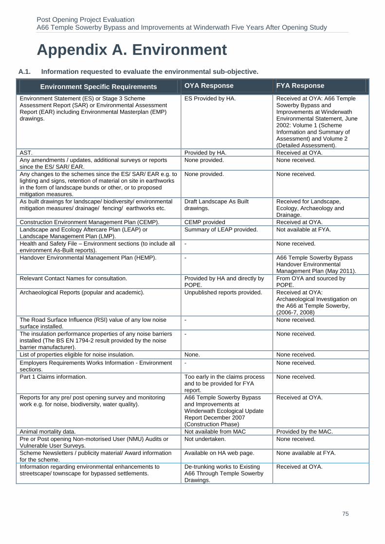
Post Opening Project Evaluation A66 Temple Sowerby Bypass and Improvements at Winderwath Five Years After Opening Study
75
Appendix A. Environment
A.1. Information requested to evaluate the environmental sub-objective.
Environment Specific Requirements OYA Response FYA Response
Environment Statement (ES) or Stage 3 Scheme Assessment Report (SAR) or Environmental Assessment Report (EAR) including Environmental Masterplan (EMP) drawings.
ES Provided by HA. Received at OYA: A66 Temple Sowerby Bypass and Improvements at Winderwath Environmental Statement, June 2002: Volume 1 (Scheme Information and Summary of Assessment) and Volume 2 (Detailed Assessment).
AST. Provided by HA. Received at OYA.
Any amendments / updates, additional surveys or reports since the ES/ SAR/ EAR.
None provided. None received.
Any changes to the schemes since the ES/ SAR/ EAR e.g. to lighting and signs, retention of material on site in earthworks in the form of landscape bunds or other, or to proposed mitigation measures.
None provided. None received.
As built drawings for landscape/ biodiversity/ environmental mitigation measures/ drainage/ fencing/ earthworks etc.
Draft Landscape As Built drawings.
Received for Landscape, Ecology, Archaeology and Drainage.
Construction Environment Management Plan (CEMP). CEMP provided Received at OYA.
Landscape and Ecology Aftercare Plan (LEAP) or Landscape Management Plan (LMP).
Summary of LEAP provided. Not available at FYA.
Health and Safety File – Environment sections (to include all environment As-Built reports).
- None received.
Handover Environmental Management Plan (HEMP). - A66 Temple Sowerby Bypass Handover Environmental Management Plan (May 2011).
Relevant Contact Names for consultation. Provided by HA and directly by POPE.
From OYA and sourced by POPE.
Archaeological Reports (popular and academic). Unpublished reports provided. Received at OYA: Archaeological Investigation on the A66 at Temple Sowerby, (2006-7, 2008)
The Road Surface Influence (RSI) value of any low noise surface installed.
- None received.
The insulation performance properties of any noise barriers installed (The BS EN 1794-2 result provided by the noise barrier manufacturer).
- None received.
List of properties eligible for noise insulation. None. None received.
Employers Requirements Works Information - Environment sections.
- None received.
Part 1 Claims information. Too early in the claims process and to be provided for FYA report.
None received.
Reports for any pre/ post opening survey and monitoring work e.g. for noise, biodiversity, water quality).
A66 Temple Sowerby Bypass and Improvements at Winderwath Ecological Update Report December 2007 (Construction Phase)
Received at OYA.
Animal mortality data. Not available from MAC Provided by the MAC.
Pre or Post opening Non-motorised User (NMU) Audits or Vulnerable User Surveys.
Not undertaken. None received.
Scheme Newsletters / publicity material/ Award information for the scheme.
Available on HA web page. None available at FYA.
Information regarding environmental enhancements to streetscape/ townscape for bypassed settlements.
De-trunking works to Existing A66 Through Temple Sowerby Drawings.
Received at OYA.
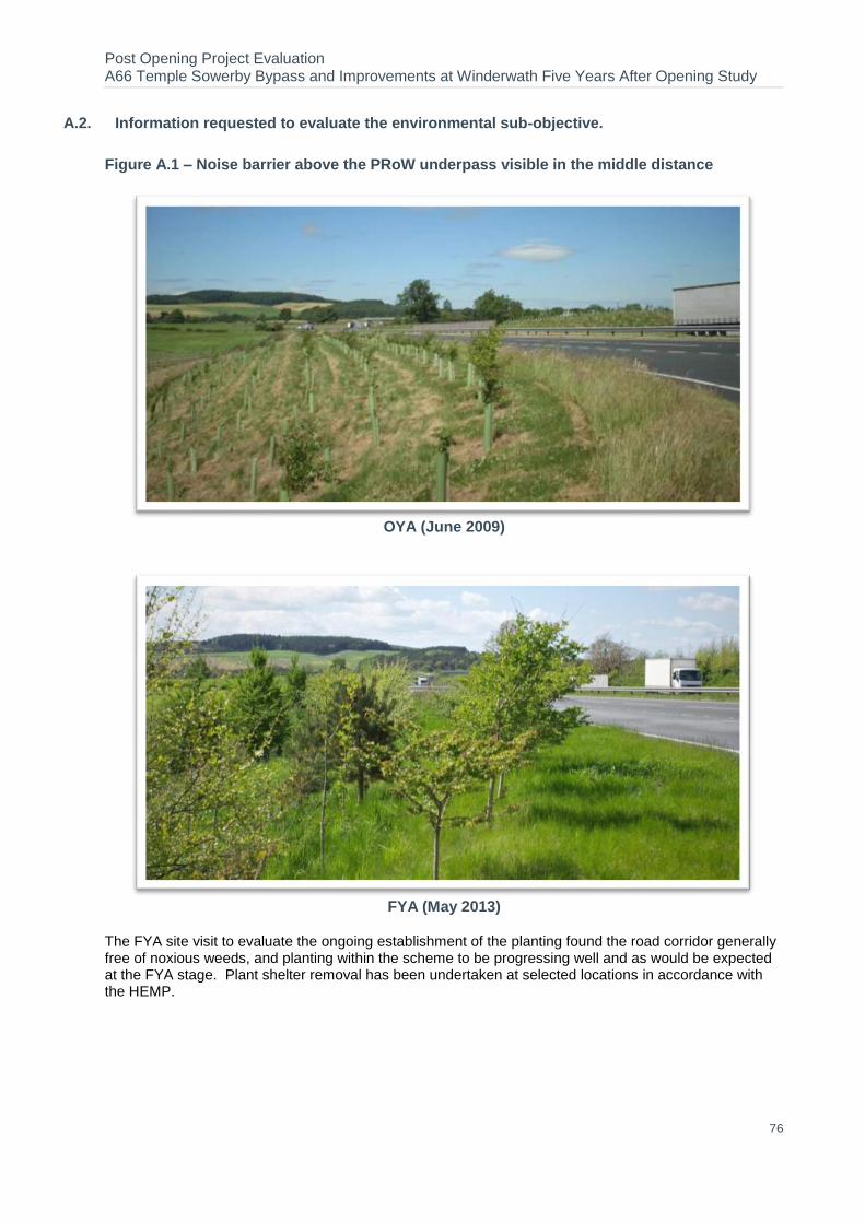
Post Opening Project Evaluation A66 Temple Sowerby Bypass and Improvements at Winderwath Five Years After Opening Study
76
A.2. Information requested to evaluate the environmental sub-objective.
Figure A.1 – Noise barrier above the PRoW underpass visible in the middle distance
OYA (June 2009)
FYA (May 2013)
The FYA site visit to evaluate the ongoing establishment of the planting found the road corridor generally free of noxious weeds, and planting within the scheme to be progressing well and as would be expected at the FYA stage. Plant shelter removal has been undertaken at selected locations in accordance with the HEMP.

Post Opening Project Evaluation A66 Temple Sowerby Bypass and Improvements at Winderwath Five Years After Opening Study
77
Figure A.2 – Steep slopes with extensive land drains and wildflower seeding at Cliburn Road junction
OYA (June 2009)
FYA (May 2013)
As specified in the HEMP, grassland areas have been maintained to be free of significant scrub cover, are healthy, established, and in good condition.
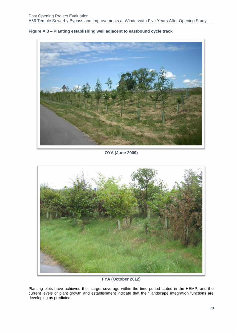
Post Opening Project Evaluation A66 Temple Sowerby Bypass and Improvements at Winderwath Five Years After Opening Study
78
Figure A.3 – Planting establishing well adjacent to eastbound cycle track
OYA (June 2009)
FYA (October 2012)
Planting plots have achieved their target coverage within the time period stated in the HEMP, and the current levels of plant growth and establishment indicate that their landscape integration functions are developing as predicted.

Post Opening Project Evaluation A66 Temple Sowerby Bypass and Improvements at Winderwath Five Years After Opening Study
79
Figure A.4 – Well established marginal vegetation and wildflowers at balancing pond adjacent to Cliburn Road link road
OYA (June 2009)
FYA (May 2013)
At the time of the FYA site visit, balancing pond inlets/ outlets and spillways were clear and appearing to operate as expected, and the vegetative treatment systems (rushes) have established well where planted.

Post Opening Project Evaluation A66 Temple Sowerby Bypass and Improvements at Winderwath Five Years After Opening Study
80
Figure A.5 – Earth bund and mitigation planting adjacent to Illings View screen road but reduce views of wider landscape
OYA (June 2009)
FYA (October 2012)
Throughout the scheme the visual screening and landscape integration functions of the planting plots are beginning to develop, reducing the scale of impact of the bypass and embankments.
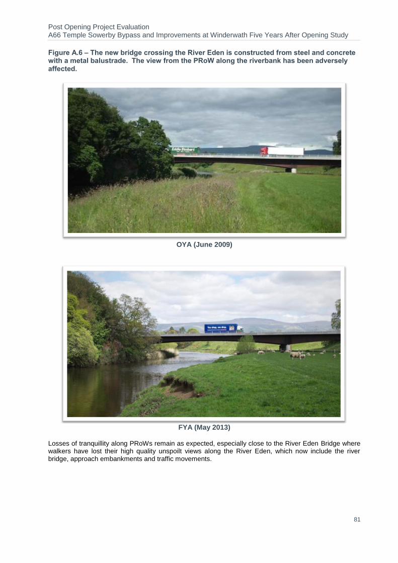
Post Opening Project Evaluation A66 Temple Sowerby Bypass and Improvements at Winderwath Five Years After Opening Study
81
Figure A.6 – The new bridge crossing the River Eden is constructed from steel and concrete with a metal balustrade. The view from the PRoW along the riverbank has been adversely affected.
OYA (June 2009)
FYA (May 2013)
Losses of tranquillity along PRoWs remain as expected, especially close to the River Eden Bridge where walkers have lost their high quality unspoilt views along the River Eden, which now include the river bridge, approach embankments and traffic movements.

Post Opening Project Evaluation A66 Temple Sowerby Bypass and Improvements at Winderwath Five Years After Opening Study
82
Figure A.7 - Mammal crossing near Cliburn Road junction
OYA (June 2009)
FYA (May 2013)
Badger fencing is intact and in good condition throughout the length of the scheme, and the badger/ wildlife crossing points have received maintenance and are in good condition. No evidence of paths at the badger/ wildlife crossing point entrances (indicating use) was noted during the FYA site visit.
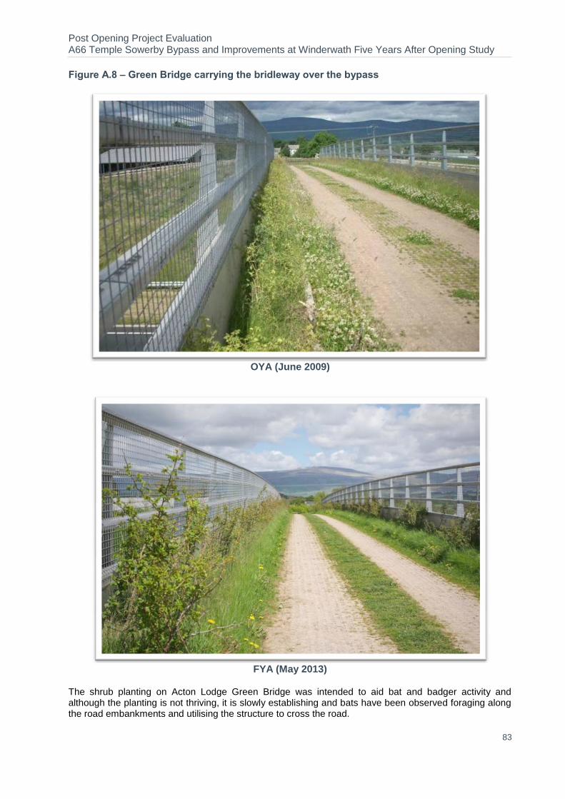
Post Opening Project Evaluation A66 Temple Sowerby Bypass and Improvements at Winderwath Five Years After Opening Study
83
Figure A.8 – Green Bridge carrying the bridleway over the bypass
OYA (June 2009)
FYA (May 2013)
The shrub planting on Acton Lodge Green Bridge was intended to aid bat and badger activity and although the planting is not thriving, it is slowly establishing and bats have been observed foraging along the road embankments and utilising the structure to cross the road.
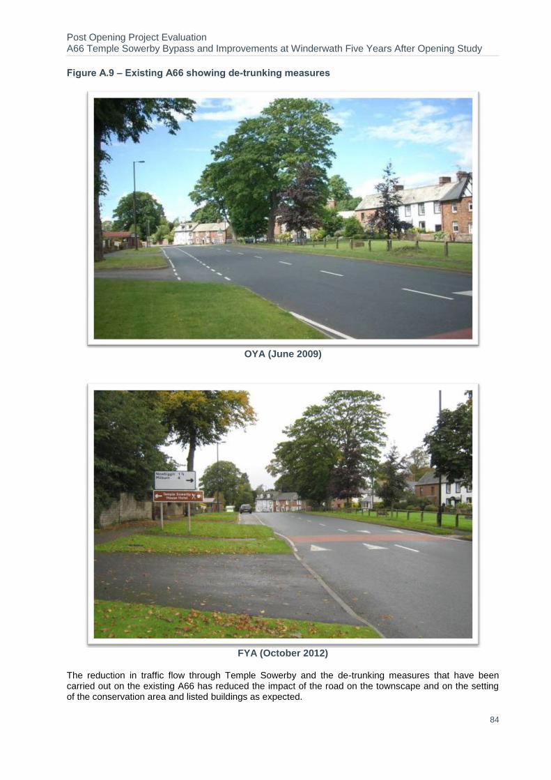
Post Opening Project Evaluation A66 Temple Sowerby Bypass and Improvements at Winderwath Five Years After Opening Study
84
Figure A.9 – Existing A66 showing de-trunking measures
OYA (June 2009)
FYA (October 2012)
The reduction in traffic flow through Temple Sowerby and the de-trunking measures that have been carried out on the existing A66 has reduced the impact of the road on the townscape and on the setting of the conservation area and listed buildings as expected.
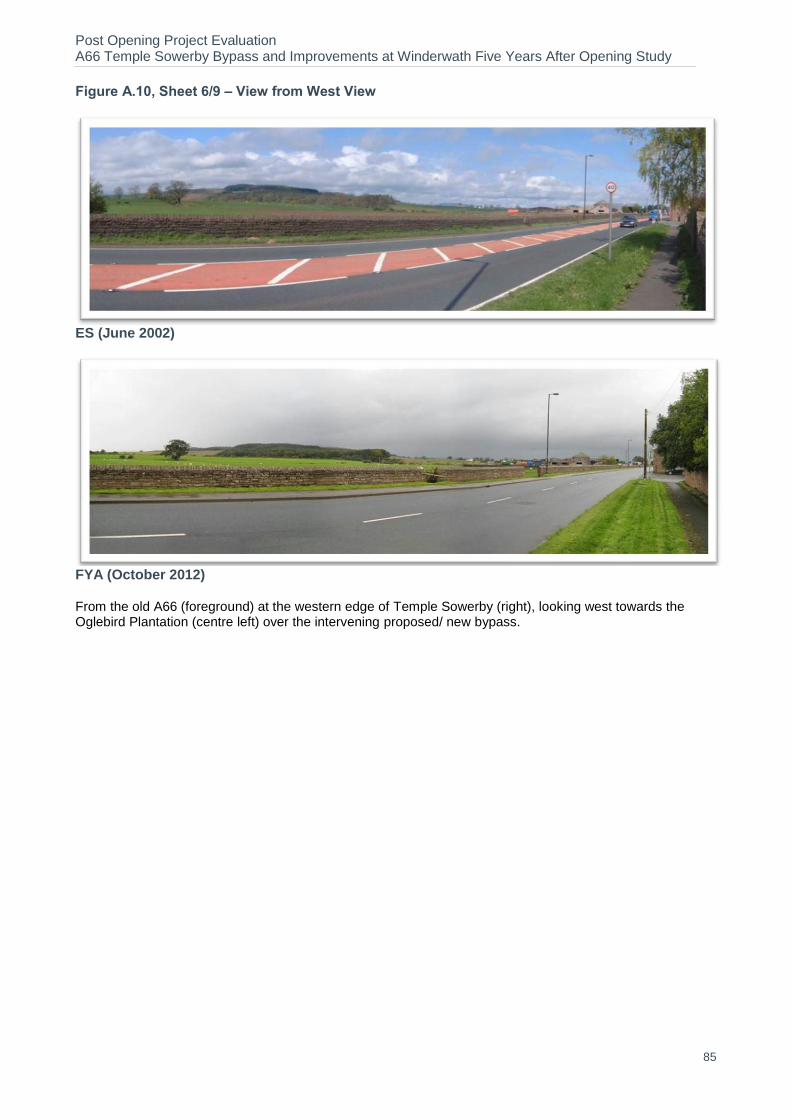
Post Opening Project Evaluation A66 Temple Sowerby Bypass and Improvements at Winderwath Five Years After Opening Study
85
Figure A.10, Sheet 6/9 – View from West View
ES (June 2002)
FYA (October 2012) From the old A66 (foreground) at the western edge of Temple Sowerby (right), looking west towards the Oglebird Plantation (centre left) over the intervening proposed/ new bypass.

Post Opening Project Evaluation A66 Temple Sowerby Bypass and Improvements at Winderwath Five Years After Opening Study
86
Figure A.11, Sheet 8/9 – View from the centre of the village
ES (June 2002)
FYA (October 2012) From the centre of the Conservation Area in Temple Sowerby, looking northwest towards the Oglebird Plantation (centre) over the intervening proposed/ new bypass.

Post Opening Project Evaluation A66 Temple Sowerby Bypass and Improvements at Winderwath Five Years After Opening Study
87
Appendix B. Glossary
Terms Definition
AADT Annual Average Daily Traffic. Average of 24 hour flows, seven days a week, for all days within a year.
Accessibility Accessibility can be defined as 'ease of reaching'. The accessibility objective is concerned with increasing the ability with which people in different locations, and with differing availability of transport, can reach different types of facility.
ADT Average Daily Traffic. Average daily flows across a given period.
AST Appraisal Summary Table. This records the impacts of the scheme according to the Government’s five key objects for transport, as defined in DfT guidance contained on its Transport Analysis Guidance web pages, WebTAG.
ATC Automatic Traffic Count
AAWT Annual Average Weekday Traffic. As AADT but for five days (Monday to Friday) only.
AWT Average Weekday Traffic. As ADT but for five days (Monday to Friday) only.
BCR Benefit Cost Ratio. This is the ratio of benefits to costs when both are expressed in terms of present value i.e. PVB divided by PVC.
COBA
Cost Benefit Analysis. A computer program which compares the costs of providing road schemes with the benefits derived by road users (in terms of time, vehicle operating costs and collisions), and expresses the results in terms of a monetary valuation. The COBA model uses the fixed trip matrix unless it is being used in Collision-only mode.
DfT Department for Transport
Discount Rate
The percentage rate applied to cash flows to enable comparisons to be made between payments made at different times. The rate quantifies the extent to which a sum of money is worth more to the Government today than the same amount in a year's time.
Discounting
Discounting is a technique used to compare costs and benefits that occur in different time periods and is the process of adjusting future cash flows to their present values to reflect the time value of money, e.g. £1 worth of benefits now is worth more than £1 in the future. A standard base year needs to be used which is 2002 for the appraisal used in this report.
DM Do Minimum. In scheme modelling, this is the scenario which comprises the existing road network plus improvement schemes that have already been committed.
DMRB Design Manual for Roads and Bridges
DS Do Something. In scheme modelling, this is the scenario detailing the planned scheme plus improvement schemes that have already been committed.
EA Environment Agency
EAR Economic Assessment Report
ES Environmental Statement
EST Evaluation Summary Table. In POPE studies, this is a summary of the evaluations of the TAG objectives using a similar format to the forecasts in the AST.
EU European Union
FYA Five Year After
HA Highways Agency. An Executive Agency of the DfT, responsible for operating, maintaining and improving the strategic road network in England.
HGV Heavy Goods Vehicle
KSI Killed or Seriously Injured. KSI is the proportion of casualties who are killed or seriously injured and is used as a measure of collision severity.
LCA Landscape Character Areas
LNS Low Noise Surfacing

Post Opening Project Evaluation A66 Temple Sowerby Bypass and Improvements at Winderwath Five Years After Opening Study
88
Terms Definition
LTP3 Local Transport Plan 3
MAC Managing Area Contractor Organisation normally contracted in 5-year terms for undertaking the management of the road network within a HA area.
MVKM Million Vehicle Kilometres
NATA New Approach to Appraisal. The basis of the standard DfT appraisal approach when this scheme was appraised.
NMU Non-Motorised User. A generic term covering pedestrians, cyclists and equestrians.
NRTF
National Road Traffic Forecasts. This document defines the latest forecasts produced by the Department of the Environment, Transport and the Regions of the growth in the volume of motor traffic. At the time this scheme was appraised, the most recent one was NRTF97, i.e. dating from 1997.
NTM National Transport Model
ONS Office for National Statistics
OYA One Year After
PIC Personal Injury Collisions
POPE Post Opening Project Evaluation. The before and after monitoring of all major highway schemes in England.
Present Value
Present Value. The value today of an amount of money in the future. In cost benefit analysis, values in differing years are converted to a standard base year by the process of discounting giving a present value.
PVB Present Value Benefits. Value of a stream of benefits accruing over the appraisal period of a scheme expressed in the value of a present value.
PVC Present Value Costs. As for PVB but for a stream of costs associated with a project
STATS19 A database of injury collision statistics recorded by police officers attending collisions.
SSSI Site of Special Scientific Interest
TEE Transport Economic Efficiency
TEMPRO Trip End Model Program. This program provides access to the DfT's national Trip End Model projections of growth in travel demand, and the underlying car ownership and planning data projections.
TIS Traffic Impact Study
TRADS Traffic Flow Data System. Database holding information on traffic flows at sites on the strategic network.
UK United Kingdom
webTAG DfT's website for guidance on the conduct of transport studies at http://www.webtag.org.uk/
Post Opening Project Evaluation A66 Temple Sowerby Bypass and Improvements at Winderwath Five Years After Opening Study
89
Appendix C. Tables and Figures in this
Report
C.1. List of Tables Table 2-1 HGV’s using A66 17 Table 2-2 Forecast DM AADT Flows vs. Observed Pre-Scheme 24-hr ADT Flows 17 Table 2-3 Forecast DS AADT Flows vs. Observed Post Opening 24-hr ADT Flows 18 Table 2-4 Journey Time Comparison for whole section 20 Table 2-5 Journey Time Comparison by Section 20 Table 2-6 – Forecast and Actual Journey Time Savings on A66 21 Table 2-7 – Observed Changes in Route Stress 22 Table 3-1 Number of Collisions by Severity in the COBA area 26 Table 3-2 Evaluation of Casualty Numbers in the COBA Area 27 Table 3-3 Number of Collisions by Severity for the Key Links 28 Table 3-4 Evaluation of Casualty Numbers for the Key Links 29 Table 3-5 Collisions East and West of the Scheme 31 Table 3-6 Collision Forecasts vs. Observed COBA Area 32 Table 3-7 Collision Rate on the Scheme Key Links 33 Table 3-8 Severity of Collisions and Casualties COBA Area 33 Table 3.9– FWI on the A66 34 Table 4-1 - Journey Time saving and Monetary Benefit (2002 market prices discounted to 2002) 38 Table 4.2 – Summary of Scheme Present Value Benefits 39 Table 4.3 – Forecast vs. Outturn Investment Costs 39 Table 4.4 – Forecast vs. Outturn PVC 39 Table 4.5 – Forecast vs. Outturn BCR 40 Table 5-1– Summary of Environmental Consultation Responses 44 Table 5-2 – Comparison of Predicted and Observed AADT for Traffic Flows at OYA and FYA 45 Table 5-3 – Evaluation Summary: Noise 47 Table 5-4– Evaluation Summary: Local Air Quality 48 Table 5.5 – Re-Forecast and Outturn Change in Carbon Emissions 48 Table 5.6 – Evaluation Summary: Greenhouse Gases 49 Table 5-7 – Evaluation Summary: Landscape 54 Table 5-8 – Evaluation Summary: Townscape 55 Table 5-9 – Evaluation Summary: Heritage 56 Table 5-10 – Animal Mortality Data, 2008-2013 59 Table 5-11 – Evaluation Summary: Biodiversity 60 Table 5-12 – Evaluation Summary: Water Quality and Drainage 62 Table 5-13 – Evaluation Summary: Physical Fitness 64 Table 5-14 – Evaluation Summary: Journey Ambience 65 Table 6-1 – Scheme Alignment with National Regional and Local Policy 70 Table 7-1 – Success against scheme objectives 71 Table 8-1 – Appraisal Summary Table (AST) 73 Table 8-2 – Evaluation Summary Table (EST) 74
C.2. List of Figures Figure 1-1 Location of A66 Temple Sowerby Bypass 5 Figure 1-2 Scheme History 6 Figure 1-3 Layout of A66 Temple Sowerby Bypass 7 Figure 2-1 Nationally Observed Trends by Road Type 11 Figure 2-2 Regional and Local Trends 12 Figure 2-3 Long Term Traffic Trends on A66 13 Figure 2-4 Before and After Traffic Volumes (AWT) 14

Post Opening Project Evaluation A66 Temple Sowerby Bypass and Improvements at Winderwath Five Years After Opening Study
90
Figure 2-5 Before and After Traffic Volumes (AWT) in the Wider Area 16 Figure 2-6 A66 Journey Time Route 19 Figure 3-1 Collision Data 23 Figure 3-2 COBA Modelled Area 24 Figure 3-3 Trends in Injury Collisions Numbers 25 Figure 3-4 Number of Collisions on Year-by-Year Basis for COBA Modelled Area 26 Figure 3-5 Number of Casualties on Year-by-Year Basis for Scheme Cordon Area 28 Figure 3-6 Locations of Collisions: Five Years before construction 30 Figure 3-7 Locations of Collisions: Five Years After opening 30 Figure 3-8–Layby on A66 Temple Sowerby Bypass 35 Figure 5-1–Retained Mature Trees Reducing the Scale of the New Overbridge at Morland Road 50 Figure 5-2– New Hedgerow at Whinfell House 51 Figure 5-3 – New Tree Planting along the Eastbound Carriageway East of Cliburn Junction 51 Figure 5-4 – Balancing Pond East of the Eastbound Lay-by 51 Figure 5-5 – Scattered Trees and Shrubs (Top of Embankment, Left) Providing a Visual link to the Oglebird Plantation
(Right) 52 Figure 5-6 – Accommodation Woodland Planting Reducing the Scale of Impact of the Bypass and Embankment,
Adjacent to Winderwath Farm and Cliburn Road Junction 53 Figure 5-7– Linear Belt of Trees and Shrubs Developing Screening Function at Whinfell House 53 Figure 5-8– Establishing Woodland Feature at the Eastbound Exit to Temple Sowerby 53 Figure 5-9– New Woodland on the Embankment Adjacent to the Oglebird Plantation 54 Figure 5-10– Acton Lodge Green Bridge 54 Figure 5-11– Badger/ wildlife crossing point 57 Figure 5-12– Acton Lodge Green Bridge 58 Figure 5-13– Species Rich Grassland Verge, West of the River Eden Bridge 60 Figure 5-14 - Cliburn Road Balancing Pond 61 Figure 5-15 – Balancing Pond Directly West of the River Eden 61 Figure 5-16–Balancing Pond Directly East of the River Eden 62 Figure 5-17–Balancing Pond at Morland Road 62 Figure 5-18–Balancing Pond Adjacent to the Lay-by on the Westbound Carriageway 62 Figure 5-19– Loss of Tranquillity near the River Eden Bridge 64