potential risks and their analysis in the application …
TRANSCRIPT

H. Erbıyık, E. Can, Ş. Kuşçu Mogući rizici i njihova analiza u primjeni geografski temeljenih tehničkih problema
ISSN 1330-3651 (Print), ISSN 1848-6339 (Online) UDC/UDK 658.512.2.011.3:005.8
POTENTIAL RISKS AND THEIR ANALYSIS IN THE APPLICATION OF GEOGRAPHIC BASED ENGINEERING PROJECTS Hikmet Erbıyık, Eray Can, Şenol Kuşçu
Original scientific paper Numerous different problems can be encountered either on project linked data or on the design works that are generated on the basis of these data during the realization of geographic based engineering projects (GBEP). Among the failures in this regard are failures originating from the horizontal and vertical position relevant design and implementation for the realized GBEP, failures relevant to project due to insufficient definition of land usage suitability, stability problems that are relevant to the implementation field of the Project, etc. For the solution of these problems it is essential to carry out necessary geometric controls at each stage of these projects, as well as to do risk management in an appropriate way for the basic elements that are causing these problems. In our article, it is attempted to analyze these potential failures and risks with Failure Mode Effect Analysis method and Pareto Charts. Keywords: engineering measurements, Failure Mode Effect Analysis (FMEA), Geographic Based Engineering Projects (GBEP), Pareto charts, risk management Mogući rizici i njihova analiza u primjeni geografski temeljenih tehničkih problema
Izvorni znanstveni članak Mnogo je različitih problema na koje se može naići kod podataka vezanih uz projekte ili uz projektne radove nastale na osnovu tih podataka tijekom realizacije geografski utemeljenih tehničkih projekata (GBEP). Među takvim greškama su greške nastale zbog projekata vezanih uz horizontalan ili vertikalan položaj i implementaciju GBEPa, greške zbog nezadovoljavajuće definicije o odgovarajućem korištenju zemljišta, problema stabilnosti vezanih uz područje implementacije projekta itd. Kako bi se ovi problemi riješili bitno je provesti odgovarajuće geometrijske provjere na svakom stadiju projekata kao i analizu i upravljanje rizicima osnovnih elemenata koji dovode do tih problema. U našem se članku te potencijalne greške i rizici pokušavaju analizirati metodom analize utjecaja posljedica kvara (FMEA) i Pareto tablicama. Ključne riječi: analiza utjecaja posljedica kvara (FMEA), geografski temeljeni tehnički projekti (GBEP), Pareto tablice, tehnička mjerenja, upravljanje rizicima 1 Introduction
Generally, most important part of the information, document and data that will form the geographic based engineering projects, consists of location, form, dimension etc. geometric features of the land based projects on the earth and underground [4, 5]. However, some other parts of these features are relevant to the design criteria of the land based projects, namely, land related topographic, geologic, geotechnical, etc. data that are obtained from the limited numbers of the measurements and observations. It is also apparent that many points of the land have different natural and geomorphologic features and the design works that are carried out upon the design input that consists of limited numbers of relevant data, may not always be compatible with the natural or even cultural structure of the concerned land. For that reason, in the realization of this type of geographic based engineering projects, it is essential to consider controlling the suitability of the natural and cultural features of the land of the implemented project regularly and to carry out relevant risk analysis alongside with the compliance to the Project [2, 5, 7, 9]. After these controls and Failure Mode Effect Analysis (FMEA), it is quite important to try to improve the intended suitability on every stage of the project, furthermore it could be even inevitable for the coherent progress of the project. As the result of the geographic based project implementation processes during project realization, for example, in case when a non-conformity is encountered with regard to highway or railway crossing or construction and if it is found as incompatible with the real topographic and/or geologic structure of the land, then further revisions and
precautions have to be made for bringing the project in a more applicable state with regard to the results of risk analysis and controls [12, 13, 14]. These types of problem cases will necessitate the typical application of the FMEA methodology. The construction sites that are the implementation fields of the geographic based engineering projects (GBEP) are such locations that have the inter-related activities. Hence the expected solutions are obtained with systematic multi-disciplined team works [15]. As far as we are concerned with the team works over geographic based engineering projects, (GBEP) proper realization of the project as in compliance with location, dimension, and form, will depend on the land topography, ownership, over ground and under ground land usage properties. Failure Mode Effect Analysis (FMEA) studies will be made in this regard as in line with the surveying and other geographic based engineering. Team work and discipline in surveying and other geographic based engineering will be critical issue in utilizing FMEA projects. 2 Failure Mode Effect Analyses (FMEA)
This type of risk analysis method is utilized to detect the failures or defects in the implemented projects before they turn into a hazardous state, and to identify and control the priorities in remedying the failure problems and to eliminate the potential failures and risks before they happen [1, 8]. In addition to the other risk analysis methods, FMEA enables us to detect and evaluate the hazards and accidents in advance. Failure Mode Effect Analysis (FMEA) has a wide range of usage field; it is also a strong analysis technique toward preventing the
Tehnički vjesnik 21, 1(2014), 9-15 9
Potential risks and their analysis in the application of geographic based engineering projects H. Erbıyık, E. Can, Ş. Kuşçu
failures by estimating the relevant risks [3, 8, 11]. This technique can both be utilized during the design review stages of the project and in implementation and installation stage. However it is more appropriate to use the technique in design review stages because reduction of relevant costs of the resources for corrections/revisions of potential failures can be made most effectively in design review stages when comparing the whole implementation period. The intended precautions as the result of the FMEA studies can only be achieved with the least cost at design review stage. The corrections/ revisions that are made in the post design period could cause multi fold increase in the cost. To use detectability factor alongside the probability and severity factors in the method shows an important aspect of the system. In the Failure Mode Effect Analysis (FMEA) study, estimations of probability, severity and detectability are made for all defined potential failures and defects. At the end of these estimations, relevant solutions are searched by giving priority to the relatively bigger risks. The advantages of the system are given below: • To improve the quality, reliability, and safety of the
product or project. • To enhance the customer satisfaction. • To reduce the product or project development period
and cost. • To ascertain the priorities in design or process
development activities. • To discover the whole potential failures modes, their
effects and similarities for all products/processes. • To assist in analysis of the design requirements and
design alternatives. • To assist in definition of potential, critical and
important characteristics. • To assist in analysis of new production or project
stages. • To maintain important media for failure prevention. • To enable the definition of corrective & preventive
actions. • To certify and monitor the risk reducing activities,
etc. 3 Failure Mode Effect Analysis (FMEA) Elements and
Calculation Method In FMEA studies, a suitable work team has to be assigned in accordance with the selected project because the definition of the problems and risk priority values in the studied project requires qualified personnel as well as knowledge and experience. At the same time, the work team has to consist of selected personnel having different job profiles and from different departments. The personnel that takes part in the FMEA team, has to possess sufficient competencies to carry out FMEA activities effectively. During Project design stages, the defects and failures that are taken into consideration are handled within a unique system and Formula. However, to define the priorities of risks and failures in this analysis, there are 3 basic elements. These are cited as: Occurrence, Severity and Detection [1, 3, 8, 16]. Among these elements, occurrence shows the existence probability, defect frequency, severity or weight, indicates
the seriousness (effect) of the failure-defect. Detectability means the level of difficulty in detecting the failure. However, the detectability element is also important due to its advantage in representing the failure’s definition before happening. There are many methods for defining the values of these elements. However the customary way is to use numerical calculation tables (risk value tables). When the above mentioned three risk factor elements are assessed altogether, it represents the risk priority level (RPL) for each failure-defect type. And this value defines the numerical level of critical risk [8, 10]. In calculation of risk priority level (RPL), the assigned values of risk factors are taken, that remain in a certain numerical range. While the risks are defined for each failure type starting from the biggest risk priority level (RPL), the intention is to reduce this risk level to an acceptable lowest level for a short term. On the other hand over the long term for eliminating these risks the relevant and suitable corrective actions are intended. Risk priority levels (RPL) for FMEA are calculated by multiplying the Occurrence (O), Severity (A), and Detectability (S) levels [1, 3, 10, 16].
.SAORPL ⋅⋅= (1)
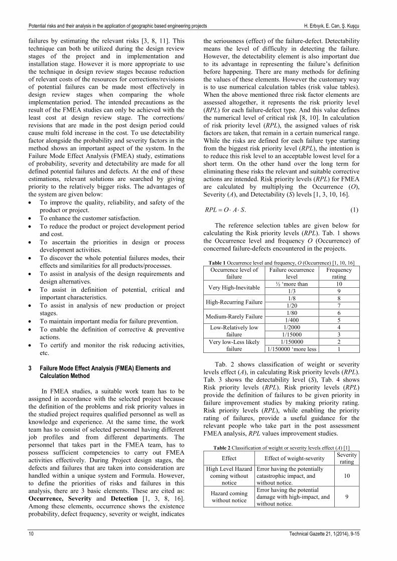
The reference selection tables are given below for calculating the Risk priority levels (RPL). Tab. 1 shows the Occurrence level and frequency O (Occurrence) of concerned failure-defects encountered in the projects.
Table 1 Occurrence level and frequency, O (Occurrence) [1, 10, 16] Occurrence level of
failure Failure occurrence
level Frequency
rating
Very High-Inevitable ½ ‘more than 10 1/3 9
High-Recurring Failure 1/8 8 1/20 7
Medium-Rarely Failure 1/80 6 1/400 5
Low-Relatively low failure
1/2000 4 1/15000 3
Very low-Less likely failure
1/150000 2 1/150000 ‘more less 1
Tab. 2 shows classification of weight or severity
levels effect (A), in calculating Risk priority levels (RPL). Tab. 3 shows the detectability level (S), Tab. 4 shows Risk priority levels (RPL). Risk priority levels (RPL) provide the definition of failures to be given priority in failure improvement studies by making priority rating. Risk priority levels (RPL), while enabling the priority rating of failures, provide a useful guidance for the relevant people who take part in the post assessment FMEA analysis, RPL values improvement studies.
Table 2 Classification of weight or severity levels effect (A) [1]
Effect Effect of weight-severity Severity rating
High Level Hazard coming without
notice
Error having the potentially catastrophic impact, and without notice.
10
Hazard coming without notice
Error having the potential damage with high-impact, and without notice.
9
10 Technical Gazette 21, 1(2014), 9-15

H. Erbıyık, E. Can, Ş. Kuşçu Mogući rizici i njihova analiza u primjeni geografski temeljenih tehničkih problema
Table 2 Classification of weight or severity levels effect (A) [1] (Continuation)
Effect Effect of weight-severity Severity rating
Very High
The type of error with detrimental effect that allows the entire system to have a complete damage that can result in serious injury.
8
High
The type of error which causes damage to the entire equipment, has fatal impact leading to death, poisoning, 3rd degree burns, acute death, and so on.
7
Medium
The type of error that affects the performance of the system and leads to the loss of limb or organ, severe injury, cancer and so on.
6
Low
The type of error that can lead to fracture, permanent small unfitness, 2nd degree burns, concussion and so on.
5
Very Low
The type of error that influences injury, minor cuts and abrasions, bruises, and so on and causes minor injuries to the short-term disturbances.
4
Small The type of error that slows down the operation of the system. 3
Very Small The type of error that may cause confusion in the operation of the system.
2
No effect Without effect. 1
Table 3 Detectability level (S) in calculating the risk priority level (RPL), [1]
Detectability Probability of Detectability Rating
Imperceptible Detectability of potential cause of failure and the following failure is not possible
10
Very far Detectability of potential cause of failure and the following failure is very far
9
Far Detectability of potential cause of failure and the following failure is far
8
Very low Detectability of potential cause of failure and the following failure is very low
7
Low Detectability of potential cause of failure and the following failure is low
6
Medium Detectability of potential cause of failure and the following failure is medium
5
Above medium Detectability of potential cause of failure and the following failure is above medium
4
High Detectability of potential cause of failure and the following failure is high
3
Very high Detectability of potential cause of failure and the following failure is very high
2
Nearly sure Detectability of potential cause of failure and the following failure is for sure
1
Table 4 Risk priority levels (RPL) [1] Risk priority levels (RPL) Precaution
RPL < 40 No need to take action.
40 ≤ RPL ≤ 100 Medium risk measures can be taken.
RPL > 100 Caution needs to be taken, high-risk.
4 Calculation of Risk Priority Levels (RPL) and FMEA
Implementation in Geographic Based Engineering Projects (GBEP)
It is essential to do the geometric, positional,
geologic, geotechnical, geomorphologic, etc. controls on every stage of geographic based engineering projects, for the solution of potential risks and problems to be encountered at design review and implementation of GBEP.
In addition to this fact, a systematic risk management has to be made as well, for the factors that cause these problems or failures. This analysis and controls will enable the smooth progress of applied geography-based projects while providing a healthy way for the future projects to be designed on a more solid foundation.
Tab. 5 provides a comprehensive analysis of potential risks and failures to be encountered during the geography-based projects implementation and on the relevant engineering measurements for these projects, calculating by Failure Mode Effect Analysis method (FMEA) and in accordance with experience from Risk Priority Levels (RPL) tables.
In this table (Tab. 5), 12 control issues that may cause risk factors are considered during the construction of geography-based engineering projects. Among these 12 control issues that may cause risk factors 6 are found as high risk level and the remaining 6 are determined as medium risk level.
The suggested precautions that are to be considered for reducing the high and medium risk values that are defined by giving reference in the implemented FMEA. Risk Priority Level values are intended to be reduced provided that relevant precautions defined in the FMEA are taken properly at relevant geography-based engineering projects. Thus, it is aimed that high and medium level risks are eliminated for the sake of progress of the Projects in a healthy way. In addition to the Failure Mode Effect Analysis, the Pareto Analysis is also utilized aiming to 75 ÷ 80 % critical threshold risk value.
Tehnički vjesnik 21, 1(2014), 9-15 11

Potential risks and their analysis in the application of geographic based engineering projects H. Erbıyık, E. Can, Ş. Kuşçu
Table 5 Comprehensive Analysis of Potential Risks and Failures to be Encountered During the Geography-Based Projects Implementation [6, 18, 19]
12 Technical Gazette 21, 1(2014), 9-15

H. Erbıyık, E. Can, Ş. Kuşçu Mogući rizici i njihova analiza u primjeni geografski temeljenih tehničkih problema
Figure 1 Pareto diagram resulting after Pareto Analysis Data Evaluation
Table 6 Designed Pareto Analysis in Geographic-Based Engineering Projects (GBEP)
PARETO CHART IN GEOGRAPHICAL BASED PROJECTS Sequence
No Failure mode Process No
RPL* Value Risk / % Cumulative
risk / % Risk state
1 The errors, arising from the vertical and horizontal position, the size and geometry of the design and implementation issues of the realized Project.
10 270 15,05 15,05 UNACCEPTABLE HIGH RISK
2 The errors and failures, arising from the lack of controls for appropriateness of the land for the concerned project in terms of geological and geotechnical suitability.
40 270 15,05 30,10 UNACCEPTABLE HIGH RISK
3 The errors and failures, arising from the lack of proper definition of the land topography and land usage appropriateness for the concerned Project.
20 240 13,38 43,48 UNACCEPTABLE HIGH RISK
4 The errors and failures, arising from failure to comply with laws and regulations concerning Occupational health and safety issues.
100 224 12,49 55,96 UNACCEPTABLE HIGH RISK
5 The errors and failures, arising from failure to calibrate the measuring equipment used in geographic-based projects.
80 175 9,75 65,72 UNACCEPTABLE HIGH RISK
6 The errors and failures, arising from lack of control on the stability and landslide control issues for implemented area of the Project.
30 140 7,80 73,52 UNACCEPTABLE HIGH RISK
7 The errors and failures, arising from lack of estimation of expected or probable realization period of Project mile Stones.
50 100 5,57 79,10 MEDIUM RISK
8 The errors and failures, arising from failure to proper planning for realized incomes (progress revenue, production…) and consumptions (manpower, material, tools and equipment...) in implementation.
70 90 5,02 84,11 MEDIUM RISK
9 The errors and failures, arising from failure to proper control efficiency of manpower and equipment. 110 75 4,18 88,29 MEDIUM RISK
10 The errors and failures, arising from deviation from technical specifications and standards relevant to implementation of realized geography based project.
60 75 4,18 92,47 MEDIUM RISK
11 The errors and failures, arising from formation of project organizational structure. 90 75 4,18 96,66 MEDIUM RISK
12 The errors and failures, arising from endured financial losses due to delay in approved job orders. 120 60 3,34 100,00 MEDIUM RISK
RPL VALUE*- Risk Priority Level Value
Tehnički vjesnik 21, 1(2014), 9-15 13

Potential risks and their analysis in the application of geographic based engineering projects H. Erbıyık, E. Can, Ş. Kuşçu
Table 7 Components of High Risk Error by 75 % Threshold Value of the Risks in the generated Pareto Chart
PARETO CHART IN GEOGRAPHIC BASED PROJECTS (HIGH RISKS) Sequence
No Failure mode Process No
RPL* Value Risk / % Cumulative
risk / % Risk state
1 The errors, arising from the vertical and horizontal position, the size and geometry of the design and implementation issues of the realized Project
10 270 20,47 20,47 UNACCEPTABLE HIGH RISK
2 The errors and failures, arising from the lack of controls for appropriateness of the land for the concerned project in terms of geological and geotechnical suitability.
40 270 20,47 40,94 UNACCEPTABLE HIGH RISK
3 The errors and failures, arising from the lack of proper definition of the land topography and land usage appropriateness for the concerned Project.
20 240 18,20 59,14 UNACCEPTABLE HIGH RISK
4 The errors and failures, arising from failure to comply with laws and regulations concerning Occupational health and safety issues.
100 224 16,98 76,12 UNACCEPTABLE HIGH RISK
5 The errors and failures, arising from failure to calibrate the measuring equipment used in geographic-based projects.
80 175 13,27 89,39 UNACCEPTABLE HIGH RISK
6 The errors and failures, arising from lack of control on the stability and landslide control issues for implemented area of the Project.
30 140 10,61 100,00 UNACCEPTABLE HIGH RISK
RPL VALUE*- Risk Priority Level Value
Figure 2 Pareto diagram of high-risk elements in their own error
In our implementation critical threshold risk value is
chosen as 75 %. Pareto analysis carried out based on failures and risks that may occur when designing geography-based engineering projects and ranked according to the severity of the risk factors with regard to the nature of each risk factor, and calculated values of relevant percentage % is shown [17] In the geographic-based engineering projects that require team work, it is one of the benefits of the analysis as reaching to a joint decision that provides precautions against the potential failures having high risk that are calculated on the basis of the Risk Priority Level (RPL) values table. Information about the Pareto Analysis is shown in Table 6, and relevant chart is shown in Fig. 1. Accordingly, in order of importance when designing geographically based engineering projects (GBEP), the following errors and failures are considered firstly in priority: 1. The errors, arising from the vertical and horizontal
position, the size and geometry of the design and implementation issues of the realized Project.
2. The errors and failures, arising from the lack of controls for appropriateness of the land for the concerned project in terms of geological and geotechnical suitability.
3. The errors and failures, arising from the lack of proper definition of the land topography and land usage appropriateness for the concerned Project.
4. The errors and failures, arising from failure to comply with laws and regulations concerning Occupational health and safety issues.
5. The errors and failures, arising from failure to calibrate the measuring equipment used in geographic-based projects.
6. The errors and failures, arising from lack of control on the stability and landslide control issues for implemented area of the Project.
The above-mentioned problems are observed that
remain in the high-risk group. While re-assessing the high risk based error sources among themselves in Pareto
14 Technical Gazette 21, 1(2014), 9-15

H. Erbıyık, E. Can, Ş. Kuşçu Mogući rizici i njihova analiza u primjeni geografski temeljenih tehničkih problema
analysis, in accordance with 75 % threshold risk value, the first 3 error sources are in the forefront. The values in this analysis are given in Tab. 7, relevant chart for this analysis is given in Fig. 2. 5 Results
Highways, railways, tunnels, dams and other geographic-based engineering projects (GBEP) are the activities that are carried out depending on a program, a project and a contract. This is why in all stages of these activities in particular the control, inspection and failure analysis in design stages play a major role in being successful in this kind of projects. For this reason, a team of experts in the control and analysis of engineering projects that do not only control the operation and error analysis for the assessment of subject matter, but also maintain the future success of the business and operations for the execution of similar projects seem to be necessary in terms of gaining experience and knowledge. FMEA analysis in the geographic-based engineering projects (GBEP), plays an important role especially during the design phase of projects in order to provide for the risks to be based on the priority order of importance and for the improvement works for them to be made quickly. However, in the geographic-based engineering projects, Risk Priority Level (RPL) values play an important role. In post analysis and evaluation of FMEA they will be a good guidance for the experts in their field that carry out improvement studies. FMEA analysis, which can be applied in any area, is in our study attempted to be implemented on the basis of the geographic-based engineering projects. As a result of the study, high-risk groups of errors-failures are defined that are ultimately referred to the content of this article. 6 References [1] Akın, B. Implementation of ISO 9000 in Business,
Failure Mode and Effects Analysis (FMEA), Science Technical Publishing, 182 p, Istanbul, (In Turkish), 1998.
[2] Bıyık, C.; Tüdeş, T. Project Planning and Management Studies in Mapping, Karadeniz Technical University, Faculty of Architecture and Engineering, Trabzon, (In Turkish), 2001.
[3] Chin, K. S.; Wang, Y. M.; Poon, G. K. K.; Yang J.B. Failure Mode and Effects Analysis Using a Group-Based Evidential Reasoning Approach. // Computers & Operations Research, 36, (2009), pp. 1768-1779.
[4] Kuşcu, Ş., Project Management for Engineering (Lecture Notes), Bülent Ecevit University, Zonguldak, Turkey, (In Turkish), 2006.
[5] Kuşçu, Ş.; Can, E. Importance of Geo-Spatial and Geometric Control in Engineering Projects. // Engineering Surveying STB Commission HKMO-3 Engineering Symposium Proceeding CD / Konya (In Turkish), 2007.
[6] Large Scale Mapping and Construction Regulations Survey and Cadastre Engineers, Ankara, (In Turkish), 2008.
[7] Lee E.; Park, Y.; Shin, J. G. Large Engineering Project Risk Management Using a Bayesian Belief Network. // Expert Systems with Applications, 36(3), Part 2, (2009), pp. 5880-5887.
[8] Liu, H.-C.; Liu, L.; Liu, N. Risk Evaluation Approaches in Failure Mode and Effects Analysis: A Literature Review // Expert Systems with Applications, 40, 2(2013), pp. 828-838.
[9] Lyons, T.; Skitmore, T. Project Risk Management in the Queensland Engineering Construction Industry: A Survey. // International Journal of Project Management, 22, 1(2004), pp. 51-61.
[10] Su, X.; Deng, Y.; Mahadevan, S.; Bao, Q. An Improved Method for Risk Evaluation in Failure Modes and Effects Analysis of Aircraft Engine Rotor Blades. // Engineering Failure Analysis, 26, (2012), pp. 164-174.
[11] Wang, Y.-M.; Chin, K.-S.; Poon, G. K. K.; Yang, J.-B. Risk Evaluation in Failure Mode and Effects Analysis Using Fuzzy Weighted Geometric Mean. // Expert Systems with Applications, 36(2), Part 1, (2009), pp. 1195-1207.
[12] Wang, L.; Li, Y.; Wang, E. Research on Risk Management of Railway Engineering Construction. // Systems Engineering Procedia, 1, (2011), pp. 174-180.
[13] Zayed, T.; Amer, M.; Pan, J. Assessing Risk and Uncertainty inherit in Chinese Highway Projects Using AHP. // International Journal of Project Management, 26, (2008), pp. 408-419.
[14] Kuo, Y.-C.; Lu, S.-T. Using Fuzzy Multiple Criteria Decision Making Approach to Enhance Risk Assessment for Metropolitan Construction Projects. // International Journal of Project Management, 31, (2013), pp. 602-614.
[15] Williams, T. Use and Benefits of Tools for Project Risk Management.// European Journal of Operational Research, 85, 1(1995), pp. 18-38.
[16] Xiao, N.; Huang, H-Z.; Li, Y.; He, L.; Jin, T. Multiple Failure Modes Analysis and Weighted Risk Priority Number Evaluation in FMEA. // Engineering Failure Analysis, 18, 4(2011), pp. 1162-1170.
[17] Pareto Analyses URL: http://www.frmtr.com/halkla-iliskiler-turizm-ve-insan-kaynaklari-ulastirma/1215522-pareto-analizi.html (10.08.2013) (In Turkish).
[18] OHSAS 18001:2007 - Occupational Health and Safety Management System-Requirements-BSI-2007.
[19] ISO 9001:2008 - Quality Management System- Requirements-ISO, Fourth edition, (2008-11-15).
Authors’ addresses
Hikmet Erbiyik Yalova University, Engineering Faculty, Department of Industry Engineering, 77100, Yalova, Turkey [email protected]
Eray Can Yalova University, Engineering Faculty, Department of Transportation Engineering, 77100, Yalova, Turkey [email protected]
Şenol Kuşçu Retired Academic Staff From Bulent Ecevit University, Engineering Faculty, Department of Geomatics Engineering, 67100, Zonguldak, Turkey [email protected]
Tehnički vjesnik 21, 1(2014), 9-15 15