powerpoint presentation - federal aviation … rvsm approval – initial monitoring to obtain rvsm...
TRANSCRIPT
Presented to:
By:
Date:
Federal AviationAdministration
AIAA GNC Conference Session 139-GNC-49
Paper AIAA-2008-7146:“Investigation into the use of Automatic Dependent Surveillance-Broadcast Data for Monitoring Aircraft Altimetry System Error ”
AIAA GNC, Honolulu, HI.
Lauren Martin, FAA
August 20, 2008
2 2Federal AviationAdministration
“Investigation into the use of Automatic Dependent Surveillance-Broadcast Data for Monitoring Aircraft Altimetry System Error ”August 20, 2008
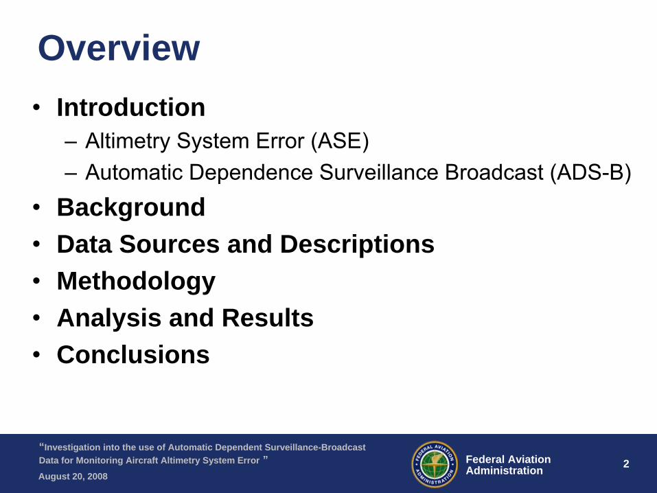
Overview•
Introduction–
Altimetry System Error (ASE)
–
Automatic Dependence Surveillance Broadcast (ADS-B) •
Background
•
Data Sources and Descriptions•
Methodology
•
Analysis and Results•
Conclusions
3 3Federal AviationAdministration
“Investigation into the use of Automatic Dependent Surveillance-Broadcast Data for Monitoring Aircraft Altimetry System Error ”August 20, 2008
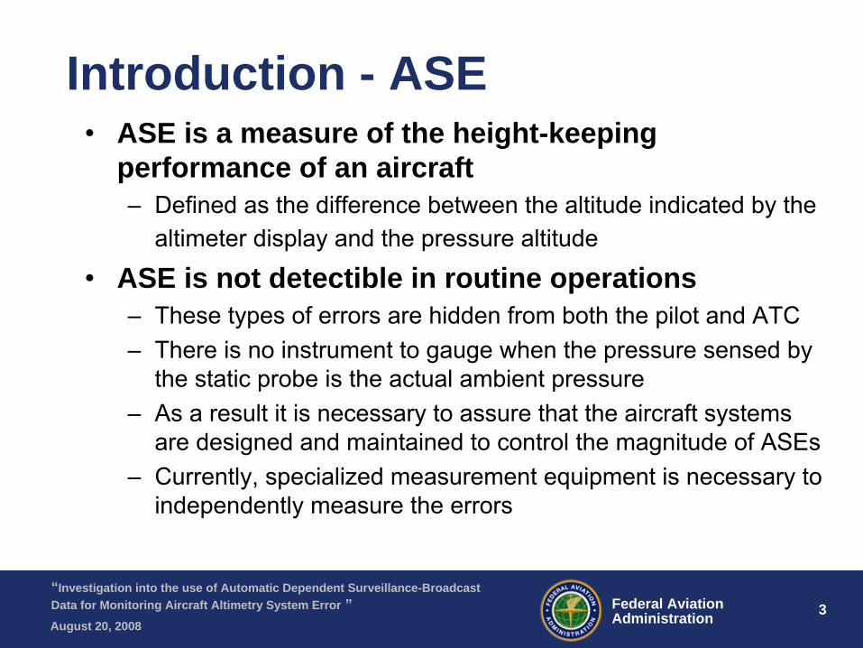
Introduction - ASE•
ASE is a measure of the height-keeping performance of an aircraft–
Defined as the difference between the altitude indicated by the altimeter display and the pressure altitude
•
ASE is not detectible in routine operations–
These types of errors are hidden from both the pilot and ATC–
There is no instrument to gauge when the pressure sensed by the static probe is the actual ambient pressure
–
As a result it is necessary to assure that the aircraft systems are designed and maintained to control the magnitude of ASEs
–
Currently, specialized measurement equipment is necessary to independently measure the errors
4 4Federal AviationAdministration
“Investigation into the use of Automatic Dependent Surveillance-Broadcast Data for Monitoring Aircraft Altimetry System Error ”August 20, 2008
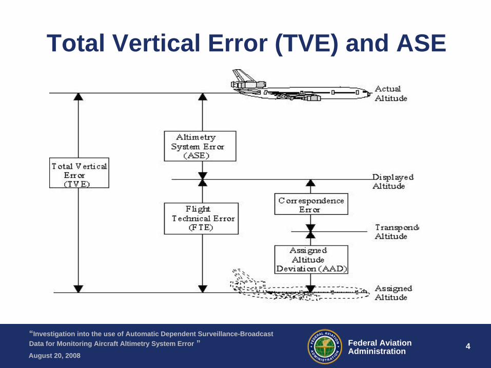
Total Vertical Error (TVE) and ASE
5 5Federal AviationAdministration
“Investigation into the use of Automatic Dependent Surveillance-Broadcast Data for Monitoring Aircraft Altimetry System Error ”August 20, 2008
Introduction
•
Why is Aircraft ASE Important ?–
Reduced Vertical Separation Minimum (RVSM)
•
Reduced the vertical separation between aircraft from 2000 ft to 1000 ft
•
Magnified the importance of aircraft height keeping capabilities
•
ICAO requirements for monitoring ASE

6 6Federal AviationAdministration
“Investigation into the use of Automatic Dependent Surveillance-Broadcast Data for Monitoring Aircraft Altimetry System Error ”August 20, 2008
Introduction – ADS-B •
ADS-B equipped aircraft use a GPS receiver to determine their position
•
Aircraft position information is broadcast to other ADS-B equipped aircraft and to air traffic controllers
•
FAA is currently increasing the ADS-B ground network infrastructure
•
Other countries are initiating programs to include ADS-B in their air traffic control systems
7 7Federal AviationAdministration
“Investigation into the use of Automatic Dependent Surveillance-Broadcast Data for Monitoring Aircraft Altimetry System Error ”August 20, 2008
Background
•
In the US most ASE estimates are computed using data collected by an enhanced GPS based monitoring unit (EGMU) on board the aircraft.–
EGMU must be installed on each aircraft that is being monitored at a cost to the airline/operator
•
RVSM approval is required for aircraft between FL290 and FL410
•
ICAO has set monitoring requirements for obtaining/maintaining RVSM approval–
Initial monitoring to obtain RVSM approval
–
Periodic monitoring to maintain RVSM approval
8 8Federal AviationAdministration
“Investigation into the use of Automatic Dependent Surveillance-Broadcast Data for Monitoring Aircraft Altimetry System Error ”August 20, 2008
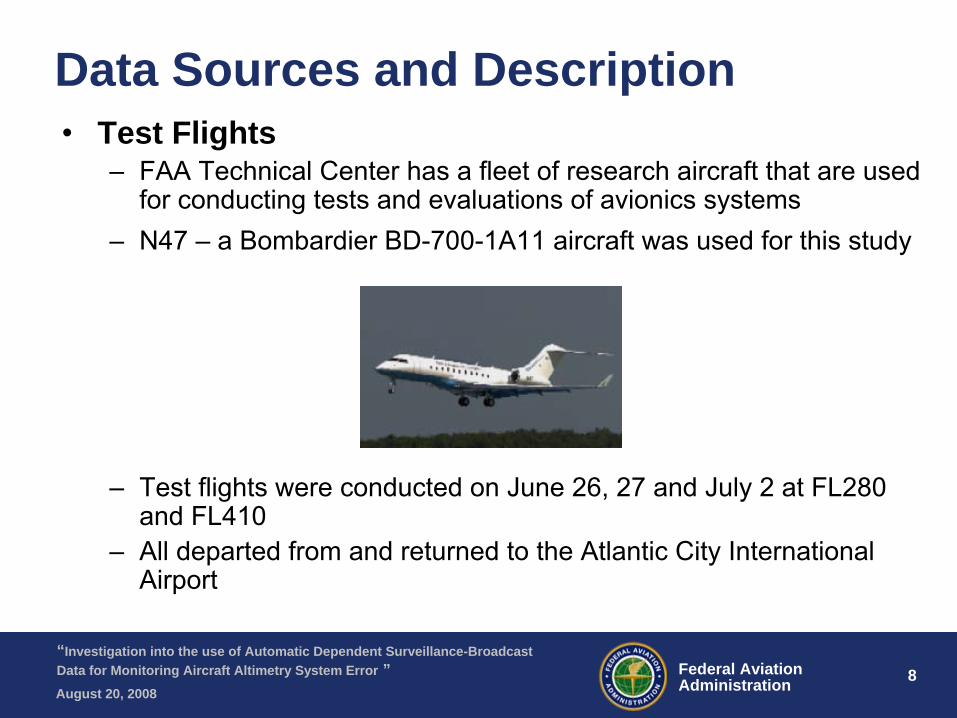
Data Sources and Description•
Test Flights–
FAA Technical Center has a fleet of research aircraft that are used for conducting tests and evaluations of avionics systems
–
N47 –
a Bombardier BD-700-1A11 aircraft was used for this study
–
Test flights were conducted on June 26, 27 and July 2 at FL280 and FL410
–
All departed from and returned to the Atlantic City International Airport
9 9Federal AviationAdministration
“Investigation into the use of Automatic Dependent Surveillance-Broadcast Data for Monitoring Aircraft Altimetry System Error ”August 20, 2008
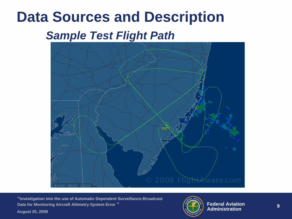
Data Sources and Description Sample Test Flight Path
10 10Federal AviationAdministration
“Investigation into the use of Automatic Dependent Surveillance-Broadcast Data for Monitoring Aircraft Altimetry System Error ”August 20, 2008
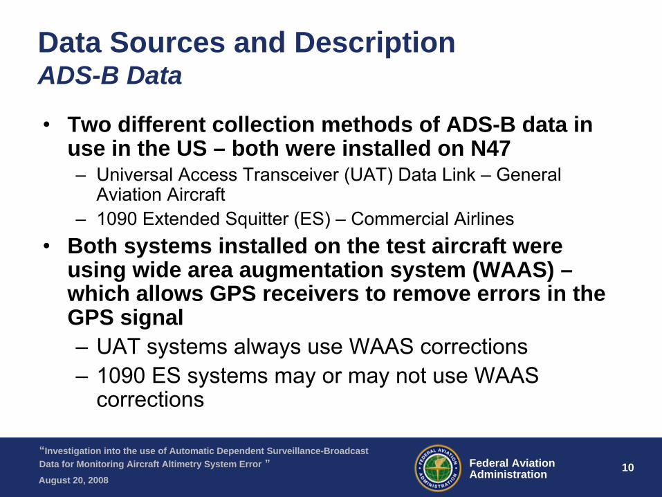
Data Sources and Description ADS-B Data
•
Two different collection methods of ADS-B data in use in the US – both were installed on N47–
Universal Access Transceiver (UAT) Data Link –
General Aviation Aircraft
–
1090 Extended Squitter
(ES) –
Commercial Airlines•
Both systems installed on the test aircraft were using wide area augmentation system (WAAS) – which allows GPS receivers to remove errors in the GPS signal–
UAT systems always use WAAS corrections
–
1090 ES systems may or may not use WAAS corrections
11 11Federal AviationAdministration
“Investigation into the use of Automatic Dependent Surveillance-Broadcast Data for Monitoring Aircraft Altimetry System Error ”August 20, 2008
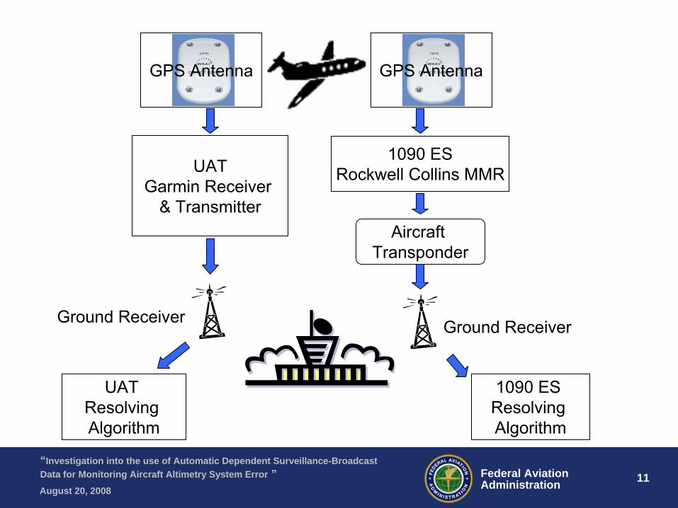
UATGarmin Receiver
& Transmitter
1090 ESRockwell Collins MMR
Aircraft Transponder
Ground Receiver
1090 ES Resolving Algorithm
UAT Resolving Algorithm
GPS Antenna GPS Antenna
Ground Receiver
12 12Federal AviationAdministration
“Investigation into the use of Automatic Dependent Surveillance-Broadcast Data for Monitoring Aircraft Altimetry System Error ”August 20, 2008
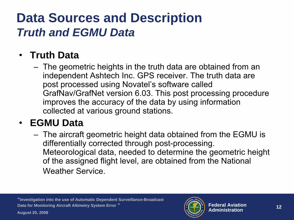
Data Sources and Description Truth and EGMU Data
•
Truth Data–
The geometric heights in the truth data are obtained from an independent Ashtech
Inc. GPS receiver. The truth data are post processed using Novatel’s
software called GrafNav/GrafNet
version 6.03. This post processing procedure improves the accuracy of the data by using information collected at various ground stations.
•
EGMU Data–
The aircraft geometric height data obtained from the EGMU is differentially corrected through post-processing. Meteorological data, needed to determine the geometric height of the assigned flight level, are obtained from the National Weather Service.
13 13Federal AviationAdministration
“Investigation into the use of Automatic Dependent Surveillance-Broadcast Data for Monitoring Aircraft Altimetry System Error ”August 20, 2008
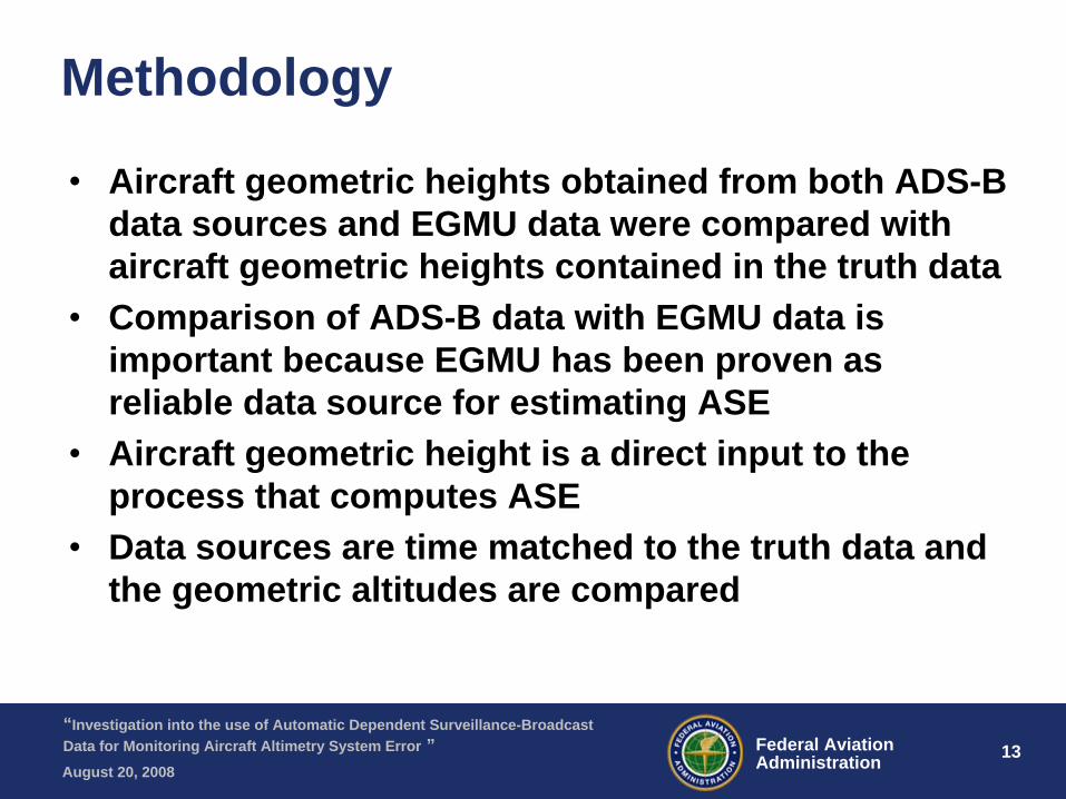
Methodology
•
Aircraft geometric heights obtained from both ADS-B data sources and EGMU data were compared with aircraft geometric heights contained in the truth data
•
Comparison of ADS-B data with EGMU data is important because EGMU has been proven as reliable data source for estimating ASE
•
Aircraft geometric height is a direct input to the process that computes ASE
•
Data sources are time matched to the truth data and the geometric altitudes are compared
14 14Federal AviationAdministration
“Investigation into the use of Automatic Dependent Surveillance-Broadcast Data for Monitoring Aircraft Altimetry System Error ”August 20, 2008
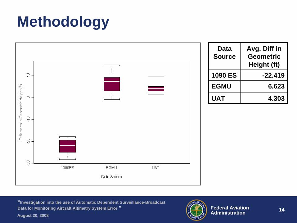
MethodologyData
SourceAvg. Diff in Geometric Height (ft)
1090 ES -22.419EGMU 6.623
UAT 4.303
15 15Federal AviationAdministration
“Investigation into the use of Automatic Dependent Surveillance-Broadcast Data for Monitoring Aircraft Altimetry System Error ”August 20, 2008
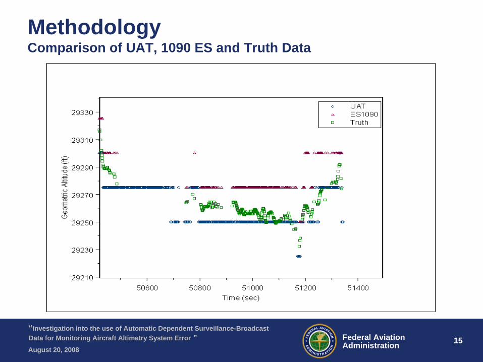
Methodology Comparison of UAT, 1090 ES and Truth Data
16 16Federal AviationAdministration
“Investigation into the use of Automatic Dependent Surveillance-Broadcast Data for Monitoring Aircraft Altimetry System Error ”August 20, 2008
Methodology
•
Prior to analysis of ADS-B data it was expected that both sources of ADS-B data would produce similar results when the aircraft geometric heights were compared to truth data
•
Each ADS-B data source treats the data differently–
UAT: rounds geometric height to nearest 25 ft increment then send the estimate to the ground receiver
–
1090 ES: determines difference between geometric altitude and pressure altitude, rounds this value to the nearest 25 ft increment. Also rounds the pressure altitude to nearest 25 ft increment. Both of these values are sent to the ground receiver. Geometric height is computed during post processing.
17 17Federal AviationAdministration
“Investigation into the use of Automatic Dependent Surveillance-Broadcast Data for Monitoring Aircraft Altimetry System Error ”August 20, 2008
Methodology•
Expected Value and Variance for UAT and 1090 ES data–
UAT:
hu
=rounded GPS aircraft heightht
= true geometric height of the aircraften
= random error N(0,σ)•
E(hu
) = E(ht
) +
12.5
(ft)•
Var(hu
) = Var(ht
) + Var(en
) + 625/12 (ft)
–
1090 ES: dr
= the rounded difference between the GPS aircraft height and pressure altitude height
hes
= geometric height from 1090 ESht
= true geometric height of the aircraften
= random error N(0,σ)•
E(hes
) = E(ht
) + 25 (ft)•
Var(hes
)~Var(ht
) + Var(en
) + 104(ft)
18 18Federal AviationAdministration
“Investigation into the use of Automatic Dependent Surveillance-Broadcast Data for Monitoring Aircraft Altimetry System Error ”August 20, 2008
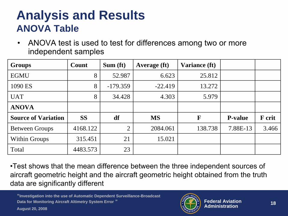
Analysis and Results ANOVA Table•
ANOVA test is used to test for differences among two or more independent samples
Groups Count Sum (ft) Average (ft) Variance (ft)
EGMU 8 52.987 6.623 25.812
1090 ES 8 -179.359 -22.419 13.272
UAT 8 34.428 4.303 5.979
ANOVA
Source of Variation SS df MS F P-value F crit
Between Groups 4168.122 2 2084.061 138.738 7.88E-13 3.466
Within Groups 315.451 21 15.021
Total 4483.573 23
•Test shows that the mean difference between the three independent sources of aircraft geometric height and the aircraft geometric height obtained from the truth data are significantly different
19 19Federal AviationAdministration
“Investigation into the use of Automatic Dependent Surveillance-Broadcast Data for Monitoring Aircraft Altimetry System Error ”August 20, 2008
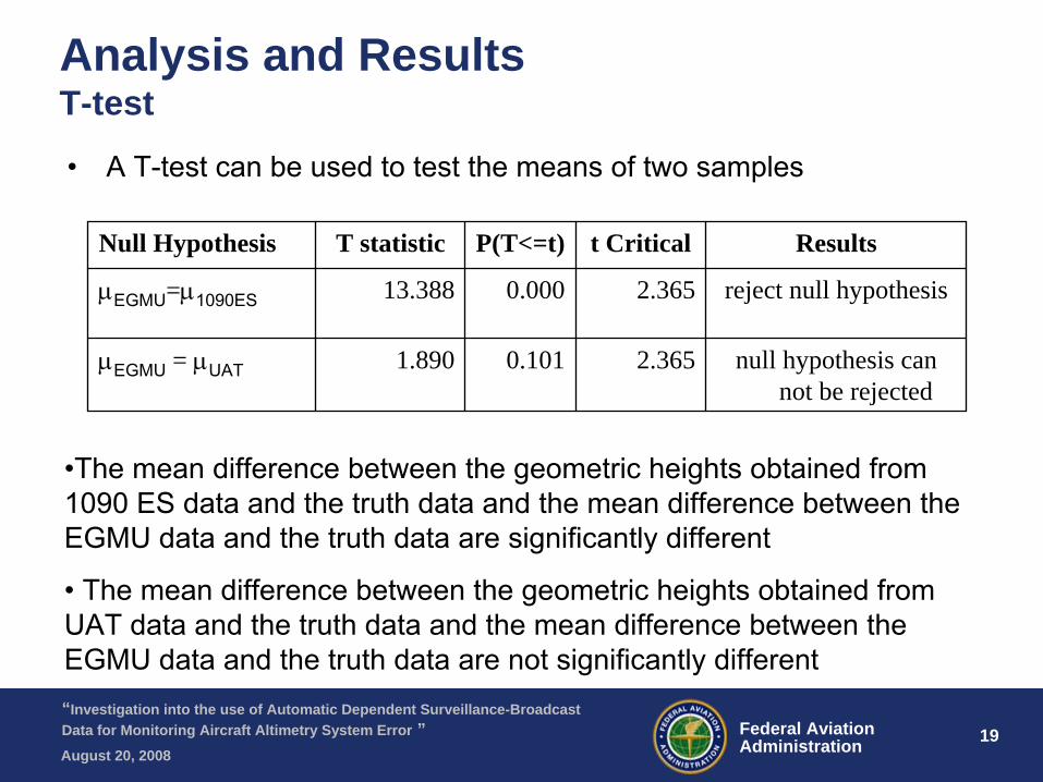
Analysis and Results T-test
•
A T-test can be used to test the means of two samples
Null Hypothesis T statistic P(T<=t) t Critical Results
μEGMU
=μ1090ES 13.388 0.000 2.365 reject null hypothesis
μEGMU
= μUAT 1.890 0.101 2.365 null hypothesis can not be rejected
•The mean difference between the geometric heights obtained from 1090 ES data and the truth data and the mean difference between the EGMU data and the truth data are significantly different
•
The mean difference between the geometric heights obtained from
UAT data and the truth data and the mean difference between the EGMU data and the truth data are not significantly different
20 20Federal AviationAdministration
“Investigation into the use of Automatic Dependent Surveillance-Broadcast Data for Monitoring Aircraft Altimetry System Error ”August 20, 2008
Analysis and Results
•
The expected value of the 1090 ES data contains a 25 ft bias in the estimate of the aircraft geometric height caused by the two rounding errors
•
This leads to the mean of the geometric heights obtained from the data being statistically different from the other two sources of data.
•
If this bias is removed and the ANOVA test is recomputed the results indicate that the three sample means are not significantly different
21 21Federal AviationAdministration
“Investigation into the use of Automatic Dependent Surveillance-Broadcast Data for Monitoring Aircraft Altimetry System Error ”August 20, 2008
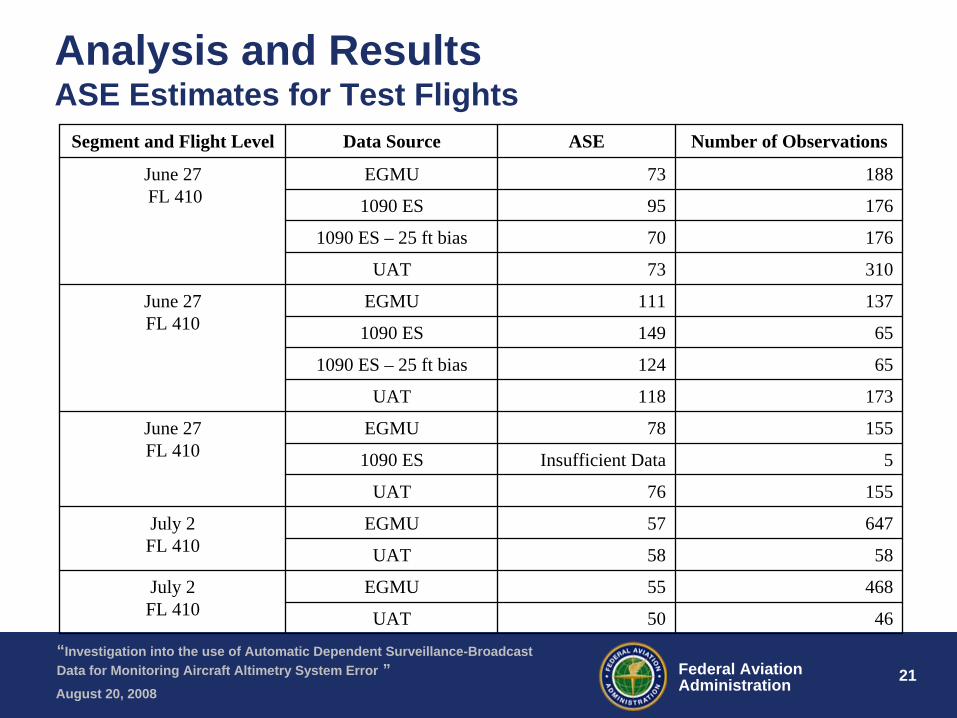
Analysis and Results ASE Estimates for Test Flights
Segment and Flight Level Data Source ASE Number of Observations
June 27FL 410
EGMU 73 188
1090 ES 95 176
1090 ES – 25 ft bias 70 176
UAT 73 310
June 27FL 410
EGMU 111 137
1090 ES 149 65
1090 ES – 25 ft bias 124 65
UAT 118 173
June 27FL 410
EGMU 78 155
1090 ES Insufficient Data 5
UAT 76 155
July 2FL 410
EGMU 57 647
UAT 58 58
July 2FL 410
EGMU 55 468
UAT 50 46
22 22Federal AviationAdministration
“Investigation into the use of Automatic Dependent Surveillance-Broadcast Data for Monitoring Aircraft Altimetry System Error ”August 20, 2008
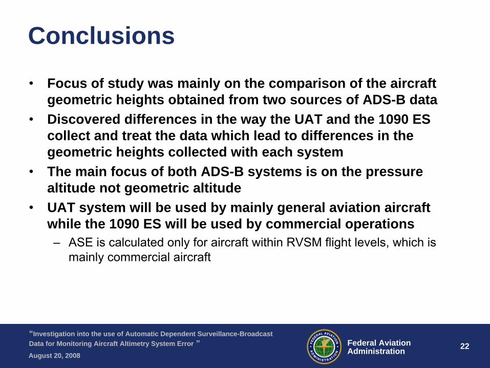
Conclusions
•
Focus of study was mainly on the comparison of the aircraft geometric heights obtained from two sources of ADS-B data
•
Discovered differences in the way the UAT and the 1090 ES collect and treat the data which lead to differences in the geometric heights collected with each system
•
The main focus of both ADS-B systems is on the pressure altitude not geometric altitude
•
UAT system will be used by mainly general aviation aircraft while the 1090 ES will be used by commercial operations–
ASE is calculated only for aircraft within RVSM flight levels, which is mainly commercial aircraft
23 23Federal AviationAdministration
“Investigation into the use of Automatic Dependent Surveillance-Broadcast Data for Monitoring Aircraft Altimetry System Error ”August 20, 2008
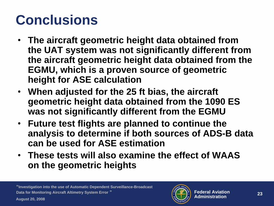
Conclusions•
The aircraft geometric height data obtained from the UAT system was not significantly different from the aircraft geometric height data obtained from the EGMU, which is a proven source of geometric height for ASE calculation
•
When adjusted for the 25 ft bias, the aircraft geometric height data obtained from the 1090 ES was not significantly different from the EGMU
•
Future test flights are planned to continue the analysis to determine if both sources of ADS-B data can be used for ASE estimation
•
These tests will also examine the effect of WAAS on the geometric heights
24 24Federal AviationAdministration
“Investigation into the use of Automatic Dependent Surveillance-Broadcast Data for Monitoring Aircraft Altimetry System Error ”August 20, 2008
Lauren Martin FAA Separation Standards Analysis Team
[email protected] 609-485-7941
Christine Falk FAA Separation Standards Analysis Team
[email protected] 609-485-6877
Jose L. Perez FAA Separation Standards Analysis Team
[email protected] 609-485-5365