predicting the effects of climate change and water resources and food production in the kennet...
TRANSCRIPT

Predicting the Effects of Climate Change and WaterResources and Food Production in the Kennet Catchment
Richard Skeffington, Aquatic Environments Research Centre
Phillip Jones and Richard Tranter, Centre for Agricultural Strategy
Potential Application to China ?
Integrated Project to evaluatethe Impacts of Global Changeon European Freshwater Ecosystems
University of Reading
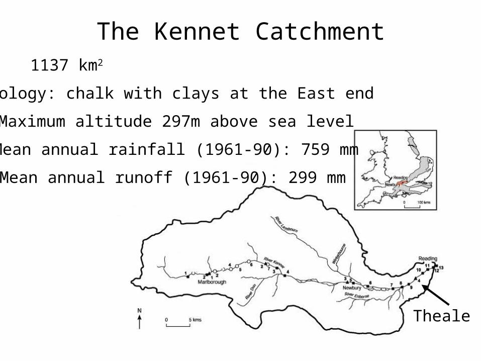
The Kennet Catchment1137 km2
Geology: chalk with clays at the East end
Maximum altitude 297m above sea level
Mean annual rainfall (1961-90): 759 mm
Mean annual runoff (1961-90): 299 mm
Theale

Kennet Agriculture
Largely arable
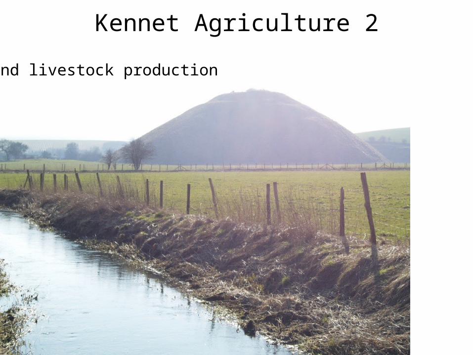
Kennet Agriculture 2
Largely arableand livestock production
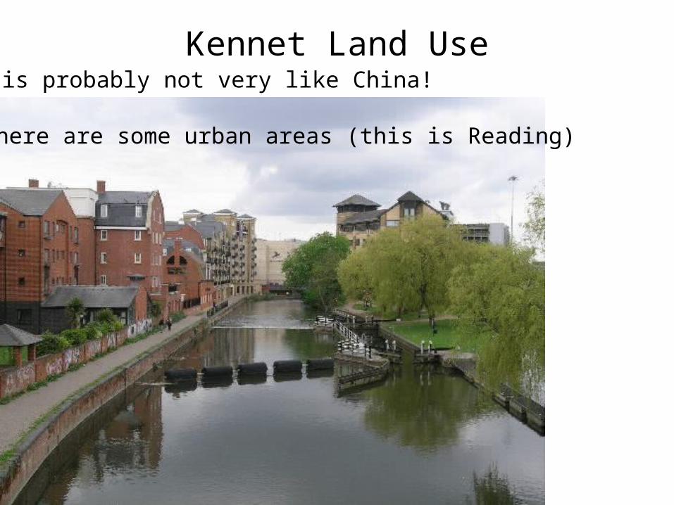
Kennet Land Use
There are some urban areas (this is Reading)
It is probably not very like China!
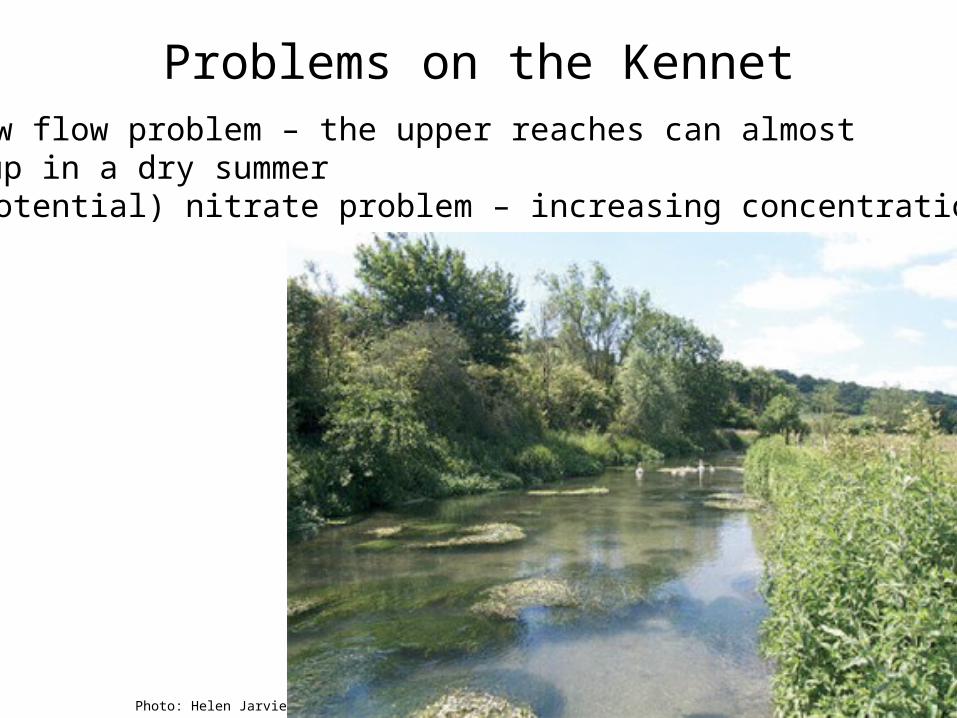
Problems on the Kennet1. A low flow problem – the upper reaches can almost
dry up in a dry summer2. A (potential) nitrate problem – increasing concentrations
Photo: Helen Jarvie

Modelling Agricultural Change
CLIMATE CHANGE
Change in river flows and composition
Change in agriculture in catchment
Changes in world agriculture
Changes in crop prices and demand
SOCIOECONOMIC CHANGE: population, global trade policies etc
Is it possible to model these outcomes?
…with any credibility?
20 April 2023 © University of Reading 2008 www.reading.ac.uk
Predicting the effect of climate change on water resources and foodproduction
Modelling land use impacts

Overview
The socio-economic change scenarios
IPCC SRES futuresUKCIP refinements for
UKBLS world food trade
model
The climate change scenarios
HadCM3 projections
The economic/land use model (CLUAM)
Input to BLS
Output From BLS
Global Climate Change & CO2 Scenarios (HadCM3)
Crop Models Sensitivity Tests
Changes in Crop Yields Over a Global Network of
Sites
Aggregation & Extrapolation to region,
Counties & Commodities
Changes Simulated by World Food Trade Model, in Production Potential &
PricesRegional Climate Change & CO2 Scenarios
Changes in Regional Crop Yields
CEH Land Classification System
CLUAM
Changes in Regional Land Use Allocations
Global Socio-economic Futures (SRES)
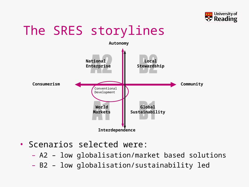
The SRES storylines
• Scenarios selected were:– A2 – low globalisation/market based solutions– B2 – low globalisation/sustainability led
LocalStewardship
ConventionalDevelopment
Autonomy
Community
Interdependence
Consumerism
NationalEnterprise
WorldMarkets
GlobalSustainability

Climate change scenarios
• AOGCM HadCM3(UK Hadley Centre’s1 third generation coupled
Atmosphere-Ocean Global Circulation Model)
– This used with the A2 & B2 SRES scenarios to project to 2100
– Our modelling scenarios sample 2020 and 2050
1 Hadley Centre for Climate Prediction and Research (part of UK Meteorological Office)

Basic Linked System (BLS) -1-
• International Institute for Applied Systems Analysis (IIASA)
• Framework for analysing the world food trade system
• The BLS is an applied general equilibrium (AGE) model system– All economic activities are represented
• 34 national and/or regional geographical components– 18 eighteen single-country national models– 2 region model– 14 country groupings
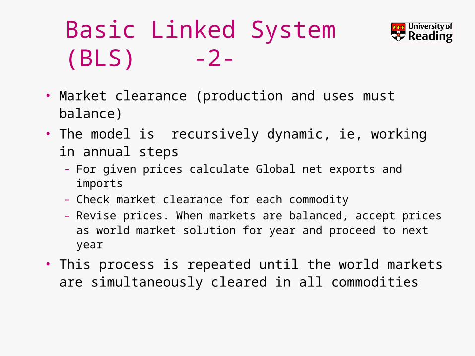
Basic Linked System (BLS) -2-
• Market clearance (production and uses must balance)
• The model is recursively dynamic, ie, working in annual steps– For given prices calculate Global net exports and imports – Check market clearance for each commodity– Revise prices. When markets are balanced, accept prices
as world market solution for year and proceed to next year
• This process is repeated until the world markets are simultaneously cleared in all commodities

BLS outputs
• Production levels (volumes)
• Market prices
• Technology change (yields)
LUAM also requires climate-driven yield changes
Input to BLS
Output From BLS
Global Climate Change & CO2 Scenarios (HadCM3)
Crop Models Sensitivity Tests
Changes in Crop Yields Over a Global Network of
Sites
Aggregation & Extrapolation to region,
Counties & Commodities
Changes Simulated by World Food Trade Model, in Production Potential &
PricesRegional Climate Change & CO2 Scenarios
Changes in Regional Crop Yields
CEH Land Classification System
CLUAM
Changes in Regional Land Use Allocations
Global Socio-economic Futures (SRES)

Climate induced yield changes
• Two stage process:– Meta analysis of
existing data on UK-specific crop yield changes due to climate change
– Decisions on where crops would not grow due to climate limit

The CLUAM• An LP model of England
& Wales agriculture
• Range of major land using agricultural enterprises included– Outputs (revenue)– Inputs (incur costs)
• Land base partitioned by CEH Land Classification system
• Model objective maximize gross margin,– Subject to various
constraints
Livestock Numbers, Crop andGrass Areas and Yields
Livestock Numbers, Crop andGrass Areas and YieldsCLUAM ITE : LCS
Experimental demand,yield and supply
data:
Demand ChangePrice Change
Experimentalenvironmental Data:
Climate ChangeYield Change
Specification and Calibrationof the model
Projection of Changes inLand Use and Production
Actual Land Use(MAFF June Census)
Input / Output Coefficients(production relationships fromfarm management type data)
Value of national inputs andoutputs to the agricultural
sector (DNIC)

Results – Agricultural ChangeKennet land cover areas (upland & lowland combined) No climate change A2/B2
0
10000
20000
30000
40000
50000
60000
70000
REF 1990s 2020 A2 2020 B2 2050 A2 2050 B2
ha
Idle-Rough
Idle-Perm
Idle-Ley
Idle-Arable
Rough
Perm
Ley
Other arable
Cereals+oil
Kennet land cover areas (upland & lowland combined) Climate change A2/B2
0
10000
20000
30000
40000
50000
60000
70000
REF 1990s CC 2020 A2 CC 2020 B2 CC 2050 A2 CC 2050 B2
ha
Idle-Rough
Idle-Perm
Idle-Ley
Idle-Arable
Rough
Perm
Ley
Other arable
Cereals+oil
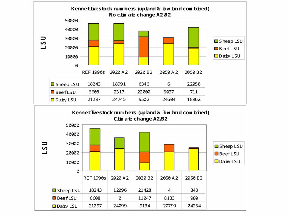
Livestock NumbersKennet livestock numbers (upland & lowland combined)
No climate change A2/B2
0
10000
20000
30000
40000
50000
LS
U Sheep LSU
Beef LSU
Dairy LSU
Sheep LSU 18243 18991 6346 6 22058
Beef LSU 6608 2317 22000 6037 711
Dairy LSU 21297 24745 9502 24604 18962
REF 1990s 2020 A2 2020 B2 2050 A2 2050 B2
Kennet livestock numbers (upland & lowland combined)
Climate change A2/B2
0
10000
20000
30000
40000
50000
LS
U Sheep LSU
Beef LSU
Dairy LSU
Sheep LSU 18243 12096 21428 4 348
Beef LSU 6608 0 11047 8133 980
Dairy LSU 21297 24099 9134 20799 24254
REF 1990s 2020 A2 2020 B2 2050 A2 2050 B2

Modelling Agricultural Change
CLIMATE CHANGE
Change in river flows and composition
Change in agriculture in catchment
Changes in world agriculture
Changes in crop prices and demand
SOCIOECONOMIC CHANGE: population, global trade policies etc
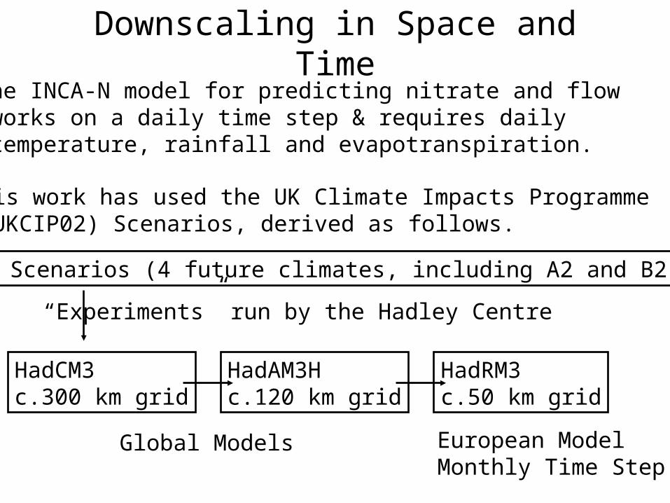
Downscaling in Space and Time
This work has used the UK Climate Impacts Programme (UKCIP02) Scenarios, derived as follows.
The INCA-N model for predicting nitrate and flow works on a daily time step & requires daily temperature, rainfall and evapotranspiration.
HadCM3c.300 km grid
HadAM3Hc.120 km grid
HadRM3c.50 km grid
SRES Scenarios (4 future climates, including A2 and B2)
“Experiments” run by the Hadley Centre
Global Models European ModelMonthly Time Step
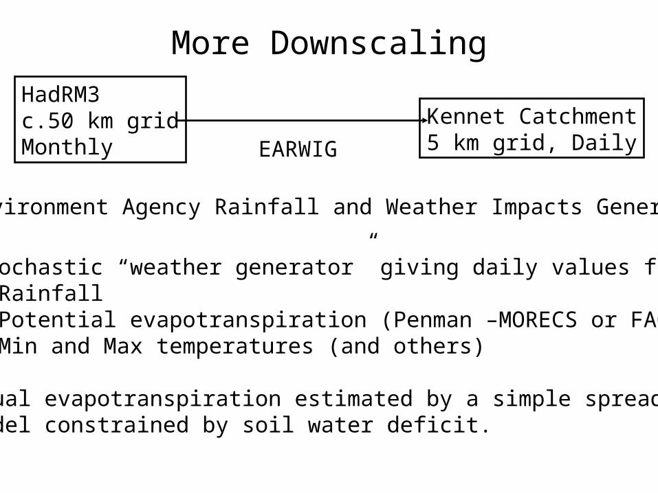
More Downscaling
HadRM3c.50 km gridMonthly
Kennet Catchment5 km grid, DailyEARWIG
Environment Agency Rainfall and Weather Impacts Generator
Stochastic “weather generator” giving daily values for:• Rainfall• Potential evapotranspiration (Penman –MORECS or FAO)• Min and Max temperatures (and others)
Actual evapotranspiration estimated by a simple spreadsheet model constrained by soil water deficit.

EARWIG: Mean Monthly Temperatures
Mean Daily Temperature
02468
101214161820
1 2 3 4 5 6 7 8 9 10 11 12
Month
Te
mp
era
ture
(C
)
Base
2020
2050B2
2050A2
Annual means: Base (1961-90) 9.2 C 2020 10.2 C 2050 B2 11.0 C 2050 A2 11.3 C

EARWIG: Mean Monthly Rainfall
Rainfall
0
20
40
60
80
100
1 2 3 4 5 6 7 8 9 10 11 12
Month
Rai
nfa
ll (m
m)
Base
2020
2050B2
2050A2
Annual Totals: Base 759 mm2020s 787 mm2050s 757 mm
How does INCA work?
.
.
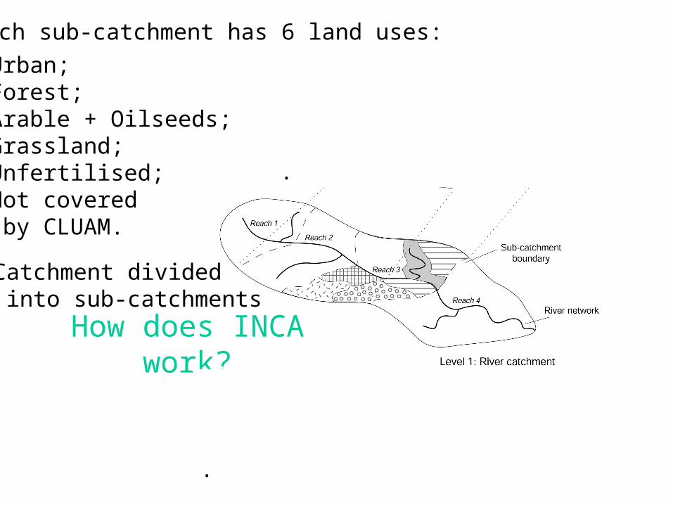
Each sub-catchment has 6 land uses:
Urban;Forest;Arable + Oilseeds;Grassland;Unfertilised;Not covered by CLUAM.
Catchment divided into sub-catchments

Land Cell: Hydrological Model
Quick flow
QuickSoil
Groundwater
Quick flow
Throughflow
Groundwater flow
P AET
Hydrological Model
Abstraction (e.g. for water supply)
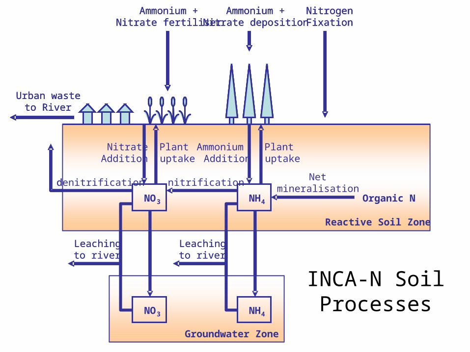
NO3
Groundwater Zone
NH4
Urban wasteto River
NitrogenFixation
Ammonium +Nitrate deposition
Ammonium +Nitrate fertiliser
NO3 NH4
nitrification
Organic N
Netmineralisation
NitrateAddition
Plantuptake
AmmoniumAddition
Plantuptake
Reactive Soil Zone
denitrification
Leachingto river
Leachingto river
NO3
Groundwater Zone
NH4
Urban wasteto River
NitrogenFixation
Ammonium +Nitrate deposition
Ammonium +Nitrate fertiliser
Urban wasteto River
NitrogenFixation
Ammonium +Nitrate deposition
Ammonium +Nitrate fertiliser
NO3 NH4
nitrification
Organic N
Netmineralisation
NitrateAddition
Plantuptake
AmmoniumAddition
Plantuptake
Reactive Soil Zone
denitrification
Leachingto river
Leachingto river
INCA-N Soil Processes

Land Uses and Fertiliser Inputs
Each land use parameterised separately for all the above
Scenario Arable Grass Not in CLUAM
Urban, Forest
Unfert.
1990 180 261 5 0 0
Socio- 2020 A2 180 263 5 0 0
Econ. 2020 B2 180 249 5 0 0
2050 A2 162 276 5 0 0
2050 B2 180 259 5 0 0
Socio- 2020 A2 180 269 5 0 0
Econ. + 2020 B2 180 248 5 0 0
Climate 2050 A2 162 272 5 0 0
change 2050 B2 180 283 5 0 0
N Fertiliser in kg N ha-1yr-1

IN-STREAM PROCESSES
in INCA

Annual Hydrology
0
100
200
300
400
500
600
700
800
900
Base 2020s A2/B2 2050s 2050s A2
mm
/yr
Rainfall
PET
AET
HER
Low summer rainfall protects the river from extra evaporation –to some extent

Period of River Recharge Shortens
0
10
20
30
40
50
60
70
80
90
100
1961-90 2020s 2050s B2 2050s A2
Pe
rce
nta
ge
of y
ea
rs
4 months
5 months
6 months
8 months
Consecutive months without hydrologically-effective rainfall
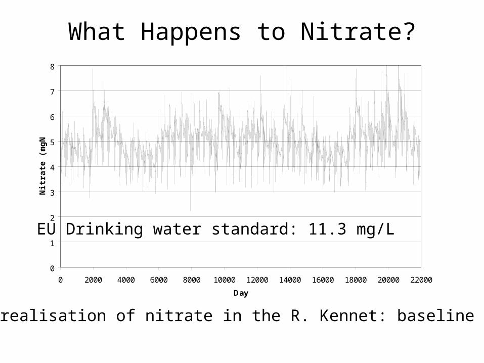
What Happens to Nitrate?
0
1
2
3
4
5
6
7
8
0 2000 4000 6000 8000 10000 12000 14000 16000 18000 20000 22000
Day
Nit
rate
(m
gN
/L)
60-year realisation of nitrate in the R. Kennet: baseline climate
EU Drinking water standard: 11.3 mg/L

Mean Nitrate Concentrations
0
1
2
3
4
5
6
Base SE CCSE
Nit
rate
mg
N/L
Baseline
2020 A2
2020 B2
2050 A2
2050 B2
Crops in reference state (1990)
Crop changes due to socio-economicfactors only
Crop changes due to socio-economic & climate change

Variation in Nitrate: 2050 A2
0
2
4
6
8
0 5 10 15 20 25 30 35 40 45 50 55 60
Year
An
nu
al
me
an
nit
rate
(m
g N
/L)
Baseline
CCSE 2050 A2
SE 2050 A2
Base 2050 A2
Socio-economic change makes a difference – adding climate change has no effect
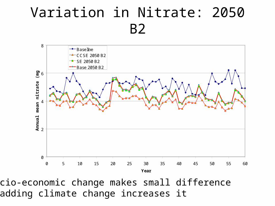
Variation in Nitrate: 2050 B2
0
2
4
6
8
0 5 10 15 20 25 30 35 40 45 50 55 60
Year
An
nu
al m
ean
nit
rate
(m
g N
/L)
BaselineCCSE 2050 B2SE 2050 B2Base 2050 B2
Socio-economic change makes small difference – adding climate change increases it

Other Modelling Work
Same river, same climate scenario
Different downscaling method, INCA parameterisation
Nitrate increases in response to climate change!

Uncertainty
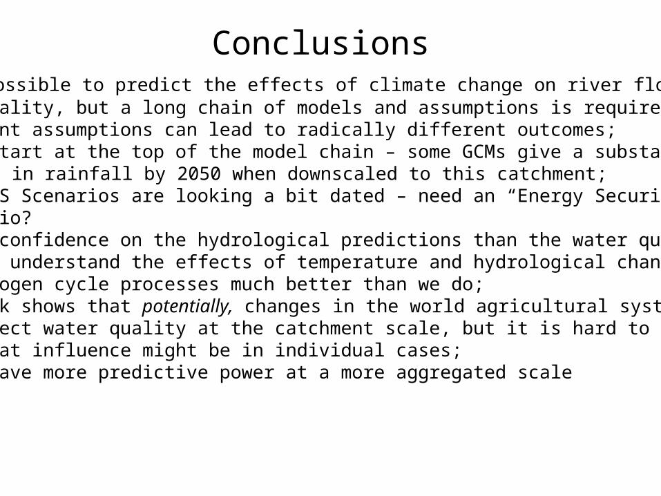
Conclusions • It is possible to predict the effects of climate change on river flows and water quality, but a long chain of models and assumptions is required;• Different assumptions can lead to radically different outcomes;• These start at the top of the model chain – some GCMs give a substantial increase in rainfall by 2050 when downscaled to this catchment; • The SRES Scenarios are looking a bit dated – need an “Energy Security” scenario?• Better confidence on the hydrological predictions than the water quality – need to understand the effects of temperature and hydrological change on nitrogen cycle processes much better than we do;• The work shows that potentially, changes in the world agricultural system can affect water quality at the catchment scale, but it is hard to predict what that influence might be in individual cases;• Might have more predictive power at a more aggregated scale
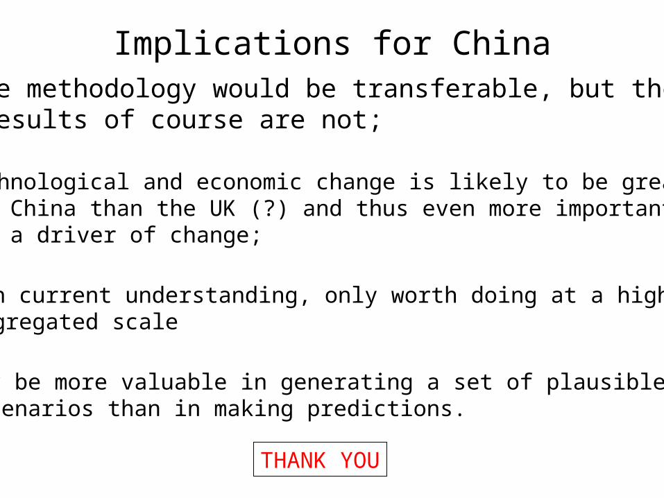
Implications for ChinaThe methodology would be transferable, but the results of course are not;
Technological and economic change is likely to be greater in China than the UK (?) and thus even more important as a driver of change;
With current understanding, only worth doing at a highly aggregated scale
May be more valuable in generating a set of plausible scenarios than in making predictions.
THANK YOU