preliminary negative declaration - planning department · preliminary negative declaration ... case...
TRANSCRIPT

www.sfplanning.org
Preliminary Negative Declaration Date: March 31, 2010 Case No.: 2008.1398E Project Title: 150 Otis Street – Veterans Commons Zoning: P (Public) Use District 85‐X Height and Bulk District Block/Lot: 3513/007 Lot Size: 20,303 square feet Project Sponsor Kim Piechota, Chinatown Community Development Center (415) 929‐0712 Lead Agency: San Francisco Planning Department Staff Contact: Jeanie Poling – (415) 575‐9072 [email protected]
PROJECT DESCRIPTION: The project site is located on the west side of Otis Street on the block bounded by McCoppin Street to the north, Duboce Street and the Central Freeway to the south, and Stevenson Street to the west in the Market/Octavia Plan Area. The site contains a nine‐story, approximately 116‐foot‐high, 51,976‐square‐foot (sf) City‐owned building. Constructed in 1916 as the Juvenile Court and Detention Home, the property has been designated as San Francisco Landmark No. 248. The lower three levels of the building are currently used as a seasonal homeless shelter, and the upper six levels are used for City storage. The proposed project involves interior and exterior renovations to create 75 units of affordable permanent housing for homeless veterans and one manager’s unit (49,314 sf), and support service offices and community space (7,283 sf). The area of the building would increase by 4,621 sf; the building height would remain the same. The project also includes replacement of all non‐original windows, the addition of an exterior elevator shaft at the rear of the building that would not extend beyond the existing building height, and reconfiguration of the entryway. The project would require the following approvals: (1) Zoning Map and Planning Code Text Amendments for the creation of a Special Use District that would overlay the existing Public Use zoning (to allow for the development of housing consistent with RTO (Residential, Transit‐Oriented) Zoning), and to address Planning Code exceptions including open space, exposure, bicycle parking, and rear yard requirements, (2) a Zoning Map Amendment for a height reclassification to 125 feet (to accommodate the elevator shaft), (3) a lot line adjustment for removal of the encroachment of an auditorium and underground garage associated with 170 Otis Street (the San Francisco Human Services Agency building), and (4) a Certificate of Appropriateness for alteration to a City Landmark. The project is also subject to review under Section 106 of the National Historic Preservation Act.

Preliminary Negative Declaration March 31, 2010
2
CASE NO. 2008.1398E150 Otis Street – Veterans Commons
FINDING: This project could not have a significant effect on the environment. This finding is based upon the criteria of the Guidelines of the State Secretary for Resources, Sections 15064 (Determining Significant Effect), 15065 (Mandatory Findings of Significance), and 15070 (Decision to prepare a Negative Declaration), and the following reasons as documented in the Initial Evaluation (Initial Study) for the project, which is attached. cc: Kim Piechota, Chinatown Community Development Center – Project Sponsor Joan McNamara, Mayor’s Office of Housing Supervisor Chris Daly, District 6 John Malamut, City Attorney’s Office Distribution List Bulletin Board Master Decision File

Case No. 2008.1398E i 150 Otis Street – Veterans Commons
Table of Contents A. PROJECT DESCRIPTION.......................................................................................................... 1 B. PROJECT SETTING................................................................................................................. 19 C. COMPATIBILITY WITH EXISTING ZONING AND PLANS .............................................. 20 D. SUMMARY OF ENVIRONMENTAL EFFECTS.................................................................... 24 E. EVALUATION OF ENVIRONMENTAL EFFECTS .............................................................. 25
1. LAND USE AND LAND USE PLANNING ............................................................................ 25 2. AESTHETICS ........................................................................................................................... 27 3. POPULATION AND HOUSING.............................................................................................. 28 4. CULTURAL RESOURCES ...................................................................................................... 30 5. TRANSPORTATION AND CIRCULATION .......................................................................... 35 6. NOISE........................................................................................................................................ 42 7. AIR QUALITY.......................................................................................................................... 46 8. GREENHOUSE GAS EMISSIONS.......................................................................................... 52 9. WIND AND SHADOW ............................................................................................................ 61 10. RECREATION .......................................................................................................................... 62 11. UTILITIES AND SERVICE SYSTEMS .................................................................................. 64 12. PUBLIC SERVICES ................................................................................................................. 67 13. BIOLOGICAL RESOURCES ................................................................................................... 69 14. GEOLOGY AND SOILS .......................................................................................................... 70 15. HYDROLOGY AND WATER QUALITY............................................................................... 73 16. HAZARDS AND HAZARDOUS MATERIALS...................................................................... 75 17. MINERAL AND ENERGY RESOURCES .............................................................................. 81 19. MANDATORY FINDINGS OF SIGNIFICANCE ................................................................... 84
F. PUBLIC NOTICE AND COMMENTS .................................................................................... 85 G. DETERMINATION .................................................................................................................. 86 H. INITIAL STUDY AUTHORS AND PROJECT SPONSOR TEAM ........................................ 87
Figures Figure 1 – Project Location....................................................................................................................... 3 Figure 2 – Zoning and Height Districts .................................................................................................... 4 Figure 3 – Existing Site Plan .................................................................................................................... 5 Figure 4 – Proposed Site Plan ................................................................................................................... 6 Figure 5 – Proposed Basement Plan ......................................................................................................... 7 Figure 6 – Proposed Ground Floor Plan ................................................................................................... 8 Figure 7 – Proposed Second Floor Plan.................................................................................................... 9 Figure 8 – Proposed Third Floor Plan..................................................................................................... 10 Figure 9 – Proposed Fourth Floor Plan................................................................................................... 11 Figure 10 – Proposed East Elevation ...................................................................................................... 12 Figure 11 – Proposed South Elevations .................................................................................................. 13 Figure 12 – Proposed West Elevation..................................................................................................... 14 Figure 13 – Proposed North Elevation.................................................................................................... 15 Figure 14 – Proposed Section ................................................................................................................. 16 Figure 15 – Site Photos ........................................................................................................................... 17
Tables Table 1 – Project Characteristics……………………………………………………………..………….3 Table 2 – Trip Generation……………………………………………………..………………………..36 Table 3 – GHG Reductions from the AB 32 Scoping Plan………………..……………………………57

Case No. 2008.1398E ii 150 Otis Street – Veterans Commons
This page intentionally left blank
Case No. 2008.1398E 1 150 Otis Street – Veterans Commons
INITIAL STUDY 2008.1398E – 150 Otis Street – Veterans Commons
A. PROJECT DESCRIPTION
Project Location and Site Characteristics
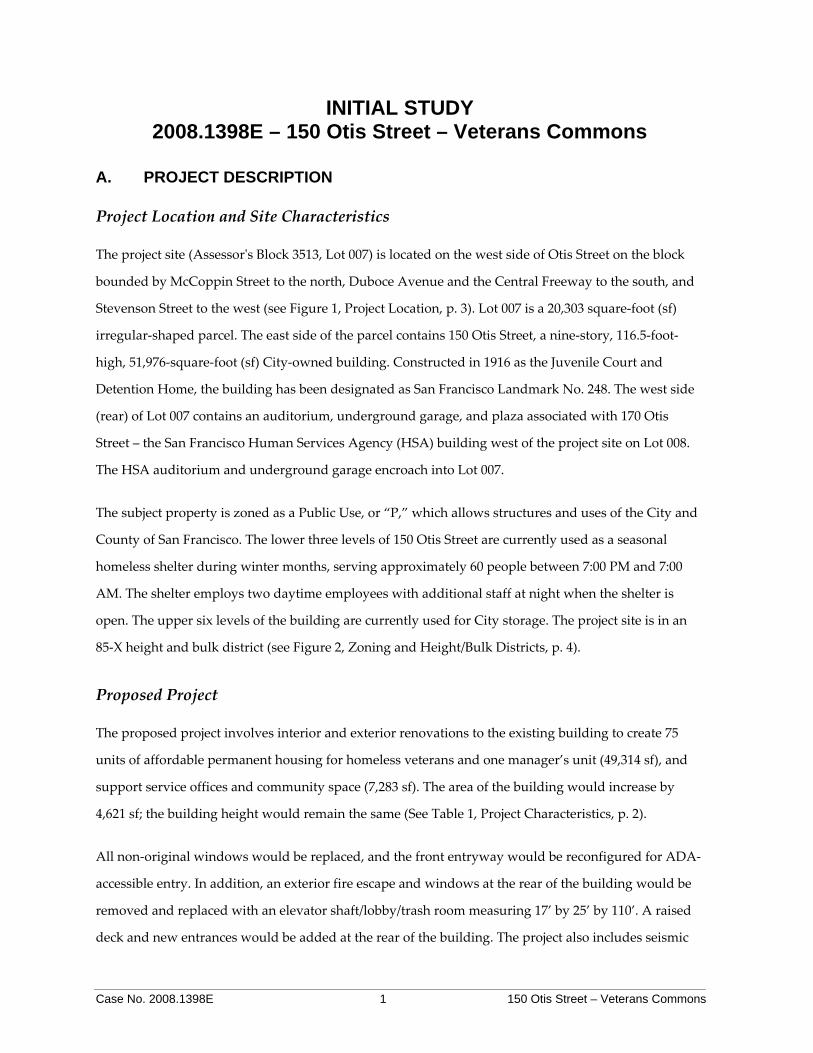
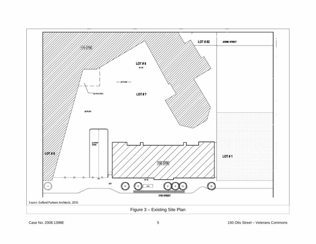
The project site (Assessorʹs Block 3513, Lot 007) is located on the west side of Otis Street on the block
bounded by McCoppin Street to the north, Duboce Avenue and the Central Freeway to the south, and
Stevenson Street to the west (see Figure 1, Project Location, p. 3). Lot 007 is a 20,303 square‐foot (sf)
irregular‐shaped parcel. The east side of the parcel contains 150 Otis Street, a nine‐story, 116.5‐foot‐
high, 51,976‐square‐foot (sf) City‐owned building. Constructed in 1916 as the Juvenile Court and
Detention Home, the building has been designated as San Francisco Landmark No. 248. The west side
(rear) of Lot 007 contains an auditorium, underground garage, and plaza associated with 170 Otis
Street – the San Francisco Human Services Agency (HSA) building west of the project site on Lot 008.
The HSA auditorium and underground garage encroach into Lot 007.
The subject property is zoned as a Public Use, or “P,” which allows structures and uses of the City and
County of San Francisco. The lower three levels of 150 Otis Street are currently used as a seasonal
homeless shelter during winter months, serving approximately 60 people between 7:00 PM and 7:00
AM. The shelter employs two daytime employees with additional staff at night when the shelter is
open. The upper six levels of the building are currently used for City storage. The project site is in an
85‐X height and bulk district (see Figure 2, Zoning and Height/Bulk Districts, p. 4).
Proposed Project
The proposed project involves interior and exterior renovations to the existing building to create 75
units of affordable permanent housing for homeless veterans and one manager’s unit (49,314 sf), and
support service offices and community space (7,283 sf). The area of the building would increase by
4,621 sf; the building height would remain the same (See Table 1, Project Characteristics, p. 2).
All non‐original windows would be replaced, and the front entryway would be reconfigured for ADA‐
accessible entry. In addition, an exterior fire escape and windows at the rear of the building would be
removed and replaced with an elevator shaft/lobby/trash room measuring 17’ by 25’ by 110’. A raised
deck and new entrances would be added at the rear of the building. The project also includes seismic

Case No. 2008.1398E 2 150 Otis Street – Veterans Commons
and building system upgrades; interior alterations for the building’s new use; repair of the roof; and
repair/cleaning of the building exterior. The lot line on the west side of the 150 Otis Street parcel would
be adjusted so that the lot line would hug the rear of the building envelope, including the proposed
elevator shaft. The auditorium, underground garage, and plaza associated with 170 Otis Street would
become part of Parcel 008.
The project sponsors are Chinatown Community Development Center in cooperation with Swords to
Plowshares. The project goal is to provide permanent affordable rental housing for chronically
homeless veterans over the age of 55, mostly those of the Vietnam‐era. The facility would provide
supportive services to its residents, including mental health and substance abuse counseling, geriatric
health care, and social and recreational activities.
Figures 3–14, pp. 5–16, show the site plan, floor plans, and elevations for the proposed project. Figure
15, p. 16, present views of the project site. The basement level would contain building services, storage,
and a vestibule leading from Otis Street to an elevator for access to the ground level. To provide an
ADA‐accessible entrance, one basement window would be removed and a door providing access to a
vestibule and elevator would be installed in a new ground floor opening.
The ground level would contain supportive services and recreation facilities for residents. Two ground
floor rear decks totaling 1,049 sf (a 593 sf south deck and a 456 sf north deck) would be aligned with the
existing ground floor area and installed between the new elevator tower and existing stair towers. The
second floor would contain 12 studio units and a lounge. The third level would contain 10 studio units,
a laundry room, a sunroom, and a lounge. Levels 4 through 9 would each contain nine studio units.
Project construction is anticipated to last 24 months, beginning in October of 2012.
Table 1 – Project Characteristics Current Proposed Seasonal shelter 3 stories / 17,536 sf Storage 6 stories / 34,440 sf Residential 0 76 studios / 49,314 sf Office/social service 0 7,283 sf Total interior area 51,976 56,597

Case No. 2008.1398E 3 150 Otis Street – Veterans Commons
Figure 1 – Project Site Location

Case No. 2008.1398E 4 150 Otis Street – Veterans Commons
Figure 2 – Zoning and Height/Bulk Districts
Case No. 2008.1398E 5 150 Otis Street – Veterans Commons
Source: Gelfand Partners Architects, 2010.
Figure 3 – Existing Site Plan
Case No. 2008.1398E 6 150 Otis Street – Veterans Commons
Source: Gelfand Partners Architects, 2010.
Figure 4 – Proposed Site Plan

Case No. 2008.1398E 7 150 Otis Street – Veterans Commons
Source: Gelfand Partners Architects, 2010.
Figure 5 – Proposed Basement Plan

Case No. 2008.1398E 8 150 Otis Street – Veterans Commons
Source: Gelfand Partners Architects, 2010.
Figure 6 – Proposed Ground Floor Plan

Case No. 2008.1398E 9 150 Otis Street – Veterans Commons
Source: Gelfand Partners Architects, 2010.
Figure 7 – Proposed Second Floor Plan

Case No. 2008.1398E 10 150 Otis Street – Veterans Commons
Source: Gelfand Partners Architects, 2010.
Figure 8 – Proposed Third Floor Plan

Case No. 2008.1398E 11 150 Otis Street – Veterans Commons
Source: Gelfand Partners Architects, 2010.
Figure 9 – Proposed Fourth Floor Plan

Case No. 2008.1398E 12 150 Otis Street – Veterans Commons
Source: Gelfand Partners Architects, 2010.
Figure 10 – Proposed East Elevation
Case No. 2008.1398E 13 150 Otis Street – Veterans Commons
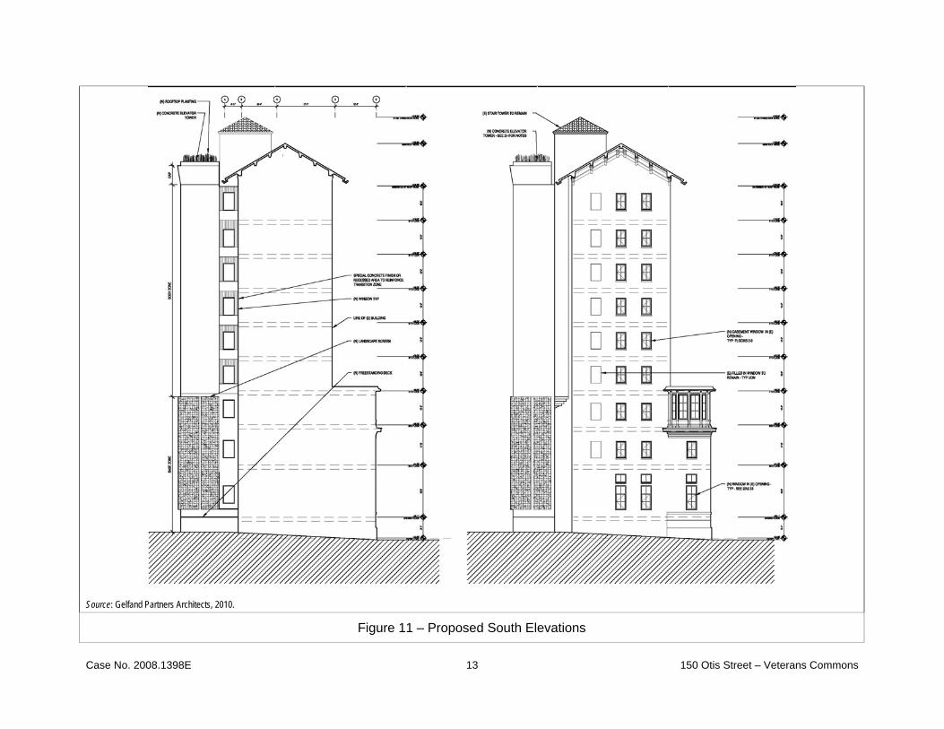
Source: Gelfand Partners Architects, 2010.
Figure 11 – Proposed South Elevations

Case No. 2008.1398E 14 150 Otis Street – Veterans Commons
Source: Gelfand Partners Architects, 2010.
Figure 12 – Proposed West Elevation

Case No. 2008.1398E 15 150 Otis Street – Veterans Commons
Source: Gelfand Partners Architects, 2010.
Figure13 – Proposed North Elevation

Case No. 2008.1398E 16 150 Otis Street – Veterans Commons
Source: Gelfand Partners Architects, 2010.
Figure 14 – Proposed Section

Case No. 2008.1398E 17 150 Otis Street – Veterans Commons
View from Otis Street at Duboce Ave. Otis Street Entryway
Rear of Building South Side of Building and Entrance to 170 Otis Street
Figure 15 – Site Photos

Case No. 2008.1398E 18 150 Otis Street – Veterans Commons
This page intentially left blank

Case No. 2008.1398E 19 150 Otis Street – Veterans Commons
B. PROJECT SETTING The project site is an irregular‐shaped midblock parcel in the block surrounded by Otis, Stevenson, and
McCoppin Streets and Duboce Avenue in the western South of Market neighborhood. The site, in the
Market and Octavia Plan Area, is near the intersection of several neighborhoods – South of Market, the
Mission, the Western Addition, and Civic Center (see Figure 1, Project Location, p. 3). The immediate
project area, approximately between Valencia Street on the west, Market Street on the north, Duboce
Avenue/Central Freeway on the south, and Mission Street on the east, is flat and contains a variety of
building types and uses, including residential, commercial, industrial, and office. The southern end of
the block is traversed by the elevated Central Freeway, located approximately 200 feet south of the
project site along Otis Street. The northern half of the block contains the north/south Jessie Street,
which dead‐ends northwest of the project site. Adjacent to the project site to the north is the Pacific
Telephone and Telegraph Exchange (AT&T) building at 1 McCoppin Street, a four‐story industrial
building constructed in 1937. Adjacent to the project site to the south is a 70‐foot‐wide gated plaza and
driveway that leads to the San Francisco Human Services Agency (HSA) building and underground
garage at 170 Otis Street. Further south along Otis Street is a self‐storage facility and surface parking
under the elevated Central Freeway. Adjacent to the project site to the west is the HSA building, a
multi‐story office building constructed in the latter half of the twentieth century. Jessie Street,
northwest of the project site, contains surface parking lots and one‐ to four‐story residential buildings.
Across from the project site on Otis Street is a narrow triangular block containing five‐ to six‐story
office buildings that front Mission Street. Figure 15, p. 16, present views of the project site.
The project site is in a transition area between neighborhoods – it is near the intersection of three major
city street grids – and while it contains office, commercial, and residential uses, it lacks cohesion as a
neighborhood, partly due to the presence of the elevated freeway and the heavy vehicle traffic on
nearby streets.
Existing housing in the project area varies from large developments to smaller multi‐unit dwellings,
and from market rate to various levels of affordability. One block from the project site, on the south
(west) side of Mission Street is 140 South Van Ness Avenue, a 212‐unit residential development
constructed in 2002. Under construction approximately one‐third of a mile from the project site is 1390
Mission Street (at 10th Street), a 136‐unit affordable housing development. Also at Mission and 10th
Streets is 1415 Mission Street, a 117‐unit residential development that was approved by the Planning
Commission in the fall of 2009. Smaller residential buildings, varying from two to four stories exist

Case No. 2008.1398E 20 150 Otis Street – Veterans Commons
along the smaller streets in the vicinity, such as Jessie and Stevenson Streets, and along the south side
of Duboce Avenue.
C. COMPATIBILITY WITH EXISTING ZONING AND PLANS
Applicable Not Applicable
Discuss any variances, special authorizations, or changes proposed to the Planning Code or Zoning Map, if applicable.
Discuss any conflicts with any adopted plans and goals of the City or Region, if applicable.
Discuss any approvals and/or permits from City departments other than the Planning Department or the Department of Building Inspection, or from Regional, State, or Federal Agencies.
Planning Code and Approvals Required
Existing Zoning
The San Francisco Planning Code, which incorporates by reference the City’s Zoning Maps, governs
permitted uses, densities, and the configuration of buildings within San Francisco. Permits to construct
new buildings (or to alter or demolish existing ones) may not be issued unless either the proposed
project conforms to the Planning Code, or an exception is granted pursuant to provisions of the
Planning Code.
The project site is zoned as a Public Use, or “P,” District, which applies to land owned by a
governmental agency and in some form of public use, including open space. Principal uses permitted
in P Districts include structures and uses of the City and County of San Francisco. Conditional uses
permitted in P Districts include social service or philanthropic facilities, community centers not
publicly owned but open for public use, and temporary uses. Permanent residences and group housing
are not permitted in P Districts. The project site is in an 85‐X height and bulk district (the “X” denotes
no specific building bulk requirements).
The immediate project area, approximately between Valencia Street on the west, Market Street on the
north, Duboce Avenue on the south, and Mission Street on the east is within the Market and Octavia
Plan Area and is zoned NCT‐3 (Moderate‐Scale Neighborhood Commercial Transit). NCT‐3 zoning
supports transit‐oriented moderate‐ to high‐density mixed‐use neighborhoods of varying scale
concentrated near transit services, Residential opportunities are intended to be maximized on or near
major transit services, and residential parking is not required and generally limited.

Case No. 2008.1398E 21 150 Otis Street – Veterans Commons
Approximately a block and a half to the northwest of the project site near the intersection of South Van
Ness Avenue and Mission Street, still within the Market and Octavia Plan Area, is a Downtown
General Commercial (C‐3‐G) district, which is composed of retail, offices, hotels, entertainment, clubs
and institutions, and high‐density residential. Parcels at the intersection of South Van Ness Avenue
and Mission Street are in the 120‐X height/bulk district. South of Duboce Avenue is within the Eastern
Neighborhoods Plan Area, is zoned PDR‐1‐G, and is within a 68‐X height/bulk district. The intent of
PDR‐1‐G zoning is to retain and encourage existing production, distribution, and repair activities. This
district prohibits residential and office uses and limits retail and institutional uses.
Prior to its current use, 150 Otis Street served as administrative office space for the San Francisco
Department of Human Services. The San Francisco Department of Human Services proposed to
renovate three lower floors of 150 Otis Street for use as an emergency shelter, to provide space to be
occupied by up to 60 occupants on an as‐needed basis for emergency shelter and storage space. On
April 6, 2004, the Zoning Administrator issued a Letter of Determination concerning this request.
Pursuant to Planning Code Section 234.1, “P” zoning allows structures and uses of the City and County
of San Francisco. As a consequence, the Zoning Administrator determined that the proposed
emergency shelter is a permitted use on the subject property.
Exceptions to the Planning Code
To allow for the development of permanent housing, the proposed project would require Zoning Map
and Planning Code Text Amendments for the creation of a Special Use District (SUD) that would
overlay the existing Public Use zoning and allow residential use consistent with RTO (Residential,
Transit‐Oriented) zoning. The SUD would also address Planning Code exceptions to open space,
exposure, bicycle parking, and rear yard requirements that apply to RTO zoning.
At 116.5 feet, the existing structure exceeds the project site’s 85‐foot height limit; per Planning Code
Section 180(e), any structure for which a permit was lawfully granted prior to May 2, 1960, is deemed a
legal, nonconforming structure. The addition of the approximately 110‐foot‐high elevator shaft would
be considered an intensification of the nonconforming structure; thus, the project would require a
Zoning Map Amendment for a height reclassification to 125 feet to accommodate the elevator shaft.
Adopted Plans and Goals

Case No. 2008.1398E 22 150 Otis Street – Veterans Commons
San Francisco General Plan
The San Francisco General Plan provides general policies and objectives to guide land use decisions.
Any conflict between the proposed project and policies that relate to physical environmental issues are
discussed in Section E, Evaluation of Environmental Effects. The compatibility of the proposed project
with General Plan policies that do not relate to physical environmental issues will be considered by
decision‐makers as part of their decision whether to approve or disapprove the proposed project. Any
potential conflicts identified as part of the process would not alter the physical environmental effects of
the proposed project.
Market and Octavia Plan
The project site is within the Market and Octavia Plan Area. Adopted in May 2008, it was one the first
three neighborhood plans of the Planning Department’s Better Neighborhood program, which used
intensive community‐based planning to meet the needs of the neighborhoods and to build more
balanced and livable places in San Francisco. The Market and Octavia Plan Area covers the general
area within a short walking distance of Market Street between the Van Ness Avenue and Church Street
Muni stations and along Octavia Boulevard on the former Central Freeway right‐of‐way. The
Neighborhood Plan calls for an increase in housing and retail capacity simultaneous to infrastructure
improvements in an effort to maintain and strengthen neighborhood character and to encourage
balanced growth in a centrally located section of the City that is ideal for transit oriented development.
Reclassification of the parcel from public use to affordable housing is consistent with the intent of the
Market and Octavia Area Plan, in that creating affordable housing is considered a public good. Policy
1.1.10 of the Area Plan states, “when public land that is zoned ‘open space’ becomes surplus to one
specific public use, the General Plan states that it should be reexamined to determine what other uses
would best serve public needs…If not appropriate for open space, other public uses should be
considered before the release of public parcels to private development.”
The Market and Octavia Area Plan also calls for balancing preservation with other needs. Policy 3.2.17
states, “To maintain the City’s supply of affordable housing, historic rehabilitation projects may need
to accommodate other considerations in determining the level of restoration. Where rehabilitation
requirements threaten the affordability of housing, other accommodations may need to be emphasized
such as: exterior rehabilitation which emphasizes the preservation and stabilization of the streetscape

Case No. 2008.1398E 23 150 Otis Street – Veterans Commons
of a district or community or recognizing funding constraints, to balance architectural character with
the objectives of providing safe, livable, and affordable housing units.”
Thus, while the proposed project would require the creation of a SUD for the change in use, it is
consistent with the intent and objectives of the Market and Octavia Area Plan.
The Accountable Planning Initiative
In November 1986, the voters of San Francisco approved Proposition M, the Accountable Planning
Initiative, which added Section 101.1 to the Planning Code to establish eight Priority Policies. These
policies, and the sections of this Environmental Evaluation addressing the environmental issues
associated with the policies, are: (1) preservation and enhancement of neighborhood‐serving retail
uses; (2) protection of neighborhood character (Question 1c, Land Use); (3) preservation and
enhancement of affordable housing (Question 3b, Population and Housing, with regard to housing
supply and displacement issues); (4) discouragement of commuter automobiles (Questions 5a, b, and f,
Transportation and Circulation); (5) protection of industrial and service land uses from commercial
office development and enhancement of resident employment and business ownership (Question 1c,
Land Use); (6) maximization of earthquake preparedness (Questions 14a‐d, Geology and Soils); (7)
landmark and historic building preservation (Question 4a, Cultural Resources); and (8) protection of
open space (Questions 9a and b, Wind and Shadow, and Questions 10a and c, Recreation and Public
Space). Prior to issuing a permit for any project which requires an Initial Study under the California
Environmental Quality Act (CEQA), and prior to issuing a permit for any demolition, conversion, or
change of use, and prior to taking any action which requires a finding of consistency with the General
Plan, the City is required to find that the proposed project or legislation is consistent with the Priority
Policies. As noted above, the consistency of the proposed project with the environmental topics
associated with the Priority Policies is discussed in Section E of this document, Evaluation of
Environmental Effects, providing information for use in the case report for the proposed project. The
case report and approval motions for the project will contain the Department’s comprehensive project
analysis and findings regarding consistency of the proposed project with the Priority Policies.
Regional Plans
Environmental plans and policies, like the Bay Area 2005 Ozone Strategy and the Bay Area 2000 Clean Air
Plan directly address physical environmental issues and/or contain standards or targets that must be
met in order to preserve or improve specific components of the City’s physical environment. The

Case No. 2008.1398E 24 150 Otis Street – Veterans Commons
proposed project would not obviously or substantially conflict with any such adopted environmental
plan or policy.
In summary, the proposed project would not conflict with any adopted plans and goals of the City or
region.
Other Approvals Required
The San Francisco Department of Public Works would need to approval the lot line adjustment for
removal of the encroachment of the auditorium and underground garage associated with the HSA
building. The project would also require National Environmental Policy Act (NEPA) and Section 106
compliance per the process outlined in the Programmatic Agreement between the City, State Historic
Preservation Office, and Advisory Council on Historic Preservation regarding historic properties
affected by use of revenue from the Department of Housing and Urban Development. The project
would also require a Certificate of Appropriateness to alter a listed local landmark.
D. SUMMARY OF ENVIRONMENTAL EFFECTS
None of the items on the Initial Study Checklist have been checked below, indicating that, upon
evaluation, staff has determined that the proposed project could not have a significant adverse
environmental effect. The following pages present a more detailed checklist and discussion of each
environmental factor. For each checklist item, the evaluation has considered the impacts of the project
both individually and cumulatively.
Land Use Air Quality Biological Resources
Aesthetics Greenhouse Gas Emissions Geology and Soils
Population and Housing Wind and Shadow Hydrology and Water Quality
Cultural and Paleo. Resources Recreation Hazards/Hazardous Materials
Transportation and Circulation Utilities and Service Systems Mineral/Energy Resources
Noise Public Services Agricultural and Forest Resources
Mandatory Findings of Significance Section E contains a detailed discussion of all environmental topic areas.

Case No. 2008.1398E 25 150 Otis Street – Veterans Commons
E. EVALUATION OF ENVIRONMENTAL EFFECTS
Topics:
Potentially Significant
Impact
Less Than Significant
with Mitigation
Incorporated
Less Than Significant
Impact No
Impact Not
Applicable
1. LAND USE AND LAND USE PLANNING— Would the project:
a) Physically divide an established community?
b) Conflict with any applicable land use plan, policy, or regulation of an agency with jurisdiction over the project (including, but not limited to the General Plan, specific plan, local coastal program, or zoning ordinance) adopted for the purpose of avoiding or mitigating an environmental effect?
c) Have a substantial impact upon the existing character of the vicinity?
1a. Established Community. Land use impacts are considered significant if the proposed project
would physically divide an established community, conflict with any applicable land use plan, policy,
or regulation, or substantially and adversely change the existing character of land uses on the site or in
the surrounding area. The proposed project would change the use of an existing building from a
seasonal shelter and City storage to 75 low‐income residential units and one manager’s unit. The
development of permanent affordable housing on the site would be consistent with RTO (Residential,
Transit‐Oriented) zoning1 and with the surrounding NCT‐3 (Moderate‐Scale Neighborhood
Commercial Transit) zoning, in which residential opportunities on or near major transit lines is
encouraged.2 This change in use would not present a physical barrier to movement through the
surrounding area. The proposed project would be constructed within the existing lot boundaries and
would not interfere with or change the existing street pattern or impede the passage of persons or
vehicles. For these reasons, the proposed project would not physically divide an established
community.
1b. Consistency with Plans and Zoning. As discussed in Section C, Adopted Plans and Goals, p. 21,
the project would be consistent with adopted local and regional plans, policies, and goals. In addition,
1 Planning Code Section 206.4 states, “RTO Districts are composed of multi‐family moderate‐density
areas…well served within short walking distance, generally less than ¼‐mile, of transit and neighborhood commercial areas. Transit available on nearby streets is frequent and/or provides multiple lines serving different parts of the City or region.”
2 Planning Code Section 731.1 states, “NCT‐3 Districts are transit‐oriented moderate‐ to high‐density mixed‐use neighborhoods of varying scale concentrated near transit services. These districts are well‐served by public transit and aim to maximize residential and commercial opportunities on or near major transit services.”

Case No. 2008.1398E 26 150 Otis Street – Veterans Commons
environmental plans and policies are those, like the Bay Area 2005 Ozone Strategy that directly address
environmental issues and/or contain targets or standards, which must be met in order to preserve or
improve characteristics of the City’s physical environment. The current proposed project would not
obviously or substantially conflict with any such adopted environmental plan or policy. Therefore, the
proposed project would have no impact on existing plans and zoning.
1c. Existing Character. The conversion of a seasonal homeless shelter and storage uses into 76
residential units and supportive services in the building would change the existing character of the
immediate vicinity, primarily in that it would add permanent residents. The intensity of use of the
building would increase, but it would not be inconsistent with the mixed‐use character of the
neighborhood. In addition, this change would be consistent with the City’s goals and objectives for
development of the area. Properties in the project vicinity include residential, office, retail, and
industrial uses. Residential uses at a lower density already exist along Stevenson and Valencia Streets
in the project vicinity, and at a higher density along Mission Street in the project vicinity.
The project would also add an approximately 110‐foot‐tall elevator shaft to the rear of the building.
This addition would not exceed the height of the main roof ridge of the existing building and thus
would not constitute a substantial change in scale, compared to the existing physical character of the
project parcel and project vicinity.
The proposed project would have no significant adverse impact on the character of the vicinity. It
would not introduce new or incompatible land uses to the area. Rather, it would extend residential
uses to the already mixed‐use character of the area onto the project site. The nature and intensity of
proposed land uses are consistent with the character of development that exists in the area. While the
proposed project would result in a change from existing conditions, the proposed project’s impacts
relating to land use would not be significant under CEQA, for the reasons discussed above.
Cumulative Land Use Impacts. The proposed project would not present a physical barrier to
movement through the surrounding area, and would thus not physically divide the surrounding
established community. It would not conflict with any applicable land use plan, policy, or overlapping
jurisdictional regulation, including the General Plan or Planning Code, thereby resulting in a less‐than‐
significant impact on land use policy consistency. The proposed residential project would increase the
intensity of land use in the project area but would have a less‐than‐significant impact on the existing

Case No. 2008.1398E 27 150 Otis Street – Veterans Commons
mixed‐use character of the project vicinity. This change to the project vicinity is in combination with
development anticipated under the Market and Octavia Area Plan and projects approximately one‐
third of a mile east of the project site at Mission and 10th Streets (1390 Mission Street, a 136‐unit
affordable housing development, is under construction, and 1415 Mission Street, a 117‐unit residential
development was approved by the Planning Commission in the fall of 2009). These projects along with
the proposed project would cumulatively lead to a slight intensification of residential development in
the project area; however, these additional residential units, considered within in the context of overall
Citywide year 2025 housing projections, would not be considered a substantial addition to the
projected residential housing stock in the City as a whole. Therefore, cumulative development projects
would not make a significant contribution to cumulative land use impacts in the project area or the
City as a whole. In conclusion, the proposed project would not result in significant individual or
cumulative land use impacts and the project’s contribution to cumulative land use impacts upon land
uses would be less than significant.
Topics:
Potentially Significant
Impact
Less Than Significant
with Mitigation
Incorporated
Less Than Significant
Impact No
Impact Not
Applicable
2. AESTHETICS—Would the project:
a) Have a substantial adverse effect on a scenic vista?
b) Substantially damage scenic resources, including, but not limited to, trees, rock outcroppings, and other features of the built or natural environment which contribute to a scenic public setting?
c) Substantially degrade the existing visual character or quality of the site and its surroundings?
d) Create a new source of substantial light or glare which would adversely affect day or nighttime views in the area or which would substantially impact other people or properties?
2a–c. Scenic and Visual Effects. There are no formally designated scenic views, viewpoints, or trails
near the project site. Thus, the proposed project would not substantially degrade or obstruct any scenic
view or vista now observed from public areas. Likewise, there are no scenic resources that contribute to
a scenic public setting in the project vicinity; thus, there would be no impact. The existing building at
150 Otis Street is a designated San Francisco Landmark that is visible from public areas in the project
vicinity and from the Central Freeway. The exterior changes that are part of the proposed project are

Case No. 2008.1398E 28 150 Otis Street – Veterans Commons
restoration of the historic windows, remodeling the entryway, and adding the elevator shaft in the rear
of the building. While the exterior changes would be visible from these public areas – in particular, the
elevator shaft – these changes would be made in compliance with the Secretary of the Interior’s Standards
for Historic Restoration, and thus would be made in a manner that would not degrade the existing
character of the project site. Thus, this impact would be less than significant.
2d. Light and Glare. The exterior changes to the building would not create any new source of light or
glare; thus there would be no project effects related to light and glare.
Cumulative Aesthetic Impacts. The project would intensify land uses on the subject property and
project block by adding 76 residents and seven employees. This change to the neighborhood would
combine with development anticipated under the Market and Octavia Area Plan and the two
residential projects at Mission and 10th Streets (1390 Mission Street, a 136‐unit affordable housing
development under construction, and 1415 Mission Street, a 117‐unit residential development
approved by the Planning Commission in the fall of 2009).
For the reasons discussed above, the proposed project’s impacts related to aesthetics, both individually
and cumulatively, would be less than significant.
Topics:
Potentially Significant
Impact
Less Than Significant
with Mitigation
Incorporated
Less Than Significant
Impact No
Impact Not
Applicable
3. POPULATION AND HOUSING— Would the project:
a) Induce substantial population growth in an area, either directly (for example, by proposing new homes and businesses) or indirectly (for example, through extension of roads or other infrastructure)?
b) Displace substantial numbers of existing housing units or create demand for additional housing, necessitating the construction of replacement housing?
c) Displace substantial numbers of people, necessitating the construction of replacement housing elsewhere?
The proposed project would add 76 studio residences, thus would increase the project site’s residential
population. In addition, an average of seven employees would be on site every day.

Case No. 2008.1398E 29 150 Otis Street – Veterans Commons
3a. Population Growth. In general, a project would be considered growth inducing if its
implementation would result in substantial population increases and/or new development that might
not occur if the project were not implemented. The 2000 U.S. Census indicates that the population of
the project’s census tract, Census Tract 201, is approximately 6,340 persons. The project would increase
the overall residential population of the City and County of San Francisco by 76.
The proposed project would increase net employment at the site by approximately five jobs. That
employment increase would be small and would not generate a substantial demand for additional
housing in the context of citywide employment growth. In addition, this demand would be more than
accounted for by the housing proposed on site.
While the project would increase population and employment at the site, compared to existing
conditions, project‐specific impacts would not be significant relative to the number of area‐wide
residents and employees in the project vicinity. Overall, the increase in housing and employment
would be less‐than‐significant in relation to the expected increases in the population and employment
of San Francisco. The project would not directly or indirectly result in a significant increase in
population. Project‐related impacts with respect to population growth would be less than significant.
3b and c. Population and Housing Displacement. No residents would be displaced by the proposed
project. While the temporary shelter operations would cease, the opportunities to house formerly
homeless veterans would be a beneficial impact that would outweigh the loss of the temporary shelter.
In addition, the loss of two employees at the shelter would be offset by the approximately seven
employees that would work year‐round. While this would be a change in on‐site employment, it
would be a less‐than‐significant impact with respect to displacement of employees. Overall, the
proposed project would result in less‐than‐significant impacts related to displacement of people.
Cumulative Population and Housing Impacts. The 2000 U.S. Census indicates that the population of
the subject property’s census tract, Census Tract 201, is 6,340 persons. Based on 2000 population totals,
the proposed project would increase the population in Census Tract 201 by approximately 1 percent.
For the reasons discussed above, the proposed project’s impacts related to population and housing,
both individually and cumulatively, are considered less than significant.
Case No. 2008.1398E 30 150 Otis Street – Veterans Commons
Topics:
Potentially Significant
Impact
Less Than Significant
with Mitigation
Incorporated
Less Than Significant
Impact No
Impact Not
Applicable
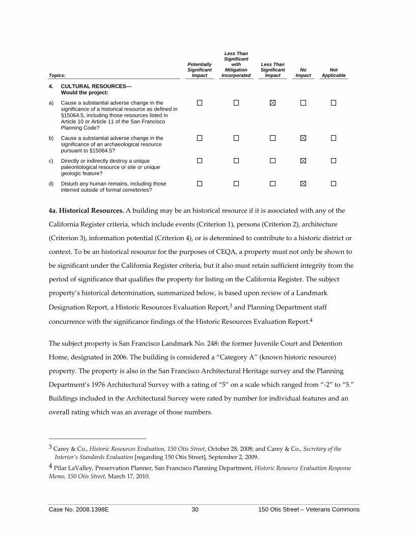
4. CULTURAL RESOURCES— Would the project:
a) Cause a substantial adverse change in the significance of a historical resource as defined in §15064.5, including those resources listed in Article 10 or Article 11 of the San Francisco Planning Code?
b) Cause a substantial adverse change in the significance of an archaeological resource pursuant to §15064.5?
c) Directly or indirectly destroy a unique paleontological resource or site or unique geologic feature?
d) Disturb any human remains, including those interred outside of formal cemeteries?
4a. Historical Resources. A building may be an historical resource if it is associated with any of the
California Register criteria, which include events (Criterion 1), persons (Criterion 2), architecture
(Criterion 3), information potential (Criterion 4), or is determined to contribute to a historic district or
context. To be an historical resource for the purposes of CEQA, a property must not only be shown to
be significant under the California Register criteria, but it also must retain sufficient integrity from the
period of significance that qualifies the property for listing on the California Register. The subject
property’s historical determination, summarized below, is based upon review of a Landmark
Designation Report, a Historic Resources Evaluation Report,3 and Planning Department staff
concurrence with the significance findings of the Historic Resources Evaluation Report.4
The subject property is San Francisco Landmark No. 248: the former Juvenile Court and Detention
Home, designated in 2006. The building is considered a “Category A” (known historic resource)
property. The property is also in the San Francisco Architectural Heritage survey and the Planning
Department’s 1976 Architectural Survey with a rating of “5” on a scale which ranged from “‐2” to “5.”
Buildings included in the Architectural Survey were rated by number for individual features and an
overall rating which was an average of those numbers.
3 Carey & Co., Historic Resources Evaluation, 150 Otis Street, October 28, 2008; and Carey & Co., Secretary of the Interior’s Standards Evaluation [regarding 150 Otis Street], September 2, 2009.
4 Pilar LaValley, Preservation Planner, San Francisco Planning Department, Historic Resource Evaluation Response Memo, 150 Otis Street, March 17, 2010.

Case No. 2008.1398E 31 150 Otis Street – Veterans Commons
The subject property, built in 1916 as the San Francisco Juvenile Court and Detention Home, is
associated with the development of the city’s juvenile justice system in the early twentieth century.
Financing for construction of the building was appropriated by the Board of Supervisors in 1914, and
architect Louise Christian Mullgardt was hired to design a facility that incorporated Progressive Era
principles for the juvenile justice system. The building, which opened to widespread praise in 1916,
included a juvenile court, detention home, and educational, medical, and recreational facilities. The
building retained its original function until 1950. Thus, the subject property appears to be eligible for
listing on the California and National Registers under criterion 1 (event).
The subject property represents the work of a master, Louis Christian Mullgardt (1866‐1942).
Mullgardt, who obtained his architectural training through apprenticeships and short academic stints,
worked briefly in England and throughout the United States during his career. Mullgardt’s career,
which spanned 1881 to 1929, was marked by his exuberant, polychromatic designs for structures at the
1893 World’s Columbian Exposition and the 1916 Panama‐Pacific Exposition. The subject building
reflects both the influence of his Panama‐Pacific Exposition work and interest in the newly emerging
area of skyscrapers. The design is the architect’s own unique composition of varied stylistic features,
vaguely both Mediterranean and Oriental in style, applied to a functionally modern building. The
subject property represents the architect’s tallest extant building, his first non‐residential commission
in San Francisco, and one of the few remaining non‐residential buildings designed by Mullgardt in San
Francisco. The subject property also appears significant for its distinctive architecture, which appears
to be a more restrained, utilitarian version of the polychromatic, Mediterranean, and Oriental revivalist
designs favored by Mullgardt in his Panama‐Pacific Exposition designs. Thus, the subject property
appears to be eligible for listing on the California and National Registers under criterion 3
(architecture).
Historical records do not indicate that the building is associated with the lives of important persons in
our past or that it is likely to yield information important to a better understanding of prehistory or
history; thus, the structure does not appear to be eligible for the California Register under criterion 2
(persons) or criterion 4 (prehistory).
To be a resource for the purposes of CEQA, a property must not only be shown to be significant under
the California Register criteria, but it also must convey integrity from its period of significance through
various aspects: location, association, design, workmanship, setting, feeling, and materials. Although

Case No. 2008.1398E 32 150 Otis Street – Veterans Commons
the design integrity of 150 Otis Street has been somewhat compromised by the removal of all interior
features and finishes and replacement of all windows, the property has retained all other aspects of
historic integrity and continues to convey its historical significance.
It must be determined whether the proposed project would cause a substantial adverse change in the
significance of the resource such that the significance of the resource would be materially impaired.
Planning Department preservation staff reviewed the following proposed alterations for compliance
with the Secretary of the Interior Standards for Rehabilitation (Standards):
• ADA‐accessible Entrance. In order to provide an ADA‐accessible entrance, the project proposes to remove one basement window and cut a new opening in the water table / base of the building in the bay of windows south of the main entrance on east elevation. A door providing access to a vestibule and elevator would be installed in new opening and an opening would be cut in the ground floor to provide an interior connection for the new vestibule and elevator. The new elevator would be set back approximately 4 feet from the existing windows such that no windows would be infilled, and the elevator enclosure would be minimally visible from the building exterior. The existing opening in the window bay north of the main entrance would be infilled and restored to match surrounding finishes. The proposed new opening would require minimal removal of historic fabric and would avoid impacts to distinctive features, finishes, and materials that characterize the property in conformance with the Standards. Previous alterations would be removed, and the façade would be restored in the area of the existing, non‐complying lift. Provision of the new opening and interior elevator would also avoid impacts to the existing main entrance stairs. If removed in the future, this ADA‐accessible would not impair the essential form and integrity of the historic property.
• Window Replacement. Existing non‐historic, aluminum sash windows would be replaced with new aluminum sash windows that match the size and shape of existing openings. Original clerestory windows at the attic level would be repaired and retained in conformance with the Standards. New sash would be two‐lite, stacked, with single‐hung operation on all elevations. While the proposed new windows would not match the appearance, operation, or material of the original windows, which appear from historic plans and photographs to have been six‐lite, stacked, awning, steel sash, the replacement windows would be compatible with the historic building and in conformance with the Standards. Proposed new sash would match the size and scale of the original openings, would be constructed of a material that is compatible with the original, and would have multi‐lite sash arranged in a configuration that reflects that of the original windows.
• New Elevator Tower. At the rear elevation, the existing steel fire escape and center bay of windows and finishes would be removed from column line to column line for the full height of the building. Within this new opening, new shear wall for the building’s seismic upgrade and the new elevator tower would be installed. Integral for seismic strengthening and for vertical circulation in the building’s proposed new use, the new elevator tower would connect to the existing building through a hyphen that terminates below the existing clerestory windows and eave overhang. The hyphen would be designed to provide a visual break between old and new construction and to preserve the distinctive features of the roof overhang, eave line, and

Case No. 2008.1398E 33 150 Otis Street – Veterans Commons
original clerestory windows. It would be no taller than the existing roof peak and would be painted concrete. A landscape screen would be attached to the tower at the lower three floors. Construction of the elevator tower and new shear wall would impact historic fabric, and the new tower would be visible due to the overall height; however, these impacts have been limited to one bay of the rear (secondary) elevation. The new tower would be clearly differentiated from the old but compatible in size, materials, and massing. Located on a secondary elevation and designed to be differentiated but compatible with the historic building, the new elevator tower would minimize impacts to the building’s historic fabric in conformance with the Standards.
• Rear Deck and Entrances. At the rear elevation, two new deck areas, aligned with the existing ground floor area, would be installed between the new elevator tower and existing stair towers. The decks would have wood slat guardrails, wood trellis, and planters. The new structures would not attach to the existing building, and appropriate expansion and drainage joints would be incorporated between old and new construction. At the bays on either end of the ground floor, new entrances would be installed by removing three existing windows and lowering the sills. These new openings would lead to a secondary interior vestibule with glass walls for transparency. The new decks would be differentiated but compatible with the historic building, would be located on a secondary façade, would not require removal of historic fabric, and would reversible in conformance with the Standards. The new entrances would require alteration of a limited number of existing openings but would avoid existing concrete mullions such that the original configuration of the openings would be maintained and the work would be reversible in a manner that is in conformance with the Standards.
• Roof. The existing red clay tile roof would be repaired as necessary. If new underlayment and sheathing are required, existing tile would be salvaged and reinstalled. Any new tile would match existing tile and would be interspersed with original material to minimize visual impacts. At the third floor (sun porch) roof are seven infilled skylights. Infill would be removed and the skylights would be restored at the two central openings. Existing curbs would be retained, repaired, and re‐roofed for the other original skylight openings. The proposed work for the roof would be undertaken in a manner that conforms to the Standards.
• Exterior Finish. The exterior finish consists of a layer of colored stucco with a stippled brush pattern over the concrete wall system. The exterior has been painted several times. The stippled application of the colored stucco was intended to give the appearance of travertine, and was an economical approach to the original construction that is a character‐defining feature of the historic building. Exterior finishes would be cleaned using the gentlest means possible, damaged areas in the stucco would be repaired in‐kind, and the building would be painted in a manner that does not detract from the original “faux travertine” treatment. As proposed, work on the exterior finishes would not alter character‐defining features of the building in conformance with the Standards.
• Seismic and Building Upgrades. The existing building is constructed of reinforced concrete with riveted steel frame. With the exception of the section of wall to be removed for the new stair tower, the existing exterior walls would be retained. Seismic retrofitting would be accomplished mainly by the addition of the central elevator tower at the rear of the building, which allows for less invasive structural strengthening of the north and south walls, and minimal additional interior perpendicular walls. New interior walls would avoid existing window and door openings and would not impact any historic fabric at the interior. New mechanical and electrical systems would be installed throughout the building. The new

Case No. 2008.1398E 34 150 Otis Street – Veterans Commons
ventilation system would utilize existing shafts but would require new exterior vents along the rear elevation. This scope of work coincides with existing exterior walls and proposed floor plan and conforms to the Standards.
• Interior Alterations. With the exception of the floor plates and stairs, the interior of the building does not retain integrity from the original construction or period of significance. The existing elevator shaft and stair configuration will be retained from basement to second floor at the south stair tower. All other areas of the existing stairs and elevators will be removed and reconfigured in the same location. New interior demising walls and drop ceilings will be installed for the new floor plan. Proposed interior work will not impact character‐defining features of the building, will not alter existing openings, and will be reversible in a manner that conforms to the Standards.
Planning preservation staff determined that the proposed project would preserve the majority of
character‐defining features while rehabilitating the building for a new use. Based on the proposed
design, all alterations would comply with the Secretary of the Interior Standards for Rehabilitation
(Standards). Thus, the proposed project would not constitute a significant adverse change on a historic
resource, and therefore would have a less‐than‐significant impact on historical resources.
4b and d. Archaeological Resources. The elevator pit would not be underground. A maximum depth
of excavation for the footings for the shaft would be about 3 feet below the floor of the underground
garage. New 4‐ to 6‐inch micropiles to be installed inside the building would involve up to 5’8” of
excavation. Significant archaeological resources and human remains are not expected to be within the
effected soils.5 Thus, there would be no impacts on archaeological resources or human remains.
4c. Paleontological, Geological Resources. There are no known paleontological resources or geological
features at the project site; therefore, the proposed project would not result in any adverse effects on
paleontological resources or geological features.
Cumulative Cultural Impacts. As discussed above, the proposed project would result in a less‐than‐
significant impact on cultural resources for the purposes of CEQA. There do not appear to be any
off‐site historical resources in the immediate vicinity that could be affected by the proposed project.
The proposed project would not combine in a cumulatively considerable manner with the projects such
as development anticipated under the Market and Octavia Area Plan, and the residential projects
approximately one‐third of a mile east of the project site at Mission and 10th Streets. Thus, the
proposed project’s cumulative impacts related to cultural resources would be less than significant. 5 Randall Dean/Don Lewis, San Francisco Planning Department, MEA Preliminary Archeological Review, 150 Otis
Avenue, January 20, 2010.

Case No. 2008.1398E 35 150 Otis Street – Veterans Commons
Topics:
Potentially Significant
Impact
Less Than Significant
with Mitigation
Incorporated
Less Than Significant
Impact No
Impact Not
Applicable
5. TRANSPORTATION AND CIRCULATION— Would the project:
a) Conflict with an applicable plan, ordinance or policy establishing measures of effectiveness for the performance of the circulation system, taking into account all modes of transportation including mass transit and non-motorized travel and relevant components of the circulation system, including but not limited to intersections, streets, highways and freeways, pedestrian and bicycle paths, and mass transit?
b) Conflict with an applicable congestion management program, including but not limited to level of service standards and travel demand measures, or other standards established by the county congestion management agency for designated roads or highways?
c) Result in a change in air traffic patterns, including either an increase in traffic levels, obstructions to flight, or a change in location, that results in substantial safety risks?
d) Substantially increase hazards due to a design feature (e.g., sharp curves or dangerous intersections) or incompatible uses?
e) Result in inadequate emergency access?
f) Conflict with adopted policies, plans, or programs regarding public transit, bicycle, or pedestrian facilities, or otherwise decrease the performance or safety of such facilities?
5a and b. Traffic and Level of Service.
Operational Impacts. Otis Street is a one‐way westbound local street with four travel lanes from South.
Traffic volumes are generally moderate to high. Vehicles traveling westbound along Mission Street
traverse the two blocks of Otis Street before rejoining Mission Street. Westbound Muni bus lines 14
Mission, 14L Mission Limited, and 49 Van Ness/Mission run along Otis Street with approximately 24
buses per hour during the AM and PM peak periods.
As set forth in the Planning Department’s October 2002 Transportation Impact Analysis Guidelines for
Environmental Review (Guidelines), the Planning Department evaluates traffic conditions for the weekday
PM peak period to determine the significance of an adverse environmental impact. Weekday PM peak‐
hour conditions typically represent the worst conditions of the local transportation network. Table 2
presents trip generation rates for the residents and employees of the proposed project. The proposed

Case No. 2008.1398E 36 150 Otis Street – Veterans Commons
project would add 76 residents and seven full‐time employees on an average day. Based on the trip
generation rate for residential space in the Guidelines, the residents of the proposed project would
generate an estimated average of 578 daily person-trips, including 100 daily person‐trips during the
PM peak hour. These 100 PM peak person-trips would be distributed among various modes of
transportation, including 30 automobile person trips, 48 public transit trips, 16 walking trips, and 7 by
other means that could include bicycling or motorcycle. Residential trip rate is a conservative
assumption; it is reasonable to expect that the residents of 150 Otis Street would have a very low rate of
automobile use – resulting in fewer than the 30 PM peak automobile person trips anticipated under the
analysis guidelines.
Table 2 – Trip Generation Daily PM Peak Period 76 Residents Person trips 578 100 Auto 172 30 Transit 276 48 Walking 91 16 Other (e.g., bicycle, motorcycle) 38 7 7 Employees Person trips 28 7 Auto 20 4 Transit 5 1 Walking 2 1 Other(e.g., bicycle, motorcycle) 1 0
To estimate the travel demand of the seven employees on a typical day, the assumption is four
potential person trips per employee (travel daily to/from work and to/from lunch. The additional
assumption is that all seven employees would leave work during the PM peak hour, which equals
seven PM peak‐hour trips. Based on the mode split and average automobile occupancy for the
proposed project’s location, there would be 28 employee daily vehicle trips, of which 20 would be
automobile trips (16 vehicle trips with a 1.23 auto occupancy rate), five trips by transit, two pedestrian,
and one other trip.6 During the PM peak hour there would be four vehicle trips (five vehicle trips with
a 1.23 vehicle occupancy rate), about one transit trip, and one walking trip. These five PM peak‐hour
6 Susan Mickelsen, Transportation Planner, San Francisco Planning Department, 150 Otis Employee Trip
Numbers, February 2, 2010.
Case No. 2008.1398E 37 150 Otis Street – Veterans Commons
vehicle trips would not be considered a substantial traffic increase relative to the existing capacity of
the local street system. Residents and businesses along Mission and Otis Streets could thus experience
an increase in vehicular activity as a result of the proposed project; however, it would be a less-than‐
significant increase relative to the existing capacity of the local street system. The project would not
contribute significantly to a Level of Service (LOS) decline at adjacent roadway intersections, per LOS
standards considered acceptable by the San Francisco Planning Department. The change in traffic in
the project area as a result of the proposed project would be undetectable to most drivers, particularly
given the relatively high volume of traffic on Mission Street during the PM peak period. Therefore, the
increase in traffic caused by the project would be considered a less‐than‐significant impact.
Loading during Project Operation. Planning Code Section 152 does not require a loading space for
under 100,000 sf of residential use. The proposed project would include 49,314 sf of residential space;
thus, off‐street freight loading space is not required. The number of delivery and service vehicles
generated by the proposed project would be, on average, one truck trip per day).7 Other deliveries
would include limited instances of residents moving into or out of the 76‐unit building. The proposed
project could involve other delivery and service trips, including vanpool trips for resident activities. All
loading activity could be accomplished in the existing on‐site loading area at 170 Otis Street. Thus,
loading impacts would be less than significant.
Construction Impacts. During the projected 24‐month construction period, temporary and intermittent
traffic and transit impacts would result from truck movements to and from the project site. Truck
movements during periods of peak traffic flow would have greater potential to create conflicts than
during non‐peak hours because of the greater numbers of vehicles on the streets during the peak hour
that would have to maneuver around queued trucks. The project sponsor and construction contractors
would meet with the City’s Transportation Advisory Staff Committee (TASC) to determine feasible
measures to reduce traffic congestion, including effects on the transit system and pedestrian circulation
impacts during construction of the proposed project. TASC consists of representatives from the Traffic
Engineering Division of the Department of Parking and Traffic (DPT), the Fire Department, MUNI, and
the Planning Department.
7 San Francisco Planning Department, Transportation Impact Analysis Guidelines for Environmental Review,
October 2002, Appendix H, Freight Delivery and Service Methodology. Average daily rate calculated based on 7,000 square feet of institutional use at a rate of 0.1 truck trips per 1,000 square feet and 49,314 square feet of residential use at a rate of 0.03 truck trips per 1,000 square feet.

Case No. 2008.1398E 38 150 Otis Street – Veterans Commons
5c. Air Traffic. The project site is not located within an airport land use plan area, within 2 miles of a
public airport, or in the vicinity of a private airstrip. Therefore, this significance criterion would not
apply to the proposed project.
5d. Traffic Hazards. The proposed project does not include any features that would alter the existing
street pattern nor increase transportation hazards (e.g., creating a new sharp curve or dangerous
intersections). Thus, this topic does not apply to the proposed project.
5e. Emergency Access. As discussed above under Topic 1, Land Use and Land Use Planning, Land Use
Character, p. 25, the proposed project would not introduce any incompatible uses. Similarly, the
proposed project would not result in a significant impact with regard to emergency access, as the
project site is accessible from major streets. As a result, the proposed project would not result in
inadequate emergency access.
5f. Plans and Policies regarding Transit, Bicycle and Pedestrian Facilities.
Transit Conditions. Muni provides transit service within the City and County of San Francisco,
including bus (both diesel and electric trolley), light rail (Muni Metro), cable car, and electric streetcar
lines. Muni operates some major bus lines in the vicinity of the project site. Westbound 14 and 49 buses
stop directly in front of the project site, and eastbound 14 and 49 buses stop approximately 150 feet
from the project site at the intersection of Mission and 13th Streets. The 14 Mission runs peak periods
every 6 minutes, midday every 8 minutes, evenings every 10 minutes, weekends every 7 to 10 minutes,
and owl every 30 minutes. The 49 Van Ness/Mission runs peak periods and weekdays every 8 minutes,
evenings every 10 minutes, weekends every 8 to 9 minutes, and weekend evenings every 15 minutes
until 1:00 AM. The 14L Mission Limited, the 47 Van Ness, F Market, and Muni Metro lines stop within
1,800 feet (one‐third of a mile) of the project site. The estimated 53 peak‐hour project trips utilizing
public transit would be distributed among the public transit lines providing service to the vicinity of
the project site.
Capacity utilization relates the number of passengers per transit vehicle to the design capacity of the
vehicle. Muni’s established capacity utilization standard for peak period operations is 85%. With
several Muni lines operating in the project vicinity, it is anticipated that most riders would choose the
closest and least crowded lines depending upon their direction of travel. Currently, the Muni routes in
the vicinity of the project site operate under or around capacity during PM peak hour. Overall, the

Case No. 2008.1398E 39 150 Otis Street – Veterans Commons
addition of 53 project‐generated transit trips would result in a less‐than‐significant impact on transit
service.
Bicycle Conditions. Bike routes in the project vicinity include a wide curb lane along westbound
McCoppin Street, one half‐block north of the project site, and bike lanes along both sides Valencia
Street, two blocks west of the project site. Bicycle circulation improvements that were approved as
short‐term projects in the San Francisco Bicycle Plan include conversion of the wide curb to a bicycle
lane on westbound McCoppin Street between Gough Street and Valencia Streets. To accommodate the
bike lane, four parking spaces will be added on the south side of McCoppin Street between Jessie and
Stevenson Streets by converting parallel parking to 60‐degree back‐in angle parking. In addition, bike
lanes will be installed in the westbound direction on Otis Street between South Van Ness Avenue and
Gough Street (the block to the east but not in front of the project site).8
Planning Code Section 155.5, Bicycle Parking Required for Residential Uses, requires that residential
projects of over 50 dwelling units provide 25 Class I bicycle plus one space for over four dwelling units
over 50. Per Section 155.5, the proposed 76‐unit project would be required to provide 31 bicycle
parking spaces. The project sponsor does not propose any bicycle parking and would request an
exception to Section 155.5 of the Planning Code.
It is not anticipated that the proposed project would have an adverse impact on bicycle conditions in
the project area. Most bicyclists are expected to continue using the existing bike lanes and routes in the
vicinity.
Pedestrian Conditions. Sidewalks adjacent to the project site have excess capacity as evidenced by the
lack of pedestrian crowding or queuing. Surrounding streets, such as Otis, Mission, and McCoppin
Streets and Duboce Avenue, also have limited pedestrian volumes. The proposed project would
generate approximately 18 PM peak-hour pedestrian trips. The proposed project would not cause a
substantial amount of pedestrian and vehicle conflict since there are currently limited pedestrian
volumes. Sidewalk widths are sufficient to allow for the free flow of pedestrian traffic. Pedestrian
activity would increase as a result of the project, but not to a degree that could not be accommodated
on local sidewalks or would result in safety concerns.
8 San Francisco Municipal Transportation Agency, San Francisco Bicycle Plan, June 26, 2009; San Francisco
Planning Department, San Francisco Bicycle Plan Final Environmental Impact Report, certified June 25, 2009.
Case No. 2008.1398E 40 150 Otis Street – Veterans Commons
Plans and Policies. One of the eight Priority Policies added to Planning Code Section 101.1 by
Proposition M, the Accountable Planning Initiative, is discouragement of commuter automobiles. In
addition, the City’s “Transit First” policy, established in the City’s Charter Section 16.102, provides that
“parking policies for areas well‐served by public transit shall be designed to encourage travel by public
transportation and alternative transportation.” The project site is well‐served by transit, and the
proposed project contains no on‐site parking to encourage automobile use; thus the proposed project
would not conflict with adopted policies, plans, or programs supporting alternative transportation.
Cumulative Transportation Impacts. The proposed project would not cause a substantial increase in
traffic, in relation to the existing traffic load and capacity of the street system. As reflected in the trip
generation explained in Section 5a and 5b, Effects on Existing Traffic and Level of Service, the project
would result in a less-than‐significant increase in traffic and a less-than‐significant contribution to a
LOS decline at surrounding intersections. The proposed project would not include any hazardous
design features or incompatible uses and would not result in inadequate emergency access to the site
itself, or any surrounding sites. The proposed project would not cause a substantial increase in transit
demand that could not be accommodated by existing and proposed transit capacity, and alternative
travel modes. With the addition of 46 PM peak‐hour vehicle trips, the proposed project would have a
less-than-significant cumulative impact, because it would add a negligible number of PM peak hour
vehicle trips to the long-term increase in vehicle traffic in the surrounding street network.
Project construction activities, in combination with other major development in the vicinity of the
project area, could temporarily result in cumulative construction-related transportation effects on local
or regional roads, but these would not result in permanent cumulatively considerable transportation
impacts. There are no known no major development projects in the immediate project vicinity. The
cumulative development in the project area would therefore not be substantial. The proposed project
also would not contribute considerably to cumulative transportation impacts related to construction.
Parking. San Francisco does not consider parking supply as part of the permanent physical
environment and therefore does not consider changes in parking conditions to be environmental
impacts as defined by CEQA. The San Francisco Planning Department acknowledges, however, that
parking conditions may be of interest to the public and the decision makers. Therefore, the parking
analysis and discussion are included here for informational purposes.
Case No. 2008.1398E 41 150 Otis Street – Veterans Commons
Parking conditions are not static, as parking supply and demand varies from day to day, from day to
night, from month to month, etc. Hence, the availability of parking spaces (or lack thereof) is not a
permanent physical condition, but changes over time as people change their modes and patterns of
travel. Parking deficits are considered to be social effects, rather than impacts on the physical
environment as defined by CEQA.
Under CEQA, a project’s social impacts need not be treated as significant impacts on the environment.
Environmental documents should, however, address the secondary physical impacts that could be
triggered by a social impact (CEQA Guidelines Section 15131(a)). The social inconvenience of parking
deficits, such as having to hunt for scarce parking spaces, is not an environmental impact, but there
may be secondary physical environmental impacts, such as increased traffic congestion at intersections,
air quality impacts, safety impacts, or noise impacts caused by congestion. In the experience of San
Francisco transportation planners, however, the absence of a ready supply of parking spaces,
combined with available alternatives to auto travel (e.g., transit service, taxis, bicycles or travel by foot)
and a relatively dense pattern of urban development, induces many drivers to seek and find alternative
parking facilities, shift to other modes of travel, or change their overall travel habits. Any such
resulting shifts to transit service in particular would be in keeping with the City’s “Transit First”
policy. The City’s Transit First Policy, established in the City’s Charter Section 16.102, provides that
“parking policies for areas well served by public transit shall be designed to encourage travel by public
transportation and alternative transportation.” Alternative transportation, such as transit, bicycle, and
pedestrian conditions, are discussed above under Question 5f.
The transportation analysis accounts for potential secondary effects, such as cars circling and looking
for a parking space in areas of limited parking supply, by assuming that all drivers would attempt to
find parking at or near the project site and then seek parking farther away if convenient parking is
unavailable. Moreover, the secondary effects of drivers searching for parking is typically offset by a
reduction in vehicle trips due to others who are aware of constrained parking conditions in a given
area. Hence, any secondary environmental impacts which may result from a shortfall in parking in the
vicinity of the proposed project would be minor, and the traffic assignments used in the transportation
analysis, as well as in the associated air quality, noise, and pedestrian safety analyses, reasonably
addresses potential secondary effects.

Case No. 2008.1398E 42 150 Otis Street – Veterans Commons
As part of the proposed project, the underground parking garage associated with 170 Otis Street but
that is below the rear of 150 Otis Street parcel would be differentiated from the project site by means of
a lot line readjustment. The building at 150 Otis Street does not contain on‐site parking and no on‐site
parking is proposed as part of the project. Planning Code Section 151 requires no off‐street parking
spaces for dwellings in an affordable housing project as defined by Section 313.1 or 315.1 of the
Planning Code.
Temporary parking demand from construction workers’ vehicles and impacts on local intersections
from construction worker traffic would occur in proportion to the number of construction workers
who would use automobiles. The estimated 75 construction workers would park in existing on‐street
parking spaces in the project vicinity. Although construction workers may have to circulate on streets
in the vicinity of the project site to find available parking, the anticipated parking deficit would not
substantially change the capacity of the existing street system or alter the existing parking conditions in
the area.
Topics:
Potentially Significant
Impact
Less Than Significant
with Mitigation
Incorporated
Less Than Significant
Impact No
Impact Not
Applicable
6. NOISE—Would the project:
a) Result in exposure of persons to or generation of noise levels in excess of standards established in the local General Plan or noise ordinance, or applicable standards of other agencies?
b) Result in exposure of persons to or generation of excessive groundborne vibration or groundborne noise levels?
c) Result in a substantial permanent increase in ambient noise levels in the project vicinity above levels existing without the project?
d) Result in a substantial temporary or periodic increase in ambient noise levels in the project vicinity above levels existing without the project?
e) For a project located within an airport land use plan area, or, where such a plan has not been adopted, in an area within two miles of a public airport or public use airport, would the project expose people residing or working in the area to excessive noise levels?
f) For a project located in the vicinity of a private airstrip, would the project expose people residing or working in the project area to excessive noise levels?
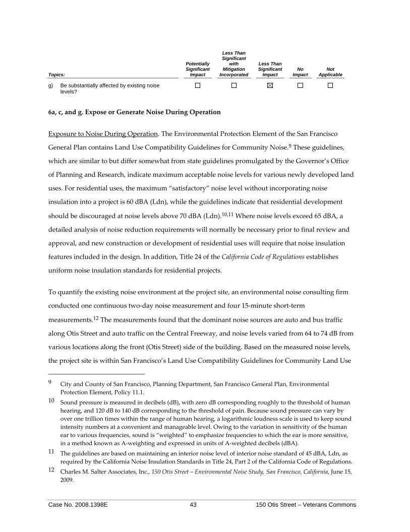
Case No. 2008.1398E 43 150 Otis Street – Veterans Commons
Topics:
Potentially Significant
Impact
Less Than Significant
with Mitigation
Incorporated
Less Than Significant
Impact No
Impact Not
Applicable
g) Be substantially affected by existing noise levels?
6a, c, and g. Expose or Generate Noise During Operation
Exposure to Noise During Operation. The Environmental Protection Element of the San Francisco
General Plan contains Land Use Compatibility Guidelines for Community Noise.9 These guidelines,
which are similar to but differ somewhat from state guidelines promulgated by the Governor’s Office
of Planning and Research, indicate maximum acceptable noise levels for various newly developed land
uses. For residential uses, the maximum “satisfactory” noise level without incorporating noise
insulation into a project is 60 dBA (Ldn), while the guidelines indicate that residential development
should be discouraged at noise levels above 70 dBA (Ldn).10,11 Where noise levels exceed 65 dBA, a
detailed analysis of noise reduction requirements will normally be necessary prior to final review and
approval, and new construction or development of residential uses will require that noise insulation
features included in the design. In addition, Title 24 of the California Code of Regulations establishes
uniform noise insulation standards for residential projects.
To quantify the existing noise environment at the project site, an environmental noise consulting firm
conducted one continuous two‐day noise measurement and four 15‐minute short‐term
measurements.12 The measurements found that the dominant noise sources are auto and bus traffic
along Otis Street and auto traffic on the Central Freeway, and noise levels varied from 64 to 74 dB from
various locations along the front (Otis Street) side of the building. Based on the measured noise levels,
the project site is within San Francisco’s Land Use Compatibility Guidelines for Community Land Use
9 City and County of San Francisco, Planning Department, San Francisco General Plan, Environmental
Protection Element, Policy 11.1. 10 Sound pressure is measured in decibels (dB), with zero dB corresponding roughly to the threshold of human
hearing, and 120 dB to 140 dB corresponding to the threshold of pain. Because sound pressure can vary by over one trillion times within the range of human hearing, a logarithmic loudness scale is used to keep sound intensity numbers at a convenient and manageable level. Owing to the variation in sensitivity of the human ear to various frequencies, sound is “weighted” to emphasize frequencies to which the ear is more sensitive, in a method known as A‐weighting and expressed in units of A‐weighted decibels (dBA).
11 The guidelines are based on maintaining an interior noise level of interior noise standard of 45 dBA, Ldn, as required by the California Noise Insulation Standards in Title 24, Part 2 of the California Code of Regulations.
12 Charles M. Salter Associates, Inc., 150 Otis Street – Environmental Noise Study, San Francisco, California, June 15, 2009.

Case No. 2008.1398E 44 150 Otis Street – Veterans Commons
Category C, in which “new construction or development should generally be discouraged. If new
construction or development does proceed, a detailed analysis of the noise reduction requirements
must be made, and needed noise insulation features included in the design.” The consultant
recommended STC‐rated windows,13 and noted that where sound‐rated windows need to be closed to
reduce noise levels, the California Building Code requires an alternative form of ventilation to provide
fresh air. Thus, the project sponsor has incorporated noise insulation features into the project design to
maintain an interior noise level of 45 dBA. The Department of Building Inspection would review
project plans for compliance with Title 24 noise standards. Compliance with Title 24 standards and
with the General Plan would ensure that effects from exposure to ambient noise would not result in
significant impacts.
Generation of Traffic Noise During Operation. Generally, traffic must double in volume to produce a
noticeable increase in average noise levels. Based on the transportation analysis prepared for the
project (see Topic 5, Transportation and Circulation, p. 35), traffic volumes would not double on area
streets as a result of the proposed project or expected cumulative traffic growth; therefore, the
proposed project would not cause a noticeable increase in the ambient noise level in the project
vicinity, nor would the project contribute to any potential cumulative traffic noise effects.
Generation of Building Noise During Operation. The project would include mechanical equipment that
could produce operational noise, such as heating and ventilation systems. These operations would be
subject to Section 2909 of the Noise Ordinance. As amended in November 2008, this section establishes
a noise limit from mechanical sources, such as building equipment, specified as a certain noise level in
excess of the ambient noise level at the property line: for noise generated by residential uses, the limit
is 5 dBA in excess of ambient, while for noise generated by commercial and industrial uses, the limit is
8 dBA in excess of ambient and for noise on public property, including streets, the limit is 10 dBA in
excess of ambient.14 In addition, the Noise Ordinance provides for a separate fixed‐source noise limit
for residential interiors of 45 dBA at night and 55 dBA during the day and evening hours. Compliance
with Article 29, Section 2909, would minimize noise from building operations. Therefore, noise effects
related to building operation would not be significant, nor would the building contribute a
considerable increment to any cumulative noise impacts from mechanical equipment.
13 Sound Transmission Class (STC) ratings rate the insulation properties of windows and building partitions,
which correspond to greater noise reduction. 14 Entertainment venues are also subject to a separate criterion for low‐frequency (bass) noise.

Case No. 2008.1398E 45 150 Otis Street – Veterans Commons
6b and d. Exposure of Groundborne Vibration or Noise During Construction
Excavation and building construction would temporarily increase noise in the project vicinity.
Construction equipment would generate noise and possibly vibrations that could be considered an
annoyance by occupants of nearby properties. According to the project sponsor, the construction
period would last approximately 24 months.
Installation of the 4‐ to 6‐inch‐diameter micropiles would involve the use of a small, low overhead drill
rig. Because it would be located in the basement, noise would be substantially reduced by the exterior
walls. An air compressor, to be used throughout the 24‐month construction period, would be located
on Otis Street or in the courtyard behind the building. This compressor would be used for demolition
and for installation of micropiles and epoxy dowels. Additional construction equipment that would be
set up and removed the same day may include concrete pumps or cranes for concrete pours or steel
installation.
Construction noise is regulated by the San Francisco Noise Ordinance (Article 29 of the Police Code).
The ordinance requires that noise levels from individual pieces of construction equipment, other than
impact tools, not exceed 80 dBA at a distance of 100 feet from the source. Impact tools (jackhammers,
hoerammers, impact wrenches) must have both intake and exhaust muffled to the satisfaction of the
Director of Public Works or the Director of Building Inspection. Section 2908 of the Ordinance prohibits
construction work between 8:00 PM. and 7:00AM, if noise would exceed the ambient noise level by
5 dBA at the project property line, unless a special permit is authorized by the Director of Public Works
or the Director of Building Inspection. The project must comply with regulations set forth in the Noise
Ordinance.
The closest sensitive noise receptors to the project site that have the potential to be adversely affected
by construction noise are the residences on the west side of Jessie Street, the closest being 170 feet from
the project site. Construction activities other than pile driving, which would not be employed in project
construction, typically generate noise levels no greater than 90 dBA (for instance, for excavation) at 50
feet from the activity, while other activities, such as concrete work, are much less noisy. Closed
windows typically can reduce daytime interior noise levels to an acceptable level. Therefore, for nearby
sensitive receptors, although construction noise could be annoying at times, it would not be expected
to exceed noise levels commonly experienced in an urban environment, and would not be considered
significant. Moreover, no other construction projects are proposed in close enough proximity to the

Case No. 2008.1398E 46 150 Otis Street – Veterans Commons
project site such that cumulative effects related to construction noise would be anticipated. In light of
the above, noise effects related to construction would be less than significant.
6e and f. Airport and Airstrip Noise. The project site is not within an airport land use plan area, nor is
it in the vicinity of a private airstrip. Therefore, topics 6e and 6f are not applicable.
Cumulative Noise Impacts. Project construction activities would be temporary and intermittent in
nature; project construction‐related noise would not substantially increase ambient noise levels at
locations greater than a few hundred feet from the project site; and as stated above, required
construction noise reduction measures would be implemented as required by the City’s Noise
Ordinance. No other construction projects are proposed in close enough proximity to the project site
such that cumulative effects related to construction noise would be anticipated. Thus, the proposed
project would not have significant cumulative noise impacts.
Topics:
Potentially Significant
Impact
Less Than Significant
with Mitigation
Incorporated
Less Than Significant
Impact No
Impact Not
Applicable
7. AIR QUALITY–Would the project:
a) Conflict with or obstruct implementation of the applicable air quality plan?
b) Violate any air quality standard or contribute substantially to an existing or projected air quality violation?
c) Result in a cumulatively considerable net increase of any criteria pollutant for which the project region is non-attainment under an applicable federal, state, or regional ambient air quality standard (including releasing emissions which exceed quantitative thresholds for ozone precursors)?
d) Expose sensitive receptors to substantial pollutant concentrations?
e) Create objectionable odors affecting a substantial number of people?
7a–d. Air Quality Plans and Standards and Criteria Pollutants
Construction‐Period Air Quality Emissions. Demolition, grading, and new construction activities
would temporarily affect local air quality during the project’s proposed 20‐month construction
schedule, causing temporary increases in particulate dust and other pollutants. Emissions generated

Case No. 2008.1398E 47 150 Otis Street – Veterans Commons
from construction activities include dust (including PM‐10 and PM‐2.5)15 primarily from “fugitive”
sources, combustion emissions of criteria air pollutants (reactive organic gases [ROG], nitrogen oxides
[NOx], carbon monoxide [CO], sulfur oxides [SOx], and PM‐10) primarily from operation of
construction equipment and worker vehicles, and evaporative emissions (ROG) from asphalt paving
and architectural coating applications. The Bay Area Air Quality Management District (BAAQMD) CEQA
Guidelines recognize that construction equipment emits ozone precursors, but indicate that such
emissions are included in the emission inventory that is the basis for regional air quality plans.16
Therefore, construction emissions are not expected to impede attainment or maintenance of ozone
standards in the Bay Area.
Project‐related demolition, excavation, grading, and other construction activities may cause
wind‐blown dust that could contribute particulate matter into the local atmosphere. Although there are
federal standards for air pollutants and implementation of state and regional air quality control plans,
air pollutants continue to have impacts on human health throughout the country. California has found
that particulate matter exposure can cause health effects at lower levels than national standards. The
current health burden of particulate matter demands that, where possible, public agencies take feasible
available actions to reduce sources of particulate matter exposure. According to the California Air
Resources Board, reducing ambient particulate matter from 1998 – 2000 levels to natural background
concentrations in San Francisco would prevent over 200 premature deaths.
Dust can be an irritant causing watering eyes or irritation to the lungs, nose, and throat. Demolition,
excavation, grading, and other construction activities can cause wind‐blown dust to add to particulate
matter in the local atmosphere. Depending on exposure, adverse health effects can occur due to this
particulate matter in general and also due to specific contaminants such as lead or asbestos that may be
constituents of soil.
In response, the San Francisco Board of Supervisors approved a series of amendments to the San
Francisco Building and Health Codes generally referred hereto as the Construction Dust Control
Ordinance (Ordinance 176‐08, effective July 30, 2008) with the intent of reducing the quantity of dust
generated during site preparation, demolition and construction work in order to protect the health of
15 Particles that are 10 microns or less in diameter and 2.5 microns or less in diameter, respectively. 16 Bay Area Air Quality Management District, BAAQMD CEQA Guidelines, Assessing the Air Quality Impacts of
Projects and Plans, December 1999.

Case No. 2008.1398E 48 150 Otis Street – Veterans Commons
the general public and of on‐site workers, minimize public nuisance complaints, and to avoid orders to
stop work by the Department of Building Inspection (DBI).
The Dust Control Ordinance requires that all site preparation work, demolition, or other construction
activities within San Francisco that have the potential to create dust or to expose or disturb more than
10 cubic yards or 500 square feet of soil comply with specified dust control measures whether or not
the activity requires a permit from DBI. The Director of DBI may waive this requirement for activities
on sites less than one half‐acre that are unlikely to result in any visible wind‐blown dust. At 7,000 sf, or
0.16 acres, the project site is less than one half‐acre.
The project sponsors and the contractor responsible for construction activities at the project site shall
use the following practices to control construction dust on the site or other practices that result in
equivalent dust control that are acceptable to the Director of DBI. Dust suppression activities may
include watering all active construction areas sufficiently to prevent dust from becoming airborne;
increased watering frequency may be necessary whenever wind speeds exceed 15 miles per hour
(mph). Reclaimed water must be used if required by Article 21, Sections 1100 et seq., of the San
Francisco Public Works Code. If not required, reclaimed water should be used whenever possible.
Contractors shall provide as much water as necessary to control dust (without creating run‐off in any
area of land clearing, and/or earth movement. During excavation and dirt‐moving activities,
contractors shall wet sweep or vacuum the streets, sidewalks, paths, and intersections where work is in
progress at the end of the workday. Inactive stockpiles (where no disturbance occurs for more than
seven days) greater than 10 cubic yards or 500 square feet of excavated materials, backfill material,
import material, gravel, sand, road base, and soil shall be covered with a 10 millimeter (0.01 inch)
polyethylene plastic (or equivalent) tarp, braced down, or use other equivalent soil stabilization
techniques.
The BAAQMD neither recommends quantified analysis of cumulative construction emissions nor
provides thresholds of significance that could be used to assess cumulative construction emissions. The
construction industry, in general, is an existing source of emissions within the Bay Area. Construction
equipment operates at one site on a short‐term basis and, when finished, moves on to a new
construction site. Because construction activities would be temporary, the contribution to the
cumulative context is so small as to be virtually immeasurable, and as all of the appropriate and
feasible construction‐related measures recommended by the BAAQMD would be implemented, the

Case No. 2008.1398E 49 150 Otis Street – Veterans Commons
contribution of construction emissions associated with the proposed project would not be cumulatively
considerable.
Operational Air Quality Emissions. Project operation would affect local air quality by increasing the
number of vehicles on nearby roads and at the project site, and by introducing stationary emissions to
the project site. Transportation vehicles are the primary source of operational project‐related
emissions.17 According to the BAAQMD guidance for CEQA analysis, a project would have potentially
significant emissions impacts if the project were to generate more than 2,000 vehicle trips per day.
Based on the transportation analysis for the proposed project, the project would generate up to about
200 vehicle trips per day, well below the BAAQMD’s threshold for air quality analysis. Therefore,
consistent with BAAQMD guidance, no quantitative analysis of transportation air quality is required,
and the project would not result in a significant effect with regard to operational air quality. The
project would be generally consistent with the General Plan, which does not project a population
increase in excess of that forecast in the Bay Area 2000 Clean Air Plan. The General Plan, Planning
Code, and City Charter implement various Transportation Control Measures identified in the Clean
Air Plan through the City’s Transit First Program, bicycle parking requirements, transit development
fees, and other actions. In light of the above, the project would not contribute considerably to
cumulative air quality impacts.
Stationary source emissions, generated by combustion of natural gas for building space and water
heating, would be relatively minimal compared to transportation emissions, and would be considered
less than significant. The project would not violate any BAAQMD ambient air quality standard or
contribute substantially to an existing or projected air quality violation. Therefore, no significant
operational air quality impacts would be generated by the project.
Toxic Air Contaminants/Roadway Particulate Exposure. The California Air Resources Board (ARB)
established its statewide comprehensive air toxics program in the early 1980s. The ARB created
California’s program in response to the Toxic Air Contaminant Identification and Control Act (AB
1807, Tanner 1983) to reduce exposure to air toxics. The ARB identifies 244 substances as toxic air
contaminants (TACs) that are known or suspected to be emitted in California and have potential
adverse health effects. Public health research consistently demonstrates that pollutant levels are
17 Bay Area Air Quality Management District, BAAQMD CEQA Guidelines, Assessing the Air Quality Impacts of
Projects and Plans, December 1999.
Case No. 2008.1398E 50 150 Otis Street – Veterans Commons
significantly higher near freeways and busy roadways. Human health studies demonstrate that
children living within 100 to 200 meters of freeways or busy roadways have poor lung function and
more respiratory disease; both chronic and acute health effects may result from exposure to TACs. In
2005, the ARB issued guidance on preventing roadway related air quality conflicts, suggesting
localities “avoid siting new sensitive land uses within 500 feet of a freeway [or other] urban roads with
volumes of more than 100,000 vehicles/day.”18 However, there are no existing federal or state
regulations to protect sensitive land uses from roadway air pollutants.
The San Francisco Department of Public Health (DPH) has issued guidance for the identification and
assessment of potential air quality hazards and methods for assessing the associated health risks.19
Consistent with ARB guidance, DPH has identified that a potential public health hazard for sensitive
land uses exists when such uses are located within a 150‐meter (approximately 500‐foot) radius of any
boundary of a project site that experiences 100,000 vehicles per day. To this end, San Francisco added
Article 38 of the San Francisco Health Code, approved November 25, 2008, which requires that, for new
residential projects of 10 or more units located in proximity to high‐traffic roadways, as mapped by
DPH, an Air Quality Assessment be prepared to determine whether residents would be exposed to
potentially unhealthful levels of PM2.5. Through air quality modeling, an assessment is conducted to
determine if the annual average concentration of PM2.5 from the roadway sources would exceed a
concentration of 0.2 micrograms per cubic meter (annual average).20 If this standard is exceeded, the
18 California Air Resources Board, 2005 Air Quality and Land Use Handbook: A Community Health Perspective,
http://www.arb.ca.gov/ch/landuse.htm, accessed October 28, 2009. 19 San Francisco Department of Public Health, Assessment and Mitigation of Air Pollutant Health Effects from Intra‐
urban Roadways: Guidance for Land Use Planning and Environmental Review, May 6, 2008, http://dphwww.sfdph.org/phes/publications/Mitigating_Roadway_AQLU_Conflicts.pdf, accessed October 28, 2009.
20 According to DPH, this threshold, or action level, of 0.2 micrograms per cubic meter represents about 8 – 10 percent of the range of ambient PM2.5 concentrations in San Francisco based on monitoring data, and is based on epidemiological research that indicates that such a concentration can result in an approximately 0.28 percent increase in non‐injury mortality, or an increased mortality at a rate of approximately 20 “excess deaths” per year per one million population in San Francisco. “Excess deaths” (also referred to as premature mortality) refer to deaths that occur sooner than otherwise expected, absent the specific condition under evaluation; in this case, exposure to PM2.5. (San Francisco Department of Public Health, Occupational and Environmental Health Section, Program on Health, Equity, and Sustainability, “Assessment and Mitigation of Air Pollutant Health Effects from Intra‐urban Roadways: Guidance for Land Use Planning and Environmental Review, May 6, 2008. Twenty excess deaths per million based on San Francisco’s non‐injury, non‐homicide, non‐suicide mortality rate of approximately 714 per 100,000. Although San Francisco’s population is less than one million, the presentation of excess deaths is commonly given as a rate per million population.)

Case No. 2008.1398E 51 150 Otis Street – Veterans Commons
project sponsor must install a filtered air supply system, with high‐efficiency filters, designed to
remove at least 80 percent of ambient PM2.5 from habitable areas of residential units.
The project site at 150 Otis Street is located within the Potential Roadway Exposure Zone, as mapped
by DPH. In consultation with DPH, an Air Quality Assessment was prepared.21 Results of the
assessment indicate that the project site does not exceed a PM2.5 concentration greater than 0.2
micrograms per cubic meter. Thus, the project would result in a less‐than‐significant impact related to
exposure of sensitive receptors within the project site to high concentrations of roadway‐related
pollutants.
7e. Odors. The project would not result in a perceptible increase or change in odors on the project site
or in the vicinity of the project, as it would not include uses prone to generation of odors. If the
commercial space were to be used as a restaurant, odor control would be implemented through the
permitting process for the use. Observation indicates that surrounding land uses are not sources of
noticeable odors, and therefore would not adversely affect project residents.
Cumulative Air Quality. The proposed project would be generally consistent with the General Plan and
air quality management plans such as the Bay Area 2000 Clean Air Plan, and the Bay Area 2005 Ozone
Strategy. Additionally, the General Plan, Planning Code, and the City Charter implement various
transportation control measures identified in the City’s Transit First Program, bicycle parking
regulations, transit development fees, and other actions. Accordingly, the proposed project would not
contribute considerably to cumulative air quality impacts; nor would it interfere with implementation
of the Bay Area 2005 Ozone Strategy or the 2001 Ozone Attainment Plan, which are the applicable regional
air quality plans developed to improve air quality towards attaining the state and federal air quality
standards. As such, operational characteristics of the proposed project would not result in
cumulatively considerable increases in regional air pollutants.

Case No. 2008.1398E 52 150 Otis Street – Veterans Commons
Topics:
Potentially Significant
Impact
Less Than Significant
with Mitigation
Incorporated
Less Than Significant
Impact No
Impact Not
Applicable
8. GREENHOUSE GAS EMISSIONS Would the project
a) Generate greenhouse gas emissions, either directly or indirectly, that may have a significant impact on the environment?
b) Conflict with any applicable plan, policy, or regulation adopted for the purpose of reducing the emissions of greenhouse gases?
Greenhouse Gases. Gases that trap heat in the atmosphere are referred to as greenhouse gases (GHGs)
because they capture heat radiated from the sun as it is reflected back into the atmosphere, much like a
greenhouse does. The accumulation of GHGs has been implicated as the driving force for global
climate change. The primary GHGs are carbon dioxide, methane, nitrous oxide, ozone, and water
vapor.
While the presence of the primary GHGs in the atmosphere are naturally occurring, carbon dioxide
(CO2), methane (CH4), and nitrous oxide (N2O) are largely emitted from human activities, accelerating
the rate at which these compounds occur within earth’s atmosphere. Emissions of carbon dioxide are
largely by‐products of fossil fuel combustion, whereas methane results from off‐gassing associated
with agricultural practices and landfills. Other GHGs include hydrofluorocarbons, perfluorocarbons,
and sulfur hexafluoride, and are generated in certain industrial processes. Greenhouse gases are
typically reported in “carbon dioxide‐equivalent” measures (CO2E).22
There is international scientific consensus that human‐caused increases in GHGs have and will
continue to contribute to global warming. Potential global warming impacts in California may include,
but are not limited to, loss in snow pack, sea level rise, more extreme heat days per year, more high
ozone days, more large forest fires, and more drought years. Secondary effects are likely to include a
global rise in sea level, impacts to agriculture, changes in disease vectors, and changes in habitat and
biodiversity.23
22 Because of the differential heat absorption potential of various GHGs, GHG emissions are frequently measured in “carbon dioxide‐equivalents,” which present a weighted average based on each gas’s heat absorption (or “global warming”) potential.
23 California Climate Change Portal. Frequently Asked Questions About Global Climate Change. Available online at: http://www.climatechange.ca.gov/publications/faqs.html. Accessed March 2, 2010.

Case No. 2008.1398E 53 150 Otis Street – Veterans Commons
The California Air Resources Board (ARB) estimated that in 2006 California produced about 484
million gross metric tons of CO2E (MMTCO2E), or about 535 million U.S. tons.24 The ARB found that
transportation is the source of 38 percent of the State’s GHG emissions, followed by electricity
generation (both in‐state and out‐of‐state) at 22 percent and industrial sources at 20 percent.
Commercial and residential fuel use (primarily for heating) accounted for 9 percent of GHG
emissions.25 In the Bay Area, fossil fuel consumption in the transportation sector (on‐road motor
vehicles, off‐highway mobile sources, and aircraft) and the industrial and commercial sectors are the
two largest sources of GHG emissions, each accounting for approximately 36 percent of the Bay Area’s
95.8 MMTCO2E emitted in 2007.26 Electricity generation accounts for approximately 16 percent of the
Bay Area’s GHG emissions followed by residential fuel usage at 7 percent, off‐road equipment at 3
percent and agriculture at 1 percent.27
Senate Bill 97 (SB 97) requires the Office of Planning and Research (OPR) to amend the state CEQA
guidelines to address the feasible mitigation of GHG emissions or the effects of GHGs. The Natural
Resources Agency adopted OPR’s CEQA guidelines on December 30, 2009, amending various sections
of the guidelines to provide guidance for analyzing GHG emissions. Specifically, the amendments add
a new section to the CEQA Checklist (CEQA Guidelines Appendix G) to address questions regarding
the project’s potential to emit GHGs. OPR’s amendments to the CEQA Guidelines have been
incorporated into this analysis accordingly.
8a. Project Greenhouse Gas Emissions. The most common GHGs resulting from human activity are
CO2, CH4, and N2O.28 State law defines GHGs to also include hydrofluorocarbons, perfluorocarbons,
and sulfur hexafluoride. These latter GHG compounds are usually emitted in industrial processes and
are therefore not applicable to the proposed project. The GHG calculation presented in this analysis
24 California Air Resources Board, “California Greenhouse Gas Inventory for 2000‐2006— by Category as Defined in the Scoping Plan.” http://www.arb.ca.gov/cc/inventory/data/tables/ghg_inventory_scopingplan_2009‐03‐13.pdf. Accessed March 2, 2010.
25 Ibid. 26 Bay Area Air Quality Management District, Source Inventory of Bay Area Greenhouse Gas Emissions: Base Year 2007,
Updated: February 2010. Available online at: http://www.baaqmd.gov/~/media/Files/Planning%20and%20Research/Emission%20Inventory/regionalinventory2007_2_10.ashx. Accessed March 2, 2010.
27 Ibid. 28 Governor’s Office of Planning and Research. Technical Advisory‐ CEQA and Climate Change: Addressing Climate Change through California Environmental Quality Act (CEQA) Review. June 19, 2008. Available at http://www.opr.ca.gov/ceqa/pdfs/june08‐ceqa.pdf. Accessed March 3, 2010.

Case No. 2008.1398E 54 150 Otis Street – Veterans Commons
includes an estimate of emissions from CO2, N2O, and CH4. Individual projects contribute to the
cumulative effects of climate change by emitting GHGs during their construction and operational
phases. Both direct and indirect GHG emissions are generated by project operations. Operational
emissions include GHG emissions from new vehicle trips and area sources (natural gas combustion).
Indirect emissions include emissions from electricity providers, energy required to pump, treat, and
convey water, and emissions associated with landfill operations.
The proposed project would increase the activity on site by adding 76 studio residences and seven
employees to the site that is currently used for City storage and as a seasonal homeless shelter during
winter months, serving approximately 60 people and employs two daytime employees with additional
staff at night when the shelter is open. Therefore, the proposed project would contribute to annual
long‐term increases in GHGs as a result of increased vehicle trips (mobile sources) and residential
operations associated with energy use, water use and wastewater treatment, and solid waste disposal.
GHG emissions from water use and wastewater treatment are presented for the proposed project.
The proposed project is expected to generate 709 metric tons of carbon dioxide equivalents (MTCO2E)
over an approximately 24‐month construction period.29 Direct project emissions of carbon dioxide
equivalents (including CO2, NOx, and CH4 emissions) include 250 MTCO2E/year from transportation,
and 133 MTCO2E /year from heating. The project would also indirectly result in GHG emissions from
off‐site electricity generation at power plants (approximately 83 MTCO2E/year), energy required to
convey, pump and treat water and wastewater (approximately 47 MTCO2E/year), and anaerobic
decomposition of solid waste disposal at landfills, mostly in the form of methane (approximately 2
MTCO2E/year), for a GHG emissions total of approximately 514 MTCO2E/year. Construction and
annual emissions represent less than 0.01 percent of the Bay Area’s GHGs emitted in 2007.30
The GHG estimate above does not include emission reductions from compliance with the City’s
regulations that would reduce the project’s GHG emissions. Specifically, the proposed project would
include the following project design features as required by city regulations.
29 Construction emissions and annual emissions are not intended to be additive as they occur at different points in the project’s
lifecycle. Construction emissions are one‐time emissions that occur prior to building occupancy. Annual emissions are incurred only after construction of the proposed project and are expected to occur annually for the life of the project.
30 Bay Area Air Quality Management District. Source Inventory of Bay Area Greenhouse Gas Emissions. Updated: February 2010. 939 Ellis Street, San Francisco, CA 94109. The Bay Area Air Quality Management District reported regional Bay Area GHGs emissions in 2007 at approximately 95.8 MMTCO2E. Bay Area 2007 GHG emissions are used as the baseline for determining whether a project’s contributions are significant as these are the most recent emissions inventory for the Bay Area.

Case No. 2008.1398E 55 150 Otis Street – Veterans Commons
• Stormwater Management. The project must meet the “Best Management Practices” and “Stormwater Design Guidelines” of the San Francisco Public Utilities Commission, and must meet or exceed applicable LEED SS 6.1 and 6.2 guidelines (Building Code Section 1304C.0.3). These guidelines emphasize low impact development using a variety of best management practices for treating stormwater runoff and reducing impervious surfaces.
• Solid Waste. The project would be required to provide areas for recycling, composting and trash storage, collection and loading that is convenient for all users to separate those three material streams, and must provide space to accommodate a sufficient quantity and type of containers to be compatible with current methods of collection (Building Code Section 1304C.0.4).
• On‐Site Retention of Historical Features. The project would gain additional LEED points or credits for retention and in‐situ reuse or restoration of certain character defining features (Building Code Section 1304C.0.6).
• Construction Debris Management. The project sponsor must submit documentation to verify that diversion of at least 75 percent of the project’s construction debris was achieved (LEED® MR2.2)(Building Code Section 1304C.1.3.4).
• LEED‐Certified Energy Efficiency. If the project’s building permit is submitted before January 1, 2012, the proposed project is required achieve LEED Silver certification (Building Code Section 1304C.3.2.1).
• Use of Low‐Emitting Materials. The project sponsor must submit documentation to verify the use of low‐emitting materials for adhesives, sealants, paints, coatings, and carpets, as applicable (LEED credits IEQ4.1, IEQ4.2, and IEQ4.3) (Building Code Section 1304C.3.2.2).
• Water Conservation. require projects to meet the following minimum standards: (1) all showerheads have a maximum flow of 2.5 gallons per minute (gpm), (2) all showers have no more than one showerhead per valve, (3) all faucets and faucet aerators have a maximum flow rate of 2.2 gpm, (4) all toilets have a maximum rated water consumption of 1.6 gallons per flush (gpf), (5) all urinals have a maximum flow rate of 1.0 gpf, and (6) all water leaks have been repaired (Building Code Chapter 13A and Housing Code Chapter 12A).
San Francisco has been actively pursuing cleaner energy, alternative transportation, and solid waste
policies, many of which have been codified into the regulations listed above. In an independent review
of San Francisco’s community‐wide emissions it was reported that San Francisco has achieved a 5
percent reduction in community‐wide GHG emissions below the Kyoto Protocol 1990 baseline levels.
The 1997 Kyoto Protocol sets a greenhouse gas reduction target of 7 percent below 1990 levels by 2012.
The ʺcommunity‐wide inventoryʺ includes greenhouse gas emissions generated by San Francisco by
residents, businesses, and commuters, as well as municipal operations. The inventory also includes
emissions from both transportation and building energy sources.31
31 City and County of San Francisco: Community GHG Inventory Review. August 1, 2008. IFC International, 394 Pacific Avenue, 2nd
Floor, San Francisco, CA 94111. Prepared for City and County of San Francisco, Department of the Environment.

Case No. 2008.1398E 56 150 Otis Street – Veterans Commons
As infill development, the proposed project would be constructed in an urban area with good transit
access, reducing regional vehicle trips and vehicle miles traveled. Additionally, compliance with the
City’s regulations, as discussed above, would reduce the project’s overall GHG emissions. Given that
San Francisco has implemented binding and enforceable programs to reduce GHG emissions
applicable to the proposed project and that San Francisco’s sustainable policies have resulted in the
measured success of reduced GHG emissions levels, the proposed project’s GHG emissions would
result in a less‐than‐significant impact.
8b. Consistency with Applicable Plans. Both the State and the City of San Francisco have adopted
programs for reducing greenhouse gas emissions, as discussed below.
Assembly Bill 32. In 2006, the California legislature passed Assembly Bill No. 32 (California Health and
Safety Code Division 25.5, Sections 38500 et seq., or AB 32), also known as the Global Warming
Solutions Act. AB 32 requires the ARB to design and implement emission limits, regulations, and other
measures, such that feasible and cost‐effective statewide GHG emissions are reduced to 1990 levels by
2020 (representing a 25 percent reduction in emissions).
Pursuant to AB 32, the ARB adopted a Scoping Plan in December 2008, outlining measures to meet the
2020 GHG reduction limits. In order to meet these goals, California must reduce its GHG emissions by
30 percent below projected 2020 business as usual emissions levels, or about 15 percent from today’s
levels.32 The Scoping Plan estimates a reduction of 174 million metric tons of CO2E (MMTCO2E) (about
191 million U.S. tons) from the transportation, energy, agriculture, forestry, and high global warming
potential sectors (see Table 3). The ARB has identified an implementation timeline for the GHG
reduction strategies in the Scoping Plan.33 Some measures may require new legislation to implement,
some will require subsidies, some have already been developed, and some will require additional
effort to evaluate and quantify. Additionally, some emissions reductions strategies may require their
own environmental review under CEQA or the National Environmental Policy Act (NEPA).
32 ARB, California’s Climate Plan: Fact Sheet. Available online at: http://www.arb.ca.gov/cc/facts/scoping_plan_fs.pdf. Accessed
March 4, 2010. 33 California Air Resources Board. AB 32 Scoping Plan. Available Online at:
http://www.arb.ca.gov/cc/scopingplan/sp_measures_implementation_timeline.pdf. Accessed March 2, 2010.

Case No. 2008.1398E 57 150 Otis Street – Veterans Commons
Table 3 – GHG Reductions from the AB 32 Scoping Plan
Reduction Measures GHG Reductions (MMT CO2E)
Reduction Measures By Sector Transportation 62.3 Electricity and natural gas 49.7 Industry 1.4 Landfill methane control measure (discrete early action) 1 Forestry 5 High global warming potential GHGs 20.2 Additional reductions needed to achieve the GHG cap 34.4 Total 174 Other Recommended Measures Government operations 1-2 Agriculture - methane capture at large dairies 1 Methane capture at large dairies 1 Additional GHG Reduction Measures Water reduction measures 4.8
Green buildings measures 26 High recycling/zero waste measures: commercial recycling, composting, anaerobic digestion, extended producer responsibility, and environmentally preferable purchasing
9
Total 42.8-43.8 Source: ARB, California’s Climate Plan: Fact Sheet, “Balanced and Comprehensive Mix of Measures.”
AB 32 also anticipates that local government actions will result in reduced GHG emissions. The ARB
has identified a GHG reduction target of 15 percent from current levels for local governments
themselves, and notes that successful implementation of the plan relies on local governments’ land use
planning and urban growth decisions. This is because local governments have primary authority to
plan, zone, approve, and permit land development to accommodate population growth and the
changing needs of their jurisdictions.
The Scoping Plan relies on the requirements of Senate Bill 375 (SB 375) to implement the carbon
emission reductions anticipated from land use decisions. SB 375 was enacted to align local land use
and transportation planning to further achieve the State’s GHG reduction goals. SB 375 requires
regional transportation plans, developed by Metropolitan Planning Organizations (MPOs), to
incorporate a “sustainable communities strategy” in their regional transportation plans (RTPs) that
would achieve GHG emission reduction targets set by the ARB. SB 375 also includes provisions for

Case No. 2008.1398E 58 150 Otis Street – Veterans Commons
streamlined CEQA review for some infill projects such as transit‐oriented development. SB 375 would
be implemented over the next several years, and the Metropolitan Transportation Commission’s 2013
RTP would be its first plan subject to SB 375.
City and County of San Francisco GHG Reduction Strategy. In addition to the State’s GHG reduction
strategy (AB 32), the City has developed its own strategy to address greenhouse gas emissions on a
local level. The vision of the strategy is expressed in the City’s Climate Action Plan, however
implementation of the strategy is appropriately articulated within other citywide plans (General Plan,
Sustainability Plan, etc.), policies (Transit‐First Policy, Precautionary Principle Policy, etc.), and
regulations (Green Building Ordinance, etc.). The following plans, policies, and regulations highlight
some of the main components of San Francisco’s GHG reduction strategy.
Overall GHG Reduction Sector San Francisco Sustainability Plan. In July 1997 the Board of Supervisors approved the Sustainability Plan for the City of San Francisco establishing sustainable development as a fundamental goal of municipal public policy. The Climate Action Plan for San Francisco. In February 2002, the San Francisco Board of Supervisors passed the Greenhouse Gas Emissions Reduction Resolution (Number 158-02) committing the City and County of San Francisco to a GHG emissions reduction goal of 20 percent below 1990 levels by the year 2012. In September 2004, the San Francisco Department of the Environment and the Public Utilities Commission published the Climate Action Plan for San Francisco: Local Actions to Reduce Greenhouse Emissions.34 The Climate Action Plan provides the context of climate change in San Francisco and examines strategies to meet the 20 percent GHG reduction target. Although the Board of Supervisors has not formally committed the City to perform the actions addressed in the Plan, and many of the actions require further development and commitment of resources, the Plan serves as a blueprint for GHG emission reductions, and several actions have been implemented or are now in progress. Greenhouse Gas Reduction Ordinance. In May 2008, the City of San Francisco adopted an ordinance amending the San Francisco Environment Code to establish City GHG emission targets and departmental action plans, to authorize the Department of the Environment to coordinate efforts to meet these targets, and to make environmental findings. The ordinance establishes the following GHG emission reduction limits for San Francisco and the target dates to achieve them:
• Determine 1990 City GHG emissions by 2008, the baseline level with reference to which target reductions are set;
• Reduce GHG emissions by 25 percent below 1990 levels by 2017;
• Reduce GHG emissions by 40 percent below 1990 levels by 2025; and • Reduce GHG emissions by 80 percent below 1990 levels by 2050. The ordinance also specifies requirements for City departments to prepare departmental Climate Action Plans that assess, and report to the Department of the Environment, GHG emissions associated with their department’s activities and activities regulated by them, and prepare recommendations to reduce emissions. As part of this, the San Francisco Planning Department is required to: (1) update and amend the City’s applicable General Plan elements to include the emissions reduction limits set forth in this ordinance and policies to achieve those targets; (2) consider a project’s impact on the City’s GHG reduction limits specified in this ordinance as part of its review under CEQA; and (3) work with other City departments to enhance the “transit first” policy to encourage a shift to sustainable modes of transportation thereby reducing emissions and helping to achieve the targets set forth by this ordinance.
34 San Francisco Department of the Environment and San Francisco Public Utilities Commission, Climate Action Plan for
San Francisco, Local Actions to Reduce Greenhouse Emissions, September 2004.

Case No. 2008.1398E 59 150 Otis Street – Veterans Commons
Transportation Sector Transit First Policy. In 1973 San Francisco instituted the Transit First Policy (Article 8A, Section 8A.115. of the City Charter) with the goal of reducing the City’s reliance on freeways and meeting transportation needs by emphasizing mass transportation. The Transit First Policy gives priority to public transit investments; adopts street capacity and parking policies to discourage increased automobile traffic; and encourages the use of transit, bicycling and walking rather than use of single-occupant vehicles. San Francisco Municipal Transportation Agency’s Zero Emissions 2020 Plan. The SFMTA’s Zero Emissions 2020 plan focuses on the purchase of cleaner transit buses including hybrid diesel-electric buses. Under this plan hybrid buses will replace the oldest diesel buses, some dating back to 1988. The hybrid buses emit 95 percent less particulate matter (PM, or soot) than the buses they replace, they produce 40 percent less oxides of nitrogen (NOx), and they reduce GHGs by 30 percent. San Francisco Municipal Transportation Agency’s Climate Action Plan. In November 2007 voters passed Proposition A, requiring the SFMTA to develop a plan to reach a 20 percent GHG reduction below 1990 levels by 2012 for the City’s entire transportation sector, not merely in the SFMTA’s internal operations. SFMTA has prepared a Draft Climate Action Plan outlining measures needed to achieve these targets. Commuter Benefit Ordinance. The Commuter Benefit Ordinance (Environment Code, Section 421), effective January 19, 2009, requires all employers in San Francisco that have 20 or more employees to offer one of the following benefits: (1) A Pre-tax Transit Benefit, (2) Employer Paid Transit Benefits, or (3) Employer Provided Transit. The City’s Planning Code reflects the latest smart growth policies and includes: electric vehicle refueling stations in city parking garages, bicycle storage facilities for commercial and office buildings, and zoning that is supportive of high density mixed-use infill development. The City’s more recent area plans, such as Rincon Hill and the Market and Octavia Area Plan, provide transit-oriented development policies. At the same time there is also a community-wide focus on ensuring San Francisco’s neighborhoods as “livable” neighborhoods, including the Better Streets Plan that would improve San Francisco’s streetscape, the Transit Effectiveness Plan, that aims to improve transit service, and the Bicycle Plan, all of which promote alternative transportation options. Renewable Energy The Electricity Resource Plan (Revised December 2002). San Francisco adopted the Electricity Resource Plan to help address growing environmental health concerns in San Francisco’s southeast community, home of two power plants. The plan presents a framework for assuring a reliable, affordable, and renewable source of energy for the future of San Francisco. Go Solar SF. On July 1, 2008, the San Francisco Public Utilities Commission (SFPUC) launched their “GoSolarSF” program to San Francisco’s businesses and residents, offering incentives in the form of a rebate program that could pay for approximately half the cost of installation of a solar power system, and more to those qualifying as low-income residents. The San Francisco Planning Department and Department of Building Inspection have also developed a streamlining process for Solar Photovoltaic (PV) Permits and priority permitting mechanisms for projects pursuing LEED® Gold Certification. Green Building LEED® Silver for Municipal Buildings. In 2004, the City amended Chapter 7 of the Environment code, requiring all new municipal construction and major renovation projects to achieve LEED® Silver Certification from the US Green Building Council. City of San Francisco’s Green Building Ordinance. On August 4, 2008, Mayor Gavin Newsom signed into law San Francisco’s Green Building Ordinance for newly constructed residential and commercial buildings and renovations to existing buildings. The ordinance specifically requires newly constructed commercial buildings over 5,000 square feet (sq. ft.), residential buildings over 75 feet in height, and renovations on buildings over 25,000 sq. ft. to be subject to an unprecedented level of LEED® and green building certifications, which makes San Francisco the city with the most stringent green building requirements in the nation. Cumulative benefits of this ordinance includes reducing CO2 emissions by 60,000 tons, saving 220,000 megawatt hours of power, saving 100 million gallons of drinking water, reducing waste and stormwater by 90 million gallons of water, reducing construction and demolition waste by 700 million pounds, increasing the valuations of recycled materials by $200 million, reducing automobile trips by 540,000, and increasing green power generation by 37,000 megawatt hours.35 Waste Reduction
35 These findings are contained within the final Green Building Ordinance, signed by the Mayor August 4, 2008.

Case No. 2008.1398E 60 150 Otis Street – Veterans Commons
Zero Waste. In 2004, the City of San Francisco committed to a goal of diverting 75 percent of its’ waste from landfills by 2010, with the ultimate goal of zero waste by 2020. San Francisco currently recovers 72 percent of discarded material. Construction and Demolition Debris Recovery Ordinance. In 2006 the City of San Francisco adopted Ordinance No. 27-06, requiring all construction and demolition debris to be transported to a registered facility that can divert a minimum of 65 percent of the material from landfills. This ordinance applies to all construction, demolition, and remodeling projects within the City. Universal Recycling and Composting Ordinance. Signed into law on June 23, 2009, this ordinance requires all residential and commercial building owners to sign up for recycling and composting services. Any property owner or manager who fails to maintain and pay for adequate trash, recycling, and composting service is subject to liens, fines, and other fees. The City has also passed ordinances to reduce waste from retail and commercial operations. Ordinance 295-06, the Food Waste Reduction Ordinance, prohibits the use of polystyrene foam disposable food service ware and requires biodegradable/compostable or recyclable food service ware by restaurants, retail food vendors, City Departments, and City contractors. Ordinance 81-07, the Plastic Bag Reduction Ordinance, requires many stores located within the City and County of San Francisco to use compostable plastic, recyclable paper and/or reusable checkout bags.
AB 32 contains a comprehensive approach for developing regulations to reduce statewide GHG
emissions. The ARB acknowledges that decisions on how land is used will have large effects on the
GHG emissions that will result from the transportation, housing, industry, forestry, water, agriculture,
electricity, and natural gas sectors. Many of the measures in the Scoping Plan—such as implementation
of increased fuel efficiency for vehicles (the “Pavley” standards), increased efficiency in utility
operations, and development of more renewable energy sources—require statewide action by
government, industry, or both.
Some of the Scoping Plan measures are at least partially applicable to development projects, such as
increasing energy efficiency in new construction, installation of solar panels on individual building
roofs, and a “green building” strategy. As evidenced above, the City has already implemented several
of these measures that require local government action, such as the Green Building Ordinance, a zero
waste strategy, the Construction and Demolition Debris Recovery Ordinance, and a solar energy
generation subsidy program, to realize meaningful reductions in GHG emissions. These programs (and
others not listed) collectively comprise San Francisco’s GHG reduction strategy and continue San
Franciscoʹs efforts to reduce the Cityʹs greenhouse gas emissions to 20 percent below 1990 levels by the
year 2012, a goal outlined in the Cityʹs 2004 Climate Action Plan. The City’s GHG reduction strategy
also furthers the Stateʹs efforts to reduce statewide GHG emissions as mandated by AB 32.
The proposed project would be required to comply with GHG reduction regulations as discussed
above, as well as applicable AB 32 Scoping Plan measures that are ultimately adopted and become
effective during implementation of proposed project. Given that the City has adopted numerous GHG

Case No. 2008.1398E 61 150 Otis Street – Veterans Commons
reduction strategies recommended in the AB 32 Scoping Plan; that the City’s GHG reduction strategy
includes binding, enforceable measures to be applied to development projects, such as the proposed
project; and that the City’s GHG reduction strategy has produced measurable reductions in GHG
emissions, the proposed project would not conflict with either the state or local GHG reduction
strategies. In addition, the proposed project would not conflict with any plans, policies, or regulations
adopted for the purpose of reducing GHG emissions. Therefore, the proposed project would have a
less‐than‐significant impact with respect to GHG emissions.
Cumulative Greenhouse Gas Emissions. As discussed above, the project would be consistent with
state and local plans and regulations that address the project’s GHG emissions; thus, it can be
presumed that the project would not have cumulatively considerable GHG emission impacts.
Topics:
Potentially Significant
Impact
Less Than Significant
with Mitigation
Incorporated
Less Than Significant
Impact No
Impact Not
Applicable
9. WIND AND SHADOW—Would the project:
a) Alter wind in a manner that substantially affects public areas?
b) Create new shadow in a manner that substantially affects outdoor recreation facilities or other public areas?
9a. Wind. Wind impacts are generally caused by large building masses extending substantially above
their surroundings and by buildings oriented such that a large wall catches a prevailing wind,
particularly if such a wall includes little or no articulation. The proposed project would involve the
addition of a 17’ by 25’ by 110’ elevator shaft/trash room on the west side of the existing 116.5‐foot‐tall
building. This addition is not anticipated to result in adverse effects on ground‐level winds.
Additionally, the proposed project would not affect the climate in either the neighborhood or region.
The addition of the elevator shaft would have little potential to cause substantial wind acceleration. In
view of the above, the proposed project not would result in a significant wind impact. Therefore, the
project would not alter wind in a manner that substantially affects public areas, and wind impacts
would be less than significant.
9b. Shadow. Section 295 of the Planning Code was adopted in response to Proposition K (passed
November 1984) in order to protect certain public open spaces from shadowing by new structures

Case No. 2008.1398E 62 150 Otis Street – Veterans Commons
during the period between one hour after sunrise and one hour before sunset, year round. Section 295
restricts new shadow upon public spaces under the jurisdiction of the Recreation and Park Department
by any structure exceeding 40 feet unless the City Planning Commission finds the impact to be
insignificant. The elevator shaft at the rear of the building would not reach any of the nearby parks
because of their location and the presence of intervening buildings. The net new shading that would
result from the project’s construction is expected to be limited in scope due to the small area of the
elevator shaft. It would not increase the total amount of shading above levels that are common and
generally accepted in urban areas. The project sponsor has submitted a Prop K shadow study, due to
the addition of the elevator shaft. The proposed project would not cast new shadow on any properties
under the jurisdiction of the Recreation and Park Commission.36 Due to the dense urban fabric of the
City, the loss of sunlight on other property is rarely considered by the Planning Department to be a
significant physical environmental impact under CEQA. Although an increase in shadow on the
property adjacent to the site, which includes an open plaza, may be regarded as an inconvenience,
increased shadow as a result of the proposed project would be a less‐than‐significant impact.
Cumulative Wind and Shadow Impacts. Given the distance between the project site and other
foreseeable projects in the vicinity, such as development anticipated under the Market and Octavia
Area Plan, and the residential projects approximately one‐third of a mile east of the project site at
Mission and 10th Streets, the project would not result in cumulatively considerable wind impacts or
new shading effects on public open spaces.
Topics:
Potentially Significant
Impact
Less Than Significant
with Mitigation
Incorporated
Less Than Significant
Impact No
Impact Not
Applicable
10. RECREATION—Would the project:
a) Increase the use of existing neighborhood and regional parks or other recreational facilities such that substantial physical deterioration of the facilities would occur or be accelerated?
b) Include recreational facilities or require the construction or expansion of recreational facilities that might have an adverse physical effect on the environment?
36 The Prop K shadow study reviews the project for compliance with Section 295 of the Planning Code, which restricts new
shadow, cast by structures exceeding a height of 40 feet, upon property under the jurisdiction of the Recreation and Park Commission. The Planning Department issued its determination of compliance with Section on March 19, 2010. This report is available as Case No. 2008.1398K.

Case No. 2008.1398E 63 150 Otis Street – Veterans Commons
Topics:
Potentially Significant
Impact
Less Than Significant
with Mitigation
Incorporated
Less Than Significant
Impact No
Impact Not
Applicable
c) Physically degrade existing recreational resources?
10a–c. Parks and Recreation. In 1998, the City of San Francisco initiated the Great Parks for a Great
City Assessment Project to determine the condition of the park system as well as to determine future
needs. In August of 2004, the San Francisco Recreation and Park Department published a Recreation
Assessment Report that evaluates the recreation needs of San Francisco residents.37 Nine service area
maps were developed for the Recreation Assessment Report. The service area maps were intended to
help Recreation and Park Department staff and key leadership assess where services are offered, how
equitable the service delivery is across the City and how effective the service is as it applies to
participating levels overlaid against the demographics of where the service is provided. The project site
is located in an area identified in the San Francisco General Plan as a high need area for recreational
facilities and improvements (to be given the highest priority for new parks and recreational facilities in
the City).38
Parks and recreational facilities in the area include Patricia’s Green in Hayes Valley (aka Hayes Green;
0.5 mile), Civic Center Plaza (0.6 mile), Koshland Park (0.5 mile), and Rose‐Page Mini Park (0.4
mile).The addition of 76 projected residents would incrementally increase the demand for park and
recreation services and facilities in the area, but not in excess of the amounts provided for in the project
vicinity. Residents would likely use Patricia’s Green at Hayes Valley, Civic Center Plaza, or Yerba
Buena Gardens, which is 1.3 miles from the project site and accessible via the 14‐Mission bus line.
With the projected addition of 76 residents and seven employees, the proposed project would not
require the construction or expansion of offsite recreation facilities. The increase in demand would not
be in excess of amounts expected and provided for in the area and the City as a whole. The additional
use of the recreational facilities would be relatively minor compared with the existing use and
37 San Francisco Recreation and Park Department, Recreation Assessment Report, August 2004. This document
is on file and available for public review by appointment at the Planning Department, 1650 Mission Street, 4th Floor, and is available at http://www.parks.sfgov.org/site/recpark_index.asp?id=27310.
38 San Francisco Planning Department, Recreation and Open Space Element of the San Francisco General Plan, Map 9: Open Space Improvement Priority Plan, adopted July 1995.

Case No. 2008.1398E 64 150 Otis Street – Veterans Commons
therefore, the proposed project would not result in substantial physical deterioration of existing
recreational resources. The impact on recreational facilities would, therefore, be less than significant.
Cumulative Recreation Impacts. Recreation facility use in the project area would also likely increase
with development anticipated under the Market and Octavia Area Plan and projects approximately
one‐third of a mile east of the project site at Mission and 10th Streets. Compliance with Planning Code
open space requirements would ensure future impacts to recreation resources from cumulative
development would not be cumulatively considerable. The proposed project would not contribute to
cumulative impacts on recreational resources overall.
Topics:
Potentially Significant
Impact
Less Than Significant
with Mitigation
Incorporated
Less Than Significant
Impact No
Impact Not
Applicable
11. UTILITIES AND SERVICE SYSTEMS—Would the project:
a) Exceed wastewater treatment requirements of the applicable Regional Water Quality Control Board?
b) Require or result in the construction of new water or wastewater treatment facilities or expansion of existing facilities, the construction of which could cause significant environmental effects?
c) Require or result in the construction of new storm water drainage facilities or expansion of existing facilities, the construction of which could cause significant environmental effects?
d) Have sufficient water supply available to serve the project from existing entitlements and resources, or require new or expanded water supply resources or entitlements?
e) Result in a determination by the wastewater treatment provider that would serve the project that it has inadequate capacity to serve the project’s projected demand in addition to the provider’s existing commitments?
f) Be served by a landfill with sufficient permitted capacity to accommodate the project’s solid waste disposal needs?
g) Comply with federal, state, and local statutes and regulations related to solid waste?
The project site is served by existing utilities and public services including wastewater collection and
transfer, stormwater drainage, solid waste collection and disposal, police and fire services, and power,
water, and communication facilities. The project would increase demand for and use of public services
Case No. 2008.1398E 65 150 Otis Street – Veterans Commons
and utilities on the site and would add to cumulative water and energy consumption, but not in excess
of amounts projected by agencies responsible for management of those services and utilities.
11a–c and e. Wastewater/Stormwater. Project‐related wastewater and stormwater would flow to the
City’s combined stormwater and sewer system and would be treated to standards contained in the
City’s National Pollutant Discharge Elimination System (NPDES) Permit for the Southeast Water
Pollution Control Plant prior to discharge into the Bay. Because the NPDES standards are set and
regulated by the Bay Area Regional Water Quality Control Board (RWQCB), the project would not
conflict with RWQCB requirements. The project would not require substantial expansion of
wastewater/stormwater treatment facilities or an extension of a sewer trunk line as the site is currently
served by existing facilities. As no new wastewater/stormwater infrastructure would be required to
serve the project, no significant impact would result from the proposed new construction.
11d. Water Supply. The proposed project would incrementally increase the demand for water in San
Francisco. The new construction would be required to incorporate water‐conserving measures, such as
low‐flush toilets and urinals, in compliance with California State Building Code Section 402.0(c).
Sufficient growth to accommodate the proposed project’s residential population was assumed in the
SFPUC’s 2005 Urban Water Management Plan (UWMP) and an adequate water supply would be
available for the proposed project.39 Thus, project impacts on water supply would be less than
significant.
11f and g. Solid Waste. Solid waste generated in San Francisco is transported to and disposed of at the
Altamont Landfill. The landfill has a permitted peak maximum daily disposal of 11,150 tons per day
and is currently operating at approximately 4,000 to 5,000 tons per day. The landfill has an annual solid
waste capacity of 2,226,500 tons from the City of San Francisco. However, the City is well below its
allowed capacity, generating approximately 550,000 tons of solid waste in 2005.
Recycling, composting, and waste reduction efforts are expected to increasingly divert waste from the
landfill. The City Board of Supervisors adopted a plan in 2002 to recycle 75 percent of annual wastes
generated by 2010. The project’s residents and employees would be expected to participate in the City’s
recycling and composting programs and other efforts to reduce the solid waste disposal stream. The
39 The SFPUC’s 2005 Urban Water Management Plan is based on data presented in the Association of Bay Area
Government’s Projections 2002: Forecasts for the San Francisco Bay Area to the Year 2025, which includes all known or expected development projects in San Francisco through the Year 2025.
Case No. 2008.1398E 66 150 Otis Street – Veterans Commons
Altamont Landfill is expected to remain operational for 20 or more years, and has current plans to
increase capacity by adding 250 additional acres of fill area. With the City’s increase in recycling efforts
and the Altamont Landfill expansion, the City’s solid waste disposal demand could be met through at
least 2026. Given the existing and anticipated increase in solid waste recycling and the proposed
landfill expansion in size and capacity, the impacts on solid waste facilities from the project would be
less than significant.
Cumulative Utilities and Service Systems Impacts. As no new wastewater/stormwater infrastructure
would be required to serve the project, a less‐than‐significant impact would result from the project’s
construction. The project would be within the projected population growth for the City of San
Francisco and would therefore not exceed the UWMP’s water supply projections. Since the proposed
water demand could be accommodated by existing and anticipated sources under the UWMP, and
would include water conservation devices, it would not result in a substantial increase in water use
and could be served from existing water supply entitlements and resources. The impacts on solid
waste facilities related to the development of the project would be less than significant given the
adequate existing and anticipated increase in solid waste recycling and the proposed landfill expansion
capacity.
Cumulative development in the project area, including the development anticipated under the Market
and Octavia Area Plan, and the residential projects approximately one‐third of a mile east of the project
site at Mission and 10th Streets, would incrementally increase demand on Citywide utilities and service
systems. Given that the City’s existing service management plans address anticipated growth in the
region, the project in combination with other cumulative projects, would not be expected to have
cumulatively considerable impacts on utility service provision or facilities under future conditions. The
project would not contribute considerably to cumulative impacts related to utilities and service
systems.

Case No. 2008.1398E 67 150 Otis Street – Veterans Commons
Topics:
Potentially Significant
Impact
Less Than Significant
with Mitigation
Incorporation
Less Than Significant
Impact No
Impact Not
Applicable
12. PUBLIC SERVICES— Would the project:
a) Result in substantial adverse physical impacts associated with the provision of, or the need for, new or physically altered governmental facilities, the construction of which could cause significant environmental impacts, in order to maintain acceptable service ratios, response times, or other performance objectives for any public services such as fire protection, police protection, schools, parks, or other services?
12a. Governmental Facilities and Services
Police Protection Services. Development of the project would bring new 76 residents and seven
employees to the project area. This increased intensity of uses could potentially increase the service
calls to the San Francisco Police Department (SFPD) and could require increased crime prevention
activities and additional policing of the project area. The project site is in the Southern Station
jurisdiction of the SFPD, located at 850 Bryant Street, approximately 1.4 miles from the project site.40.
The closest police station is the Mission Station at 630 Valencia Street, approximately 1 mile from the
project site. No new stations are proposed in the project vicinity; however, the SFPD has sufficient
resources to accommodate a project of this size. Given the scale of the proposed project, it would not
necessitate the construction of a new police station. Overall, the project would have a less‐than‐
significant impact on police protection services.
Fire Protection Services. The project would increase the demand for fire protection services within the
project area. The project area is served by Station 36 (at 109 Oak Street) of the San Francisco Fire
Department (SFFD). Traffic delays and added call volume may result for the SFFD, due to cumulative
development in the project area; however, the SFFD is able to minimize potential impacts by shifting
primary response duties to other nearby fire stations. By replacing the existing storage and temporary
shelter uses with permanent residential uses on site, the number of calls for services from the project
site would be expected to increase. However, the increases would be incremental and would not likely
be substantial in light of the existing demand and capacity for fire suppression and emergency medical
services in the City.
40 San Francisco Police Department website: http://sf‐police.org/. Accessed February 11, 2010.
Case No. 2008.1398E 68 150 Otis Street – Veterans Commons
The project would be required to comply with all regulations of the 2001 California Fire Code, which
establishes requirements pertaining to fire protection systems, including the provision of state‐
mandated smoke alarms, fire extinguishers, appropriate building access, and emergency response
notification systems. In addition, occupants of the proposed building would contribute to congestion if
an emergency evacuation of the area were required. Section 12.202(e)(1) of the San Francisco Fire Code
requires that all owners of high‐rise buildings (over 75 feet) ʺshall establish or cause to be established
procedures to be followed in case of fire or other emergencies. All such procedures shall be reviewed
and approved by the chief of division.ʺ Project construction would be required to conform to the
provisions of the Building and Fire Codes, which require additional life safety protections for high‐rise
buildings. The project would comply with those provisions. The proposed project would also not
create the need for new fire protection facilities that would result in impacts to the physical
environment. Overall, the proposed project would result in less‐than‐significant impacts related to fire
protection services.
Schools. The nearest public schools are Marshall Elementary School at 1575 15th Street (0.3 mile from
project site); Everett Middle School at 450 Church Street (0.9 mile from project site); and Mission High
School at 3750 18th Street (1.0 mile from project site). The 76 residents of the proposed project’s
single‐occupancy units would be formerly homeless veterans, anticipated to be senior citizens; thus, it
is unlikely that any school age children would occupy the proposed project.
In the last decade, overall SFUSD enrollment has gradually declined. The decline stopped in the fall of
2008, when kindergarten enrollments began to increase, reflecting a growth in birth rates five years
earlier. SFUSD projections indicate that elementary enrollment will continue to grow.41 The number of
elementary school students will eventually rise from 25,000 students in 2008 to 27,600 in 2013,
representing an 11 percent increase in five years. After a slight decline in 2009 and 2010, middle school
enrollment will increase again. However, in 2013 it will still stand below current enrollment (at 11,640
compared with 11,816 in 2008). High school enrollment will experience a continuous decline over the
next five years, from 19,696 students in 2008 to 18,396 in 2013. District‐wide enrollment as of Fall 2008
was 55,272. SFUSD is adopting a new student assignment policy to manage the projected growth in
students. An increase in students associated with the proposed project would not substantially change
41 San Francisco Unified School District, Capital Plan FY 2010‐2019, September 2009. Available at
http://portal.sfusd.edu/data/facilities/FINAL%20APPROVED%20CAPITAL%20PLAN%202010‐2019%20Oct%2027%202009.pdf. Accessed February 11, 2010.

Case No. 2008.1398E 69 150 Otis Street – Veterans Commons
the demand for schools, and no new facilities are expected to be needed to accommodate the students.
The proposed project would thus result in a less‐than‐significant impact on schools.
Cumulative Public Services Impacts. Cumulative development in the project area, including
development anticipated under the Market and Octavia Area Plan and residential projects at Mission
and 10th Streets, would incrementally increase demand for public services, including police, fire
protection and schools, but not beyond levels anticipated and planned for by public service providers.
Thus, project‐related impacts to public services would not contribute to cumulatively considerable
impacts related to public services.
Topics:
Potentially Significant
Impact
Less Than Significant
with Mitigation
Incorporation
Less Than Significant
Impact No
Impact Not
Applicable
13. BIOLOGICAL RESOURCES— Would the project:
a) Have a substantial adverse effect, either directly or through habitat modifications, on any species identified as a candidate, sensitive, or special-status species in local or regional plans, policies, or regulations, or by the California Department of Fish and Game or U.S. Fish and Wildlife Service?
b) Have a substantial adverse effect on any riparian habitat or other sensitive natural community identified in local or regional plans, policies, regulations or by the California Department of Fish and Game or U.S. Fish and Wildlife Service?
c) Have a substantial adverse effect on federally protected wetlands as defined by Section 404 of the Clean Water Act (including, but not limited to, marsh, vernal pool, coastal, etc.) through direct removal, filling, hydrological interruption, or other means?
d) Interfere substantially with the movement of any native resident or migratory fish or wildlife species or with established native resident or migratory wildlife corridors, or impede the use of native wildlife nursery sites?
e) Conflict with any local policies or ordinances protecting biological resources, such as a tree preservation policy or ordinance?
f) Conflict with the provisions of an adopted Habitat Conservation Plan, Natural Community Conservation Plan, or other approved local, regional, or state habitat conservation plan?
Case No. 2008.1398E 70 150 Otis Street – Veterans Commons
13a–d and f. Habitat and Wildlife. The project site is within a developed urban area and is completely
covered by impervious surfaces. The site, therefore, does not provide habitat for any rare or
endangered plant or animal species, and the proposed project would not affect or diminish plant or
animal habitats, including riparian or wetland habitat. The proposed project would not interfere with
any resident or migratory species, or affect any rare, threatened, or endangered species. There are no
adopted habitat conservation plans applicable to the project site.
13e. Trees. The San Francisco Board of Supervisors adopted legislation that amended the City’s Urban
Forestry Ordinance, Public Works Code Sections 801 et seq., to require a permit from the DPW to
remove any protected trees. Protected trees include landmark trees, significant trees, and street trees
located on private or public property. No trees exist on the project site. Adjacent to the building along
Otis Street are six mature street trees, which would remain. Based on the conditions discussed above,
the project site and its surroundings provide no important biological habitats. Because the proposed
project would not have a significant impact on rare, threatened, or endangered species or their habitats,
or resident or migratory species or their habitats, and would not conflict with the new Board of
Supervisors legislation regarding significant tree removal, project biological resource impacts would be
less than significant.
Cumulative Biological Resources Impacts. As described above, the project site does not contain
biological resources, and the project would have no impact. Subsequently, cumulative development in
the project vicinity would not combine with the project to impact biological resources. Thus, the
proposed project and other projects in the area would not have a significant cumulative impact on
biological resources.
Topics:
Potentially Significant
Impact
Less Than Significant
with Mitigation
Incorporated
Less Than Significant
Impact No
Impact Not
Applicable
14. GEOLOGY AND SOILS— Would the project:
a) Expose people or structures to potential substantial adverse effects, including the risk of loss, injury, or death involving:

Case No. 2008.1398E 71 150 Otis Street – Veterans Commons
Topics:
Potentially Significant
Impact
Less Than Significant
with Mitigation
Incorporated
Less Than Significant
Impact No
Impact Not
Applicable
i) Rupture of a known earthquake fault, as delineated on the most recent Alquist-Priolo Earthquake Fault Zoning Map issued by the State Geologist for the area or based on other substantial evidence of a known fault? (Refer to Division of Mines and Geology Special Publication 42.)
ii) Strong seismic ground shaking?
iii) Seismic-related ground failure, including liquefaction?
iv) Landslides?
b) Result in substantial soil erosion or the loss of topsoil?
c) Be located on geologic unit or soil that is unstable, or that would become unstable as a result of the project, and potentially result in on- or off-site landslide, lateral spreading, subsidence, liquefaction, or collapse?
d) Be located on expansive soil, as defined in Table 18-1-B of the Uniform Building Code, creating substantial risks to life or property?
e) Have soils incapable of adequately supporting the use of septic tanks or alternative wastewater disposal systems where sewers are not available for the disposal of wastewater?
f) Change substantially the topography or any unique geologic or physical features of the site?
Construction would require the installation of micropiles and excavation to a depth of 5’ 8” below the
existing slab. Soil removed from the site would be trucked to an appropriate landfill following testing
pursuant to City and State requirements.
14a and c. Seismic and Geologic Hazards. The San Francisco General Plan Community Safety Element
contains maps that show areas of the City subject to geologic hazards. These maps indicate that the
southwest corner of the project site is located in an area of liquefaction potential (Map 4).42 For any
development proposal located in an area of liquefaction potential, DBI may require the project sponsor
to prepare an updated geotechnical report pursuant to the State Seismic Hazards Mapping Act as part
42 San Francisco General Plan Community Safety Element, Map 4. Available at http://www.sf‐
planning.org/ftp/General_Plan/images/I8.community_safety/Map4.gif

Case No. 2008.1398E 72 150 Otis Street – Veterans Commons
of its review of the building permit application. A geotechnical investigation was conducted for the
proposed project.43
The geotechnical report assesses the nature and severity of the hazards on the site and recommends
project design and construction features that would reduce the hazards. The report notes that the
primary geotechnical issues for the project are the presence of groundwater near the basement floor,
developing foundations capable of resisting potential seismic overturning forces associated with the
building’s height (9 stories) to narrow base dimension (44 feet), and the potential surcharge loads on
the BART tunnel that runs in front of the project site under Otis Street. The report concludes that the
proposed project can be constructed as planned provided the geotechnical recommendations presented
in the report are incorporated into the design.
Use of the building became limited after the 1989 Loma Prieta earthquake due to seismic safety
concerns. The proposed project would bring the building up to current seismic safety standards in
conformance with the San Francisco Building Code. Decisions about appropriate foundation design
and whether additional background studies are required would be considered as part of the
Department of Building Inspection (DBI) review process. Background information provided to DBI
would provide for the security and stability of adjoining properties as well as the subject property
during construction. Therefore, potential damage to structures from geologic hazards on the project
site would be addressed through the DBI review of the building permit application and geotechnical
report pursuant to its implementation of the Building Code. In light of the above, the proposed project
would not result in a significant effect related to seismic and geologic hazards.
14b. Erosion. Because the project sponsor is required to implement construction Best Management
Practices listed on the Stormwater Pollution Prevention Program “Checklist for Construction
Requirements,” implementation of erosion and sedimentation control measures, as required by the
City and/or resources agencies, would minimize short‐term construction‐related erosion impacts to less
than significant.
14d–f. Soils and Topography. The project site is located on flat terrain in an area of San Francisco that
is underlain by beach and dune sand; it is not located on expansive soil. Septic tanks and/or alternative
43 Treadwell and Rollo, Geotechnical Investigation, 150 Otis Street, San Francisco, California, March 22, 2010. This
report is available upon request as part of Case No. 2008.1398E.

Case No. 2008.1398E 73 150 Otis Street – Veterans Commons
wastewater disposal systems would not be required for the development of the proposed project.
There are no unique geologic or physical features on the site. Thus, the project would have no impact
on these topics.
Cumulative Geologic and Soil Impacts. Geology impacts are generally site specific and do not have
cumulative effects with other projects. Thus, the project would not contribute to any significant
cumulative effects on geology or soils.
Topics:
Potentially Significant
Impact
Less Than Significant
with Mitigation
Incorporation
Less Than Significant
Impact No
Impact Not
Applicable
15. HYDROLOGY AND WATER QUALITY— Would the project:
a) Violate any water quality standards or waste discharge requirements?
b) Substantially deplete groundwater supplies or interfere substantially with groundwater recharge such that there would be a net deficit in aquifer volume or a lowering of the local groundwater table level (e.g., the production rate of pre-existing nearby wells would drop to a level which would not support existing land uses or planned uses for which permits have been granted)?
c) Substantially alter the existing drainage pattern of the site or area, including through the alteration of the course of a stream or river, in a manner that would result in substantial erosion of siltation on- or off-site?
d) Substantially alter the existing drainage pattern of the site or area, including through the alteration of the course of a stream or river, or substantially increase the rate or amount of surface runoff in a manner that would result in flooding on- or off-site?
e) Create or contribute runoff water which would exceed the capacity of existing or planned stormwater drainage systems or provide substantial additional sources of polluted runoff?
f) Otherwise substantially degrade water quality?
g) Place housing within a 100-year flood hazard area as mapped on a federal Flood Hazard Boundary or Flood Insurance Rate Map or other authoritative flood hazard delineation map?
h) Place within a 100-year flood hazard area structures that would impede or redirect flood flows?
i) Expose people or structures to a significant risk of loss, injury or death involving flooding, including flooding as a result of the failure of a levee or dam?

Case No. 2008.1398E 74 150 Otis Street – Veterans Commons
Topics:
Potentially Significant
Impact
Less Than Significant
with Mitigation
Incorporation
Less Than Significant
Impact No
Impact Not
Applicable
j) Expose people or structures to a significant risk of loss, injury or death involving inundation by seiche, tsunami, or mudflow?
15a and f. Water Quality and Groundwater. The proposed project would not substantially degrade
water quality or contaminate a public water supply. Groundwater is not used as a drinking water
supply in San Francisco. The project site is completely covered with impervious surfaces, and natural
groundwater flow would continue under and around the site. The proposed project would not increase
impervious surface coverage on the site nor reduce infiltration and groundwater recharge. Therefore,
the proposed project would not substantially alter existing groundwater or surface flow conditions.
During construction, there would be a potential for erosion and transportation of soil particles during
site preparation, excavation, and expansion of the existing footings. Once in surface water runoff,
sediment and other pollutants could leave the construction site and ultimately be released into the San
Francisco Bay. Stormwater runoff from project construction would drain into the combined sewer and
stormwater system and be treated at the Southeast Water Pollution Control Plant prior to discharge
into San Francisco Bay. Pursuant to the San Francisco Building Code and the City’s National Pollutant
Discharge Elimination System (NPDES) permit, the project sponsor would be required to implement
measures to reduce potential erosion impacts. During project operation, all wastewater from the
proposed project building and stormwater runoff from the project site would be treated at the
Southeast Water Pollution Control Plant. Treatment would be provided pursuant to the effluent
discharge standards contained in the City’s NPDES permit for the plant. During operation and
construction, the proposed project would be required to comply with all local wastewater discharge
and water quality requirements. Therefore, the proposed project would not substantially degrade
water quality.
15c–e. Drainage and Surface Runoff. Site runoff would continue to drain to the city’s combined storm
and sanitary sewer system. Because stormwater flows from the proposed project could be
accommodated by the existing combined sewer system, and because there would not be an expected
increase in stormwater flows, the proposed project would result in a less‐than‐significant impact on
drainage and surface runoff.

Case No. 2008.1398E 75 150 Otis Street – Veterans Commons
15g–i. Flood Hazard. The site is not within a flood hazard area as mapped on federal Flood Hazard
Boundary or Flood Insurance Rate Maps. The site is not subject to flooding by failure of a levee or dam.
Thus, the project would have no impacts regarding flood hazards.
15j. Seiche, Tsunami, Mudflow. The site is not on the San Francisco 20‐foot Tsunami Runup Map;
therefore, no significant tsunami hazard exists at the site. A seiche is an oscillation of a water body,
such as a bay, which may cause local flooding. A seiche could occur on the San Francisco Bay due to
seismic or atmospheric activity. However, based on the historical record, seiches are rare and there is
no significant seiche hazard at the site. There is no mudslide hazard at the project site because the site
and vicinity are fully‐developed with no erosion‐prone slopes. Thus, there would be no project‐related
significant impact from seiche, tsunami, or mudflow hazard.
Cumulative Hydrology Impacts. The proposed project would not have a significant impact on water
quality standards, groundwater, drainage, or runoff, and thus would not contribute considerably to
cumulative impacts in these areas. Similarly, the project would no increase or decrease the amount of
impervious surfaces, and thus would not contribute considerably to any potential cumulative
stormwater impacts. Flood and inundation hazards are site‐specific; thus, the proposed project would
have no cumulatively considerable impacts. Cumulative development in the project area could result
in intensified uses and a cumulative increase in wastewater generation. The SFPUC, which provides
wastewater treatment in the City, has accounted for such growth in its service projections. Thus, the
project would not contribute to any cumulatively considerable impacts on hydrology or water quality.
Topics:
Potentially Significant
Impact
Less Than Significant
with Mitigation
Incorporated
Less Than Significant
Impact No
Impact Not
Applicable
16. HAZARDS AND HAZARDOUS MATERIALS Would the project:
a) Create a significant hazard to the public or the environment through the routine transport, use, or disposal of hazardous materials?
b) Create a significant hazard to the public or the environment through reasonably foreseeable upset and accident conditions involving the release of hazardous materials into the environment?

Case No. 2008.1398E 76 150 Otis Street – Veterans Commons
Topics:
Potentially Significant
Impact
Less Than Significant
with Mitigation
Incorporated
Less Than Significant
Impact No
Impact Not
Applicable
c) Emit hazardous emissions or handle hazardous or acutely hazardous materials, substances, or waste within one-quarter mile of an existing or proposed school?
d) Be located on a site which is included on a list of hazardous materials sites compiled pursuant to Government Code Section 65962.5 and, as a result, would it create a significant hazard to the public or the environment?
e) For a project located within an airport land use plan or, where such a plan has not been adopted, within two miles of a public airport or public use airport, would the project result in a safety hazard for people residing or working in the project area?
f) For a project within the vicinity of a private airstrip, would the project result in a safety hazard for people residing or working in the project area?
g) Impair implementation of or physically interfere with an adopted emergency response plan or emergency evacuation plan?
h) Expose people or structures to a significant risk of loss, injury or death involving fires?
16a. Use of Hazardous Materials. The project would involve the development of 76 residential units,
which would result in the use of relatively small quantities of hazardous materials for routine
purposes. The development would likely handle common types of hazardous materials, such as
cleaners and disinfectants. These products are labeled to inform users of potential risks and to instruct
them in appropriate handling procedures. Most of these materials are consumed through use, resulting
in relatively little waste. Businesses are required by law to ensure employee safety by identifying
hazardous materials in the workplace, providing safety information to workers who handle hazardous
materials, and adequately training workers. For these reasons, hazardous materials used during project
operation would not pose any substantial public health or safety hazards related to hazardous
materials. Thus, there would be less‐than‐significant impacts related to hazardous materials use, with
development of the proposed project.
16b and d. Release of Hazardous Materials and Hazardous Materials Sites List.
Potential Impacts Related to Materials in Soil or Groundwater.

Case No. 2008.1398E 77 150 Otis Street – Veterans Commons
A Phase I Environmental Site Assessment (ESA) was prepared for the project site to assess possible
environmental concerns related to on‐site or nearby chemical use, storage, handling, spillage, and/or
on‐site disposal, with particular focus on potential degradation of soil or groundwater quality.44 The
ESA also reviewed the land use history of the project site and operating practices at or near the site to
assess potential hazards from reported chemical releases on nearby properties and the potential
migration of chemicals, contaminants, and toxics onto the project site.
The site was used as a juvenile court and detention facility from 1916 until the 1950s, and as a City
public welfare office from the 1950s to 1989. Currently the building is used as a seasonal shelter and for
storage of surplus office equipment on floors 4 through 9. A basement currently contains a boiler room
and other storage areas. Groundwater is locally encountered at depths of approximately 7 and 8 feet
below ground surface and generally flows toward the southeast. A review of environmental regulatory
agency lists and records found no files regarding the project site in regards to adverse environmental
conditions. The report focused on offsite facilities with known contamination in soil and groundwater
that were most likely to represent potential environmental concerns at the project site. Three nearby
sites were discussed in the Phase I ESA report.
The property immediately to the north and upgradient of the project site is 1 McCoppin Street, an
AT&T facility. In 1985, two underground storage tanks (USTs) were replaced with one 8,000‐gallon
diesel UST, three groundwater monitoring wells were installed in the vicinity of the USTs, due to
elevated levels of extractable petroleum hydrocarbons (TEPH) and total volatile hydrocarbons.
Groundwater sampling was conducted in 1999, and on February 17, 2000, the San Francisco
Department of Public Health (DPH) issued a Remedial Action Completion Certification letter
confirming the completion of investigation and remedial action for the former USTs located at 1
McCoppin Street. On January 29, 2004, the 8,000‐gallon diesel UST and associated piping were
removed and soil sampling was conducted. On May 20, 2004, DPH issued a Remedial Action
Completion Certification letter confirming the completion of investigation and remedial action for the
closure of the 8,000‐gallon UST.
A dry cleaning facility operated at 69 Duboce Avenue, approximately 600 feet upgradient of the project
site, from 1927 until the 1990s. The site was listed on the State of California registered leaking
44 Treadwell and Rollo, Phase I Environmental Site Assessment, 150 Otis Street, San Francisco, California, March 11,
2009. This report is available upon request as part of Case No. 2008.1398E.

Case No. 2008.1398E 78 150 Otis Street – Veterans Commons
underground storage tank (LUST) list. In June 1990, 10 USTs were removed from the property, and soil
samples were taken from exploratory soil borings, which indicated elevated concentrations of total
petroleum hydrocarbons as Stoddard solvent (TPH‐s). Additional monitoring and sampling was
conducted in 1993 and 1997, and on September 8, 1997, all groundwater monitoring wells at the
property were decommissioned and DPH issued case closure with no additional remediation required.
A moving and storage facility at 150 Valencia Street, approximately 600 feet upgradient of the project
site, was listed on the State of California registered LUST site. On August 26, 1999, a 200‐gallon
gasoline UST was removed from the property. Soil sampling was conducted. Due to the analytical
results and the fact that there was no groundwater in the excavation, the property was granted case
closure by DPH on October 1, 1999.
Potential Impacts Related to Building Materials
Asbestos‐Containing Materials
The Phase I ESA conducted for the proposed project noted that asbestos‐containing material was
observed within the basement boiler room and that 0.84 tons of asbestos‐containing waste from the
project site was disposed at a landfill in 2005.45 Section 19827.5 of the California Health and Safety
Code, adopted January 1, 1991, requires that local agencies not issue demolition or alteration permits
until an applicant has demonstrated compliance with notification requirements under applicable
Federal regulations regarding hazardous air pollutants, including asbestos. The Bay Area Air Quality
Management District (BAAQMD) is vested by the California legislature with authority to regulate
airborne pollutants, including asbestos, through both inspection and law enforcement, and is to be
notified ten days in advance of any proposed demolition or abatement work.
Notification includes the names and addresses of operations and persons responsible; description and
location of the structure to be demolished/altered, including size, age, and prior use, and the
approximate amount of friable asbestos; scheduled starting and completion dates of demolition or
abatement; nature of planned work and methods to be employed; procedures to be employed to meet
BAAQMD requirements; and the name and location of the waste disposal site to be used. The
BAAQMD randomly inspects asbestos removal operations. In addition, the BAAQMD would inspect
45 Ibid.

Case No. 2008.1398E 79 150 Otis Street – Veterans Commons
any removal operation for which a complaint has been received. The local office of the State
Occupational Safety and Health Administration (OSHA) must be notified of asbestos abatement to be
carried out. Asbestos abatement contractors must follow state regulations contained in 8CCR1529 and
8CCR341.6 through 341.14, where there is asbestos‐related work involving 100 square feet or more of
material containing asbestos. Asbestos removal contractors must be certified as such by the Contractors
State License Board. The owner of the property where abatement is to occur must have a Hazardous
Waste Generator Number assigned by and registered with the Office of the California Department of
Health Services in Sacramento. The contractor and hauler of the material are required to file a
Hazardous Waste Manifest that details the hauling of the material from the project site and the
disposal of it. Pursuant to California law, the San Francisco Department of Building Inspection (DBI)
would not issue the required permit until the applicant has complied with the notice requirements
described above. These regulations and procedures, already established as a part of the permit review
process, would ensure that potential impacts of demolition due to asbestos would be reduced a
less‐than‐significant level.
Lead‐based Paint
Lead‐based paint may be found within the existing on‐site structure, constructed in 1916, which is
proposed for renovation. Renovation of the existing building must comply with Chapter 34, Section
3407 of the San Francisco Building Code, “Work Practices for Exterior Lead‐Based Paint on Pre‐1979
Buildings and Steel Structures.” Where there is any work that may disturb or remove more than 10
total square feet of lead‐based paint on the exterior of any building built prior to December 31, 1978,
Chapter 34, Section 3407 requires specific notification and work standards and identifies prohibited
work methods and penalties.
The code contains performance standards, including establishment of containment barriers that are at
least as effective at protecting human health and the environment as those in the Department of Housing
and Urban Development Guidelines (the most recent Guidelines for Evaluation and Control of Lead‐Based
Paint Hazards), and identifies prohibited practices that may not be used to remove lead‐based paint.
Any person performing work subject to Chapter 34, Section 3407 must make all reasonable efforts
during the course of work to prevent migration of lead‐based paint contaminants beyond containment
barriers, and any person performing regulated work shall make all reasonable efforts to remove visible
lead‐based paint contaminants from regulated areas of the property prior to completion of the work.

Case No. 2008.1398E 80 150 Otis Street – Veterans Commons
Chapter 34, Section 3407 also includes notification requirements, information the notice should contain,
and requirements for signs. Notification includes notifying bidders of any paint‐inspection reports that
verify the presence or absence of lead‐based paint in the regulated area of the proposed project. Prior
to commencement of work, the responsible party must provide written notice to the Director of the DBI
of the location of the project; the nature and approximate square footage of the painted surface being
disturbed and/or removed; anticipated job start and completion dates for the work; whether the
responsible party has reason to know or presume that lead‐based paint is present; whether the
building is residential or nonresidential, owner‐occupied or rental property; the approximate number
of dwelling units, if any; the dates by which the responsible party has fulfilled or would fulfill any
tenant or adjacent property notification requirements; and the name, address, telephone number, and
pager number of the party who would perform the work. The ordinance contains provisions regarding
inspection and sampling for compliance by the DBI, and enforcement, and describes penalties for
non‐compliance with the requirements of the ordinance. Compliance with these regulations and
procedures contained in the Building Code would ensure that potential impacts of disturbance due to
lead‐based paint would be reduced to a less‐than‐significant level.
PCBs and Other Building Materials
The existing building may contain polychlorinated biphenyls (PCBs) and mercury. Inadvertent release
of such materials could expose construction workers, occupants, or visitors to these substances, which
could result in various adverse health effects if exposure were of sufficient quantity. Although
abatement programs similar to those described for asbestos and lead‐based paint have not been
adopted for PCB and mercury testing and cleanup, items containing PCBs and mercury that are
intended for disposal must be managed as hazardous waste and must be handled in accordance with
OSHA worker protection requirements. These regulations and procedures, already established as a
part of the permit review process, would ensure that potential project impacts related to other potential
hazardous materials would be reduced to a less‐than‐significant level.
16c. Proximity to Schools. The project site is not located within one‐quarter mile of an existing or
proposed school. Thus, this topic is not applicable.
15e and f. Airports and Airstrips. The project site is not located within an airport land use plan area or
in the vicinity of a public or private airstrip. Thus, this topic is not applicable.

Case No. 2008.1398E 81 150 Otis Street – Veterans Commons
15g and h. Fire Safety and Emergency Access. San Francisco ensures fire safety and emergency
accessibility within new and existing developments through provisions of its Building and Fire Codes.
The project would conform to these standards, which may include development of an emergency
procedure manual and an exit drill plan for the proposed development. Potential fire hazards
(including those associated with hydrant water pressure and blocking of emergency access points)
would be addressed during the permit review process. Conformance with these standards would
ensure appropriate life safety protections for the residential structures. Consequently, the project
would not have a significant impact on fire hazards nor interfere with emergency access plans.
Cumulative Hazards Impacts. Impacts from hazards are generally site‐specific, and typically do not
result in cumulative impacts. Any hazards at nearby sites would be subject to the same safety
requirements discussed for the proposed project above, which would reduce any hazard effects to less‐
than‐significant levels. Overall, the project would not contribute to cumulatively considerable
significant effects related to hazards and hazardous materials.
Topics:
Potentially Significant
Impact
Less Than Significant
with Mitigation
Incorporated
Less Than Significant
Impact No
Impact Not
Applicable
17. MINERAL AND ENERGY RESOURCES—Would the project:
a) Result in the loss of availability of a known mineral resource that would be of value to the region and the residents of the state?
b) Result in the loss of availability of a locally-important mineral resource recovery site delineated on a local General Plan, specific plan or other land use plan?
c) Encourage activities which result in the use of large amounts of fuel, water, or energy, or use these in a wasteful manner?
All land in San Francisco, including the project site, is designated Mineral Resource Zone 4 (MRZ‐4) by
the CDMG under the Surface Mining and Reclamation Act of 1975 (CDMG, Open File Report 96‐03 and
Special Report 146 Parts I and II). This designation indicates that there is not adequate information
available for assignment to any other MRZ and thus the site is not a designated area of significant
mineral deposits. However, because the project site is already developed, future evaluation or
designation of the site would not affect or be affected by the project. There are no operational mineral

Case No. 2008.1398E 82 150 Otis Street – Veterans Commons
resource recovery sites in the project vicinity whose operations or accessibility would be affected by the
construction or operation of the project.
17a–b. Mineral Resources. No known mineral deposits exist at the project site. Thus, the project would
not result in the loss of availability of a locally‐ or regionally‐important mineral resource. The project
would not have a significant impact on mineral resources.
17c. Energy. The project would meet current state and local codes concerning energy consumption,
including Title 24 of the California Code of Regulation enforced by the DBI. Other than natural gas and
coal fuel used to generate the electricity for the project, the project would not have a substantial effect
on the use, extraction, or depletion of a natural resource.
San Francisco’s 2002 Electricity Resource Plan discusses sources for electricity and projected citywide
demand.46 The Pacific Gas & Electricity peak load forecast is approximately 1,200 megawatts, while the
available capacity is over 1,700 megawatts. The City plans to reduce consumption by 107 megawatts by
2012 through various energy efficiency strategies. Any new developments, including the project,
would be expected to conform to new City policies designed to reduce energy consumption. While the
project would increase new demand for electricity services, the project‐generated demand for
electricity would be negligible in the context of the overall consumer demand in San Francisco and the
state. Therefore, the project would not, in and of itself, generate a significant demand for energy and a
major expansion of power facilities. For this reason, the project would not cause a wasteful use of
energy and would not have a significant effect on natural resources.
Cumulative Mineral and Energy Resources Impacts. As described above, no known minerals exist at
the project site, and therefore the project would not contribute to any cumulative impact on mineral
resources. San Francisco consumers have recently experienced rising energy costs and uncertainties
regarding the supply of electricity. The root causes of these conditions are under investigation and are
the subject of much debate. Part of the problem may be that the state does not generate sufficient
energy to meet its demand and must import energy from outside sources. Another part of the problem
may be the lack of cost controls as a result of deregulation. The CEC is currently considering
applications for the development of new power‐generating facilities in San Francisco, the Bay Area,
46 San Francisco Public Utilities Commission and San Francisco Department of the Environment, The Electricity
Resource Plan, 2002. Available at: http://sfwater.org/detail.cfm/MC_ID/12/MSC_ID/138/ MTO_ID239/C_ID/1346. Accessed July 8, 2008.

Case No. 2008.1398E 83 150 Otis Street – Veterans Commons
and elsewhere in the state. These facilities could supply additional energy to the power supply “grid”
within the next few years. These efforts, together with conservation, will be part of the statewide effort
to achieve energy sufficiency. The project‐generated demand for electricity would be negligible in the
context of overall demand within San Francisco and the State, and would not in and of itself require a
major expansion of power facilities. Therefore, the energy demand associated with the project would
not result in a significant physical environmental effect or contribute to a cumulative impact. Overall,
the project would not have cumulatively considerable impacts related to mineral and energy resources.
Topics:
Potentially Significant
Impact
Less Than Significant
with Mitigation
Incorporated
Less Than Significant
Impact No
Impact Not
Applicable
18. AGRICULTURE AND FOREST RESOURCES: In determining whether impacts to agricultural resources are significant environmental effects, lead agencies may refer to the California Agricultural Land Evaluation and Site Assessment Model (1997) prepared by the California Dept. of Conservation as an optional model to use in assessing impacts on agriculture and farmland. In determining whether impacts to forest resources, including timberland, are significant environmental effects, lead agencies may refer to information compiled by the California Department of Forestry and Fire Protection regarding the state’s inventory of forest land, including the Forest and Range Assessment Project and the Forest Legacy Assessment project; and forest carbon measurement methodology provided in Forest Protocols adopted by the California Air Resources Board. —Would the project
a) Convert Prime Farmland, Unique Farmland, or Farmland of Statewide Importance, as shown on the maps prepared pursuant to the Farmland Mapping and Monitoring Program of the California Resources Agency, to non-agricultural use?
b) Conflict with existing zoning for agricultural use, or a Williamson Act contract?
c) Conflict with existing zoning for, or cause rezoning of, forest land (as defined in Public Resources Code Section 12220(g)) or timberland (as defined by Public Resources Code Section 4526)?
d) Result in the loss of forest land or conversion of forest land to non-forest use?
e) Involve other changes in the existing environment which, due to their location or nature, could result in conversion of Farmland to non-agricultural use or forest land to non-forest use?
18a–e. Agriculture and Forest Resources. The project site is located within an urbanized area of San
Francisco. The California Department of Conservation’s Farmland Mapping and Monitoring Program
identifies the site as “Urban and Built‐up Land” (Department of Conservation, 2002). Because the site
does not contain agricultural uses and is not zoned for such uses, the proposed project would not
convert any prime farmland, unique farmland, or Farmland of Statewide Importance to non‐

Case No. 2008.1398E 84 150 Otis Street – Veterans Commons
agricultural use, and it would not conflict with existing zoning for agricultural land use or a
Williamson Act contract, nor would it involve any changes to the environment that could result in the
conversion of farmland. No part of San Francisco falls under the State Public Resource Code definitions
of forest land or timberland; therefore, the project would not conflict with zoning for, or cause rezoning
of, forest land, result in the loss of forest land, or convert forest land to non‐forest use. Thus, these
topics are not applicable to the project.
Cumulative Agriculture and Forestry Impacts. As described above, the project would not have
impacts related to agriculture and forestry resources; therefore, the project would not contribute to any
cumulative considerable impacts on agricultural resources.
Topics:
Potentially Significant
Impact
Less Than Significant
with Mitigation
Incorporation
Less Than Significant
Impact No
Impact Not
Applicable
19. MANDATORY FINDINGS OF SIGNIFICANCE—Would the project:
a) Have the potential to degrade the quality of the environment, substantially reduce the habitat of a fish or wildlife species, cause a fish or wildlife population to drop below self-sustaining levels, threaten to eliminate a plant or animal community, reduce the number or restrict the range of a rare or endangered plant or animal, or eliminate important examples of the major periods of California history or prehistory?
b) Have impacts that would be individually limited, but cumulatively considerable? (“Cumulatively considerable” means that the incremental effects of a project are considerable when viewed in connection with the effects of past projects, the effects of other current projects, and the effects of probable future projects.)
c) Have environmental effects that would cause substantial adverse effects on human beings, either directly or indirectly?
19a and c. Impacts. As assessed in the preceding sections of this Initial Study, no significant effects
have been identified, and no mitigation measures have been incorporated into the project to address
potential impacts.
19b. Cumulative Effects. The project site is in the Market and Octavia Plan Area, which encourages
high‐density residential development in areas with easy access to public transit. The Market and Octavia
Neighborhood Plan EIR analyzes the impacts of the reasonably foreseeable development in the Market

Case No. 2008.1398E 85 150 Otis Street – Veterans Commons
and Octavia Plan Area, including the project site and site vicinity, and analyzes cumulative development
in the vicinity of the project site.47 Approximately 80 percent of the square footage in the Market and
Octavia Plan Area would be residential, which could contain up to approximately 5,960 residential
units by 2025.48 Cumulative impacts were analyzed based on land use projections as well as currently
proposed projects. The EIR concludes that implementation of the plan could generate two potentially
significant and unavoidable shadow impacts (on the War Memorial Open Space, United Nations
Plaza), seven traffic intersection impacts (at the intersection of Hayes/Gough, Hayes/Franklin;
Laguna/Market/Hermann/ Guerrero; Market/Sanchez/Fifteenth; Market/Church/Fourteenth;
Mission/Otis/South Van Ness; and Hayes/Van Ness), and transit service degradation due to the traffic
intersection impacts. The proposed project would not contribute to the shadow impacts, and because of
its minimal contribution of auto trips, it would not substantially contribute to intersection impacts. The
Market and Octavia Neighborhood Plan EIR found that all other potentially significant program‐level
impacts would be reduced to less than significant through mitigation measures. It also found that
cumulative historic resource impacts would be less than significant.49 Therefore, all potential
cumulative impacts of the proposed project, which would be a small fraction of the development
predicted by the Market Octavia Area Plan, would be less than significant for all checklist items.
F. PUBLIC NOTICE AND COMMENTS
A “Notification of Project Receiving Environmental Review” was mailed on January 15, 2010, to the
owners of properties within 300 feet of the project site and to neighborhood groups. The Planning
Department received telephone calls from one person, in response to the notice, requesting that the
project sponsor make a presentation about the project to a neighborhood group, the Alliance for a
Better District 6. No comments or concerns were expressed in response to the notification.
47 San Francisco Planning Department, Market and Octavia Neighborhood Plan EIR, April 5, 2007, Table 1‐1,
Summary of Significant Impacts and Mitigation Measures, pp. 1‐9 and 1‐38. 48 Ibid, Table 4‐1, Projected Land Uses by Category in the Project Area (2025) Section 4.2, p. 44. 49 Ibid, Section 4.6, p. 174.

G. DETERMINATION
On the basis of this initial study:
~ I find that the proposed project COULD NOT have a significant effect on the environment, and
a NEGA TIVE DECLARATION will be prepared.
D I find that although the proposed project could have a significant effect on the environment,there wil not be a significant effect in this case because revisions in the project have been
made by or agreed to by the project proponent. A MITIGATED NEGATIVE DECLARATION
will be prepared.
D I find that the proposed project MAY have a significant effect on the environment, and anENVIRONMENTAL IMPACT REPORT is required.
D I find that the proposed project MAY have a "potentially significant impact" or "potentiallysignificant unless mitigated" impact on the environment, but at least one effect 1) has been
adequately analyzed in an earlier document pursuant to applicable legal standards, and 2) hasbeen addressed by mitigation measures based on the earlier analysis as described on attached
sheets. An ENVIRONMENTAL IMPACT REPORT is required, but it must analyze only the
effects that remain to be addressed.
D I find that although the proposed project could have a significant effect on the environment,because all potentially significant effects (a) have been analyzed adequately in an earlier EIR or
NEGA TIVE DECLARATION pursuant to applicable standards, and (b) have been avoided or
mitigated pursuant to that earlier EIR or NEGATIVE DECLARATION, including revisions or
mitigation measures that are imposed upon the proposed project, no further environmentaldocumentation is required. ',-2?4'~~
Bill Wycko
Environmental Review Officer
for
John RahaimDirector of Planning
DATE~;7~~~ ..d2c1/Ò,.
Case No. 2008.1398E 86 150 Otis Street - Veterans Commons

Case No. 2008.1398E 87 150 Otis Street – Veterans Commons
H. INITIAL STUDY AUTHORS AND PROJECT SPONSOR TEAM
Initial Study Authors
Planning Department, City and County of San Francisco Major Environmental Analysis 1650 Mission Street, Suite 400 San Francisco, CA 94103 Environmental Review Officer: Bill Wycko Senior Environmental Planner: Lisa Gibson Environmental Planner: Jeanie Poling
Project Sponsor Team
Chinatown Community Development Center Housing Development Program 1525 Grant Avenue San Francisco, CA 94133
Kim Piechota, Project Manager
Mayor’s Office of Housing 1 South Van Ness, 5th floor San Francisco, CA 94103
Joan McNamara, Senior Project Manager