preliminary plan of subdivision 4-20006 freeway airport
TRANSCRIPT

The Planning Board encourages all interested persons to request to become a person of record for this application. Requests to become a person of record may be made online at
http://www.mncppcapps.org/planning/Person_of_Record/. Please call 301-952-3530 for additional information.
The Maryland-National Capital Park and Planning Commission Prince George’s County Planning Department Development Review Division 301-952-3530Note: Staff reports can be accessed at http://mncppc.iqm2.com/Citizens/Default.aspx
Preliminary Plan of Subdivision 4-20006Freeway Airport
REQUEST STAFF RECOMMENDATION
This case was continued from the Planning Board hearing date of October 29, 2020 to November 5, 2020.
509 lots and 62 parcels for 416 townhouse units and 93 single-family detached units.
APPROVAL with conditions
Variance from Section 25-122(b)(1)(G) APPROVAL
Location: At the southwest corner of the intersection of US 50 (John Hanson Highway) and Church Road.
Gross Acreage: 131.50
Zone: R-A
Gross Floor Area: N/A
Dwelling Units: 509
Lots: 509
Parcels: 62
Planning Area: 74A
Council District: 06
Election District: 07
Municipality: None
200-Scale Base Map: 205NE12 and 206NE12
Applicant/Address: Freeway Realty, LLC 2560 Lord Baltimore Drive Baltimore, MD 21244
Staff Reviewer: Eddie Diaz-Campbell Phone Number: 301-952-3665 Email: [email protected]
Planning Board Date: 11/05/2020
Planning Board Action Limit: 11/10/2020
Mandatory Action Timeframe: 70 days
Staff Report Date: 10/16/2020
Date Accepted: 08/20/2020
Informational Mailing: 03/25/2020
Acceptance Mailing: 08/04/2020
Sign Posting Deadline: 09/29/2020
SUPPLEMENTAL AGENDA ITEM: 9 AGENDA DATE: 11/5/2020

2 4-20006
Table of Contents
OVERVIEW ................................................................................................................................................................................. 3
SETTING ...................................................................................................................................................................................... 4
FINDINGS AND REASONS FOR STAFF RECOMMENDATION ................................................................................. 4
1. Development Data Summary ................................................................................................................................ 4
2. Previous Approvals ................................................................................................................................................... 5
3. Community Planning ................................................................................................................................................ 5
4. Stormwater Management ....................................................................................................................................... 6
5. Parks and Recreation ............................................................................................................................................... 6
6. Trails ............................................................................................................................................................................... 7
7. Transportation ............................................................................................................................................................ 9
8. Site Access ................................................................................................................................................................... 13
9. Schools ......................................................................................................................................................................... 14
10. Public Facilities ......................................................................................................................................................... 14
11. Use Conversion ......................................................................................................................................................... 15
12. Public Utility Easement (PUE) ............................................................................................................................ 15
13. Historic ......................................................................................................................................................................... 15
14. Environmental .......................................................................................................................................................... 15
15. Urban Design ............................................................................................................................................................. 27
16. Noise.............................................................................................................................................................................. 29
RECOMMENDATION ............................................................................................................................................................ 29

3 4-20006
THE MARYLAND-NATIONAL CAPITAL PARK AND PLANNING COMMISSION
PRINCE GEORGE’S COUNTY PLANNING BOARD
STAFF REPORT SUBJECT: Preliminary Plan of Subdivision 4-20006
Type 1 Tree Conservation Plan TCP1-016-2020 Freeway Airport
OVERVIEW The site is located at 3600, 3702, and 3900 Church Road, at the southwest corner of the intersection of Church Road and US 50 (John Hanson Highway).The site consists of eight parcels known as Parcels 7, 58, 59, and 60 (recorded in Liber 9549 Folio 317); Parcels 49 and 51 (recorded in Liber 11971 Folio 383); Parcel 50 (recorded in Liber 3612 Folio 481); and Parcel 51 (recorded in Liber 4254 Folio 917). The 131.50-acre property is located in the Residential Agricultural (R-A) Zone and is subject to the 2006 Approved Master Plan for Bowie and Vicinity and Sectional Map Amendment for Planning Areas 71A, 71B and 74B (area master plan and SMA). This application proposes to subdivide the property into 509 lots for the development of 93 single-family detached units and 416 townhouse units. Sixty-two parcels are also proposed and are to be conveyed to a homeowners association. The subject site is improved with an existing airport known as the Freeway Airport, and a weather radar tower, both of which are proposed to be razed. Closure of the airport is in line with the recommendations of the 2000 Airport Land Use Compatibility and Air Safety Study, which identified the airport as a potential safety risk to both pilots and residents of surrounding neighborhoods. The property is not the subject of any previous record plats or preliminary plans of subdivision (PPS). Therefore, a PPS is required in order to permit the division of land and the construction of multiple dwelling units. The project benefits from Prince George’s County Council Bill CB-17-2019, which was approved by the Prince George’s County Council on November 19, 2019. This council bill amended Section 27-441 of the Prince George’s County Zoning Ordinance, to permit townhouses and one-family detached dwellings in the R-A Zone at a maximum density of 4.5 units per acre, subject to certain criteria which are met by the subject site. The site’s conformance to these criteria is discussed further in the Urban Design section of this technical staff report. The project also benefits from CB-12-2020, which was approved by the County Council on July 21, 2020. This council bill amended Section 24-128 of the Prince George’s County Subdivision Regulations to permit private streets and alleys in any zone where townhouses are permitted. The

4 4-20006
use of private streets and alleys is discussed further in the Site Access finding of this technical staff report. The applicant filed a variance request to Section 25-122(b)(1)(G) of the 2010 Prince George’s County Woodland and Wildlife Habitat Conservation Ordinance (WCO) to allow removal of five specimen trees. This request is discussed further in the Environmental finding of this technical staff report. Staff recommends approval of the PPS and Type 1 tree conservation plan (TCP1), with conditions, and approval of the variance, based on the findings contained in this technical staff report. SETTING The subject site is located on Tax Map 54 in Grids B-2, B-3, B-4, C-2, C-3, and C4; and is within Planning Area 74A. The site is bound on the north by US 50, with vacant land in the Mixed-Use Community Zone beyond. The site is bound on the west by right-of-way for Potomac Electric Power Company power lines, with single-family detached dwellings beyond, both of which are in the R-A Zone. To the south and southeast are vacant land and single-family detached dwellings in the R-A Zone. To the east is Church Road, with vacant land in the Reserved Open Space Zone owned by the Maryland-National Capital Park and Planning Commission (M-NCPPC) beyond. The property and its surroundings are all in an aviation policy area (APA), which is expected to cease effect once the airport is razed. FINDINGS AND REASONS FOR STAFF RECOMMENDATION 1. Development Data Summary—The following information relates to the subject PPS
application and the proposed development. EXISTING PROPOSED Zones R-A R-A Use(s) Airport Residential Acreage 131.50 131.50 Parcels 8 62 Lots 0 509 Dwelling Units 0 509 Variance No Yes
(Section 25-122(b)(1)(G)) Variation No No Pursuant to Section 24-119(d)(2) of the Subdivision Regulations, this case was heard at the Subdivision and Development Review Committee (SDRC) meeting on September 4, 2020. A requested variation from Section 24-128(b)(19) of the Subdivision Regulations was accepted on August 20, 2020, and also heard at the SDRC meeting on September 4, 2020, as required by Section 24-113(b) of the Subdivision Regulations. This variation pertained to allowing alleys in the R-A Zone and was subsequently withdrawn due to the adoption of CB-12-2020.

5 4-20006
2. Previous Approvals—This property is the subject of one prior approved application, a special exception known as SE-4375. This special exception was approved in May 2000 for the purpose of permitting a 140-foot-tall weather radar tower near the northwest corner of the site. This tower is proposed to be razed along with the rest of the existing site improvements. As such, the special exception’s conditions of approval will no longer be in effect.
3. Community Planning—Conformance with the 2014 Plan Prince George’s 2035 Approved
General Plan (Plan 2035) and the area master plan are evaluated as follows: General Plan This application is in the Established Communities. The vision for the Established Communities is to create the most appropriate context-sensitive infill and low- to medium-density development (page 20). Master Plan The area master plan and SMA retained subject property into the R-A Zone and recommends Residential Low land uses on the subject property. This land use is intended for suburban neighborhoods with single-family houses on lots ranging from 6,500 square feet to once acre in size and retirement or planned residential development. Pursuant to Section 24-121(a)(5) of the Subdivision Regulations, this application is not required to conform to the land use recommendations of the area master plan because the District Council approved CB-17-2019, which permits the development of townhouses and detached single-family dwellings in the R-A Zone under certain circumstances subject to a property being developed in accordance with a majority of the Townhouse (R-T) Zone regulations, including general design criteria, minimum net lot areas and setback requirements. This renders the relevant recommendations within the area master plan no longer applicable. Aviation Pursuant to Section 27-548.32(b) (Aviation Policy Areas) of the Zoning Ordinance, this application is located within APAs 1, 3M, 5 and 6 associated with the operation of Freeway Airport. The APA regulations identify permitted, prohibited, and site plan approval uses for each of the four defined APAs adjacent to the airport. The regulations also set development standards and guidelines that supplement or supersede other Zoning Ordinance regulations as long as the airport is active and licensed for public use by the Maryland Aviation Administration (MAA). The applicant has noted that upon formal cessation of the airport use of the site, the associated APAs and their development criteria will no longer be applicable to the subject site in accordance with Section 27-548.32(b). However, the applicant should provide evidence that the airport is not active and no longer licensed for public aviation use by the MAA prior to approval of a final plat of subdivision, in order to ensure the plats are not encumbered by the APA regulations. In addition, the validity issue of the APAs must be resolved prior to approval of a detailed site plan (DSP) for the proposed development. This is because Section 27-548.37 of the Zoning Ordinance requires that the plan be reviewed for compliance with the APA regulations at the time of DSP. It would not be possible for the DSP review to find this

6 4-20006
preliminary plan’s lotting pattern compliant with the APA regulations, due to the use and density restrictions of APAs 1, 3M, and 5 given in Section 27-548.38 of the Zoning Ordinance. The applicant should provide evidence prior to approval of the DSP that the airport will no longer be licensed by the time a final plat of subdivision is approved. Such evidence is needed to ensure the APA regulations do not need to be applied during DSP review.
4. Stormwater Management—An unapproved stormwater management (SWM) concept plan
has been submitted which shows the use of numerous (approximately 3) micro bioretention areas and submerged gravel wetlands (approximately 4). The plan shows proposed reinforced concrete pipes for two stream and floodplain road crossings with associated grading. The Prince George’s County Department of Permitting, Inspections and Enforcement (DPIE) has indicated that they have no objections to the construction of the stream crossings. Development of the site shall conform with the SWM concept (once approved) and any subsequent revisions to ensure no on-site or downstream flooding occurs.
5. Parks and Recreation—This PPS has been reviewed for conformance with the
requirements and recommendations of the area master plan the 2013 Formula 2040: Functional Master Plan for Parks, Recreation and Open Space, and the Prince George's County Subdivision Regulations (Subtitle 24); as they pertain to public parks and recreation and facilities. The subject subdivision is not adjacent to existing M-NCPPC owned parkland. However, there are two M-NCPPC parcels in the proximity of the subject subdivision, Collingbrook Park, (a 21-acre undeveloped parcel) located on the east side of Church Road, Woodmore Road Park, (a 40-acre undeveloped parcel) approximately 800 feet south, and Spring Lake Park, located approximately two miles to the southeast of the subject subdivision, which contains a soccer field, softball diamond and playground. Per Section 24-134(a)(1) of the Subdivision Regulations, the development of a residential subdivision with the current density proposed on the subject property requires 6.13 acres of mandatory dedication of parkland. The area master plan identifies a floating park symbol on this property as a potential site for a 30-acre community park to provide for additional parkland and ballfields in the immediate area. As noted above, there are currently 61 acres of undeveloped parkland within 800 feet of the subject site. According to the Prince George’s County Department of Parks and Recreation (DPR), on-site private recreation facilities will best serve the residents of the proposed development as the land available for dedication is not contiguous to the existing adjacent parkland. In addition, the land available for dedication contains environmental features and would not be suitable for active recreation. DPR believes that the 30-acre community park designated on the current area master plan was implemented via dedication of the 21-acre Collingbrook Park located to the east of the subject property and 40-acre Woodmore Road Park located to the south of the subject property. Per Section 24-135 of the Subdivision Regulations, the Prince George’s County Planning Board may approve private on-site recreational facilities. The applicant has provided a description of the proposed private recreation facilities on-site that will be available for the

7 4-20006
future residents. This list is robust and will be further reviewed with the DSP application for this project. On a conceptual level, the facilities proposed would include a standalone clubhouse with swimming pool, two pre-school aged (2-5-year-old) playgrounds, two school aged (5-12-year-old) playgrounds, and over 6,000 linear feet of trails throughout the development. Staff finds that future residents would be best served by the provision of on-site recreational facilities, and that the on-site recreational facilities proposed will meet the requirements of Mandatory Park Dedication, as required by Section 24-135(b) of the Subdivision Regulations.
6. Trails—This PPS was reviewed for conformance with the 2009 Approved Countywide
Master Plan of Transportation (MPOT), the area master plan and the Prince George’s County Subdivision Regulations to provide the appropriate pedestrian and bicycle transportation recommendations. Review of Internal Sidewalks and Bike Infrastructure The proposed development includes 5-foot-wide sidewalks; a 10-foot-wide shared-use path loop at the north side of the subject site that connects to the internal road network at three separate locations; a 10-foot-wide shared-use path encircling an internal open space; and an 8-foot-wide shared-use-path connecting two interior streets. Pursuant to Section 24-121(a)(9) of the Subdivision Regulations, the proposed PPS provides walkways with rights-of-way at least 10 feet wide through all blocks over 750 feet long. Pursuant to Section 24-123(a)(6) of the Subdivision Regulations, the PPS shall indicate the location of the pedestrian and bicycle circulation systems. However, the submitted plans do not show the location of all land for bike trails and pedestrian circulation systems that are indicated on a master plan, County Trails Plan, or abutting, existing, or dedicated trails. MPOT calls for six-foot-wide shoulders along Church Road, with sidepath construction at major intersections. The submitted plans depict a five-foot-wide sidewalk at the two intersections along Church Road. Review of Connectivity to Adjacent/Nearby Properties The subject site is located on Church Road, in the southwest quadrant of its intersection with US 50. There are existing residential neighborhoods across the street and to the south of the subject site. The subject site is connected to these neighborhoods by way of a roadway with intermittent roadway shoulders. There are no sidewalks along Church Road at the subject site. In addition, there is a shopping center approximately two miles north of the subject site known as Fairwood Green, with a shared-use path connecting the majority of the route. Finally, there are plans for a community ice rink on the opposite side of US 50. Master Plan Compliance The MPOT recommends six-foot-wide shoulders along Church Road, with sidepath construction at major intersections. The Complete Streets element of the MPOT reinforces the need for pedestrian and bicycle recommendations and includes the following policies regarding sidewalk and bikeway construction, and the accommodation of pedestrians and bicyclists (MPOT, pages 9-10):
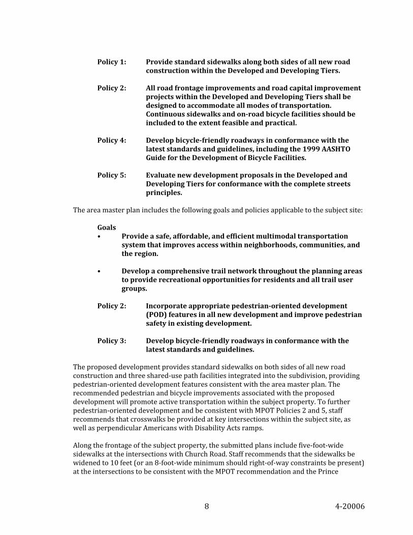
8 4-20006
Policy 1: Provide standard sidewalks along both sides of all new road
construction within the Developed and Developing Tiers. Policy 2: All road frontage improvements and road capital improvement
projects within the Developed and Developing Tiers shall be designed to accommodate all modes of transportation. Continuous sidewalks and on-road bicycle facilities should be included to the extent feasible and practical.
Policy 4: Develop bicycle-friendly roadways in conformance with the
latest standards and guidelines, including the 1999 AASHTO Guide for the Development of Bicycle Facilities.
Policy 5: Evaluate new development proposals in the Developed and
Developing Tiers for conformance with the complete streets principles.
The area master plan includes the following goals and policies applicable to the subject site:
Goals • Provide a safe, affordable, and efficient multimodal transportation
system that improves access within neighborhoods, communities, and the region.
• Develop a comprehensive trail network throughout the planning areas
to provide recreational opportunities for residents and all trail user groups.
Policy 2: Incorporate appropriate pedestrian-oriented development
(POD) features in all new development and improve pedestrian safety in existing development.
Policy 3: Develop bicycle-friendly roadways in conformance with the
latest standards and guidelines. The proposed development provides standard sidewalks on both sides of all new road construction and three shared-use path facilities integrated into the subdivision, providing pedestrian-oriented development features consistent with the area master plan. The recommended pedestrian and bicycle improvements associated with the proposed development will promote active transportation within the subject property. To further pedestrian-oriented development and be consistent with MPOT Policies 2 and 5, staff recommends that crosswalks be provided at key intersections within the subject site, as well as perpendicular Americans with Disability Acts ramps. Along the frontage of the subject property, the submitted plans include five-foot-wide sidewalks at the intersections with Church Road. Staff recommends that the sidewalks be widened to 10 feet (or an 8-foot-wide minimum should right-of-way constraints be present) at the intersections to be consistent with the MPOT recommendation and the Prince

9 4-20006
George’s County Department of Public Works and Transportation (DPW&T) standards for sidepaths that are not located in Plan 2035 centers. Moreover, staff recommends a standard sidewalk be provided along the subject site’s frontage of Church Road, consistent with Complete Streets principles and Policy 2 of the MPOT Complete Streets element. It should be noted that Church Road is a designated Scenic and Historic Roadway, which traditionally does not include sidewalks. However, DPW&T and DPIE can require sidewalks along scenic or historic roadways, as appropriate. While the frontage of the subject site is only a short segment of Church Road, sidewalks along this road can be part of a future larger sidewalk network for the area to support pedestrian traffic and safety. The submitted plans include a six-foot-wide shoulder to be provided along the subject site frontage for bicycle facilities, consistent with MPOT. Staff recommends that the shoulder shall have shared lane markings (sharrows) and appropriate bikeway signage. In addition, staff recommends a variety of bicycle facilities within the subject site to be consistent with Complete Streets Policies 2, 4, and 5. These bicycle facilities include bicycle parking at the proposed club house, and trail crossing signage and speed humps at the intersections of the roadway and the internal trail network.
7. Transportation—Transportation-related findings for adequacy are made for this
application, in accordance with the Subdivision Regulations, along with any needed determinations related to dedication, access, and general subdivision layout. The subject property is located within Transportation Service Area 2, as defined in Plan 2035. As such, the subject property is evaluated according to the following standards:
Links and Signalized Intersections: Level of Service (LOS) D, with signalized intersections operating at a critical lane volume of 1,450 or better. Mitigation per Section 24-124(a)(6) of the Subdivision Regulations, is permitted at signalized intersections within any tier subject to meeting the geographical criteria in the “Transportation Review Guidelines - Part 1- 2012” (Guidelines). Unsignalized Intersections: The procedure for unsignalized intersections is not a true test of adequacy, but rather an indicator that further operational studies need to be conducted. For two-way stop-controlled intersections, a three-part process is employed: (a) vehicle delay is computed in all movements using the Highway Capacity Manual (Transportation Research Board) procedure; (b) the maximum approach volume on the minor streets is computed if delay exceeds 50 seconds, (c) if delay exceeds 50 seconds and at least one approach volume exceeds 100, the critical lane volume is computed. For all-way stop-controlled intersections, a two-part process is employed: (a) vehicle delay is computed in all movements using the Highway Capacity Manual (Transportation Research Board) procedure; (b) if delay exceeds 50 seconds, the critical lane volume is computed.
10 4-20006
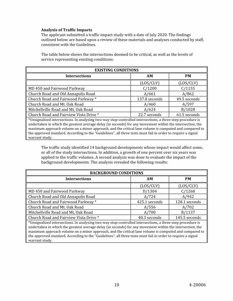
Analysis of Traffic Impacts The applicant submitted a traffic impact study with a date of July 2020. The findings outlined below are based upon a review of these materials and analyses conducted by staff, consistent with the Guidelines. The table below shows the intersections deemed to be critical, as well as the levels of service representing existing conditions:
EXISTING CONDITIONS
Intersections AM PM
(LOS/CLV) (LOS/CLV) MD 450 and Fairwood Parkway C/1200 C/1155 Church Road and Old Annapolis Road A/661 A/862 Church Road and Fairwood Parkway * 137.8 seconds 49.5 seconds Church Road and Mt. Oak Road A/460 A/597 Mitchellville Road and Mt, Oak Road A/624 B/1028 Church Road and Fairview Vista Drive * 22.7 seconds 61.5 seconds *Unsignalized intersections. In analyzing two-way stop-controlled intersections, a three-step procedure is undertaken in which the greatest average delay (in seconds) for any movement within the intersection, the maximum approach volume on a minor approach, and the critical lane volume is computed and compared to the approved standard. According to the “Guidelines”, all three tests must fail in order to require a signal warrant study.
The traffic study identified 14 background developments whose impact would affect some, or all of the study intersections. In addition, a growth of one percent over six years was applied to the traffic volumes. A second analysis was done to evaluate the impact of the background developments. The analysis revealed the following results:
BACKGROUND CONDITIONS
Intersections AM PM
(LOS/CLV) (LOS/CLV) MD 450 and Fairwood Parkway D/1304 C/1268 Church Road and Old Annapolis Road A/724 A/942 Church Road and Fairwood Parkway * 425.1 seconds 128.1 seconds Church Road and Mt. Oak Road A/556 A/702 Mitchellville Road and Mt, Oak Road A/700 B/1137 Church Road and Fairview Vista Drive * 40.3 seconds 145.5 seconds *Unsignalized intersections. In analyzing two-way stop-controlled intersections, a three-step procedure is undertaken in which the greatest average delay (in seconds) for any movement within the intersection, the maximum approach volume on a minor approach, and the critical lane volume is computed and compared to the approved standard. According to the “Guidelines”, all three tests must fail in order to require a signal warrant study.
11 4-20006
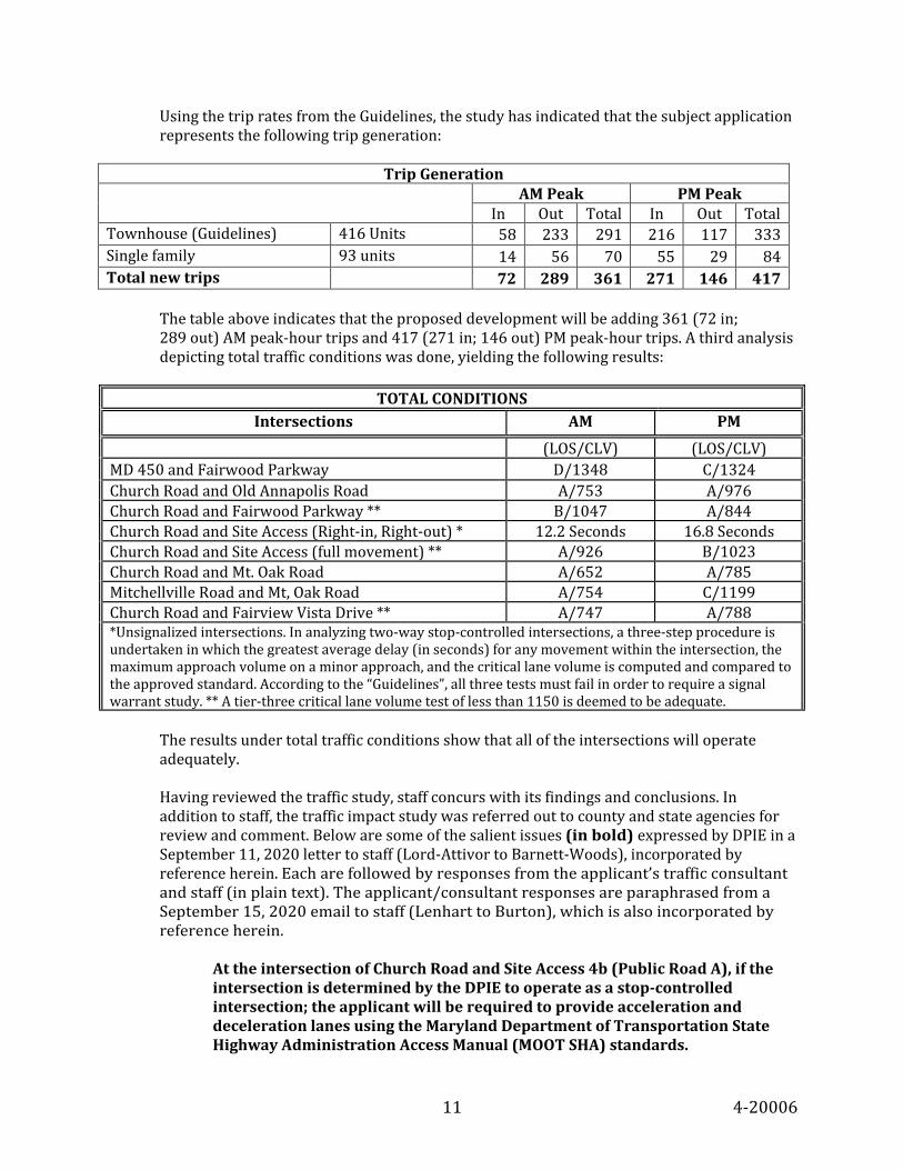
Using the trip rates from the Guidelines, the study has indicated that the subject application represents the following trip generation:
Trip Generation
AM Peak PM Peak In Out Total In Out Total
Townhouse (Guidelines) 416 Units 58 233 291 216 117 333 Single family 93 units 14 56 70 55 29 84 Total new trips 72 289 361 271 146 417
The table above indicates that the proposed development will be adding 361 (72 in; 289 out) AM peak-hour trips and 417 (271 in; 146 out) PM peak-hour trips. A third analysis depicting total traffic conditions was done, yielding the following results:
TOTAL CONDITIONS
Intersections AM PM (LOS/CLV) (LOS/CLV) MD 450 and Fairwood Parkway D/1348 C/1324 Church Road and Old Annapolis Road A/753 A/976 Church Road and Fairwood Parkway ** B/1047 A/844 Church Road and Site Access (Right-in, Right-out) * 12.2 Seconds 16.8 Seconds Church Road and Site Access (full movement) ** A/926 B/1023 Church Road and Mt. Oak Road A/652 A/785 Mitchellville Road and Mt, Oak Road A/754 C/1199 Church Road and Fairview Vista Drive ** A/747 A/788 *Unsignalized intersections. In analyzing two-way stop-controlled intersections, a three-step procedure is undertaken in which the greatest average delay (in seconds) for any movement within the intersection, the maximum approach volume on a minor approach, and the critical lane volume is computed and compared to the approved standard. According to the “Guidelines”, all three tests must fail in order to require a signal warrant study. ** A tier-three critical lane volume test of less than 1150 is deemed to be adequate.
The results under total traffic conditions show that all of the intersections will operate adequately. Having reviewed the traffic study, staff concurs with its findings and conclusions. In addition to staff, the traffic impact study was referred out to county and state agencies for review and comment. Below are some of the salient issues (in bold) expressed by DPIE in a September 11, 2020 letter to staff (Lord-Attivor to Barnett-Woods), incorporated by reference herein. Each are followed by responses from the applicant’s traffic consultant and staff (in plain text). The applicant/consultant responses are paraphrased from a September 15, 2020 email to staff (Lenhart to Burton), which is also incorporated by reference herein.
At the intersection of Church Road and Site Access 4b (Public Road A), if the intersection is determined by the DPIE to operate as a stop-controlled intersection; the applicant will be required to provide acceleration and deceleration lanes using the Maryland Department of Transportation State Highway Administration Access Manual (MOOT SHA) standards.

12 4-20006
Applicant Response: This is a permitting issue with the operating agency (not an adequacy requirement), and the applicant intends to work through these issues with DPIE. Further study may indicate that signalization will be warranted and will work with DPIE through the permitting process. Staff Response: Staff concurs with this explanation. At the intersection of Church Road and Site Access 4b (Public Road A), if the intersection is determined by the DPIE to operate as a stop-controlled intersection; the applicant will be required to provide a by-pass lane as opposed to the left turn lane showed on the site Development Concept Plan. Applicant Response: This is a permitting issue with the operating agency (not an adequacy requirement), and the applicant intends to work through these issues with DPIE. Further study may indicate that signalization will be warranted and will work with DPIE through the permitting process. Staff response: Staff concurs with this explanation. During the permitting stage, the applicant would be required to perform an operational analysis along Church Road. Applicant Response: This traffic impact study was conducted including all of the major intersections along the entire corridor of Church Road, including intersections that were not required in the scoping process. These additional intersections were provided for informational purposes because the applicant understood that there would be a lot of questions in the community and the applicant wanted to provide as much information as possible to assuage concerns. The traffic impact study shows that all of the intersections along Church Road pass the adequacy requirements set forth in the County's Subdivision Regulations (and by association M-NCPPC's Transportation Guidelines), and the applicant believes that he/she has met requirements of the Adequate Public Facilities Ordinance in the evaluation of off-site improvements. Staff Response: While staff is in general agreement with the response provided by the traffic consultant, during the permitting phase of any development, the permitting agency’s authority is often independent of the Planning Board. Consequently, any request from DPIE should be resolved through direct negotiation between DPIE and the applicant.
Staff is also in receipt of a September 24, 2020 letter from the Maryland State Highway Administration (Rigby to Lenhart), incorporated by reference herein. Most of the reviewers agreed with the traffic impact study conclusion. Other comments were provided, but nothing staff deemed substantive that would alter the traffic impact study conclusion.

13 4-20006
Master Plan Roads The property is in an area where the development policies are governed by the area master plan, as well as the MPOT. The subject property currently fronts on Church Road, which is recommended in both master plans to be upgraded to a collector (C-300). While C-300 is proposed with a variable width right-of-way, the northeastern section of the property will need additional dedication. This additional right-of-way dedication is accurately reflected on the plan. Based on the preceding findings, adequate transportation facilities will exist to serve the proposed subdivision, as required, in accordance with Section 24-124 of the Subdivision Regulations, with the recommended conditions.
8. Site Access—The site design features two entrance points from Church Road and a mixture
of public and private roads to serve the homes in the development. The public roads serve the single-family detached homes in the development and a few townhomes near the northern site entrance. Private roads serve the rest of the townhomes. Private alleys are also provided for rear access to townhomes in Blocks A, C, F, K, and M. The overall design of the road and alley network is deemed acceptable. Pursuant to Section 24-128(b)(19), private streets and alleys may be approved by the Planning Board to serve the townhouse units. This section does not allow private streets and alleys to serve the single-family detached units. All of the single-family detached units in the subdivision are served by public streets. Private Access Easements The site design features two access easements for properties located off-site. The first serves a lot known as Lot 1 of Rodenhauser’s Subdivision. Though this lot has frontage on Church Road, the driveway for the house is on the Freeway Airport property. The existing 25-foot-wide easement is just south of the lot and covers most of the driveway. The applicant is proposing a 1,462-square-foot addition to the easement in order to ensure the driveway is fully covered. The second access easement serves an acreage parcel known as Parcel 72, which abuts the Freeway Airport property on the southwest. There is an existing access easement which starts at the driveway described above and follows a meandering path south through the airport property to this parcel’s eastern edge. The applicant proposes to expunge this easement and replace it with a new one with formalized boundaries. The new easement will start at the intersections of Public Roads B and A and follow the airport property’s eastern edge south to the eastern edge of Parcel 72. Both the existing easement and its proposed replacement have a 55-foot width. Lot 1 of Rodenhauser’s Subdivision has frontage on Church Road, so if in the future it is necessary to provide its access on-site (instead of on the subject property), the access point could be moved. Parcel 72, however, has no road frontage, and so the easement leading to it is considered necessary to ensure continued access to the property. Should either adjoining property be subject to a future PPS, it will be evaluated at that time to ensure the access provided to it is adequate for the proposed development, in conformance with Division 4 of the Subdivision Regulations.

14 4-20006
9. Schools—This PPS has been reviewed for impact on school facilities, in accordance with Section 24-122.02 of the Subdivision Regulations and Prince George’s County Council Resolution CR-23-2001. The subject property is located within Cluster 4, which is located outside the I-495 Capital Beltway. Staff has conducted an analysis and the results are as follows:
Impact on Affected Public School Clusters by Dwelling Units
Single Family Attached/Detached Dwelling Units Affected School Clusters Number
Elementary School Cluster 4
Middle School Cluster 4
High School Cluster 4
Total Dwelling Units 509 509 509
Townhouse (TH) 416 416 416
TH Pupil Yield Factor (PYF) 0.114 0.073 0.091
# of TH * PYF 47.424 30.368 37.856
Single-Family Detached (SFD) 93 93 93
SFD Pupil Yield Factor (PYF) .158 0.098 0.127
# of SFD * PYF 14.694 9.114 11.811 Total Future Subdivision Enrollment (# of TH * PYF) + (# of SFD * PYF)
62 39 50
Adjusted Enrollment in 2019 12,927 9,220 7,782
Total Future Enrollment 12,989 9,259 7,832
State Rated Capacity 15,769 9,763 8,829
Percent Capacity 82% 95% 89% Section 10-192.01 establishes school surcharges and an annual adjustment for inflation, unrelated to the provision of Subtitle 24. The current amount is $9,741 per dwelling if a building is located between I-495 and the District of Columbia; $9,741 per dwelling if the building is included within a basic plan or conceptual site plan that abuts an existing, or planned mass transit rail station site operated by the Washington Metropolitan Area Transit Authority; or $16,698 per dwelling for all other buildings. This project is outside of the I-495 Capital Beltway; thus, the surcharge fee is $16,698 per dwelling unit. This fee is to be paid to DPIE at the time of issuance of each building permit.
10. Public Facilities—In accordance with Section 24-122.01 of the Subdivision Regulations,
water and sewerage, police, and fire and rescue facilities are found to be adequate to serve the subject site, as outlined in a memorandum from the Special Projects Section dated September 30, 2020 (Thompson to Diaz-Campbell), provided in the backup of this technical staff report and incorporated by reference herein.

15 4-20006
11. Use Conversion—The total development included in this PPS is for 416 single-family attached dwellings and 93 single-family detached dwellings in the R-A Zone. If a substantial revision to the mix of uses on the subject property is proposed, including any non-residential development, that affects Subtitle 24 adequacy findings, as set forth in the resolution of approval and reflected on the PPS, that revision of the mix of uses shall require approval of a new PPS, prior to approval of any building permits.
12. Public Utility Easement (PUE)—In accordance with Section 24-122(a) of the Subdivision
Regulations, when utility easements are required by a public company, the subdivider shall include the following statement in the dedication documents recorded on the final plat:
“Utility easements are granted pursuant to the declaration recorded among the County Land Records in Liber 3703 at Folio 748.”
The standard requirement for PUEs is 10 feet wide along both sides of all public rights-of-way. In addition, Section 24-128(b)(12) of the Subdivision Regulations requires a PUE along one side of all private streets. The subject site abuts the existing public rights-of-way of US 50 to the north and Church Road to the east. New public and private streets are proposed internal to the development. The PPS demonstrates the required PUEs will be provided along all existing and proposed streets, public and private.
13. Historic—The subject property does not contain and is not adjacent to any Prince George's
County historic sites or resources. A Phase I archeological survey was recommended by staff on areas of the site not previously disturbed by construction of the existing airport. In February 2020, the applicant's archeological consultant initiated the fieldwork with a pedestrian survey to identify any surface features or modern disturbance. Areas with a high probability of containing archeological resources were identified for shovel testing. Four areas within the larger 130-acre parcel were identified as high probability areas for containing prehistoric or historic resources. These areas were designated the "Northern," "Northeastern," "Eastern," and "Western" Test Areas. A total of 196 shovel test pits were excavated within approximately 10.2 acres of the entire 130-acre parcel. One prehistoric quartz biface, designated as the Flyover Isolate, was recovered from the shovel test pit survey. This quartz fragment had no diagnostic features to assist in designating a timeframe for its production or use. Given the limited information that the recovered isolated fragment could provide, and the lack of any other cultural material in the vicinity, an archeological site was not defined. No cultural material was recovered from any of the other shovel test pits excavated across the property. Therefore, no further work was recommended on the Freeway Airport property. Staff concurs that no additional archeological investigations are warranted.
14. Environmental—The subject PPS and a TCP1 were accepted on August 20, 2020. Comments
were provided in a SDRC meeting on September 4, 2020. Revised information was received on September 25, 2020. The following applications and associated plans for the subject site applicable to this case were previously reviewed:

16 4-20006
Review Case Number
Associated Tree Conservation Plan
Number
Authority Status Action Date Resolution Number
SE-4375 Exempt per E-091-99
Zoning Hearing Examiner
Approved 6/22/2000 00-74
NRI-029-2020 N/A Planning Director
Approved 4/27/2020 N/A
NRI-029-2020-01 N/A Planning Director
Approved 9/24/2020 N/A
4-20006 TCP1-016-2020 Planning Board
Pending N/A N/A
Grandfathering The project is subject to the environmental regulations contained in Subtitles 24, 25, and 27 that came into effect on September 1, 2010 because the application is for a new PPS. Site Description The 131.50-acre property in the R-A zone is in the southwest quadrant of US 50 and Church Road, and currently used as an airport. A review of available information, and as shown on the approved natural resource inventory (NRI), indicates that 100-year floodplain, wetlands, streams, and steep slopes are found to occur on the property. The site does not contain any Wetlands of Special State Concern. The site is in the Northeast Branch watershed, as identified by the County’s Department of the Environment (DOE), and within the Western Branch watershed of the Patuxent River basin, as identified by the Maryland Department of Natural Resources (DNR). The Northeast Branch is identified in the area master plan as a secondary corridor. The Western Branch is identified by DNR as a Stronghold watershed. The on-site stream is not a Tier II water, nor is it within a Tier II catchment. The predominant soils found to occur according to the US Department of Agriculture (USDA) Natural Resource Conservation Service (NRCS) Web Soil Survey (WSS) include the Adelphia-Holmdel, Annapolis fine sandy loam, Collington-Wist, Donlonton fine sandy loam, Shrewsbury loam, Udorthents highway and loamy, and Widewater and Issue soils. According to available information, Marlboro and Christiana clays are not found to occur on this property. According to available information from the Maryland Department of Natural Resources Natural Heritage Program (DNR NHP), rare, threatened and endangered species are not found to occur on-site. The site fronts on Church Road, a MPOT designated collector roadway and a scenic and historic road, and fronts on US 50, a MPOT designated Freeway (F-4). US 50 will be regulated for noise with respect to residential uses. Church Road is an historic roadway in the vicinity of this property. According to the approved Countywide Green Infrastructure Plan of the 2017 Approved Prince George's County Resource Conservation Plan: A Countywide Functional Master Plan, the site contains regulated areas and evaluation areas. The site is located within the Established Communities of the Growth Policy Map and Environmental Strategy Area 2 (formerly the Developing Tier) of the Regulated Environmental Protection Areas Map, as designated by Plan 2035.
17 4-20006
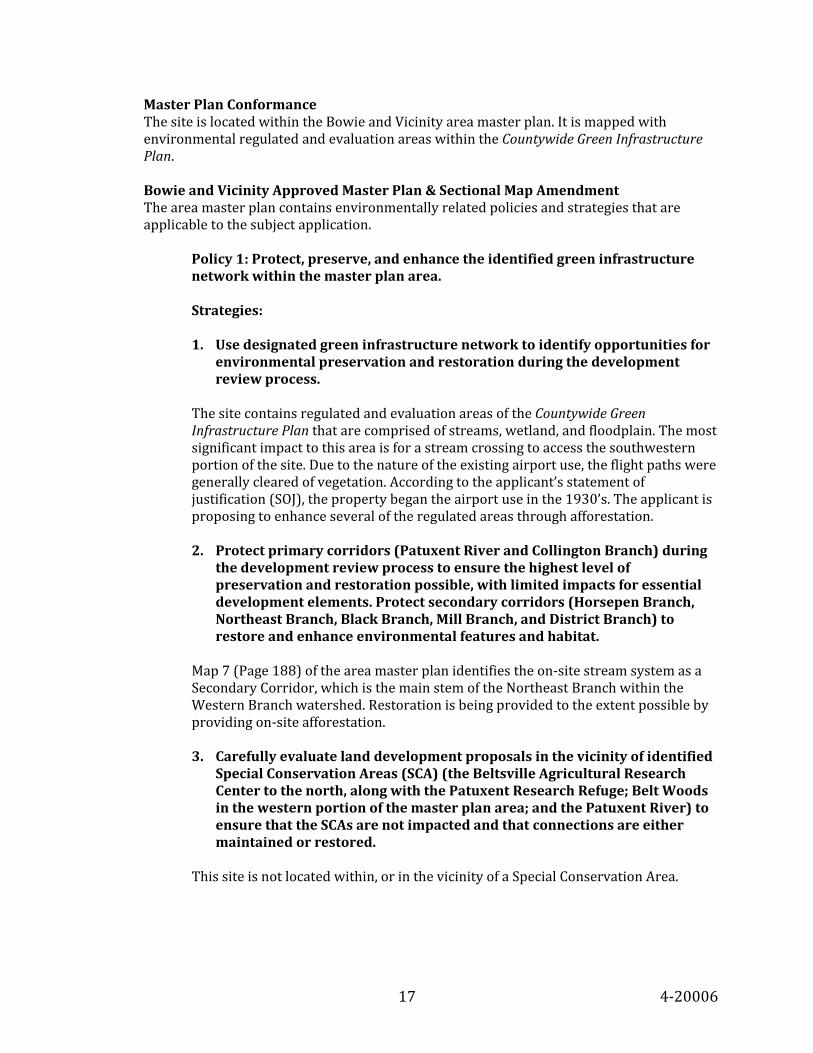
Master Plan Conformance The site is located within the Bowie and Vicinity area master plan. It is mapped with environmental regulated and evaluation areas within the Countywide Green Infrastructure Plan. Bowie and Vicinity Approved Master Plan & Sectional Map Amendment The area master plan contains environmentally related policies and strategies that are applicable to the subject application.
Policy 1: Protect, preserve, and enhance the identified green infrastructure network within the master plan area. Strategies: 1. Use designated green infrastructure network to identify opportunities for
environmental preservation and restoration during the development review process.
The site contains regulated and evaluation areas of the Countywide Green Infrastructure Plan that are comprised of streams, wetland, and floodplain. The most significant impact to this area is for a stream crossing to access the southwestern portion of the site. Due to the nature of the existing airport use, the flight paths were generally cleared of vegetation. According to the applicant’s statement of justification (SOJ), the property began the airport use in the 1930’s. The applicant is proposing to enhance several of the regulated areas through afforestation. 2. Protect primary corridors (Patuxent River and Collington Branch) during
the development review process to ensure the highest level of preservation and restoration possible, with limited impacts for essential development elements. Protect secondary corridors (Horsepen Branch, Northeast Branch, Black Branch, Mill Branch, and District Branch) to restore and enhance environmental features and habitat.
Map 7 (Page 188) of the area master plan identifies the on-site stream system as a Secondary Corridor, which is the main stem of the Northeast Branch within the Western Branch watershed. Restoration is being provided to the extent possible by providing on-site afforestation. 3. Carefully evaluate land development proposals in the vicinity of identified
Special Conservation Areas (SCA) (the Beltsville Agricultural Research Center to the north, along with the Patuxent Research Refuge; Belt Woods in the western portion of the master plan area; and the Patuxent River) to ensure that the SCAs are not impacted and that connections are either maintained or restored.
This site is not located within, or in the vicinity of a Special Conservation Area.

18 4-20006
4. Target public land acquisition programs within the designated green infrastructure network in order to preserve, enhance or restore essential features and special habitat areas.
The site contains an extensive stream valley that connects to regulated areas within privately owned Parcel 72, then flows further south to a large tract of undeveloped land owned by M-NCPPC, and then further to land minimally developed with ballfields as the Prince George’s County Boys and Girls Club fronting on Woodmore Road. It is expected that the environmental area of the subject property will be part of a homeowners association. These tracts of land, publicly and privately owned, are within regulated environmental areas and should, outside of necessary permanent impacts, be the subject of preservation, restoration, and enhancement, and will be placed in a conservation easement for long term protection. Policy 2: Restore and enhance water quality in areas that have been degraded and preserve water quality in areas not degraded. Strategies: 1. Implement the strategies contained in the Western Branch Watershed
Restoration Action Strategy (WRAS). 2. Add identified mitigation strategies from the Western Branch WRAS to the
countywide database of mitigation sites. 3. Encourage the location of necessary off-site mitigation for wetlands,
streams, and woodlands within sites identified in the Western Branch WRAS and within sensitive areas that are not currently wooded.
The project area is within the Western Branch Watershed Restoration Action Strategy (WRAS) area. The on-site streams are headwaters of the Northeast Branch. The final WRAS report for Western Branch, prepared by DNR and the City of Bowie, was issued in 2004 and presented the findings of a stream corridor assessment and recommended implementation strategies for restoring or enhancing problematic areas. The area master plan cites policies and strategies to protect these corridors, and to restore and enhance the water quality implementing the mitigation strategies of the WRAS. One of the areas targeted in the WRAS is stream buffers, including a focus on the importance of protecting the headwater stream buffers. The site’s location within the WRAS and the environmental policies and strategies of the area master plan along with the Countywide Green Infrastructure Plan focus on the preservation and restoration of stream buffers. In accordance with Section 25-122(a)(6) of the WCO, off-site woodland conservation credits are required to be considered as follows: “…within the same eight-digit sub-watershed, within the same watershed, within the same river basin, within the same growth policy tier, or within Prince George's County. Applicants shall demonstrate to the Planning Director or designee due diligence in seeking out opportunities for off-site woodland conservation locations following these priorities. All woodland conservation is required to be met within Prince George's County.” However, because this site is in a master plan identified WRAS area, the
19 4-20006
purchase of off-site woodland conservation credits shall first be sought within tree banks located in the WRAS area. 4. Ensure the use of low impact-development techniques to the extent
possible during the development process. The proposal has not yet received SWM concept approval. The submitted unapproved concept plan shows use of numerous micro-bioretention facilities as well as submerged gravel wetlands to meet the current requirements of Environmental Site Design to the Maximum Extent Practicable (ESD to the MEP). In addition to these low impact stormwater controls, the plan also proposes road crossings at Public Road A and Private Road K, with proposed reinforced concrete pipes for the stream and floodplain crossing with associated grading. Through correspondence with DPIE, the proposed crossing was preferred. 5. During the development review process evaluate streams that are to
receive stormwater discharge for water quality and stream stability. Unstable streams and streams with degraded water quality should be restored, and this mitigation should be considered as part of the stormwater management requirements.
Proposed stream impacts, mitigation, and restoration are discussed in the Environmental Review section below. 6. Encourage the use of conservation landscaping techniques that reduce
water consumption and the need for fertilizers or chemical applications. Woodland planting will consist of the use of native species. Species selection should be based on ability to reduce water consumption and the need for fertilizers or chemical applications. 7. Minimize the number of parking spaces and provide for alternative
parking methods that reduce the area of impervious surfaces. The plan proposes surface parking for single family attached and single family detached residential uses, as well as private garages for both single family attached and detached lots. 8. Reduce the area of impervious surfaces during redevelopment projects. Only a small portion of the 131.50-acre property is developed as a small airport. The remainder of the property has never been developed although most of it has been actively mowed in the past. An increase in impervious surface is expected due to the nature of the project, consisting of single family attached and detached units; however, implementation of the current SWM regulations will address water quality and quantity controls.

20 4-20006
Policy 3: Protect and enhance tree cover within the master plan area. Strategies: 1. Encourage the planting of trees in developed areas and established
communities to increase the overall tree cover. 2. Provide a minimum of ten percent tree cover on all development projects.
This can be met through the provision of preserved areas or landscape trees.
3. Establish street trees in planting strips designed to promote long-term
growth and increase tree cover. 4. Establish tree planting adjacent to and within areas of impervious
surfaces. Ensure an even distribution of tree planting to provide shade to the maximum amount of impervious areas possible.
This proposal is for a new development. Conformance with the current WCO regulations is required and detailed discussion of technical conformance is included in the Environmental Review section below. The TCP1 shows that the site will be approximately 29 percent forested as a result of this project, which exceeds the area master plan recommended 10 percent tree canopy cover. Policy 4: Reduce overall energy consumption and implement more environmentally sensitive building techniques. Strategies: 1. Encourage the use of green building techniques that reduce energy
consumption. New building designs should strive to incorporate the latest environmental technologies in project buildings and site design. As redevelopment occurs, the existing buildings should be reused and redesigned to incorporate energy and building material efficiencies.
2. Encourage the use of alternative energy sources such as solar, wind, and
hydrogen power. Provide public examples of uses of alternative energy sources.
The use of green building techniques and energy conservation techniques is encouraged as appropriate.

21 4-20006
Policy 5: Reduce light pollution and intrusion into residential, rural, and environmentally sensitive areas. Strategies: 1. Encourage the use of alternative lighting technologies for athletic fields,
shopping centers, gas stations, and car lots so that light intrusion on adjacent properties is minimized. Limit the total amount of light output from these uses.
2. Require the use of full cut-off optic light fixtures for all proposed uses. 3. Discourage the use of streetlights and entrance lighting except where
warranted by safety concerns. The minimization of light intrusion from this site into the primary management area (PMA) and adjacent residential communities should be addressed. The use of alternative lighting technologies and the limiting of total light output should be demonstrated. Full cut-off optic light fixtures should be used. The lighting provided will be evaluated at the time of DSP. Policy 6: Reduce adverse noise impacts to meet State of Maryland noise standards. Strategies: 1. Evaluate development proposals using Phase I noise studies and noise
models. 2. Provide adequate setbacks for projects located adjacent to existing and
proposed noise generators. 3. Provide the use of approved attenuation measures when noise issues are
identified. The site fronts on US 50, which is a designated freeway, and Church Road, which is a designated collector road. US 50 generates sufficient traffic to make noise impacts a concern. In addition, since the property is Freeway Airport, the entirety of the site is within APAs associated with the airport use. The airport use will discontinue with the development of the site. A noise study has been submitted. Details of the noise study as well as recommendations are addressed in the Noise section of this technical staff report. Policy 7: Protect wellhead areas of public wells. Strategies: 1. Retain land uses that currently exist within the wellhead areas of existing
public wells.

22 4-20006
2. Continue monitoring water quality. 3. Consider the development of alternative public water provision strategies,
such as public water connections, to eventually eliminate public wells. This site is not located within a wellhead protection area.
Conformance with the 2017 Green Infrastructure (GI) Plan The site contains regulated and evaluation areas of the 2017 Green Infrastructure Plan. This area is comprised of a stream system with floodplain and an extensive wetland network. The area has previously been significantly impacted due to clearing for the airport. The current GI plan does not map Network Gap Areas as the previous 2005 plan did. Instead, it allows for the opportunity to identify Network Gaps at a smaller scale through the land development process. Based on an evaluation of the site and the adjacent areas, with the exception of the abutting Parcel 72 which is privately owned, the stream valley to the south is owned by M-NCPPC and Waterford Mill Homeowner’s Association. The regulated area is protected by a platted conservation easement on the Waterford Mill plat. South of the subject site, fronting on Woodmore Road is a park owned by Prince George’s County Boys and Girls Club Inc., which is improved with ballfields. The on-site stream system where these off-site streams meet, as well as its floodplain, present an opportunity to meet the environmental policies and strategies of the area master plan, and the Green Infrastructure Plan, by establishing a contiguous ecological connection, limiting unnecessary disturbance, establishing woodlands, preserve and enhance existing habitat, and possibly restoring parts of the steam valley naturally. Most of the PMA previously cleared is proposed to be afforested and placed in a protective conservation easement. Environmental Review Natural Resource Inventory Plan A signed Natural Resource Inventory (NRI-029-2020) and the proposed 01 revision were submitted with the application. The site contains 100-year floodplain, wetlands, streams, and steep slopes that comprise the PMA. A wetland delineation was updated with the -01 revision to the NRI and indicates the presence of two forest stands labeled as stands 1 and 2, and 41 specimen trees identified on the site. The TCP1 and the PPS show all required information correctly in conformance with the NRI. No additional information is required regarding the NRI. Woodland Conservation This project is subject to the WCO and the Environmental Technical Manual. TCP1-016-2020 has been submitted with the subject application and requires minor revisions to be found in conformance with the WCO. The woodland conservation threshold for this 131.50-acre property is 50 percent of the net tract area, or 60.17 acres; however, because this site contains very little existing net tract woodland, the 20-percent afforestation threshold becomes part of the planting requirement for the sites overall woodland conservation required. The total woodland conservation

23 4-20006
requirement based on the amount of clearing proposed is 38.19 acres. This requirement is proposed to be satisfied with 7.25 acres of on-site preservation, 21.74 acres of on-site afforestation; the remainder of the requirement (9.20 acres) is proposed to be met with off-site woodland conservation credits. Technical revisions to the TCP1 are required and included in the recommended conditions of approval listed at the end of this technical staff report. Specimen Trees Tree conservation plans are required to meet all of the requirements of Subtitle 25, Division 2, which includes the preservation of specimen trees, Section 25-122(b)(1)(G). Every effort should be made to preserve the trees in place, considering the different species’ ability to withstand construction disturbance (refer to the Construction Tolerance Chart in the Environmental Technical Manual for guidance on each species’ ability to tolerate root zone disturbances). If after careful consideration has been given to the preservation of the specimen trees there remains a need to remove any of the specimen trees, a variance from Section 25-122(b)(1)(G) is required. Applicants can request a variance from the provisions of Division 2 of Subtitle 25 (WCO) provided all of the required findings in Section 25-119(d) can be met. An application for a variance must be accompanied by a Letter of Justification stating the reasons for the request and how the request meets each of the required findings. A Subtitle 25 variance application and a SOJ in support of a variance dated August 17, 2020 were submitted. The SOJ requests removal of five (5) of the existing forty-one (41) specimen trees located on-site. Specifically, the applicant seeks to remove trees 4, 5, 27, 31, and 36. The TCP1 and specimen tree removal exhibit show the location of the trees proposed for removal. Specimen trees 4, 5, and 27, are in poor condition. Specimen trees 31and 36 are in good condition. Specimen trees 27 and 31 are located within the limits of disturbance of the culvert crossing to access the southern pod of proposed development. Specimen trees 4 and 5 are located adjacent to an existing building that is proposed to be razed. Specimen tree 36 is proposed for removal due to grading associated with a retaining wall proposed to reduce PMA impacts. Staff supports the removal of the 5 specimen trees requested by the applicant based on the findings below. (A) Special conditions peculiar to the property have caused the unwarranted
hardship. The property is 131.50 acres and contains approximately 25.26 acres of PMA comprised of streams, wetlands, floodplain, and associated buffers. This represents approximately 19.21 percent of the overall site area. These existing conditions are peculiar to the property. Specimen trees have been identified in both the upland and lowland/ PMA areas of the site. The applicant is proposing to remove the specimen trees surrounding existing buildings to be removed, along the limits of disturbance of the proposed culvert, and for a retaining wall installation. To further restrict development of the non-wooded upland areas of the site would cause unwarranted hardship.
24 4-20006
(B) Enforcement of these rules will deprive the applicant of rights commonly
enjoyed by others in similar areas. The proposed residential community includes housing options that align with the uses permitted in the R-A zone as well as the vision for such zones as described in the area master plan. Based on the unique characteristics for the property, enforcement of these rules would deprive the applicant of the right to develop the property in a similar manner to other properties zoned R-A in the area.
(C) Granting the variance will not confer on the applicant a special privilege that
would be denied to other applicants If other constrained properties encounter trees in similar locations on a site, the same considerations would be provided during the review of the required variance application.
(D) The request is not based on conditions or circumstances which are the result
of actions by the applicant The existing site conditions or circumstances, including the location of the specimen trees, are not the result of actions by the applicant.
(E) The request does not arise from a condition relating to land or building use,
either permitted or nonconforming, on a neighboring property The request to remove the trees does not arise from any condition on a neighboring property.
(F) Granting of the variance will not adversely affect water quality
All proposed land development activities will require sediment control and SWM measures to be reviewed and approved by the County.
Staff finds that the required findings of Section 25-119(d) have been adequately addressed for the removal of specimen trees 4, 5, 27, 31, and 36. Regulated Environmental Features This site contains regulated environmental features that are required to be preserved and/or restored to the fullest extent possible under Section 24-130(b)(5) of the Subdivision Regulations. The on-site regulated environmental features include streams, stream buffers, wetlands, wetland buffers, 100-year floodplain, and steep slopes. Section 24-130(b)(5) states: “Where a property is located outside the Chesapeake Bay Critical Areas Overlay Zones the preliminary plan and all plans associated with the subject application shall demonstrate the preservation and/or restoration of regulated environmental features in a natural state to the fullest extent possible consistent with the guidance provided by the Environmental Technical Manual established by Subtitle 25. Any lot with an impact shall demonstrate sufficient net lot area where a net lot area is required pursuant to Subtitle 27, for the reasonable development of the lot outside the regulated
25 4-20006
feature. All regulated environmental features shall be placed in a conservation easement and depicted on the final plat.” Impacts to the regulated environmental features should be limited to those that are necessary for the development of the property. Necessary impacts are those that are directly attributable to infrastructure required for the reasonable use and orderly and efficient development of the subject property or are those that are required by County Code for reasons of health, safety, or welfare. Necessary impacts include, but are not limited to, adequate sanitary sewerage lines and water lines, road crossings for required street connections, and outfalls for SWM facilities. Road crossings of streams and/or wetlands may be appropriate if placed at the location of an existing crossing or at the point of least impact to the regulated environmental features. SWM outfalls may also be considered necessary impacts if the site has been designed to place the outfall at a point of least impact. The types of impacts that can be avoided include those for site grading, building placement, parking, SWM facilities (not including outfalls), and road crossings where reasonable alternatives exist. The cumulative impacts for the development of a property should be the fewest necessary and sufficient to reasonably develop the site in conformance with County Code. A letter of justification was received September 24, 2020 for the proposed impacts. The letter is not dated, provided on letterhead, or signed. The impact areas must also be provided to the hundredth of an acre. All references to the application as a DSP must be revised to refer to the current PPS application. Prior to signature approval of the PPS, the applicant must provide a SOJ for the impacts which is on letterhead, signed by the preparer, dated, rounds all impact to the hundredth of an acre, and replaces all reference to the application as a DSP with reference to the current PPS application. The PPS proposes impacts to the PMA. The proposed impacts are to demolish existing pavement and structures, roadway crossing, stormdrain outfalls, and to validate two areas of impact created by a deeded access easement for adjoining Parcel 72. The proposed impacts total 2.06 acres. The current letter of justification and associated exhibit reflect ten (10) proposed impacts to regulated environmental features associated with the proposed redevelopment totaling approximately 2.06 acres. The SOJ states that all impacts are permanent; however, impacts 1 and 4 are for the demolition of an existing building and an existing driveway, and show planting to mitigate in these areas. This is considered a temporary impact. The SOJ needs to be updated to reflect impacts 1 and 4 as temporary. The proposed PMA impacts are considered necessary to the orderly development of the subject property. These impacts cannot be avoided because they are required by other provisions of the county and state codes. The plan shows the preservation, restoration, and enhancement, of the remaining areas of PMA.
Impacts 1 and 4 – Demolition of Existing Structures and Pavement Impacts I and 4 are for the demolition of existing structures and pavement. The total of these impacts is 0.21 acre. Impact 1 is for the demolition of an existing building located in an isolated wetland area and PMA. The structure was relevant to the airport use and will no longer be needed for the residential community. Impact 4 is for the demolition of an existing driveway that is for an existing house on the property that will be razed. In both impact areas, the applicant is proposing

26 4-20006
demolishing the existing structure and pavement and afforesting the extent of the PMA. The result is these will be temporary impacts and the PMA areas will be restored to their natural state. Impacts 2 and 5 – Road and Utility Crossings These impacts total 1.17 acres and are for the installation of a road crossing with a co-located water line and sewer connections. Impact 2 is for Public Road A, which is aligned at Church Road across from the existing driveway for a M-NCPPC owned property. Waterline and sewer utilities will be co-located with the road crossing. Using the minimum centerline radius requirements, the proposed road turns south, resulting in 0.450 acre of stream and PMA impact. This impact was limited as much as possible, affecting the tip of this headwater stream. It was noted by the applicant that this area is currently impacted by the existing airport runway and an existing building to be razed. Although the impact to construct the road would be permanent, the disturbance to remove the building would be considered temporary as the applicant is proposing to afforest the area to return it to a natural state. Impact 5 is in the southwestern portion of the site and is a crossing for proposed Private Road K, along with waterline and sewer utilities. This portion of the site cannot be accessed without crossing the PMA. The applicant located the crossing at the westernmost point, where the PMA is the narrowest, and designed the road, culvert, temporary bypass channels for the culvert and the water and sewer mains to result in the smallest impact. The applicant notes that the sewer line is planned around the culvert due to DPIE’s requirements. This option proposes to redirect the existing stream permanently to allow a crossing design that is perpendicular to the stream, as required by SWM regulations. Impacts 3, 6, 7, and 9 – Stormdrain outfalls These impacts total 0.32 acre. The stormdrain outfalls meet best management practices for discharging water back into the stream while limiting erosion at the discharge points. At the request of staff, the applicant redesigned Impact 3 to outfall below a delineated wetland adjacent to the stream. The stormdrain outfalls are required by County code. Impacts 8 and 10 – Access Easement These impacts total 0.37 acre and is needed for validating the impacts for an existing ingress and egress easement serving the Flick property (Parcel 72) to the south. The deeded “Declaration of Easements and Covenants” (Liber 8602 folio 88) gives no metes and bounds description for access, but grants an easement “not to exceed 35 feet, over reasonably passable terrain for ingress and egress by both pedestrian as well as vehicular traffic, from Church Road to the property herewith conveyed, over land retained by the grantors as well as an easement over and area of reasonable width, not to exceed ten feet, on either side of said ingress and egress area, for purposes of performing necessary maintenance on the roadway established.” With the development of 4-20006, the applicant intends to provide a modified easement of the same width (55 feet) utilizing the proposed road system, resulting in minimal impacts to the PMA. Impact 8 starts where the access drive will leave Public Road A, to the west of Lot 26, Block D, and extends to the point where the existing access driveway crosses the PMA (0.28 acre). Since the existing

27 4-20006
driveway meanders off onto an adjoining property (Lot 11 of Kings Isle Estates), the access easement will be rerouted to follow the property line to join back to the existing driveway. At Impact 10, the existing access easement crosses the PMA at the narrowest point (0.09 acre) to enter the Flick property. Both areas of impact are existing conditions, and are dirt roads, not paved.
Based on the level of design information available at the present time, staff finds that the regulated environmental features on the subject property have been preserved and/or restored to the fullest extent possible, based on the limits of disturbance shown on the applicant’s Environmental Impacts Exhibit (incorporated by reference herein) and the conditions recommended in this technical staff report. The proposed impacts are to demolish existing pavement and structures, roadway crossing, stormdrain outfalls, and to validate two areas of impact created by a deeded access easement for adjoining Parcel 72. Erosion and Sediment Control The County requires the approval of an Erosion and Sediment Control Plan. the tree conservation plan must reflect the ultimate limits of disturbance not only for installation of permanent site infrastructure, but also for the installation of all temporary infrastructure including Erosion and Sediment Control measures. A copy of the Erosion and Sediment Control Technical Plan must be submitted so that the ultimate Limits of Disturbance (LOD) for the project can be verified and shown on the TCP1.
15. Urban Design—The review of the subject application is evaluated for conformance to the
Zoning Ordinance as follows: Council Bill CB-17-2019 CB-17-2019 added Footnote 136 to the Residential Use Table included in Section 27-441. This footnote allows for single-family attached and detached development in the R-A Zone under certain circumstances, including specific location, acreage, and development criteria. The applicant’s Limits of CB-17-2019 Exhibit (incorporated by reference herein) demonstrates that the site conforms with the location and acreage requirements. In addition, the PPS proposes a development density of 4.23 dwelling units per acre, which is below the maximum limit of 4.5 dwelling units per acre established by the footnote. Footnote 136 also requires the approval of a PPS and DSP for the development proposal. Part b of the footnote provides development criteria, including most regulations for the R-T Zone, and rescinding most R-A Zone requirements. Several R-T Zone requirements are applicable to the PPS, including minimum lot sizes, and number of townhouse units per each building stick. The PPS and exhibits provided by the applicant demonstrate conformance with these criteria by showing townhouse and single-family lots sized above the minimum criteria, and by limiting the number of townhouse building sticks with no less than six, but no more than eight units, to ten percent of the total number of the townhouse buildings. Of the 80 townhouse building sticks, a total of eight will include more than six units (three buildings with eight units and five buildings with seven units). The overall site layout and basic spatial arrangements of the development shown in the PPS conform with the design-related criteria of Footnote 136. DSP review will be required for the proposed development.
28 4-20006
One design issue noted that should be addressed is a deficiency of 17 parking spaces provided for townhouses, as shown in the applicant’s Freeway Airport Parking Exhibit. The parking table provided shows 849 spaces required, and 832 provided. The overall parking requirements of the site appear to be met and conformance with the parking requirements will be further evaluated at time of DSP. Conformance with the Tree Canopy Coverage Ordinance In accordance with Section 25-128 of the Zoning Ordinance, properties in the R-A Zone are exempt from the tree canopy coverage requirements. Conformance with the Requirements of the Prince George’s County Landscape Manual The proposed residential subdivision will be subject to the requirements of Sections 4.1, 4.2, 4.3, 4.4, 4.6, 4.7, 4.9, and 4.10 of the 2010 Prince George’s County Landscape Manual (Landscape Manual). Conformance with these requirements will be reviewed at DSP. In general, the site layout provided in the PPS appears to provide adequate space for landscaped areas required by the Landscape Manual. Other Urban Design Issues Staff has concerns about locating trails in the confined spaces between the townhouse units and single-family detached residences and between townhouse units in Block J. Additional space is needed in order to accommodate the proposed trails while providing enough screening for the rear yards of the residences; this space may be achieved by shifting or removing lots/units. The space provided for the trails will be further evaluated at the time of DSP, when evaluated in combination with landscaping. The site design features three townhouse groups (“sticks”) with eight attached units, and five sticks with seven attached units, for a total of eight sticks that exceed six attached units. The locations of these sticks are shown on the applicant’s “Townhouse Stick Exhibit,” incorporated by reference herein. There are eighty townhouse sticks total in the development, and these eight sticks therefore represent ten percent of the total number. The sticks are meant to conform with Section 27-433(d)(2) of the Zoning Ordinance, which provides that up to twenty percent of the sticks in a development may exceed six attached units, so long as the Planning Board makes a finding that the sticks would create a more attractive living environment, be more environmentally sensitive, or otherwise achieve the purposes of Part 5, Division 2 of the Zoning Ordinance. In a comment-response letter dated September 22, 2020 (Antonetti to Diaz-Campbell, incorporated by reference herein), the applicant provided that the 7 and 8-unit sticks would achieve the following objectives: • Wider separation between sticks of units • Frames the streetscape in a more attractive manner • Complements sticks of units on the opposite side of a street • Provides for greater separation from proposed SWM facilities Staff agrees with the applicant that the 7 and 8-unit sticks will provide for a more attractive living environment for future residents of the subdivision, and therefore recommends the Planning Board approve the three eight-unit sticks and five seven-unit sticks the applicant is requesting.

29 4-20006
16. Noise—An August 13, 2020 Phase I Noise Analysis was prepared by Hush Acoustics LLC and was submitted by the applicant with this PPS. The analysis accounted for noise measurements from US 50 on the north side of the site, where lots and recreational areas will be most impacted by highway noise. The delineation of the unmitigated 65 dBA Ldn has been reflected on the PPS. Specifically, parts of Lots 48 to 66 of Block B are within the limits of the unmitigated 65 dBA Ldn. Portions of the trail loop on Parcel B1 are within the limits as well. A wooden sound barrier is shown on the PPS in the northwest portion of the site. This barrier extends from a point north of Lot 45, Block B, west to the northwest corner of the site, and then south to a point west of Lot 67, Block B. The noise study recommends that this barrier be between nine and thirteen feet tall, with the height varying by wall segment. The noise study found that, with the noise wall proposed, noise levels in the rear yards of the townhouses closest to US 50 will be below 65 dBA Ldn. Common outdoor activity areas such as the clubhouse and the open space on Parcel H will also have noise levels below 65 dBA Ldn. It is not clear however whether noise levels will be appropriately reduced in the outdoor activity area closest to US 50, the large open space on Parcel B1 which features a trail loop. A Phase II noise study should be provided prior to acceptance of the DSP, which evaluates how noise impacts will be mitigated for the proposed buildings and the outdoor activity areas, including the trail loop on Parcel B1. To ensure that the necessary interior noise levels are maintained. At the time of building permit the buildings should have acoustical certification that the building shell has been designed to reduce interior noise levels in the affected units to 45 dBA Ldnor less. The DSP should also show more details for the proposed noise wall, including how it is to be constructed and its precise siting. Section 24-121(a)(4) of the Subdivision Regulations requires a minimum 300-foot lot depth when residential lots are platted next to roadways of freeway classification. The plan as proposed meets this requirement. Parcel B1 provides the bulk of the lot depth for the affected lots, rather than the lots themselves.
RECOMMENDATION APPROVAL, subject to the following conditions: 1. Prior to signature approval of the preliminary plan of subdivision (PPS), the plan shall be
revised to: a. Revise General Note 9 to state that the uses are allowed per Prince George’s County
Council Bill CB-17-2019 and Section 27-441(b) of the Prince George’s County Zoning Ordinance, Footnote 136.
b. Remove all Maryland-National Capital Park and Planning Commission approval
blocks from the PPS. Leave a two square-inch blank space in the bottom-right corner of each plan sheet so that staff can insert a new approval block.

30 4-20006
c. Ensure the correct applicant name is given (Freeway Realty LLC or St. John’s Properties Inc.)
d. On the coversheet, relabel Private Road A as Private Road H in order to be
consistent with later plan sheets. 2. A substantial revision to the mix of uses on the subject property that affects Subtitle 24
adequacy findings, as set forth in this resolution of approval, shall require the approval of a new preliminary plan of subdivision prior to approval of any building permits.
3. Development of this site shall be in conformance with Stormwater Management Concept
Plan 17175-2020-00 (once approved) and any subsequent revisions. 4. Prior to approval of a final plat, administrative approval shall be obtained for placing the
property in Water and Sewer Category 3. 5. Prior to approval of a final plat, in accordance with the approved preliminary plan of
subdivision (PPS), the final plat shall include:
a. The dedication of public utility easements. b. The dedication of 19,630 square feet to the right-of-way of Church Road (C-300). c. The dedication of the new public streets. d. Continued access to adjacent Parcel 72 (The Flick Property) in the form of an access
easement. The applicant and the applicant’s heirs, successors, and/or assignees shall provide a draft Access Easement Agreement or Covenant to the Maryland-National Capital Park and Planning Commission (M-NCPPC), Development Review Division, for approval. The easement agreement shall contain the rights of M-NCPPC, be recorded in land records, and the Liber/folio shown on the final plat prior to recordation. The final plat shall reflect the location and extent of the easement, in accordance with the approved PPS.
e. The labeling of parcels to be conveyed to the homeowners association.
6. Prior to acceptance of a detailed site plan, a Phase II noise analysis shall be provided and
demonstrate that any outdoor activity areas are located outside of the mitigated 65 dBA Ldn/DNL and that the building structures proposed mitigate interior noise levels to 45 dBA Ldn/DNL or less.
7. Prior to approval of a building permit, a certification by a professional engineer with
competency in acoustical analysis shall be placed on the building permit stating that the building shell or structure has been designed to reduce interior noise levels to 45 dBA Ldn/DNL or less in residential units exposed to noise above 65 dBA Ldn/DNL.
8. Prior to approval of a detailed site plan, the applicant shall provide official correspondence
from the Maryland Aviation Administration to the Prince George’s County Planning Department guaranteeing that the airport will no longer be active and licensed for public use by the time the final plat of subdivision is approved.

31 4-20006
9. Prior to approval of a final plat of subdivision, the applicant and the applicant’s heirs,
successors, and/or assignees shall provide official correspondence from the Maryland Aviation Administration that Freeway Airport is no longer licensed for public aviation use.
10. The applicant, his successors, and/or assigns, shall provide adequate, private recreational
facilities on site in accordance with the standards outlined in the Parks and Recreation Facilities Guidelines. The private recreational facilities shall be reviewed by the Urban Design Section of the Development Review Division for adequacy, in accordance with the approved preliminary plan of subdivision, and be approved by the Prince George’s County Planning Board with the detailed site plan (DSP). Triggers for construction shall also be established at the time of DSP.
11. Prior to submission of the final plat of subdivision, three original, executed private
Recreational Facilities Agreements (RFA) shall be submitted to the Development Review Division (DRD) of the Prince George’s County Planning Department, for review and approval. Upon approval by DRD, the RFA shall be recorded among the land records of Prince George’s County, Upper Marlboro, Maryland, and the Liber/folio shall be reflected on the final plat, prior to recordation.
12. The applicant and the applicant’s heirs, successors, and/or assignees shall submit a
performance bond, letter of credit, or other suitable financial guarantee for construction of recreational facilities, prior to issuance of building permits.
13. In conformance with the 2009 Approved Countywide Master Plan of Transportation, and the
2006 Approved Bowie and Vicinity Master Plan and Sectional Map Amendment, the applicant and the applicant’s heirs, successors, and/or assignees shall provide the following improvements: a. A six-foot-wide shoulder along the subject site frontage of Church Road including
shared-roadway bicycle pavement markings (sharrows), unless modified by the Prince George’s County Department of Permitting, Inspections and Enforcement or Maryland State Highway Administration with written correspondence.
b. A standard sidewalk along the subject site frontage, unless modified by the Prince
George’s County Department of Permitting, Inspections and Enforcement or Maryland State Highway Administration with written correspondence.
c. A 10-foot-wide (or 8-foot-wide if right-of-way constraints are present) shared use
path along Church Road at the intersections with the subject site’s roadway entrances, unless modified by the Prince George’s County Department of Permitting, Inspections and Enforcement or Maryland State Highway Administration with written correspondence.
14. In conformance with the 2009 Approved Countywide Master Plan of Transportation and the
2006 Approved Bowie and Vicinity Master Plan and Sectional Map Amendment, the applicant and the applicant’s heirs, successors, and/or assignees shall provide the following improvements, and provide an exhibit depicting the following improvements prior to acceptance of any detailed site plan:

32 4-20006
a. Perpendicular Americans with Disability Acts ramps at each corner of all intersections.
b. Marked crosswalks at all locations where the shared use paths intersect roadways. c. Marked crosswalks at key intersections within the subject site, including both site
entrances at their respective intersections with Church Road. d. Speed humps on either side of the intersection of the shared-use path with the
roadway, unless modified by the Prince George’s County Department of Permitting, Inspections and Enforcement.
e. W11-15/W11-15P/W16-7P (Bicycle/Pedestrian warning sign, trail x-ing,
downward arrow) sign assemblies per Figure 9B-7 on page 933 of the 2011 Maryland Manual of Uniform Traffic Control Devices.
f. Short term bicycle parking at the proposed club house consistent with the
2012 AASHTO Guide for Bicycle Facilities including Inverted U racks or functional equivalents.
15. Prior to signature approval of the preliminary plan, the TCP1 shall be revised as follows:
a. Revise the title block to add the TCP case number, TCP1-016-2020 b. Correct the Parcel areas in General Note 1. c. Remove the “Proximity to Emergency Services” map from page 1. d. The worksheet reports that 0.33 acre of net tract woodland are retained but not part
of the requirements. Reconcile the Woodland Conservation Summary Table to reflect this acreage and add to the plan and legend or revise the worksheet.
e. Have the Type 1 Tree Conservation Worksheet signed by the qualified professional
who prepared it. f. Have the plans signed and dated by the qualified professional who prepared them.
16. Prior to signature approval of the preliminary plan, the applicant shall submit a revised
statement of justification for the impacts to regulated environmental features, which is on letterhead, signed by the preparer, dated, rounds all impacts to the hundredth of an acre, revises Impacts 1 and 4 to be labeled as temporary, and replaces all reference to the application as a detailed site plan with reference to the current preliminary plan application, for inclusion in the record.
17. Development of this subdivision shall be in conformance with an approved Type 1 Tree
Conservation Plan (TCP1-016-2020). The following note shall be placed on the final plat of subdivision:
33 4-20006
“This development is subject to restrictions shown on the approved Type 1 Tree Conservation Plan (TCP1-016-2020 or most recent revision), or as modified by the Type 2 Tree Conservation Plan and precludes any disturbance or installation of any structure within specific areas. Failure to comply will mean a violation of an approved Tree Conservation Plan and will make the owner subject to mitigation under the Woodland and Wildlife Habitat Conservation Ordinance (WCO). This property is subject to the notification provisions of CB-60-2005. Copies of all approved Tree Conservation Plans for the subject property are available in the offices of the Maryland-National Capital Park and Planning Commission, Prince George’s County Planning Department.”
18. Prior to the issuance of permits for this subdivision, a Type 2 tree conservation plan shall be
approved. The following note shall be placed on the final plat of subdivision: “This plat is subject to the recordation of a Woodland Conservation Easement pursuant to Section 25-122(d)(1)(B) with the Liber and folio reflected on the Type 2 Tree Conservation Plan, when approved.”
19. At time of final plat, a conservation easement shall be described by bearings and distances.
The conservation easement shall contain the delineated primary management area except for any approved impacts and shall be reviewed by the Environmental Planning Section prior to approval of the final plat. The following note shall be placed on the plat:
"Conservation easements described on this plat are areas where the installation of structures and roads and the removal of vegetation are prohibited without prior written consent from the M-NCPPC Planning Director or designee. The removal of hazardous trees, limbs, branches, or trunks is allowed."
20. Prior to the issuance of any permits which impact wetlands, wetland buffers, streams or
Waters of the U.S., the applicant shall submit copies of all federal and state wetland permits, evidence that approval conditions have been complied with, and associated mitigation plans.
21. Prior to signature approval of the preliminary plan of subdivision, an approved stormwater
management concept plan shall be submitted. The limits of disturbance shall be consistent between the approved stormwater management concept plan and the Type 1 tree conservation plan.
22. Prior to the issuance of the first permit, the Final Erosion and Sediment Control Plan shall
be submitted. The limits of disturbance shall be consistent between the Final Erosion and Sediment Control Plan and the detailed site plan.
23. Total development within the subject property shall be limited to uses which generate no
more than 361 AM peak-hour trips and 417 PM peak-hour vehicle trips. Any development generating an impact greater than that identified herein above shall require a new preliminary plan of subdivision with a new determination of the adequacy of transportation facilities.

34 4-20006
24. Prior to approval of a final plat, the applicant and the applicant’s heir, successors, and/or assignees shall demonstrate that a homeowners association has been established for the subdivision. The draft covenants shall be submitted to the Subdivision and Zoning Section to ensure that the rights of the Maryland-National Capital Park and Planning Commission are included. The Liber/folio of the declaration of covenants shall be noted on the final plat, prior to recordation.
25. Prior to approval of building permits, the applicant and the applicant’s heirs, successors,
and/or assignees shall convey to the homeowners association land, as identified on the approved preliminary plan of subdivision. Land to be conveyed shall be subject to the following: a. A copy of the recorded deed for the property to be conveyed shall be submitted to
the Subdivision and Zoning Section of the Development Review Division. b. All waste matter of any kind shall be removed from the property, and all disturbed
areas shall have a full stand of grass or other vegetation upon completion of any phase, section, or the entire project.
c. The conveyed land shall not suffer the disposition of construction materials or soil
filling, other than the placement of fill material associated with permitted grading operation that are consistent with the permit and minimum soil class requirements, discarded plant materials, refuse, or similar waste matter.
d. Any disturbance of land to be conveyed to the association shall be in accordance
with an approved site plan and tree conservation plan. This shall include, but not be limited to, the location of sediment control measures, tree removal, temporary or permanent stormwater management facilities, utility placement, and stormdrain outfalls.
e. Stormdrain outfalls shall be designed to avoid adverse impacts on land to be
conveyed to the association. The location and design of drainage outfalls that adversely impact property to be conveyed shall be reviewed and approved by the Development Review Division.
f. The Prince George’s County Planning Board, or its designee, shall be satisfied that
there are adequate provisions to ensure retention and future maintenance of the property to be conveyed.
STAFF RECOMMENDS: • Approval of Preliminary Plan of Subdivision 4-20006 • Approval of Type 1 Tree Conservation Plan TCP1-016-2020 • Approval of a Variance from Section 25-122(b)(1)(G)