preliminary report on uranium in the gas … · 1c. 352 geological survey circular 352 preliminary...
TRANSCRIPT
1C. 352
GEOLOGICAL SURVEY CIRCULAR 352
PRELIMINARY REPORT ON URANIUM
IN THE GAS HILLS AREA, FREMONT
AND NATRONA COUNTIES
WYOMING
This report concerns work done on behalf of the U. S. Atomic Energy Commission and is published with the permission of the Commission.

UNITED STATES DEPARTMENT OF THE INTERIOR Douglas McKay, Secretary
GEOLOGICAL SURVEY W. E. Wrather, Director
GEOLOGICAL SURVEY CIRCULAR 352
PRELIMINARY REPORT ON URANIUM IN THE GAS HILLS AREA
FREMONTAND NATRONA COUNTIES, WYOMING
By J. D. Love
This report concerns work done on behalf of the U. 8. Atomic Energy Commission and is published with the permission of the Commission.
Washington, D. C., 1954Free on application to the Geological Survey, Walhington 25, D. C.
EX
PL
AN
AT
ION
R.8
9 W
.A
lluvi
um
Land
slid
e de
bris
Mio
cene
roc
ks
Whi
te R
iver
form
atio
n
Upp
er a
nd m
iddl
e E
ocen
e ro
cks
Mid
dle
and
low
er E
ocen
e ro
cks
Win
d R
iver
form
atio
n
Cod
y sh
ale
Fro
nti
er
form
atio
n
Mow
ry a
nd T
herm
opol
is s
hale
s
Cle
verl
y an
d M
orri
son
form
atio
ns
Jura
ssic
roc
ks
Chu
gwat
er f
orm
atio
n
Pho
spho
ria
form
atio
n
Tens
leep
san
dsto
ne o
nd A
msd
en f
m.
Mad
ison
lim
esto
ne
Cam
bria
n ro
cks
Igne
ous
rock
s
Tida
U
pper
an
d m
iddl
e E
ocen
e in
trus
ive
rock
s
p u
(?)
Pre
-Cam
bria
n ro
cks
Lo
calit
y at
whi
ch s
ampl
es w
ere
take
n
L7W
YO
MIN
G
Gas
H
ills
are
a
R.
91
W.
R.
90
W.
R.
89
W.
Geo
logy
fr
om
publ
ishe
d an
d un
publ
ishe
d m
aps
by J
. D. L
ove,
J. L
. W
eitz
, F.
B.
Van
Ho
ute
n,
and
C.J
. H
ares
I5
Mile
sI
Fig
ure
1. G
eolo
gic
map
of
Gas
Hil
ls a
rea,
cen
tral
Wyo
min
g.
PRELIMINARY REPORT ON URANIUM IN THE GAS HILLS AREA
FREMONT AND NATRONA COUNTIES, WYOMING
By J. D. Love
CONTENTS
Page
Abstract...................................... 1Introduction................................... 1Geography.................................... 2Geology....................................... 2Stratigraphy .................................. 2Uranium occurrences.......................... 4
Page
Uranium occurrences ContinuedDescription of localities.................. 4
Origin of uranium in the Gas Hills area......... 9Possibility of industrial health hazard .......... 10Selected references .......................... 10Unpublished reports .......................... 11
ILLUSTRATIONSPage
Figure 1. Geologic map of Gas Hills area, central Wyoming.............................................. ii2. Uraniferous sandstone in Wind River formation at locality 5..................................... 73. Wind River formation at locality 7 ............................................................ 8
Table
TABLESPage
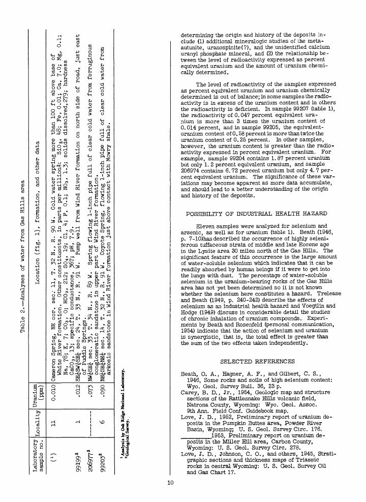
1. Analyses of samples........................................................................ 62. Analyses of water.......................................................................... 10
ABSTRACT
Uranium minerals have been discovered in the Wind River formation of early Eocene age, in strata of middle and late Eocene age, and in the Thermopolis shale of Early Cretaceous age in the Gas Hills area of central Wyoming. Localities of uranium mineraliza tion were found independently by prospectors and by geologists of the U. S. Geological Survey. Geologists of the Atomic Energy Commission have made evalua tion studies of many of the occurrences in the area as well as reconnaissance that led to new discoveries.
The uranium is concentrated in clayey and con glomeratic sandstone and in carbonaceous shale. Sev eral selected samples of sandstones in the Wind River formation, taken for mineral determination, contain more than 10 percent uranium. The highest analysis of a channel sample is 6.72 percent uranium from a 1-foot section of conglomeratic sandstone in the Wind River formation. The highest analysis of a carbona ceous shale in this formation is 0.062 percent uranium. A sample of sandstone from the sequence of middle and late Eocene age contained 0.078 percent uranium. A sample from the Thermopolis shale directly overlain by the Wind River formation contained 0.041 percent uranium.
Several uranium minerals are present. The dom inant one is meta-autunite, Ca(UO2 ) 2(PO4)2» 2|-6iH2O, a pale greenish-yellow highly fluorescent mineral. In , some samples, arsenic appears to be more abundant than phosphorus and the mineral may be uranospinite, Ca(UO2) 2{AsO4 )2 8-12H2O. A greenish-yellow non- fluorescent mineral is present in several localities. X-ray studies indicate that it is a calcium uranyl phos phate, possibly a new mineral.
The writer believes that the source of the urani um may have been tuff in the White River formation (Oligocene) or younger Tertiary rocks that once over lay this portion of the Wind River Basin. The avail able evidence suggests that the uranium was carried downward and laterally along sandstone aquifers in the middle Eocene sequence and Wind River formation and was concentrated in favorable host rocks.
INTRODUCTION
The Gas Hills area is located in eastern Fremont and western Natrona Counties, central Wyoming (fig. 1). A reconnaissance examination of some of the rocks in the area was made with a Geiger counter in 1951 while a Geological Survey field party was engaged in oil and gas
investigations there. A water sample (no. 1, table 2) was collected for analysis by the Oak Ridge lab oratory of the Atomic Energy Commission. The water sample and the rocks showed small amounts of uranium. Data obtained on the geologic occur rence of uranium during 1952 and 1953 in the Pumpkin Buttes (Love, 1952) and Miller Hill (Love, 1953) areas suggested that the Gas Hills area warranted a detailed scintillation counter survey. This sur vey was begun on September 27, 1953, Abnor mally high background radiation was noted through out many square miles and rock samples were collected for analysis from several of the locali ties shown in figure 1. However, the writer was unaware at that time that Mr. Neil McNeice, of Riverton, Wyo., had already discovered radio active sandstone in sec. 22, T. 33 N., R. 90 W. (loc. 7) on September 9, 1953. Early in October, Mr. McNeice informed geologists of the Atomic Energy Commission of the location of his discov ery claim and they began detailed studies of the uranium deposits in the area. N. M. Denson and the writer likewise examined and sampled many of the localities in October.
This discovery received widespread publicity which resulted in an intensive search for uranium throughout the general region and several hundred claims were staked in the Gas Hills area. The Atomic Energy Commission is continuing evalua tion studies of occurrences in the area and is assisting in the physical exploration and develop ment of individual deposits. The Geological Sur vey is making further studies of the relation of uranium occurrences to geologic features.
C. C. Towle, chief, Denver Exploration Branch of the Atomic Energy Commission, read the manu script and contributed valuable suggestions. L. F. Rader and his associates made the chemical and radio- metric analyses. Mrs. Alice D. Weeks and L. B. Riley identified the uranium minerals. The reconnais sance examination of the Gas Hills area was made on behalf of the Division of Raw Materials of the U. S. Atomic Energy Commission.
Stratigraphic and structural studies of the Wind River Basin, including the Gas Hills, have been in progress by the U. S. Geological Survey since 1944, as part of a regional oil and gas investigations program. The results of many of these studies have been published and are listed in the selected bibliography. The Gas Hills area is included in published topographic maps, scale, 1:24,000, of the Puddle Springs, Coyote Springs, Gas Hills, and Ervay Basin SW quadrangles, 7. 5-minute series, with 20-foot contour interval.
GEOGRAPHY
The Gas Hills area lies along the southern margin of the Wind River Basin. The hills to which the name is applied are steep hogbacks of Mesozoic rocks on the north and west flanks of the Dutton Basin anticline which projects north ward from the Beaver Divide. The Beaver. Divide escarpment marks the southern boundary of the area and trends generally east. The steep north
face rises 300 to 800 feet above the Wind -River Basin to the north. The lip of the escarpment is essentially the drainage divide between north ward-flowing tributaries of the Wind River having high gradients and southward-flowing tributaries of the Sweetwater River having low gradients.
Although the Gas Hills area has no towns and no improved roads most of the area is accessible by car. Moneta is the nearest post office, 25 miles to the north on U. S. High way 20. The nearest railroad station is at Lysite, on the Chicago, Burlington, and Quincy Railroad, 34 miles to the north. The area has no permanent residents. Sheep and cattle ranch ing is the only industry. Vegetation is sparse and bedrock is moderately well exposed.
GEOLOGY
The Gas Hills are hogbacks of steeply dipping Mowry shale and of sandstone in the Cloverly forma tion on the north and west flanks of the Dutton Basin anticline. This anticline branches off the Granite Mountains to the south and plunges northwestward into the Wind River Basin. Folding occurred near the close of Paleocene time and erosion developed the present topography on the pre-Eocene rocks. The overlying Wind River formation and the suc ceeding younger Tertiary strata were then de posited until the structural basin between the Granite Mountains to the south and Owl Creek Mountains to the north was filled with nearly horizon tal Eocene, Oligocene, Miocene, and possibly Pliocene rocks, at least to the level of the present crest of the Beaver Divide escarpment. Pliocene and Pleistocene uplift started the present erosion cycle, and as the face of the Beaver Divide escarpment moved southward, the Gas Hills and other areas of older resistant folded rocks along the south margin of the Wind River Basin were exhumed. Remnants of lower and middle Eocene rocks are present in steep pre-Eocene valleys be tween the hogbacks of Mesozoic rocks. These valleys extend generally south and probably continue for some distance beneath the Tertiary strata that form the Beaver DMde. This relationship may have a bearing on the orientation and distribution of uranium deposits, and is discussed in more detail in the description of individual deposits. About 10 miles southeast of the Gas Hills, in and south of the Rattlesnake Hills is a volcanic field of middle and late Eocene age, the rocks of which were intruded through pre-Cambrian, Paleo zoic, and Mesozoic rocks. These vents furnished much of the volcanic debris in the middle and upper Eocene rocks in the Gas Hills area.
STRATIGRAPHY
Detailed descriptions and thicknesses of the rock units in the Gas Hills area are summarized below:
Alluvium: Gravel, sand, and clay derived from Tertiary rocks along the Beaver Divide escarpment and de posited along stream "bottoms.
Landslide debris: Claystone and sandstone masses of Eocene and Oligocene rocks that nave "broken loose and moved north down the slopes of the Beaver Divide.
Miocene rocks: Sandstone, gray and white, soft, tuff aceous; containing lenses of conglomerate near the base and pumicite in the upper part. Thickness ranges from a feather edge to 100 feet.
White River formation (Oligocene): Tuff, light-gray, limy, biotitic, vitric, and tuffaceous mudstone. Basal bed is 50 feet thick. The upper 200 to 300 feet is grayish-orange to yellowish-gray sandy mudstone with some layers of gray vitric tuff and thin lenses of conglomerate. South of Coyote Spring, this sequence is, in part, soft plastic tuffaceous variegated claystone. The formation in the Gas Hills area is of Chadron age. The thick ness ranges from a feather edge to more than It-50 feet.
Upper and middle Eocene volcanic rocks: Dacite, light- gray to dark-gray; hornblende latite, sodic trachyte, andesite, and alkalic rocks. They are intruded through pre-Cambrian, Paleozoic, and Mesozoic rocks in the Rattlesnake Hills and fur nished boulders and ash that are incorporated in the upper and middle Eocene sedimentary sequence. The volcanic rocks are overlain by Oligocene and Miocene strata.
Upper and middle Eocene sedimentary rocks: Six units are recognizable along the Beaver Divide escarp ment. (Van Houten, F. B., personal communication.)
6. Conglomerate, volcanic, very coarse grained, more than li-O feet thick. Crops out in a massive ledge at the top of the formation and forms the lip of the Beaver Divide escarpment at some places.
5. Sandstone, dark-yellowish-gray, tuffaceous; and volcanic conglomerate consisting chiefly of andesite porphyry. Uraniferous sandstone at locality 9 is believed to be a northward extension of this unit.
It-. Tuff, biotitic; lapilli tuff, and cobbles of volcanic rocks. Bed is 1*5 feet thick.
3. Sandstone, tuffaceous; sandy mudstone, and con glomerate containing pebbles and cobbles of sodic trachyte pumice, tuff, and lava. Bed is 90 feet thick. Giant boulders of pre-Cambrian gneiss and granite are present in lower 25 feet of the unit.
2. Mudstone, soft; and arkosic sandstone contain ing very little tuffaceous debris. The upper most bed is a dredge-forming arkose and con glomerate containing pebbles of sodic trachyte lava.
1. Mudstone, green to olive, ledge-forming; con tains a thin bed of acidic tuff that probably records the initial volcanic outburst in the Rattlesnake Hills volcanic field. Thickness at base is 25-30 feet.
Middle and lower Eocene rocks: For a distance of 5 miles or more north of the Beaver Divide and east of the Gas Hills, the Wind River formation is overlain by rocks of middle Eocene age. The formations look very much alike and have not as yet been mapped separately. Both sequences contain yellow soft sandstone, lenses of ferruginous brown sandstone, and conglomerate. The chief lithologic difference is that conglomerate in the middle Eocene sequence contains abundant boulders of andesite derived from the Rattlesnake Hills, whereas the conglomerate in the Wind River formation contains no locally de rived volcanic rock fragments. The sequence ranges in thickness from a feather edge to more than 200 feet.
Wind River formation (lower Eocene): This is an ex tremely variable sequence of rocks that was de posited on a rugged topography cut in folded and eroded Paleozoic and Mesozoic rocks. In the north western part of the area the basal strata are brightly variegated claystones and clayey sand stones. In the southeastern part of the area the basal beds are yellow to gray arkosic sandstone and granitic conglomerate. Higher in the sequence are lenticular sandstones, some of which are highly ferruginous. The sandstones contain many of the uranium deposits in this area. Thin carbonaceous shales and coals likewise contain some concentra tions of uranium. The formation ranges in thick ness from a feather edge to more than -300 feet.
Cody shale (Upper Cretaceous): Shale, gray, soft; sandy in the upper part. The Cody shale is more than 3,000 feet thick and underlies extensive areas of the Wind River formation north and west of the Gas Hills. Because of its low dips, extent, and imper meability, the Cody shale was of major significance in confining some of the ground water containing ura nium within the overlying Wind River formation.
Frontier formation (Upper Cretaceous): Sandstone,chiefly gray, soft, lenticular; interbedded with gray to black soft shale. White tuff and bentonite beds mark base of formation, which is about 580 feet thick.
Mowry and Thermopolis shales (Lower Cretaceous): TheMowry shale is dark-gray hard siliceous; containing abundant fish scales; weathers silvery gray and crops out in ridges forming the outer portion of the Gas Hills. The shale is about It-70 feet thick and is underlain by the Thermopolis shale containing the Muddy sandstone member at the top. The Muddy sand stone member is 32 feet thick and consists of gray fine-grained sandstone and siltstone interbedded with black shale. It IB underlain by 150 feet of soft black fissile shale. This shale contains one of the uranium deposits in this area.
Cleverly and Morrison formations (Lower Cretaceous and Upper Jurassic): Sandstone, chiefly ferruginous, 80 feet thick; and conglomerate which forms the highest inner ridges of the Gas Hills, 200 feet thick. The middle and lower part of the sequence is interbedded variegated claystone and sandstone.
Jurassic rocks: Sundance formation, sandstone, grayand green shale; 2^0 feet thick; underlain by gray and white Nugget sandstone, 170 feet thick.
Chugwater formation (Triassic): Only the upper part of this formation is exposed. The Popo Agie member at the top is 300 feet thick and consists of red shale, red sandstone and siltstone, and thin sparse limestone pellet conglomerates. It is underlain by the Alcova limestone member, a gray thin-bedded hard limestone 5 feet thick. The underlying Red Peak member is a red sandstone, siltstone, and shale sequence about 700 feet thick.
Phosphoria formation (Permian): Dolomite, interbedded,| cherty and red shale containing thin anhydrite beds. This formation is about 325 feet thick.
Tensleep sandstone and Amsden formation (Pennsylvania^): Tensleep sandstone, white, hard, fine-grained, about 200 feet thick; underlain by the Amsden formation, consisting of about 200 feet of red and green shale, cherty dolomite, and a basal ferruginous sandstone about 60 feet thick.
Madison limestone (Mississippian): Limestone, blue-gray, massive to thick-bedded, cherty; containing some dolomite near the base. This formation is 300 feet thick.

Cambrian rocks: Sandstone, chiefly arkosic red and brown in the lower half; green and gray sandy and silty shale, and sparse thin limestones in the upper half. Thickness is about 800 feet.
Pre-Cambrian rocks: Granite, chiefly red and brown, granite gneiss, and black schist cut by quartz pegmatite dikes.
URANIUM OCCURRENCES
The purpose of this report is to present geologic data on several types of uranium depos its in the Gas Hills area rather than to give the complete description of each locality where radioactivity or uranium minerals occur. There fore, some localities are described that are of geologic significance but in which there is no commercial-grade uranium ore, whereas other localities where rocks contain more than 0.1 per cent uranium are omitted because the geologic setting is similar to that of one already described in this report. The Atomic Energy Commission has been actively engaged in physical exploration throughout the area, beginning in October, 1953, with the objective of evaluating tonnage and grade of many of the deposits. Therefore, the Geolog ical Survey has made no attempt to estimate ton nage and grade in any locality in the Gas Hills area.
Uranium occurs in the Thermopolis shale of Early Cretaceous age, in the Wind River forma tion, and in middle Eocene rocks. Occurrences of uranium minerals are most abundant in soft sandstones in the Wind River formation. One con spicuous feature of the area is the background of radioactivity. It is commonly more than twice as high on outcrops of the Wind River formation and middle Eocene rocks than on adjacent outcrops of the Cody shale.
Description of localities
Locality 1 (SWjSEJsec. 24, T. 33N.. R. 91 W). - The site of this locality is a water well at the Puddle Springs ranch, and is reported to be 80 feet deep. The water issues from an arkosic sandstone in the lower part of the Wind River formation, A water sample obtained by hand pumping contained 0.012 ppm uranium.
Locality 2 (C SWJ sec. 32. T. 33N.. R. 90 W). - A radioactive carbonaceous shale is the site of locality 2. It is stratigraphically above the ura- niferous sandstone beds at localities 3, 4, and 5. Locality 2 is considered significant because (a) it is one of many stratigraphic zones in which ura nium occurs in the Wind River formation, and (b) it shows how much uranium is present in car bonaceous rocks where they are overlain by a soft porous sandstone. By comparison, another carbonaceous shale, north of locality 1, is over lain and underlain by variegated claystone and contains very little radioactivity. A preliminary reconnaissance section including the carbonaceous shale at locality 2, from top to bottom, is shown in the following section:
Unit no.
Thickness (feet)
20
Lithologic character
6 Sandstone, pale green, arkosic, coarse grained, finely conglomeratic in upper 10 feet; 1 3-foot granite boulder pres ent but average size is less than 2 inches; no volcanic rock fragments observed; most fragments are of gray granite.
5 Shale, dark brown, carbonaceous, contains .5 O.OJ1 percent equivalent uranium and 0.021 percent uranium; contains flattened plant and tree fragments; forms top of ledge.
k Shale, black, coaly, interbedded with thin 1.5 coal partings.
3 Shale, brown and gray, carbonaceous, platy; 2.2 contains leaf impressions.
2 Claystone, pale green, plastic, soft. 5
1 Sandstone, pale brownish green, soft, 15 coarse-grained, interbedded with arkose and fine-grained conglomerate with small black chert and granite pebbles.
In the general vicinity of this locality there are many places of higher radioactivity, and uranium minerals occur in some of them, chiefly in sandstone, above and below the carbonaceous shale. Although this shale is of no commercial value, carbonaceous shales with readily detect able uranium content probably can be useful guides in locating areas of possible uranium deposits. These shales are conspicuous and can be easily checked. Where such shales are underlain or overlain by porous sandstones, if any uranium is in the vicinity, some of it will probably be concentrated in the carbonaceous shale.
Locality 3 (SWiSEiSWi- sec. 1. T. 32 N.. R. 91 W). Meta-autunite is disseminated in sandstone of the Wind River formation at lo cality 3. The relationship of the uraniferous sandstone to overlying and underlying rocks of the Wind River formation can be observed. Localities 3, 4, and 5 are stratigraphically lower than locality 2. The rocks at locality 3 dip about 1° SW. The stratigraphic section shown below was measured on the west-facing slope just west of the uraniferous deposit. Unit 1 is at the base of the section.
Unit no. Lithologic character
Sandstone, pale green, clayey, in lower 5 feet, grading up to ledge-forming coarse-grained gray sandstone, and then to granite boulder conglomerate. The top of the unit is the top of the knob just west of the uranium locality. The uranium is concentrated in a pale green and brown clayey sandstone about 7 feet above the base of the unit where readings are locally 2.5 mr/hr. A trench sample of 1 foot of beds con tains 0.13 percent equivalent uranium and 0.050 percent uranium. Overlying strata of the Wind River formation are eroded away so there is no way to determine the total thickness of the formation here.
Thickness (feet)
Unit no.
Thickness (feet)
Lithologic character
Sandstone, dark brown, hard, forming 1 ledge, lenticular; appears at slightly different levels in outcrops to north east and southwest; locally gives read ings of 1.5 mr/hr.
Sandstone, pale green, interbedded with 18 conglomerate of granite fragments, very soft; sandstone is very coarse grained but has a greenish clay matrix in part; roundstones are chiefly of gray granite as much as 6 inches in diameter but averaging 1 to 2 inches.
Sandstone and conglomerate, greenish- 10 brown; matrix is so soft it is almost unlithified; rock fragments are chiefly gray granite; gives readings of 0.2 to 0.25 mr/hr.
Conglomerate and sandstone, gray to brown, 6 forming ledges; middle part is a mass of boulders as much as 2 feet in dia meter jumbled together; almost all are coarse grained gray granite but some are black chert from Paleozoic rocks; sand stone is coarse grained and lenti- ular; gives readings of 0.1 to 0.15 mr/hr.
Sandstone, pale greenish brown, soft, 66 with clay matrix, interbedded with brownish-green plastic claystone in which are many sand grains, in lower half of unit; upper half is largely very coarse grained greenish-brown soft arkosic sandstone.
Sandstone, gray, hard, lenticular; forms 0-12 ledges that appear intermittently in outcrops to south at this same position; very coarse grained and pebbly; most pebbles are of granite as much as 1 inch in diameter but commonly less than 1/10 inch; gives reading of 0.06 mr/hr.
Sandstone, greenish gray, coarse-grained; 22 with clay matrix; less clayey toward top; gives readings of 0.06 to 0.07 mr/hr.
Claystone, "brownish green, soft, plastic, 1? very sandy; grades up to coarse-grained arkosic sandstone with a clay matrix; in upper 5 feet and particularly at top are abundant groups of aragonite crystals as much as 2 feet in diameter; gives reading of 0.05 mr/hr.
Total thickness of measured part of Wind 187-199 * River formation.
The underlying rocks are not exposed but the base of the section probably is not more than 50 to 75 feet above the contact with Cody shale.
The area within 50 feet of the spot sampled for analysis (fig. 2) is markedly radioactive. To the northwest, where the section was measured, the radioactivity appears to extend through a strati- graphic interval of 7 feet of sandstone, but at the spot
sampled, a trench only 1 foot, deep was dug. This trench sample contained 0.13 per cent equivalent ura nium and 0.050 percent uranium (table 1). The bright greenish-yellow highly fluorescent mineral at this locality is meta-autunite which is disseminated through the soft sandstone and in places is concentrated in small green pods.
Locality 4 (NE4-NEiNWi sec. 12. T. 32 N.. R. 91 W). This locality yielded some of the highest radioactivity measurements made in the Gas Hills area. A scintillation counter read 8 mr/hr on the surface and a trench sample of the uppermost 1 foot of sandstone contains 1.2 percent equivalent uranium and 1.87 percent uranium. The uranium is con centrated in a very light gray slightly clayey sand stone at about the same horizon as that at locality 3. The thickness of the uraniferous part of the sand stone is not known, but 50 feet to the southwest on the point of the spur along which the sandstone crops out, a ledge 5 feet thick is moderately radioactive. Meta-autunite, possible uranospinite, Ca(UO2)2(AsO 4 ) 2 .8-12H2 O, and an unknown greenish- yellow nonfluorescent mineral are disseminated in the coarse-grained sandstone near the surface. Readings of more than 1 mr/hr were obtained for a distance of 20 feet on each side of the spot that was sampled and lower readings for another 50 feet beyond that.
Locality 5 (SEiNEiNWi sec. 12. T. 32 N.. R. 91 W). Abundant meta-autunite, uranospinite(?), and possibly the unknown nonfluorescent greenish- yellow uranium mineral are disseminated in a coarse-grained conglomeratic sandstone (fig. 2) at locality 5. A trench sample of 1 foot of rock at the surface contains 0.58 percent equiv alent uranium and 0.25 percent uranium. At a depth of 5 feet a 1-foot channel sample contains 0.19 percent equivalent uranium and 0.065 per cent uranium. The deposit is in a very soft ferruginous conglomeratic sandstone about 50 feet stratigraphically below the uraniferous sandstone at locality 4. The sandstone is brown, coarse grained, and contains rounded pebbles of granite . as much as 2 inches in diameter. A scintillation counter reads 8 mr/hr at the surface point sampled, and indicates a high level of radio activity for 20 feet in all directions. About 400 feet to the southeast another occurrence of high radioactivity occurs in a similar sandstone.
Locality 6 (SEiSEjNEi sec. 14. T. 32 N.. R. 91 W).- The site of locality 6 fs Coyote Spring which issues from the basal conglomeratic sandstone of the Wind River formation where it overlaps northward onto a pre-Wind River hill of Mowry shale. The spring flows a 1-inch pipe full of clear cold water which contains 0.090 ppm uranium.
Locality 7 (fig. 3) (NEjSEj- sec. 22, T. 33 N.. R. 90 W). The site of locality 7 is in the Gas Hills area where Neil McNeice first discovered radioactive sandstone. The uranium is in the Wind River formation which overlies the Cody shale, strikes east, and dips 3° S. Exposures of the Wind River formation begin about 50 feet
Tabl
e 1. Analyses
of samples
from G
as H
ills
area
1
Laboratory
sample no.
99202
9920
1
9920
4
9920
5
2069
7599206
99207
9920
9
99208
200929
99210
99212
5806
8
9921
1
58067
2069
7^
Locali
ty
2 3 4 5 5 7 7(AEG sa
mple
loc. EW
S-6)
.7
(AEG sa
mple
loc. EWS-2).
7(AEG sample
loc. EW
S-1).
7 8(AEG sample
loc. EW
S-8)
.9 10 10 10
eU
(percent)
0.051
.13
1.2 .58
.19
.21
.047
.19
.08
.52
.039
.06
.015
.078
.003
4.7
U (p
erce
nt)
0.02
1
.050
1.87 .25
.065
.24
.014
.24
.096
.95
.041
.078
.018
.062
.003
6.72
V20
5 (p
ercent)
0.06 .06
.06
.06
.1 .06
.05
.06
.06
.05
.08
.12
.1
Se
(ppm) 10 20 50 2 50 12 40 80 3 2 15
As
(ppm) 150 50 750
400
1000 350
200
400 50 50 50
Loca
tion
(fig.
l),
lithology, and formation
C SW£
sec.
52
, T. 33 N. ,
R. 90
W.
Chan
nel
samp
le of 6
in.
of carbonaceous sh
ale
in Wind River
formation.
SW£SE£SW£
sec.
1, T. 32 N
., R.
91
W.
Chan
nel
samp
le o
f 1 ft
of sandstone
in Win
d Ri
ver
formation; me. ta-
aut unite
pres
ent.
NE£NE£NW£
sec.
12
, T.
32 N
., R. 91 W
. Ch
anne
l sample of 1
ftof sandstone
in Win
d River
formation; me
ta-a
utun
ite,
po
ssi
bly
uran
ospi
nite
, and
an un
iden
tifi
ed n
onfluorescent
uranium
mine
ral
pres
ent.
SE£N
E£NW
£ se
c. 12
, T.
32
N.,
R. 91
W.
Channel
samp
le o
f 1 ft
of c
ongl
omer
atic
sandstone
in Win
d Ri
ver
formation; me
ta-
autunite,
poss
ibly
urano
spin
ite,
and
an unidentified n
on-
fluo
resc
ent
uran
ium minera
l pr
esen
t.Ch
anne
l sample of 1
ft of
sandstone
5 ft
below sample 9
9205
.NE^SE^ se
c. 22,
T. 33 N
., R.
90
W.
Chan
nel
samp
le of 1 ft
of
sandstone
in Win
d Ri
ver
formation.
36 f
t SW o
f 99206.
Chan
nel
sample of 1 ft
of sandstone
inWi
nd River f
orma
tion
.
126
ft S
W of 9
9207.
Channe
l sa
mple
of 1 ft
of sandstone
inWi
nd Riv
er f
orma
tion
.
8l ft S
W of 9
9209.
Chan
nel
sample of 1 ft
of sandstone
inWi
nd River f
orma
tion
.
Pebble of
bas
ic ig
neou
s ro
ck fro
m ur
anif
erou
s sandstone
inWind Riv
er f
orma
tion
.NE
£SEj
LSW£
se
c. 23
, T. 33 N
., R.
90
W.
Channel
sample of
1 ft
of b
lack The
rmop
olis
shale.
NW£H
E£SW
£ se
c. 17
, T. 33 N
., R. 89
W.
Ferr
ugin
ous
sand
ston
ein middle Eocene sequen
ce.
C SE£-NE£
sec.
27
, T. 33 N
., R. 89
W.
Carbonaceous sh
ale
inWi
nd River f
orma
tion
.30 f
t southwest
of sample 58068, channel
1 ft ca
rbon
aceo
ussh
ale
in Wind Ri
ver
formation.
SE£S
EjLN
E£ se
c. 27
, T.
33 N., R. 89 W
. Tu
ff i
n middle a
ndup
per Eocene ro
cks
above Wi
nd Riv
er f
ormation.
NWlc
?U':
Ll\ni
J-i-
«*f»r»
f*i
T
~*&
TJ
T?
QO U
PVmnrxal
<*am
nT e* of
~\ ft-
XNW ̂
wn j^lvn^
oc5U.
vJ,
X .
J7^
1" .
,
-TV *
y\
J W
L/
llcL
llil
C/J.
oo
ul^i
j.c/
(JJ.
JL
J. U
of co
nglo
mera
tic
sandstone
in Wind River
formation.
1 Sam
ples
ana
lyze
d by
the
U.
5. G
eolo
gica
l Su
rrey
. A
naly
sts:
Fu
rman
, D
ufou
r, M
eado
ws,
Mou
ntjo
y, a
nd V
ilson
.
</."/.<««,,,:. j^.
X^^'«*^?£^*S&ass&*'*r
£ - ^ -J~. ^ --;,£__ ^ . . .. ---v^ '>-.**- -:*- *- - .r*TS
Figure 2. Uraniferous sandstone in Wind River formation at locality 5. Sample of top foot contains 0. 25 percenturanium and from the bottom foot 0.65 percent uranium.
above the Cody shale. A generalized estimated sec tion is shown below, from top to bottom (fig. 3):
Unit no. Lithologic character
Sandstone, gray, medium-grained to coarse-grained, crossbedded, with hard and soft layers; forms inter mittent ledges; contains many fer ruginous uraniferous concretionary masses that cut across bedding and resemble the uranium-bearing con cretions in the Pumpkin Buttes area. Some meta-autunite or uranospinite(?) is visible. A channel sample of 1 foot of sandstone contained 0.21 percent equiv alent uranium and 0.2*4- percent uranium.
Shale, brown, carbonaceous, slightly radio active.
Sandstone and claystone, greenish-brown, soft, interbedded.
Shale, dark brown, carbonaceous, slightly radioactive.
Sandstone and claystone, greenish- brown, soft.
Shale, brown, carbonaceous.
Sandstone and claystone, greenish- brown, soft.
Estimated thickness (feet)
10
0.5
10
20
1
25
The uraniferous sandstone crops out exten sively along the top of a broad upland area. A 1-foot channel sample of this sandstone from AEC pit EWS-6, about 36 feet southwest of the measured
section, contained 0.047 percent equivalent ura nium and 0.014 percent uranium. About 125 feet farther southwest, a 1-foot channel sample of sandstone at the same horizon in AEC pit to EWS-2, contained 0.19 percent equivalent uranium and 0. 24 per cent uranium. Another 1-foot channel sample of sandstone taken from the same horizon 81 feet farther southwest, at AEC pit EWS-1 contained 0.08 percent equivalent uranium and 0.096 percent uranium. This zone of ferruginous radioactive sandstone crops out for a distance of 450 feet farther southwest but the amount of radioactivity apparently decreases in that direction. High radio activity was detected at a number of additional places southeast and east of locality 7 on the same ridge and in the same sandstone. A pebble of dark- gray basic igneous rock from this locality contained 0.52 percent equivalent uranium and 0.95 percent uranium. Concentric zones of alteration suggest that uranium soaked into the pebble from solutions in the surrounding sandstone.
Locality 8 (NEjSEJSWi- sec. 23. T. 33 N.. R. 90 W.). The black Thermopolis shale of Early Cretaceous age is the site of locality 8. A chan nel sample of the shale taken at AEC pit EWS-8 contained 0.039 percent equivalent uranium and 0.041 percent uranium. The shale dips west about 35° and is overlain by essentially horizontal fer ruginous conglomeratic sandstone in the Wind River formation. The radioactive zone is about 30 feet below the Muddy sandstone member. Neither the Muddy sandstone member nor the basal sandstone of the Wind River formation show more than a

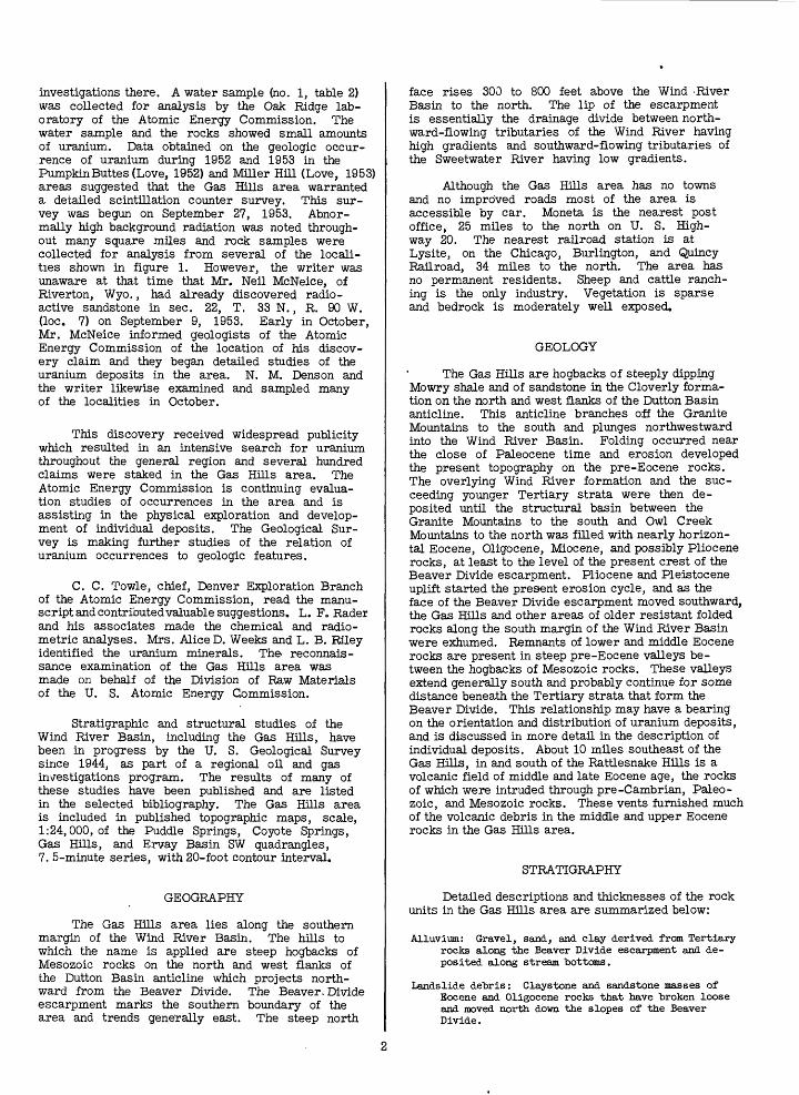
Figure 3. Wind River formation at locality 7. Arrow marks zone of uraniferous sandstone.ground cut on Cody shale.
Flats in left back-
normal background radioactivity count. The radio active zone in the Thermopolis shale extends for more than 50 feet north-south, and has a strati- graphic thickness of about 10 feet, but the radio activity gradually diminishes in both directions from the pit where the sample was taken.
The sandstones of the Wind River formation were deposited in a steep narrow valley cut along the strike within the soft Thermopolis shale and flanked on the west by a resistant ridge of Mowry shale and on the east by resistant sandstone in the Cleverly formation. The writer believes that the uranium carried by ground water along porous sandstones in the Wind River formation could not escape laterally because of the confines of the pre-Wind River valley, and was depos ited in carbonaceous shales in the nearly impervious underlying Thermopolis shale. Sandstones in the Cloverly formation on the east side of this pre-Wind River valley are slightly radioactive.
Locality 9 (NWJNEJSWj sec. 17. T. 33 N.. R. 89 W). A uranium occurrence in middle Eocene rocks is the site of locality 9. It is in the middle of an area where the background radioactivity is several times as high as the average in adjacent localities of pre-Tertiary rocks. The rocks are very ferruginous coarse-grained conglomeratic sandstones near the base of the middle and upper Eocene sequence. A 2-foot channel sample contained 0.06 percent equivalent ura nium and 0. 078 percent uranium. These rocks crop out as dark-brown discontinuous ledges for half a mile. A reconnaissance section of the rocks is listed from top to bottom as. follows:
Unit no. Lithologic character
Conglomerate, gray; composed largely of "boulders of mouse-gray andesite*de rived from volcanic rocks of middle Eocene age in the Rattlesnake Hills; conglomerate interbedded with a minor amount of chalky white crystal tuff; slightly radioactive.
Sandstone, yellowish-white, coarse-grained, slightly tuffaceous, soft, interbedded with conglomerate in which roundstones are of pre-Cambrian granite and Eocene volcanic rocks from the Rattlesnake Hills; slightly radioactive.
Volcanic conglomerate, mouse-gray, com posed largely of "boulders of gray andesite porphyry derived from Eocene vents in the Rattlesnake Hills; some "boulders ^ feet in diameter; slightly radioactive.
Sandstone, pale yellow, very coarsegrained, arkosic, soft, with white tuff fragments; slightly radioactive.
Sandstone and conglomerate, gray to dark- "brown, with very ferruginous lenses in middle; some lenses 15 feet thick and 100 feet long; a channel sample of 2 feet of sandstone from one lens con tained 0.06 percent equivalent uranium and 0.078 percent uranium; conglomerate intertongued with the sandstone con tains rounded fragments of pre-Cambrian granite and Eocene andesite porphyry from the Rattlesnake Hills; some andesite "boulders are 3 feet in diameter.
Estimated thickness (feet)
30
30
50
30

R.Locality 10 (C SEJNE4- sec. 27. T. 33 N.. W.). A carbonaceous shale near the top of the
Wind River formation is the site of locality 10. A chan nel sample of 1 foot of shale contained 0.078 percent equivalent uranium and 0.062 percent uranium. This carbonaceous shale bed overlies coarse-grained greenish-yellow arkosic sandstone. The top of the bed grades upward through 6 inches of slightly carbonaceous shale to a greenish-gray plastic claystone. Leaves identified by R. W. Brown of the U. S. Geological Sur vey from this carbonaceous shale are: Ulmus sp., Leguminosites sp., Aralia sp., Quercus castaneopsis, and Zizyphus cinnamomoides and are considered to be of early or middle Eocene age. The carbonaceous shale is exposed in an area about 75 feet long and 25 feet wide but its uranium content suggests that uraniferous ground waters have been in the area and that higher grade de posits may be present in more favorable host rocks.
Locality 11 (NE cor, sec. 11. T. 32 N.. R. 90 W.). -The site of locality 11 is Cameron Spring which issues from the White River formation of Oligo- cene age, 100 feet or more above the base of the se quence, and 250 feet or more below the top. The water is clear, cold, and comes out along fractures in light- tan hard tuffaceous claystone. The water contains 0. 010 ppm uranium.
Other localities of interest. A spring issues from a very ferruginous conglomeratic sandstone in the upper part of the Wind River formation in the NW-JSEl sec. 33, T. 34 N., R. 89 W. This spring flows about a 1-inch pipe full of clear cold water that contains 0.073 ppm uranium. The presence of this much ura nium is significant because the locality is at an altitude of about 6, 800 feet, higher than nearly all the uranium deposits found in the Gas Hills area, and is about 3 miles northeast of the Gas Hills, beyond the border of the area shown in figure 1.
A locality near the center of the SWi sec. 29, T. 33 N., R. 90 W. shows many places where meta- autunite is concentrated in ferruginous coarse-grained soft porous sandstone in the middle part of the Wind River formation. A spectrographic analysis of a sam ple collected for mineralogic study showed more than 10 percent uranium.
In the NWiSWiNWi sec. 6, T. 32 N., R. 90 W., there are localized concentrations of an unidentified calcium uranyl phosphate mineral, greenish-yellow in color, nonfluorescent, and which, according to L. B. Riley (personal communication, 1954), contains more than 10 percent uranium, 1-2 percent elemental phosphorus, traces of barium, and arsenic. The min erals are concentrated in and adjacent to a petrified log which is embedded in a coarse-grained gray sandstone in the middle of the Wind River formation. A channel sample of 1 foot of sandstone adjacent to the log con tained 4. 7 percent equivalent uranium, 6. 72 percent uranium, and 0.1 percent V2 O 5 .
Another locality where considerable uranium min erals occur is about half a mile northeast of Coyote Spring (locality 6), in the southern part of the SEi sec. 12, T. 32 N., R. 91 W. Both meta-autunite and the unidentified greenish-yellow uranium mineral are pres ent. The host rock is a ferruginous conglomeratic sandstone in the lower part of the Wind River formation northeast of a partly exhumed hill of Mowry shale sur rounded by the Wind River formation.
ORIGIN OF URANIUM IN THE GAS HILLS AREA
Insufficient data are available on the occurrences of uranium minerals now known in the Gas Hills area to warrant a definite statement as to the origin of the deposits. It is apparent that these minerals were de posited in their present sites by water moving through ithe rocks and bringing uranium into an environment favorable for precipitation. The source of the uranium ions and the origin of the water that carried them can only be assumed at the present time.
The uranium deposits may be the result of hydro- thermal solutions coming from the volcanic rocks in and south of the Rattlesnake Hills. These volcanic rocks are dacites, andesites, and alkalic rocks F. B. Van Houten (personal communication) and B. D. Carey, Jr., (1954) of middle and late Eocene age. There is no known evidence of hydrothermal activity in the Gas Hills area other than, possibly, the uranium deposits themselves. The writer prefers the theory that the uranium originally was a primary constituent in the ashes in the White River formation or younger Tertiary rocks in this area, that the uranium was leached out by ground water which transported it downward and later ally along sandstone aquifers in the middle Eocene se quence and the Wind River formation, and that the ura nium concentrated wherever favorable host rocks were found. This theory of origin was likewise advocated for the uranium deposits in the Pumpkin Buttes area of northeastern Wyoming (Love, 1952, p. 17). The Oligocene and younger rocks once extended over the Gas Hills area and across the Wind River Basin, for remnants are found in the mountains on both sides. In the Pumpkin Buttes area, the Wasatch formation, which is the same age as the Wind River formation and has much the same lithology, contains uranium deposits and is overlain by the White River formation, which is ura niferous (Love, 1952).
Denson, Bachman, and Zeller (1951) have re ported uraniferous lignites of Paleocene age overlain by the White River formation in South Dakota. J. R. Gill (personal communication) has found carno- tite in the White River formation in the Slim Buttes area, South Dakota, and G. W. Moore and H. A. Tour- telot (personal communication) have found uranocircite and tyuyamunite in rocks of the White River formation in the Big Badlands of South Dakota. Miocene (?) rocks in the Miller Hill area, southern Wyoming, contain 0.15 percent or more uranium (Love, 1953), and tuff aceous limestones of Pliocene (?) age in the Split Rock area, 16 miles south of the Gas Hills, contain0.023per cent uranium (Love, 1952, unpublished report, sup plemented by later field studies). Carnotite occurs in tuffaceous sandstones in the lower Pliocene(?) North Park formation of the Saratoga area.
In all of these areas, the possibility of hydro- thermal activity that would form uranium deposits seems slight. The White River formation in the Gas Hills area is contributing above-normal amounts of uranium to ground water today (table 2) and may have supplied the uranium now found in the underlying rocks. The ura nium in the water in the Wind River formation may come either from the White River formation or from second ary uranium minerals previously deposited by ground water in the Wind River formation.
Characteristics of the currently known deposits that need further investigation and that will assist in
<H
P OO C
03 O
O Pi
In bO O SO ">co O Oo3 C ^-d
O « cd > o5 ^J O O
£> * o3 .»Ch
H t- -P O CM In «
O "d O 0 O » > H O H
fe O C oo o3 »> co «CO iH
O O -HS vH H
CO O
Pi C CO O H
HP H > 0 H co -P -H O
In
I d
H ps Pi O
So ,rj c -p
vH -H
jii » TJ -d o H cH Pi vH 00^ O CO
-I** ^
^ P-.o c' In
01 o t^-
Pj-p > c. O H 'Pi D
S3 On-P - .*
CM vH ' t^- KS -P O VJD
co CO K\ ^S CEH O - -H
O CM 0 ONHO
H p CM C? I I
C HO O -P PivH bO O H -P C 03 Pi 05 -H -P
& £ o oO O H OC In In H O
H O bO O> C ,a
bOv-H -H 03C « P H Pi-P
O C 3 H v-H 0) "-9
^ "O C bOln !>a O C O O iH H O -P
CO 05 S P.^ O
<H
3
Pi
0003 03 O -d S co MC
O K\ C > O K\ POO O -H O O -P > iH EH
03 CO-On&q S O vH -v
H -d
. O -H C CM Js O K\ P C DO vH
CM -H
&
WK oo ...C 0 [ "CO O 43 O
O
H S Mi P > O CO
o co K\ -p o c
H H O 0)
O H| j O H| j O
CM K\ H t^- 00
VO
t- ME~- K\ON O>O CM
ON
determining the origin and history of the deposits in clude (1) additional mineralogic studies of the meta- autunite, uranospinite(?), and the unidentified calcium uranyl phosphate mineral, and (2) the relationship be tween the level of radioactivity expressed as percent equivalent uranium and the amount of uranium chemi cally determined.
The level of radioactivity of the samples expressed as percent equivalent uranium and uranium chemically determined is out of balance; in some samples the radio activity is in excess of the uranium content and in others the radioactivity is deficient. In sample 99207 (table 1), the radioactivity of 0.047 percent equivalent ura nium is more than 3 times the uranium content of 0.014 percent, and in sample 99205, the equivalent- uranium content of 0.58 percent is more than twice the uranium content of 0. 25 percent. In other samples, however, the uranium content is greater than the radio activity expressed in percent equivalent uranium. For example, sample 99204 contains 1. 87 percent uranium but only 1. 2 percent equivalent uranium, and sample 206974 contains 6. 72 percent uranium but only 4. 7 per cent equivalent uranium. The significance of these var iations may become apparent as more data accumulate, and should lead to a better understanding of the origin and history of the deposits.
POSSIBILITY OF INDUSTRIAL HEALTH HAZARD
Eleven samples were analyzed for selenium and arsenic, as well as for uranium (table 1). Beath (1946, p. 7-10)has described the occurrence of highly seleni- ferous tuffaceous strata of middle and late Eocene age in the Lysite area 30 miles north of the Gas Hills. The significant feature of this occurrence is the large amount of water-soluble selenium which indicates that it can be readily absorbed by human beings if it were to get into the lungs with dust. The percentage of water-soluble selenium in the uranium-bearing rocks of the Gas Hills area has not yet been determined so it is not known whether the selenium here constitutes a hazard. Trelease and Beath (1949, p. 240-242) describe the effects of selenium as an industrial health hazard and Voegtlin and Hodge (1949) discuss in considerable detail the studies of chronic inhalation of uranium compounds. Experi ments by Beath and Rosenfeld (personal communication, 1954) indicate that the action of selenium and uranium is synergistic, that is, the total effect is greater than the sum of the two effects taken independently.
SELECTED REFERENCES
Beath, O. A., Hagner, A. F., and Gilbert, C. S., 1946, Some rocks and soils of high selenium content: Wyo. Geol. Survey Bull. 36, 23 p.
Carey, B. D., Jr., 1954, Geologic map and structure sections of the Rattlesnake Hills volcanic field, Natrona County, Wyoming: Wyo. Geol. Assoc. 9th Ann. Field Conf. Guidebook map.
Love, J. D., 1952, Preliminary report of uranium de posits in the Pumpkin Buttes area, Powder River Basin, Wyoming; U. S. Geol. Survey Circ. 176.
_______1953, Preliminary report on uranium de posits in the Miller Hill area, Carbon County, Wyoming: U. S. Geol. Survey Circ. 278.
Love, J. D., Johnson, C. O., and others, 1945, Strati- graphic sections and thickness maps of Triassic rocks in central Wyoming: U. S. Geol. Survey Oil and Gas Chart 17.
10

Love, J. D., Thompson, R. M., and others, 1945, Stratigraphic sections and thickness maps of Lower Cre taceous and non-marine Jurassic rocks of central Wyo ming: U. S. Geol. Survey Oil and Gas Chart 13.
Love, J. D., Tourtelot, H. A., and others, 1945, Stratigraphic sections and thickness maps of Jurassic rocks in central Wyoming: U. S. Geol. Survey Oil and Gas Chart 14.
______1947, Stratigraphic sections of Mesozoic rocks in central Wyoming: Wyo. Geol. Survey Bull. 38, 59p.
Love, J. S., Weitz, J. L., and Hose, R. K., 1952, Geologic map- of Wyoming: U. S. Geol. Survey map.
Thompson, R. M., Love, J. D., and Tourtelot, H. A., 1949, Stratigraphic sections of pre-Cody Upper Cre taceous rocks in central Wyoming: U. S. Geol. Sur vey Oil and Gas Chart 36.
Trelease, S. F., and Beath, O. A., 1949, Selenium, its geological occurrence and its biological effects in relation to botany, chemistry, agriculture, nu trition, and medicine: 292 p. Published by the authors, Box 42, Schermerhorn Hall, Columbia University, N. Y.
Van Houten, F. B., Volcanic-rich middle and upper Eocene sedimentary rocks northwest of Rattlesnake Hills, central Wyoming: U. S. Geol. Survey Prof. Paper 264. [In preparation. ]
Voegtlin, Carl, and Hodge, H. C., 1949, Pharmacology and toxicology of uranium compounds: National Nuclear Energy Series, Manhattan Project, Tech. Sec., Div. 6, v. 1, pts. 3 and 4, Chronic inhalation and other studies, McGraw Hill Book Co.
UNPUBLISHED REPORTS
Denson, N. M., Bachman, G. O., and Zeller, H. D., 1951, Summary of new information on uranif- erous lignites in the Dakotas: U. S. Geol. Survey Trace Elements Memo. Rept. 175.
Love, J. D., 1952, Preliminary report on uranium- bearing Pliocene (?) rocks in the Split Rock area, central Wyoming: U. S. Geol. Survey Trace Ele ments Memo. Rept. 282.
Rachou, J. F., 1951, Tertiary stratigraphy of the Rattlesnake Hills, central Wyoming: [Unpub lished master of arts thesis in files of Univ. Wyo. library. ]
Weeks, A. D., and Thompson, M. E., 1953, Identification and occurrence of uranium and vanadium minerals from the Colorado Plateaus: U. S. Geol. Survey Trace Elements Inv. Rept. 334.
11INT.-DUP. see., HASH.. 0,0.71409