preliminary site investigation - santa fe, new mexico · 2501 cerrillos road to evaluate the...
TRANSCRIPT
Preliminary Site Investigation
Cerrillos Road Reconstruction Phase IIC Camino Carlos Rey to Llano Street
Santa Fe, New Mexico
May 2, 2014 Terracon Project No. 66147009
Prepared for:
Parsons Brinckerhoff Albuquerque, New Mexico
Prepared by:
Terracon Consultants, Inc. Albuquerque, New Mexico
Terracon Consultants, Inc. Address City, State Zip P (505) 797 4287 F (505) 797 4288 terracon.com
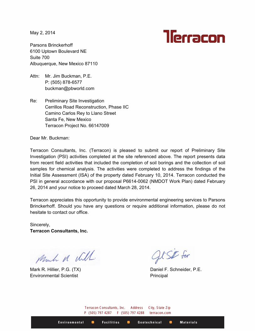
May 2, 2014 Parsons Brinckerhoff 6100 Uptown Boulevard NE Suite 700 Albuquerque, New Mexico 87110 Attn: Mr. Jim Buckman, P.E. P: (505) 878-6577 [email protected] Re: Preliminary Site Investigation Cerrillos Road Reconstruction, Phase IIC Camino Carlos Rey to Llano Street Santa Fe, New Mexico Terracon Project No. 66147009 Dear Mr. Buckman: Terracon Consultants, Inc. (Terracon) is pleased to submit our report of Preliminary Site Investigation (PSI) activities completed at the site referenced above. The report presents data from recent field activities that included the completion of soil borings and the collection of soil samples for chemical analysis. The activities were completed to address the findings of the Initial Site Assessment (ISA) of the property dated February 10, 2014. Terracon conducted the PSI in general accordance with our proposal P6614-0062 (NMDOT Work Plan) dated February 26, 2014 and your notice to proceed dated March 28, 2014. Terracon appreciates this opportunity to provide environmental engineering services to Parsons Brinckerhoff. Should you have any questions or require additional information, please do not hesitate to contact our office. Sincerely, Terracon Consultants, Inc.
Mark R. Hillier, P.G. (TX) Daniel F. Schneider, P.E. Environmental Scientist Principal
TABLE OF CONTENTS
ii
1.0 INTRODUCTION ............................................................................................................... 1 1.1 Purpose ................................................................................................................. 1 1.2 Scope of the Project .............................................................................................. 1 1.3 Standard of Care ................................................................................................... 2 1.4 Additional Scope Limitations ................................................................................. 2 1.5 Reliance ................................................................................................................ 2
2.0 BACKGROUND ................................................................................................................ 3 2.1 2501 Cerrillos Road ............................................................................................... 3 2.2 2631 Cerrillos Road ............................................................................................... 3
3.0 SCOPE OF SERVICES .................................................................................................... 3 4.0 FIELD INVESTIGATION ................................................................................................... 4 5.0 RESULTS OF THE FIELD INVESTIGATION ................................................................... 5
5.1 Geology/Hydrogeology .......................................................................................... 5 5.2 Field Screening ..................................................................................................... 5 5.3 Geophysical Survey .............................................................................................. 5
6.0 ANALYTICAL RESULTS ................................................................................................. 6 7.0 CONCLUSIONS ................................................................................................................ 6 8.0 RECOMMENDATIONS ..................................................................................................... 6 APPENDIX A – EXHIBITS Exhibit 1 – Topographic Map Exhibit 2 – Site Diagram APPENDIX B – SOIL BORING LOGS Boring Logs for B-1 through B-4 APPENDIX C – ANALYTICAL REPORT AND CHAIN OF CUSTODY APPENDIX D – GEOPHYSICAL REPORT APPENDIX E – WORK PLAN
Responsive ■ Resourceful ■ Reliable
PRELIMINARY SITE INVESTIGATION CERRILLOS ROAD RECONSTRUCTION, PHASE IIC
CAMINO CARLOS REY TO LLANO STREET SANTA FE, NEW MEXICO
Terracon Project No. 66147009
May 2, 2014
1.0 INTRODUCTION
1.1 Purpose The purpose of this Preliminary Site Investigation (PSI) was to evaluate potential impacts of petroleum hydrocarbons to the portions of Cerrillos Road adjoining a historical gasoline station located at 2501 Cerrillos Road and an existing gasoline station located at 2631 Cerrillos Road. In addition, the purpose of this PSI was to perform a geophysical survey of the area adjacent to 2501 Cerrillos Road to evaluate the potential presence of relic underground storage tanks (USTs) and/or associated piping. The existing and historical gasoline stations were identified as Recognized Environmental Conditions (RECs) in Terracon’s Initial Site Assessment (ISA) (Terracon Project 66137738) conducted for the Cerrillos Road Reconstruction, Phase IIC project (the Project Corridor). Terracon conducted the PSI in general accordance with our proposal P6614-0062 (NMDOT Work Plan) dated February 26, 2014 and your notice to proceed dated March 28, 2014. The Project Corridor location is depicted on Exhibit 1 of Appendix A, which was reproduced from a portion of the USGS 7.5-minute series topographic map. Site Diagrams of the two areas assessed during this LSI are presented as Exhibit 2 and Exhibit 3 in Appendix A.
1.2 Scope of the Project The Project Corridor includes the portion of Cerrillos Road from Camino Carlos Rey to Llano Street, Santa Fe, Santa Fe County, New Mexico and consists of an approximate 150-foot wide by 3,400-foot wide portion of the Cerrillos Road right-of-way (ROW). The project will consist of roadway reconstruction with asphalt pavement, six driving lanes, bike lanes, auxiliary lanes, raised median, curb and gutter, sidewalk, bus stops, traffic signals, street lighting, and landscaping. Utilities will include storm drain, water lines, and sanitary sewer replacement. Signal and lighting foundation shafts may be up to 16 feet deep. The maximum depth of soil disturbance for the project may be up to 17 feet below grade surface (bgs).

Preliminary Site Investigation Cerrillos Rd. Phase IIC ■ Santa Fe, New Mexico May 2, 2014 ■ Terracon Project No. 66147014
Responsive ■ Resourceful ■ Reliable 2
1.3 Standard of Care Terracon’s services were performed in a manner consistent with generally accepted practices of the profession undertaken in similar studies in the same geographical area during the same time. Terracon makes no warranties, either express or implied, regarding the findings, conclusions, or recommendations. Please note that Terracon does not warrant the work of laboratories, regulatory agencies, or other third parties supplying information used in the preparation of the report. These PSI services were performed in accordance with the scope of work agreed with you, our client, as reflected in our proposal and were not restricted by ASTM E1903-11. The PSI was conducted to determine the presence or absence of contaminants associated with the RECs identified in the ISA. The scope of services was not intended to identify every chemical possibly associated with the site. Similarly, the proposed scope was not intended to determine the extent or magnitude of any existing contamination.
1.4 Additional Scope Limitations Findings, conclusions, and recommendations resulting from these services are based upon information derived from the on-site activities and other services performed under this scope of work; such information is subject to change over time. Certain indicators of the presence of hazardous substances, petroleum products, or other constituents may have been latent, inaccessible, unobservable, non-detectable, or not present during these services. We cannot represent that the site contains no hazardous substances, toxic materials, petroleum products, or other latent conditions beyond those identified during this PSI. Subsurface conditions may vary from those encountered at specific borings or wells or during other surveys, tests, assessments, investigations, or exploratory services. The data, interpretations, findings, and our recommendations are based solely upon data obtained at the time and within the scope of these services.
1.5 Reliance This report has been prepared for the exclusive use of Parsons Brinkerhoff (PB) and the City of Santa Fe (COSF), and any authorization for use or reliance by any other party (except a governmental entity having jurisdiction over the site) is prohibited without the express written authorization of PB, the COSF and Terracon. Any unauthorized distribution or reuse is at PB’s and the COSF’s sole risk. Notwithstanding the foregoing, reliance by authorized parties will be subject to the terms, conditions, and limitations stated in the proposal, PSI report, and Professional Services Subcontract between Terracon and PB dated August 5, 2013. The limitation of liability defined in the terms and conditions is the aggregate limit of Terracon’s liability to PB, the COSF and all relying parties unless otherwise agreed in writing.
Preliminary Site Investigation Cerrillos Rd. Phase IIC ■ Santa Fe, New Mexico May 2, 2014 ■ Terracon Project No. 66147014
Responsive ■ Resourceful ■ Reliable 3
2.0 BACKGROUND
2.1 2501 Cerrillos Road The property located at 2501 Cerrillos Road, (currently the India House Restaurant) was historically occupied by gasoline stations from at least 1948 through 1987. Potential impacts of petroleum hydrocarbons from the historical gasoline stations and the potential presence of relic USTs associated with this property within the ROW of Cerrillos Road were identified as RECs in Terracon’s ISA. Based on a review of historical aerial photographs, it was estimated that fuel dispenser islands were located within 20 feet of the existing Cerrillos Road ROW. Based on the historical use of this property as a gasoline station for over 35 years, the absence of previous assessment of soils adjacent to this facility for impact of petroleum hydrocarbons, and the absence of Fire Department UST removal records, this facility was considered to have the potential to impact the soils of the Cerrillos Road ROW with petroleum products. In addition, relic USTs may remain within or near the Cerrillos Road ROW. The maximum anticipated depth of soil disturbance for the Cerrillos Road Phase IIC project adjacent to this site is approximately 15 feet below ground surface (bgs).
2.2 2631 Cerrillos Road The property located at 2631 Cerrillos Road is currently operating as a Fill Up gasoline station. According to review of city directories, the property has been a gasoline station since at least 1960. Potential impacts of petroleum hydrocarbons from the Fill Up gasoline station were identified as a REC in Terracon’s ISA. This facility was formerly operated as a Diamond Shamrock and a Shell station. Based on the history of releases at this facility, an absence of subsurface investigations at the facility since 2002, and the location of the existing dispensers estimated to be within 16 feet of the Cerrillos Road ROW, this facility was determined to have the potential to impact the soils of the Cerrillos Road ROW with petroleum products. The maximum depth of soil disturbance for the Cerrillos Road Phase IIC project adjacent to this site is approximately 10 feet bgs.
3.0 SCOPE OF SERVICES Terracon’s PSI was undertaken in to investigate the RECs identified in Terracon’s ISA. The objective of this PSI was to evaluate the presence of total petroleum hydrocarbons (TPH), benzene, toluene, ethyl benzene, total xylenes and methyl tert-butyl ether (BTEX/MTBE) (above relevant laboratory reporting limits) in the on-site soils as a result of potential releases from the RECs identified in our ISA. In addition, the objective of the PSI is to perform a geophysical

Preliminary Site Investigation Cerrillos Rd. Phase IIC ■ Santa Fe, New Mexico May 2, 2014 ■ Terracon Project No. 66147014
Responsive ■ Resourceful ■ Reliable 4
survey of the ROW adjacent to 2501 Cerrillos Road to evaluate the potential presence of relic USTs within the ROW at that location. Following receipt of authorization to proceed and at least two working days prior to intrusive activities, Terracon contacted a public utility locator to arrange for underground utility locates at the locations of proposed soil borings. Terracon has a 100% commitment to the safety of all its employees. As such, and in accordance with our Incident and Injury Free® safety culture, Terracon developed a site-specific safety plan used by our personnel during field services. Prior to commencement of on-site activities, Terracon held a meeting to review health and safety needs for this specific project. The field work was performed in OSHA Level D work uniform consisting of hard hats, safety glasses, protective gloves, and steel-toed boots.
4.0 FIELD INVESTIGATION India House Restaurant - 2501 Cerrillos Road. Terracon conducted the following scope to evaluate subsurface conditions within the Cerrillos Road ROW adjacent to the existing India House restaurant property, which was historically used as a gasoline station:
Terracon contracted Sunbelt Geophysics to conduct a geophysical survey of the portion of the Cerrillos Road ROW adjacent to 2501 Cerrillos Road to identify relic USTs and/or associated piping. The survey was conducted using electromagnetic and ground penetrating radar methods.
Terracon contracted Environmental Drillers, Inc. (EDI) to advance two soil
borings to total depths of 10 feet bgs in the northeast and southwest portions of the Cerrillos Road ROW adjoining this facility. Soil samples were recovered continuously and samples collected from selected intervals were submitted for laboratory analysis of TPH and BTEX/MTBE.
Fill Up Station - 2631 Cerrillos Road. Terracon conducted the following scope to evaluate subsurface conditions within the Cerrillos Road ROW adjacent to the existing Fill Up station:
Terracon contracted EDI to advance two soil borings to total depths of 15 feet bgs in the northeast and southwest portions of the Cerrillos Road ROW adjoining this facility. Soil samples were recovered continuously and samples collected from selected intervals were submitted for laboratory analysis of TPH and BTEX/MTBE.
Terracon field screened the soil samples for organic vapors using a photoionization detector (PID). This device provides a direct reading in parts per million (ppm) isobutylene equivalents.

Preliminary Site Investigation Cerrillos Rd. Phase IIC ■ Santa Fe, New Mexico May 2, 2014 ■ Terracon Project No. 66147014
Responsive ■ Resourceful ■ Reliable 5
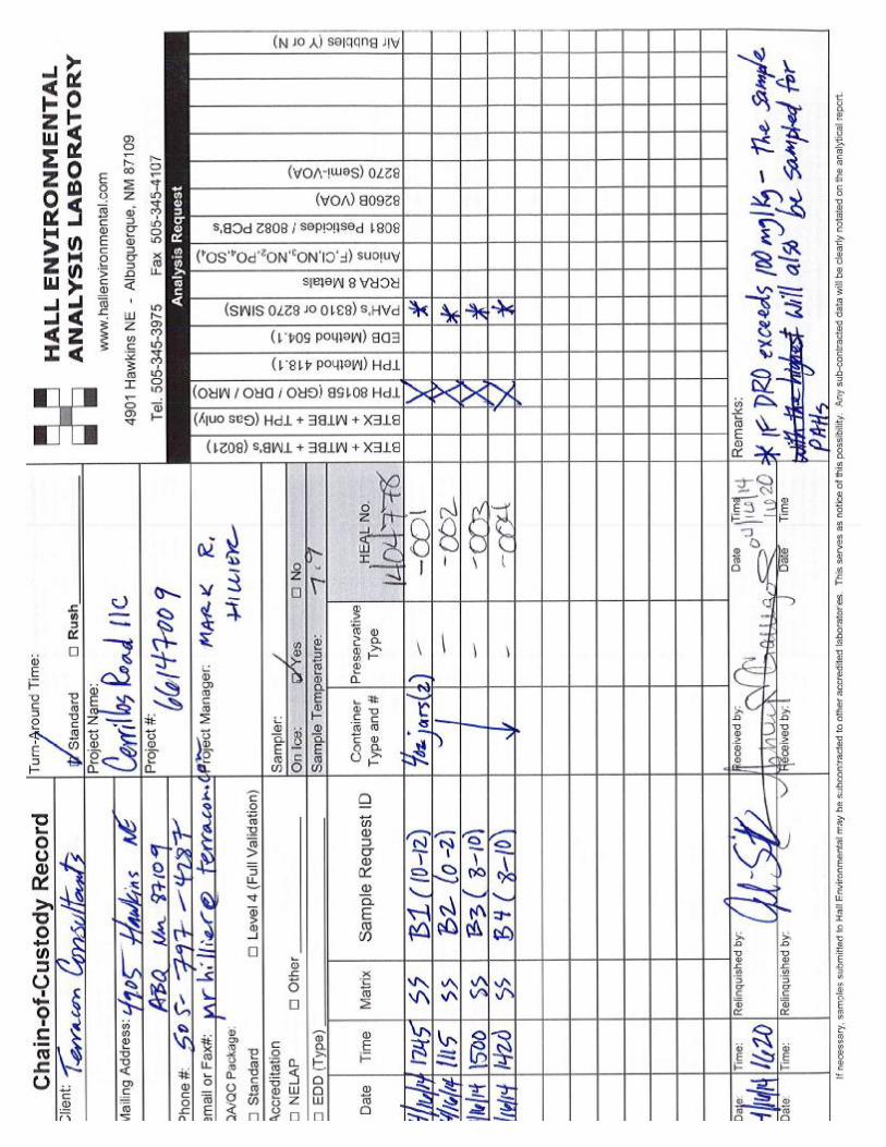
Upon removal of the sampler from the borehole, Terracon put a portion of each sample in a glass jar, which was sealed with aluminum foil. After a stabilization period, Terracon screened the headspace above the soil using the PID equipped with a 10.2 electron-volt (eV) ultraviolet lamp source. Terracon calibrated the PID in accordance with the manufacturer's recommendations before the field activities. The boring logs include the field screening results for each soil boring. Based on the field screening results, Terracon selected soil samples from each boring for laboratory analysis. Groundwater was not encountered during the drilling activities. After packaging each soil sample in laboratory-provided containers, Terracon recorded the sample time on each container label in permanent ink and place the filled containers in an ice-filled cooler for transport to Hall Environmental Analysis Laboratory (HEAL) in Albuquerque, New Mexico, a National Environmental Laboratory Accreditation Conference (NELAC)-accredited laboratory. The samples were analyzed for total petroleum hydrocarbons (TPH) using United States Environmental Protection Agency (USEPA) SW-846 Method 8015D and for benzene, toluene, ethylbenzene, xylenes and methyl tert-butyl ether (BTEX/MTBE) using USEPA SW-846 Method 8260B. At the completion of field activities, Terracon abandoned the borings with commercial bentonite sealant. The borings completed in the paved areas were completed to surface level with cement grout.
5.0 RESULTS OF THE FIELD INVESTIGATION
5.1 Geology/Hydrogeology The boring logs in Appendix B detail the observed soil stratigraphy. In general, Terracon encountered silt from the surface to depths of between 7 feet bgs to 10 feet bgs underlain by sand. Groundwater was not encountered during the drilling activities.
5.2 Field Screening The field screening results are summarized on the boring logs in Appendix B. Elevated readings above 2.4 ppm were not detected in the soil samples collected from borings B-1 through B-4.
5.3 Geophysical Survey The geophysical survey performed adjacent to the India House restaurant, located at 2501 Cerrillos Road, did not identify anomalies consistent with relic USTs or associated piping.
Preliminary Site Investigation Cerrillos Rd. Phase IIC ■ Santa Fe, New Mexico May 2, 2014 ■ Terracon Project No. 66147014
Responsive ■ Resourceful ■ Reliable 6
Based on the results of the geophysical survey, relic USTs and/or associated piping do not appear to remain within the ROW adjacent to 2501 Cerrillos Road. A copy of the geophysical report is included in Appendix D.
6.0 ANALYTICAL RESULTS Concentrations of BTEX, TPH diesel range organics (DRO) or TPH gasoline range organics (GRO) were not detected above the laboratory reporting limits in the four soil samples collected at the site. Although the soil sample collected from soil boring B-2 (0’ to 2’ bgs) exhibited a TPH motor oil range organics (MRO) concentration of 63 milligrams per kilogram (mg/kg), the detected TPH MRO concentration does not exceed the New Mexico Environment Department (NMED) TPH Screening Guideline of 2,500 mg/kg for waste oil. The laboratory analytical report and chain-of-custody record are attached in Appendix C.
7.0 CONCLUSIONS Based on the scope of services described in this report and subject to the limitations described herein, Terracon concludes the following.
Relic USTs and/or associated piping do not appear to remain within the ROW adjacent to 2501 Cerrillos Road.
The soils within the Cerrillos Road ROW adjacent to 2501 Cerrillos Road and
2631 Cerrillos Road have not been affected by releases of petroleum hydrocarbons above levels requiring special handling or disposal. Although soil borings B-3 and B-4 were terminated at 10 feet bgs, approximately five feet above the maximum construction depth adjacent to 2501 Cerrillos Road, the soils between 10 feet bgs and 15 feet bgs in this area are not suspected to be impacted based on the absence of relic USTs in that area, and the absence of elevated PID readings or detected concentrations of BTEX or TPH in the soil samples collected from 8 feet bgs to 10 feet bgs in soil borings B-3 and B-4.
8.0 RECOMMENDATIONS Based on the results of this PSI, Terracon recommends no further environmental assessment of potential releases of petroleum products to the Project Corridor or the presence of relic USTs within the Project Corridor.

APPENDIX A – EXHIBITS Exhibit 1 – Topographic Map
Exhibit 2 – Site Diagram
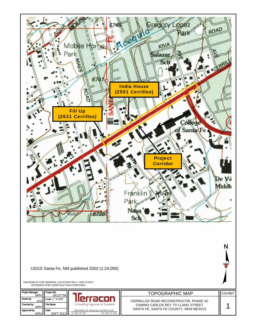
DIAGRAM IS FOR GENERAL LOCATION ONLY, AND IS NOT INTENDED FOR CONSTRUCTION PURPOSES
4905 Hawkins, NE Albuquerque, New Mexico 87109
PH. (505) 797-4287 FAX. (505) 797-4288
1
EXHIBITTOPOGRAPHIC MAP
CERRILLOS ROAD RECONSTRUCTIN, PHASE IICCAMINO CARLOS REY TO LLANO STREET
SANTA FE, SANTA FE COUNTY, NEW MEXICO
Project Manager:
Drawn by:
Checked by:
Approved by:
MRH
JAS
MRH
MRH
Project No.
Scale: 1” ≈ 530’
File Name:
Date:
66137738
SEPT 2013
Project Corridor
USGS Santa Fe, NM published 2002 (1:24,000)
India House(2501 Cerrillos)
Fill Up (2631 Cerrillos)

DIAGRAM IS FOR GENERAL LOCATION ONLY, AND IS NOT INTENDED FOR CONSTRUCTION PURPOSES
4905 Hawkins, NE Albuquerque, New Mexico 87109
PH. (505) 797-4287 FAX. (505) 797-4288
2
EXHIBITSITE DIAGRAM
INDIA HOUSE RESTAURANT2501 CERILLOS ROAD
SANTA FE, NEW MEXICO
Project Manager:
Drawn by:
Checked by:
Approved by:
MRH
JAS
MRH
MRH
Project No.
Scale: 1” ≈ 38’
File Name:
Date:
66137738
FEB 2014
Soil Boring Location

DIAGRAM IS FOR GENERAL LOCATION ONLY, AND IS NOT INTENDED FOR CONSTRUCTION PURPOSES
4905 Hawkins, NE Albuquerque, New Mexico 87109
PH. (505) 797-4287 FAX. (505) 797-4288
3
EXHIBITSITE DIAGRAM
FILL UP2631 CERRILLOS ROAD
SANTA FE, NEW MEXICO
Project Manager:
Drawn by:
Checked by:
Approved by:
MRH
JAS
MRH
MRH
Project No.
Scale: 1” ≈ 30’
File Name:
Date:
66147009
apr 2014
Soil Boring Location
APPENDIX B – SOIL BORING LOGS Boring Logs for B-1 through B-4
0.5
2.0
8.0
14.0
15.0
PORTLAND CEMENT CONCRETEFILL - SILTY SAND WITH GRAVEL , trace sand, fine grained, brown, moist
SILT (ML), trace sand, brown, moist
WELL GRADED SAND WITH SILT (SW-SM), brown, trace granitic gravel fragments, moist
SILTY SAND (SM), fine grained, reddish yellow, moist
Boring Terminated at 15 Feet
0.8
0.0
0.0
0.0
0.0
1.0
0.3
0.3
Stratification lines are approximate. In-situ, the transition may be gradual.
LOCATION
DEPTH
GR
AP
HIC
LO
G 2631 Cerrillos, Fill UpStation, southwestboring
TH
IS B
OR
ING
LO
G IS
NO
T V
ALI
D IF
SE
PA
RA
TE
D F
RO
M O
RIG
INA
L R
EP
OR
T.
G
EO
SM
AR
T L
OG
-NO
WE
LL 6
614
700
9 B
OR
ING
LO
GS
.GP
J T
EM
PLA
TE
UP
DA
TE
3-3
1-14
.GP
J 4
/29/
14
2501 and 2631 Cerrillos Road Santa Fe, New MexicoSITE:
PROJECT: Cerrillos Road ReconstructionPlase IIC
Page 1 of 1
Advancement Method:
Abandonment Method:Borings backfilled with cement-bentonite grout uponcompletion.
4905 Hawkins, NEAlbuquerque, New Mexico
Notes:
Project No.: 66147009
Drill Rig: CME-75
Boring Started: 4/16/2014
BORING LOG NO. B-1Parsons BrinkerhofCLIENT:Albuquerque, New Mexico
Driller: Enviro-Drill
Boring Completed: 4/16/2014
Exhibit: B-1
See Appendix B for explanation of symbols andabbreviations.
See Appendix B for description of laboratoryprocedures and additional data (if any).
See Exhibit B for description of field procedures
FIE
LD T
ES
TR
ES
ULT
S
DE
PT
H (
Ft.)
5
10
15
SA
MP
LE T
YP
E
WA
TE
R L
EV
EL
OB
SE
RV
AT
ION
S
PID
No water encountered
WATER LEVEL OBSERVATIONS

0.5
7.0
15.0
PORTLAND CEMENT CONCRETESILT (ML), trace gravel, fine grained, brown, moist
WELL GRADED SAND (SW), brown, trace granitic gravel, moist
Boring Terminated at 15 Feet
2.4
0.3
0.0
0.0
0.0
0.0
0.0
0.0
Stratification lines are approximate. In-situ, the transition may be gradual.
LOCATION
DEPTH
GR
AP
HIC
LO
G 2631 Cerrillos, Fill UpStation, northeastboring
TH
IS B
OR
ING
LO
G IS
NO
T V
ALI
D IF
SE
PA
RA
TE
D F
RO
M O
RIG
INA
L R
EP
OR
T.
G
EO
SM
AR
T L
OG
-NO
WE
LL 6
614
700
9 B
OR
ING
LO
GS
.GP
J T
EM
PLA
TE
UP
DA
TE
3-3
1-14
.GP
J 4
/29/
14
2501 and 2631 Cerrillos Road Santa Fe, New MexicoSITE:
PROJECT: Cerrillos Road ReconstructionPlase IIC
Page 1 of 1
Advancement Method:
Abandonment Method:Borings backfilled with cement-bentonite grout uponcompletion.
4905 Hawkins, NEAlbuquerque, New Mexico
Notes:
Project No.: 66147009
Drill Rig: CME-75
Boring Started: 4/16/2014
BORING LOG NO. B-2Parsons BrinkerhofCLIENT:Albuquerque, New Mexico
Driller: Enviro-Drill
Boring Completed: 4/16/2014
Exhibit: B-2
See Appendix B for explanation of symbols andabbreviations.
See Appendix B for description of laboratoryprocedures and additional data (if any).
See Exhibit B for description of field procedures
FIE
LD T
ES
TR
ES
ULT
S
DE
PT
H (
Ft.)
5
10
15
SA
MP
LE T
YP
E
WA
TE
R L
EV
EL
OB
SE
RV
AT
ION
S
PID
No water encountered
WATER LEVEL OBSERVATIONS
10.0
SILT (ML), trace clay, brown, damp
trace sand, fine grained
Boring Terminated at 10 Feet
0.0
0.0
0.0
0.0
0.0
Stratification lines are approximate. In-situ, the transition may be gradual.
LOCATION
DEPTH
GR
AP
HIC
LO
G 2501 Cerrillos Road,India House Restaurant,southwest boring
TH
IS B
OR
ING
LO
G IS
NO
T V
ALI
D IF
SE
PA
RA
TE
D F
RO
M O
RIG
INA
L R
EP
OR
T.
G
EO
SM
AR
T L
OG
-NO
WE
LL 6
614
700
9 B
OR
ING
LO
GS
.GP
J T
EM
PLA
TE
UP
DA
TE
3-3
1-14
.GP
J 4
/29/
14
2501 and 2631 Cerrillos Road Santa Fe, New MexicoSITE:
PROJECT: Cerrillos Road ReconstructionPlase IIC
Page 1 of 1
Advancement Method:
Abandonment Method:Borings backfilled with cement-bentonite grout uponcompletion.
4905 Hawkins, NEAlbuquerque, New Mexico
Notes:
Project No.: 66147009
Drill Rig: CME-75
Boring Started: 4/16/2014
BORING LOG NO. B-3Parsons BrinkerhofCLIENT:Albuquerque, New Mexico
Driller: Enviro-Drill
Boring Completed: 4/16/2014
Exhibit: B-3
See Appendix B for explanation of symbols andabbreviations.
See Appendix B for description of laboratoryprocedures and additional data (if any).
See Exhibit B for description of field procedures
FIE
LD T
ES
TR
ES
ULT
S
DE
PT
H (
Ft.)
5
10
SA
MP
LE T
YP
E
WA
TE
R L
EV
EL
OB
SE
RV
AT
ION
S
PID
No water encountered
WATER LEVEL OBSERVATIONS
0.5
6.0
10.0
PORTLAND CEMENT CONCRETESILT (ML), trace gravel, fine grained, light brown to brown, moist
SILT WITH SAND (SM), brown, moist
-becomes pale red with granite particles
Boring Terminated at 10 Feet
0.0
0.0
norecovery
0.0
0.0
Stratification lines are approximate. In-situ, the transition may be gradual.
LOCATION
DEPTH
GR
AP
HIC
LO
G 2501 Cerrillos Road,India House Restaurant,northeast boring
TH
IS B
OR
ING
LO
G IS
NO
T V
ALI
D IF
SE
PA
RA
TE
D F
RO
M O
RIG
INA
L R
EP
OR
T.
G
EO
SM
AR
T L
OG
-NO
WE
LL 6
614
700
9 B
OR
ING
LO
GS
.GP
J T
EM
PLA
TE
UP
DA
TE
3-3
1-14
.GP
J 4
/29/
14
2501 and 2631 Cerrillos Road Santa Fe, New MexicoSITE:
PROJECT: Cerrillos Road ReconstructionPlase IIC
Page 1 of 1
Advancement Method:
Abandonment Method:Borings backfilled with cement-bentonite grout uponcompletion.
4905 Hawkins, NEAlbuquerque, New Mexico
Notes:
Project No.: 66147009
Drill Rig: CME-75
Boring Started: 4/16/2014
BORING LOG NO. B-4Parsons BrinkerhofCLIENT:Albuquerque, New Mexico
Driller: Enviro-Drill
Boring Completed: 4/16/2014
Exhibit: B-4
See Appendix B for explanation of symbols andabbreviations.
See Appendix B for description of laboratoryprocedures and additional data (if any).
See Exhibit B for description of field procedures
FIE
LD T
ES
TR
ES
ULT
S
DE
PT
H (
Ft.)
5
10
SA
MP
LE T
YP
E
WA
TE
R L
EV
EL
OB
SE
RV
AT
ION
S
PID
No water encountered
WATER LEVEL OBSERVATIONS
APPENDIX C – ANALYTICAL REPORT AND CHAIN OF CUSTODY

April 25, 2014
TerraconMark Hillier
Dear Mark Hillier:
RE: Cerrillos Road IIC OrderNo.: 1404778
FAX (505) 797-4288TEL: (505) 715-0375
4905 Hawkins, NEAlbuquerque, NM 87109
Hall Environmental Analysis Laboratory4901 Hawkins NE
Albuquerque, NM 87109
Website: www.hallenvironmental.comTEL: 505-345-3975 FAX: 505-345-4107
Hall Environmental Analysis Laboratory received 4 sample(s) on 4/16/2014 for the analyses presented in the following report.
Andy Freeman
These were analyzed according to EPA procedures or equivalent. To access our accredited tests please go to www.hallenvironmental.com or the state specific web sites. In order to properly interpret your results it is imperative that you review this report in its entirety. See the sample checklist and/or the Chain of Custody for information regarding the sample receipt temperature and preservation. Data qualifiers or a narrative will be provided if the sample analysis or analytical quality control parameters require a flag. When necessary, data qualifers are provided on both the sample analysis report and the QC summary report, both sections should be reviewed. All samples are reported, as received, unless otherwise indicated. Lab measurement of analytes considered field parameters that require analysis within 15 minutes of sampling such as pH and residual chlorine are qualified as being analyzed outside of the recommended holding time.
Please don't hesitate to contact HEAL for any additional information or clarifications.
ADHS Cert #AZ0682 -- NMED-DWB Cert #NM9425 -- NMED-Micro Cert #NM0190
Sincerely,
Laboratory Manager4901 Hawkins NEAlbuquerque, NM 87109

Project: Cerrillos Road IICClient Sample ID: B1 (10-12)
Collection Date: 4/16/2014 12:45:00 PMMatrix: SOIL
CLIENT: Terracon
Lab ID: 1404778-001
Date Reported: 4/25/2014
Analytical ReportLab Order 1404778
Analyses Result Qual Units Date AnalyzedDFRL
Hall Environmental Analysis Laboratory, Inc.
Received Date: 4/16/2014 4:20:00 PM
Batch
EPA METHOD 8015D: DIESEL RANGE ORGANICS Analyst: JMEDiesel Range Organics (DRO) 4/18/2014 9:44:43 AM9.9 mg/Kg 1ND 12758Motor Oil Range Organics (MRO) 4/18/2014 9:44:43 AM50 mg/Kg 1ND 12758 Surr: DNOP 4/18/2014 9:44:43 AM57.9-140 %REC 1106 12758
EPA METHOD 8015D: GASOLINE RANGE Analyst: RAAGasoline Range Organics (GRO) 4/18/2014 6:29:49 PM4.8 mg/Kg 1ND 12765 Surr: BFB 4/18/2014 6:29:49 PM74.5-129 %REC 185.8 12765
EPA METHOD 8260B: VOLATILES SHORT LIST Analyst: cadgMethyl tert-butyl ether (MTBE) 4/25/2014 1:04:29 AM0.048 mg/Kg 1ND 12765Benzene 4/25/2014 1:04:29 AM0.048 mg/Kg 1ND 12765Toluene 4/25/2014 1:04:29 AM0.048 mg/Kg 1ND 12765Ethylbenzene 4/25/2014 1:04:29 AM0.048 mg/Kg 1ND 12765Xylenes, Total 4/25/2014 1:04:29 AM0.096 mg/Kg 1ND 12765 Surr: 1,2-Dichloroethane-d4 4/25/2014 1:04:29 AM70-130 %REC 1104 12765 Surr: 4-Bromofluorobenzene 4/25/2014 1:04:29 AM70-130 %REC 195.0 12765 Surr: Dibromofluoromethane 4/25/2014 1:04:29 AM70-130 %REC 1110 12765 Surr: Toluene-d8 4/25/2014 1:04:29 AM70-130 %REC 189.5 12765
Qualifiers:
Page 1 of 7
Refer to the QC Summary report and sample login checklist for flagged QC data and preservation information.
* Value exceeds Maximum Contaminant Level. B Analyte detected in the associated Method BlankE Value above quantitation range H Holding times for preparation or analysis exceededJ Analyte detected below quantitation limits ND Not Detected at the Reporting LimitO RSD is greater than RSDlimit P Sample pH greater than 2.R RPD outside accepted recovery limits RL Reporting Detection LimitS Spike Recovery outside accepted recovery limits
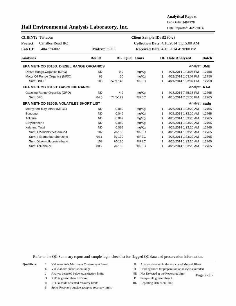
Project: Cerrillos Road IICClient Sample ID: B2 (0-2)
Collection Date: 4/16/2014 11:15:00 AMMatrix: SOIL
CLIENT: Terracon
Lab ID: 1404778-002
Date Reported: 4/25/2014
Analytical ReportLab Order 1404778
Analyses Result Qual Units Date AnalyzedDFRL
Hall Environmental Analysis Laboratory, Inc.
Received Date: 4/16/2014 4:20:00 PM
Batch
EPA METHOD 8015D: DIESEL RANGE ORGANICS Analyst: JMEDiesel Range Organics (DRO) 4/21/2014 1:03:07 PM9.9 mg/Kg 1ND 12758Motor Oil Range Organics (MRO) 4/21/2014 1:03:07 PM50 mg/Kg 163 12758 Surr: DNOP 4/21/2014 1:03:07 PM57.9-140 %REC 1108 12758
EPA METHOD 8015D: GASOLINE RANGE Analyst: RAAGasoline Range Organics (GRO) 4/18/2014 7:55:33 PM4.9 mg/Kg 1ND 12765 Surr: BFB 4/18/2014 7:55:33 PM74.5-129 %REC 184.0 12765
EPA METHOD 8260B: VOLATILES SHORT LIST Analyst: cadgMethyl tert-butyl ether (MTBE) 4/25/2014 1:33:20 AM0.049 mg/Kg 1ND 12765Benzene 4/25/2014 1:33:20 AM0.049 mg/Kg 1ND 12765Toluene 4/25/2014 1:33:20 AM0.049 mg/Kg 1ND 12765Ethylbenzene 4/25/2014 1:33:20 AM0.049 mg/Kg 1ND 12765Xylenes, Total 4/25/2014 1:33:20 AM0.099 mg/Kg 1ND 12765 Surr: 1,2-Dichloroethane-d4 4/25/2014 1:33:20 AM70-130 %REC 1102 12765 Surr: 4-Bromofluorobenzene 4/25/2014 1:33:20 AM70-130 %REC 194.1 12765 Surr: Dibromofluoromethane 4/25/2014 1:33:20 AM70-130 %REC 1108 12765 Surr: Toluene-d8 4/25/2014 1:33:20 AM70-130 %REC 188.2 12765
Qualifiers:
Page 2 of 7
Refer to the QC Summary report and sample login checklist for flagged QC data and preservation information.
* Value exceeds Maximum Contaminant Level. B Analyte detected in the associated Method BlankE Value above quantitation range H Holding times for preparation or analysis exceededJ Analyte detected below quantitation limits ND Not Detected at the Reporting LimitO RSD is greater than RSDlimit P Sample pH greater than 2.R RPD outside accepted recovery limits RL Reporting Detection LimitS Spike Recovery outside accepted recovery limits
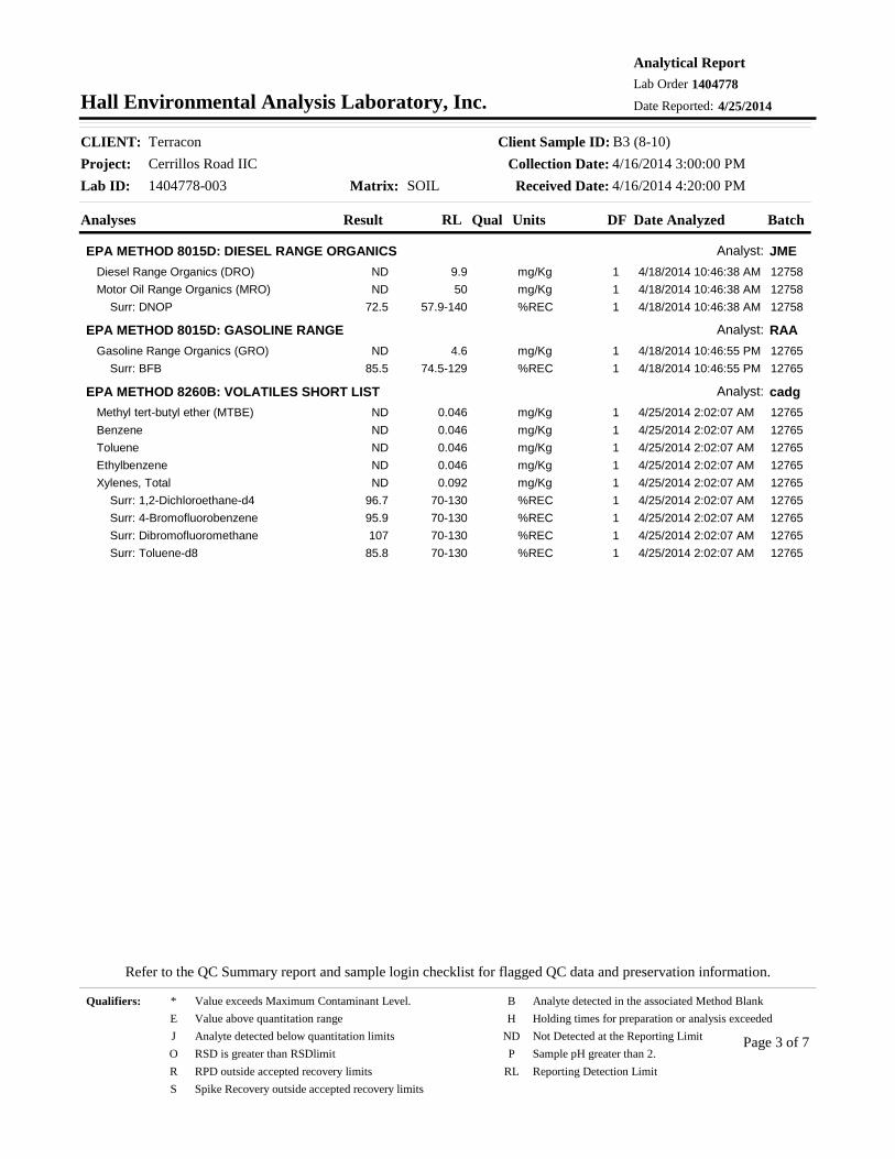
Project: Cerrillos Road IICClient Sample ID: B3 (8-10)
Collection Date: 4/16/2014 3:00:00 PMMatrix: SOIL
CLIENT: Terracon
Lab ID: 1404778-003
Date Reported: 4/25/2014
Analytical ReportLab Order 1404778
Analyses Result Qual Units Date AnalyzedDFRL
Hall Environmental Analysis Laboratory, Inc.
Received Date: 4/16/2014 4:20:00 PM
Batch
EPA METHOD 8015D: DIESEL RANGE ORGANICS Analyst: JMEDiesel Range Organics (DRO) 4/18/2014 10:46:38 AM9.9 mg/Kg 1ND 12758Motor Oil Range Organics (MRO) 4/18/2014 10:46:38 AM50 mg/Kg 1ND 12758 Surr: DNOP 4/18/2014 10:46:38 AM57.9-140 %REC 172.5 12758
EPA METHOD 8015D: GASOLINE RANGE Analyst: RAAGasoline Range Organics (GRO) 4/18/2014 10:46:55 PM4.6 mg/Kg 1ND 12765 Surr: BFB 4/18/2014 10:46:55 PM74.5-129 %REC 185.5 12765
EPA METHOD 8260B: VOLATILES SHORT LIST Analyst: cadgMethyl tert-butyl ether (MTBE) 4/25/2014 2:02:07 AM0.046 mg/Kg 1ND 12765Benzene 4/25/2014 2:02:07 AM0.046 mg/Kg 1ND 12765Toluene 4/25/2014 2:02:07 AM0.046 mg/Kg 1ND 12765Ethylbenzene 4/25/2014 2:02:07 AM0.046 mg/Kg 1ND 12765Xylenes, Total 4/25/2014 2:02:07 AM0.092 mg/Kg 1ND 12765 Surr: 1,2-Dichloroethane-d4 4/25/2014 2:02:07 AM70-130 %REC 196.7 12765 Surr: 4-Bromofluorobenzene 4/25/2014 2:02:07 AM70-130 %REC 195.9 12765 Surr: Dibromofluoromethane 4/25/2014 2:02:07 AM70-130 %REC 1107 12765 Surr: Toluene-d8 4/25/2014 2:02:07 AM70-130 %REC 185.8 12765
Qualifiers:
Page 3 of 7
Refer to the QC Summary report and sample login checklist for flagged QC data and preservation information.
* Value exceeds Maximum Contaminant Level. B Analyte detected in the associated Method BlankE Value above quantitation range H Holding times for preparation or analysis exceededJ Analyte detected below quantitation limits ND Not Detected at the Reporting LimitO RSD is greater than RSDlimit P Sample pH greater than 2.R RPD outside accepted recovery limits RL Reporting Detection LimitS Spike Recovery outside accepted recovery limits

Project: Cerrillos Road IICClient Sample ID: B4 (8-10)
Collection Date: 4/16/2014 2:20:00 PMMatrix: SOIL
CLIENT: Terracon
Lab ID: 1404778-004
Date Reported: 4/25/2014
Analytical ReportLab Order 1404778
Analyses Result Qual Units Date AnalyzedDFRL
Hall Environmental Analysis Laboratory, Inc.
Received Date: 4/16/2014 4:20:00 PM
Batch
EPA METHOD 8015D: DIESEL RANGE ORGANICS Analyst: JMEDiesel Range Organics (DRO) 4/18/2014 1:57:11 PM9.8 mg/Kg 1ND 12758Motor Oil Range Organics (MRO) 4/18/2014 1:57:11 PM49 mg/Kg 1ND 12758 Surr: DNOP 4/18/2014 1:57:11 PM57.9-140 %REC 1105 12758
EPA METHOD 8015D: GASOLINE RANGE Analyst: RAAGasoline Range Organics (GRO) 4/18/2014 11:15:26 PM4.7 mg/Kg 1ND 12765 Surr: BFB 4/18/2014 11:15:26 PM74.5-129 %REC 186.4 12765
EPA METHOD 8260B: VOLATILES SHORT LIST Analyst: cadgMethyl tert-butyl ether (MTBE) 4/25/2014 2:30:52 AM0.047 mg/Kg 1ND 12765Benzene 4/25/2014 2:30:52 AM0.047 mg/Kg 1ND 12765Toluene 4/25/2014 2:30:52 AM0.047 mg/Kg 1ND 12765Ethylbenzene 4/25/2014 2:30:52 AM0.047 mg/Kg 1ND 12765Xylenes, Total 4/25/2014 2:30:52 AM0.094 mg/Kg 1ND 12765 Surr: 1,2-Dichloroethane-d4 4/25/2014 2:30:52 AM70-130 %REC 1103 12765 Surr: 4-Bromofluorobenzene 4/25/2014 2:30:52 AM70-130 %REC 192.9 12765 Surr: Dibromofluoromethane 4/25/2014 2:30:52 AM70-130 %REC 1113 12765 Surr: Toluene-d8 4/25/2014 2:30:52 AM70-130 %REC 189.5 12765
Qualifiers:
Page 4 of 7
Refer to the QC Summary report and sample login checklist for flagged QC data and preservation information.
* Value exceeds Maximum Contaminant Level. B Analyte detected in the associated Method BlankE Value above quantitation range H Holding times for preparation or analysis exceededJ Analyte detected below quantitation limits ND Not Detected at the Reporting LimitO RSD is greater than RSDlimit P Sample pH greater than 2.R RPD outside accepted recovery limits RL Reporting Detection LimitS Spike Recovery outside accepted recovery limits
Project: Cerrillos Road IICClient: Terracon
25-Apr-14
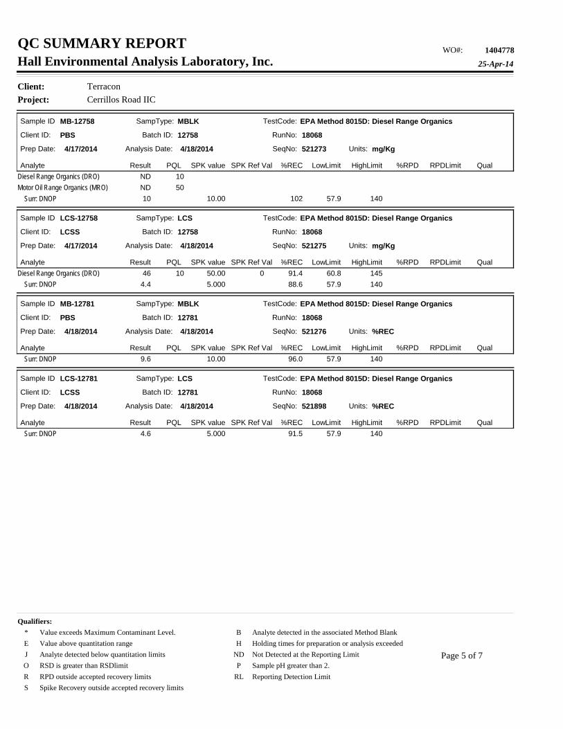
QC SUMMARY REPORT 1404778WO#:Hall Environmental Analysis Laboratory, Inc.
Sample ID MB-12758
Batch ID: 12758
Analysis Date: 4/18/2014Prep Date: 4/17/2014
Analyte Result SPK value SPK Ref Val %REC %RPDLowLimit HighLimit RPDLimit Qual
Units: mg/Kg
PQL
Client ID: PBS RunNo: 18068
SeqNo: 521273
MBLKSampType: TestCode: EPA Method 8015D: Diesel Range Organics
Diesel Range Organics (DRO) 10NDMotor Oil Range Organics (MRO) 50ND Surr: DNOP 10.00 102 57.9 14010
Sample ID LCS-12758
Batch ID: 12758
Analysis Date: 4/18/2014Prep Date: 4/17/2014
Analyte Result SPK value SPK Ref Val %REC %RPDLowLimit HighLimit RPDLimit Qual
Units: mg/Kg
PQL
Client ID: LCSS RunNo: 18068
SeqNo: 521275
LCSSampType: TestCode: EPA Method 8015D: Diesel Range Organics
Diesel Range Organics (DRO) 50.00 91.4 60.8 14510 046 Surr: DNOP 5.000 88.6 57.9 1404.4
Sample ID MB-12781
Batch ID: 12781
Analysis Date: 4/18/2014Prep Date: 4/18/2014
Analyte Result SPK value SPK Ref Val %REC %RPDLowLimit HighLimit RPDLimit Qual
Units: %REC
PQL
Client ID: PBS RunNo: 18068
SeqNo: 521276
MBLKSampType: TestCode: EPA Method 8015D: Diesel Range Organics
Surr: DNOP 10.00 96.0 57.9 1409.6
Sample ID LCS-12781
Batch ID: 12781
Analysis Date: 4/18/2014Prep Date: 4/18/2014
Analyte Result SPK value SPK Ref Val %REC %RPDLowLimit HighLimit RPDLimit Qual
Units: %REC
PQL
Client ID: LCSS RunNo: 18068
SeqNo: 521898
LCSSampType: TestCode: EPA Method 8015D: Diesel Range Organics
Surr: DNOP 5.000 91.5 57.9 1404.6
Qualifiers:
Page 5 of 7
* Value exceeds Maximum Contaminant Level. B Analyte detected in the associated Method BlankE Value above quantitation range H Holding times for preparation or analysis exceededJ Analyte detected below quantitation limits ND Not Detected at the Reporting LimitO RSD is greater than RSDlimit P Sample pH greater than 2.R RPD outside accepted recovery limits RL Reporting Detection LimitS Spike Recovery outside accepted recovery limits

Project: Cerrillos Road IICClient: Terracon
25-Apr-14
QC SUMMARY REPORT 1404778WO#:Hall Environmental Analysis Laboratory, Inc.
Sample ID MB-12765
Batch ID: 12765
Analysis Date: 4/18/2014Prep Date: 4/17/2014
Analyte Result SPK value SPK Ref Val %REC %RPDLowLimit HighLimit RPDLimit Qual
Units: mg/Kg
PQL
Client ID: PBS RunNo: 18084
SeqNo: 522600
MBLKSampType: TestCode: EPA Method 8015D: Gasoline Range
Gasoline Range Organics (GRO) 5.0ND Surr: BFB 1000 85.6 74.5 129860
Sample ID LCS-12765
Batch ID: 12765
Analysis Date: 4/18/2014Prep Date: 4/17/2014
Analyte Result SPK value SPK Ref Val %REC %RPDLowLimit HighLimit RPDLimit Qual
Units: mg/Kg
PQL
Client ID: LCSS RunNo: 18084
SeqNo: 522601
LCSSampType: TestCode: EPA Method 8015D: Gasoline Range
Gasoline Range Organics (GRO) 25.00 97.9 71.7 1345.0 024 Surr: BFB 1000 91.5 74.5 129910
Sample ID 1404778-001AMS
Batch ID: 12765
Analysis Date: 4/18/2014Prep Date: 4/17/2014
Analyte Result SPK value SPK Ref Val %REC %RPDLowLimit HighLimit RPDLimit Qual
Units: mg/Kg
PQL
Client ID: B1 (10-12) RunNo: 18084
SeqNo: 522619
MSSampType: TestCode: EPA Method 8015D: Gasoline Range
Gasoline Range Organics (GRO) 24.15 95.7 69.5 1454.8 023 Surr: BFB 966.2 93.9 74.5 129910
Sample ID 1404778-001AMSD
Batch ID: 12765
Analysis Date: 4/18/2014Prep Date: 4/17/2014
Analyte Result SPK value SPK Ref Val %REC %RPDLowLimit HighLimit RPDLimit Qual
Units: mg/Kg
PQL
Client ID: B1 (10-12) RunNo: 18084
SeqNo: 522620
MSDSampType: TestCode: EPA Method 8015D: Gasoline Range
Gasoline Range Organics (GRO) 24.04 90.0 69.5 145 204.8 0 6.6922 Surr: BFB 961.5 92.9 74.5 129 00890
Qualifiers:
Page 6 of 7
* Value exceeds Maximum Contaminant Level. B Analyte detected in the associated Method BlankE Value above quantitation range H Holding times for preparation or analysis exceededJ Analyte detected below quantitation limits ND Not Detected at the Reporting LimitO RSD is greater than RSDlimit P Sample pH greater than 2.R RPD outside accepted recovery limits RL Reporting Detection LimitS Spike Recovery outside accepted recovery limits
Project: Cerrillos Road IICClient: Terracon
25-Apr-14
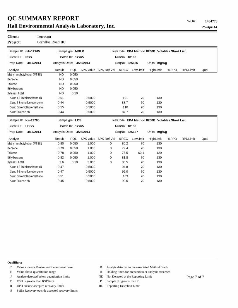
QC SUMMARY REPORT 1404778WO#:Hall Environmental Analysis Laboratory, Inc.
Sample ID mb-12765
Batch ID: 12765
Analysis Date: 4/25/2014Prep Date: 4/17/2014
Analyte Result SPK value SPK Ref Val %REC %RPDLowLimit HighLimit RPDLimit Qual
Units: mg/Kg
PQL
Client ID: PBS RunNo: 18198
SeqNo: 525686
MBLKSampType: TestCode: EPA Method 8260B: Volatiles Short List
Methyl tert-butyl ether (MTBE) 0.050NDBenzene 0.050NDToluene 0.050NDEthylbenzene 0.050NDXylenes, Total 0.10ND Surr: 1,2-Dichloroethane-d4 0.5000 101 70 1300.51 Surr: 4-Bromofluorobenzene 0.5000 88.7 70 1300.44 Surr: Dibromofluoromethane 0.5000 110 70 1300.55 Surr: Toluene-d8 0.5000 87.7 70 1300.44
Sample ID lcs-12765
Batch ID: 12765
Analysis Date: 4/25/2014Prep Date: 4/17/2014
Analyte Result SPK value SPK Ref Val %REC %RPDLowLimit HighLimit RPDLimit Qual
Units: mg/Kg
PQL
Client ID: LCSS RunNo: 18198
SeqNo: 525687
LCSSampType: TestCode: EPA Method 8260B: Volatiles Short List
Methyl tert-butyl ether (MTBE) 1.000 80.2 70 1300.050 00.80Benzene 1.000 79.4 70 1300.050 00.79Toluene 1.000 78.5 60.1 1200.050 00.78Ethylbenzene 1.000 81.8 70 1300.050 00.82Xylenes, Total 3.000 85.5 70 1300.10 02.6 Surr: 1,2-Dichloroethane-d4 0.5000 94.8 70 1300.47 Surr: 4-Bromofluorobenzene 0.5000 95.0 70 1300.47 Surr: Dibromofluoromethane 0.5000 103 70 1300.51 Surr: Toluene-d8 0.5000 90.5 70 1300.45
Qualifiers:
Page 7 of 7
* Value exceeds Maximum Contaminant Level. B Analyte detected in the associated Method BlankE Value above quantitation range H Holding times for preparation or analysis exceededJ Analyte detected below quantitation limits ND Not Detected at the Reporting LimitO RSD is greater than RSDlimit P Sample pH greater than 2.R RPD outside accepted recovery limits RL Reporting Detection LimitS Spike Recovery outside accepted recovery limits


APPENDIX D – GEOPHYSICAL SURVEY REPORT

APPENDIX E – WORK PLAN

Terracon Consultants, Inc. 4905 Hawkins NE Albuquerque, NM 87109 P (505) 797 4287 F (505) 797 4288 terracon.com
February 26, 2014 Mr. Jim Buckman, P.E. Parsons Brinckerhoff 6100 Uptown Boulevard NE, Suite 700 Albuquerque, NM 87110 Telephone: (505) 878-6577 Email: [email protected] Re: Proposal for Preliminary Site Investigation (NMDOT Work Plan) Cerrillos Road Reconstruction, Phase IIC Camino Carlos Rey to St. Michael’s Drive Santa Fe, Santa Fe County, New Mexico Terracon Proposal No: P6614-0062 Dear Mr. Buckman: Terracon Consultants, Inc. (Terracon) appreciates the opportunity to submit this proposal to conduct a Preliminary Site Investigation (PSI) at the above-referenced site. The following sections provide an outline of the project, Terracon’s PSI scope of services, including schedule, and compensation.
PROJECT INFORMATION 1.0 For the purpose of this proposal, the site is defined as the existing right-of-way (ROW) of Cerrillos Road from Camino Carlos Rey northward to St. Michael’s Drive in Santa Fe, Santa Fe County, New Mexico. Terracon understands that the improvements to the Cerrillos Road ROW will include, but are not limited to: the reconstruction of Cerrillos Road roadway typical in the project area; geometric and interconnect; storm drainage improvements; pedestrian, bicycle and ADA improvements to include sidewalks, curb ramps and bicycle lanes; irrigation and landscaping; and, design of bus bays/lanes and permanent signing and striping. Terracon previously performed an Initial Site Assessment (ISA) for the project corridor (Terracon Report No. 66137738). The following two Recognized Environmental Conditions (RECs) were identified in the ISA:
■ The India House Restaurant, located at 2501 Cerrillos Road, was historically occupied by gas stations. Potential impacts of petroleum hydrocarbons from the historical gas stations and the potential presence of relic USTs associated with this property within the ROW of Cerrillos Road were considered RECs. Based on a review of historical aerial photographs, it appears that dispensers were located within 20 feet of the existing Cerrillos Road ROW. Based on the suspected use of this property as a gas station for over 35 years, the
Proposal for Limited Site Investigation Cerrillos Road Phase IIC ■ Santa Fe, New Mexico February 26, 2014 ■ Terracon Proposal No. P6614-0062
Responsive ■ Resourceful ■ Reliable 2
absence of previous assessment of soils adjacent to this facility for impact of petroleum hydrocarbons, and the absence of Fire Department UST removal records, this facility has the potential to have impacted the soils of the Cerrillos Road ROW with petroleum products and relic underground storage tanks (USTs) may remain within or near the Cerrillos Road ROW. The maximum depth of soil disturbance for the project adjacent to this facility is approximately 15 feet below grade surface (bgs).
■ The Fill Up gas station, located at 2631 Cerrillos Road, has been a gas station since at
least 1960. Potential impacts of petroleum hydrocarbons from the Fill Up gas station were considered RECs. This facility was formerly operated as a Diamond Shamrock and a Shell station. Based on the history of releases at this facility, an absence of subsurface investigations at the facility since 2002, and the location of the existing dispensers within 16 feet of the Cerrillos Road ROW, this facility has the potential to have impacted the soils of the Cerrillos Road ROW with petroleum products. The maximum depth of soil disturbance for the project adjacent to this facility is approximately 10 feet below grade surface (bgs).
SCOPE OF SERVICES 2.0 At your request, the proposed scope of work is in response to the results of Terracon’s ISA. The objective of the proposed PSI is to evaluate the presence of total petroleum hydrocarbons (TPH), benzene, toluene, ethyl benzene, total xylenes and methyl tert butyl ether (BTEX/MTBE), and polycyclic aromatic hydrocarbons (PAHs) (above relevant laboratory reporting limits) in the on-site soils as a result of potential releases from the RECs identified in our ISA. In addition, the objective of the proposed PSI is to perform a geophysical survey of the ROW adjacent to 2501 Cerrillos Road to evaluate the potential presence of relic USTs within the ROW at that location. Following receipt of authorization to proceed and no later than 48 hours prior to intrusive activities, Terracon will contact a utility locator to arrange for underground utility locates at the locations of proposed soil borings. Terracon has a 100% commitment to the safety of all its employees. As such, and in accordance with our Incident and Injury Free® safety culture, Terracon will develop a safety plan to be used by our personnel during field services. Prior to commencement of on-site activities, Terracon will hold a meeting to review health and safety needs for this specific project. At this time, we anticipate performing fieldwork in a OSHA Level D work uniform consisting of hard hats, safety glasses, protective gloves, and steel-toed boots. It may become necessary to upgrade this level of protection, at additional cost, while sampling activities are being conducted in the event that petroleum or chemical constituents are encountered in soils or groundwater that present an increased risk for personal exposure.
Proposal for Limited Site Investigation Cerrillos Road Phase IIC ■ Santa Fe, New Mexico February 26, 2014 ■ Terracon Proposal No. P6614-0062
Responsive ■ Resourceful ■ Reliable 3
2.1 Soil Borings Terracon will advance two soil borings adjacent to each of the two facilities identified as RECs using concrete coring and direct-push drilling equipment. One soil boring will be advanced in the location of a planned storm sewer drop inlet adjacent to 2631 Cerrillos Road. This location is near the southern dispenser island at the facility. One soil boring will be advanced adjacent to the northern dispenser island at 2631 Cerrillos Road. One soil boring will be advanced in the location of a planned storm sewer drop inlet adjacent to the southwest portion of 2501 Cerrillos Road. This location is near the location of a suspected historical dispenser island. One soil boring will be advanced adjacent to the northeast portion of 2501 Cerrillos Road. The soil borings adjacent to 2631 Cerrillos Road will be advanced to a maximum depth of approximately 15 feet bgs or until refusal, whichever occurs first. The soil borings adjacent to 2501 Cerrillos Road will be advanced to a maximum depth of approximately 10 feet bgs or until refusal, whichever occurs first. The proposed total boring depths will not be exceeded without verbal approval from the client. Maps depicting the locations of the proposed soil borings are include as attached Exhibit 1 and Exhibit 2. Drilling equipment will be cleaned using a high-pressure washer prior to beginning the project and before beginning each boring. Non-dedicated sampling equipment will be cleaned using an Alconox®
detergent wash and potable water rinse prior to commencement of the project and between collection of each sample. Soil samples will be collected continuously using split spoon samplers to document lithology, color, and relative moisture content. In addition, the soil samples will be field screened using sensory methods and a photoionization detector (PID) to detect the presence of volatile organic compounds (VOCs). Following completion of sampling activities, the soil borings will be closed in place in accordance with applicable state regulations and guidelines.
2.2 Geophysical Survey Terracon proposes to subcontract Sunbelt Geophysics to conduct a geophysical survey using electromagnetic and ground penetrating radar methods to evaluate the ROW adjacent to 2501 Cerrillos Road for anomalies consistent with the presence of USTs. A spatial control grid will be placed over the area of interest establishing parallel data acquisition lines separated by 4 ft, oriented parallel to Cerrillos Rd. The grid will be marked with small dots of spray paint and tied to local landmarks. An initial survey will be conducted using a Geonics EM-61 high-resolution metal detector. This instrument has a proven ability to map buried metal features, such as USTs, to a depth of approximately 10 ft. A second survey will be conducted over the site using a Sensors & Software

Proposal for Limited Site Investigation Cerrillos Road Phase IIC ■ Santa Fe, New Mexico February 26, 2014 ■ Terracon Proposal No. P6614-0062
Responsive ■ Resourceful ■ Reliable 4
250 MHz ground-penetrating radar (GPR) system. Additional screening will be performed with a Schonstedt magnetic locator and a Radiodetection CAT 3+ line tracer as needed. The results of the survey and the interpretations of the geophysicist performing the survey will be provided in a written report, which will include maps of the site and anomalies, if identified.
2.3 Sampling Program Terracon’s soil sampling program will consist of the following:
Collection of one soil sample from each soil boring from the zone exhibiting the highest PID readings. If, based on these observations, no elevated PID reading is observed, the sample will be collected from the interval exhibiting a change in lithology, from the bottom of the boring, or from the interval of most likely environmental impact as determined in the field by the sampling professional.
The soil samples will be collected and placed in laboratory prepared containers, labeled, and placed on ice in a cooler which will be secured with a custody seal. The samples and completed chain-of-custody forms will be transported to the selected analytical laboratory for analysis on a standard 5-day turnaround.
2.4 Laboratory Analytical Program The soil samples collected from the soil borings will be analyzed for TPH using United States Environmental Protection Agency (USEPA) SW-846 Method 8015 and for BTEX/MTBE using USEPA SW-846 Method 8260. If TPH diesel range organics (DRO) are detected at concentrations exceeding 100 milligrams per kilogram (mg/kg), the soil sample from each source area exhibiting the highest TPH DRO concentrations will be additionally analyzed for PAHs using USEPA SW-846 Method 8310.
2.5 Preparation of PSI Report Upon completion of site activities and receipt of the laboratory analytical results, a report will be prepared that will include the following:
Documentation of field activities; Site plan showing pertinent site features; Soil boring logs; Analytical laboratory results; Geophysical survey results; Data evaluation and presentation of findings; and, Recommendations concerning further action, if necessary.
Proposal for Limited Site Investigation Cerrillos Road Phase IIC ■ Santa Fe, New Mexico February 26, 2014 ■ Terracon Proposal No. P6614-0062
Responsive ■ Resourceful ■ Reliable 5
Terracon is prepared to commence work on this project within five days following receipt of written notification to proceed. We anticipate completing the field activities in two days. The standard analytical turnaround time is five working days (expedited turnaround is available at an additional charge). Preliminary verbal results of the PSI may be available within 24 hours of Terracon’s receipt of laboratory analytical reports. The PSI report will be available two weeks following Terracon’s receipt of final laboratory analytical reporting. This written report will reflect results, findings, and recommendations, and, as such, will take precedence over any verbal reports that Terracon personnel may have provided. The analysis, comments and recommendations presented in the written report will be based on the information collected as discussed in this proposal. Terracon’s services will be performed in a manner consistent with generally accepted practices of the professional undertaken in similar studies in the same geographic area during the same period. Terracon- makes no warranties, expressed or implied, regarding its services, findings, conclusions or recommendations. Please note that Terracon does not warrant the work of laboratories, regulatory agencies or other third parties supplying information used in the preparation of the report. These PSI services will be performed in accordance with the scope of work agreed with you, our client, as set forth in this proposal and are not intended to be in strict conformance with ASTM E1903-11. Findings, conclusions, and recommendations resulting from these services will be based upon information derived from on-site activities and other services performed under this scope of work; such information is subject to change over time. Certain indicators of the presence of hazardous substances, petroleum products, or other constituents may have been latent, inaccessible, unobservable, nondetectable, or not present during these services, and we cannot represent that the site contains no hazardous substances, toxic substances, petroleum products, or other latent conditions beyond those identified during this PSI. Subsurface conditions may vary from those encountered at specific borings or during other surveys, tests, assessments, investigations or exploratory services; the data, interpretations, findings and our recommendations are based solely upon data obtained at the time and within the scope of these services.
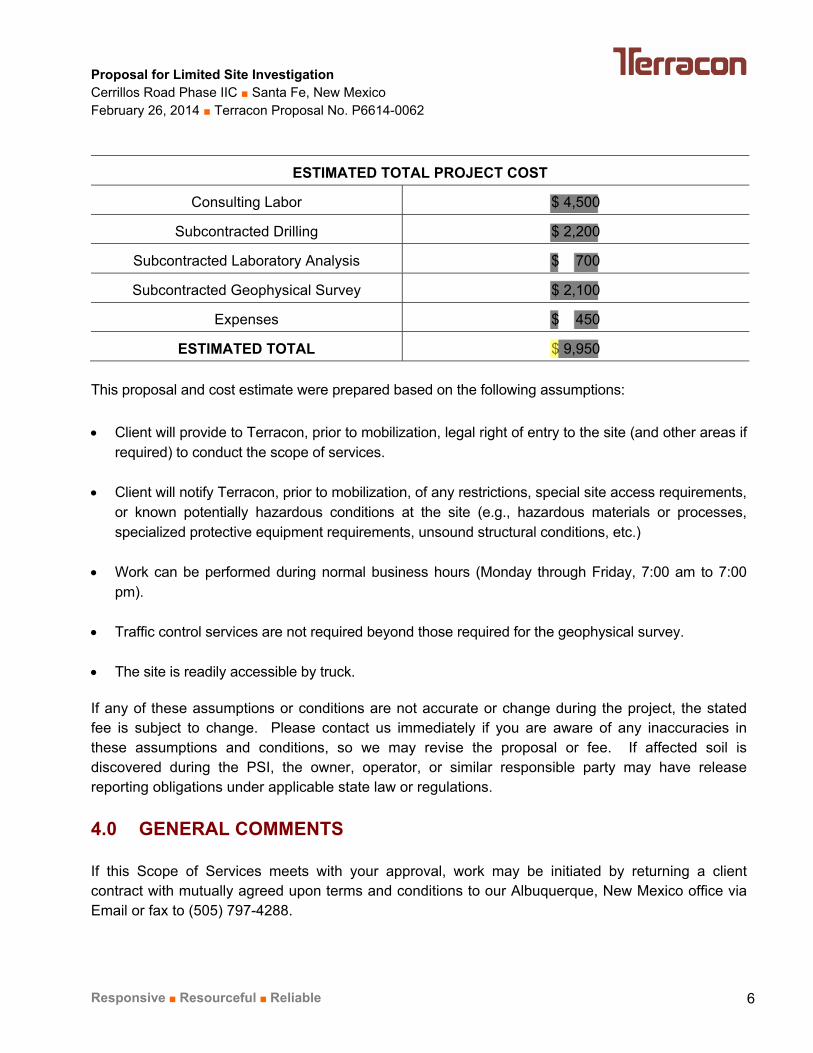
COMPENSATION 3.0 The Scope of Services outlined in this proposal will be performed on a Lump Sum basis for $9,950. If, as a result of these services, additional work is required outside the scope of this proposal, you will be contacted, and upon request, proposed costs for additional work will be provided. Client authorization will be obtained prior to commencement of any additional work outside the scope of this proposal. A summary of estimated costs is provided in the following table:
Proposal for Limited Site Investigation Cerrillos Road Phase IIC ■ Santa Fe, New Mexico February 26, 2014 ■ Terracon Proposal No. P6614-0062
Responsive ■ Resourceful ■ Reliable 6
ESTIMATED TOTAL PROJECT COST
Consulting Labor $ 4,500
Subcontracted Drilling $ 2,200
Subcontracted Laboratory Analysis $ 700
Subcontracted Geophysical Survey $ 2,100
Expenses $ 450
ESTIMATED TOTAL $ 9,950
This proposal and cost estimate were prepared based on the following assumptions:
Client will provide to Terracon, prior to mobilization, legal right of entry to the site (and other areas if required) to conduct the scope of services.
Client will notify Terracon, prior to mobilization, of any restrictions, special site access requirements,
or known potentially hazardous conditions at the site (e.g., hazardous materials or processes, specialized protective equipment requirements, unsound structural conditions, etc.)
Work can be performed during normal business hours (Monday through Friday, 7:00 am to 7:00
pm). Traffic control services are not required beyond those required for the geophysical survey. The site is readily accessible by truck. If any of these assumptions or conditions are not accurate or change during the project, the stated fee is subject to change. Please contact us immediately if you are aware of any inaccuracies in these assumptions and conditions, so we may revise the proposal or fee. If affected soil is discovered during the PSI, the owner, operator, or similar responsible party may have release reporting obligations under applicable state law or regulations.
GENERAL COMMENTS 4.0 If this Scope of Services meets with your approval, work may be initiated by returning a client contract with mutually agreed upon terms and conditions to our Albuquerque, New Mexico office via Email or fax to (505) 797-4288.
Proposal for Limited Site Investigation Cerrillos Road Phase IIC ■ Santa Fe, New Mexico February 26, 2014 ■ Terracon Proposal No. P6614-0062
Responsive ■ Resourceful ■ Reliable 7
If you should have any questions or comments regarding this proposal, please contact either of the undersigned. Sincerely,
Mark R. Hillier, P.G. (TX) Department Manager Attachments: Exhibit 1 and Exhibit 2 – Soil Boring Location Maps
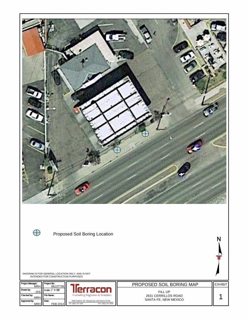
DIAGRAM IS FOR GENERAL LOCATION ONLY, AND IS NOT INTENDED FOR CONSTRUCTION PURPOSES
4905 Hawkins, NE Albuquerque, New Mexico 87109
PH. (505) 797-4287 FAX. (505) 797-4288
1
EXHIBITPROPOSED SOIL BORING MAP
FILL UP2631 CERRILLOS ROAD
SANTA FE, NEW MEXICO
Project Manager:
Drawn by:
Checked by:
Approved by:
MRH
JAS
MRH
MRH
Project No.
Scale: 1” ≈ 30’
File Name:
Date:
66137738
FEB 2014
Proposed Soil Boring Location

DIAGRAM IS FOR GENERAL LOCATION ONLY, AND IS NOT INTENDED FOR CONSTRUCTION PURPOSES
4905 Hawkins, NE Albuquerque, New Mexico 87109
PH. (505) 797-4287 FAX. (505) 797-4288
2
EXHIBITPROPOSED SOIL BORING MAP
INDIA HOUSE RESTAURANT2501 CERILLOS ROAD
SANTA FE, NEW MEXICO
Project Manager:
Drawn by:
Checked by:
Approved by:
MRH
JAS
MRH
MRH
Project No.
Scale: 1” ≈ 38’
File Name:
Date:
66137738
FEB 2014
Proposed Soil Boring Location